south san francisco bay shoreline study - uf/ifas...
TRANSCRIPT

BUILDING STRONG®ALVISO
PACIFICOCEAN
SOUTH SAN FRANCISCO BAY SHORELINEIntegrating flood risk management and ecosystem restoration along the bay’s edge
Dr. Judy McCreaPlan Formulation SpecialistSouth Pacific DivisionUS Army Corps of Engineers

STUDY PARTICIPANTSNON-FEDERAL SPONSORS
LANDOWNERS
CONSULTANTS
HeadquartersSouth Pacific DivisionSan Francisco DistrictLos Angeles DistrictJacksonville DistrictPlanning Centers of Expertise
Coastal Storm Risk Management Flood Risk ManagementEcosystem Restoration
Engineer Research & Development CenterAgency Technical Review TeamIndependent External Peer Review TeamMandatory Cost Center of Expertise
U.S. ARMY CORPS OF ENGINEERSSanta Clara Valley Water DistrictState Coastal Conservancy
U.S. Fish & Wildlife ServiceCity of San Jose
HDRNorthwest Habitat InstituteBattelle
2

BUILDING STRONG®
PROJECT LOCATION & AUTHORITY
BUILDING STRONG®3
1976 WATER RESOURCES DEVELOPMENT ACTFlood risk management in North & South San Francisco Bay
PACIFICOCEAN
1976
Marin County
NapaCounty
SonomaCounty
SolanoCounty
Contra CostaCounty
AlamedaCounty
SanMateoCounty
SantaClara
County
SanFranciscoCounty
2002 STUDY RESOLUTION South Bay focus w/added ecosystem restoration & recreation
PACIFICOCEAN
2002AlamedaCounty
SanMateoCounty
SantaClara
County
SanFranciscoCounty
SAN FRANCISCO
PACIFICOCEAN
SILICONVALLEY
2004 FREMONT
ALVISO
2004 RECONNAISSANCE PHASEGeographic scope = 9,000 acres/15 shoreline miles
SAN JOSE
ALVISOPALOALTO
SILICON VALLEY
FREMONT
2005
2005 FEASIBILITY PHASEScope further reduced to Alviso Ponds and associated shoreline
2011 STUDY FOOTPRINT REDUCED Northern San Jose area2,900 acres/4 shoreline miles
SAN JOSE
ALVISOPALOALTO
SILICON VALLEY
FREMONT
2011
N

SOUTH SAN FRANCISCO BAY SHORELINE THE RISK OF NOT ACTING
CONTINUEDLACK OF HABITAT/
CONNECTIVITYTo Support
Wetland Wildlife
Existing residual tidal wetlands fragmented,
narrow
Minimal refugial habitat for listed
species at high tide
LOST OPPORTUNITY TO RESTORE TIDAL
WETLANDSRising sea levels & deeper water
will prevent natural
sedimentation from establishing
tidal wetlands
INCREASEDTHREAT TO LISTED
SPECIES2 Federal
EndangeredSpecies
Salt marsh harvest mouseRidgway’s rail
INCREASED THREAT OF FLOODINGCommunity of Alviso &
Surrounding Area(~5,500 people
~1,100 structures)
Increased vulnerability
due to existing pond dikes
INCREASED THREAT OF FLOODINGRegional
Wastewater Treatment
Facility
Serves 1.4 MillionPeople in
8-City Region
INCREASED THREAT OF FLOODING
Water Purification
CenterProduces 8 million
gallons/day of purified water matching CA
drinking standards
SEA LEVEL RISE & POTENTIAL FLOOD RISK4
BUILDING STRONG®
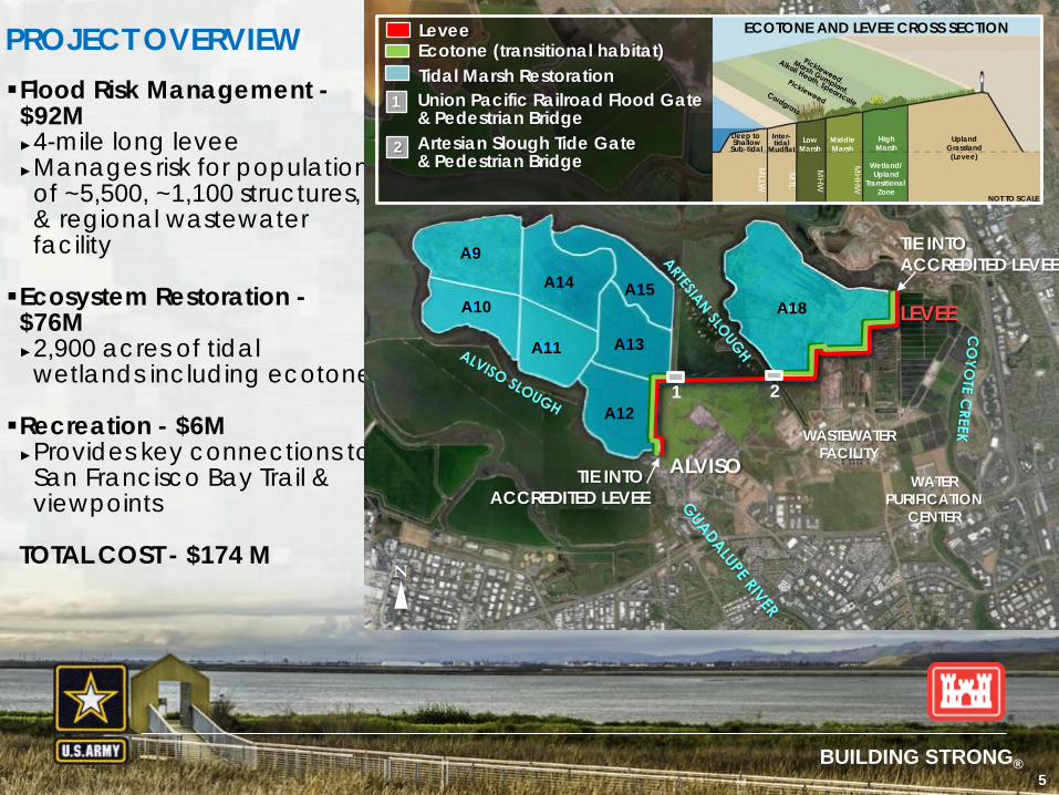
PROJECT OVERVIEWFlood Risk Management -$92M►4-mile long levee►Manages risk for population
of ~5,500, ~1,100 structures, & regional wastewater facility
Ecosystem Restoration -$76M►2,900 acres of tidal
wetlands including ecotone
Recreation - $6M►Provides key connections to
San Francisco Bay Trail & viewpoints
TOTAL COST - $174 M
BUILDING STRONG®
ALVISOWASTEWATER
FACILITY
LEVEE
Ecotone (transitional habitat)Levee
Tidal Marsh RestorationUnion Pacific Railroad Flood Gate & Pedestrian Bridge
1
2 Artesian Slough Tide Gate& Pedestrian Bridge
N
TIE INTO ACCREDITED LEVEE
TIE INTO ACCREDITED LEVEE
WATER PURIFICATION
CENTER
1 2
A18
A12
A13
A15A14
A11
A9
A10
ECOTONE AND LEVEE CROSS SECTION
Deep to Shallow
Sub-tidalMiddleMarsh
HighMarsh
Wetland/Upland
Transitional Zone
LowMarsh
UplandGrassland(Levee)
Inter-tidal
Mudflat
MLLW
MTL
MHW
MHHW
NOT TO SCALE
5

BUILDING STRONG®
A9A14
A10
A15
A18
A12
A11 A13
SR 237
ALVISO
WastewaterFacility
ALVISO NORTH (EXISTING DIKE ALIGNMENT)
WPCP SOUTH (EXISTING DIKE ALIGNMENT)
TIDE GATE
ProblemsOpportunities
PlanFormulation
ExistingConditions
RecommendedPlan
Policy andReviews
FutureWithout-Project
6
ALVISO NORTH LEVEE
ALVISO RR SPUR LEVEE
ALVISO SOUTH LEVEE
FLOOD RISK MANAGEMENT
+ WPCP South
+ UPRRFlood Gate
+ Artesian Tide Gate
+ Non-structural
FLOOD RISK MANAGEMENT
FLOOD GATE
N
6

BUILDING STRONG®
SR 237
ALVISO
ECOSYSTEM RESTORATION
IN-POND PREPARATIONprior to breaching fortidal connection
Pilot channels through fringing marsh into ponds Ditch blocks Internal dike
reinforcement or breaches
TRANSITIONAL HABITAT 30:1 Ecotone fill
POND BREACH PHASING A12, A18 A9-A11 A13-A15
Phased Pond Breaching + Transitional Habitat (Ecotone)TIDAL MARSH RESTORATION FEATURES:
* Between tidal marsh & levee
LeveeTransitional fill/habitat *
N
7
A9
A10A15
A14
A11
WastewaterFacility
A12TIDE
GATEFLOODGATE
A18
A13
30:1 SLOPE LEVEE CROSS SECTION
Deep to Shallow
Sub-tidalMiddleMarsh
HighMarsh
Wetland/Upland
Transitional Zone
LowMarsh
UplandGrassland(Levee)
Inter-tidal
Mudflat
MLLW
MTL
MHW
MHHW
NOT TO SCALE
UplandGrassland(Levee)Deep to Shallow
Subtidal
BENCH DESIGN LEVEE CROSS SECTION
NOT TO SCALE

BUILDING STRONG®
Ditch Blockto directs flow
toward center of site
Levee Lowering
Breach
Pilot Channels
Breach
Tidal Marsh Restoration Features
8
Example Restoration: Pond A21 (April 2008 – 2011) Photo Credit: C. Benton

BUILDING STRONG®
ECOTONE TRANSITIONAL HABITAT
9
TIDALMUDFLAT
DEEP TOSHALLOWSUBTIDAL
MLLW MTL
TIDALMARSH(MIDDLE & HIGHMARSH)
TIDAL MARSH(LOW
MARSH)
MHW MHHW
GRASSLAND/SEASONAL WETLAND MOSAIC
& SEASONAL WETLAND/SPACE FOR SLC
ADAPTATION
LEVEECREST
TIDAL WETLAND ECOTONE (post-construction condition)OPPORTUNITY FOR MORE DIVERSE HABITAT & MORE RESILIENT FLOOD RISK MANAGEMENT
TIDALMARSH(MIDDLE & HIGHMARSH)
TIDAL MARSH(LOW
MARSH)
TIDALMUDFLAT
GRASSLAND/SEASONAL WETLAND MOSAIC
& SEASONAL WETLAND/SPACE FOR SLC
ADAPTATION
LEVEECRESTMHW MHHW
DEEP TOSHALLOWSUBTIDAL
MLLW MTL
TIDAL WETLAND ECOTONE (restored condition over time)
9

BUILDING STRONG®
MONITORING AND ADAPTIVE MANAGEMENT
POST-CONSTRUCTION ACTIONS
LONG-TERM ACTIONS
MonitoringEvaluate Progress of Habitat Restoration
Adaptive ManagementAdjust timing of phased breaches, lower dikes, adjust in-pond features, import fill, active seeding
Operation, Maintenance, Repair, Replacement and Rehabilitation (OMRR&R)by non-Federal sponsor
Total Estimated Cost for Monitoring
($1.7m) & Adaptive
Management ($6.3M)
$8 million
10
BUILDING STRONG®
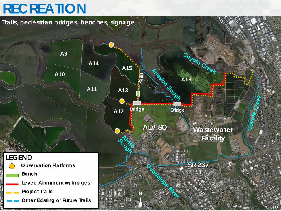
RECREATION
11
A9A14
A10A15
A18
A12
A11 A13
SR 237
ALVISO WastewaterFacility
LEGENDObservation PlatformsBenchLevee Alignment w/bridgesProject TrailsOther Existing or Future Trails
RECREATIONTrails, pedestrian bridges, benches, signage
N
Bridge Bridge
11

BUILDING STRONG®
TIMELINE Chief’s report: December 2015 Project Authorization: To be determined Design Agreement: Spring 2016 Project Partnership Agreement: Spring 2017 Construction Contract Award: Spring 2018 Construction Begins: Summer 2018
12

BUILDING STRONG®
INTEGRATED PROJECT: CRITICAL INVESTMENT
LEVEE: Length: 4-miles long Height: 15.2’ NAVD 88 Gates
2,900 ACRE WETLANDRESTORATION partial breaching
of existing dikes ditch blocks pond berms
Observation Platform Signage Trails Benches
ECO
SYST
EMRE
STO
RATIO
NFL
OO
D RI
SKM
AN
AG
EMEN
T (FR
M)
REC
REA
TION
Levee Trails Pedestrian Bridges
30:1 slope ecotone fill
Risk managed for population of ~5,500, ~1,100 structures, businesses, & regional wastewater facility
Key connections to San Francisco Bay Trail
More diversified tidal wetland habitat (ecotone)
Robust to long-term sea level rise
Conditions restored for tidal wetland habitat (sedimentation & flows)
Connections restored between wetland restorations, as well as San Francisco Bay
FEATURE BENEFIT
Key connections to San Francisco Bay Trail plusadditional recreation enhancements
Levee with Adjacent EcotoneWetland Restoration
Project TrailsExisting Trails
Gates/Pedestrian Bridges
NOT TO SCALE
N
13

BUILDING STRONG®
Questions?
14