south sumatra basin
DESCRIPTION
south sumatra basinTRANSCRIPT
Vol. 1 - 803
IPA01-G-010
PROCEEDINGS, INDONESIAN PETROLEUM ASSOCIATION Twenty-Eight Annual Convention & Exhibition, October 2001
HYDROCARBON EXPLORATION IN THE MERANG TRIANGLE,
SOUTH SUMATRA BASIN
John Clure* Nunuk Fiptiani*
ABSTRACT The swampy, densely forested Merang Triangle had very limited exploration for many years. Numerous plays have been established by a JOB that has been operating in the area of Jambi-Merang, with numerous assistant operators, since 1988. Production has been established from the Talang Akar in the Gelam field, which is unitised with Gulf Indonesia Resources and partners, A field has been established in the Baturaja carbonates and further stratigraphic potential has been highlighted. The various components of the petroleum systems are discussed along with the challenges encountered in evaluating the carbonate reservoir. A Plio-Pleistocene structural uplift, the Sembilang High, which resulted in the erosion of thousands of feet of sediment, is demonstrated. It is shown that this uplift is associated with a regional tilt to the southeast, causing possible re-migration. Also shown is that recent faulting has broken up a carbonate complex and the resultant off-reef platform facies being currently structurally higher than the original reef crest. This resulted in earlier drilling at the structural crest encountering the platform facies and missing the build-up. The block comprises an area of many overlapping plays and an interesting petroleum system. INTRODUCTION AND HISTORY OF EXPLORATION The Merang triangle is situated just south of the city of Jambi, overlapping the boundary between the Jambi Province and the Province of South Sumatra. It is a low-lying, swampy area, which was initially covered by tropical rain forest. The earliest exploration to be carried out in this area was by BPM and NIAM. The latter carried out gravity surveys in __________________________________________________________ * JOB Pertamina-YPF Jambi Merang
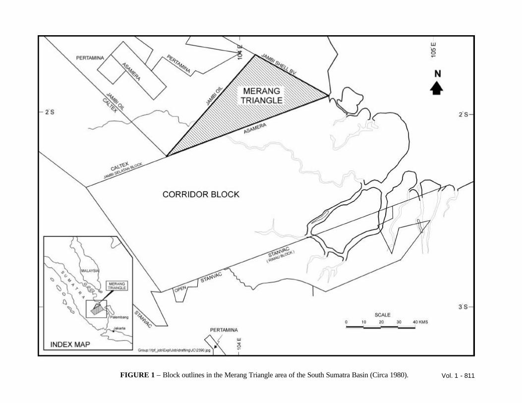
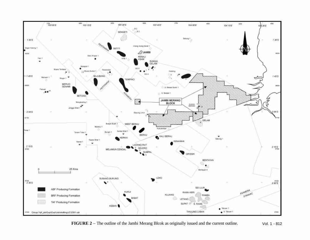
the Jambi area in the 1920’s and following the drilling of the Air Benakat discovery at Tempino in 1931, drilled Sungai Merang-1 near oil seeps in the Merang River in 1934. Minor shows brought them back to drill Sungai Merang-2 in 1937, which was a dry hole. NIAM however, had better luck the following year when they drilled West Berau-1 and Kali Berau 5, both of which produced oil from the Air Benakat Formation. After the 1939-45 war, BPM drilled Bayung Lincir-1, a surface feature near to the road between Palembang and Jambi, this well tested gas at a very low rate with water. After the formation of PN Pertamina in 1960, the area was explored again in the Sungai Merang and Bayung Lincir areas with Sungai Merang-3 being drilled in 1961 and Bayung Lincir 2 in 1967. The later well recovered water with a trace of oil from the Air Benakat. The shows attracted Pertamina to return in 1973 and drill Bayung Lincir 3, which recovered oil, but not in commercial amounts. Pertamina awarded the Corridor Block to REDCO in 1968 and the Jambi Area to Jambi Oil in 1978, leaving the swampy Merang Triangle open (Figure 1). In 1989, part of the Jambi oil block plus the Merang Triangle was awarded to Elf Aquitaine Indonesie (Elf) as the JOB Jambi Merang (Figure 2). A seismic survey carried out in 1990 highlighted the major features in the block. The first well drilled, was Sukajaya-1 in 1991, on a feature that had been highlighted by an earlier survey carried out by Jambi Oil. This was down dip from the Tempino Oil field, which is producing oil from the Air Benakat Formation. The feature was predominantly a nose dipping down from the Tempino Field with a counter dip creating the closure. This well encountered gas in the Air Benakat Formation, but the feature was small at the productive horizon. It also had shows at the Talang Akar level although high temperatures and
Vol. 1 - 804
pressures along with some H2S prevented a full evaluation of that interval. Sukajaya-1 also demonstrated drilling difficulties as the shales of the Gumai Formation were over pressured. The second well, Muara Sabak-1, was drilled along strike from the East Ketaling (Air Benakat) Oil Field with a resultant dry hole. A third well, Kukulambar-1, was drilled to test a structural closure at Talang Akar level and a carbonate (Baturaja) play. Here a platform limestone was encountered, which after acidizing, recovered gas and condensate, but the Talang Akar Formation lacked reservoir. Meanwhile, Asamera, which is now Gulf Indonesia Resources Ltd (Gulf), discovered the Gelam gas/condensate field in the Talang Akar Formation. This field crosses over into Jambi Merang, Elf demonstrated this with the drilling of Gelam 4 in 1992. The field is now on production and forms part of the Corridor Gas Project supplying gas to Duri for the steamflood operations there. A final well Merang-1 was dry. Elf had evaluated, without success, the extension of two oil trends into the block and a large structural high near the West Berau discovery of NIAM. They had encountered tight limestone at Baturaja level in Kukulambar-1, Muara Sabak-1 and Merang-1, while the Baturaja at Gelam, although having porosity, was water wet. Elf sold its remaining interest to Saga Petroleum Indonesia (Saga). Saga pursued the Baturaja carbonate by drilling the Pulau Gading feature, which had both structural and stratigraphic closure at Baturaja level. Pulau Gading-1 discovered gas and condensate in the Baturaja Formation, uneconomic gas flows from the Talang Akar Formation and gas shows in fractured basement. The porosity in the Baturaja Formation was predominantly at the top of the buildup, but wherever there was porosity there was gas and a gas/water contact was not confirmed. Saga sold out initially to Cue Energy (Cue), but finally to YPF-Indonesia (a subsidiary of YPF-Repsol). JOB Pertamina-YPF-Jambi Merang has since drilled two delineation wells on Pulau Gading. These wells demonstrated the areal extent of the hydrocarbon bearing porosity. Further evaluation of the remaining prospects has been carried out. This has been achieved in several ways, for instance by studying the seismic amplitudes to determine porosity distribution, and by flattening on Intra-Gumai events
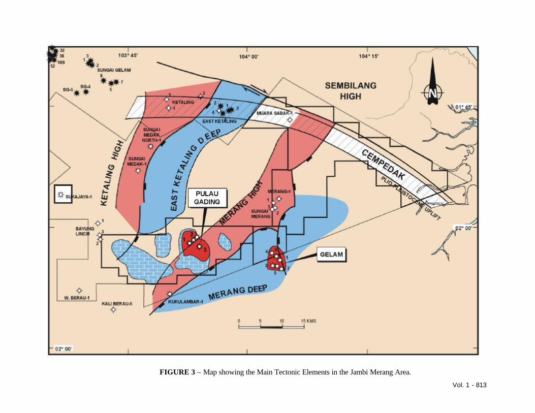
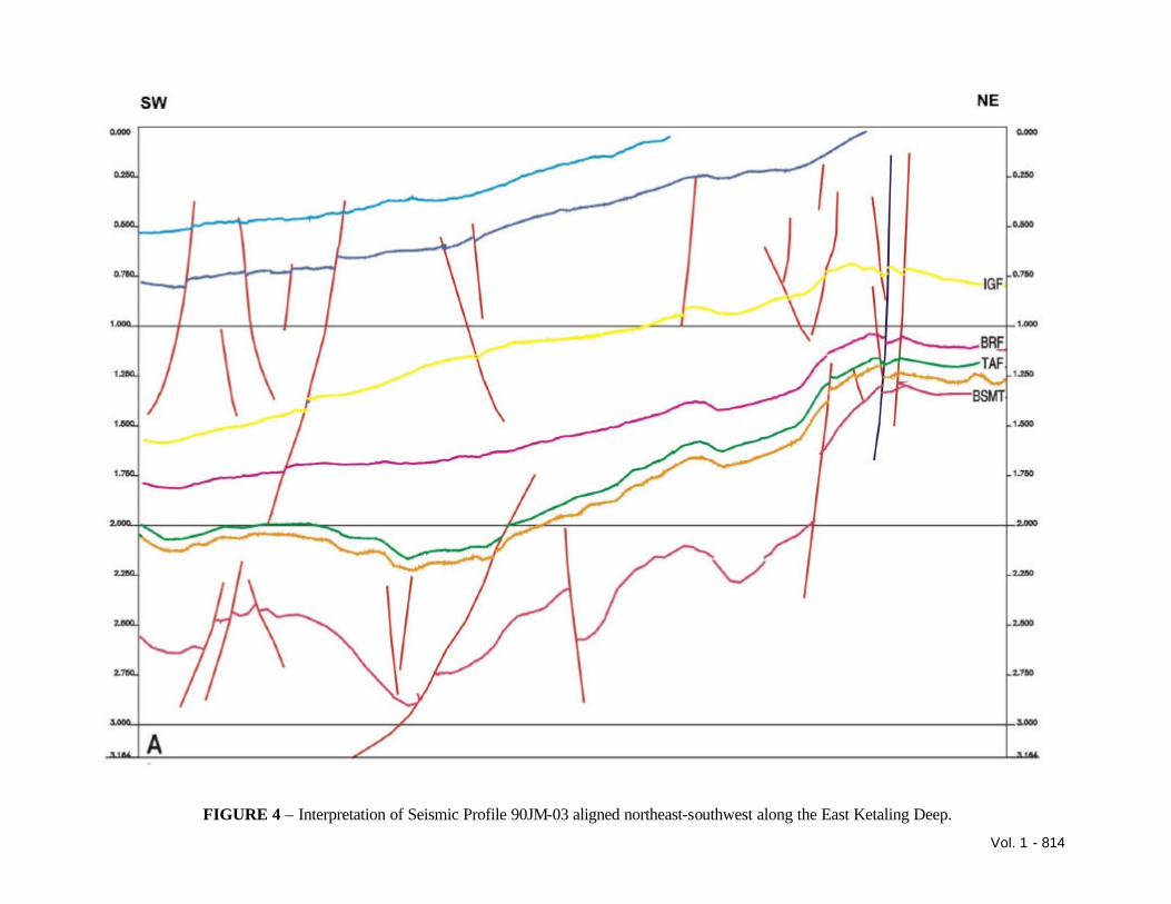
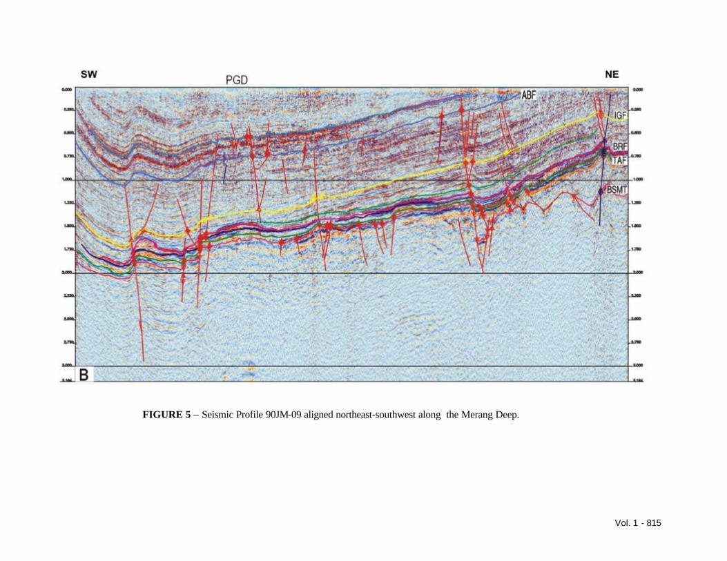
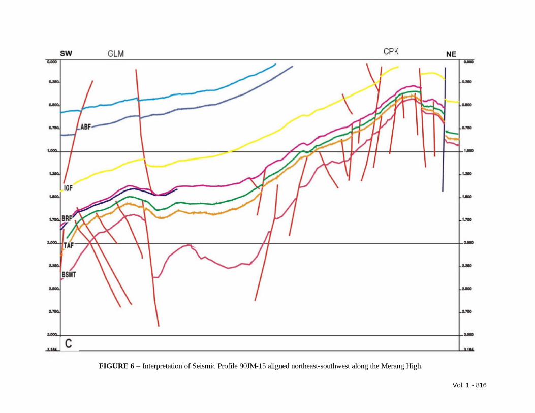
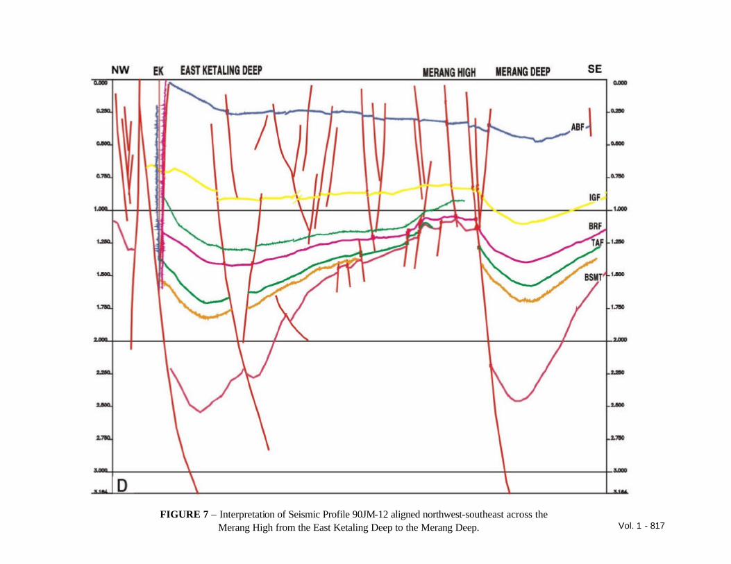
to reveal the paleo-configuration of the carbonate buildups, and this has highlighted the potential of other buildups such as Sungai Kenawang. The petroleum system of this carbonate play is discussed, with the other plays in the block, later. TECTONIC HISTORY The main structural elements of the Jambi sub-basin are horsts and grabens, formed in the Palaeogene, which align northeast to southwest as opposed to the usual north-south trend of the South Sumatra Basin. In the Jambi Merang area, the Merang High and the Ketaling High represent horsts (Figure 3). The rift between the Merang High and the Ketaling High forms the East Ketaling depocentre. To the southeast of the Merang High is the Merang depocentre. These horsts were sources of sediment into the basins until they were eventually sub-merged and carbonates developed on these old highs. The area was subjected to Mid-Miocene wrenching and then further subsidence. Finally, it was subjected to Plio-Pleistocene compression, which formed northwest-southeast trending folds, however, this compressional phase is also associated with a regional tilt towards the southwest and the uplift of the Sembilang High, followed by a considerable amount of erosion over the last few million years. Interpretations of three seismic lines that are aligned parallel to the horst and graben are shown in Figures 4, 5 and 6, Line A (Figure 4) runs down the East Ketaling Deep, line B (Figure 5) runs along the Merang High and line C (Figure 6) runs down the Merang Deep from the Sembilang High through the Gelam Field. Line A clearly demonstrates the regional tilt, the blue horizon is near base Muara Enim and thus represents a time of less than 10 m.y.a. This indicates that the tilting phase is younger than the near base Muara Enim event and probably took place at the same time as the Plio-Pleistocene compressional phase. This was followed by a period of erosion. The yellow horizon represents an Intra-Gumai event that can be mapped regionally; below this are a series of downlapping events demonstrating the sediments were derived from the Sunda Craton to the northeast. The green horizon is the top of the Talang Akar Formation and is approximately the top of the syn-rift sequence. Line B, being predominantly on the Merang High, only has a thin section of Talang Akar
Vol. 1 - 805
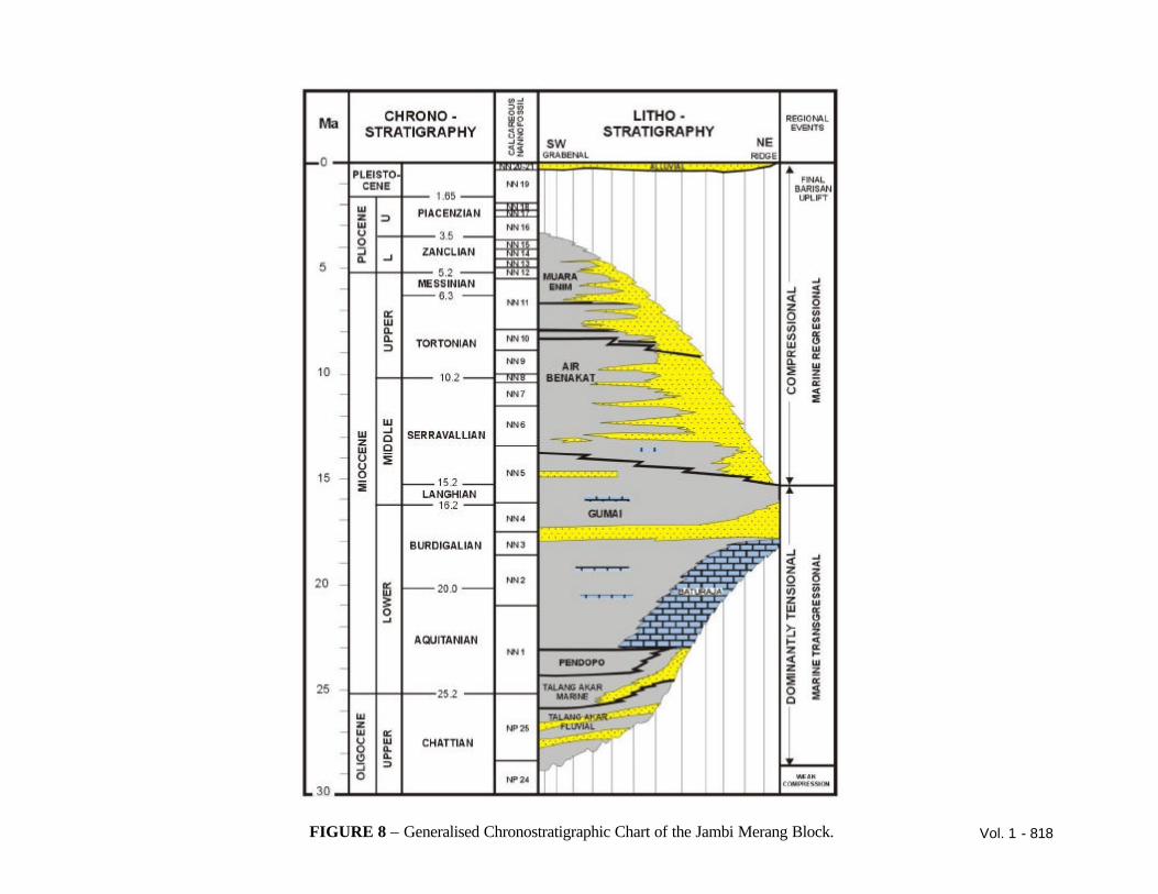
Formation. Parts of the Merang High were submerged prior to the end of the Talang Akar. The Muara Enim section clearly comprises parallel beds dipping to the southwest, as seen in the previous section, and the downlapping sequences are clear below the Intra-Gumai event. Line C is closer to the Sembilang High and the amount of recent uplift and erosion can be seen to be many thousands of feet and thus this area was buried much deeper. This section also goes through the Gelam Field, which is situated on the basement high at the western end of the seismic line. This recent tilting will have had an effect on any hydrocarbons that migrated prior to this tilting event, resulting in remigration. A similar remigration has been observed in the Kaji-Semoga area as described by Hutapea (1998). Line D (Figure 7) is aligned perpendicular to the previous three lines and shows the East Ketaling Deep, the Merang High and the Merang Deep. STRATIGRAPHIC HISTORY The earliest sediments in the Jambi sub-basin have yet to be penetrated as they are only deposited in the graben areas and so far there have been no deep tests in any of these features. The earliest sediments so far encountered form the Oligocene, Talang Akar Formation, (Figure 8), which are fluvial channel sands in the deepest parts encountered and form the reservoir of the Gelam Field. As sea level started to rise, in association with the subsidence, the Talang Akar sediments became more marine in origin and gradually encroached onto the basement highs. The Talang Akar marine shales act as a seal for the channel sands, but they are also interbedded with marine sandstones. As the Merang High became submerged and thus cutting off a nearby supply of clastics, the waters became clearer and carbonates started to develop. The initial carbonate deposits were argillaceous, eventually cleaning up to form platform limestones. On top of these platform areas developed carbonate buildups. To call them reefs would be stretching the definition; there is reefal material in them, but it is generally found in restricted layers. The age of these carbonate build-ups varies from nannofossil zone NN1 to NN4 and thus is dependent on when the basement high, on which they are situated, was submerged and also on the reduction of clastic influx.
Eventually, these carbonate buildups were drowned and the Gumai shales act as a regional seal over the area. Within the Gumai Formation, there are numerous downlapping events. These contain glauconitic sandstones, which are potential reservoirs, although within the Jambi-Merang block they are tight. These sands, however, are productive to the north in Sungai Gelam and in Grissik to the south. The downlapping events on the seismic profiles demonstrate that the sediments are derived from the Sunda Craton to the northeast. These sandstones, in addition to being potential reservoirs and stratigraphic traps, can also form thief beds. They, with the Plio-Pleistocene faulting, provide conduits for the hydrocarbons to escape through the regional seal and into the Air Benakat reservoirs. The Air Benakat Formation is productive in the region, particularly in the Jambi area to the north. In the Jambi Merang area, it is the reservoir for small fields such as East Ketaling and West Berau. In the Jambi Merang block the sands tend to be thin and argillaceous and probably of limited areal extent, although they always contain oil shows. There is a regional unconformity at Muara Enim times, which represents the onset of the last compressional phase. This is clearly seen on the seismic sections, indicated by the large amount of coal present at that level. The Plio-Pleistocene Kasai Formation has not been observed in the block. The area contains many potential reservoirs; these include weathered and fractured Basement, Talang Akar sandstones, Baturaja limestones, Intra-Gumai sandstones and Air Benakat sandstones. GEOCHEMISTRY Hydrocarbon source correlation Studies of hydrocarbons from wells drilled in the area and from a core in a seismic shothole have indicated that the hydrocarbons are derived from two different source rocks. One source being the coals and coaly shales of the Talang Akar Formation and the other the nearshore marine Talang Akar Formation. The crude oil characterisation from Kali-Berau-5, West Berau-1 and East Ketaling showed that the East Ketaling oil was different. Oils from Kali Berau-5 and West Berau-1 were the same oil type based on their
Vol. 1 - 806
bulk oil properties. They are medium gravity, low wax, paraffinic crude oils and neither of the oils were biodegraded. The Kali Berau-5 oil was generated from a mixed terrestrial/algal organic facies reworked by bacteria with deposition in a marine environment. A possible source rock is the near shore marine Talang Akar shales. The East Ketaling oils are different from the Kali Berau oils in that they are generated from a predominantly terrestrial organic facies. A likely source for these oils was the fluvial-deltaic Talang Akar coals and coaly shales. Oil extracted from a core taken from a shot hole during the 1990 seismic programme in the Cempedak area, at the eastern end of the block, was derived from a mixed terrestrial/algal source rock facies deposited within a nearshore marine setting. This biodegraded oil is believed to be a fully mature liquid hydrocarbon product, which was probably sourced/expelled during the principal phase of oil generation. The migrated oil shows a good match with the Kali-Berau-5 oil based on its saturated biomarker distribution and corresponding δ13 C data. Minor differences and variations between these oils are probably due to the effects of biodegradation and maturity/migration. The condensate and gas recovered from the Baturaja Formation of Kukulambar-1 was determined to be generated from a late mature source containing mixed higher plant and non-marine algal organic matter. The gas associated with the condensate appears to have been generated at a la te stage of thermal maturity. There is, however, a component of methane present which is thought to be biogenic. Crude recovered from the RFT in the Baturaja Formation of Pulau Gading-1 determined that it was a typical mature light oil/condensate derived from a mostly higher plant organic facies, which was probably deposited in a fluvio-deltaic setting. Bitumen extract data from the Baturaja indicated results that were consistent with deposition of the parent source rock within a nearshore marine to shallow marine setting, probably the marine Talang Akar shales. Pulau Gading is a gas condensate field and the bitumen extract suggests an earlier oil migration phase.
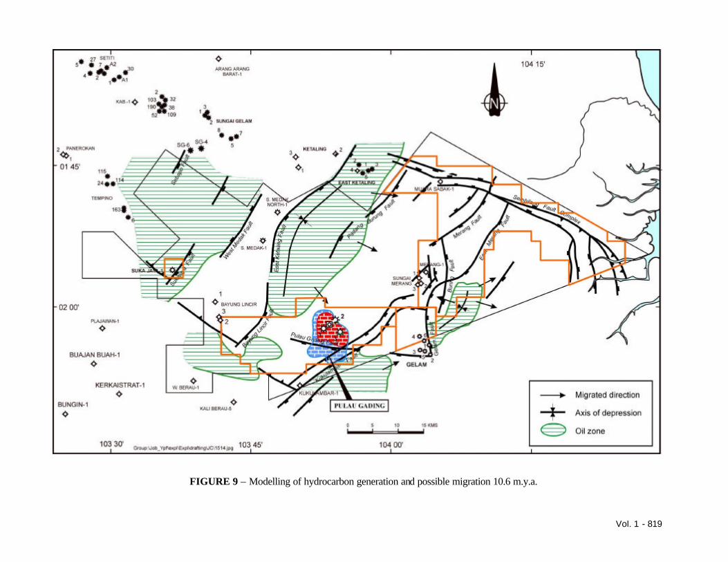
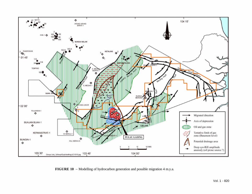
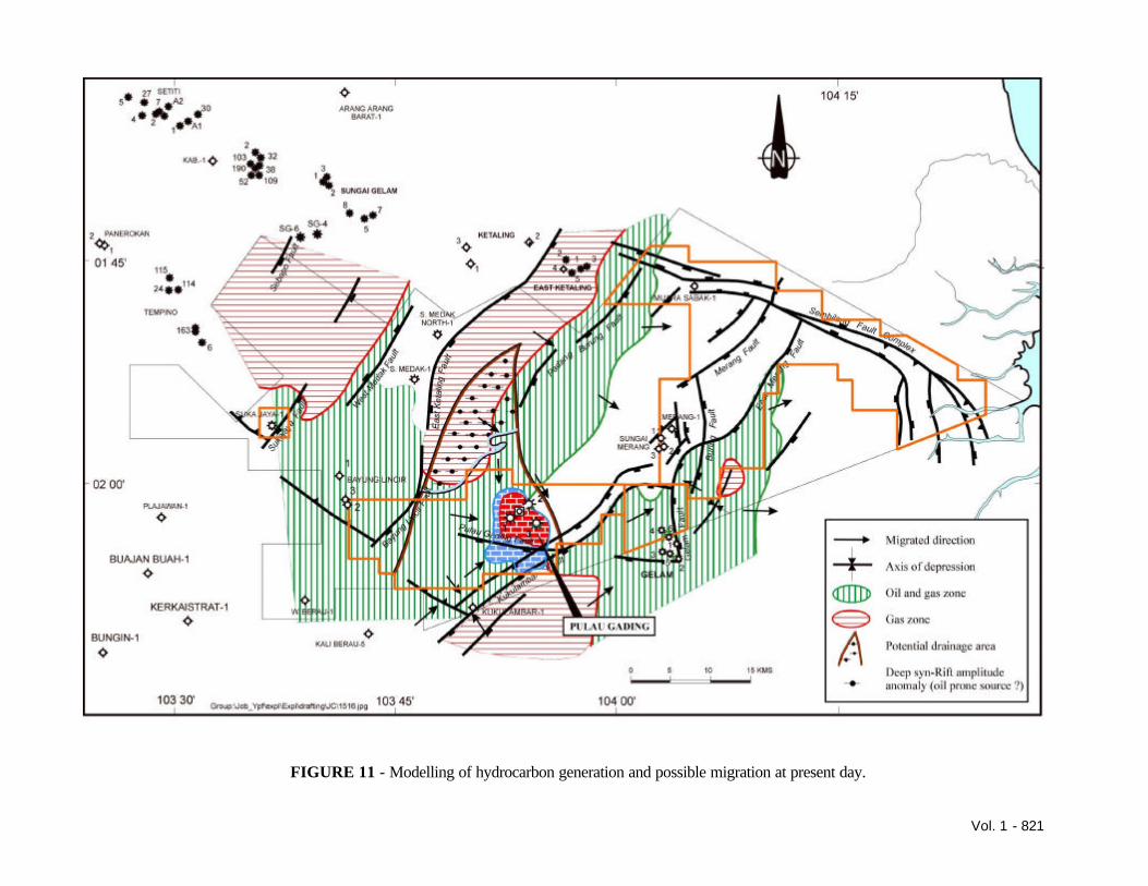
Source rock richness The coals, at optimum maturity, in the Muara Enim Formation might generate significant amounts of gas, whilst the claystones/shales would be expected to generate only minor amounts of gas. The Gumai Formation has fair source potential, but the better parts are only early mature and would therefore not have generated significant quantities of hydrocarbons. The Baturaja Formation was found to be of low gas generating potential. Bitumen extracts were sourced by a Type III/II kerogen facies. The Pendopo shales show poor remnant hydrocarbon source potential and have low gas generative potential at the present day, while the Talang Akar has good oil and gas potential. In the Sukajaya-1 well, although the argillaceous section had no source potential, due to its generally low organic content and high maturity (related to the overpressure), it could have been a significant source rock at lower maturities. Coals, interpreted to have caved from the Air Benakat Formation are good quality gas source rocks. In Kukulambar-1, no source potential was identified and this well was also overpressured. Analysis of Muara Sabak-1, at the eastern end of the block, identified fair to good quality oil and gas source rocks in the Air Benakat Formation, Gumai Formation, Baturaja “shales” and Talang Akar Formation, but none had generated hydrocarbons due to lack of maturity. Maturity Oil generation from the Talang Akar Formation started in Late Middle Miocene times. The top of the oil window varies according to the amount of uplift and erosion, and is affected by areas of high heat flow created by nearby Plio-Pleistocene intrusive bodies. The effects of the high heat flow are seen in Kali-Berau-5, Batu Ampar-1, Sungai Medak-1 and possibly Sungai Merang-1. Such wells show a rapid increase in maturity immediately above basement. In areas unaffected by metamorphism, the top of the oil window is estimated to be 2200m. Geochemical modelling of 2D lines through the basin concludes that only the TAF gets mature with oil generation starting 10.6 m.y.a. and gas generation starting 4.0 m.y.a. This work is based only on two
Vol. 1 - 807
seismic lines and was carried out prior to the drilling of the last 8 wells. Figure 9 shows the modelling of hydrocarbon generation and possible migration at 10.6 m.y.a., which is the start of the oil migration. Figure 10 shows the modelling of hydrocarbon generation and possible migration at 4 m.y.a., which is the initiation of gas migration. Figure 11 shows the modelling of hydrocarbon generation and possible migration at the present day. The migration pathways are shown in sectional view in Figure 12. Analyses carried out on Sukajaya-1 and Kukulambar-1 showed the sections to be immature to early mature above the overpressure and below this they showed a rapid increase in maturity associated with the thermal effects of the overpressure. Analyses of Pulau Gading-1 show the Muara Enim and Air Benakat Formations to be immature and to have generated no hydrocarbons to date, the Gumai Formation to be marginal to early mature, while the Baturaja Formation was determined to be early to mid-mature. The Talang Akar Formation was determined to be thermally mature and lying within the main zone of oil generation/expulsion, but the sediments would require slightly deeper burial/higher temperatures to achieve peak oil generation and expulsion. BATURAJA CARBONATE PLAY The Jambi Merang area represents the northern edge of the Baturaja play of South Sumatra. To the south, there is a carbonate shelf with build-ups along the edge. The carbonates in the Merang Triangle area, not seen until the 1990 seismic survey, form an isolated group of build-ups on the Merang High. To the north there is another similar group of build-ups on the Ketaling High, the Sungai Medak-1 well, penetrated one of these and encountered gas with a high CO2
content. Pulau Gading wells have demonstrated that these carbonates comprise a shaly base, a carbonate platform and a carbonate build-up. These build-ups have undergone a complicated diagenetic history. Studies of core in Pulau Gading-1 show nine stages of diagenesis with porosity destroyed and reformed. The studies indicated that the diagenetically created porosity tended to follow the zones where the primary porosity had existed. The area, which had evidence of reefal material, had zones where vugular porosity had later developed. FMS studies matched with cores in Pulau Gading showed fractures to exist, these are
vertical, only extending the width of the diagenetic porosity and do not seem to cross the impermeable zones. Compositional analysis of the hydrocarbons seems to support these findings, as each zone has a different composition. The fracturing, therefore, must be related to diagenesis and the chemical alteration of the minerals causing size changes, resulting in local fracturing. This suggests a dual porosity system. Conversely an FMI run on Pulau Gading 3 did not show any fracturing, but did show fist-sized vugs demonstrating the complicated nature of the porosity distribution. Examination of the core data in Pulau Gading 1 suggested that porosity zones were related to drops in sealevel, causing exposure and porosity development. This indicates that the porosity zones should be flat across the buildups, or at least flat at the time of deposition. The recent tilt of the Merang High, and the carbonate platform, to the southwest should cause any previously flat porosity zones to slope to the southwest. Pulau Gading 3 supported this theory, however, Pulau Gading 2 indicated that the porosity was not related to the palaeo-height but simply the depth into the carbonate, suggesting that the meteoric waters percolating through the carbonate had enhanced the porosity. Prior to the drilling of Pulau Gading 2 and 3 seismic inversion studies had suggested an improvement of porosity/thickness in the areas of wells 2 and 3. However, it should be noted that the benefits of such work is limited by the data being only 2-D. The porosities were better, although the thickness of the porosity zones proved to be similar to previous wells. Seismic amplitude has also been examined and this tends to show the same general trends. This work was extended to the other carbonate build-ups as will discussed later. The drilling of the delineation wells produced another interesting problem, that of predicting the top of the limestone. It appears to be a clear marker on the seismic, but came in 91 feet high to prediction in the number 3 well. The locations for both wells had been established by Cue prior to JOB Pertamina-YPF-Jambi Merang’s acquisition of the block. JOB Pertamina-YPF-Jambi Merang decided that the location of the number 2 well was too close to the discovery well to add much to the knowledge of the field. It was decided to deviate the well to the northeast, with the intent of penetrating down the
Vol. 1 - 808
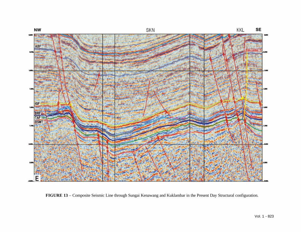
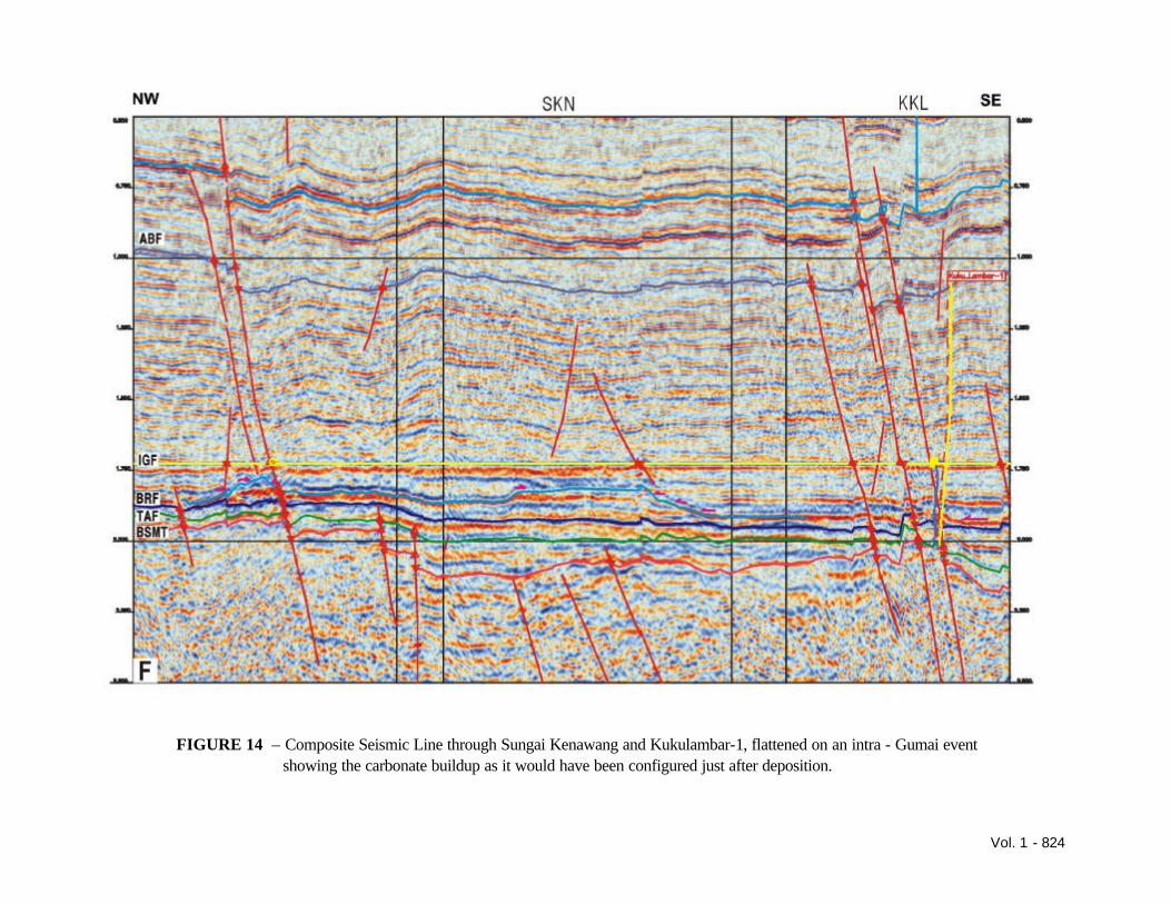
flank of the feature. Surprisingly this well came in higher than the discovery well, 222 feet high to prediction, and far from being a down flank well, was in fact a crestal well. It had been hoped that this well would demonstrate that the porosity wrapped over the build-up, but it just further demonstrated the porosity being on the crest of the feature. This seismic tie problem is still being studied. As Pulau Gading 2 and 3 tie with each other, the problem is probably related to the tie of the discovery well with the seismic. Taking the knowledge gained from Pulau Gading, the other, adjacent carbonate prospects were examined. The Sungai Kenawang Prospect was the most important as it was bigger than Pulau Gading and could significantly add to the reserves of the block. The first challenge being that the prospect is down-dip from an earlier test, namely Kukulambar-1. Close examination of the seismic section (Figure 13) shows that there has been some recent faulting that has broken up this area. Therefore, to examine how this feature looked just after deposition, the section was flattened on an intra-Gumai event (Figure 14). This event was chosen, as it is a clear marker over the whole of the block. From this flattened section it can be seen that instead of a series of build-ups there is just one huge 27,000-acre build-up. It was also noted that the Kukulambar-1 well is off the build-up and this helps to explain the carbonate platform that was encountered in the Kukulambar-1 well. Therefore, although this is down-dip from Kukulambar-1 it is in fact up reef from it. Kukulambar-1 having hydrocarbons in poor quality reservoir adds to the hope of the better quality reservoir in Sungai Kenawang also containing hydrocarbons. Next, the seismic amplitude was examined to estimate the chances of finding good porosity in the build up. The amplitude was mapped and showed a weaker amplitude response compared with the Pulau Gading build up. This response was related to the lower acoustic impedance which probably indicating a better porosity/thickness than that seen in Pulau Gading. The build-up was then modelled and this indicated that there were multiple zones of low acoustic impedance probably related to porosity being found not only at the top, but also in the middle of the build-up. Either of the two source rocks mentioned earlier could supply the hydrocarbons, whilst the sandstones within the Talang Akar could provide the migration
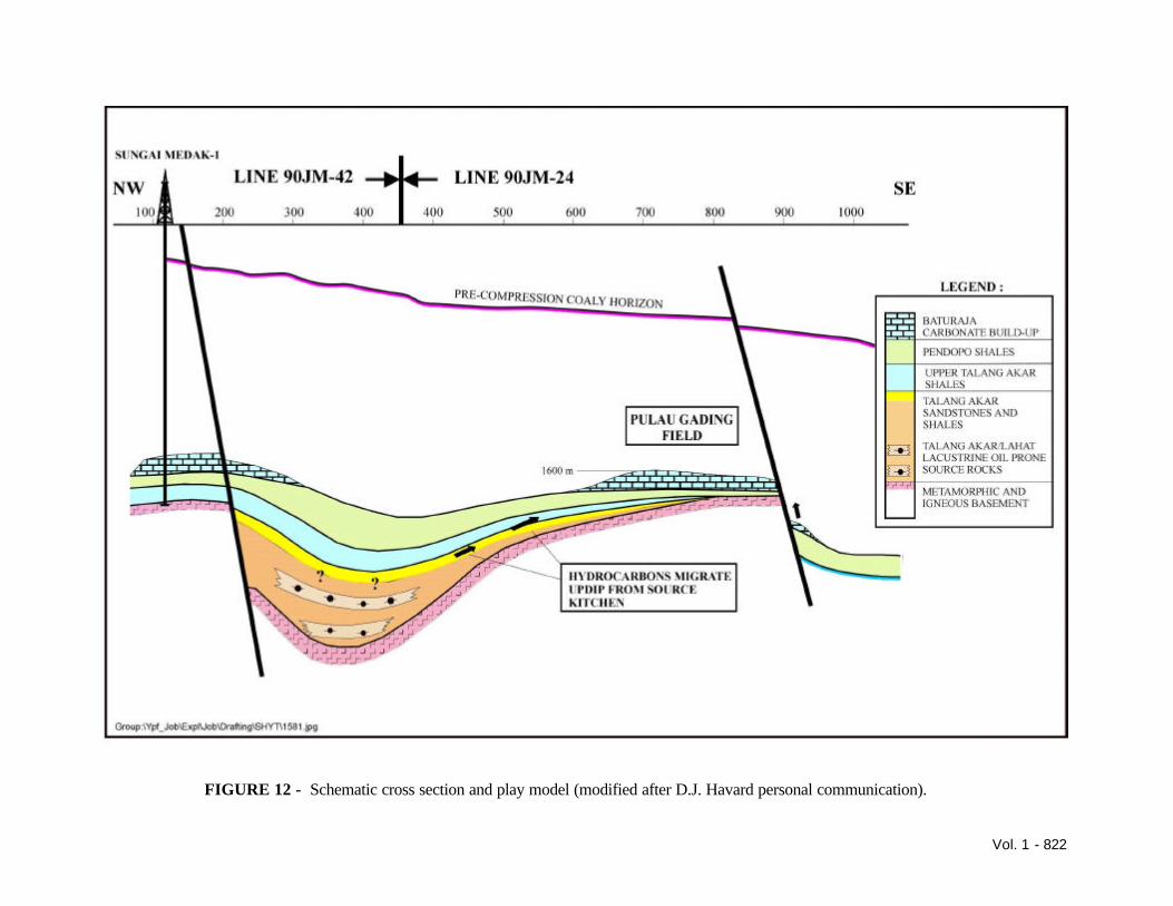
pathway. Modelling indicates that oil will have started migration about 10.6 mya, prior to the last phase of compression, and gas would be migrating at the time of the tectonics. Oil will have been trapped in features present before the last movement and possibly remigrated after faulting and tilting. Gas has displaced some of the oil as demonstrated by the presence of bitumen in Pulau Gading 1 Baturaja limestone. Possible migration pathways have also been examined. Pulau Gading, which has two possible source areas, the East Ketaling Deep and the Merang Deep (Figure 12). If the hydrocarbons are sourced from the Merang deep they would have migrated up the main fault situated at the southern end of the Pulau Gading feature. Any earlier migrated oil will have been forced down structure and could form an oil leg to the present gas condensate discovery. An alternate theory is that hydrocarbons were generated in the East Ketaling Deep. This area must have supplied the oil, which is being produced in the East Ketaling Field which overlies the East Ketaling Deep. The hydrocarbons would have migrated up the slope of the Merang high towards the carbonate play and initially been trapped in the Talang Akar sandstones. These would then have passed through either faults or fractures in the Pendopo Shale into the Baturaja Formation. It is also possible that the oil first migrated and accumulated in the Talang Akar sandstones. When the gas was generated, the hydrocarbon column would have exceeded the fracture pressure of the Pendopo shales thus allowing the hydrocarbons to pass through into the Baturaja limestone. If the hydrocarbons come from the Merang Deep the oil could have migrated up the faults through the Kukulambar-1 area into the Sungai Kenawang build-up prior to it being down thrown to Kukulambar-1. Thus, Sungai Kenawang would be isolated from subsequent gas migration. If the hydrocarbons are from the East Ketaling deep they would have migrated up the faulting at the northwestern end of the build-up, the oils being followed by gas and thus forming a gas cap. TALANG AKAR PLAY The Talang Akar has been demonstrated as a play in the Merang Triangle by the presence of gas in the
Vol. 1 - 809
producing Gelam Field and production to the north and south of the area. The sediment source of the fluvial channels is the Sunda Craton to the northeast of the area. Studies of the sands at Gelam demonstrate the channel’s northeast-southwest orientation. These sands appear to be limited to the northwest and southeast by the extent of the original flood plain and to the south west as they eventually shale out into the marine environment. The Gelam field demonstrates the presence of these sands in the Merang Deep while the Muara Sabak-1 well demonstrates that these sands are present in the East Ketaling Deep. This play has the advantage in that the sands are in close proximity to the hydrocarbon source. At Pulau Gading there is only a thin Talang Akar section overlying basement, encountered as marine shales with thin tight sandstones, thus, the good quality fluvial channel sands are downdip. Recent tilting of the section would cause hydrocarbons to migrate up dip towards the Sembilang High, oil would have migrated prior to the recent uplift of the Sembilang High and recent faulting could have isolated the Cempedak area from later gas migration or alternately provided a conduit. The Sembilang High, although having undergone a large amount of recent uplift was also a high at the time of the initial deposition of the Talang Akar and thus only the later Talang Akar will have onlapped onto it. This then wedges out onto the Sembilang High and forms a stratigraphic trap. It is essential to find the limits of the better quality channel sands, the top of which is very hard to pick. Oil has definitely migrated in this direction, as is demonstrated by oil in a core taken in a shot hole during the 1990 seismic survey. The risk lies in the amount that has been trapped in the Talang Akar and the limits of good quality reservoir sands The recent compression event has also created a large number of faults in this area, which could result in surface leakage. BASEMENT PLAY The numerous basement discoveries by Gulf in the acreage to the south demonstrate the importance of this play. To the north, gas was encountered in basement in Sungai Medak North-1. This also contained a large percentage of CO2. Pulau Gading 1 encountered gas shows in Basement with 25% CO2, this discovery encouraged Saga to deepen Pulau
Gading 1. Lost circulation caused problems, as the lost circulation material will have entered the fractures. An FMS study carried out on the basement showed fractures associated with the gas shows observed on the mudlog. A later test only produced water, but the extent of the penetration of the fractures by lost circulation material is unknown. Pulau Gading 3 encountered no fractures in basement, whilst Pulau Gading 2 had pay on the logs in the top part of the basement. Thus, the play exists within the block and has yet to be reliably established. AIR BENAKAT PLAY The Air Benakat Formation is a major play to the north in the Jambi area; it has been productive at West Berau and is currently producing at East Ketaling. All wells drilled in the block have encountered oil shows within this section. The difficulty is in finding an adequate sized structure and extensive reservoir sandstones, the sands being thin and probably shaled out. A stratigraphic trap is always a possibility in this formation. The first well drilled by Elf, Sukajaya-1, encountered gas in the Air Benekat and the Tempino field up dip produces from this horizon. Also, non-commercial quantities of oil were encountered in the Bayung Lincir wells in the basal part of this formation. CONCLUSIONS The rapid uplift and erosion of the Sembilang High pose regional questions as to the extent of this uplift (local or regional) but possibly, the most important question of all is where did all the eroded sediments go? This uplift will have also effected hydrocarbon migration and remigration as it brought about a regional tilt towards the southwest. The Baturaja carbonate play is dependent on the local diagenetic history and establishing the present day facies distribution, as the recent tectonics have altered the stratigraphic configuration. The Talang Akar requires refinement of the seismic data to establish where the better quality reservoirs wedge out and thus define these stratigraphic traps. A basement play exists, but work still needs to be done to establish a means of predicting it.
Vol. 1 - 810
The current drilling program will further test the Baturaja carbonate play, attempt to find a stratigraphic trap in the Talang Akar as well as increase knowledge of the basement play. ACKNOWLEDGEMENTS The authors would like to thank the management of JOB Pertamina-YPF Jambi Merang, Pertamina, YPF Indonesia, and Amerada Hess for permission to
publish this paper. The authors would also like to acknowledge the work of previous employees of the JOB, which has obviously contributed to this paper. REFERENCE Hutapea, O.M., 1998. The Semoga-Kaji Discoveries: Large Stratigraphic Baturaja Oil Fields in South Sumatra. Proceedings of the Indonesian Petroleum Association, v. 26/1, p. 313-328.
Vol. 1 - 811
FIGURE 1 – Block outlines in the Merang Triangle area of the South Sumatra Basin (Circa 1980).
Vol. 1 - 812
FIGURE 2 – The outline of the Jambi Merang Blcok as originally issued and the current outline.
Vol. 1 - 813
FIGURE 3 – Map showing the Main Tectonic Elements in the Jambi Merang Area.
Vol. 1 - 814
FIGURE 4 – Interpretation of Seismic Profile 90JM-03 aligned northeast-southwest along the East Ketaling Deep.
Vol. 1 - 815
FIGURE 5 – Seismic Profile 90JM-09 aligned northeast-southwest along the Merang Deep.
Vol. 1 - 816
FIGURE 6 – Interpretation of Seismic Profile 90JM-15 aligned northeast-southwest along the Merang High.
Vol. 1 - 817
FIGURE 7 – Interpretation of Seismic Profile 90JM-12 aligned northwest-southeast across the Merang High from the East Ketaling Deep to the Merang Deep.
Vol. 1 - 818
FIGURE 8 – Generalised Chronostratigraphic Chart of the Jambi Merang Block.
Vol. 1 - 819
FIGURE 9 – Modelling of hydrocarbon generation and possible migration 10.6 m.y.a.
Vol. 1 - 820
FIGURE 10 – Modelling of hydrocarbon generation and possible migration 4 m.y.a.
Vol. 1 - 821
FIGURE 11 - Modelling of hydrocarbon generation and possible migration at present day.
Vol. 1 - 822
FIGURE 12 - Schematic cross section and play model (modified after D.J. Havard personal communication).
Vol. 1 - 823
FIGURE 13 – Composite Seismic Line through Sungai Kenawang and Kuklambar in the Present Day Structural configuration.
Vol. 1 - 824
FIGURE 14 – Composite Seismic Line through Sungai Kenawang and Kukulambar-1, flattened on an intra - Gumai event showing the carbonate buildup as it would have been configured just after deposition.