south worcestershire joint core strategy level 1 and level
TRANSCRIPT

South Worcestershire Joint
Core Strategy
Level 1 and Level 2 Strategic
Flood Risk Assessment
November 2009
FINAL REPORT
JBA Consulting Magna House South Street ATHERSTONE Warwickshire CV9 1DF UK t: +44 (0)1827 722 710 f: +44 (0)1827 722 719
www.jbaconsulting.co.uk

South Worcestershire Joint Core Strategy Strategic Flood Risk Assessment Final Report
JBA Consulting www.jbaconsulting.co.uk 30/03/2010 i
REVISION HISTORY
Revision Ref./ Date Issued
Amendments Issued to
Initial Draft Report February 2009
South Worcestershire Joint Core Strategy Environment Agency Severn Internal Drainage Board
Draft Final Report June 2009
Inclusion of storage volumes and runoff rates Inclusion of Floodplain Policy
South Worcestershire Joint Core Strategy Environment Agency Severn Internal Drainage Board British Waterways Severn Trent
Final Report November 2009
Final Comments Added South Worcestershire Joint Core Strategy Environment Agency Severn Internal Drainage Board British Waterways Severn Trent
CONTRACT
This report describes work commissioned by South Worcestershire Joint Core Strategy in October 2008
Prepared by: Edward James BSc, MSc Assistant Analyst
Reviewed by: David Pettifer, CEng, FICE, FCIWEM, MEPS Director
PURPOSE
This document has been prepared solely as a Strategic Flood Risk Assessment Report for South Worcestershire Joint Core Strategy. JBA Consulting accepts no responsibility or liability for any use that is made of this document other than by South Worcestershire Joint Core Strategy for the purposes for which it was originally commissioned and prepared.
ACKNOWLEDGMENTS
JBA would like to thank all those at Wychavon District Council, Worcester City Council, Malvern Hills District Council, Severn Trent Water, British Waterways, Severn IDB and the Environment Agency who provided information and data to support this project. Their assistance is gratefully acknowledged.
South Worcestershire Joint Core Strategy Strategic Flood Risk Assessment Final Report
JBA Consulting www.jbaconsulting.co.uk 30/03/2010 ii
EXECUTIVE SUMMARY
This report is a Strategic Flood Risk Assessment (SFRA) for South Worcestershire Joint Core Strategy area, which includes the City of Worcester Council, Wychavon District Council and Malvern Hills District Council areas. It is a Level 1 and Level 2 SFRA. This SFRA has been prepared in accordance with current best practice, Planning Policy Statement 25 Development and Flood Risk (PPS25).
The SFRA constitutes one of a number of planning tools that enables the Local Authorities to select and develop sustainable site allocations away from areas of greatest vulnerability to flooding in the South Worcestershire Joint Core Strategy area. The assessment includes specific preferred development locations that are proposed for the South Worcestershire Joint Core Strategy Pre-submission Document.
The report discusses the flood risk within the South Worcestershire Joint Core Strategy area as a whole, allowing an informed decision to be taken when allocating future development sites, and sets out the procedure to be followed when assessing sites in the future. The SFRA will assist the Local Authorities to make the spatial planning decisions required to inform the Local Development Framework (LDF) for the South Worcestershire Joint Core Strategy area.
High level planning, policy and guidance documents have been identified which have to be taken into account in preparing this SFRA. The documents which have been reviewed include national, regional and local planning legislation, together with Environment Agency policy guidance.
A thorough review of existing information and undertaking of additional flood modelling work has identified the level of flood risk in the South Worcestershire Joint Core Strategy area from fluvial and other sources. An assessment of the impact of climate change on flood risk in the catchment is a highly important consideration. An allowance for climate change over the 100 year period to 2109 has been included in the assessment of flood risk. There are limited flood defences within the South Worcestershire Joint Core Strategy area and as such, no assessment of flood risk from breaches or residual (overtopping) flooding has been undertaken.
A surface water vulnerability map has been produced in this SFRA with historic surface water, sewer water flooding and highway flooding areas shown.
Maps and GIS layers have been provided with the report showing the extents of Flood Zones 2, 3a and 3b, and the effect of climate change on Flood Zone 3a.
No major flood defences are present in the SFRA area so the Flood Zone Maps give a good first indication of actual flood risk in the South Worcestershire Joint Core Strategy area. Detailed hydraulic models exist for the River Severn and Barbourne Brook at Worcester, the River Avon at Evesham and Pershore, the River Salwarpe at Droitwich, the River Severn at Upton upon Severn and the River Teme at Tenbury Wells. These models will give a more detailed flood risk in the areas covered.
The only formal flood defences within the South Worcestershire Joint Core Strategy area are new floodbanks and demountable defences at Hylton Road Worcester and minor agricultural embankments along the River Severn. The agricultural embankments are maintained by the Environment Agency and provide an important flood storage function by allowing flood waters to enter washlands behind them at a certain stage in a flood event and thus reduce peak flood levels downstream in the towns of Upton upon Severn, Tewkesbury and Gloucester.
An overview of flood risk within South Worcestershire Joint Core Strategy has been undertaken, allowing the Councils to apply the Sequential Test. It provides advice on any site-specific requirements for a Flood Risk Assessment within the different flood zones, and advises the Councils on the use of the Exception Test, should the Sequential Test be passed.
Guidance for the Councils on the future management of development with respect to flood risk has been given, including suggested development control policy for the different flood zones and possible types of development. Advice has also been given regarding strategic flood risk management and emergency planning.
In addition, an outline has been given of requirements for developers for Flood Risk Assessments, with supporting guidance on reducing flood risk and making development safe, including Sustainable Drainage Systems (SuDS) and flood mitigation measures. Advice is also given on environmental improvement opportunities and other issues to consider as part of a development proposal.

South Worcestershire Joint Core Strategy Strategic Flood Risk Assessment Final Report
JBA Consulting www.jbaconsulting.co.uk 30/03/2010 iii
CONTENTS
Page REVISION HISTORY i CONTRACT i PURPOSE i ACKNOWLEDGMENTS i EXECUTIVE SUMMARY ii CONTENTS iii LIST OF FIGURES, MAPS & TABLES v ABBREVIATIONS vi GLOSSARY vii
1 INTRODUCTION ----------------------------------------------------------------------------------------------------- 1 1.1 Background .................................................................................................................................... 1 1.2 Scope and objectives ..................................................................................................................... 1 1.3 Study area ...................................................................................................................................... 1 1.4 Main sources of flooding ................................................................................................................ 1 1.5 Existing Flood Defence Infrastructure ............................................................................................ 3 1.6 Historic Flooding............................................................................................................................. 3 1.7 Emergency Planning ...................................................................................................................... 3 1.8 SFRA User Guides ......................................................................................................................... 3 1.9 Updating of SFRA .......................................................................................................................... 3
2 THE PLANNING FRAMEWORK --------------------------------------------------------------------------------- 5 2.1 Introduction ..................................................................................................................................... 5 2.2 Flood Risk Management Drivers .................................................................................................... 5 2.3 National Planning Policy ................................................................................................................ 9 2.4 Regional Planning Policy ............................................................................................................. 12 2.5 Green Infrastructure Framework .................................................................................................. 14
3 STRATEGIC FLOOD RISK ASSESSMENT OVERVIEW ------------------------------------------------ 16 3.1 Background to Strategic Flood Risk Management Objectives ..................................................... 16 3.2 Overview of the SFRA Process .................................................................................................... 16 3.3 Sequential Flood Risk Test (SFRT) – PPS25 .............................................................................. 18 3.4 The Exception Test ...................................................................................................................... 18 3.5 Flood Risk Vulnerability Classification ......................................................................................... 19 3.6 Specific Guidance ........................................................................................................................ 21 3.7 Flood Zone 3a – High Probability ................................................................................................. 22 3.8 Flood Zone 3b – The Functional Floodplain ................................................................................ 25 3.9 Flood Zone 2 – Medium Probability ............................................................................................. 26 3.10 Flood Zone 1 – Low Probability .................................................................................................... 26 3.11 Other Known Flood Risk Areas .................................................................................................... 26 3.12 Catchment Flood Management Plan............................................................................................ 27 3.13 Flood Warning .............................................................................................................................. 28
4 DATA SOURCES -------------------------------------------------------------------------------------------------- 29 4.1 Data Collection ............................................................................................................................. 29 4.2 Flood Zone Map ........................................................................................................................... 29 4.3 Flood Defences ............................................................................................................................ 30 4.4 Hydraulic Modelling ...................................................................................................................... 30 4.5 History of Flooding ....................................................................................................................... 30
5 APPROACH TO THE SOUTH WORCESTERSHIRE JOINT CORE STRATEGY STRATEGIC FLOOD RISK ASSESSMENT ---------------------------------------------------------------------------------- 31
5.1 Overview ...................................................................................................................................... 31 5.2 Delineation of Flood Zones .......................................................................................................... 32 5.3 Groundwater Flood Risk .............................................................................................................. 33
South Worcestershire Joint Core Strategy Strategic Flood Risk Assessment Final Report
JBA Consulting www.jbaconsulting.co.uk 30/03/2010 iv
CONTENTS
Page 5.4 Spatial Data .................................................................................................................................. 34 5.5 Limitations of Background Information ......................................................................................... 34
6 LEVEL 2 ASSESSMENT OF FLOOD RISK ----------------------------------------------------------------- 36 6.1 Overview and Aims ...................................................................................................................... 36 6.2 Detailed Hydraulic Modelling ........................................................................................................ 36 6.3 Flood Hazard Mapping ................................................................................................................. 36 6.4 Identification of Localised Drainage Issues .................................................................................. 37
7 INITIAL ASSESSMENT OF SITES PROPOSED FOR THE PRE-SUBMISSION DOCUMENT 42 7.1 Introduction ................................................................................................................................... 42
8 GUIDANCE FOR DETAILED FLOOD RISK ASSESSMENT ------------------------------------------- 91 8.1 General ......................................................................................................................................... 91 8.2 Standard Flood Risk Management Guidance for Developers ..................................................... 91 8.3 Assessment of Fluvial Flood Risk ................................................................................................ 91 8.4 Climate Change............................................................................................................................ 92 8.5 Mitigation Measures ..................................................................................................................... 92 8.6 Windfall Sites ................................................................................................................................ 92 8.7 Pre- Planning Guidance for Developers ...................................................................................... 93 8.8 Sustainable Drainage Systems .................................................................................................... 94 8.9 Surface Water Drainage Assessments ...................................................................................... 101 8.10 Reducing Flood Risk .................................................................................................................. 101 8.11 Managing Flood Risk from Other Sources ................................................................................. 103 8.12 Making Development Safe ......................................................................................................... 104 8.13 Making Space for Water ............................................................................................................. 105 8.14 Future Planning Applications ..................................................................................................... 105 8.15 Requirements at Detailed Planning Stage ................................................................................. 105
9 RECOMMENDED POLICY FOR MANAGEMENT OF FLOOD RISK ------------------------------- 106 9.1 Recommended Policy ................................................................................................................ 106
10 CONCLUSIONS -------------------------------------------------------------------------------------------------- 108
11 LIST OF ENDNOTES ------------------------------------------------------------------------------------------- 109
APPENDICES:
Appendix A National Plans, Policies and Strategies
Appendix B Level 1 Flood Zones & Climate Change Flood Outlines
Appendix C Surface Water Flood Risk Mapping
Appendix D Other Sources Flood Risk Mapping
Appendix E Floodplain Policy Mapping
Appendix F Guidance Flow Charts

South Worcestershire Joint Core Strategy Strategic Flood Risk Assessment Final Report
JBA Consulting www.jbaconsulting.co.uk 30/03/2010 v
LIST OF FIGURES
Figure 3-1: The SFRA Process ........................................................................................................................ 16
Figure 3-2: Illustration of the undefended scenario under fluvial and/or tidal flood risk ................................... 23
Figure 3-3: Illustration of the defended scenario and residual flood risk behind fluvial/tidal defences ............ 23
LIST OF MAPS
Map 1: South Worcestershire Joint Core Strategy SFRA Study Area
LIST OF TABLES
Table 2-1: Reviewed National and Regional Strategies and Plans for the SFRA Study Area ........................... 5
Table 3-1: Flood Risk Vulnerability Classification ............................................................................................ 20
Table 3-2: Flood Risk Vulnerability and Flood Zone Compatibility ................................................................... 21
Table 4-1: Data availability for use in the South Worcestershire Joint Core Strategy area SFRA ................... 29
Table 6-1: Flood Hazard Rating Matrix............................................................................................................. 37
Table 6-2: Flood Hazard Rating Classification ................................................................................................. 37
Table 7-1: Worcester North West ..................................................................................................................... 43
Table 7-2: Worcester North .............................................................................................................................. 46
Table 7-3: Fernhill Heath .................................................................................................................................. 49
Table 7-4: Kilbury Drive, Worcester .................................................................................................................. 52
Table 7-5: Worcester South .............................................................................................................................. 55
Table 7-6: Copcut Lane, Droitwich Spa ............................................................................................................ 58
Table 7-7: Pulley Lane, Droitwich Spa ............................................................................................................. 61
Table 7-8: Hill End, Droitwich Spa .................................................................................................................... 64
Table 7-9: Malvern North .................................................................................................................................. 67
Table 7-10: Malvern East.................................................................................................................................. 70
Table 7-11: Malvern South ............................................................................................................................... 73
Table 7-12: Blackmore Park ............................................................................................................................. 76
Table 7-13: Pershore ........................................................................................................................................ 79
Table 7-14: Hampton, Evesham ....................................................................................................................... 82
Table 7-15: Cheltenham Road, Evesham ........................................................................................................ 85
Table 7-16: Offenham Road, Evesham ............................................................................................................ 88
Table 8-1: Rationale for Flood Resilient and/or Resistant Design Strategies .................................................. 93
Table 8-2: SuDS Techniques ............................................................................................................................ 95
Table 8-3: Safe Access .................................................................................................................................. 104

South Worcestershire Joint Core Strategy Strategic Flood Risk Assessment Final Report
JBA Consulting www.jbaconsulting.co.uk 30/03/2010 vi
ABBREVIATIONS
ABD AEP
Areas Benefiting From Defences Annual Exceedance Probability
AONB BRE 365
Area of Outstanding Natural Beauty Building Research Establishment: Soakaway Design Guidance
CC Climate Change CFMP CIRIA 156 CLG
Catchment Flood Management Plan Construction Industry Research and Information Association: Infiltration Design Manual of Good Practice Communities and Local Government
COWC City of Worcester Council DEFRA DF DPD
Department for the Environment, Food and Rural Affairs Debris Factor Development Plan Document
EA EU FEH FLL
Environment Agency European Union Flood Estimation Handbook Landscape Research, Development and Construction Society
FRA FRM FRMP
Flood Risk Assessment Flood Risk Management Flood Risk Management Plan
FZ GDPO
Flood Zone General Development Procedure Order
Ha IDB
Hectare Internal Drainage Board
JBA Jeremy Benn Associates Ltd LDD Local Development Document LDF Local Development Framework LPA Local Planning Authority MHDC Malvern Hills District Council m AOD Metres Above Ordnance Datum MSfW NFCDD
Making Space for Water National Flood Coastal Defence Database
OS NGR PAG 2 PFRA
Ordnance Survey National Grid Reference Project Appraisal Guidance Preliminary Flood Risk Assessment
PPG25 Planning Policy Guidance Note 25 PPS25 Planning Policy Statement 25 RFRA RSS
Regional Flood Risk Appraisal Regional Spatial Strategy
SA SEA SFR SFRA
Sustainability Assessment Strategic Environmental Assessment Significant Flood Risk Strategic Flood Risk Assessment
SFRT SMP
Sequential Flood Risk Test Shoreline Management Plan
SSSI STW
Site of Specific Scientific Interest Sewage Treatment Works
SuDS SWMP WCC WDC WFD WHS
Sustainable Drainage Systems Surface Water Management Plan Worcester City Council Wychavon District Council Water Framework Directive World Heritage Sites
South Worcestershire Joint Core Strategy Strategic Flood Risk Assessment Final Report
JBA Consulting www.jbaconsulting.co.uk 30/03/2010 vii
GLOSSARY
Actual Risk The risk posed to development situated within a defended area (i.e. behind defences), expressed in terms of the probability that the defence will be overtopped, and/or the probability that the defence will suffer a structural failure, and the consequence should a failure occur.
Annual Exceedance Probability
e.g. 1% AEP
Refer to „probability‟.
Brownfield Brownfield (sites or land) is a term in common usage that may be defined as „development sites or land that has previously been developed‟. Prior to PPS25, the term „Brownfield‟ was used in Governmental Guidance and Statements, but in PPS25 has been replaced with „Previously-developed land‟. See „Greenfield‟.
Catchment Flood Management Plan
CFMP A strategic planning tool through which the Environment Agency will seek to work with other key decision-makers within a river catchment to identify and agree policies for sustainable flood risk management.
Compensatory Storage A floodplain (flood storage) area introduced to compensate for the loss of storage as a result of filling for development purposes.
Core Strategy
CS This is the strategic vision of an area and is a central pillar of the Local Development Framework, comprising: A Vision, Strategic Objectives, a spatial land use strategy, core policies and a monitoring and implementation framework. The Core Strategy is a Development Plan Document which will determine overall patterns of future development, identifying site specific and broad locations where future growth will take place The revised PPS12 enables a local planning authority to allocate strategic sites within a core strategy. All other Development Plan Documents should be in broad conformity with the Core Strategy Document The Core Strategy is a mandatory document, and a timetable for production is set out within the Local Development Scheme.
Defended Area An area offered a degree of protection against flooding through the presence of a flood defence structure.
Development Plan Documents
DPDs These documents have Development Plan Status and consequently form part of the statutory development plan for the area. A DPD will be subject to an independent hearing. Typical documents that will have DPD status include the Core Strategy, Site-specific Allocations of Land, Proposals Map, and Area Actions Plans (where needed).
Exception Test An integral part of the risk-based approach at the core of PPS25, the Exception Test is designed to allow for those exceptional circumstances when, for wider sustainability reasons, development not entirely compatible with the level
South Worcestershire Joint Core Strategy Strategic Flood Risk Assessment Final Report
JBA Consulting www.jbaconsulting.co.uk 30/03/2010 viii
of flood risk may be permitted. For the Exception Test to be passed, all three of its components must be fulfilled.
Flood Estimation Handbook FEH Provides current methodologies for estimation of flood flows for the UK.
Flood Hazard A classification system developed by DEFRA/Environment Agency that gives an assessment of the hazard posed by a flood event at a given location. It is defined using the maximum modelled flood depth, velocity and a factor to allow for debris.
Floodplain Any area of land over which water flows or is stored during a flood event or would flow but for the presence of defences.
Flood Risk Assessment FRA A detailed site-based investigation that is undertaken by the developer at planning application stage.
Flood Risk Management The introduction of mitigation measures (or options) to reduce the risk posed to property and life as a result of flooding. It is not just the application of physical flood defence measures.
Flood Risk Vulnerability Classification
Refer to Section 3.5.
Flood Zone 1 FZ1 This zone comprises land assessed as having a less than 1 in 1000 annual probability of river or sea flooding in any year (<0.1%).
Flood Zone 2 FZ2 This zone comprises land assessed as having between a 1 in 100 and 1 in 1000 annual probability of river flooding (1%-0.1%) or between a 1 in 200 and 1 in 1000 annual probability of sea flooding (0.5%-0.1%) in any year.
Flood Zone 3a FZ3a This zone comprises land assessed as having a 1 in 100 or greater annual probability of river flooding (>1%) or a 1 in 200 or greater annual probability of flooding from the sea (>0.5%) in any year.
Flood Zone 3b FZ3b This zone comprises land where water has to flow or be stored in times of flood. This is land which would flood with an annual probability of 1 in 20 (5%) or greater in any year or other probability flood event agreed between the local authority and the Environment Agency. Designated as Functional Floodplain.
Fluvial Flooding
Flooding caused by the overtopping of river or stream banks.
Formal Defence A flood defence asset that is maintained by the Environment Agency.
Freeboard A „safety margin‟ to account for residual uncertainties in water level prediction and/or structural performance, expressed in mm.
Functional Floodplain An area of land where water has to flow or be stored in times of (fluvial) flooding (Flood Zone 3b).
Greenfield Greenfield (sites or land) is a term in common usage that may be defined as „development sites or land that has not previously been developed‟. Prior to PPS25 the term „Greenfield‟ was used in Governmental Guidance and Statements, but in PPS25 has been replaced with

South Worcestershire Joint Core Strategy Strategic Flood Risk Assessment Final Report
JBA Consulting www.jbaconsulting.co.uk 30/03/2010 ix
„Undeveloped land‟ See „Brownfield‟
Informal Defence A structure that provides a flood defence function, however is not owned nor maintained by the Environment Agency.
Internal Drainage Board IDB An Internal Drainage Board is a statutory body that provides storm water management by operating and maintaining an artificial surface water drainage system.
Local Development Framework
LDF The Local Development Framework is made up of a series of documents that together will form part of the Development Plan. Broadly, Local Development Framework documents fall into two categories: - Development Plan Documents - Supplementary Planning Documents.
Local Development Scheme LDS A Local Development Scheme is a public statement of the Council programme for the preparation of Local Development Documents which will form the Local Development Framework.
Local Planning Authority LPA Local authority with responsibility for determining whether proposed developments are approved or otherwise.
Main River A watercourse designated as such by DEFRA that is regulated and maintained by the Environment Agency using their permissive powers.
Measure A deliverable solution that will assist in the effective management (reduction) of risk to property and life as a result of flooding, e.g. flood storage, raised defence, effective development control and preparedness, and flood warning.
Mitigation The management (reduction) of flood risk.
Option Refer to „measure‟.
PAG2 Project Appraisal Guidance (PAG) 2 (Strategic Planning) outlines the DEFRA requirements against which the Environment Agency must demonstrate that they are managing flood risk in a strategic (catchment wide) manner.
Probability e.g. 1% A measure of the chance that an event will occur. The probability of an event is typically defined as the relative frequency of occurrence of that event, out of all possible events. Probability can be expressed as a fraction, percentage or a decimal. For example, the probability of obtaining a six with the shake of a fair die is 1/6, 16% or 0.166. Probability is often expressed with reference to a time period, for example, annual exceedance probability. For example, a 1% AEP event is an event with a 1% chance of occurring or being exceeded in any one year.
Proposals Map
This is an Ordnance Survey based map that spatially illustrates policies and proposals within LDDs.
South Worcestershire Joint Core Strategy Strategic Flood Risk Assessment Final Report
JBA Consulting www.jbaconsulting.co.uk 30/03/2010 x
The Proposals Map will show planning policy designations and land allocations identified within DPDs, statutory land use and landscape designations and other land and area based designations. It will form part of the statutory development plan.
Residual Risk The risk that inherently remains after implementation of a flood mitigation measure (option).
Return Period e.g. 1 in 100-Year
The expected (mean) time (usually in years) between the exceedance of a particular extreme threshold. Return period is traditionally used to express the frequency of occurrence of an event, although it is often misunderstood as being a probability of occurrence.
Risk The threat to property and life as a result of flooding, expressed as a function of probability (that an event will occur) and consequence (as a result of the event occurring).
Sequential Flood Risk Test SFRT The assessment and „categorisation‟ of flood risk on a catchment-wide basis in accordance with PPS25.
Site Specific Allocations Development Plan Document
A mandatory document, the Allocations Development Plan Document is a high priority item for preparation, details of which are provided in the Local Development Scheme. Prepared in conformity with the Core Strategy, once approved, the Allocations Document will identify sites for development as part of the delivery of the overall planning strategy for the area.
Standard of Protection SoP The return period to which properties are protected against flooding
Strategic Flood Risk Assessment
SFRA The assessment of flood risk on a catchment-wide basis for proposed development in a District
Strategic Flood Risk Management
SFRM Considers the management of flood risk on a catchment-wide basis, the primary objective being to ensure that the recommended flood risk management „measures‟ are sustainable and cost effective
Supplementary Planning Documents
SPD Supplementary Planning Documents, or SPD, support DPDs in that they may cover a range of issues, both thematic and site specific. Examples of SPDs may be design guidance or development briefs. SPDs may expand policy or provide further detail to policies in a DPD. They will not be subject to independent hearing.
Sustainable Drainage Systems
SuDS Current „best practice‟ for new development that seeks to minimise the impact upon the localised drainage regime, e.g. through the use of pervious areas within a development to reduce the quantity of runoff from the development.
Uncertainty A reflection of the (lack of) accuracy or confidence that is considered attributable to a predicted water level or (modelled) flood extent.
Windfall Sites Sites that become available for development unexpectedly and are not included in a planning authority‟s development plan as allocated land.
South Worcestershire Joint Core Strategy Strategic Flood Risk Assessment Final Report
JBA Consulting www.jbaconsulting.co.uk : 30/03/2010 1
1 INTRODUCTION
1.1 Background
In October 2008 JBA Consulting was commissioned to undertake a Level 1 and Level 2 Strategic Flood Risk Assessment (SFRA) for South Worcestershire Joint Core Strategy, including the areas of Wychavon District Council (WDC), Worcester City Council (WCC) and Malvern Hills District Council (MHDC). Major towns within the area include Worcester, Evesham, Upton upon Severn, Droitwich Spa, Malvern, Pershore and Tenbury Wells.
This SFRA has been prepared in accordance with current best practice, Planning Policy Statement 25 Development and Flood Risk (PPS25)1. The SFRA will assist the Local Planning Authorities (LPA) to make the spatial planning decisions required to inform their Local Development Framework (LDF).
The SFRA is a planning tool that enables the LPA to select and develop sustainable allocations away from the highest flood risk areas. This report sets out the procedure to be followed when assessing sites for development in the future.
The SFRA should be treated as a „dynamic‟ document that is periodically reviewed as further information becomes available to provide a better understanding of flood risk, for example strategy reports or additional river modelling, or if conditions change that impact on the nature of flood risk, for example the presence and characteristics of flood defences.
1.2 Scope and objectives
The overall objective for this SFRA is to provide sufficient information for the application of the Sequential Test and to identify whether application of the Exception Test is likely to be necessary. It involves a broad scale assessment of flood risk to identify sites at flood risk from fluvial and other sources of flooding, utilising existing available information. In addition to this, the SFRA will allow the councils to:
prepare appropriate policies for the management of flood risk within their area;
inform the Sustainability Appraisal so that flood risk is taken into account when considering options and in the preparation of strategic land use policies;
identify the level of detail required for site-specific Flood Risk Assessments (FRA) in particular locations; and
enable the councils to determine the acceptability of flood risk in relation to emergency planning capability.
1.3 Study area
The study area comprises the towns of Worcester, Evesham, Upton upon Severn, Droitwich Spa, Malvern, Pershore and Tenbury Wells together with surrounding villages in Wychavon and Malvern Hills districts. In total the SFRA covers an area 1270km
2 as shown in Map 1 at the end of the report.
Significant watercourses within the study area are the River Severn, River Avon, River Salwarpe, Barbourne Brook and River Teme.
The Lower Severn Internal Drainage Board area covers a small part of Malvern Hills District in the south of the South Worcestershire Joint Core Strategy area.
The key transport route passing through the study area is the M5 motorway.
1.4 Main sources of flooding
The main causes of flooding are considered to be fluvial and surface water (either overland or from sewers). Flood risk from canal and reservoir breaches and groundwater have also been considered. There can be a tidal influence on the River Severn as far as Worcester, however the effect of fluvial flows are dominant, therefore no tidal risk has been included.
South Worcestershire Joint Core Strategy Strategic Flood Risk Assessment Final Report
JBA Consulting www.jbaconsulting.co.uk : 30/03/2010 2
Worcester
The main causes of flooding within Worcester are the River Severn, River Teme, Barbourne Brook, several smaller watercourses and surface water flooding from sewers and overland flow. Canal flooding has also been recorded in the past which has been attributed to vandalism of the lock gates.
Evesham
The main causes of flooding within Evesham are the River Avon, River Isbourne, Battleton Brook, several smaller watercourses and surface water flooding from sewers and overland flow.
Pershore
The main causes of flooding within Pershore are the River Avon, several smaller watercourses and surface water flooding from sewers and overland flow.
Droitwich Spa
The main causes of flooding within Droitwich are the River Salwarpe, Elmbridge Brook and surface water flooding from sewers and overland flow. In addition, the Droitwich Canal interacts with the River Salwarpe in several places and needs to be considered.
Tenbury Wells
The main causes of flooding within Tenbury Wells are the River Teme, Kyre Brook and surface water flooding from sewers and overland flow. Flooding usually occurs first from the Kyre Brook before flooding from the River Teme starts. In addition, a culverted section of an un-named watercourse causes flooding at Bog Lane.
Malvern
The main cause of flooding within Malvern is surface water flooding from sewers and overland flow. Outside of Malvern itself but within Malvern Hills District the Hatfield Brook in Kempsey causes flooding. Short duration intense storms causing flash or rapid response flooding in smaller watercourses are a particular problem.
Upton upon Severn
The main causes of flooding within Upton upon Severn are the River Severn and surface water flooding from sewers and overland flow. There is an important flood flow route to west of the town during extreme flood events on the River Severn, which essentially isolates the town. Proposals for permanent defences within Upton upon Severn have been flagged for the near future.
Villages
The main causes of flooding within the villages are the smaller watercourses and surface water flooding from sewers and overland flow.
Surface water flooding resulting from short duration, intense storms poses a possible risk to development. Flooding along watercourses in urban areas can, in some cases, be associated with the surcharge of subsurface drainage systems or the blockage of structures (e.g. culverts, gullies, outfalls or bridges).
In smaller communities, it may be the cumulative effect of several small developments that could rise to flooding problems.
South Worcestershire Joint Core Strategy Strategic Flood Risk Assessment Final Report
JBA Consulting www.jbaconsulting.co.uk : 30/03/2010 3
1.5 Existing Flood Defence Infrastructure
There are limited flood defences within the South Worcestershire Joint Core Strategy area. Agricultural defences are located along the River Severn downstream of Worcester. These are permanent earth embankments which exist along the rural areas of the River Severn and are mostly constructed to a 1 in 10-year (0.5% AEP) level, designed to protect agricultural land against the more frequent floods but to allow the larger floods to overtop and fill washland areas behind them. The effect of filling these washland areas is to provide attenuation of flood flows going downstream and hence they are extremely important for the flood protection of the larger towns such as Upton upon Severn, Tewkesbury and Gloucester. In addition, temporary defences in Upton on Severn give some protection from flooding for more frequent flood events. A demountable and permanent defence has recently been completed at Hylton Road in Worcester which offers 1 in 100 year standard of protection. However it must be noted that the 1 in 100 year standard of protection does not include an allowance for climate change.
1.6 Historic Flooding
Fluvial flooding has occurred in the South Worcestershire Joint Core Strategy area on several occasions in the past. The most recent noticeable events occurred in 1998, 2000 and 2007, when several hundred properties flooded on each occasion. The floods in 1998 were attributed to a large storm event whilst the November and December 2000 events were the largest flood events since 1947. In 2007, there were over 1600 recorded incidents of flooding in Wychavon alone and nearly 200 properties flooded in Worcester. This particular event was a combination of fluvial and surface water flooding.
Although hydraulic computer modelling can give a good estimate of the flood risk to properties and areas of land for various return period flood events, records of actual flooding incidents will provide a better indication of where problems are likely to occur. In this respect flood incidents from the 1998 and 2007 flood events have been considered in this SFRA.
1.7 Emergency Planning
Under the Civil Contingencies Act (2004) Worcester City, Wychavon and Malvern Hills Councils are classified as a category 1 responder. During an emergency such as a flood event, coordination with the other category 1 responders (including the emergency services and the Environment Agency) is essential to guarantee the safety of residents. Under the Civil Contingencies Act, the Local Authority holds a statutory duty to provide civil protection to their communities to ensure human welfare, environmental stability and UK security are not affected. Under the Act, risk assessments and planning is arranged through Local and Regional Resilience Forums (LRF/RRF).
The aim of the SFRA is to try and avoid development in flood risk areas in the first instance. However, it has also been accepted that there is current development in flood risk areas and there will need to be a level of continued regeneration. Minimising flood risk to people, property and the environment should be considered. Flood defences go some way in reducing the current flood risk by providing a standard of protection, however there is still a residual risk associates with them as they can be overtopped or breached. Flood Warnings is an integral part of flood risk management, for which the Environment Agency are the lead authority responsible for warning the public, local authorities and emergency services.
This SFRA contains useful data to allow emergency planning processes to be tailored to the needs of the area and be specific to the flood risks faced. The detailed maps and GIS layers provided should be made available for consultation by emergency planners during an event
1.8 SFRA User Guides
Flow Charts are provided in Appendix F as guidance for using the SFRA, Planning Application Process/Development Control and undertaking the Sequential Test.
1.9 Updating of SFRA
Whilst this SFRA has been produced using the most up-to-date national guidance and flood risk data, it is recommended that the SFRA should be updated on a regular basis. The Environment Agency has suggested that this be every 3 to 4 years, unless there is a significant flood affecting the area, arising to new information or areas at flood risk. A review of the SFRA should also be

South Worcestershire Joint Core Strategy Strategic Flood Risk Assessment Final Report
JBA Consulting www.jbaconsulting.co.uk : 30/03/2010 4
undertaken if there are any major national policy changes new detailed hydraulic models become available for the larger watercourses.
There are a number of key outputs from possible future studies and datasets which are known to be regularly updated. These should be incorporated in any update to the SFRA.
South Worcestershire Joint Core Strategy Strategic Flood Risk Assessment Final Report
JBA Consulting www.jbaconsulting.co.uk : 30/03/2010 5
2 THE PLANNING FRAMEWORK
2.1 Introduction
The purpose of this section of the report is to identify and outline those high level documents which must be taken into account in preparing this SFRA, from a national to local level.
The land use planning process is driven by a whole host of policy guidance on a national, regional and local level. Whilst the majority of these policies are not aimed at mitigating flood risk, there are key links at strategic, tactical and operational levels between land use and spatial planning (Regional and Local Government), and Flood Risk Management (FRM) planning (Environment Agency), which should be considered as part of a planned and integrated approach to delivering sustainable development.
The sustainability appraisal will help draw together these links and balance the application of wider social, economic and environmental planning policy and guidance. Flood risk assessment is required at all levels of the planning process and for all major developments in flood risk areas; these play an increasingly important role in assisting effective delivery of key planning objectives.
A summary of the principal acts, guidance, strategies and plans of relevance to the South Worcestershire Joint Core Strategy SFRA study area are presented in Table 2-1.
Table 2-1: Reviewed National and Regional Strategies and Plans for the SFRA Study Area
Strategy, Plan Abbreviation Produced by Year Published
National Strategies
Planning and Compulsory Purchase Act HM Government 2004
Planning Policy Statement 1: Delivering Sustainable Development
PPS1 Communities and Local Government Office
2005
Planning Policy Statement 12: Local Spatial Planning
PPS12 Communities and Local Government Office
2008
Planning Policy Statement 25: Development and Flood Risk
PPS25 Communities and Local Government Office
2006
Planning Policy Statement 3: Housing PPS3 Communities and Local Government Office
2006
Planning Policy Guidance 4: Industrial, Commercial Development and Small Firms
PPG4 Communities and Local Government Office
1992
Planning Policy Statement 6: Planning for Town Centres
PPS6 Communities and Local Government Office
2005
Making Space for Water – Government strategy for flood and coastal erosion risk management
DEFRA MSW DEFRA 2005
Regional Strategies
River Severn Catchment Flood Management Plan
Fluvial Severn CFMP
Environment Agency Draft May 2008
Local Strategies
Worcester Local Floodplain Management Policies
Worcester City Council Currently valid to 2011
2.2 Flood Risk Management Drivers
The principal FRM policy drivers are brought together in the Government‟s recently released draft Flood and Water Management Bill, an important part of the Government‟s response to Sir Michael Pitt‟s Report on the summer 2007 floods. It also gives effect to a number of commitments in the Government‟s “Future Water” strategy document. In addition, the draft Bill responds to a number of

South Worcestershire Joint Core Strategy Strategic Flood Risk Assessment Final Report
JBA Consulting www.jbaconsulting.co.uk : 30/03/2010 6
climate change challenges including, more frequent extreme weather events causing a greater risk of flooding and drought, increased population, increased water demand and more water quality problems. It provides the Environment Agency with a strategic overview role for flood risk in England and Wales and gives local authorities in England a clear leadership role in local flood risk management encompassing all sources of flooding. An improved integrated and risk based approach is proposed to the future management of flood risks, and this requires other concerns such as sustainability, biodiversity and the whole water cycle to be taken into account by local authorities and other relevant organisations.
A core policy thread running through all current policy drivers is the fundamental shift in emphasis from building defences to prevent flooding, to one of managing flood risk by using a suite of measures. All operating authorities are required to invest in the provision of sustainable flood risk management and this includes LPAs adopting a flood risk management hierarchy of assessing, avoiding, substituting, controlling and mitigating flood risk through the land use planning system. They should have regard to flooding from all sources (particularly surface water and not just from rivers and the sea). Government does however; recognise that in some circumstances, appropriate mitigation measures may still involve new flood defences, or improving and maintaining existing flood defences where justified, to protect increasingly vulnerable communities.
Current key policy related documents provide LPAs with important and valuable knowledge on the strategic direction of flood risk management and assist their strategic land use planning decision making for re-generation, inward investment and growth etc.
Key documents currently influencing FRM policy are:
EU Floods Directive – (2007)
Draft Floods and Water Management Bill – Defra (2009)
Future Water (2008)
Improving Surface Water Drainage – Defra (2008)
Making Space for Water – Defra (2005)
Planning Policy 25: Development & Flood Risk - (2006)
Planning Policy 25: Development & Flood Risk Practice Guide - (2008)
Learning Lessons from the 2007 Floods – Sir Michael Pitt (2008)
Catchment Flood Management Plans
Shoreline Management Plans
2.2.1 EU Floods Directive
The “EU Floods Directive” aims to reduce and manage the risk floods pose to human health, the environment, cultural heritage and economic activity. Member States have two years in which to transpose its provisions into domestic legislation and the first requirements of the Directive begin at the end of 2011. By this date, an evidence base for flood risk should be developed to map the risk and then produce plans to manage it. Preliminary Flood Risk Assessments (PFRAs) for all sources of flooding need to be prepared showing the impact of historic flooding and the potential impact of a repeat event. Following this, areas of potentially Significant Flood Risk (SFR) need to be defined. In addition, and by the end of 2013, flood hazard and flood risk maps for the SFR areas are required and be co-ordinated with, and possibly integrated into, the reviews of River Basin Districts under the Water Framework Directive (WFD). Finally, by the end of 2015, Flood Risk Management Plans (FRMPs) must be established to aim to reduce the potential adverse consequences of flooding and/or reduce its likelihood.
The Government propose to use existing flood risk planning outputs of RFRAs and SFRAs to deliver the requirements of PFRAs. It is also proposed that local authorities extend their Level 2 SFRAs to look at the impact of flooding on the environment and cultural heritage when determining SFR areas. In addition, it is proposed that Surface Water Management Plans (SWMPs) will be Flood Risk Management Plans (FRMPs) under the Directive, and will also be a tool more generally for local flood risk management. This integrated approach will underpin the planning system and guide the location of future development to avoid and minimise flood risk, whilst also meeting the requirements of the Floods Directive. Local authorities, through their land use planning activities, have a key role to play.

South Worcestershire Joint Core Strategy Strategic Flood Risk Assessment Final Report
JBA Consulting www.jbaconsulting.co.uk : 30/03/2010 7
2.2.2 Draft Floods & Water Management Bill
The “Draft Floods and Water Management Bill” proposes new unifying legislation covering all forms of flooding and shifting the emphasis from building defences to managing risk. It aims to:
Reduce the likelihood and impacts of flooding;
Improve the ability to manage the risk of flooding, by clarifying who is responsible for what;
Reduce pollution and improve water quality;
Give water companies better powers to conserve water during drought;
Reduce red tape and other burdens on water and sewerage companies; and
Improve the overall efficiency of the industry.
A number of proposals in the draft Bill have particular implications for local authorities, land use planning and related flood risk. These include:
The Environment Agency will be given a strategic overview role covering all forms of flooding and will coordinate maps and plans in relation to the sea, main rivers and reservoirs; it will also be given the same powers as councils to carryout coastal erosion works and may be a statutory consultee in respect of future coastal erosion planning applications;
Local authorities will have an enhanced leadership role in local flood risk management which includes ensuring that flood risk from all sources, including from surface run-off, groundwater and ordinary watercourses, is identified, taken account of in the spatial planning process and managed as part of locally agreed work programmes;
Local authorities will develop a suite of measures for managing local flood risk, for example, surface water mapping, appropriate development planning and collating information on flood risk and drainage assets;
County and unitary authorities will be responsible for local flood risk assessment and lead in ensuring the production of SFRAs and SWMPs;
SFRAs will provide the evidence to allow LPAs to factor flood risk into their LDFs, DPDs and individual planning proposals, and help to determine where SWMPs are needed;
Level 2 SFRAs in areas of significant risk would directly inform EU Floods Directive flood risk maps and also inform the production of local FRMPs, such as SWMPs;
SWMPs will have a stronger role in coordinating development and investment planning;
County and unitary authorities will lead new local partnerships and have responsibility for adopting and maintaining sustainable drainage systems (SuDS) in new development, where they affect more than one property;
The automatic right to connect surface water drains and sewers to the public sewerage system will be ended and developers will be required to put SuDS in place in new developments wherever practicable;
Surface water connection to public sewers will be conditional on meeting new national standards on SuDS and drainage, and the approval of a SuDS approving body will be needed, and a certificate issued, before development can begin;
Increased emphasis is needed on enabling flood water to safely flow overland with green infrastructure and safe flow routes being identified as part of flood risk assessments;
County or unitary authorities, the Environment Agency and IDBs will have powers to formally designate natural and man-made features (similar in principle to the Listed Buildings classification), which help to manage flood or coastal risk; they will give formal consent before anyone can change or remove the feature and use enforcement powers where needed; and
All relevant authorities will have a duty to cooperate and share information.
The content and implications of the draft Bill provide considerable opportunities for improved and integrated land use planning and flood risk management by local authorities and other key partners. The integration and synergy of strategies and plans at national, regional and local scales, is increasingly important to protect vulnerable communities and deliver sustainable re-generation and growth.
South Worcestershire Joint Core Strategy Strategic Flood Risk Assessment Final Report
JBA Consulting www.jbaconsulting.co.uk : 30/03/2010 8
2.2.3 Improving Surface Water Drainage
The “Improving Surface Water Drainage” consultation document was produced in support of the Government‟s water strategy and in line with Sir Michael Pitt‟s initial conclusions. Many of the proposals identified have been carried forward into the new draft Flood and Water Management Bill. The consultation considers policy measures to improve the way surface water runoff is managed. In particular, it proposes:
1. Issuing SWMPs as a tool to improve co-ordination between stakeholders involved in drainage and local management of flood risk;
2. Increasing uptake of SUDS by clarifying responsibilities for adoption and management; and
3. Reviewing the ability for premises to connect surface water drainage automatically into the public sewer system.
Current roles and responsibilities were considered along with various options for improving the current surface water drainage situation. In particular the document recognises that SFRAs and SWMPs already form part of the PPS25 planning framework and there is an aim to enhance their role and make stronger links between surface water drainage and strategic planning.
2.2.4 Making Space for Water Strategy
The “Making Space for Water Strategy” is a milestone document that confirms the Government‟s strategic direction for Flood and Coastal Erosion Risk Management (FCERM). Over the 20-year lifetime of the new strategy, Government will implement a more holistic approach to managing flood and coastal erosion risks in England. The approach will involve taking account of all sources of flooding, embedding flood and coastal risk management across a range of Government policies, and reflecting other relevant Government policies in the policies and operations of operating authorities for flood and coastal erosion risk management.
The 2004 consultation document “Making Space for Water” sets out the following vision:
“…we want to make space for water so that we can manage the adverse human and economic consequences of flooding and coastal erosion while achieving environmental and social benefits in line with wider government objectives.”
In other words, the aim of the strategy is to balance the three pillars of sustainability, managing flood risk and ensuring that the social and economic benefits which accrue from growth and development are attained. This balanced approach, integrating sustainable development with responsible risk management, has underpinned this SFRA.
Section 7 of the consultation document deals with measures to reduce flood risk through land-use planning, which emphasises the Government‟s commitment to ensuring that the planning system aims to reduce flood risk wherever possible and, in any event, should not add to it. However, it is acknowledged that 10% of England is already within mapped areas of flood risk and that contained within these areas are some of the Brownfield sites which other areas of Government policy has identified as a priority for future housing provision. The document asserts that over the past five years, 11% of new houses were built in flood-risk areas. The document identifies three sets of measures which may be undertaken to manage flood risk when development is sited in such areas:
Protection measures to provide, at minimum, the standards of protection specified in PPS25;
Provision of features such as sacrificial areas and compartmentalisation to reduce the consequences of a flood event should one occur (such as functional floodplain); and
Use of construction techniques that increase the flood resistance and resilience of buildings.
The document proposes that RSSs and LDFs should take full account of flood risk and incorporate the sequential approach in PPS25. Moreover, the document encourages integration with other planning systems, in particular Catchment Flood Management Plans. Use of European Union (EU) funding streams, such as Intgerreg IIIB is recommended where applicable, to enable Local Authorities to undertake trans-national projects aimed at advancing knowledge and good practice in flood risk management.
2.2.5 Making Space for Water: Programme of Work
The “Making Space for Water: Programme of Work” was developed following consultation and takes account of any relevant recommendations that emerged from the Pitt Review into the 2007 floods that affected many parts of England.
South Worcestershire Joint Core Strategy Strategic Flood Risk Assessment Final Report
JBA Consulting www.jbaconsulting.co.uk : 30/03/2010 9
One of DEFRA‟s and CLG‟s early outputs from the Making Space for Water Programme was the publication, of PPS25 in December 2006. This work, together with the Practice Guide forms the Governments required approach to managing and reducing flood risk through the land use planning system.
A valuable piece of work looking at “Developing a Broader Portfolio of Options to Deliver Flooding and Coastal Solutions” has been carried out as part of this programme and is very useful to local authorities and other operating authorities, in their strategic planning of flood risk management. Outputs from this work are available from Defra.
Quarterly update reports are released providing details of progress made and key achievements. These reports can be accessed via the Making Space for Water website at http://www.defra.gov.uk/environ/fcd/policy/strategy.htm
2.2.6 The Pitt Review
The “Pitt Review” has been carried out following the severe floods of summer 2007 and is a key document for local authorities in their consideration of flood risk management. Sir Michael Pitt was asked by Ministers to conduct an independent review of events and report on the lessons that should be learned. In December 2007 an Interim Report was published by the Review team. The Review collected evidence by visiting affected areas and examining over 600 written statements submitted by victims of the floods. The report presents a schedule of interim conclusions, many of which relate to local authorities. These interim conclusions shaped the National approach to flood management and can be accessed via the Defra website.
Pitt‟s final report was released in June 2008 and contains detailed findings, conclusions and 92 recommendations for action, covering all aspects of strategic and local flood risk management. These interim conclusions are intended to shape the National approach to flood management and can be accessed via the Defra website. Some of the recommendations which are relevant to this SFRA include;
Recommendation 11 – Building Regulations should be revised to ensure that all new or refurbished development in high flood risk areas are flood resistant or resilient.
Recommendation 14 – Local Authorities should lead on the management of local flood risk, with support of the relevant organisations.
Recommendation 17 – All relevant organisations should have a duty to share information and cooperate with local authorities and the Environment Agency to facilitate the management of flood risk.
Recommendation 18 – Local Surface Water Management Plans, as set out under PPS25 and coordinated by local authorities, should provide the basis for managing all local flood risk.
Recommendation 52 – In the short term, the Government and infrastructure operators should work together to build a level of resilience in critical infrastructure assets that ensures continuity during worst case flood event.
Recommendation 57 – The Government should provide Local Resilience Forums with the inundation maps for both large and small reservoirs to enable them to assess risks and plan for contingency, warning and evacuation.
Pitt‟s findings, conclusions and recommendations for action are challenging but will be extremely important in guiding local authorities and other operating authorities in their consideration of future flood risk management activities, including land use planning. They have also been a key driver in shaping the content of the draft Flood and Water Management Bill.
2.3 National Planning Policy
The SFRA has been prepared in a period during which planning authorities have been implementing the provisions of the Planning and Compulsory Purchase Act 2004 and accompanying planning guidance including PPS1 Delivering Sustainable Development and PPS12 Local Development Frameworks. This affected all tiers of the planning system and has necessitated major changes at both the regional and local level which will impact on the way in which planned development is approached in the regional strategy and delivered locally.
A synopsis of the most relevant national policy to this SFRA, Planning Policy Statement 25 (PPS25) is provided below and summaries of the most relevant regional and local policy documents are

South Worcestershire Joint Core Strategy Strategic Flood Risk Assessment Final Report
JBA Consulting www.jbaconsulting.co.uk : 30/03/2010 10
presented in the following sections. Further summaries of other national policies are presented in Appendix A.
2.3.1 Planning Policy Statement 25 (PPS25): Development and Flood Risk
The introduction of PPG25 in July 2001 reinforced the responsibility of LPAs to ensure that flood risk is understood and effectively managed using a risk-based approach as an integral part of the planning process. PPG25 represented a marked shift from the reactive resolution of flooding problems as a result of development (i.e. flood defence) to the effective management of flood risk within the planning system.
PPG25 was superseded by the introduction of PPS25 in 2006, which sets out a policy framework designed to bring clarity to flood risk in relation to the planning process. The primary aim of PPS25 is to ensure that flood risk is taken into account at all stages in the planning process to avoid inappropriate development in areas at risk of flooding and to direct development away from areas at highest risk. PPS25 was issued as a consultation draft in December 2005 and the final version replaced PPG25 in December 2006.
Development must facilitate the socio-economic needs of a community, and spatially must sit within an existing framework of landscape and infrastructure. For this reason, a balance must be sought between development need and the risk posed to existing and future development in an area.
The Government has set an objective for the Environment Agency to reduce the risks to people and to the developed and natural environment from flooding. In response to this the Environment Agency has set a target to seek to influence planning activities to prevent 100% of inappropriate development within floodplains.
The role of the Environment Agency is to provide advice to LPAs to ensure the management of flood risk in an effective manner as part of the planning process. To facilitate the delivery of this role and to inform the planning process, LPAs are encouraged to undertake a Sequential Flood Risk Test (SFRT). This Test is intended to provide a rigorous understanding of flood risk within their area, delineating the extent and nature of flooding in accordance with the flood risk zones set out within PPS25. This must consider the planning context and provide the framework for effective and sustainable flood risk management within areas where a balance between susceptibility-to-flooding and wider spatial planning pressures is required.
Catchment boundaries often cover more than one planning district, therefore it is imperative that the planning process ensures that adopted policies are consistent with the longer term vision for the wider catchment, and take adequate account of the impacts that the decisions made may have upon adjoining districts.
It is generally agreed that PPG25 worked well, and highlighted the importance of flood risk in the development process. The role of PPS25 is to build upon PPG25, to focus on core policies and be clearer and easier to understand than PPG25. It includes clarification of the Sequential Test, which matches types of development against levels of flood risk in order to direct the more sensitive land uses into lower risk areas.
In revising PPG25, the Government sought to provide clarity on what is required at a regional and local level to ensure that appropriate and timely decisions are made to deliver sustainable planning for development. The key planning objectives are that, „Regional planning bodies (RPBs) and local planning authorities (LPAs) should prepare and implement planning strategies that help to deliver sustainable development by:
identifying land at risk and the degree of risk of flooding from river, sea and other sources in their areas;
South Worcestershire Joint Core Strategy Strategic Flood Risk Assessment Final Report
JBA Consulting www.jbaconsulting.co.uk : 30/03/2010 11
preparing Regional Flood Risk Appraisals (RFRAs) or Strategic Flood Risk Assessments (SFRAs) as appropriate, as a freestanding assessment that contributes to the Sustainability Appraisal of their plans;
framing policies for the location of development which avoid flood risk to people and property where possible, and manage any residual risk, taking account of the impacts of climate change;
only permitting development in areas of flood risk when there are no reasonably available sites in areas of lower flood risk and the benefits of the development outweigh the risks from flooding;
safeguarding land from development that is required for current and future flood management e.g. conveyance and storage of flood water, and flood defences;
reducing flood risk to and from new development through location, layout and design, incorporating sustainable drainage systems (SuDS);
using opportunities offered by new development to reduce the cause and impacts of flooding e.g. surface water management plans; making the most of the benefits of green infrastructure for flood storage, conveyance and SuDS; re-creating functional floodplain; and setting back defences;
working effectively with the Environment Agency, other operating authorities and other stakeholders to ensure that best use is made of their expertise and information so that plans are effective and decisions on planning applications can be delivered expeditiously; and
ensuring spatial planning supports flood risk management policies and plans, River Basin Management Plans and emergency planning.‟ 2
In addition to setting out the roles and responsibilities for LPAs and RPBs, PPS25 identifies that landowners also have a primary responsibility for safeguarding their land and other property against natural hazards such as flooding. Those promoting sites for development are also responsible for:
demonstrating that it is consistent with PPS25 and Local Development Documents (LDDs);
providing a Flood Risk Assessment (FRA) demonstrating whether the proposed development: is likely to be affected by current or future flooding; satisfies the LPA that the development is safe; and identifies management and mitigation measures.
The Sequential Test is a key part of PPS25, which steers new development to areas at the lowest risk of flooding. In addition, PPS25 introduces the Exception Test which allows limited scope for departures from the sequential approach where development is essential to meet the wider aims of sustainable development. When the use of the Exception Test is required, decision makers should apply it at the earliest stage in the preparation of all Local Development Documents (LDDs). All three elements of the Exception Test need to be passed before development is permitted.
PPS25 clarifies that the potential impacts of climate change should be addressed in FRAs. It includes advice on current sources of information on climate change including, Planning Policy Statement: Planning and Climate Change - Supplement to Planning Policy Statement 13 ,to ensure that plans and planning decisions are fully informed about climate change.
PPS25 uses the amendment to Article 10 of the Town and Country Planning (General Development Procedure) Order 2005 (or GDPO) to make the Environment Agency a Statutory Consultee on all applications for development in flood risk areas (except minor development), including those in areas with critical drainage problems, those within 20m of a Main River and for any development on land exceeding 1 hectare outside flood risk areas. The Town and Country Planning (Flooding) (England) Direction 2007 also introduces the requirement for LPAs to notify the Secretary of State where they are minded to approve a planning application contrary to a sustained objection by the Environment Agency. PPS25 also introduces a partnership approach between Government and the Environment Agency, to extend the involvement of the Environment Agency in planning applications.
The introduction of PPS25 enables local authorities to make a direction under Article 4 of the Town and County Planning (General Permitted Development) Order 1995. This will enable Local Authorities to remove permitted development rights where those rights threaten to have a direct, significant and adverse effect on a flood risk area, or its flood defences and their access, or the permeability and management of surface water, or flood risk to occupants.
South Worcestershire Joint Core Strategy Strategic Flood Risk Assessment Final Report
JBA Consulting www.jbaconsulting.co.uk : 30/03/2010 12
2.3.2 A Practice Guide Companion to PPS25
The Department for Communities and Local Government produced a consultation companion guide to PPS25 in February 2007. The practice guide was published in its final form in June 20084.
The practice guide provides guidance on the implementation of the policy set out in PPS25. The document provides further guidance on the preparation of FRAs and SFRAs, implementation of the Sequential and Exception Tests and outlines potential mitigation measures (e.g. SuDS) and risk management techniques.
Local Authority planners and developers are advised to refer to and use PPS25 and the practice guide in conjunction with the further advice contained within this report.
2.3.3 Other Planning Policy Statements
PPS1 Delivering Sustainable Development published in February 2005 sets out the overarching planning policies for the delivery of sustainable development across the planning system and sets the tone for other planning policy statements. PPS1 explicitly states that development plan policies should take account of flooding, including flood risk. It proposes that new development in areas at risk from flooding should be avoided. Planning authorities are also advised to ensure that developments are “sustainable, durable and adaptable” including taking into account natural hazards such as flooding.
PPS1 also places an emphasis on „spatial planning‟ in contrast to the more rigid „land use planning‟ approach which it supersedes. Planning authorities will still produce site specific allocations and a proposals map as LDDs, but their Core Strategy will be more strategic and visionary in content and will take into account the desirability of achieving integrated and mixed use development and will consider a broader range of community needs than in the past. With regard to flood risk, it will be important for the Core Strategies and accompanying Supplementary Planning Documents to recognise the contribution that non-structural measures can make to flood management.
Planning Policy Statement: Planning and Climate Change, a supplement to PPS1, published in December 2007, sets out how the Government expects the planning system to address climate change. It explains that there is a compelling scientific consensus that human activity is changing the world‟s climate. The evidence that climate change is happening, and that man-made emissions are its main cause, is strong. The Intergovernmental Panel on Climate Change highlights that we are already experiencing the effects of climate change and if these changes deepen and intensify, as they are predicted to do without the right responses locally and globally, we will see even more extreme impacts.
One of the predicted impacts of climate change is more intense periods of rainfall and consequent flooding. The PPS1 supplement requires Regional Spatial Strategies and Local Development Frameworks to shape sustainable communities that are resilient to such effects. A key objective of the planning system being to secure new development and shape places that minimise vulnerability and provide resilience to climate change in ways that are consistent with social cohesion and inclusion. Accordingly new development should be planned to minimise future vulnerability in a changing climate. The SFRA incorporating Sequential and Exception Test information is essential in meeting the objectives of the PPS1 supplement Planning and Climate Change.
Whilst not directly relevant to the development of an SFRA, it is important to recognise that the exercise takes place within the context of other planning policy guidance and statements, some of which also require sequential testing of site allocations and development proposals. PPS3 (Housing), emerging PPS4 (Planning for Sustainable Economic Development) and PPS6 (Planning for Town Centres) are intrinsic within the planning process and, therefore, an understanding of the constraints faced as a result of this additional policy guidance is required.
2.4 Regional Planning Policy
The Regional Spatial Strategy (RSS) for the West Midlands was published in 2008. The Regional strategy for the South Worcestershire Joint Core Strategy Area is contained within this document.
Chapter 8 of the RSS entitled Quality of the Environment contains policies and guidance on the water environment.
Policy QE9 states that
A. Development plan policies and plans of the Environment Agency and other agencies should be co-ordinated, where necessary across local authority and Regional boundaries, to:
South Worcestershire Joint Core Strategy Strategic Flood Risk Assessment Final Report
JBA Consulting www.jbaconsulting.co.uk : 30/03/2010 13
i) Protect or improve water quality and where necessary significantly reduce the risk of pollution especially to vulnerable surface and groundwater in order to improve health and well-being;
ii) Manage demand, conserve supply, promote local recycling of water and the multiple use of water resources;
iii) Protect and enhance wetland species and habitats, particularly those subject to local biodiversity partnerships;
iv) Ensure that abstraction from watercourses and aquifers does not exceed sustainable levels;
v) Reduce any adverse effects of development on the water environment by encouraging consideration of sustainable drainage systems where appropriate at an early stage in the design process;
vi) Ensure the timing and location of development respects potential economic and environmental constraints on water resources; and
vii) Maintain and enhance river and inland waterway corridors as key strategic resources, particularly helping to secure the wider regional aims of regeneration, tourism and conservation of the natural, built and historical environment.
B. Development that poses an unacceptable risk to the quality of groundwater or surface water in this or other regions should therefore be avoided.
Under the heading “Development and Flood Risk” the RSS confirms that although the implications of climate change on the severity of flooding is uncertain, flooding will be an inevitable process. PPS25 provides detailed guidance on how to take account of future climate change at all stage of the planning and development process, including a sequential approach to locating development. Local Authorities are also to consider Local EA plans, Catchment Flood Management Plans and Indicative floodplains.
The planning authorities with the EA and other partners should identify where flooding issues are likely to be of Regional significance, assess their implications for the distribution of development and where appropriate, set out appropriate policies and measures to address them. This could include defining areas where sustainable drainage systems would best contribute to reducing flood risk.
When considering the possible risks, implications and steps needed to prevent general flooding affecting new development, the potential for sewer flooding should also be considered by developers and planning authorities.
The West Midlands Regional Assembly, West Midlands Regional Final Flood Risk Appraisal update was published in February 2009. This document provides a high level overview of development and flood risk in Worcester City and Wychavon District Council area. The report confirms that Worcester City covers an area of approximately 33km
2 and Wychavon District Council
an area of 662km2. Worcester City and Wychavon are identified as local authorities where high
growth area/high flood risk is indentified. The Flood Risk Indicators are summarised as follows: -
Worcester City
14% of the City is currently located within Flood Zone 3. This will rise to 20% with climate change;
The River Severn runs through the centre of the City and a significant number of properties are at risk from fluvial flooding;
The Severn CFMP has highlighted that surface water flooding from run-off is an issue in the City;
There is no data on groundwater flooding in the City;
Permanent flood banks and demountable defences are now located along the River Severn at Hylton Road with a 1 in 100-year standard of protection;
There are 3 records of canal breaching and 4 records of canal overtopping in the City. The last record of breaching was 2002;
There are no reservoirs within the City;
The Critical Infrastructure vulnerability probability ranking is 12, with a low consequence;

South Worcestershire Joint Core Strategy Strategic Flood Risk Assessment Final Report
JBA Consulting www.jbaconsulting.co.uk : 30/03/2010 14
The high overall flood risk in Worcester is higher than recorded in the 2007 Regional Flood Risk Assessment report, possibly due to more data being available.
The main conclusions from the Regional Flood Risk Appraisal on proposed development within Worcester City are as follows:-
The assessment undertaken demonstrates a high flood risk in the area from all sources of flooding.
Given the high level of risk and constraints on development, it is recommended that opportunities for liaison with adjoined local authorities is undertaken (this is being done by this joint Core Strategy SFRA which includes Wychavon District Council and Malvern Hills Council).
The Severn CFMP highlights an existing flood risk of surface water flooding in the City and advises further action to ensure the level of risk does not increase in the future.
Future development must be located using the guidance of the CFMP, SFRA and PPS25 to ensure they do not increase the number of properties at risk to flooding in the future.
Given the high risk of surface water flooding, it is strongly recommended that the LPA undertakes a Surface Water Management Plan to take count of the high level of surface water issues and other actions required to reduce the risk from such sources of flooding.
Wychavon District Council
9% of the District is located with Flood Zone 3. This will rise to 10% with climate change.
The River Avon flows through Evesham and Pershore and the River Salwarpe through Droitwich. These urban areas are highlighted in the Severn CFMP as having a significant number of properties at risk from fluvial flooding.
The Severn CFMP has highlighted that surface water flooding from run–off is an issue, especially in Pershore and Droitwich.
There is no data on groundwater flooding within the District.
The CFMP states that there are raised defences in Sedgeberrow. The defences were designed to provide protection to the village up to the 1 in 100-year event. In the summer of 2007, the scheme was overwhelmed and the design standard was exceeded.
There are no records of overtopping or breaching
Malvern Hills District Council
Malvern Hills is considered mainly rural with the main urban area being Great Malvern. Fluvial flooding is particularly severe at Upton and Kempsey and a number of properties are at risk of flooding in Tenbury Wells from the River Teme. Watercourses in the River Teme catchment are identified as flashy in nature.
2.5 Green Infrastructure Framework
The Green Infrastructure (GI) of Worcester City, Malvern Hills and Wychavon is part of the council area‟s life support system. It is a planned and managed network of natural environmental components and green spaces that intersperse and connect the urban centres, suburbs and rural fringe. In general GI consists of:
Open Spaces – parks, woodlands, nature reserves, lakes...
Linkages – River corridors and canals, pathways and cycle routes and greenways
Networks of “urban green” – private gardens, street trees, verges and green roofs.
The identification and planning of GI is critical to sustainable growth. It merits forward planning and investment as much as other socio-economic priorities such as health, transport, education and economic development.
GI is also central to climate change action and is recurring theme in planning policy statements, regional spatial strategy and the sub-regional SFRA.
South Worcestershire Joint Core Strategy Strategic Flood Risk Assessment Final Report
JBA Consulting www.jbaconsulting.co.uk : 30/03/2010 15
With regards to flood risk, green spaces can be used to manage storm flows and free up water storage capacity in existing infrastructure to reduce risk of damage to urban property, particularly in city centres and vulnerable urban regeneration areas. GI can also improve accessibility to waterways and improve water quality, supporting regeneration and improving opportunity for leisure, economic activity and biodiversity.
This evidence base provided in this SFRA should be used to enhance the South Worcestershire Joint Core Strategy Green Infrastructure Study. River corridors identified as functional floodplain are an excellent linkage of GI and can provide storage during a flood event. Areas identified within the urban environment or upstream of a critical surface water flood areas should be incorporated into council GI strategies. Opening up land to create flow paths or flood storage areas can help protect current and future property.
It is proposed to have a 20% green infrastructure area (disregarding gardens) for on each South Worcestershire Joint Core Strategy Strategic Allocation Areas.

South Worcestershire Joint Core Strategy Strategic Flood Risk Assessment Final Report
JBA Consulting www.jbaconsulting.co.uk : 30/03/2010 16
3 STRATEGIC FLOOD RISK ASSESSMENT OVERVIEW
3.1 Background to Strategic Flood Risk Management Objectives
Historically, the management of flood risk was undertaken in a reactive manner, addressing problems on an as-needed basis in response to flooding events. It was recognised by the Government that this approach was generally not cost effective and often failed to consider individual problem areas within the wider river system.
To address this, the Environment Agency is committed to a rolling programme of flood risk mapping and strategic flood risk management investigations. These include Catchment Flood Management Plans (CFMPs) and Flood Risk Management (PAG2) Strategies within fluvial systems and Shoreline Management Plans (SMPs) within coastal areas.
These studies take a catchment-wide approach to flood risk. They identify where flooding is known or perceived to be an existing problem and consider how flooding regimes are likely to alter as a result of climate and land use changes. The studies aim to understand the mechanism of flooding in an area and include assessments of how flooding can be managed in a cost effective and sustainable fashion over the next 50 to 100 years. These investigations also pay particular attention to the environmental implications of flood risk management and seek to provide opportunities for environmental benefit wherever possible.
The importance of influencing both the strategic planning process and development control, by preventing development within flood risk areas is recognised as a key objective by the Environment Agency. For this reason it is vital that the recommendations of the SFRA are consistent with the long-term strategy for flood risk management in the study area.
3.2 Overview of the SFRA Process
The SFRA is a planning tool that can be used to inform the spatial planning process. This process is shown in Figure 3-1 and discussed in more detail below.
Figure 3-1: The SFRA Process
Recommend areas suitable for development & identify
potential flood risk management opportunities
Step 4: Identification of localised drainage
issues
Assessment of actual risk within
defended areas
Step 2: Delineation of Medium Risk Zone 2
Step 3: Delineation of
High Risk Zone 3
Review of Planning Constraints within the High Risk Zone
Delineation of Zone 3b and review planning constraints associated with
essential infrastructure
water compatible development within the high risk zone
Assessment of climate change
impacts
Assessment of residual risk & uncertainty
Step 1: Delineation of Low Risk Zone 1
Review planning constraints associated with:
Essential Infrastructure
More vulnerable
Less vulnerable
Water compatible development within the medium risk
zone
Identification of areas subject to
development pressure
Delineation of Zone 3a and review planning constraints associated with
Essential Infrastructure
More vulnerable
Less vulnerable
Water compatible development within the high risk zone

South Worcestershire Joint Core Strategy Strategic Flood Risk Assessment Final Report
JBA Consulting www.jbaconsulting.co.uk : 30/03/2010 17
In line with PPS25, allocations should be made outside of the flood risk areas (i.e. in Flood Zone 1) wherever possible. If there are no reasonably appropriate Flood Zone 1 sites, allocations should be made in Flood Zone 2 first, considering flood risk vulnerability of land uses. Only where there are no reasonably available sites in Flood Zones 1 or 2 should Flood Zone 3 allocations be made. In order to demonstrate that there are no lower risk sites available the Sequential Test needs to be carried out. The information provided in the SFRA should allow the LPA to carry out the Sequential Test.
Only on completion of the Sequential Test should the Exception Test be used to justify allocations or developments in high risk areas where the need to develop is considered exceptional. Whilst the SFRA has been undertaken in partnership with the Environment Agency, they may object to some of the potential allocation sites. They may maintain objections to these on site specific flood risk grounds unless sufficient information can be provided to show the risks can be safely mitigated in the design. This is a matter of detail that cannot be addressed in a strategic assessment.
A SFRA is a project with defined start and end points. The deliverables are a report and suite of maps to allow the sequential testing to take place within the LDF. The SFRA itself cannot be used to determine where additional replacement sites in low-risk areas might be found. Should the LPA need to revisit their site allocations at any time during the Sequential Test phase, the Exception Test should not be undertaken without first re-starting the Sequential Test from the beginning. The LPA has the information and options to sequentially test and provide more detailed evidence to support the Exception Test within this SFRA. The SFRA recommends removal of allocations at the extreme of flood risk policy, i.e. sites in the functional floodplain. The SFRA provides some indication of deliverability, and hence whether the site should be considered in more detail.
At its highest level the SFRA assesses the spatial flood probability across the study area allowing the Sequential Test to be undertaken. Within defended floodplains where individual allocations have the potential to alter the risks significantly, leading to significant residual risks, the Sequential Test requires a more detailed assessment of probability and consequences. Floodplains provide storage and attenuation for the river system. Any major changes to the floodplain must, therefore, also consider the impact to the river system as a whole.
The assessment of flood risk within the study areas should be targeted where development is proposed within current planning horizons. Furthermore, the confidence placed in the SFRA, with respect to the delineation of flood risk, should be sufficient so that it may be used to inform the future allocation of sites within the LDF.
Risk is defined as a function of both probability of an event occurring and the consequence should that event take place. When considering the actual risk associated with the failure of a flood defence, consideration must be given to both overtopping and the structural integrity of the defence. In terms of both economic viability and practicality, the consequence of defence failure is largely a function of the intended land use. For example, the vulnerability of residential areas to flooding is considered greater than flooding to industrial or commercial developments. Similarly, the risk to a residential home is considered greater than the risk to a renovated mill where the ground floor level is not likely to be used for residential accommodation. PPS25 discusses residual risk arising from flood defences and that „development should not normally be permitted where flood defences, properly maintained and in combination with agreed warning and evacuation arrangements, would not provide an acceptable standard of safety taking into account climate change‟. Therefore even in a heavily defended floodplain, with say a 1% standard of protection, an assessment is required of the residual risks and that these remain acceptable over the lifetime of the development.
To assess actual risk, it is necessary to model the consequence of overtopping in a 0.1% probability event. Generally, the worst case scenario will coincide with a failure of the defences at the peak of the flood event. To this end, a two dimensional inundation model (which has the ability to predict depth and velocity) of the defended area is required to examine the impact of either a breach failure or overtopping during the design event. The extent of inundation behind the defence should be identified, and the depth and velocity of flow (within the inundated area) monitored over time throughout the duration of the event. Results will be provided based on the worst case scenario for each site.
South Worcestershire Joint Core Strategy Strategic Flood Risk Assessment Final Report
JBA Consulting www.jbaconsulting.co.uk : 30/03/2010 18
3.3 Sequential Flood Risk Test (SFRT) – PPS25
PPS25 provides the basis for the sequential approach; it recommends that LPAs use a risk based approach to development planning and specifies the need for undertaking SFRAs in Annex E.
When allocating or approving land for development in flood risk areas, those responsible for making development decisions are expected to demonstrate that there are no suitable alternative development sites located in lower flood risk areas.
The methodology introduces a Sequential Flood Risk Test (SFRT) that is core to the SFRA process. The SFRT is the key driver for the SFRA. The Environment Agency Flood Zone Map provides the basis of the test, which will be undertaken a number of times, considering a greater resolution and understanding of flood risk at each stage, taking into account flooding from other sources. At each step, sites of lower flood risk are identified and prioritised in order of vulnerability to flood risk and their safety in terms of allocation for development. A further level of analysis may be required where development is planned behind or adjacent to existing defences in order to test the sustainability and robustness of the mitigation measures.
This SFRA provides South Worcestershire Joint Core Strategy with flood zone classifications for the identified South Worcestershire Joint Core Strategy SFRA study area as well as the information required to classify future allocations. The information provided by the SFRA will assist South Worcestershire Joint Core Strategy in developing its LDF and prioritise allocations.
The South Worcestershire Joint Core Strategy will be required to prioritise the allocation of land for development in ascending order from Flood Zones 1 to 3, including the subdivisions of Flood Zone 3, if necessary. The Environment Agency has statutory responsibility and must be consulted on all development applications allocated with medium and high risk zones, including those in areas with critical drainage problems and for any development on land exceeding one hectare outside Flood Zones 2 and 3. The Environment Agency will comment on the Sequential Test for all “major development” as defined in footnote 9 of PPS25. For other developments the LPA will need to be satisfied that there are no reasonable alternatives in lower flood risk zones that are available for development. Where appropriate, the Exception Test is to be applied.
A Flow Chart guideline for the Sequential Test is included in Appendix F.
3.4 The Exception Test
The Exception Test is „only appropriate for use when there are development areas in Flood Zones 2 and 3, where the Sequential Test alone cannot deliver acceptable sites, but where some continuing development is necessary for wider sustainable development reasons, taking into account the need to avoid social or economic blight and the need for essential infrastructure to remain operational during floods.‟ It may also be appropriate to use it where restrictive national designations such as landscape, heritage and nature conservation designations, e.g. Areas of Outstanding Natural Beauty (AONBs), Sites of Special Scientific Interest (SSSIs) and World Heritage Sites (WHS), prevent the availability of unconstrained sites in lower risk areas.
PPS25 explains where and for what type of development the Exception Test needs to be applied. In some situations, for certain types of development, it is not appropriate to use the Exception Test to justify development; for example, development which is highly vulnerable to flooding cannot be justified within Flood Zone 3 through the use of the Exception Test. The situations where it is necessary and appropriate to apply the Exception Test are outlined below.
Where the Exception Test is required, it should be applied as soon as possible to all Local Development Document (LDD) allocations for development and all planning applications other than for minor development5. All three elements of the Exception Test have to be passed before development is allocated or permitted. For the Exception Test to be passed:
a. It must be demonstrated that the development provides wider sustainability benefits to the local community that outweigh flood risk, informed by an SFRA, where one has been prepared. If the Development Plan Document (DPD) has reached the „submission‟ stage – see Figure 4 of PPS12: Local Development Frameworks – the benefits of the development should contribute to sustainability;
b. The development should be on developable previously developed land or, if it is not on previously developed land, that there are no reasonable alternative sites on developable, previously developed land; and
South Worcestershire Joint Core Strategy Strategic Flood Risk Assessment Final Report
JBA Consulting www.jbaconsulting.co.uk : 30/03/2010 19
c. A Flood Risk Assessment must demonstrate that the development will be safe, without increasing flood risk elsewhere, and, where possible, will reduce flood risk overall.
PPS25 (paragraphs D11 and D12) states that the Exception Test „should be applied to LDD site allocations for development and used to draft criteria-based policies against which to consider planning applications… Where the Exception Test has been applied in LDD allocations or in criteria-based policies, the local planning authority should include policies in its LDDs to ensure that the developer‟s FRA satisfies criterion c). The Environment Agency and other appropriate operating authorities, such as Internal Drainage Boards, should be consulted on the drafting of any policy intended to apply the Exception Test at a local level.
Compliance „with each part of the Exception Test should be demonstrated in an open and transparent way‟. Table 3-2 summarises the applicability of the Exception Test for different development sites; housing allocations are classified as „more vulnerable‟ and employment allocations are „less vulnerable‟.
3.5 Flood Risk Vulnerability Classification
In PPS25 different types of development are divided into five flood risk vulnerability classifications (see Table 3-1 and Table 3-2):
Essential infrastructure.
Highly vulnerable.
More vulnerable.
Less vulnerable.
Water compatible development.
Subject to the application of the Sequential Test, PPS25 specifies which of these types of development are suitable within each flood zone:
Flood Zone 1: All the uses of land listed above are appropriate in this zone.
Flood Zone 2: The water-compatible, less vulnerable and more vulnerable uses of land and essential infrastructure are appropriate in this Zone. The highly vulnerable uses are only appropriate in this zone if the Exception Test is passed.
Flood Zone 3a: The water-compatible and less vulnerable uses of land are appropriate in this zone. The highly vulnerable uses should not be permitted in this zone. The more vulnerable and essential infrastructure uses should only be permitted in this zone if the Exception Test is passed.
Flood Zone 3b: Only the water-compatible uses and the essential infrastructure that has to be there should be permitted in this zone. Essential infrastructure in this zone should pass the Exception Test and be designed and constructed to meet a number of flood risk related targets. The less vulnerable, more vulnerable and highly vulnerable uses should not be permitted in this zone.
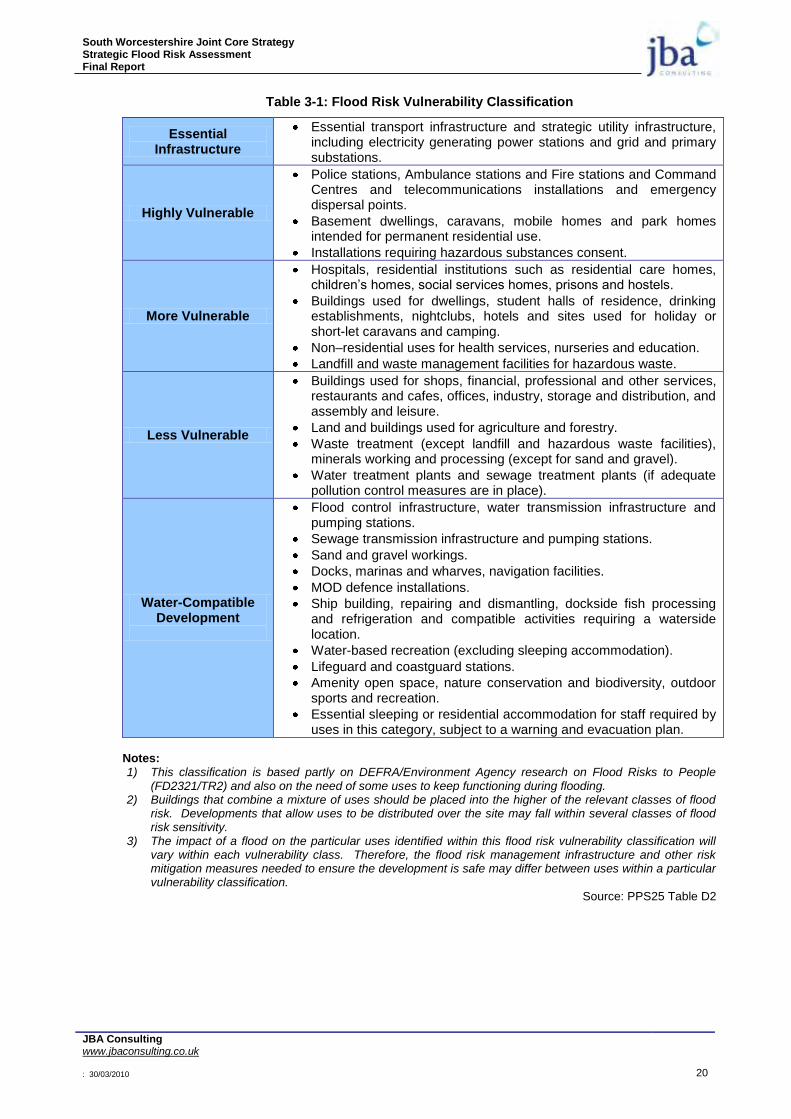
South Worcestershire Joint Core Strategy Strategic Flood Risk Assessment Final Report
JBA Consulting www.jbaconsulting.co.uk : 30/03/2010 20
Table 3-1: Flood Risk Vulnerability Classification
Essential Infrastructure
Essential transport infrastructure and strategic utility infrastructure, including electricity generating power stations and grid and primary substations.
Highly Vulnerable
Police stations, Ambulance stations and Fire stations and Command Centres and telecommunications installations and emergency dispersal points.
Basement dwellings, caravans, mobile homes and park homes intended for permanent residential use.
Installations requiring hazardous substances consent.
More Vulnerable
Hospitals, residential institutions such as residential care homes, children‟s homes, social services homes, prisons and hostels.
Buildings used for dwellings, student halls of residence, drinking establishments, nightclubs, hotels and sites used for holiday or short-let caravans and camping.
Non–residential uses for health services, nurseries and education.
Landfill and waste management facilities for hazardous waste.
Less Vulnerable
Buildings used for shops, financial, professional and other services, restaurants and cafes, offices, industry, storage and distribution, and assembly and leisure.
Land and buildings used for agriculture and forestry.
Waste treatment (except landfill and hazardous waste facilities), minerals working and processing (except for sand and gravel).
Water treatment plants and sewage treatment plants (if adequate pollution control measures are in place).
Water-Compatible Development
Flood control infrastructure, water transmission infrastructure and pumping stations.
Sewage transmission infrastructure and pumping stations.
Sand and gravel workings.
Docks, marinas and wharves, navigation facilities.
MOD defence installations.
Ship building, repairing and dismantling, dockside fish processing and refrigeration and compatible activities requiring a waterside location.
Water-based recreation (excluding sleeping accommodation).
Lifeguard and coastguard stations.
Amenity open space, nature conservation and biodiversity, outdoor sports and recreation.
Essential sleeping or residential accommodation for staff required by uses in this category, subject to a warning and evacuation plan.
Notes: 1) This classification is based partly on DEFRA/Environment Agency research on Flood Risks to People
(FD2321/TR2) and also on the need of some uses to keep functioning during flooding. 2) Buildings that combine a mixture of uses should be placed into the higher of the relevant classes of flood
risk. Developments that allow uses to be distributed over the site may fall within several classes of flood risk sensitivity.
3) The impact of a flood on the particular uses identified within this flood risk vulnerability classification will vary within each vulnerability class. Therefore, the flood risk management infrastructure and other risk mitigation measures needed to ensure the development is safe may differ between uses within a particular vulnerability classification.
Source: PPS25 Table D2
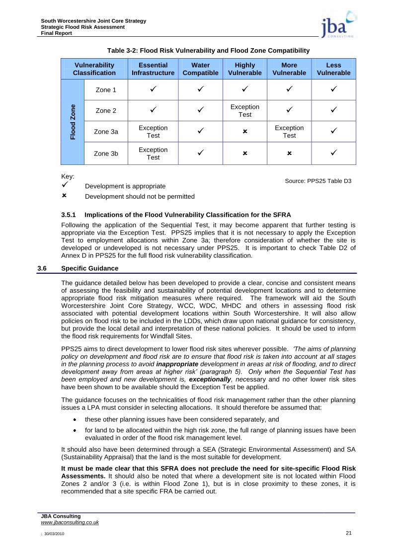
South Worcestershire Joint Core Strategy Strategic Flood Risk Assessment Final Report
JBA Consulting www.jbaconsulting.co.uk : 30/03/2010 21
Table 3-2: Flood Risk Vulnerability and Flood Zone Compatibility
Vulnerability Classification
Essential Infrastructure
Water Compatible
Highly Vulnerable
More Vulnerable
Less Vulnerable
Flo
od
Zo
ne
Zone 1
Zone 2 Exception
Test
Zone 3a Exception
Test Exception
Test
Zone 3b Exception
Test
Key:
Development is appropriate
Development should not be permitted
3.5.1 Implications of the Flood Vulnerability Classification for the SFRA
Following the application of the Sequential Test, it may become apparent that further testing is appropriate via the Exception Test. PPS25 implies that it is not necessary to apply the Exception Test to employment allocations within Zone 3a; therefore consideration of whether the site is developed or undeveloped is not necessary under PPS25. It is important to check Table D2 of Annex D in PPS25 for the full flood risk vulnerability classification.
3.6 Specific Guidance
The guidance detailed below has been developed to provide a clear, concise and consistent means of assessing the feasibility and sustainability of potential development locations and to determine appropriate flood risk mitigation measures where required. The framework will aid the South Worcestershire Joint Core Strategy, WCC, WDC, MHDC and others in assessing flood risk associated with potential development locations within South Worcestershire. It will also allow policies on flood risk to be included in the LDDs, which draw upon national guidance for consistency, but provide the local detail and interpretation of these national policies. It should be used to inform the flood risk requirements for Windfall Sites.
PPS25 aims to direct development to lower flood risk sites wherever possible. „The aims of planning policy on development and flood risk are to ensure that flood risk is taken into account at all stages in the planning process to avoid inappropriate development in areas at risk of flooding, and to direct development away from areas at higher risk‟ (paragraph 5). Only when the Sequential Test has been employed and new development is, exceptionally, necessary and no other lower risk sites
have been shown to be available should the Exception Test be applied.
The guidance focuses on the technicalities of flood risk management rather than the other planning issues a LPA must consider in selecting allocations. It should therefore be assumed that:
these other planning issues have been considered separately, and
for land to be allocated within the high risk zone, the full range of planning issues have been evaluated in order of the flood risk management level.
It should also have been determined through a SEA (Strategic Environmental Assessment) and SA (Sustainability Appraisal) that the land is the most suitable for development.
It must be made clear that this SFRA does not preclude the need for site-specific Flood Risk Assessments. It should also be noted that where a development site is not located within Flood Zones 2 and/or 3 (i.e. is within Flood Zone 1), but is in close proximity to these zones, it is recommended that a site specific FRA be carried out.
Source: PPS25 Table D3
South Worcestershire Joint Core Strategy Strategic Flood Risk Assessment Final Report
JBA Consulting www.jbaconsulting.co.uk : 30/03/2010 22
This chapter will present the guidance for Flood Zone 3, Flood Zone 2 and Flood Zone 1. It will then discuss issues relating to other known flood risk areas.
3.7 Flood Zone 3a – High Probability
PPS25 states that water-compatible and less vulnerable developments are permitted in this Flood Zone, following testing within the sequential process. According to PPS25, highly vulnerable development is not permitted. Essential infrastructure and more vulnerable development need to pass the Exception Test, while essential infrastructure should be designed and constructed to remain operational and safe for users in times of flood.
According to PPS25, developers and local authorities should address the following policy aims:
Reduce the overall level of flood risk in the area through the layout and form of the development and the appropriate application of SuDS.
Relocate existing development to land in zones with a lower probability of flooding.
Create space for flooding to occur by restoring functional floodplain and flood flow pathways and by identifying, allocating and safeguarding open space for flood storage.6
Therefore a presumption for further development in existing floodplains is not supported by PPS25, and any future SFRA should review existing areas to see if relocation is a spatially sustainable strategy. The delineation of the subset zones of high risk Flood Zone 3 may be sufficient to allow the spatial planning process to continue, with development steered away from these high risk zones.
Regeneration of land or change in land use behind existing defended areas in the high risk Zone will continue to require a more detailed assessment of the flood risk (i.e. whether the scale of flood risk is worth taking, and how sustainable and effective the mitigation measures would be [i.e. whether the risk could be managed]. Where, due to wider sustainable development reasons there are no other suitable sites available in lower risk zones, an assessment of the actual risk within Flood Zone 3 is required. Annex G in PPS25 deals with managing residual flood risk.
Flood Zone 3a should not be used for development where suitable alternative sites exist in Flood Zones 1 or 2. Paragraph G2 of PPS25 states that following application of the Sequential Test and Exception Test for development in Flood Zone 3a, a clear examination of the residual flood risks should be made and development:
„Should not normally be permitted where flood defences, properly maintained and in combination with agreed warning and evacuation arrangements, would not provide an acceptable standard of safety taking into account climate change.‟ 6
It would be the responsibility of the developer to demonstrate how, in planning terms, this safety can be achieved and how the residual risks will be managed. A clear distinction between commercial flood standards of protection and management of loss of life should be explored in the FRA. A greater reliance on flood warning may be required, which is not always a tangible alternative to accepting a lower standard of protection.
In the context of this discussion, an undefended area (Figure 3-2) of floodplain under fluvial and/or tidal flood risk is considered to be an area where the water level for the 1% fluvial / 0.5% tidal flood event will be similar to that of the river/sea. These areas may be entirely undefended, or if defences are present, they are discontinuous or constructed to a low standard. In these areas guidance provided in Section 3.7.1 (undefended areas) will be most relevant in assessing sustainability and determining mitigation requirements.

South Worcestershire Joint Core Strategy Strategic Flood Risk Assessment Final Report
JBA Consulting www.jbaconsulting.co.uk : 30/03/2010 23
Figure 3-2: Illustration of the undefended scenario under fluvial and/or tidal flood risk
A defended area (Figure 3-3) is considered to be an area of floodplain where the defences will result in a water level for the 1% fluvial / 0.5% tidal flood event that is considerably lower than the source (river or sea). This means the defences substantially (but not necessarily completely) mitigate the flood risk associated with the 1% fluvial / 0.5% tidal flood event. These areas will be defended to a minimum standard promoted by DEFRA, but not always necessarily to the 1% fluvial / 0.5% tidal standards. In these areas guidance provided in Section 3.7.2 (defended areas) will be most relevant in assessing sustainability and determining mitigation requirements.
Areas Benefiting from Defences is the next generation of information to be provided by the Environment Agency on their Flood Map. At present there are limited areas benefitting from defences in the South Worcestershire Joint Core Strategy area. The Environment Agency may have proposals, however, for new flood defences at Pershore and Upton upon Severn, amongst others, in the future. For the purposes of future application of this guidance, the standard of protection provided by the Environment Agency or from an assessment of an existing or new hydraulic model would suffice. Areas which are defended are highlighted in this report.
Figure 3-3: Illustration of the defended scenario and residual flood risk behind fluvial/tidal defences
3.7.1 Undefended Areas – Flood Risk Mitigation
Within undefended or poorly defended Flood Zone 3a areas, floor levels for housing developments should, as a minimum, be situated above the acceptable standard of safety with sufficient freeboard to allow for uncertainties in flood level prediction and climate change. The following paragraphs define an appropriate standard of flood risk mitigation in undefended areas in the context of the South Worcestershire Joint Core Strategy area SFRA.
The Sequential Test should be applied within the development location area, and it is considered appropriate to direct more vulnerable land uses to parts of the location at a lesser probability and lower residual risk of flooding. The lower floors of buildings in areas at both medium and high probability of flooding should seek to develop water-compatible and less vulnerable uses, including car parks or other public areas.
River/Sea Defence Floodplain
Predicted 1% fluvial or 0.5% tidal flood level
No or low standard defences present
Lower residual risk area
Level inferred by Flood Zone Map
Level calculated from breach or overtopping modelling River/Sea Defence Floodplain

South Worcestershire Joint Core Strategy Strategic Flood Risk Assessment Final Report
JBA Consulting www.jbaconsulting.co.uk : 30/03/2010 24
Housing developments (more vulnerable development) should provide a minimum habitable space floor level above the estimated 1% (for fluvial flooding) water level with the addition of allowances for modelling uncertainty and climate change (i.e. freeboard). This may be achieved by providing car parking or other public areas at ground floor level. It must be noted however that designs for dry access must be in place as parking space at ground floor level does not always provide a safe alternative. Undercroft car parking also presents long term maintenance issues.
Employment development (less vulnerable development) should provide a similar standard of flood defence as housing developments. Within undefended or poorly defended Flood Zone 3a areas, employment development should remain dry during the 1% fluvial flood event, with sufficient freeboard to account for uncertainties in flood level prediction and climate change. Developers will need to carefully consider the commercial viability of developing in these areas. In exceptional circumstances, where there is significant planning justification for development and the provision of this standard of defence is not feasible, a greater acceptance of flood risk may be permitted for less vulnerable development in areas of high probability of flooding with the focus on providing safety to occupants, flood proofing and designing buildings to minimise flood damage.
For mixed use development, the Sequential Test should be based on the development that has the highest flood risk category.
Flood resilient construction may be considered for less vulnerable use development in circumstances where there is a low probability of limited shallow depth water entry (< 1 in 1000-year annual probability) and buildings are not subjected to severe floodwater inundation depths. This type of construction is designed to reduce the consequences of flooding (the probability of flood occurrence remains unchanged) and facilitate recovery from the effects sooner than conventional buildings. More vulnerable and highly vulnerable development should be dry up to the 1 in 1000-year flood event.
This may be achieved „through the use of water-resistant materials for floors, walls and fixtures and the positioning of electrical controls, cables and appliances at a higher than normal level‟6 and flood resistant construction to either reduce the amount of water or prevent entry of water into a building where resistant techniques are used. A means of safe access and egress in times of flooding must be provided so that at a minimum, emergency services and their vehicles are able to evacuate people, especially when considering those that are more vulnerable and/or with restricted mobility.
Whilst the basic level of protection afforded to residential and commercial development is the same, it is clear that approaches to how residual risk is managed may differ between these two types of developments. For residential development residual risk is a societal issue, for which a presumption of avoidance and removal is appropriate. Hence a significant freeboard should be incorporated into housing development floor levels, whereas for a commercial property the end user and insurer can assess and transfer this residual risk as appropriate. Therefore commercial and employment uses have a suitably different approach to the management of the residual risk, above that provided by the basic mitigation works. The onus would be on WDC, COWC and MHDC to determine whether these risks are acceptable, in conjunction with advice from the Environment Agency.
PPS25 advocates a risk based approach linked to vulnerability and does not provide a prescriptive set of flood protection standards. Wherever possible, the highest achievable standard should be provided.
Isolated small Greenfield developments may be sustainable in terms of their impact on floodplain storage and conveyance, however the cumulative effects of many small developments can be large and Greenfield sites must be viewed within a wider perspective.
The feasibility of mitigation measures may be assessed in accordance with the guidance established in section 8.
Long term and residential car parking is unlikely to be acceptable in areas which regularly flood to a significant depth, due to the risk of car owners being away from the area or unable to move their cars when a flood occurs. An assessment of “hazard risk” including water depth, velocity and distance to higher ground (exit route) may be required as part of a Flood Risk Assessment.
For “less vulnerable” development, as defined by PPS25, development sites may be allowed to flood in certain circumstances, where it can be demonstrated that floor levels cannot be raised for practical reasons, providing suitable flood evacuation plans and flood warning are in place and the developer is made aware of the flood depths, flood frequency and possible consequences of flooding on his business. Such development should be constructed with suitable flood resilience measures.
South Worcestershire Joint Core Strategy Strategic Flood Risk Assessment Final Report
JBA Consulting www.jbaconsulting.co.uk : 30/03/2010 25
For “more vulnerable” and “highly vulnerable” development, a safe dry pedestrian access/egress is required up to a 100-year (1% AEP) flood event with climate change, without the need for the intervention of the emergency services. For extreme flood events and when considering the residual flood risk, safe access routes should be provided, ideally these should be dry but at the very least they should be safe for the emergency services to evacuate and rescue.
3.7.2 Defended Areas – Flood Risk Mitigation
Within defended areas flood risk is primarily associated with overtopping and/or breach of defences (and localised flooding associated with drainage systems in some locations). These risks are related to the likelihood (standard of protection and structural integrity of defences) and the consequences of flooding.
The likelihood of overtopping can be estimated by comparison of modelled water levels (where available) and defence crest levels. An indication of the likelihood of defence breach can be gained by reviewing the flood defence condition data held within the National Flood and Coastal Defence Database (NFCDD) and more detailed surveys and investigations undertaken by the Environment Agency and/or others. The consequences of defence overtopping or breach failure can be estimated using flood inundation modelling and mapping.
For a development to proceed it must also be shown that it will not increase flood risk elsewhere through a loss of storage or conveyance. Flood risk must be reduced or kept at current levels.
3.7.3 Residual Risk
For all Flood Zone 3a potential development locations consideration must be given to residual risks and the risk to public safety associated with access and egress from properties. Residual risks are those associated with failure of infrastructure or capacity being exceeded such as defences or SuDS features. Development should not be sited where these risks would unduly threaten public safety and/or the structural integrity of buildings and infrastructure. Consideration of the depth of flooding, flow velocity, rate of inundation and safe access / egress is required to assess these risks.
It is stated in PPS25 that single storey residential development is generally more vulnerable to flood damage and that occupants do not have the opportunity to retreat to higher floor levels. Due to the particular vulnerability that single storey residential developments face, the Council will not approve any applications for single storey residential development within the areas classified as being in a Flood Zone 3 area, where they are behind defences and a Site Specific Flood Risk Assessment shows the hazard classification to be “a danger for all” (DEFRA R&D document FD23207 and clarified in the Supplementary Note published in May 20088.)
3.8 Flood Zone 3b – The Functional Floodplain
PPS25 states that only the water-compatible uses are permissible in Flood Zone 3b. Essential Infrastructure can be permitted after the Exceptions Test is passed. According to PPS25, developers and local authorities should aim to:
Reduce overall level of flood risk in the area through the layout and form of the development and the appropriate application of SuDS.
Relocate existing development to land with a lower probability of flooding.
In addition, according to PPS25, essential infrastructure should:
Remain operational and safe for users in times of flood.
Result in no net loss of floodplain storage.
Consider the risk of flooding up to 0.1% annual probability event.
Not impede water flows.
Not increase flood risk elsewhere.6
Other than water-compatible and essential infrastructure (subject to the Exception Test) uses, Flood Zone 3b should not be used for development except for access road purposes. In this case, the roadway should be kept to the narrowest width possible and crossing the watercourse at 90 degrees to the direction the watercourse flows.
In the South Worcestershire Joint Core Strategy area, Functional Floodplain is defined as the 1 in
South Worcestershire Joint Core Strategy Strategic Flood Risk Assessment Final Report
JBA Consulting www.jbaconsulting.co.uk : 30/03/2010 26
20-year Return Period Flood extent unless the area is within one of the proposed Flood Zoning Policy maps provided in Appendix E. The 1 in 20-year Return Period Flood extent is shown for all watercourses where a detailed hydraulic model is available on the maps in Appendix C. For all other locations, the Functional Floodplain will be taken to be the greater of a) 8 metres from the top of bank of each watercourse or b) the current Flood Zone 3a (1 in 100-year flood outline). This can be revised by undertaking detailed hydraulic modelling at the Site Specific Flood Risk Assessment stage. It is also understood that it may be during the life time of this report that, as more detailed studies are undertaken for watercourses, this figure may change following the agreement of the LPA and EA.
3.9 Flood Zone 2 – Medium Probability
Flood Zone 2 is considered suitable for water-compatible, less vulnerable, more vulnerable and essential infrastructure. Highly vulnerable development is only allowed where the Exception Test is passed.
In this zone, developers and South Worcestershire Joint Core Strategy councils should seek opportunities to reduce the overall level of flood risk in the area through the layout and form of the development, and the appropriate application of SuDS.
For highly vulnerable development in Flood Zone 2, this SFRA also indicates whether part c. of the Exception Test is most likely to be met.
Where development is implemented, floor levels should be situated, as a minimum, above the 1% AEP fluvial flood level with sufficient freeboard to account for inherent uncertainties with respect to flood level prediction and potential climate change scenarios. Developments must take into account extreme flood events, as a residual risk development should be safe up to a 1 in 100 year event where occupants are able to remain safe inside the building. Further guidance is given on this in Chapter 8. A site-specific FRA should be undertaken at the planning application stage to facilitate the delineation and definition of the 1% AEP fluvial flood event envelope including an allowance for climate change.
3.10 Flood Zone 1 – Low Probability
In accordance with PPS25, all development (essential infrastructure, highly vulnerable, more vulnerable, less vulnerable and water-compatible development) is permissible in Flood Zone 1.
For development proposals on sites comprising one hectare or more, the vulnerability to flooding from other sources as well as from river and sea flooding, and the potential to increase flood risk elsewhere through the addition of hard surfaces and the effect of the new development on surface water run-off, should be incorporated in a FRA (see section 8.9 on surface water drainage assessment).
In this zone, developers and local authorities should seek opportunities to reduce the overall level of flood risk in the area and beyond through the layout and form of the development, and the appropriate application of SuDS.
In situations where a known flooding problem has been identified downstream, WDC, WCC and MHDC will require developers to ensure that the proposed development does not result in a worsening of existing flooding conditions.
3.11 Other Known Flood Risk Areas
In certain locations an increase in the rate of surface water runoff and/or volume from a new development situated upstream of an area that is known to be susceptible to localised flooding (e.g. as a result of problematic surface water drainage) may exacerbate the degree of flood risk to that downstream area.
Such areas will be sensitive to the drainage system implemented with that particular development site, as the drainage system will determine site runoff rates and volumes.
The capacity of internal drainage infrastructure is often limited and is at or near capacity under existing conditions. Development that leads to increased peak runoff within the drainage catchments may lead to infrastructure capacity being exceeded, with the potential for increased flood risk. A detailed FRA would be expected regardless of which Flood Zone applies.
New developments upstream of these areas must be managed effectively to ensure that the impact upon downstream properties is fully mitigated. Wherever possible, this should be achieved through

South Worcestershire Joint Core Strategy Strategic Flood Risk Assessment Final Report
JBA Consulting www.jbaconsulting.co.uk : 30/03/2010 27
the implementation of a sustainable drainage or flow retention system, constructed within the boundaries of the development site.
Ideally the LPA should work closely with the Environment Agency, sewerage undertakers and developers to enable surface water runoff to be controlled as near to the source as possible. For Greenfield developments, the aim is to not increase runoff from the undeveloped situation and for Brownfield re-developments, to reduce existing runoff rates. Wherever possible, this should be achieved through the implementation of a sustainable drainage or flow retention system, constructed within the boundaries of the development site.
A FRA will be required in each instance to design appropriate mitigation measures and demonstrate that the development will not adversely affect existing flooding conditions. The FRA should define and address the constraints that will govern the design of the drainage system.
The effectiveness of a flow management scheme within a single site is heavily limited by site constraints including (but not limited to) topography, geology (soil permeability), development density, adoption issues and available area. The design, construction and ongoing maintenance regime of such a scheme must be carefully defined at an early stage, and a clear and comprehensive understanding of the catchment hydrological processes (i.e. nature and capacity of the existing drainage system) is essential. In these areas a FRA will be required that demonstrates that the proposed development will not adversely affect existing flooding conditions either alone or in combination with other development.
Prior to making a planning application, discussions should be held with the Environment Agency, the Local Planning Authority and Severn Trent Water to ascertain the specific nature and most appropriate means of managing the flood risk.
Sustainable Drainage Systems (SUDS) should be considered in the preference order of infiltration, surface retention then underground retention. SUDS should be designed to manage flood risk and to improve water quality and increase amenity and biodiversity.
The integration of drainage management is highlighted within the DEFRA strategy for flood risk management in England, detailed within the consultation document „Making Space for Water‟9. The strategy aims to achieve better overall management of surface water drainage through better co-ordination between the different bodies.
3.12 Catchment Flood Management Plan
The Severn Flood Catchment Management Plan draft report was issued in May 2008. There are six pre-defined national policies provided in the CFMP guidance. These policies are intended to cover the full range of long term flood risk management options in the catchment. The six national policies are: -
1. No active intervention (including flood warning and maintenance). Continue to monitor and advise;
2. Reduce existing flood risk management actions;
3. Continue with existing or alternative actions to manage flood risk at the current level;
4. Take further action to sustain the current level of flood risk;
5. Take action to reduce flood risk (now and/or in the future);
6. Take action to increase the frequency of flooding to deliver benefits locally or elsewhere.
Within the Severn CFMP 19 policy units have been identified that set out the proposed policies. The following policy units are relevant to the South Worcestershire Joint Core Strategy SFRA: -
Policy Unit 8 Middle Severn Corridor (includes Worcester). Policy 4 is proposed.
High priorities are listed as: -
No increase in flood risk due to development;
Set a framework to deliver a sustainable approach to flood risk management that considers the natural functions of the river and reduces long term dependences on raised defences;
Maintain existing flood warning areas and improve effectiveness and coverage;
Promote SUDS for new development.
South Worcestershire Joint Core Strategy Strategic Flood Risk Assessment Final Report
JBA Consulting www.jbaconsulting.co.uk : 30/03/2010 28
Policy Unit 10 Lower Severn Corridor. Policy 2 is proposed.
The same high priorities are proposed as policy unit 8
Policy Unit 12 Middle Avon (includes Evesham and Pershore). Policy 3 is proposed.
The high priorities are listed as: -
Maintain existing flood watch area of Lower Avon;
Safeguard floodplains;
SFRA is the agreed approach to allocate future development;
Policy Unit 16 Avon Tributaries. Policy 3 is proposed.
Policy Unit 19 River Teme (includes Tenbury Wells). Policy 3 is proposed.
The high priorities are listed as: -
Maintain existing flood watch areas of River Teme;
Promote SUDS;
3.13 Flood Warning
The Environment Agency operates a flood warning service in the South Worcestershire Joint Core Strategy area, called Flood Warnings Direct. Based on upstream river level and hydraulic modelling of recorded rainfall, flood warnings are issued to the professional partners (Fire, Police and Local Authorities) and to members of the public who have requested the service. The following flood warnings are issued in the South Worcestershire Joint Core Strategy area: -
Flood Watch Area 108 River Severn in Worcestershire
Flood Watch 110 Droitwich and River Salwarpe
Flood Watch Area 111 Barbourne Brook
Flood Warning Area S9 Worcester
Flood Warning Area S10 River Severn Worcester to Tewkesbury
Flood Warning Area 031 River Avon Evesham to Tewkesbury
Flood Watch Areas 112 upper Teme and 113 Lower Teme
Flood Warning Areas T1 Teme Ludlow to Bransford Bridge and T2 Bransford Bridge to Powick
The Environment Agency is currently converting some of the current flood warning areas to community based warning areas, and these codes are likely to change over the next year.
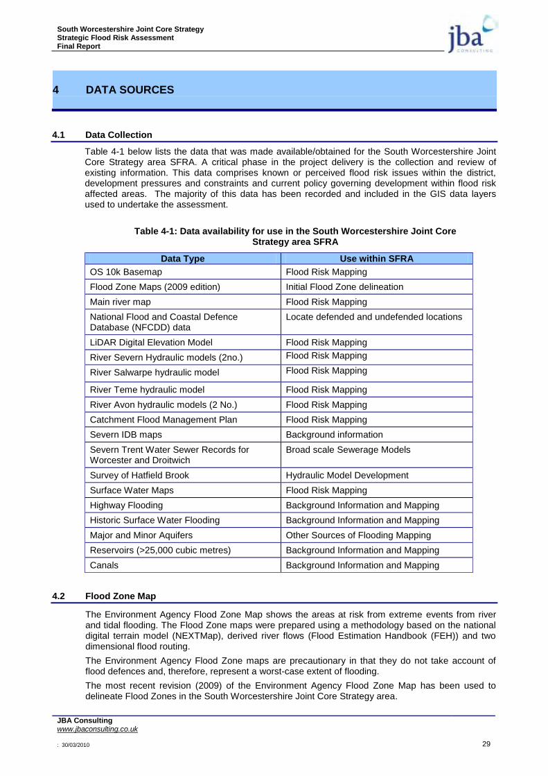
South Worcestershire Joint Core Strategy Strategic Flood Risk Assessment Final Report
JBA Consulting www.jbaconsulting.co.uk : 30/03/2010 29
4 DATA SOURCES
4.1 Data Collection
Table 4-1 below lists the data that was made available/obtained for the South Worcestershire Joint Core Strategy area SFRA. A critical phase in the project delivery is the collection and review of existing information. This data comprises known or perceived flood risk issues within the district, development pressures and constraints and current policy governing development within flood risk affected areas. The majority of this data has been recorded and included in the GIS data layers used to undertake the assessment.
Table 4-1: Data availability for use in the South Worcestershire Joint Core Strategy area SFRA
Data Type Use within SFRA
OS 10k Basemap Flood Risk Mapping
Flood Zone Maps (2009 edition) Initial Flood Zone delineation
Main river map Flood Risk Mapping
National Flood and Coastal Defence Database (NFCDD) data
Locate defended and undefended locations
LiDAR Digital Elevation Model Flood Risk Mapping
River Severn Hydraulic models (2no.) Flood Risk Mapping
River Salwarpe hydraulic model Flood Risk Mapping
River Teme hydraulic model Flood Risk Mapping
River Avon hydraulic models (2 No.) Flood Risk Mapping
Catchment Flood Management Plan Flood Risk Mapping
Severn IDB maps Background information
Severn Trent Water Sewer Records for Worcester and Droitwich
Broad scale Sewerage Models
Survey of Hatfield Brook Hydraulic Model Development
Surface Water Maps Flood Risk Mapping
Highway Flooding Background Information and Mapping
Historic Surface Water Flooding Background Information and Mapping
Major and Minor Aquifers Other Sources of Flooding Mapping
Reservoirs (>25,000 cubic metres) Background Information and Mapping
Canals Background Information and Mapping
4.2 Flood Zone Map
The Environment Agency Flood Zone Map shows the areas at risk from extreme events from river and tidal flooding. The Flood Zone maps were prepared using a methodology based on the national digital terrain model (NEXTMap), derived river flows (Flood Estimation Handbook (FEH)) and two dimensional flood routing.
The Environment Agency Flood Zone maps are precautionary in that they do not take account of flood defences and, therefore, represent a worst-case extent of flooding.
The most recent revision (2009) of the Environment Agency Flood Zone Map has been used to delineate Flood Zones in the South Worcestershire Joint Core Strategy area.

South Worcestershire Joint Core Strategy Strategic Flood Risk Assessment Final Report
JBA Consulting www.jbaconsulting.co.uk : 30/03/2010 30
4.3 Flood Defences
As discussed above, the Environment Agency Flood Map does not take account of the presence of flood defences. PPS2510 states that defended areas (i.e. those areas that are protected to some degree against flooding by the presence of a formalised flood defence) are still at risk of flooding, and therefore sites within these areas must be assessed with respect to the adequacy of the defences.
An extract from the Environment Agency‟s National Flood and Coastal Defence Database (NFCDD) has been supplied and provides information about existing defences in the area, as well as categorising them by type and providing information on who owns and maintains them. In the South Worcestershire Joint Core Strategy area the only existing formal permanent flood defences are the minor earth embankments along the River Severn that protect agricultural land and the recently completed flood embankment and demountable defence at Hylton Road, Worcester. These are maintained by the Environment Agency.
Areas Benefiting from Defences (ABDs) are those areas which benefit from formal flood defences in the event of flooding from rivers with a 1% chance in any given year or from the sea with a 0.5% chance in any given year. In the South Worcestershire Joint Core Strategy area there are currently no ABD areas (note this assumes that the minor defences protecting washlands on the River Severn are not classified as major defences protecting to property because of their low standard of protection).
At the time of writing, capital works to provide flood defences at Upton upon Severn and Pershore are proposed in the future and as such this SFRA should be updated to include ABD areas when these have been constructed.
4.4 Hydraulic Modelling
Existing hydraulic models have been used in the SFRA to obtain the functional floodplain based on a 1 in 20-year flood extent, (unless the area is within the Flood Zoning Policy Maps provided in Appendix E and described in 5.2). Detailed hydraulic models used were the River Severn Models for Worcester and Upton upon Severn, the River Avon Model for Evesham and Pershore, the River Salwarpe Model for Droitwich, the Barbourne Brook model for Worcester and the River Teme Model for Tenbury Wells. As part of the Level 2 assessment, a hydraulic model was also developed for the Hatfield Brook in Kempsey.
4.5 History of Flooding
Flooding has affected large areas of the South Worcestershire Joint Core Strategy area in the past. The last two significant flood events occurred in April 1998, November/December 2000 and June/July 2007. It is not intended to report on all historic flood locations in this SFRA instead studies have been carried by the three councils and information on each flood incident has been documented. Flood data has been collected from parish councils and people affected by flooding. Potential developers are requested to contact the councils concerned to view the flood incident reports to see how these may affect their proposals.
South Worcestershire Joint Core Strategy Strategic Flood Risk Assessment Final Report
JBA Consulting www.jbaconsulting.co.uk : 30/03/2010 31
5 APPROACH TO THE SOUTH WORCESTERSHIRE JOINT CORE STRATEGY
STRATEGIC FLOOD RISK ASSESSMENT
5.1 Overview
A SFRA may be sub-divided into two degrees of detail: Level 1 and Level 2. The assessment approach taken for the South Worcestershire Joint Core Strategy SFRA is given below, detailing the requirements at both Level 1 and Level 2. The South Worcestershire Joint Core Strategy SFRA is at Level 2 and therefore incorporates the requirements of both a Level 1 and Level 2 SFRA.
5.1.1 Level 1 – Scoping Study SFRA
A Level 1 SFRA should be sufficiently detailed to allow application of the Sequential Test and to identify whether the Exception Test is likely to be necessary. Existing data is used to make an assessment of flood risk from all sources now and in the future.
Assessment of Current Flood Risk
Flood risk within South Worcestershire Joint Core Strategy is assessed, categorised and mapped to a level concurrent with the nature and availability of existing data. In general, however, the following key considerations are addressed:
Identification of known or perceived flood risk areas, including the nature of the flooding problem (e.g. river flooding, local surface water flooding) providing the initial „filter‟ for key flood risk issues areas within the SFRA area.
Review of the current Environment Agency Flood Zone Map and mapping of fluvial and tidal flood zones, providing the broad (first pass) definition of High Risk Flood Zone 3.
Consideration of critical floodplain areas and high risk Flood Zone 3b.
Identification of existing defences that reduce flood risk to potential development locations.
Identification of any known flooding issue locations to ensure impact upon upstream and downstream properties is adequately considered (irrespective of flood risk posed to proposed development).
Review Climate Change and Land Use Management Impact
Climate change and associated sea level rise has the potential to significantly increase the consequences of flooding, and consideration was given to the sustainability of potential development locations under climate change and more extreme events. Table B1 and Table B2 in PPS25 were used to assess climate change effects.
Assess Flood Risk from „Other Sources‟
This stage involved a broadscale initial assessment of the underlying geological and pedological characteristics of the South Worcestershire Joint Core Strategy area. Surface water flood risk maps are presented in Appendix C. These show areas susceptible to surface water flood risk based on broadscale rainfall modelling undertaken by JBA Consulting, together with historic surface water flooding locations provided by the local authorities and Severn Trent Water. The geology and soils of South Worcestershire Joint Core Strategy area are shown on “other sources of flooding” maps in Appendix D. These can provide a first indication where infiltration methods of SuDS may or may not be appropriate.
Reservoirs and Canals
Details of existing reservoirs over a volume of 25,000m3 of stored water above ground level were
obtained from the Environment Agency. These are shown on the “other sources of flooding” maps in Appendix D. Reservoirs over a volume of 25,000m
3 (current legislation may change as a result of
the Water Bill) have to be inspected by a Panel Engineer and modifications and repairs undertaken as directed to the reservoir owners. However, it should be remembered that reservoirs still pose a possible flood risk if they are breached and this should be considered when allocating development.
South Worcestershire Joint Core Strategy Strategic Flood Risk Assessment Final Report
JBA Consulting www.jbaconsulting.co.uk : 30/03/2010 32
There are several canals in the South Worcestershire Joint Core Strategy area. Details of past breaches or overtopping from canals are shown on the “other sources of flooding” maps in Appendix D.
Application of the Sequential Test
Guidance for the future management of development within low, medium and high flood risk zones is provided to meet the requirements of national planning guidance and regional and local flood risk policy. Consideration of the requirements for FRAs, and suitable mitigation measures (such as surface water attenuation and SuDs) will be identified to assist both developers and planners.
5.1.2 Level 2 – Increased Scope SFRA
According to the PPS25 Practice Guide11, the principle purpose of a Level 2 SFRA is to facilitate the application of the Exception Test. It considers the detailed nature of flood hazard taking account of the presence of flood risk management measures such as flood defences. This also allows a sequential approach to development location allocation within the Flood Zones.
Assessment of Actual and Residual Risk
Actual flood risk can be determined by a detailed hydraulic model that takes account of existing flood defences. Further investigation can be undertaken in areas protected by flood defences to examine the probability, depth, velocity and hazard of flooding if defences are breached or overtopped. The flood risk to people hazard rating is assessed according to the methodology given in DEFRA R&D document FD232012 and clarified in the Supplementary Note published in May 200813. As major flood defences do not exist in the South Worcestershire Joint Core Strategy area, these assessments will have to be undertaken by developers in the future if flood defences are constructed. For the detailed flood risk in Worcester, Evesham, Pershore, Upton upon Severn, Tenbury Wells, Kempsey and Droitwich, the Flood Zone Maps in Appendix B provide the first guidance of flood risk. The existing detailed hydraulic models owned by the Environment Agency covering these towns and city will provide a more detailed assessment of the flood risk and as such developers are advised to request information from these models from the Environment Agency at the site specific FRA stage.
Outputs and Information Informing the Exception Test
The (Level 1) maps and guidance for developers are further developed and finalised based on the results of the Level 2 SFRA. A more detailed assessment of flood risk and residual risk is made, with specific recommendations for FRAs.
Where major development locations pass parts (a) and (b) of the Exception Test, an assessment must be made as to whether development proposals can pass part (c) of the Exception Test.
Recommendations for mitigation methods and emergency planning, reduction of flood risk, and requirements for a site-specific FRA are made. Potential mitigation measures will depend on the proposed end use for the site and defining an acceptable level of residual risk for development proposals.
5.2 Delineation of Flood Zones
To provide the information necessary for the South Worcestershire Joint Core Strategy area SFRA, an assessment of fluvial flood risk has been made from the Flood Zone Maps and the detailed hydraulic models that are currently available. Following consideration of the data available and discussions with the Environment Agency, flood risk within the South Worcestershire Joint Core Strategy area SFRA study area has been assessed using the methodology described below.
The most recent revision of the Environment Agency Flood Zone Map (2009) has been used to delineate Flood Zones in the South Worcestershire Joint Core Strategy area. The flood zones are precautionary in that they do not take account of flood defences and, therefore, represent a worst-case extent of flooding, although as there are few defences in this case the outlines will provide a good indication of flood risk in the South Worcestershire Joint Core Strategy area.
Flood Zones are defined in accordance with PPS25. Following discussions with the Environment Agency and because up to date Flood Zone Maps with climate change have not been produced, it has been agreed that Flood Zone 3 with climate change will be defined by the current Flood Zone 2 extent. The flood zones are presented in Appendix B.
South Worcestershire Joint Core Strategy Strategic Flood Risk Assessment Final Report
JBA Consulting www.jbaconsulting.co.uk : 30/03/2010 33
PPS25 Table D1 defines Flood Risk Zones 3a (high probability) and 3b (functional floodplain). The latter can be defined as the 1 in 20-year return period flood, or at another probability to be agreed between the LPA and the Environment Agency, including water conveyance routes. For the South Worcestershire Joint Core Strategy area, the LPA‟s and the Environment Agency have agreed on three sub-divisions of Flood Zone 3 for the major conurbations as defined below: -
Floodplain [“Blue Zone”]
Functional Floodplain. Development will not normally be permitted here. Exceptions may be water compatible developments and essential infrastructure, but these must be accompanied by a detailed Flood Risk Assessment;
Floodplain [“Yellow Zone”] Redevelopment of existing sites within the floodplain in areas not subject to significant flood flows [as defined by the environment agency], shown as “yellow zone” on the proposals map, will normally be permitted provided:-
i. it is for less vulnerable or water compatible use (as defined in Table D2 of PPS25);
ii. ground floor levels of all buildings are set above the 1 in 100-year flood level including an allowance for climate change, with an appropriate freeboard to be agreed with the LPA and Environment Agency, and should be flood free during an extreme flood event;
iii. safe access is available for the lifetime of the development and is supported by flood warning and suitable evacuation plans being in place;
iv. car parking is designed to have regard to potential flood depths and hazards and mitigation measures are put in place. (No basement car parking shall be permitted);
v. there is no detriment to the available flood storage capacity of the floodplain and additional flood storage is created;
vi. unnecessary obstructions to flood flow are removed, restoring flood flow pathways.
Floodplain [“Red Zone”] New development (including extensions) and redevelopment will not normally be permitted in areas of existing or previously existing floodplain flow [as defined by the environment agency] shown as “red zone”, or within 8 metres of the top of both banks of other watercourses, as shown on the proposals map. Where options for managed retreat or land swap exist, developers should explore these with the Local Authority.
Maps showing these three Flood Zone 3 sub-divisions are shown in Appendix E.
5.3 Groundwater Flood Risk
Whereas fluvial flood risks have, in recent years, become better appreciated and understood, little is generally known about the risks posed by groundwater emergence. To better understand the risks of groundwater flooding, the Department for the Environment, Food and Rural Affairs (Defra) commissioned a scoping study to assess these risks. A subsequent report was commissioned by the Environment Agency entitled “Making Space for Water Groundwater flooding records collation, monitoring and risk assessment (reference HA5)” published in 20071. This report confirms that little or no guidance is available for flood risk assessment of groundwater flooding and that the best method of reactive or proactive management options is made through examination of records of previous flooding.
There are two basic forms of groundwater flooding. That from unconfined aquifers, which is primarily associated with the chalk catchments of southern England and flooding in alluvial aquifers, which occurs when water moves laterally and emerges above ground through the permeable sides of a river channel into lower lying alluvial deposits, particularly where narrow floodplains exists and engineering measures have been carried out that allows high in-bank river levels. This type of
1 Making Space for Water Groundwater flooding records collation, monitoring and risk assessment (reference HA5) Jacobs
December 2007
South Worcestershire Joint Core Strategy Strategic Flood Risk Assessment Final Report
JBA Consulting www.jbaconsulting.co.uk : 30/03/2010 34
groundwater flooding is more common and is more relevant to the study area. Flooding in alluvial aquifers is likely to short because as the high permeability sediments will allow the groundwater to drain once the river levels fall.
As part of the DEFRA scoping study, provisional maps of areas vulnerable to groundwater emergence from consolidated aquifers were produced that reflect the groundwater conditions experienced in the exceptionally wet winter of 2000–2001. These maps, covering all consolidated aquifers of England, are presented as a provisional set of risk maps that, with further refinement, could be utilized in regional planning decisions and for flood risk management. The maps do not, however, show any groundwater from consolidated aquifers vulnerable areas in the South Worcestershire Joint Core Strategy area.
Groundwater flooding is not considered to be a major issue in the South Worcestershire Joint Core Strategy area, however there may be locations where rising groundwater is an issue and needs to be considered, particularly where main watercourses adjoin the aquifers as these areas may have rising groundwater problems as highlighted above.
There is little or no guidance available for taking account of groundwater flooding at the strategic level. It is recommended that groundwater flood risk is considered initially by reference to the major and minor aquifers and geology soil types shown on the “other sources” of flooding maps provided in Appendix D. These should be used to identify where main watercourses adjoin the aquifers. Historic flood records should be investigated for individual and strategic sites at the detailed flood risk assessment stage along with ground investigation to identify seasonal variations in the water table level. In general, North Worcestershire tends have a “sponge” effect due to sandy soils however South Worcester is more flashy.
From spring 2006, the Environment Agency assumed the strategic overview for monitoring groundwater flooding and, although the extent of this role is currently being clarified, knowledge of groundwater flooding should improve in the future.
5.4 Spatial Data
The maps provided in the appendices that should be used to inform the initial flood risk and aid the sequential test for possible development sites are as follows:
Appendix B – Level 1 Food Zones and Climate Change Flood Zones
Appendix C – Surface Flood Risk Maps
Appendix D – Other Sources of Flooding; groundwater, canals and reservoirs.
5.5 Limitations of Background Information
The data used in the SFRA is limited in some aspects and it is important that these limitations are considered.
The Environment Agency‟s Flood Zone maps are based on generalised river modelling only and are limited by way of not including all minor watercourse floodplains. This is due to the Flood Zone maps being a national mapping project that provide flood zone mapping from the points where river catchments reach an area of 3km
2. Therefore, for any site (including those below 1ha) adjacent to
an unmapped watercourse, a site-specific FRA will be required to establish the true floodplain extent and flood risk to the development site.
The floodplain extent should be demonstrated through a site-specific FRA, in addition, a minimum 8 metre easement should be kept free of all buildings and structures (including gates, walls and fences) and ground levels must not be raised in this area. The permanent retention of a continuous unobstructed area is an essential requirement for the preservation and enhancement of the water corridor wildlife habitat, flood flow (including out of bank overland flow), conveyance, floodplain storage capacity, future watercourse maintenance or improvement, and to provide adequate drainage.
Where there is no reference to localised flooding issues at a site, this does not necessarily mean that there are none; data may not exist or have been made available.
If a development is a key allocation site, then some investigation will be required during a Level 1 FRA, looking at the topography of the land and other features, to identify possible causes of flood risk.

South Worcestershire Joint Core Strategy Strategic Flood Risk Assessment Final Report
JBA Consulting www.jbaconsulting.co.uk : 30/03/2010 35
The soil and geology data used can only give a broad scale indication of the underlying geology at a site. Soils can change significantly within a short distance, within the same field. This highlights the need for site-specific assessments of underlying geology and soils so that effective drainage and flood risk management techniques can be applied (e.g. to determine whether infiltration SuDS would be suitable). It is important that SuDS are considered for all planning applications, not just those requiring an FRA. For lower risk planning applications where the EA would not be consulted developers are advised to contact the Land Drainage Officer at the relevant LPA for further advice. More guidance on this is provided in Chapter 8.
South Worcestershire Joint Core Strategy Strategic Flood Risk Assessment Final Report
JBA Consulting www.jbaconsulting.co.uk : 30/03/2010 36
6 LEVEL 2 ASSESSMENT OF FLOOD RISK
6.1 Overview and Aims
The Level 2 assessment of flood risk has concentrated on the assessment of functional floodplain using detailed hydraulic models and the development of broad scale sewerage models for Worcester and Droitwich. It has not been necessary to undertake residual hazard assessment because, apart from Hylton Road in Worcester, there are no formal major flood defences.
6.2 Detailed Hydraulic Modelling
The Flood Zone Maps in the South Worcestershire Joint Core Strategy area provide a good representation of the actual flood risk because no formal major flood defences exist apart from the recently constructed temporary defence at Hylton Road. However, more detailed flood risk is available for Worcester, Droitwich, Tenbury Wells, Evesham, Pershore and Upton upon Severn because more detailed hydraulic models exist for these places. Information from these models is available to Developers upon request to the Environment Agency. Such information includes design flows, water levels and flood extents.
A new detailed hydraulic model for the Hatfield Brook in Kempsey has been developed as part of the Level 2 SFRA and will be available via the Environment Agency.
6.3 Flood Hazard Mapping
Flood Hazard Mapping has not been produced for this SFRA as no formal major flood defences exist apart from the recently constructed Hylton Road defences in Worcester. However, if more flood defences are constructed in the future at Worcester, Upton upon Severn and Pershore or anywhere else in the South Worcestershire Joint Core Strategy area, an assessment of hazard will be required. Hazard mapping should also be included where it will help to inform Emergency Planning requirements for developments. Flood Hazards should be determined for the 1% annual exceedance with climate change and for 0.1% annual exceedance events. The following methodology should be used: -
Flood depth and velocity data needs to be derived from a 2-dimensional hydraulic model. The flood defence breach and overtopping modelling is used to produce a map of flood hazard. It is agreed with the Environment Agency that flood hazard should be mapped according to the methodology given in the DEFRA report FD232014. This methodology was clarified and affirmed in the Supplementary Note published in May 200815.
The formula below provides a means to calculate the flood hazard rating for every grid cell in a Digital Terrain Model. The Hazard Rating is based on flood depth, velocity and a value to allow for likely debris during flood. The flood hazard rating is calculated using the equation:
Hazard Rating = d × (v + 0.5) + DF
d is depth (m)
v is velocity (m/s)
DF is the debris factor with a value of 0 or 1.
The velocity component of the flood hazard rating includes an adjustment factor of 0.5. The DEFRA Flood Risks to People research project identified that an adjustment factor of 0.5 was required in order to reflect the wide variation in velocity in the degree of associated hazard16.
Where maximum flood depth at any grid cell is less than or equal to 0.25m, a DF of 0 is applied and where the maximum flood depth is greater than 0.25m, a DF of 1 is applied. This method of applying debris factors is discussed in the Supplementary Note on mapping flood hazard and is considered

South Worcestershire Joint Core Strategy Strategic Flood Risk Assessment Final Report
JBA Consulting www.jbaconsulting.co.uk : 30/03/2010 37
most appropriate for urban areas. Table 6-1 depicts a matrix of flood hazard ratings, based on the maximum modelled flood depth, velocity and debris factor.
Once a Flood Hazard Rating has been calculated, it is categorised, as shown in Table 6-2.
Table 6-2: Flood Hazard Rating Classification
Flood Hazard Rating Colour Code
Classification
Less than 0.75 Very Low Hazard – Caution
0.75 to 1.25 Danger For Some – Includes children, the elderly and the infirm
1.25 to 2.0 Danger For Most – Includes the general public
More than 2.0 Danger For All – Includes the emergency services
6.4 Identification of Localised Drainage Issues
In addition to fluvial flood risk from watercourses, other sources of flooding including groundwater, overland flow and surface water drainage also need to be considered when planning development. Although explicit consideration of these sources of flooding is not a requirement for Flood Zone allocation, local drainage issues have the potential to cause substantial damage and distress. When considering development proposals, known drainage and surface water problems need to be taken into account.
Some surface water sewer flooding information has been made available in the SFRA. However, in some locations there may be further localised sewer flooding issues that have not been identified, and these should be addressed in a site-specific FRA. The potential for groundwater flooding should also be addressed in a FRA, even if there are no historical records of groundwater flooding occurring. Maps showing surface water flood risk are provided in Appendix E.
If a localised drainage issue is identified by a site-specific FRA, further development upstream of this location has a potential to exacerbate the existing problem by increasing discharge and altering the flow regime of the watercourse or the floodwater path. For this reason, all proposed developments
Table 6-1: Flood Hazard Rating Matrix
Flood Hazard Rating = d × (v + 0.5) + DF
Depth of Flooding d (m)
Velocity DF = 0 DF = 1
v (m/s) 0.05 0.10 0.20 0.25 0.30 0.40 0.50 0.60 0.80 1.00 1.50 2.00 2.50
0 0.03 0.05 0.10 0.13 1.15 1.20 1.25 1.30 1.40 1.50 1.75 2.00 2.25
0.1 0.03 0.06 0.12 0.15 1.18 1.24 1.30 1.36 1.48 1.60 1.90 2.20 2.50
0.3 0.04 0.08 0.16 0.20 1.24 1.32 1.40 1.48 1.64 1.80 2.20 2.60 3.00
0.5 0.05 0.10 0.20 0.25 1.30 1.40 1.50 1.60 1.80 2.00 2.50 3.00 3.50
1 0.08 0.15 0.30 0.38 1.45 1.60 1.75 1.90 2.20 2.50 3.25 4.00 4.75
1.5 0.10 0.20 0.40 0.50 1.60 1.80 2.00 2.20 2.60 3.00 4.00 5.00 6.00
2 0.13 0.25 0.50 0.63 1.75 2.00 2.25 2.50 3.00 3.50 4.75 6.00 7.25
2.5 0.15 0.30 0.60 0.75 1.90 2.20 2.50 2.80 3.40 4.00 5.50 7.00 8.50
3 0.18 0.35 0.70 0.88 2.05 2.40 2.75 3.10 3.80 4.50 6.25 8.00 9.75
3.5 0.20 0.40 0.80 1.00 2.20 2.60 3.00 3.40 4.20 5.00 7.00 9.00 11.00
4 0.23 0.45 0.90 1.13 2.35 2.80 3.25 3.70 4.60 5.50 7.75 10.00 12.25
4.5 0.25 0.50 1.00 1.25 2.50 3.00 3.50 4.00 5.00 6.00 8.50 11.00 13.50
5 0.28 0.55 1.10 1.38 2.65 3.20 3.75 4.30 5.40 6.50 9.25 12.00 14.75

South Worcestershire Joint Core Strategy Strategic Flood Risk Assessment Final Report
JBA Consulting www.jbaconsulting.co.uk : 30/03/2010 38
need to consider mitigation measures to ensure flood risk is not increased either upstream or downstream of the proposed development, and wherever possible reduced.
Mitigation may take the form of sustainable drainage techniques or surface water attenuation. The consideration of soil type will provide a positive contribution in the consideration of drainage arrangements strategically and therefore will be considered on sites selected for development in Flood Zones 1, 2 and 3, which give an indication of their suitability for SuDS. It should be stressed that whilst the permeability of the soil is an important consideration for infiltration techniques, some SuDS techniques can be used on impermeable soils and could help aid attenuation by reducing conveyance time. This should be considered by the developer and LPA at the planning application stage.
Where new development is proposed upstream of an area which has surface water drainage problems, it is important to ensure that neither the actual risk nor the residual risk is increased downstream. For example, SUDS features can ensure that there is no increase in surface water run-off downstream, however if the SUDS features fail (i.e. become blocked) or their capacity exceeded, then it is important that measures are incorporated into the development to mitigate the impacts and risk of this occurring. In some instances off site works may be required to deal with this before new development commences.
Where possible, betterment should be provided by new developments. This could be achieved by reducing surface water run-off, residual flood risk measures to deal with extreme flood events or improvements to watercourse channels and structures. The Environment Agency and LPA‟s within the South Worcestershire Joint Core Strategy area would seek a minimum of 20% reduction in run-off from Brownfield sites and where specific problems are identified then a greater reduction would be requested.
Worcester City
Particular flood risk issues in Worcester relates to fluvial flooding from the River Teme, River Severn and its tributary, the Barbourne Brook. Detailed flood risk from these watercourses is identified by the Flood Risk Maps in the SFRA and by detailed hydraulic models of the River Severn (2004) and Barbourne Brook (2009), for which information can be obtained from the Environment Agency. The Birmingham Worcester Canal passes through Worcester and there have been 2 or 3 incidents of flooding from the canal.
Other flood risk issues in Worcester are localised surface water flooding and flooding in the Barbourne Brook catchment, caused by a possible combination of fluvial and surface and sewer floods. A broadscale surface water sewerage model was developed as part of the Level 2 SFRA for the lower reaches of the Barbourne Brook catchment, however the results from the modelling were inconclusive as far as flood risk in the lower reaches of the Barbourne Brook, mainly because the sewer records provided by Severn Trent Water show that the larger surface water catchments (see Figure 6-1) discharge upstream of the large surface water balancing area adjacent to the Perdiswell Sports Centre and Golf Club.
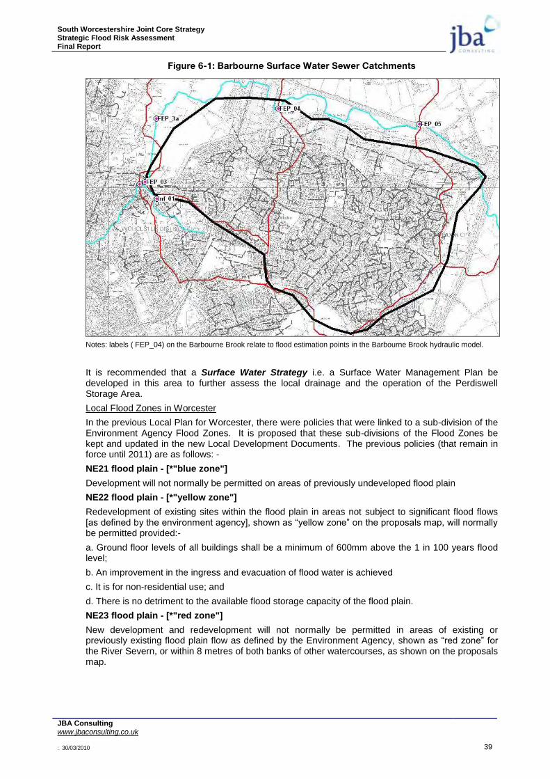
South Worcestershire Joint Core Strategy Strategic Flood Risk Assessment Final Report
JBA Consulting www.jbaconsulting.co.uk : 30/03/2010 39
Figure 6-1: Barbourne Surface Water Sewer Catchments
Notes: labels ( FEP_04) on the Barbourne Brook relate to flood estimation points in the Barbourne Brook hydraulic model.
It is recommended that a Surface Water Strategy i.e. a Surface Water Management Plan be developed in this area to further assess the local drainage and the operation of the Perdiswell Storage Area.
Local Flood Zones in Worcester
In the previous Local Plan for Worcester, there were policies that were linked to a sub-division of the Environment Agency Flood Zones. It is proposed that these sub-divisions of the Flood Zones be kept and updated in the new Local Development Documents. The previous policies (that remain in force until 2011) are as follows: -
NE21 flood plain - [*"blue zone"]
Development will not normally be permitted on areas of previously undeveloped flood plain
NE22 flood plain - [*"yellow zone"]
Redevelopment of existing sites within the flood plain in areas not subject to significant flood flows [as defined by the environment agency], shown as “yellow zone” on the proposals map, will normally be permitted provided:-
a. Ground floor levels of all buildings shall be a minimum of 600mm above the 1 in 100 years flood level;
b. An improvement in the ingress and evacuation of flood water is achieved
c. It is for non-residential use; and
d. There is no detriment to the available flood storage capacity of the flood plain.
NE23 flood plain - [*"red zone"]
New development and redevelopment will not normally be permitted in areas of existing or previously existing flood plain flow as defined by the Environment Agency, shown as “red zone” for the River Severn, or within 8 metres of both banks of other watercourses, as shown on the proposals map.
South Worcestershire Joint Core Strategy Strategic Flood Risk Assessment Final Report
JBA Consulting www.jbaconsulting.co.uk : 30/03/2010 40
NE24 flood risk assessment
All proposals for development within or deemed to have an impact upon the flood plains referred to in policies NE21, NE22 and NE23 as shown on the proposals map, are required to provide a flood risk assessment.
The blue, yellow and red sub-divisions of the Flood Zones in Worcester are shown in Appendix E. The Barbourne Brook Flood Zones have been updated following the completion of the new Barbourne Brook hydraulic model.
Wychavon District Council
In Wychavon, flood risk is from the River Avon in Evesham and Pershore, the River Salwarpe the Droitwich Canals and many small watercourses in the rural areas. In addition surface water is an issue in many locations. The council has undertaken studies to identify and assess where possible, the floods that were recorded in 2007 and 1998. These studies and records are available to view at the council house in Pershore by contacting the main contact number at the Pershore One Stop Shop 01386 565000. Detailed flood risk for the River Avon is available by requesting data from the Environment Agency for the River Avon model. A new River Avon Model, including Depth and Velocity Maps is programmed for 2010/11.
A Broadscale surface water sewerage model was developed as part of the Level 2 SFRA for Droitwich. This confirms that surface water discharge in some areas of the town will exacerbate flooding from the River Salwarpe. A more detailed study of the surface water flooding issues in Droitwich is currently being prepared by Severn Trent Water following a hydraulic sewer model assessment by their Consultants. It is recommended, that when this study has been completed, a surface water strategy i.e. a Surface Water Management Plan should be developed for Droitwich.
It is recommended that a Surface Water Strategy i.e. a Surface Water Management Plan be developed for Pershore to assess the local drainage because of the reported surface water issues.
It is proposed to adopt a similar approach as Worcester in respect of the blue, yellow and red sub-divisions of the flood zones in Evesham, Pershore and Droitwich. These are shown in Appendix E.
Malvern Hills District Council
In Malvern Hills the main cause of flooding is local watercourses and surface water sewers. In particular, rapid response catchments are of concern and as many of the watercourses at risk from such flooding are less than 3km
2 in area there are no Flood Risk Maps covering these areas. The
Environment Agency have produced a Rapid Response Risk Register based on rainfall modelling techniques similar to the Surface Water Vulnerability Maps produced by JBA Consulting and these will be useful to identify areas at risk from rapid response catchments.
A study to collect information on the 2007 floods has been undertaken by Consultants BWB and these records are available to view at the council house in Malvern by contacting the main contact number 01684 862151.
The BWB report identified 39 flooded properties in Tenbury Wells (2007 floods), mainly from surface water. The cattle market near the centre of town is a low spot and has frequently been flooded.
Bog Lane has a culverted watercourse which caused severe surface water flooding in 2007. Water follows flow routes along Bog Lane, Berrington Gardens, Cross Street and down towards the centre of town.
There are surface water problems at Wheeler Orchard to the south of Tenbury Wells town centre, with an overland flood route affecting properties back to the Kyre Brook. There are similar problems affecting properties near The Crescent.
Flood information in Kempsey is available by requesting information from the Environment Agency from the River Severn model and the Hatfield Brook model.
In Malvern, Whippets Brook is a problem, due to being a quick response catchment. Flooding problems have been identified at Tanhouse Lane, where Whippets brook runs through a residential area. Redevelopment of the Defence Evaluation Research Agency could cause more problems with flooding from Whippets Brook.

South Worcestershire Joint Core Strategy Strategic Flood Risk Assessment Final Report
JBA Consulting www.jbaconsulting.co.uk : 30/03/2010 41
There is a surface water flooding problem at St Ann‟s Road with high runoff rates from the Malvern Hills.
The watercourse running through Spring Lane Industrial Estate and beneath Townsend Way is a problem where flooding occurred in the past, mainly associated with culverts.
Pool Brook running through Watkins Way (residential) has flooded in the past. Surface water flooding has also occurred at Longridge Road, St Bernard Drive and at a culverted section of the watercourse at Murren Avenue.
Upton Upon Severn town centre becomes cut off when an extreme flood occurs on the River Severn. There is an important flood flow route to the west of the town that should not be obstructed. Existing caravan sites within the flow route can be problematic.
It is proposed to adopt a similar approach as Worcester in respect of the blue, yellow and red sub-divisions of the flood zones in Upton upon Severn and Tenbury Wells. These are shown in Appendix E.
Lower Severn Internal Drainage Board
The area of the Severn Internal Drainage Board within the South Worcestershire Joint Core Strategy area is limited to the Longdon Marshes in the south of the Malverns Hills DC area. The main flood risk issue for the Severn IDB is the condition of the Longdon Brook which will affect the IDB drains that drain to it. Only 1 or 2 flooding reports were received in 2007 but these could increase if the Longdon Brook is not maintained. Any development proposals affecting the Longdon Marshes or Longdon Brook will need to be discussed with the Severn IDB to agree strategies for surface water disposal and flood protection. Contact details for the Lower Severn Internal Drainage Board are: Waterside Buildings, Oldbury Naite, Thornbury, South Gloucestershire, BS35 1RF. Telephone 01454 413340.
South Worcestershire Joint Core Strategy Strategic Flood Risk Assessment Final Report
JBA Consulting www.jbaconsulting.co.uk : 30/03/2010 42
7 INITIAL ASSESSMENT OF SITES PROPOSED FOR THE PRE-SUBMISSION
DOCUMENT
7.1 Introduction
Sixteen Strategic Allocation Areas have been identified for the South Worcestershire Joint Core Strategy Pre-Submission document by the local authorities. As part of the Level 2 SFRA each site has been initially assessed for flood risk and guidance provided for detailed site specific flood risk assessments for each site. The following methodology was initially undertaken to identify the 16 areas:
The South Worcestershire authorities produced a methodology for their joint Strategic Housing Land Availability Assessment in April 2007;
The Environment Agency was one of several bodies consulted on the draft methodology; The methodology identified flood risk as one of the overriding constraints to housing development.
Thus sites were ranked in two levels. Level one sites were those sites ‚unsuitable because of major planning/ physical constraints including :
o Flood Plain considerations- i.e. those sites in Flood Zones 2 & 3 as identified on the EA Flood Zone maps
o Other major constraints included national & local nature designations; and high levels of land contamination;
Sites in level one above were generally taken no further in terms of assessing housing potential unless: o A further exploration was done on sites in flood zones 2 & 3 to ascertain if some of the site area
(particularly on the larger sites) might be suitable for housing. o Thus an estimate was made of the percentage of each relevant site in flood zones 2 & 3; o From the above, sites with more than 50% of their area in flood zone were excluded from
further development consideration in the SHLAA; None of the Strategic sites in the preferred options paper for the SWJCS were in Flood Zones 2 & 3,
except for peripheral areas of a few sites.
The following tables provide the summary information for each Strategic Allocation Area. Where minor watercourses cross the areas that have not been mapped for Flood Zones (as the catchments are less than 3km
2), the precautionary approach is recommended, whereby floodplains are initially assumed to extend to
8m on either of the watercourses. A more detailed analysis should be undertaken for these watercourse at the detailed FRA stage.

South Worcestershire Joint Core Strategy Strategic Flood Risk Assessment Final Report
JBA Consulting www.jbaconsulting.co.uk : 30/03/2010 43
Table 7-1: Worcester North West
OS NGR: SO 823 561 Area: 364 ha Brown/Greenfield: Both
Flood Zone Coverage: FZ3a 4%; FZ3b 1%; FZ2 4%; FZ1 91%
Exception Test required? Yes, for More Vulnerable and Essential Infrastructure development in FZ3a and Highly Vulnerable development in FZ2.
Requirements for passing part c. of the Exception Test:
To pass Part „c‟ of the Exception Test, a FRA should demonstrate that: the development will be safe, will avoid increasing flood risk elsewhere, and will reduce flood risk overall.
Preference should be given first to locating development to the western and southern parts of this development area away from Laughern Brook. It should be possible to reduce flood risk at this development area by using sequential design to locate more vulnerable development towards higher ground, through building design, and by meeting drainage requirements. Some resilience measures may be required if buildings are sited in the flood risk area.
Consultation with the Local Authority and the Environment Agency should be undertaken at an early stage.
Flood Zone Map:
© Crown copyright 2008. All rights reserved. Worcester City Council: 100018714 (2008) Wychavon District Council: 100024324 (2008) Malvern Hills District Council: 100018590 (2008)
Climate Change:
© Crown copyright 2008. All rights reserved. Worcester City Council: 100018714 (2008) Wychavon District Council: 100024324 (2008) Malvern Hills District Council: 100018590 (2008)
North
North
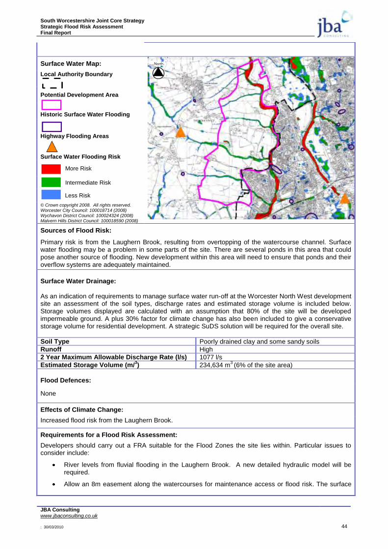
South Worcestershire Joint Core Strategy Strategic Flood Risk Assessment Final Report
JBA Consulting www.jbaconsulting.co.uk : 30/03/2010 44
Surface Water Map:
Local Authority Boundary
Potential Development Area
Historic Surface Water Flooding
Highway Flooding Areas
Surface Water Flooding Risk
More Risk
Intermediate Risk
Less Risk
© Crown copyright 2008. All rights reserved. Worcester City Council: 100018714 (2008) Wychavon District Council: 100024324 (2008) Malvern Hills District Council: 100018590 (2008)
Sources of Flood Risk:
Primary risk is from the Laughern Brook, resulting from overtopping of the watercourse channel. Surface water flooding may be a problem in some parts of the site. There are several ponds in this area that could pose another source of flooding. New development within this area will need to ensure that ponds and their overflow systems are adequately maintained.
Surface Water Drainage: As an indication of requirements to manage surface water run-off at the Worcester North West development site an assessment of the soil types, discharge rates and estimated storage volume is included below. Storage volumes displayed are calculated with an assumption that 80% of the site will be developed impermeable ground. A plus 30% factor for climate change has also been included to give a conservative storage volume for residential development. A strategic SuDS solution will be required for the overall site.
Soil Type Poorly drained clay and some sandy soils
Runoff High
2 Year Maximum Allowable Discharge Rate (l/s) 1077 l/s
Estimated Storage Volume (m/3) 234,634 m
3 (6% of the site area)
Flood Defences:
None
Effects of Climate Change:
Increased flood risk from the Laughern Brook.
Requirements for a Flood Risk Assessment:
Developers should carry out a FRA suitable for the Flood Zones the site lies within. Particular issues to consider include:
River levels from fluvial flooding in the Laughern Brook. A new detailed hydraulic model will be required.
Allow an 8m easement along the watercourses for maintenance access or flood risk. The surface
North
South Worcestershire Joint Core Strategy Strategic Flood Risk Assessment Final Report
JBA Consulting www.jbaconsulting.co.uk : 30/03/2010 45
water map gives an indication of where this will be required along ordinary watercourses.
Consider the effect of climate change over the next 100 years on fluvial river flows.
Demonstration that the development will meet necessary drainage requirements to avoid increasing flood risk elsewhere.
The use of SuDS will be required for surface water discharge.
Surface water flow rates should be restricted to existing Greenfield rates.
Demonstration that development at this location can be made safe.
Consider using flood zones 2 and 3 as public open space.
Consider de-culverting of existing watercourses where possible.
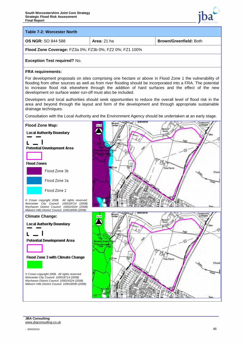
South Worcestershire Joint Core Strategy Strategic Flood Risk Assessment Final Report
JBA Consulting www.jbaconsulting.co.uk : 30/03/2010 46
Table 7-2: Worcester North
OS NGR: SO 844 588 Area: 21 ha Brown/Greenfield: Both
Flood Zone Coverage: FZ3a 0%; FZ3b 0%; FZ2 0%; FZ1 100%
Exception Test required? No.
FRA requirements:
For development proposals on sites comprising one hectare or above in Flood Zone 1 the vulnerability of flooding from other sources as well as from river flooding should be incorporated into a FRA. The potential to increase flood risk elsewhere through the addition of hard surfaces and the effect of the new development on surface water run-off must also be included.
Developers and local authorities should seek opportunities to reduce the overall level of flood risk in the area and beyond through the layout and form of the development and through appropriate sustainable drainage techniques.
Consultation with the Local Authority and the Environment Agency should be undertaken at an early stage.
Flood Zone Map:
© Crown copyright 2008. All rights reserved.
Worcester City Council: 100018714 (2008) Wychavon District Council: 100024324 (2008) Malvern Hills District Council: 100018590 (2008)
Climate Change:
© Crown copyright 2008. All rights reserved. Worcester City Council: 100018714 (2008)
Wychavon District Council: 100024324 (2008) Malvern Hills District Council: 100018590 (2008)
North
North
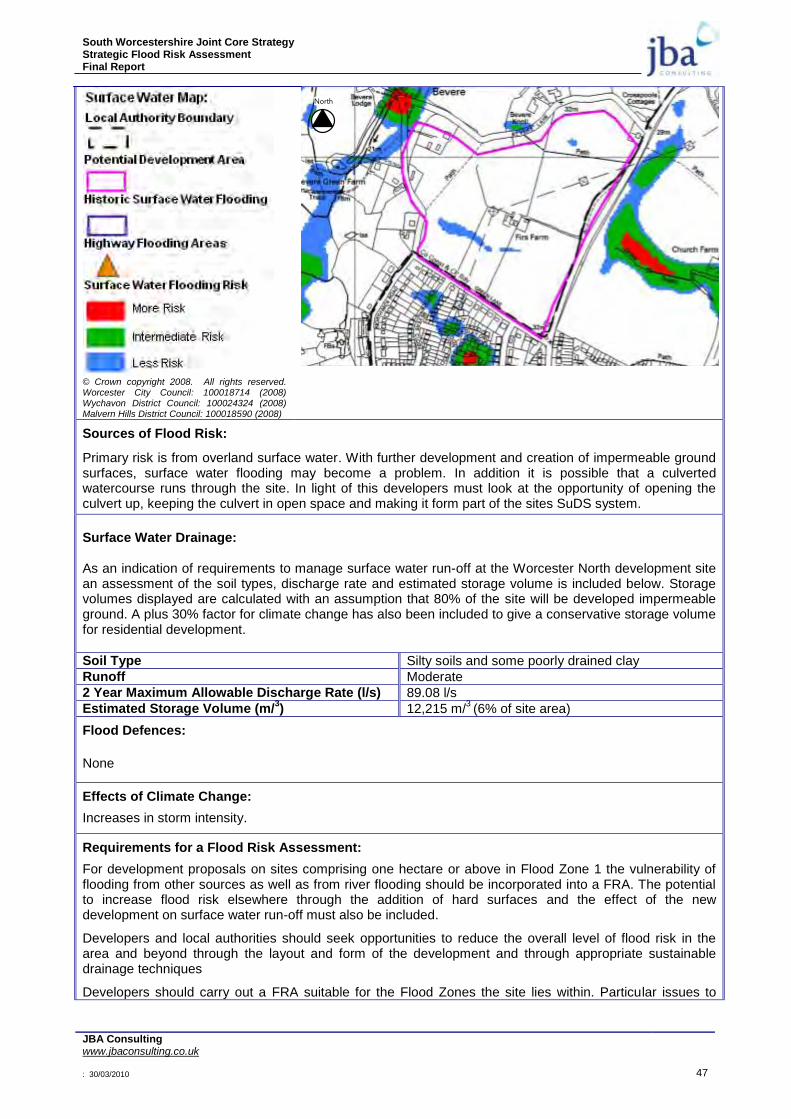
South Worcestershire Joint Core Strategy Strategic Flood Risk Assessment Final Report
JBA Consulting www.jbaconsulting.co.uk : 30/03/2010 47
© Crown copyright 2008. All rights reserved. Worcester City Council: 100018714 (2008) Wychavon District Council: 100024324 (2008) Malvern Hills District Council: 100018590 (2008)
Sources of Flood Risk:
Primary risk is from overland surface water. With further development and creation of impermeable ground surfaces, surface water flooding may become a problem. In addition it is possible that a culverted watercourse runs through the site. In light of this developers must look at the opportunity of opening the culvert up, keeping the culvert in open space and making it form part of the sites SuDS system.
Surface Water Drainage: As an indication of requirements to manage surface water run-off at the Worcester North development site an assessment of the soil types, discharge rate and estimated storage volume is included below. Storage volumes displayed are calculated with an assumption that 80% of the site will be developed impermeable ground. A plus 30% factor for climate change has also been included to give a conservative storage volume for residential development.
Soil Type Silty soils and some poorly drained clay
Runoff Moderate
2 Year Maximum Allowable Discharge Rate (l/s) 89.08 l/s
Estimated Storage Volume (m/3) 12,215 m/
3 (6% of site area)
Flood Defences:
None
Effects of Climate Change:
Increases in storm intensity.
Requirements for a Flood Risk Assessment:
For development proposals on sites comprising one hectare or above in Flood Zone 1 the vulnerability of flooding from other sources as well as from river flooding should be incorporated into a FRA. The potential to increase flood risk elsewhere through the addition of hard surfaces and the effect of the new development on surface water run-off must also be included.
Developers and local authorities should seek opportunities to reduce the overall level of flood risk in the area and beyond through the layout and form of the development and through appropriate sustainable drainage techniques
Developers should carry out a FRA suitable for the Flood Zones the site lies within. Particular issues to
North

South Worcestershire Joint Core Strategy Strategic Flood Risk Assessment Final Report
JBA Consulting www.jbaconsulting.co.uk : 30/03/2010 48
consider include:
Consider the effect of climate change over the next 100 years on fluvial river flows.
Demonstration that the development will meet necessary drainage requirements to avoid increasing flood risk elsewhere.
The use of SuDS will be required for surface water discharge.
Surface water flow rates should be restricted to existing Greenfield rates. Consultation with the Local Authority and the Environment Agency should be undertaken at an early stage.
Consider using flood zones 2 and 3 as public open space.
Consider de-culverting of existing watercourses where possible.

South Worcestershire Joint Core Strategy Strategic Flood Risk Assessment Final Report
JBA Consulting www.jbaconsulting.co.uk : 30/03/2010 49
Table 7-3: Fernhill Heath
OS NGR: SO 866 596 Area: 33 ha Brown/Greenfield: Greenfield
Flood Zone Coverage: FZ3a 0%; FZ3b 0%; FZ2 0%; FZ1 100%
Exception Test required? No.
FRA requirements:
For development proposals on sites comprising one hectare or above in Flood Zone 1 the vulnerability of flooding from other sources as well as from river flooding should be incorporated into a FRA. The potential to increase flood risk elsewhere through the addition of hard surfaces and the effect of the new development on surface water run-off must also be included.
Developers and local authorities should seek opportunities to reduce the overall level of flood risk in the area and beyond through the layout and form of the development and through appropriate sustainable drainage techniques.
Consultation with the Local Authority and the Environment Agency should be undertaken at an early stage.
Flood Zone Map:
© Crown copyright 2008. All rights reserved.
Worcester City Council: 100018714 (2008) Wychavon District Council: 100024324 (2008) Malvern Hills District Council: 100018590 (2008)
Climate Change:
© Crown copyright 2008. All rights reserved. Worcester City Council: 100018714 (2008)
Wychavon District Council: 100024324 (2008) Malvern Hills District Council: 100018590 (2008)
North
North
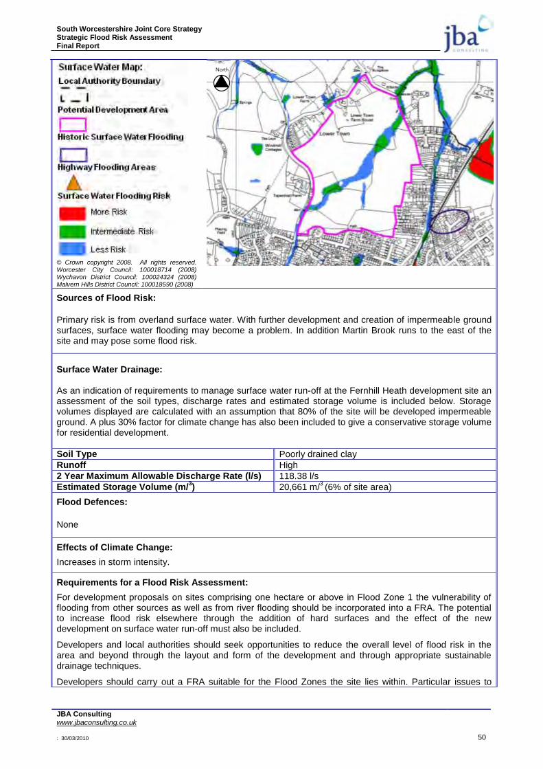
South Worcestershire Joint Core Strategy Strategic Flood Risk Assessment Final Report
JBA Consulting www.jbaconsulting.co.uk : 30/03/2010 50
© Crown copyright 2008. All rights reserved. Worcester City Council: 100018714 (2008) Wychavon District Council: 100024324 (2008) Malvern Hills District Council: 100018590 (2008)
Sources of Flood Risk:
Primary risk is from overland surface water. With further development and creation of impermeable ground surfaces, surface water flooding may become a problem. In addition Martin Brook runs to the east of the site and may pose some flood risk.
Surface Water Drainage: As an indication of requirements to manage surface water run-off at the Fernhill Heath development site an assessment of the soil types, discharge rates and estimated storage volume is included below. Storage volumes displayed are calculated with an assumption that 80% of the site will be developed impermeable ground. A plus 30% factor for climate change has also been included to give a conservative storage volume for residential development.
Soil Type Poorly drained clay
Runoff High
2 Year Maximum Allowable Discharge Rate (l/s) 118.38 l/s
Estimated Storage Volume (m/3) 20,661 m/
3 (6% of site area)
Flood Defences:
None
Effects of Climate Change:
Increases in storm intensity.
Requirements for a Flood Risk Assessment:
For development proposals on sites comprising one hectare or above in Flood Zone 1 the vulnerability of flooding from other sources as well as from river flooding should be incorporated into a FRA. The potential to increase flood risk elsewhere through the addition of hard surfaces and the effect of the new development on surface water run-off must also be included.
Developers and local authorities should seek opportunities to reduce the overall level of flood risk in the area and beyond through the layout and form of the development and through appropriate sustainable drainage techniques.
Developers should carry out a FRA suitable for the Flood Zones the site lies within. Particular issues to
North

South Worcestershire Joint Core Strategy Strategic Flood Risk Assessment Final Report
JBA Consulting www.jbaconsulting.co.uk : 30/03/2010 51
consider include:
Consider the effect of climate change over the next 100 years on fluvial river flows.
Demonstration that the development will meet necessary drainage requirements to avoid increasing flood risk elsewhere.
Allow an 8m easement along the watercourses for maintenance access or flood risk. The surface water map gives an indication of where this will be required along ordinary watercourses.
The use of SuDS will be required for surface water discharge.
Surface water flow rates should be restricted to existing Greenfield rates. Consultation with the Local Authority and the Environment Agency should be undertaken at an early stage
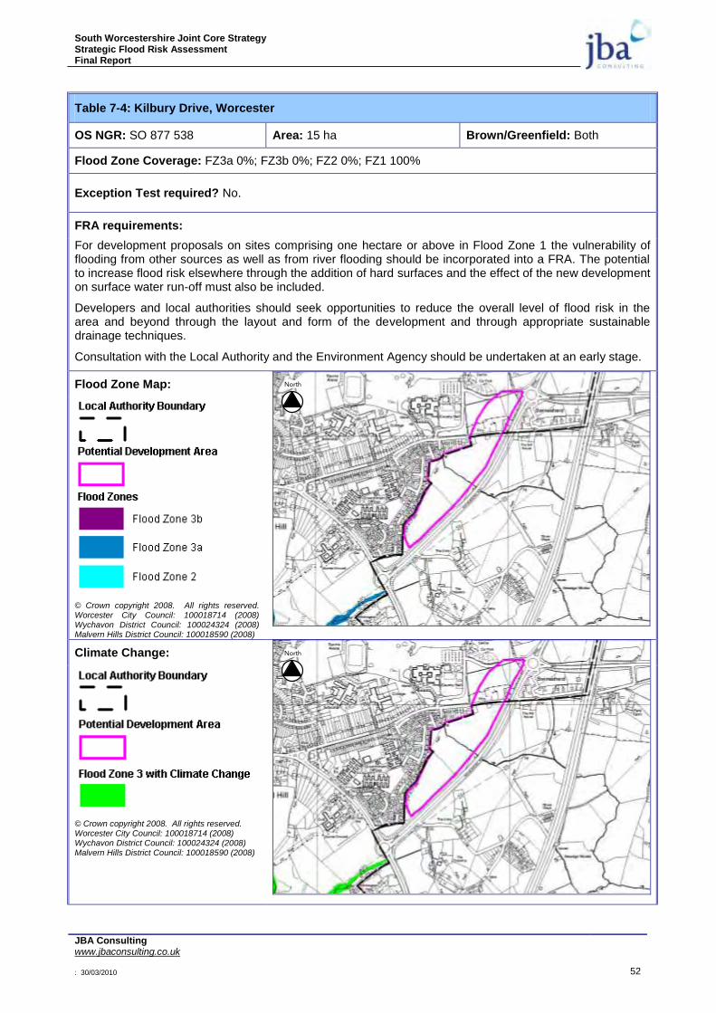
South Worcestershire Joint Core Strategy Strategic Flood Risk Assessment Final Report
JBA Consulting www.jbaconsulting.co.uk : 30/03/2010 52
Table 7-4: Kilbury Drive, Worcester
OS NGR: SO 877 538 Area: 15 ha Brown/Greenfield: Both
Flood Zone Coverage: FZ3a 0%; FZ3b 0%; FZ2 0%; FZ1 100%
Exception Test required? No.
FRA requirements:
For development proposals on sites comprising one hectare or above in Flood Zone 1 the vulnerability of flooding from other sources as well as from river flooding should be incorporated into a FRA. The potential to increase flood risk elsewhere through the addition of hard surfaces and the effect of the new development on surface water run-off must also be included.
Developers and local authorities should seek opportunities to reduce the overall level of flood risk in the area and beyond through the layout and form of the development and through appropriate sustainable drainage techniques.
Consultation with the Local Authority and the Environment Agency should be undertaken at an early stage.
Flood Zone Map:
© Crown copyright 2008. All rights reserved. Worcester City Council: 100018714 (2008) Wychavon District Council: 100024324 (2008) Malvern Hills District Council: 100018590 (2008)
Climate Change:
© Crown copyright 2008. All rights reserved. Worcester City Council: 100018714 (2008) Wychavon District Council: 100024324 (2008) Malvern Hills District Council: 100018590 (2008)
North
North

South Worcestershire Joint Core Strategy Strategic Flood Risk Assessment Final Report
JBA Consulting www.jbaconsulting.co.uk : 30/03/2010 53
© Crown copyright 2008. All rights reserved. Worcester City Council: 100018714 (2008) Wychavon District Council: 100024324 (2008) Malvern Hills District Council: 100018590 (2008)
Sources of Flood Risk:
Primary risk is from the small watercourse flowing west to east through the site. No Flood Zones are shown for this watercourse; however, the detailed flood risk needs to be assessed. With further development and creation of impermeable ground surfaces, surface water flooding may become a problem. Again developers will need to ensure the watercourse is kept in open space and linked to appropriate SuDS techniques.
Surface Water Drainage: As an indication of requirements to manage surface water run-off at the Kilbury Drive development site an assessment of the soil types, discharge rates and estimated storage volume is included below. Storage volumes displayed are calculated with an assumption that 80% of the site will be developed impermeable ground. A plus 30% factor for climate change has also been included to give a conservative storage volume for residential development.
Soil Type Poorly drained clay
Runoff High
2 Year Maximum Allowable Discharge Rate (l/s) 51.62 l/s
Estimated Storage Volume (m/3) 8,875 m/
3 (5% of site area)
Flood Defences:
None
Effects of Climate Change:
Increased watercourse flows and storm intensities.
Requirements for a Flood Risk Assessment:
For development proposals on sites comprising one hectare or above in Flood Zone 1 the vulnerability of flooding from other sources as well as from river flooding should be incorporated into a FRA. The potential to increase flood risk elsewhere through the addition of hard surfaces and the effect of the new development on surface water run-off must also be included.
Developers and local authorities should seek opportunities to reduce the overall level of flood risk in the area and beyond through the layout and form of the development and through appropriate sustainable drainage techniques.
Developers should carry out a FRA suitable for the Flood Zones the site lies within. Particular issues to
North

South Worcestershire Joint Core Strategy Strategic Flood Risk Assessment Final Report
JBA Consulting www.jbaconsulting.co.uk : 30/03/2010 54
consider include:
Assess flood risk from the minor watercourse crossing the site. A detailed model will be required.
Consider the effect of climate change over the next 100 years on fluvial flows.
Allow an 8m easement along the watercourses for maintenance access or flood risk. The surface water map gives an indication of where this will be required along ordinary watercourses.
Demonstration that the development will meet necessary drainage requirements to avoid increasing flood risk elsewhere.
The use of SuDS will be required for surface water discharge.
Surface water flow rates should be restricted to existing Greenfield rates. Consultation with the Local Authority and the Environment Agency should be undertaken at an early stage.
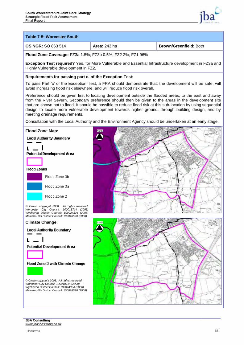
South Worcestershire Joint Core Strategy Strategic Flood Risk Assessment Final Report
JBA Consulting www.jbaconsulting.co.uk : 30/03/2010 55
Table 7-5: Worcester South
OS NGR: SO 863 514 Area: 243 ha Brown/Greenfield: Both
Flood Zone Coverage: FZ3a 1.5%; FZ3b 0.5%; FZ2 2%; FZ1 96%
Exception Test required? Yes, for More Vulnerable and Essential Infrastructure development in FZ3a and Highly Vulnerable development in FZ2.
Requirements for passing part c. of the Exception Test:
To pass Part „c‟ of the Exception Test, a FRA should demonstrate that: the development will be safe, will avoid increasing flood risk elsewhere, and will reduce flood risk overall.
Preference should be given first to locating development outside the flooded areas, to the east and away from the River Severn. Secondary preference should then be given to the areas in the development site that are shown not to flood. It should be possible to reduce flood risk at this sub-location by using sequential design to locate more vulnerable development towards higher ground, through building design, and by meeting drainage requirements.
Consultation with the Local Authority and the Environment Agency should be undertaken at an early stage.
Flood Zone Map:
© Crown copyright 2008. All rights reserved. Worcester City Council: 100018714 (2008) Wychavon District Council: 100024324 (2008) Malvern Hills District Council: 100018590 (2008)
Climate Change:
© Crown copyright 2008. All rights reserved. Worcester City Council: 100018714 (2008) Wychavon District Council: 100024324 (2008) Malvern Hills District Council: 100018590 (2008)
North
North

South Worcestershire Joint Core Strategy Strategic Flood Risk Assessment Final Report
JBA Consulting www.jbaconsulting.co.uk : 30/03/2010 56
© Crown copyright 2008. All rights reserved. Worcester City Council: 100018714 (2008) Wychavon District Council: 100024324 (2008) Malvern Hills District Council: 100018590 (2008)
Sources of Flood Risk:
Primary risk is from the River Severn and from surface water flooding, particularly with the effects of future climate change. With further development and creation of impermeable ground surfaces, surface water flooding may become a problem. Hatfield Brook running across the site will need to be assessed using the Hatfield Brook Model developed for the SFRA as part of a detailed FRA and all development should be within Flood Zone 1.
Surface Water Drainage: As an indication of requirements to manage surface water run-off at the Worcester South development site an assessment of the soil types, discharge rates and estimated storage volume is included below. Storage volumes displayed are calculated with an assumption that 80% of the site will be developed impermeable ground. A plus 30% factor for climate change has also been included to give a conservative storage volume for residential development. A strategic SuDS solution will be required for the overall site.
Soil Type Poorly drained clay
Runoff High
2 Year Maximum Allowable Discharge Rate (l/s) 1029.46 l/s
Estimated Storage Volume (m/3) 144,177 m/
3 (6% of site area)
Flood Defences:
None
Effects of Climate Change:
Increased river levels are likely to increase the overall flood risk from the River Severn. Increased storm intensity.
Requirements for a Flood Risk Assessment:
Developers should carry out a FRA suitable for the Flood Zones the site lies within. Particular issues to consider include:
River levels from fluvial flooding in the River Severn and ordinary watercourses.
Consider the effect of climate change over the next 100 years on fluvial river flows.
Allow an 8m easement along the watercourses for maintenance access or flood risk. The surface water map gives an indication of where this will be required along ordinary watercourses.
North
South Worcestershire Joint Core Strategy Strategic Flood Risk Assessment Final Report
JBA Consulting www.jbaconsulting.co.uk : 30/03/2010 57
Demonstration that the development will meet necessary drainage requirements to avoid increasing flood risk elsewhere.
Demonstration that development at this location can be made safe.
The use of SuDS will be required for surface water discharge.
Surface water flow rates should be restricted to existing Greenfield rates. Consultation with the Local Authority and the Environment Agency should be undertaken at an early stage.
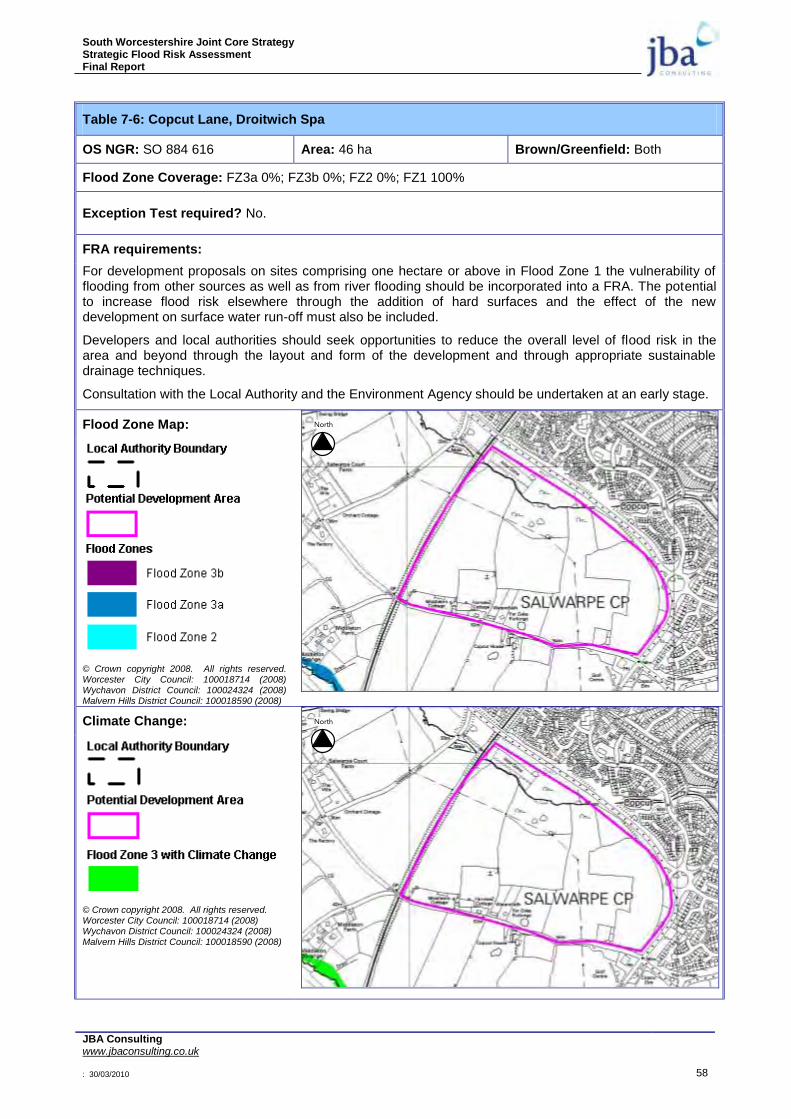
South Worcestershire Joint Core Strategy Strategic Flood Risk Assessment Final Report
JBA Consulting www.jbaconsulting.co.uk : 30/03/2010 58
Table 7-6: Copcut Lane, Droitwich Spa
OS NGR: SO 884 616 Area: 46 ha Brown/Greenfield: Both
Flood Zone Coverage: FZ3a 0%; FZ3b 0%; FZ2 0%; FZ1 100%
Exception Test required? No.
FRA requirements:
For development proposals on sites comprising one hectare or above in Flood Zone 1 the vulnerability of flooding from other sources as well as from river flooding should be incorporated into a FRA. The potential to increase flood risk elsewhere through the addition of hard surfaces and the effect of the new development on surface water run-off must also be included.
Developers and local authorities should seek opportunities to reduce the overall level of flood risk in the area and beyond through the layout and form of the development and through appropriate sustainable drainage techniques.
Consultation with the Local Authority and the Environment Agency should be undertaken at an early stage.
Flood Zone Map:
© Crown copyright 2008. All rights reserved. Worcester City Council: 100018714 (2008) Wychavon District Council: 100024324 (2008) Malvern Hills District Council: 100018590 (2008)
Climate Change:
© Crown copyright 2008. All rights reserved. Worcester City Council: 100018714 (2008) Wychavon District Council: 100024324 (2008) Malvern Hills District Council: 100018590 (2008)
North
North

South Worcestershire Joint Core Strategy Strategic Flood Risk Assessment Final Report
JBA Consulting www.jbaconsulting.co.uk : 30/03/2010 59
© Crown copyright 2008. All rights reserved. Worcester City Council: 100018714 (2008) Wychavon District Council: 100024324 (2008) Malvern Hills District Council: 100018590 (2008)
Sources of Flood Risk:
Primary risk is from the minor watercourse on the north of the site. A new hydraulic model will be required to assess actual flood risk from this watercourse. With further development and creation of impermeable ground surfaces, surface water flooding may become a problem.
Surface Water Drainage: As an indication of requirements to manage surface water run-off at the Copcut Lane development site an assessment of the soil types, discharge rates and estimated storage volume is included below. Storage volumes displayed are calculated with an assumption that 80% of the site will be developed impermeable ground. A plus 30% factor for climate change has also been included to give a conservative storage volume for residential development.
Soil Type Poorly drained clay
Runoff High
2 Year Maximum Allowable Discharge Rate (l/s) 175.89 l/s
Estimated Storage Volume (m/3) 28,113 m/
3 (6% of site area)
Flood Defences:
None
Effects of Climate Change:
Increased watercourse design water levels and increased rainfall intensities.
Requirements for a Flood Risk Assessment:
For development proposals on sites comprising one hectare or above in Flood Zone 1 the vulnerability of flooding from other sources as well as from river flooding should be incorporated into a FRA. The potential to increase flood risk elsewhere through the addition of hard surfaces and the effect of the new development on surface water run-off must also be included.
Developers and local authorities should seek opportunities to reduce the overall level of flood risk in the area and beyond through the layout and form of the development and through appropriate sustainable drainage techniques.
Developers should carry out a FRA suitable for the Flood Zones the site lies within. Particular issues to
North
South Worcestershire Joint Core Strategy Strategic Flood Risk Assessment Final Report
JBA Consulting www.jbaconsulting.co.uk : 30/03/2010 60
consider include:
River levels from fluvial flooding in the minor watercourse.
Consider the effect of climate change over the next 100 years on fluvial river flows.
Allow an 8m easement along the watercourses for maintenance access or flood risk. The surface water map gives an indication of where this will be required along ordinary watercourses.
Demonstration that the development will meet necessary drainage requirements to avoid increasing flood risk elsewhere.
Demonstration that development at this location can be made safe.
The use of SuDS will be required for surface water discharge.
Surface water flow rates should be restricted to existing Greenfield rates. Consultation with the Local Authority and the Environment Agency should be undertaken at an early stage.
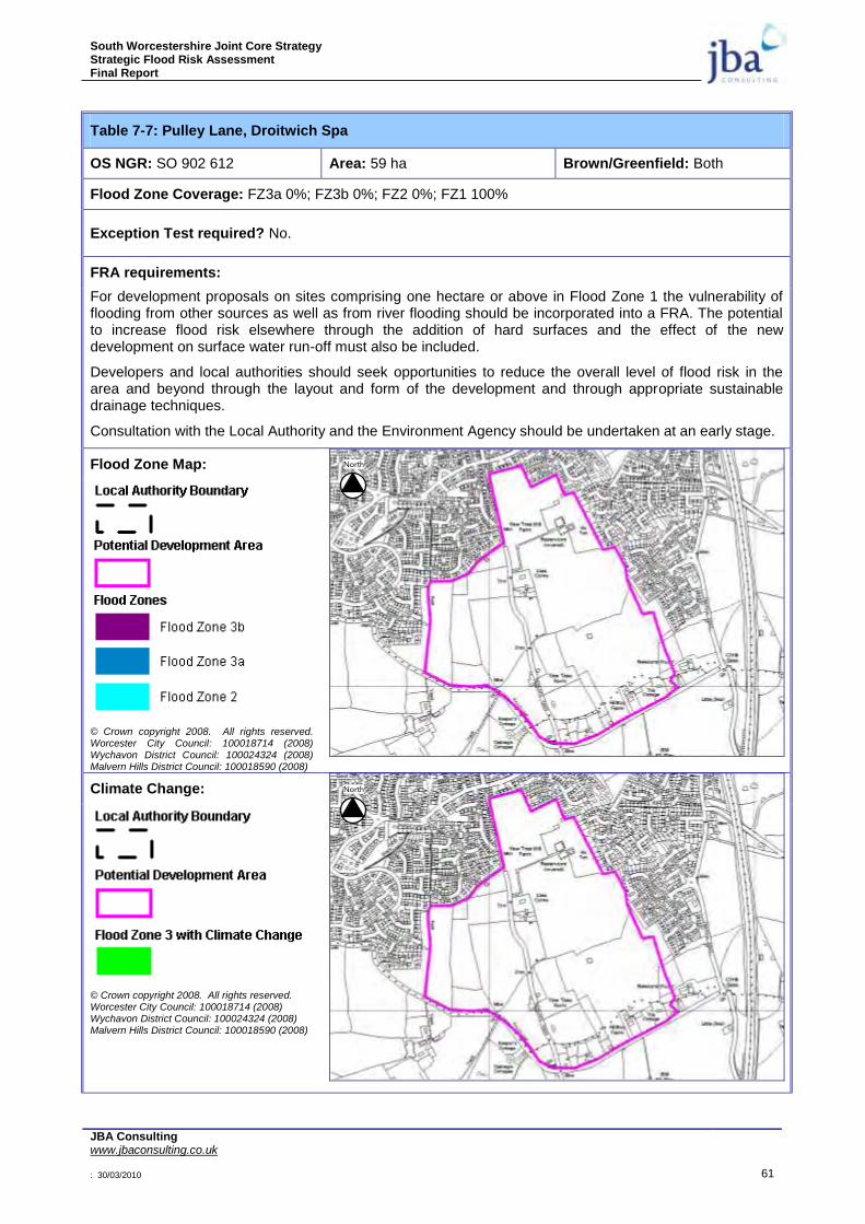
South Worcestershire Joint Core Strategy Strategic Flood Risk Assessment Final Report
JBA Consulting www.jbaconsulting.co.uk : 30/03/2010 61
Table 7-7: Pulley Lane, Droitwich Spa
OS NGR: SO 902 612 Area: 59 ha Brown/Greenfield: Both
Flood Zone Coverage: FZ3a 0%; FZ3b 0%; FZ2 0%; FZ1 100%
Exception Test required? No.
FRA requirements:
For development proposals on sites comprising one hectare or above in Flood Zone 1 the vulnerability of flooding from other sources as well as from river flooding should be incorporated into a FRA. The potential to increase flood risk elsewhere through the addition of hard surfaces and the effect of the new development on surface water run-off must also be included.
Developers and local authorities should seek opportunities to reduce the overall level of flood risk in the area and beyond through the layout and form of the development and through appropriate sustainable drainage techniques.
Consultation with the Local Authority and the Environment Agency should be undertaken at an early stage.
Flood Zone Map:
© Crown copyright 2008. All rights reserved. Worcester City Council: 100018714 (2008) Wychavon District Council: 100024324 (2008) Malvern Hills District Council: 100018590 (2008)
Climate Change:
© Crown copyright 2008. All rights reserved. Worcester City Council: 100018714 (2008) Wychavon District Council: 100024324 (2008) Malvern Hills District Council: 100018590 (2008)
North
North
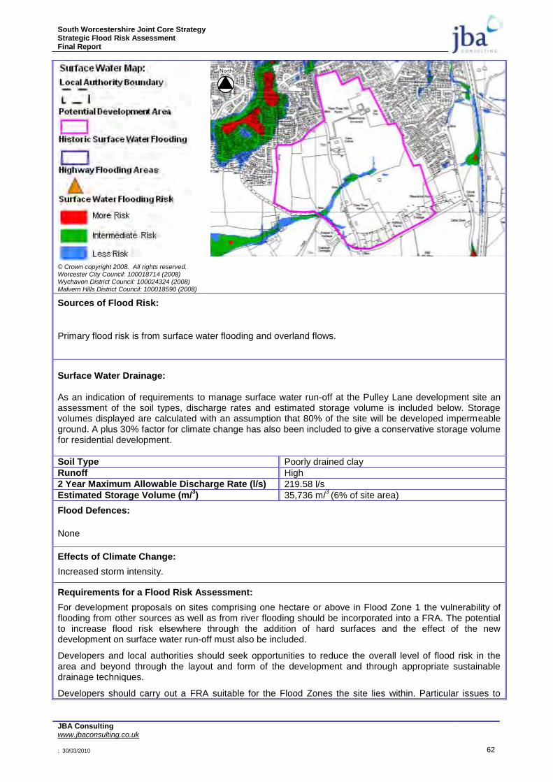
South Worcestershire Joint Core Strategy Strategic Flood Risk Assessment Final Report
JBA Consulting www.jbaconsulting.co.uk : 30/03/2010 62
© Crown copyright 2008. All rights reserved. Worcester City Council: 100018714 (2008) Wychavon District Council: 100024324 (2008) Malvern Hills District Council: 100018590 (2008)
Sources of Flood Risk:
Primary flood risk is from surface water flooding and overland flows.
Surface Water Drainage: As an indication of requirements to manage surface water run-off at the Pulley Lane development site an assessment of the soil types, discharge rates and estimated storage volume is included below. Storage volumes displayed are calculated with an assumption that 80% of the site will be developed impermeable ground. A plus 30% factor for climate change has also been included to give a conservative storage volume for residential development.
Soil Type Poorly drained clay
Runoff High
2 Year Maximum Allowable Discharge Rate (l/s) 219.58 l/s
Estimated Storage Volume (m/3) 35,736 m/
3 (6% of site area)
Flood Defences:
None
Effects of Climate Change:
Increased storm intensity.
Requirements for a Flood Risk Assessment:
For development proposals on sites comprising one hectare or above in Flood Zone 1 the vulnerability of flooding from other sources as well as from river flooding should be incorporated into a FRA. The potential to increase flood risk elsewhere through the addition of hard surfaces and the effect of the new development on surface water run-off must also be included.
Developers and local authorities should seek opportunities to reduce the overall level of flood risk in the area and beyond through the layout and form of the development and through appropriate sustainable drainage techniques.
Developers should carry out a FRA suitable for the Flood Zones the site lies within. Particular issues to
North

South Worcestershire Joint Core Strategy Strategic Flood Risk Assessment Final Report
JBA Consulting www.jbaconsulting.co.uk : 30/03/2010 63
consider include:
Demonstration that the development will meet necessary drainage requirements to avoid increasing flood risk elsewhere.
Allow an 8m easement along the watercourses for maintenance access or flood risk. The surface water map gives an indication of where this will be required along ordinary watercourses.
Demonstration that development at this location can be made safe.
The use of SuDS will be required for surface water discharge.
Surface water flow rates should be restricted to existing Greenfield rates. Consultation with the Local Authority and the Environment Agency should be undertaken at an early stage.
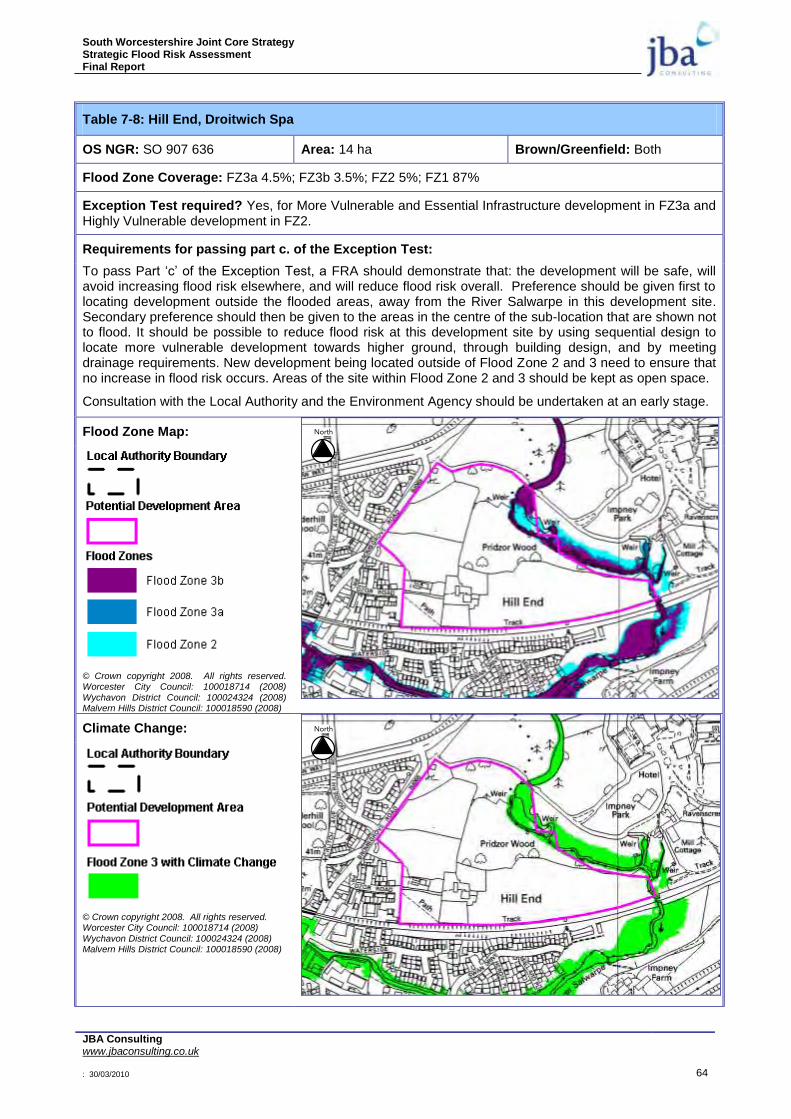
South Worcestershire Joint Core Strategy Strategic Flood Risk Assessment Final Report
JBA Consulting www.jbaconsulting.co.uk : 30/03/2010 64
Table 7-8: Hill End, Droitwich Spa
OS NGR: SO 907 636 Area: 14 ha Brown/Greenfield: Both
Flood Zone Coverage: FZ3a 4.5%; FZ3b 3.5%; FZ2 5%; FZ1 87%
Exception Test required? Yes, for More Vulnerable and Essential Infrastructure development in FZ3a and Highly Vulnerable development in FZ2.
Requirements for passing part c. of the Exception Test:
To pass Part „c‟ of the Exception Test, a FRA should demonstrate that: the development will be safe, will avoid increasing flood risk elsewhere, and will reduce flood risk overall. Preference should be given first to locating development outside the flooded areas, away from the River Salwarpe in this development site. Secondary preference should then be given to the areas in the centre of the sub-location that are shown not to flood. It should be possible to reduce flood risk at this development site by using sequential design to locate more vulnerable development towards higher ground, through building design, and by meeting drainage requirements. New development being located outside of Flood Zone 2 and 3 need to ensure that no increase in flood risk occurs. Areas of the site within Flood Zone 2 and 3 should be kept as open space.
Consultation with the Local Authority and the Environment Agency should be undertaken at an early stage.
Flood Zone Map:
© Crown copyright 2008. All rights reserved. Worcester City Council: 100018714 (2008)
Wychavon District Council: 100024324 (2008) Malvern Hills District Council: 100018590 (2008)
Climate Change:
© Crown copyright 2008. All rights reserved. Worcester City Council: 100018714 (2008)
Wychavon District Council: 100024324 (2008) Malvern Hills District Council: 100018590 (2008)
North
North

South Worcestershire Joint Core Strategy Strategic Flood Risk Assessment Final Report
JBA Consulting www.jbaconsulting.co.uk : 30/03/2010 65
© Crown copyright 2008. All rights reserved. Worcester City Council: 100018714 (2008) Wychavon District Council: 100024324 (2008) Malvern Hills District Council: 100018590 (2008)
Sources of Flood Risk:
Primary risk is from the River Salwarpe. With further development and creation of impermeable ground surfaces, surface water flooding may become a problem.
Surface Water Drainage: As an indication of requirements to manage surface water run-off at the Hill End development site an assessment of the soil types, discharge rates and estimated storage volume is included below. Storage volumes displayed are calculated with an assumption that 80% of the site will be developed impermeable ground. A plus 30% factor for climate change has also been included to give a conservative storage volume for residential development.
Soil Type Poorly drained clay
Runoff High
2 Year Maximum Allowable Discharge Rate (l/s) 56.38 l/s
Estimated Storage Volume (m/3) 8,803 m/
3 (6% of site area)
Flood Defences:
None
Effects of Climate Change:
Increased water levels in the River Salwarpe.
Requirements for a Flood Risk Assessment:
Developers should carry out a FRA suitable for the Flood Zones the site lies within. Particular issues to consider include:
River levels from fluvial flooding in the River Salwarpe.
Allow an 8m easement along the watercourses for maintenance access or flood risk. The surface water map gives an indication of where this will be required along ordinary watercourses.Consider the effect of climate change over the next 100 years on fluvial river flows.
Demonstration that the development will meet necessary drainage requirements to avoid increasing
North
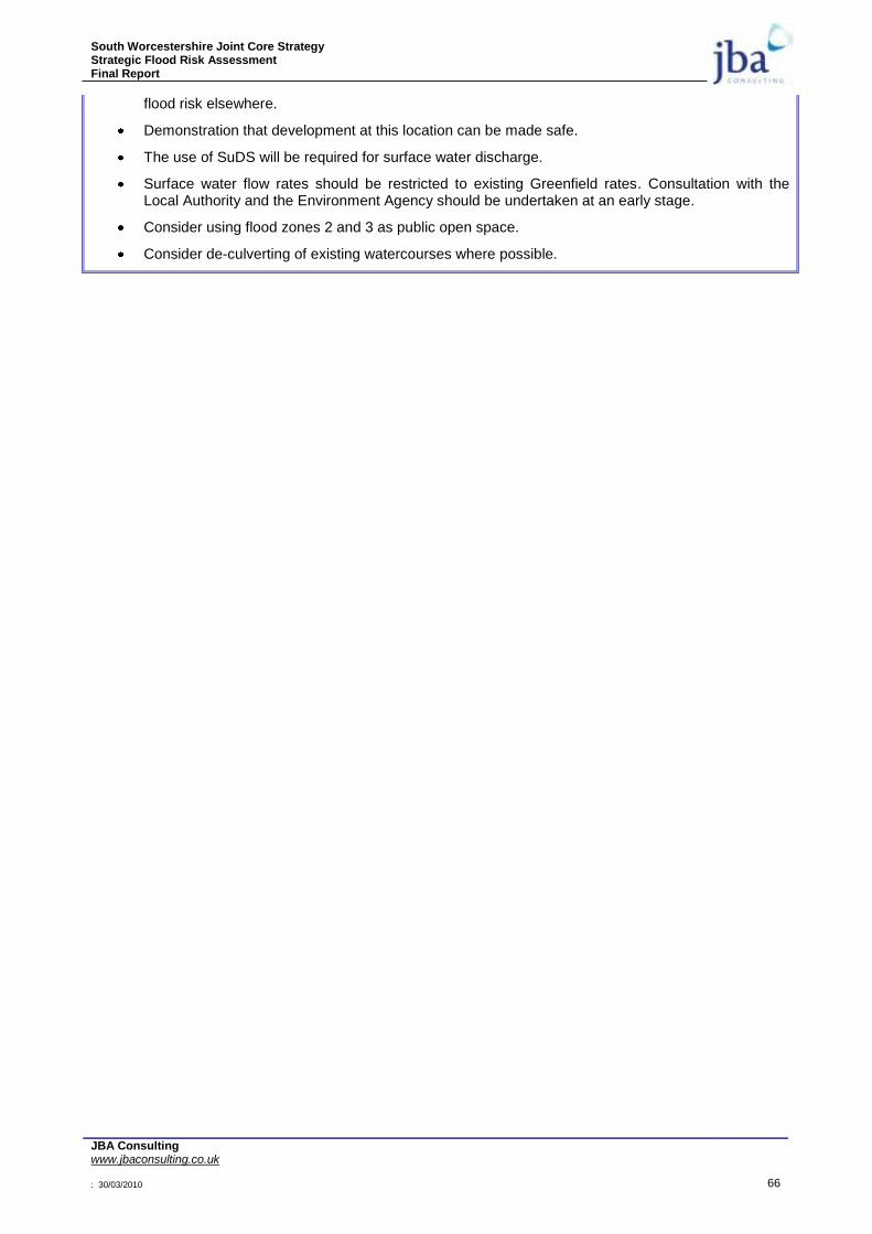
South Worcestershire Joint Core Strategy Strategic Flood Risk Assessment Final Report
JBA Consulting www.jbaconsulting.co.uk : 30/03/2010 66
flood risk elsewhere.
Demonstration that development at this location can be made safe.
The use of SuDS will be required for surface water discharge.
Surface water flow rates should be restricted to existing Greenfield rates. Consultation with the Local Authority and the Environment Agency should be undertaken at an early stage.
Consider using flood zones 2 and 3 as public open space.
Consider de-culverting of existing watercourses where possible.
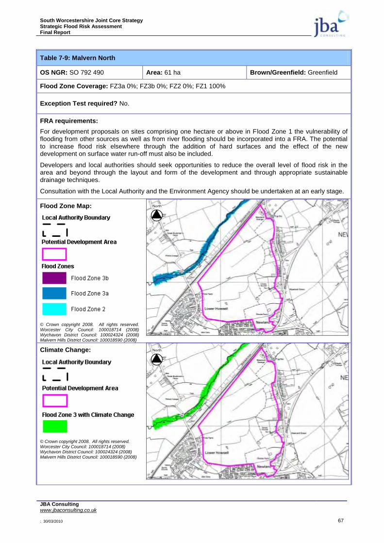
South Worcestershire Joint Core Strategy Strategic Flood Risk Assessment Final Report
JBA Consulting www.jbaconsulting.co.uk : 30/03/2010 67
Table 7-9: Malvern North
OS NGR: SO 792 490 Area: 61 ha Brown/Greenfield: Greenfield
Flood Zone Coverage: FZ3a 0%; FZ3b 0%; FZ2 0%; FZ1 100%
Exception Test required? No.
FRA requirements:
For development proposals on sites comprising one hectare or above in Flood Zone 1 the vulnerability of flooding from other sources as well as from river flooding should be incorporated into a FRA. The potential to increase flood risk elsewhere through the addition of hard surfaces and the effect of the new development on surface water run-off must also be included.
Developers and local authorities should seek opportunities to reduce the overall level of flood risk in the area and beyond through the layout and form of the development and through appropriate sustainable drainage techniques.
Consultation with the Local Authority and the Environment Agency should be undertaken at an early stage.
Flood Zone Map:
© Crown copyright 2008. All rights reserved. Worcester City Council: 100018714 (2008) Wychavon District Council: 100024324 (2008) Malvern Hills District Council: 100018590 (2008)
Climate Change:
© Crown copyright 2008. All rights reserved. Worcester City Council: 100018714 (2008) Wychavon District Council: 100024324 (2008) Malvern Hills District Council: 100018590 (2008)
North
North
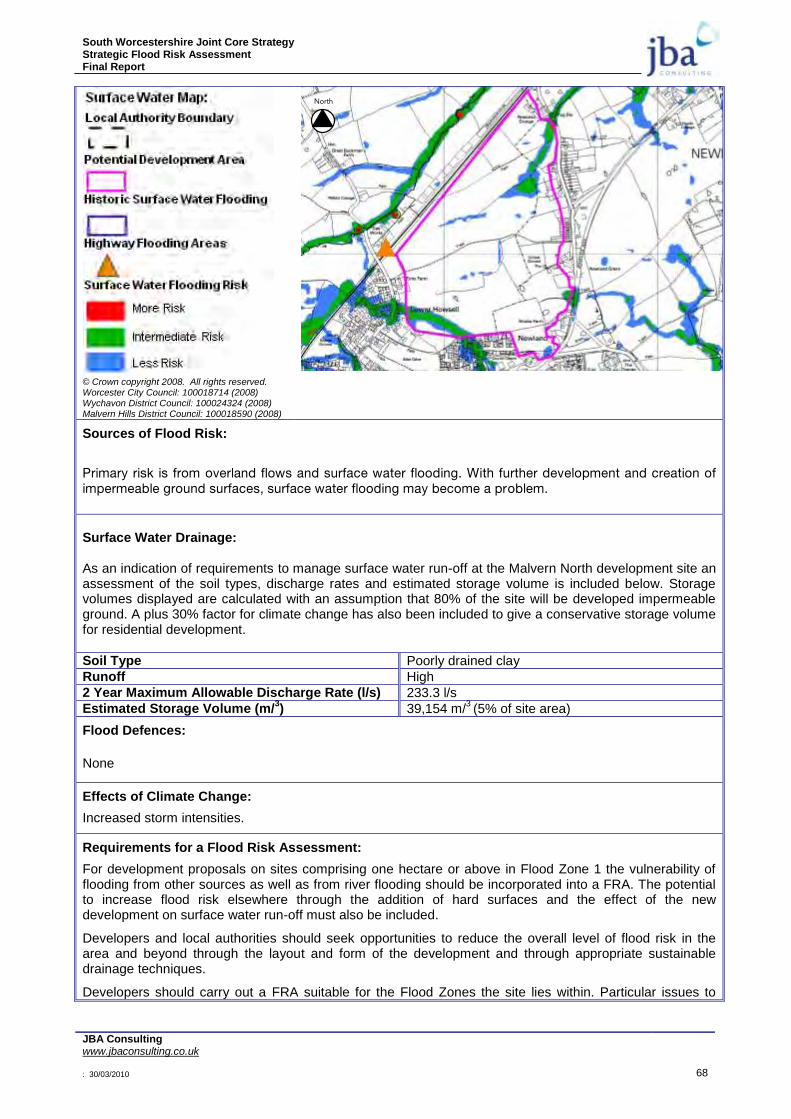
South Worcestershire Joint Core Strategy Strategic Flood Risk Assessment Final Report
JBA Consulting www.jbaconsulting.co.uk : 30/03/2010 68
© Crown copyright 2008. All rights reserved. Worcester City Council: 100018714 (2008) Wychavon District Council: 100024324 (2008) Malvern Hills District Council: 100018590 (2008)
Sources of Flood Risk:
Primary risk is from overland flows and surface water flooding. With further development and creation of impermeable ground surfaces, surface water flooding may become a problem.
Surface Water Drainage: As an indication of requirements to manage surface water run-off at the Malvern North development site an assessment of the soil types, discharge rates and estimated storage volume is included below. Storage volumes displayed are calculated with an assumption that 80% of the site will be developed impermeable ground. A plus 30% factor for climate change has also been included to give a conservative storage volume for residential development.
Soil Type Poorly drained clay
Runoff High
2 Year Maximum Allowable Discharge Rate (l/s) 233.3 l/s
Estimated Storage Volume (m/3) 39,154 m/
3 (5% of site area)
Flood Defences:
None
Effects of Climate Change:
Increased storm intensities.
Requirements for a Flood Risk Assessment:
For development proposals on sites comprising one hectare or above in Flood Zone 1 the vulnerability of flooding from other sources as well as from river flooding should be incorporated into a FRA. The potential to increase flood risk elsewhere through the addition of hard surfaces and the effect of the new development on surface water run-off must also be included.
Developers and local authorities should seek opportunities to reduce the overall level of flood risk in the area and beyond through the layout and form of the development and through appropriate sustainable drainage techniques.
Developers should carry out a FRA suitable for the Flood Zones the site lies within. Particular issues to
North

South Worcestershire Joint Core Strategy Strategic Flood Risk Assessment Final Report
JBA Consulting www.jbaconsulting.co.uk : 30/03/2010 69
consider include:
Demonstration that the development will meet necessary drainage requirements to avoid increasing flood risk elsewhere.
Allow an 8m easement along the watercourses for maintenance access or flood risk. The surface water map gives an indication of where this will be required along ordinary watercourses.
Demonstration that development at this location can be made safe.
The use of SuDS will be required for surface water discharge.
Surface water flow rates should be restricted to existing Greenfield rates. Consultation with the Local Authority and the Environment Agency should be undertaken at an early stage.
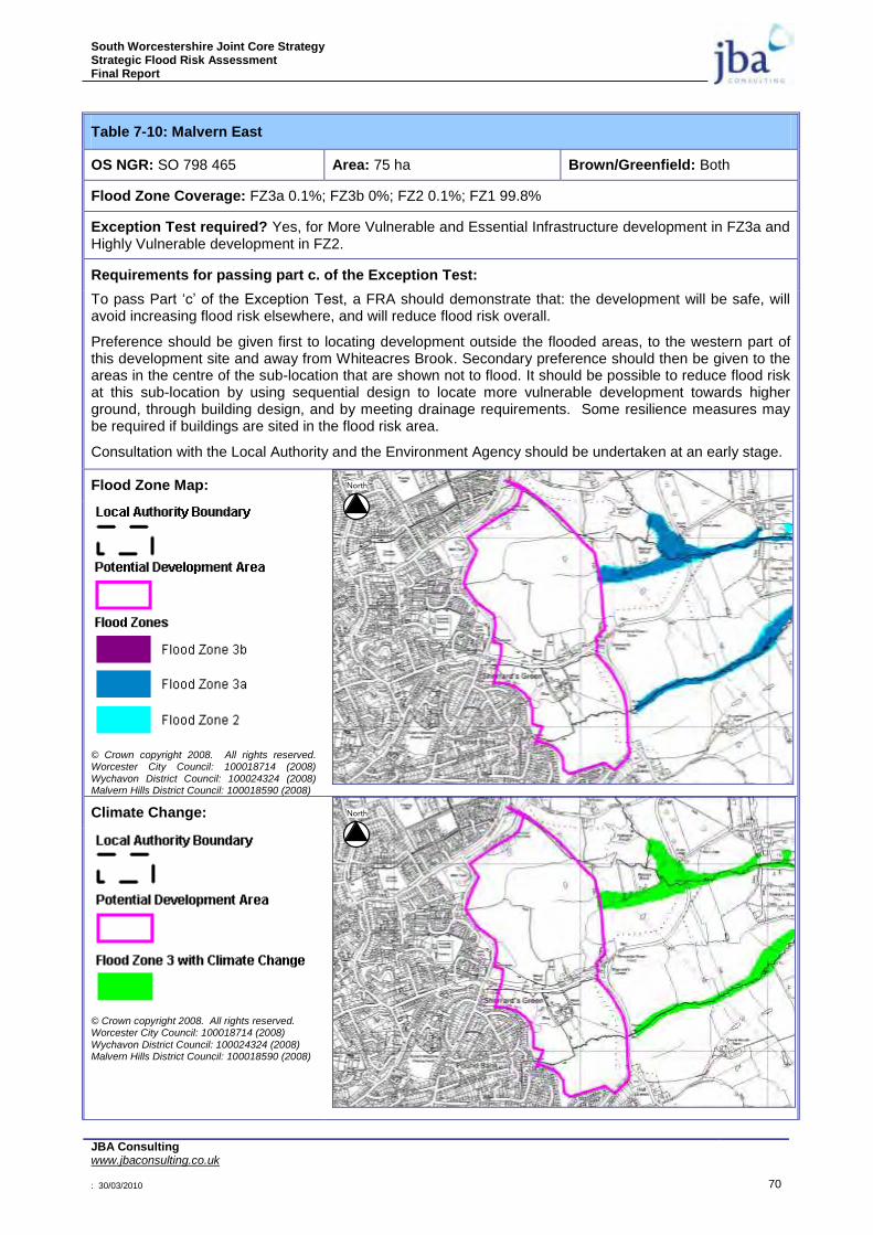
South Worcestershire Joint Core Strategy Strategic Flood Risk Assessment Final Report
JBA Consulting www.jbaconsulting.co.uk : 30/03/2010 70
Table 7-10: Malvern East
OS NGR: SO 798 465 Area: 75 ha Brown/Greenfield: Both
Flood Zone Coverage: FZ3a 0.1%; FZ3b 0%; FZ2 0.1%; FZ1 99.8%
Exception Test required? Yes, for More Vulnerable and Essential Infrastructure development in FZ3a and Highly Vulnerable development in FZ2.
Requirements for passing part c. of the Exception Test:
To pass Part „c‟ of the Exception Test, a FRA should demonstrate that: the development will be safe, will avoid increasing flood risk elsewhere, and will reduce flood risk overall.
Preference should be given first to locating development outside the flooded areas, to the western part of this development site and away from Whiteacres Brook. Secondary preference should then be given to the areas in the centre of the sub-location that are shown not to flood. It should be possible to reduce flood risk at this sub-location by using sequential design to locate more vulnerable development towards higher ground, through building design, and by meeting drainage requirements. Some resilience measures may be required if buildings are sited in the flood risk area.
Consultation with the Local Authority and the Environment Agency should be undertaken at an early stage.
Flood Zone Map:
© Crown copyright 2008. All rights reserved. Worcester City Council: 100018714 (2008)
Wychavon District Council: 100024324 (2008) Malvern Hills District Council: 100018590 (2008)
Climate Change:
© Crown copyright 2008. All rights reserved. Worcester City Council: 100018714 (2008)
Wychavon District Council: 100024324 (2008) Malvern Hills District Council: 100018590 (2008)
North
North

South Worcestershire Joint Core Strategy Strategic Flood Risk Assessment Final Report
JBA Consulting www.jbaconsulting.co.uk : 30/03/2010 71
© Crown copyright 2008. All rights reserved. Worcester City Council: 100018714 (2008) Wychavon District Council: 100024324 (2008) Malvern Hills District Council: 100018590 (2008)
Sources of Flood Risk:
Primary risk is from the Whiteacres Brook. With further development and creation of impermeable ground surfaces, surface water flooding may become a problem.
Surface Water Drainage: As an indication of requirements to manage surface water run-off at the Malvern East development site an assessment of the soil types, discharge rates and estimated storage volume is included below. Storage volumes displayed are calculated with an assumption that 80% of the site will be developed impermeable ground. A plus 30% factor for climate change has also been included to give a conservative storage volume for residential development.
Soil Type Poorly drained clay
Runoff High
2 Year Maximum Allowable Discharge Rate (l/s) 284.23 l/s
Estimated Storage Volume (m/3) 47,855 m/
3 (6% of site area)
Flood Defences:
None
Effects of Climate Change:
Increased water levels in the Whiteacres Brook. Increased storm intensities.
Requirements for a Flood Risk Assessment:
For development proposals on sites comprising one hectare or above in Flood Zone 1 the vulnerability of flooding from other sources as well as from river flooding should be incorporated into a FRA. The potential to increase flood risk elsewhere through the addition of hard surfaces and the effect of the new development on surface water run-off must also be included.
Developers and local authorities should seek opportunities to reduce the overall level of flood risk in the area and beyond through the layout and form of the development and through appropriate sustainable drainage techniques.
Developers should carry out a FRA suitable for the Flood Zones the site lies within. Particular issues to
North
South Worcestershire Joint Core Strategy Strategic Flood Risk Assessment Final Report
JBA Consulting www.jbaconsulting.co.uk : 30/03/2010 72
consider include:
River levels from fluvial flooding in the Whiteacres Brook.
Allow an 8m easement along the watercourses for maintenance access or flood risk. The surface water map gives an indication of where this will be required along ordinary watercourses.
Demonstration that the development will meet necessary drainage requirements to avoid increasing flood risk elsewhere.
Demonstration that development at this location can be made safe.
The use of SuDS will be required for surface water discharge.
Surface water flow rates should be restricted to existing Greenfield rates. Consultation with the Local Authority and the Environment Agency should be undertaken at an early stage.
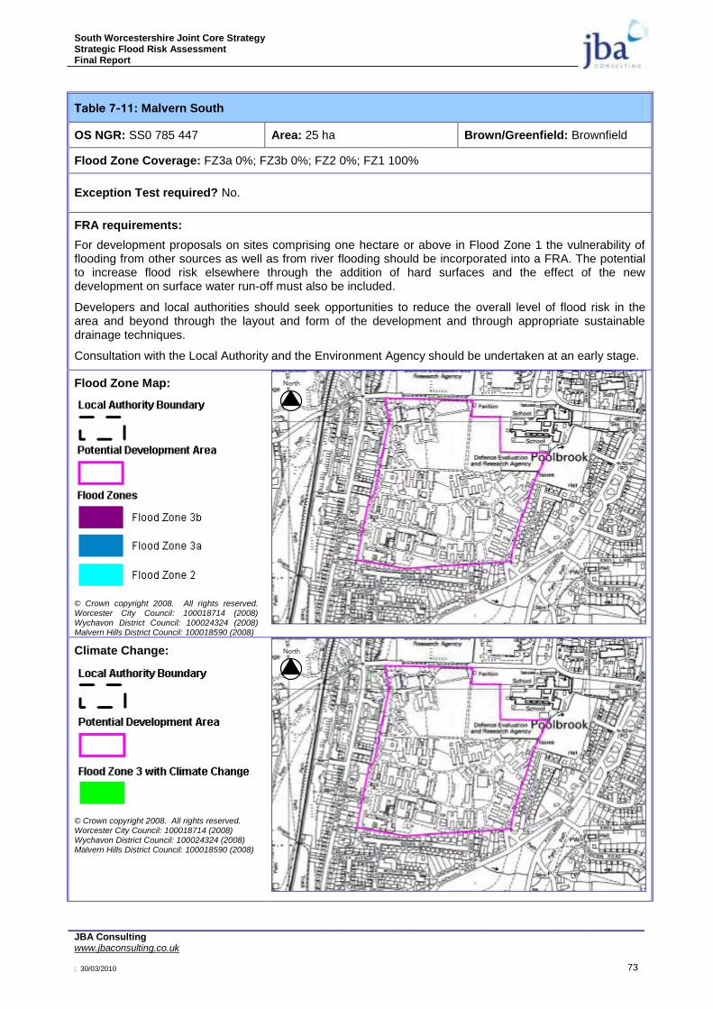
South Worcestershire Joint Core Strategy Strategic Flood Risk Assessment Final Report
JBA Consulting www.jbaconsulting.co.uk : 30/03/2010 73
Table 7-11: Malvern South
OS NGR: SS0 785 447 Area: 25 ha Brown/Greenfield: Brownfield
Flood Zone Coverage: FZ3a 0%; FZ3b 0%; FZ2 0%; FZ1 100%
Exception Test required? No.
FRA requirements:
For development proposals on sites comprising one hectare or above in Flood Zone 1 the vulnerability of flooding from other sources as well as from river flooding should be incorporated into a FRA. The potential to increase flood risk elsewhere through the addition of hard surfaces and the effect of the new development on surface water run-off must also be included.
Developers and local authorities should seek opportunities to reduce the overall level of flood risk in the area and beyond through the layout and form of the development and through appropriate sustainable drainage techniques.
Consultation with the Local Authority and the Environment Agency should be undertaken at an early stage.
Flood Zone Map:
© Crown copyright 2008. All rights reserved. Worcester City Council: 100018714 (2008) Wychavon District Council: 100024324 (2008) Malvern Hills District Council: 100018590 (2008)
Climate Change:
© Crown copyright 2008. All rights reserved. Worcester City Council: 100018714 (2008) Wychavon District Council: 100024324 (2008) Malvern Hills District Council: 100018590 (2008)
North
North
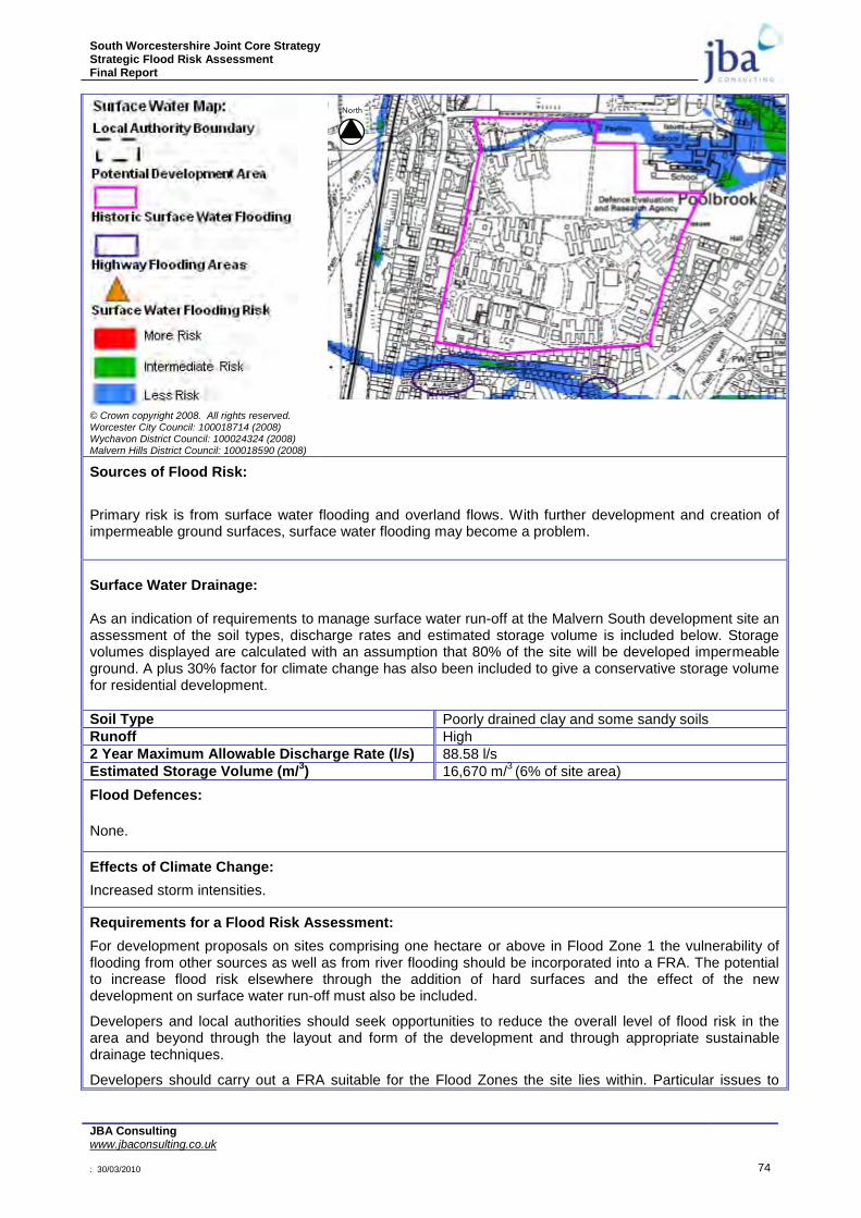
South Worcestershire Joint Core Strategy Strategic Flood Risk Assessment Final Report
JBA Consulting www.jbaconsulting.co.uk : 30/03/2010 74
© Crown copyright 2008. All rights reserved. Worcester City Council: 100018714 (2008) Wychavon District Council: 100024324 (2008) Malvern Hills District Council: 100018590 (2008)
Sources of Flood Risk:
Primary risk is from surface water flooding and overland flows. With further development and creation of impermeable ground surfaces, surface water flooding may become a problem.
Surface Water Drainage: As an indication of requirements to manage surface water run-off at the Malvern South development site an assessment of the soil types, discharge rates and estimated storage volume is included below. Storage volumes displayed are calculated with an assumption that 80% of the site will be developed impermeable ground. A plus 30% factor for climate change has also been included to give a conservative storage volume for residential development.
Soil Type Poorly drained clay and some sandy soils
Runoff High
2 Year Maximum Allowable Discharge Rate (l/s) 88.58 l/s
Estimated Storage Volume (m/3) 16,670 m/
3 (6% of site area)
Flood Defences:
None.
Effects of Climate Change:
Increased storm intensities.
Requirements for a Flood Risk Assessment:
For development proposals on sites comprising one hectare or above in Flood Zone 1 the vulnerability of flooding from other sources as well as from river flooding should be incorporated into a FRA. The potential to increase flood risk elsewhere through the addition of hard surfaces and the effect of the new development on surface water run-off must also be included.
Developers and local authorities should seek opportunities to reduce the overall level of flood risk in the area and beyond through the layout and form of the development and through appropriate sustainable drainage techniques.
Developers should carry out a FRA suitable for the Flood Zones the site lies within. Particular issues to
North

South Worcestershire Joint Core Strategy Strategic Flood Risk Assessment Final Report
JBA Consulting www.jbaconsulting.co.uk : 30/03/2010 75
consider include:
Obtain information on existing surface water and combined sewers.
Demonstration that the development will meet necessary drainage requirements to avoid increasing flood risk elsewhere.
Demonstration that development at this location can be made safe.
The use of SuDS will be required for surface water discharge.
Surface water flow rates should be restricted to previous Greenfield rates. Consultation with the Local Authority and the Environment Agency should be undertaken at an early stage.
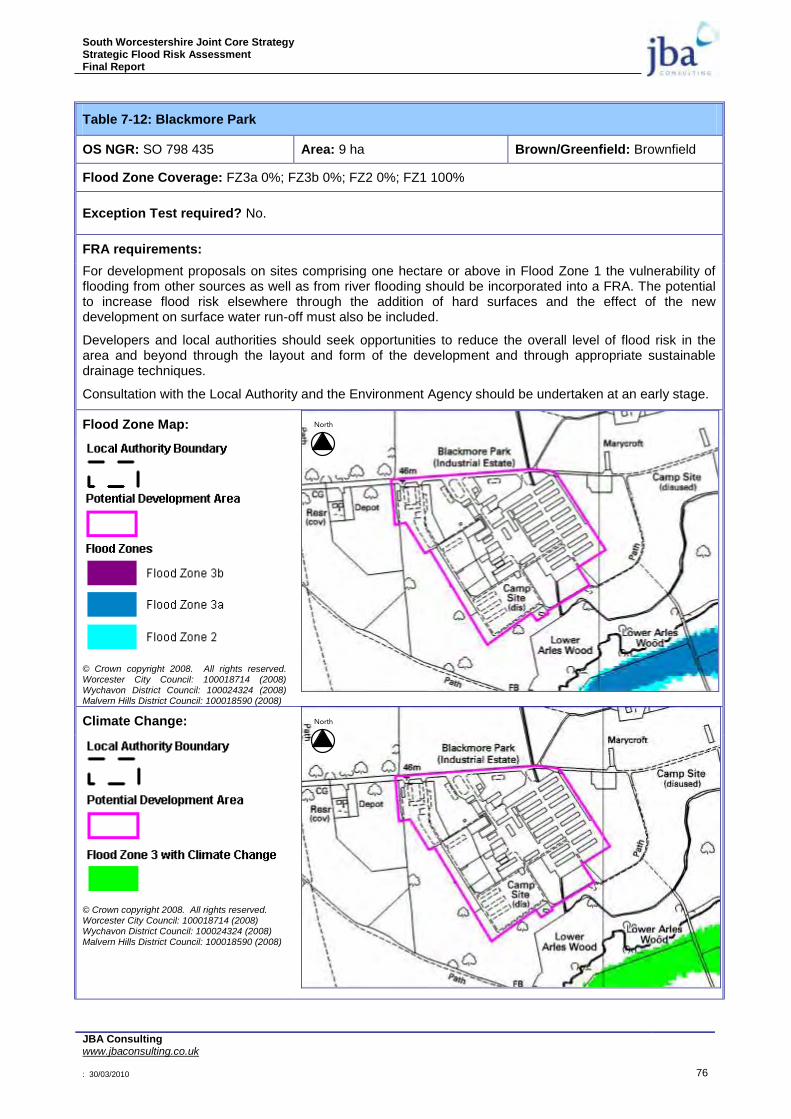
South Worcestershire Joint Core Strategy Strategic Flood Risk Assessment Final Report
JBA Consulting www.jbaconsulting.co.uk : 30/03/2010 76
Table 7-12: Blackmore Park
OS NGR: SO 798 435 Area: 9 ha Brown/Greenfield: Brownfield
Flood Zone Coverage: FZ3a 0%; FZ3b 0%; FZ2 0%; FZ1 100%
Exception Test required? No.
FRA requirements:
For development proposals on sites comprising one hectare or above in Flood Zone 1 the vulnerability of flooding from other sources as well as from river flooding should be incorporated into a FRA. The potential to increase flood risk elsewhere through the addition of hard surfaces and the effect of the new development on surface water run-off must also be included.
Developers and local authorities should seek opportunities to reduce the overall level of flood risk in the area and beyond through the layout and form of the development and through appropriate sustainable drainage techniques.
Consultation with the Local Authority and the Environment Agency should be undertaken at an early stage.
Flood Zone Map:
© Crown copyright 2008. All rights reserved. Worcester City Council: 100018714 (2008) Wychavon District Council: 100024324 (2008) Malvern Hills District Council: 100018590 (2008)
Climate Change:
© Crown copyright 2008. All rights reserved. Worcester City Council: 100018714 (2008) Wychavon District Council: 100024324 (2008) Malvern Hills District Council: 100018590 (2008)
North
North
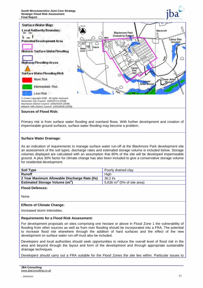
South Worcestershire Joint Core Strategy Strategic Flood Risk Assessment Final Report
JBA Consulting www.jbaconsulting.co.uk : 30/03/2010 77
© Crown copyright 2008. All rights reserved. Worcester City Council: 100018714 (2008) Wychavon District Council: 100024324 (2008) Malvern Hills District Council: 100018590 (2008)
Sources of Flood Risk:
Primary risk is from surface water flooding and overland flows. With further development and creation of impermeable ground surfaces, surface water flooding may become a problem.
Surface Water Drainage: As an indication of requirements to manage surface water run-off at the Blackmore Park development site an assessment of the soil types, discharge rates and estimated storage volume is included below. Storage volumes displayed are calculated with an assumption that 80% of the site will be developed impermeable ground. A plus 30% factor for climate change has also been included to give a conservative storage volume for residential development.
Soil Type Poorly drained clay
Runoff High
2 Year Maximum Allowable Discharge Rate (l/s) 36.2 l/s
Estimated Storage Volume (m/3) 5,636 m/
3 (5% of site area)
Flood Defences:
None.
Effects of Climate Change:
Increased storm intensities.
Requirements for a Flood Risk Assessment:
For development proposals on sites comprising one hectare or above in Flood Zone 1 the vulnerability of flooding from other sources as well as from river flooding should be incorporated into a FRA. The potential to increase flood risk elsewhere through the addition of hard surfaces and the effect of the new development on surface water run-off must also be included.
Developers and local authorities should seek opportunities to reduce the overall level of flood risk in the area and beyond through the layout and form of the development and through appropriate sustainable drainage techniques.
Developers should carry out a FRA suitable for the Flood Zones the site lies within. Particular issues to
North
South Worcestershire Joint Core Strategy Strategic Flood Risk Assessment Final Report
JBA Consulting www.jbaconsulting.co.uk : 30/03/2010 78
consider include:
Obtain information on existing surface water and combined sewers.
Demonstration that the development will meet necessary drainage requirements to avoid increasing flood risk elsewhere.
Demonstration that development at this location can be made safe.
The use of SuDS will be required for surface water discharge.
Surface water flow rates should be restricted to previous Greenfield rates. Consultation with the Local Authority and the Environment Agency should be undertaken at an early stage.

South Worcestershire Joint Core Strategy Strategic Flood Risk Assessment Final Report
JBA Consulting www.jbaconsulting.co.uk : 30/03/2010 79
Table 7-13: Pershore
OS NGR: S0 950 472 Area: 53 ha Brown/Greenfield: Both
Flood Zone Coverage: FZ3a 10%; FZ3b 6%; FZ2 10%; FZ1 74%
Exception Test required? Yes, for More Vulnerable and Essential Infrastructure development in FZ3a and Highly Vulnerable development in FZ2.
Requirements for passing part c. of the Exception Test:
To pass Part „c‟ of the Exception Test, a FRA should demonstrate that: the development will be safe, will avoid increasing flood risk elsewhere, and will reduce flood risk overall.
Preference should be given first to locating development to the western part of this development site and outside the floodplain areas of the River Avon. It should be possible to reduce flood risk at this sub-location by using sequential design to locate more vulnerable development towards higher ground, through building design, and by meeting drainage requirements. Some resilience measures may be required if buildings are sited in the flood risk area.
Consultation with the Local Authority and the Environment Agency should be undertaken at an early stage.
Flood Zone Map:
© Crown copyright 2008. All rights reserved. Worcester City Council: 100018714 (2008) Wychavon District Council: 100024324 (2008) Malvern Hills District Council: 100018590 (2008)
Climate Change:
© Crown copyright 2008. All rights reserved. Worcester City Council: 100018714 (2008) Wychavon District Council: 100024324 (2008) Malvern Hills District Council: 100018590 (2008)
North
North
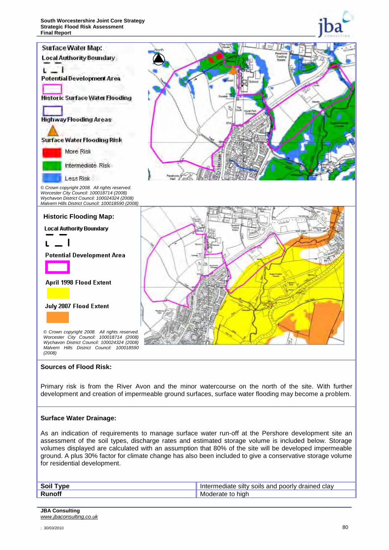
South Worcestershire Joint Core Strategy Strategic Flood Risk Assessment Final Report
JBA Consulting www.jbaconsulting.co.uk : 30/03/2010 80
© Crown copyright 2008. All rights reserved. Worcester City Council: 100018714 (2008) Wychavon District Council: 100024324 (2008) Malvern Hills District Council: 100018590 (2008)
Sources of Flood Risk:
Primary risk is from the River Avon and the minor watercourse on the north of the site. With further development and creation of impermeable ground surfaces, surface water flooding may become a problem.
Surface Water Drainage: As an indication of requirements to manage surface water run-off at the Pershore development site an assessment of the soil types, discharge rates and estimated storage volume is included below. Storage volumes displayed are calculated with an assumption that 80% of the site will be developed impermeable ground. A plus 30% factor for climate change has also been included to give a conservative storage volume for residential development.
Soil Type Intermediate silty soils and poorly drained clay
Runoff Moderate to high
North
Historic Flooding Map:
© Crown copyright 2008. All rights reserved. Worcester City Council: 100018714 (2008) Wychavon District Council: 100024324 (2008) Malvern Hills District Council: 100018590 (2008)
South Worcestershire Joint Core Strategy Strategic Flood Risk Assessment Final Report
JBA Consulting www.jbaconsulting.co.uk : 30/03/2010 81
2 Year Maximum Allowable Discharge Rate (l/s) 162.28 l/s
Estimated Storage Volume (m/3) 34,213 m/
3 (5% of site area)
Flood Defences:
None
Effects of Climate Change:
Increased flood water levels in the River Avon and increased storm intensities.
Requirements for a Flood Risk Assessment:
Developers should carry out a FRA suitable for the Flood Zones the site lies within. Particular issues to consider include:
River levels from fluvial flooding in the River Avon.
Allow an 8m easement along the watercourses for maintenance access or flood risk. The surface water map gives an indication of where this will be required along ordinary watercourses.
Consider flood risk from the minor watercourse in the north of the site. A hydraulic model will be required.
Consider the effect of climate change over the next 100 years on fluvial river flows.
Demonstration that the development will meet necessary drainage requirements to avoid increasing flood risk elsewhere.
Demonstration that development at this location can be made safe.
The use of SuDS will be required for surface water discharge.
Surface water flow rates should be restricted to existing Greenfield rates. Consultation with the Local Authority and the Environment Agency should be undertaken at an early stage..
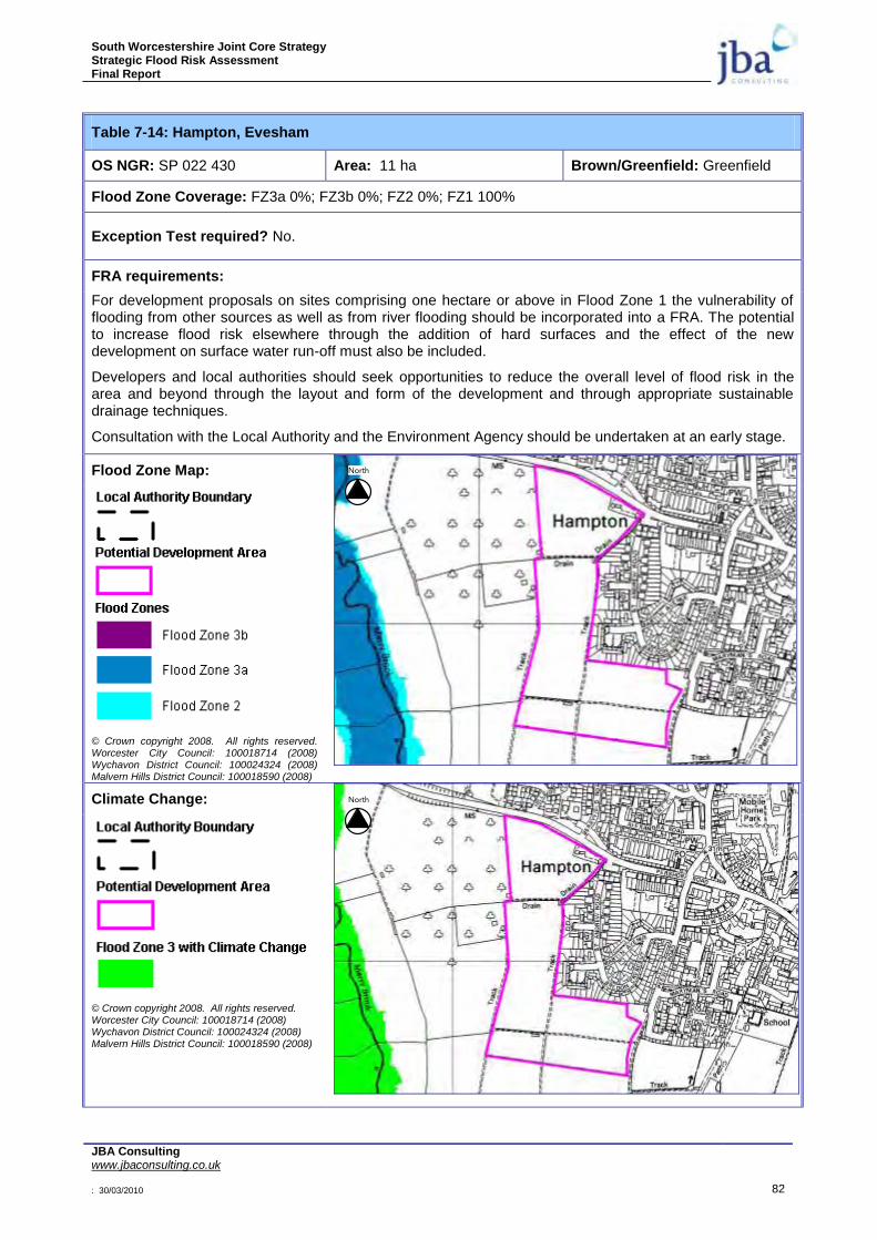
South Worcestershire Joint Core Strategy Strategic Flood Risk Assessment Final Report
JBA Consulting www.jbaconsulting.co.uk : 30/03/2010 82
Table 7-14: Hampton, Evesham
OS NGR: SP 022 430 Area: 11 ha Brown/Greenfield: Greenfield
Flood Zone Coverage: FZ3a 0%; FZ3b 0%; FZ2 0%; FZ1 100%
Exception Test required? No.
FRA requirements:
For development proposals on sites comprising one hectare or above in Flood Zone 1 the vulnerability of flooding from other sources as well as from river flooding should be incorporated into a FRA. The potential to increase flood risk elsewhere through the addition of hard surfaces and the effect of the new development on surface water run-off must also be included.
Developers and local authorities should seek opportunities to reduce the overall level of flood risk in the area and beyond through the layout and form of the development and through appropriate sustainable drainage techniques.
Consultation with the Local Authority and the Environment Agency should be undertaken at an early stage.
Flood Zone Map:
© Crown copyright 2008. All rights reserved. Worcester City Council: 100018714 (2008) Wychavon District Council: 100024324 (2008) Malvern Hills District Council: 100018590 (2008)
Climate Change:
© Crown copyright 2008. All rights reserved. Worcester City Council: 100018714 (2008) Wychavon District Council: 100024324 (2008) Malvern Hills District Council: 100018590 (2008)
North
North

South Worcestershire Joint Core Strategy Strategic Flood Risk Assessment Final Report
JBA Consulting www.jbaconsulting.co.uk : 30/03/2010 83
© Crown copyright 2008. All rights reserved. Worcester City Council: 100018714 (2008) Wychavon District Council: 100024324 (2008) Malvern Hills District Council: 100018590 (2008)
Sources of Flood Risk:
Primary risk is from surface water and overland flows. There is also an ordinary watercourse running through the site which will need to be investigated in a detailed FRA.
Surface Water Drainage: As an indication of requirements to manage surface water run-off at the Hampton development site an assessment of the soil types, discharge rates and estimated storage volume is included below. Storage volumes displayed are calculated with an assumption that 80% of the site will be developed impermeable ground. A plus 30% factor for climate change has also been included to give a conservative storage volume for residential development.
Soil Type Intermediate silty soils
Runoff Moderate
2 Year Maximum Allowable Discharge Rate (l/s) 32.16 l/s
Estimated Storage Volume (m/3) 8,000 m/
3 (6% of site area)
Flood Defences:
None
Effects of Climate Change:
Increased storm intensities.
Requirements for a Flood Risk Assessment:
For development proposals on sites comprising one hectare or above in Flood Zone 1 the vulnerability of flooding from other sources as well as from river flooding should be incorporated into a FRA. The potential to increase flood risk elsewhere through the addition of hard surfaces and the effect of the new development on surface water run-off must also be included.
Developers and local authorities should seek opportunities to reduce the overall level of flood risk in the area and beyond through the layout and form of the development and through appropriate sustainable drainage techniques.
Developers should carry out a FRA suitable for the Flood Zones the site lies within. Particular issues to
North
South Worcestershire Joint Core Strategy Strategic Flood Risk Assessment Final Report
JBA Consulting www.jbaconsulting.co.uk : 30/03/2010 84
consider include:
Demonstration that the development will meet necessary drainage requirements to avoid increasing flood risk elsewhere.
Demonstration that development at this location can be made safe.
The use of SuDS will be required for surface water discharge.
Surface water flow rates should be restricted to existing Greenfield rates. Consultation with the Local Authority and the Environment Agency should be undertaken at an early stage.
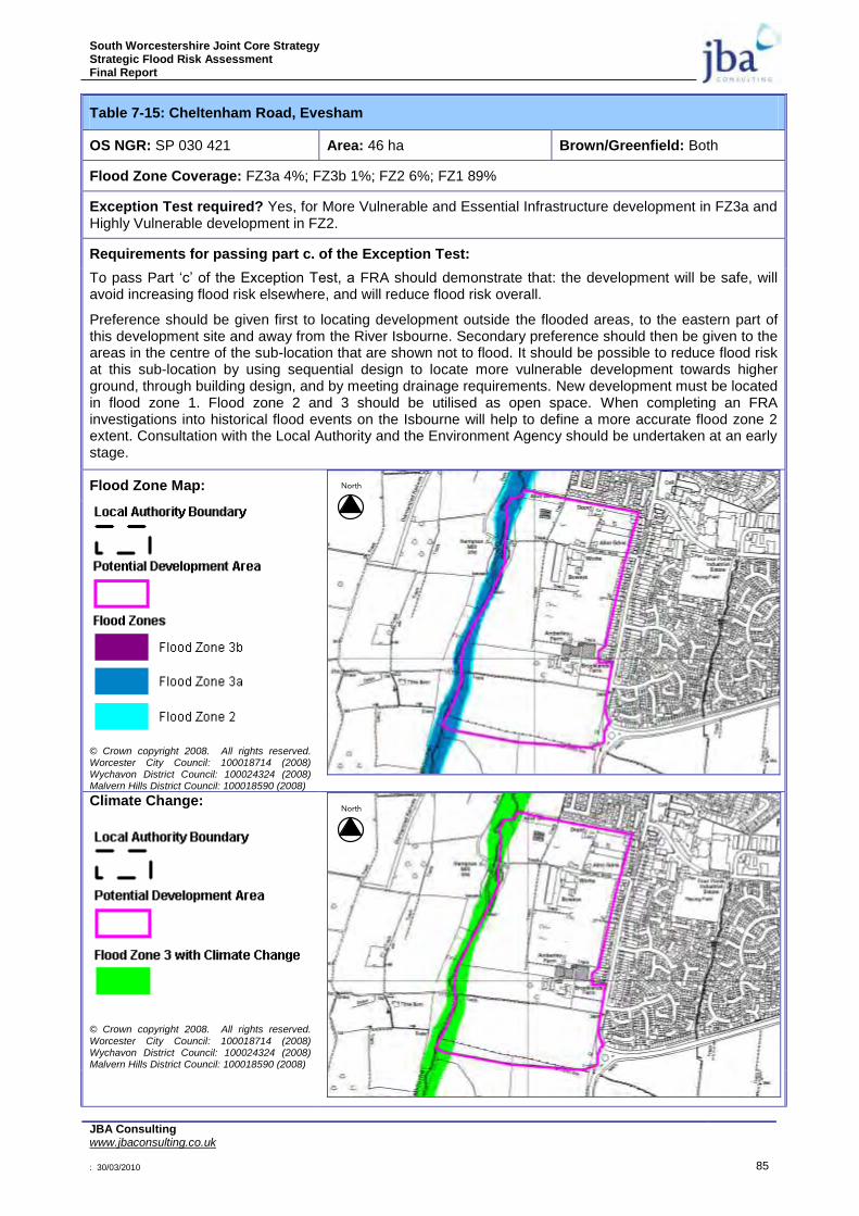
South Worcestershire Joint Core Strategy Strategic Flood Risk Assessment Final Report
JBA Consulting www.jbaconsulting.co.uk : 30/03/2010 85
Table 7-15: Cheltenham Road, Evesham
OS NGR: SP 030 421 Area: 46 ha Brown/Greenfield: Both
Flood Zone Coverage: FZ3a 4%; FZ3b 1%; FZ2 6%; FZ1 89%
Exception Test required? Yes, for More Vulnerable and Essential Infrastructure development in FZ3a and Highly Vulnerable development in FZ2.
Requirements for passing part c. of the Exception Test:
To pass Part „c‟ of the Exception Test, a FRA should demonstrate that: the development will be safe, will avoid increasing flood risk elsewhere, and will reduce flood risk overall.
Preference should be given first to locating development outside the flooded areas, to the eastern part of this development site and away from the River Isbourne. Secondary preference should then be given to the areas in the centre of the sub-location that are shown not to flood. It should be possible to reduce flood risk at this sub-location by using sequential design to locate more vulnerable development towards higher ground, through building design, and by meeting drainage requirements. New development must be located in flood zone 1. Flood zone 2 and 3 should be utilised as open space. When completing an FRA investigations into historical flood events on the Isbourne will help to define a more accurate flood zone 2 extent. Consultation with the Local Authority and the Environment Agency should be undertaken at an early stage.
Flood Zone Map:
© Crown copyright 2008. All rights reserved. Worcester City Council: 100018714 (2008) Wychavon District Council: 100024324 (2008) Malvern Hills District Council: 100018590 (2008)
Climate Change:
© Crown copyright 2008. All rights reserved.
Worcester City Council: 100018714 (2008) Wychavon District Council: 100024324 (2008) Malvern Hills District Council: 100018590 (2008)
North
North
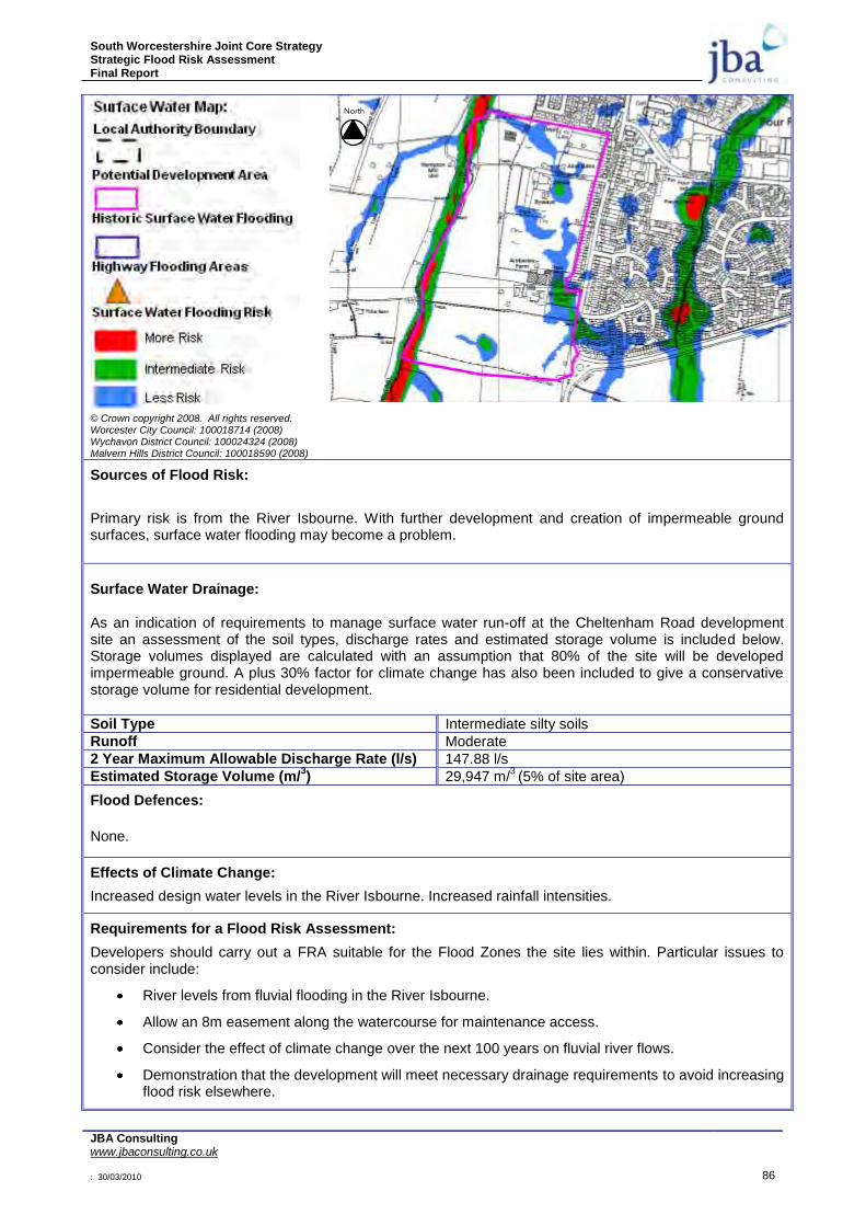
South Worcestershire Joint Core Strategy Strategic Flood Risk Assessment Final Report
JBA Consulting www.jbaconsulting.co.uk : 30/03/2010 86
© Crown copyright 2008. All rights reserved. Worcester City Council: 100018714 (2008) Wychavon District Council: 100024324 (2008) Malvern Hills District Council: 100018590 (2008)
Sources of Flood Risk:
Primary risk is from the River Isbourne. With further development and creation of impermeable ground surfaces, surface water flooding may become a problem.
Surface Water Drainage: As an indication of requirements to manage surface water run-off at the Cheltenham Road development site an assessment of the soil types, discharge rates and estimated storage volume is included below. Storage volumes displayed are calculated with an assumption that 80% of the site will be developed impermeable ground. A plus 30% factor for climate change has also been included to give a conservative storage volume for residential development.
Soil Type Intermediate silty soils
Runoff Moderate
2 Year Maximum Allowable Discharge Rate (l/s) 147.88 l/s
Estimated Storage Volume (m/3) 29,947 m/
3 (5% of site area)
Flood Defences:
None.
Effects of Climate Change:
Increased design water levels in the River Isbourne. Increased rainfall intensities.
Requirements for a Flood Risk Assessment:
Developers should carry out a FRA suitable for the Flood Zones the site lies within. Particular issues to consider include:
River levels from fluvial flooding in the River Isbourne.
Allow an 8m easement along the watercourse for maintenance access.
Consider the effect of climate change over the next 100 years on fluvial river flows.
Demonstration that the development will meet necessary drainage requirements to avoid increasing flood risk elsewhere.
North
South Worcestershire Joint Core Strategy Strategic Flood Risk Assessment Final Report
JBA Consulting www.jbaconsulting.co.uk : 30/03/2010 87
Demonstration that development at this location can be made safe.
The use of SuDS will be required for surface water discharge.
Surface water flow rates should be restricted to existing Greenfield rates. Consultation with the Local Authority and the Environment Agency should be undertaken at an early stage.
Consider using flood zones 2 and 3 as public open space.
Consider de-culverting of existing watercourses where possible.
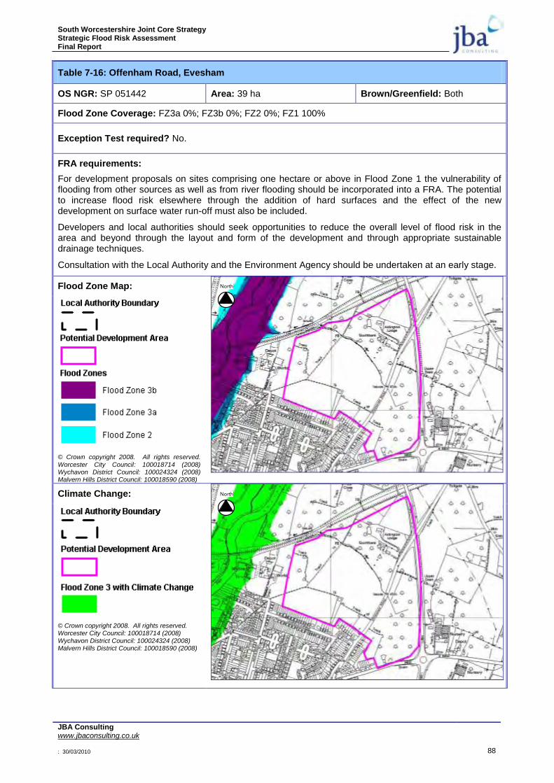
South Worcestershire Joint Core Strategy Strategic Flood Risk Assessment Final Report
JBA Consulting www.jbaconsulting.co.uk : 30/03/2010 88
Table 7-16: Offenham Road, Evesham
OS NGR: SP 051442 Area: 39 ha Brown/Greenfield: Both
Flood Zone Coverage: FZ3a 0%; FZ3b 0%; FZ2 0%; FZ1 100%
Exception Test required? No.
FRA requirements:
For development proposals on sites comprising one hectare or above in Flood Zone 1 the vulnerability of flooding from other sources as well as from river flooding should be incorporated into a FRA. The potential to increase flood risk elsewhere through the addition of hard surfaces and the effect of the new development on surface water run-off must also be included.
Developers and local authorities should seek opportunities to reduce the overall level of flood risk in the area and beyond through the layout and form of the development and through appropriate sustainable drainage techniques.
Consultation with the Local Authority and the Environment Agency should be undertaken at an early stage.
Flood Zone Map:
© Crown copyright 2008. All rights reserved.
Worcester City Council: 100018714 (2008) Wychavon District Council: 100024324 (2008) Malvern Hills District Council: 100018590 (2008)
Climate Change:
© Crown copyright 2008. All rights reserved. Worcester City Council: 100018714 (2008)
Wychavon District Council: 100024324 (2008) Malvern Hills District Council: 100018590 (2008)
North
North
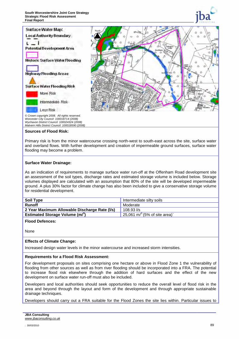
South Worcestershire Joint Core Strategy Strategic Flood Risk Assessment Final Report
JBA Consulting www.jbaconsulting.co.uk : 30/03/2010 89
© Crown copyright 2008. All rights reserved. Worcester City Council: 100018714 (2008) Wychavon District Council: 100024324 (2008) Malvern Hills District Council: 100018590 (2008)
Sources of Flood Risk:
Primary risk is from the minor watercourse crossing north-west to south-east across the site, surface water and overland flows. With further development and creation of impermeable ground surfaces, surface water flooding may become a problem.
Surface Water Drainage: As an indication of requirements to manage surface water run-off at the Offenham Road development site an assessment of the soil types, discharge rates and estimated storage volume is included below. Storage volumes displayed are calculated with an assumption that 80% of the site will be developed impermeable ground. A plus 30% factor for climate change has also been included to give a conservative storage volume for residential development.
Soil Type Intermediate silty soils
Runoff Moderate
2 Year Maximum Allowable Discharge Rate (l/s) 108.93 l/s
Estimated Storage Volume (m/3) 25,061 m/
3 (5% of site area)`
Flood Defences:
None
Effects of Climate Change:
Increased design water levels in the minor watercourse and increased storm intensities.
Requirements for a Flood Risk Assessment:
For development proposals on sites comprising one hectare or above in Flood Zone 1 the vulnerability of flooding from other sources as well as from river flooding should be incorporated into a FRA. The potential to increase flood risk elsewhere through the addition of hard surfaces and the effect of the new development on surface water run-off must also be included.
Developers and local authorities should seek opportunities to reduce the overall level of flood risk in the area and beyond through the layout and form of the development and through appropriate sustainable drainage techniques.
Developers should carry out a FRA suitable for the Flood Zones the site lies within. Particular issues to
North

South Worcestershire Joint Core Strategy Strategic Flood Risk Assessment Final Report
JBA Consulting www.jbaconsulting.co.uk : 30/03/2010 90
consider include:
Design water levels in the minor watercourse crossing the site.
Allow an 8m easement along the watercourses for maintenance access or flood risk. The surface water map gives an indication of where this will be required along ordinary watercourses.
Consider the effect of climate change over the next 100 years on fluvial flows.
Demonstration that the development will meet necessary drainage requirements to avoid increasing flood risk elsewhere.
Demonstration that development at this location can be made safe.
The use of SuDS will be required for surface water discharge.
Surface water flow rates should be restricted to existing Greenfield rates. Consultation with the Local Authority and the Environment Agency should be undertaken at an early stage
South Worcestershire Joint Core Strategy Strategic Flood Risk Assessment Final Report
JBA Consulting www.jbaconsulting.co.uk : 30/03/2010 91
8 GUIDANCE FOR DETAILED FLOOD RISK ASSESSMENT
8.1 General
In accordance with current planning policy guidance, the planning process encourages only sustainable development in areas vulnerable to flooding. This includes adopting a precautionary approach to decisions based on estimates of the present and future impact of flood risks. The South Worcestershire Joint Core Strategy SFRA focuses on delivering a strategic assessment of flood risk within the area. Prior to development, site-specific assessments will need to be undertaken to ensure that all forms of flood risk at a site are fully addressed. In addition, following the Sequential Test, some sites may be put forward for the Exception Test. These will require further work in a detailed FRA. Any site that does not pass the Exception Test should not be allocated for development. It is normally the responsibility of the developer to provide a FRA with an application. However, an LPA can decide to commission a detailed, site-specific FRA to help them decide upon allocations in the high risk zone. The SFRA cannot provide this level of site-specific information.
It should be acknowledged that a detailed FRA may show that a site is not appropriate for development of a particular vulnerability, or at all. Where the FRA shows that a site is not appropriate for a particular usage, a lower vulnerability classification may be appropriate.
8.2 Standard Flood Risk Management Guidance for Developers
The aim of a FRA is to demonstrate that the development is protected to the 1% annual probability event and is safe during the design flood event, including an allowance for climate change and any historical events and extreme events. This includes assessment of mitigation measures required to safely manage flood risk. The FRA also needs to demonstrate that the proposed development will not increase flood risk either upstream or downstream of the site and should also consider techniques for managing and reducing flood risk. All sources of flood risk, including tidal, fluvial, surface water runoff and drainage need to be considered.
FRAs for proposed development in the South Worcestershire Joint Core Strategy area should follow the approach recommended by:
PPS25 and its Practice Guide Companion.
The Environment Agency (see its National Standing Advice to Local Planning Authorities for Planning Applications – Development and Flood Risk in England (March 2007)17;
These documents describe when a FRA is required and are commensurate with the advice given in this SFRA. All proposed development sites require at least an initial assessment of flood risk. A detailed FRA will be required for all developments that fall in the medium and high flood risk zones and other sites where significant flood risk is identified. A FRA will be required for sites in Flood Zone 1 which are greater than 1ha that concentrates on the management of surface water through an appropriate drainage strategy, as development of sites of this size can generate significant volumes of runoff. (The FRA should also consider other sources of flooding).
The SFRA provides guidance on what tests and standards need to be provided by the development. This would be elaborated on within the FRA, which should thoroughly investigate how the residual risks after mitigation are managed. Residual risks are to be agreed with the LPA and Environment Agency.
8.3 Assessment of Fluvial Flood Risk
Before embarking on detailed hydraulic modelling, and in light of this SFRA, proposals for development should be discussed in detail with the Environment Agency at an early stage. It may be the case that the results of the modelling undertaken for this SFRA would be sufficient.
When considering future development needs in the South Worcestershire Joint Core Strategy area, a detailed and site-specific FRA is required.
South Worcestershire Joint Core Strategy Strategic Flood Risk Assessment Final Report
JBA Consulting www.jbaconsulting.co.uk : 30/03/2010 92
8.4 Climate Change
The effects of climate change need to be assessed in a detailed Flood Risk Assessment for the lifetime of the development. The guidelines for net sea level rises and peak rainfall, river flows, offshore wind speeds and wave heights should be taken from PPS25 Table B1 and Table B2.
As part of the Level 2 SFRA the following estimations of 1 in 100-year water level rises in the next 100-years were obtained from the detailed hydraulic models:
River Severn – varies between 75m and 350mm
River Avon – varies between 100mm and 200mm
River Teme – varies between 173mm and 554mm
8.5 Mitigation Measures
Mitigation measures should be seen as a last resort to address flood risk issues. Consideration should first be given to minimising risk by planning sequentially across a site. Once risk has been minimised, only then should mitigation measures be considered.
Where allocations remain in high risk Flood Zone areas, it needs to be demonstrated in a detailed FRA that technically feasible flood mitigation options are available. These measures must be designed to provide an appropriate level of flood mitigation to a site for the lifetime of the development. The measures required may result in some practical constraints on development and/or require significant financial cost where flood risk is high. The minimum acceptable standard of protection against flooding for new property within flood risk areas is the 1% annual probability for fluvial flooding and a breach during a 0.5% annual probability tidal event, with allowance for climate change over the lifetime of the development.
The fact that mitigation measures are discussed in this SFRA should not be taken as a presumption that the Sequential Test has been bypassed. It is included to give a fuller picture of the implications of allocating a site, and for use in a subsequent SA. Normally, suitable mitigation measures for a proposed development will be determined through assessment of flood depths via hydrological and hydraulic modelling (or use of existing models) carried out as part of a FRA.
Often the determining factor in deciding whether a particular development can or cannot proceed is the financial feasibility of flood risk mitigation rather than technical limitations. Detailed technical assessments are required in the FRA to assess this feasibility, together with a commercial review by the developer of the cost of the mitigation works. At the SFRA stage, broad assumptions are therefore required regarding the feasibility of flood risk mitigation to ensure that only sites with realistic development potential are put forward.
Some mitigation measures as outlined in PPS25 are presented in Table 8-1. It is assumed that floor level raising will continue to be the traditional mitigation measure. It should be noted that the Environment Agency see actual land raising as a last option. Thought will also be required to ensure safe access and egress is available for flood events including climate change. As a residual risk, development should be safe up the 1 in 1000-year flood event such that people can remain safe in the properties. The Emergency Services should be satisfied on the evacuation and rescue capabilities if required.
There should be no interruption to flood flows or loss of flood storage as a result of any proposed development. Flood storage compensation may be appropriate for sites on the edge of the existing floodplain. Modification of ground levels/compensation works may re-configure the floodplain but should not be used to increase land available for development.
Whilst flooding mitigation measures can be implemented in most sites, it is worth noting that in some instances the findings of individual FRAs may determine that the risk of flooding to a proposed development is too great and mitigation measures are not feasible. In these instances, the development will be subject to an objection by the Environment Agency.
8.6 Windfall Sites
Windfall sites that become available for development unexpectedly, and are not included in a planning authority‟s development plan as allocated land, will need to be sequentially tested and also,
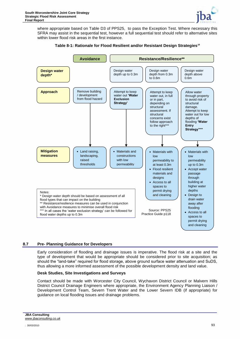
South Worcestershire Joint Core Strategy Strategic Flood Risk Assessment Final Report
JBA Consulting www.jbaconsulting.co.uk : 30/03/2010 93
where appropriate based on Table D3 of PPS25, to pass the Exception Test. Where necessary this SFRA may assist in the sequential test, however a full sequential test should refer to alternative sites within lower flood risk areas in the first instance.
Table 8-1: Rationale for Flood Resilient and/or Resistant Design Strategies18
8.7 Pre- Planning Guidance for Developers
Early consideration of flooding and drainage issues is imperative. The flood risk at a site and the type of development that would be appropriate should be considered prior to site acquisition; as should the “land-take” required for flood storage, above ground surface water attenuation and SuDS, thus allowing a more informed assessment of the possible development density and land value.
Desk Studies, Site Investigations and Surveys
Contact should be made with Worcester City Council, Wychavon District Council or Malvern Hills District Council Drainage Engineers where appropriate, the Environment Agency Planning Liaison / Development Control Team, Severn Trent Water and the Lower Severn IDB (if appropriate) for guidance on local flooding issues and drainage problems.
Notes: * Design water depth should be based on assessment of all flood types that can impact on the building ** Resistance/resilience measures can be used in conjunction with Avoidance measures to minimise overall flood risk *** In all cases the „water exclusion strategy‟ can be followed for flood water depths up to 0.3m
Source: PPS25 Practice Guide p118
Resistance/Resilience**
Design water depth up to 0.3m
Design water depth from 0.3m to 0.6m
Design water depth above 0.6m
Design water
depth*
Avoidance
Approach Attempt to keep water out „Water Exclusion
Strategy‟
Remove building / development from flood hazard
Attempt to keep water out, in full or in part, depending on structural assessment. If structural concerns exist follow approach to the right***
Allow water through property to avoid risk of structural damage. Attempt to keep water out for low depths of flooding „Water Entry
Strategy‟***
Land raising,
landscaping,
raised
thresholds
Materials and
constructions
with low
permeability
Materials with
low
permeability to
at least 0.3m
Flood resilient
materials and
designs
Access to all
spaces to
permit drying
and cleaning
Materials with
low
permeability
up to 0.3m
Accept water
passage
through
building at
higher water
depths
Design to
drain water
away after
flooding
Access to all
spaces to
permit drying
and cleaning
Mitigation
measures
South Worcestershire Joint Core Strategy Strategic Flood Risk Assessment Final Report
JBA Consulting www.jbaconsulting.co.uk : 30/03/2010 94
The location of the site within either Flood Zone 1, 2 or 3 should be established by consulting the Environment Agency Flood Zone Maps. It is possible the site will require a FRA or Drainage Impact Assessment depending on the development size, type and location. It should be noted that some developments are classed as more vulnerable than others as described in PPS25. Reference should be made to the later section on FRAs.
During the site walkover survey, the slope of the ground should be assessed. Notes should be taken on what lies around the site, whether the site could be vulnerable to flooding sources off site or whether adjacent land could be vulnerable to flooding generated on the site. It might be necessary to make provisions for intercepting surface run-off from adjacent land at a higher level. It will be necessary to make space on site for storing all flows generated on the site in the 1 in 100 year event with climate change.
The existing surface water drainage outfall from the site needs to be established. For Brownfield sites, any existing drainage should be surveyed and recorded. The impermeable areas that are positively drained and the outfall positions should be recorded, whether these are to soakaways, connections to off-site sewers or direct to watercourses. For Greenfield sites, a topographical survey will be required and details of the infiltration capacity of the ground.
During trial pit investigations, soakaway tests should be carried out in accordance with BRE365 (Soakaway Design Guidance) or CIRIA 156 (Infiltration Design Manual of Good Practice). These will be required in order to establish the suitability of infiltration techniques on the site.
Development Layout
The layout design can play a significant part in the management of any residual risk of flooding to the development, for example due to blockage or failure of drainage systems. More vulnerable development should be positioned in areas of the site at least risk of flooding. Gaps between buildings can be strategically positioned for flood water to flow though, causing minimum damage. Boundary treatments can be designed to allow flow through rather than “trap” flood water in low areas of the site; hence railings might be more appropriate than solid walls. The layout should be designed with some thought towards the proposed site levels. Ideally, buildings should not be placed in low spots or with doorways facing a slope.
The Sketch Layout should be produced in conjunction with the preparation of a drainage strategy and an assessment of flood risk. The proposals for surface water drainage can have a fundamental impact on the development layout. If drainage is not considered until after a layout has been produced, it can result in inappropriate or restricted choice of drainage techniques.
The choice of surface water conveyance system, underground pipes or above ground swales; the choice of surface water attenuation, above ground or below ground; the use of infiltration techniques such as soakaways or porous paving; these will all have an effect on the development layout.
Currently STW will adopt surface water attenuation within the adoptable sewer network up to a 1 in 30 year event storm. The EA will require attenuation on site up to the 1 in 100 year storm with an allowance for climate change and space must be made on the site for this additional volume of water.
Reference should be made to the next section on SuDS.
8.8 Sustainable Drainage Systems
Sustainable Drainage Systems (SuDS) are management practices which enable surface water to be drained in a way which mimics, as closely as possible, the run-off prior to site development. The choice of flow management facilities within a single site is heavily influenced by constraints including (but not limited to) topography, geology (soil permeability), available area, former site use, proposed site use, groundwater conditions, future adoption and maintenance possibilities. The design, construction and ongoing maintenance regime of such a scheme must be carefully defined, and a clear and comprehensive understanding of the existing catchment hydrological processes and existing drainage arrangements is essential.
For infiltration SuDS techniques it is imperative that the water table is low enough and a site-specific infiltration test is undertaken in accordance with BRE365 or CIRIA 156. Where sites lie within or close to groundwater protection zones or aquifers further restrictions may be applicable, and guidance should be sought from the Environment Agency.
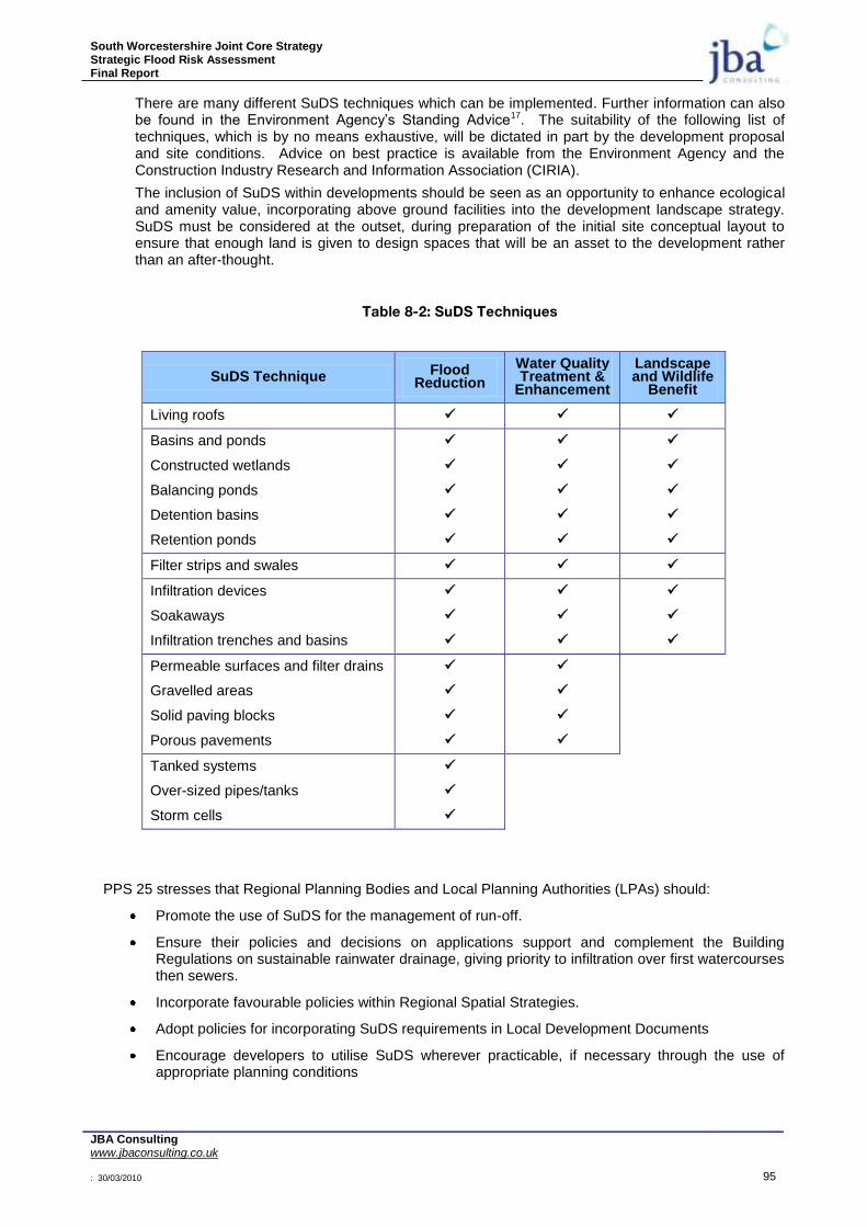
South Worcestershire Joint Core Strategy Strategic Flood Risk Assessment Final Report
JBA Consulting www.jbaconsulting.co.uk : 30/03/2010 95
There are many different SuDS techniques which can be implemented. Further information can also be found in the Environment Agency‟s Standing Advice17. The suitability of the following list of techniques, which is by no means exhaustive, will be dictated in part by the development proposal and site conditions. Advice on best practice is available from the Environment Agency and the Construction Industry Research and Information Association (CIRIA).
The inclusion of SuDS within developments should be seen as an opportunity to enhance ecological and amenity value, incorporating above ground facilities into the development landscape strategy. SuDS must be considered at the outset, during preparation of the initial site conceptual layout to ensure that enough land is given to design spaces that will be an asset to the development rather than an after-thought.
Table 8-2: SuDS Techniques
SuDS Technique Flood Reduction
Water Quality Treatment &
Enhancement
Landscape and Wildlife
Benefit
Living roofs
Basins and ponds
Constructed wetlands
Balancing ponds
Detention basins
Retention ponds
Filter strips and swales
Infiltration devices
Soakaways
Infiltration trenches and basins
Permeable surfaces and filter drains
Gravelled areas
Solid paving blocks
Porous pavements
Tanked systems
Over-sized pipes/tanks
Storm cells
PPS 25 stresses that Regional Planning Bodies and Local Planning Authorities (LPAs) should:
Promote the use of SuDS for the management of run-off.
Ensure their policies and decisions on applications support and complement the Building Regulations on sustainable rainwater drainage, giving priority to infiltration over first watercourses then sewers.
Incorporate favourable policies within Regional Spatial Strategies.
Adopt policies for incorporating SuDS requirements in Local Development Documents
Encourage developers to utilise SuDS wherever practicable, if necessary through the use of appropriate planning conditions

South Worcestershire Joint Core Strategy Strategic Flood Risk Assessment Final Report
JBA Consulting www.jbaconsulting.co.uk : 30/03/2010 96
Develop joint strategies with sewerage undertakers and the Environment Agency to further encourage the use of SuDS.
Adoption and future maintenance of above ground SuDS facilities by the local authorities as public open space requires early discussion between the developer, the local authority and Severn Trent Water. Above ground attenuation can be adopted by the local authority as public open space, with the provision of a payment to the local authority via a Section 106 Agreement under the Town and Country Planning Act. This must, however, be agreed at an early stage and ideally discussed in advance of the planning application to allow the contribution to be ring fenced specifically for the facility.
If future maintenance arrangements are to be assigned to a Management Company, this should be discussed at an early stage with STW. This can have implications on the adoption of the remaining site drainage and consequently adoption of any highways on the development.
Allowance should be made by whomever is to take future responsibility for the SuDS facilities, for checking the SuDS designs and for inspection during construction, if necessary employing competent individuals to perform this task.
Information should be provided to make the end-users of the development aware of SuDS and in particular their responsibilities to maintain and not to remove any privately owned SuDS facilities. If deemed necessary the removal of permitted development rights or the inclusion of covenants in the deeds of properties could be considered.
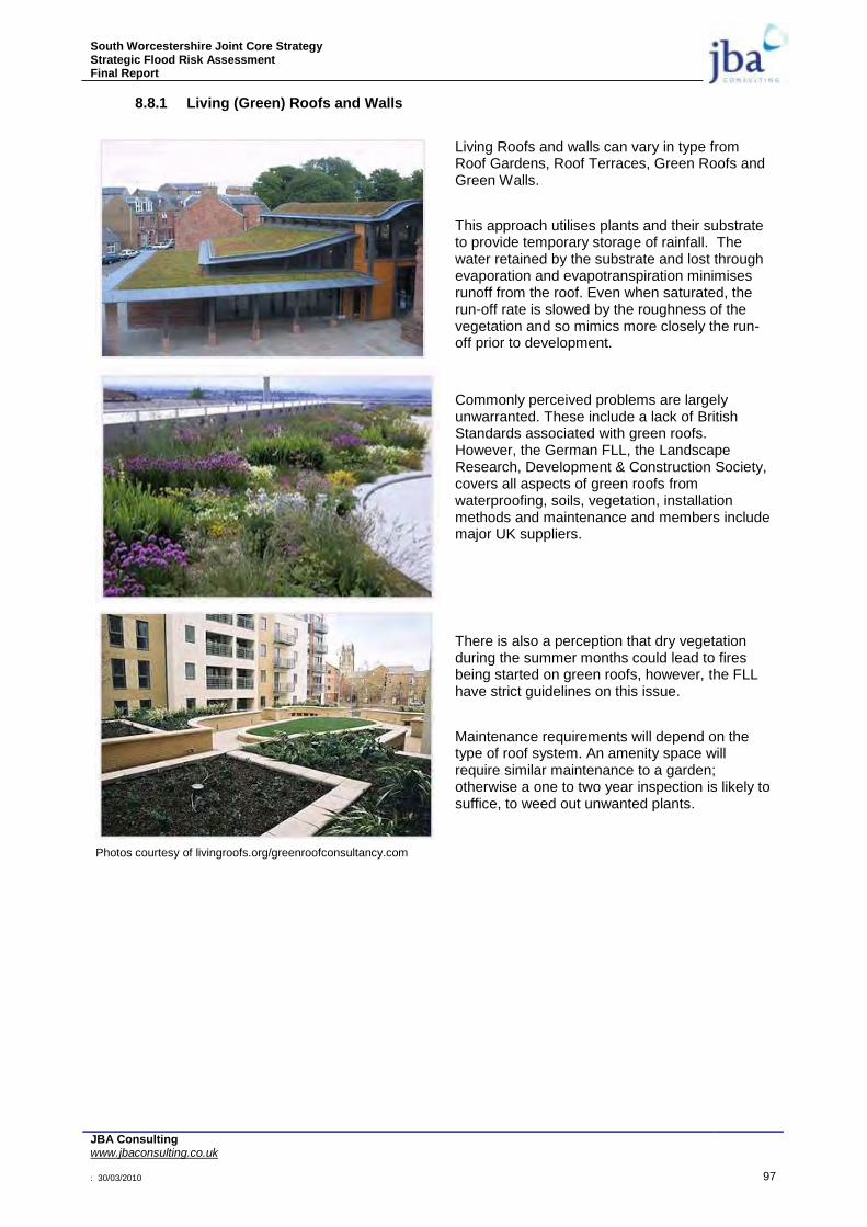
South Worcestershire Joint Core Strategy Strategic Flood Risk Assessment Final Report
JBA Consulting www.jbaconsulting.co.uk : 30/03/2010 97
8.8.1 Living (Green) Roofs and Walls
Living Roofs and walls can vary in type from Roof Gardens, Roof Terraces, Green Roofs and Green Walls.
This approach utilises plants and their substrate to provide temporary storage of rainfall. The water retained by the substrate and lost through evaporation and evapotranspiration minimises runoff from the roof. Even when saturated, the run-off rate is slowed by the roughness of the vegetation and so mimics more closely the run-off prior to development.
Commonly perceived problems are largely unwarranted. These include a lack of British Standards associated with green roofs. However, the German FLL, the Landscape Research, Development & Construction Society, covers all aspects of green roofs from waterproofing, soils, vegetation, installation methods and maintenance and members include major UK suppliers.
Photos courtesy of livingroofs.org/greenroofconsultancy.com
There is also a perception that dry vegetation during the summer months could lead to fires being started on green roofs, however, the FLL have strict guidelines on this issue.
Maintenance requirements will depend on the type of roof system. An amenity space will require similar maintenance to a garden; otherwise a one to two year inspection is likely to suffice, to weed out unwanted plants.

South Worcestershire Joint Core Strategy Strategic Flood Risk Assessment Final Report
JBA Consulting www.jbaconsulting.co.uk : 30/03/2010 98
8.8.2 Basins, Ponds and Wetlands
Dry basins, ponds and wetlands can be designed to provide temporary storage for storm water through the regrading of site ground levels to form a contained storage area, in conjunction with a flow control to force water into the storage facility and allow it to drain down slowly at a controlled rate.
They can often be a key part of landscape strategies, providing amenity space and opportunities for the creation of wildlife habitats.
The permanent pool volume and pond planting can be designed to provide a cleaning function, diluting and removing pollutants from the storm water. Basins, ponds and wetlands can be fed by swales, filter drains or piped systems.
Safety should be carefully considered when designing the side slope gradients and water depths and, if required, fencing and barrier planting should be incorporated.
The future adoption and maintenance arrangements need to be agreed with WCC and Severn Trent Water prior to designing the attenuation basin or pond, as this can potentially affect the adoption of site sewers and highways.
In areas susceptible to fluvial flooding, surface water attenuation facilities should be designed not to conflict with floodplains or flood mitigation measures. The basin or pond base level should be set above the peak 1 in 100 year fluvial flood level with climate change.
Photos courtesy of Greenbelt Group

South Worcestershire Joint Core Strategy Strategic Flood Risk Assessment Final Report
JBA Consulting www.jbaconsulting.co.uk : 30/03/2010 99
8.8.3 Filter Strips, Swales and Infiltration Devices
Swales provide temporary storage for storm water to help reduce peak flow runoff. While providing an alternative to traditional piped conveyance systems, the flow across vegetation provides a filtering function at low velocities. Check dams and flow controls can be introduced to further reduce flows and utilise the storage potential.
Filter Strips are vegetated areas that are intended to treat sheet flow from adjacent impervious areas. Filter strips function by slowing runoff velocities and filtering out sediment and other pollutants, and providing some infiltration into underlying soils. Filter strips were originally used as an agricultural treatment practice, and have more recently evolved into an urban practice.
Photos courtesy of Greenbelt Group
Infiltration devices drain water directly into the ground. They may be used at source or the runoff can be conveyed in a pipe or swale to the infiltration area. They include soakaways, infiltration trenches and infiltration basins as well as swales, filter drains and ponds. Infiltration devices can be integrated into and form part of the landscaped areas.
Filter Drains are gravel filled trenches which trap sediments from run-off and provide attenuation. Flow is directed to a perforated pipe which conveys run-off back into the sewerage network or into a water body. Filter drains are used mainly to drain road and car park surfaces.
8.8.4 Rainwater Harvesting
Rainwater harvesting techniques can aid in increasing the attenuation of rainfall and contribute to the onsite recycling of water. Water butts are a common rainwater harvesting technique; however they are easily bypassed or full when a rainfall event occurs. If used on a strategic basis and it can be demonstrated that their use will make available volume for storage, the Environment Agency may consider whether they can count towards surface water attenuation, however, due to the issues of overfilling, the volumes in water butts are not considered in calculations for flow attenuation.

South Worcestershire Joint Core Strategy Strategic Flood Risk Assessment Final Report
JBA Consulting www.jbaconsulting.co.uk : 30/03/2010 100
8.8.5 Permeable Surfaces
Courtesy of Charcon / Aggregate Industries
Pervious pavements such as permeable concrete blocks, reinforced grass, crushed stone or gravel and permeable asphalt will allow water to infiltrate directly into the subsoil before soaking into the ground.
It is also possible to incorporate attenuation into the sub base of porous paving construction if the infiltration potential of the ground is not ideal.
On Brownfield sites where contaminated ground is an issue, a lined attenuation system can be built into the sub-base. The porous paving provides a filtering action and improves water quality. Additional products are available that provide a specific filtering function within the attenuation system.
The shallow excavation required to install such facilities in comparison to traditional over-sized pipes can have the added benefit of reducing surplus material and costly off-site disposal costs.
Bettess R. (1996). Infiltration Drainage - Manual of Good Practice. CIRIA Report 156.
CIRIA. (2000). Sustainable Urban Drainage Systems – Design Manual for England and Wales. CIRIA Report C522.
CIRIA. (2001). Sustainable Urban Drainage Systems – Best Practice Manual. CIRIA
Report C523.

South Worcestershire Joint Core Strategy Strategic Flood Risk Assessment Final Report
JBA Consulting www.jbaconsulting.co.uk : 30/03/2010 101
8.9 Surface Water Drainage Assessments
Opportunities for developing an Integrated Water or Drainage Management Strategy across development site boundaries should be explored, and a catchment led approach should be adopted. This approach has been recognised in the consultation paper by DEFRA, Making Space For Water. An integrated approach to controlling surface water drainage can lead to a more efficient and reliable surface water management system as it enables a wider variety of potential flood mitigation options to be used. In addition to controlling flood risk, integrated management of surface water has potential benefits, including improved water quality and a reduction of water demand through grey water recycling.
Integrated drainage systems may be considered suitable for catchments where other development is being planned or constructed, and where on-site measures are set in isolation of the systems and processes downstream.
Surface water drainage assessments are required where proposed development may be susceptible to flooding from surface water drainage systems. The potential impact upon areas downstream of the development also needs careful consideration.
The relevant local planning authority should be contacted regarding surface water flooding and surface water drainage systems.
The requirements for surface water drainage systems will need to be discussed with the Environment Agency and Severn Trent Water. Consideration should be given to whether a „Greenfield runoff approach‟ to the assessment of source control is appropriate. This method is generally satisfactory in the cases where the development is relatively small, isolated from other planned sites and where the runoff processes are fully understood.
The FRA should then conclude with an assessment of the scale of the impact, and the recommended approach to controlling surface water discharge from a proposed development.
It is recommended that a Supplementary Planning Document on surface water runoff or a policy in the LDF is considered.
8.10 Reducing Flood Risk
The minimum acceptable standard of protection against flooding for new property within flood risk areas is 1% annual probability for fluvial flooding and a breach during a 0.5% annual probability tidal event, with allowance for climate change over the lifetime of the development.
The measures chosen will depend on the nature of the flood risk. Some of the more common measures appropriate to the South Worcestershire Joint Core Strategy area are outlined here, and more detail is given in Chapter 6 of the PPS25 Practice Guide. 19
8.10.1 Reducing Flood Risk through Site Layout and Design
Flood risk should be considered at an early stage in deciding the layout and design of a site to provide an opportunity to reduce flood risk within the development. Most of the South Worcestershire Joint Core Strategy area potential development sub-locations cover all three Flood Zones.
The PPS25 Practice Guide states that a sequential, risk-based approach should be applied to try to locate more vulnerable land use to higher ground, while more flood-compatible development (e.g. vehicular parking, recreational space) can be located in higher risk areas. However vehicular parking in floodplains should be based on nature of parking, flood depths and hazard including evacuation procedures and flood warning, in line with the PPS25 Practice Guide paragraphs 6.13-6.14.
Waterside areas, or areas along known flow routes, can be used for recreation, amenity and environmental purposes, allowing the preservation of flow routes and flood storage, and at the same time providing valuable social and environmental benefits contributing to other sustainability objectives. Landscaping should ensure safe access to higher ground from these areas, and avoid the creation of isolated islands as water levels rise. WCC use an approach of floodplain retreat, setting back development away from the rivers, which could be adopted as a strategy for the Joint Authorities.
South Worcestershire Joint Core Strategy Strategic Flood Risk Assessment Final Report
JBA Consulting www.jbaconsulting.co.uk : 30/03/2010 102
8.10.2 Modification of Ground Levels
Modifying ground levels to raise the land above the required flood level is a very effective way of reducing flood risk to the site in question, particularly where the risk is entirely from tidal flooding and the land does not act as conveyance for flood waters.
However, in most areas of fluvial flood risk, conveyance or flood storage would be reduced by raising land above the floodplain, adversely impacting on flood risk downstream. Compensatory flood storage must be provided, and should be on a level for level, volume for volume basis on land that does not currently flood but is adjacent to the floodplain (in order for it to fill and drain). It should be in the vicinity of the site and within the red line of the planning application boundary (unless the site is strategically allocated). Ground raising in the floodplain should not be undertaken to increase the developable land on a site but merely to configure it for a more convenient use.
Where the site is entirely within the floodplain it is not possible to provide compensatory storage at the maximum flood level and this will not be a viable mitigation option. Compensation schemes must be environmentally sound.
8.10.3 Raised Defences
Construction of raised floodwalls or embankments to protect new development is not a preferred option, as a residual risk of flooding will remain. Compensatory storage must be provided where raised defences remove storage from the floodplain.
Temporary or demountable defences are not acceptable flood protection for a new development unless flood risk is residual only.
8.10.4 Developer Contributions
In some cases and following the application of the sequential test, it may be necessary for the developer to make a contribution to the improvement of flood defence provision that would benefit both the development in question and the local community. Developer contributions can also be made to maintenance and provision of flood risk management assets, flood warning and the reduction of surface water flooding (i.e. SUDS).
8.10.5 Building Design
Internal areas of new development should be designed to be dry during the 1 in 1000-year flood event.
The raising of floor levels within a development avoids damage occurring to the interior, furnishings and electrics in times of flood. If it has been agreed with the Environment Agency that, in a particular instance, the raising of floor levels is acceptable, they should be raised to 600mm above the maximum water level caused by a 1 in 100-year (1% AEP) event plus climate change. This additional height that the floor level is raised to is referred to as the „freeboard‟.
Making the ground floor of a building for less vulnerable use is an effective way of raising living space above flood levels.
Putting a building on stilts is not considered an acceptable means of flood mitigation for new development. However it may be allowed in special circumstances if it replaces an existing solid building, as it can improve flood flow routes. In these cases attention should always be paid to safe access and egress and a legal agreement should be entered into to ensure the ground floor use is not changed.
8.10.6 Resistance and Resilience
There may be instances where flood risk remains to a development. For example, where the use is water compatible, where an existing building is being changed, where residual risk remains behind defences, or where floor levels have been raised but there is still a risk at the 0.1% annual probability. In these cases (and for existing development in the floodplain), additional measures can be put in place to reduce damage in a flood and increase the speed of recovery. These measures should not be relied on as the only mitigation method.
The 2007 document „Improving the Flood Performance of New Buildings‟ provides further details on possible resistance and resilience measures.20

South Worcestershire Joint Core Strategy Strategic Flood Risk Assessment Final Report
JBA Consulting www.jbaconsulting.co.uk : 30/03/2010 103
Temporary Barriers
Temporary barriers consist of moveable flood defences which can be fitted into doorways and/or windows. The permanent fixings required to install these temporary defences should be discrete and keep architectural impact to a minimum. On a smaller scale temporary snap on covers for airbricks and air vents can also be fitted to prevent the entrance of flood water.
Permanent barriers
Permanent barriers can include built up doorsteps, rendered brick walls and toughened glass barriers.
Wet-proofing
Interior design to reduce damage caused by flooding, for example:
Electrical circuitry installed at a higher level with power cables being carried down from the ceiling rather than up from the floor level.
Water-resistant materials for floors, walls and fixtures.
If redeveloping existing basements, new electrical circuitry installed at a higher level with power cables being carried down from the ceiling rather than up from the floor level to minimise damage if the development floods.
Resilience measures will be specific to the nature of flood risk, and as such will be informed and determined by the FRA.
8.11 Managing Flood Risk from Other Sources
8.11.1 Surface Water and Sewer Flooding
Where new development is in an area where the public sewerage network does not currently have sufficient spare capacity to accept additional development flows it is recommended that the developer discusses such issues with Severn Trent Water at the early possible stage. The development should improve the drainage infrastructure to reduce flood risk on site. It is important however that a drainage impact assessment shows that this will not increase flood risk elsewhere, and the drainage requirements regarding runoff rates and SuDS for new development are met.
If residual surface water flood risk remains, the likely flow routes and depths across the site should be modelled. The site should be designed so that these flow routes are preserved and building design should provide resilience against this residual risk.
When redeveloping existing buildings, the installation of some permanent or temporary flood proofing and resilience measures could prevent against both surface water and sewer flooding. Non-return valves prevent water entering the property from drains and sewers. Non-return valves can be installed within gravity sewers or drains, within the property‟s private sewer upstream of the public sewerage system. These need to be carefully installed and must be regularly maintained. The CIRIA publication, „Low cost options for prevention of flooding from sewers‟, provides further information. Additionally, manhole covers within the property‟s grounds could be sealed to prevent surcharging.
8.11.2 Groundwater
Groundwater flooding has a very different flood mechanism to any other, as it rises up from below ground level, and for this reason many conventional flood defence and mitigation methods are not suitable. The only way to fully reduce flood risk would be through building design, ensuring that floor levels are raised above the water levels caused by a 1% annual probability fluvial / 0.5% annual probability tidal plus climate change event. Site design would also need to preserve any flow routes followed by the groundwater overland and make sure flood risk is not increased downstream.
When redeveloping existing buildings it may be acceptable to install pumps in basements as a resilience measure. However for new development this is unlikely to be considered an acceptable solution.
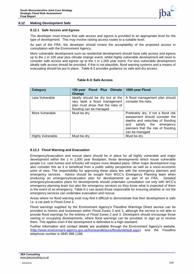
South Worcestershire Joint Core Strategy Strategic Flood Risk Assessment Final Report
JBA Consulting www.jbaconsulting.co.uk : 30/03/2010 104
8.12 Making Development Safe
8.12.1 Safe Access and Egress
The developer must ensure that safe access and egress is provided to an appropriate level for the type of development. This may involve raising access routes to a suitable level.
As part of the FRA, the developer should review the acceptability of the proposed access in consultation with the Environment Agency.
More vulnerable development such as residential development should have safe access and egress up to the 1 in 100 year plus climate change event, whilst highly vulnerable development will need to consider safe access and egress up to the 1 in 1,000 year event. For less vulnerable development ideally safe access should be provided. If this is not plausible, flood warning systems and a means of evacuating should be put in place. Table 8-3 provides guidance on safe and dry access.
Table 8-3: Safe Access
Category 100-year Flood Plus Climate
Change
1000-year Flood
Less Vulnerable Ideally should be dry but at the very least a flood management plan must show that the risks of flooding can be managed
A flood management plan should consider the risks
More Vulnerable Must be dry Preferably dry, if not a flood risk assessment should consider the depths and velocities of flooding and satisfy the emergency planners that the risk of flooding can be managed
Highly Vulnerable Must be dry Must be dry
8.12.2 Flood Warning and Evacuation
Emergency/evacuation and rescue plans should be in place for all highly vulnerable and major development within the 1 in 1,000 year floodplain; those developments which house vulnerable people (i.e. care homes and schools) will require more detailed plans. Other major development may also consider this as it is beneficial from a public safety perspective as well as a socio-economic point of view. The responsibility for approving these plans lies with the emergency planners and emergency services. Advice should be sought from WCC‟s Emergency Planning team when producing an emergency/evacuation plan for developments as part of an FRA. Detailed emergency/evacuation plans for developments should undertake consultation not only with WCC‟s emergency planning team but also the emergency services so they know what is expected of them in the event of an emergency. Table 6-1 can assist those responsible for ensuring whether or not the emergency services can undertake evacuation and rescue.
Areas where no flood warning exist may find it difficult to demonstrate that their development is safe i.e. a car park in Flood Zone 3.
Flood warnings supplied by the Environment Agency‟s Floodline Warnings Direct service can be provided to homes and businesses within Flood Zones 2 and 3, although the service is not able to provide flood warnings for the entirety of Flood Zones 2 and 3. Developers should encourage those owning or occupying developments, where flood warnings can be provided, to sign up to receive them. This applies even if the development is defended to a high standard.
Further information and contact details are available through the Environment Agency‟s website, (http://www.environment-agency.gov.uk/homeandleisure/floods/default.aspx) and the Floodline telephone number is 0845 988 1188.

South Worcestershire Joint Core Strategy Strategic Flood Risk Assessment Final Report
JBA Consulting www.jbaconsulting.co.uk : 30/03/2010 105
8.13 Making Space for Water
8.13.1 Opportunities for River Restoration and Enhancement
All new development close to rivers should consider the opportunity presented to improve and enhance the river environment. Developments should look at opportunities for river restoration and enhancement as part of the development. Options include backwater creation, de-silting, in-channel habitat enhancement and removal of structures. When designed properly, such measures can have benefits such as reducing the costs of maintaining hard engineering structures, reducing flood risk, improving water quality and increasing biodiversity. Social benefits are also gained by increasing green space and access to the river.
8.13.2 Buffer Strips
As a minimum, developers should set back development 8 metres from the landward toe of fluvial defences or top of bank where defences do not exist. This provides a buffer strip to „make space for water‟, allow additional capacity to accommodate climate change and ensure access to defences is maintained for maintenance purposes.
For watercourses classed as „Main River‟ a minimum 8 metre easement from the top of bank is recommended for maintenance purposes to avoid disturbing riverbanks, benefiting ecology and having to construct engineered riverbank protection. Building adjacent to riverbanks can also cause problems to the structural integrity of the riverbanks and the building, making future maintenance of the river much more difficult.
8.13.3 Drainage Capacity
The capacity of internal drainage infrastructure is often limited and is at or near capacity under existing conditions. Development that leads to increased peak runoff within the drainage catchments may lead to infrastructure capacity being exceeded, with the potential for increased flood risk. Development locations should be assessed to ensure capacity exists within both the on and off site network.
8.14 Future Planning Applications
The first document that local planners should refer to when considering future planning applications is the Environment Agency‟s National Standing Advice to Local Planning Authorities for Planning Applications – Development and Flood Risk, England (February 2009).
This SFRA is not intended to be a prescriptive document, but a planning tool to guide future sustainable development away from more vulnerable flood risk areas.
8.15 Requirements at Detailed Planning Stage
The SFRA should be used to test that the requirements of the Sequential Test are met. If the development meets with the recommendations of the SFRA strategically, then the specific requirements of the Environment Agency should be addressed in a detailed FRA undertaken to PPS25 requirements. Developers are advised to check with WCC and the Environment Agency before presuming a site can be developed.
A precautionary approach to development and flood risk is required. At each site, applicants for all development proposals need to carry out an assessment of flood risk from all sources and they also need to consider the potential impact the development could have on others through the completion of a flood risk and runoff assessment. Guidance on sustainable development and the detail required in this assessment for different types of development is provided in PPS25 and by the Environment Agency through their standing advice on development and flood risk.
South Worcestershire Joint Core Strategy Strategic Flood Risk Assessment Final Report
JBA Consulting www.jbaconsulting.co.uk : 30/03/2010 106
9 RECOMMENDED POLICY FOR MANAGEMENT OF FLOOD RISK
9.1 Recommended Policy
The following Policy is recommended to cover the management of flood risk within the South Worcestershire Join Core Strategy area. This policy is to go alongside the blue, yellow and red sub-divisions of the Flood Zones. These maps can be found in Appendix E. Below is the suggested wording:
A Management of Flood Risk
1. Floodplain [“Blue Zone”] The blue zone is functional floodplain and development will not normally be permitted here.
2. Floodplain [“Yellow Zone”] Redevelopment of existing sites within the floodplain in areas not subject to significant flood flows [as defined by the environment agency], shown as “yellow zone” on the proposals map, will normally be permitted provided:-
1. it is for less vulnerable or water compatible use (as defined in Table D2 of PPS25);
2. ground floor levels of all buildings are set above the 1 in 100-year flood level including an allowance for climate change, with an appropriate freeboard to be agreed with the LPA and Environment Agency, and should be flood free during an extreme flood event;
3. safe access is available for the lifetime of the development and is supported by flood warning and suitable evacuation plans being in place;
4. car parking is designed to have regard to potential flood depths and hazards and mitigation measures are put in place. (No basement car parking shall be permitted);
5. there is no detriment to the available flood storage capacity of the floodplain and additional flood storage is created;
6. unnecessary obstructions to flood flow are removed, restoring flood flow pathways.
3. Floodplain [“Red Zone”] New development (including extensions) and redevelopment will not normally be permitted in areas of existing or previously existing floodplain flow [as defined by the environment agency] shown as “red zone”, or within 8 metres of the top of both banks of other watercourses, as shown on the proposals map. Where options for managed retreat or land swap exist, developers should explore these with the Local Authority.
B Development and Flood Risk
In order to: protect floodplains from inappropriate development; ensure no increase in flood risk;
where possible provide flood risk betterment and; ensure development is safe.
All development must adhere to the advice in the current version of the South Worcestershire Strategic Flood Risk Assessment (Level 1 and 2) and the guidance provided on Flood Risk Assessment requirements.

South Worcestershire Joint Core Strategy Strategic Flood Risk Assessment Final Report
JBA Consulting www.jbaconsulting.co.uk : 30/03/2010 107
C Protection and Enhancement of Watercourses
Planning permission for development will only be granted where: 1. the natural watercourse system which provides drainage of land is not adversely affected; 2. a minimum 8m width access strip is provided adjacent to the top of both banks of any
watercourses for maintenance purposes and is appropriately landscaped for open space and Biodiversity benefits, this width may be reduced in particular circumstances with agreement from the Environment Agency and LPA;
3. it would not result in the loss of open water features through draining, culverting or enclosure by other means and culverts are opened up where ever possible;
4. surface water drainage is delivered by sustainable drainage systems (SuDS); and 5. betterment in the surface water runoff regime is ensured; with any residual risk of flooding, from
drainage features both on or off site not placing people and property at unacceptable risk.
Reasoned justification:
A (3) (Red Zone) – developers should undertake pre-application discussions with the Local Authority to discuss suitable options for managed retreat and the possibility of land swap. Confirmation of pre-application discussions should be submitted at the application stage.
Additional Policy on Caravans
Policy…. - Caravans and Flood Risk
Development for caravan, mobile home and chalet parks will not be permitted within the 1% plus climate change (‘high risk’) floodplain. Where existing caravan, mobile home and chalet parks are located within the ‘high risk’ floodplain, permission will not be granted for intensification of the park through additional caravans and/or increased occupancy. Options for the relocation of the existing development to a suitable area of lower flood risk should be considered.
Reasoned justification: There is a number of existing caravan sites within the South Worcestershire area, which are located within the ‘high risk’ floodplain along the River Severn, River Avon and the River Teme for example. These sites are located in unsustainable locations, where there should be no intensification of the park and /or increased occupancy. PPS25 acknowledges that the instability of these structures places their occupants at special risk. However to ensure that there are no new (or intensification of) caravans, mobile homes and chalet parks within the ‘high risk’ floodplain we consider a policy is required to strengthen the guidance within PPS25 and assist in relocating caravans to areas of lower flood risk.
South Worcestershire Joint Core Strategy Strategic Flood Risk Assessment Final Report
JBA Consulting www.jbaconsulting.co.uk : 30/03/2010 108
10 CONCLUSIONS
The South Worcestershire Joint Core Strategy SFRA has considered fluvial, groundwater and surface water flood risk in Worcester City, Wychavon District Council and Malvern Hills District Council. In addition flood risk from canals and reservoirs is considered;
16 Strategic Allocations have been identified for the South Worcestershire Joint Core Strategy Pre-Submission document and have been initially assessed for flood risk and guidance for mitigation;
The latest flood zone maps have been provided with and without climate change to advise on the fluvial flood risk. It is recommended that the LPA use the maps that include climate change when making future allocations;
Surface water flood risk maps are provided indicating the likelihood of surface water flooding in the joint core strategy area. These are supplemented by locations of known surface water flooding;
Surface water flooding is a risk in many of the areas, particularly Worcester and Droitwich. An integrated approach to the management of surface water and fluvial flood risk is required;
It is recommended that Surface Water Management Plans are produced for Droitwich, Pershore Malvern and Worcester City;
For large developments, a strategic approach to SuDS for runoff attenuation and water quality improvement linking to the green infrastructure plan is required;
Guidance for the requirements for a site specific Flood Risk Assessment for each of the 16 Strategic Allocations is provided together with general guidance on flood risk assessment for any development proposals within the joint core strategy area;
Site specific Flood Risk Assessments for future development within the South Worcestershire Joint Core Strategy area, including windfall sites, should take account of the information and requirements contained within this SFRA;
A SFRA flow chart User Guide and flow chart Sequential Test Guide are provided in the report.
The SFRA is a living document and should be periodically updated when new information on flood risk, flood warning or new planning guidance or legislation becomes available.

South Worcestershire Joint Core Strategy Strategic Flood Risk Assessment Final Report
JBA Consulting www.jbaconsulting.co.uk : 30/03/2010 109
11 LIST OF ENDNOTES
1 Planning Policy Statement 25: Development and Flood Risk – December 2006
2 Communities and Local Government. 2006. Planning Policy Statement 25: Development and Flood Risk.
December 2006. http://www.communities.gov.uk/publications/planningandbuilding/pps25floodrisk
3 Communities and Local Government. 2007. Planning Policy Statement: Planning and Climate Change -
Supplement to Planning Policy Statement 1 December 2007. http://www.communities.gov.uk/publications/planningandbuilding/ppsclimatechange
4 Communities and Local Government. 2008. Planning Policy Statement 25: Development and Flood Risk –
Practice Guide. June 2008. http://www.communities.gov.uk/publications/planningandbuilding/pps25practiceguide
5 Definition of minor development:
- Minor non-residential extensions: Industrial/Commercial/Leisure etc. extensions with a footprint less than 250m
2
- Alterations: development that does not increase the size of buildings e.g. alterations to external appearance. - „Householder‟ development: e.g. sheds, garages, games rooms etc. within the curtilage of the existing dwelling in addition to physical extensions to the existing dwelling itself. This definition excludes any proposed development that would create a separate dwelling within the curtilage of the existing dwelling e.g. subdivision of houses into flats.
6 Communities and Local Government. 2006. Planning Policy Statement 25: Development and Flood Risk.
December 2006. http://www.communities.gov.uk/publications/planningandbuilding/pps25floodrisk
7 DEFRA/Environment Agency. 2005. Flood Risk Assessment Guidance for New Development. R&D
Technical Report FD2320/TR2. http://sciencesearch.defra.gov.uk/Document.aspx?Document=FD2320_3364_TRP.pdf
8 DEFRA/Environment Agency. 2008. Supplementary Note on Flood Hazard Ratings and Thresholds for
Development Planning and Control Purpose. http://sciencesearch.defra.gov.uk/Document.aspx?Document=FD2320_7399_PR.pdf
9 DEFRA. 2004. Making Space for Water; Developing a new Government strategy for flood and coastal
erosion risk management in England, A consultation exercise. http://www.defra.gov.uk/environ/fcd/policy/strategy.htm
10 Communities and Local Government. 2006 Planning Policy Statement 25: Development and Flood Risk.
Annex G paragraph G2.
11 Communities and Local Government. 2008. Planning Policy Statement 25: Development and Flood Risk
– Practice Guide. June 2008. http://www.communities.gov.uk/publications/planningandbuilding/pps25practiceguide
12 DEFRA/Environment Agency. 2005. Flood Risk Assessment Guidance for New Development. R&D
Technical Report FD2320/TR2. http://sciencesearch.defra.gov.uk/Document.aspx?Document=FD2320_3364_TRP.pdf
13 DEFRA/Environment Agency. 2008. Supplementary Note on Flood Hazard Ratings and Thresholds for
Development Planning and Control Purpose. http://sciencesearch.defra.gov.uk/Document.aspx?Document=FD2320_7399_PR.pdf
14 DEFRA/Environment Agency. 2005. Flood Risk Assessment Guidance for New Development. R&D
Technical Report FD2320/TR2. http://sciencesearch.defra.gov.uk/Document.aspx?Document=FD2320_3364_TRP.pdf
15 DEFRA/Environment Agency. 2008. Supplementary Note on Flood Hazard Ratings and Thresholds for
Development Planning and Control Purpose.
South Worcestershire Joint Core Strategy Strategic Flood Risk Assessment Final Report
JBA Consulting www.jbaconsulting.co.uk : 30/03/2010 110
http://sciencesearch.defra.gov.uk/Document.aspx?Document=FD2320_7399_PR.pdf
16 DEFRA/Environment Agency. 2006. The Flood Risks to People Methodology. R&D Technical Report
FD2321/TR1. http://sciencesearch.defra.gov.uk/Document.aspx?Document=FD2321_3436_TRP.pdf
17 Environment Agency Standing Advice Development and Flood Risk – England (2009). http://www.pipernetworking.com/floodrisk/index.html?lang=_e
18 Communities and Local Government. 2008. Planning Policy Statement 25: Development and Flood Risk
– Practice Guide. June 2008. (Figure 6.2). http://www.communities.gov.uk/publications/planningandbuilding/pps25practiceguide
19 Communities and Local Government. 2008. Planning Policy Statement 25: Development and Flood Risk
– Practice Guide. June 2008. http://www.communities.gov.uk/publications/planningandbuilding/pps25practiceguide
20 Communities and Local Government, May 2007. Improving the Flood Performance of New Buildings –
Flood Resilient Construction. http://www.planningportal.gov.uk/uploads/br/flood_performance.pdf

South Worcestershire Joint Core Strategy Strategic Flood Risk Assessment Final Report
JBA Consulting www.jbaconsulting.co.uk : 30/03/2010
MAPS

South Worcestershire Joint Core Strategy Strategic Flood Risk Assessment Final Report
JBA Consulting www.jbaconsulting.co.uk : 30/03/2010
APPENDICES

South Worcestershire Joint Core Strategy Strategic Flood Risk Assessment Final Report
JBA Consulting www.jbaconsulting.co.uk : 30/03/2010
Appendix A National Plans, Policies and Strategies

South Worcestershire Joint Core Strategy Strategic Flood Risk Assessment Final Report
JBA Consulting www.jbaconsulting.co.uk : 30/03/2010
A.1.1 Planning and Compulsory Purchasing Act
The SFRA has been undertaken whilst planning authorities have been implementing the provisions of the Planning and Compulsory Purchase Act 2004, together with the accompanying planning guidance, including Planning Policy Statement 1 Delivering Sustainable Development (PPS1) and Planning Policy Statement 12 Local Development Frameworks (PPS12). The Act has affected all tiers of the planning system and has necessitated major changes at regional and local level.
Planning Policy Guidance (PPG) has been reviewed by Government and was updated and replaced by Planning Policy Statements in December 2006. Government has indicated that PPGs will be replaced as and when considered necessary and in the light of their policy and strategic significance.
At a local council level, Local Plans are to be phased out and replaced by Local Development Frameworks (LDF), which are a suite of planning documents that will guide decisions on the development and use of land. Where Local Plans have been adopted recently, or preparation is at an advanced stage, the process will continue to adoption providing „saved policies‟ for development control purposes. As the new Development Plan Documents are adopted, they will replace parts of the Local Plan. However, where it is proposed to cease work on the review of Local Plans and to commence work on LDFs, only those local plan policies which form part of the Development Plan can be saved.
Local Planning Authorities (LPAs) were required to produce a Local Development Scheme (LDS) by March 2005, setting out their programme for the production of the new development plan and summarising the documents that will, collectively, make up the Local Development Framework. Hence the transition provides an ideal opportunity for each of the local authorities to review and update their policies on flood risk.
A.1.2 Planning Policy Statement 1 (PPS1): Delivering Sustainable Development21
PPS1 published in February 2005, sets out the overarching planning policies for the delivery of sustainable development across the planning system and sets the tone for other planning policy statements. PPS1 explicitly states that development plan policies should take account of flooding, including flood risk. It proposes that new development in areas at risk from flooding should be avoided. Planning authorities are also advised to ensure that developments are „sustainable, durable and adaptable‟ including taking into account natural hazards such as flooding.
PPS1 also places an emphasis on „spatial planning‟ in contrast to the more rigid „land-use planning‟ approach which it supersedes. Planning authorities will still produce site specific allocations and a proposals map part of relevant Local Development Documents, but their Core Strategy will be more strategic and visionary in content. The Core Strategy will take into account the desirability of achieving integrated and mixed use development and will consider a broader range of community needs than in the past. With regard to flood risk, it will be important for the Core Strategies and accompanying supplementary planning documents to recognise the contribution that non-structural measures can make to flood management.
A supplement to PPS1 was published in December 2007, titled Planning and Climate Change22. This planning statement is in response to Government making tackling of climate change a key priority for the planning system. The PPS sets out how the planning system should contribute to the reduction of emissions and allow for the expected effects of climate change.
A.1.3 Planning Policy Statement 3 (PPS3): Housing23
PPS3 has the aim of creating sustainable, inclusive, mixed communities in all areas, both urban and
rural (paragraph 9). There is an emphasis on giving priority to re-using previously-developed land within urban areas, bringing empty homes back into use and converting existing buildings, in preference to the development of Greenfield sites. Re-use of previously-developed land, empty properties and the conversion of non-residential buildings into housing is encouraged, both to promote development and reduce the amount of Greenfield land being taken for development. Each region will contribute to the national target by setting recycling targets within their RPG. LPAs should contribute to the regional targets by incorporating land recycling into their development plans. Paragraph 38 lists flood risk as one of the reasons that previously developed land might be unsuitable for housing allocation, although in Annex C PPS3 also states: „A Strategic Housing Land
South Worcestershire Joint Core Strategy Strategic Flood Risk Assessment Final Report
JBA Consulting www.jbaconsulting.co.uk : 30/03/2010
Availability Assessment should: Identify what action could be taken to overcome constraints on particular sites‟.
A.1.4 Planning Policy Guidance 4 (PPG4): Industrial, Commercial Development and Small Firms24
The overall guidance document commits to a goal of sustainable development, and the opening statement shares responsibility for sustainability throughout the community as a whole.
„Responsibility for the environment is not solely the preserve of Government. The principles of sustainable development require the responsible use of manmade and natural resources by all concerned in a way that ensures that future generations are not left worse off‟
The consultation paper on a new Planning Policy Statement 4, Planning for Sustainable Economic Development, was published in December 2007. PPS4 remains at the draft stage, with PPG4 remaining as the established guidance document.
A.1.5 Planning Policy Statement 6 (PPS6): Planning for Town Centres25
PPS6 is mostly concerned with the type and location of developments and their impact upon the socio-economic vitality of the area. No specific mention is made regarding flooding but the need to re-use existing sites is highlighted in paragraph 2.4 which states „Wherever possible, growth should be accommodated by more efficient use of land and buildings within existing centres. Local planning authorities should aim to increase the density of development, where appropriate. Opportunities within existing centres should be identified for sites suitable for development or redevelopment or where conversions and changes of use will be encouraged for specific buildings or areas‟.
A.1.6 Making Space for Water26
During 2004, the Department for Environment, Food and Rural Affairs (DEFRA) undertook a consultation exercise to engage a wide range of stakeholders in a debate about the future direction of flooding strategy. The 2005 document “Making Space for Water: First Government Response” sets out the following vision:
“…we want to make space for water so that we can manage the adverse human and economic consequences of flooding and coastal erosion while achieving environmental and social benefits in line with wider government objectives.”
The aim of the strategy is to balance the three pillars of sustainability, managing flood risk and ensuring that the social and economic benefits resulting from growth and development are attained. This balanced approach, integrating sustainable development with responsible risk management, has underpinned the current study.
Section 7 of the „Making Space for Water‟ consultation document deals with measures to reduce flood risk through land-use planning. This section emphasises the Government‟s commitment to ensuring that the planning system aims to reduce flood risk wherever possible and, in any event, should not add to it. However, it is acknowledged that 10% of England is already within mapped areas of flood risk and that contained within these areas are the Brownfield sites which other areas of Government policy has identified as a priority for future housing provision. The document identifies three sets of measures which may be undertaken to manage flood risk when development is sited in flood risk areas:
Protection measures to provide, at minimum, the standards of protection specified in PPS25
Provision of features such as sacrificial areas and compartmentalisation to reduce the consequences of a flood event should one occur
Use of construction techniques that increase the flood resistance and resilience of buildings.
The document proposes that Regional Spatial Strategies and Local Development Frameworks should take full account of flood risk and incorporate the sequential approach introduced in PPG25 and continued in PPS25. Moreover, the document encourages integration with other plans, in particular Catchment Flood Management Plans27. Use of European Union funding streams, such as Intgerreg IIIB is recommended to enable local authorities to undertake trans-national projects aimed at advancing knowledge and good practice in flood-risk management.
At the development control level, the document encourages local authorities to give full weight to the advice issued by the Environment Agency in response to consultations on planning applications,

South Worcestershire Joint Core Strategy Strategic Flood Risk Assessment Final Report
JBA Consulting www.jbaconsulting.co.uk : 30/03/2010
implying that only in exceptional cases should permission be granted against the Environment Agency‟s advice. In addition, the use of site-specific (local) Flood Risk Assessments as supporting documents to planning applications in areas of flood risk is encouraged. The document proposes that if mitigating measures are shown to be required, they should be fully funded as part of the development.
21
http://www.communities.gov.uk/publications/planningandbuilding/planningpolicystatement1
22 http://www.communities.gov.uk/publications/planningandbuilding/ppsclimatechange
23 http://www.communities.gov.uk/publications/planningandbuilding/pps3housing
24 http://www.communities.gov.uk/publications/planningandbuilding/ppg4
25 http://www.communities.gov.uk/publications/planningandbuilding/pps6
26 DEFRA. 2004. Making Space for Water – Developing a new Government strategy for flood and coastal
erosion risk management in England.
27 Catchment Flood Management Plans are voluntary plans through which the Environment Agency works
with other key decision makers in river catchments to identify and agree policies for sustainable flood risk management.

South Worcestershire Joint Core Strategy Strategic Flood Risk Assessment Final Report
JBA Consulting www.jbaconsulting.co.uk : 30/03/2010
Appendix B Level 1 Flood Zones & Climate Change Flood Outlines

South Worcestershire Joint Core Strategy Strategic Flood Risk Assessment Final Report
JBA Consulting www.jbaconsulting.co.uk : 30/03/2010
Appendix C Surface Water Flood Risk Mapping
South Worcestershire Joint Core Strategy Strategic Flood Risk Assessment Final Report
JBA Consulting www.jbaconsulting.co.uk : 30/03/2010
Appendix D Other Sources Flood Risk Mapping

South Worcestershire Joint Core Strategy Strategic Flood Risk Assessment Final Report
JBA Consulting www.jbaconsulting.co.uk : 30/03/2010
Appendix E Floodplain Policy Mapping

South Worcestershire Joint Core Strategy Strategic Flood Risk Assessment Final Report
JBA Consulting www.jbaconsulting.co.uk : 30/03/2010
Appendix F Guidance Flow Charts