southampton document pt.1 20/1/09 10:37 page 126
TRANSCRIPT

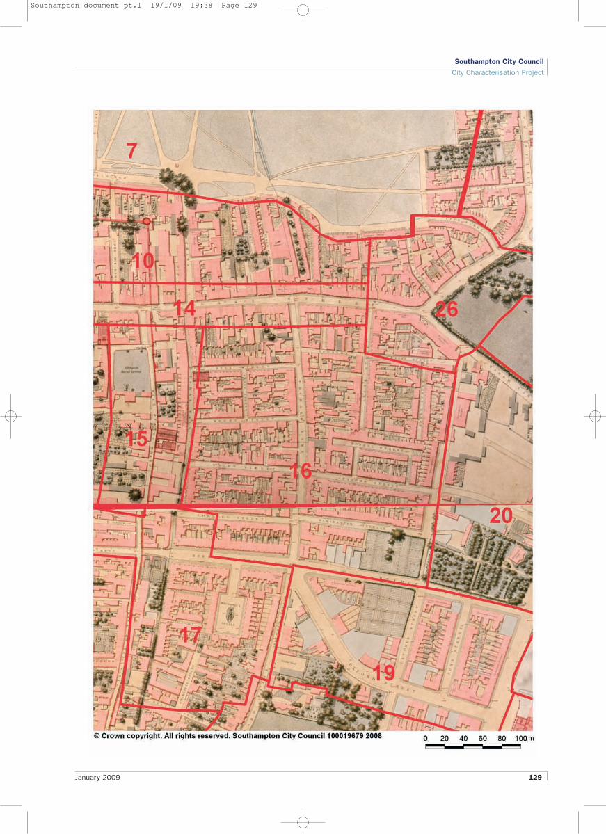
16 Holyrood Estate
ContextA large urban ‘superblock’ on a flat site bounded byCanal Walk on the west, Bernard Street on the south andThreefield Lane on the east. The character area adjoinsCA14: East Street, and CA26: Evans Street andThreefield Lane’s environs to the north, CA20: DukeStreet, Richmond Street and College Street to the eastand CA19: Oxford Street and environs to the south. Thisis an almost totally redeveloped area dating from 1950s– 60s, except for remnant earlier development on theextreme southern edge.
This area remained undeveloped agricultural land untilthe first half of the nineteenth century when it was devel-oped for terraced housing. The area suffered bombdamage in WWII and this probably led to clearance forpost-war redevelopment which has almost entirelychanged the layout of the block in terms of streetpattern, other than the survival of the early, possiblymedieval Orchard Lane and Threefield Lane whichprovided access to the fields east of the walled town.
GrainOpen texture medium grain development with ‘modern’planning which rejects conventional street alignment.Landscape settings between the buildings. The buildingsare in staggered alignment, with the main axis beingnorth-east/south-west. There is a slightly finer grain tothe south-east corner (survival of Victorian terracedhousing) and on north-west edge (to the rear of EastStreet shops).
ScaleMainly four storey flat roof blocks with three nine storeypoint blocks towards southern edge. The church toweron Bernard Street is a local landmark of some note. Thethree point blocks also seen from adjoining areas to thesouth. The slab block to the east is clearly seen acrossthe site as a negative landmark.
UsesPredominantly residential. Church and public house (nowconverted to residential) on Bernard Street frontage.Some small businesses on northern fringe.
Public RealmLarge proportion of space between buildings. Mainlygreen spaces with small trees. There is a line of largestreet trees on the Queensway frontage. Pockets ofparking area. Footpath network.
ConnectivityConnection with Queensway is severely impaired by analmost continuous railing. A diagonal footpath runsthrough the site. There is direct connection to streets onthe south and east of the site, but there is less perme-
Southampton City Council
City Characterisation Project
126 January 2009
Southampton document pt.1 20/1/09 10:37 Page 126

Southampton City Council
City Characterisation Project
January 2009 127
ability to the north. Orchard Lane runs through wholearea north-south and Queensway skirts the westernedge though the western side reads as very much partof this development.
ViewsViews east are dominated by Dukes Keep, the seven-teen storey slab block to the east (in CA20). There is aglimpsed view through to the cupola of Central Hall(CA26) towards the northern part of the character area.There is also a local view towards the slender brick towerof St Nicholas on the north side of Bernard Street.
The strategic view towards St Michael’s spire alongBernard Street (from the Itchen Bridge) travels along thesouthern boundary of the character area.
Building typesPredominantly flats. Some modest terrace houses onthe extreme south-east corner. Church and former publichouse.
Architectural qualitiesEarly post-war modern style. Reminiscent of New Townneighbourhood planning. Horizontal emphasis on eleva-tions, with recessed balconies. Flat roofs. The axis ofOrchard Lane creates the most effective sense of place.Landscape is part of the design concept. Victorianterrace remnant plus eighteenth century pub. Good1950s church with well-proportioned tower.
The two storey shopping parade facing Queensway,topped by four 4 storey towers spaced at regular inter-vals relates visually and conceptually to the 1950sneighbourhood on the east side of Queensway and is awell-considered and striking group which also appears tobe a well looked after and well liked mixed use group ofresidential units above shops.
Heritage AssetsThe area is considered to possess a moderate degree ofevidential value due to the area being largely agriculturalland accessed by lanes including Orchard Lane andThreefield Lane until the nineteenth century. Therefore,the archaeological potential of the area appears limitedbut the area lies within a Local Area of ArchaeologicalImportance to reflect some potential to yield evidencefor past activity in the area.
The early nineteenth century former public house, TheGlobe, is the only listed building in the character area.This building, though much altered is still considered tohave cultural and social value. St Nicholas GreekOrthodox Church and is of some aesthetic (being astriking and well composed building in the street sceneand spiritual value as a place of worship. It is a locallylisted building which reflects these heritage values.There is a remnant of late nineteenth century terraced
01 Larger blocks are set within spacious grounds02 Poor connectivity with Queensway03 Trees are an important part of the estate
1
2
3
Southampton document pt.1 20/1/09 10:37 Page 127

housing in the south-east corner of the character area,illustrative of the type of housing which once occupiedmuch of this area of pre-war Southampton.
Part of the Bernard Street frontage faces onto the OxfordStreet Conservation Area.
MaterialsPale grey bricks, exposed concrete fascias. Red brickchurch. Rendered public house. Dark red brick Victorianterrace.
ConditionGenerally quite well managed with some evidence oferosion of quality. Some fencing in of semi-privatespace. Parking areas somewhat run down.
OwnershipMainly local authority ownership with some privatehouseholders.
Interventionn A landscape plan and management plan for the
communal spaces is required.n Some small areas could be redeveloped more
successfully and intensively.n Remove unnecessary barriers to pedestrians combined
with traffic calming measures (not speed bumps).
Design Principlesn Maintain and improve permeability.n Increase the dominance of the pedestrian (particularly
in relation to Queensway).
Southampton City Council
City Characterisation Project
128 January 2009
Southampton document pt.1 20/1/09 10:37 Page 128
Southampton City Council
City Characterisation Project
January 2009 129
Southampton document pt.1 19/1/09 19:38 Page 129

Southampton City Council
City Characterisation Project
130 January 2009
Southampton document pt.1 19/1/09 19:38 Page 130
Heritage Assets

Southampton City Council
City Characterisation Project
January 2009 131
Southampton document pt.1 19/1/09 19:38 Page 131
Townscape