southampton level 2 strategic flood risk assessment · southampton level 2 sfra page | ii 4.3.4...
TRANSCRIPT

Southampton Level 2 Strategic Flood Risk Assessment
Version 1.2
May 2017

Southampton Level 2 SFRA
[Page intentionally left blank]

Southampton Level 2 SFRA Page | i
Contents 1. Introduction ...................................................................................................................................................... 1
1.1 Background ............................................................................................................................................................... 1
1.2 Purpose of the SFRA ................................................................................................................................................. 1
1.3 Objectives of the SFRA .............................................................................................................................................. 2
1.4 Outputs of the SFRA .................................................................................................................................................. 2
1.5 Southampton ............................................................................................................................................................ 3
1.6 Using the SFRA .......................................................................................................................................................... 4
2. Policy and Legislative Framework ....................................................................................................................... 5
2.1 National Plans and Policies ....................................................................................................................................... 5
2.1.1 National Planning Policy Framework ................................................................................................................. 5
2.1.2 Planning Practice Guidance ............................................................................................................................... 6
2.1.3 Flood Risk Regulations ....................................................................................................................................... 6
2.1.4 Flood and Water Management Act ................................................................................................................... 6
2.1.5 The Localism Act ................................................................................................................................................ 7
2.1.6 Flood Risk Standing Advice ................................................................................................................................ 7
2.1.7 Civil Contingencies Act ....................................................................................................................................... 8
2.2 Local Plans and Policy ............................................................................................................................................... 8
2.2.1 Southampton Local Plan .................................................................................................................................... 8
2.2.2 Southampton Core Strategy .............................................................................................................................. 8
2.2.3 City Centre Action Plan .................................................................................................................................... 10
2.2.4 Local Plan Review (2006) ................................................................................................................................. 11
3. How Flood Risk is Assessed .............................................................................................................................. 12
3.1 Flood Zones ............................................................................................................................................................. 12
3.2 Actual Flood Risk ..................................................................................................................................................... 13
3.3 Residual Flood Risk ................................................................................................................................................. 14
4. Understanding Flood Risk in Southampton ....................................................................................................... 15
4.1 Topography, Hydrology, Geology and Soils ............................................................................................................ 15
4.1.1 Topography ...................................................................................................................................................... 15
4.1.2 Hydrology ......................................................................................................................................................... 15
4.1.3 Geology and Soils ............................................................................................................................................. 16
4.2 Overview of Flood Defences, Assets and Structures .............................................................................................. 17
4.3 Tidal Flood Risk ....................................................................................................................................................... 17
4.3.1 Assessment of Tidal Flood Risk ........................................................................................................................ 18
4.3.2 Future Extreme Water Levels .......................................................................................................................... 19
4.3.3 Historic Flood Risk - Tidal ................................................................................................................................. 20

Southampton Level 2 SFRA Page | ii
4.3.4 Assessment Results .......................................................................................................................................... 20
4.4 Fluvial Flood Risk (Rivers) ....................................................................................................................................... 21
4.4.1 Assessment of Fluvial Flood Risk ..................................................................................................................... 22
4.4.2 Assessment Results .......................................................................................................................................... 22
4.4.3 Historic Flood Risk - Fluvial .............................................................................................................................. 23
4.4.4 Uncertainties in Flood Risk Assessment .......................................................................................................... 24
4.5 Surface Water Flood Risk ........................................................................................................................................ 24
4.5.1 Assessment of Surface Water Flood Risk ......................................................................................................... 25
4.5.2 Historic Flooding – Surface Water ................................................................................................................... 25
4.5.3 Assessment Results .......................................................................................................................................... 26
4.5.4 Uncertainties in Flood Risk Assessment .......................................................................................................... 26
4.6 Flood Risk from Sewers ........................................................................................................................................... 26
4.6.1 Assessment of Flood Risk from Sewers ........................................................................................................... 27
4.6.2 Historic Flooding – Sewers (Foul, Surface Water and/or Combined) .............................................................. 27
4.6.3 Assessment Results .......................................................................................................................................... 28
4.6.4 Uncertainties in Flood Risk Assessment .......................................................................................................... 28
4.7 Flood Risk from Groundwater ................................................................................................................................ 28
4.7.1 Assessment of Groundwater Flood Risk .......................................................................................................... 30
4.7.2 Historic Flooding - Groundwater ..................................................................................................................... 30
4.7.3 Assessment Results .......................................................................................................................................... 31
4.7.4 Uncertainties in Flood Risk Assessment .......................................................................................................... 31
4.8 Flood Risk from Artificial Sources ........................................................................................................................... 32
4.8.1 Assessment of Flood Risk from Artificial Sources ............................................................................................ 32
4.8.2 Historic Flooding from Artificial Sources ......................................................................................................... 33
4.8.3 Assessment Results .......................................................................................................................................... 33
4.9 Interaction between Flood Sources ........................................................................................................................ 33
4.10 Impact of Climate Change on Flood Risk in Southampton ................................................................................... 34
4.10.1 Key Climate Change Projections for the South East ...................................................................................... 34
4.10.2 Sea Level Rise ................................................................................................................................................. 35
4.10.3 Peak River Flow Allowances........................................................................................................................... 35
4.10.4 Rainfall ........................................................................................................................................................... 36
4.10.5 Implications for Flood Risk ............................................................................................................................. 37
5. Planning and Flood Risk: The Sequential Approach ........................................................................................... 38
5.1 When Should the Sequential Approach be followed? ............................................................................................ 38
5.2 The Sequential Test ................................................................................................................................................ 38
5.2.1 Applying the Sequential Test ........................................................................................................................... 39

Southampton Level 2 SFRA Page | iii
5.1.2 Evidence of the Sequential Test ...................................................................................................................... 41
5.2 The Exception Test .................................................................................................................................................. 42
5.2.1 Applying the Exception Test ............................................................................................................................ 42
5.2.2 Evidence of the Exception Test ........................................................................................................................ 44
6. Flood Risk Management in Southampton ......................................................................................................... 45
6.1 Principles of Flood Risk Management .................................................................................................................... 45
6.2 Local Flood Risk Management Strategy .................................................................................................................. 46
6.3 Managing Flooding from Tidal Sources .................................................................................................................. 48
6.3.1 Southampton Coastal Flood and Erosion Risk Management Strategy ............................................................ 48
6.3.2 River Itchen Flood Alleviation Scheme ............................................................................................................ 50
6.4 Managing Fluvial Flood Risk .................................................................................................................................... 51
6.4.1 Riparian Landownership .................................................................................................................................. 51
6.4.2 Main River and Ordinary Watercourse Activities ............................................................................................ 52
6.5 Managing Surface Water Flooding ......................................................................................................................... 52
6.5.1 Surface Water Hotspot Study .......................................................................................................................... 52
6.5.2 Sustainable Drainage Systems ......................................................................................................................... 53
6.6 Management of Groundwater Flooding ................................................................................................................. 53
6.7 Management of Flooding from Sewers .................................................................................................................. 55
6.8 Emergency Planning ............................................................................................................................................... 56
6.8.1 Civil Contingencies Act 2004: Duty of the Local Authority .............................................................................. 56
6.8.2 Hampshire and Isle of Wight Multi Agency Flood Plan ................................................................................... 57
6.8.3 Critical Infrastructure ....................................................................................................................................... 58
7. Guidance for Developers .................................................................................................................................. 61
7.1 Site Specific Flood Risk Assessment ........................................................................................................................ 61
7.1.1 Aim and Objectives of the Site Specific Flood Risk Assessment ...................................................................... 62
7.1.2 Requirements for a Site Specific Flood Risk Assessment ................................................................................. 62
7.1.3 Information to Include in a Site Specific Flood Risk Assessment ..................................................................... 63
7.1.4 Reviewing the Site Specific Flood Risk Assessment ......................................................................................... 66
7.2 Flood Risk Mitigation .............................................................................................................................................. 66
7.2.1 Site Layout and Design ..................................................................................................................................... 66
7.2.2 Raised Defences ............................................................................................................................................... 66
7.2.3 Ground Level Modification (Land Raising) ....................................................................................................... 67
7.2.4 Developer Contributions .................................................................................................................................. 67
7.2.5 Building Design: Finished Floor Levels ............................................................................................................. 68
7.2.6 Resistance and Resilience Measures ............................................................................................................... 68
7.2.7 Safe Access and Egress .................................................................................................................................... 70

Southampton Level 2 SFRA Page | iv
7.2.8 Flood Warning and Evacuation ........................................................................................................................ 71
7.3 Reducing Tidal Flood Risk ....................................................................................................................................... 74
7.4 Reducing Flood Risk from Sewers ........................................................................................................................... 77
7.5 Reducing Flooding from Groundwater ................................................................................................................... 77
7.6 Reducing flood risk from watercourses .................................................................................................................. 77
7.6.1 Buffer Strips ..................................................................................................................................................... 77
7.6.2 Additional Consents ......................................................................................................................................... 77
7.7 Reducing Risk from Surface Water ......................................................................................................................... 78
8. SFRA Management and Maintenance ............................................................................................................... 87
8.1 Data Collection ........................................................................................................................................................ 87
8.2 Monitoring of the SFRA .......................................................................................................................................... 87
9. Glossary and Notations .................................................................................................................................... 89
Figures Figure 1: Visual Outline of Flood Zones ........................................................................................................................... 13
Figure 2: Guidance on Applying the Sequential Test ....................................................................................................... 39
Figure 3: Application of the Exception Test ..................................................................................................................... 43
Figure 4: Source – Pathway – Receptor Model ............................................................................................................... 46
Figure 5: River Itchen Flood Alleviation Scheme Frontline Route ................................................................................... 50
Figure 6: Overview of Sewer Ownership ......................................................................................................................... 55
Figure 7: When a Site Specific Flood Risk Assessment is Required ................................................................................. 62
Figure 8: Considerations for Flood Avoidance: Resistance and Resilience Measures..................................................... 70
Figure 9: Environment Agency Flood Warnings .............................................................................................................. 73
Figure 10: Example SuDS Techniques and the SuDS Philosophy Objectives They Meet................................................. 80
Figure 11: Examples of Applying the SuDS Matrix .......................................................................................................... 86
Tables Table 1: Environment Agency Flood Zone Definitions .................................................................................................... 13
Table 2: Areas Experiencing Overtopping from a Present Day 1 in 20 Year Return Period Flood Event ........................ 19
Table 3: Future Extreme Tidal Flood Levels – 1 in 200 Year Data (Dock Head, Southampton)....................................... 19
Table 4: Summary of Tidal Flood Risk in Southampton (1 in 200 Year Return Period) ................................................... 20
Table 5: Additional Future High Probability Fluvial Flooding Locations .......................................................................... 23
Table 6: Sea Level Allowances for Each Epoch in Millimetres per Year with Cumulative Sea Level Rise ........................ 35
Table 7: Peak River Flow Allowances............................................................................................................................... 35
Table 8: Peak Rainfall Intensity Allowance in Small and Urban Catchments .................................................................. 37
Table 9: Flood Vulnerability Classification, as Defined by Planning Practice Guidance .................................................. 40

Southampton Level 2 SFRA Page | v
Table 10: Sequential Test Evidence Base ........................................................................................................................ 42
Table 11: Compatibility of Development Type and Flood Zones (Subject to Passing of Sequential Test) ...................... 42
Table 12: Preferred Options for Tidal Flood Risk Management from the Coastal Strategy 2012 ................................... 48
Table 13: Model Checklist for a Site Specific Flood Risk Assessment .............................................................................. 63
Table 14: Safety Matrix – Making New Development Safe from Flooding ..................................................................... 75
Table 15: Sustainable Drainage Solution Analysis – Data Set Weighting Criteria ........................................................... 84
Table 16: Sustainable Drainage Solution Analysis – Data Set Significance Criteria ......................................................... 85
Table 17: Data Used to Inform the Level 2 SFRA ............................................................................................................. 87
Table 18: Glossary and Notations .................................................................................................................................... 89
Maps Accompanying Level 2 SFRA Map 1: Southampton Overview
Map 2: Southampton Lidar Overview
Map 3: River Test and Itchen Wider Catchment Overview
Map 4: Hydrological Features Overview
Map 5: Geological Overview – Bedrock Permeability
Map 6: Geological Overview – Superficial Deposits and Bedrock Composition
Map 7: Flood and Coastal Erosion Defence Overview
Map 8: Environment Agency Flood Zones (Present Day)
Map 9 – 9.4: Present Day and Future Tidal Flood Risk
Map 10 – 10.4: Present Day Tidal Flood Hazard (2015)
Map 11 – 11.4: Future Tidal Flood Hazard (2115)
Map 12: Recorded Flood Incidents in Southampton
Map 13 – 13.4: Surface Water Flood Risk (Present Day)
Map 14: Areas Susceptible to Groundwater Flooding
Map 15: Environment Agency Flood Alert Areas
Map 16: Environment Agency Flood Warning Areas
Map 17: Critical Infrastructure Overview
Appendices Appendix A: Mapping to Accompany Level 2 SFRA
Appendix B: Summary of Flood Incidents in Southampton

Southampton Level 2 SFRA Page | vi
Record of Amendments
Date of Publication Record of Amendments
V1.1 January 2017 First publication
V1.2 May 2017 Flood records updated to include those to April 2017 – alterations to Appendix A and B

1. Introduction
Southampton Level 2 SFRA Page | 1
1. Introduction
Flood events can, more than many other emergencies, affect a wide number of homes and businesses, causing
disruption, damage, and even loss of life. The time required to fully recover from a flood can be prolonged, leaving
many temporarily, or even permanently displaced anywhere from a matter of days to a number of years.
Financially, the average cost of damage to a home as a result of flooding is somewhere in the region of between £20,000
and £50,000 (Association of British Insurers (ABI) January 2016 figures), however the financial impact on property can
last years, negatively impacting property prices in an area affected by flooding. This highlights the need for both
planners and developers to take flood risk into consideration when determining where development can take place, to
reduce the risk for both people and property.
This document is the Southampton Level 2 Strategic Flood Risk Assessment hereafter referred to as the SFRA. It
supersedes the Level 2 SFRA published in 2010. The SFRA provides a point of reference for both planners and
developers when considering development at a site where flood risk exists, present day and/or in the future.
1.1 Background
It is emphasised within the National Planning Policy Framework (NPPF) that Local Planning Authorities (LPAs) should
take an active role to ensure that flood risk is considered in strategic land use planning to reduce the impact of flooding
on people and property. Paragraph 100 of the NPPF which states that ‘inappropriate development in areas at risk of
flooding should be avoided by directing development away from areas of highest risk, but where development is
necessary, making it safe without increasing flood risk elsewhere’.
It is well documented in the NPPF that a SFRA is required to support the Local Plan, and encouraged by the
accompanying Planning Practice Guidance (PPG) that LPAs undertake an SFRA to ‘fully understand and assess the flood
risk from all sources in the area both at present day and in the future (taking account of climate change), and to assess
the impacts that changes to land use and development will have on flood risk’.
This Level 2 SFRA has been prepared under the requirements of the NPPF and PPG, whilst following the guidance
supplied by the Environment Agency. The results will be used to inform the development of the Local Plan and assist
with the making of planning decisions.
1.2 Purpose of the SFRA
The purpose of this SFRA is to provide an overview of all sources of flood risk in Southampton, covering all areas within
the Southampton City Council (SCC) administrative boundary (see Map 1). It aims to provide general guidance to
planning officers, developers and other interested parties about areas where flooding is an issue, whilst forming an
integral part of the Council’s evidence base in terms of identifying locations for development and preparation of flood
risk policies.
There are two different levels of the SFRA that reflect the likely risk of flooding from all sources and development
pressures. They are:

1. Introduction
Southampton Level 2 SFRA Page | 2
Level 1 SFRA: where flooding is not a major issue and where development pressures are low. It should be
sufficiently detailed to allow application of the Sequential Test.
Level 2 SFRA: where land outside flood risk areas cannot appropriately accommodate all the necessary
development and the Exception Test needs to be applied. The assessment should consider the detailed nature
of flood characteristics within a flood zone.
It is accepted that new development within Southampton cannot take place solely within Flood Zone 1 where there is
a very low risk of flooding from the rivers and sea, therefore a Level 2 SFRA is required to provide the additional
information needed to apply the Exception Test.
1.3 Objectives of the SFRA
The main objectives of the SFRA are to:
a) Inform policies and plans to ensure future developments, where appropriate, have been subjected to the
Sequential Test and Exception Test;
b) Form part of the evidence base supporting the development allocations within the Local Plan to ensure they
are in accordance with the NPPF;
c) Identify strategies to limit flood risks and adapt to climate change;
d) Ensure the safety of new development.
In order to achieve these objectives, PPG states that SFRAs are required to provide sufficient detail on all types of flood
risk to enable the LPA to:
Determine flood risk from all sources of flooding across the administrative area.
Ensure that flood risk is fully taken into account when considering allocation options, and in the preparation of
future plan and policies.
Provide the basis from which to apply the Sequential Test and where necessary, the Exception Test.
Identify the requirements for site-specific Flood Risk Assessments in particular locations.
Determine the acceptability of flood risk in relation to emergency planning capability.
Consider opportunities to reduce flood risk to existing communities and developments through better
management of surface water, provision for conveyance and storage of water.
1.4 Outputs of the SFRA
The SFRA provides a number of outputs in order to assess the risk of flooding in Southampton and satisfy the objectives
listed in section 1.3. The outputs will include:
Level one outputs:
Maps showing the Local Planning Authority area, Main Rivers, ordinary watercourses and flood zones.

1. Introduction
Southampton Level 2 SFRA Page | 3
An assessment of the implication of climate change on flood risk.
Areas at risk from other sources of flooding, for example surface water or reservoirs.
Flood risk management measures, including location and standard of flood defences, flood warning coverage
and emergency plans.
Recommendations about the identification of critical drainage areas and the potential need for surface water
management plans.
Advice on the likely applicability of sustainable drainage systems for managing surface water runoff at key
development sites.
Advice on the preparation of Flood Risk Assessments for development sites.
Level two outputs:
An appraisal of the current condition of flood defence infrastructure.
An appraisal of the probability and consequences of overtopping or failure of flood risk management
infrastructure, including an appropriate allowance for climate change.
Definition and mapping of the functional floodplain.
Maps showing the distribution of flood risk across all flood zones from all sources of flooding taking climate
change into account.
Advice on appropriate policies for sites which could satisfy the first part of the Exception Test, and on the
requirements that would be necessary for a site-specific Flood Risk Assessment supporting a planning
application for an application to pass the second part of the Exception Test.
Advice on the preparation of a site-specific Flood Risk Assessment for sites of varying risk across the flood zones,
including information about the use of sustainable drainage techniques.
Meaningful recommendations to inform policy, development control and technical issues.
1.5 Southampton
The City of Southampton is the largest settlement in South Hampshire, with an estimated population of 236,900 which
is expected to grow to at least 252,600 by 2035 (2011 Census, Office of National Statistics). Southampton is a major
employment centre providing the focus for commercial, retail and port-based industries. The city is divided into 16
ward areas (also used to record flood reports), and bordered by Test Valley District Council to the north-west, Eastleigh
Borough Council to the north-east, and New Forest District Council to the south across Southampton Water. Map 1
provides an overview of the city.
The city covers a land area of approximately 50km2, of which around 80% is currently developed. A large portion of the
low-lying ground around the Southampton waterfront is land previously reclaimed from the sea in the early 20th
Century. There is approximately 35km of tidal frontage in Southampton.
The 2011 Census recorded 98,300 residential dwellings in the city. Several areas of undeveloped open space exist to
the north-west, north and south-east of the city, along with the main parks, greenways and other open spaces including

1. Introduction
Southampton Level 2 SFRA Page | 4
Southampton Common, Weston Shore, and Riverside Park. The city also has a number of internationally protected
habitats, Sites of Special Scientific Interest and Ramsar Sites, many of which are located along the coastline of the tidal
Itchen Estuary.
1.6 Using the SFRA
The SFRA provides SCC with the information required to assess the allocations of new development sites and apply the
risk based Sequential Test. The SFRA also provides information for planners to make strategic decisions that identify
the amount and type of development that may be appropriate, its deliverability, the infrastructure required to make
the development ‘safe’ from flooding, and requirements for the management of run-off.
It is possible that, as a result of any future changes to legislation, data, policy, baseline flooding situations or revised
Government guidance, the outputs of the SFRA may become invalid. This SFRA is intended to be a live document and
effort will be made to update it as and when new information, data or guidance becomes available. Timescales for
updates will depend on factors including the impact of the change and availability of staff resources.
It is important to recognise that the Level 2 SFRA has been developed using the best information available at the
time of writing. This relates to both the current risk of flooding, and the potential impacts of future climate change.
It is the responsibility of the user to check for more up-to-date information prior to using the outputs of the SFRA
for any purpose including, but not limited to, the support of strategy development, or development of a site-specific
Flood Risk Assessment for a proposed development.
The Environment Agency regularly reviews and updates the flood risk mapping. It is important that they are
approached to determine whether updated or more accurate information has become available prior to
commencing a site-specific Flood Risk Assessment.

2. Policy and Legislative Framework
Southampton Level 2 SFRA Page | 5
2. Policy and Legislative Framework
The overarching aim of planning policy on development and flood risk is to ensure that people and property are kept
safe from flooding by directing development away from areas of highest flood risk. This section outlines the planning
framework and the responsibilities that planning officers and developers must adhere to when proposing development
or approving applications. Since the publication of the first Level 2 SFRA in August 2010 there have been a number of
changes to the planning system, policy, regulations, legislation and law, including the introduction of:
National Planning Policy Framework (NPPF) (2012)
Planning Practice Guidance (PPG) (March 2014)
Flood Risk Regulations (2009)
Flood and Water Management Act (2010)
Localism Act (2011)
2.1 National Plans and Policies
2.1.1 National Planning Policy Framework
The NPPF was issued on 27 March 2012 during the Government’s reforms to make the planning system less complex
and easier to understand. The NPPF sets out the Government’s planning policies for England, replacing Planning Policy
Statements (PPS).
Paragraphs 99 to 108 of the NPPF relate specifically to flood risk and coastal change (replacing PPS 25: Development
and Flood Risk) providing national planning guidance in relation to the assessment of flood risk when considering
development in areas where a risk of flooding exists.
The NPPF provides guidance to Local Planning Authorities, helping them to prepare Local Plans whilst considering flood
risk. In particular Paragraph 100 of the NPPF states ‘Local Plans should be supported by Strategic Flood Risk Assessment
and develop policies to manage flood risk from all sources, taking account of advice from the Environment Agency and
other relevant flood risk management bodies, such as lead local flood authorities and internal drainage boards. Local
Plans should apply a sequential, risk-based approach to the location of development to avoid where possible flood risk
to people and property and manage any residual risk, taking account of the impacts of climate change’.
The key message of the NPPF is to guide new development into areas with the lowest probability of flooding by applying
the Sequential and Exception Tests as appropriate. Where it is not possible to locate development in areas with the
lowest risk of flooding, all sources of flood risk must be carefully assessed and appropriate mitigation measures put in
place to reduce the impact on people and property over the lifetime of the development.

2. Policy and Legislative Framework
Southampton Level 2 SFRA Page | 6
2.1.2 Planning Practice Guidance
PPG was originally published in March 2014 to replace both the NPPF Technical Guidance (2012) and the Planning Policy
Statement Practice Guidance (2009). PPG gives detailed guidance on how planning can take account the risks associated
with flooding and coastal change in plan making and the application process.
In May 2015 the PPG was updated to reflect changes to the planning framework made by central Government regarding
the requirement for Sustainable Drainage Systems to be incorporated into all major development.
The PPG should be applied alongside the NPPF, to all developments and planning applications.
2.1.3 Flood Risk Regulations
The Flood Risk Regulations (2009) transpose the EU Floods Directive into UK law, placing a responsibility on Lead Local
Flood Authorities (LLFA) to manage local flood risk. This means that SCC, as a designated LLFA, has the responsibility
for the management of flooding from groundwater, ordinary watercourses and surface water (local sources of
flooding), while the Environment Agency remains responsible for the management of flooding from the sea, main rivers
and reservoirs.
It is a requirement under the Flood Risk Regulations for all LLFAs to ‘prepare a preliminary assessment report in relation
to flooding in its area’ including information on past floods and the possible harmful consequences of future flooding.
2.1.3.1 Preliminary Flood Risk Assessment
SCC prepared a Preliminary Flood Risk Assessment (PFRA) for Southampton in accordance with the Flood Risk
Regulations, publishing the main report in June 2011. The assessment considers the effects of past flooding and the
potential consequences of future flooding from local flood sources, including surface water, groundwater and ordinary
watercourses, in order to develop a clear understanding of local flood risk within the city. Nationally, the PFRA provides
a high level summary of the areas at significant risk from local sources of flood risk (as per information available in
2011). PFRAs follow a 6 year cycle, with the next update due in 2017.
View the PFRA for Southampton online at: www.southampton.gov.uk/flooding
2.1.4 Flood and Water Management Act
The Flood and Water Management Act (FWMA) received royal assent in April 2010, aiming to create a simpler and
more effective means of managing the risk of flood and coastal erosion. The FWMA incorporates and implements some
of the recommendations from the Pitt Review (2008), following the severe flooding that affected a large area of the UK
in 2007.
The FWMA also places a number of new duties and responsibilities on LLFAs regarding the management of local flood
risk, including:
Develop, maintain, apply and monitor a Local Flood Risk Management Strategy.
Approve, adopt and maintain Sustainable Drainage Systems (SuDS) (yet to be implemented).

2. Policy and Legislative Framework
Southampton Level 2 SFRA Page | 7
Establish and maintain a flood risk Asset Register.
Investigate incidents of flooding (where appropriate) and publish the findings in a report.
Ensure delivery of effective and joined up management of flood risk.
Under the FWMA, LLFAs also have the power to:
Designate any feature or structure which may have significant impact on flood risk.
Consent and enforce certain activities associated with ordinary watercourses.
Undertake works to manage flood risk.
2.1.4.1 Local Flood Risk Management Strategy
The FWMA places a statutory duty on all LLFAs to ‘develop, maintain, implement and monitor a Local Flood Risk
Management Strategy (LFRMS) to manage local flood risk in its area’. In respect of this duty, SCC has produced a LFRMS
which was formally adopted in November 2014.
The purpose, and overarching aim of the LFRMS is to help individuals, communities, businesses and other risk
management authorities better understand and manage flood risk within the city. It lists a number of objectives which
will help SCC achieve this aim. Chapter 6 of this SFRA describes the LFRMS in more detail.
The LFRMS is available on the SCC website at www.southampton.gov.uk/flooding
2.1.5 The Localism Act
The Localism Act was introduced in November 2011 with the aim of devolving more decision making powers from
central Government back to local councils, communities and individuals. It covers a range of issues relating to local
public services, community rights, neighbourhood planning and housing.
A duty to cooperate in relation to planning of sustainable development was placed on local authorities though
Paragraph 110 of the Act. This duty to cooperate requires LAs to ‘engage constructively, actively and on an ongoing
basis in any process by means of which development plan documents are prepared so far as relating to a strategic
matter’.
2.1.6 Flood Risk Standing Advice
Produced by the Environment Agency, Flood Risk Standing Advice is a tool to assist LPAs with planning applications for
development (including minor development and change of use) in areas at risk of flooding. It also helps LPAs assess
some types of planning applications without the need to directly consult with the Environment Agency.
Flood Risk Standing Advice can be found here: https://www.gov.uk/guidance/flood-risk-assessment-local-planning-
authorities#check-if-you-need-to-consult

2. Policy and Legislative Framework
Southampton Level 2 SFRA Page | 8
2.1.7 Civil Contingencies Act
The Civil Contingencies Act 2004 is a piece of legislation that aims to provide a single framework for civil protection in
the United Kingdom and sets out the actions that need to be taken in the event of a flood. The Act is separated into
two substantive parts: local arrangements for civil protection (Part 1) and emergency powers (Part 2).
2.2 Local Plans and Policy
2.2.1 Southampton Local Plan
The City of Southampton Local Plan provides the framework for all development in the city to 2026. The Local Plan is a
collection of adopted plans. These consist of the:
Core Strategy (adopted 2010), including changes from the Core Strategy Partial Review (adopted 2015).
City Centre Action Plan (adopted 2015).
Local Plan Review – ‘saved’ policies (amended 2015).
Minerals and Waste Plan (adopted 2013).
They guide new developments to appropriate locations whilst protecting and improving the environment and people’s
quality of life. They will be used to decide planning applications and investment decisions across the city.
2.2.2 Southampton Core Strategy
The Core Strategy is one of the Plans that makes up the adopted Local Plan, outlining the future plans for the City of
Southampton. It aims to promote the economic growth of the city and deliver the sustainable community strategy’s
vision for Southampton. It explains how much and what type of development there will be in the city and where this
will be located.
The Core Strategy is produced in accordance with the Planning and Compulsory Purchase Act 2004 and conforms to
the (now abolished) Regional Spatial Strategy (RSS) as well as reflecting national policies. It is the strategic Development
Plan Document (DPD) within the Local Development Framework. It is supported by a Sustainability Appraisal (SA) and
Strategic Environmental Assessment (SEA) to ensure the strategy accords with the principles of sustainable
development, and an Appropriate Assessment (AA) to demonstrate that the policies in this plan do not harm European
designated sites for nature conservation.
The strategy sets out the long term spatial vision and the objectives for Southampton, the strategic policies and
development principles. The strategy strives to implement spatial and transport policies based on development,
housing and regeneration needs. Thus it sets out broad locations for delivering the housing and other strategic
development (employment, retail, leisure, community, essential public services and transport development). The Core
Strategy has a spatial vision to show what the city will look and feel like in 2026. The vision will be delivered through
strategic objectives which are grouped together under three headings:
A growing regional centre within a prosperous South Hampshire.

2. Policy and Legislative Framework
Southampton Level 2 SFRA Page | 9
Strong and distinctive neighbourhoods – a good place to live.
An environmentally sustainable city.
The Core Strategy was initially adopted in January 2010 following a public examination. In March 2015 it was amended
to incorporate changes following the adopted Core Strategy Partial Review. Changes included a reduction in
development targets for new office and retail floor space, and the inclusion of a presumption in favour of sustainable
development.
2.2.2.1 Flood Risk and the Core Strategy
Due to the importance of new city centre development in contributing to the region’s economic growth and in
regenerating parts of the city centre some sites within medium and high flood risk areas will need to be considered for
development. Such proposals will need to demonstrate appropriate mitigation and adaptation measures such as land
raising and providing safe means of escape on key housing sites and other vulnerable uses.
Responding to climate change and making Southampton more environmentally sustainable is a theme that runs
throughout the Core Strategy. As a coastal city climate change is a major issue for Southampton and significant impacts
are predicted on water resources, sea levels, the coastline and the natural environment.
The City of Southampton Strategy’s vision states that:
‘As the major city in central southern England, Southampton will be recognised as the region’s economic, social and
cultural driver, building on its role as an international seaport, centre for cutting edge research and leading retail centre.
It will be a centre of learning, have a varied and exciting cultural landscape and be known for its innovative and creative
businesses, leisure opportunities and fine parks and open spaces. Adapting into a sustainable waterfront city
Southampton will have a world-wide profile, attracting visitors, new citizens and businesses by being the UK’s premier
cruise liner home port, a major European container port and the local city for one of the UK’s top airports. Southampton
will be known as a city that is good to grow up in and good to grow old in where people are proud to live and economic
success is harnessed to social justice’.
To adequately inform the vision, twenty strategic objectives were identified in the Core Strategy. Flood risk is
acknowledged in Strategic Objective 20, which states: ‘Adopt an ‘avoid, reduce and mitigate’ approach to flooding to
achieve an appropriate degree of safety, so adapting positively to sea level rise’.
Flood risk is also recognised as a common issue through many of the Core Strategy policies. Core Strategy Policy CS20
(Tackling and Adapting to Climate Change) states ‘Sustainable Drainage Systems (SUDS) and measures to reduce or
avoid water contamination and safeguard groundwater supply should be incorporated into all development, unless it
can be demonstrated that this is not appropriate in a specific location’.
Core Strategy Policy CS 23 (Flood Risk) states: ‘The Council will work with the Environment Agency and other key
stakeholders to manage flood risk in the city, particularly in relation to new development in the flood risk zones within
the city centre and Northam… Development will achieve an appropriate degree of safety taking into account standards
of defence and sea level rise over the life of the development’.

2. Policy and Legislative Framework
Southampton Level 2 SFRA Page | 10
Core Strategy Policy CS 25 (Infrastructure and developer contributions) states that ‘development will only be permitted
if the necessary infrastructure services, facilities and amenities to meet the needs of the development are available or
to be provided at the appropriate time. SCC will seek developer contributions towards measures required in association
with the development, which may include flood defence infrastructure, to deliver sustainable development and be safe’.
2.2.3 City Centre Action Plan
The City Centre Action Plan (CCAP), adopted in March 2015, updates the statutory planning framework for the city
centre. It sets the framework for protecting the historic and natural environments, tackling climate change and creating
an attractive and uplifting place to be, while promoting more offices, shops, homes and leisure facilities. It identifies
the improvements in infrastructure required to support this growth to create a city centre we can be proud of. The
vision in the City Centre Action Plan will be delivered through action across 6 cross-cutting themes.
The City Centre Action Plan is used by the council when deciding planning applications in the city centre. It replaces the
city centre policies in the Local Plan Review.
2.2.3.1 Flood Risk and the City Centre Action Plan
The CCAP acknowledges that flood risk is an issue within Southampton. Policy AP 15 Flood Resilience states that:
The Council will work with the Government and Environment Agency, developers and landowners, to implement a
strategic flood defence for the city, including the city centre. To help achieve this:
1. Strategic contributions will be received from developers towards a flood defence, through the Councils
Community Infrastructure Levy (CIL) policy.
2. Where the flood defence search zone passes through a side, development will be designed to facilitate the
delivery of an appropriate strategic flood defence, as follows:
a. All or part of the development site will be raised to form the defence; or
b. If it is clear that ‘a’ is not practical, viable or appropriate, development will:
i. When necessary, provide a robust ‘front line’ defence as an integral part of the development.
ii. If ‘i’ is not necessary, safeguard an area of land sufficient to provide a robust and appropriate
‘front line’ defence at a future date
Development proposals which are or will be within a flood risk zone:
1. Will be accompanied by a Flood Risk Assessment;
2. Will:
a. Provide a safe access and egress route away from the flood risk (i.e. to flood zone 1 or where flood risk
is negligible) during a design flood event; and
b. Locate more vulnerable uses in the area of the proposal least at risk;

2. Policy and Legislative Framework
Southampton Level 2 SFRA Page | 11
c. Or provide a clear justification as to why these requirements are not practical, viable or appropriate in
planning and design terms.
1. Will achieve an appropriate degree of safety over the lifetime of the development. The minimum safety
standards are as follows:
a. For more vulnerable uses, the floor levels of habitable rooms will be above the design flood level.
b. For all uses the development will:
i. Remain structurally sound in an extreme flood event;
ii. Provide appropriate flood resistance / resilience measures to the extreme flood level;
iii. Not generate an increase in flood risk elsewhere;
iv. Provide a flood plan, which covers methods of warning and evacuation;
v. Provide an appropriate safe refuge above the extreme flood level if criterion 4a is not met.
Provision for a strategic flood defence and measures to make individual sites safe will integrate as far as practicable
with the principles of good design for the site and wider cityscape, including public access to and along the waterfront.
2.2.4 Local Plan Review (2006)
The Local Plan Review is one of the current Local Plan Documents for the city. It is part of the statutory land-use plan
and is used to make planning decisions. This means that it sets out the authority's policies on which land across the city
should be developed and used, and against which applications for planning permission will be determined. This includes
allocating areas and sites as suitable for uses such as housing, industry and shopping.
The Local Plan Review was first adopted in March 2006 after a public inquiry into the objections to the Plan. Parts of
the Local Plan Review were replaced or changed by policies in the adopted Core Strategy, and a revised version was
produced in 2010 to show the updated polices, including a list of ‘saved’ policies that remain operational. The Local
Plan Review was last revised in March 2015 following the adoption of the City Centre Action Plan and Core Strategy
Partial Review.
2.2.4.1 Flood Risk and the Local Plan
The Local Plan has an important role to play in resisting development where it would threaten the quality of water
supplies or increase flood risk or be at direct risk from flooding itself. The initial policy SDP 20 Flood Risk and Coastal
Protection was replaced by Core Strategy Policy CS 23 in the March 2015 partial review.

4. Understanding Flood Risk in Southampton
Southampton Level 2 SFRA Page | 12
3. How Flood Risk is Assessed
The terms ‘flood’ and ‘flood risk’ are used many times throughout this SFRA. The standard definitions are set by the
Flood and Water Management Act 2010 (FWMA) and used by all flood risk management authorities.
A “flood”, as defined by the FWMA includes ‘any case where land not normally covered by water becomes covered by
water’.
It ‘does not matter for the purpose of subsection (1) whether a flood is caused by –
(a) Heavy rainfall,
(b) A river overflowing or its banks being breached
(c) A dam overflowing or being breached
(d) Tidal waters
(e) Groundwater, or
(f) Anything else (including any combination of factors)
A “flood” does not include –
(a) A flood from any part of a sewerage system, unless wholly or partially caused by an increase in the volume of
rainwater entering or otherwise affecting the system, or
(b) A flood caused by a burst water main
“Flood risk” is defined by Section 3 (subsection 1) of the FWMA as ‘a risk in respect of an occurrence assessed and
expressed (as for insurance and scientific purposes) as a combination of the probability of the occurrence with its
potential consequences’. For simplicity, flood risk can be defined as:
For the purposes of applying the NPPF, flood risk is defined as a combination of the probability and the potential
consequences of flooding from all sources – including rivers and the sea, directly from rainfall on the ground surface
and rising groundwater, overwhelmed sewers and drainage systems, and from reservoirs, canals, lakes and other
artificial sources.
3.1 Flood Zones
Flood Zones describe the land that would be at risk of flooding from rivers and the sea, if there were no defences
present, depending upon the magnitude of a flood event. Table 1, reproduced from the PPG describes each Flood Zone,
based upon the criteria set by the Environment Agency. It is these criteria, and data from the Environment Agency that
has been used to prepare the mapping that accompanies this SFRA.
Flood Risk = Probability (chance) of a flood X potential consequences (impacts) of a flood.

4. Understanding Flood Risk in Southampton
Southampton Level 2 SFRA Page | 13
When allocating land for development, it is preferred that (wherever possible), all new development is placed within
in Flood Zone 1 where there is a low probability of flooding. Map 8 shows the areas of Southampton that are within
each of the defined Flood Zones. Figure 1 gives a visual of the Flood Zones in relation to a river.
Table 1: Environment Agency Flood Zones Definitions
Flood Zone Definition
Zone 1
(low probability)
Land having a less than 1 in 1,000 annual probability (0.1% chance) of river of sea
flooding.
Zone 2
(medium probability)
Land having between a 1 in 100 and 1 in 1,000 annual probability (1% - 0.5% chance) of
river flooding; or between a 1 in 200 and 1 in 1,000 annual probability of sea flooding.
Zone 3a
(high probability)
Land having a 1 in 100 or greater annual probability of river flooding; or a 1 in 200 or
greater annual probability of sea flooding.
Zone 3b
(functional floodplain) This zone comprises land where water has to flow or be stored in times of a flood.
Note: Flood Zones are shown on the Environment Agency flood maps for planning. It is important to be aware that
these flood maps do not take account of the possible impacts of climate change or future probability of flooding.
It should be noted that the Flood Zones set by the Environment Agency only consider flooding from the sea and rivers.
Flooding from sources such as surface water, groundwater and sewers can occur anywhere, regardless of the Flood
Zones.
3.2 Actual Flood Risk
Actual flood risk takes into account the presence of flood defences, providing a description of the safety of existing and
proposed development. The following issues should be considered when assessing actual flood risk
The level of protection afforded by existing defences might be less than appropriate and may need to be
improved.
Figure 1: Visual outline of Flood Zones

4. Understanding Flood Risk in Southampton
Southampton Level 2 SFRA Page | 14
The flood risk management policy for the defences will provide information on the level of future commitment
to maintain existing standards of protection.
The standard of safety must be maintained for the intended lifetime of the development (assumed to be 100
years for residential, and 60 years for non-residential). This means that over time, with the effect of climate
change, maintenance and/or upgrade of the defence may be necessary to maintain present day standard of
protection.
The assessment of actual risk can include consideration of the magnitude of the hazard posed by flooding, but does not
allow for residual breach risk. By understanding the depth, velocity, speed of onset and rate of rise of floodwater it is
possible to assess the level of hazard posed by flood events from the respective sources. This assessment will be needed
in circumstances where consideration is given to the mitigation of the consequences of flooding or where it is proposed
to place lower vulnerability development in areas that are at risk from inundation.
3.3 Residual Flood Risk
Residual risk refers to the risk that remains after all risk avoidance, reduction and mitigation measures (e.g. flood
defences) have been taken to alleviate flooding. Whilst flood risk management infrastructure, including flood defences
and flood storage areas, offer significant benefits to people and property by reducing the frequency and likelihood of
flooding, the flooding hazard is not removed completely.
Examples of residual risk can include:
The breach or failure of flood defences or flood risk management infrastructure including the failure of flood
gates, flood embankments and/or pumping stations to operate in their intended manner.
Failure of a reservoir, or;
The effect of a flood of a higher magnitude than a defence/management measure was designed for, such as a
flood that overtops a raised flood defence, or an intense rainfall event which the drainage system has not been
designed to manage.
It is important that these risks are quantified to confirm that the consequences can be safely managed. When assessing
the residual risk, thought should be given to the vulnerability of the receptors and the mitigation required to manage
the resultant flood.
4. Understanding Flood Risk in Southampton
Southampton Level 2 SFRA Page | 15
4. Understanding Flood Risk in Southampton
PPG requires that the Level 2 SFRA assesses flood risk from the six sources of flooding, as each are likely to present a
range of different risks. The sources identified are:
The sea (tidal). Groundwater.
Rivers (fluvial). Sewers (foul, surface water and combined systems).
Surface water (pluvial). Artificial sources (e.g. reservoirs).
This chapter provides an overview of the flood risk in Southampton from each of the above sources, providing the
relevant information to apply the Sequential Test, and for sites where it is a requirement to prepare a site specific Flood
Risk Assessment. Please see Chapter 5 for further information on the Sequential Approach, and Chapter 7 for guidance
on the development of site specific Flood Risk Assessments.
4.1 Topography, Hydrology, Geology and Soils
Various factors including topography, hydrology, geology and soils can all have an influence on flooding. Local and site-
specific conditions can also influence the suitability of flood management techniques such as Sustainable Drainage
Systems (SuDS). The following sections give a brief overview of the Southampton environment.
4.1.1 Topography
A Digital Terrain Model (DTM) has been generated using LiDAR data (see Map 2). LiDAR is remotely sensed topographic
data, with quoted vertical accuracies in the region of +/- 150mm in Southampton.
The DTM shows Southampton generally sloping downwards from the outer edges of the administrative boundary
towards the River Test, River Itchen and coastal frontage. The highest areas of the city are to the north, along the
boundaries with Test Valley and Eastleigh, where land heights are typically 50-60 metres above ordnance datum
(mAOD). In contrast, the lowest areas are along the coastal frontage, including the docks where much of the land has
been reclaimed. Here ground elevations average 3mAOD, with some areas as low as 0.5mAOD.
4.1.2 Hydrology
Southampton receives, on average, 779.4mm of rainfall per year making it one of the drier areas of the south. For
comparison, the average for south England for the same period was 793.9mm per year (based on Met Office data
averages for 1918-2010).
Southampton is within two large catchment areas, split between the River Test to the west, and the River Itchen to the
east, the outlines of which are shown in Map 3. Both the Test and the Itchen are fed by groundwater from the
underlying chalk aquifer close to the source, which is outside of the SCC administrative boundary. This helps to regulate
the flows throughout the year, maintaining a relatively slow response to rainfall.
The lower reaches of both the River Test and River Itchen are tidal estuaries. This tidal effect extends throughout much
of the city’s administrative boundary, following a unique tidal regime, with a twice daily double high water and a young
4. Understanding Flood Risk in Southampton
Southampton Level 2 SFRA Page | 16
flood stand. Tide locking can occur on the River Itchen where the fluvial Itchen meets the tidal estuary at Woodmill,
increasing flood risk at times when high river flows occur at the same time as high tide.
There are several other smaller rivers and watercourses within the Southampton administrative boundaries including:
Tanners Brook Monks Brook
Holly Brook Blighmont Crescent Stream
Rolles Brook Jurds Lake
Map 4 provides information on the detailed river network including other unnamed/unclassified ordinary watercourses
and Main Rivers in the city and their catchment areas.
4.1.3 Geology and Soils
The geology of a catchment, and variations in the permeability of the strata can be an important influencing factor in
the response it has to rainfall, while also influencing the suitability of some types of SuDS in new and existing
developments, in particular those which require infiltration.
Typically Southampton is underlain by moderately permeable bedrock formations with the exception of bands of low
permeability bedrock in the north of the city and along the waterfront (see Map 5). With a moderate permeability, the
percentage runoff is likely to be high.
The geology of the River Test and River Itchen catchments are typically dominated by chalk in the north, and clay in the
south. The southern catchment through Southampton, which includes the tributaries (Monks Brook, Tanners Brook
and Holly Brook), therefore tends to be more responsive to rainfall due to the presence of clay, creating a more flashy
hydrograph.
To the north of the city, the underlying bedrock geology consists primarily of London Clay, with pockets of Whitecliff
Sand Member, Portsmouth Sand Member and Nursling Sand Member also present. Central to the city is a band of
Wittering Formation which has a much more sandy texture, and is more permeable than the London Clay. Following
this to the south and along the coastal areas is a narrow band consisting of Earnley Sand Formation and Marsh Farm
Formation.
Superficial geology in the lower areas adjacent to the River Test and River Itchen consists of Tidal Flat deposits. The
higher areas of ground away from the rivers are predominantly River Terrace deposits, with Alluvium present in some
of the smaller watercourses in the catchment. Superficial deposits are displayed in Map 6.
Much of Southampton’s soil is un-surveyed due to the largely urban environment of the city. However, site-specific
surveys show that in some areas the soil is generally slowly permeable, and particularity along the coast, can become
seasonally waterlogged.

4. Understanding Flood Risk in Southampton
Southampton Level 2 SFRA Page | 17
4.2 Overview of Flood Defences, Assets and Structures
It is important to recognise that Southampton does not currently benefit from any formal raised defences to provide
protection against flooding from rivers or the sea. There are however some isolated areas of raised erosion structures
which are in private ownership, therefore the condition and standard of protection offered is highly variable.
The Environment Agency Spatial Flood Defence data (July 2016) (Map 7) shows the locations and types of known
defence structures in the city. Since not all defences are owned or maintained by the Environment Agency, the
condition and standard of protection that the defence currently provides is not included.
The most recent defence condition survey was carried out in October 2010 as part of the Southampton Coastal Erosion
and Flood Risk Management Strategy in order to inform the decision making process. The visual survey of defences on
the west bank of the Itchen Estuary and River Test showed a significant variation in defence type, condition, standard
of protection and residual life. Many of the defences along the study frontage are in fair or good condition, with some
poorer sections and other areas with no formal defences, summarised below:
Upper Itchen – complex mix of informal private defences and formal defences mainly to prevent erosion, in
moderate to good condition.
Northam, St Marys and Town Depot - mix of mainly industrial and commercial land uses including marinas,
operational wharves and quays with structures mainly in fair to good condition, however there are sections in
poorer condition.
Lower Itchen frontage - comprised of a mix of mass concrete quay walls and steel sheet pile erosion defences
mainly in fair to good condition. However there is a localised area in poor condition with some loose/missing
blocks and spalling.
Eastern Docks of the Port of Southampton from Ocean Village to Town Quay - comprised of mass concrete quay
walls and steel sheet pile walls in fair to good condition.
Western Docks to the Test frontage – quay walls in generally fair to good condition. However there are two
sections of mass concrete sea wall on the lower Test frontage that are also identified as having some poor areas
with significant cracking and spalling.
Redbridge to lower Test Valley - comprised of natural reed beds, saltmarshes and a tidal floodplain backed by
a railway embankment, railway line and road, with no formal defences.
4.3 Tidal Flood Risk
Flooding from the sea and tidal estuaries occurs when water levels rise higher than coastal ground levels or defence
structures, spilling onto the adjacent land (the floodplain). The main reason that sea levels can rise above land height
is the result of a storm surge, which can develop during times of low pressure, coinciding with high tide, or wave
overtopping. Tidal flooding can depend upon:
The height of the tide
Weather/storm systems, including wind and water conditions,

4. Understanding Flood Risk in Southampton
Southampton Level 2 SFRA Page | 18
Local topography
The condition of defences (where they exist), and
Local drainage
Tidal flooding can produce conditions that are a significant risk to life and property, with deep, fast flowing water in
coastal areas; however the risk of hazardous conditions can also extend significant distances inland depending on
topography.
4.3.1 Assessment of Tidal Flood Risk
Southampton has approximately 35km of tidal frontage, including the River Test and River Itchen estuaries, with the
tidal influence of these rivers extending through much of the city’s administrative boundary. Approximately 13% of the
city is identified as currently at high or medium risk of flooding from tidal sources, as indicated by Map 8 which shows
the present day Flood Zones.
The assessment of actual risk of tidal flooding in Southampton has been made based on the Southampton Water
modelling produced by the Environment Agency completed in 2016, which provides information on areas at risk of tidal
flooding, the expected flood duration and the tidal hazard at present day and in the future. The corresponding outputs
are shown in the following maps:
Overview of tidal flooding - Maps 9 – 9.4,
Present day tidal flood hazard - Maps 10 - 10.4
Future tidal flood hazard (2115) - Maps 11 – 11.5.
Erosion protection structures along the River Itchen and River Test, as well as some areas of the coastal frontage,
provide a varying level of protection from flooding. Where those structures do exist, flooding can still occur if they are
overtopped or breached.
At present there are no formal raised flood defences in Southampton therefore there is little risk from defence breach.
Breach of erosion defence structures which at this time help to reduce flooding is possible, therefore future flood risk
management and new development should consider this risk and include appropriate residual risk management
measures where necessary. If raised flood defences are constructed in future to provide protection to lower lying
ground, there is the potential for defences to breach or fail resulting in fast flowing water and deep flooding with little
warning.
The outputs from the Southampton Water Modelling also provide the flood levels for a more frequent 1 in 20 year
Average Recurrence Interval (ARI) flood (a flood with a 5% chance of occurring in any given year). At Dock Head the 1
in 20 year level is 2.95m Above Ordnance Datum (mAOD). Under this flood event, the outputs indicate overtopping
occurs at a number of locations (Table 2), however general flood extents and depths are relatively limited.

4. Understanding Flood Risk in Southampton
Southampton Level 2 SFRA Page | 19
Table 2: Areas Experiencing Overtopping from a Present Day 1 in 20 Year Return Period Flood Event (2015)
Location Grid Reference Approximate Flood Depth (m)
Endle St/Crosshouse Road (Town Depot) SU 44302 11129 0.15 - 0.6
Itchen frontage east of Marine Parade SU 44301 11168 0.3 - 0.45
Itchen frontage at Shamrock Quay and William Street,
Millbank SU 44338 11232 0.15 - 0.3
Itchen frontage on the Meridian and Drivers Wharf
sites either side of the Northam Bridge SU 44314 11287 0.15
Properties and gardens on Priory Road SU 43184 13668 0.3 - 0.45
Back gardens on Oliver Road and over Woodmill Lane SU 44377 11524 0.4 - 0.9 (back gardens)
0.15 (Woodmill Lane)
4.3.2 Future Extreme Water Levels
As a result of potential future sea level rise, extreme water levels are predicted to increase. The projected changes in
relative mean sea level, as well as the projected changes in the storm surge component have been added to the present
day extreme water levels to predict future extreme water levels.
The risk of overtopping of the coastline by a flood event with a 1 in 200 year ARI (a flood with a 0.5% annual chance of
occurring in any given year) has been considered up to 2115. It has been identified that extreme water levels vary along
the tidal frontage as a result of the hydraulic slope that exists on the River Test and River Itchen estuaries. Table 3
outlines the extreme water levels modelled for Dock Head only. Site specific levels coastline are available from the
Environment Agency.
Table 3 Future Extreme Tidal Flood Levels 1 in 200 year data (Dock Head, Southampton)
Average Recurrence Interval (ARI) Extreme Water Level
1 in 200 year (2015) 3.1 mAOD
1 in 200 year (2070) 3.6 mAOD
1 in 200 year (2115) 4.3 mAOD
Source: Environment Agency Southampton Water Model (2016)
The extreme levels nearest to the development location should be used to determine tidal flood risk in site
specific FRAs for planning applications, therefore developers should contact the Environment Agency to obtain
the levels nearest to the development site prior to identifying appropriate mitigation measures to ensure the
development remains safe from flooding for its lifetime.

4. Understanding Flood Risk in Southampton
Southampton Level 2 SFRA Page | 20
4.3.3 Historic Flood Risk - Tidal
A number of tidal flood events have been recorded by SCC and the Environment Agency. In most cases these are the
result of a combination of high tides, storm surges and heavy rainfall being unable to drain. All tidal flood incidents
recorded have been compiled and are listed in Table 1 of Appendix B, arranged by road name. Flood records are also
illustrated in Map 12.
4.3.4 Assessment Results
Flood hazard can vary greatly throughout catchments and even across floodplain areas. The hazard posed by floodwater
is proportional to the depth of exposure, the velocity of flow and the speed of onset of flooding. Hazardous flood flows
can pose a significant risk to exposed people, property and infrastructure.
Whilst low hazard flows are less of a risk to life (shallow, tranquil water), they can still disrupt communities, require
significant post-flood clean-up and can cause costly and possible structural damage to property.
Table 4 provides a summary of tidal flood risk in Southampton over the next 100 years.
Table 4: Summary of Tidal Flood Risk in Southampton (1 in 200 year return period event)
Present
Day (2016)
The main areas at risk are located on the lower ground either side of the River Itchen, notably north
of the Itchen Bridge, along Marine Parade (Chapel) and in the suburb of Northam. This area is
generally characterised by industrial and commercial uses that in many instances utilise the river for
the transport of goods.
Further upstream on the River Itchen, flooding is predominantly limited to gardens of private
property, however this may reach buildings and properties, in particular along Priory Road (St Denys)
and Oliver Road (Woodmill) on the west bank of the Itchen. Resistance and resilience measures to
reduce the impact of flooding to 27 properties in Priory Road were installed in 2015, with similar
measures being installed to a further 30 properties in 2017. Whilst the area remains at high risk of
flooding, the potential damage to property has been reduced.
On the River Test, there is limited overtopping of existing ground levels during the 1 in 200 year ARI
flood event, however the combined effect of fluvial and tidal flooding means some areas in Millbrook
are at risk of flooding. Some areas of Redbridge, along the River Test are also at risk of flooding.
2055
A projected increase of 300mm in tidal levels over the next 50 years results in an increase in flood
extent in Northam, St Marys and Chapel, as well as in the industrial and commercial areas on both
sides of the river including Spitfire Quay and Bevois Valley. The sewage treatment works at Portswood
is also at high risk of flooding, raising the risk of pollution.
On the River Test, Mayflower Park and the surrounding area including the ferry terminal is at risk from
flooding, whilst the risk to the Millbrook area also increases.
Northam Road, a key transport route connecting the eastern side of the city to the city centre,
becomes at risk of inundation on both sides of Northam Bridge.

4. Understanding Flood Risk in Southampton
Southampton Level 2 SFRA Page | 21
2070-2085
A further projected increase of 200mm compared to the 2055 scenario tidal levels means that
Northam, St Marys and Chapel areas would be almost entirely inundated during the 1 in 200 year ARI
event. Many of the properties along Priory Road (St Denys) on the west bank of the Itchen Estuary,
up to Oliver Road at Woodmill are likely to be at risk, including the Portswood sewage treatment
works and several on the eastern bank of the Itchen.
Overtopping on the River Test is likely to extend onto Town Quay and West Quay Road, at relatively
shallow depths. Further to the west, tidal flooding to the docks is likely to become more extensive.
Overtopping of the mainline railway at St Denys is also predicted to occur, causing major disruption
to the rail network across the south.
2115
Between 2085 and 2115 there is the potential for a significant increase in flood risk to Southampton,
based upon the projected future increase in sea level. Much of the city centre will be inundated during
a 1 in 200 ARI flood event, including the Port, with areas of Northam, St Marys and Chapel exposed to
a significant flood hazard with the potential for very deep water in parts.
On the River Itchen the mainline railway would be overtopped, flooding low lying areas of Bevois
Valley (significant hazard), and many of the properties within 100-200m of the western bank would
be at risk.
Major transport routes including the A33, Southampton Central Station and many sections of the
mainline railway near to the coast would be at risk.
4.4 Fluvial Flood Risk (Rivers)
Flooding from rivers occurs when water levels rise higher than the level of the banks or breach raised banks or defences,
causing water to flow out and across adjacent land (the floodplain). The main reasons for a rise in water levels in rivers
are:
Intense or prolonged rainfall causing increased runoff rates and flow to rivers, exceeding the capacity of the
channel. This can be exacerbated by prolonged wet conditions and significant contributions of groundwater.
Constrictions in the river channel causing flood water to back-up.
Blockage of structures (i.e. culverts/trash screens) or the river channel increasing hydraulic roughness resulting
in slower flows and causing flood water to back-up.
High water levels and/or locked flood gates preventing discharge at the outlet of the river.
The consequence of river flooding depends on how hazardous the flood waters are and the potential receptors. The
hazard of river flood water is related to the depths and velocity, which depends on:
The magnitude of flood flows,
Size, shape, slope and roughness of the river channel,
Width, topography and roughness of the floodplain, and
Types of structures that cross the channel.

4. Understanding Flood Risk in Southampton
Southampton Level 2 SFRA Page | 22
4.4.1 Assessment of Fluvial Flood Risk
The assessment of actual flood risk has been undertaken using the fluvial Flood Zones (ignoring the presence of
defences) on the basis that:
The Flood Zones are based upon the most up-to-date detailed hydraulic modelling for fluvial flood risk;
There are no areas within Southampton benefiting from fluvial flood defences;
There is no major development proposed in or adjacent to fluvial watercourses in Southampton.
Map 8 identifies the Flood Zones which indicate the areas with a ‘high’ or ‘medium’ probability of fluvial flooding based
on the present day. It is highly likely that as a result of climate change, some areas that are presently within Flood Zone
2, will become Flood Zone 3 in future, putting more properties at risk from fluvial flooding.
As no consistent modelled climate change data is available for both the Tanner Brook/Holly Brook catchment and the
Monks Brook catchment, the following assumptions have been made in this SFRA regarding climate change:
Over the next 100 years Flood Zone 3b (functional floodplain) will be equivalent to the existing Flood Zone 3 (1
in 100 year ARI event);
Over the next 100 years Flood Zone 3 (1 in 100 year ARI event) will be equivalent to the existing Flood Zone 2
(1 in 1000 year ARI event);
The future Flood Zone 2 has not been mapped to date.
4.4.2 Assessment Results
Flood hazard can vary greatly throughout catchments and even across floodplain areas. The hazard posed by floodwater
is proportional to the depth of exposure, the velocity of flow and the speed of onset of flooding. Hazardous floodplain
flows can pose a significant risk to exposed people, property and infrastructure.
Whilst low hazard flows are less of a risk to life (shallow, tranquil water), they can still disrupt communities, require
significant post flood clean-up and cause costly and possible structural damage to property and infrastructure.
At present flooding on Tanners Brook and Holly Brook is predicted to be predominantly limited to the open space either
side of the watercourses, however there is the potential for over 100 properties to be at risk where Holly Brook is
constricted near Dale Valley Road. This number is likely to increase with climate change.
Flooding on the fluvial River Itchen and Monks Brook is also predominantly limited to the open space surrounding the
watercourse, however flooding has occurred to the A27 Mansbridge Road and the bridge at Woodmill Lane. There are
a number of businesses at risk of flooding at Mansbridge Road/Woodmill Lane, which have been impacted on several
occasions, most notably by deep water in the flooding experienced over the winter of 2013/14.
More detailed hydraulic modelling for Tanner Brook and Holly Brook may have been developed by the
Environment Agency. Developers should contact the Environment Agency directly to determine whether a
proposed site is at risk of fluvial flooding from these rivers, and if so, to what extent, to ensure that
appropriate mitigation measures are identified and in line with the Environment Agency Standing Advice.

4. Understanding Flood Risk in Southampton
Southampton Level 2 SFRA Page | 23
Climate change is likely to result in increased rainfall intensity and increased peak flood flows in watercourses (UK
Climate Change Predictions 2009), which has the potential to significantly increase flooding from watercourses.
Table 5 provides a summary of the additional areas identified as being potentially at high risk of fluvial flooding, within
the future flood zone 3.
Table 5: Additional future high probability fluvial flooding locations
Location Grid Ref Source and Pathway Properties at
risk in future
Turnstone Gardens and
Goldcrest Gardens
439470,
116194
Out of bank flooding on the Tanners Brook. 40-60
Longleat Gardens 439735,
115945
Out of bank flooding on the Tanners Brook. 10-20
Springford Road 439807,
115478
Out of bank flooding on the Tanners Brook. 20-35
Coxford Road 439343,
115173
Surcharging of culverts and/or overtopping of
headwalls.
1 - 5
Warren Avenue 439669,
114371
Surcharging of culverts and/or overtopping of culverts. 1
Dale Road, Dale Valley Road
and Dale Valley Close
440391,
115219
Surcharging of culverts and/or out of bank flooding on
Holly Brook.
60-100
Romsey Road, Winchester
Road
439320,
114271
Out of bank flooding on the Tanners Brook. 1+
Percy Road 439196,
113958
Out of bank flooding on the Tanners Brook. 10-25
King Georges Avenue 438973,
113466
Out of bank flooding on the Tanners Brook. 10-20
Elmes Drive, Creighton Road
and Westbury Road
438806,
112935
Likely combined fluvial/tidal flooding where Tanners
Brook discharges into the River Test.
60-80
Brookside Way, Monks Way
and Wessex Lane
444064,
115785
Out of bank flooding on the Monks Brook 50-60
Lawrence Grove 444863,
110804
Out of bank flooding on Jurds Lake 5-10
4.4.3 Historic Flood Risk - Fluvial
There have been several incidents of fluvial flooding across the city. Table 2 of Appendix B lists all known fluvial flood
incidents by road name reported to the Environment Agency or directly to SCC from 1999 to 01 April 2017. Flood
records are also illustrated on Map 12.

4. Understanding Flood Risk in Southampton
Southampton Level 2 SFRA Page | 24
4.4.4 Uncertainties in Flood Risk Assessment
The assessment of fluvial flood risk in Southampton has been based on Flood Zone Mapping provided by the
Environment Agency, which in turn has been informed by detailed hydraulic modelling, where available. As with any
hydraulic modelling, this has been based on a number of assumptions which may introduce uncertainties into the
assessment of risk. The following key assumptions should be noted such that informed decisions can be made when
using flood mapping:
Flood Zone 2 is assumed as future Flood Zone 3 therefore there is currently uncertainty regarding the effects
of climate change on the Tanner’s Brook and Holly Brook in Southampton. However on the basis that key
development sites in Southampton are located away from Flood Zone 2 and 3 this approach is considered
appropriate for this SFRA. Detailed FRAs for development located in Flood Zone 2 or 3 on the fluvial
watercourses in Southampton should seek the latest detailed modelling data from the Environment Agency,
and where this is not available consider undertaking further analysis where necessary.
The flood extents shown in this SFRA do not show localised flooding resulting from intense rainfall and where
surface flow might exceed the capacity of the drainage system.
The risk of blockage in structures throughout the river network may affect flood levels and extents, as
demonstrated by previous records of flooding on the Tanner’s Brook.
Flood Zone or hazard mapping is not currently available for some of the smaller watercourses in Southampton,
such as the Rolles Brook, however this does not mean there is no flood risk from these watercourses. New
development proposed in close proximity to watercourses in Southampton should consider flood risk from
these sources.
All hydraulic models have limitations relating to factors such as input data, model hydrology and modular
assumptions. It is therefore important to consider whether the model and its outputs are appropriate for the
purpose for which they are being used. For example, a hydraulic model for a watercourse may not contain
detailed information on ground levels at a development site and the results may therefore not be significantly
accurate for assessing flood risk at the site. Further analysis may be required.
Taking these uncertainties and constraints into consideration, the estimation of flood risk of flooding from rivers
presented in this report is considered robust based on the objectives and level of assessment required in the SFRA.
4.5 Surface Water Flood Risk
Flooding from land (surface water flooding), occurs when intense, often short duration rainfall is unable to soak into
the ground or enter the local drainage system. It is made worse when soils are saturated so that they cannot accept
any more water. The excess water then ponds in low lying points, overflows or concentrates in minor drainage lines
that are usually dry. This type of flooding is usually short lived, localised and associated with heavy downpours of rain,
and often has very little warning before it occurs.
It is recommended that those proposing development in or adjacent to fluvial Flood Zones request the most
up to date data from the Environment Agency to inform the detailed assessment of flood risk at the site level.

4. Understanding Flood Risk in Southampton
Southampton Level 2 SFRA Page | 25
Surface runoff is directly related to the size and shape of the drainage catchment. There are a number of sub-
catchments in Southampton where water is collected and discharged via underground drainage or small drainage
channels directly in the River Test and River Itchen. It is often only when the drainage network is exceeded that the
original drainage (overland flow) routes become apparent.
The amount of runoff is also a function of geology, slope, climate, rainfall, saturation, soil type, urbanisation and
vegetation. Geological considerations include rock, soil types and characteristics, and the degree of weathering. The
geology in Southampton is generally relatively impermeable therefore has a limited capacity to absorb surface water
runoff, unlike porous material (sand, gravel and soluble rock), and will therefore have a higher runoff potential which
is more likely to result in flooding. The highly urbanised nature of Southampton, and the underlying geological
characteristics mean there is a potential to generate large volumes of surface water runoff.
Developments which are close to artificial drainage systems, or located at the bottom of a hillslope, in valley bottoms
and hollows, may be more prone to flooding. In Southampton this includes low lying land adjacent to the River Test
and River Itchen, or where overland flow routes are blocked by buildings and infrastructure.
4.5.1 Assessment of Surface Water Flood Risk
Surface water flooding can happen anywhere within the city following a period of rainfall. The Environment Agency has
produced detailed mapping to show the extent of land that could be affected by a flood of a given chance (1 in 30, 1 in
100 or 1 in 1000). This information is provided in Maps 13 – 13.4.
The Environment Agency surface water data only presents a current day scenario, and does not show flooding that
occurs from overflowing watercourses, drainage systems or public sewers, river flow or ground water. It also does not
include the presence or effect of pumping stations, or make any allowance for tide locking or high fluvial levels where
sewers cannot discharge.
The areas at risk of surface water flooding are related to the major flow paths based on the overall topography of the
area rather than purely urbanisation. The interaction between the increased flows in watercourses together with the
expansion of the city, have led to the progressive culverting and channelling of downstream sections, which can in some
cases increase the risk of surface water flooding.
The flow characteristics of watercourses and drainage systems are impacted by urbanisation, as storm waters flow
faster within pipes due to reduced friction. Natural attenuation areas have also been removed, increasing the risk of
surface water flooding. Flooding is further exacerbated through the flow restrictions at outfalls, especially within the
Millbrook and Portswood catchments to the west of the city, as many outlets are below the high tide level and are
affected by tide locking. Flood risk is at its highest when high tide and extreme rainfall occur simultaneously.
4.5.2 Historic Flooding – Surface Water
Distinguishing between flooding from land and flooding from groundwater can be complicated, and it is likely that
errors have been made in the past recording of flood incidents. There are a number of records of groundwater flooding
in Southampton, however it is likely that a majority of these were a result of surface water, rather than the water table.
The flood records for surface water are listed in Table 3 of Appendix B. Flood records are also illustrated on Map 12.

4. Understanding Flood Risk in Southampton
Southampton Level 2 SFRA Page | 26
4.5.3 Assessment Results
Results from the Environment Agency surface water flood risk areas and historic flooding records were overlain to
identify areas where surface water flooding may occur. In addition to the rivers forming flow routes for surface water,
the topography of Southampton has dictated a number of undefined, but important, flow routes through the urban
environment.
During extreme rainfall events it is likely that water will either not be able to enter the drainage system, or sewers may
surcharge due to exceedance of capacity. The broad scale surface water modelling depicted in Maps 13 - 13.4 are useful
in identifying the areas that are more vulnerable to extreme rainfall events.
4.5.4 Uncertainties in Flood Risk Assessment
The causes of flooding from surface water are generally understood. However it is difficult to predict the actual location,
timing and extent of flooding, which are dependent upon the characteristics of the site specific land use, local variations
in topography, geology soils and the hydrological conditions.
There is a lack of reliable measured datasets on flood frequency and extent, and the estimation of flood events and is
therefore difficult to verify. Strategic studies tend to present the incidents of flooding from surface water, rather than
undertake frequency analyses.
The impact of climate change on this type of flooding is uncertain and likely to be very site specific, but more intense,
short duration rainfall and increased more prolonged winter rainfall are likely to exacerbate flooding in the future, with
guidance on climate change also stating that an increase in peak rainfall intensity is expected. In Southampton the
highly urbanised nature of the area increases the potential for significant increases in runoff.
The mapping of areas at risk of surface water flooding provides an indication of where surface water flooding may occur
however, as already identified, it is not a reliable for determining the actual risk of surface water flooding. With reliance
on a largely aging positive drainage network in the city it is often difficult to disaggregate between surface water
flooding and sewer flooding.
4.6 Flood Risk from Sewers
Flooding from sewers occurs when rainfall exceeds the capacity of the drainage network or where there is an
infrastructure failure. The impact of sewer flooding is usually confined to relatively small localised areas, however when
flooding is associated with a blockage or failure of the sewer network, flooding can be rapid and unpredictable. The
main causes of sewer flooding are:
Lack of capacity in sewer drainage networks due to original under-design;
Lack of capacity in sewer drainage networks due to an increase in demand (such as climate change and/or new
developments);
Lack of capacity in sewer drainage due to events larger than the system designed event;

4. Understanding Flood Risk in Southampton
Southampton Level 2 SFRA Page | 27
Lack of capacity in sewer drainage networks when a watercourses is fully culverted (lost watercourse), thus
removing capacity;
Tide locking of drainage systems during periods of high tide, resulting in water ‘backing up’ in the drainage
system;
Lack of maintenance of sewer networks which leads to infrastructure failure, a reduction in capacity and can
sometimes lead to total sewer blockage or pump failure.
Groundwater infiltration into poorly maintained or damaged pipe networks.
Restricted outflow from the sewer systems due to high water levels in the receiving watercourse.
4.6.1 Assessment of Flood Risk from Sewers
Southampton benefits from an extensive network of surface water, foul and combined sewers. The foul and combined
sewer networks collect water for treatment at the local sewage treatment works (located at Millbrook, Portswood and
Woolston), whilst the surface water sewers discharge into the River Test and River Itchen either directly or via the local
watercourse network.
Two large areas of the city, including parts of the city centre and parts of Freemantle, Millbrook and Shirley to the west,
rely on pumping stations to aid the discharge of surface water. These pumping stations, operated and maintained by
Associated British Ports (ABP), are located within the Port estate at the King George V Dock and adjacent to Mayflower
Park.
These surface water pumping stations are critical infrastructure for managing flooding from sewers in Southampton,
particularly when the system cannot drain by gravity due to the tide level. The reliance on pumping means there is
potentially a significant residual risk in the event of pump station failure, which is difficult to quantify without detailed
modelling.
The surface water sewer network is further complicated by the interaction of the tide with surface water outfalls that
discharge directly into the Itchen Estuary or tidal reaches of the River Test. In many cases, non-return valves or ‘flap
valves’ are fitted to outfalls to protect the drainage system from tidal ingress, however these valves can at the same
time reduce the ability for surface water to discharge. This is known as ‘tide locking’ and can result in water backing up
in the drainage system, potentially leading to flooding inland from surcharging sewers, whilst also restricting outflow
from the network into local watercourses (both main rivers and ordinary watercourses) due to high water levels, all of
which can increase the risk of flooding. There is also a risk of flooding from the failure of flap valves, in particular if they
get stuck open or damaged, allowing water ingress into the sewer system.
4.6.2 Historic Flooding – Sewers (Foul, Surface Water and/or Combined)
Data requested from Southern Water, the sewage undertaker for Southampton, shows a number of incidents relating
to flooding from surface water, foul and combined sewer systems that have occurred within the SCC administrative
boundary. These have been added to any reports made directly to SCC and are listed in Table 4 of Appendix B. Flood
records are also illustrated on Map 12.

4. Understanding Flood Risk in Southampton
Southampton Level 2 SFRA Page | 28
4.6.3 Assessment Results
Southampton has a combination of drainage networks, some that rely on gravity assisted branched systems, which
convey water in trunk sewers located at the lower end of the catchment, as well as areas dependent upon pumped
outfalls. Failure of either the trunk sewers or pumping stations can have serious consequences, which are often
exacerbated by topography, as water from surcharged manholes will flow into low-lying areas. The effects of sewer
flooding tend to be relatively localised, but often occur with very little warning.
Whilst an area affected by sewer flooding is often localised, the quality of water can be poor. Flooding of combined
sewers can lead to contaminated water entering properties and watercourses. This form of flooding has adverse health
implications for the local population, with potential for the spread of illness and disease if it happens on a regular basis.
Flooding from sewers is likely to have a high concentration of solid, soluble and insoluble contaminants, which can lead
to a reduction in the environmental quality of receiving watercourses. Flooding of contaminated land (such as landfill,
motorways and petrol station forecourts) will transport containments such as organics and metals to vulnerable
receptors if the respective drainage systems are not designed to treat the water. The highly urbanised nature of
Southampton heightens the impact that sewer flooding may have on surrounding land, properties and people.
The modification of watercourses in Southampton into either culverted or piped structures can also result in a reduced
capacity in the overall drainage network in the city. Excess water may be sent along unexpected routes as its original
channel is no longer present, and the new system cannot manage receiving flows, with the risk increasing from the
pressures of new developments.
4.6.4 Uncertainties in Flood Risk Assessment
Assessing the risk of sewer flooding over a wide area is limited by a lack of data and the quality of the data that is
available. Furthermore, flood events may be a combination of surface water, groundwater and sewer flooding.
Use of historic data to estimate the probability of sewer flooding is the most practical approach given the limited
availability of modelled data, however it does not take account of possible future changes due to climate or future
development. The incidents of flooding which are from sewers recorded throughout Southampton should be viewed
with caution as the sewer network is constantly being maintained, upgraded and improved, thus flooding issues may
be relatively short lived or ‘shift’ to a different location.
4.7 Flood Risk from Groundwater
Groundwater flooding is caused by the emergence of water originating from sub-surface permeable strata. A
groundwater flood event results from a rise in groundwater level sufficient for the water table to intersect the ground
surface and inundate low lying land or properties. Groundwater floods may emerge from either point or diffuse
locations developing over weeks or months and prevailing for days or sometimes weeks.
There are many mechanisms associated with groundwater flooding, which are linked to high groundwater levels. These
can be broadly classified as:
Direct contribution to channel flow.

4. Understanding Flood Risk in Southampton
Southampton Level 2 SFRA Page | 29
Springs erupting at the surface.
Inundation of drainage infrastructure.
Inundation of low-lying property (i.e. basements).
Groundwater levels rise and fall in response to rainfall patterns and distribution. The significance of this rise and fall for
flooding depends largely on the type of geology and soils it occurs in, i.e. how permeable to water the geology or soil
is, and whether the water level comes close to or meets the ground surface.
The primary controls on the distribution and timing of groundwater flooding include:
Spatial and temporal distribution of rainfall.
Spatial distribution of aquifer properties.
Recharge mechanisms.
Spatial distribution of geological structures.
Efficiency of the surface drainage network.
The likelihood of an area experiencing groundwater flooding can largely be determined on a broad scale through an
analysis of the previous meteorological conditions and geological knowledge. This can be helped by the analysis of
groundwater boreholes and historic information, some of which is available from the British Geological Survey
(www.bgs.ac.uk).
The main impacts of groundwater flooding are:
Flooding of basements or buildings below ground level. In the mildest case this may involve seepage of small
volumes through walls and temporary loss of service, but in the more extreme cases larger volumes may lead
to the catastrophic loss of stored items and failure of structural integrity.
Infiltration of sewers and drains. Surcharging of drainage networks can lead to overland flows causing
significant but localised damage to property. Sewer surcharging can lead to inundation of property by polluted
water. Note: it is complex to separate this flooding from other sources, notably surface water or sewer flooding.
Flooding of buried services or other assets below ground level, which can lead to disruption of supply of
services, particularly if inundation is prolonged.
Inundation of roads, commercial, residential and amenity areas. Inundation of grassed areas can be
inconvenient, however the inundation of hard-standing areas can lead to structural damage and the disruption
of commercial activity and transportation.
Flooding of ground floors of buildings above ground level which can be significantly disruptive, and may result
in structural damage.
Additionally groundwater flooding can cause a change in the structural properties of clay overlying chalk
aquifers. This may cause costly damage to structures in the ground and the buildings that they support.

4. Understanding Flood Risk in Southampton
Southampton Level 2 SFRA Page | 30
Groundwater flooding has always occurred. It generally occurs more slowly than river flooding and in specific locations.
The rarity of groundwater flooding combined with the mobility of the population means that people often do not know
that there is a groundwater flood risk.
4.7.1 Assessment of Groundwater Flood Risk
Southampton is mainly split into areas of low and medium permeability of bedrock areas, as shown by Map 5, and the
city is at risk of groundwater flooding. Map 14 gives an indication of the susceptibility of groundwater flooding across
the city, based upon 1km grid squares where geological and hydro-geological conditions show that groundwater may
emerge. Each 1km grid square gives the proportion of each square (land area) that may be susceptible to groundwater,
and does not show actual groundwater flood risk. Consideration should be given to these areas in development plans,
and in the consideration of SuDS features.
In the lower lying areas of the city, groundwater tends to be influenced by the tidal levels of the River Test and River
Itchen. With sea level rise, the number of areas at risk of groundwater flooding is also likely to increase.
The majority of the city is shown to be moderately permeable and therefore assessed as at medium risk of groundwater
flooding, indicating a potential risk of groundwater emerging due to geology, soils and elevation. There are however a
few areas within Southampton where the risk of groundwater flooding is assessed as high, namely Tanners Brook, Holly
Brook and adjacent to the River Itchen in Portswood, predominantly as a result of the underlying geology. Most at risk
will be deep foundations, basements and underground infrastructure.
It should be noted that this assessment is broad scale and does not provide a detailed analysis of groundwater. It only
aims to provide an indication of where more detailed consideration of the risks may be required. This assessment was
undertaken at a local authority scale using the information available from the Environment Agency. Historic records of
groundwater flooding do not tend to show any distinct pattern, however in recent years following the very wet winter
of 2013/14, reports of groundwater flooding show that areas of the city that appear to be susceptible include Bassett
Green, Daisy Dip and Townhill Park.
In general terms groundwater flooding rarely poses a risk to life, however groundwater flooding can be associated with
significant damage to property. Groundwater flooding is dependent on local variations in topography, geology and soils.
It is difficult to predict the actual location, timing and extent of groundwater flooding without comprehensive datasets.
The sparse frequency of groundwater flood events can contribute to poor decision-making, with newer developments
more likely to be at risk because little consideration has been given to groundwater as a source of flooding during the
planning process. It is important that groundwater flood risk to any future development is considered and appropriate
mitigation measures put in place to reduce any significant risk identified.
4.7.2 Historic Flooding - Groundwater
SCC records show over 60 records of flooding attributed to groundwater. Details provided in a majority of these records
indicates that flooding lasted approximately 2 hours and was caused by heavy rainfall. It is likely that these flooding
incidents were a result of saturated ground, including the flow of water through soil, rather than a result of the water
table and high groundwater levels. However, these records do illustrate the difficulty in accurately determining the
source of flooding. Records suspected to be surface water rather than groundwater are listed within Table 3 of

4. Understanding Flood Risk in Southampton
Southampton Level 2 SFRA Page | 31
Appendix A with groundwater flood records listed in Table 5 of Appendix B. Flood records are also illustrated on Map
12.
In recent years, particularly during the very wet winter of 2013/14, groundwater flooding has become more prominent
with several springs developing across the city.
4.7.3 Assessment Results
In general terms groundwater flooding is more likely to occur after an above average rainfall event which causes
groundwater levels to rise, and in areas where there is insufficient surface drainage. The areas that appear to be more
susceptible to groundwater, based upon geology, are shown in Map 14.
Consideration should be given to the potential for groundwater flooding in all site specific Flood Risk Assessments in
Southampton (see further guidance in Chapter 7). A more detailed assessment of the risk from groundwater flooding
should be made in areas identified by this SFRA as being at higher risk of groundwater flooding.
There is currently no research specifically considering the impact of climate change on groundwater flooding. The
mechanisms of flooding from aquifers are unlikely to be affected by climate change, however if winter rainfall becomes
more frequent and heavier, groundwater levels may increase. Higher winter recharge may however be counteracted
by a lower recharge rate during the predicted hotter and drier summers.
In low-lying areas of Southampton, the groundwater level is linked to the tidal levels of the River Itchen and River Test.
As mean sea levels are predicted to rise by approximately 1m over the next 100 years, it is likely that local groundwater
levels, where influenced by the tide, will also rise.
With increased rainfall as a result of climate change, it is likely that there will be increased groundwater levels occurring
across the city, in particular in those areas with impermeable bedrock, which could lead to an increase in groundwater
flooding. This combined with the effects of rising mean sea level on the local water table in lower lying areas is also
likely to increase the risk of groundwater flooding.
4.7.4 Uncertainties in Flood Risk Assessment
The spatial analysis undertaken in the SFRA is highly qualitative. The maps do not indicate specific areas that will flood,
but instead indicate areas where the risk of emergence may be relatively higher and therefore further analysis is
recommended. Local factors that cannot be assessed without more reliable quantitative data can affect groundwater
and the potential for emergence.
The causes of groundwater flooding are generally understood. However groundwater flooding is dependent on local
variations in topography, geology, soils and the tides. It is difficult to predict the actual location, timing and extent of
groundwater flooding without comprehensive datasets.
There is a lack of reliable measured datasets to undertake flood frequency analysis and even with datasets this analysis
is complicated due to the non-independence of groundwater level data. Studies therefore tend to analyse historic
flooding which means that it is difficult to assign a level of certainty.

4. Understanding Flood Risk in Southampton
Southampton Level 2 SFRA Page | 32
4.8 Flood Risk from Artificial Sources
Flooding from artificial sources is defined as flooding arising from the failure of man-made infrastructure or human
intervention that causes flooding. This includes failure of canals or reservoir embankments, as well as activities such as
ground water pumping. To understand flooding from artificial sources the whole hydrological and drainage system
must be considered, along with the potential for interaction with other sources of flooding.
The spatial and temporal extent of flooding from artificial sources is highly variable. For example, the likelihood of a
new reservoir failing is very low compared to that of a canal embankment that is more than one hundred years old.
However the consequences of a reservoir failing is potentially catastrophic in comparison to a local canal embankment
breaching. Failure of a structure can result in rapid, deep and fast flowing water, which poses a serious hazard,
threatening life and potentially causing major damage to property.
Increased urbanisation, aging infrastructure and the impacts of climate change all result in the requirement for
consideration of flooding from artificial sources within the development process.
4.8.1 Assessment of Flood Risk from Artificial Sources
Very few substantial artificial waterbodies exist within Southampton. There are four covered (one disused), water
service reservoirs that store potable water for supply, owned and maintained by Southern Water. These are located at:
South Hill, Glen Eyre Road, Bassett.
Southampton Common.
Dean Road, Bitterne.
Mansbridge Road, Mansbridge (disused).
There are also two further water service reservoirs that are within the Eastleigh Borough Council administrative area
but adjacent to the SCC boundary. They are:
Moorhill (near Telegraph Woods), and
West End (near to the River Itchen).
Reservoir Inundation Mapping has been completed by, and is available from the Environment Agency for the site at
Glen Eyre Road, since this was identified as potentially resulting in the highest hazard.
Within Southampton Common there are also number of man-made lakes that include retaining embankments. These
lakes are supplied by, and discharged into minor watercourses that merge with Rolles Brook which passes through the
city centre, eventually discharging into the River Test. The most significant are:
Model Yachting Lake (Boating Lake) (constructed 1831)
Cemetery Lake (constructed 1881 by filling in a former gravel pit)
Ornamental Lake (constructed 1888)

4. Understanding Flood Risk in Southampton
Southampton Level 2 SFRA Page | 33
The Model Yachting Lake is retained by an embankment that is approximately 2m above the surrounding ground, with
the other two including raised ground to assist in the retaining of water. The probability of flooding from these lakes is
considered low due to the ongoing maintenance; however there is a residual risk of flooding in the event of an
embankment failure.
Although the lakes are not in close proximity to property, flooding is likely to affect the park and potentially the
surrounding road network, presenting a significant hazard to anyone using the park at the time. Depending on the
location of the failure, the majority of water is likely to be captured within the drainage network of the park, discharging
into Rolles Brook.
Historical maps indicate that a canal used to exist within Southampton, however this was filed in at some point during
the 1840’s. The route was thought to have followed the main railway line from Northam in the east, to Redbridge in
the west, with a branch beginning at the River Test near Gods House Tower running north and connecting to the main
route close to the main railway tunnel near Central Station. There are no known traces of the canal existing in
Southampton today.
4.8.2 Historic Flooding from Artificial Sources
There are no records of flooding resulting from the failure of artificial sources in Southampton.
4.8.3 Assessment Results
The risk of flooding from artificial sources is considered to be very low in Southampton, as there are very few artificial
structures or manmade lakes within the city that have the potential to affect people or property.
A large reservoir is classified by the Environment Agency as one that holds over 25,000 cubic metres of water, and only
one exists within SCC’s administrative boundary at South Hill, Glen Eyre Road. Reservoir flooding is extremely unlikely
to happen and there has been no loss of life in the UK from reservoir flooding since 1925. All large reservoirs must be
inspected and supervised by reservoir panel engineers. The Environment Agency is the enforcement authority for the
Reservoirs Act 1975 (as amended by the FWMA) in England, who ensure that reservoirs are inspected regularly and
essential safety work is carried out.
However, in the unlikely event that a reservoir dam failed, a large volume of water would escape at once and flooding
could happen with little or no warning, and could impact those living and working in the area.
4.9 Interaction between Flood Sources
In Southampton the interaction between different types of flooding can result in more severe flooding incidents so it
is not possible to address each type in isolation. The following interactions are particularly evident within the city:
Tidal/surface water - High tide conditions coinciding with heavy downpours can result in ‘tide locking’ of surface
water sewers which discharge directly into the River Test and River Itchen, causing back up through the surface
water sewer network.

4. Understanding Flood Risk in Southampton
Southampton Level 2 SFRA Page | 34
Sewer/surface water/river - High flows within rivers and ordinary watercourses coinciding with heavy
downpours can prevent surface water sewers discharging into the channel, causing back up through the surface
water sewer network. Additionally surface water can inundate the sewer network reducing its capacity.
Surface water/sewer - Exceedance of the sewer capacity or failure of the infrastructure during heavy
downpours can result in accumulation of surface water runoff from impermeable areas as it can’t enter the
drainage network.
Tidal/river - High tide conditions can prevent discharge of water from rivers and ordinary watercourses into the
River Test and River Itchen. Tidal inundation upstream within the river channel can also occur.
Tidal/groundwater - Groundwater levels within the low lying areas of the tidal frontage are believed to be
influenced by the state of the tide, fluctuating in response to the tidal ebb and flow.
4.10 Impact of Climate Change on Flood Risk in Southampton
The projected impact of climate change and sea level rise over the coming century will inevitably increase the risk of all
forms of flooding within Southampton. There is clear scientific evidence that global climate change is happening now
so it cannot be ignored. At a national level flood risk has been identified as one of the greatest climate change challenges
facing the UK (Climate Change Risk Assessment, 2012).
Over the past century around the UK, sea level rise has been experienced along with more winter rain falling as intense
wet spells. Seasonal rainfall is highly variable. It seems to have decreased in summer and increased in winter, although
winter amounts have changed little in the last 50 years. Some of the changes might reflect natural variation; however
the broad trends are in line with the climate change projections (UKCP09).
Past emissions of greenhouse gases mean some climate change is inevitable in the next 20-30 years. Lower emissions
could reduce the amount of climate change further into the future, but changes are still projected at least as far ahead
as the 2080s (UKCP09)
We have enough confidence in large scale climate models to say that we must plan for change. There is more
uncertainty at a local scale but model results can still help us plan to adapt. For example we understand rain storms
may become more intense, even if we can’t be sure about exactly where or when. By the 2080s, the latest UK climate
projections (UKCP09) are that there could be around three times as many days in winter with heavy rainfall (defined as
more than 25mm in a day). It is plausible that the amount of rain in extreme storms (with a 1 in 5 annual chance, or
rarer) could increase locally by 40%.
4.10.1 Key Climate Change Projections for the South East
If emissions follow a medium future scenario, UKCP09 projected changes by the 2050s relative to the recent past are:
Winter precipitation increases of around 18% (very likely to be between 2 and 39%)
Precipitation on the wettest day in winter up by around 16% (very unlikely to be more than 34%)
Relative sea level at Portsmouth very likely to be up between 10 and 40cm from 1990 levels (not including extra
potential rises from polar ice sheet loss)

4. Understanding Flood Risk in Southampton
Southampton Level 2 SFRA Page | 35
Peak river flows in a typical catchment likely to increase between 11 and 24%
Increases in rain are projected to be greater at the coast and in the west of the South East regions.
In February 2016, the Environment Agency released its updated guidance on climate change allowances for Flood Risk
Assessment and planning. These are based on UKCP09 UK Climate Projections for peak river flow, peak rainfall intensity,
sea level rise, offshore wind speed and extreme wave height. Whilst the exact future climate of Southampton cannot
be accurately predicted, the projections in the guidance give an indication of how the climate is likely to change over
the next hundred years. The allowances indicate that an increase in peak river flow, peak rainfall intensity, sea level,
offshore wind speed and extreme wave height is likely.
These projections are discussed in more detail in the sections below.
4.10.2 Sea Level Rise
As a consequence of climatic changes and continued warming of the global oceans, sea levels are expected to increase
over the coming century. The sea level rise allowances are listed in Table 6.
4.10.3 Peak River Flow Allowances
Table 7 shows the peak river flow allowances which identify the anticipated changes to peak flow by river basin district.
Table 7: Peak river flow allowances (use 1961 to 1990 baseline)
Area Allowance Category Total Change
Anticipated ‘2020s’
(2015-2039)
Total Change
Anticipated ‘2050s’
(2040-2069)
Total Change
Anticipated ‘2080s’
(2070-2115)
South East
Upper End 25% 50% 105%
Higher Central 15% 30% 45%
Central 10% 20% 35%
Source: Environment Agency Guidance - Flood Risk Assessment: Climate Change Allowances, April 2016
Developers will need to ensure that a site will be safe from flooding in future years, and advice should be sought, where
required, from the Environment Agency.
Table 6: Sea level allowances for each epoch in millimeters (mm) per year with cumulative sea level rise for each
epoch in brackets (use 1990 baseline)
Area 1990 to 2025 2025 to 2055 2055 to 2085 2085 to 2115 Cumulative Rise 1990 to
2115 / metres (m)
South East
England +4.0 (140mm)
+8.5
(255mm)
+12.0
(360mm)
+15.0
(450mm) 1.21m
Source: Environment Agency Guidance - Flood Risk Assessment: Climate Change Allowances, April 2016.

4. Understanding Flood Risk in Southampton
Southampton Level 2 SFRA Page | 36
The Environment Agency guidance states that, any development proposals will need to consider the Flood Zone and
relevant flood risk vulnerability classification in order to understand the range of impacts and select appropriate values
from the allowances in Table 7.
Flood Zone 2:
Essential infrastructure – use the higher central and upper end to assess a range of allowances
Highly vulnerable – use the higher central and upper end to assess a range of allowances
More vulnerable – use the central and higher central to assess a range of allowances
Less vulnerable – use the central allowance
Water compatible – use none of the allowances
Flood Zone 3a
Essential infrastructure – use the upper end allowance
Highly vulnerable – development should not be permitted
More vulnerable – use the higher central and upper end to assess a range of allowances
Less vulnerable – use the central and higher central to assess a range of allowances
Water compatible – use the central allowance
Flood Zone 3b
Essential infrastructure – use the upper end allowance
Highly vulnerable – development should not be permitted
More vulnerable – development should not be permitted
Less vulnerable – development should not be permitted
Water compatible – use the central allowance
4.10.4 Rainfall
Rainfall is likely to become more frequent and more intense, which will have an impact on river levels and surface
water, particularly in urban environments such as Southampton.
Table 8 shows the anticipated changes in extreme rainfall intensity in small and urban catchments. For site-specific
Flood Risk Assessments, both the central and upper end allowances should be assessed to understand the range of
impact.

4. Understanding Flood Risk in Southampton
Southampton Level 2 SFRA Page | 37
Table 8: Peak rainfall intensity allowance in small and urban catchments (1961 to 1990 baseline)
Applies across
all of England
Total potential change
anticipated for the ‘2020s’
(2015 to 2039)
Total potential change
anticipated for the ‘2050s’
(2040 to 2069)
Total potential change
anticipated for the ‘2080s’
(2070 to 2115)
Upper end 10% 20% 40%
Central 5% 10% 20%
Source: Environment Agency Guidance - Flood Risk Assessment: Climate Change Allowances, April 2016
4.10.5 Implications for Flood Risk
Climate change can affect flood risk in several ways, although impacts will depend on local conditions and vulnerability.
It is anticipated that climate change will increase the likelihood of flooding, and that the severity and consequences will
also increase. It is well documented through the NPPF that developers should take climate change into account to
ensure that development remains safe for its lifetime. The effects of climate change and flood risk to the site should be
determined as part of a site specific Flood Risk Assessment.
Wetter winters with more rain falling in persistent wet spells may increase river flooding. More intense rainfall increases
surface runoff which will increase localised flooding. In turn, this will put more pressure on drains, sewers and water
quality. Storm intensity in summer could increase, even in generally drier summers.
Rising sea or river levels will inevitably increase river and tidal flooding but this will have a knock on effect increasing
other sources of flood risk because of the interactions with sewers and groundwater.
With more intense rainfall, the sewer networks are likely to experience exceedance of capacity more often and this will
increase the pressure on ageing infrastructure which in combination is likely to increase the frequency of sewer flooding
in the future. An increase in peak river flows is likely to increase the risk of fluvial flooding. Increased storminess and
rainfall also increases the possibility of blockages or obstructions to watercourse channels, trash screens and other
structures from debris washed into the watercourse or into highway drains.
Groundwater levels in coastal areas are projected to rise in response to the rising sea levels, which is likely to increase
the risk of groundwater flooding. In addition, the interaction between the various sources of flooding, which are all
anticipated to become more frequent in the future, will mean even more extreme flood events are likely to occur in
the future, and the number of overall flooding incidents is expected to increase.
It is unlikely that climate change will significantly increase flood risk from artificial sources in Southampton. However,
there may be a requirement to adapt the management regime to accommodate the potential increases in rainfall and
storm intensity, particularly for water bodies that receive drainage from these sources, either formally or informally.

5. Planning and Flood Risk: The Sequential Approach
Southampton Level 2 SFRA Page | 38
5. Planning and Flood Risk: The Sequential Approach
Both the Southampton Core Strategy (CS) and City Centre Action Plan (CCAP) have demonstrated that the target for
development in the city cannot be entirely met using land outside of the flood zones. It is therefore recognised that
development will be required in flood zones 2 and 3 to meet both the development target and to promote regeneration.
This is recognised in the CS (paragraph 5.4.25) and the CCAP (paragraph 4.136).
The NPPF sets out requirements for developments (in particular the Sequential Test and Exception Test) to protect
people and property from flooding, which all Local Planning Authorities are expected to follow. Where these tests are
not passed, national policy is clear that new development must not be permitted. The PPG that accompanies the NPPF
supports and describes a risk based Sequential Approach that planners should follow when allocating land for
development.
The Sequential Approach is a risk-based approach to the location of development designed to ensure that areas at little
of no risk of flooding from any source are developed in preference to areas at high risk. The aim is to avoid development
in medium and high flood risk areas (Flood Zones 2 and 3) and areas affected by other sources of flooding, where
possible.
This chapter explains the process of how to perform the Sequential Test and, where required, the Exception Test, which
are required in order to provide evidence that a site will be safe from flooding.
5.1 When Should the Sequential Approach be followed?
In Southampton, there are some circumstance when a developer does not need to follow the Sequential Test as it is
assumed that it has already been passed. This is the case for sites that have been allocated in the CCAP, or sites in the
city centre and identified in the Council’s Strategic Housing Land Availability Assessment 2013 (SHLAA – available online
http://www.southampton.gov.uk/planning/planning-policy/research-evidence-base/shlaa.aspx). In these cases, the
developer should still apply the Sequential Approach within the site to locate uses with higher vulnerability in areas at
lowest risk.
For windfall sites (areas not specifically identified as being available) in the city centre and Northam where there are
regeneration/sustainability benefits which outweigh flood risk, the Sequential Test will be deemed to have been
passed, providing the developer is able to demonstrate that the benefits of the proposal outweigh the flood risk. This
position was agreed with the Environment Agency and is reflected in paragraph 4.136 of the CCAP.
For all other sites, including those listed on the SHLAA that are not within the city centre, the applicant/developer
should apply the Sequential Approach, beginning with the Sequential Test.
5.2 The Sequential Test
The Sequential Test aims to ensure that the Sequential Approach is followed to steer development into areas with the
lowest probability of flooding. In most circumstances the Sequential Test must be applied to planning applications, with
the outcome considered alongside other planning objectives, however there are some circumstances where the passing
of the Sequential Test is not required to be demonstrated (as described in 5.1).

5. Planning and Flood Risk: The Sequential Approach
Southampton Level 2 SFRA Page | 39
5.2.1 Applying the Sequential Test
It is accepted that development cannot be delivered entirely in flood zone 1, therefore the Sequential Test should be
applied to individual planning application proposals, using information from this SFRA. Flood risk should be considered
alongside other spatial planning issues such as transport, housing, economic growth and natural resources to help
determine which alternative locations are considered reasonable. Figure 2 provides guidance on the application of the
Sequential Test.
In order to apply the Sequential Test it needs to be clear which flood zone a site falls within, and whether there are any
reasonably available alternatives suitable for the purpose of the development. Flood zones are defined by the
Environment Agency and refer to the probability of flooding from rivers or the sea, ignoring the presence of flood
defences. Table 1 (page 14) of this SFRA defines the Flood Zones, while Map 8 shows the location of the present day
Flood Zones within Southampton.
Following identification of the flood zone(s) and application of the Sequential Test, the vulnerability classification should
then be used to determine whether a particular development type is appropriate. The vulnerability of a development
varies according to the type and purpose of the development, shown in Table 9.
Figure 2: Guidance on the Application of the Sequential Test

5. Planning and Flood Risk: The Sequential Approach
Southampton Level 2 SFRA Page | 40
Table 9: Flood vulnerability classification, as defined by Planning Practice Guidance
Development
classification
Type / Purpose of development
Essential
infrastructure
Essential transport infrastructure (including mass evacuation routes) which has to cross
the area at risk.
Essential utility infrastructure which has to be located in a flood risk area for operational
reasons, including electricity generating power stations and grid and primary substations;
and water treatment works that need to remain operational in times of flooding.
Wind turbines
Highly
vulnerable
Police and ambulance stations, fire stations and command centres; telecommunications
installations required to be operational during flooding
Emergency dispersal points
Basement dwellings
Caravans, mobile homes and park homes intended for permanent residential use
Installations requiring hazardous substances consent (Where there is a demonstrable
need to locate such installations for bulk storage of materials with port or other similar
facilities, or such installations with energy infrastructure or carbon capture and storage
installations, that require coastal or water-side locations, or need to be located in other
high flood risk areas, in these instances the facilities should be classified as ‘Essential
Infrastructure’).
More
vulnerable
Hospitals
Residential institutions such as residential care homes, children’s homes, social services
homes, prisons and hostels.
Buildings used for dwelling houses, student halls of residence, drinking establishments,
nightclubs and hotels.
Non-residential uses for health services, nurseries and educational establishments.
Landfill and sites used for waste management facilities for hazardous waste.
Sites used for holiday or short-let caravans and camping, subject to a specific warning and
evacuation plan.
Less vulnerable Police, ambulance and fire stations which are not required to be operational during a
flood.
Buildings used as shops, financial, professional and other services; restaurants, cafes and
hot food takeaways; offices; general industry, storage and distribution; non-residential
institutions not included in the ‘More Vulnerable’ class; and assembly and leisure.
Land and buildings used for agriculture and forestry.
Waste treatment (except landfill (as defined in Schedule 10 to Environmental Permitting
(England and Wales) Regulations 2010) and hazardous waste facilities).
Minerals working and processing (except for sand and gravel working).
Waste treatment works which do not need to remain operational during times of flood.
Sewage treatment works, if adequate measures to control pollution and manage sewage
during flood events are in place

5. Planning and Flood Risk: The Sequential Approach
Southampton Level 2 SFRA Page | 41
Water
compatible
Flood control infrastructure
Water transmission infrastructure and pumping stations
Sewage transmission infrastructure and pumping stations
Sand and gravel working
Docks, marinas and wharves.
Navigation facilities
Ministry of Defence (MoD) defence installations
Ship building, repairing and dismantling, dockside fish processing and refrigeration, and
compatible activities requiring a waterside location
Water-based recreation (excluding sleeping accommodation)
Lifeguard and coastguard stations
Amenity open space, nature conservation and biodiversity, outdoor sports and recreation
and essential facilities such as changing rooms
Essential ancillary sleeping or residential accommodation for staff required by uses in this
category, subject to a specific warning and evacuation plan.
Source: PPG - Table 2: Flood Risk Vulnerability Classification
5.1.2 Evidence of the Sequential Test
Evidence of the application of the Sequential Test should be provided through the provision of a Site Specific Flood Risk
Assessment (FRA). When applying the Test, it should be demonstrated that:
A transparent process has been formulated and followed,
The process has sought to steer new development to areas with the lowest probability of flooding wherever
possible, and;
Full consideration has been given to reasonably available alternatives on land with a lower probability of
flooding.
Where other sustainability criteria outweigh flood risk issues, the decision making process should be transparent with
reasoned justifications for any decisions to allocate land in areas at high flood risk in the sustainability appraisal report.
The Sequential Test evidence base should be recorded, and it is suggested that this is included as an appendix to the
Sustainability Appraisal. The required evidence base to show the passing of the Sequential Test is described in Table
10.

5. Planning and Flood Risk: The Sequential Approach
Southampton Level 2 SFRA Page | 42
Table 10: Sequential Test Evidence Base
Required evidence Guidance
Flood risk on the site Refer to the map sets in Appendix A of this SFRA, or undertake
more detailed analysis
The availability of ‘reasonably available’ sites in
areas of lower flood risk, including allocated sites
where appropriate.
Refer to the Southampton Local Development Framework
SHLAA (2013) for guidance on defining ‘reasonably available’
The vulnerability classification of the development Refer to PPG or Table 09 (page 40) of this SFRA
The wider sustainability benefits of the site (if the
Exception Test will need to be applied).
Assess the site against the aims and objectives of the
Sustainability Appraisal of the LDD policies.
5.2 The Exception Test
The Exception Test is a method to demonstrate and help ensure that flood risk to people and property will be managed
to a satisfactory level, while allowing necessary development to go ahead in situations where suitable sites at lower
risk of flooding are not available.
If, following the application of the Sequential Test, it is not possible, consistent with wider sustainability objectives, for
the development to be located within zones of lower probability of flooding, the Exception Test can be applied, if
appropriate (as per paragraph 102 of the NPPF). The aim of the Exception Test is to ensure that more vulnerable
development, such as residential development, are not located in areas at high risk of flooding.
5.2.1 Applying the Exception Test
The Exception Test only needs to be applied as set out in Table 11, following the application of the Sequential Test.
Table 11 should be used in conjunction with the vulnerability of the development, which is described in Table 9.
Table 11: Compatibility of development type and Flood Zones (subject to passing of Sequential Test) (From PPG)
Flood Risk Vulnerability Classification
Essential
Infrastructure
Highly
Vulnerable More Vulnerable Less Vulnerable
Water
Compatible
Flo
od
Zo
nes
*
1
2 Exception Test
Required
3a Exception Test
Required
Exception Test
Required
3b Exception Test
Required
Development is appropriate (subject to passing Sequential Test)
Development should not be permitted
* See table 1 (page 13) of this SFRA for Flood Zone Definition
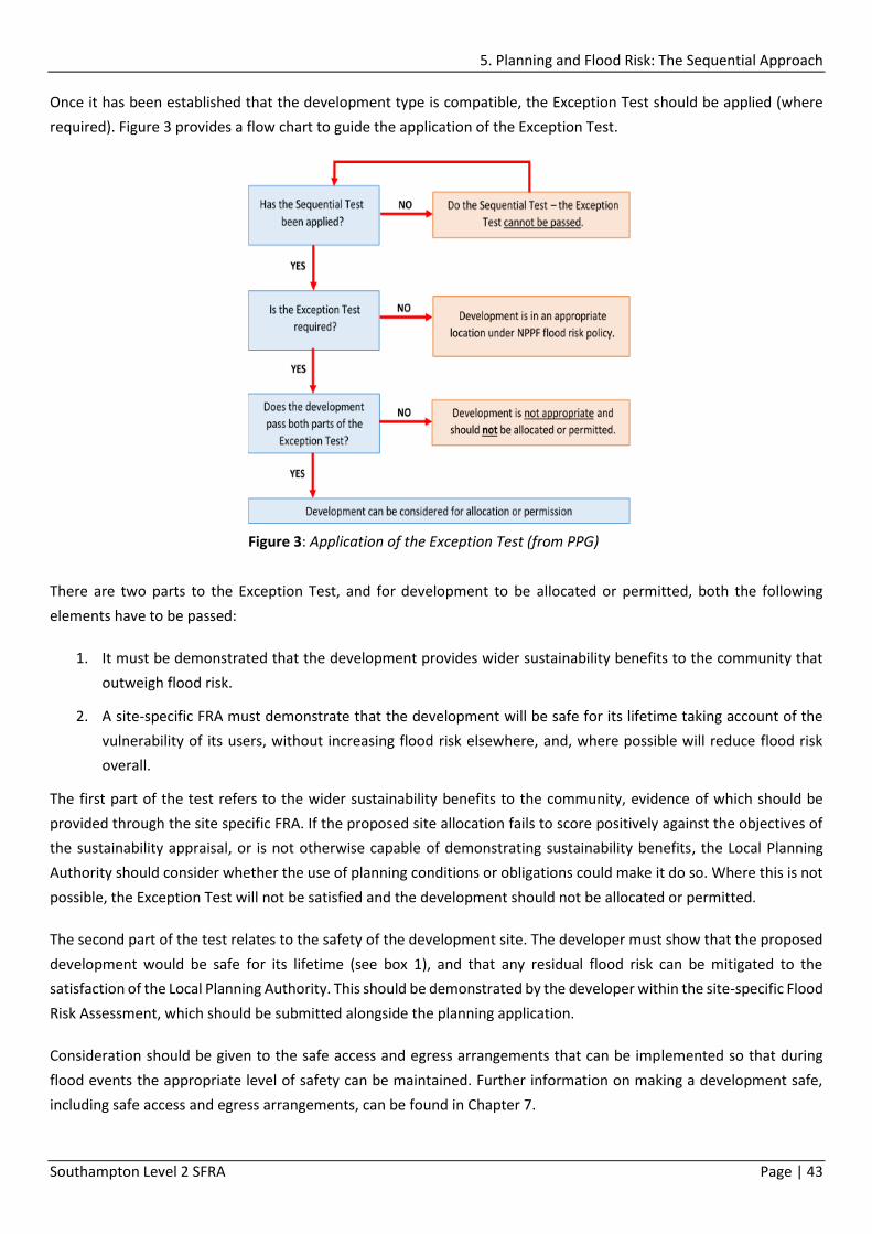
5. Planning and Flood Risk: The Sequential Approach
Southampton Level 2 SFRA Page | 43
Once it has been established that the development type is compatible, the Exception Test should be applied (where
required). Figure 3 provides a flow chart to guide the application of the Exception Test.
There are two parts to the Exception Test, and for development to be allocated or permitted, both the following
elements have to be passed:
1. It must be demonstrated that the development provides wider sustainability benefits to the community that
outweigh flood risk.
2. A site-specific FRA must demonstrate that the development will be safe for its lifetime taking account of the
vulnerability of its users, without increasing flood risk elsewhere, and, where possible will reduce flood risk
overall.
The first part of the test refers to the wider sustainability benefits to the community, evidence of which should be
provided through the site specific FRA. If the proposed site allocation fails to score positively against the objectives of
the sustainability appraisal, or is not otherwise capable of demonstrating sustainability benefits, the Local Planning
Authority should consider whether the use of planning conditions or obligations could make it do so. Where this is not
possible, the Exception Test will not be satisfied and the development should not be allocated or permitted.
The second part of the test relates to the safety of the development site. The developer must show that the proposed
development would be safe for its lifetime (see box 1), and that any residual flood risk can be mitigated to the
satisfaction of the Local Planning Authority. This should be demonstrated by the developer within the site-specific Flood
Risk Assessment, which should be submitted alongside the planning application.
Consideration should be given to the safe access and egress arrangements that can be implemented so that during
flood events the appropriate level of safety can be maintained. Further information on making a development safe,
including safe access and egress arrangements, can be found in Chapter 7.
Figure 3: Application of the Exception Test (from PPG)

5. Planning and Flood Risk: The Sequential Approach
Southampton Level 2 SFRA Page | 44
5.2.2 Evidence of the Exception Test
In order for developments to be allocated or permitted, both elements of the Exception Test will have to be passed
with suitable evidence of how each element is satisfied. For a successful application it is important that the arguments
presented for justification through the Exception Test are in line with policies set out in the Local Plan and the Local
Development Framework.
Where the NPPF requires the Exception Test to be applied for site allocation, it should be ensured that the wider
sustainability benefits of the development, and how these outweigh flood risk, are clearly documented with reference
to the site specific FRA.
It is for the developer/applicant to provide evidence that a proposed development is safe, and that any residual flood
risk can be mitigated to the satisfaction of the Local Authority, taking account of any advice from the Environment
Agency. Evidence should be reported within a site-specific Flood Risk Assessment submitted alongside the planning
application, demonstrating that people will not be exposed to hazardous flooding.
Box 1: Development Lifetime
Residential
Residential development should be considered for a minimum of 100 years, unless there is a specific justification
for considering a shorter period, which must be demonstrated to the LPA.
Non-residential
The lifetime of non-residential development depends on the characteristics of the development, and planners
should use their experience within the locality to assess how long they anticipate the development to be present.
For the purpose of flood risk, SCC will assume a 60 year life for non-residential developments.
Developers are expected to justify why they have adopted the given lifetime for the proposed development if it
differs from the above.

6. Flood Risk Management in Southampton
Southampton Level 2 SFRA Page | 45
6. Flood Risk Management in Southampton
The aim of this chapter is to set out how flood risk is currently managed in Southampton. For further detail on how
flood risk can be managed on individual development sites, please see Chapter 7.
6.1 Principles of Flood Risk Management
The NPPF and accompanying PPG requires a precautionary approach to be undertaken when making land use planning
decisions regarding flood risk. This is partly due to the considerable uncertainty surrounding flooding mechanisms and
how flood risk may be affected by climate change. It is also due to the potentially devastating consequences of flooding
to the people and property affected.
Flood risk is the combination of the probability of flooding and the consequences of flooding. Hence ‘managing flood
risk’ involves managing either the probability of flooding, the consequences of flooding, or both.
The standard framework for managing flood risk is to use the ‘source – pathway – receptor’ risk management model.
The source being the source of flooding (e.g. rainfall, rivers and the sea), the receptor the entity which can be damaged
by flooding (e.g. a town, people, buildings, roads, the economy and habitats), and the pathway the link which connects
the source(s) with the receptor (e.g. rivers, land, streets and sea defences).
This model can be applied at different scales, for example:
River catchment: the source is rainfall, the pathway is the soil and rivers and the receptor is the town.
Town scale: the source is the river, the pathway is the land, streets and any flood defences, and the receptor is
the community, buildings, roads and economy.
Development site: the source can be floodwater in the street adjacent to the site, the pathway can be the
building on the site, or the land on which it might be raised, and the receptor can be the people in the building
or the economic use of the building.
Modern flood risk management involves identifying how the source, the pathway and the receptors can be managed
to reduce flood risk. For example:
NPPF requires flooding from all sources (tidal, fluvial, surface water, sewers, groundwater and artificial sources) to be
considered. A subset of the source – pathway – receptor model is the spatial planning framework for regulating
development in flood zones. This is shown in Figure 4.
Surface water flooding – the source may be overloaded sewers which are surcharging. In which case consider
increasing the sewerage capacity to remove the source of flooding.

6. Flood Risk Management in Southampton
Southampton Level 2 SFRA Page | 46
This hierarchy underpins the risk based approach and must be the basis for making all decisions involving development
and flood risk. When using the hierarchy, account should be taken of:
The nature of the flood (the source of the flooding)
The spatial distribution of the flood (the pathways and areas affected by flooding)
Climate change impacts, and
The degree of vulnerability of different types of development (the receptors)
6.2 Local Flood Risk Management Strategy
As a unitary authority, SCC is designated a Lead Local Flood Authority (LLFA) under the Flood and Water Management
Act 2010 (FWMA). The FWMA places a statutory duty on LLFAs to ‘develop, maintain, implement and monitor a Local
Flood Risk Management Strategy (LFRMS) to manage local flood risk in its area’.
The purpose of the LFRMS is to help individuals, communities, businesses and authorities better understand and
manage flood risk in Southampton. It considers flooding from surface water, groundwater and ordinary watercourses,
however it was decided to also include other types of flooding (tidal and Main River), since it can sometimes be difficult
to identify the source of flooding during an incident and flooding often can be from a combination of different sources.
By including all sources of flood risk it provides a clear overview of flood risk within Southampton and the co-ordinated
approach to managing these risks.
The aim of the Strategy is to better understand, communicate and manage the risk of flooding in Southampton through
viable, sustainable and coordinated approaches, for the benefit of people, property, land and the environment, both
now and in the future.
Step 1
Assess
Appropriate Flood
Risk Assessment
Step 2
Avoid
Apply the
Sequential
Approach
Step 3
Substitute
Apply the
Sequential Test at
site level
Step 4
Control
E.g. SuDS, design,
flood defences
Step 5
Mitigate
E.g. Flood resilient
construction
Figure 4: Source – Pathway – Receptor model
Avoid and substitute relate to the location of the receptor (i.e. new development)
Control relates to protecting the development site, or the buildings on it from flooding with sea
defences or raising the level of the site/buildings (managing the pathway), or by controlling runoff
from the site to avoid increasing flood risks elsewhere (managing the source).
Mitigate (residual risks) is about resilience measures at the receptor to deal with residual risks once
the primary control measures have been put in place.

6. Flood Risk Management in Southampton
Southampton Level 2 SFRA Page | 47
The objectives of the LFRMS are to:
1. Improve the knowledge and understanding of all sources of flood risk across the City.
2. Work in partnership with other authorities and stakeholders who have a role in flood risk management,
including across administrative boundaries.
3. Identify ways to increase public awareness of flood risk across the City.
4. Identify ways of improving support for people at direct risk to promote appropriate individual and community
level planning and action.
5. Ensure that planning decisions are properly informed by flooding issues so future development assists with
reducing and mitigating flood risk.
6. Identify appropriate measures which reduce the likelihood of harm to people and damage to the economy and
the environment and assign a lead organisation to facilitate delivery.
7. Maintain, and improve where necessary, affordable and sustainable flood risk management infrastructure and
systems to reduce flood risk.
8. Identify all available funding mechanisms to enable delivery of flood risk management interventions
The Strategy identifies the actions to address flood risk in Southampton, which include:
Investigate flooding incidents (where deemed appropriate).
Maintain a register of flood risk assets.
Maintenance/regulating activities on main rivers.
Regulating works on ordinary watercourses through consenting and enforcement.
Implement completed flood plans and strategies including the Coastal Strategy.
Spatial/land use planning.
Joint working/duty to co-operate through a co-ordinated approach.
Improve our knowledge and understanding of flood risk, including groundwater and ordinary watercourses.
Improve recording of flooding incidents.
Raise awareness of flood risk in Southampton.
Improve existing drainage infrastructure and rivers/watercourses with available resources.
Designate features/structures which affect flood and coastal erosion.
Retrofit SuDS.
The Southampton LFRMS has been developed to manage flood risk over the next 5 years; therefore a review of the
Strategy will provide a good opportunity to also review any changes to the baseline data. Should a review of the Strategy
be required sooner, the environmental baseline shall also be reviewed.
The LFRMS can be viewed online at www.southampton.gov.uk/flooding.

6. Flood Risk Management in Southampton
Southampton Level 2 SFRA Page | 48
6.3 Managing Flooding from Tidal Sources
This SFRA has identified tidal flooding as a significant risk in Southampton as there are currently no formal defences to
protect against flooding from the sea. The tidal frontages do include some protection, however these are
predominantly erosion structures that provide an intrinsic (but varied) level of flood protection. Tidal flooding is
generally a low probability but high consequence event, however over time both the probability and consequences will
increase.
In addition to considering a strategic flood defence solution that aims to provide protection to Southampton, tidal flood
risk can be managed through site specific measures such as flood resistant and resilient design, safe access and egress
routes, evacuation and emergency planning and flood awareness. Land use planning and design of the site layout to
avoid the areas with greatest flood hazard should also be considered. Further detail on these points, is available in
Chapter 7 (Guidance for Developers).
6.3.1 Southampton Coastal Flood and Erosion Risk Management Strategy
The Southampton Coastal Flood and Erosion Risk Management Strategy (the Coastal Strategy) focuses on the long term
management of a 22km stretch of frontage from Woodmill at the tidal extent of the River Itchen, to Redbridge on the
River Test. The Strategy, completed in 2012, will influence future flood risk management options for key areas along
this frontage.
The primary aim of the Strategy was to develop a sustainable and robust coastal management strategy to provide
details on how the strategic Shoreline Management Plan policy of ‘Hold the Line’ could be implemented over the
coming century.
The 22km stretch of coast was divided into sub-areas, Option Development Units (ODUs), which were used to assess
the technical and practical feasibility of different defence options depending on the various constraints of each area
(providing flexibility to develop appropriate management options for each area). Table 12 lists the preferred options
for managing tidal flood risk in each ODU, and when implementation is likely to be required in order to reduce tidal
flooding to people and property.
Table 12: Preferred options for tidal flood risk management from the Coastal Strategy 2012
Area 2015+ 2030+ 2060+ 2110+
Unit 1 - Upper
Itchen / St Denys
Community and property level protection to
improve resistance and resilience of
properties.
Concrete floodwall on or near the frontline.
Unit 2 - Bevois
Valley
Defended by existing
structures. Defend by steel sheet pile wall at the front line.
Unit 3- Meridian
Studios area
Raise vacant land at Meridian Studios prior
to development. The remainder will require
an intermediate height flood wall until
raised land undertaken through
Raise land to achieve a continuous strip of
raised land of at least 50m width and to a
height of 4.25mODN. Land raised would need
to tie into land previously raised at the

6. Flood Risk Management in Southampton
Southampton Level 2 SFRA Page | 49
redevelopment supersedes the wall as the
main defence by 2060.
Meridian Studios site in order to form a robust
defence.
Unit 4 - Northam
Intermediate height floodwall forming the
spine of the flood defence until raised land,
preferably achieved through redevelopment
supersedes the floodwall as the main
defence by 2060.
Continuous strip of raised land.
Unit 5 – St Mary’s
Wharves
Intermediate height floodwall forming the
spine of the flood defence until raised land
supersedes the floodwall as the main
defence by 2060.
Defend by a continuous strip of raised land.
Unit 6 –
Crosshouse /
Town Depot
Defend by raising land through redevelopment.
Unit 7 – Ocean
Village
Maintain existing quay walls and defence
structures.
Defend by raised quay walls with floodwall
defences along perimeter of ABP land.
Unit 8 – Eastern
Docks / Dock
Gate 4
Do nothing. The area behind the Port is
protected against flooding by the Strategy
defences along the Itchen frontage to the
north and the existing quay walls in the Port
which is assumed will be maintained by
ABP.
Defend by a floodwall around Ocean Village
and along the boundary of the Port.
Unit 9 –
Mayflower Park /
Major
Development
Quarter
Land raising through development of the
Royal Pier Site and the Major Development
Quarter preferred. Implementation of a
floodwall forming the spine of the defence
by 2030 if a continuous strip of raised land
not achieved by this time.
Defend by a floodwall or raised land.
Unit 10 –
Western Docks
Do nothing. The area behind Port protected
against flooding by the existing quay walls in
the Port which it is assumed will be
maintained by ABP.
Area behind the Port defended against
flooding by a floodwall along the boundary of
the Port with ramps or demountable defences
on access points.
Unit 11 -
Redbridge
Defended by current
structures and
existing land levels.
Community and
property level
protection to
improve resistance
and resilience to
flooding.
Defend by a floodwall constructed along the
seaward side of the railway embankment.

6. Flood Risk Management in Southampton
Southampton Level 2 SFRA Page | 50
It is important to note that whilst the Coastal Strategy identifies the preferred options for the management of tidal
flooding, implementation is dependent on a number of factors including funding, so there is no guarantee they will be
implemented, or to the timescales recommended. Therefore developers should always consider flood mitigation
measures to protect people and property at a local, site level.
6.3.2 River Itchen Flood Alleviation Scheme
The River Itchen Flood Alleviation Scheme (River Itchen FAS) is a multi-million pound scheme developed from the
recommendations of the 2012 Coastal Strategy. The Scheme focuses on reducing flood risk to hundreds of existing
homes and businesses in Northam, St Marys, Chapel and parts of the city centre, through the implementation of a flood
wall along on the west bank of the River Itchen from the Mount Pleasant Industrial Estate to the raised Southampton
Water Activity Centre.
At present along this frontage there are over 500 residential properties, and 450 businesses are at risk from a 1 in 200
year tidal flood (a 0.5% chance of occurring in any year), as existing quay walls, structures and ground levels are not
high enough to prevent more extreme high tides from inundating the west bank of the River Itchen. Flooding will
become more frequent and severe if no action is taken to address tidal flood risk with the number of existing residential
properties at risk increasing to approximately
1500 by 2115, with flood water reaching depths
of up to 1.5 metres in several areas across
Northam, St Marys and Chapel. In 2014, SCC
began working with the Environment Agency
and AECOM on a study to determine a feasible
scheme, and scope out an appropriate route
alignment for a floodwall. Two feasible options
were put forward in a public consultation in
August 2015, involving a frontline and a set-back
route. A decision to progress with the frontline
scheme was made by SCC in March 2016 (subject
to future funding approval). This frontline route
is illustrated in Figure 5.
Over the next 5 years, work will continue to
develop the scheme, with progress updates
being made available online at
www.southampton.gov.uk/riveritchenfas.
Once construction is complete, the risk of
flooding to the area will be dramatically reduced,
however this does not reduce the responsibility
for developers to ensure that sites benefiting
from the scheme are safe from future flood risk,
since there will still be a residual risk of flooding
to the area in the form of breach or overtopping.
Figure 5: River Itchen FAS frontline route alignment

6. Flood Risk Management in Southampton
Southampton Level 2 SFRA Page | 51
6.4 Managing Fluvial Flood Risk
The management of flood risk from Main Rivers is the responsibility of the Environment Agency, with smaller ordinary
watercourses the responsibility of SCC. The most suitable type of flood management for a site depends on site specific
conditions, the receptor of flooding and the type of flooding. Currently there are limited fluvial flood defences,
however, the risk (and in particular the consequences) covers a relatively limited area when comparison is made to
that of tidal flooding. Where developments are at risk of fluvial flooding, steps should be taken to minimise the risk,
including appropriate site design to locate developments away from the highest risk, and use of measures to improve
the resistance and resilience of the building (see Chapter 7, Guidance for Developers).
The precautionary approach adopted in this SFRA for assessing fluvial flood risk in Southampton should be adopted to
secure river corridors, for flood risk management both now and in the future. This is supported by the Test and Itchen
Catchment Flood Management Plan action to ‘put in place polices within the Local Development Frameworks that work
towards long-term protection and re-creation of river corridors though sustainable land use management’.
New development in fluvial Flood Zone 3b should be avoided. It is assumed that SCC will adopt fluvial Flood Zone 3 as
the future Flood Zone 3b to assist in securing river corridors for appropriate ‘water compatible’ uses and, where
necessary, ‘essential infrastructure’ only.
SCC will also adopt a presumption against further culverting, and seek opportunities to de-culvert, where site and
ground conditions allow, in order to return watercourses to a more natural state, reducing the speed of water along
the channel and increasing capacity through the drainage system, therefore helping to reduce flood risk.
6.4.1 Riparian Landownership
Any person who owns land or property next to a river, stream or ditch (a watercourse) is deemed to be a ‘riparian
landowner’ and has a number of rights and responsibilities regarding the section of watercourse they own.
Riparian landowners play an important role in the reduction and management of flood risk, which is reflected in these
rights and responsibilities. A riparian landowner must:
Let water flow through their land without any obstruction pollution or diversion.
Accept flood flow through their land, even if these are caused by inadequate capacity downstream.
Keep the banks clear of anything that could cause an obstruction and increase flood risk, either on their land
or downstream if it is washed away. This includes maintaining the bed and banks, any trees/shrubs growing on
the banks, and removal of litter even if they did not originate from their land.
Leave a development free edge on the banks next to a watercourse to allow for easy access for maintenance
or inspection if required.
Full rights and responsibilities of a riparian landowner, as well as additional guidance is presented in the Environment
Agency guide ‘Living on the Edge’ available on the Environment Agency’s Website at:
https://www.gov.uk/government/publications/riverside-ownership-rights-and-responsibilities.

6. Flood Risk Management in Southampton
Southampton Level 2 SFRA Page | 52
6.4.2 Main River and Ordinary Watercourse Activities
Both the Environment Agency and SCC have different responsibilities for the management of activities on main rivers
and ordinary watercourses.
The Environment Agency are responsible for the management and monitoring of activities that may affect flood risk
from main rivers. Where the developer proposes to carry out works in, under, over or near a main river (including
where the river is in a culvert), on or near a flood defence on a main river, in the floodplain of a main river or, on or
near a sea defence, an Environmental Permit may be required. The developer should check with the Environment
Agency prior to beginning any works, with further guidance on the types of activities requiring a permit available at
https://www.gov.uk/topic/environmental-management/environmental-permits.
SCC, as a LLFA is responsible for the management of flood risk from ordinary watercourses, and under the FWMA 2010
has been given the powers of consenting and enforcement of certain works that may impact or alter the flow or
structure of a watercourse.
The purpose of ordinary watercourse regulation is to control certain activities that might have an adverse flooding
impact. An ordinary watercourse is defined as a watercourse that is not part of a main river, and includes rivers,
streams, ditches, drains, cuts, culverts, dikes, sluices, sewers (other than public sewers) and passages through which
water flows (although can be dry).
If proposals include the intention to carry out works (either permanent or temporary) which may place or alter a
structure within an ordinary watercourse (i.e. affect the flow or storage of water), the developer will be required to
apply to SCC for consent before any works begin. For further information see www.southampton.gov.uk/flooding
6.5 Managing Surface Water Flooding
Under the Flood and Water Management Act 2010, SCC as a Lead Local Flood Authority (LLFA), has a responsibility for
the management of flooding from surface water which is set out within the LFRMS, available online at
www.southampton.gov.uk/flooding.
Although the management of flooding from surface water is the responsibility of the LLFA, the Environment Agency
has a Strategic Overview role assigned by the government following the recommendations of the Pitt Review released
after the summer floods of 2007. A key part of this role is to provide local authorities with data, tools and guidance on
risk management activities.
6.5.1 Surface Water Hotspot Study
The Southampton Surface Water Hotspots study is currently being developed to address the ‘identification of priority
surface water management schemes within hotspot catchments’ action of the LFRMS through:
Identification of potentially feasible options for managing surface water within hotspot catchments;
Provision of evidence to support the exploration of funding options for priority surface water management
schemes; and

6. Flood Risk Management in Southampton
Southampton Level 2 SFRA Page | 53
Provision of evidence to support the detailed design and implementation of priority surface water schemes.
A number of surface water hotspot areas have been identified within the city, based on a number of factors including
flood history, and both short-term and long-term actions have been identified for each hotspot area. The short-term
actions are generally investigative or maintenance works which are unlikely to require significant additional funding
and which will help to provide evidence towards developing more long-term schemes. The long-term and strategic
actions are likely to require additional resources. A number of city-wide actions have also been identified. It is envisaged
that the identified hotspots and the action plan will be updated periodically to reflect any additional information
collected or progress made on the actions.
This study is considered to have partially addressed the LFRMS actions detailed above, although it is recognised that
further work will be required to fully meet these objectives. Identification of several potentially feasible options has
been undertaken for each hotspot area, based on available data, but further work is required to collect additional
information and to assess the feasibility of options. Evidence has been collected and presented in the hotspots action
plan to support future detailed design and the exploration of funding options for further work. It is expected that
funding will be the largest potential constraint on future work and the feasibility of schemes although a number of
other potential constraints have also been identified. Hotspot areas have been ranked to determine which actions
should be prioritised once funding becomes available.
When complete, the study will be available at www.southampton.gov.uk/flooding.
6.5.2 Sustainable Drainage Systems
Sustainable Drainage Systems (SuDS) are designed to control surface water runoff close to where it falls, mimicking
natural drainage as closely as possible, and designed correctly are a good way of managing flooding from surface water.
The requirement for the provision of SuDS in all major development came into effect on the 6 April 2015, to ensure
that runoff from a site is managed appropriately. The requirement for SuDS is well documented in the PPG that
accompanies the NPPF, which states ‘new development should only be considered appropriate in areas at risk of
flooding if priority has been given to the use of sustainable drainage systems’.
The inclusion of SuDS in the master planning or development site planning stage can have a significant benefit on the
viability and cost-effectiveness of SuDS integration, as all opportunities and constraints can be considered prior to
construction. The location of SuDS features can also be used to inform the site layout as well as improving the amenity
and visual appeal of the development.
For more detail on SuDS including advice on selection, please see chapter 7 (Guidance for Developers), or the SCC SuDS
Guidance available at www.southampton.gov.uk/flooding.
6.6 Management of Groundwater Flooding
Under the Flood and Water Management Act 2010, SCC as a LLFA and are responsible for the management of
groundwater flooding, which is set out in the LFRMS.

6. Flood Risk Management in Southampton
Southampton Level 2 SFRA Page | 54
Groundwater flooding is often highly localised and complex. Groundwater flood risk should be investigated, identified,
quantified and managed where possible by the Flood Risk Assessment process. Assessments of groundwater flooding
must therefore always be included at all levels of future Flood Risk Assessment. Indicators that the site may be at risk
from groundwater flooding include:
If the development site is near to, or at, the junction between geological strata of differing permeability;
If the development site is located at a similar level to nearby springs, or stream headwaters;
If the development proposals include basements or excavations into the ground;
If the vegetation on the site suggests periodic water logging due to high groundwater levels; and/or,
If nearby recorded borehole water levels reach those of the site.
Management is highly dependent upon the characteristics of the specific situation. The costs associated with the
management of groundwater flooding are highly variable. The implications of groundwater flooding should be
considered and managed through development control and building design. Possible mitigation includes:
Raising property ground or floor levels and avoiding the building of basements in areas considered to be at risk
of groundwater flooding.
Minimising excavation depths – for example; stipulating rafts in place of piles or trenches.
Provide local protection for specific problem areas such as flood proofing properties i.e. tanking or sealing of
basements.
Replacement and renewal of leaking sewers, drains and water supply reservoirs. Water companies have a
program to address leakage from infrastructure, so there is a clear ownership of the potential source.
Major ground works (such as construction of new or enlarged watercourses) and improvements to the existing
surface water drainage network to improve conveyance of floodwater from surface water or fluvial events
through and away from areas prone to groundwater flooding.
The potential increase in groundwater levels due to sea level rise has the potential to result in flooding of low lying
areas of Southampton. It is important to assess the impacts of managing groundwater with regard to water resources,
and environmental designations. Likewise, placing a barrier to groundwater movement can shift groundwater flooding
from one location to another.
The potential for higher groundwater levels should be considered where basements or underground structures are
proposed in low-lying parts of Southampton. These types of structures should be discouraged in these areas, due to
the potentially high probability of tidal flooding, however where they are necessary, development should assess the
effect of climate change on local groundwater levels, and include appropriate mitigation into development proposals.
Development proposals will need to consider ground conditions and ground water levels over the lifetime of the
development. In particular the design of any underground structures, services or foundations.

6. Flood Risk Management in Southampton
Southampton Level 2 SFRA Page | 55
6.7 Management of Flooding from Sewers
Southern Water’s main role is to provide and manage the public sewer system, which includes the foul, surface water
and combined drainage system, as well as the provision of fresh water. The main roles of the water and sewerage
company in managing flood risk include:
Ensuring their systems have the appropriate level of resilience to flooding, and maintain essential services
during emergencies.
Maintain and manage their water supply and sewerage systems to manage the impact and reduce the risk of
flooding and pollution to the environment.
Provide advice to LLFAs on how water and sewerage company assets impact on local flood risk.
Work with developers, landowners and LLFAs to understand and manage risks.
Work with the Environment Agency, LLFAs and district councils to coordinate the management of water supply
and sewerage systems with other flood risk management work. They also need to have regard to Flood and
Coastal Erosion Risk Management (FCERM) plans in their own plans and work.
Adopted public sewers are owned and maintained by Southern Water, whereas un-adopted sewers are the
responsibility of a third party. Private drains, those serving a single property are the responsibility of the property
owner. As of 11 October 2011, property owners are only responsible for the sewer pipes that drain only their property,
not those sections that are shared with others. Figure 6 explains the responsibilities for sewers, with sections of pipe
coloured red owned and maintained by Southern Water, and those in yellow owned and maintained by the property
owner. It is beneficial for property owners to maintain their privately owned sections of sewer in order to reduce the
risk of flooding to their own property.
Figure 6: Overview of sewer ownership

6. Flood Risk Management in Southampton
Southampton Level 2 SFRA Page | 56
Since 1980, with the introduction of Sewers for Adoption, Southern Water sewers are required to be designed in order
to accommodate 1 in 30 year rainfall events. With this, flood risk from sewers is better managed, however many sewers
in Southampton are pre-1980 and are likely to have a significantly lower capacity, which can in some areas lead to
issues of flooding.
The sewerage system in Southampton is further complicated by the tidal nature of the sewer outfalls, and the reliance
on pumping stations. In many instances ‘non-return’ valves are located on the outfalls. This protects the drainage
system from the sea, but at the same time it will often prevent (or reduce) the ability of the system to discharge surface
water – referred to as ‘tide locking’. This can result in surface water backing up in the drainage system, potentially
leading to flooding. The same effect can also be observed for outfalls into watercourses when water levels are elevated
due to prolonged or intensive rainfall.
Southampton’s surface water pumping stations are critical infrastructure for managing flooding from sewers. The
reliance on the pumping stations means there is potentially a significant ‘residual risk’ in the event of pumping station
failure, which is difficult to quantify without detailed modelling.
During the early stages of planning for a development, the developer should contact Southern Water to check the
capacity available within the sewer system (more information is online at www.southernwater.co.uk). In areas where
there is limited or insufficient capacity, the developer should seek to improve the drainage infrastructure to reduce
flood risk on site, whilst not increasing flood risk elsewhere. There should be no increase in peak flow or volume of
runoff from the development compared to the existing rate, but they should be reduced to as close as possible to
Greenfield rate. In line with the changes to the PPG made in March 2015, major developments should seek to
incorporate SuDS to reduce the risk of flooding from both surface water and sewers. It is also good practice and a
requirement in local planning policy that all developments try to incorporate the use of SuDS to manage surface water
runoff.
Any new development should not build over a public sewer. It is a requirement that a minimum distance of three
metres must be maintained between any building and the public sewer to ensure that the building does not damage
the sewer and that access is available at all times.
6.8 Emergency Planning
Emergency Planning for extreme events is a key consideration for new developments which have passed both the
Sequential and Exception Tests, but must be located in areas identified at risk of flooding.
6.8.1 Civil Contingencies Act 2004: Duty of the Local Authority
The Civil Contingencies Act 2004 draws up the structure and procedures for civil protection. The Act formalises the
duties of Category 1 responders (Local Authorities, Government Agencies, Emergency Services and NHS bodies) by
requiring risk assessment and contingency planning to deal with emergencies, and the provision of advice and
information to the public about actual or likely emergencies.
Under the Act, risk assessment and planning is arranged through Local and Regional Resilience Forums. The Forums,
seek to co-ordinate with all those bodies which may be exposed to risk or be required to respond to events (including

6. Flood Risk Management in Southampton
Southampton Level 2 SFRA Page | 57
flooding). This includes the production of a Multi-Agency Flood Plan, which may then be incorporated into a local
emergency plan or major incident plan as appropriate.
The Civil Contingencies Act also places a legal duty on Category 1 responders (which includes Local Authorities) to
produce a community risk register. Community risk registers are a compilation of risk assessments for hazards, including
flood risk which is identified as one of the key risks to Southampton. It is expected that the outputs of this SFRA are
used to support SCC in the maintenance of the Community Risk Register and mapping such that the risks can be
evaluated with greater precision.
SCC has a legal duty to prepare and update emergency plans for major and local civil emergencies including flooding.
As part of the requirements, SCC is expected to:
Assist other relevant services and agencies, including the emergency services and the Environment Agency,
with regards to alerting or warning the public if local flooding is either imminent or likely;
Assist the emergency services with the evacuation of residents from areas that are likely to be, or have already
been flooded;
Identify and staff public reception centres for evacuees to offer information, refreshments and if necessary
shelter overnight;
Assist the Fire Service in dealing with floodwater and mitigating damage, by providing flood control measures
such as sandbags;
Assist the emergency services to control access to the scene by undertaking road closures or erecting road
barriers etc.
It is expected that the mapping within this SFRA will support SCC in identifying evacuation areas, reception centre
locations and critical infrastructure that lie within Flood Zones 2 and 3 and also assist in identification of future
resourcing requirements for an emergency response. The information within this SFRA is likely to assist those preparing
and updating emergency plans, by improving the understanding of the risk. It also enables those attending flood
emergencies to prepare in advance and reduce the chance of unforeseen exposure to hazards during a flood
emergency.
6.8.2 Hampshire and Isle of Wight Multi Agency Flood Plan
The Hampshire and Isle of Wight Multi Agency Flood Plan (Response & Recovery) (MAFP) is a specific hazard plan
updated in 2016. It outlines both SCC’s and the multi-agency response to flood events and is supported by Hampshire
and the Isle of Wight Local Resilience Forum (HIOW LRF).
There are three parts to the MAFP:
Part One: Response and Recovery.
Part Two: Summarises the risks to each of the four Top Tier Local Authority areas (Hampshire, Isle of Wight,
Southampton and Portsmouth Council areas).
Part Three: Provides specific detail on Southampton’s flood risk areas and the supporting mapping.

6. Flood Risk Management in Southampton
Southampton Level 2 SFRA Page | 58
The plan describes the multi-agency management and response arrangements in preparation for, and in response to,
a flood event in Hampshire and the Isle of Wight. The aim of the MAFP is to minimise the impacts of significant flood
events in Hampshire and the Isle of Wight.
Each part of the MAFP has a number of objectives:
Provide background information including relevant legislation, terminology definitions and supporting risk
assessment.
Describe the mechanisms for flood and severe weather warnings.
Define plan activation triggers.
Outline recovery arrangements specific to flooding.
Describe the multi-agency emergency response structures that would be established.
Provide flood response information for use by these response structures.
Describe the roles and responsibilities of agencies responding to flooding.
Outline considerations for media and public information.
Provide information to support the warning and informing of the public before, during and after a flood event.
Provide a flood risk profile for Hampshire, Isle of Wight, Portsmouth and Southampton.
Provide a site specific flood response plan for areas at risk of flooding.
6.8.3 Critical Infrastructure
To assist in informing the Emergency Planning Team, this section gives an overview of the critical infrastructure in the
city. Map 17 provides a visual of sites of critical infrastructure in relation to Flood Zone 2.
6.8.3.1 Emergency Service Infrastructure
There are four hospitals in Southampton, all of which are presently located in, and will remain in Flood Zone 1, over the
next 100 years. They are:
Southampton General Hospital (Tremona Road) – Flood Zone 1
Princess Ann Hospital (Coxford Road) – Flood Zone 1
Spire Hospital (formerly Chalybeate Hospital) (Chalybeate Close) – Flood Zone 1
Royal South Hants Hospital (Brinton’s Terrace) – Flood Zone 1
There are four police stations across the city, three of which are located will remain in Flood Zone 1 over the next 100
years, with the other being in present day Flood Zone 3. They are:
Southampton City Centre (Mountbatten Way) – Flood Zone 3
Shirley (Shirley Road) – Flood Zone 1

6. Flood Risk Management in Southampton
Southampton Level 2 SFRA Page | 59
Bitterne (Bursledon Road) – Flood Zone 1
Portswood (St Denys Road) – Flood Zone 1
There are three fire stations located across the city, all of which are presently located, and will remain in Flood Zone 1
over the next 100 years. They are:
Hightown (Bursledon Road) – Flood Zone 1
Redbridge (Redbridge Hill) – Flood Zone 1
St Marys (St Mary’s Road) – Flood Zone 1
6.8.3.2 Transport Infrastructure
There are a number of major transport routes within Southampton including national rail lines and road routes.
Southampton Central Rail Station connects Southampton with London and the north, as well as the urban centres to
the east (Brighton) and west (Weymouth) along the coast. There are 7 district stations within Southampton which
include St Denys, Bitterne, Woolston and Sholing to the east, Millbrook and Redbridge to the west and Swaythling to
the north, as well as connections to the docks for freight and container distribution.
Large sections of the rail route to the west of Central Station are within areas of high flood risk, particularly from tidal
flood events. The effects of climate change over the next 100 years are predicted to include areas within the city centre
and could lead to flooding of St Denys, Redbridge and Millbrook rail stations. Notably, Southampton Central Rail Station
was flooded in May 2008, believed to have resulted from heavy rainfall.
Certain elements of Southampton’s road infrastructure are critical to providing an integrated and effective response to
major flooding. Most importantly access routes such as roads and pedestrian routes are vital to provide access for the
emergency services to affected areas. Pedestrian and vehicular routes along with elements of public transport will also
be important in providing a means of evacuation of the public should this be necessary. As there is much land within
Southampton that could potentially be affected by surface water and tidal flooding, several key access routes may also
be vulnerable to flooding.
Although outside SCC’s administrative boundary, Southampton Airport is a regionally important infrastructure. The
airport lies adjacent to Flood Zones 2 and 3, and is partially protected by flood defences on the River Itchen. The risk to
the airport is expected to increase in the future as a result of climate change.
6.8.3.3 Service Infrastructure
Maintaining and protecting essential services such as water, electricity, gas and sanitation, or if this is not possible,
ensuring their swift restoration is vital to securing a rapid return to normality following a flood. The Council will liaise
with, and require assistance from, statutory undertakers during and after a flood event.
ABP maintain and operate two pumping stations to aid the discharge of surface water from the drainage system and
prevent tide locking. These two pumping stations are critical to the operation of the surface water network in
Southampton as they serve considerable drainage catchments including key transport links such as the A3024 and A33.
These pumping stations are located adjacent to Mayflower Park and near King George V Dock at Millbrook.

6. Flood Risk Management in Southampton
Southampton Level 2 SFRA Page | 60
Due to operational requirements, Southern Water’s sewage treatment works at Kent Road, Millbrook Point and Victoria
Road are all located in Flood Zone 3. Southern Water are planning to review the resilience of key water infrastructure
sites in Southampton during their 2015 plan period.
The impacts of infrastructure which may cause danger to people during flood events needs to be assessed.
Infrastructure such as foul sewers, electrical installations, nuclear installations such as Z-Berth (refer to the SotonSafe
Plan) and areas where hazardous chemicals and fuels are stored. The responders will need to be aware of these hazards
and the appropriate responses to them should they arise.

7. Guidance for Developers
Southampton Level 2 SFRA Page | 61
7. Guidance for Developers
This chapter provides information and advice to developers and planners on the methods that can be used to help
manage flood risk to a development site, improve the safety of future occupants, and meet the requirements of
planning policy relating to flood risk.
7.1 Site Specific Flood Risk Assessment
In accordance with paragraph 103 of the NPPF which states ‘Local Planning Authorities should ensure flood risk is not
increased elsewhere and only consider development appropriate in areas at risk of flooding where, informed by a site-
specific Flood Risk Assessment following the Sequential Test, and if required the Exception Test’. A site specific FRA
must ‘demonstrate that the development will be safe for its lifetime taking account of the vulnerability of its users,
without increasing flood risk elsewhere, and, where possible, will reduce flood risk overall’.
Although this SFRA has been undertaken for Southampton, it does not negate the need for site specific FRAs to be
undertaken at the planning application stage. Instead, this SFRA provides advice on the scope of the additional
information required within a site specific FRA. Developers and applicants should be referred to this SFRA at the start
of any pre-application discussions with SCC.
Flooding should be managed through the Flood Risk Assessment process. Further collection of relevant data is
required, such as land use, runoff rates, existing drainage systems, past flood events and consultation with relevant
bodies. Specific factors that should be considered when undertaking a FRA included:
Areas liable to flooding (based on site and catchment characteristics).
The extent, standard capacity and effectiveness of existing drainage systems,
Existing runoff rates, with any probable increases,
The likely impacts to other areas (such as increases in surface water runoff rates),
The likely extent, depth and velocity of flooding,
The effect of climate change, and
The suitability of various sustainable urban drainage system options.
The site-specific FRA, which should be submitted alongside the planning application in accordance with NPPF, is
required to demonstrate how flood risk will be managed now and in the future over the development’s lifetime. It is
the responsibility of the developer/applicant to undertake a site specific FRA to fully assess the flood risk to and from
the site, propose appropriate measures to mitigate the risk and demonstrate that any residual risks can be managed
safely.
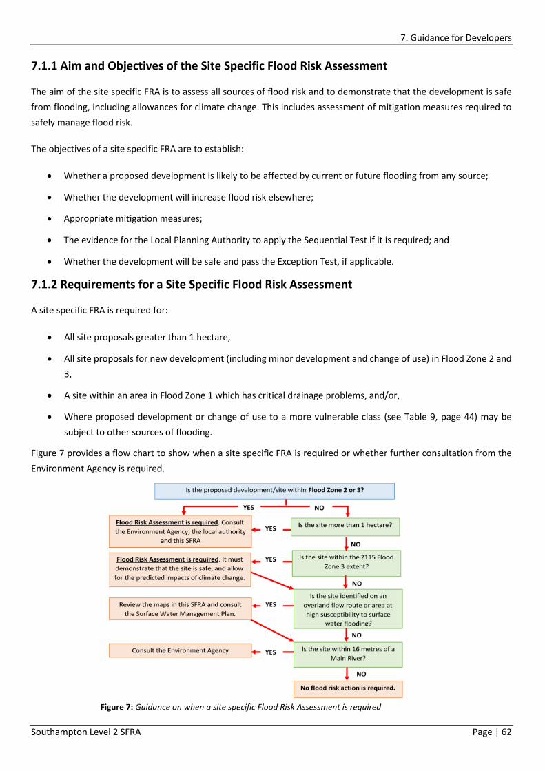
7. Guidance for Developers
Southampton Level 2 SFRA Page | 62
7.1.1 Aim and Objectives of the Site Specific Flood Risk Assessment
The aim of the site specific FRA is to assess all sources of flood risk and to demonstrate that the development is safe
from flooding, including allowances for climate change. This includes assessment of mitigation measures required to
safely manage flood risk.
The objectives of a site specific FRA are to establish:
Whether a proposed development is likely to be affected by current or future flooding from any source;
Whether the development will increase flood risk elsewhere;
Appropriate mitigation measures;
The evidence for the Local Planning Authority to apply the Sequential Test if it is required; and
Whether the development will be safe and pass the Exception Test, if applicable.
7.1.2 Requirements for a Site Specific Flood Risk Assessment
A site specific FRA is required for:
All site proposals greater than 1 hectare,
All site proposals for new development (including minor development and change of use) in Flood Zone 2 and
3,
A site within an area in Flood Zone 1 which has critical drainage problems, and/or,
Where proposed development or change of use to a more vulnerable class (see Table 9, page 44) may be
subject to other sources of flooding.
Figure 7 provides a flow chart to show when a site specific FRA is required or whether further consultation from the
Environment Agency is required.
Figure 7: Guidance on when a site specific Flood Risk Assessment is required

7. Guidance for Developers
Southampton Level 2 SFRA Page | 63
Development proposals requiring a Site Specific FRA should:
Apply the Sequential Test, and where necessary, the Exception Test.
Not increase flood risk either upstream, downstream or to the site, including allowances for climate change.
Not increase surface water volumes or peak flows in any circumstances.
Use opportunities provided by new development to, where practicable, reduce flood risk within the site and
elsewhere.
Ensure that where development is necessary in areas of flood risk (after Sequential and Exception Tests
applied), it is made safe from flooding for the lifetime of the development, taking into account the impact of
climate change.
Assess all sources of flood risk, including fluvial, surface water and groundwater.
7.1.3 Information to Include in a Site Specific Flood Risk Assessment
The information provided in a site specific FRA should be credible and fit for purpose, whilst remaining proportionate
to the degree of flood risk, and appropriate to the scale, nature and location of the development. It should be
demonstrated that the flood risk management hierarchy of ‘assess – avoid – substitute – control – mitigate’ has been
applied.
The site specific FRA should:
Consider the flood risk to the development site, as well as the risk that may arise as a result of the
development, taking climate change into account.
Consider the different types of flooding and identify any flood risk reduction measures.
Consider the effects of a range of flooding events including extreme events on people, and property.
Include an assessment of residual risk after flood risk measures have been taken into account, demonstrating
that it is acceptable for the particular development or land use.
The site specific FRA should be undertaken as early as possible in the planning process to identify whether the site is
suitable for particular development types, to avoid wasting time later in the planning process. It should be fully
supported by appropriate data and information, including historical information on previous flood events. Table 13
provides a checklist of the minimum required content of a site specific FRA.
Table 13: Model Checklist for a Site Specific Flood Risk Assessment
1. Development site and location - This section should describe the site of the proposed development.
a) Where is the development site located? (e.g. postal address or national grid reference and a map)
b) What is the current use of the site (e.g. undeveloped land, housing, shops, offices etc.)
C) Which Flood Zone is the site within? (i.e. Flood Zone 1, 2 or 3 – use the Environment Agency flood map to
determine)
2. Development proposals – this section should provide a general summary of the development proposals, and
where possible make reference to/include plans or drawings.

7. Guidance for Developers
Southampton Level 2 SFRA Page | 64
a) What are the development proposal(s) for this site? Will this involve a change of use of the site and, if so, what
will that change be?
b) In terms of vulnerability to flooding, what is the vulnerability classification of the proposed development?
c) What is the expected or estimated lifetime of the proposed development likely to be?
3. Sequential Test – required for developments in Flood Zones 2 or 3 only.
a) What other locations with a lower risk of flooding have you considered for the proposed development?
b) If you have not considered any other locations, what are the reasons for this?
c) Explain why you consider the development cannot reasonably be located within an area with the lowest
probability of flooding (flood zone 1); and, if your chosen site is within flood zone 3, explain why you consider
the development cannot reasonably be located in flood zone 2.
d) As well as flood risk from rivers or the sea, have you taken account of the risk from any other sources of
flooding in selecting the location for the development?
4. Climate change
a) How is flood risk at the site likely to be affected by climate change? See section 4 of this SFRA and the
Environment Agency Climate Change Allowances for further guidance.
5. Site specific flood risk – describe the risk of flooding to and from the proposed development over its expected
lifetime, including allowances for climate change.
a) What is/are the main source(s) of flood risk to the site? (E.g. tidal/sea, fluvial or rivers, surface water,
groundwater, other?). Consider information from the Environment Agency maps, this SFRA and historic flood
records.
b) What is the probability of the site flooding, taking account of the maps of flood risk available from the
Environment Agency, this SFRA and any further flood risk information?
c) Are you aware of any other sources of flooding that may affect the site?
d) What is the expected depth and level for the design flood? Flood levels should be presented in metres above
Ordnance Datum.
e) Are properties expected to flood internally in the design flood and to what depth? Internal flood depths should
be provided in metres.
f) How will the development be made safe from flooding and the impacts of climate change, for its lifetime? See
Section 7 of this SFRA for guidance.
g) How will you ensure that the development and any measures to protect the site from flooding will not cause
any increase in flood risk off-site and elsewhere? Consideration should be given to the impacts of climate change
over the lifetime of the development.
h) Are there any opportunities offered by the development to reduce the causes and impacts of flooding?
6. Surface water management – this section can be used to describe the existing and proposed surface water
management arrangements at the site using SuDS wherever appropriate, to ensure there is no increase in flood
risk to others off site.
a) What are the existing surface water drainage arrangements for the site?
b) If known, what (approximately) are the existing rates and volumes of surface water run-off generated by the
site?
C) What are the proposals for managing and discharging surface water from the site, including any measures for
restricting discharge rates? For major developments (e.g. of ten or more homes or major commercial

7. Guidance for Developers
Southampton Level 2 SFRA Page | 65
developments), and for all developments in areas at risk of flooding, sustainable drainage systems should be
used, unless demonstrated to be inappropriate.
d) How will you prevent run-off from the completed development causing an impact elsewhere?
e) Where applicable, what are the plans for the ongoing operation and/or maintenance of the surface water
drainage systems?
7. Occupants and users of the development – this section should provide a summary of the numbers of future
occupants and users of the new development; the likely future pattern of occupancy and use; and proposed
measures for protecting more vulnerable people from flooding.
a) Will the development proposals increase the overall number of occupants and/or people using the building or
land, compared with the current use? If this is the case, by approximately how many will the number(s) increase?
b) Will the proposals change the nature or times of occupation or use, such that it may affect the degree of flood
risk to these people? If this is the case, describe the extent of the change.
c) Where appropriate, are you able to demonstrate how the occupants and users that may be more vulnerable
to the impact of flooding (e.g., residents who will sleep in the building; people with health or mobility issues;
etc.,) will be located primarily in the parts of the building and site that are at lowest risk of flooding? If not, are
there any overriding reasons why this approach is not being followed?
8. Exception Test – this section should provide evidence to support certain development proposals in Flood
Zones 2 and 3 if, following the Sequential Test, it is appropriate to apply the Exception Test.
a) Would the proposed development provide wider sustainability benefits to the community? If so, could these
benefits be considered to outweigh the flood risk to and from the proposed development?
b) How can it be demonstrated that the proposed development will remain safe over its lifetime without
increasing flood risk elsewhere?
c) Will it be possible to for the development to reduce flood risk overall (e.g. through the provision of improved
drainage)?
9. Residual risk
a) What flood related risks will remain after the flood risk management and mitigation measures have been
implemented?
b) How, and by whom, will these risks be managed over the lifetime of the development? (E.g., putting in place
flood warning and evacuation plans).
10. Flood risk assessment credentials
a) Who has undertaken the flood risk assessment?
b) When was the flood risk assessment completed?
FRAs for proposed development within the SCC administrative boundary should follow the approach recommended
by the NPPF and accompanying PPG, as well as guidance provided by the Environment Agency. To assist developers in
the preparation of a suitable site specific FRA, SCC has produced a FRA template which is available on the SCC website
www.southampton.gov.uk/flooding.

7. Guidance for Developers
Southampton Level 2 SFRA Page | 66
7.1.4 Reviewing the Site Specific Flood Risk Assessment
Once a planning application, together with an appropriate FRA, is submitted by the developer/applicant, it will be
assessed to ensure that the applicant has considered flood risk from all sources and demonstrated how flood risk will
be managed (flood mitigation measures etc.) taking climate change into account.
It is the responsibility of the applicant to provide sufficient detail to demonstrate compliance with NPPF and with local
SCC policies, in particular that proposals will remain ‘safe’ for the lifetime of the development, which is typically 100
years for residential development, and 60 years for commercial, whilst making allowances for climate change.
7.2 Flood Risk Mitigation
The minimum acceptable standard of protection against flooding for new property within flood risk areas is 1% (1 in
100 year) annual probability for fluvial flooding and surface water drainage, and 0.5% (1 in 200 year) annual probability
tidal event, with allowance for climate change over the lifetime of the development. The measures chosen to help
manage and reduce flood risk will depend on different factors including the nature and source of the flood risk, and
the site specific conditions.
7.2.1 Site Layout and Design
The Sequential Approach should be applied within the development site to locate the most vulnerable elements of the
development in the areas with the lowest risk. Residential developments should be restricted to areas of lowest
hazard, whereas parking, open space or proposed landscaped areas may be located within the areas of the site where
a higher probability of flooding may exist.
Where structures such as bicycle shelters, park benches and refuse bins (and their associated storage areas) are located
in areas with a high risk of flooding, they should be designed to be flood resilient and also firmly anchored to the
ground to secure them should a flood event occur.
7.2.2 Raised Defences
Raised defences are a common method of flood risk mitigation, however can be expensive as they need to be specially
designed and engineered to withstand the force of water, and require ongoing maintenance. Raised defences should
be designed to achieve at least a 1 in 100 year standard of protection for fluvial flood risk and 1 in 200 year standard
of protection for tidal flood risk until the end of the design life, adopting relevant climate change allowances for flood
risk assessments (Environment Agency April 2016), whilst also including a 300mm freeboard to allow for uncertainty,
settlement and small waves.
Whilst construction of a raised floodwall or embankment can help reduce the risk to a development, it is not the
preferred option for flood risk management. This is because the residual risk will remain since water collecting on the
landward side of a raised defence cannot discharge to a watercourse or the sea while levels remain high, and so will
be trapped for the duration of the flood. Where raised defences are built on fluvial areas, compensatory storage must
be provided as floodplain storage is used, and it must be demonstrated that the proposed structures do not increase
flood risk elsewhere.

7. Guidance for Developers
Southampton Level 2 SFRA Page | 67
Areas behind flood defences are at particular risk from rapid onset of fast-flowing deep water flooding, with little or
no warning if defences are breached or overtopped. Land raising is the preferred option over the use of raised
defences, however it is acknowledged this is not always a viable option.
Temporary or demountable defences are not acceptable forms of flood protection for new development, unless the
flood risk is residual only.
7.2.3 Ground Level Modification (Land Raising)
The most robust form of flood defence is raising land to create high ground. This method is particularly effective for
reducing tidal flood risk, and also has the advantage of minimal defence maintenance or repair costs (depending on
the design), and also minimises the need for additional resistance and resilience measures.
Such an option would be most appropriately and effectively carried out during the re-development of sites, as
demolition of existing buildings may otherwise be required. However, if opportunities to redevelop do not arise, and
sufficient time is available until the defence is required, with careful co-ordination and planning, such an option could
be achieved through joining up incrementally raised areas overtime, aligned with renovation or building replacements
therefore allowing existing land uses to remain.
This option should ensure safe movement of people in or out of the area, i.e. an island effect with surrounding areas
inundated by floodwater is not acceptable, since access to the site for emergency services will not be possible.
In areas at risk of fluvial flooding, raising land above the floodplain is likely to reduce conveyance and flood storage,
which may in turn have an adverse impact on flood risk further downstream. If land raising is proposed where fluvial
flooding occurs then compensatory flood storage must be provided on land that is adjacent to the floodplain, but does
not currently flood, and should be on a volume for volume, level for level basis.
Raising ground levels can also deflect flood flows. Analyses should therefore be performed to demonstrate that there
are no adverse effects on third party land. It can also create areas where surface water may pond during significant
rainfall events. Any proposals to raise ground levels should be assessed to ensure that it would not cause increased
ponding or build-up of surface runoff on third party land.
7.2.4 Developer Contributions
Flood risk management authorities can apply for Flood Defence Grand in Aid (FDGiA) from Defra to help pay for the
provision of flood defence schemes that reduce the risk of flooding and coastal erosion for existing communities,
however eligibility is dependent on criteria including the benefits the scheme will provide. This means that some
schemes may only be part funded and any shortfall in funding will need to be found from other sources including local
levy funding or contributions from other parties that benefit from the scheme.
Following the application of the Sequential Test, it may therefore be necessary, in some cases, for the developer to
make a contribution to the improvement of flood defences that would benefit both the development and the local
community. Contributions from developers can also be made towards the maintenance and provision of flood risk
management assets and the reduction of surface water flooding, for example SuDS.

7. Guidance for Developers
Southampton Level 2 SFRA Page | 68
The Community Infrastructure Levy (CIL) (which is levied on extensions and buildings) allows Local Planning Authorities
to raise funds from new development. The charges are set by the local council, based on the size and type of the new
development. These rates are set out in the Local Charging Schedule.
The money raised from CIL can be used to fund a variety of infrastructure requirements as set out in Section 216 (2) of
the Planning Act 2008. This includes strategic transport schemes, flood defences and open spaces.
Further information on CIL, and the requirements of developer contributions can be found on SCC’s website at:
http://www.southampton.gov.uk/planning/community-infrastructure-levy/
7.2.5 Building Design: Finished Floor Levels
Where development in flood risk areas is unavoidable (following satisfaction of the Sequential and Exception Test),
the most common method of flood risk mitigation to people and property, particularly with ‘more vulnerable’ land
uses, is to ensure that habitable floor areas are raised above the flood zone. Internal areas of these types of
development (including change of use) should be designed to be dry during the design flood (1 in 100 ARI for fluvial
and 1 in 200 ARI for tidal), for the lifetime of the development.
At a minimum, finished floor levels should be raised above the extreme flood level. In addition, the Environment
Agency requires a 300mm freeboard (the difference between finished floor levels of habitable rooms and the design
flood level) to be achieved to allow for small waves.
In certain situations, such as proposed extensions to buildings with lower floor levels, it may prove impractical to raise
the internal ground floor levels sufficiently in order to meet the general requirements. In these cases, the Environment
Agency should be approached to discuss the options for a reduction in the minimum internal ground levels, providing
appropriate flood mitigation and proofing measures (resistance and resilience measures) are implemented up to an
agreed level. The Environment Agency Standing Advice (available at https://www.gov.uk/guidance/flood-risk-
assessment-standing-advice) should be followed when considering development in areas of flood risk.
In some cases it may be possible to introduce flood resilient design in lieu of the freeboard level or to allocate less
vulnerable development to the ground floor, for example commercial premises with residential above. Where this is
the case, attention must be given to safe access and egress routes and the safety of people should not be jeopardised
by creating an island development in times of flooding. A Site Flood Plan should be developed to ensure all future
occupants are aware of the risks and how to evacuate safely when required.
The use of basement accommodation should be restricted to areas which are not susceptible to flooding, including
groundwater flooding. Should basement development be required in areas designated by the Environment Agency as
susceptible to groundwater flooding, it is advised that more consideration should be given to this source of flooding
as part of a site specific FRA following a geological investigation being undertaken. SCC will not usually allow new
residential development of basements in flood risk areas.
7.2.6 Resistance and Resilience Measures
There may be some instances where flood risk to a development remains. Examples include where the building use is
water compatible (see Table 9 Flood Vulnerability Classification, page 45), residual risk remains behind a flood defence,

7. Guidance for Developers
Southampton Level 2 SFRA Page | 69
where an existing building is modified or where the floor levels have been raised but there is still a risk at the 0.1%
annual probability. In these cases (and for existing development in the floodplain), additional measures can be put in
place to reduce damage and aid recovery following a flood. These mitigation measures are often referred to as
resistance and resilience measures.
Flood-resilient buildings are designed to reduce the consequences of flooding and facilitate the quick recovery should
water enter a building. Resilience can be achieved:
Through the use of water-resistant materials for floors, walls and fixtures e.g. lime based plaster on walls, tiles
instead of carpets and plastic/stainless steel kitchen units rather than wood.
By raising electrical sockets, cables and appliances above the flood level, and running electrical cables down
from ceilings rather than up from floors.
Installing solid concrete floors in place of suspended floors.
In considering appropriate resilience measures, it will be necessary to have a clear understanding of the mechanisms
that lead to flooding and the nature of the flood risk by undertaking a Flood Risk Assessment.
Flood-resistant construction can prevent entry of water, or minimise the amount of water that may enter a building,
where there is short duration flooding expected. Flood resistance measures can include:
Flood barriers for doors and windows, or passive flood doors.
Automatic airbricks which close on rising water and open when water recedes.
Air vent covers.
Non-return valves to waste water outlets and the foul sewer chamber to prevent flooding from sinks, toilets
and other appliances.
Sumps and pumps to control water levels under buildings with suspended floors reducing the likelihood of
water entering via the floor.
Application of a breathable waterproof brick sealant to at least 600mm above ground level.
Flood resistant construction should be used with caution, used in conjunction with resilience measures (in case of
failure) and maintained regularly to ensure all components, such as rubber seals, are in good working condition.
Resistance measures are not suitable where flood depths exceed 0.6m as the pressure exerted on the building by the
outside may cause structural damage. In cases where depths of 0.6m is likely to be exceeded it is advised to allow
water into the building, and rely on resilience measures to aid clean up.
In accordance with the Sequential Approach, flood resilience and resistance measures in new buildings should only be
used as a means to manage relatively ‘low’ hazard or ‘residual’ flood risk, and should only be used as a last resort to
address flood risk issues. Flood resistance and resilience measures should not be used to justify development in

7. Guidance for Developers
Southampton Level 2 SFRA Page | 70
inappropriate areas, and consideration should first be given to minimising risk by planning sequentially across a site.
Once risk has been minimised, only then should mitigation measures be considered.
Figure 8 is taken from the Environment Agency guidance to support NPPF, to offer advice on the considerations for
flood avoidance, resistance and resilience measures.
7.2.7 Safe Access and Egress
Access and egress is required to enable the safe evacuation of people from the development during times of flooding,
while also allowing the emergency services and other support with vehicular access to perform any necessary duties.
Wherever possible, safe access routes should be located above design flood levels and avoid flood flow paths. Where
this is not possible, limited depths of flooding may be acceptable, provided that the proposed access is designed with
appropriate signage etc. to make it safe. The acceptable flood depth for safe access will vary depending on flood
velocities and the risk of debris within the flood water. Even low levels of flooding can pose a risk to people in situ
Figure 8: Considerations for Flood Avoidance, Resistance and Resilience Measures (EA Advice 2013)

7. Guidance for Developers
Southampton Level 2 SFRA Page | 71
(because of, for example, the presence of unseen hazards and contaminants in floodwater, or the risk that people
remaining may require medical attention).
The site specific FRA should provide information on flood hazard, duration and speed of onset along access/egress
routes during the extreme flood event so that the LPA can make a judgement as to whether this is acceptable in light
of the timeframe over which people might be trapped, the quality of the temporary refuge provided (and/or the length
of time over which people might be displaced if prior evacuation has occurred), the capability of emergency services
to effect a rescue and the advice of the particular authorities, operators, utilities and regulators as appropriate.
Where the site specific FRA shows that flood risk is an issue, access and egress should be discussed with SCC and the
Environment Agency as early as possible in the planning stages, since it can affect the overall design of the
development.
Where an acceptable standard of safe access/egress cannot be met, it will be necessary for users of the development
to avoid flood hazards through the use of a Site Flood Plan which will detail how risk will be managed through the
following methods:
Evacuation procedure prior to a flood
Reliance on temporary refuge during a flood
The FRA must provide clear evidence i.e. options appraisal which demonstrate why safe access and egress cannot be
achieved before alternative methods will be considered by the Council.
7.2.8 Flood Warning and Evacuation
All development must be designed so that it is safe from flooding, including the consideration of residual risks, over its
lifetime. Where a site would still be exposed to a flood hazard, because it has been demonstrated that safe access and
egress is not feasible, then it may be considered appropriate to rely on flood warning and evacuation procedures,
supported through the development of a Site Flood Plan.
The considerations for determining whether reliance on flood warning and evacuation procedures are appropriate
include:
The potential flood hazard to the site from a design flood event at the end of the anticipated lifetime of the
development and the potential frequency and extent of any flooding at the site.
Any well-developed proposals for future strategic flood defence schemes that could benefit the site.
Where the development proposal for more vulnerable uses (as defined by PPG) is considered appropriate from a flood
risk perspective, with the habitable areas remaining dry under the design flood (for the lifetime), a Site Flood Plan
complete with an appropriate evacuation procedure will be also be requested to inform all future occupants of the
flood hazards and how to avoid them. For other developments, such as commercial, leisure or industrial premises, the
requirement for a Site Flood Plan will be considered on a case-by-case basis depending upon factors including:
The potential vulnerability and number of site users i.e. whether elderly or disabled persons or young children
will be present at the site and may require additional support to evacuate safely.

7. Guidance for Developers
Southampton Level 2 SFRA Page | 72
The proposed design of the development, including flood resistance and resilience measures.
The potential flood hazard on the site over the lifetime of the development.
For any less vulnerable and water compatible developments where a Site Flood Plan has not been requested through
a planning condition or planning obligation but a flood hazard exists at the site, it would be advised that the responsible
owner/operator of the premises/operation develops a suitable flood evacuation procedure applicable to the future
activities on the site which is communicated to staff and users so they are able to avoid being exposed to future flood
hazards on the site. Further information on preparing a Site Flood Plan can be found online at
www.southampton.gov.uk/flooding.
7.2.8.1 Flood Warnings Direct
The Environment Agency has the lead role for managing the issue of flood warnings and alerts, for coastal and fluvial
(main river) flooding, and aims to give timely and effective warnings to people and property at risk in those situations
where flooding is possible.
The Environment Agency uses the latest technology to monitor rainfall, river levels and sea conditions 24 hours a day.
It uses this information to forecast the possibility of flooding from most major rivers and the sea, sending out warning
and alert messages to the public via the Flood Warning Direct service. This service provides free waring messages
directly to homes and businesses who are signed up and within areas at risk of flooding from Main Rivers or the sea,
covering areas highlighted in Map 15 for flood alerts and Map 16 when a flood warning is issued.
The flood warning system is based on geographical flood warning areas and indicates the level of predicted risk, and
any actions that should be taken. Three flood codes are used to indicate the level of predicted risk: flood alert, flood
warning and severe flood warning, each explained in Figure 9. When the flood threat has receded, a “Warning No
Longer in Force” message will be issued. In addition to this, the Environment Agency can issue Operational Messages
that advise specific groups about the operation of certain assets or advise third parties to operate assets and/or install
property level protection.

7. Guidance for Developers
Southampton Level 2 SFRA Page | 73
Members of the public can also call the Environment Agency’s dedicated 24 hour Floodline on 0345 988 1188 to access
updates and advice on the current alert/warning situation. Quick-dial codes can be used to get to relevant information
on a specific area quickly. The quick-dial codes for the flood warning areas within Southampton are listed in Box 2 The
relevant code, together with how to use it, should be made available in required Site Flood Plans issued to occupants
of new developments (including change of use) that are within a flood zone.
Figure 9: Environment Agency Flood Warnings
Box 2: Environment Agency Quick Dial Codes
To use a quick-dial code, call Floodline on 0345 988 1188, select option 1 then enter the code for the relevant
warning area. The codes are:
Southampton Water: 012 21 21 Monks Brook: 012 22 38
Itchen Estuary: 012 21 24 Southampton Docks and Ocean Village: 012 21 23
Lower Test: 012 22 18 Hythe, Marchwood, Eling and Redbridge: 012 21 22
Lower Itchen: 012 22 36 Mansbridge to Woodmill (River Itchen): 012 22 37
Tanners Brook: 012 22 24

7. Guidance for Developers
Southampton Level 2 SFRA Page | 74
Developers are strongly advised to encourage those owning or occupying developments (including future occupants)
within flood warning areas to sign up to the Flood Warnings Service, either by calling Floodline (0345 988 1188) or via
the Environment Agency website (https://www.gov.uk/sign-up-for-flood-warnings). This applies even if the
development is defended to a high standard and will remain dry internally under flood conditions since the occupant
may be required to evacuate under extreme flood conditions.
7.3 Reducing Tidal Flood Risk
Table 14 provides further information on how new development can be made ‘safe’ in accordance with NPPF and the
PPG. It has been prepared with consideration of local circumstances in Southampton (i.e. tidal flooding being the
dominant source of flood risk) however particular local circumstances may dictate that an alternative approach is
suitable. It is therefore particularly important that pre-application discussions are conducted with SCC, the
Environment Agency and Southern Water (as a minimum), to avoid lengthy consultation following submission, or
potential planning objections.
The information has been prepared on the basis of two broad flood risk management measures – a future strategic
solution in Southampton that provides the required standard of protection, as well as ‘site specific’ solutions where a
strategic approach is not available, or not appropriate.

7. Guidance for Developers
Southampton Level 2 SFRA Page | 75
Development Vulnerability
Strategic Flood Risk Management Site Specific Flood Risk Management Residual Flood Risk Management
Flooding within Design Flood Event Within Extreme Design Flood Event
Site Design Requirements Safe Access Requirements Site Design Requirements Safe Access Requirements Site Design Requirements Emergency Response Requirements
Essential Infrastructure
Where development benefits from strategic flood risk management the developer should contribute to funding through Council contributions policy (CIL).
Development is afforded ‘dry access’ by virtue of the defence, however where possible opportunities should be sought to increase access levels above breach flood levels – unless hydraulic modelling results (accepted by the Council and EA) indicate that the depths are lower than indicated in the SFRA.
The site should remain operational and safe for use. The safety will be dependent upon the particular function of the essential infrastructure and should be agreed with the Environment Agency.
Prepare a site flood plan, in consultation with SCC emergency planners, local resilience forum, and with reference to the Multi Agency Flood Plan. Emergency services must be afforded access in extreme flood events. As a guide, flood depths to provide emergency access should not exceed 0.9m where velocities remain low, however the emergency services should be consulted in preparing development proposals.
Highly Vulnerable
This type of development should not be permitted in this area, based on Flood Zone compatibility. Finished floor levels/entrance levels of permanent buildings should be set to a minimum of 300mm above design flood level. Mobile homes or caravans intended for permanent occupancy must be located on ground a minimum of 300mm above design flood level
Prepare a site flood plan, in consultation with SCC emergency planners, local resilience forum, and with reference to the Multi Agency Flood Plan. Emergency services must be afforded access in extreme flood events. As a guide, flood depths to provide emergency access should not exceed 0.9m where velocities remain low, however the emergency services should be consulted in preparing development proposals.
More Vulnerable
Where development benefits from strategic flood risk management the developer should contribute to funding through Council contributions policy (CIL).
Development is afforded ‘dry access’ by virtue of the defence, however where possible opportunities should be sought to access levels above breach flood levels – unless hydraulic modelling results (approved by the Council and EA) indicate that the depths are lower than indicated in the SFRA. All site users to be placed on Environment Agency Flood Warning Register (Flood Warning Direct). All site users to receive a Site Flood Plan from developers identifying, as a minimum, the risk of flooding, how this is being managed on site, actions site users should take in the event of a flood and appropriate emergency contact details.
Finished floor levels of single storey buildings must be a minimum of 300mm above design flood event level. Internal services capable of operation during design flood event. Multi-storey buildings to have habitable rooms a minimum of 300mm above design flood event level. Where ground floor of multi storey buildings flood, flood hazard should be classified as ‘low’ and resilience and resistance techniques should be adopted in design. All site users to be placed on Environment Agency Flood Warning Register (Flood Warning Direct). All site users to receive a Site Flood Plan from developers identifying, as a minimum, the risk of flooding, how this is being managed on site, actions site users should take in the event of a flood and appropriate emergency contact details.
Unaided safe access and egress through the site and out of the floodplain must be available. Where ‘dry’ access is not available, flood hazard on access routes out of the floodplain should remain ‘low’ (e.g. flood depth should not exceed 250mm where velocities are low. Where necessary, access routes should be signposted, and all site users made aware of ‘safe access’ routes. A suitable Site Flood Plan should be developed prior to occupation.
Finished floor levels/entrance levels of single storey buildings can be subject to ‘low’ hazard from extreme flood events, if ‘safe’ access is available out of the floodplain during an extreme event. Where development includes ground floor habitable rooms, finished floor levels/entrance levels must be set a minimum of 300mm above design flood levels to prevent water ingress. Where possible, multi-storey buildings should locate habitable rooms a minimum of 300mm above design flood levels. Where this is not possible, they should be classified as single storey buildings.
Where ground floor of multi-storey buildings flood, access must be available to upper storeys (safe refuge), including for those with restricted mobility. Emergency services must be afforded access in extreme flood events. As a guide, flood depths to provide emergency access should not exceed 0.9m where velocities remain low, however the emergency services should be consulted in preparing development proposals. A suitable Site Flood Plan should be developed prior to occupation.
Table 14: Safety Matrix – Making New Development Safe from Flooding

7. Guidance for Developers
Southampton Level 2 SFRA Page | 76
Development Vulnerability
Strategic Flood Risk Management Site Specific Flood Risk Management Residual Flood Risk Management
Flooding within Design Flood Event Within Extreme Design Flood Event
Site Design Requirements Safe Access Requirements Site Design Requirements Safe Access Requirements Site Design Requirements Emergency Response Requirements
Less Vulnerable
Where development benefits from strategic flood risk management the developer should contribute to funding through Council contributions policy (CIL).
Development is afforded ‘dry access’ by virtue of the defence, however where possible opportunities should be sought to access levels above breach flood levels – unless hydraulic modelling results (approved by the Council and EA) indicate that the depths are lower than indicated in the SFRA. All site users to be placed on Environment Agency Flood Warning Register (Flood Warning Direct). All site users to receive a Site Flood Plan from developers identifying, as a minimum, the risk of flooding, how this is being managed on site, actions site users should take in the event of a flood and appropriate emergency contact details.
Finished floor levels should be ‘safe’ and subject to only ‘low’ flood hazard during design flood event and resilience and resistance measures should be adopted in design. Internal services capable of operation during design flood event. All site users to be placed on EA Flood Warning Register (Flood Warning Direct). All site users to receive a Site Flood Plan from developers identifying, as a minimum, the risk of flooding, how this is being managed on site, actions site users should take in the event of a flood and appropriate emergency contact details.
Unaided safe access and egress through the site and out of the floodplain should be available. Where it can be demonstrated that development is not ‘deliverable’ and not compliant with other policy requirements by adopting unaided safe access and egress - ‘safe refuge’ must be available to all site users a minimum of 300mm above design flood levels, and include evacuation procedures in the site flood plan. A suitable Site Flood Plan should be developed prior to occupation.
Flood resilience and resistance measures should be adopted in design where appropriate. Buildings must be designed to withstand hydrostatic pressure from an extreme flood event, where necessary. All site users to be placed on EA Flood Warning Register (Flood Warning Direct). All site users to receive an ‘information pack’ from developers identifying, as a minimum, the risk of flooding, how this is being managed on site, actions site users should take in the event of a flood and appropriate emergency contact details.
A suitable Site Flood Plan should be developed prior to occupation. Emergency services must be afforded access in extreme flood events. As a guide, flood depths to provide emergency access should not exceed 0.9m where velocities remain low, however the emergency services should be consulted in preparing development proposals.
Water Compatible
Where water compatible development benefits from strategic flood risk management, the developer contribute to funding through Council contributions policy (CIL). however in some instances development may be on the sea-ward of the defence line.
Where ancillary sleeping or residential accommodation in this vulnerability classification flood, flood hazard should be classified as ‘low’. Flood resistance and resilience measures should be adopted in the design where appropriate. Buildings must be designed to withstand hydrostatic pressure, where necessary. All site users to be placed on EA Flood Warning Register (Flood Warning Direct). All site users to receive a Site Flood Plan from developers identifying, as a minimum, the risk of flooding, how this is being managed on site, actions site users should take in the event of a flood and appropriate emergency contact details
A suitable Site Flood Plan should be developed prior to occupation.
Flood resistance and resilience measures should be adopted in the design where appropriate. Buildings must be designed to withstand hydrostatic pressure, where necessary. All site users to be placed on EA Flood Warning Register (Flood Warning Direct). All site users to receive a Site Flood Plan from developers identifying, as a minimum, the risk of flooding, how this is being managed on site, actions site users should take in the event of a flood and appropriate emergency contact details.
A suitable Site Flood Plan should be developed prior to occupation.
Development on Critical Drainage Routes
Development layout and form should be designed so that critical drainage routes are retained and do not increase risk to others. Opportunities should be sought to reduce the risk of surface water flooding through the application of SuDS. Finished floor levels in proximity to critical drainage routes/areas should be raised 300mm above flood levels, as determined though hydraulic modelling. Opportunities to ‘open up’ critical drainage routes including deculverting should be sought.

7. Guidance for Developers
Southampton Level 2 SFRA Page | 77
7.4 Reducing Flood Risk from Sewers
Developers should check the capacity of the local public sewer network with Southern Water at the earliest possible
stage in the planning process to ensure that there is sufficient capacity. All new developments should seek to improve
the drainage infrastructure and reduce the risk of flooding, without increasing the risk of flooding elsewhere. There
should be no increase in peak flow or volume of runoff from developments, and runoff rates should be reduced to as
close as possible to Greenfield rate and volume. In line with PPG and SCC Local Plan policy, major developments should
seek to incorporate SuDS to reduce the risk of flooding from both surface water and sewers.
Simple measures including non-return valves fitted to foul chambers and waste water outlets can help protect
individual properties from both surface water and sewer flooding by preventing water entering the property via the
drains and sewers. These can be easily incorporated into both new and existing developments.
7.5 Reducing Flooding from Groundwater
Many flood defences and methods of mitigation are not suitable for reducing flooding from groundwater. New
development that includes basements is not deemed acceptable in areas where groundwater flooding is likely to be
an issue, unless suitable mitigation is proposed. When redeveloping existing buildings it may be acceptable to use
pumps, or tanking, as an option for resilience, however this is dependent on the proposed use of the basement.
7.6 Reducing flood risk from watercourses
The policy aim for Flood Zone 3 is to ‘make space for water’ by restoring the functional flood plain wherever possible.
This is clearly set out within NPPF and the accompanying PPG.
Any developments in close proximity to rivers or watercourses should consider the opportunity to improve and
enhance the river environment, including (where possible) river restoration, channel enhancement, de-culverting and
removal of structures. Such measures can have benefits including reducing flood risk, improving water quality,
increasing biodiversity and improving access to the river for maintenance or recreation.
7.6.1 Buffer Strips
Buffer strips refer to the vegetated riparian zone between a watercourse and adjacent land. All development bordering
watercourses in Southampton should seek opportunities to set back development in accordance with the principles of
‘Making Space for Water’. This should consider opportunities for restoring the river corridor, provision of flood storage
and conveyance and future adaptation of flood defences where appropriate.
Individual planning applications should seek to adopt the Environment Agency requirements for an 8 metre wide buffer
strips on Main Rivers, and 16 metre wide buffer strips from tidal defences, wherever possible.
7.6.2 Additional Consents
Where a planning application includes works to a watercourse that falls within the remit of the Water Resources Act
1991 or the Land Drainage Act 1991, additional approval may be required from SCC or the Environment Agency, prior

7. Guidance for Developers
Southampton Level 2 SFRA Page | 78
to any works being undertaken. More information on Ordinary Watercourse Consent can be found at
www.southampton.gov.uk/flooding.
Developers may also be required to obtain an Environmental Permit from the Environment Agency if works are
proposed on, over, under or adjacent to a Main River, flood or sea defence, or to make changes to any structure that
helps to control flooding. Further information can be obtained from the Environment Agency at
https://www.gov.uk/flood-defence-consent-england-wales.
Both Ordinary Watercourse Consent and an Environmental Permit must be obtained prior to any works being carried
out. Failure to obtain the relevant consent prior to carrying out works may be a criminal offence and any person acting
in contravention may be liable, on conviction, of a fine.
For further information refer to Section 6.4.2 (Main River and Ordinary Watercourse Activities)
7.7 Reducing Risk from Surface Water
Developers should seek to reduce surface water runoff to as close to Greenfield rates and volumes as possible. This
can be achieved by the incorporation of Sustainable Drainage Systems (SuDS) into the site.
7.7.1 Sustainable Drainage Systems
For many years developers have dealt with surface water through the use of piped systems that collect and convey
water away from the site as quickly as possible, discharging it directly into the nearest watercourse or sewer. Although
this method may work in the reduction of surface water at the site, it can result in the increase of flood risk
downstream, as well as pollution of watercourses from oil, silt and other pollutants carried directly from a
development.
In order to help reduce the risk of surface water flooding to development sites across the city, developers should look
for opportunities to move away from traditional piped drainage towards softer engineering solutions which seek to
mimic the natural drainage regime. This can be achieved through the use of SuDS, which aim to control surface water
runoff as close to its origin as possible, before it is discharged to a watercourse or sewer.
Incorporating SuDS into a development provides opportunities to:
Reduce the causes and impacts of flooding
Improve water quality by removing pollutants from urban runoff at source
Combine water management with green space to provide benefits for amenity, recreation and wildlife
Protect the natural flow regime of watercourses
Encourage natural groundwater recharge

7. Guidance for Developers
Southampton Level 2 SFRA Page | 79
The replication of natural drainage is referred to as the SuDS philosophy, which can be achieved through three
objectives:
Water quality management: SuDS can help prevent and treat pollution in surface water, contributing to the
objectives of the Water Framework Directive.
Amenity and biodiversity: SuDS provide opportunities to create visually attractive green spaces and blue
(water) corridors in developments, connecting people to water whilst providing the opportunity to improve
existing, and create new habitats for wildlife.
Flood risk management: SuDS help reduce the quantity and flow rate of surface water runoff, lowering the risk
of flooding at, and downstream of the development.
Each of the three objectives should be considered equally, however delivery will vary according to the constraints and
opportunities presented on a site by site basis.
7.7.1.2 SuDS: The Planning Context
Following consultation by Defra on the use of the planning system to secure SuDS, the Department for Communities
and Local Government released written statement HCWS161 which came into effect on 06 April 2015. This states that
local planning policies and decisions on planning applications should ensure that SuDS are put in place for major
development, unless demonstrated to be inappropriate. Local Planning Authorities (LPAs) should consult the relevant
LLFA on the management of surface water for major developments.
SCC’s Adopted Core Strategy (amended 2015) requires SuDS measures to be incorporated into all development unless
they can be demonstrated to be inappropriate at a specific location. For minor developments, there is currently no
requirement for the LPA to consult the LLFA on surface water drainage, however the incorporation of SuDS is always
recommended.
7.7.1.3 Types of SuDS
There are many different SuDS features that can be incorporated into a development to help reduce flood risk and
provide additional benefits to the site. SuDS features can be broadly split into three types:
1. Source control - those that aim to control runoff at, or close to, the source e.g. green roofs and rainwater
harvesting.
2. Site control - the management of runoff from several areas in the local area e.g. routing water to detention
basins.
3. Regional control – involves the management of runoff from a site or number of sites, typically draining to a
balance pond or wetland.
Figure 10 summarises each SuDS feature, showing how each of the SuDS philosophy objectives can be met.

7. Guidance for Developers
Southampton Level 2 SFRA Page | 80
7.7.1.4 SuDS Design and Suitability
SuDS should be designed in accordance with the National Non-Statutory Technical Standards (Defra, 2015), which set
out the requirements for design, construction, operation and maintenance of SuDS. The Standards are available to
view at https://www.gov.uk/government/publications/sustainable-drainage-systems-non-statutory-technical-
standards. The principles of SuDS design that should be incorporated, include:
Considering drainage at the earliest stages of site design
Figure 10: Example SuDS techniques and the SuDS philosophy objectives they meet

7. Guidance for Developers
Southampton Level 2 SFRA Page | 81
SuDS can be multifunctional spaces
SuDS should follow the management train
Rainwater should be managed as close to its source as possible
Connection to foul sewer is not permitted, unless it can be demonstrated that all other discharge methods are
unfeasible.
The suitability of SuDS techniques within a single site should be assessed on a site-by-site basis, as selection will be
dictated in part by site conditions and potential constraints including, (but not limited to):
Topography
Geology and permeability of soil
Groundwater levels and protection status
Proposed site use e.g. industrial increases contamination risk
Previous site uses, and possibility of contamination
SCC has also developed a Local SuDS Design Guidance document to assist developers in identifying the local
requirements and design principles/criteria that should be followed. Along with this guidance, developers should
consult the CIRIA SuDS Manual 2015 for specific detailed design guidance.
It is recommended that the developer/applicant considers the use of SuDS as early as possible in the development of
a site, as doing so can have a significant impact on the cost-effectiveness since all opportunities and constraints can be
considered prior to construction. The location of SuDS features can be used to inform the layout of buildings, roads
and open spaces, contributing to the improvement of amenity and visual appeal of the development. SuDS features
should be designed with the long-term maintenance requirements in mind to ensure they remain functional for the
lifetime of the development.
It must be recognised that some of the typical approaches to SuDS are not appropriate in areas which suffer from high
groundwater levels or seasonally waterlogged soils. This should be considered in Southampton when assessing
drainage proposals as part of planning applications as some areas are particularly susceptible to this type of situation,
both now and increasingly in the future.
When determining if infiltration is suitable, it is recommended that site-specific infiltration tests are undertaken. Based
on the geology and soils of Southampton there are limited areas within the catchment with permeable soils that would
be suitable to implement infiltration based SUDS techniques. Geology close to the main watercourses of the River
Itchen and River Test along with pockets of sands and gravels are moderately permeable, which could allow infiltration,
although development should, where possible, be located outside the Flood Zones. In other areas of the catchment
where the geology is less permeable, swales and balancing ponds may be suitable where space is available but the
potential for infiltration based drainage solutions will be limited.
Guidance should be sought from the Environment Agency where a site falls within, or close to, a groundwater
protection zone or aquifer as further restrictions may apply to the type of SuDS or activities that may be undertaken
at the site. In addition, the historical industrial land use in parts of Southampton has resulted in the presence of

7. Guidance for Developers
Southampton Level 2 SFRA Page | 82
contaminated land in the city. This is likely to further limit any increase in infiltration on development sites due to the
potential to negatively impact on groundwater quality, and consequently surface watercourses.
Where non-infiltration based SuDS techniques are recommended, particular consideration should be given to the
inclusion of additional on-site surface water attenuation where there is a reliance on pumping to discharge surface
water (either on site or further downstream).
The suitability of particular SUDS techniques to a specific development should be assessed on a site-by-site basis. A
matrix like the one shown at the end of this chapter (Tables 15 and 16) is a useful tool in assessing where SuDS could
be implemented. The technique assesses the optimum SuDS solution for the area by ranking the local geology,
groundwater and contamination risk, topography and land use cover. The matrix acts as a decision framework for
choosing the most applicable SUDS option.
Table 16 provides a qualitative guide on the relative weighting of the different factors for particular SuDS Groups. For
example, geology (5) and groundwater/contamination (4) are relatively more significant factors in the use of infiltration
techniques than land cover (2) or site slope (1). Similarly, topography (4) and land use (5) are relatively more significant
factors in using wetlands than geology (1) or groundwater (2). Geology and groundwater are factors to be considered
in the use of a wetland, but issues can be ‘engineered out’ (e.g. through use of an impermeable liner) more easily than
‘regrading’ an entire site. Each relative weighting is out of 12.
A specific site can then be ranked on a score from 1-3 for each of the four factors – geology, topography, land use and
groundwater/contamination. High values (3) indicate a SuDS solution is particularly well suited to a specific site. Table
16 provides a guide on how each factor could be scored. For example, in scoring ‘land use’ a densely developed site
may be given a score of 1 out of 3, whereas a low density development may be scored 3 out of 3 – this would indicate
SuDS solutions such as wetlands, or detention basins may be a suitable solution. Multiplying each factor against each
weighting in each group of SuDS can provide a quick indication of the SuDS potential for a site.
This method is useful to carry out a broad scale assessment across Southampton, however does not remove the need
to consider each site on its own specific conditions. This approach should not be used as a definitive justification for
particular SuDS techniques and it is recommended that appropriately qualified drainage engineers are employed to
make decisions on drainage on a site specific basis. In general terms the method looks at where SuDS techniques that
rely on permeable material will be appropriate and where swales and balancing ponds may be more appropriate to
store and manage the controlled discharge of water.
Based on the geology and soils of Southampton there are very few areas within the catchment with permeable soils
that would be suitable to implement infiltration based SuDS techniques. The underlying bedrock in Southampton is
predominantly Sand, Silt and Clay with a few areas overlain by the Wittering formation. Geology close to the main
watercourses of the River Itchen and River Test along with pockets of sands and gravels are moderately permeable,
which could allow infiltration, although development/redevelopment should, where possible, be located outside the
floodplain. In other areas of the catchment where the geology is less permeable, swales and balancing ponds may be
suitable where space is available but the potential for infiltration based drainage solutions will be limited.
It must be recognised that some of the typical approaches to SuDS will not work in areas which suffer from high
groundwater levels or seasonally waterlogged soils. This should be considered in Southampton when assessing

7. Guidance for Developers
Southampton Level 2 SFRA Page | 83
drainage proposals as part of planning applications as some areas are particularly susceptible to this type of situation,
both now and increasingly in the future.
In addition, the historical industrial land use in parts of Southampton has resulted in contaminated land. This is likely
to further limit any increase in infiltration on development sites due to the potential to negatively impact groundwater
quality, and consequential surface watercourses.
Figure 11 at the end of this section are examples of how the SuDS matrix can work to provide initial SUDS guidance for
two conceptual sites. The matrix does not consider ‘at source’ SuDS techniques as these will be particular to the site
proposals, however should be considered. Green (living) roofs are at the top of the sustainability hierarchy for SuDS
techniques and are suitable in this area. As well as flood reduction benefits, green roofs also provide pollution control
and landscape and wildlife benefits. The attenuation provided by green roofs on redeveloped Brownfield sites has
been shown to provide a 40% reduction in surface water runoff. The use of green roofs can therefore play a significant
role in this management of runoff. Permeable surfaces and filter drains are another non infiltration based SuDS
technique that should be considered in all new development in Southampton.

7. Guidance for Developers
Southampton Level 2 SFRA Page | 84
SuDS Solution Data Set
Group Technique Geology Comment Land Use / Cover
Comment DTM / Slope
Comment Groundwater / Contamination
Risk Comment
Retention Retention Ponds and Subsurface Storage
1
In permeable geology a liner (or other impermeable material such as puddled clay) will be required to prevent the pond drying out.
3
Ponds should be located in, or adjacent to, non-intensively managed landscapes where natural sources of native species are likely to be good.
7 Ponds should not be located on steep slopes, or on unstable ground.
1
The soil below a wet pond should be sufficiently impermeable to maintain the water levels within the permanent pool at the required level, unless a continuous upstream base flow can be guaranteed.
Wetland
Shallow Wetland,
Extended Detention Wetland, Pond/ Wetland, Pocket Wetland, Submerged Gravel and Wetland Channel
1
In permeable geology a liner (or other impermeable material such as puddled clay) will be required to prevent the wetland drying out.
5
Usually requiring a high land take, the location of a wetland should take account the natural site features that might be used as additional temporary storage when wetland capacity is exceeded.
4
Wetland basins require a near-zero (almost horizontal) longitudinal slope, which can be provided using embankments.
2
The soil below a wetland should be sufficiently impermeable to maintain wet conditions, unless the wetland intersects with the water table.
Infiltration Infiltration Trench/ Basin and Soakaways
5 Infiltration measures are generally appropriate for catchments with small impermeable areas.
2
Infiltration measures should be integrated into the site planning and should take account of the location and use of other site features.
1
Infiltration measures are usually restricted to sites without significant slopes, unless they can be placed parallel to contours.
4
The seasonally high groundwater table must be more than 1m below the base of the facility. Infiltration measures are designed for intermittent flow and should be allowed to drain between rainfall events.
Filtration
Surface Sand Filter, Sub-surface Filter, Perimeter sand Filter, Bioretention/ filter Strips and Filter Trench
5
Filtration measures should not be used to drain hotspot runoff if soils are permeable and groundwater may be put at risk.
2
Filtration measures should be sited next to and alongside its drainage area. They should be integrated with the overall site design and landscaping. However they are not suitable where pedestrian traffic is expected.
2
Site gradients should not exceed 1 in 20 to prevent erosion and channel flows across the filtration measures.
3
The maximum 'length' of impervious area draining to filtration measures should be controlled to reduce risk of 'sheet flows' changing to concentrated flows, although this is dependent on slope.
Detention Detention Basin 1 Geology is not a significant issue in use of detention basins.
4
Detention basins should be integrated into the site planning process and take into account the location, use of other site features and undisturbed natural areas.
5
The basin floor should be as level as possible to minimise flow velocities, maximise pollution removal efficiencies and minimise risks of erosion.
2
Groundwater level records should be checked to ensure that during periods of high groundwater, t storage capacity of the retention pond is maintained.
Open Channels
Swales 2 Swales are generally appropriate for catchments with small impermeable areas.
4
Swales should be integrated into the site planning and should take account of the location and use of other site features.
4
Swales are usually restricted to sites without significant slopes, though careful planning enable their use in steeper areas by considering the contours of the site.
2 The seasonally high groundwater table must be more than 1m below the base of the facility.
Table 15: Sustainable Drainage Solution Analysis Data Set Weighting Criteria

7. Guidance for Developers
Southampton Level 2 SFRA Page | 85
SuDS Solution Data Set
Group Technique Geology Comment Land Use / Cover
Comment DTM / Slope
Comment Groundwater / Contamination
Risk Comment
Retention
Subsurface storage
3 Impermeable Geology would assist retention
1 Low density development and/or green field development.
3 Relatively flat ground levels are advantageous for retention measures.
3 Low groundwater preferable.
2
Mildly permeable Geology, which may require an impermeable membrane at various locations
2 Urban areas where landscaping/open space can be multifunctional.
2
Ground levels that are a mixture of steep and shallow should altered to flat gradient for retention measures.
2 Fluctuating groundwater levels or moderate contamination may mean additional remedial work is required.
1 Permeable Geology, which would require an impermeable membrane.
3 High density urban or commercial/industrial environment.
1 Steep ground levels are not advisable for retention measures.
1
High groundwater and/or site contamination may mean impermeable membrane is Required.
Wetland
Ponds, Shallow Wetland, Extended Detention Wetland, Pond/Wetland, Pocket Wetland, Submerged Gravel and Wetland Channel
3
In permeable geology a liner (or other impermeable material such as puddled clay) will be required to prevent the wetland drying out.
1 High density urban or commercial/industrial environment.
3 Relatively flat ground levels are advantageous for wetland areas.
2 2 Urban areas where landscaping/open space can be multifunctional.
2
Ground levels that are a mixture of steep and shallow should altered to flat gradient for retention measures.
1 3 Low density development and/or green field development.
1 Steep ground levels are not advisable for wetland areas.
1 Groundwater not a significant factor, may require liner in contaminated site
Infiltration Infiltration Trench/Basin and Soakaways
1 Low permeability (e.g. clay) means infiltration is unlikely to be suitable.
1 High density urban or commercial/industrial environment.
3 Relatively flat ground levels are advantageous
1
Permanently high ground water or significant contamination is inadvisable in locations with infiltration and likely to require significant remedial works
2 Moderate permeability would mean infiltration may be possible in conjunction with other techniques.
3 Urban areas where landscaping/open space can be multifunctional.
2
Slopes should be kept to a minimum, although ground contours can be used in locations with significant gradients
2
Varying ground water or contamination 'hot spots' will require monitoring prior to decision on using infiltration.
3 Permeable geology required for infiltration measures
3 Low density development and/or green field development.
2
Steep ground levels are not advisable for infiltration basins or trenches, but may be designed out in soakaways
3 Permanently low ground water is preferable in locations with infiltration.
Filtration
Surface Sand Filter, Subsurface Filter, or Perimeter sand Filter, Bioretention / filter Strips and Filter Trench
3 Impermeable Geology, which would assist filtration measures.
1 High density urban or commercial/industrial environment.
3
Relatively flat ground levels are advantageous for filtration measures and to keep sheet flow to a minimum.
3
High groundwater and/or site contamination may mean filtration will mobilise contaminants
2
Mildly permeable Geology, which may require an Impermeable membrane at various locations
3 Urban areas where landscaping/open space can be multifunctional.
2
Slopes should be kept to a minimum, although ground contours can be used in locations with significant gradients.
2
Varying ground water or contamination 'hot spots' mean filtration locations will have to be carefully selected.
1 Permeable Geology, which would require an impermeable membrane.
3 Low density development and/or green field development.
1
Steep ground levels are not advisable for retention measures and limited filtration will be possible on steep slopes.
1
High groundwater and/or site contamination may mean filtration will mobilise Contaminants.
Table 16: Sustainable Drainage Solution Analysis – Data Set Significance Criteria

7. Guidance for Developers
Southampton Level 2 SFRA Page | 86
Detention Detention Basin 1 Geology is not considered a significant issue.
1 High density urban or commercial/industrial environment.
3 A virtually flat gradient is essential. 3 Low groundwater preferable.
3 Urban areas where landscaping/open space can be multifunctional.
2
Ground levels that are a mixture of steep and shallow should be altered to flat gradient for detention measures.
2 Fluctuating groundwater levels or moderate contamination may mean additional remedial work is required.
3 Low density development and/or green field development.
1 Steep ground levels are not advisable for detention measures.
1
High groundwater and/or site contamination may mean impermeable membrane is required
Open Channels
Swales 1 Large impermeable areas should be avoided.
2 High density urban or commercial/industrial environment.
3 Relatively flat ground levels are advantageous for swales.
3 Low groundwater preferable.
2 A 50/50 split in geological permeability would be acceptable if this was the deciding factor.
3 Urban areas where landscaping/open space can be multifunctional
2
Slopes should be kept to a minimum, although ground contours can be used in locations with significant gradients.
2 Fluctuating groundwater levels or moderate contamination may mean additional remedial work is required.
3 Large areas of permeable geology would be advantageous.
3 Low density development and/or green field development.
1
Steep ground levels should be avoided, however 'check dams' may be able to be used to slow flow.
1 High groundwater and/or site contamination may mean impermeable membrane is required.
Figure 11: Examples of Applying the SuDS Matrix

8. SFRA Management and Maintenance
Southampton Level 2 SFRA Page | 87
8. SFRA Management and Maintenance
This chapter provides an overview of the data collection, management procedures and maintenance that are required
to ensure that this SFRA remains up-to-date and continues to make use of the best available information.
Implementing a maintenance and management procedure for the SFRA will assist in the regular review of the technical
data available and in commissioning updates where necessary.
8.1 Data Collection
The data sources used to inform this SFRA are listed in Table 17.
Table 17: Data used to inform the Level 2 SFRA
Data Date of Data Owner
LiDAR June/July 2011 SCC
Detailed River Network June 2013 Environment Agency
Environment Agency Classified Main Rivers June 2015 Environment Agency
Bedrock Geology August 2015 Environment Agency
Superficial Deposits and Bedrock Composition August 2015 Environment Agency
Flood and Erosion Defence Overview July 2016 SCC / Environment Agency
Flood Zones 2 and 3 July 2016 Environment Agency
Tidal Flood Risk 2016 Environment Agency
Recorded Flood Incidents April 2017 SCC / Southern Water / Environment Agency
Surface Water Flood Risk (Complex) May 2016 Environment Agency
Areas Susceptible to Groundwater Flooding May 2011 Environment Agency
Flood Alert Areas June 2016 Environment Agency
Flood Warning Areas October 2016 Environment Agency
Critical Infrastructure August 2015 SCC / SSE
No data processing was carried out; the datasets obtained for use in the SFRA have come from a number of sources
under licence agreement. These datasets cannot be passed to external sources without permission from the owner
and that those requiring the data ensure that they possess the appropriate copyrights and access.
It is recommended that information on all sources of flooding continues to be collected and that where required more
resources are invested in determining the source and pathways of flooding. When more detailed or updated hydraulic
modelling becomes available from the Environment Agency or other sources this should be incorporated into the
SFRA. More detailed information may also be collected from site specific FRAs carried out by developers and land
owners at the local site scale.
8.2 Monitoring of the SFRA
It is in the interest of SCC that this SFRA remains current and as up-to-date as possible.

8. SFRA Management and Maintenance
Southampton Level 2 SFRA Page | 88
The following tasks should be undertaken when including new datasets in the Southampton SFRA:
Identify new dataset;
Save new dataset/information;
Record new information in a log so that the next update can review this information.
The following tasks should be undertaken when updating the Southampton SFRA:
Undertake further analyses as required after SFRA review;
Document all new technical analysis by rewriting and replacing relevant chapters;
Amend and replace relevant SFRA;
Re-issue to departments within SCC and other relevant stakeholders.

8. SFRA Management and Maintenance
Southampton Level 2 SFRA Page | 89
9. Glossary and Notations
Several terms and acronyms have been used throughout this SFRA. These are explained in Table 18 below.
Table 18: Glossary and Notations
Acronym or Term Meaning
AA (Appropriate
Assessment)
Also “Habitats Regulation Assessment” - a powerful tool in the control of environmental
impacts. Often described as a decision making tool because it has the potential to stop a
development,
ABI (Association of
British Insurers)
Represents the collective interests of the UK insurance industry, speaking out on
common interest, helps to inform and participate in debates on public policy issues, and
also acts as an advocate for high standards of customer service in the insurance industry.
ABP (Associated British
Ports)
Associated British Ports is the port owner and operator in Southampton.
Actual Risk The risk that has been estimated based on a qualitative assessment of the performance
capability of the existing flood defences.
AEP (Annual
Exceedance Probability)
The chance or probability of a natural hazard event (usually a rainfall or flooding
event) occurring annually and is usually expressed as a percentage.
ARI (Average
Recurrence Interval)
The average time interval between occurrences of a hydrological event, such as a flood
of a given or greater magnitude.
Astronomical tide The ‘perigean’ spring tide, when both the sun and the moon are closest to the earth.
Occurs approximately four times per year.
Breach or failure hazard Hazards attributed to flooding caused by a breach or failure of flood defences or other
infrastructure which is acting as a flood defence.
CCAP (City Centre
Action Plan)
Sets the framework for protecting the historic and natural environments, tackling climate
change and creating an attractive and uplifting place to be, while promoting more offices,
shops, homes and leisure facilities. Adopted March 2015.
CFERMS (Coastal Flood
and Erosion Risk
Management Strategy)
A non-statutory document focusing on the long term management of a 22km stretch of
Southampton’s coastline. Published by Southampton City Council in 2012.
CFMP (Catchment
Flood Management
Plan)
Consider all types of inland flooding, from rivers, groundwater, surface water and tidal
flooding, helping to plan and agree the most effective way to manage flood risk in the
future.
CIL (Community
Infrastructure Levy)
Allows Local Planning Authorities to raise funds from new development. It is levied on
extensions and buildings. The charges, set by the local council, based on the size and type
of the new development, are used to fund a variety of infrastructure including transport,
flood defences and open spaces.
Consequence Impact that the flood event would cause if it occurred.
Critical Drainage Area An area that has critical drainage problems and which has been notified to the Local
Planning Authority as such by the Environment Agency.

8. SFRA Management and Maintenance
Southampton Level 2 SFRA Page | 90
CS (Core Strategy) One of the plans that make up the Southampton’s adopted Local Plan. It contains the
vision, objectives and strategic planning policies for the city
Defra (Department for
Environment, Food and
Rural Affairs)
The UK Government department responsible for safeguarding the natural environment,
supporting world-leading food and farming industry, and sustaining a thriving rural
economy
Design flood event The return period event for which flood risk management measures are design to provide
protection.
DPD (Development
Plan Document)
The planning policy documents which make up the Local Plan. They help to guide
development within a Local Planning Authority area by setting out the detailed planning
policies, which planning officers use to make their decisions on planning applications.
DTM (Digital Terrain
Model)
A topographic model of the bare earth that can be manipulated by computer
programmes.
Exception Test A method to demonstrate and help ensure that flood risk to people and property will be
managed satisfactorily, while allowing necessary development to go ahead in situations
where suitable sites at lower risk of flooding are not available and there are wider
sustainability benefits.
Extreme flood event The return period event, or flood conditions, exceeding the standard of protection for
which flood risk management measures have been designed.
FDGiA (Flood Defence
Grant in Aid)
Capital funding from the Government, provided by Defra and administered and managed
by the Environment Agency. Defined ‘Outcome Measures’ are used to determine which
applications will receive funding, and how much.
Flood Defence Natural or man-made infrastructure used to prevent flooding.
Flood Risk Flood risk is a combination of two components: the chance (or probability) of a particular
flood event and the impact (or consequence) that the event would cause if it occurred.
Flood Risk
Management
Flood risk management can reduce the probability of occurrence through the
management of land, river systems and flood defences, and reduce the impact through
influencing development in flood risk areas, flood warning and emergency response
Flood Zones The extent of flooding based on extensive modelling undertaken by the Environment
Agency, ignoring the presence of flood defences, and as defined by the Planning Practice
Guidance.
Floodplain Area of land that borders a watercourse, an estuary or the sea, over which water flows
in time of flood, or would flow but for the presence of flood defences where they exist.
Floods Directive European Directive (Directive 2007/60/EC) is legislation in the European Parliament on
the assessment and management of flood risks. Transposed into UK law by the Flood Risk
Regulations 2009.
Flood Risk Regulations Transposes the European Floods Directive into UK law. Under the Flood Risk Regulations
2009 the Environment Agency and LLFAs had to prepare preliminary Flood Risk
Assessments.
FRA (Flood Risk
Assessment)
A document required for all development located within Flood Zones 2 and 3, and for
development larger than 1 hectare in size in Flood Zone 1, to assess the level of flood risk
to a property or site

8. SFRA Management and Maintenance
Southampton Level 2 SFRA Page | 91
FWMA (Flood and
Water Management
Act 2010)
The Act to make provision about water, including provision about the management of
risks in connection with flooding and coastal erosion.
IPCC Intergovernmental Panel on Climate Change
LFRMS Local Flood Risk Management Strategy – Southampton’s strategy for the management of
local flood risk within the city, published in 2014.
LiDAR Light Detection and Ranging – a remote sensing method that uses light in the form of a
pulsed laser measure ranges (variable distances) to the Earth.
LLFA (Lead Local Flood
Authority)
All unitary authorities, including SCC, are designated as LLFAs under the Flood and Water
Management Act 2010, holding a number of duties, powers and responsibilities related
to flood risk management.
Local Plan Collection of adopted plans, consisting of the City Centre Action Plan, Core Strategy,
saved policies from the Local Plan review and the Minerals and Waste Plan.
Localism Act An Act of Parliament that changes the powers of local government in England. The aim
of the act is to facilitate the devolution of decision-making powers from central
government control to individuals and communities.
LPA (Local Planning
Authority)
The local authority or council that is empowered by law to exercise statutory town
planning functions for a particular area of the UK.
mAOD Metres Above Ordnance Datum
NPPF (National
Planning Policy
Framework)
Sets out government's planning policies for England and how these are expected to be
applied.
Ordinary Watercourse A watercourse that does not form part of a main river and includes rivers, streams,
ditches, drains, cuts, dikes, sluices, sewers (other than public sewers within the meaning
of the Water Industry Act 1991) and passages, through which water flows.
PFRA (Preliminary
Flood Risk Assessment)
A document summarising the flood risk from local sources, describing both the
probability and harmful consequences of past and future flooding.
Pitt Review An independent review of the 2007 floods, carried out by Sir Michael Pitt, outlining the
lessons learnt and future recommendations.
PLP (Property Level
Protection)
A method of flood protection on an individual property basis rather than a wider area.
Usually consists of resistance and resilience measures.
PPG (Planning Practice
Guidance)
Additional guidance that accompanies the National Planning Policy Framework.
Planning Policy
Statements
Superseded by the Planning Practice Guidance in 2014
PUSH (Partnership for
Urban South
Hampshire)
PUSH Strategic Flood Risk Assessment - A critical part of the evidence base for the sub-
region and enables the Local Planning Authorities within the PUSH sub-region to make
informed decisions on the allocation of land for development in their Local Development
Frameworks
Residual risk Risk that remains after all risk avoidance, reduction and mitigation measures have been
applied

8. SFRA Management and Maintenance
Southampton Level 2 SFRA Page | 92
River Itchen FAS River Itchen Flood Alleviation Scheme – A scheme taken from the Coastal Strategy,
looking into the construction of flood defences from Mount Pleasant Industrial Estate to
the Itchen Bridge, protecting parts of Northam, St Marys and Chapel.
SA (Sustainability
Appraisal)
An appraisal of the economic, environmental and social effects of a plan from the outset
of the preparation process to allow decisions to be made that accord with sustainable
development.
SCC Southampton City Council
SEA (Strategic
Environmental
Assessment)
A systematic decision support process, aiming to ensure that environmental and possibly
other sustainable aspects are considered effectively in policy, plan and programme
making.
Sequential Test A test set out in National Planning Policy Framework aiming to steer development
towards areas with the lowest probability of flooding. Development should not be
allocated or permitted if there are reasonably available sites appropriate for that
development in areas of lower probability of flood risk.
SFP (Site Flood Plan) A document that provides a means by which those living or working in a development
where flood risk exists shall be made aware of the flood hazard, and identify any
procedures that will enable them to avoid being directly exposed to the hazard in any
future flood even.
SFRA (Strategic Flood
Risk Assessment)
A study carried out by one or more Local Planning Authorities to assess the risk to an area
from flooding from all sources, now and in the future, taking account of climate change,
and to assess the impact that land use changes and development in the area will have on
flood risk.
SMP (Shoreline
Management Plan)
A large scale assessment of the risks associated with coastal processes. Identifies the
most sustainable approach to managing the flood and coastal erosion risks to the
coastline in the short, medium and long term.
South East Plan Adopted in May 2009, the South East Plan sets out the vision for the future of the south
east region to 2026
Storm surge A rise in sea level above normal levels. Mainly the result low pressure and stormy
weather conditions.
SuDS (Sustainable
Urban Drainage
System)
Drainage designed to reduce the potential impact of surface water on new and existing
development, by mimicking natural drainage.
Tide Locking When tidal water enters the surface water network causing the system to ‘back up’ as
water is unable to discharge.
Windfall Site Development sites that have not specifically been identified as available for development
in the Local Plan.