sp-g2: effects of project operations on ......2004/04/28 · sp-g2: effects of project operations...
TRANSCRIPT
State of California The Resources Agency
Department of Water Resources
SP-G2: EFFECTS OF PROJECT OPERATIONS ON GEOMORPHIC PROCESSES DOWNSTREAM
FERC Project No. 2100
OF OROVILLE DAM
TASK 1.2 – PHYSIOGRAPHIC SETTING AND MESOHABITAT
Oroville Facilities Relicensing
APRIL 2004
ARNOLD SCHWARZENEGGER
Governor State of California
MIKE CHRISMAN Secretary for Resources The Resources Agency
LESTER A. SNOW Director
Department of Water Resources

State of California The Resources Agency
Department of Water Resources
SP-G2: EFFECTS OF PROJECT OPERATIONS ON GEOMORPHIC PROCESSES DOWNSTREAM
OF OROVILLE DAM
TASK 1.2 – PHYSIOGRAPHIC SETTING AND MESOHABITAT
Oroville Facilities Relicensing
FERC Project No. 2100
This report was prepared under the direction of
Terry J. Mills....................................................... Environmental Program Manager, DWR
by Koll Buer................................................................... Senior Engineering Geologist, DWR Dave Forwalter .................................................... Associate Engineering Geologist, DWR Bruce Ross.......................................................... Associate Engineering Geologist, DWR Tom Boullion ..................................................................... Environmental Scientist, DWR
Assisted by Jon Mulder .......................................................... Associate Engineering Geologist, DWR Glen Gordon.........................................................................Engineering Geologist, DWR Clint Andreasen...........................................................................Student Assistant, DWR Eamonn Foster............................................................................Student Assistant, DWR Jason Duncan .............................................................................Student Assistant, DWR Eric Willard ..................................................................................Student Assistant, DWR Casey Murray..............................................................................Student Assistant, DWR
Preliminary Information – Subject to Revision – For Collaborative Process Purposes Only
Oroville Facilities Relicensing Team April 22, 2004 D:\Dave's Documents\01 ALL REQUESTS\09 Source Doc Lib\Study Reports\Environmental\Geomorphic\G2 Task 1.2 apr04..............(Ted, Hold for now)\SP-G2-Task 1.2 - Physiographic Setting4-22-04 part 1.doc

DRAFT SP-G2 TASK 1.2: PHYSIOGRAPHIC SETTING AND MESOHABITAT Oroville Facilities P-2100 Relicensing
REPORT SUMMARY
The construction of Oroville Dam has altered the hydraulic, geomorphic, and sediment transport regimes of the Feather River. Study Plan G2 is designed to identify and evaluate ongoing effects of altered downstream hydrology and sediment retention in Lake Oroville on channel morphology and sediment transport in the Lower Feather River. Specifically, the study plan addresses the following components: 1. Determine sediment conditions and sediment transport requirements. 2. Evaluate sediment sources (including tributaries) and conditions. 3. Map major sediment deposits. 4. Evaluate stream channel stability. 5. Evaluate project-affected sediment regimes. 6. Evaluate timing, magnitude, and duration of project-affected flows in relation to
geomorphic effects. 7. Determine the effect of the project on fluvial geomorphologic features. 8. Evaluate erosion effects on farmland (private and public trust resources). Results from these components will be used to identify limiting factors (impacts associated with biological effects) and develop a comprehensive sediment management plan for the purposes of protection, mitigation and enhancement measures to improve river form and function in the Feather River. The study results will also be used to help assess the Oroville Facilities ongoing effects on downstream water quality, aquatic and riparian resources, and protection of private lands and public trust resources. The study plan is organized into individual tasks and sub-tasks that are addressed in separate reports because of the amount and complexity of the data. These are:
• Task 1.1 - obtain, review, and summarize existing resource data and
references; • Task 1.2 – prepare a general description of the lower Feather River and
watershed, including mesohabitat typing and large woody debris characterization;
• Task 2 - map and characterize spawning riffles; • Task 3 - evaluate changes to the channel morphology by re-establishing
historic cross-section surveys and photo points; • Tasks 4, 6 - assess current channel characteristics and monitor selected
cross-sections for significant changes to those characteristics; establish bank erosion monitoring sites
Preliminary Information – Subject to Revision – For Collaborative Process Purposes Only RS-1
Oroville Facilities Relicensing Team April 22, 2004 D:\Dave's Documents\01 ALL REQUESTS\09 Source Doc Lib\Study Reports\Environmental\Geomorphic\G2 Task 1.2 apr04..............(Ted, Hold for now)\SP-G2-Task 1.2 - Physiographic Setting4-22-04 part 1.doc

DRAFT SP-G2 TASK 1.2: PHYSIOGRAPHIC SETTING AND MESOHABITAT Oroville Facilities P-2100 Relicensing
• Task 5 - determine project effects on river hydraulic and geomorphic
parameters;
• Task 7 - model sediment transport and channel hydraulics; make predictions This task report fulfills the requirements for “Task 1.2 – Physiographic Setting and Mesohabitat”. The report presents the sub-tasks, methodology, and results completed to date. It presents the physiographic “framework” for the overall study. In effect it is the foundation on which the other study plan tasks and corresponding reports are based. It describes the overall watershed and river physical characteristics, morphology and hydrology; large-scale human land-uses affecting geomorphic processes; geomorphic instability and sediment sources within the watershed and river; and, finally, the mesohabitat of the Feather River below Oroville Dam.
Preliminary Information – Subject to Revision – For Collaborative Process Purposes Only RS-2
Oroville Facilities Relicensing Team April 22, 2004 D:\Dave's Documents\01 ALL REQUESTS\09 Source Doc Lib\Study Reports\Environmental\Geomorphic\G2 Task 1.2 apr04..............(Ted, Hold for now)\SP-G2-Task 1.2 - Physiographic Setting4-22-04 part 1.doc

DRAFT SP-G2 TASK 1.2: PHYSIOGRAPHIC SETTING AND MESOHABITAT Oroville Facilities P-2100 Relicensing
TABLE OF CONTENTS
1.0 INTRODUCTION...............................................................................................1-1 1.1 Background Information..........................................................................1-1
1.1.1 Study Area ..................................................................................1-2 1.1.2 Description ..................................................................................1-4
1.2 Description of Facilities ...........................................................................1-6 1.3 Current Operational Constraints ...........................................................1-11
1.3.1 Downstream Operation .............................................................1-11 1.3.1.1 Instream Flow Requirements.......................................1-12 1.3.1.2 Temperature Requirements.........................................1-12 1.3.1.3 Water Diversions .........................................................1-13 1.3.1.4 Water Quality...............................................................1-13
1.3.2 Flood Management ...................................................................1-13 2.0 NEED FOR STUDY...........................................................................................2-1
2.1 Purpose and Scope ................................................................................2-1 3.0 STUDY OBJECTIVE(S).....................................................................................3-1
3.1 Application of Study Information .............................................................3-1 4.0 STUDY ORGANIZATION ..................................................................................4-1
4.1 Study Design ..........................................................................................4-1 4.2 How And Where The Studies Were Conducted......................................4-1
5.0 PHYSIOGRAPHIC SETTING ............................................................................5-1 5.1 Watershed Characteristics......................................................................5-1
5.1.1 North Fork Feather River.............................................................5-4 5.1.1.1 East Branch - North Fork Feather River ........................5-6 5.1.1.2 West Branch – North Fork Feather River.......................5-7
5.1.2 Middle Fork Feather River...........................................................5-7 5.1.3 South Fork Feather River ..........................................................5-10
5.2 Topography...........................................................................................5-11 5.3 Climate..................................................................................................5-13 5.4 Vegetation.............................................................................................5-15 5.5 Geology ................................................................................................5-17
5.5.1 Geologic Units above Oroville Dam...........................................5-19 5.5.2 Geologic Structure above Oroville Dam ....................................5-21 5.5.3 Geologic Units below Oroville Dam...........................................5-22
5.5.3.1 Chico Formation ..........................................................5-23 5.5.3.2 Ione Formation ............................................................5-23 5.5.3.3 Lovejoy Basalt .............................................................5-27 5.5.3.4 Laguna Formation .......................................................5-27 5.5.3.5 Turlock Lake Formation...............................................5-27 5.5.3.6 Red Bluff Formation.....................................................5-27 5.5.3.7 Riverbank Formation ...................................................5-28 5.5.3.8 Modesto Formation......................................................5-28 5.5.3.9 Alluvium.......................................................................5-28
Preliminary Information – Subject to Revision – For Collaborative Process Purposes Only i
Oroville Facilities Relicensing Team April 22, 2004 D:\Dave's Documents\01 ALL REQUESTS\09 Source Doc Lib\Study Reports\Environmental\Geomorphic\G2 Task 1.2
apr04..............(Ted, Hold for now)\SP-G2-Task 1.2 - Physiographic Setting4-22-04 part 1.doc

DRAFT SP-G2 TASK 1.2: PHYSIOGRAPHIC SETTING AND MESOHABITAT Oroville Facilities P-2100 Relicensing
5.5.3.10 Stream Channel Deposits..........................................5-28 5.5.3.11 Dredge Tailings .........................................................5-29
5.5.4 Geologic Structure Downstream of Oroville Dam......................5-29 5.5.5 Geologic History ........................................................................5-32 5.5.6 Tectonic Setting.........................................................................5-33
5.6 Soils ......................................................................................................5-36 5.7 Fluvial Geomorphology .........................................................................5-40
5.7.1 River Classification....................................................................5-41 5.7.1.1 Rosgen Stream Typing...............................................5-41 5.7.1.2 Feather River Geomorphic Reaches ...........................5-43
5.7.2 Habitat Typing and Physical Characteristics .............................5-48 5.7.2.1 Meander Characteristics..............................................5-50 5.7.2.2 Channel Sinuosity........................................................5-51 5.7.2.3 Channel Gradient and Longitudinal Profile ..................5-52 5.7.2.4 Channel Depth and Width............................................5-53 5.7.2.5 Bank Characteristics....................................................5-54 5.7.2.6 Bank Composition and Geologic Control .....................5-54 5.7.2.7 Bank Erosion ...............................................................5-57 5.7.2.8 Bed Characteristics .....................................................5-59 5.7.2.9 Large Woody Debris ....................................................5-60
5.8 Hydrology..............................................................................................5-65 5.8.1 Water Resources Development.................................................5-66 5.8.2 Stream Discharge above Lake Oroville .....................................5-70 5.8.3 Mean Monthly Discharge, Flow Exceedance, and Flood Frequency
below Lake Oroville....................................................................5-72 5.8.3.1 Lake Oroville near Oroville Gage.................................5-72 5.8.3.2 Feather River at Oroville Gage ....................................5-73 5.8.3.3 Feather River at Gridley Gage.....................................5-77 5.8.3.4 Feather River at Yuba City Gage.................................5-82 5.8.3.5 Feather River near Nicolaus Gage ..............................5-82
5.8.4 Peak Flows................................................................................5-82 5.9 Sediment Transport in the lower feather river .......................................5-85
6.0 LARGE SCALE EVENTS AND LAND - USE PRACTICES AFFECTING GEOMORPHIC PROCESSES ..........................................................................6-1 6.1 Mining .....................................................................................................6-2
6.1.1 Hydraulic Mining..........................................................................6-2 6.1.1.1 Impacts of Hydraulic Mining...........................................6-5
6.1.2 Dredging and Gravel Mining........................................................6-7 6.3 Volcanic Eruptions ..................................................................................6-8 6.4 Agriculture...............................................................................................6-8 6.5 Timber Harvesting ..................................................................................6-9 6.6 Grazing ...................................................................................................6-9 6.7 Recreation ............................................................................................6-10 6.8 Dams and Hydroelectric Development .................................................6-10
Preliminary Information – Subject to Revision – For Collaborative Process Purposes Only ii
Oroville Facilities Relicensing Team April 22, 2004 D:\Dave's Documents\01 ALL REQUESTS\09 Source Doc Lib\Study Reports\Environmental\Geomorphic\G2 Task 1.2
apr04..............(Ted, Hold for now)\SP-G2-Task 1.2 - Physiographic Setting4-22-04 part 1.doc
DRAFT SP-G2 TASK 1.2: PHYSIOGRAPHIC SETTING AND MESOHABITAT Oroville Facilities P-2100 Relicensing
6.9 Levees ..................................................................................................6-12 6.10 Bank Protection ....................................................................................6-14 6.11 Historic Flood Events ............................................................................6-15
6.11.1 Pre - Oroville Dam Flood Events .............................................6-16 6.11.2 Post -Oroville Dam Flood Events ............................................6-19
7.0 WATERSHED INSTABILITY, EROSION, AND SEDIMENT SOURCES ...........7-1 7.1 Watershed Instability and Erosion Hazard ..............................................7-1 7.2 Lake Oroville Instability and Erosion Hazard ..........................................7-4
8.0 REFERENCES..................................................................................................8-1
LIST OF TABLES
Table 1.1-1. River Miles, Valley Miles and Related Geographic Features of the Feather River......................................................................................................................1-2
Table 5.1-1. Selected Physiographic Data for the Feather River ................................5-3 Table 5.6-1. Soil Properties.......................................................................................5-39 Table 5.7-1. Geomorphic Reaches of the Feather River . .........................................5-44 Table 5.7-2 Mesohabitat from Oroville to Yuba City ..................................................5-49 Table 5.7-3. Large Woody Debris on the Lower Feather River. ................................5-64 Table 5.8-1. Jurisdictional Dams in the Feather River Watershed. ...........................5-66 Table 5.8-2. Department of Water Resources Facilities. ...........................................5-70 Table 5.8-3. Gaging Stations of Streams entering Lake Oroville...............................5-71 Table 5.8-4. Gaging Stations for the Feather River below Lake Oroville...................5-72 Table 5.8-5. Peak Flows for Feather River Gaging Stations. ....................................5-83 Table 6.8-1. Hydroelectric Generating Plants on the Feather River above Lake
Oroville. ...............................................................................................................6-11 Table 7.1-1. Sediment Yield to Rock Creek Reservoir. ...............................................7-3
LIST OF FIGURES
Figure 1.1-1. SP-G2 Geomorphic Study Area and Subreaches, Lake Oroville to Yuba
City........................................................................................................................1-5 Figure 1.2-1. Overview of FERC Project No. 2100 Facilities.......................................1-9 Figure 5.1-1. Feather River Watershed, Lower River, and Hydrography.....................5-2 Figure 5.1-2. Profiles of Feather River and Principal Tributaries Upstream from Yuba
City........................................................................................................................5-4 Figure 5.1-3. Feather River (North Fork) Basin Shaded Relief (http://ice.ucdavis.edu/)
..............................................................................................................................5-5Figure 5.1-4. North Fork Feather River Stream Profile (DWR 1994)...........................5-6 Figure 5.1-5. Middle Fork Feather River Basin Shaded Relief (http://ice.ucdavis.edu/ )
..............................................................................................................................5-8
Preliminary Information – Subject to Revision – For Collaborative Process Purposes Only iii
Oroville Facilities Relicensing Team April 22, 2004 D:\Dave's Documents\01 ALL REQUESTS\09 Source Doc Lib\Study Reports\Environmental\Geomorphic\G2 Task 1.2
apr04..............(Ted, Hold for now)\SP-G2-Task 1.2 - Physiographic Setting4-22-04 part 1.doc

DRAFT SP-G2 TASK 1.2: PHYSIOGRAPHIC SETTING AND MESOHABITAT Oroville Facilities P-2100 Relicensing
Figure 5.1-6. Middle Fork Feather River Stream Profiles (DWR 1994). ......................5-9 Figure 5.1-7. South Fork Feather River Stream Profile. ............................................5-11 Figure 5.2-1. Feather River Basin between Oroville Dam and Verona Shaded
Relief...................................................................................................................5-13 Figure 5.3-1. Isohyetal Map of Feather River Watershed..........................................5-14 Figure 5.5-1. Geomorphic Provinces of California.....................................................5-18 Figure 5.5-2. Generalized Geologic Map of Feather River Watershed (DWR 1994). 5-20 Figure 5.5-3. Lower Feather River Geologic Units, Fish Barrier Dam to Thermalito
Afterbay...............................................................................................................5-24 Figure 5.5-4. Geologic Units of the Lower Feather River, Thermalito Afterbay to Honcut
Creek. .................................................................................................................5-25 Figure 5.5-5. Geologic Units of the Lower Feather River, Honcut Creek to Yuba
City......................................................................................................................5-26 Figure 5.5-6. Floating Dredge Working in the Oroville Area Circa 1900’s. ................5-29 Figure 5.5-7. Structural Domains in the Sacramento Valley......................................5-31 Figure 5.5-8. Intersection of the Willows Fault with the Sacramento and Feather Rivers.
............................................................................................................................5-32Figure 5.5-9. Schematic Profile of Subduction System Across Northern California
during the Late Mesozoic . ..................................................................................5-34 Figure 5.5-10. Mendocino Triple Junction and Plate Boundaries ..............................5-35 Figure 5.7-1. Feather River Aleck and Mathews Riffles - Mesohabitat Typing. .........5-50 Figure 5.7-2. Thalweg Profiles of the Feather River from 1909 and 1964 Surveys,
Reaches FR-1 to FR-8. .......................................................................................5-53 Figure 5.7-3. Percent of eroding banks between RM 21 and RM 61.........................5-58 Figure 5.7-4. Percent of bank protection in study reaches FR-1 to FR-4. .................5-59 Figure 5.7-5. Lower Feather River LWD, Total Amount by River Mile.......................5-64 Figure 5.7-6. Lower Feather River LWD, Amount and Location by River Mile ..........5-65 Figure 5.8-1. Lake Oroville near Oroville Lake Level Exceedence Frequency. .........5-73 Figure 5.8-2. Feather River at Oroville Mean Monthly Flow Data..............................5-75 Figure 5.8-3. Feather River at Oroville Flow Exceedence Graph ..............................5-76 Figure 5.8-4. Feather River at Oroville Flood Frequency Graph. .............................5-77 Figure 5.8-5. Sum of Mean Monthly Diversions from Lake Oroville and the Thermalito
Afterbay...............................................................................................................5-78 Figure 5.8-6. Feather River near Gridley Changes in Mean Monthly Discharge .......5-79 Figure 5.8-7. Feather River near Gridley Flood Frequency .......................................5-80 Figure 5.8-8. Feather River near Gridley Flow Exceedance.......................................5-81 Figure 5.8-9. Peak Flows for the Feather River at Oroville Gage. .............................5-82 Figure 5.8-10. Peak Flows for the Feather River near Gridley Gage. .......................5-83 Figure 6.1-1. Cross - Valley Topographic Profile of Sacramento and Feather Rivers .6-7Figure 6.9-1. Levees along the lower part of the Feather River. ...............................6-14 Figure 6.10-1. Rate of Bank Protection Emplacement. .............................................6-15
Preliminary Information – Subject to Revision – For Collaborative Process Purposes Only iv
Oroville Facilities Relicensing Team April 22, 2004 D:\Dave's Documents\01 ALL REQUESTS\09 Source Doc Lib\Study Reports\Environmental\Geomorphic\G2 Task 1.2
apr04..............(Ted, Hold for now)\SP-G2-Task 1.2 - Physiographic Setting4-22-04 part 1.doc

DRAFT SP-G2 TASK 1.2: PHYSIOGRAPHIC SETTING AND MESOHABITAT Oroville Facilities P-2100 Relicensing
LIST OF APPENDICES
Appendix A – Rosgen Level II Analysis Appendix B – Analysis of Large Woody Debris Appendix C – Mesohabitat Survey Table Oroville to Honcut Creek
Preliminary Information – Subject to Revision – For Collaborative Process Purposes Only v
Oroville Facilities Relicensing Team April 22, 2004 D:\Dave's Documents\01 ALL REQUESTS\09 Source Doc Lib\Study Reports\Environmental\Geomorphic\G2 Task 1.2
apr04..............(Ted, Hold for now)\SP-G2-Task 1.2 - Physiographic Setting4-22-04 part 1.doc

DRAFT SP-G2 TASK 1.2: PHYSIOGRAPHIC SETTING AND MESOHABITAT Oroville Facilities P-2100 Relicensing
1.0 INTRODUCTION
Study Plan G2 was designed to evaluate Feather River geomorphic changes resulting from the construction of Oroville Dam. The study reach begins at the Fish Barrier Dam near Oroville and extends to the mouth of the Feather River at Verona, a river distance of about 70 miles. The study plan investigates the hydraulic, geomorphic, and sediment transport changes that have occurred. The effect of these changes on salmonid spawning riffles, flooding, riparian vegetation, riparian habitat, and river habitat was also considered. Changes in sediment transport were evaluated by use of a sediment transport model. This model will also be used to predict changes in sediment transport and channel meandering resulting from various proposed flow regimes. Based on the results of the study, we will identify needs for protection, mitigation or enhancement activities. The study results will also be used by other studies to help assess and predict the Oroville Facilities ongoing effects over the next 25 and 50 years on downstream water quality, aquatic and riparian resources, and protection of private lands and public trust resources. This report, Task 1.2- Physiographic Setting and Mesohabitat is one of seven reports that fulfill the scope of work for Study Plan G2. 1.1 BACKGROUND INFORMATION The Feather River is an important resource for salmonid spawning habitat in California, second only to the Sacramento River. The completion of Oroville Dam in 1967 reduced this habitat by blocking access to upstream reaches. This includes 25 miles to Miocene Dam on the West Branch, 21 miles to Poe Powerhouse on the North Fork, 19 miles to Curtain Falls on the Middle Fork, and 8 miles to Ponderosa Dam on the South Fork. This loss of spawning habitat was mitigated by the Feather River Fish Hatchery. The Hatchery provides an artificial spawning and rearing facility for Chinook salmon and Steelhead. Oroville Dam also affects hydrology and sediment transport characteristics, altering the movement of water, sediment, and woody debris in the river. The primary function of the dam is to store winter and spring runoff for release into the Feather River as necessary for project purposes. This results in an altered hydrologic regime that includes changes to the yearly, monthly, and daily stream flow distributions; bankfull discharge, flow exceedance, peak flow, and other hydraulic characteristics. The reservoir along with other hydroelectric projects on the Feather River captures most of the sediment eroded from the upper Feather River watershed. This changes patterns of sediment transport and deposition, scour, mobilization of sediment, and levels of
Preliminary Information – Subject to Revision – For Collaborative Process Purposes Only 1-1
Oroville Facilities Relicensing Team April 22, 2004 D:\Dave's Documents\01 ALL REQUESTS\09 Source Doc Lib\Study Reports\Environmental\Geomorphic\G2 Task 1.2
apr04..............(Ted, Hold for now)\SP-G2-Task 1.2 - Physiographic Setting4-22-04 part 1.doc

DRAFT SP-G2 TASK 1.2: PHYSIOGRAPHIC SETTING AND MESOHABITAT Oroville Facilities P-2100 Relicensing
turbidity. These changes can result in the coarsening of spawning gravel on riffles, which in turn may adversely affect salmon and steelhead. These changes to the river hydrology and sedimentation patterns also alter the channel morphology. These can include changes to the channel shape, meandering, and capacity. These potential impacts may extend downriver from Oroville Dam to the junction with the Sacramento River or beyond. These are further complicated by a long history of a variety of land uses along the Feather River including hydraulic mining, gravel mining, gold dredging, timber harvesting, water diversions, and urbanization. 1.1.1 Study Area The Lower Feather River flows about 72 miles from Oroville Dam to the Sacramento River at Verona. The river flows past distinctive geographic and geomorphic features. These are shown in Table 1.1-1. The river mile denotes distance along the river and the valley mile denotes distance in the general down- valley direction.
Table 1.1-1. River Miles, Valley Miles and Related Geographic Features of the Feather River
RIVER MILE (1997 USACE)
RIVER MILE ( USGS) VALLEY MILE GEOGRAPHIC FEATURE
71.5 Oroville Dam
67.2 67.8 Thermalito Diversion Dam
66.5 67.2 Fish Barrier Dam
66.3 67.0 Table Mountain Bridge
65.0 65.6 Highway 70 Bridge
58.7 59.0 Confluence with Thermalito Afterbay Outflow
50.6 50.8 Gridley Bridge
44.3 44.0 Confluence with Honcut Creek
42.5 42.3 Live Oak
27.9 28.5 24.9 Yuba City and Marysville
27.1 27.5 24.4 Confluence with Yuba River
N/A 25.4 22.6 Upstream End of State Cutoff (1909)
Preliminary Information – Subject to Revision – For Collaborative Process Purposes Only 1-2
Oroville Facilities Relicensing Team April 22, 2004 D:\Dave's Documents\01 ALL REQUESTS\09 Source Doc Lib\Study Reports\Environmental\Geomorphic\G2 Task 1.2
apr04..............(Ted, Hold for now)\SP-G2-Task 1.2 - Physiographic Setting4-22-04 part 1.doc

DRAFT SP-G2 TASK 1.2: PHYSIOGRAPHIC SETTING AND MESOHABITAT Oroville Facilities P-2100 Relicensing
RIVER MILE (1997 USACE)
RIVER MILE ( USGS) VALLEY MILE GEOGRAPHIC FEATURE
N/A 22.5 20 Downstream End of State Cutoff (1909)
N/A 19.5 17.4 Abbot Lake
N/A 18.8 16.7 Star Bend
N/A 17.0 15.7 O’Conner Lakes
N/A 13.0 12.3 Lake of the Woods
N/A 12.5 11.6 Confluence with Bear River
N/A 9.6 9.1 Town of Nicolaus
N/A 9.3 8.9 99 Bridge (Garden Highway)
N/A 8.2 8 Upstream End of State Cutoff (post-1911)
N/A 7.5 7.3 Confluence with Sutter Bypass; Downstream End State Cutoff (post-1911)
0.0 0.0 0 Verona, Confluence with Sacramento River
More effort was spent on the 39-mile reach from the Fish Barrier Dam to Yuba City (Figure 1.1-1). Below Yuba City, the Yuba and Bear Rivers join the Feather, and the overall effect of Oroville Dam is reduced and obscured. The study boundary extends laterally to the edge of the 500-year floodplain as defined by the USACE (1997). The study reach is further divided into four subreaches based on differences in the hydrologic flow regime. The first (the Low Flow Reach) is the 8-mile stretch between the Fish Barrier Dam and the Thermalito Afterbay outflow. The second (the High Flow Reach) is the 39-mile reach between the Afterbay outflow and the Yuba River. The third, is the 15 miles from the confluence of the Yuba River to the confluence of the Bear. The fourth, about 12 miles long, begins at the confluence with the Bear and ends at the confluence of the Feather and the Sacramento Rivers at Verona. Most of the SP-G2 study effort was on reach between the Fish Barrier Dam and Honcut Creek. Activities included in this reach are: FLUVIAL-12 modeling, sediment sampling, permeability, dissolved oxygen, and temperature measurements. Below Honcut Creek, geomorphic and mesohabitat typing was done, including bank erosion, bank composition, habitat, geology, soils, and woody debris.
Preliminary Information – Subject to Revision – For Collaborative Process Purposes Only 1-3
Oroville Facilities Relicensing Team April 22, 2004 D:\Dave's Documents\01 ALL REQUESTS\09 Source Doc Lib\Study Reports\Environmental\Geomorphic\G2 Task 1.2
apr04..............(Ted, Hold for now)\SP-G2-Task 1.2 - Physiographic Setting4-22-04 part 1.doc

DRAFT SP-G2 TASK 1.2: PHYSIOGRAPHIC SETTING AND MESOHABITAT Oroville Facilities P-2100 Relicensing
1.1.2 Description The Feather River watershed is mainly in the northern Sierra Nevada geomorphic province. The river drains the western slope of the Sierra Nevada and is tributary to the Sacramento River. Some of the headwaters also lie within the Basin and Range geomorphic province, containing both steep forested mountains and large intermountain valleys. The climate is Mediterranean, with mostly dry summers and wet winters. Annual precipitation ranges from 75 inches in the upper watershed to 30 inches in the lower watershed near Oroville Dam. The Feather River from Oroville Dam to the Fish Diversion Dam is underlain by resistant metamorphic, volcanic, and plutonic rocks and is incised into these rocks, forming steep canyon walls. Below the town of Oroville, the Feather River emerges from the Sierra Nevada into the foothills of the Sacramento Valley. At about three quarters of a mile below the Diversion Dam, at the first major spawning riffle, bedrock is still exposed in the channel. Below Bedrock Park, the river begins to flow in an alluvial channel incised into dissected older alluvial uplands. The Oroville Wildlife Area, consisting of dredger tailings and borrow pits, occurs from a few miles below Oroville to a few miles above Gridley. Below the dredger tailings, the river meanders through hydraulic mining debris, floodplain deposits, and older terrace deposits.
Preliminary Information – Subject to Revision – For Collaborative Process Purposes Only 1-4
Oroville Facilities Relicensing Team April 22, 2004 D:\Dave's Documents\01 ALL REQUESTS\09 Source Doc Lib\Study Reports\Environmental\Geomorphic\G2 Task 1.2
apr04..............(Ted, Hold for now)\SP-G2-Task 1.2 - Physiographic Setting4-22-04 part 1.doc

DRAFT SP-G2 TASK 1.2: PHYSIOGRAPHIC SETTING AND MESOHABITAT Oroville Facilities P-2100 Relicensing
ParadiseChico
North
Fork
Feat
her R
iver
MiddleFork
Lake Oroville
South
Fork
N. F
ork
Middle Fork
Honcut
Honc
ut
N.
Cr.Cr
.S.
S. Fork
NewBullardsBar
EnglebrightReservoir
Oroville
Palermo
ThermalitoForebay
ThermalitoAfterbay
River
EastBiggs
Biggs
Gridley
Live Oak
Feat
her
Yuba City Marysville
YubaRiver
FEATHER RIVER GEOMORPHIC STUDY AREA LAKE OROVILLE TO VERONA
70
99E
149
99E
70
0 5
50
10
10
15
15
kilometers
milesSacramento
Verona
BearRiver
CacheCreek
Sacramento
River
HIGH FLOW STUDY REACH #3(Yuba City to Bear River)HIGH FLOW STUDY REACH #4(Bear River to Verona)
LOW FLOW STUDY REACH #1
HIGH FLOW STUDY REACH #2
Sutter Buttes
Sutter
Bypass
Figure 1.1-1. SP-G2 Geomorphic Study Area and Subreaches, Lake Oroville to Yuba City
Preliminary Information – Subject to Revision – For Collaborative Process Purposes Only 1-5
Oroville Facilities Relicensing Team April 22, 2004 D:\Dave's Documents\01 ALL REQUESTS\09 Source Doc Lib\Study Reports\Environmental\Geomorphic\G2 Task 1.2
apr04..............(Ted, Hold for now)\SP-G2-Task 1.2 - Physiographic Setting4-22-04 part 1.doc

DRAFT SP-G2 TASK 1.2: PHYSIOGRAPHIC SETTING AND MESOHABITAT Oroville Facilities P-2100 Relicensing
1.2 DESCRIPTION OF FACILITIES The Oroville Facilities were developed as part of the State Water Project (SWP), a water storage and delivery system of reservoirs, aqueducts, power plants, and pumping plants. The main purpose of the SWP is to store and distribute water to supplement the needs of urban and agricultural water users in northern California, the San Francisco Bay area, the San Joaquin Valley, and southern California. The Oroville Facilities are also operated for flood management, power generation, to improve water quality in the Delta, provide recreation, and enhance fish and wildlife. A background of the operational design of the facilities is provided as Figure 2. FERC Project No. 2100 encompasses 41,100 acres and includes Oroville Dam and Reservoir, three power plants (Hyatt Pumping-Generating Plant, Thermalito Diversion Dam Power Plant, and Thermalito Pumping-Generating Plant), Thermalito Diversion Dam, the Feather River Fish Hatchery and Fish Barrier Dam, Thermalito Power Canal, Oroville Wildlife Area (OWA), Thermalito Forebay and Forebay Dam, Thermalito Afterbay and Afterbay Dam, and transmission lines, as well as a number of recreational facilities. Figure 3 shows an overview of these facilities and the FERC Project boundary. Oroville Dam, along with two small saddle dams, impounds Lake Oroville, a 3.5-million-acre-feet (maf) capacity storage reservoir with a surface area of 15,810 acres at its normal maximum operating level. The hydroelectric facilities have a combined licensed generating capacity of approximately 762 megawatts (MW). The Hyatt Pumping-Generating Plant is the largest of the three power plants with a capacity of 645 MW. Water from the six-unit underground power plant (three conventional generating and three pumping-generating units) is discharged through two tunnels into the Feather River just downstream of Oroville Dam. The plant has a generating and pumping flow capacity of 16,950 cfs and 5,610 cfs, respectively. Other generation facilities include the 3-MW Thermalito Diversion Dam Power Plant and the 114-MW Thermalito Pumping-Generating Plant.
Preliminary Information – Subject to Revision – For Collaborative Process Purposes Only 1-6
Oroville Facilities Relicensing Team April 22, 2004 D:\Dave's Documents\01 ALL REQUESTS\09 Source Doc Lib\Study Reports\Environmental\Geomorphic\G2 Task 1.2
apr04..............(Ted, Hold for now)\SP-G2-Task 1.2 - Physiographic Setting4-22-04 part 1.doc

DRAFT SP-G2 TASK 1.2: PHYSIOGRAPHIC SETTING AND MESOHABITAT Oroville Facilities P-2100 Relicensing
Figure 1.2-1. Overview of FERC Project No. 2100 Facilities.
Preliminary Information – Subject to Revision – For Collaborative Process Purposes Only 1-9
Oroville Facilities Relicensing Team April 22, 2004 D:\Dave's Documents\01 ALL REQUESTS\09 Source Doc Lib\Study Reports\Environmental\Geomorphic\G2 Task 1.2
apr04..............(Ted, Hold for now)\SP-G2-Task 1.2 - Physiographic Setting4-22-04 part 1.doc

DRAFT SP-G2 TASK 1.2: PHYSIOGRAPHIC SETTING AND MESOHABITAT Oroville Facilities P-2100 Relicensing
Thermalito Diversion Dam four miles downstream of the Oroville Dam creates a tail water pool for the Hyatt Pumping-Generating Plant and is used to divert water to the Thermalito Power Canal. The Thermalito Diversion Dam Power Plant is a 3-MW power plant located on the left abutment of the Diversion Dam. The power plant releases a maximum of 615 cubic feet per second (cfs) of water into the river. The Power Canal is a 10,000-foot-long channel designed to convey generating flows of 16,900 cfs to the Thermalito Forebay and pump-back flows to the Hyatt Pumping-Generating Plant. The Thermalito Forebay is an off-stream regulating reservoir for the 114-MW Thermalito Pumping-Generating Plant. The Thermalito Pumping-Generating Plant is designed to operate in tandem with the Hyatt Pumping-Generating Plant and has generating and pump-back flow capacities of 17,400 cfs and 9,120 cfs, respectively. When in generating mode, the Thermalito Pumping-Generating Plant discharges into the Thermalito Afterbay, which is contained by a 42,000-foot-long earth-fill dam. The Afterbay is used to release water into the Feather River downstream of the Oroville Facilities, helps regulate the power system, provides storage for pump-back operations, and provides recreational opportunities. Several local irrigation districts receive water from the Afterbay. The Feather River Fish Barrier Dam is downstream of the Thermalito Diversion Dam and immediately upstream of the Feather River Fish Hatchery. The flow over the dam maintains fish habitat in the low-flow channel of the Feather River between the dam and the Afterbay outlet, and provides attraction flow for the hatchery. The hatchery was intended to compensate for spawning grounds lost to returning salmon and steelhead trout from the construction of Oroville Dam. The hatchery can accommodate 15,000 to 20,000 adult fish annually. The Oroville Facilities support a wide variety of recreational opportunities. They include: boating (several types), fishing (several types), fully developed and primitive camping (including boat-in and floating sites), picnicking, swimming, horseback riding, hiking, off-road bicycle riding, wildlife watching, hunting, and visitor information sites with cultural and informational displays about the developed facilities and the natural environment. There are major recreation facilities at Loafer Creek, Bidwell Canyon, the Spillway, North and South Thermalito Forebay, and Lime Saddle. Lake Oroville has two full-service marinas, five car-top boat launch ramps, ten floating campsites, and seven dispersed floating toilets. There are also recreation facilities at the Visitor Center and the OWA. The OWA comprises approximately 11,000-acres west of Oroville that is managed for wildlife habitat and recreational activities. It includes the Thermalito Afterbay and surrounding lands (approximately 6,000 acres) along with 5,000
Preliminary Information – Subject to Revision – For Collaborative Process Purposes Only 1-10
Oroville Facilities Relicensing Team April 22, 2004 D:\Dave's Documents\01 ALL REQUESTS\09 Source Doc Lib\Study Reports\Environmental\Geomorphic\G2 Task 1.2
apr04..............(Ted, Hold for now)\SP-G2-Task 1.2 - Physiographic Setting4-22-04 part 1.doc

DRAFT SP-G2 TASK 1.2: PHYSIOGRAPHIC SETTING AND MESOHABITAT Oroville Facilities P-2100 Relicensing
acres adjoining the Feather River. The 5,000 acre area straddles 12 miles of the Feather River, which includes willow and cottonwood lined ponds, islands, and channels. Recreation areas include dispersed recreation (hunting, fishing, and bird watching), plus recreation at developed sites, including Monument Hill day use area, model airplane grounds, three boat launches on the Afterbay and two on the river, and two primitive camping areas. California Department of Fish and Game’s (DFG) habitat enhancement program includes a wood duck nest-box program and dry land farming for nesting cover and improved wildlife forage. Limited gravel extraction also occurs in a number of locations. 1.3 CURRENT OPERATIONAL CONSTRAINTS Operation of the Oroville Facilities varies seasonally, weekly and hourly, depending on hydrology and the objectives DWR is trying to meet. Typically, releases to the Feather River are managed to conserve water while meeting a variety of water delivery requirements, including flow, temperature, fisheries, recreation, diversion and water quality. Lake Oroville stores winter and spring runoff for release to the Feather River as necessary for project purposes. Meeting the water supply objectives of the SWP has always been the primary consideration for determining Oroville Facilities operation (within the regulatory constraints specified for flood control, in-stream fisheries, and downstream uses). Power production is scheduled within the boundaries specified by the water operations criteria noted above. Annual operations planning are conducted for multi-year carry over. The current methodology is to retain half of the Lake Oroville storage above a specific level for subsequent years. Currently, that level has been established at 1,000,000 acre-feet; however, this does not limit draw down of the reservoir below that level. If hydrologic conditions are drier than expected or water requirements greater than expected, additional water would be released from Lake Oroville. The operations plan is updated regularly to reflect changes in hydrology and downstream operations. Typically, Lake Oroville is filled to its maximum annual level of up to 900 feet above mean sea level in June and then can be lowered as necessary to meet downstream requirements, to its minimum level in December or January. During drier years, the lake may be drawn down more and may not fill to the desired levels the following spring. Project operations are directly constrained by downstream operational constraints and flood management criteria as described below. 1.3.1 Downstream Operation An August 1983 agreement between DWR and DFG entitled, “Agreement Concerning the Operation of the Oroville Division of the State Water Project for Management of Fish & Wildlife,” sets criteria and objectives for flow and temperatures in the low flow channel and the reach of the Feather River between Thermalito Afterbay and Verona. This agreement: (1) establishes minimum flows
Preliminary Information – Subject to Revision – For Collaborative Process Purposes Only 1-11
Oroville Facilities Relicensing Team April 22, 2004 D:\Dave's Documents\01 ALL REQUESTS\09 Source Doc Lib\Study Reports\Environmental\Geomorphic\G2 Task 1.2
apr04..............(Ted, Hold for now)\SP-G2-Task 1.2 - Physiographic Setting4-22-04 part 1.doc

DRAFT SP-G2 TASK 1.2: PHYSIOGRAPHIC SETTING AND MESOHABITAT Oroville Facilities P-2100 Relicensing
between Thermalito Afterbay Outlet and Verona which vary by water year type; (2) requires flow changes under 2,500 cfs to be reduced by no more than 200 cfs during any 24-hour period, except for flood management, failures; (3) requires flow stability during the peak of the fall-run Chinook spawning season; and (4) sets an objective of suitable temperature conditions during the fall months for salmon and during the later spring/summer for shad and striped bass. 1.3.1.1 Instream Flow Requirements The Oroville Facilities are operated to meet minimum flows in the Lower Feather River as established by the 1983 agreement (see above). The agreement specifies that Oroville Facilities release a minimum of 600 cfs into the Feather River from the Thermalito Diversion Dam for fisheries purposes. This is the total volume of flows from the diversion dam outlet, diversion dam power plant, and the Feather River Fish Hatchery pipeline. Generally, the instream flow requirements below Thermalito Afterbay are 1,700 cfs from October through March, and 1,000 cfs from April through September. However, if runoff for the previous April through July period is less than 1,942,000 af (i.e., the 1911-1960 mean unimpaired runoff near Oroville), the minimum flow can be reduced to 1,200 cfs from October to February, and 1,000 cfs for March. A maximum flow of 2,500 cfs is maintained from October 15 through November 30 to prevent spawning in overbank areas that might become de-watered. 1.3.1.2 Temperature Requirements The Diversion Pool provides the water supply for the Feather River Fish Hatchery. The hatchery objectives are 52°F for September, 51°F for October and November, 55°F for December through March, 51°F for April through May 15, 55°F for last half of May, 56°F for June 1-15, 60°F for June 16 through August 15, and 58°F for August 16-31. A temperature range of plus or minus 4°F is allowed for objectives, April through November. There are several temperature objectives for the Feather River downstream of the Afterbay Outlet. During the fall months, after September 15, the temperatures must be suitable for fall-run Chinook. From May through August, they must be suitable for shad, striped bass, and other warm water fish. The National Marine Fisheries Service has also established an explicit criterion for steelhead trout and spring-run Chinook salmon. Memorialized in a biological opinion on the effects of the Central Valley Project and SWP on Central Valley spring-run Chinook and steelhead as a reasonable and prudent measure; DWR is required to control water temperature at Feather River mile 61.6 (Robinson’s
Preliminary Information – Subject to Revision – For Collaborative Process Purposes Only 1-12
Oroville Facilities Relicensing Team April 22, 2004 D:\Dave's Documents\01 ALL REQUESTS\09 Source Doc Lib\Study Reports\Environmental\Geomorphic\G2 Task 1.2
apr04..............(Ted, Hold for now)\SP-G2-Task 1.2 - Physiographic Setting4-22-04 part 1.doc

DRAFT SP-G2 TASK 1.2: PHYSIOGRAPHIC SETTING AND MESOHABITAT Oroville Facilities P-2100 Relicensing
Riffle in the low-flow channel) from June 1 through September 30. This measure requires water temperatures less than or equal to 65°F on a daily average. The requirement is not intended to preclude pump-back operations at the Oroville Facilities needed to assist the State of California with supplying energy during periods when the California ISO anticipates a Stage 2 or higher alert. The hatchery and river water temperature objectives sometimes conflict with temperatures desired by agricultural diverters. Under existing agreements, DWR provides water for the Feather River Service Area (FRSA) contractors. The contractors claim a need for warmer water during spring and summer for rice germination and growth (i.e., 65°F from approximately April through mid May, and 59°F during the remainder of the growing season). There is no obligation for DWR to meet the rice water temperature goals. However, to the extent practical, DWR does use its operational flexibility to accommodate the FRSA contractor’s temperature goals. 1.3.1.3 Water Diversions Monthly irrigation diversions of up to 190,000 (July 2002) af are made from the Thermalito Complex during the May through August irrigation season. Total annual entitlement of the Butte and Sutter County agricultural users is approximately 1 maf. After meeting these local demands, flows into the lower Feather River continue into the Sacramento River and into the Sacramento-San Joaquin Delta. In the northwestern portion of the Delta, water is pumped into the North Bay Aqueduct. In the south Delta, water is diverted into Clifton Court Forebay where the water is stored until it is pumped into the California Aqueduct. 1.3.1.4 Water Quality Flows through the Delta are maintained to meet Bay-Delta water quality standards arising from DWR’s water rights permits. These standards are designed to meet several water quality objectives such as salinity, Delta outflow, river flows, and export limits. The purpose of these objectives is to attain the highest water quality, which is reasonable, considering all demands being made on the Bay-Delta waters. In particular, they protect a wide range of fish and wildlife including Chinook salmon, Delta smelt, striped bass, and the habitat of estuarine-dependent species. 1.3.2 Flood Management The Oroville Facilities are an integral component of the flood management system for the Sacramento Valley. During the wintertime, the Oroville Facilities are operated under flood control requirements specified by the U.S. Army Corps of Engineers (USACE). Under these requirements, Lake Oroville is operated to
Preliminary Information – Subject to Revision – For Collaborative Process Purposes Only 1-13
Oroville Facilities Relicensing Team April 22, 2004 D:\Dave's Documents\01 ALL REQUESTS\09 Source Doc Lib\Study Reports\Environmental\Geomorphic\G2 Task 1.2
apr04..............(Ted, Hold for now)\SP-G2-Task 1.2 - Physiographic Setting4-22-04 part 1.doc

DRAFT SP-G2 TASK 1.2: PHYSIOGRAPHIC SETTING AND MESOHABITAT Oroville Facilities P-2100 Relicensing
maintain up to 750,000 af of storage space to allow for the capture of significant inflows. Flood control releases are based on the release schedule in the flood control diagram or the emergency spillway release diagram prepared by the USACE, whichever requires the greater release. Decisions regarding such releases are made in consultation with the USACE. The flood control requirements are designed for multiple use of reservoir space. During times when flood management space is not required to accomplish flood management objectives, the reservoir space can be used for storing water. From October through March, the maximum allowable storage limit (point at which specific flood release would have to be made) varies from about 2.8 to 3.2 maf to ensure adequate space in Lake Oroville to handle flood flows. The actual encroachment demarcation is based on a wetness index, computed from accumulated basin precipitation. This allows higher levels in the reservoir when the prevailing hydrology is dry while maintaining adequate flood protection. When the wetness index is high in the basin (i.e., wetness in the watershed above Lake Oroville), the flood management space required is at its greatest amount to provide the necessary flood protection. From April through June, the maximum allowable storage limit is increased as the flooding potential decreases, which allows capture of the higher spring flows for use later in the year. During September, the maximum allowable storage decreases again to prepare for the next flood season. During flood events, actual storage may encroach into the flood reservation zone to prevent or minimize downstream flooding along the Feather River.
Preliminary Information – Subject to Revision – For Collaborative Process Purposes Only 1-14
Oroville Facilities Relicensing Team April 22, 2004 D:\Dave's Documents\01 ALL REQUESTS\09 Source Doc Lib\Study Reports\Environmental\Geomorphic\G2 Task 1.2
apr04..............(Ted, Hold for now)\SP-G2-Task 1.2 - Physiographic Setting4-22-04 part 1.doc

DRAFT SP-G2 TASK 1.2: PHYSIOGRAPHIC SETTING AND MESOHABITAT Oroville Facilities P-2100 Relicensing
2.0 NEED FOR STUDY 2.1 PURPOSE AND SCOPE A naturally functioning channel in dynamic equilibrium is capable of transporting the water and sediment delivered to it without significantly changing its geometry, streambed composition, or gradient through time. The flow conditions that promote this stability can be described as geomorphically significant flows (bankfull). These flows do the majority of the sediment transport and are considered most responsible for channel form. A natural flow regime typically includes flow ranges responsible for in-channel clearing and overbank flows to support riparian vegetation, along with channel-forming flows. Project related structures and operations alter flow regimes, which can impact the occurrence of geomorphically significant flows. Potential adverse effects include loss of undercut banks, increased fine sediment from loss of flushing flows, loss of channel capacity, reduced sediment transport capability, channel scour, armoring, and impairment of the ability of the stream to maintain functional riparian and instream habitat. This geomorphic investigation compares historic and current conditions to identify ongoing project effects to the downstream reaches. It will be used by other studies to help assess the Oroville Facilities effects on plant, fish, animal, and riparian resources caused by hydrologic, channel, and sediment routing changes.
Preliminary Information – Subject to Revision – For Collaborative Process Purposes Only 2-1
Oroville Facilities Relicensing Team April 22, 2004 D:\Dave's Documents\01 ALL REQUESTS\09 Source Doc Lib\Study Reports\Environmental\Geomorphic\G2 Task 1.2 apr04..............(Ted, Hold for now)\SP-G2-Task 1.2 - Physiographic Setting4-22-04 part 1.doc

DRAFT SP-G2 TASK 1.2: PHYSIOGRAPHIC SETTING AND MESOHABITAT Oroville Facilities P-2100 Relicensing
3.0 STUDY OBJECTIVE(S) 3.1 APPLICATION OF STUDY INFORMATION The objective is to determine the ongoing effects of altered downstream hydrology and sediment retention in Lake Oroville on channel morphology and sediment transport below Lake Oroville. The study will determine the ongoing Oroville Project effects on river flows and morphology downstream of Oroville Dam. Specifically, the study will address the following components: 1. Determine sediment conditions and sediment transport requirements. 2. Evaluate sediment sources (including tributaries) and conditions. 3. Map major sediment deposits. 4. Evaluate stream channel stability. 5. Evaluate project-affected sediment regimes. 6. Evaluate timing, magnitude, and duration of project-affected flows in
relation to geomorphic effects. 7. Determine the effect of the project on fluvial geomorphologic features. 8. Evaluate erosional effects on farmland and public trust resources. This Task 1.2 report summarizes the physiographic setting of the Feather River and its watershed. The mesohabitat of the Lower Feather River was mapped as part of this task and presented in this report. Study results will be used to identify limiting factors and biological effects. The information will be used to develop a comprehensive sediment and flow regime management plan to improve form and function in the Feather River. The study results will also be used by other studies to help assess the Oroville Facilities ongoing effects on downstream water quality, aquatic and riparian resources, and protection of private lands and public trust resources.
Preliminary Information – Subject to Revision – For Collaborative Process Purposes Only 3-1
Oroville Facilities Relicensing Team April 22, 2004 D:\Dave's Documents\01 ALL REQUESTS\09 Source Doc Lib\Study Reports\Environmental\Geomorphic\G2 Task 1.2 apr04..............(Ted, Hold for now)\SP-G2-Task 1.2 - Physiographic Setting4-22-04 part 1.doc

DRAFT SP-G2 TASK 1.2: PHYSIOGRAPHIC SETTING AND MESOHABITAT Oroville Facilities P-2100 Relicensing
4.0 STUDY ORGANIZATION
4.1 STUDY DESIGN The original seven individual tasks and sub-tasks specified in the SP-G2 study plan have been re-organized into the following reports:
• Task 1.1 - obtain, review, and summarize existing resource data and
references. • Task 1.2 – prepare a general description of the lower Feather River and
watershed. • Task 2 - map and characterize spawning riffles. • Task 3 - evaluate changes to the channel morphology by re-establishing
historic cross-section surveys and photo points. • Tasks 4, 6 - assess current channel characteristics and monitor
selected cross-sections for significant changes to those characteristics; establish bank erosion monitoring sites.
• Task 5 - determine project effects on river hydraulic and geomorphic
parameters.
• Task 7 - model channel hydraulics and sediment transport and make predictions for future project related changes.
Each of these bulleted items is a separate report. This report fulfills the requirements for Task 1.2 to prepare a general physiographic description of the Lower Feather River and its watershed. Included also is mesohabitat typing and large woody debris mapping of the Feather River between Oroville and Verona. 4.2 HOW AND WHERE THE STUDIES WERE CONDUCTED The first half of the Task 1.2 report focuses on researching and collecting references and available information on the Feather River and its watershed. Research was conducted on large scale geomorphic occurrences such as volcanic eruptions, earthquakes, and large floods. Information on climate, topography, relief, vegetation, geology, geography, and geomorphology were
Preliminary Information – Subject to Revision – For Collaborative Process Purposes Only 4-1
Oroville Facilities Relicensing Team April 22, 2004 D:\Dave's Documents\01 ALL REQUESTS\09 Source Doc Lib\Study Reports\Environmental\Geomorphic\G2 Task 1.2 apr04..............(Ted, Hold for now)\SP-G2-Task 1.2 - Physiographic Setting4-22-04 part 1.doc

DRAFT SP-G2 TASK 1.2: PHYSIOGRAPHIC SETTING AND MESOHABITAT Oroville Facilities P-2100 Relicensing
collected and summarized. The pre- and post project hydrologic characteristics were compiled and analyzed. Flood flow frequency analyses were conducted. Information on major flood events was documented. Mean annual and mean monthly flows were calculated for relevant gaging stations. Flow exceedance was calculated. Geomorphic data available in the literature were compiled and presented in this report. Additional studies and more recent data are presented in the other SP-G2 task reports. This report concentrates on providing the background and physiographic descriptions to serve as a basis for the other reports. These other reports are also where specific details of sampling locations, methodologies and results are provided.
Preliminary Information – Subject to Revision – For Collaborative Process Purposes Only 4-2
Oroville Facilities Relicensing Team April 22, 2004 D:\Dave's Documents\01 ALL REQUESTS\09 Source Doc Lib\Study Reports\Environmental\Geomorphic\G2 Task 1.2 apr04..............(Ted, Hold for now)\SP-G2-Task 1.2 - Physiographic Setting4-22-04 part 1.doc

DRAFT SP-G2 TASK 1.2: PHYSIOGRAPHIC SETTING AND MESOHABITAT Oroville Facilities P-2100 Relicensing
5.0 PHYSIOGRAPHIC SETTING
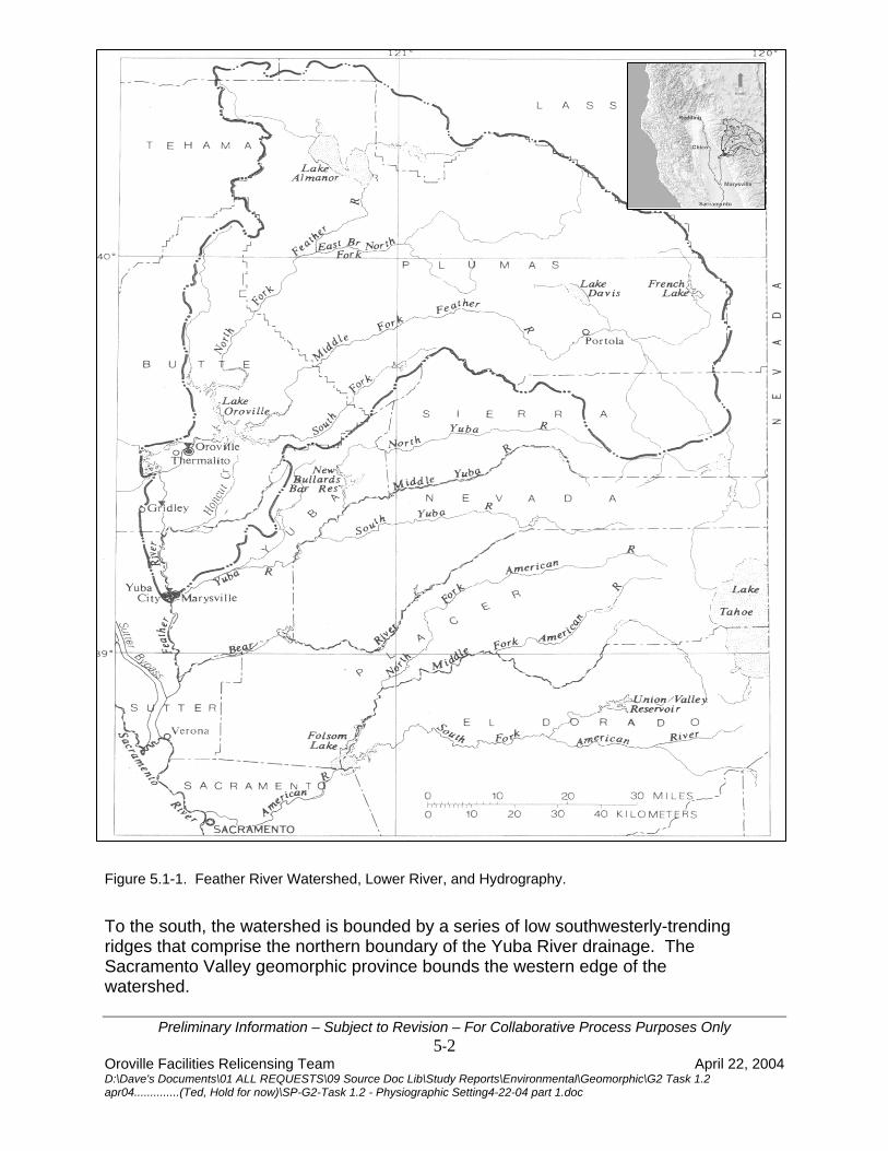
The Feather River watershed physiography and ecology are complex and sensitive to human activities. Elevation, slope and aspect, geology, soils, hydrology, climate, fire history, vegetation, and land use all vary and interact in complex relationships. 5.1 WATERSHED CHARACTERISTICS The Feather River watershed is situated in the Sacramento River Basin along the western slope of the Sierra Nevada Mountains (Figure 5.1-1). It includes large parts of Butte, Plumas and Sierra Counties and smaller portions of Lassen, Shasta, and Yuba Counties. It encompasses a total area of about 3,611 square miles. The upper part of the watershed is trisected by three roughly parallel ridges that trend from northwest to south-east. The resultant intervening high mountain valleys, the Sierra, American, Indian, and Mohawk, contain streams of low to moderate slopes. The Middle Fork Feather River originates along the crest of the Sierra Nevada and flows northwesterly and the North Fork originates near Mt. Lassen in the Cascade Range. The North, West Branch of the North Fork, Middle, and South Forks flow westerly through deep, rugged canyons. The four forks then meet in Lake Oroville, just above the Sacramento Valley floor. The North Fork and Middle Fork Feather Rivers comprise 3,222 square miles and the smaller South Fork and West Branch comprise the additional square 389 miles. The watershed above Lake Oroville is bounded on the northwest and north by volcanic ridges and mountains, including Mt. Lassen, which constitute the southern portion of the Cascade Range geomorphic province. It is bounded on the east and north-east by prominent, east-facing fault scarps including the Honey Lake escarpment, of the Basin and Range geomorphic province. This roughly corresponds to the northern and eastern boundary of the Sierra Nevada geomorphic province.
Preliminary Information – Subject to Revision – For Collaborative Process Purposes Only 5-1
Oroville Facilities Relicensing Team April 22, 2004 D:\Dave's Documents\01 ALL REQUESTS\09 Source Doc Lib\Study Reports\Environmental\Geomorphic\G2 Task 1.2 apr04..............(Ted, Hold for now)\SP-G2-Task 1.2 - Physiographic Setting4-22-04 part 1.doc
DRAFT SP-G2 TASK 1.2: PHYSIOGRAPHIC SETTING AND MESOHABITAT Oroville Facilities P-2100 Relicensing
Figure 5.1-1. Feather River Watershed, Lower River, and Hydrography.
To the south, the watershed is bounded by a series of low southwesterly-trending ridges that comprise the northern boundary of the Yuba River drainage. The Sacramento Valley geomorphic province bounds the western edge of the watershed.
Preliminary Information – Subject to Revision – For Collaborative Process Purposes Only 5-2
Oroville Facilities Relicensing Team April 22, 2004 D:\Dave's Documents\01 ALL REQUESTS\09 Source Doc Lib\Study Reports\Environmental\Geomorphic\G2 Task 1.2 apr04..............(Ted, Hold for now)\SP-G2-Task 1.2 - Physiographic Setting4-22-04 part 1.doc

DRAFT SP-G2 TASK 1.2: PHYSIOGRAPHIC SETTING AND MESOHABITAT Oroville Facilities P-2100 Relicensing
Table 5.1-1 shows selected physiographic data for the Feather River.
Table 5.1-1. Selected Physiographic Data for the Feather River
Intervening Reach
Location Drainage
Area 1 (miles)
Elevation above
Mean Sea Level
(ft) Change in Altitude(ft)
Length (1,000 ft)
Slope (ft/ft)
Distance Upstream from Yuba City Gage (1,000 ft)
North Fork@ Pulga 1,953 --- --- --- --- ---
Middle Fork nr. Merrimac 1,062 --- --- --- --- ---
South Fork @ Enterprise 132 --- --- --- --- ---
West Branch nr. Paradise 113 --- --- --- --- ---
Confluence Middle Fork and South Fork Feather
Rivers --- 330 --- --- --- 288
Confluence North Fork Feather and Feather
Rivers --- 230 100 15 0.0067 273
Oroville Dam 3,607 210 20 13.5 0.0015 259.5
Feather River at Oroville Gage 3,624 135 75 29 0.0026 230.5
Feather River nr Gridley Gage 3,676 80 55 113 0.0004
9 117.5
Feather River at Yuba City Gage 3,974 35 45 117.5 0.0003
8 0
1 609 square miles of the basin upstream from the Feather River at Oroville are assumed to be noncontributing
Stream length from the headwaters to Oroville Dam is approximately 135 miles along the North Fork and 120 miles along the Middle Fork Feather River (Figure 5.1-2). The complex topography governs stream morphology. Stream gradients are moderate in the upper portions of the watershed where streams cross montane meadows and valleys. Gradients increase as streams flow through deep, rugged canyons.
Preliminary Information – Subject to Revision – For Collaborative Process Purposes Only
5-3 Oroville Facilities Relicensing Team April 22, 2004 D:\Dave's Documents\01 ALL REQUESTS\09 Source Doc Lib\Study Reports\Environmental\Geomorphic\G2 Task 1.2 apr04..............(Ted, Hold for now)\SP-G2-Task 1.2 - Physiographic Setting4-22-04 part 1.doc

DRAFT SP-G2 TASK 1.2: PHYSIOGRAPHIC SETTING AND MESOHABITAT Oroville Facilities P-2100 Relicensing
North Fork Feather River watershed has an area of 2,006 square miles and the Middle Fork 1,216 square miles. The channel morphologies are different and will be discussed separately.
DISTANCE UPSTREAM FROM FEATHER RIVER AT YUBA CITY, IN THOUSANDS OF FEET
ELEV
ATI
ON
, IN
FEE
T A
BO
VE M
EAN
SEA
LEV
EL
8000
7000
6000
5000
4000
3000
2000
1000
0
0 840800700600500400300200100
HO
NC
UT
CR
EEK
GA
GE-
FEA
THER
RIV
ER N
EAR
GR
IDLE
Y
GA
GE-
FEA
THER
RIV
ER A
T O
RO
VILL
E
OR
OVI
LLE
DA
MC
ON
FLU
ENC
E W
ITH
N.F
. FEA
THER
RIV
ERC
ON
FLU
ENC
E, M
.F. A
ND
S.F
. FEA
THER
RIV
ERS
CIT
Y O
F PO
RTO
LA
(N.F.)NORTH FORK
(M.F.)MIDDLE FORK
NORTH FORK
MIDDLE FORK
LAK
E A
LMA
NO
R
(S.F.)SOUTH FORK
Figure 5.1-2. Profiles of Feather River and Principal Tributaries Upstream from Yuba City.
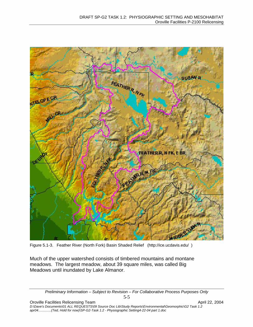
5.1.1 North Fork Feather River The North Fork Feather River watershed elevations range from 10,000 feet on the southeast slope of Mt. Lassen, and drop to a minimum elevation of 900 feet at Lake Oroville. It is the largest tributary, draining 2,090 square miles. The shape is roughly triangular, oriented in the east-west direction, with a point of the triangle meeting the confluence of the Middle Fork in Lake Oroville (Figure 5.1-3). The basin's maximum length and width are 65 and 75 miles respectively. The East Branch of the North Fork is a major tributary. It drains high elevation valleys and joins with the North Fork near Belden on Highway 70.
Preliminary Information – Subject to Revision – For Collaborative Process Purposes Only 5-4
Oroville Facilities Relicensing Team April 22, 2004 D:\Dave's Documents\01 ALL REQUESTS\09 Source Doc Lib\Study Reports\Environmental\Geomorphic\G2 Task 1.2 apr04..............(Ted, Hold for now)\SP-G2-Task 1.2 - Physiographic Setting4-22-04 part 1.doc
DRAFT SP-G2 TASK 1.2: PHYSIOGRAPHIC SETTING AND MESOHABITAT Oroville Facilities P-2100 Relicensing
Figure 5.1-3. Feather River (North Fork) Basin Shaded Relief (http://ice.ucdavis.edu/ )
Much of the upper watershed consists of timbered mountains and montane
as called Big eadows until inundated by Lake Almanor.
meadows. The largest meadow, about 39 square miles, wM
Preliminary Information – Subject to Revision – For Collaborative Process Purposes Only 5-5
Oroville Facilities Relicensing Team April 22, 2004 D:\Dave's Documents\01 ALL REQUESTS\09 Source Doc Lib\Study Reports\Environmental\Geomorphic\G2 Task 1.2 apr04..............(Ted, Hold for now)\SP-G2-Task 1.2 - Physiographic Setting4-22-04 part 1.doc

DRAFT SP-G2 TASK 1.2: PHYSIOGRAPHIC SETTING AND MESOHABITAT Oroville Facilities P-2100 Relicensing
The main channel between Lake Almanor and Lake Oroville flows through steep canyons as shown on the North Fork stream profile in Figure 5.1-4. The elevation drop of nearly 4,000 feet is fairly evenly distributed over the 65-mile distance. The form, slope, and behavior of this mostly bedrock channel are etermined more by its geology than the quantity of water and sediment which it
e
dconveys (DWR 1988). The channel has a pool-riffle configuration. Four dams have been built in this reach for hydroelectric production. The highprecipitation, large impoundment capabilities, and the steep canyon below LakAlmanor are reasons for the extensive hydroelectric development.
Figure 5.1-4. North Fork Feather River Stream Profile (DWR 1994).
5.1.1.1 East Branch - North Fork Feather River The East Branch of the North Fork (1,031 square miles) is a major tributary and drains the eastern part of the watershed, from the Honey Lake Escarpment to
Preliminary Information – Subject to Revision – For Collaborative Process Purposes Only
its onfluence with the North Fork Feather River near Belden. DWR's Antelope ake is on Indian Creek, one of the East Branch tributaries.
he East Branch is a major contributor of sediment, mainly because of i ferences in geology and soils, and extensive timber harvesting and grazing
(PGE 1986; SCS 1989 both in DWR 1994). These sediments accumulate in pools, on point bars, and behind dams. Reservoirs such as Rock Creek and Cresta on the North Fork trap most of the gravel-size and some of the sand- and
cL Td f
5-6 Oroville Facilities Relicensing Team April 22, 2004 D:\Dave's Documents\01 ALL REQUESTS\09 Source Doc Lib\Study Reports\Environmental\Geomorphic\G2 Task 1.2 apr04..............(Ted, Hold for now)\SP-G2-Task 1.2 - Physiographic Setting4-22-04 part 1.doc

DRAFT SP-G2 TASK 1.2: PHYSIOGRAPHIC SETTING AND MESOHABITAT Oroville Facilities P-2100 Relicensing
silt-size sediment. According to a PG&E survey (1992), in a 34 year period, 4.4 illion cubic yards of sediment were deposited behind Rock Creek Dam. This
ear Paradise. Miocene Dam, a small diversion dam for the Miocene Canal, is e the gage. There are about 25 river miles and an unknown
amount of watershed area between Miocene Dam and the confluence with the North Fork. The West Branch has some hydro-electric development including Philbrook Reservoir in the upper reaches with some water diversions into Butte Creek. 5.1.2 Middle Fork Feather River
mrate of deposition averages approximately 130,000 cubic yards per year. Typical of dammed rivers, stream channels below the reservoirs have experienced depletion of gravel and sand size material and become armored by cobbles and boulders at certain locations. 5.1.1.2 West Branch – North Fork Feather River
he West Branch is a small watershed of about 113 square miles at the gage Tnabout two miles abov
The Middle Fork basin is roughly crescent-shaped. It is elongated along an east-west axis with its maximum length and width approximately 75 and 35 miles respectively (Figure 5.1-5). Sierra Valley, in the eastern portion of the watershed, is the largest basin (203 square miles). Its shape is roughly circular, with smooth relief crossed by many weakly entrenched, meandering, and braided streams. It is mostly developed for agriculture. The main crop is alfalfa, but the valley is also used for dry land farming, grazing, irrigated crops, and pasture.
Preliminary Information – Subject to Revision – For Collaborative Process Purposes Only 5-7
Oroville Facilities Relicensing Team April 22, 2004 D:\Dave's Documents\01 ALL REQUESTS\09 Source Doc Lib\Study Reports\Environmental\Geomorphic\G2 Task 1.2 apr04..............(Ted, Hold for now)\SP-G2-Task 1.2 - Physiographic Setting4-22-04 part 1.doc

DRAFT SP-G2 TASK 1.2: PHYSIOGRAPHIC SETTING AND MESOHABITAT Oroville Facilities P-2100 Relicensing
Figure 5.1-5. Middle Fork Feather River Basin Shaded Relief (http://ice.ucdavis.edu/ )
The Middle Fork is about 108 miles long from its headwaters to Lake Oroville, as shown in Figure 5.1-6. The maximum elevation in the Middle Fork watershed is approximately 7,500 feet in the mountains bordering Sierra Valley, dropping minimum elevation of 900 feet at Lake Oroville. Channel gradient is low to moderate in the upper basin. Gradient increases dramatically in the lower reaches as the river flows through rugged, steep canyons. The Middle Fork
to a
became part of the National Wild and Scenic Rivers System in October 1968.
Preliminary Information – Subject to Revision – For Collaborative Process Purposes Only 5-8
Oroville Facilities Relicensing Team April 22, 2004 D:\Dave's Documents\01 ALL REQUESTS\09 Source Doc Lib\Study Reports\Environmental\Geomorphic\G2 Task 1.2 apr04..............(Ted, Hold for now)\SP-G2-Task 1.2 - Physiographic Setting4-22-04 part 1.doc

DRAFT SP-G2 TASK 1.2: PHYSIOGRAPHIC SETTING AND MESOHABITAT Oroville Facilities P-2100 Relicensing
Figure 5.1-6. Middle Fork Feather River Stream Profiles (DWR 1994).
Unlike the North Fork, the Middle Fork has no system of hydroelectric projects upstream of Lake Oroville. Frenchman Lake and Lake Davis are the only reservoirs and were constructed on tributaries as part of the State Water Prin the 1960s. Lake Davis was built to provide public recreation, enhance downstream fisheries and supply water for the city of Portola. Frenchman Reservoir provides public recreation and irrigation water for Sierra Valley. Downstream from the community of Sloat, the Middle Fork becomes a wild rives it flows approximately 45 miles through the Middle Fork Canyon
Preliminary Information – Subject to Revision – For Collaborative Process Purposes Only
oject
r . In places,
e sides of the gorge rise one-half mile straight up from the gravel banks of the ver. An average stream gradient of 62 feet per mile through this section has reated numerous pools and riffles. The Middle Fork Feather River provides
excellent habitat and is considered one of the best wild trout fisheries in California. Little data has been compiled on erosion and sedimentation. Most erosion investigations have been conducted on the East Branch of the North Fork. With the lack of hydroelectric development, little incentive exists to gather information on flows, erosion or sedimentation. Streamflow data collection was discontinued at all United States Geological Survey (USGS) gaging stations by 1986.
athric
5-9 Oroville Facilities Relicensing Team April 22, 2004 D:\Dave's Documents\01 ALL REQUESTS\09 Source Doc Lib\Study Reports\Environmental\Geomorphic\G2 Task 1.2 apr04..............(Ted, Hold for now)\SP-G2-Task 1.2 - Physiographic Setting4-22-04 part 1.doc

DRAFT SP-G2 TASK 1.2: PHYSIOGRAPHIC SETTING AND MESOHABITAT Oroville Facilities P-2100 Relicensing
Conclusions about erosion and sedimentation in the Middle Fork Feather River watershed must be based on the minimal information available and comparisons to similar situations on the North Fork. The Middle Fork watershed shares many characteristics with the North Fork including land use practices, precipitation patterns, vegetation, topography, and geology. Because of these similarities, watershed erosion and sediment transport rates are probably similar to those occurring in the North Fork watershed. Unlike the North Fork with numerous dams, diversions and power plants, most sediment from the Middle Fork is not trapped by dams until arriving at Lake Oroville. 5.1.3 South Fork Feather River The South Fork Feather River enters the Middle Fork in Lake Oroville. The watershed area is 132 square miles at the Enterprise gage, 11 miles east of Oroville. The South Fork skirts the southwest portion of the Middle Fork Feather River watershed and mostly drains the lower foothills of the Sierra Nevada. The South Fork has been developed for hydroelectric and water supply needs by the Oroville-Wyandot Irrigation District (now the South Fork Feather Water and Power). Dams and reservoirs include Ponderosa Dam at the high water mark of Lake Oroville, Lost Creek Reservoir, Sly Creek Reservoir and Little Grass Valley Reservoir. The South Fork watershed does not cross the crest of the Sierra.
Preliminary Information – Subject to Revision – For Collaborative Process Purposes Only 5-10
Oroville Facilities Relicensing Team April 22, 2004 D:\Dave's Documents\01 ALL REQUESTS\09 Source Doc Lib\Study Reports\Environmental\Geomorphic\G2 Task 1.2 apr04..............(Ted, Hold for now)\SP-G2-Task 1.2 - Physiographic Setting4-22-04 part 1.doc

DRAFT SP-G2 TASK 1.2: PHYSIOGRAPHIC SETTING AND MESOHABITAT Oroville Facilities P-2100 Relicensing
Preliminary Information – Subject to Revision – For Collaborative Process Purposes Only
6800'
6000'
5000'
4000'
vatio
n (f/
t)
3000'
2000'
1000'
0 mi. 5.00 mi. 10.00 mi. 15.00 mi. 20.00 mi. 25.00 mi. 30.00 mi. 35.00 mi. 40.00 mi. 45.00 mi.
Ele
Little Grass Valley Reservoir
Rock Creek
Know-Nothing Creek
Bear Creek
South Fork Diversion DamLost Creek
Oroleve Creek
Forbestown Diversion Dam
Distance (mi)
Post Creek
Feather River South Fork
Physiographic ProfilesFeather River South Fork
&Tributaries
Oroville Reservoir
Figure 5.1-7. South Fork Feather River Stream Profile.
5.2 TOPOGRAPHY The Feather River watershed is complex, with numerous geologic formations, deeply incised canyons, broad alluvial valleys, many volcanic features, and steepforested slopes. The west-flowing upper Feather River system is unique because it is the only river which crosses the crest of the Sierra Nevada. The watershed above Lake Oroville can be divided into a western and eastern
pographic area. This designation is used frequently by Plumas National Forest
toand refers to areas west and east of the Sierra Nevada crest. The two areasdiffer in topography, climate, vegetative communities, and forest productivity. The western topographic area comprises the western slope of the Sierra Nevada, bounded on the west by the Sacramento Valley and on the east by the Sierran crest. The western slope averages about 50 miles wide, east to west, and consists of mountainous terrain incised by south-west trending, steep-slopedcanyons with depths exceeding 3,000 feet. Narrow plateaus are located
5-11 Oroville Facilities Relicensing Team April 22, 2004 D:\Dave's Documents\01 ALL REQUESTS\09 Source Doc Lib\Study Reports\Environmental\Geomorphic\G2 Task 1.2 apr04..............(Ted, Hold for now)\SP-G2-Task 1.2 - Physiographic Setting4-22-04 part 1.doc

DRAFT SP-G2 TASK 1.2: PHYSIOGRAPHIC SETTING AND MESOHABITAT Oroville Facilities P-2100 Relicensing
between the canyons and are productive timber land. The western slope rises n a 4 degree inclination from the Sacramento Valley to the crest. Maximum
. lel features are similar to those of the adjoining Basin and Range
eomorphic province. Valley bottoms are typically open with broad meadows
e der.
nters the Sacramento Valley. Here the stream gradient is less and the
or
oelevations along the crest range from about 7,000 to 7,500 feet. The eastern topographic area is bounded by the Sierran crest on the west and the Honey Lake escarpment on the east. It is characterized by northwest-trending, fault-bounded mountains separated by down-thrown alluvial valleysThese paralgand grass land used for livestock grazing and agriculture. Under naturalconditions, streams in these valleys maintain gentle gradients because they havshallow banks, considerable riparian vegetation and a tendency to meanElevations range in this zone from 2,100 to 7,700 feet. Below Lake Oroville, the Feather River emerges from the Sierra Nevada and etopography is mostly flat, with the exception of overflow channels, multiple channel areas, and both artificial and natural levees occurring along the river course. Honcut Creek, the Yuba River, and the Bear River join the Feather before entering the Sacramento River at Verona. Elevation of the valley flovaries from about 150 feet at Oroville to about 25 feet at Verona.
Preliminary Information – Subject to Revision – For Collaborative Process Purposes Only 5-12
Oroville Facilities Relicensing Team April 22, 2004 D:\Dave's Documents\01 ALL REQUESTS\09 Source Doc Lib\Study Reports\Environmental\Geomorphic\G2 Task 1.2 apr04..............(Ted, Hold for now)\SP-G2-Task 1.2 - Physiographic Setting4-22-04 part 1.doc
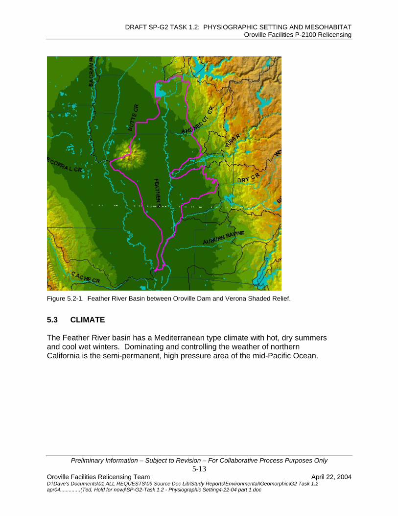
DRAFT SP-G2 TASK 1.2: PHYSIOGRAPHIC SETTING AND MESOHABITAT Oroville Facilities P-2100 Relicensing
Figure 5.2-1. Feather River Basin between Oroville Dam and Verona Shaded Relief.
5.3 CLIMATE The Feather River basin has a Mediterranean type climate with hot, dry summers and cool wet winters. Dominating and controlling the weather of northern California is the semi-permanent, high pressure area of the mid-Pacific Ocean.
Preliminary Information – Subject to Revision – For Collaborative Process Purposes Only 5-13
Oroville Facilities Relicensing Team April 22, 2004 D:\Dave's Documents\01 ALL REQUESTS\09 Source Doc Lib\Study Reports\Environmental\Geomorphic\G2 Task 1.2 apr04..............(Ted, Hold for now)\SP-G2-Task 1.2 - Physiographic Setting4-22-04 part 1.doc

DRAFT SP-G2 TASK 1.2: PHYSIOGRAPHIC SETTING AND MESOHABITAT Oroville Facilities P-2100 Relicensing
Figure 5.3-1. Isohyetal Map of Feather River Watershed.
ll to
This pressure center moves northward in summer, pushing storm tracks wethe north. In winter, it generally moves south, allowing storms to cross California.Frontal cyclonic storms generally occur from November through March. Rainfall in the watershed is shown on the isohyetal map (Figure 5.3-1).
Preliminary Information – Subject to Revision – For Collaborative Process Purposes Only 5-14
Oroville Facilities Relicensing Team April 22, 2004 D:\Dave's Documents\01 ALL REQUESTS\09 Source Doc Lib\Study Reports\Environmental\Geomorphic\G2 Task 1.2 apr04..............(Ted, Hold for now)\SP-G2-Task 1.2 - Physiographic Setting4-22-04 part 1.doc

DRAFT SP-G2 TASK 1.2: PHYSIOGRAPHIC SETTING AND MESOHABITAT Oroville Facilities P-2100 Relicensing
Rainfall within the watershed varies greatly because of topography and rain-shadow effects. The western part of the watershed intercepts winter moisture-laden air from the Pacific Ocean. Orographic effects result in an average increase of two to six inches for each 300-foot rise in elevation. Precipitation ranges from about 30 inches at Oroville, 50 inches at Lake Oroville, to 90 inches
the high mountains in the upper end of the North Fork Feather River.
GETATION
n, temperature and precipitation nd also varies according to slope, aspect, soils, fire history and land use
taining Jeffrey pine, ponderosa pine, Douglas fir, incense cedar, white r, red fir, and sugar pine grow at higher elevations. Elevation provides a general
ur over
e ransition life zone, and
anadian life zone. These are repeated on the eastern slope of the Sierras. The cies
n
is in the Great Valley iparian Forest environmental setting. The predominant forest type on the high
floodplain is the Great Valley Oak Riparian Forest, surviving in small patches alley oak.
,
in Rain-shadow effects limit precipitation within the southeastern part of the watershed. This is drained by the Middle Fork Feather River. Annual precipitation varies from 15 to 40 and averages about 30 inches within the shadow area. About 50 percent of the precipitation occurs as snow, providing streamflow by snowmelt runoff during the months of April, May, and June. 5.4 VE Vegetation is generally dependent on elevatioapractices. Chaparral plants such as ceanothus, manzanita, chamise, oak species, and blackjack pine grow at elevations below 2,000 feet. Mixed conifer forests conficontrol of vegetation type but some plants such as manzanita and oak occa wide range. Four roughly parallel vegetation areas, called "life zones", occur from the Sacramento Valley to the Sierran crest. From west to east, these zones are thGreat Valley Riparian Forest, Upper Sonoran life zone, TClife zone classification is a generalized vegetation guide. Overlapping of speis common, depending on local conditions of elevation, moisture, and soil. For example, variation exists between vegetation on west-, north-, south-, and east-facing slopes because of the differences in topography, soils and moisture. Plantcommunities are often affected by past or present land use, particularly whecertain species predominate in areas that have been burned or disturbed. The lower Feather River between Verona and OrovilleR
between agricultural developments. The dominant tree species is the vonwood riparian forests occur on lower, Great Valley Mixed and Great Valley Cott
more recent river meander deposits. Dominant tree species include Freemont cottonwood, sycamore, box elder, and black walnut. Point bar deposits and lower stream banks are the home of the Great Valley Riparian Scrub communitydominated by the narrow leaf willow series.
Preliminary Information – Subject to Revision – For Collaborative Process Purposes Only 5-15
Oroville Facilities Relicensing Team April 22, 2004 D:\Dave's Documents\01 ALL REQUESTS\09 Source Doc Lib\Study Reports\Environmental\Geomorphic\G2 Task 1.2 apr04..............(Ted, Hold for now)\SP-G2-Task 1.2 - Physiographic Setting4-22-04 part 1.doc

DRAFT SP-G2 TASK 1.2: PHYSIOGRAPHIC SETTING AND MESOHABITAT Oroville Facilities P-2100 Relicensing
The Upper Sonoran life zone begins in the foothills above the valley floor. ThUpper Sonoran life zone is also called foothill woodland. The primary componentof this community is the blue oak, with buckeye, blackjack pine, valley oak andinterior live oak also characteristic of this zone. Thi
e
s plant community dominates
e western foothills and ridges between approximate elevations of 300 and
fir, ak.
an life zone occupies higher elevations, generally above 5,500 feet. his plant community is dominated by red fir and lodgepole pine but contains
te
ation type but some plants such as anzanita and oak occur over a wide range.
soil ion, including montane meadow, riparian zone, and
agebrush steppe.
. ildlife and pasture for livestock.
haracteristic vegetation is dense growth of sedges and other perennial herbs.
es cottonwood, alder, aspen, and illow. Riparian zones are important for wildlife habitat, erosion control, flood
th1,200 feet. The Transition life zone is a broad transitional area between the foothill communities and the mixed conifers of the higher elevations. It dominates the elevations between 1,200 and 5,500 feet and contains a large variety of characteristic trees and shrubs. These include big leaf maple, canyon oak, black oak, interior live oak, madrone, ponderosa pine, sugar pine, white fir, Douglasincense cedar, snow brush, deer brush, buck brush, manzanita, and poison o The CanadiTseveral other characteristic trees and shrubs including white fir, western whipine, sugar pine, western hemlock, plants such as ceonothus, manzanita, chamise, oak species, and blackjack pine grow at elevations below 2,000 feet. Mixed conifer forests containing Jeffrey pine, ponderosa pine, Douglas fir, incense cedar, white fir, red fir, and sugar pine grow at higher elevations. Elevation provides a general control of vegetm Other plant communities exist in the watershed, which are more a function of and moisture than of elevats Montane meadows exist in the alluvial valleys along major and minor tributary streams. These relatively flat meadow areas are floodplains, or "stringer" meadows, which are narrow strips along riparian areas, near seeps or springsMeadows provide food and cover for wCVegetative composition varies depending on the amount of moisture available. Soils are characterized by sandy loam and loamy sand, with a weak, fine granular structure. Without plant roots to hold them together, these soils are easily eroded (USFS 1989, in DWR 1994). The riparian zone includes aquatic ecosystems and distinctive vegetative communities that require a shallow ground water table. Periodic flooding and a generally higher level of moisture promote growth of plants not found elsewhere in the forest. Representative vegetation includw
Preliminary Information – Subject to Revision – For Collaborative Process Purposes Only 5-16
Oroville Facilities Relicensing Team April 22, 2004 D:\Dave's Documents\01 ALL REQUESTS\09 Source Doc Lib\Study Reports\Environmental\Geomorphic\G2 Task 1.2 apr04..............(Ted, Hold for now)\SP-G2-Task 1.2 - Physiographic Setting4-22-04 part 1.doc

DRAFT SP-G2 TASK 1.2: PHYSIOGRAPHIC SETTING AND MESOHABITAT Oroville Facilities P-2100 Relicensing
control, ground water recharge, and water quality maintenance. The riparian one extends down from the upper watershed and continues downstream from
, y includes the stream banks and the
reas between the levees.
s species. Bunchgrass dominance varies with soil depth and istribution. This community is mainly in the eastern watershed below elevations
ide. The rocks and sedimentary deposits in the basin are part of the Great and
zLake Oroville to the mouth of the Feather. The riparian zone has been constricted over time by farming and land clearingresulting in a narrow zone that generally onla The sagebrush steppe community is dominated by sagebrush and perennial bunchgrasdof coniferous forests or at higher elevations. This community has been substantially degraded by grazing in the past 100 years. 5.5 GEOLOGY The lower Feather River is in the Sacramento Valley, the north half of the Great Valley of California. The Great Valley basin is a narrow, elongated, northwest trending depression that is approximately 450 miles long and 40 to 70 miles wValley geomorphic province. It is bordered by the Sierra Nevada to the eastthe California Coast Ranges provinces to the west. The geomorphic provinces are shown in Figure 5.5-1.
Preliminary Information – Subject to Revision – For Collaborative Process Purposes Only 5-17
Oroville Facilities Relicensing Team April 22, 2004 D:\Dave's Documents\01 ALL REQUESTS\09 Source Doc Lib\Study Reports\Environmental\Geomorphic\G2 Task 1.2 apr04..............(Ted, Hold for now)\SP-G2-Task 1.2 - Physiographic Setting4-22-04 part 1.doc
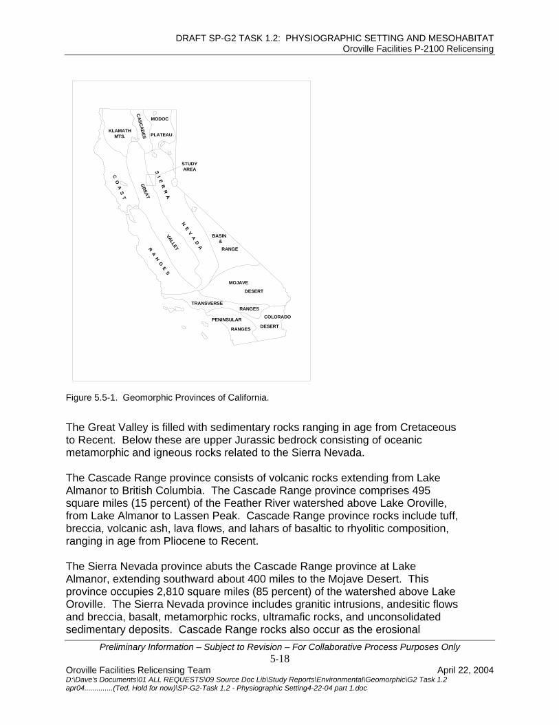
DRAFT SP-G2 TASK 1.2: PHYSIOGRAPHIC SETTING AND MESOHABITAT Oroville Facilities P-2100 Relicensing
Preliminary Information – Subject to Revision – For Collaborative Process Purposes Only
STUDY AREA
PENINSULAR
TRANSVERSERANGES
COLORADO
&BASIN
RANGE
DESERT
MOJAVE
R A N G E SVALLEY
N E V A D A
DESERT
ES PLATEAUMTS.
CASCA
D
MODOC
KLAMATH
C O A S T
GREAT
S I E R R A
RANGES
Figure 5.5-1. Geomorphic Provinces of California.
The Great Valley is filled with sedimentary rocks ranging in age from Cretaceous
Recent. Below these are upper Jurassic bedrock consisting of oceanic
lmanor to Lassen Peak. Cascade Range province rocks include tuff, reccia, volcanic ash, lava flows, and lahars of basaltic to rhyolitic composition,
ne to Recent.
Oroville. The Sierra Nevada province includes granitic intrusions, andesitic flows and breccia, basalt, metamorphic rocks, ultramafic rocks, and unconsolidated sedimentary deposits. Cascade Range rocks also occur as the erosional
tometamorphic and igneous rocks related to the Sierra Nevada. The Cascade Range province consists of volcanic rocks extending from LakeAlmanor to British Columbia. The Cascade Range province comprises 495 square miles (15 percent) of the Feather River watershed above Lake Oroville, from Lake Abranging in age from Plioce The Sierra Nevada province abuts the Cascade Range province at Lake Almanor, extending southward about 400 miles to the Mojave Desert. This province occupies 2,810 square miles (85 percent) of the watershed above Lake
5-18 Oroville Facilities Relicensing Team April 22, 2004 D:\Dave's Documents\01 ALL REQUESTS\09 Source Doc Lib\Study Reports\Environmental\Geomorphic\G2 Task 1.2 apr04..............(Ted, Hold for now)\SP-G2-Task 1.2 - Physiographic Setting4-22-04 part 1.doc

DRAFT SP-G2 TASK 1.2: PHYSIOGRAPHIC SETTING AND MESOHABITAT Oroville Facilities P-2100 Relicensing
remnants of a thick blanket of volcanic rocks that formerly covered much of the watershed. Uplift of the Sierra Nevada province, by various mechanisms started in the early Cenozoic and continues today. The current uplift mechanism, which stems from mantle-thinning, commenced approximately five million years ago in the Pliocene epoch. The geologic units of the area (Figure 5.5-2) may be grouped into the steeply dipping “bedrock series” and the younger, nearly flat-lying “superjacent series”. The two are separated by a profound angular unconformity. The metamorphism, steep dips, tight folds, and thrust faults of the bedrock series were formed during the Upper Jurassic Nevadan orogeny. This is believed to represent the collision and accretion of an island arc onto the North American plate. The bedrock series are in marked contrast to the low dips and lack of deformation in the superjacent series. 5.5.1 Geologic Units above Oroville Dam The Cenozoic, Mesozoic and Paleozoic rocks above Lake Oroville are a wide range of ultramafic, granitic, metamorphic, sedimentary, and alluvial rocks and deposits. Ultramafic rocks consist largely of serpentinite but also include peridotite, pyroxenite and talc schist. Serpentinite is a moderately soft, green alteration product of ultramafic igneous rock prominent in the central portion of the watershed. It is generally associated with fault zones. An almost continuous band about 3 miles wide crosses the watershed from northwest to southeast. These rocks are structurally weak and landslide-prone. Granitic Jurassic and Cretaceous rocks were molten magmas emplaced by stoping and shouldering aside overlying rock, forming roughly circular patterns, ranging from less than five miles to over twenty miles in diameter. In the western portion of the watershed, they are bounded by metamorphic rock; in the eastern portion they are partially covered by volcanic flows. Granitic rocks include granite, granodiorite, diorite, and gabbro. Highly weathered or decomposed granite is erodible and prone to landslides and occurs in the eastern watershed and along portions of the Middle Fork Feather River.
Preliminary Information – Subject to Revision – For Collaborative Process Purposes Only 5-19
Oroville Facilities Relicensing Team April 22, 2004 D:\Dave's Documents\01 ALL REQUESTS\09 Source Doc Lib\Study Reports\Environmental\Geomorphic\G2 Task 1.2 apr04..............(Ted, Hold for now)\SP-G2-Task 1.2 - Physiographic Setting4-22-04 part 1.doc

DRAFT SP-G2 TASK 1.2: PHYSIOGRAPHIC SETTING AND MESOHABITAT Oroville Facilities P-2100 Relicensing
Figure 5.5-2. Generalized Geologic Map of Feather River Watershed (DWR 1994).
The metamorphic rocks outcrop in the upstream part of the study area. These rocks are mostly metavolcanic breccias of Upper Jurassic age. They are believed to extend below the Sacramento Valley and form the basement of the overlying sedimentary sequence. Creely (1965) mapped the metavolcanic rocks as the Oregon City Formation, but they are equivalent to the Logtown Ridge Formation found to the south. The metasedimentary rocks were mapped as the Monte de Oro Formation, equivalent to the Mariposa Formation to the south. The rocks are typically hard and erosion resistant. Metamorphic rocks ranging in age from Ordovician to Cretaceous underlie a significant portion of the watershed. These are generally greenschist facies metamorphic rocks occurring along northwest trending belts or in contact areole surrounding intruding plutons. Argillite, slate, mica schist, greywacke, quartzite, and marble were derived from sedimentary rocks. Greenstone, amphibolite, talc schist, and chlorite schist were derived from igneous rocks, or sedimentary rocks derived from igneous rocks. These thin-bedded, foliated and steeply dipping rocks are extensively folded and faulted. Some of these rocks belong to the Smartville Ophiolite Complex, and are structurally weak and subject to landslides.
Preliminary Information – Subject to Revision – For Collaborative Process Purposes Only 5-20
Oroville Facilities Relicensing Team April 22, 2004 D:\Dave's Documents\01 ALL REQUESTS\09 Source Doc Lib\Study Reports\Environmental\Geomorphic\G2 Task 1.2 apr04..............(Ted, Hold for now)\SP-G2-Task 1.2 - Physiographic Setting4-22-04 part 1.doc

DRAFT SP-G2 TASK 1.2: PHYSIOGRAPHIC SETTING AND MESOHABITAT Oroville Facilities P-2100 Relicensing
Sedimentary deposits include Tertiary gold-bearing or "auriferous" gravels, glacial till, Quaternary alluvium, and landslide deposits. Tertiary auriferous gravels are stream deposits buried by volcanic activity such as flows and lahars during the Eocene and later. The auriferous gravels range from sand-size to boulder-size and contain placer gold. Where exposed by hydraulic mining, these deposits are erodible and landslide prone. Glacial till forms small moraines at the base of glacial cirques such as those on the slopes of Mt. Lassen. Glacial till deposits are also found in the southern portion of the watershed. Quaternary alluvium occurs along active stream channels, on floodplains and on valley floors. Most of the deposits occur in the broad, fault bounded valleys in the eastern portion of the watershed. The loose, unconsolidated sand, silt and gravel deposits can be highly erodible where it is exposed on steep slopes in gullies, headcuts, and streambanks. Landslides occur in a variety of rock types. Large landslides are common around Lake Oroville and along the North Fork Feather River, mostly in metamorphic rocks. Landslides also occur along the Middle Fork Feather. The combination of steep topography and steeply dipping, highly faulted, thin-bedded and weakly metamorphosed sediments in a seismically active area indicates a potential landslide risk. This potential risk ranges from minor rockfalls to destructive landslides. Evidence indicates a historic landslide temporarily blocked the North Fork of the Feather River (DWR 1979). Landslides in the vicinity of Lake Oroville are discussed in more detail in Section 7.2.1. 5.5.2 Geologic Structure above Oroville Dam Geologic structure in the North Fork, South, and Middle Fork Feather River watersheds contributes significantly to slope instability and erosion (DWR 1979). Historic seismicity within and adjoining the watershed is fairly low. Structures include faults, folds, bedding, and foliation. Two fault types offset rocks in the watershed: High-angle reverse faults in the Sierra Nevada province and normal faults in the Sierra Nevada and Cascade province. The dominant structure of the Sierra Nevada metamorphic belt is a series of north to northwest-trending, east-dipping reverse faults, called the foothills fault system. These faults were formed during accretion of oceanic, crustal, and
Cowan 1975). Seismicity on these faults has been reactivated in the late Cenozoic island-arc rocks in the late Jurassic Nevadan orogeny (Schweickert and
Preliminary Information – Subject to Revision – For Collaborative Process Purposes Only 5-21
Oroville Facilities Relicensing Team April 22, 2004 D:\Dave's Documents\01 ALL REQUESTS\09 Source Doc Lib\Study Reports\Environmental\Geomorphic\G2 Task 1.2 apr04..............(Ted, Hold for now)\SP-G2-Task 1.2 - Physiographic Setting4-22-04 part 1.doc

DRAFT SP-G2 TASK 1.2: PHYSIOGRAPHIC SETTING AND MESOHABITAT Oroville Facilities P-2100 Relicensing
(Wong 1992). Historic seismicity in the foothills fault system include a magnitu5.7 on August 1, 1975, southeast of Oroville; a magnitud
de e 4.6 on May 24, 1966,
ear Chico; and a magnitude 5.7 on February 8, 1940, 20 miles east of Chico.
the eastern portion of the watershed, the dominant structural feature is a
h y
olding is chiefly limited to metamorphic rocks within the Sierra Nevada province s and overturned relict beds. In general,
etamorphic rocks "... dip steeply eastward and form a stack of west-directed
y
by
rs as
ille Dam
n Inseries of roughly parallel normal faults, resulting from extensional tectonic forces.This structural regime is related to the adjacent Basin and Range province, whicadjoins the Honey Lake Escarpment on the east. Displacement along thesefaults has created a series of down-dropped broad alluvial valleys bounded bridges. Normal faulting is responsible for current seismicity in the eastern watershed area. The greatest magnitude historic seismic event in this area occurred on an unnamed fault near Portola at a magnitude 5.6 in 1959 (DWR 1994). Fwith predominant isoclinal foldmthrust sheets" (Hacker 1993 in DWR 1994). Folding originated during a succession of deformational events including the late Jurassic Nevadan orogen(Schweickert and Cowan 1975). Foliation occurs over large portions of the metamorphic rock terrain in the SierraNevada province. Foliation is the planar orientation of platy minerals, formedheating and tectonic compression of rocks. Foliation in these rocks appeaslaty cleavage, oriented southeast-northwest, roughly parallel to the Sierra Nevada crest. Foliation is most pronounced in metamorphosed rocks of sedimentary origin whereas foliation is less common in rocks of volcanic or plutonic origin. 5.5.3 Geologic Units below Orov
5.5-4, and 5.5-5).
between Oroville Dam and the Fish Hatchery. hese rocks are mostly metavolcanic breccias of Upper Jurassic age. They are
e s
Formation found to the south. The metasedimentary rocks were mapped as the
Deposits in the Sacramento Valley proper are only a small fraction of the overall watershed area. It mostly includes a narrow strip along the Feather River between Oroville and Verona. The deposits are older Tertiary sedimentary deposits, Quaternary terrace deposits, basin deposits, and more recent stream-derived channel and floodplain deposits (Figures 5.5-3, The metamorphic rocks outcropTbelieved to extend below the Sacramento Valley and form the basement of thoverlying sedimentary sequence. Creely (1965) mapped the metavolcanic rockas the Oregon City Formation, but they are equivalent to the Logtown Ridge
Preliminary Information – Subject to Revision – For Collaborative Process Purposes Only 5-22
Oroville Facilities Relicensing Team April 22, 2004 D:\Dave's Documents\01 ALL REQUESTS\09 Source Doc Lib\Study Reports\Environmental\Geomorphic\G2 Task 1.2 apr04..............(Ted, Hold for now)\SP-G2-Task 1.2 - Physiographic Setting4-22-04 part 1.doc

DRAFT SP-G2 TASK 1.2: PHYSIOGRAPHIC SETTING AND MESOHABITAT Oroville Facilities P-2100 Relicensing
Monte de Oro Formation, equivalent to the Mariposa Formation to the south. The rocks are typically hard and erosion resistant.
e superjacent series is the upper Cretaceous arine Chico Formation. The continental Eocene Ione, followed by the Miocene
sandstone, but with some shale and conglomerate, overlies the basement cks in places. The sandstone ranges in color from light green to yellowish
ils and lenticular beds of conglomerate. Outcrops ccur both north and south of the study area but none has been identified in the
e
The oldest sedimentary unit in thmLovejoy basalt, and the Pliocene Laguna Formation compose the older deposits in the area. Pleistocene deposits include the Turlock Lake, Red Bluff, Riverbank, and Modesto formations. Quaternary and Recent deposits include alluvium, stream channel deposits, basin deposits, and dredge tailings. 5.5.3.1 Chico Formation The upper Cretaceous Chico Formation consisting mostly of nearly flat-lying, marine robrown, commonly contains fossofield area. 5.5.3.2 Ione Formation The Eocene Ione Formation consists mostly of moderately indurated yellow-whitclaystone. Some interbedded siltstone, sandstone, and conglomerate occur in places. Where weathered, the Ione tends to be unstable and landslide prone.
Preliminary Information – Subject to Revision – For Collaborative Process Purposes Only 5-23
Oroville Facilities Relicensing Team April 22, 2004 D:\Dave's Documents\01 ALL REQUESTS\09 Source Doc Lib\Study Reports\Environmental\Geomorphic\G2 Task 1.2 apr04..............(Ted, Hold for now)\SP-G2-Task 1.2 - Physiographic Setting4-22-04 part 1.doc

DRAFT SP-G2 TASK 1.2: PHYSIOGRAPHIC SETTING AND MESOHABITAT Oroville Facilities P-2100 Relicensing
Figure 5.5-3. Lower Feather River Geologic Units, Fish Barrier Dam to Thermalito Afterbay.
Preliminary Information – Subject to Revision – For Collaborative Process Purposes Only 5-24
Oroville Facilities Relicensing Team April 22, 2004 D:\Dave's Documents\01 ALL REQUESTS\09 Source Doc Lib\Study Reports\Environmental\Geomorphic\G2 Task 1.2 apr04..............(Ted, Hold for now)\SP-G2-Task 1.2 - Physiographic Setting4-22-04 part 1.doc

DRAFT SP-G2 TASK 1.2: PHYSIOGRAPHIC SETTING AND MESOHABITAT Oroville Facilities P-2100 Relicensing
Figure 5.5-4. Geologic Units of the Lower Feather River, Thermalito Afterbay to Honcut Creek.
Preliminary Information – Subject to Revision – For Collaborative Process Purposes Only
5-25 Oroville Facilities Relicensing Team April 22, 2004 D:\Dave's Documents\01 ALL REQUESTS\09 Source Doc Lib\Study Reports\Environmental\Geomorphic\G2 Task 1.2 apr04..............(Ted, Hold for now)\SP-G2-Task 1.2 - Physiographic Setting4-22-04 part 1.doc

DRAFT SP-G2 TASK 1.2: PHYSIOGRAPHIC SETTING AND MESOHABITAT Oroville Facilities P-2100 Relicensing
Figure 5.5-5. Geologic Units of the Lower Feather River, Honcut Creek to Yuba City.
Preliminary Information – Subject to Revision – For Collaborative Process Purposes Only 5-26
Oroville Facilities Relicensing Team April 22, 2004 D:\Dave's Documents\01 ALL REQUESTS\09 Source Doc Lib\Study Reports\Environmental\Geomorphic\G2 Task 1.2 apr04..............(Ted, Hold for now)\SP-G2-Task 1.2 - Physiographic Setting4-22-04 part 1.doc