spatial analysis of political participation pattern in … analysis of political participation...
TRANSCRIPT

Geographical Urban Planning Research, Vol. 4, No. 3, Autumn 2016 1
Spatial analysis of political participation pattern in the fourth City
Council elections (2013), Amol
Amer Nikpour1
, Farzin Mahmoudi Pati 2, Mostafa Safaie Reyneh
3
1. Assistant Professor, Department of Geography and Urban Planning, University of Mazandaran,
Iran
2. Assistant Professor, Department of Urban Planning and Arts, University of Mazandaran, Iran
3. PhD Candidate in Geography and Urban Planning, Faculty of Geography, University of Tehran,
Iran
Received: 26 September 2015 Accepted: 26 November 2016
Extended abstract
Introduction
Contribution of people in election of councils is the sign of development in providing and
fulfilling the needs of residents of the cities. By the advent of democracy and development of
public right of vote, election has become one of the important display of political life in the
current world. It is one of the political development criteria and illustrates the role of people in
government. Election rules, their execution and the rate of people contribution in election
explain the relationship of government and people and also represent the social condition of that
community. There is a wide range of factors in terms of geographical and situational issues
overshadowing the type of election decisions. The current research, with the analysis of the
number and proportion of casted vote and displaying the effective areas from the political
contribution of citizens in the fourth city election (2003) can show the relationship between
various social-economical parameters and rate of contribution and also investigation on
conceptual analysis of the impact of neighboring areas on the election of city councils in
political culture of citizens.
Theoretical principle
Council is totally regarded as a democratic organization which undertakes the responsibilities to
discuss, investigate, and decide on the issues concerning daily life and public affairs. It can be
said that city council is a policy maker, decision maker and to some extent law maker in local
urban management. It must have comprehensive features and be able to do responsibilities
related to policy making and supervision in all the issues concerning urban affairs and
respective organizations. Election is a continuous measurement and process within particular
geographical area in a set limited time. Foundation and theme of geographical election is based
on the concepts such as democracy, political contribution, election, decision making, and
election field. The most geographical election impacts are related to election behavior and
election patterns. Political contribution has some consequences and impacts on executive
Corresponding Author: [email protected], Tel: +98 9111002343

Geographical Urban Planning Research, Vol. 4, No. 3, Autumn 2016 2
system because the consistency and efficiency in all political systems needs people’s approval
and knowing them as valid. It is possible to know election as the most prominent political
contribution that can be measured and can be considered as a criterion to evaluate power
distribution in society. Since elections are regarded as criteria to recognize viewpoints,
interpretations, bottlenecks and problems of society the distribution of election result on the
map displays the differences of spatial behavior.
Methodology
This research with the aim of practical and descriptive-analytical design was carried out to
analyze spatial pattern of the fourth city council election in Amol City. The needed information
was collected by studying documents and referring to offices of municipalities and statistics
center. The statistical society of this research is the polling station of Islamic Council of Amol.
The design of analysis and interpretation of the data is quantity- concerned and by space
analysis and statistics, the data are alayzed to see the effective impact of citizens’ contribution
in the election and also the significant factors in the election of the member of the city council in
the previous election of city council of Amol.
Findings
Election in the council of Amol city experienced many ups and downs in a way that the rate of
contribution had the downward trend from 74% in 1998 to 41% in 2015. The proportion of the
elected person in the whole votes is very low in a way that the greatest majority among the
whole candidates within all rounds is 36. In the following round, this rate was decreased and
displaying the phenomenon of “single vote” or voting based on individual recognition. The
pattern of vote distribution is dispersed and in the adjacent neighbors no consistency exists in
terms of space. Moran Space Criterion shows that only in district 21 the votes are consistent and
similar and in other districts there is no significant relationship between the votes. In addition,
the graph of Moran shows inconsistency of these criteria, because Moran Criterion is near to the
point of -0.7 to -1. Besides, the distribution of the space vote shows the majority of votes were
in eastern and western districts of Amol City. Despite the few polling stations in these districts,
the votes are more than central district with more polling stations. The literacy variance shows
that in the district with low literacy level the rate of distribution is higher and more educated
areas were not so willing to participate in the election. Identifying the address and polling
stations with higher votes indicated that in all issues there was a relationship between these two
variables and the greater majority vote for the selected persons was related to their residence.
Conclusion
The analysis of 4 round of election in Amol City shows that the rate of contribution in election
of the third round was 54% and this value was 62% for the fourth round. One of the particular
features of election of city council is the “impact of neighboring” on election behavior of the
voters that has a clear space in political map of city. In fact, in this condition the political culture
of some part of the city has the features in which we have the concept of general city identity,
party inclination, effective political contribution, and citizen orientation. The findings of the
research show that there is significant relationship between the economical situation and rate of
political contribution. Based on the findings, although the invalid votes are higher in educated
areas than less educated areas, the educated people have more contribution compared with the
illiterate people. On the other hand, as much as the educational level increases, the level of
contribution decreases. Consistency between the map of invalid vote of distribution with level
of literacy shows that educated people do not trust the map and instruction of the council in
advancing the city management system.
Keywords: Amol, city council election, political contribution, spatial pattern.
Geographical Urban Planning Research, Vol. 4, No. 3, Autumn 2016 3
References
1. Blaksel, M. (2010). Political geography. Translated by Hafeznia et al. Entekgab publications.
2. Dowived, R.L. (1990). Political Geography, Allahabad print at Shiva Mudranalaya.
3. Estes, T. (2006). Where the Votes Are: The Electoral Geography of the Coming Democratic Majority;
Oakland University, Vol 3. From: http://www.bepress.com.
4. Flint, C. (1998). The Political Geography of the Nazi Party’s Electoral Support: The NSDAP as
Regional Milieuparteien and National Sammlungsbewegung. The Arab World Geographer, Vol. 1, pp.
79-100
5. Glassner, M. (1993). The Political Geography, Pub: John Willy.
6. Goli, A.; Mahkouie, H. (2014). Participation spatial pattern in presidential election. Geopolitics
Journal, Tenth year, 2, pp. 189-213.
7. Hafeznia, M.; Ahmadpour, Z.; Ghaderihojjat, M. (2012). Plitic and space. Papoli publications. 1.
8. Hafeznia, M.; Kavianirad, M. (2004). New Perspectives in Political Geography. Samt Publications,
Tehran.
9. Haghighi, M.S. (1996). Election, Definition and Terms. Political office and Social Deputy of Interior
Ministry election office, khane publications.
10. Hakimian, A. (1989). Alavian of Tabarestan. Zarrinkoub publication, Tehran.
11. Horn, M. (1999). GIS and the geography of politics from Geographical Information System:
Principles, Techniques, Management and Application, Willy.
12. http://hezarsangar.blogfa.com.
13. Johnson, R. (1993). The Dictionary of Human Geography. Blackwell.
14. Kavianirad, M. (2007). The geography of elections. Journal of Strategic Studies, Tenth year, 3, 481-
505.
15. Kavianirad, M.; Veysi, H. (1999). Investigate Neighborhood Effects on Iran's Elections case study:
The first period of nintheen presidential election in Iran. International Journal of Geopolitics, forth
year, 3, pp. 10-20.
16. Latifi, GH, R. (2008). Urban Management. Institute of Culture, Information and Press.
17. Mazandaran Statistical Yearbook. (2011). Population and housing census. Statistics Center of Iran.
18. Muer, R. (2000). Political Geography: A new introduction. Translate by Mirheidar, D, Geographical
Armed Forces Organization Publications.
19. Muer, R. (1999). New introduction to political Geography. Translated by Mirheidar, D & Safavi, R,
Geographical Armed Forces Organization Publications. 1.
20. Naghibzadeh, A. (1994). The government in Europe. Samt Publications, Tehran, 12.
21. Norouzi, K. (1999). Introduction to the constitutional rights of Islamic Councils. Municipality’s
scientific, research, education, monthly magazine, first year, 1.
22. Pattie, Ch.; Johnston, R. (2007). Political issues, valence issues and the economic geography of voting
in British elections. Journal of Economic Geography Advanced, Access published online on October
9, from: http://joeg.oxfordjournals.org /content/abstract/ lbm032vl.
23. Rash, M. (1998). Socity and politc, Translate by Sabouri, M, Samt Publications, Tehran.
Geographical Urban Planning Research, Vol. 4, No. 3, Autumn 2016 4
24. Razeghi, S.; Souri, E. (2006). The role of councils in urban management with emphasis of past
council pathology. Municipality’s scientific, research, education, monthly magazine. Sixth year, 75,
pp. 18-29.
25. Saiednia, A. (2000). Urban management. Seris of municipality green book, Vol. 11, press of
municipality organization.
26. Salehi, H. (1999). The legal obligations of councils. Municipality’s scientific, research, education,
monthly magazine, second year, 7.
27. Saraie, A. (2006). People urban management sector. Municipality magnize, Sixth year, 75, pp. 5-9.
28. Seifoddini, F & Mansourian, H. (2011). Analyzing utilities concentration pattern and its
environmental impacts in Tehran city. Journal of Ecology, Thirty-seventh year, 6, pp. 53-64.
29. Shafiepour, S. (2000). Municipality Law. Majd pulication. 3.
30. Tavassoli, Gh. (2003). Social participation in terms of anomic society Social injuries and deviations
relation with social participation. University of Tehran Publications, 63.
31. Taylor, P. (1989). Political Geography, New Yourk: Longman.
32. Uhlaner, C.J. (2004). Participation: Political, International Encyclopedia of the Social & Behavioral
Sciences, pp 11078-11082.

Geographical Urban Planning Research, Vol. 4, No. 3, Autumn 2016 5
Assessment of the impacts of urban transportation policies on
improvement of the quality of public spaces in the central Tehran
(Case study: Bazar neighborhood)
Fatemeh Salarvandian 1
, Ahmad Pourahmad 2, Seyed Ali Hosseini
3
1. Ph.D. in Geography and Urban Planning, University of Tehran
2. Professor, Department of Geography and Urban Planning, University of Tehran, Iran
3. Ph.D. in Geography and Urban Planning, University of Tehran, Iran
Received: 3 March 2015 Accepted: 19 December 2016
Extended Abstract
Introduction
Use of automobiles is increasing as a travel mode in large cities especially in developing
countries. It increases the concerns over traffic jam, pollution, and the death of public spaces.
Dominance of car on public spaces, particularly in city centers, is associated with difficulty to
access to public spaces and makes these spaces available just for essential activities. While
nowadays, having the vital urban spaces with the social activities is considered as one of the
most important development criteria for cities. Moreover, making and developing public spaces
is becoming a competition element of the cities to get more earnings. In one hand, finding a
solution to revitalize the public spaces in small and large cities is undoubtedly a significant
challenge. On the other hand, it is worthwhile and positive and needs to set the priorities which
places are preceding the buildings and traffic. It caused the access of sustainable transportation
becomes one of the critical challenge for present and next generations. To solve the traffic
problem to regenerate public spaces, urban managers are turning to change the transportation
policies. Whole of the various traffic policies try to minimize the car usage in Travel Demand
Management. in the present time in Tehran, a large number of public spaces of city center is out
of public access due to the increased dominance of private cars. Public spaces in Tehran become
more faded and poorer, if this continues. Therefore, urban management is performing several
traffic policies in Tehran city center to reduce dependence on private cars.
Methodology
With the aim of exploring the impact of traffic policies on revitalizing public spaces, this study
wants to introduce the model of how traffic policies influence on improving quality of public
spaces in Tehran city center using mixed method. In this research, five aspects are considered
for Public space including social- cultural, infrastructure, environmental, and economic
dimensions. Then, the impact of two push policies (including car and parking restrictions), and
two pull policies (including the improvement of public transport facilities and pedestrianizing)
are identified on these aspects. Mix Research Method is used to explore the factors which affect
Corresponding Author: [email protected]
Geographical Urban Planning Research, Vol. 4, No. 3, Autumn 2016 6
the four dimensions of public spaces. As the influences of traffic policies on public spaces are
unrevealed, we used Exploring Research Method. Our method compromises three following
sections. Firstly, the characteristics of good and livable urban public space are identified
through literature reviews. Using qualitative research method, we studied reliable sources
including documents, reports and books. Then, four dimensions including social- cultural,
infrastructure, environmental, economic are ascertained for a good urban public space. In
section two, using Policy Delphi Technique and by semi-structured interviews, we asked 10
people who are expert in fields of transport management, urban geography, urban planning, and
urban management to introduce the features of livable urban public spaces which are almost
strongly influenced by transportation polices. Eventually, we found that there are no new ideas
after 16 interviews, meaning the subject reached to the theoretical saturation. After
accumulating the data, the primary research model is designed. In Section three, a questionnaire
is designed based on what we extracted from two previous sections. Up to 384 people in a
neighborhood in central Tehran titled “Bazare Tehran” have been selected to fill out the
questionnaires. Then, we employ Causal-comparative research method to determine the
influences of four transportation policies on improving urban public spaces. We choose to
analyze our data using a Friedman test. The Friedman test is the non-parametric alternative to
the one-way ANOVA with repeated measures. It is used to test differences between groups
when the dependent variable being measured is ordinal. Since we aim to compare these four
transportation policies in terms of their significant contributions to improving urban public
spaces, essentially the Friedman test is used. It can be used when you want to use the same
sample of subjects or cases and assess them at three or more points in time or under differing
conditions.
Results and Discussion The analysis states that environmental, social-cultural, and economic and infrastructure aspects
have been most influenced by traffic policies. Our findings show that the pedestrianization
policy has improved the economic indicators of public spaces, at 70.3 mean. The median value
for socio-cultural dimension is almost 68.86 and it is followed by the figures for environmental
and physical and infrastructure dimensions, respectively, at 66.66 and 61.75. The same goes for
the influence of parking restriction policy on the four dimensions. This shows 55.78 for
economic, 47.59 for socio-cultural, 46.29 for environmental and 42.65 for physical and
infrastructure dimensions.
Furthermore, car restriction policy has dramatically upgraded the mean values of
environmental, economic, socio-cultural and physical and infrastructure dimensions at 54.96,
50.42, 46.47, and 43.02, respectively. Results for the policy of developing public transport
demonstrate the highest mean value for economic aspect indicators at 69.85. The second highest
value is seen for criteria of physical and infrastructure aspect with 61.77 mean. They are
succeeded by figures for socio-cultural aspect at 61.59 and environmental dimensions at 59.71.
Generally speaking, these results indicate that two pull policies compromising
pedestrianization and developing public transport have more influence on improving quality and
revitalizing the public spaces compared with push policies, e.g., car and parking restriction
schemes. From the magnitudes of the mean value, we can rank the four transportation policies
in terms of their impact on regeneration of urban public spaces in Bazar neighborhood.
Developing pedestrianization has the largest ratio at 66.65, meaning it is the most influential
policy in reviving public spaces. The ratio for developing public transport policy is slightly
smaller at 63.23. Average value for push policies is significantly small rather than two pervious
policies. The policies with the smallest mean value is car restriction with 48.72 and parking
restriction with 40.08, respectively.
Conclusion
It seems wise to integrate push policies, e.g., car and parking restriction schemes, with intensive
policies, e.g., improvement of public transportation and development of infrastructure facilities

Geographical Urban Planning Research, Vol. 4, No. 3, Autumn 2016 7
for walking and biking to improve their impacts on quality of urban public spaces. It is also
cleared that people in public spaces are most influenced by the measures which give them more
alternatives to travel rather than the measures which limit their travel choices.
Keywords: central Tehran, public spaces, quality improvement, urban transportation policies.
References
1. Bodnar, J. (2015). Reclaiming public space, Journal of Urban Studies, Vol. 52, No. 12, pp. 2090-2104.
2. Broaddus, A.; Litman, T.; Menon, G. (2009). Transportation Demand Management, Training
Document, published by gtz (Transport Policy Advisory Services) on behalf of Federal Ministry for
Economic Cooperation and Development. Echborn, Germany.
3. Burke, J.; Anthony J.O. (2007). Mixed Methods Research: A Research Paradigm Whose Time Has
Come, Educational Researcher, Vol. 33, No. 7.
4. Carmona, M.; Heath, T.; Oc, T.; Tiesdell, S.T. (2003). Public places urban spaces: The dimensions
of urban design, Architectural press, London.
5. Creswell, J.W. (2003). Chapter 1, A Framework for Design, in Research Design: Qualitative,
Quantitative and Mixed Methods. Sage Publications.
6. Gomes, P.M.S. (2012). Factors of good public space use, Meubook.
7. ICT Organization of Tehran Municipality (2014). Geographic and Demographic Statistics of
Tehran’s Neighborhoods.
8. Jacobs, J. (1961). The Death and Life of Great American Cities, London: Jonathan Cape.
9. Kashanijou, Kh. (1390). Walking routes from the basics to design, functional features, second
edition, Azarakhsh press, Tehran.
10. Knoflacher, H. (1381). Verkehrskonzeption für Wien– Teil C: Radverkehr, translated by Fereidoun
Gharib, Tehran University Press, Tehran.
11. Knoflacher, H.; Kloss, H.P. (1980). Verkehrskonzeption für Wien- Teil C: Radverkehr; Magistrat
der Stadt Wien – Magistratsabteilung 18; Wien.
12. McFerran, K.S.; Saarikallio, S. (2014). Depending on music to feel better: Being conscious of
responsibility when appropriating the power of music, The Arts in Psychotherapy, Vol. 41, pp. 89-97.
13. Office of the Deputy Prime Minister (2004). The Building Act 1984 and the Building Regulations.
Published by ODPM, London.
14. Paumier, C. (1391). Creating a Vibrant City Center: Urban Design and Regeneration Principles,
Translated by Mostafa Behzadfar and Amir Shakibamanesh, University of Science and Industry
Press, Tehran.
15. http://www.pps.org.
16. Tehran Master Plan Region N0. 12 (2006). Deputy of Architecture and Urban Planning, Region 12,
pp. 1-54.
17. Tehran Transportation and Traffic Organization (1391). Tehran Comprehensive Transportation and
Traffic Studies, Chapter 1.
18. Tehran Transportation and Traffic Organization (1392). Selective statistics of Tehran Transportation
and Traffic.

Geographical Urban Planning Research, Vol. 4, No. 3, Autumn 2016 8
19. Tibbalds, F. (1385). Making people-friendly towns: improving the public environment in towns and
cities, translated by Hasanali Laghaee, Tehran University Press.Tehran.
20. Transportation Research Board Annual Report (2010). National Academy of Sciences, Engineering,
Institute of Medicine, National Research Council.

Geographical Urban Planning Research, Vol. 4, No. 3, Autumn 2016 9
The role of neighborhood-based planning for neighborhood
sustainable development
(Case study: Hosseinieh neighborhood in Zanjan City)
Alireza Mohammadi
1, Fariba Rafiee
2
1. Assistant Professor , Departmentof Geography and Urban Planning, Faculty of
Humanities, University of Mohagheghe Ardabili, Ardabil, Iran
2. M.A. in Geography and Urban Planning, Department of Geography and Urban
Planning, Faculty of Humanities, University of Mohagheghe Ardabili, Ardabil, Iran
Received: 20 February 2016 Accepted: 6 November 2016
Extended Abstract
Introduction
Zanjan is one of the historic cities of Iran with rapid urbanization. Now its old and historic
neighborhoods have been turned into the deteriorated textures. The problems of those
neighborhoods have not been solved through projects and programs in urban scale. Hence, this
is required to consider the issues in the neighborhood scale to solve them. One of the old
neighborhoods of Zanjan city is Hosseinieh neighborhood faced with many physical and socio-
economical problems. So far, the city plans have failed to help properly this area
revitalization.Hence, the problems need to be solved by the neighborhood and community
planning. Researchers such as Watts (2006), Dixon (2011), Colton (2012), Hajipour (2006), The
Salek (2007), Rafieapour (2009), Masoumi (2011), Madani (2012) and Rakhtabnak (2014) have
used the concept of neighborhood planning and community development in recent years. In this
study, we have tried to answer these questions: 1. what is the relationship between community
planning and community sustainable development? 2. What is the relationship between the local
community participation and sustainable neighborhoods? 3. What is the impact of local
planning initiatives and the participation of the local community on sustainable development in
the Hosseinieh neighborhood.
Methodology
The type of study is descriptive - analytical and conducted by the questionnaire survey among
neighborhood residents. The universal population of the study is 357 people calculated based on
the Cochran’s Sample size method. The reliability of the instrument has calculated the Cranach
alpha and value of 88.3 is obtained. In order to analyze the data, we used the several methods
such as Pearson's correlation and regression analysis in SPSS software for description and
analysis of the statistics.
Discussion
The findings of this study are consistent with the findings of Rahmati, Reza Zadeh and Sleseleh
(2008), with the necessity of neighborhood planning. The research findings are consistent with
Corresponding Author: [email protected]
Geographical Urban Planning Research, Vol. 4, No. 3, Autumn 2016 10
the results of the studies of Madani (2012), Abdullahi and Rkhtabnak (2014) in relation to
sustainable development, public service and community initiatives subject. The findings of this
study comply with the results of Masoud and Moazzezi (2012). The results of the study are also
consistent with the findings of Doiran (2008), Rafieian, and Forozandeh (2011) about the
willingness of people to participate. The results of this study with the results of Rafieapour and
Gavgani (2009), Forozandeh (2010) and Mousavi, Reza Al-Hashem (2010) in relation to the
participation cost, attitude and attitude toward the willingness to pay a city toll authorities and
citizen participation.
Conclusion The results of this research show that there is a positive correlation between the sustainable
development and the index of neighborhood planning. In addition, there is high positive
correlation between neighborhood sustainable development and resident’s participation.
Community planning is the first factor affects sustainable development of study neighborhood
and the participation of the local community is the second factor affecting in the issue.
Therefore, we have proposed improvement of resident satisfaction, neighborhood environment,
residents' awareness of the development projects, the establishment of the Social Development
Fund, establishment of neighborhood councils and mayor of the neighborhood, empowerment
of management system in neighborhood council, promotion of vertical relationships between
local management and staff levels, motivating residents to facilitate the empowerment of local
communities and to give more power to local groups, facilitation of the formation and activities
of local community groups and networks, strengthening institutions, non-governmental
organizations, organizing informal institutions and finally education of youth for participation in
community affairs.
Keywords: community participation, Hosseinieh neighborhood, neighborhood-based planning,
sustainable neighborhood development, Zanjan.
References
1. Abdollahi, A.; Rokhtabnak, Sh. (2014). Evaluation of factors affecting the stability of
neighborhoods in urban planning (case study: Shiraz Sang siah neighborhood). Vol. 5, No.. 17, pp.
103-122. [in Persian]
2. Aminnaseri, A. (2006). Neighborhood Planning. Jostarhaye shahrsazi journal, No. 19-20, pp. 118-
125. [in Persian]
3. Arefian, M. (2001).Toward an asset based approach in community development. Honarhaye Ziba
Journal, No. 27, pp. 35-46. [in Persian]
4. Arefiem, M. (2001). Toward the an asset based approach in community development. Honarhaye
Ziba Journal, No.10, pp. 22-33. [in Persian]
5. Azani, M.; Mokhtary, M.; Abadi, R.; Haji A.G.S. (2014). Investigating the Local Sustainable
Development Indicator (Case Study Isfahan Region 1). Journal of Barnamerizi fazaei, Vol. 2, No. 4,
pp. 129-152. [in Persian]
6. Azizi, M. (2006). Sustainable Residential Neighborhood. Case Study Narmak.
7. Barton, H. (2003). Shaping Neighborhoods, London and New York, Spon Press rapid urbanization:
Unregulated assets and transitional neighborhoods. Habitat International, 34, pp. 135-144.

Geographical Urban Planning Research, Vol. 4, No. 3, Autumn 2016 11
8. Bglari, Sh. (2010). Evaluation of urban management performance in neighborhood sustainability.
M.A. dissertation, Faculty of humanities. Tarbiat Modaress University. [in Persian]
9. Choguill, Ch.L. (2007). Developing Sustainable Neighborhoods, Habitat International, Vol. 27, No.
3.
10. Coulton, C. (2012). Defining Neighborhoods For Research And Policy, 231 Cityscape: A Journal of
Policy Development and Research, Vol. 14, No. 2, U.S.
11. Dadashzadeh, A. (2013). Evaluation of the neighborhood sustainable development. Case Study:
Neighborhood Amiriyeh, 11 th District 2 Region, Tehran. Master's thesis for Geography and Urban
Planning, School of Geographical Sciences, University of Khwarizmi. [in Persian]
12. Daviran, E. (2010). People oriented planning (participation) in micro scale urban (neighborhood)
Case Study: Zanjan Islamabad neighborhood. Journal of Tahghighte Goghrafiaie, Vol. 25, No. 98,
pp. 79-102. [in Persian]
13. Dixon, T. (2011). Sustainable Urban Development To 2050: Complex Transitions In The Built
Environment Of Cities, Retrofit 2050 Working Paper October 2011, Oxford Institute for Sustainable
Development, Oxford Brookes University.
14. Fani, Z.; Rezazadehm M. (2016). The Role of Faith-Based Organizations in the Management and
Sustainable Development of Urban Neighborhoods (Case Study: Neighborhoods of Region 1,
Tehran). Amayeshe Shahri va Mantagheie Journal, Vol. 5, No. 17, pp. 31-50. [in Persian]
15. Flanagan, W.C. (1993). Contemporary Urban Society, university press, Cambridge, England.
16. Forouzandehm M. (2009). Neighborhood Based planning in urban distressed areas based on New
Urbanism approach, Case study: Tehran neighborhood Sanglaj. Dissertation in Urban Planning,
Faculty of Art and Architecture, Tarbiat Modarres University. [in Persian]
17. Friedman, J. (1992). The Politics of Alternative Development, Cambridge, Blackwell.
18. Ghalambor D.M; Naghizade, M. (2014). Urban Design in the Context of Social Interaction
Enhancement (Case Study: Street between Neighborhoods).Vol.8, No. 17:15-24. [in Persian]
19. Hajipoor, K. (2006). Neighborhood based planning, an effective approach in the development of
sustainable urban management. Journal of Honarhaye Ziba, Tehran University, No. 26, pp. 37-46.
[in Persian]
20. Hekmatniya, H.; Zangiabadi, A. (2004). Investigation and analysis of the level of sustainability in
the city of Yazd and strategies to improve it. Journal of Tahghighte Goghrafiaie, No. 72, pp. 37-51.
[in Persian]
21. Hoodseni, H. (2005). Sustainable neighborhood development. Theoretical concepts and historical
origin. Urban planning thesis, Faculty of Arts. Tarbiat Modarres University. Tehran. [in Persian]
22. Kalantari, H.; Derakhxhani, N. (2015). Corporal-social sustainability guidelines in historic sites,
case study: Oodlaajaan parish (Tehran). Motaleate Shahri Journal, No. 10, pp. 3-14. [in Persian]
23. Kazemian, GH.; Ghorbanizadehm V.; Shafiaa, S. (2013). Achieving to neighborhood sustainable
development within social capacity of informal settlement’s inhabitants and economical activists’:
(Case study: Shemiran Nou). Motaleate Shahri Journal, No. 4, pp. 1-10.
24. Khoshfar, Gh.; Bargahim, R.; Karami, Sh. (2013). Social Capital and Urban Sustainability. Vol. 2,
No. 8, pp. 31-46. [in Persian]
25. Kline, E. (1997). Sustainable Community Indicator. IN; Roseland; M. Eco city Dimensions: Healthy
Communities; Healthy planet, New Society publishers, Gabriela Island, BC.
26. Madani, B. (2013). Evaluate new models of community development planning. Case Study:
Narmak neighborhood, Tehran. Urban Planning Master's thesis, Faculty of Art and Architecture,
Tarbiat Modarres University. [in Persian]

Geographical Urban Planning Research, Vol. 4, No. 3, Autumn 2016 12
27. Mafi, E, Razavi, M. (2012). Community Development Strategic Planning with a Focus on Social
Variables, Case study: Tollab Community of Mashhad. URS, Vol. 4 No. 14, pp. 115-130. [in
Persian]
28. Majidi, B.M.; Koolivand, H. (2013). Analysis of the spatial structure of urban neighborhoods based
on community-based sustainable development, Case Study: Tehran neighborhood Darabad.
Amayesh Mohit Journal. No.19, pp. 47-73. [in Persian]
29. Masaood, M.; Moazezim, A. (2013). Asset Based approach, a new approach in organizing of
deprived and historic areas. Case Study: Tehran’s Baghe Azeri neighborhood. Maramat Journal,
Vol. 2. No. 3, pp. 63-77. [in Persian]
30. Masoumi, S. (2012).Community development, with the aim of Tehran metropolis sustainability.
First Edition, Jameae va Farhang Publication, Tehran. [in Persian]
31. Moein, F. (1362). Persian Encyclopedia. 5th
ed. Amirkabir Publications. Tehran.
32. Mohammadi, A.; Pashazadeh, A. (2015). Measuring the Sustainability Level of Ardebil
Neighborhoods With An Emphasis on Neighborhoods with Rural Cores. Motaleate Shahri Journal,
No.11, pp. 51-64. [in Persian]
33. Movahed, A.; Kamanroodi, M.; Sasanpur, F.; kafrudi, S. (2015). Investigating the sustainability of
urban neighborhoods Case studies; 19th district of Tehran municipality). Pazhoheshhaye
Goghrafiaie Barnamerizieh Shahri Journalm, Vol. 2, No. 4, pp. 541-558. [in Persian]
34. Musai, M.; Razavi, A.B. (2011). SWOT Analysis of Citizens’ Participation in Civic Affairs in
Tehran. Social Welfare, Vol. 11, No. 41, pp. 123-152. [in Persian]
35. Pourmohammadi, M.; Mosayeb zadeh, A. (2009). Understanding the neighborhood and
neighborhood devisioning with an Emphasise on Tabriz. Journal of Goghraphia va Barnamerizi, No.
28, pp. 53-90. [in Persian]
36. Rafieapoor, S. (2009). Review and explain the factors that influencing on neighborhood-based
planning, Case study: Firozsalar neighborhood of the Gugan city. Master's thesis in Urban Planning,
School of Architecture, Tarbiat Modarres University. [in Persian]
37. Rafiyan, M.; Dadashpour, H.; Foruzandeh M. (2013). Implementations of Community Oriented
Planning in Urban Deteriorated Fabrics Case study of sanglaj district in Tehran. Urban and Regional
Studies and Researchs. Vol. 5, No. 18, pp. 89-106. [in Persian]
38. Rahmati, N. (2008). Empowering social capital with the best model of partnership in order to
improvement of Sarshoor neighborhood, Mashhad. Master thesis in geography and urban planning,
Shahid Beheshti University. [in Persian]
39. Ramazani, F.; Gazlan, A.; Toosi, J. (2013). Neighborhood management in Iran. Elected local
participation experiences in Iran. Booye Behesht Publications, Mashhad. [in Persian]
40. Reza Zadeh, R.; Selseleh, A. (2013). Survey Relation between Social Capital and Community Base
Planning for the Degree of Master of Art in Urban Planning. Intenational Journal of Urban and
Rural Management, Vol. 11, No. 32, pp. 81-100. [in Persian]
41. Rezaei, M.; Negintaji, S. (2015). Study on effective strategies to create a sustainable neighborhood
with participatiory approach (Case Study: Rahnamaie Neighborhood Yasouj). Pazhohesh va
Barnamerizi Shahrim Journal, Vol. 6, No. 20, pp. 69-82. [in Persian]
42. Salek, N. (2007). Evaluation of factors affecting the stability of neighborhoods in urban planning.
Dissertation in Urban and Regional Planning, Tarbiat Modarres University, Tehran. [in Persian]
43. Saraie, M.; Lotfie, S.; Ebrahimi, S. (2010). Evaluation and assessment of sustainable development
level of Babolsar city neighborhoods. Pazhohesh va Barnamerizi Shahrim Journal, No .2, pp. 37-60.
[in Persian]

Geographical Urban Planning Research, Vol. 4, No. 3, Autumn 2016 13
44. Sasanpour, F.; Movahed, A.; Mostafavi, S.; Yousefi, M. (2014). Evaluating sustainability urban
neighborhoods in the neighborhoods of Saqez City. Pazhoheshhaye Geoghrafiaei Barnamerizi
Shahri Journal, Vol. 2, No. 1, pp. 73-94. [in Persian]
45. Sharafi, M.; Barakpur, N. (2010). Typology of Public Participation Techniques in Urban Planning
based on Different Levels of Participation. Name Meamari Shahrsazi Journal, Vol. 2, No. 4, pp. 77-
102. [in Persian]
46. Shokohie, A.; Pasandm A. (2009). Extraction of the urban distressed areas identification indicators
with GIS (case study Hosieniyeh neighborhood Zanjan). 1st conference on Urban GIS. Amol City,
Iran. [in Persian]
47. Statistical Center of Iran (2013). According to the General Census of Population and Housing in
Zanjan. Zanjan Planning Department.
48. Tavakolinia, J.; Mohammadi, A. (2013). Physical and functional degradation in the tissue of city
centers. A Case Study of Zanjan. Journal of Pazhoheshhaye Daneshe Zamin, No.1, pp. 35-54. [in
Persian]
49. Tavakolinia, J.; Ostadi Sisi, M. (2010). An Analysis of Sustainability in Neighborhoods of Tehran
Metropolis with Emphasis on the Assistant Council's Function Case Studies: Evin, Darakeh,
Velenjak. Vol. 42, No. 70, pp. 29-43. [in Persian]
50. Townsend, C.L. (2005). Building great neighborhood a citizens ’guide for neighborhood planning.
Michigan: Michigan state university.
51. Wates, N. (2006). The Community Planning Handbook How People Can Shape Their Cities, Towns
And Villages In Any Part Of The World. First published in the UK in 2000 by Earth scan Reprinted
2006.
52. Willis, M. (2006). Sustainability: The Issue Of Our Age and A Concern For Local Government,
public Management, No. 88, pp. 8-12.
53. Ziari, K.; Tavoosian, A.; Rezaei, M.; Rezaei, H. (2015). Estimation and Ranking of Neighborhoods
with an emphasis on social capital components (case study: the city of Abarkuh). Pazhohesh va
Barnamerizi Shahrim Journal, Vol. 5, No. 18, pp. 59-76. [in Persian]

Geographical Urban Planning Research, Vol. 4, No. 3, Autumn 2016 14
Performance assessment of urban renewal organization to
environmental improvement
(Case study: Worn texture areas of Tehran)
Rasoul Afzali 1
, Amir Sharifi 2
1. Associate Professor, Geography and Urban Planning, University of Tehran, Tehran, Iran
2. Ph.D. Candidate in Geography and Urban Planning, Shahid Beheshti University, Iran
Received: 2 December 2015 Accepted: 12 December 2015
Expanded Abstract
Introduction
Performance of urban organizations, municipal and other public local institutes is effective on life
quality and urban sustainable life. Assessement of the performance of these institutions is
considered as constructive and corrective actions for their prosperity. That is why local
organizations performance management as a management strategy has attracted the attention of
local authorities and led central government officials to scientific and legal measures to improve
the performance of local organizations. Among the various countries, the experience of Britain
about movement performance assessment management of urban councils was accompanied with
success and remarkable initiatives. Performance assessment means the actions and activities
conducted to increase the efficient use of resources in order to achieve ends and means coupled
with the efficiency and effectiveness. This program was common in most developed countries
during recent decades. Some developing countries evaluating the performance of specific
legislation considered the component requirements. The purpose of performance assessment is
measurement, valuation and judgment about performance of executive bodies of the country
according to the rules and regulations, effective criteria approach, efficient, economic and ethical
aspects in order to improve the quality of government services. One type of performance
assessment is performance assessment by the public. Performance assessment is debatable in this
respect; from one side satisfaction of the people plays an important role in the success of the
organization in achieving their goals. Citizens who are satisfied about the city council
performances with more confidence do their citizenship duties (such as payment and participation
in public programs). On the other hand, it can be said that people themselves are only those who
can understand their problems as well. Reconstruction and renovation of damaged area of the
cities is very important for various cultural, economic, security and social reasons. This topic is
more important in city of Tehran and the necessity of build an institution responsible for this case
was felt. After the Islamic revolution, urban renewal organization of Tehran in 1994, with the
adoption of new articles of association, was quietly looking for a new role. Urban renewal
organization of Tehran is in charge of improving the worn out tissues in Tehran so that it can
prevent the consequential problems of the old textures in the city. This research attempts to review
the urban renewal organization activities in making functions favorable in urban areas, in
Corresponding Author: [email protected], Tel: +98 9187700159
Geographical Urban Planning Research, Vol. 4, No. 3, Autumn 2016 15
improving the lives of citizens, in solving physical problems of urban distressed areas, in solving
the living problems of citizens, in renovation of damaged areas and in renovation of old buildings
in urban areas. Therefore, we are to use the system functions (feedback and improvement) to
promote the organizations.
Methodology Due to the nature of research and considered purposes, this research has descriptive - analytical
method by survey by applied views. In this research, after collecting the required data by using
existing resources in the field of subject of study, field methods and questionnaire instrument was
used to complete the information. Validity of the questionnaire of this research is based on the
content validity and has been revised by professors and researchers several times. Reliability of
the questionnaire has been tested by Cronbach's alpha (0.701). T-test (one sample test) is used to
evaluate the performance of the organization in promoting each of the under study measures.
Moderate performance of urban renewal organization in each of the functional areas of the test
was 3. Kruskal- Wallis test has been used to determine that which areas have good performance in
urban renewal organization and which areas have poor performance.
Results and Discussion
In one sample T-test, H0 assumption showed equal stability with the general average number (3)
and H1 assumption indicates the inequality of mediocre quality. Results revealed that urban
renewal organization in three fields of modernization of old buildings in urban areas, improvement
of the lives of citizens and improvement in the functions of the city was to some extent good. The
results have also indicated that it was poor in three fields of urban old texture modernization,
solving physical problems of old texture and solving problems of citizens living. According to
Kruskal- Wallis test, regional performance of urban renewal organization resulted from the total
functions of renewal organization in six constituencies. According to the results, renewal
organization has good performance in districts of 15, 16, 9, and 18. It has average performance in
the districts of 7, 8, 17, 19 and 10 and also has underperforming performance in districts of 12, 13,
14 and 11.
Conclusion
In general, two important statements can be concluded from this study. The administrative and
planning of Tehran municipality in the field of improvement and repairing of the worn out tissues
of the city has been relatively goodin the micro scale. This means that this institution
was able to put many old residential buildings and inhospitable areas in its target program and
make them renewed. This can disapprove the views that state the municipality was not able to
solve the problems of the worn out textures.
Keywords: performance evaluation, quality improvement, renovation organization, therteen
regions of Tehran Municipality, urban life environment.
References
1. Ahmadi, A. (1386). Analysis of the Islamic Councils in rural development, Case study Hakim Abad
district Zarandieh city, Tehran University master's thesis, Faculty of Geography, Department of
Human Geography, SupervisorMohammad Reza Rezvani.
2. Agha Safari, A.; Hatmynzhad, H.; Pourahmad, A.; Mansurnejad, H.; Ddansh, J.; Ebrahimi Kargr,
S.R. (1391). Renovation of Damaged urban context of Tehran By using AIDA technique, Studies in
Islamic Iran, No. 8, pp. 39-54.

Geographical Urban Planning Research, Vol. 4, No. 3, Autumn 2016 16
3. Azizi, M.M.; Rrasth M. (1389). Assessing the success of integration projects in the city of Yazd
historical context, Case Study: Residential collections and seal oil, Journal of Urban and Regional
Studies and Research, No. 5, pp. 1-28.
4. Baoshan, H. (2006). A Theoretical Framework for the Study of the Social and Spatial Networks in
the Traditional Neighborhoods in Beijing China, Georgia Institute of Technology, USA, Windsor
Chase Trial, Duluth, Georgia, pp. 1-12.
5. Colby, A. (1384). Planning quality of urban life in urban centers, Definitions and indicators,
magazine Threads in urban planning, Vol. 4, No. 12.
6. Faghihi, H.; Salarzehi, H. (1383). Superior value techniques, new operational model for evaluating
the performance of the City Council and local organizations, cultural and managerial Quarterly,
Vol. 7, No. 4, pp. 5-25.
7. Falamaki, M.M. (1384). Modernization and urban Rehabilitation, Study and Compilation of
Humanities Books Organization (Samt), Tehran.
8. Firoozabadi, S.A.; Imani Jajarmi, H. (1391). The villager’s satisfaction and related factors of
performance of Dehyariha, Case Study: Qazvin villages, rural studies, Vol. 3, No. 1, pp. 63-91.
9. Habibi, M.; Maqsoudy, M. (1381). Urban restoration, Tehran University Press, First Edition.
10. Johnson et al. (1997). Meanings of environmental terms. Journal of Environmental Quality, Vol. 26,
pp. 581-589.
11. Kulshrestha, S.K. (2006). Dictionary of Urban and Regional Planning.
12. Lahyjanyan, A.M.; Arjmndy, R.; Moharamnzhad, N.; Deljoo Jamshidi, M. (1387). Examination of
the structure and function of the environmental non-governmental organizations and the role of
them in urban development process in Tehran, Environmental Science and Technology, Vol. 12,
No. 3, pp. 101-111.
13. McCrea, R., Shyy, T.K.; Stimson, R. (2006). What is the Strength of the Link between Objective
and Subjective Indicators of Urban Quality of Life? Applied Research in Quality of Life, Vol. 1,
No. 1, pp. 79-96.
14. Mirkatouly, J.; Alipur, A.; Hosni, A. (1391). The effect of government support policies in old
tissues urban development management, case study of Behshahr, preparation of geographic space,
Golestan University, Vol. 2, No. 5, pp. 37-56.
15. Mohammad, A.; Bustani, D.; Alizadeh, M. (1392). Qualitative assessment of the welfare
organizations and Emam Committee at Reduction of Poverty of Female-headed households Sari,
Journal of Social Welfare, Twelfth year, Vol. 12, No. 46, pp. 319-352.
16. Montgomery, J. (2003) Cultural Quarters as Mechanisms for Urban Regeneration. Part 1:
Conceptualising Cultural Quarters, Planning Practice & Research, Vol. 18, No. 4, pp. 293-306,
DOI: 10.1080/1561426042000215614.
17. Pourtaheri, M.; Hamdami Moghadam, Y.; Rukn al-Din Aftkhary, A. (1388). Evaluating the
performance of councils in rural development (Case study: Aladagh Bojnoord), planning and
preparation of space, Vol. XIV, Tehran, pp. 23-38.
18. Ploegmakers, H.; Beckers, P. (2015). Evaluating urban regeneration: An assessment of the
effectiveness of physical regeneration initiatives on run-down industrial sites in the
Netherlands.Urban Studies, Vol. 52, No. 12, pp. 2151-2169.
19. Rasouli, R.; Karimiyan, A. (1389). Review on attitude of people towards city councils and evaluate
the performance of Islamic councilscin East Azerbaijan provincecin the year 1387, Urban
Management, Number twenty-six, pp. 27-40.
20. Rezvani, M.R.; Ahmadi, A. (1388). Review of the Islamic councils in rural development, Journal of
Urban management, number twenty-four, Tehran, pp. 27-36.

Geographical Urban Planning Research, Vol. 4, No. 3, Autumn 2016 17
21. Rezvani, M.R.; Mohammadi, S.; Pyry, S. (1392). Assessment of Dehyariha performance by using
General Framework Assessment, Case Study: Dehloran, Human Geography Research, Vol. 45, No.
1, pp. 199-216.
22. Sajadi, G.; Purmusavi, S.M.; Askndrpvr, M. (1391). Improvement and renovation of old urban
tissues with an emphasis on public participation, case study: DOOLAB neighborhood in Tehran,
geographical preparation Environmental Quarterly, No. 14, pp. 143-164.
23. Sajadi, G.; Muhammad, K. (1390). Socio-spatial analysis in the old urban tissues, case Study:
central context of Sardasht, Research and Urban Planning, Vol. 2, No 8, pp. 70-50.
24. Sanderson, LAN (2001). Performance Management, Evaluation and Learning in Local Government,
Public Administration, 79(2).
25. Sashvrpvr, M. (1388). The process of intervention in distressed areas, the third regional conference
on urban issues Zanjan.
26. Shakvhy, A. (1388). Analysis of urban Distressed Areas By using fuzzy map, Third Regional
Conference of Review of Zanjan Urban Issues.
27. Shakybamnsh, A. (1387). Promotion of qualitative and dynamic urban centers, master's thesis,
University of Science and Technology.
28. Shamaei, A.; Pourahmad, A. (1384). Rehabilitation and urban renewal from the perspective of
geography, First Edition, Tehran University Press.
29. Tavassoly, M. (1379). Terminology modernization and urban development, Journal of Civil
Engineering and Urban Upgrading (Seven Cities), No. 2.
30. The Journal of Dehyariha (1387). Evaluating the performance of Dehyariha, Vol. 5, No. 26.
31. Walmsly, D.J. (1988). Urban Living, Longman Scientific and technical, Network.
32. World Bank (2000). Environmental Model for Sustainable Rural Development: The Africa Network
on Participatory Approaches, Available on: http://d1002391/.Mydoman Web
Shot.com/JOT/Articles/2-1/zaki-fp.htm.
33. Zali, N.; Zarei, M.; EbiZadeh, S. (1395). Strategic planning for the organization of urban distressed
areas, Case study, Boeqheh Shahydgah neighborhood of Sheikh Safi in Ardabil, by using SOWT
matrix, Journal of Urban Economics and Management, Vol. 14, No. 4, pp. 39-62.
Geographical Urban Planning Research, Vol. 4, No. 3, Autumn 2016 18
Evaluation of the impacts of spatial-temporal urban land policies and
law on the optimal urban expansion using CA-Markov, Mahabad
Iraj Ghaderi Motlagh1, Zahra Pishgahifard
2, Majid Vali Shariyat Panahi
3
1. PhD Candidate in Geography and Urban Planning, Department of Geoghraphy, Islamic
Azad University, Science and Research Branch, Tehran, Iran
2. Professor, Department of Political Geography, University of Tehran, Iran
3. Associate Professor, Department of Geography, Islamic Azad University, Science and
Research Branch, Tehran, Iran
Received: 9 July 2016 Accepted: 7 November 2016
Extended Abstract
Introduction
Urbanization processes are now pervasive, because more than half the worldpopulation is living
in cities. This proportion will increase to over 72% by 2050. Most of this urban growth will
occur in less developed countries. States are controling over urban land covers and land-use
changes, zoning, building regulations, taxation, eminent domain, finance, and conservation
rules. However, centralized governmental policies and control in most less developed countries
always create ineffective land delivery system and distortions in normal land market behavior. Land policy is a directional and macro political behavior appearing as the attitude, norms and
guidelines of the behavior makers. In recent years, the "LUCC" community1 has produced a
large set of operational models that can be used to predict or explore possible land use change
trajectories. The models can not only support the exploration of future land use changes under
different scenario conditions, Scenario analysis with land use models can also support land use
planning and policy. So far, all these models were divided into three classes: empirical and
statistical models such as Markov chains and regression models, dynamic models such as
Cellular Automata (CA), and Agent-based models and system dynamic model, and integrated
model. On the basis of rapid growth of Mahabad in the near future, a systematic approach and
accurate planning is the key and plays a vital role in being successful. Given the geological
region of Mahabad in the area, the aim of this study is to analyse the changes in the years 1985
to 2015 as well as to predict and simulate the rate of growth of the city by 2021.
Methodology
In this study, applied research is performed through a descriptive/educational method. The
research also has used satellite imaging (multitemporal sensors of Land Sat TM, and ETM
based on the years 1985, 1993, 2003 and OLI82015) to determine and evaluate land changes in
the two classes of built areas and not built areas in the city of Mahabad. In order to manufacture
the maps, we have used Autocad2015, IDRISI Selva, Envi 4.8, and ArcGIS 10.2.2. For
production of land cover maps, we have employed the maximum probability method by
Corresponding Author: [email protected]; Tel: +98 9128485976
1. Land Use/Cover Change (LUCC)

Geographical Urban Planning Research, Vol. 4, No. 3, Autumn 2016 19
supervised classification. This method is considered to be the most accurate method of
classification amongst many researchers. Finally, the files of maps of land areas are converted
from raster format into GIS vector formats in two classes of built and not built areas.
Results and Discussion
It is essential to ensure accuracy and to validate the appropriate practical simulation. Maps of
land cover classification in this study were evaluated for 2015 by an overall kappa coefficient of
90% higher than the 85% from calculations based on error matrix. This indicates that there is a
good agreement between the classification and land cover types on the ground. Thus, land cover
maps for a 30-year period in four whole coverage plans in the years 1985, 1993, 2003 and 2015
were studied with the two classes (built land and not built). Model forecast maps show that the
process of centralization in land classes is continued during the study. Based on field
observations and survey maps prepared by consulting engineers to design housing site selection
with a 20 year old plan in the city of Mahabad in 2025, the simulator predictions and plans of
the city in the areas of study are approved. According to satellite images and the maps created
from sharing the role of the National Land Survey and housing estate, it seems important for
organization of public lands to focus on the urban fringe of the city. The following reasons are a
support of this idea. A: An overview is focused on satellite images of urban areas will influence
a widespread mandatory horizontal expansion. Because of the conditions and regulations, the
transfer of municipal lands, the annexation of the lands to expand the city is believed to be
appropriate. Referring to the cases of transfer of the Roads and Urban Development Department
of Mahabad, assignment in the immediate area in previous years show the intervals assigned to
the land a few years to the time required to build. This requires the necessary time for the
perennial works in the area to take place. Therefore, verified simulation model reveals that it is a
very close estimation to real life situations and conditions. The percentage of acceptance of our
study is delayed to the time after the action has taken place and is faced with the relevant facts.
Conclusion Research studies indicate that the extent of Mahabad expansion in the geological region in terms
of space and time via interpretation of the resulting satellite images show 514 hectares increase
in land by 1985. This figure in 2015 increased to an average of 1237 hectares based on actual
and projected maps with the help of satellite techniques. Consequently, with the help of the
Markov mode, this figure increased to 1657 hectares by 2021. Additionally, the amounts of land
belonging to the National Land Survey and housing estate increases from 28 hectares in 1985
to 397 hectares by 2021, according to the estimations. Construction of make-up and
organization of physical space phenomena due to socio-economic development of networks and
the establishment of settlements as a result of natural processes and social and economic factors
will enable vast advancements across the city of Mahabad. In analysis of the physical or spatial
construction, a particular emphasis on treatment and physical system components is a
fundamental requirement.
Main features include the following physical or spatial parameters in Mahabad:
Open City is under the influence of natural factors. Expansion of the city has occurred
in north-south axis and in the middle part of the east-west axis.
River of Mahabad flowing is along the east-west axis with a strong edge strongly
separating the northern part and southern part.
One of the main limitations is the relative height of the city compared with the sea level
for physical development.
In addition to the expansion of urban constructions, the use of correct (position and with
appropriate slope) methods towards the high lands and maximum neighborhood
distances to the main body of the city is plausible.
Markov model analysis of urban development planning helps us provide a quick and reliable
direction as well as provide an accepted principle and guideline for future projects. The model

Geographical Urban Planning Research, Vol. 4, No. 3, Autumn 2016 20
also provides clear decision for space systems and estimates growth with a high level of
accuracy and reliability. Following this approach of management and mentality, in combination
with such an evolutional ideas, would be paramount and extremely beneficial for the future.
Keywords: land cover, Mahabad, Markov model, urban growth.
References
1. Abdi, N.; Zanganeh Shahraki, S.; Marsousi, N.; Rostami, Sh. (2016). Evaluation and Prediction of
the Optimal Path for Urban Development of Sanandaj Using CA Markov, Geography and Urban
Planning Research, No. 4. pp. 431-446.
2. Akbari, E.; Shekaribadi, A. (2014). Processing and extracting information from satellite data by
using Envi Software, Satellite Press, Tehran
3. Arsanjani, J.J.; Helbich, M.; Kainz, W.; Darvishi Boloorani, A. (2013). Integration of logistic
regression, Markov chain and cellular automata models to simulate urban expansion, International
Journal of Applied Earth Observation and Geoinformation, Vol. 21, pp. 265-275.
4. Asheri, E. (2015). Study on Urban Land Use Change Impacts on Rural Settlement Strategy using
Automated Cell Model (Case Study City of Urmia), Geographical Planning of Space Quarterly
Journal, No. 18, pp. 151-167.
5. Department of Housing and Urban Development of West Azerbaijan Province (2011).
Comprehensive Plan of the City of mahabad, Existing Studies, the five Report.
6. Divsalar, A.; Mohammadzade, H. (2011). Checking the role of development projects and Urban
Construction On urban land market Case Study: City Mahmoud Abad, First National Conference of
Utopia Iran, Islamic Azad University, Amol Branch, Mazandaran.
7. Eslah, M.; Almodarresi, S.A.; Mofidifar, M.; Malekzade Bafeghi, Sh. (2014). Checking Efficiency
of Markov Chain Model to Estimate Changes in Land Use and Land Cover using Satellite Images
LANDSAT, First National Conference on Application of advanced spatial analysis models (remote
sensing and GIS) in land use planning, Islamic Azad university, Yazd Branch, Kerman.
8. Espada, J.R.; Apan, A.; McDougall, K. (2014). Spatial modelling of natural disaster risk reduction
policies with Markov decision processes, Applied Geography, Vol. 53, pp. 284-298.
9. Faramarzi, M.; Fathizad, H.; Pakbaz, N.; Golmohamadi, B. (2013). Application of Different
Methods of Decision Tree Algorithmfor Mapping Rangeland Using Satellite Imagery (Case Study:
Doviraj Catchment in Ilam Province), Journal of Rangeland Science, Vol. 3, No. 4. pp. 321-330.
10. Gong, W.; Yuan, L.; Fan, W.; Stott, P. (2015). Analysis and simulation of land use spatial pattern in
Harbin prefecture based on trajectories and cellular automata-Markov modelling, International
Journal of Applied Earth Observation and Geoinformation, Vol. 34, pp. 207-216.
11. Guan, D.; Li, H.; Inohae, T.; Su, W.; Nagaie, T.; Hokao, K. (2011). Modeling urban land use
change by the integration of cellular automaton and Markov model, Ecological Modelling, Vol. 222,
pp. 3761-3772.
12. Halmy, M.W.A,; Gessler, P.E.; Hicke, J.A.; Salem, B.B. (2015). Land use/land cover change
detection and prediction in the north-western coastal desert of Egypt using Markov-CA, Applied
Geography, Vol. 63, pp. 101-112.
13. Han, J.; Zhang, Y. (2014). Land policy and land engineering, Land Use Policy. Vol. 40, pp. 64-68.
14. Jiang, P.; Liu, X. (2016). Hidden Markov model for municipal waste generation forecasting under
uncertainties, European Journal of Operational Research, Vol. 250, No. 2, pp. 639-651.

Geographical Urban Planning Research, Vol. 4, No. 3, Autumn 2016 21
15. Kamusoko, C.; Aniya, M.; Adi, B.; Manjoro, M. (2009). Rural sustainability under threat in
Zimbabwe – Simulation of future land use/cover changes in the Bindura district based on the
Markov-cellular automata model, Applied Geography, Vol. 29, No. 3, pp. 435-447.
16. Kaviani, A.; Farhoodi, R.; Rajabi, A. (2016). Analysis of Urban Growth Pattern in Tehran City by
Landscape Ecology Approach, Geography and Urban Planning Research, No. 4. pp. 407-429.
17. Kityuttachai, K.; Tripathi, N.K.; Tipdecho, T.; Shrestha, R. (2013). CA-Markov Analysis of
Constrained Coastal Urban Growth Modeling: Hua Hin Seaside City, Thailand, No. 5, pp. 1480-
1500.
18. Lalepour, M.; Srour, H. (2012). Review the rules and Urban land policies after the Islamic
Revolution, Fourth Conference planning and urban management, 21 May, Mashhad, Iran
19. Meshkini, A.; Nourmohammadi, M. (2013). Analysis of urban land management challenges for
developing countries, Fifth International Conference on Urban Planning and Management.
20. Ministry of Roads and Urban Development (2012). Project of land needed location housing
programs in Mahabad, General Directorate of Roads and Urban Development in Western
Azerbaijan province Poyanaqsh Consulting Engineers.
21. Mirabadi, M. (2016). Spatial analysis and explanation of social inequalities in urban areas of
Mahabad, Ph.D thesis in geographic and urban planing, Islamic Azad University, Science and
Research Branch.
22. Morsi, E.A.M. (2003). The role of the state in managing urban land supply and prices in Egypt,
Habitat International, Vol. 27, No. 3, pp. 429-458.
23. Pilevar, A.A.; Afrakhte, H.; Karimipour, Y.; Soleimani, M.;Ghahroodi, M. (2011). Checking the
Lmpact of Political Decisions on Land and Housing Instability and Structural Changes Resulting
from the Political Approach: Bojnoord, Geography and Development Iranian Journal, No. 23. pp.
141-162.
24. Pourmohammadi, M.R.; Taghipour, A. (2012). Resumption of Urban Brownfields, Journal of
Geography and Planning, No. 42, pp. 65-88.
25. Puertas, O.L.; Henríquez, C.; Javier Meza, F. (2014). Assessing spatial dynamics of urban growth
using an integrated landuse model. Application in Santiago Metropolitan Area, 2010-2045, Land
Use Policy, pp. 415-425.
26. Sadatshojaei, R. (2009). Examine the Relationship between the Price of Land and the Use of Urban
Land in Tehran, Three Neighborhoods of Jamal Abad, Yusef Abad and Yakhchi Abad, Journal of
Housing Economics, No. 46, pp. 85-104.
27. Sang, L.; Zhang, C.; Yang, J.; Zhu, D.; Yun, W. (2011). Simulation of land use spatial pattern of
towns and villages based on CA–Markov model, Mathematical and Computer Modelling, Vol. 54,
No. 3-4, pp. 938-943.
28. Saraiey, M.H. (2009). Investigate the causes of land remain abandoned entrusted with residential
land use in the city of Yazd, Urban- Regional Studies and Research, No. 3. pp. 43-70.
29. Shafizade. M.H.; Helbich, M. (2013). Spatio temporal urbanization processes in the megacity of
Mumbai, India: A Markov chains-cellular automata urban growth model, Applied Geography, Vol.
40. pp. 140-149.
30. Wanga, S.Q.; Zheng, X.Q.; Zang, X.B. (2012). Accuracy assessments of land use change simulation
based on Markov-cellular automata model, Procedia Environmental Sciences, Vol. 13, pp. 1238-
1245.
31. Yang, X.; Zheng, X.Q.; Chen, R. (2014). A land use change model: Integrating landscape pattern
indexes andMarkov-CA, Ecological Modelling, Vol. 283, pp.. 1-7.

Geographical Urban Planning Research, Vol. 4, No. 3, Autumn 2016 22
32. Zaregaziri, A.; Sheikh, V.; Sadadin, A.; Salmanmahini, A. (2012). Simulation of spatial – time of
changes in forest area in the Watershed Chehelchai in Golestan province by using automated cell
integrated model and Markov chain, Iranian Journal of Rangelands and Forests Plant Breeding and
Genetic Research, No. 2, pp. 273-285.
33. Zhou, D.; Lin, Z.; Liu, L. (2012). Regional land salinization assessment and simulation through
cellular automaton-Markov modeling and spatial pattern analysis, Science of The Total
Environment, Vol. 439, pp. 260-274.

Geographical Urban Planning Research, Vol. 4, No. 3, Autumn 2016 23
Analysis of the role of good urban governance and strategic planning
(Case study: Birjand City)
Hossein Yaghfoori 1
, Mohammad Eskandari Sani 2, Hamed Arshad
3
1. Assistant Professor, Department of Geography and Urban Planning, Sistan and Baluchestan
University, Zahedan, Iran
2. Assistant Professor, Department of Geography and Urban Planning, Birjand University,
Birjand, Iran
3. M.A. in Geography and Urban Planning, Sistan and Baluchestan University, Zahedan, Iran
Received: 1 January 2016 Accepted: 27 November 2016
Extended Abstract
Introduction Todays, the population living in urban areas is higher than all periods of human history. The
global urban population is expected to grow double by 2025. Populatioin of the world was
doubled and will reach more than 5 billion people. More than 90% of this growth will be in the
developing countries. However, the cities as engines of social growth and development have
incredible potential. Thus, urban management will be faced with challenge in the future and in
the twenty one century particularly; a challenge is derived from technological, economical,
political and international change. Today, it has been accepted that stable development is
realized through democracy goals, equality in providing services and conservation of
environment accompanied with formation of urban management and observance of the
principles of urbanization science, urban transportation and unequal division of resources and
urban income. Global society understood that the main problem of urban management is not the
shortage of financial resource or modern technology or skills but it is in the ways by which the
authorities manage these factors. The experience of centralized countries showed that one-side
and subject view to city creates many problems and the only way to solve the problems is public
supervision (account ability) and cooperative act and promotion of efficacy level of urban
functions. Principally, urban governance is regarded as an approach of decision-making system
and management of urban affairs and in fact it is a process that shapes the interaction between
organization and formal institutions on one hand and private organization and institutions of
civil society on the other hand.
Theoretical bases Since the late nineteenth centary, the “good governance” was initiated as an answer to the civil
corruption to support employers and political organizations. National movements with
intelligence of governance and civil morals was supported as an antitoxin for urban area living.
The simple definition of urban governance is the quality of relationship between the government
and its citizens. Researchers and scientific centers considered special particulars for good
governance. But the most important of these particulars are those that United Nation has
introduced. They are explained below, in detail:
Corresponding Author: [email protected], Tel: +98 5431136978, +98 9151416720
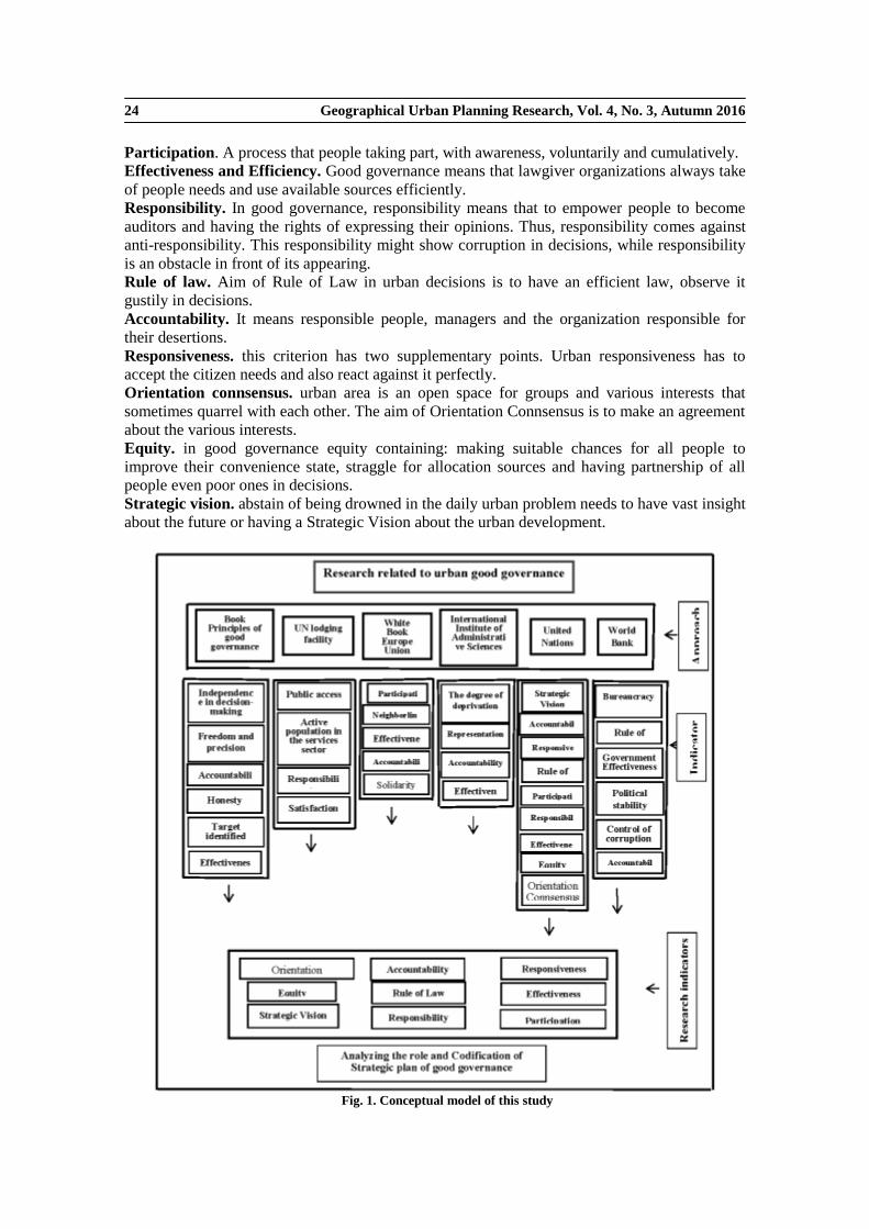
Geographical Urban Planning Research, Vol. 4, No. 3, Autumn 2016 24
Participation. A process that people taking part, with awareness, voluntarily and cumulatively.
Effectiveness and Efficiency. Good governance means that lawgiver organizations always take
of people needs and use available sources efficiently.
Responsibility. In good governance, responsibility means that to empower people to become
auditors and having the rights of expressing their opinions. Thus, responsibility comes against
anti-responsibility. This responsibility might show corruption in decisions, while responsibility
is an obstacle in front of its appearing.
Rule of law. Aim of Rule of Law in urban decisions is to have an efficient law, observe it
gustily in decisions.
Accountability. It means responsible people, managers and the organization responsible for
their desertions.
Responsiveness. this criterion has two supplementary points. Urban responsiveness has to
accept the citizen needs and also react against it perfectly.
Orientation connsensus. urban area is an open space for groups and various interests that
sometimes quarrel with each other. The aim of Orientation Connsensus is to make an agreement
about the various interests.
Equity. in good governance equity containing: making suitable chances for all people to
improve their convenience state, straggle for allocation sources and having partnership of all
people even poor ones in decisions.
Strategic vision. abstain of being drowned in the daily urban problem needs to have vast insight
about the future or having a Strategic Vision about the urban development.
Fig. 1. Conceptual model of this study
Geographical Urban Planning Research, Vol. 4, No. 3, Autumn 2016 25
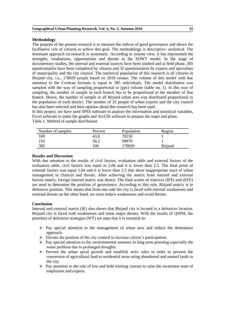
Methodology
The purpose of the present research is to measure the indices of good governance and shows the
facilitative role of citizens to achive this goal. The methodology is descriptive- analytical. The
dominant approach on research is systematic. According to system view, it has represented the
strengths, weaknesses, opportunities and threats in the SOWT model. In the stage of
documentary studies, the internal and external sources have been studied and at field phase, 385
questionnaires have been completed by citizens and 32 questionnaires by experts and specialists
of municipality and the city council. The statistical population of this research is all citizens in
Birjand city, i.e., 178020 people based on 2010 census. The volume of this model with due
attention to the Cochran formula is equal to 385 individuals. The model distribution was
sampled with the way of sampling proportional to (pps) volume (table nu. 1). In this way of
sampling, the number of sample in each branch has to be proportional to the member of that
branch. Hence, the number of sample in all Birjand urban area was distributed proportional to
the population of each district. The number of 32 people of urban experts and the city council
has also been selected and their opinion about this research has been used.
In this project, we have used SPSS software to analyze the information and statistical variables,
Excel software to make the graphs and ArcGIS software to prepare the maps and plans.
Table 1. Method of sample distribution
Region Population Percent Number of samples
1 78150 43.8 169 1 99870 56.2 216 Birjand 178020 100 385
Results and Discussion
With due attention to the results of civil factors, evaluation table and external factors of the
evaluation table, civil factors was equal to 2.06 and it is lower than 2.5. The final point of
external factors was equal 1.84 and it is lower than 2.5 that show inappropriate react of urban
management to chances and threats. After achieving the matrix from internal and external
factors matrix, foreign internal matrix was drawn. The final scores of matrices (IFE) and (EFE)
are used to determine the position of governance. According to this rule, Birjand matrix is in
defensive position. This means that from one side the city is faced with internal weaknesses and
external threats on the other hand, we must reduce weaknesses and avoid threats.
Conclusion Internal and external matrix (IE) also shows that Birjand city is located in a defensive location.
Birjand city is faced with weaknesses and some major threats. With the results of QSPM, the
priorities of defensive strategies (WT) are state that it is essential to:
Pay special attention to the management of urban area and reduce the dominance
approach.
Elevate the position of the city council to increase citizen’s participation.
Pay special attention to the environmental assumes in long term planning especially the
water problem due to prolonged droughts.
Prevent the urban spiral growth and establish strict rules in order to prevent the
conversion of agricultural land to residential areas using abandoned and unused lands in
the city.
Pay attention to the rule of low and hold training courses to raise the awareness state of
employees and experts.

Geographical Urban Planning Research, Vol. 4, No. 3, Autumn 2016 26
Therefore, it can be concluded that Birjand city in the event of good governance in terms of
internal factors is weak and did not respond to external factors. Thus, we can judge that Birjand
city in the event of good governance do not have good position.
Keywords: accountability, Birjand City, good governance, participation, SWOT Model.
References
1. Ahmadi Pour, Z.; Eftekhari, A.; Amoli, J.; pour Taheri, M. (2011). Presented a model of good
governance in the country, geography, geopolitics, No. 26, pp. 1-26.
2. Alizadeh, H.; Nemati, M.; Rezaeijafari, K. (2014). Analysis of the urban good governance criteria using fuzzy hierarchical analysis, urban and regional studies and research, No. 24, pp. 128-105.
3. BarakPour, N. (2005). Urban good governance and management of cities in Iran, Planning and Urban Management Conference Proceedings, pp. 571-491.
4. BarakPour, N.; Asadi, I. (2010). Management and urban governance, Tehran University Art Research Center.
5. Bhuiyan S.H. (2010). A crisis in governance: urban solid waste management in Bangladesh, Habitat international, No. 34, pp. 125-133.
6. Birjand municipal statistics, Department of Planning, Department of Statistics and Information (2010). The Municipal Planning Branch Byrjnd.
7. Cave, R.W. (2005). Encyclopedia of the city, London & New York.
8. CHaudhry, I.;,Malik, Sh.; Nawaz Khan, Kh. (2009). Factors affecting good governance in Pakistan: an imperial analysis. p.339.
9. Darbanastaneh, A.; Rezvan, M.R. (2011). Explaining the impact on rural governance in local government (case study: the city of Qazvin), Journal of Urban Management, No. 29, pp.179-197.
10. Ebrahimzadeh, I., Asadi, M. (2013). Analysis and evaluation of realization of the urban good governance in Iran Case study: Kashmar, Geography and Urban Planning, No. 6, pp. 30-17.
11. Ebrahimzadeh, I.; Mousavi, M.N. (2014). Methods and techniques of land, first edition, the publisher, Tehran.
12. Eftekhari, A.; Ahmadi Pour, Z.; Amoli, J.; pour Taheri, M. (2012). The perfect model of good governance in the country, Geopolitical Journal, NO. 2, pp. 28-1.
13. Hafeznia, M.R. (2003). An introduction to research methods in the humanities, Samt, Tehran.
14. Lewis, D.; Mioch, J. (2005). Urban vulnerability and good governance. Journal of Contingencies and Crisis Management.
15. Lotfi, H.; Edalatkhah, F.; Mirzayi. M.; Vazirpor, S.H. (2008). Urban management and its role in promoting the rights of citizens, Journal of Human Geography, No. 1, pp. 101-110.
16. Maharati, Y.; Hnzayy, W.; Hamidi, M. (2011). Assessment of strategic planning based on urban good governance "programs of Tehran and Mashhad comparative study, Fourth Conference of Planning and Urban Management, Mashhad.
17. Muvahhed, A.; Kohzad, S. (2009). Analysis of factors affecting the development of tourism in the province by using swot», Journal of Research and Urban Planning, NO. 2, pp. 85-102.
18. Oliveira, J.; Christopher, N.H.; Doll O.B. (2013). Green economy and governance in cities: assessing good governance in key urban economic processes, Journal of Cleaner Production, No. 58, pp. 138-152.

Geographical Urban Planning Research, Vol. 4, No. 3, Autumn 2016 27
19. Popovych, O. (2008). Good Governance and Policy Addressing Poverty Alleviation in Ukraine.MSc-Public Administration.
20. Rahnama, M.R.; Mafi, E.; Asadi, R. (2009). Analysis of the status of good governance in Mashhad city with a sowt, Journal of Geography and Regional Development, No. 15, pp. 224-197.
21. Rahnama, M.R.; Asadian, M. (2014). The status of good governance indicators in Mashhad city, The Researcher-Urban and Regional Studies, No. 20, pp. 162-143.
22. Roberts, S.M.; Wright, S.; O’Neil, Ph. (2007). Good governance in the Pacific? Ambivalence and possibility, Geoforum, No.38, pp: 967- 984.
23. Scott, C.M.; Fata, D.P. (2001). Secrecy and Good Governance.
24. Sadashiva, M. (2008). Effects of civil society on urban planning and governance in Mysore, India, Doctoral thesis, Technical University of Dortmund.
25. Salehi, R.; Nemati, M.; Amanpor, S. (2014). Effective mechanism of social capital indicators in the good urban governance using Amos, Case Study: City Nasim City, Spatial planning, No. 4, No. 1, pp. 1-24.
26. Shahidi, M.H. (2007). Transport and urban governance, Urban Icon, No. 16, pp. 38-44.
27. Sheng, Y.K. (2010). Good Governance in Southeast Asia, Environment and Urbanization ASIA, Vol. 1, No. 2, pp. 131-147.
28. Torabi, A. (2004). Depends on good governance and sustainable urban management, publication Dehyariha and municipalities, No. 69, pp. 10.
29. World Bank (1992). Governance and Development Report, Washington. DC.
Geographical Urban Planning Research, Vol. 4, No. 3, Autumn 2016 28
Citizen-oriented space, new approach to realization of urban
sustainable development (Case study: Tehran)
Ziba Parnoon 1
, Mohammad Taghi Razavian 2, Zohreh Fani
3, Mohammad Hassan Pasvar
4, Jamile
Tavakolinia5
1. Ph.D. Candidate in Geography and Urban Planning, Shahid Beheshti University, Iran
2 Professor, Deparment of Geography, Shahid Beheshti University, Iran
3. Associate Professor, Department of Geography and Urban Planning, Shahid Beheshti
University, Iran
4. Ph.D. in Management, Tarbiat Modares University, Iran
5. Assistant Professor, Department of Human Geography, Shahid Beheshti University, Iran
Received:14 August 2016 Accepted: 1 January 2017
Expanded Abstract
Introduction
Theoretical basis of citizenship oriented space definition is consisted of evolution of the space
concept in the last decade. It creates a common understanding that space is a social construction
and also is a community structure. This takes into account the social rights of citizens as a basis
for planning. Citizenship oriented space can be created anytime that urban space is organized in
a way that it can meet the needs of citizens. This included physical and functional goals and
qualitative and psychological needs of citizen in urban life such as social identity, social
security and welfare, sustainable employment, psychological comfort, sense of beauty,
solidarity and social belonging. The space can create readability and respond to human needs in
space and effort to increase the happiness of the people. Precise comprehension of the
citizenship oriented space is required to identify its dimensions and components. The latest and
most complete approach in this regard is the Citizen Satisfaction Index (CSI). This model is
based on four main axes which include urbanity and diversity, nature and recreation, job
opportunities, cost-efficiency and overall satisfaction and attachment as two complementary
axes. The main objective of this research is to study Tehran space in terms of citizenship. The
following questions are Tehran space within the framework of concept, scope and definitions of
citizenship oriented space. To respond to this issue, it is required to review theoretical concepts
and principles of the citizenship oriented space, identify its dimensions and indicators, and
finally analyze Tehran situation.
Methodology Research Methodology in this paper is analytical. The study area is Tehran. This city is involved
in the most recent urban projects and planning. What now is appeared in the urban space is
reflecting the existing planning system. The status of this space from the rights of citizens and
their degree of satisfaction from this space created effective recognition in existing problem.
This can be a guide for other cities in recognition of their urban planning in the future. Mixed or
cluster sampling was used because of complex and diverse structure in Tehran with different
Corresponding Author: [email protected], Tel: +98 9124386574

Geographical Urban Planning Research, Vol. 4, No. 3, Autumn 2016 29
levels of prosperity and economic, social and cultural rights. Therefore, based on research that
had been divided the city of Tehran according to spatial equity and level of development, we
have selected three-zones including district 1 (high development), district 22 (intermediate level
of development) and district 18 (the low level of development).
Data collection method is documentary and field survey based on questionnaires. The study
population included all citizens in Tehran. Using Cochran formula, the sample size was 384
people. To determine the variables and measure the components of Tehran space, we used CSI
model. However, little changes have given in the CSI model due to Tehran city conditions,
limitations in assessing some components, and lack of issues in this version. Added indicators
are access to public transport, motion flow and movement in the city, and feeling safe in the
city. Statistical methods used are cronbach's alpha, chi-square, one sample T-test, and spearman
correlation coefficient.
Results and Discussion
Visual image of the city, environmental quality, parks and open spaces, motion flow and
movement in the city, feeling safe in the city, the price of rental housing and cost of living are
the indicators that demonstrate dissatisfaction of citizens. Wide range of cultural activities, a
variety of shopping opportunities, energy and atmosphere of the city, access to utilities, the
sense of security in public spaces, how to accept and absorb the cultures and subcultures, natural
green space and public access to public transport indicators demonstrate relative satisfaction of
citizens and relative desirability. The indicators of general level of wages and employment
opportunities show satisfaction of citizen and ideal situation. Finally, main axis of CSI model
and overall satisfaction index demonstrate lack of citizen satisfaction in Tehran space.
Conclusion The concept of space, its dimensions and spatial planning are challenging issues of urban
planning. Space is not limited to physical aspects. Citizenship oriented space is multi-faceted
concept and covers all economic, social, cultural, environmental aspects of life and the rights of
citizens. CSI is one of the most comprehensive models to measure citizenship oriented space.
Assessment of this model in Tehran city demonstrated that Tehran space is not in the context of
citizenship oriented space and dissatisfaction of citizens is undesirable. Higher satisfaction of
citizens in both the general level of wages and employment opportunities are the result of the
basic problem of the national planning system. This is resulted from concentration of all
economic activities in Tehran, needs of citizens to live in this city, and access to jobs. This
problem requires urban planning reform with considering citizenship rights to observe the
balance between population, activities and space and balance between national, regional,
municipal and local planning. The results showed that the balance between population, space
and activities have not been met in Tehran. Unsuitable organization of the national space have
had a direct effect on Tehran metropolitan situation and caused dissatisfaction of citizens in
other fields. Among other factors affecting the noncompliance in Tehran with the citizenship
oriented space indicators are the lack of citizen participation in urban planning process,
extrovert urban system, urban management accountability to upper authorities, and political
context effectiveness on urban management values. Undoubtedly improvement of this situation
in Tehran with the huge population cannot be done in a short time and through massive
intervention in the physical space of the city. Basis of creating citizenship oriented space is to
target satisfaction of citizens in all planning. This would requires changing urban planning
approach to bottom-up planning and citizen participation in the policymaking, decision-making,
implementation and monitoring. Hence, it is essential to make coordination in civil law, politics,
government, foundations and rules of urban management to consider necessity of social
management and crisis.
Keywords: Citizen Satisfaction Index (CSI), citizenship oriented space, sustainable
development, urban management.

Geographical Urban Planning Research, Vol. 4, No. 3, Autumn 2016 30
References
1. Afrough, E. (1998). Space and social inequalities: the study of spatial segregation and poverty
concentration in residential nighborhoods of Tehran, Tarbiat Modarres University Publication,
Faculty of Humanities. [in Persian]
2. Afrough, E. (1997). Space and social inequalities: the study of spatial segregation and poverty
concentration in residential nighborhoods of Tehran, Ph.D. Thesis in Sociology, Tarbiat Modarres
University, Faculty of Humanities. [in Persian]
3. Corcoran, M.P. (2015). Jacobs, Jane (1916–2006) International Encyclopedia of the Social &
Behavioral Sciences (Second Edition), pp. 776-781.
4. Cunningham, Frank (2011). The virtues of urban citizenship City, Culture and Society, 2, pp. 35-44.
5. Erica (2003). European Charter on the Participation of Young People in Local and Regional Life.
Available at: www.youth-partnership.net.
6. Este vez-Mauriz, L.; Jimeno A.; Fonseca, Claudiu Forgaci, Nils Bjorling (2016). The livability of
spaces: Performance and/or resilience? Reflections on the effects of spatial heterogeneity in
transport and energy systems and the implications on urban environmental quality, Gulf
Organization for Research and Development International Journal of Sustainable Built Environment
7. Falks, K. (2002). Citizenship Mohammad Taqi Delforouz Translation, Kimiya Press, Tehran.
8. Gilles Clément, A.P. Bukley (2014). Human space exploration–From surviving to performing, Acta
Astronautica, 100, pp. 101-106
9. Harvey, D. (2000). Social justice and the city F. Hsamyan and others Translation, Second Edition,
Tehran, processing and urban planning company (affiliated to Tehran Municipality).
10. Imani Shamloo, J. and others (2016). Urban speculation and Space divergence- Analysis of Tehran
Metropolis spatial changes based on oil economy" Geopolitics Journal, Vol. 12, No. 1, pp. 135-104.
11. Jacobson, K. (2012). Philosophical Perspectives on Home’ International Encyclopedia of Housing
and Home, pp. 178-182.
12. Jan, G. (2015). Cities for People, translated by Maryam Charkhchian, publications essence of of
knowledge, Tehran.
13. Karl-Henrik Robèrt, S.B.; Henrik Ny, Göran Broman (2017). A strategic approach to sustainable
transport system development - Part 1: attempting a generic community planning process model”
Journal of Cleaner Production, Volume 140, No 1, 1 January, pp 53-61.
14. Kazemiyan, Gholamreza, 2004, Urban good governance approach and Necessity in Tehran
metropolitan area management, PhD thesis, Tarbiat Modares University.
15. Lasmini Ambarwati, R.V.; Bart van Arem, Adam J. Pel (2016). The influence of integrated space–
transport development strategies on air pollution in urban areas, Transportation Research Part D:
Transport and Environment, Vol. 44, May, pp. 134-146.
16. Mclean, I. (1996). Oxford Dictionary of Politics, Oxford University Press.
17. Massy, D. (1987). New Direction in Space, Gregory & Urry (eds.).Social Relation & Spatial
Structure. London: Macmillan Education LTD.
18. Nejati Hosseini, S.M. (2001). Modern society, citizenship and participation, Urban Management
Journal, No. 5, pp. 15-6.
19. Nigro, Héctor Oscar; González Císaro, S.E. (2016). The citizen satisfaction index: Adapting the
model in Argentine cities, Cities, Vol. 56, pp. 85-90.

Geographical Urban Planning Research, Vol. 4, No. 3, Autumn 2016 31
20. Nazarian, A.; Daneshmand, F. (2010). Strengthening the citizenship spirit of metropolises
Management (Case Study: Hamedan), Journal of environmental planning, No. 8, pp. 115-87.
21. Nozari, K. and other (2009). Citizen Oriented planning or modernist and functionalist planned,
Geography Education Journal, No. 86, pp. 36-32.
22. Oscar Nigro, H.; González Císaro, S.E. (2016). The citizen satisfaction index: Adapting the model
in Argentine cities” Cities, Vol. 56, July, pp. 85-90.
23. Pierre Dias, Th.R. (2015). Social trajectory and socio-spatial representation of urban space: The
relation between social and cognitive structures, Journal of Environmental Psychology, Vol. 41,
135e144.
24. Rabbani, R. (2002). Urban sociology, Isfahan University Press, first Edition, Isfahan.
25. Razzaghi, H. (2016). Qualitative analysis of space and space Users Behavioral pattern- Case Study:
edges of Karaj river, Geographical Research Journal, Vol. 28, No. 4, serial number 111, pp. 112-95.
26. Rafieian, M.; Shali, M. (2012). Spatial analysis of the development Tehran level of different regions
of city to separation of urban areas, Human Sciences Professor- Spatial Planning, Vol. XVI, No. 4,
pp. 25-49.
27. RennieShort, J. (1996). The Urban Order: An Introduction to Urban Geography, Wiley Blackwell.
28. Roberts, B. (1996).The Social Context of Citizenship in Latin America, International Journal of
Urban and Regional Research, Vol. 20, No. I, pp. 38-65.
29. Sarafi, M.; Esmailzadeh, H. (2005). Citizenship a Solution to urban issues in Iran" Political -
Economic Information Journal, No. 218-217, pp. 145-136.
30. Sasanpour, F. and others (2014). Viability cities in the sustainable urban development- case Study
Tehran Metropolis, Geography Journal, Vol. 12, No. 42, pp. 129-157.
31. Siagian, M. (2016). Social Space as People-Gathering Tool, ASEAN-Turkey ASLI (Annual Serial
Landmark International) Conferences on Quality of Life 2016 AMER International Conference on
Quality of Life, AicQoL2016Medan, 25-27 February, Medan, Indonesia.
32. Spencer, Ch. (1991). City Design and City Sense: Writing and Projects of Kevin Lynch, T.
Bannerjee, M. Southworth (Eds.). Journal of Environmental Psychology, Vol. 11, No. 3, pp. 295-
297, Available online 8 July 2005.
33. Stanek, L.; Schmid, Ch.; Morav Anszky , A. (2016). Urban Revolution Now: Henri Lefebvre in
Social Research and Architecture, Emotion, Space and Society, Ashgate, Farnham, England, 2014,
xv and 345 pp, ISBN: 978-1-4094-4293-6.
34. Tavassoly, Gh.A.; Nejati Hosseini, S.M. (2004). Citizenship social reality in Iran, Iran Sociology
Journal, Vol. V, No 2, pp. 62-32.
35. Turner, B.S. (1993). Contemporary Problems in the Theory of Citizenship, in Turner (ed)
Citizenship and Social theory, sage, chap1.
36. Zarghami, I.; Behrouz, S.M. (2015). The role and concept of "space" in recreating architectural
theory and social sciences, Interdisciplinary studies in the human sciences Journal, Vol. VII, No. 2,
pp. 99-81.

Geographical Urban Planning Research, Vol. 4, No. 3, Autumn 2016 32
Analysis of spatial inequalities based on social, economic and physical
indices in medium-sized cities (Case study: Miyandoab City)
Shahrivar Roustaie 1, Hossein Karimzadeh
2, Khosro Rahmati
3
1. Associate Professor, Department of Geography and Urban Planning, University of
Tabriz, Iran
2 Assistant Professor, Department of Geography and Urban Rural, University of Tabriz,
Iran
3. M.A. in Geography and Urban Planning, University of Tabriz, Iran
Received:10 October 2015 Accepted: 11 December 2016
Expanded Abstract
Introduction
In Iran, after land reform and overflowing dollars from the sale of oil to the urban economy,
urbanization has started. This urbanization made different urban groups deprived of having
access to services and facilities due to lack of facilities and urban infrastructures tailored to their
social situation. Miyandoab city was not an exception. In this city, due to vast rural
immigration, integration of villages surrounding to the city, inefficient management, and
unplanned urban growth, spatial inequalities have been increased. The present research has been
conducted in order to investigate spatial inequalities in Miyandoab city. Therefore, the situation
of city blocks in Miyandoab is initially studied in order to assess social, economic, and physical
facilities using spatial statistics and hot spot analysis. Then, the distribution pattern of spatial
inequality is determined using spatial autocorrelation. Accordingly, the questions of research
are:
1. Does Miyandoab have spatial inequality according to social, economic, and physical
indicators?
2. How is spatial distribution of these inequalities?
Methodology
In terms of objectives, this is an applied study with a qualitative-analytic research method in
terms of the nature and method of data gathering. Library method has been used to gather data.
The source citation of used indicators and quantities was the data and information of the
statistical blocks of the general population and housing census of Miyandoab in 2011. The GIS
maps have been derived from Planning Deputy of Governorate of Western Azerbaijan.
Statistical population of this research is all statistical blocks (1660) of Miyandoab in 2011. After
theoretical research, 34 social, economic, and physical indicators were selected for investigation
of inequality situation and recognizing spatial pattern of the inequality. In the next stage, based
on these indicators, Spatial Statistics tools, Hot Spot Analysis, and Autocorrelation Moran’s I in
Corresponding Author: [email protected], Tal: +98 9147197800
Geographical Urban Planning Research, Vol. 4, No. 3, Autumn 2016 33
ArcGIS software have been used. Indexing has been done in Excel software and the information
has been projected in ArcGIS for analysis and mapping.
First, the analysis of Hot Spots on 8 indicators has been done for each social, economic, and
physical factor. For each factor, a map entitled Hot Spots analysis on social, economic, and
physical indicators has been extracted. At the last stage, these three maps have been overlaid
using ArcGIS to create one map. Then, to analyze the spatial inequality of the urban blocks, a
combinational map obtained from triple indicators has been prepared using Morris indicators in
five levels. Autocorrelation Moran’s I has also been used to determine the type of distribution
pattern of the inequality.
Results and Discussion
Findings of the research have been obtained in two stages:
1. Analyzing Hot Spots on the indicators used in the research (social, economic, physical),
overlaying layers, and determining the levels of spatial inequality in urban blocks of
Miyandoab.
2. Identifying distribution pattern of the inequality in Miyandoab in 2011.
The Hot Spot analysis has been done for each sub-indicator of social factors. Then, the layers
have been combined to create the map of Hot Spot analysis of social indicators of Miyandoan in
2011 based on the total of social sub-indicators. The same was done for economic and physical
indicators. Then, the obtained three layers have been combined to generate the regarded map of
Hot Spot analysis of social, economic, and physical factors. At the end, to analyze the situation
and understanding the subject in the city, urban blocks were graded according to having the the
indicators using maps and Morris development index.
The map of city blocks has been determined in five levels (very deprived, deprived, average,
possessed, highly possessed). From total 1660 urban blocks in Miyandoab, 626 blocks are very
deprived and 287 blocks are deprived. While 403 blocks have the indicators in average level,
307 blocks are possessed, and the highest value and the lowest numbers of indicators are 37
highly possessed blocks.
The urban blocks are not in an equal situation in terms of possessing, and regarding the
quantitative output, the distribution pattern of inequality is cluster type. The deprived and very
deprived clusters in the city could be due to integration of rural cores to the city. Average and
possessed blocks are also in the center and margins of the city. Meanwhile, highly possessed
blocks are the least ones.
Conclusion
The results show that poor and very poor blocks (913) are the most (55 percent), and they have
the least values of the indicators. Considerable placement of them in the edge of city is due to
the integration of rural cores to the city. A large number of these blocks are seen in districts of
the damaged areas of the city, districts behind hospital, Namaz Boulevard, and Rabari alley.
There are 403 blocks with average indicators (24 percent). The possessed blocks are mostly
located around left side of Zine Rood River, i.e., shoreline where economic and social bases
have separated the population groups (307 blocks, i.e., 19 percent). The highly possessed blocks
have the highest value of the indicators, but they are the least in numbers (37 cases) and 2.3
percent could not be a desirable result. The findings have shown that the distribution pattern of
spatial inequality is cluster type. The deprived clusters are mostly located in the edges of the
city and the possessed clusters are located in the center. This situation indicates class differences
and duality in urban spaces and difference in having regarded indicators.
Keywords: Miandoab, spatial equity, spatial inequality, spatial statistics, urban blocks.

Geographical Urban Planning Research, Vol. 4, No. 3, Autumn 2016 34
References
1. AhmadTozeh, V. (2013). Investigation and Analysis of Urban Spatial Equity in Saghez (A Case
Study: Neighborhoods of Saqqez City), MA thesis Geography and Urban Planning, University of
Tehran, Faculty of Geography.
2. Asgari, A. (2011). Analyzes of Spatial Data with ArcGIS, Information and Communication
Technology Organization Publications of Tehran Municipality, First Edition.
3. Behravan, H. (2007). Preparation of the Culture and Urban Equity in 12 Different Districts of
Mashhad, Conference planning and urban management, Mashhad, pp. 1-28.
4. DadashPour, H.; Alizadeh, H.; Rostami, F. (2015). Explaining the Conceptual Framework of Spatial
Equity in Urban Planning with a Focus on the Concept of Equity in Islam, Journal of Naghshe
Jahan, Vol. 5, No. 1, pp. 75-84.
5. Daneshpour, Z. (2006). Analysis of Spatial Inequality in Rural-Urban Environments (An Effort in
the Use of Planning and Strategic Management Approach in Tehran), Journal of Fine Arts, No 28,
pp. 5-14.
6. Dehghan, H. (2007). Opportunities and Threats for Education in Dealing with Spatial Inequality in
Information Technology and Communications, Journal of Education, Vol. 23, No. 3, pp. 126-163.
7. Farid, Y. (2005). The research method used in urban and rural geography, Tabriz, University of
Tabriz.
8. Ghanbari, A. (2009). Analysis of Regional Inequalities in Iran, with Emphasis on Urban Areas of
East Azerbaijan, Geography and urban planning doctoral thesis, University of Tabriz, Faculty of
Humanities and Social Sciences.
9. Hall, P.; Pfeiffer, U. (2004). Urban Future 21, Spoon Press, London.
10. Harvey, D. (2000). Social Justice and City, Translated by Farrokh Hesamian, Mohammadreza Haeri
and Monadizadeh, Behrouz, Processing enterprises and urban planning, Tehran.
11. Harvey, D. (1973). Social justice and the city, Edward Arnold, London.
12. Hewko, Jared N. (2001). Spatial Equity in the Urban Environment: Assessing Neighborhood
Accessibility to Public Amenities, University of Alberta, Canada
13. Iveson, K. (2011). Social or Spatial justice? Marcuse and Soja, on the right to the city, City, Vol. 15,
No 2., pp. 248-261.
14. Jomepour, M. (2006). Rural development planning, SAMT, Tehran
15. Kalantari, Kh. (2001). Planning and Regional Development, Publications Khoshbin, Tehran.
16. Kanbur, R.; Venables, Anthony J. (2005). Spatial Inequality and Development, Oxford: Oxford
University Press.
17. Kaplan, D.H.; Kathleen W. (2004). Research in Ethnic Segregation I: Causal Factors Urban
Geography, Vol. 25, No. 6 (August-September).
18. Karam, A.; Mohammadi, A. (2009). Evaluation and Zonation of Land Suitability for Physical
Development of the City of Karaj and Surrounding Lands Based on Natural Factors and Analytic
Hierarchy Process Method, Journal of Natural Geography, Vol 1, No 4, pp. 59-74.
19. KhalouBagheri, M. (2012). Dealing with Spatial Inequality, in addition to the Application of
Planning Based on Improving the Quality of Life, Journal of Urban Economics and Management,
No 1, pp. 49-67.
20. Lashgari, A. (2009). Right, Justice and Society, Journal of Economic Research, Vol. 6, pp. 31-57.

Geographical Urban Planning Research, Vol. 4, No. 3, Autumn 2016 35
21. Latifi, G.; Sejasi Gheydari, M. (2011). Ranking the Level of Social Welfare in towns of Zanjan
Province Using TOPSIS Models, Journal of Planning and Social Development, No. 7, pp. 166-189.
22. Liao, Ch.H.; Chang Hsueh-Sheng, K.T. (2009). Explore the spatial equity of urban public facility
allocation based on sustainable development, Real Corp,(http://www.corp.a, (pp. 135-144.
23. Liu.c.xu.m, Chen.s.an.jm and Yan.pl (2007). Assessing the impact of urbanization on regional net
primary productivity in Jiangyin County, China, Journal of Environmental Management, pp. 597-606
24. Marx, K. (1975). Capitalism, Publication Nour, Tehran.
25. Miandoab city Government, 2014.
26. Mirsendesy, S.M. (1996). Effective Factors For People’s Perception from Justice Of Its
Relationship Equality (Inequality), The Case Study : Mashhad City, M.S Thesis In Sociology,
Tarbiat Modarres University, Faculty Of Human Sciences.
27. Morais, P. (2010). Evaluation of performance of European cities with the aim to promote quality of
life improvements; Elsevier, Vol. 39, No. 4, pp. 398-409.
28. Mousavi, M. (2012). The stable form of the City and social justice (Case Study: Miandoab), Human
Geography Research, No 80, pp. 177-192.
29. Pacione, M. (2003). Urban Geography: A Golobal Perspective, 2th, New York.
30. Panych, L. (2001). Manifest After 150 Years, Agah press, Tehran.
31. PourFathifar, J.; Emamali, A. (2010). Analysis of Spatial Inequalities of Rural Settlements in Ahar
City, Geographical space, Vol. 10, No 32, pp. 95-116.
32. Qadeer, M.A. (2004) Urbanization by implosion, Guest Editorial/ Habit ate International, Vol. 28,
pp. 1-12.
33. Rabbani, R.; Kalantari, S.; Hashemianfar, A. (2010). Examining the Relationship between Social
Determinants and Inequalities, Vol. 11, No. 41, pp. 267-305.
34. Rahnama, M.R.; Zabihi, J. (2011). Analysis of Distributing the Urban Public Facilities in line with
of Spatial Equity with Integrated Access Model in Mashhad, Geography and Development, No 23,
pp. 5-21.
35. Sarvar, R. (2004). Using the AHP Method in Geolocation of the Case Study: Locating for Future
Development of Miyandoab City, Human geography researches, No 41, pp. 19-38.
36. Shakouie, H. (2013). New thoughts in philosophy, geography, V 1, fifteenth edition, Gitashenasi
Publications, Tehran.
37. Sheikhi, A. (2014). City development strategies of Piaranshahr with CDS approach, MA thesis
Geography and Urban Planning, University of Tehran, Faculty of Geography.
38. Sohel Rana, M.D. (2009). Status of wateruse sanitation and hygienic condition of urban slums:
Astudy on Rupsha Ferighat slum, Khulna, www.elsevier.com, pp. 322-328.
39. Soja, E. (2006). The city and spatial justice, justice spatial/spatial justice, www.jssj.org
40. Tabibian, M.; Shokouhi, M.S.; Arbab, P. (2010). Evaluation of Social Justice from the Urban
Landscape, Case Study: Neighborhood of Khoub Bakht, District 15 of Tehran, Journal of Utopia,
pp. 111-122.
41. Taghavi, M.; Sarvari, Z. (2003). The impact of liberalism in urban spaces, Journal of Political–
Economic, pp. 156-163.
42. Talen, E. (2002). Tthe Social Goals of New Urbanism. Housing Policy Debate, Vol. 13, No. 1, pp.:
165-188.
Geographical Urban Planning Research, Vol. 4, No. 3, Autumn 2016 36
43. Tsou, K.; Yu-Ting, H.; Yao- Lin, C.)2005(. An accessibility-based integrated measure of relative
spatial equity in urban public facilities, Cities, Vol. 22 No. 6, pp. 424-435.
44. Vaezi, A. (2005). John Rawls: A Theory of Justice to liberal politics, Publication BagherolOloum,
Ghom.
45. Yasouri, M. (2009). Evaluation of regional disparity in Khorasan Razavi, Journal of Geographi and
Regional Planning, No 12, Spring and Summer, pp. 201-223.
46. Zadvali, F. (2014). A comparative study of poverty in the city of Tabriz in the period 1385-1375,
MA thesis Geography and Urban Planning, Faculty of Geography, University of Tabriz.
47. Zarabi, A.; Mousavi, M. (2010). Spatial Analysis of Population Distribution and Distribution of
Services in Yazd City, Journal of Geographical Research, N0 97, pp. 27-46.
48. Ziari, K.; Mahdian Behmoniri, M.; Ali, M. (2013). Review and Assessment of Spatial Equity
Benefiting the Urban Public Services Based on Population Distribution and Accessibility in the City
of Babolsar, Vol. 13, No. 28, pp. 217-241.
Geographical Urban Planning Research, Vol. 4, No. 3, Autumn 2016 37
Investigation on the relationship between objective and subjective
indices of quality of life and quality of access to urban services
(Case study: Distressed area of Zahedan City)
Ali Hajinejad 1
, Hamid Reza Rakhshaninasab 2, Tayyebeh Sargolzaaei Javan
3
1. Associate Professor, Department of Geography and Rural Planning, University of Gilan,
Iran
2 Assistant Professor, Department of Geography and Urban Planning, University of Sistan
and Balouchestan, Iran
3. M.A. in Geography and Urban Planning, University of Sistan and Balouchestan, Iran
Received:2 February 2016 Accepted: 19 December 2016
Expanded Abstract
Introduction
In the past half century, cities due to increase in urbanization, which nowadays is considered as
one of the most important aspects of global changes, have provided grounds for expansive urban
development and created a lot of changes in land use from local to global scales. These changes
were in such a way that following increase in population of the cities and rapid expansion, urban
areas are faced with considerable challenges in terms of physical and environmental
deterioration, social exclusion, insecurity, unemployment, housing shortage and traffic
problems. All these issues reduce quality of life in the cities. Although urbanization is an
important index of welfare and social and economic development, its rapid expansion can
reduce per capita of urban services and socioeconomic facilities. This in return will manifest
itself in the form of life quality reduction in different aspects of urban life. Therefore, nowadays,
we emphasize upon solving urban challenges, problems of distribution of urban utilities, social
justice, well-being, and consequently citizens quality of life. Consequently, life quality studies
can help us identify problematic areas, reasons for public dissatisfaction, citizen priorities in
life, the impact of social and population factors on life quality, and monitoring and evaluation of
the efficiency of policies and strategies of life quality. Therefore, the aim of the present study is
to investigate the effects of urban services and their impacts on life quality in distressed areas of
Zahedan City based on cultural-religious, healthcare, service-welfare, and urban facilities and
utilities dimensions as the indices of available urban services in these areas.
Methodology
The research method is descriptive-analytical. In the present study, to obtain the required data,
the field study was employed via developing and distributing questionnaires based on the
indices of urban services in each of the studied areas. The sample size included 384 individuals
of residents of distressed areas of Zahedan City based on the Cochran formula. To access more
complete results, the sample size increased to 390 individuals and questionnaires were
Corresponding Author: [email protected]; Tel: +98 9155426930

Geographical Urban Planning Research, Vol. 4, No. 3, Autumn 2016 38
distributed in terms of the number of population in each 8 areas. Then, using the SPSS software
and employing Pearson correlation coefficient, GIS, and fuzzy functions, the data were
analyzed.
Results and Discussion
Findings of the present study indicate that Zahedan City has not been significantly successful in
providing urban services for its citizens because most of its distressed areas have average scores
lower than the moderate level. In this study, index of access to services was evaluated using 4
major indices (cultural-religious, service-welfare, healthcare and facilities and equipment)
which are comprised of 29 sub-indices.
The mean score of resident satisfaction with life quality is based on the indices of access to
urban services. The index value was 2.44 which is lower than average. Among these variables,
satisfaction with access to exceptional education centers, world tourism and hospitality,
libraries, green spaces and secondary schools have scores of 1.08, 1.39, 1.53, 1.95, and 1.99,
respectively. Satisfaction with sewage disposal system, surface water collection ducts, and
neighborhood cleanliness have scores of 1.72, 1.79 and 1.95, respectively, as the worst status.
Satisfaction values with access to bus stations and access to mosques have scores of 3.56 and
3.68, respectively, as the best status. These values are according to the surveys in distressed
areas. Therefore, we may state that satisfaction with quality of access in the distressed areas of
Zahedan is not very good.
In addition, a comparison between the subjective and objective indices of access to urban
services indicates that the final score of subjective indices is calculated based on 17 indices
including distance to nursery school, primary school, secondary school, high school and
exceptional education centers, tourism and hospitality centers, neighborhood services such as
retail shops, desalination stations, post offices, cultural-religious centers (library and mosque),
transportation centers such as tax and bus stations, healthcare centers such as hospitals, clinics
and sport facilities. The value of the indices is 0.11 and higher than the final score of objective
indices (0.07) measured based on 29 indices (satisfaction with access to library, nursery school,
primary school, secondary school, high school, exceptional education, mosques, drugstores,
healthcare centers, clinics, satisfaction with neighborhood cleanliness, water quality, blackouts,
neighborhood lighting, post offices, surface water collection ducts, waste collection, fire
stations, storehouses, repair shops, green spaces, sport centers, world tourism and hospitality,
retail shops, desalination stations, sewage disposal, access to communication networks, taxi and
bus stations). Findings indicate that in some cases, there are differences among what residents
perceive from their place of residence and what the results of objective assessment of the
environment indicate. One of the reasons for the mean differences between objective and
subjective indices in the distressed areas of Zahedan is that most of the urban services are
located in Zahedan District 4 which is the central part of the city where most objective services
are located. Most distressed areas are located in the northern part of Zahedan. Therefore,
citizens are not very well satisfied with the access they have to services in their own
neighborhoods and this accounts for the difference between objective and subjective indices in
the distressed areas. In addition, using Pearson correlation test, the relationship between
cultural-religious, healthcare, service-welfare and facility indices and quality of life was
evaluated. Results indicate a significantly positive relationship between all urban service
parameters and quality of life in the distressed areas of Zahedan.
Conclusion
Regarding the fact that distressed areas of Zahedan City are divided into 8 areas, and most of the
areas are located at suburbs of the city, they suffer from the lack of services and access to a lot
of urban services. Among these 8 areas, Area 4 is considered as the best due to its location at
the center of the city in terms of indices of the subjective life quality with mean scores as 3.59
and Area 8 with mean score of 2.06 is the worst area. In terms of objective indices of life
quality, Area 4 with mean scores of 4.44 is the best area and Area 6 with mean score of 2.75 is

Geographical Urban Planning Research, Vol. 4, No. 3, Autumn 2016 39
the worst area. Since the degree of life quality in distressed areas of Zahedan is not indicated to
be at favorable levels, therefore, strategies should be devised to inject urban services among
these areas to improve life quality of residents in these areas.
Keywords: distressed areas, life quality, social justice, urban services, Zahedan City.
References
1. Bahirai, M. (2013). Check in improving the quality of urban management with an emphasis on
green living environment of citizens (Case study: City Dehdasht), Master Thesis Geography and
Urban Planning, Supervisor, zohre hadiyani, University of Sistan and Baluchestan.
2. Costanza, R. (2007). Quality Of Life: An Approach Integration Opportunities, Human Needs, and
Subjective Well-Being, Economics, No. 61. pp. 267-276.
3. Darvish, A.; Kalteh, E. (2013). According to a ranking of urban neighborhoods civil service (Case
study: the city of Noshahr), First National Conference on Geography, Urban Development and
Sustainability, Tehran, pp. 1-15.
4. Deniz, A. (2012). Measuring the satisfaction of citizens for the services given by the municipality:
the case of Kirsehir municipality. Procedia Social and Behavioral Sciences, 62(24), pp. 555-560.
5. Ebrahimzadeh, A.; Barimani, F.; Nasiri, Y. (2004). Marginalization, urban anomalies and the
proposed adjustment (Case study; Karimabad of Zahedan), Journal of Geography and Development,
pp. 121-149
6. Falahi Y. (2011). Quality of life in rural areas (Case Study: kakavand city Delfan), Master Thesis
Geography and Rural Planning, University of Tehran.
7. Faraji, A. (2010). Indicators analysis and planning to improve the quality of urban life (Case study:
Babolsar), Master's thesis in geography and urban planning, University of Tehran.
8. Fassio, O.; Rollero Ch.; Piecoli, N. (2012). Health, quality of life and population, pensity, a
preliminary study contextualized, Quality of life, Social indicators Research published online first.
9. Ferriss, A.L. (2010). Approaches researches to improviny the qulity of life. How to enhance the
quality of life, Social India cators research series.
10. Ghorbani, Z.; Khakpur, B.; Mafi, E. (2013). Analysis of the spatial distribution of the quality of life
in the neighborhoods of the city of Chalus, Research and Urban Planning, 4(13), pp. 1-18.
11. Hataminezhad, H.; Farhoudi, R.; Mohamadpur jaberi, M. (2008). Analysis of social inequality in the
allocation of land utilities (Case Study: City Esferayen), Journal of Human Geography, 40, pp. 71-85.
12. Hataminezhad, H.; Manoochrhri Miandoab, A.; Baharlu, I.; Ebrahimpur, A.; Hataminezhad, H.
(2012). The city and social justice: An Analysis of neighborhood inequality (Case study: the old
quarters of the city miandoab), Journal of Human Geography, 80, pp. 41-63.
13. Havasi, V. (2001). Financial siluation and its consrquenees on the quality of liffein the ecountries.
Social indicators research, Published on line firsi 03 august
14. Hekmatnia, H., Givechi, S.; Heydari noshahr, N.; Heydari noshahr, M. (2011). Analysis of the
spatial distribution of urban services using standardized data, numerical taxonomy and factor model
features (Case study: Ardakan), Journal of Human Geography, 77, pp. 165-179.
15. Jayapalan, N. (2002). urban sociology: Atlantic publishers and distribators, New dehli.
16. Leen, Y.J. (2008). Subjective quality of life Measurement in Taipei, Building and environment.

Geographical Urban Planning Research, Vol. 4, No. 3, Autumn 2016 40
17. Moradi, M. (2013). Measure the satisfaction of the quality of life of rural residents (Case Study:
Rural Mount Khajeh our city), Master Thesis Geography and Rural Planning, University of Sistan
and Baluchestan.
18. Pourahmad, A.; Khaliji, M. (2014). The survey of municipal services by using VIKOR (Case Study:
Bonab), Journal of Spatial Planning (Geography), i(4), pp. 1-16.
19. Rezvani, M.; Matkan, A.; Mansurian, H.; Satari, M.H. (2009). Develop and indicators to measure
the quality of urban life (Case Study: City Nurabad, Lorestan Province), Journal of Urban and
Regional Studies and Research, 1(2), pp. 87-110.
20. Rostami, M.; Shaali, J. (2009). Analysis of the spatial distribution of urban services in the city of
Kermanshah, Journal of the Geographical Landscape, 4(9), pp. 27-59.
21. Senlier, N.; Yeldiz, R.; Aktas, ED. (2009). Aperception survey for the evaluation of urban quality of
lifein Kocaeli and comparison of the life satis faction with the europan citis, Social indicators
Research, 94, pp. 213-226.
22. Shamai, Azimi, A.; Faraji, A.; Hattafi, A. (2012). Disparities Analysis quality of life in city
neighborhoods. Geographic Society's Journal, 10(23), pp. 253-280.
23. Sinha, R. (2007). Ecology and quality of life in urban slums, Concept publishing company india
24. Sun, C. (2010). Performance evaluation model by integrating fuzzy AHP and fuzzy TOPSIS
methods, Expert Systems with Applications, 37(12), pp. 7745-7754.
25. Tirband, M.; Azani, M. (2010). Dispatcher and municipal services based on social justice, The Case
of Yasouj, Journal of Applied Sociology, 23(2), pp. 109-138.
26. Vazife dust, H.; Amini, M. (2011). Evaluation of the importance of urban life quality indicators
Tehran of administrators and professionals Municipal Management, Studies of Urban Management,
1(3), pp. 1-18.

Geographical Urban Planning Research, Vol. 4, No. 3, Autumn 2016 41
Spatial analysis of enjoyment level of urban services in Ahvaz
metropolitan areas with an emphasis on social justice
Saeid Amanpour 1, Nabiollah Hosseini Shahpariyan
2, Saeed Maleki
3
1. Associate Professor in Geography and Urban Planning, Shahid Chamran University of
Ahvaz, Iran
2 M.A. in Geography and Urban Planning, Shahid Chamran University of Ahvaz, Iran
3. Associate Professor in Geography and Urban Planning, Shahid Chamran University of
Ahvaz, Iran
Received:17 October 2015 Accepted: 21 December 2016
Expanded Abstract
Introduction
One of the main consequences of rapid urbanization growth and physical development in Iran in
the recent decades has been disintegrating distribution system underlying inequality in citizen
service centers. With the lack of financial, technical and social infrastructures for public use, the
city has also fueled the homogeneity and spatial inequalities.
Polarization of urban spatial structure due to management policies and rate environment to
attract or repel undesirable qualities has increased facilities and services. Today, the issue of
social justice is at the heart of urban studies in all related disciplines. Social justice in cities and
eventually in satisfaction of your lifestyle will contribute to political stability and national
sovereignty. The social justice is a fair distribution of resources between urban areas and equal
access of residents to their facilities. Because they lead to social unrest, lack of equitable
distribution of space can lead to complex problems. That is why in the past two decades, we saw
a lot of development studies related to social justice. Today, in relation to solving urban
problems and difficulties arising from this relationship, the authorities have emphasized on the
distribution of public services, social justice and the welfare of citizens. Spatial balance and
preparations for Sustainable Urban Development provides distribution services in the city
centers. Regional and local causes of irregularity are among the distribution of distant areas of
social justice. Therefore, eliminating poverty and reducing inequalities are economic, social and
cultural development goals and social justice. Therefore, the problems of metropolises and big
cities, especially in the third world, are a reflection of poverty, misery, injustice and
unemployment in the cities. It is necessary to analyze problems and structural problems of the
cities with the theory of social justice to solve problems at the national level.
As a highly populated city, Ahvaz in Khuzestan province has experienced unbridled growth
in the last years due to natural growth , immigration, expansion of services, and changes in
social, economic and demographic trends. The population of this city has increased from
120,089 people in 1956 to 1,064,177 people in 2010. The population of Ahvaz has increased
more than 8 times. This change occurred just in 55 years and has come covered as areas from
2,500 hectares to 22,000 hectares. During this period, the urban lands covered about 78 percent
of the previous urban area. Therefore, the city has faced with the problem of injustice in the
Corresponding Author: [email protected], Tel: +98 9378883961

Geographical Urban Planning Research, Vol. 4, No. 3, Autumn 2016 42
distribution of utilities in recent decades due to population variability. Paying attention to the
situation in Ahvaz metropolitan urban areas can change municipal services from the perspective
of spatial equity index and identify the weaknesses and strengths of urban planning and policy
in the future development.
Methodology
This study is an applied research with a combination of analytical methods. In this study, we
have used two methods to collect data by library and field survey. The civil service has been
used to determine the parameters of the Delphi survey. Hence, a questionnaire has been
prepared and distributed among 15 experts in urban issues. The weighted data have been used to
model hierarchical fuzzy and data from electronic techniques. To measure social justice we have
used enjoyment of civil service per capita. The measures are including business - services,
education and research training, cultural - artistic, religious, health - health, sports, office, parks
and green spaces, urban facilities, municipal facilities, housing, roads, transportation and
industrial.
Results and Discussion
The main objective of this study is spatial analysis metropolitan areas of Ahvaz. The data is also
derived from electronic engineering (ELECTRE). The final results obtained from electric model
show that the region is quite high in categories 3 and 4, in the category of Region 2, Region 1,
6, 7 and 8. The results of this study indicated spatial justice in the metropolitan areas of Ahvaz.
We have also argued about the identification of the factors affecting the spatial inequality in
Ahvaz.
Influence Power viewpoint focuses on national and regional sovereignty. The influence of
the less developed areas of the national and regional scale will continue in less developed areas.
Given the results of these authorities and relevant institutions, Ahvaz metropolis can offer
strategies such as more attention to underserved areas of Ahvaz and prioritizing the areas of
social development, cost allocation to regions, and allocation of additional costs in deprived
areas.
Keywords: electrical engineering, Metropolis Ahvaz, social inequality, urban utilities.
References
1. Azimi, H. (2005). Circulation Underdevelopment Economy in Iran, Ney Publishing, edition 5.
2. Barry, B. (1989). Theories of justice London, harvester-wheat sheaf.
3. Bashiriyeh, H. (1996. The history of political thought in the twentieth century, the 25 political
philosophies of John Rawls, Political Information Economic Journal, 11, pp. 109-110.
4. Bass, R. (1998). Evaluating environmental justice under the National Environmental Policy
Act.Environmental Impact Assessment Review, 18, pp. 83-92.
5. Behroozi, M. (2014). Review and assessment of spatial justice, The take advantage city General
services Case study: ten regions in Tabriz, Master Thesis, Department of Geography and Urban
Planning, University Ardebili investigator: 1.
6. Buckley, J.J. (1985). Ranking alternatives using fuzzy numbers. Fuzzy Sets and Systems, 10, pp.
21-31.
7. Chalabi, M. (2009). Sociology orders, describing the theoretical analysis of the social order, Tehran:
Ney Publishing.
Geographical Urban Planning Research, Vol. 4, No. 3, Autumn 2016 43
8. Cho, & Chun Man, (2003). Study on effects of resident-perceived neighborhood boundaries on
public services: Accessibility & its relation to utilization: Using Geographic Information System
focusing on the case of public parks in Austin, Texas A&M University, Texas.
9. Gray, R. (2002). Social Accounting Project and Accounting Organization and Society Privileging
Engagement, Imaging New Accounting Organizations and Society.
10. Greer, J.R. (2002). Equity in the spatial distribution of municipal services: how to operationalize the
concepts and institutionalize a program The University of Texas at Dallas.
11. Harvey, D. (1996). Social justice and the city, Translation Hsamyan,F. Mohammad Reza, H. and
Monadi Zade.B, Processing and urban planning, Tehran municipality.
12. Hashemi, M.M.; Yahya Pour, M. (2011). The principles of urban services in municipalities,
municipal organizations and Dhyaryhay publication of the first volume, Tehran, 17
13. Hatami Nejad, H. (2001). City and social justice: the heterogeneity of space in the neighborhood of
Mashhad, PhD thesis, University martyr Beheshti: 8.
14. Hatami Nejad, H.; Farhoudi, R.; Mohammad pourjabry, M. (2008). Analysis of social inequalitie in
the enjoyment of urban service: Case study: City Esfarāyen, Human Geography Research Quarterly,
41(65).
15. Hewko, & Jared Neil, (2001). Spatial Equity in the Urban Environment: Assessing Neighborhood
Accessibility to Public Amenities, University of Alberta, Canada.
16. Hosseini, N. (2015). An Analysis of spacial justice with an emphasis on civic services in Zones of
Ahvaz. Department of Geography and Urban Planning, University of Chamran martyr, pp. 131-132.
17. Hosseini, S.N.; Hosseini, K.R.; Morteza, N. (2015). Analysis of The Spatial Structure of
Development Indicators, With Emphasis On Regional Inequality (Case Study: Khuzestan),
Quarterly new approaches in human Geographi, 7(3).
18. Johnston, R. et al. (1994). Dictionary of Human Geography (third edition), Black well,G.B
19. Joukar, S. (2011). The study patterns of shopping malls and commercial complexes in Ahvaz",,
Master Thesis, Department of Geography and Urban Planning, University of shahid Chamran
20. Kaphle, & Isha (2006). evaluating people’s accessibility to public parks using Geographic
Information Systems: A case study in Ames, Iowa, Iowa State University, USA.
21. Kim, S. (2008). Spatial Inequality and Economic Development: Theories, Facts, and Policies, The
World Bank.
22. Lall, S.V.; Chakravorty, S. (2005). Industrial Location and Spatial Inequality: Theory and Evidence
from India. Review of Development Economics, 9(1-47).
23. Langford, M.; Higgs, G.; Radcliffe, J.; While, S. (2008). Urban Population Distntution Models and
Service Accessibility Estimation Compuers Environment and Urban System. p. 57.
24. Lotfi, S.; Shabani, M. (2012). Compilation model to rank Regional Development Case Study:
Health– Treatment province Mazandaran, Journal of Applied Researches in Geographcal Sciences,
13(28).
25. Maleki, S.; Damanbagh, S. (2013). Evaluation of sustainable development indexes with emphasis
on physical and social indexes and urban services (A case study of Ahvaz city), 1(3), pp. 29-54.
26. Martinez, & Javier (2009). The use of GIS and indicators to monitor intra-urban inequalities. A case
study in Rosario, Argentina, Habitate International, 33(4).
27. Mayoganje, A.A.; Msyra, A.P. (1990). Regional development, new approaches, Translation: Abbas
Mokhber, Tehran, Organization plan and budget.

Geographical Urban Planning Research, Vol. 4, No. 3, Autumn 2016 44
28. Meshkini, A.; Lotfi S.; Ahmadi Kurd, F. (2014). Analysis of urban management in spatial equity
between urban areas, case study: Ghaemshahr City, Spatial Planning, 18(2).
29. Mitchel, G.; Norman, P. (2012). Longitudinal environmental justice analysis: Co-evolution of
environmental quality and deprivation in England, 1960–2007, Geoforum, 43, pp. 44-57.
30. Mohammad Zadeh Tytkanlv, H. (2002). Explaining the role of medium cities in regional spatial
development (Case study: Bojnoord), doctoral theses Urban Planning, Faculty of Arts, Tehran
University: 16.
31. Nazm Far, Hossein, G.; Mehdi, Y.M. (2014). Check the status of social justice facing urban spatial
structure (case study: the city of Maragheh), Journal of Geography and Environmental Studies, pp.
91-112.
32. Pour Ahmad, A.; Hatami Nejad, H.; Zayyari, K.; Faraji Sabokbar, H.A.; Vaqai, A. (2014). Review
and evaluation of urban land use in terms of social justice, Case Kashan, VI(2), pp. 179-208.
33. Rezvani, M.R. (2004). Measures and Analyzes trends of Development of Rural areas in Sanandaj
City, Journal of Geographi and Regional Development, University Press; Ferdousi Mashhad, No. 3.
34. Roy, B. (1991). The Outranking Approach and the Foundation of ELECTRE Methods, Theory and
Decision, 31, pp. 49-73.
35. Savas, E.S. (1978). On Equity in Providing Public Services. Management Science, 24.
36. Shahrivar, R.; Babaei, L.; kameli Far, Z. (2013). The Assessment of Spatial Justice in the
Distribution of Urban Services. Case Study: Tabriz Metropolis, Quarterly Geographical space
Logistics, 3(7), pp. 82-100.
37. Sharif, A.N. (2006). Social Justice and the City: An Analysis of the regional disparities in the city of
Ahvaz, urban planning trends Geography PhD thesis, Tehran University
38. Sharifzadegan, M.H. (2006). Strategies for economic Development and social justice, Social
Welfare Quarterly, 6(24).
39. Shokooei, H. (1999). A new thought in philosophy, geography, Geographical, p. 3.
40. Smith, A. (2004). An Inquiry into the Nature and Causes of the Wealth of Nations, I. viii. 36, p. 96.
41. Soleimani Rad, I. (2014). Classified / urban land cover is based on artificial intelligence using
remote sensing images (Case Study: Kianpars neighborhood of Ahvaz, master's thesis, Department
of Geography and Urban Planning, University of Chamran martyr:68.
42. Statistics a metropolitan Ahwaz (2013).
43. Strategic Plan Development (comprehensive) Ahwaz, (2011).
44. Tavakoli Nia, J.; Moslemi, M.; Feiroozi, E.; Bandani, S. (2015). Analysis of Spatial Distribution of
Population and Utilities on the Basis of Spatial Justice (Case Study: Ardabil), Geographical Urban
Planning Research, 3(3).
45. Tsou, K.W.; Hung, Y.T.; Chang, Y.T.; Chang, Y.T. (2005). An accessibility based integrated
measure of relative spatial equity in urban public facilities, Cities.
46. Varesi, H.R.; Ghaed Rahmati, S.; Bastani Far, E. (2007). The effects of the imbalance in the
population distribution of municipal services, case study: Regions in Isfahan, Geography and
Development, 9, pp. 91-106.
47. Varesi, H.R.; Zangiabadi, A.; Yaghoubi, H. (2008). A comparative study of the distribution of
public services from the perspective of social justice, Case: Zahedan, Geography and Development,
11, pp. 139-156.
48. Yasouri, M.; Sadeghi, Kh.R. (2009). Inequality; the causes, manner and consequences, Political
Information- Economic, N. 265-266.

Geographical Urban Planning Research, Vol. 4, No. 3, Autumn 2016 45
49. Yousefi, S. (2014). Evaluates the performance of urban management in the justice spatial in urban
areas (Case Study of Yazd), Master's thesis, Department of Geography and Urban Planning, School
of Social Sciences and Geography, University of Yazd.
50. Zayyari, K.; Mahdianbahan Meri, M.; Mehdi, A. (2012). Space measure of justice to benefit from
the urban service on the basis of population distribution and availability in the city of Babolsar,
Journal of Applied Researches in Geographcal Sciences, 13(28), pp. 217-241.