spatial data science: challenges & opportunities
TRANSCRIPT

Spatial Data Science: Challenges & Opportunities
Shashi Shekhar McKnight Distinguished University Professor Department of Computer Science and Engineering University of Minnesota www.cs.umn.edu/~shekhar

Sources
• From GPS and Virtual Globes to Spatial Computing 2020, CCC Report, 2013. www.cra.org/ccc/visioning/visioning-activities/spatial-computing
• With few slides on work from presenter’s group
Identifying patterns in spatial information: a survey of methods, Wiley Interdisc. Reviews: Data Mining and Know. Discovery , 1(3):193-214, May/June 2011. (DOI: 10.1002/widm.25).

Outline
• Introduction – Spatial Computing Audience: Niche => Everyone – Spatial Computing 2020 - Workshop
• GPS • Location Based Services • Spatial Statistics • Spatial Database Management Systems • Virtual Globes • Geographic Information Systems • Conclusions
3

What is Spatial Computing?
• Transformed our lives though understanding spaces and places • Examples: localization, navigation, site selection, mapping, • Examples: spatial context, situation assessment (distribution, patterns), …
Smarter Planet

The Changing World of Spatial Computing
Late 20th Century 21st Century and Beyond Maps were produced by a few highly trained people in government agencies and surveying companies
Everyone is a mapmaker and many phenomena are observable.
Only sophisticated groups (e.g., Department of Defense, oil exploration groups) used GIS technologies
Everyone uses location-based services
Only specialized software (e.g., ArcGIS, Oracle SQL) could edit or analyze geographic information
Every platform is location aware
User expectations were modest (e.g., assist in producing and distributing paper maps and their electronic counterparts)
Rising expectations due to vast potential and risks

It is widely used by Government!
Geospatial Information and Geographic Information Systems (GIS): An Overview for Congress
9
May 18th, 2011
Folger, Peter. Geospatial Information and Geographic Information Systems (GIS): Current Issues and Future Challenges. Congressional Research Service. June 8th, 2009.

10
It is only a start! Bigger Opportunities Ahead!

11
11
CCC Visioning Workshop: Making a Case for Spatial Computing 2020 http://cra.org/ccc/spatial_computing.php

Workshop Participants
12
Academia Industry Government
>30 Universities 14 Organizations 12 Agencies

Workshop Highlights
13
Organizing Committee Agenda • Identify fundamental research questions
for individual computing disciplines • Identify cross-cutting research questions
requiring novel, multi-disciplinary solutions

Workshop Highlights
14
Outline
• Introduction • GPS
– Outdoors => Indoors • Location Based Services • Spatial Statistics • Spatial Database Management Systems • Virtual Globes • Geographic Information Systems • Conclusions
15

Global Positioning Systems
• Positioning ships – Latitude f(compass, star positions) – Longitude: dead-reckoning => marine chronometer – Longitude prize (1714), accuracy in nautical miles
• Global Positioning System (GPS),& competition
– Infrastructure: satellites, ground stations, receivers, … – Use: Positioning (sub-meter), Clock synchronization
16
Trilateration
http://answers.oreilly.com/topic/2815-how-devices-gather-location-information/
http://en.wikipedia.org/wiki/Global_Positioning_System

Trends: Localization Indoors and Underground
• GPS works outdoors, but, – We are indoors 90% of time! – Ex. malls, hospitals, airports, etc. – Indoor asset tracking, exposure hotposts, …
• Leveraging existing indoor infrastructure
– WiFi, Cell-towers, cameras, Other people?
• How to model indoors for navigation, tracking, hotspot analysis, …? – What are nodes and edges ?
WiFi Localization
http://www.mobilefringe.com/products/square-one-shopping-center-app-for-iphone-and-android/
http://rfid.net/basics/rtls/123-wi-fi-how-it-works

Outline
• Introduction • GPS • Location Based Services
– Queries => Persistent Monitoring • Spatial Statistics • Spatial Database Management Systems • Virtual Globes • Geographic Information Systems • Conclusions
18

Location Based Services
• Open Location Services: Queries – Location: Where am I? (street address, <latitude, longitude> – Directory: Where is the nearest clinic (or doctor)? – Routes: What is the shortest path to reach there?
20

Trends: Persistent Environmental Hazard Monitoring
• Environmental influences on our health & safety – air we breathe, water we drink, food we eat
• Surveillance (e.g., SEER): – Passive > Active > Persistent – A fixed sensor covers a location, all the time – A moving sensor covers all location for some time! – How may one economically cover all locations all the time ?
• How do we create the infrastructure for the continuous and timely collection, fusion, curation and analysis of big spatio-temporal data?
– Crowd-sourcing, e.g., American Redcross tweet maps – Smart-phone based sensors, e.g., NIEHS

Outline
• Introduction • GPS • Location Based Services • Spatial Statistics
– Concepts: Mathematical => Spatial • Spatial Database Management Systems • Virtual Globes • Geographic Information Systems • Conclusions
22

Spatial Statistics: Mathematical Concepts
• Spatial Statistics – Quantify uncertainty, confidence, … – Is it significant? – Is it different from a chance event or rest of dataset?
• e.g., SaTScan finds circular hot-spots
• Models of Auto-correlation, Heterogeneity, Edge-effect, … – Point Process, e.g., Ripley’s K-functions, SatScan – Geo-statistics, e.g., Kriging, GWR – Lattice-based models
23

Trends: Spatial-Concept Aware Patterns
• Spatial Concepts – Natural geographic features, e.g., rivers, streams, … – Man-made geographic features, e.g., transportation network – Spatial theories, e.g,, environmental criminology – doughnut hole
• Spatial-concept-aware patterns – Hotspots: Circle => Doughnut holes – Hot-spots => Hot Geographic-features
Source: Identifying patterns in spatial information: a survey of methods, Wiley Interdisciplinary Reviews: Data Mining and Knowledge Discovery , 193-214, 1(3), May/June 2011. (DOI: 10.1002/widm.25).
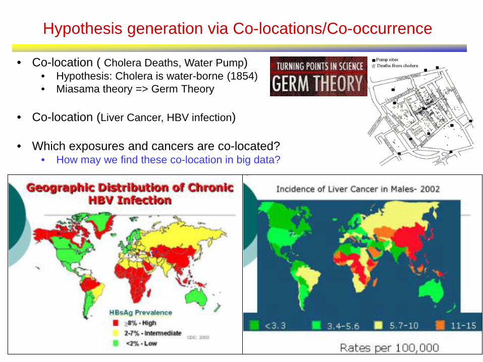
Hypothesis generation via Co-locations/Co-occurrence
• Co-location ( Cholera Deaths, Water Pump) • Hypothesis: Cholera is water-borne (1854) • Miasama theory => Germ Theory
• Co-location (Liver Cancer, HBV infection)
• Which exposures and cancers are co-located?
• How may we find these co-location in big data?

Co-locations/Co-occurrence
• Given: A collection of different types of spatial events
• Find: Co-located subsets of event types
Source: Identifying patterns in spatial information: a survey of methods, Wiley Interdisciplinary Reviews: Data Mining and Knowledge Discovery , 193-214, 1(3), May/June 2011. (DOI: 10.1002/widm.25).

Fast Algorithms to Mine Colocations from Big Data
Participation ratio pr(fi, c) of feature fi in colocation c = {f1, f2, …, fk}: fraction of instances of fi with feature {f1, …, fi-1, fi+1, …, fk} nearby (i.e. within a given distance) Participation index PI( c ) = min{ pr( fi, c ) } Properties: (1) Computational: Non-monotonically decreasing like support measure Allows scaling up to big data via pruning (2) Statistical: Upper bound on Cross-K function Comparison with Ripley’s K-function (Spatial Statistics)
K-function (B A) 2/6 = 0.33 3/6 = 0.5 6/6 = 1 PI (B A) 2/3 = 0.66 1 1
A.1
A.3
B.1
A.2 B.2
A.1
A.3
B.1
A.2 B.2
A.1
A.3
B.1
A.2 B.2

Cascading spatio-temporal pattern (CSTP)
29
Input: Urban Activity Reports Output: CSTP
Partially ordered subsets of ST event types. Located together in space. Occur in stages over time.
Applications: Public Health, Public Safety, …
TimeT1
Assault(A) Drunk Driving (C) Bar Closing(B)
Aggregate(T1,T2,T3) TimeT3 TimeT2
B A
C
CSTP: P1
Source: Identifying patterns in spatial information: a survey of methods, Wiley Interdisciplinary Reviews: Data Mining and Knowledge Discovery , 193-214, 1(3), May/June 2011. (DOI: 10.1002/widm.25).

Outline
• Introduction • GPS • Location Based Services • Spatial Statistics • Spatial Database Management Systems
– Geometry => Spatial Network Databases
• Virtual Globes • Geographic Information Systems • Conclusions
30

Spatial Databases for Geometry
• Dice, Slide, Drill-down, Explore, … – Closest pair( school, pollution-source) – Set based querying
• Reduce Semantic Gap • Clumsy code for inside, distance, … • 6 data-types • Operations: inside, overlap, distance, area, …
• Scale up Performance • Data-structures: B-tree => R-tree • Algorithms: Sorting => Geometric
31

Trend: Spatial Network Databases
32
• Motivation: Urban phenomena • Access to medical facilities • Disparity in access
• Trend: model facility capacities • Graph models to Flow-Networks
• Trend: Network Patterns • (Origin, Destination) pairs • => Frequent Routes
• Trend: Spatio-temporal Networks
(b) Output: Journey- to-Crime (thickness = route popularity)
Source: Crimestat
(a) Input: Pink lines connect crime location & criminal’s
residence

Challenge: Geo-privacy, geo-confidentiality, …
• Emerging personal geo-data – Trajectories of smart phones, gps-devices, life-trajectories and migrations, …
• Privacy: Who gets my data? Who do they give it to? What promises do I get? • Socio-technical problem
– Need government support – Challenges in fitting location privacy into existing privacy constructs (i.e
HIPPA, Gramm-Leach-Bliley, Children's Online Privacy Protection Act) • Groups interested in Geo-Privacy
– Civil Society, Economic Entities, Public Safety ,Policy Makers
http://illumemagazine.com/zine/articleDetail.php?FBI-GPS-Tracking-and-Invasion-of-Privacy-13346
NIH

Outline
• Introduction • GPS • Location Based Services • Spatial Statistics • Spatial Database Management Systems • Virtual Globes & VGI
– Quilt => Time-travel & Depth
• Geographic Information Systems • Conclusions
34

Virtual Globes & Volunteered Geo-Information
• Virtual Globes – Visualize Spatial Distributions, Patterns – Visual drill-down, e.g., fly-through
• Change viewing angle and position • Even with detailed Streetview!
• Volunteered Geo-Information – Allow citizens to make maps & report – Coming to public health! – People’s reporting registry (E. Brokovich) – www.brockovich.com/the-peoples-reporting-registry-map/
35

Opportunities: Time-Travel and Depth in Virtual Globes
• Virtual globes are snapshots
• How to add time? depth? – Ex. Google Timelapse: 260,000 CPU
core-hours for global 29-frame video
• How may one convey provenance, accuracy, age, and data semantics?
• What techniques are needed to integrate and reason about diverse available sources? http://googleblog.blogspot.com/2013/05/a-picture-of-earth-through-time.html

Outline
• Introduction • GPS • Location Based Services • Spatial Statistics • Spatial Database Management Systems • Virtual Globes • Geographic Information Systems
– Geo => Beyond Geo
• Conclusions
37

Geographic Information Systems & Geodesy
• GIS: An umbrella system to – capture, store, manipulate, analyze, manage, and
present diverse geo-data. – SDBMS, LBS, Spatial Statistics, … – Cartography, Map Projections, Terrain, etc.
• Reference Systems – Which countries in North Korea missile range? – 3D Earth surface displayed on 2D plane – Spherical coordinates vs. its planar projections
38 Original Correction
http://odt.org/hdp/

Opportunities: Beyond Geographic Space
• Spaces other than Earth – Challenge: reference frame?
• Ex. Human body – What is Reference frame ?
• Adjust to changes in body • For MRIs, X-rays, etc.
– What map projections? – Define path costs and routes to reach a brain tumor ?
Oliver, Dev, and Daniel J. Steinberger. "From geography to medicine: exploring innerspace via spatial and temporal databases." Advances in Spatial and Temporal Databases. Springer Berlin Heidelberg, 2011. 467-470.
http://convergence.ucsb.edu/issue/14
Outer Space Moon, Mars, Venus, Sun, Exoplanets, Stars, Galaxies
Geographic Terrain, Transportation, Ocean, Mining
Indoors Inside Buildings, Malls, Airports, Stadiums, Hospitals
Human Body Arteries/Veins, Brain, Neuromapping, Genome Mapping
Micro / Nano Silicon Wafers, Materials Science

Outline
• Introduction • GPS • Location Based Services • Spatial Statistics • Spatial Database Management Systems • Virtual Globes • Geographic Information Systems • Conclusions
40

Recommendations
• Spatial Computing has transformed our society – It is only a beginning! – It promises an astonishing array of opportunities in coming decade
• However, these will not materialize without support • Universities
– Institutionalize spatial computing • GIS Centers, a la Computing Centers of the 1960’s
– Incorporate spatial thinking in STEM curriculum • During K-12, For all college STEM students?
• Government – Support spatial computing projects – Large and adventurous projects
• 12+ faculty across multiple universities
42