spatial sustainability in cities organic patterns and sustainable
TRANSCRIPT

Spatial Sustainability in Cities Organic Patterns and Sustainable Forms
Proceedings of the 7th International Space Syntax Symposium Edited by Daniel Koch, Lars Marcus and Jesper Steen, Stockholm: KTH, 2009.
Key-Note 1
K01:1
Bill Hillier University College London [email protected] Abstract Because the complexity of cities seems to defy description, planners and urban designers have always been forced to work with simplified concepts of the city. Drawn from natural language, these concepts emphasize clear hierarchies, regular geometries and the separation of parts from wholes, all seemingly at variance with the less orderly complexity of most real cities. Such concepts are now dominating the debate about sustainability in cities. Here it is argued that space syntax has now brought to light key underlying structures in the city, which have a direct bearing on sustainability in that they seem to show that the spatial form of the self-organised city, as a foreground network of linked centres at all scales set into a background network of mainly residential space, is already a reflection of the relations between environmental, economic and socio-cultural forces, that is between the three domains of sustainability. Evidence that this is so in all three domains is drawn from recent and new research, and a concept of spatial sustainability is proposed focused on the structure of the primary spatial structure of the city, the street network. Introduction: naive descriptions of the city Ever since the planning and design of towns and cities became a recognized arena for human thought, planners and designers have worked with simplified conceptions of the city. Concepts of orderly hierarchies, regularized geometries, and the separation of parts from wholes, have commonly prevailed and been in striking contrast to the seemingly disorderly complexities of real cities. The reasons were perhaps simple. The complexity of real cities seemed to defy description, so descriptions of the city were shaped by the nearest available concepts and terms in common thought, and these were then turned into design and plans for new cities. In 1965, Christopher Alexander offered a luminous critique of such thinking, in particular locating the origins of hierarchical thinking in the nature of human thought and language itself, with its dependence on well defined classes of things ordered in a more or less hierarchical way (Alexander 1965). The Alexander of 1965 saw that the problem of naïve descriptions of the city needed to be circumvented by arriving at descriptions of the city without, or with the minimum, dependence on language, even though his attempt at a general characterisation of the city as a semi-lattice was less than compelling. With this in mind, it was always a primary aim of space syntax to arrive at spatial descriptions of buildings and cities with the minimum intervention of linguistic concepts. The ultimate model for all such endeavours is of course Euclid, who made the first sciences possible by freeing the descript-tion of geometric forms from linguistic baggage and substituting purely formal terms with minimal – and so clearly definable - meanings. In this sense space syntax always aimed to be in the first instance a theory of description for the spatial forms of buildings and cities. It aimed to be able to describe, compare and relate the differences between spatial patterns with the minimum of terms with the minimum of meaning. We often described this project as that of making the city and the building speak, rather than speaking on their behalf as we felt other theories had done. We were aiming at what we might call internally derived, rather than externally imposed, descriptions. In the case of cities, one of the principal drivers of the quest for internally derived descriptions was the expectation that they would, through these descriptions, reveal themselves to be (as Alexander

Proceedings of the 7th International Space Syntax Symposium Edited by Daniel Koch, Lars Marcus and Jesper Steen, Stockholm: KTH, 2009. K01:2
and, before him, Jane Jacobs (Jacobs 1959)) had believed, not disorderly, but orderly complexity, perhaps of a kind more intricate than could be described with language-based descriptions. Cities all over the world, after all, had a great deal in common, physically and spatially. All were essentially islands of outward facing buildings linked by networks of linear spaces, and animated by functional differentiations through which everything seemed somehow to be in the right place. A simply formula of some kind, it seemed, underlay much of the surface complexity of cities, but, with growth, the simplicity gives rise to emergent spatial and functional patterns which were far from simple. It was this emergent complexity that needed to be captured by structural descriptions. We believe that through the efforts of the many scholars and researchers (for a review see Hillier 2008) who have contributed to and made use of its methods, not least of course the generous hosts of this Symposium, space syntax has now gone a long way to achieving this aim by bringing to light something like deep structures - in more or less the twentieth century meaning of the term - underlying the real complexity of cities. The concept of structure is central to syntax, maybe its distinguishing mark. Many other recent attempts to address the complexity of the city in a formal way have taken the form of statistical descriptions, describing the distribution of spatial or functional properties of cities, but in abstract statistical space rather than real space. By definition this omits how elements with these properties connect to each other in real space, and so omits any detailed account of the internal structure of the system. But by developing forms of analysis which show how things are connected together to form local and global patterns, syntax has brought to light structures underlying the complexity of cities, which suggest that cities have universal, as well as culturally determined spatial features, which play a strong role both in embodying and reproducing the underlying social and economic patterns in cities and in driving the evolution of functional complexity in the system.
Spatial sustainability The aim of this paper is to suggest that syntactic concepts of structure now need to be brought much more explicitly to bear on the key problem of the twenty-first century city, that of sustainability. This will be done by proposing a new concept of spatial sustainability focused on the geometric and configurational ordering of space in the city. The notion of spatial sustainability has of course made its appearance before as an explicit concept in the urban literature, but in the main either through regional studies of the spatial distribution of economic and related activity (for example, Grazi et al 2009) or, more commonly, through the concept of the ecological footprint of cities (Rees and Wackernagel 1996), in studies which typically show that the ecological demand that a city makes on land area is much greater than the area of the city itself. The concept has been widely criticised (notably the recent Fiala 2008), but from the point of view of cities, ecological footprint studies are essentially about population and living standards rather than about the spatial form of cities, since it is widely acknowledged that the population of a city living with the same style and standard of living under dispersed spatial conditions would have an even larger footprint. As an implicit concept, the idea that some spatial forms are more sustainable than other of course underlies much of the work for and against density and compactness in cities (for example Jencks 1996, Rogers & Gumuchdjian 1997). But with the exceptions of Batty (Batty 2008) and Marshall (Marshall 2005), and of course Jacobs herself, what has not been suggested is that some generic ways of arranging the primary spatial structure of the city, that is its street network, might be more sustainable than others. The aim of this paper is to show a range of evidence that this may be the case, but that these spatial properties of cities are largely concealed by language-based styles of description, and only come to light through the more intricate understanding of the deep structures of cities, local and global, that is possible through space syntax. As things are, naïve descriptions of space, with the full conceptual panoply of simple hierarchies, , repetitive geometric forms, and separation of parts, continue, in our view, to obstruct and obscure a much needed debate on the contribution that the form of spatial networks in the city can make to sustainability. The root source of the belief that syntactic concepts of structure need to be brought to bear on sustainability, lies in the fact that kinds of structure brought to light by syntax seem already to be the product of interaction between environmental, economic and social factors, that is, between the three principal domains of sustainability. More precisely, the dual generic form of the city

Proceedings of the 7th International Space Syntax Symposium Edited by Daniel Koch, Lars Marcus and Jesper Steen, Stockholm: KTH, 2009. K01:3
brought to light by syntax, as a foreground network of linked centres at all scales set into a background network of largely residential space, seems already to be created by the interaction of economic and social factors, against a background of the minimisation of the energy required for movement through the creation of what we might call general accessibility, that is the accessibility of all points in the system to and from all others. This raises the possibility that the generic spatial form of the self-organised city may in and of itself contribute to sustainability. If this is to any degree the case, then an understanding of the spatial complexity of real cities seems to be the required first step in understanding their spatial sustainability. The belief that self-organised cities may in themselves have sustainability virtues has been encouraged recently by some intriguing figure about London, in many ways an archetypal self-organised city. For example, against a background in which London has been steadily increasing in wealth, the National Travel Survey of 2006 showed that between 1998-2000 and 2006 the number of cars to which each individual had access fell in London from .49 to .44. In all other areas it increased, for example from .55 to .61 in ‘large urban areas’, from .65 to .67 in ‘small urban areas’ and from .72 to .80 in ‘rural areas’. Since 1996-7 the average has increased from .54 cars per adult to .61.and in 1985-6 it was .42, similar to the current figure for London. It was also reported in Social Trends that while cars belonging to households in rural areas in Great Britain travelled an average of 16,494 kilometres in 2005, compared with 13,597 kilometres in metropolitan areas, cars belonging to households in London travelled only 11,612 kilometres. It was also reported in a recent study of London’s high streets that the great majority of local residents walked or used public transport to get to their high street – very few drove. A substantial proportion of people coming from further afield used public transport (Jones, Roberts & Morris 2007). Since London has grown richer in recent decades, and since these trends run against those usually associated with increasing wealth, we must ask why London is moving in this direction. One possibility is that London’s spatial and functional morphology as a system of ‘urban villages’ is somehow implicated. The form of the paper will be as follows. Because many of the critical structural insights into cities have come from the use of the DepthMap software, a brief resume of DepthMap and how it works and what it does in the spatial analysis of cities will be presented. The generic picture of city structures that have been brought to light by DepthMap will then be reviewed, and it will be argued that two new concepts are necessary to describe these. The first is pervasive centrality, meaning that the function of centrality in cities pervades the urban grid in a more intricate way than has been thought, and that multi scale centrality should be seen as a pervasive function in cities, with clear spatial correlates, and not simply as a hierarchy of locations. The second is the concept of fuzzy boundaries (as set out in Hillier et al 2007), meaning that urban areas are created through spatial differentiation, so maintaining inter-accessibility between areas, rather than through well-defined boundaries which limit inter-accessibility. Both pervasive centrality and fuzzy boundaries are, it will be argued, in principle naturally sustainable forms relating economic and social activity to space in a way which minimises travel distances. We then review some recent studies which throw more light first on the interaction between spatial and economic factors in the generic spatial patterning of cities, and second on the interaction between spatial and social factors, all pointing in the direction of the sustainability properties of self-organised cities. A brief review of DepthMap The basic element in DepthMap is the street segment between intersections. DepthMap generates this automatically from a least line, or axial, map, and Space Syntax Limited has now developed algorithms to derive it from road centre line data (allowing whole regions, or even whole countries to me modelled). DepthMap allows 3 definitions of the distance between each segment and each of its neighbours: metric, that is the distance in metres between the centre of a segment and the centre of a neighbouring segment; topological, assigning a value of 1 if there is a change of direction between a segment and a neighbouring segment, and 0 if not; and geometric - assigning the degree of the angular change of direction between a segment and a neighbour, so straight connected are 0-valued and a line is a sequence of 0-valued connections, so that the linear structure of cities is captured. It then uses these 3 concepts of distance to calculate two kind of

Proceedings of the 7th International Space Syntax Symposium Edited by Daniel Koch, Lars Marcus and Jesper Steen, Stockholm: KTH, 2009. K01:4
measure: syntactic integration, or mathematical closeness, which measures how close each segment is to all others under each definition of distance; and syntactic choice or mathematical betweenness, which calculates how many distance-minimising paths between every pair of segments each segment lies on under different definitions of distance. So using the metric definition of distance we find the system of shortest path maps for integration and choice, with the topological definition we find the system of fewest turns maps, and with the geometrical definition we find the system of least angle change maps. Each of the 6 measures (2 measures with 3 definitions of distance) can then be applied with the 3 definitions of distance used as definitions of the radius at which the measures can be applied, giving a total of 18 measures, which can of course be applied at any radius, so yielding a potentially very large set of possible measures - for example least angle change choice at a metric radius of 800 metres – which would be infinite if we count the smallest variation in metric radius. We increasingly think of integration as measuring the to-movement potential of a segment as a destination, since the measure describes its accessibility or how easy it is to get to from all other segments; and of choice as measuring the through-movement potential since the measure describes how likely you are to pass through the segment on trips, and so its potential as a route, from all segments to all others. Since the selection of a destination and the selection of a route are the two prime components of any trip, we have then a well-grounded set of techniques for identifying movement related structural patterns in cities, and looking for functional correlates. In fact, using this panoply of measures, it was quickly possible to show that human movement followed least angle change paths and not shortest paths (the most likely explanation being that people use an angular geometric model of their environment to calculate distances), so the least angle change definition of distance is the default setting in DepthMap (Hillier & Iida 2005). Large numbers of studies have failed to suggest any reason why this should be changed. Similarly, metric radii have been shown again and again to be the most effective radius settings, with analyses typically being run across a range of metric radii, typically 250, 500, 750, 1000, 1250, 1500, 2000, 2500, 3000, 4000, 5000, 7500, 10000, 15000, 20000 metres and so on. So the standard measures used in DepthMap based studies are least angle integration and choice measures at variable metric radii. DepthMap also allows the weighting of segment by their length. So, for example, with the choice measure, a long segment with many buildings would generate and receive more movement than a short segment with few buildings, so the measure for the segment can be weighted by the products of the lengths of each origin-destination pair used in the calculation. In general, least angle measures with variable metric radii bring to light linear structures in the city, while metric measures with metric radii show the kind of area patchwork presented first at the Istanbul Symposium (Hillier, Turner, Yang & Park 2007).
Pervasive centrality The urban structures brought to light by DepthMap, using the usual space syntax technique of colour banding values from red to blue, resemble those produced by least line, or axial, analysis, but are always more detailed and penetrate farther into the different parts of the system. Also vary-ing the metric radius tends to identify more intricate local structures than was possible with the line based technology. The most generic urban structure that is brought into view by DepthMap shows that cities in general, as we have said, take a generic dual form: that of a foreground network of linked centres at all scales, from a couple of shops and a café at the smallest scale to whole sub-cities at the largest, all set into a background network of mainly residential space, Figure 1. The foreground network is made up of a relatively small number of longer lines, connected at their ends by open angles, and forming a super-ordinate structure within which we find the background network, made up of much larger numbers of shorter lines, which tend to intersect each other and be connected at their ends by near right angles, and form local grid like clusters. Least angle choice measures will normally identify the foreground network, as in Figure 1, and do so at different scales by varying the metric radius of the measures. For example, at radius n, choice identifies the main structure of global routes in London, and we can set this alongside Mike Batty’s remarkable map of the 168 largest centres in London, Figure 2. At a radius of 750 metres, Figure 3, however, the same analysis identifies a much more localized network of small London

Proceedings of the 7th International Space Syntax Symposium Edited by Daniel Koch, Lars Marcus and Jesper Steen, Stockholm: KTH, 2009. K01:5
‘villages’, most of which do not feature on the larger scale map. There are up to ten times as many of these small scale centres as large scaled centres. Patterns like this are not confined to London, or even to ‘organic; cities like London. On the contrary, something like this pattern in which centrality is diffused everywhere in the system, is found in most cities.
10000m
Figure 1 The foreground network
Figure 2 & 3 (2 – left) Batty’s map of London’s centres; (3 – right) ‘localized villages’ in London at radius 750m.

Proceedings of the 7th International Space Syntax Symposium Edited by Daniel Koch, Lars Marcus and Jesper Steen, Stockholm: KTH, 2009. K01:6
For example, in a recent study of the ancient but now rapidly growing city of Suzhou in the Jiangsu province of China, carried out in collaboration with the China Academy for Urban Planning and Design, it was shown that even in the ancient regular grid of the historic central areas, as well as the more recently grown strongly gridded areas, varying the radius of the choice measure picked out the organic centres which had emerged in the grid (see figure 4 on the following page). In each case, it is possible to identify a segment with a significantly higher value than others, so it seems likely that these segments may be acted as local ‘seeds’ for the development of the centre. Even in Brasilia, we argue that an approximation of this emergent pattern can be found. At a radius of 5000 metres, choice identifies the 11 kilometre long one sided shopping streets which emerged in the early years of the city, and at 1600 metres virtually all the local centres which emerges when the services road for the designed superblock shops were turned round to form a local high street are picked out. In this sense, even Brasilia is emerging as an organic city! We believe that this intricate pattern of centres at all scales is potentially a vital component of spatial sustainability, for the very simple reason that it means that wherever you are you are close to a small local centre and not far from a much larger one. This is not just a matter of distance, but of what we have called the intelligible distance created by the angular structure of the network: centres fit into the natural pattern of movement in the area at different scales, and so each centre will be part of a natural movement pattern at a certain scale, so we can then expect to relate to the scale of the centre itself. It is this pattern that we believe should be called pervasive centrality, meaning that the function of centrality pervades the urban grid in a far more intricate way than has been thought, through, for example, notions of polycentricity. Emergent multi-scale centrality should be seen as a pervasive function in cities, with clear spatial correlates, and not simply as a hierarchy of locations. What appears to be a multi-scale pattern of linked centres arises in cities through a well-defined process of self-organisation, based on the relationship between the grid structure and movement at all scales. What then is this process like? Pervasive centrality: a sketch for a theory Pre-DepthMap studies of centres (as reviewed in Hillier 1999) had suggested that centres had two crucial properties: they formed in the urban grid where there was a co-incidence of global and local factors; and while the global factors were topo-geometric and could be identified by axial (and now of course by least angle) analysis, local factors were metric factors such as the reduction in the scale of the grid which we called grid intensification. Grid intensification was seen to play a double role, first in creating easy accessibility to higher number of local dwelling, so this could sometimes be the factor that sparked the development of a centre, and then, as private uses turned into more public uses, e.g. houses became shops, in creating the high degree of inter-accessibility necessary for a centre to act as a location for inter-dependent activities. In the light of this earlier work and the more recent studies using DepthMap we can suggest there is a generic process of centre formation on something like the following lines. Every centre has a centre. It starts with a spatial seed, usually an intersection, but it can be a segment. The seed of a centre will have destination and route values at both local and global levels. Some – usually small - centres start because they are the focus of a local intensified grid – a local case – others because they are at an important intersection – a global case. Both global and local properties are relevant to how centres form and evolve. The spatial values of the seed for the centre will establish what we can call a fading distance from the seed which defines the distance from the seed up to which e.g. shops will be viable. This is a function of metric distance from the seed proportionate to the strength of the seed. The centre will grow beyond the fading distance established by the initial seed to the degree that further seeds appear within the fading distance, which reinforce the original seed. Again these can be local or global, and stronger or weaker. A centre becomes larger to the degree that it is reinforced by what are, in effect, new seeds created by the grid which allow the shopping to be continuous. Centres then expand in two ways: linearly and convexly. Linear expansion, the most common case, will be along a single alignment or two intersecting alignments, and occurs when the reinfor-cers are more or less orthogonal or up to 45 degrees to the original alignment or alignments. Convex expansion will be when the shopping streets form a localised grid, and this occur when

Proceedings of the 7th International Space Syntax Symposium Edited by Daniel Koch, Lars Marcus and Jesper Steen, Stockholm: KTH, 2009. K01:7
1000m
Figure 4a Suzhou Region. At radius 7500, it picks out the cluster below the intersection of Gan Jiang Avenue and Ren Min Avenue and its continuation southwards
1000m
1000m 1000m
Figure 4b (top right) At radius-n – the whole Suzhou region – the North- south alignment is secondary and fades as it goes north; (bottom left) At radius 5000 metres, however, the whole alignment becomes on of the strongest in Suzhou. However, the northern end, where main cluster is found, is weaker; (bottom right) at radius 3000, the main alignment fades, and the northern end of the line, where the centre is, becomes one of the strongest lines in the whole of Suzhou. It is the combination of local and global strength that creased the centre in that location

Proceedings of the 7th International Space Syntax Symposium Edited by Daniel Koch, Lars Marcus and Jesper Steen, Stockholm: KTH, 2009. K01:8
reinforcers occur on the parallel as well as the orthogonal alignment. So centres vary in the strength of their local and global properties and reinforcers, and the balance between them will tend to define the nature of the centre. Most centres will be in some sense strong in both in local and global terms, but differences in the balance between local and global will be influential in generating the scale and character of the centre. Centres also grow or fail through interaction with neighbouring centres at different scales, and some potential locations for centre fail to be realised due to the existence of centre close by, but the way in which the urban grid evolves tends to ensure that seeds for potential centres occur only at certain distances from each other. The foreground and background networks This process by which the pattern of pervasive centrality evolves in cities is essentially a process in the foreground network, though it occurs at all scales and at every scale interacts with the structure of the background network, not least of course through the presence of such properties as grid intensification and local reinforcers. But how the foreground network relates to the background net-work creates perhaps the most significant interface in the system, that between the high movement potential, high activity foreground network and the – by definition – lower movement potential, lower activity, mainly residential background network. Again we find generic spatial patterns. The most common follows a simple principle: that the relations to ambient centres around the area form a dominant multidirectional structure within the area, often approximating something like the familiar ‘deformed wheel’ pattern, reflected in syntactic values, and sometimes generating an even smaller scale centre within the area. This local structure has implications. It means that movement within the area is structured in the main by the edge to centre relations which are syntactically the strongest, and these will also structure movement within the areas, giving rise to pattern we have called the shallow core, which maximises co-presence between those moving with the system and those mov-ing in and out of the system. This pattern means that the relative segregation of the residential area is in fact quite marginal, and does not generate the catastrophic fall in movement rates found, for example, in many housing estates (Hillier 1996). It also means that the spatial efficiencies of the fore-ground network in creating ease of movement are also found in the background network. Most significantly, it suggests areas are structured first and foremost by space, and only secondarily by clearly defined boundaries or discontinuities. This reminds us that there is another sense in which syntactic studies have recently shown how urban areas can be identified spatially, though these do not necessarily correspond to the background areas we have been discussing. These were the three studies (Dalton 2007, Yang 2007, Hillier et al 2007), all presented at the Istanbul Symposium, each of which showed a way of measuring urban spatial networks in such a way as to identify, not the familiar linear structures in space, as most angular measures do, but a patchwork of areas, with the scale of the patches varying with the radius of the measure. Each type of patchwork suggested that cities self-organise into something like natural spatial areas at different scales in cities, and that an identifiable pattern of area-isation can be created through spatial differentiation rather than through clear well-defined boundaries, suggesting that the formation of spatially and functionally identifiable areas can be reconciled to grid continuity and integration, again to the benefit of sustainable patterns of inter-accessibility in cities. Both types of area study show the subtle role that space can play in creating area structures. It can then be argued that both components of the dual structure of cities, the foreground network at its pattern of linked centres at all scales, and the spatial patchwork of areas at different scale, are both component of a locally and globally efficient system of inter-related to- and throughmovement potentials, whose prima facie sustainability properties deserve further investigation. But these further investigations should set out from what syntax has brought to light and not retreat into language-based simplifications based on hierarchies, simple geometries, and spatially discrete areas. The spatial geometry and configurational properties by which this apparently sustainable pattern is achieved are complex and need to be better understood from the point of view of the optimisation of movement potentials in a functionally differentiated spatial network. There seem in principle then to be some relation between the structure of the dual network of cities and environmental sustainability, seeing this in terms of the minimisation of the energy needed for useful movement in the system. However, if we look more closely at the self-organising process

Proceedings of the 7th International Space Syntax Symposium Edited by Daniel Koch, Lars Marcus and Jesper Steen, Stockholm: KTH, 2009. K01:9
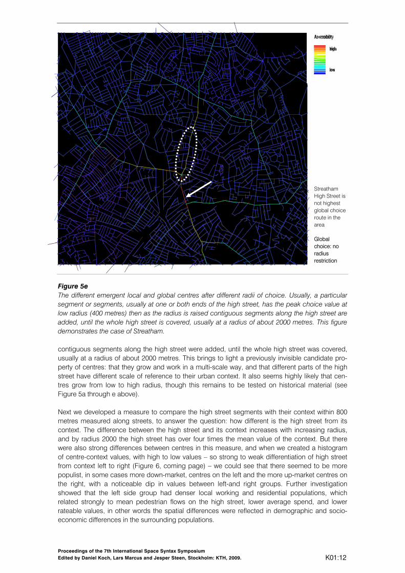
through which the structure emerges, we find that, as has been argued in previous papers the creation of the foreground network is shaped by micro-economic factors in that economic activity will always seek to maximise the global reach of spaces and the flows through them, while the formation of – geometrically and syntactically very different – background network is shaped by social and cultural factors which seek to modulate and structure movement rather than maximise it (Hillier & Vaughan 2007. This means in effect that creation of the dual network form of cities emerges from the interaction between economic and social factors against a general background of optimising movement efficiency. In this sense we can say that the generic form of cities is already the product of interaction between all three kinds of sustainability: the environmental, the economic and the social. It is time to understand this better. We now turn to recent studies which have sought to clarify aspects of this dual structure in more detail, looking first at the foreground network and seeking to understand the relevance of its spatial dimension to economic sustainability. Then we turn to the residential background to explore any possible role that space may play in social sustainability.. The foreground network and economic sustainability A recent series of studies, carried out as part of the UK Urban Buzz programme aimed at making links between universities and other agencies in creating sustainable communities, set out to link economic value to spatial layout using the techniques of space syntax. The particular study was called iValul, and, under the leadership of Alain Chiaradia of Space Syntax Limited (who will present the findings of this study more fully in another session) one of its studies was of ten high street centres in London to see how far spatial factors could be identified as playing a part in the economic value of centres. The centres were Tooting, Walworth, Streatham, Kilburn, West Ealing, Chiswick, Clapham, North Fichley, Swiss Cottage and Hampstead. To the degree that centres had consistent spatial properties that distinguished them from the non-centre parts of the grid, then it would be likely that these properties would be linked to the economic functioning and so potentially to economic sustainability. Since the ten high streets were predominantly linear, the first thing we did was to make spatial network comparisons between the active high street line with an equal length of the continuation of the high street in the foreground network at both ends (in some cases where this was not feasible, one end) in the expectation that the high street section would have distinct spatial properties. If it did not, then it would suggest that centres could occur anywhere, or at least anywhere in the foreground network, and that there were not spatial correlates to centrality. All the measures were made on the basis of the same map of London within the M25. The first measure on which we compared the centre and non centres was the simplest: mean segment length. The theoretical expectation was that centre segments would be smaller. What surprised us was the degree and consistency with which this turned out to be the case. In every case, the centre segments were smaller than the non-centre segments, and by an average of over 40%. This suggests strongly that a locally intensified grid is a key dimension of centres which emerges from self-organisation. A related expectation was (because choice would reflect a greater local density of segments) that centre segments would have on average higher local, but not global, choice values. Again this turned out to be true to a remarkable degree. At a radius of 300 metres, centres had on average 72% higher choice values than non-centre, and that this fell to 29% by radius 800, 12% by radius 2000 and disappeared completely at radius n, where the values of centre and non-centre segment in the foreground network are more or less the same. A similar result was found for integration, with strong differences for local radii, but diminishing with increasing radius. This seemed to show unequivocally that it is the coincidence of global and local properties that leads to the formation of a centre. An even more remarkable consistency was found when we look just at the segments making up the centre. In each case, a particular segment or segments, usually at one or both ends of the high street, had the peak choice value at low radius (400 metres) then as the radius was raised

Proceedings of the 7th International Space Syntax Symposium Edited by Daniel Koch, Lars Marcus and Jesper Steen, Stockholm: KTH, 2009. K01:10
Figure 5a and b
Local Choice R400 Local centre starts at southern end of Streatham High Street
…. and shifts gradually to the North towards a more global radius Local choice R800
458
3379

Proceedings of the 7th International Space Syntax Symposium Edited by Daniel Koch, Lars Marcus and Jesper Steen, Stockholm: KTH, 2009. K01:11
Figure 5c and d
Choice R1200 …. and shifts gradually to the North towards a more global radius
The best fitting radius with the retail definition of the high street is R1400. Choice R1400
11235
15900
Proceedings of the 7th International Space Syntax Symposium Edited by Daniel Koch, Lars Marcus and Jesper Steen, Stockholm: KTH, 2009. K01:12
Figure 5e The different emergent local and global centres after different radii of choice. Usually, a particular segment or segments, usually at one or both ends of the high street, has the peak choice value at low radius (400 metres) then as the radius is raised contiguous segments along the high street are added, until the whole high street is covered, usually at a radius of about 2000 metres. This figure demonstrates the case of Streatham. contiguous segments along the high street were added, until the whole high street was covered, usually at a radius of about 2000 metres. This brings to light a previously invisible candidate pro-perty of centres: that they grow and work in a multi-scale way, and that different parts of the high street have different scale of reference to their urban context. It also seems highly likely that cen-tres grow from low to high radius, though this remains to be tested on historical material (see Figure 5a through e above). Next we developed a measure to compare the high street segments with their context within 800 metres measured along streets, to answer the question: how different is the high street from its context. The difference between the high street and its context increases with increasing radius, and by radius 2000 the high street has over four times the mean value of the context. But there were also strong differences between centres in this measure, and when we created a histogram of centre-context values, with high to low values – so strong to weak differentiation of high street from context left to right (Figure 6, coming page) – we could see that there seemed to be more populist, in some cases more down-market, centres on the left and the more up-market centres on the right, with a noticeable dip in values between left-and right groups. Further investigation showed that the left side group had denser local working and residential populations, which related strongly to mean pedestrian flows on the high street, lower average spend, and lower rateable values, in other words the spatial differences were reflected in demographic and socio-economic differences in the surrounding populations.
Streatham High Street is not highest global choice route in the area Global choice: no radius restriction

Proceedings of the 7th International Space Syntax Symposium Edited by Daniel Koch, Lars Marcus and Jesper Steen, Stockholm: KTH, 2009. K01:13
Centre - Context CHOICE R2000
Toot
ing
Wal
wor
th R
oad
Stre
atha
m
Kilb
urn
Wes
t Eal
ing
Chi
swic
k
Cla
pham
Nor
th F
inch
ley
Sw
iss
Cot
tage
Ham
pste
ad
0
1
2
3
4
5
6
2.397 .609 .193 10 1.643 3.339 03.230 .696 .220 10 2.539 4.543 04.356 .903 .286 10 3.019 5.584 0
Mean Std. Dev. Std. Error Count Minimum Maximum # MissingCC/ped800segA400avgCC/ped800segA800avgCC/ped800segA2000avg
Descriptive Statistics
Figure 6 (above) If we plot centres from high to low on the centre-context measure, we find a discontinuity around 4.5; (below) the ratio between the spatial values of the segments in the centre and their context in different radii. In all cases the centre segments are sharply distinguished from their surrounding context. The difference increases with increasing radius. So it was clear that from the point of view of the relation between economic factors and space, the centres were not exactly falling into types, but arranging themselves on a spectrum from something like popular to selective, with the popular ones on more significant routes in and out of London and the selective ones on less significant routes. The ‘popular’ centres were more sharply distinguished from context on choice, had higher local population and employment densities, and so higher rates of pedestrian activity, had larger and less street oriented shops with economic success coming from numbers rather than affluence, while the more selective centres were more part of their context on choice, had lower local population and employment densities and lower – through still strong – rates of pedestrian activity, and had smaller more street oriented shops and success came more from high value and local affluence. In this range of cases, then, we see that space interacts with micro-economic activity in a very specific, but not uniform, way. In each case, centres locate and organises themselves spatially in such a way as to create a natural relationship between movement to and around the centre and the wider patterns of movement in the area. Centres in effect exploit and develop spatial potentials for both to-movement and through-movement already inherent in the urban grid, and do so across scales. These spatial factors are not simply a matter of metric distance, although they are also this locally, but have to do with the ways in which space is configured geometrically and syntactically to create patterns of movement. We could think of these multi-scale properties of centres as embeddedness. Centres are attractors in the urban grid, but if a centre is an embedded attractor, it will have additional potentials to act as an economic focus in its area. The properties that make up embeddedness then seem prima facie to be exactly those that contribute to spatial sustainability and it is these that we should be further investigating. But again with a caveat. The geometrical and configurational properties that make up embedded-ness are difficult to see with the naked eye, and even harder to describe in the naïve urban
Proceedings of the 7th International Space Syntax Symposium Edited by Daniel Koch, Lars Marcus and Jesper Steen, Stockholm: KTH, 2009. K01:14
language of hierarchies, regular geometries and separated parts – indeed such language would almost certainly misrepresent them. The most critical relations are those that related the internal structure of the centre to its local and global context. It has taken syntactic analysis to bring these into the light of day, and it is difficult to see how further progress, either in research or design, can be made if we retreat from the subtle precision that syntax brings to urban spatial analysis. Indeed some of the most vital properties are expressed as what we might call necessary measurements reflecting necessary precision. We should not expect that this degree of analytic or design precision could be retained if we retreat into the old language based descriptions. Constructive and emergent variables
5000m
Figure 7
5000m
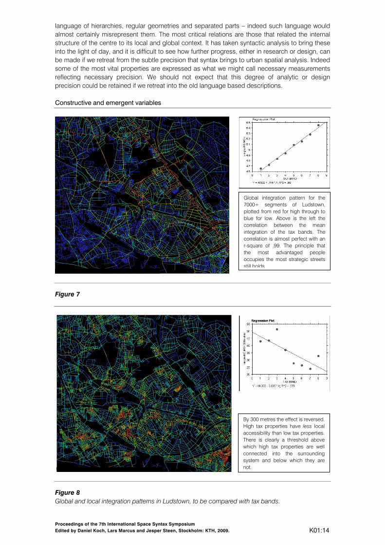
Figure 8 Global and local integration patterns in Ludstown, to be compared with tax bands.
Global integration pattern for the 7000+ segments of Ludstown, plotted from red for high through to blue for low. Above is the left the correlation between the mean integration of the tax bands. The correlation is almost perfect with an r-square of .99. The principle that the most advantaged people occupies the most strategic streets still holds.
By 300 metres the effect is reversed. High tax properties have less local accessibility than low tax properties. There is clearly a threshold above which high tax properties are well connected into the surrounding system and below which they are not.
Proceedings of the 7th International Space Syntax Symposium Edited by Daniel Koch, Lars Marcus and Jesper Steen, Stockholm: KTH, 2009. K01:15
We now turn to the background network of mainly residential space, and ask if there too, the social sustainability we seek there might have spatial correlates? But before we do this, we must address an interesting question. Why is choice the critical measure in the emergence of centres and will it be so for residential areas. As we will see, it is not. In residential areas integration seems to be the key variable. Why should this be? Light was thrown on this by another Urban Buzz iValul study (again under the leadership of Alain Chiaradia, who will again present a fuller version of this research in another session) on the relationship between space and property values as indexed by the ‘Council Tax Band’, a UK local tax tied to property values. This showed a completely unexpected linear relation between mean Council Tax Band and radius-n integration, Figure 7, with a much weaker, thought still positive relation with choice. This did not mean of course that the highest value properties were on the foreground network, as was the case a century ago when Booth made his economic map of London, since in the areas studied there was relatively little residence of any kind. What it did mean was that high value properties were to be found on the principle roads in the residential background, with a step by step diminution in values with decreasing prominence. At the same time, with reducing radius the relationship between integration and value became steadily weaker and at low radii was strongly reversed, showing that high value property was globally integrated but locally relatively segregated, Figure 8. There is clearly a threshold above which high tax properties are well connected into the surrounding system and below which they are not. It also means that high tax properties are not found in the kind of broken up small scale layouts associated with most social housing estates. On the contrary, high tax properties are strongly associated with larger block layouts. Why then is the economic value of residential property linked to integration and that of centres with choice. We believe that there is a critical difference between the two variables. Integration is an intuitable variable in that it is possible to intuit with reasonable accuracy how integrated a space is. The mind can construct a kind of imaginary j-graph from a space, and almost visualise the depth relation of the root space to others. Choice is not an intuitable in this sense, since the degree to which a space lies on paths between remote locations is remote from intuition. The effects of choice become clear only when the system is created and movement patterns can be experienced. We might then reasonably see integration as a constructive variable – we construct the environment with the integration-segrega-tion dimension in mind – while choice is an emergent variable, and its effects are discovered through the changes it engenders in the environment as time goes by. So we create the residential pattern using the intuition of integration, but the emergent effects of choice become clear only when it shapes the emergence of centres. As we will see, integration was the critical variable is the studies of the residential background that follow.
The background network and social sustainability What then of social sustainability in the background network of mainly residential space. The idea that space might play a role in social sustainability has usually been conceptualised in terms of the intervening variable of community formation. If space can in some sense support community formation, then it can play not only a positive role in creating social sustainability, but also as a direct consequence play a role in the reduction of crime and anti-social behaviour. Within this paradigm – for such it seems to be – the assumption has usually been that smaller spatial group-ing are more likely to form communities than larger ones, hence a pervasive preference for small scale spaces and groupings rather than for large ‘impersonal’ ones. Recently published research reporting a large scale study of nearly 20000 residential burglaries and street crimes over five years in a London borough with a population of over a quarter of a million suggested that both key elements of this paradigm – the community element and the scale element – may be wrong. (Hillier & Sahbaz 2008) In this study, it was shown with remarkable consistency that not only were higher ground level densities associated with lower rates of residential burglary, but also that the larger the number of inter-visible neighbours in a space, whether on a street segment or cul-de-sac, the lower the rate of both residential burglary and street crime. Higher residential numbers in space were also shown to inhibit the higher rates of crime sometimes found in mixed used areas. These results, showing a general pattern of safety in numbers, often through the strong syntactic constitution of space (dwellings opening on to the space) are so consistent that they suggest that it is the simple presence of people that inhibits

Proceedings of the 7th International Space Syntax Symposium Edited by Daniel Koch, Lars Marcus and Jesper Steen, Stockholm: KTH, 2009. K01:16
crime, without invoking community formation. To use the term suggested in Space is the Machine (Hillier 1996), it seems to be the presence of a strong virtual community that inhibits crime without regard to how interactive that community is.
(a)
(b)
Figure 9 (a) Incident patterns in ‘Street based’ Layouts; (b) Incident patterns in ‘Estate’ Layouts. Recent results from a study of the spatial distribution of anti social behavior in two London boroughs (also to be presented in another session by Eva Friedrich) one inner London and one outer, have provided a remarkable confirmation of this. The study was again part of the Urban Buzz programme under the title SEDUC and the leadership of Professor Alain Brimmicombe of the

Proceedings of the 7th International Space Syntax Symposium Edited by Daniel Koch, Lars Marcus and Jesper Steen, Stockholm: KTH, 2009. K01:17
University of East London. The study covered motor vehicle crime, property damage, drugs, dumping and violence in one borough and vehicle crime, drugs, graffiti, harassment, prostitution, and theft in the other. Both boroughs are a patchwork of two kinds of spatial layout: street-based areas, and housing estates, with the former more prevalent in the outer London borough and the latter in the inner London one. The two types of layout are for the most part easy to distinguish on the map, and where it was less clear other checks were made using Google Earth or a visit. Although we expected very different patterns for different forms of anti-social behaviour, it quickly became clear that there was a remarkable consistency in the pattern of differences between the two kinds of layout. In street based areas (figure 9a), little anti-social behaviour was found in the main body of the residential areas, and the concentrations that could be found were normally at the edges of the housing area in the streets that connected one area to the other, that is, in the foreground network adjoining the residential area, though notably not in the centres themselves but in the links, that is, the parts of the foreground network that lie between the centres. In complete contrast, in the housing estates (figure 9b), far more anti-social behaviour was found in the interior of the estate, often in the deeper more segregated areas remote from building entrances.
Figure 10 Findings: Number of incidents per integrationR800m in Tower Hamlets Because the streets connecting the street based residential areas are, as parts of the foreground network, by definition likely to be more integrated than the main body of the areas which form part of the less integrated background network this difference could be expressed statistically. By using a radius measure of integration as 800 metres radius (experiments showed this captured the differences most clearly), and dividing the constituent spaces of the area into deciles we could then assign counts of incidents to the different deciles and plot the results on a chart (figure 10) in which the number of incidents on the vertical axis and the integration deciles on the horizontal, from least integrated on the left to most on the right. In virtually all cases the peak for housing estates was on the left, more segregated, deciles, with a fall off towards the right, while for street-based areas the peaks were on right, more integrated deciles, with a fall off to the left. In effect, being in the main body of a street based area protects residents from anti-social behaviour, while being in the main body of a housing estate exposes residents to it. There is no clearer demonstration anywhere, as far as we know, of the ability of traditional street based

Proceedings of the 7th International Space Syntax Symposium Edited by Daniel Koch, Lars Marcus and Jesper Steen, Stockholm: KTH, 2009. K01:18
systems to create beneficial social conditions, and we may note again that this effect can be shown without invoking community formation a an intervening variable. The natural inference would be that it is the spatial form of the street system and the strong virtual community it creates that protects against anti-social behaviour (see Hanson and Zako 2007). A fuller account of this work, including a discussion of possible intervening social variables such as relative affluence, can be found in Eva Friedrich’s presentation. Spatial sustainability and the culture of the street Although these results are very preliminary, we can see then that in principle, spatial configuration can play a role in all three domains of sustainability: the environmental, the economic and the social. It would not be an exaggeration to suggest that the generic form of the organic city – and most cities fall into this category – is shaped by the interaction of all three domains and in such a way as to realise all three in a well-ordered way, and one which, if these results are pointing in the right direction, seems to contribute to sustainability in all three. It might even be worth exploring the idea that the intricate spatial form of the organic city may be already, in and of itself, the paradigm exemplar for spatial sustainability in the sense in which we have defined it. These effects from space to sustainability come from what many will find an unexpected place: the detailed micro- and macro-structure of the street network. For most of the twentieth century, street systems were seen by the designers and planners of cities to be too simple and too uniform to be worth creative effort, and too neutral to serve the planners and designers aims of creating new kinds of communities. We see now that both of these assumptions are wrong. The street networks of cities are both complex and subtle, both in their universal properties and cultural variations, and these subtleties and complexities are the means through which economic and social forces find spatial expression in space, with the relation between local and global organisation perhaps the single most critical factors. It was exactly this relation between scales, and by implication the relation between movement and place, that was abandoned by planning and design in the twentieth century, and put in the hand of highway engineers (Marshall 2005). Yet it is the most critical relation of all in the ways in which the city expresses economic and social forces. The failure to see this for most of the twentieth century was first and foremost a failure of methodology: the lack of the means to describe these complexities, and the consequent substitution of naïve language-based descriptions of the city which rendered these complexities invisible. The failure was comprehensive. The whole twentieth century effort to design discrete ‘layouts’ as part of the whole package of design, and to delegate the connecting spaces between areas to the highway engineer, was at fault in principle. Above all, it separated the issue of movement from the creation of places, and as we have seen here, movement is the heart of place. We propose then that the relation between the local and global structure of street networks, in terms of their ability to contribute to environmental, economic and social sustainability, should be the focus of an intensified research effort. We have taken only the first steps along this path. But certain key lessons have been learned, the most important being perhaps that the complex spatial subtleties of the city only reveal themselves to formal analysis of spatial and functional patterns, of the kind made possible – but perhaps not only this kind – by space syntax. It may be hard for some to accept that the key human subtleties of space only reveal themselves through patterns of numbers (albeit translated into colours), but it is the case. To retreat to the naïve form of language based descriptions would be to risk sending the whole research programme down another blind alley. It is also vital to challenge, at every level, the idea that street systems are neutral in terms of human purposes. Space syntax has now showed extensively how space responds to economic and social forces, and how these between them give the city its shape. But there is a more generic way in which street systems express human purposes: through what we might call the universal culture of the street. Historically, street systems have always been the means by which heterogeneous populations were able to co-exist under dense condition, essentially through the mutual surveillance provide by the patterns of constant, though variable, co-presence that arise through movement. This requires

Proceedings of the 7th International Space Syntax Symposium Edited by Daniel Koch, Lars Marcus and Jesper Steen, Stockholm: KTH, 2009. K01:19
the operation of a simple cultural principle. Urban populations are divided by differences of many kinds: statuses, wealth, position, and so on, and these differences find commonly expression within buildings. But in the street all these differences are backgrounded, and everyone is enjoined to be just another individual. It is an extraordinary, though rarely noticed fact, that social differences play no role in the street. In this sense, streets do not reflect society, but act in a contrary sense by putting together in space what society divides. I have argued elsewhere that this can be seen as the profane counterpart of Victor Turner’s communitas where social differences between individuals are wiped out in the transitions to and from ritual. (Turner 1969) The culture of the street, and the structure of the street pattern, is in effect the means to the normal, peaceful co-existence of diverse and dense populations, and this is why the life of the streets seems the most powerful indicator of the presence of civil society. It might even be argument that it is because streets are relatively anonymous in this sense that they can play their role so effectively. The abandonment of the street as the key urban element in the twentieth century was then was then more that abandonment of a form of space. It was the abandonment of the form of life by which cities were most distinguishable from other kind of social existence. The fact that everywhere now the street life of cities seems to be becoming intensified is perhaps the most optimistic sign that the direction of change of cities in the twenty first century will be back in the direction of the universal culture of the street.
References Alexander, C. 1965. A city is not a tree. Architectural Forum, 122, 1: 58-62 (Part I), and 122, 2: 58-
62 (Part II). Batty, M. 2008. The Size, Scale, and Shape of Cities. Science 319: 769-771. Dalton N. 2007. Is neighbourhood measurable? Proceedings of the Sixth International Space
Syntax Symposium, Istanbul. Fiala, N. 2008. Measuring sustainability: Why the ecological footprint is bad economics and bad
environmental science. Ecological Economics, 67, 4: 519-525. Grazi, F., H. Waisman and J. van den Bergh. 2009. Agglomeration economies and spatial
sustaina¬bility. In Climate Change: Global Risks, Challenges and Decisions IOP Publishing, Earth and Environ¬mental Sciences 6.
Hanson, J. and R. Zako. 2007. Comunities of copresence and surveillance: how public open space shapes awareness and behaviour in residential developments. Proceedings of the Sixth International Space Syntax Symposium, Istanbul.
Hillier, B. 1996. Space is the machine. Cambridge UK: Cambridge University Press. E-version UCL and Space Syntax Limited: www.spacesyntax.com
Hillier, B. 2000. Centrality as a process: accounting for attraction inequalities in deformed grids. Urban Design International, 3-4: 107-127.
Hillier, B. and S. Iida. 2005. Network effects and psychological effects: a theory of urban movement. In Cohn, A. and D. Mark (Eds), Spatial Information Theory Lecture Notes in Computer Science 3603, Springer Verlag: 473-490.
Hillier, B. and L. Vaughan, L. 2007. The city as one thing. Progress in Planning, 67 (3): 205-230. A special issue on space syntax research on space as an aspect of social segregation
Vaughan, L. (Ed). 2007. The spatial syntax of urban segregation. Elsevier, Oxford. Hillier, B., A. Turner, T. Yang and H. Park. 2007. Metric and topo-geometric properties of urban
street networks: some convergencies, divergencies and new results. Opening paper for the 6th Space Syntax Symposium, Istanbul 2007. To appear in Journal of Space Syntax Studies.
Hillier, B. 2008. Introduction, to the e-version of Space is the Machine, www.spacesyntax.com Hillier, B. and O. Sahbaz. 2009. Crime and urban de¬sign: an evidence based approach. In
Designing Sustainable Cities, ed. R. Cooper and G. Evans. Jacobs, J. 1961. The Death and Life of the Great American Cities. New York: Random House. Jenks, M., E. Burton, and K. Williams (Eds). 1996. The Compact City: A Sustainable Urban Form?.
London: Spon Press. Jones, P., M. Roberts and L. Morris. 2007. The contribution of local high streets to sustainable
communities. Joseph Rowntree Foundation. Marshall, S. 2005. Streets and Patterns. London: Spon Press.

Proceedings of the 7th International Space Syntax Symposium Edited by Daniel Koch, Lars Marcus and Jesper Steen, Stockholm: KTH, 2009. K01:20
National Travel Survey 2006 http://www.dft.gov.uk/pgr/statistics/datatablespublications/personal/mainresults/nts2006/
Rees, W. and M. Wackernagel. 1996. Urban ecological footprints: why cities cannot be sustainable – and why they are a key to sustainability. Environmental Impact Assessment Review 16: 223-248.
Rogers, R. and P. Gumuchdjian. 1997. Cities for Small Planet. London: Faber and Faber Limited. Social Trends http://www.statistics.gov.uk/socialtrends39/ Turner, V. 1969. The Ritual Process. Aldine (Cornell 1977). Yang, T. 2007. The fuzzy boundary: the spatial definition of urban areas. Proceedings of the Sixth
International Space Syntax Symposium, Istanbul.