special meeting agenda wednesday, june 26, 2013 … · 2015-05-05 · special meeting agenda...
TRANSCRIPT

Santa Cruz County Regional Transportation Commission
Transportation Policy Workshop
SPECIAL MEETING
AGENDA
Wednesday, June 26, 2013 9:00 a.m.
See the last page for details about access for people with disabilities and meeting broadcasts. NOTE
Para información sobre servicios de traducción al español, diríjase a la última página. En Español
To receive email notification when the TPW meeting agenda packet is posted on our website, AGENDAS ONLINE
please call (831) 460-3200 or email [email protected] to subscribe.
COMMISSION MEMBERSHIP Caltrans (ex-officio) Tim Gubbins
City of Capitola Dennis Norton City of Santa Cruz Don Lane City of Scotts Valley Randy Johnson City of Watsonville Eduardo Montesino County of Santa Cruz Greg Caput County of Santa Cruz Neal Coonerty County of Santa Cruz Zach Friend County of Santa Cruz John Leopold County of Santa Cruz Bruce McPherson Santa Cruz Metropolitan Transit District Dene Bustichi Santa Cruz Metropolitan Transit District Ron Graves Santa Cruz Metropolitan Transit District Lynn Robinson
The majority of the Commission constitutes a quorum for the transaction of business.
NOTE LOCATION THIS MONTH SCCRTC Conference Room
1523 Pacific Ave Santa Cruz, CA
TPW Special Meeting Agenda June 26, 2013 2
Article 8 Transportation Development Act Claims – only City and County representatives vote Article 4 Transportation Development Act Claims, Policy Issues, and SAFE – all 12 members vote 1. Introductions
2. Oral communications
Any member of the public may address the Commission for a period not to exceed three minutes on any item within the jurisdiction of the Commission that is not already on the agenda. The Commission will listen to all communication, but in compliance with State law, may not take action on items that are not on the agenda. Speakers are requested to sign the sign-in sheet so that their names can be accurately recorded in the minutes of the meeting.
CONSENT AGENDA
All items appearing on the consent agenda are considered to be minor or non-controversial and will be acted upon in one motion if no member of the RTC or public wishes an item be removed and discussed on the regular agenda. Members of the Commission may raise questions, seek clarification or add directions to Consent Agenda items without removing the item from the Consent Agenda as long as no other Commissioner objects to the change.
3. Approve amendments to the FY 2013-14 Budget and Funding Agreement with
the Association of Monterey Bay Area Governments (Resolution)
4. Approve selection of auditor for fiscal and compliance audit (Resolution)
5. Approve changes to Executive Director’s employment agreement
6. Approve the FY 2013-14 RTC Work Program
REGULAR AGENDA 7. 2014 Metropolitan Transportation Plan (MTP)/Sustainable Communities
Strategy: Scenario Development (George Dondero, Executive Director) a. Report by Heather Adamson of the Association of Monterey Bay Area
Governments (AMBAG) b. MTP-SCS Scenario Descriptions & Placetype Menu c. MTP-SCS Community Workshop Notes – May 2013
8. 2014 Regional Transportation Plan (RTP): Financial Estimates
(Rachel Moriconi, Senior Transportation Planner) a. Staff report b. Draft financial projections
TPW Special Meeting Agenda June 26, 2013 3
9. Scenario Planning for 2014 Transportation Plans – STARS Transportation
Investment Analysis (Ginger Dykaar, Transportation Planner) a. Staff report b. STARS Qualitative Analysis of Transportation Investments in Alternative
Scenarios through 2035
10. 2014 Regional Transportation Plan – updates to draft goals, policies, targets and draft project list (Grace Blakeslee, Transportation Planner) a. Staff report b. Revised draft targets and policies c. Draft Complete Street project list
11. Metropolitan Transportation Plan (MTP) Sustainable Communities Strategy
(SCS) Priorities and Preferences (Karena Pushnik, Senior Transportation Planner) a. Staff report
12. Next meetings
The next SCCRTC meeting is scheduled for Thursday, August 1, 2013 at 9:00 a.m. at the Scotts Valley City Council Chambers, 1 Civic Center Drive, Scotts Valley, CA. The next Transportation Policy Workshop is scheduled for Thursday, August 15, 2013 at 9:00 am at the Watsonville City Council Chambers, 275 Main Street, Suite 400, Watsonville, CA.
HOW TO REACH US Santa Cruz County Regional Transportation Commission 1523 Pacific Avenue, Santa Cruz, CA 95060 phone: (831) 460-3200 / fax (831) 460-3215 Watsonville Office 275 Main Street, Suite 450, Watsonville, CA 95076 (831) 768-8012 email: [email protected] / website: www.sccrtc.org HOW TO STAY INFORMED ABOUT RTC MEETINGS, AGENDAS & NEWS
TPW Special Meeting Agenda June 26, 2013 4
Broadcasts: Many of the meetings are broadcast live. Meetings are cablecast by Community Television of Santa Cruz. Community TV’s channels and schedule can be found online (www.communitytv.org) or by calling (831) 425-8848. Agenda packets: Complete agenda packets are available at the RTC office, on the RTC website (www.sccrtc.org), and at the following public libraries: - Aptos Branch Library - Branciforte Library - Central Branch Library - Scotts Valley Library - Watsonville Library For information regarding library locations and hours, please check online at www.santacruzpl.org or www.watsonville.lib.ca.us. On-line viewing: The SCCRTC encourages the reduction of paper waste and therefore makes meeting materials available online. Those receiving paper agendas may sign up to receive email notification when complete agenda packet materials are posted to our website by sending a request to [email protected]. Agendas are typically posted 5 days prior to each meeting. Newsletters: To sign up for E-News updates on specific SCCRTC projects, go to http://sccrtc.org/about/esubscriptions/. HOW TO REQUEST ACCOMMODATIONS FOR PEOPLE WITH DISABILITIES
The Santa Cruz County Regional Transportation Commission does not discriminate on the basis of disability and no person shall, by reason of a disability, be denied the benefits of its services, programs, or activities. This meeting location is an accessible facility. If you wish to attend this meeting and require special assistance in order to participate, please contact RTC staff at 460-3200 (CRS 800/735-2929) at least three working days in advance of this meeting to make arrangements. People with disabilities may request a copy of the agenda in an alternative format. As a courtesy to those persons affected, Please attend the meeting smoke and scent-free.
SERVICIOS DE TRADUCCIÓN/ TRANSLATION SERVICES
Si gusta estar presente o participar en esta junta de la Comisión Regional de Transporte del Condado de Santa Cruz y necesita información o servicios de traducción al español por favor llame por lo menos con tres días laborables de anticipo al (831) 460-3200 para hacer los arreglos necesarios. (Spanish language translation is available on an as needed basis.) Please make advance arrangements (at least three days in advance) by calling (831) 460-3200.
S:\TPW\TPW 2013\0613 Special Meeting\2013-06-26-tpw-agenda.docx

AGENDA: June 26, 2013
TO: Regional Transportation Commission Transportation Policy Workshop FROM: Luis Pavel Mendez, Deputy Director RE: Amendments to the Fiscal Year (FY) 2013-14 Budget and Funding Agreement
with the Association of Monterey Bay Area Governments RECOMMENDATIONS The Budget and Administration/Personnel (B&A/P) Committee and staff recommend that the Santa Cruz County Regional Transportation Commission (RTC) approve the attached resolution (Attachment 1) amending the FY 2013-14 RTC Budget as shown on Exhibit A to Attachment 1
.
Staff further recommends that the RTC authorize the Executive Director to enter into a funding agreement with the Association of Monterey Bay Area Governments (AMBAG) for the RTC’s contribution for the production of the metropolitan transportation plan (MTP) environmental document. BACKGROUND At its May 2013 meeting, the RTC approved the FY 2013-14 RTC budget with a significant reduction in Federal Highway Administration (FHWA) Planning (PL) funds received through the Association of Monterey Bay Area Governments (AMBAG). RTC staff also communicated that AMBAG requested a contribution from the RTC towards the cost of the environmental impact report (EIR) for the 2014 metropolitan transportation plan (MTP) and that RTC staff would return with a recommendation for that contribution after more discussions with AMBAG. DISCUSSION Contribution for 2014 Metropolitan Transportation Plan EIR The EIR for the MTP also serves as the EIR for the regional transportation plans produced by the RTC and the other regional transportation planning agencies in the AMBAG region. Therefore, the cost has traditionally been shared by AMBAG and the regional transportation planning agencies. Because the amount of FHWA PL funds traditionally provided to the RTC by AMBAG was reduced by $150,000 it is a challenge for the RTC to accommodate that funding reduction and also provide a contribution to AMBAG for the MTP EIR. AMBAG asked for a $75,000 contribution from the RTC toward the cost of the MTP EIR. After discussions with AMBAG, AMBAG reduced its request f to $57,500. RTC staff met with the AMBAG Executive Director and the Santa Cruz METRO General Manager. At that meeting it was determined that the only way to fund a contribution to AMBAG for the MTP EIR was to use anticipated surplus FY 2012-13 Transportation Development Act (TDA) revenues.

Amendments to FY 2013-14 Budget & Funding Agreement with AMBAG Page 2
Currently, the FY 2012-13 TDA revenues are $405,000 above the Santa Cruz County Auditor Controller’s estimate. The RTC budgeted $114,411 of that anticipated surplus to help cover the reduction in FHWA PL funds. There are still sufficient anticipated FY2012-13 TDA surplus revenues to fund a $57,500 contribution for the cost of the MTP EIR. RTC staff, the AMBAG Executive Director and the Santa Cruz METRO General Manager agreed to this approach. TDA Apportionments for Local Jurisdictions Consistent with the RTC rules and regulations and the TDA statute, the RTC apportions TDA funds to the cities and the counties. The apportionments are partly based on the most current population figures. Every year new population figures are released by the State in May. Therefore, the attached budget amendment modifies the TDA apportionments to the cities and the county consistent with the recently released population figures. Funding Agreement with the Association of Monterey Bay Area Governments If the RTC approves the proposed budget amendment to provide a $57,500 contribution to AMBAG for the production of the EIR for the MTP, it will be necessary for the RTC to enter into a funding agreement with AMBAG. The funding agreement would include the other regional transportation planning agencies in the AMBAG region and specify the RTC’s $57,500 contribution and the contributions of the other regional transportation planning agencies. The Transportation Agency for Monterey County (TAMC) would also contribute $57,500 and the Council of San Benito County Governments (SBtCOG) would contribute $20,000. The B&A/P Committee and staff recommend that the RTC approve the attached resolution (Attachment 1) amending FY 2013-14 budget as shown on Exhibit A of Attachment 1.
Staff further recommends that the RTC authorize the Executive Director to enter into a funding agreement with AMBAG for the RTC’s contribution for the production of the MTP environmental document.
SUMMARY In May, the RTC approved the FY 2013-14 budget with a significant reduction in FHWA PL funding from AMBAG and was informed that AMBAG requested a contribution from the RTC toward the cost of the EIR for the MTP. RTC staff met with AMBAG and Santa Cruz METRO staff and it was agreed that the RTC contribution should come from anticipated TDA surplus revenues. The State released new population figures in May and TDA apportionments for local jurisdictions are adjusted consistent with those figures. The B&A/P Committee and staff recommend that the RTC approve the attached resolution (Attachment 1) amending FY 2013-14 budget as shown on Exhibit A of Attachment 1.
Staff also recommends that the RTC authorize the Executive Director to enter into a funding agreement with AMBAG for the RTC’s contribution for the production of the MTP EIR.
1. Proposed amended FY 2013-14 RTC Budget Attachments:
S:\TPW\TPW 2013\0613 Special Meeting\FY1314BudgAmd\FY1314BudgAmd.doc

ATTACHMENT 1
RESOLUTION NO. Adopted by the Santa Cruz County Regional Transportation Commission on the date of June 26, 2013 on the motion of Commissioner duly seconded by Commissioner
A RESOLUTION AMENDING THE FY 2013-14 BUDGET FOR THE REGIONAL TRANSPORTATION COMMISSION AND AUTHORIZING THE EXECUTIVE DIRECTOR TO ENTER INTO A FUNDING AGREEMENT WITH THE ASSOCIATION OF MONTEREY BAY
AREA GOVERNMENTS
WHEREAS, the Santa Cruz County Regional Transportation Commission (RTC) adopts and periodically amends a budget and work program for each fiscal year to guide its expenses and work; and
WHEREAS, the RTC will work with the Association on Monterey Bay Area Governments
(AMBAG) to produce an environmental document for AMBAG’s metropolitan transportation plan and the RTC’s regional transportation plan and the RTC’s FY 2013-14 budget includes $57,500 toward the cost of that environmental document; BE IT RESOLVED BY THE SANTA CRUZ COUNTY REGIONAL TRANSPORTATION COMMISSION:
1. The FY 2013-14 Budget and Work Program for the Santa Cruz County Regional Transportation Commission (RTC) are hereby amended as shown in Exhibit A; and
2. The Executive Director is hereby authorized to enter into a funding agreement with the Association of Monterey Bay Area Governments to provide an RTC funding contribution of $57,500 toward the cost of the environmental document for the 2014 metropolitan transportation plan.
AYES: COMMISSIONERS NOES: COMMISSIONERS ABSTAIN: COMMISSIONERS ABSENT: COMMISSIONERS ______________________________ Neal Coonerty, Chair

ATTEST: ____________________________ George Dondero, Secretary Attachments: Exhibit A - SCCRTC FY 2013-14 Budget as amended Distribution: RTC Fiscal AMBAG S:\RESOLUTI\2013\RES0613\BUDWPAMEND FY13-14.doc

SANTA CRUZ COUNTY REGIONAL TRANSPORTATION COMMISSIONPROJECTED REVENUE SUMMARY
FY 2013-2014 BUDGET
-1-
1 PROJECTED REVENUE SUMMARY2 FY12-13 FY13-143 SOURCES APPROVED PROPOSED DIFFERENCE NOTE4 5/02/13 6/26/135 Transportation Development Act (TDA):6 Auditor's 1/4 Cent Sales Tax Estimate 8,165,852 8,165,852 07 Previous FY Surplus Revenues Budgeted 114,411 171,911 57,500 - for RTC's share of environmental document cost for MTP/RTP8 Interest Estimate 8,000 8,000 09 Total TDA Apportioned 8,288,263 8,345,763 57,500
1011 State Transit Assistance (STA) 2,759,269 2,759,269 012 Planning Grant Funds/Others:13 Rural Planning Assistance (RPA) 316,933 316,933 014 STIP for Planning (PPM) 163,537 163,537 015 RSTP Exchange - Eco Act, CTSC, & Bike Signage 81,024 81,024 016 FHWA - Earmark 180,000 180,000 017 FHWA - Planning (PL) - from AMBAG 100,000 100,000 018 Coastal Conservancy 150,000 150,000 019 New Freedom Grant 165,000 165,000 020 SGC Grant 13,927 13,927 021 Transit intern and planning grants 133,191 133,191 022 Other Revenues 0 0 023 RTC Funds Budgeted 159,074 159,074 024 Planning/Other Total 1,462,686 1,462,686 025 Rideshare:26 RSTP Exchange & AMBAG funds 318,841 318,841 027 CMAQ - Rideshare 0 0 028 AB2766 58,738 58,738 029 Service Authority for Freeway Emergency (SAFE):30 DMV Fees and interest 239,000 239,000 031 Other - MTC SAFE and Partnership Planning Grant 107,000 107,000 032 SAFE Funds Budgeted 112,300 112,300 033 Freeway Service Patrol (FSP):34 Caltrans Grant 205,000 205,000 035 Hwy 1 Constructin and RSTP Exchange 135,000 135,000 036 FSP Reserves Budgeted and Interest 32,000 32,000 037 Rail/Trail Authority:38 Proposition 116 and STIP 5,240,000 5,240,000 039 Leases and Union Pacific 50,000 50,000 040 Federal Earmark and RSTP Exchange 0 0 041 Transfer - in from TC Planning 110,000 110,000 042 Rail/Trail Funds Budgeted 135,000 135,000 043 Highway 1:44 RSTP Exchange 981,248 981,248 045 STIP 317,729 317,729 046 CMIA (state bond) 1,992,271 1,992,271 047 RSTP Exchange Program 30,000 30,000 048 TOTAL 22,574,345 22,631,845 57,500
I:\FISCAL\BUDGET\FY13-14Budget\Jun13\[FY2014Jun13-1RTC.xlsx]Revenue Summary 6/17/2013 13:42

SANTA CRUZ COUNTY REGIONAL TRANSPORTATION COMMISSIONAPPORTIONMENT SUMMARY
FY 2013-2014 BUDGET
-2-
1 APPORTIONMENT SUMMARY2 FY12-13 FY13-143 CLAIMANTS APPROVED PROPOSED DIFFERENCE NOTE4 5/02/13 6/26/135 Transportation Development Act (TDA): (1)67 TDA Reserve Fund 46,162 46,162 08 RTC Reserve Fund 09 RTC Planning 114,411 171,911 57,500 - for RTC's share of environmental document cost for MTP/RTP
10 SCCRTC: % Chg11 TDA Administration 527,288 527,288 0 0.00%12 TDA Planning: General Planning 310,600 310,600 0 0.00%13 Bike to Work 50,000 50,000 0 0.00%14 Bike & Pedestrian Safety (CTSC) 100,000 100,000 0 0.00%15 Subtotal 987,888 987,888 0 0.00%1617 SCMTD 6,104,531 6,104,531 0 0.00%18 Specialized Transit (Community Bridges/CTSA) 599,743 599,743 0 0.00%19 Volunteer Center 71,398 71,398 0 0.00%20 City of Capitola 13,664 13,639 -25 -0.19% - Adjusted per 2013 population figures released in May 201321 City of Santa Cruz - Non Transit 84,817 85,170 353 0.42% - Adjusted per 2013 population figures released in May 201322 City of Scotts Valley 15,937 15,946 10 0.06% - Adjusted per 2013 population figures released in May 201323 City of Watsonville 70,656 70,477 -179 -0.25% - Adjusted per 2013 population figures released in May 201324 County of Santa Cruz 179,057 178,898 -158 -0.09% - Adjusted per 2013 population figures released in May 201325 Subtotal 7,139,802 7,139,802 0 0.00%2627 TOTAL TDA APPORTIONED 8,288,263 8,345,763 57,500 - for RTC's share of environmental document cost for MTP/RTP2829 State Transit Assistance (STA) - SCMTD 2,759,269 2,759,269 03031 Planning Grant Funds/Others: 1,462,686 1,462,686 03233 Rideshare 377,579 377,579 03435 SAFE 458,300 458,300 03637 Freeway Service Patrol (FSP) 372,000 372,000 03839 Rail/Trail Authority 5,535,000 5,535,000 04041 Highway 1 3,291,248 3,291,248 04243 RSTP Exchange Program 30,000 30,000 04445 TOTAL 22,574,345 22,631,845 57,5004647 (1) TDA apportionments are based on the formulas in the RTC's Rules and Regulations. Balance not used for Planning and Administration is allocated to other TDA claimants as follows:48 85.5% is appropriated to SCMTD, 8.4% to Community Bridges and 1% to the Volunteer Center; the remaining funds are proportionally allocated to cities and the County according to population.

SANTA CRUZ COUNTY REGIONAL TRANSPORTATION COMMISSIONBUDGET SUMMARY
FY 2013-2014 BUDGET
-3-
1 BUDGET SUMMARY23 TOTAL TOTAL TOTAL4 FY 11-12 SALARIES & SERVICES & FY12-13 SALARIES & SERVICES & FY13-14 SALARIES & SERVICES &5 ADOPTED BENEFITS SUPPLIES ADOPTED BENEFITS SUPPLIES PROPOSED BENEFITS SUPPLIES6 OPERATIONS PROGRAMS 06/12 5/02/13 6/26/13 (1)78 SCCRTC - Administration 648,350 201,000 447,350 624,500 208,000 416,500 624,500 208,000 416,500 9 Rideshare 416,991 180,000 236,991 366,679 180,000 186,679 366,679 180,000 186,679
10 SAFE 598,633 140,000 458,633 458,300 165,000 293,300 458,300 165,000 293,300 11 Freeway Service Patrol 362,000 45,000 317,000 372,000 70,000 302,000 372,000 70,000 302,000 12 SCCRTC Planning 2,821,434 996,654 1,824,780 1,940,485 1,057,861 882,624 1,997,985 1,057,861 940,124 1314 Total Operations Programs 4,847,408 1,562,654 3,284,754 3,761,964 1,680,861 2,081,103 3,819,464 1,680,861 2,138,603 1516 CAPITAL PROGRAMS1718 Rail/Trail Authority 21,007,359 100,000 20,907,359 5,535,000 180,000 5,355,000 5,535,000 180,000 5,355,000 19 Highway 1 Env Docs & Design 2,807,022 150,832 2,656,190 981,248 200,000 781,248 981,248 200,000 781,248 20 Highway 1 Construction 15,933,000 200,000 15,733,000 2,310,000 75,000 2,235,000 2,310,000 75,000 2,235,000 2122 Total Capital Programs 39,747,381 450,832 39,296,549 8,826,248 455,000 8,371,248 8,826,248 455,000 8,371,248 2324 TOTAL ALL PROGRAMS 44,594,789 2,013,486 42,581,303 12,588,212 2,135,861 10,452,351 12,645,712 2,135,861 10,509,851 2526272829 FY 11-12 FY12-13 FY13-1430 FY 11-12 FY 11-12 ACTUAL LESS FY12-13 FY 11-12 ADOPTED VS FY13-14 FY12-13 PROPOSED VS31 PROGRAM ADOPTED ACTUAL ADOPTED ADOPTED ADOPTED FY 11-12 PROPOSED ADOPTED FY12-1332 06/12 6/30/11 06/12 5/02/13 06/12 ADOPTED 6/26/13 5/02/13 ADOPTED3334 SCCRTC - Administration 648,350 495,198 (153,152) 624,500 648,350 (23,850) 624,500 624,500 - 35 Rideshare 416,991 179,767 (237,224) 366,679 416,991 (50,312) 366,679 366,679 - 36 SAFE 598,633 397,579 (201,054) 458,300 598,633 (140,333) 458,300 458,300 - 37 Freeway Service Patrol 362,000 290,206 (71,794) 372,000 362,000 10,000 372,000 372,000 - 38 Rail/Trail Authority 21,007,359 469,161 (20,538,198) 5,535,000 21,007,359 (15,472,359) 5,535,000 5,535,000 - 39 Highway 1 Env Docs & Design 2,807,022 921,236 (1,885,786) 981,248 2,807,022 (1,825,774) 981,248 981,248 - 40 Highway 1 Construction 15,933,000 3,720,462 (12,212,538) 2,310,000 15,933,000 (13,623,000) 2,310,000 2,310,000 - 41 SCCRTC Planning 2,821,434 1,589,272 (1,232,162) 1,940,485 2,821,434 (880,949) 1,997,985 1,940,485 57,500 4243 Total Operating Budget 44,594,789 8,062,881 (36,531,908) 12,588,212 44,594,789 (32,006,577) 12,645,712 12,588,212 57,500 4445 Notes: (1) Includes staffing shown on page 16
FY13-14 PROPOSED DETAILFY11-12 ADOPTED DETAIL FY12-13 ADOPTED DETAIL
BUDGET COMPARISONPRIOR YEAR AND BUDGET YEAR
SANTA CRUZ COUNTY REGIONAL TRANSPORTATION COMMISSIONPLANNING REVENUES SUMMARY
FY 2013-2014 BUDGET
-11-
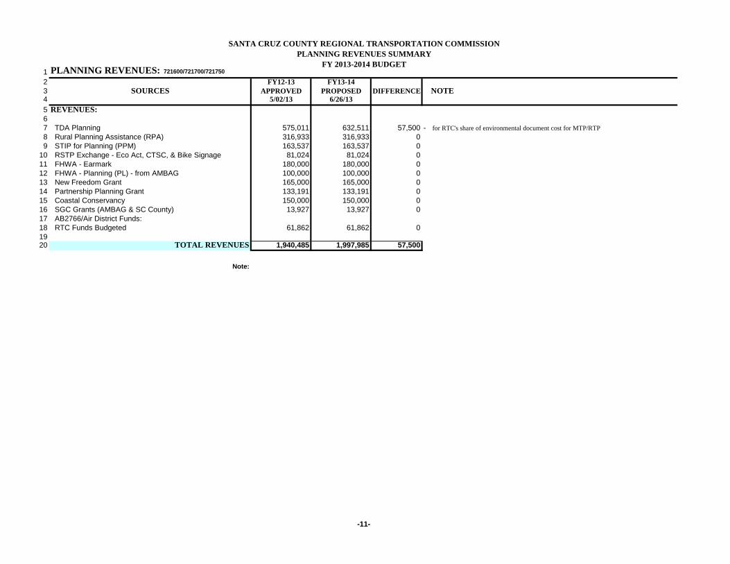
1 PLANNING REVENUES: 721600/721700/721750
2 FY12-13 FY13-143 SOURCES APPROVED PROPOSED DIFFERENCE NOTE4 5/02/13 6/26/135 REVENUES:67 TDA Planning 575,011 632,511 57,500 - for RTC's share of environmental document cost for MTP/RTP8 Rural Planning Assistance (RPA) 316,933 316,933 09 STIP for Planning (PPM) 163,537 163,537 0
10 RSTP Exchange - Eco Act, CTSC, & Bike Signage 81,024 81,024 011 FHWA - Earmark 180,000 180,000 012 FHWA - Planning (PL) - from AMBAG 100,000 100,000 013 New Freedom Grant 165,000 165,000 014 Partnership Planning Grant 133,191 133,191 015 Coastal Conservancy 150,000 150,000 016 SGC Grants (AMBAG & SC County) 13,927 13,927 017 AB2766/Air District Funds: 18 RTC Funds Budgeted 61,862 61,862 01920 TOTAL REVENUES 1,940,485 1,997,985 57,500
Note:

SANTA CRUZ COUNTY REGIONAL TRANSPORTATION COMMISSIONPLANNING EXPENDITURES
FY 2013-2014 BUDGET
-12-
1 PLANNING EXPENDITURES: 721600/721700/721750
2 FY12-13 FY13-143 EXPENDITURES APPROVED PROPOSED DIFFERENCE NOTE4 5/02/13 6/26/1356 Staff & Overhead by Program7 Plan Coordination 103,648 103,648 08 Unified Corridor Study 116,607 116,607 09 Complete streets plan 34,095 34,095 0
10 Work Program 30,000 30,000 011 Public Information 15,000 15,000 012 Bicycle/Pedestrian Planning 50,429 50,429 013 Bike Signage Plan 20,000 20,000 014 Monterey Bay Sanctuary Scenic Trail (MBSST) Network 100,000 100,000 015 Specialized Transportation 50,959 50,959 016 Safe Paths to Transit 6,500 6,500 017 Regional Transportation Plan for MTP 233,450 233,450 018 Regional Travel Demand Model 35,000 35,000 019 Transportation Improvement Program (TIP) 188,173 188,173 020 Highway & Roadway Planning 74,000 74,000 021 Subtotal Staff and Overhead 1,057,861 1,057,861 022 Services & Supplies23 Passthrough Programs24 Bike To Work Program (Ecology Action) 50,000 50,000 025 Bike & Ped Safety (Community Traffic Safety Coalition) 100,000 100,000 026 Safe Paths to Transit 160,000 160,000 027 Bike Signage Program 61,024 61,024 02829 Professional Services (contracts)30 Sacramento Assistant - - 031 Washington Assistant 44,600 44,600 032 Engineering and Other Technical Consultants 50,000 50,000 0
Environmental Document for MTP/RTP 57,500 57,500 - for RTC's share of environmental document cost for MTP/RTP33 STARS for Regional Transportation Plan - - 034 MBSST Network Master Plan Consultant 210,000 210,000 035 Unified Corridor Investment Plan Consultant 50,000 50,000 03637 RTC Work Element Related Items38 Traffic Monitoring services 15,000 15,000 039 Printing RTP, RTIP, other Documents and Pub Info Materials 12,000 12,000 040 MBSST Network Plan Outreach 20,000 20,000 041 Transfer to Rail/Trail Authority 110,000 110,000 042 Subtotal Services & Supplies 882,624 940,124 57,5004344 TOTAL EXPENDITURES 1,940,485 1,997,985 57,500

SANTA CRUZ COUNTY REGIONAL TRANSPORTATION COMMISSIONPLANNING FUNDS SOURCE DETAIL
FY 2013-2014 BUDGET
-13-
1 PLANNING DETAIL: 721600/721700/721750
2 FY13-14 RTC FHWA SGC STIP FHWA Fed 5304 New3 EXPENDITURES PROPOSED TDA FUND RPA PL - Grant PPM Earmark Part Freedom Coastal RSTPX4 6/26/13 AMBAG (AMBAG) Plang Grant Conserv5 SALARIES, Benefits & Overhead 6 Plan Coordination 103,648 9,422 - 84,226 10,000 7 Unified Corridor Study 116,607 23,416 10,000 - - 83,191 8 Complete streets plan 34,095 14,677 5,491 13,927 9 Work Program 30,000 3,118 - 6,882 20,000
10 Public Information 15,000 15,000 - - - 11 Bicycle/Pedestrian Planning 50,429 5,429 - 20,000 - 25,000 12 Bike Signage Plan 20,000 - - 20,000 13 Monterey Bay Sanctuary Scenic Trail (MBSST) Network 100,000 - - 100,000 14 Specialized Transportation 50,959 6,375 - 44,584 15 Safe Paths to Transit 6,500 1,500 - 5,000 16 Regional Transportation Plan for MTP 233,450 80,396 - 80,021 50,000 23,033 17 Regional Travel Demand Model 35,000 - 10,000 10,000 15,000 18 Transportation Improvement Program (TIP) 188,173 50,736 10,000 16,933 10,000 100,504 19 Highway & Roadway Planning 74,000 19,713 - 54,287 20 Salaries, Benefits & Overhead Subtotal 1,057,861 229,782 25,491 316,933 100,000 13,927 163,537 100,000 83,191 5,000 - 20,000 2122 Services & Supplies23 Passthrough Programs24 Bike To Work Program (Ecology Action) 50,000 50,000 - 25 Bike & Ped Safety (Community Traffic Safety Coalition) 100,000 100,000 - 26 Safe Paths to Transit 160,000 - 160,000 27 Bike Signage Program 61,024 - 61,024 2829 Professional Services30 Sacramento Assistant - - - 31 Washington Assistant 44,600 44,600 - 32 Engineering and Other Technical Consultants 50,000 30,000 20,000 33 Environmental Document for MTP/RTP 57,500 57,500 - 34 STARS for Regional Transportation Plan - - - - 35 MBSST Network Master Plan Consultant 210,000 - 60,000 150,000 36 Unified Corridor Investment Plan Consultant 50,000 - 50,000 3738 RTC Work Element Related Items39 Traffic Monitoring services 15,000 10,000 5,000 40 Printing RTP, RTIP, other Documents and Pub Info Materials 12,000 12,000 - - 41 MBSST Network Plan Outreach 20,000 - - 20,000 42 Transfer to Rail/Trail Authority 110,000 98,629 11,371 43 Subtotal Services & Supplies 940,124 402,729 36,371 - - - - 80,000 50,000 160,000 150,000 61,024 4445 TOTAL EXPENDITURES 1,997,985 632,511 61,862 316,933 100,000 13,927 163,537 180,000 133,191 165,000 150,000 81,024
SANTA CRUZ COUNTY REGIONAL TRANSPORTATION COMMISSIONTDA ALLOCATION BALANCES
FY 2013-2014 BUDGET
-17-
12 TDA ALLOCATION BALANCES3 FY13-14 UNSPENT AVAILABLE4 CLAIMANTS PROPOSED PRIOR FUNDS5 6/26/13 ALLOCATIONS ADJUSTMENT 6/26/136 SCCRTC7 TDA Administration 527,288 527,288 8 TDA Planning 460,600 460,600 9 Subtotal 987,888 - 987,888
101415 SCMTD 6,104,531 6,104,531 1617 Specialized Transit 599,743 599,743 18 - 19 Volunteer Center 71,398 71,398 2021 City of Capitola 13,639 - 13,639 2223 City of Santa Cruz - Non Transit 85,170 - 85,170 2425 City of Scotts Valley 15,946 - 15,946 2627 City of Watsonville 70,477 - 70,477 2829 County of Santa Cruz 178,898 - 178,898 3031 TOTAL 8,127,690 - - 8,127,690
Note: Allocations for the Cities and the County use the most recent population figures from the Department of Finance

AGENDA: June 26, 2013 TO: Regional Transportation Commission FROM: Daniel Nikuna, Fiscal Officer RE: Fiscal Audit Contract RECOMMENDATIONS Staff recommends that the Santa Cruz County Regional Transportation Commission (RTC):
1. Approve the selection of Moss, Levy & Hartzheim as the fiscal auditor for another five-year term; and
2. Approve the resolution (Attachment 1
) authorizing the Executive Director to negotiate, execute and amend the contract with Moss, Levy & Hartzheim.
BACKGROUND The RTC is required to annually undergo a fiscal and compliance audit in accordance with the Transportation Development Act (TDA). In addition, all claimants who receive or expend TDA funds are required to be audited in order to remain compliant; a prerequisite to continue to receive TDA funds. The five year contract with the current auditor, Moss, Levy & Hartzheim, expires on June 30, 2013. The selected auditing firm will perform the fiscal and compliance audit of all Regional Transportation Commission funds and TDA funds of all TDA claimants except Santa Cruz METRO (which does its own complete audit of all funds). The audit firm will also prepare the State Controller Report for the RTC. DISCUSSION RTC staff distributed the fiscal audit request for proposals (RFP) to 12 firms, but only two firms – R. J. Ricciardi, Inc. and Moss, Levy & Hartzheim – submitted proposals by the June 10, 2013 due date. RTC staff evaluated both proposals based on four criteria delineated in the RFP, including qualifications and experience; reference checks; and cost.

The two respondents to the RFP are qualified; however, Moss, Levy & Hartzheim’s proposal is more responsive to the requirements of the RFP and reflects that the firm is more experienced in auditing organizations similar to the RTC. Staff recommends contracting with Moss, Levy & Hartzheim, which also has the lower cost proposal. The cost proposals (Attachment 2
) to fully meet the Commission’s FY12-13 audit requirements as stated in the RFP would be $20,750 for Moss, Levy & Hartzheim and $33,500 for R. J. Ricciardi, Inc. The potential saving over the life of the contract is $63,450 if Moss, Levy & Hartzheim is approved.
Moss, Levy & Hartzheim would start a third five-year contract if the selection is approved. Moss, Levy & Hartzheim has been in public accounting for 58 years and has 29 professional staff members in three offices in California. The Santa Maria office will handle the RTC’s audits. A five-year contract is recommended due to cost saving and operating efficiency of not issuing annual RFPs. SUMMARY Staff recommends that the Commission retain Moss, Levy & Hartzheim as fiscal auditor and approve the resolution (Attachment 1
) authorizing the Executive Director to negotiate a five-year contract with the firm.
1: Resolution Attachments:
2: Cost Proposals
\\RTCSERV2\Shared\TPW\TPW 2013\0613 Special Meeting\Fiscal Auditor\FY2013 CotractStaffReport.doc

ATTACHMENT 1
RESOLUTION NO. Adopted by the Santa Cruz County Regional Transportation Commission on the date of June 26, 2013 on the motion of Commissioner duly seconded by Commissioner
A RESOLUTION AUTHORIZING THE EXECUTIVE DIRECTOR TO EXECUTE A CONTRACT AGREEMENT
WITH MOSS, LEVY & HARTZHEIM, CPAs TO CONDUCT ANNUAL FISCAL AUDIT FOR FIVE YEARS, EFFECTIVE JULY 1, 2013.
WHEREAS, the Santa Cruz County Regional Transportation Commission is required to undergo independent fiscal and compliance audits of itself and all Transportation Development Act (TDA) fund claimants; WHERAS, the Regional Transportation Commission awards grants and acts as a conduit for state and federal funds to area local agencies; WHEREAS, the Regional Transportation Commission’s FY13-14 budget includes adequate funds to audit FY12-13 financial statements; BE IT RESOLVED BY THE SANTA CRUZ COUNTY REGIONAL TRANSPORTATION COMMISSION: 1. The Executive Director is hereby authorized to serve as the agent to negotiate,
sign and execute a five-year contract with Moss, Levy & Hartzheim to perform fiscal and compliance audits of the Regional Transportation Commission and all TDA claimants except for Santa Cruz METRO at a cost not to exceed $20,750 for the first audited fiscal year (FY12-13) and $110,500 for the five-year term.
2. The Executive Director is further authorized to amend the contract consistent with
the RTC’s approved budget and work program.
AYES: COMMISSIONERS NOES: COMMISSIONERS ABSTAIN: COMMISSIONERS ABSENT: COMMISSIONERS ______________________________ Neal Coonerty, Chair

ATTEST: ____________________________ George Dondero, Secretary Distribution: RTC Fiscal
\\RTCSERV2\Shared\TPW\TPW 2013\0613 Special Meeting\Fiscal Auditor\FY2013ContractResolution.doc

ATTACHMENT 2
SCCRTC
COST PROPOSALS TO FY 2012-13 RFP
AUDIT YEARS - FY2013 TO FY2017
Moss, Levy &
Hartzheim
FY 2013 33,250 20,750 (12,500)
FY 2014 33,250 21,450 (11,800)
FY 2015 33,250 22,100 (11,150)
FY 2016 37,100 22,750 (14,350)
FY 2017 37,100 23,450 (13,650)
TOTAL 173,950 110,500 (63,450)
\\Rtcserv2\internal\FISCAL\AUDIT\RFP\Fiscal\FY2013\[Cost Proposals.xlsx]FY203RFP
R.J. Ricciardi Difference
AGENDA: June 26, 2013
TO: Regional Transportation Commission (RTC) – Policy Workshop FROM: Neal Coonerty, Chair RE: Executive Director’s Employment Agreement RECOMMENDATIONS The ad-hoc Committee on the Executive Director’s compensation recommends that the Regional Transportation Commission (RTC) approve the following changes in the RTC Executive Director’s compensation:
1. A salary increase of 2% annually for two years, and 2. Increase of allowable vacation payout hours to 120 hours per year 3. An additional five days of vacation annually
BACKGROUND RTC Executive Director, George Dondero has been employed by the RTC as an at-will employee under a contract executed on March 7, 2006. That contract included two step increases in the second and third year of employment. No increases or changes in benefits have been authorized since. At the February 7, 2013 the RTC approved extensions of Memoranda of Understanding with the RTC bargaining units, Community of RTC Employees (CORE) and the RTC Association of Middle Managers (RAMM). The approved extensions included the following conditions outlined in side letters to the MOUs:
1. Labor agreement extension for 24 months, effective April 1, 2013 and expiring on March 31, 2015
2. RTC will maintain the same level of benefits as outlined in the previous labor agreements.
3. RTC agrees to pay same percentage of benefit premiums as outlined in the labor agreements based on premiums for each year.
4. Cost of living increases (COLA) as follows: a. 2% COLA on April 1, 2013 b. 2% COLA on April 1, 2014
5. In addition, changes apply only to RAMM included an increase of allowable vacation payout hours to 120 hours per fiscal year.
DISCUSSION On June 12, 2013 the RTC Chair appointed an ad-hoc committee to meet with the Executive Director to discuss his compensation package. The committee consists of the RTC Chair, Vice-chair Eduardo Montesino and RTC Commissioner Lynn

Executive Director’s Employment Agreement Page 2 Robinson. On June 18, 2013 the ad-hoc committee met with the Executive Director to have that discussion. The Executive Director proposed the following changes to his compensation package:
1. Cost of living increases (COLA) as follows: a. 2% COLA effective April 1, 2013 b. 2% COLA effective April 1, 2014
2. Increase of allowable vacation payout hours to 120 hours per fiscal year. 3. Increase of five additional vacation days per year.
The first two items are consistent with the changes approved for the bargaining units. The third item is requested due to the nature and scope of the work performed by the Executive Director. The current compensation includes an annual salary of $162,073, three weeks of paid vacation and two weeks of paid administrative leave. The existing contract was written before the RTC separated from the County in November 2006. Therefore there is some language referencing County procedures and practices which is no longer relevant and can effectively be removed. This would be an opportune time to clean up the contract to remove any irrelevant references. The ad-hoc committee recommends that the RTC approve the above changes to the Executive Director’s compensation and authorize the RTC Chair to sign a contract incorporating these changes as well as making non-substantive changes to update the document, removing references to procedures and practices no longer applicable to the RTC. As with the existing contract there is no termination date.
SUMMARY The RTC Chair appointed an ad-hoc committee to discuss changes in compensation for the Executive Director. The committee recommends that the RTC approve changes to the compensation package to include 2% COLA increases in 2013 and 2014, an increase of allowable vacation payout hours to 120 hours per year, and an increase of five additional vacation days per year.
s:\tpw\tpw 2013\0613 special meeting\sr_ed contract.docx
AGENDA: June 26, 2013
TO: Regional Transportation Commission Transportation Policy Workshop FROM: Luis Pavel Mendez, Deputy Director RE: Fiscal Year (FY) 2013-14 Work Program
RECOMMENDATIONS The Budget and Administration/Personnel (B&A/P) Committee and staff recommend that the Santa Cruz County Regional Transportation Commission (RTC) approve the attached FY 2013-14 RTC Work Program (Attachment 1
).
BACKGROUND Each year the RTC works with Caltrans and the Association of Monterey Bay Area Governments (AMBAG) to prepare a work program for the following fiscal year. The work program is required for RTC to receive federal and state transportation planning funds and must include the work necessary to meet federal and state transportation planning requirements. The RTC’s work program also includes all of the other work that the RTC performs. The work program provides summary information on the work that the RTC will perform with the state and federal planning funds as well as a summary schedule and work products. DISCUSSION RTC staff prepared a draft FY 2013-14 work program for the RTC and submitted it to Caltrans for review. The final draft included as Attachment 1 has incorporated Caltrans comments and suggestions. As in past years, the FY 2013-14 RTC work program (Attachment 1
) includes state-mandated responsibilities and RTC priorities, including:
• Production of the 2014 Regional Transportation Plan (RTP) and Metropolitan Transportation Plan (MTP) in coordination and cooperation with AMBAG, neighboring regional transportation planning agencies, Caltrans and local jurisdictions;
• Production and implementation of the various required state and federal funding documents;
• Continuation of the Highway 1/HOV Lane project tiered environmental analysis; • Construction of the Soquel to Morrissey Auxiliary Lanes project; • Management, operation and planning for the Santa Cruz Branch Rail Line; • Work to develop potential new transportation revenues to help meet continuously
increasing transportation needs in the region; • Continued work with project sponsors and funding agencies on securing funds for high
priority projects from all modes of transportation; • Completion of the master plan and environmental document for the Monterey Bay
Sanctuary Scenic Trail (MBSST) Network;
FY 2013-14 Work Program Page 2
• Monitor and participate in local, state and federal efforts to address global warming; • Participate in statewide efforts to authorize a new federal transportation funding bill and
ensure that California and its regional agencies receive their fair share of federal funds • Continued services to Santa Cruz area travelers through the Commute; and Solutions,
SAFE callbox, Safe on 17 and Freeway Service Patrol programs, including coordination with partner agencies to ensure the best possible service.
The Budget and Administration/Personnel Committee and staff recommend that the Santa Cruz County Regional Transportation Commission (RTC) approve the attached proposed FY2013-14 RTC Work Program (Attachment 1
).
SUMMARY The RTC must prepare a work program to receive state and federal transportation planning funds. The proposed FY 2013-14 RTC work program includes state-mandated responsibilities and RTC priorities. The proposed VY 2013-14 work program has been reviewed by Caltrans and their comments and suggestions have been incorporated. The B&A/P Committee and staff recommend that the RTC approve the proposed FY 2013-14 RTC Work Program (Attachment 1 ).
1. Final Draft FY 2013-14 Work Program Attachments:
S:\TPW\TPW 2013\0613 Special Meeting\FY1314WkPrg\FY1314WP.doc
FINAL DRAFT ATTACHMENT 1
Santa Cruz County Regional Transportation Commission
FISCAL YEAR 2013 - 2014 WORK PROGRAM
June 26, 2013

Page - 1 -
The fiscal year (FY) 2013-2014 work program for the Santa Cruz County Regional Transportation Commission (SCCRTC) describes the activities to be accomplished during the fiscal year beginning July 1, 2013 and ending June 30, 2014 and includes the following mandated responsibilities and SCCRTC priorities: • continued production of the 2014 Regional Transportation Plan and 2014 Metropolitan Transportation Plan in
coordination and cooperation with the Association of Monterey Bay Area Governments (AMBAG), the Transportation Agency for Monterey County (TAMC) the San Benito Council of Governments (SBtCOG), local jurisdictions, Caltrans and other local and regional agencies;
• production and implementation of the various required state and federal funding documents; • continued production of the Highway 1 HOV Lanes Project environmental documents; • construction completion of the Highway 1 Soquel to Morrissey Auxiliary Lanes Project; • management, operation and planning of the Santa Cruz Branch Rail Line; • continued development of a master plan and environmental review for the Monterey Bay Sanctuary Scenic Trail
(MBSST) Network; • continued work to carry out the RTC’s responsibilities to monitor and coordinate with Caltrans and local agencies
on timely implementation of state highway and local projects with state or federal funding participation; • continued work with project sponsors and funding agencies on securing funds for high priority projects for all
modes of transportation; • continued services to Santa Cruz area travelers through the Commute Solutions, SAFE callbox, Safe on 17 and
Freeway Service Patrol programs, including coordination with partner agencies to ensure the best possible service;
• continuation of the Bike to Work and the Community Traffic Safety Coalition’s bicycle and pedestrian education programs;
• continued maintenance and enhancement of a variety of public information outlets; • continued development and implementation of systems necessary to ensure that the RTC continues to function
efficiently and effectively as an independent government agency; • monitor and participate in local, state, and federal efforts to address global warming; • participate in statewide efforts to reauthorize the federal transportation law and ensure that California and its
regional agencies receive their fair share of federal transportation funds; and • pursuit of any and all funding sources for transportation projects in the region including the development of local
funding sources as well as seeking other new sources. Through the activities listed in this work program, the SCCRTC works to deliver a full range of safe, convenient, reliable and efficient transportation choices for the community.

Page - 2 -

Page - 2 -

Page - 3 -
WORK ELEMENT NUMBER 101 Overall Work Program
Agency: SCCRTC Project Manager: Luis Mendez, Deputy Director Total Budget: $30,000
ESTIMATED EXPENDITURE AND ANTICIPATED REVENUE: FY 2013-2014
EXPENDITURES REVENUE
Category Amount ($) Change Source Amount ($) Change
Personnel 30,000 0 FHWA PL 20,000 00 0 State RPA 6,882 0
Local 3,118 0
TOTAL 30,000 0 TOTAL 30,000 0% Federal 67%
Project Description
Project Product(s)
Federally Eligible Task Proposed Expenditure of Federal Funding (PL/FTA 5303)67%
Previous Accomplishments
Task Description Deliverable Completion Date
1 8/15/2013
2 8/15/2013
3 10/31/2013
410/30/2013 01/31/2014 04/30/2014
Develop and implement annual Overall Work Program and Budget
Develop, implement and oversee the annual overall work program activities and budget in accordance with federal and state requirements in coordination with AMBAG and other partner agencies; and produce quarterly and annual progress reports.
Developed and adopted FY 2012-13 OWP and Budget; Processed amendments to the FY 2012-13 OWP and Budget; provided required quarterly and annual progress reports for transportation planning and projectactivities to SCCRTC, AMBAG, and Caltrans.
Finalize FY 2012-13 revenues and expenditures
Produce final FY 2012-13 work program quarterly report and provide to AMBAG
Prepare and adopt the annual fall FY 2013-14 budget and overall work program amendment
Produce FY 2013-14 quarterly work program reports and provide to AMBAG
Revenues and expenditures files
Final FY 2012-13 quarterly report
FY 2013-14 amendments and staff reports
FY 2013-14 quarterly work program reports
Services & Supplies
Develop, maintain, and oversee the annual work program and budget to carryout the transportation planning activities of the Santa Cruz County Regional Transportation Commission (SCCRTC) in accordance withfederal, state and local requirements and available funding as a component of the overall work program for the three-county AMBAG region. This includes OWP development, coordination, and meetings with local,regional, state and federal agencies (including AMBAG, Caltrans, FHWA, TAMC and San Benito COG) to ensure that the entire three-county region is meeting federal requirements. Additionally, this work elementprovides monitoring and review of policy and legislative activities that impact the production, coordination, implementation and requirements of the OWP. Further duties include quarterly reporting to verify progressin implementing the work program.
FY 2014-15 Overall Work Program and Budget and amendments; amendments to the FY 2013-14 OWP and Budget; quarterly and annual progress reports.

Page - 4 -
512/15/2013
603/01/14
704/30/14
8 04/30/14
9 05/15/14
10 06/15/14
11 06/30/14
Develop draft FY 2014-15 draft work program and budget and provide document to AMBAG
Prepare for and participate in annual OWP kick-off meeting with TAMC and AMBAG Meeting with regional partners, agenda and materials
Draft FY 2014-15 draft work program and budget
Participate in 2014-15 OWP development and coordination meetings with AMBAG and other agencies in the region
Incorporate comments/suggestions into final draft FY 2014-15 OWP and provide document to AMBAG
Prepare and adopt the annual spring FY 2013-14 budget and overall work program amendment and provide to AMBAG
Prepare other amendments to the FY 2013-14 budget and work program as necessary and submit to AMBAG
Prepare and present final FY 2014-15 OWP to SCCRTC board for approval
Amendments and staff reports
Meetings, agendas and materials
Final draft FY 2014-15 OWP
Amendment and staff report
Final OWP and staff report
Page - 5 -
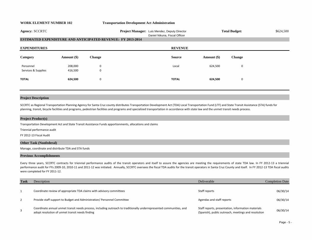
WORK ELEMENT NUMBER 102 Transportation Development Act Administration
Agency: SCCRTC Project Manager: Luis Mendez, Deputy Director Total Budget: $624,500Daniel Nikuna, Fiscal Officer
ESTIMATED EXPENDITURE AND ANTICIPATED REVENUE: FY 2013-2014
EXPENDITURES REVENUE
Category Amount ($) Change Source Amount ($) Change
Personnel 208,000 0 Local 624,500 0416,500 0
TOTAL 624,500 0 TOTAL 624,500 0
Project Description
Project Product(s)
Other Task (Nonfederal)
Previous Accomplishments
Task Description Deliverable Completion Date
1 06/30/14
2 06/30/14
3 06/30/14
Agendas and staff reports
Staff reports, presentation, information materials (Spanish), public outreach, meetings and resolution
Every three years, SCCRTC contracts for triennial performance audits of the transit operators and itself to assure the agencies are meeting the requirements of state TDA law. In FY 2012-13 a triennialperformance audit for FYs 2009-10, 2010-11 and 2011-12 was initiated. Annually, SCCRTC oversees the fiscal TDA audits for the transit operators in Santa Cruz County and itself. In FY 2012-13 TDA fiscal auditswere completed for FY 2011-12.
Staff reportsCoordinate review of appropriate TDA claims with advisory committees
Provide staff support to Budget and Administration/ Personnel Committee
Services & Supplies
SCCRTC as Regional Transportation Planning Agency for Santa Cruz county distributes Transportation Development Act (TDA) Local Transportation Fund (LTF) and State Transit Assistance (STA) funds for planning, transit, bicycle facilities and programs, pedestrian facilities and programs and specialized transportation in accordance with state law and the unmet transit needs process.
Transportation Development Act and State Transit Assistance Funds apportionments, allocations and claims
Manage, coordinate and distribute TDA and STA funds
Triennial performance audit
FY 2012-13 Fiscal Audit
Coordinate annual unmet transit needs process, including outreach to traditionally underrepresented communities, and adopt resolution of unmet transit needs finding

Page - 6 -
4 06/30/14
5 06/30/14
6 06/30/14
7 7/13/13 1/10/14
8 06/30/14
9 6/30/2014
10 06/30/14
11 08/31/13
12 06/30/14
13 6/30/2014
14 12/31/13
Files, invoice processing and payments
Phone calls, emails
ICAP report and staff report
Financial report and staff reports
Meetings, agenda and information materials
Triennial performance audit
Implement recommendations in performance audit
Prepare and submit to Caltrans the FY 2013-14 indirect cost allocation plan
Produce and distribute annual financial report
Complete triennial performance audit
Coordinate, meet, confer and negotiate with labor representatives
Emails and estimate materials
Staff reports and modifications to processes and forms
Reports to B&A/P Committee and RTC
Audit report and staff reports
Assignment list, individual staff meetings, evaluation forms
Obtain TDA funds estimates from County Auditor Controller
Monitor TDA revenue receipts, compare to estimates and adjust estimates as necessary
Conduct the FY 2012-13 annual fiscal audit and implement suggested changes
Produce staff assignment lists, performance evaluations and personnel actions
Assist transit operators with annual financial audits
Maintain records and pay claims for TDA, STA and other trust fund accounts.
Page - 7 -
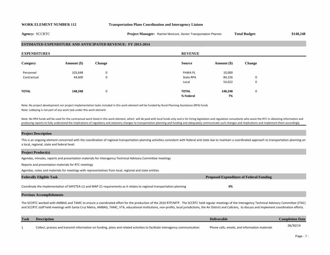
WORK ELEMENT NUMBER 112 Transportation Plans Coordination and Interagency Liaison
Agency: SCCRTC Project Manager: Rachel Moriconi, Senior Transportation Planner Total Budget: $148,248
ESTIMATED EXPENDITURE AND ANTICIPATED REVENUE: FY 2013-2014
EXPENDITURES REVENUE
Category Amount ($) Change Source Amount ($) Change
Personnel 103,648 0 FHWA PL 10,000 Contractual 44,600 0 State RPA 84,226 0
Local 54,022 0
TOTAL 148,248 0 TOTAL 148,248 0% Federal 7%
Note: No project development nor project implementation tasks included in this work element will be funded by Rural Planning Assistance (RPA) fundsNote: Lobbying is not part of any work task under this work element
Project Description
Project Product(s)
Federally Eligible Task Proposed Expenditure of Federal Funding
0%
Previous Accomplishments
Task Description Deliverable Completion Date
1 06/30/14Collect, process and transmit information on funding, plans and related activities to facilitate interagency communication
The SCCRTC worked with AMBAG and TAMC to ensure a coordinated effort for the production of the 2010 RTP/MTP. The SCCRTC held regular meetings of the Interagency Technical Advisory Committee (ITAC)and SCCRTC staff held meetings with Santa Cruz Metro, AMBAG, TAMC, VTA, educational institutions, non-profits, local jurisdictions, the Air District and Caltrans, to discuss and implement coordination efforts.
This is an ongoing element concerned with the coordination of regional transportation planning activities consistent with federal and state law to maintain a coordinated approach to transportation planning ona local, regional, state and federal level.
Agendas, minutes, reports and presentation materials for Interagency Technical Advisory Committee meetings
Coordinate the implementation of SAFETEA-LU and MAP-21 requirements as it relates to regional transportation planning
Note: No RPA funds will be used for the contractual work listed in this work element, which will de paid with local funds only and is for hiring legislation and regulation consultants who assist the RTC in obtaining information and producing reports to fully understand the implications of regulatory and statutory changes to transportation planning and funding and adequately communicate such changes and implications and implement them accordingly
Phone calls, emails, and information materials
Reports and presentation materials for RTC meetings
Agendas, notes and materials for meetings with representatives from local, regional and state entities

Page - 8 -
2 06/30/14
306/30/14
4
06/30/14
506/30/14
606/30/14
706/30/14
8
06/30/14
906/30/14
1006/30/14
1106/30/14
1206/30/14
1306/30/14
1406/30/14
156/30/2014
Monitor and participate in efforts at the state and regional level to effectively implement the requirements of MAP-21Phone calls, teleconferences, emails, notes and information materials
Agendas and staff reports
Meeting participation, meeting notes, agendas
Meetings, phone calls, emails and information materials
ITAC meetings, agendas and packets
Develop partnerships with local agencies responsible for land use decisions to facilitate coordination of transportation planning with land use, open space, job-housing balance, environmental constraints, and growth management
Coordinate with business and community organizations, and task forces, including those who engage traditionally underrepresented communities, on transportation issues, transportation planning, and funding issues
With the assistance of consultant services, stay informed on state and federal legislative and budgetary changes and proposed changes to more effectively and efficiently coordinate current transportation activities with changing requirements
With the assistance of consultant services, communicate with legislative officials and others on the effective and efficient coordination of proposed legislative and budgetary changes with current transportation planning activities
Continue to work with Interagency Technical Advisory Committee members and other transportation partners to cooperatively develop and pursue grant opportunities for transportation studies and development of transportation plan components and funding
Participate in, prepare and distribute agendas and staff reports for RTC and committee meetings
Coordinate on planning and programming with other agencies throughout the state through participation in the Regional Transportation Planning Agencies group, the California Association of Councils of Government(CalCOG), the Central Coast Coalition and the California Transportation Commission
Exchange information concerning transportation planning, and funding with local jurisdictions, Caltrans, AMBAG, Santa Cruz Metro, the Air District, UCSC, and other federal, state and local agencies
Prepare reports and materials for Interagency Technical Advisory Committee (ITAC) to facilitate planning and programming coordination among all of the various transportation partners represented on the Committee (public works departments, planning departments, transit district, UCSC, Caltrans, AMBAG, Air District)
Monitor and participate in efforts at the federal, state and local level related to global warming
Joint grant applications
Phone calls, emails, meetings, notes and information materials
Conference calls, meetings and notes
Presentations, phone calls, meetings and materials in Spanish
Staff reports and information materials
Phone calls, emails, letters and meetings
Work with the City of Watsonville and other partner agencies to update the master plan for the Watsonville airport Communications with partner agencies, meetings
Meet quarterly with Caltrans to coordinate planning and programming activities and prepare materials for meetings Teleconference, Agenda and meeting materials
Continue to work with Caltrans, AMBAG and other partner agencies on improved planning for the movement of goods into, out of and through the region
Communications with partner agencies, meetings
Page - 9 -
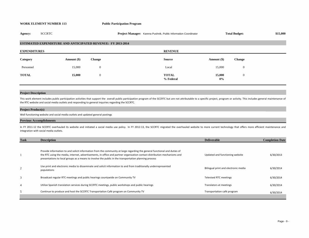
WORK ELEMENT NUMBER 113 Public Participation Program
Agency: SCCRTC Project Manager: Karena Pushnik, Public Information Coordinator Total Budget:
ESTIMATED EXPENDITURE AND ANTICIPATED REVENUE: FY 2013-2014
EXPENDITURES REVENUE
Category Amount ($) Change Source Amount ($) Change
Personnel 15,000 0 Local 15,000 0
TOTAL 15,000 0 TOTAL 15,000 0% Federal 0%
Project Description
Project Product(s)Well functioning website and social media outlets and updated general postings
Previous Accomplishments
Task Description Deliverable Completion Date
1 6/30/2013
2 6/30/2014
3 6/30/2014
4 6/30/2014
5 6/30/2014Continue to produce and host the SCCRTC Transportation Café program on Community TV Transportation café program
$15,000
This work element includes public participation activities that support the overall public participation program of the SCCRTC but are not attributable to a specific project, program or activity. This includes general maintenance ofthe RTC website and social media outlets and responding to general inquiries regarding the SCCRTC.
In FY 2011-12 the SCCRTC overhauled its website and initiated a social media use policy. In FY 2012-13, the SCCRTC migrated the overhauled website to more current technology that offers more efficient maintenance andintegration with social media outlets.
Utilize Spanish translation services during SCCRTC meetings, public workshops and public hearings Translators at meetings
Provide information to and solicit information from the community at large regarding the general functional and duties of the RTC using the media, internet, advertisements, in-office and partner organization contact distribution mechanisms and presentations to local groups as a means to involve the public in the transportation planning process
Updated and functioning website
Use print and electronic media to disseminate and solicit information to and from traditionally underrepresented populations
Bilingual print and electronic media
Broadcast regular RTC meetings and public hearings countywide on Community TV Televised RTC meetings

Page - 10 -
Page - 11 -
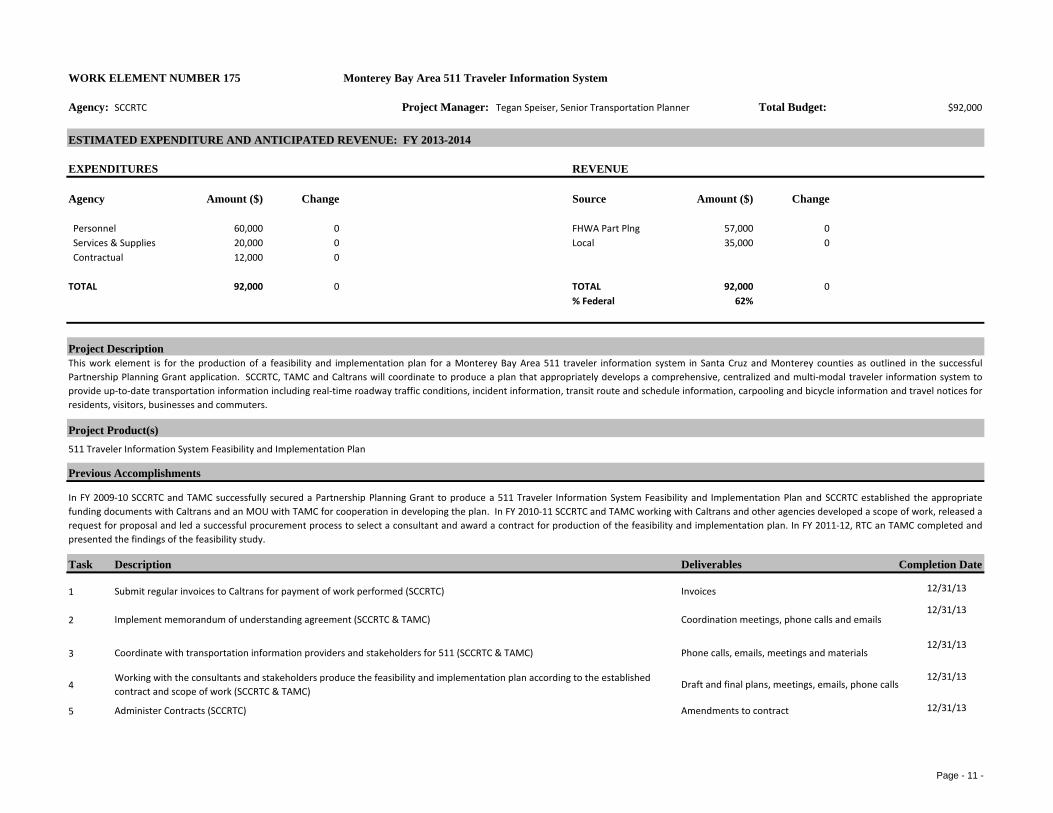
WORK ELEMENT NUMBER 175 Monterey Bay Area 511 Traveler Information System
Agency: SCCRTC Project Manager: Tegan Speiser, Senior Transportation Planner Total Budget: $92,000
ESTIMATED EXPENDITURE AND ANTICIPATED REVENUE: FY 2013-2014
EXPENDITURES REVENUE
Agency Amount ($) Change Source Amount ($) Change
Personnel 60,000 0 FHWA Part Plng 57,000 0 Services & Supplies 20,000 0 Local 35,000 0 Contractual 12,000 0
TOTAL 92,000 0 TOTAL 92,000 0% Federal 62%
Project Description
Project Product(s)
Previous Accomplishments
Task Description Deliverables Completion Date
1 12/31/13
212/31/13
312/31/13
412/31/13
5 12/31/13
Draft and final plans, meetings, emails, phone calls
Amendments to contract
Working with the consultants and stakeholders produce the feasibility and implementation plan according to the established contract and scope of work (SCCRTC & TAMC)
Administer Contracts (SCCRTC)
Submit regular invoices to Caltrans for payment of work performed (SCCRTC)
Implement memorandum of understanding agreement (SCCRTC & TAMC)
Coordinate with transportation information providers and stakeholders for 511 (SCCRTC & TAMC)
Invoices
Coordination meetings, phone calls and emails
Phone calls, emails, meetings and materials
This work element is for the production of a feasibility and implementation plan for a Monterey Bay Area 511 traveler information system in Santa Cruz and Monterey counties as outlined in the successfulPartnership Planning Grant application. SCCRTC, TAMC and Caltrans will coordinate to produce a plan that appropriately develops a comprehensive, centralized and multi-modal traveler information system toprovide up-to-date transportation information including real-time roadway traffic conditions, incident information, transit route and schedule information, carpooling and bicycle information and travel notices forresidents, visitors, businesses and commuters.
511 Traveler Information System Feasibility and Implementation Plan
In FY 2009-10 SCCRTC and TAMC successfully secured a Partnership Planning Grant to produce a 511 Traveler Information System Feasibility and Implementation Plan and SCCRTC established the appropriatefunding documents with Caltrans and an MOU with TAMC for cooperation in developing the plan. In FY 2010-11 SCCRTC and TAMC working with Caltrans and other agencies developed a scope of work, released arequest for proposal and led a successful procurement process to select a consultant and award a contract for production of the feasibility and implementation plan. In FY 2011-12, RTC an TAMC completed andpresented the findings of the feasibility study.

Page - 12 -
6 12/31/13Final plans, and staff reportFinalize the Draft Plan (SCCRTC & TAMC)

Page - 13 -
WORK ELEMENT NUMBER 177 Freeway Service Patrol (FSP)
Agency: SCCRTC Project Manager: Amy Naranjo, Transportation Planner Total Budget: $372,000
ESTIMATED EXPENDITURE AND ANTICIPATED REVENUE: FY 2013-2014
EXPENDITURES REVENUE
Category Amount ($) Change Source Amount ($) Change
Personnel 70,000 0 Caltrans 205,000 0302,000 0 Hwy 1 Aux Lanes pr 0 0
Reserves 0 0 RSTP Exchange 135,000 0Local 32,000 0
TOTAL 372,000 0 TOTAL 372,000 0
Project Description
Project Product(s)
Other Task (Nonfederal)
Previous Accomplishments
Task Description Deliverables Completion Date
106/30/14
206/30/14
306/30/14
406/30/14
Administration: Provide supplies as needed, monitor use, evaluate future program needs, and process invoices for payment of service from contractors.
Conduct quarterly training and informational meetings with Caltrans, CHP and tow operators and partner with TAMC for the quarterly trainings
Services & Supplies
SCCRTC Freeway Service Patrol (FSP) operates on Highways 1 and 17 in Santa Cruz County to assist stranded or stalled motorists, and to remove freeway objectives that cause episodic traffic congestion.SCCRTC works closely with Caltrans and California Highway Patrol to implement the program.
Freeway Service Patrol towing services, invoices, service contracts, funding agreements
Implement county level Freeway Service Patrol
In FY's 2011-12 and 2012-13, SCCRTC implemented FSP service on Highway 1 to alleviate congestion resulting from the Highway 1 Soquel to Morrissey Auxiliary Lanes construction. In FY 2012-13, SCCRTCsecured some Regional Surface Transportation Program (RSTP) funding for the Highway 1 FSP service and initiated a procurement process for new four-year tow service contracts.
Represent agency at statewide oversight committee meetings to demonstrate effectiveness and to maintain and increase state funding for FSP program
Improve data collection techniques and enhance Personal Digital Assistants to improve truck tracking and vehicle dispatching capabilities.
Tow truck service to motorists, invoices, purchase orders, statistics, and reports
Training sessions, agendas and materials
Meeting participation, reports, presentations
Data reports and analysis
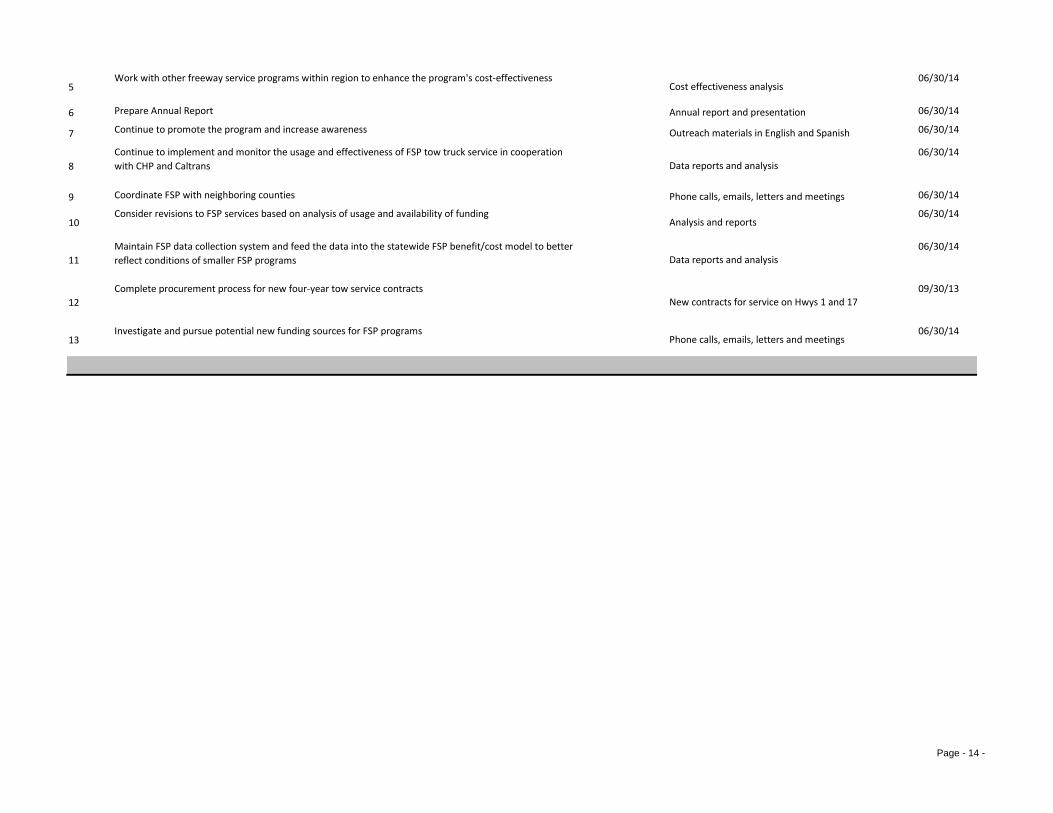
Page - 14 -
506/30/14
6 06/30/14
7 06/30/14
806/30/14
9 06/30/14
1006/30/14
1106/30/14
1209/30/13
1306/30/14
Data reports and analysis
New contracts for service on Hwys 1 and 17
Prepare Annual Report
Continue to promote the program and increase awareness
Continue to implement and monitor the usage and effectiveness of FSP tow truck service in cooperation with CHP and Caltrans
Investigate and pursue potential new funding sources for FSP programs
Coordinate FSP with neighboring counties
Maintain FSP data collection system and feed the data into the statewide FSP benefit/cost model to better reflect conditions of smaller FSP programs
Complete procurement process for new four-year tow service contracts
Phone calls, emails, letters and meetings
Work with other freeway service programs within region to enhance the program's cost-effectiveness
Consider revisions to FSP services based on analysis of usage and availability of funding
Cost effectiveness analysis
Annual report and presentation
Outreach materials in English and Spanish
Data reports and analysis
Phone calls, emails, letters and meetings
Analysis and reports
Page - 15 -
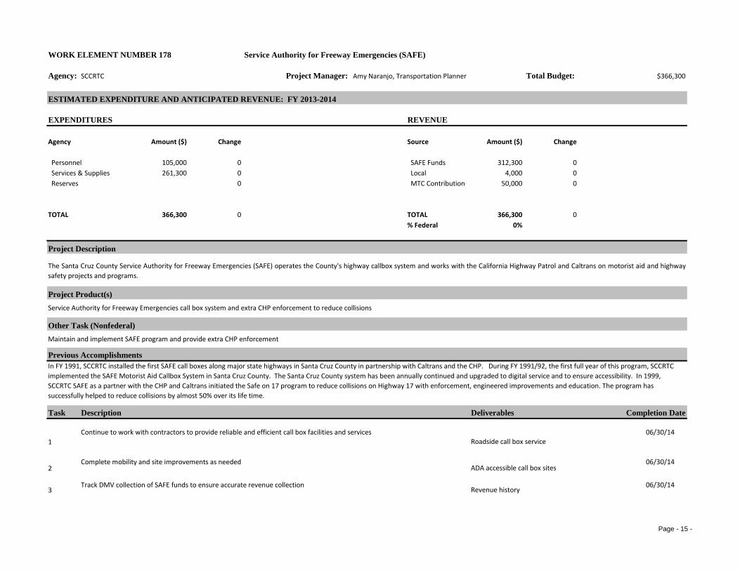
WORK ELEMENT NUMBER 178 Service Authority for Freeway Emergencies (SAFE)
Agency: SCCRTC Project Manager: Amy Naranjo, Transportation Planner Total Budget: $366,300
ESTIMATED EXPENDITURE AND ANTICIPATED REVENUE: FY 2013-2014
EXPENDITURES REVENUE
Agency Amount ($) Change Source Amount ($) Change
Personnel 105,000 0 SAFE Funds 312,300 0 Services & Supplies 261,300 0 Local 4,000 0 Reserves 0 MTC Contribution 50,000 0
TOTAL 366,300 0 TOTAL 366,300 0% Federal 0%
Project Description
Project Product(s)
Other Task (Nonfederal)
Previous Accomplishments
Task Description Deliverables Completion Date
106/30/14
206/30/14
306/30/14
The Santa Cruz County Service Authority for Freeway Emergencies (SAFE) operates the County's highway callbox system and works with the California Highway Patrol and Caltrans on motorist aid and highwaysafety projects and programs.
Service Authority for Freeway Emergencies call box system and extra CHP enforcement to reduce collisions
Maintain and implement SAFE program and provide extra CHP enforcement
In FY 1991, SCCRTC installed the first SAFE call boxes along major state highways in Santa Cruz County in partnership with Caltrans and the CHP. During FY 1991/92, the first full year of this program, SCCRTC implemented the SAFE Motorist Aid Callbox System in Santa Cruz County. The Santa Cruz County system has been annually continued and upgraded to digital service and to ensure accessibility. In 1999, SCCRTC SAFE as a partner with the CHP and Caltrans initiated the Safe on 17 program to reduce collisions on Highway 17 with enforcement, engineered improvements and education. The program has successfully helped to reduce collisions by almost 50% over its life time.
Continue to work with contractors to provide reliable and efficient call box facilities and services
Complete mobility and site improvements as needed
Track DMV collection of SAFE funds to ensure accurate revenue collection
Roadside call box service
ADA accessible call box sites
Revenue history
Page - 16 -
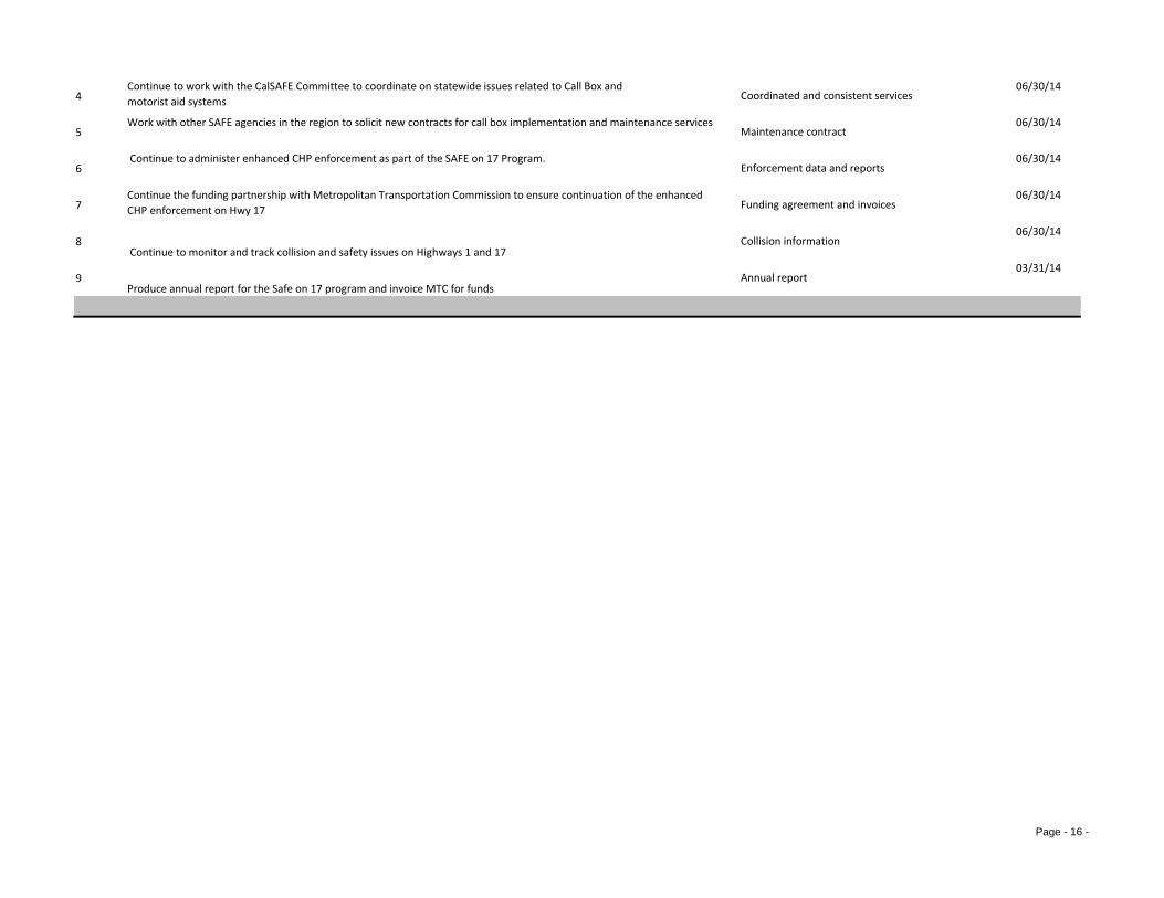
406/30/14
506/30/14
606/30/14
706/30/14
8 Continue to monitor and track collision and safety issues on Highways 1 and 17
06/30/14
9Produce annual report for the Safe on 17 program and invoice MTC for funds
03/31/14
Funding agreement and invoices
Collision information
Annual report
Continue to work with the CalSAFE Committee to coordinate on statewide issues related to Call Box and motorist aid systems
Work with other SAFE agencies in the region to solicit new contracts for call box implementation and maintenance services
Continue to administer enhanced CHP enforcement as part of the SAFE on 17 Program.
Continue the funding partnership with Metropolitan Transportation Commission to ensure continuation of the enhanced CHP enforcement on Hwy 17
Maintenance contract
Enforcement data and reports
Coordinated and consistent services
Page - 17 -
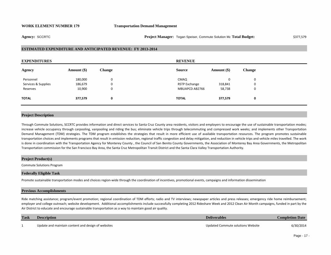
Transportation Demand Management
Agency: SCCRTC Project Manager: Tegan Speiser, Commute Solution Ma Total Budget: $377,579
ESTIMATED EXPENDITURE AND ANTICIPATED REVENUE: FY 2013-2014
EXPENDITURES REVENUE
Agency Amount ($) Change Source Amount ($) Change
Personnel 180,000 0 CMAQ 0 0 Services & Supplies 186,679 0 RSTP Exchange 318,841 0 Reserves 10,900 0 MBUAPCD AB2766 58,738 0
TOTAL 377,579 0 TOTAL 377,579 0
Project Description
Project Product(s)Commute Solutions Program
Federally Eligible Task
Previous Accomplishments
Task Description Deliverables Completion Date
1 6/30/2014Update and maintain content and design of websites
WORK ELEMENT NUMBER 179
Through Commute Solutions, SCCRTC provides information and direct services to Santa Cruz County area residents, visitors and employers to encourage the use of sustainable transportation modes;increase vehicle occupancy through carpooling, vanpooling and riding the bus; eliminate vehicle trips through telecommuting and compressed work weeks; and implements other TransportationDemand Management (TDM) strategies. The TDM program establishes the strategies that result in more efficient use of available transportation resources. The program promotes sustainabletransportation choices and implements programs that result in emission reduction, regional traffic congestion and delay mitigation, and reduction in vehicle trips and vehicle miles travelled. The workis done in coordination with the Transportation Agency for Monterey County , the Council of San Benito County Governments, the Association of Monterey Bay Area Governments, the MetropolitanTransportation commission for the San Francisco Bay Area, the Santa Cruz Metropolitan Transit District and the Santa Clara Valley Transportation Authority.
Promote sustainable transportation modes and choices region-wide through the coordination of incentives, promotional events, campaigns and information dissemination
Ride matching assistance; program/event promotion; regional coordination of TDM efforts; radio and TV interviews; newspaper articles and press releases; emergency ride home reimbursement;employer and college outreach; website development. Additional accomplishments include successfully completing 2012 Rideshare Week and 2012 Clean Air Month campaigns, funded in part by theAir District to educate and encourage sustainable transportation as a way to maintain good air quality.
Updated Commute solutions Website

Page - 18 -
2 6/30/2014
3 6/30/2014
4 6/30/2014
5 6/30/2014
6 6/30/2014
7 6/30/2014
8 6/30/2014
9 6/30/2014
10 6/30/2014
11 6/30/2014
12 6/30/2014
13 6/30/2014
14 6/30/2014
15 6/30/2014Prepare and conduct community outreach, education, and promotional materials and provide personalized ridematching services
Promote, reimburse and monitor Emergency Ride Home Program
Assist employers in promoting multi-modal travel options and services through transportation fairs and on-site presentations
Promotional materials and handouts
Participation requests and reimbursements
Scatter maps, presentation materials, list of employers
Improved evaluation tools
Promotional materials and handouts
Improved PNR facilities, signs, and agreements; usage counts
Participant lists, gas cards
Data on TDM programs
Information on other programs
Promotional materials and handouts
Agendas, notes and action items
Agendas, notes and action items
Develop and apply a consistent set of evaluation measures for TDM projects and programs
Operate 429-POOL hotlines and coordinate regional participation and access to the 511.org online ride matching system. Maintain online database of people interested in a ride match.
Direct, monitor, and document media communications related to program's objectives and goals
Match lists, robust database
Media releases, interviews, articles, etc.
Participate in transportation-related air quality and climate change activities including those related to implementing State and Federal Clean Air Acts and other legislation such as AB 32 and SB 375
Promote and facilitate access to existing park and Ride Lots and plan for future P&R facility needs
Participate in tri-county coordination of outreach campaigns - i.e. Rideshare Week
Research most effective methods and strategies to meet program objectives
Increase vehicle occupancy by implementing the countywide carpool incentive program funded by a MBUAPCD grant
Coordinate with regional rideshare and transit service providers, promote transit services
Develop and maintain information on TDM initiatives in the community
Participate in periodic meetings of the Transportation and Air Quality Joint Marketing Committee

Page - 19 -
Regional Travel Demand Model
Agency: SCCRTC Project Manager: Rachel Moriconi, Senior Transportation Planner Total Budget: $50,000Ginger Dykaar, Transportation Planner
ESTIMATED EXPENDITURE AND ANTICIPATED REVENUE: FY 2013-2014
EXPENDITURES REVENUE
Agency Amount ($) Change Source Amount ($) Change
Personnel 35,000 0 FHWA PL 10,000 0 Contractual 15,000 0 State RPA 10,000 0
Local 15,000 0 STIP PPM 15,000 0
TOTAL 50,000 0 TOTAL 50,000 0% Federal 20%
Project Description
Project Product(s)
Traffic count data on web page
Improved regional travel demand model
Federally Eligible Task Proposed Expenditure of Federal Funding (PL/FTA 5303)
Previous Accomplishments
Task Description Deliverables Completion Date
106/30/14
206/30/14
Traffic count data
Webpage with count data
Note: The contractual work listed in this work element is for collecting and reporting traffic volume, vehicle occupancy counts, and bicycle travel information
WORK ELEMENT NUMBER 251
The SCCRTC's regional travel demand model work element involves collecting and reporting data on the county's transportation network for use by AMBAG in updating the regional travel demand model. It alsoinvolves coordinating with and assisting AMBAG on various data collection efforts and the improvement and more effective use of the regional travel demand model.
Traffic, vehicle occupancy and bicycle counts with GIS information as available
Collect data on the transportation network including traffic, vehicle occupancy and bicycle counts as well as origin and destination and household travel data; and work with AMBAG to update and improve the regional travel demand model 20%
SCCRTC collects traffic count data annually through consultant services and in 2011 collected traffic count information to provide to AMBAG for improvement of the regional travel demand model. In FY 2011-12 SCCRTC worked with AMBAG on the completion of an origin and destination study and additional surveys for the California Household Travel Survey to ensure a statistically significant level of data for abetter regional travel demand model. In FY 2011-12 and 2012-13 the SCCRTC partnered with the Community Traffic Safety Coalition and UCSC to collect bicycle travel data and worked with AMBAG on regionaltravel demand model improvements to better incorporate the bicycle and transit modes.
Coordinate the collection of traffic volume and vehicle occupancy data at various locations throughout the county, using consultant services as budgeted and convert to GIS format Post count and historic traffic count data on RTC’s website for easy access and reference by government agencies and members of the public

Page - 20 -
306/30/14
406/30/14
506/30/14
606/30/14
706/30/14
806/30/14
906/30/14
1006/30/14
1106/30/14
1206/30/14
Improved travel demand model
Improved bicycle component of travel demand model
Coordinated transportation data
Improved travel demand model
Bicycle use data
Improved travel demand model
Data for travel demand model
Traffic count data usable by entire region
Phone calls, email and other communication with traffic information
Transit data for model
Coordinate traffic data collection and reporting with Caltrans, UCSC, AMBAG, the cities and the County
Provide traffic count data to local, state and federal agencies, land use development proponents and members of the public as needed
Continue working with AMBAG and Santa Cruz Metro on the inclusion of transit information in the travel demand model
Continue working with local jurisdiction, AMBAG and the Transportation Agency for Monterey County (TAMC) on coordinated and/or joint traffic counting services and/or reporting
Continue working to conduct bicycle counts
Continue working with AMBAG to assess how well the travel demand model can assess mode shift given new bike facilities
Work with AMBAG to improve the regional travel demand model to better incorporate various travel modes and be more usable for the development of regional planning and programming documents
Assist AMBAG in the development and finalization of model outputs and scenario analysis
Assist AMBAG to gather Santa Cruz County information required for model development and sketch planning tool
Work with AMBAG on the coordination of the disaggregation and verification process of the model

Page - 21 -
Complete Streets for Sustainable Community Strategy
Agency: SCCRTC Project Manager: Grace Blakeslee, Senior Transportation Planner Total Budget: $34,095
ESTIMATED EXPENDITURE AND ANTICIPATED REVENUE: FY 2013-2014
EXPENDITURES REVENUE
Agency Amount ($) Change Source Amount ($) Change
Personnel 34,095 0 SGC Grant 13,927 0 Local 20,168 0
TOTAL 34,095 0 TOTAL 34,095 0% Federal 0%
Project Description
Project Product(s)
Complete streets transition strategy and guidelines
Federally Eligible Task Proposed Expenditure of Federal Funding (PL/FTA 5303)Plan for a more sustainable transportation system
Step Description Deliverables Completion Date
109/30/13
209/30/13
309/30/13
409/30/13
509/30/13Strategy for evaluation economic impacts of
complete streetsDevelop framework for conducting economic benefits analysis of complete streets infrastructure
WORK ELEMENT NUMBER 601
The focus of this work element is to work with AMBAG and other regional and local partners in the production of a complete streets assessment to accommodate multi-modal connectivity and acomplete streets transition strategy and guidelines. These will be components of the sustainable communities strategy for the region to ensure a more sustainable transportation system.
Complete streets assessment
0%
Communicate with local jurisdictions, Santa Cruz METRO, AMBAG and other regional partners regarding how to achieve complete streets and a sustainable community strategy
Identify transportation needs of elderly and disabled populations in sustainable community strategy priority areas
Coordinate with local jurisdictions, AMBAG, Santa Cruz METRO and other regional partners on development of guidelines and a phasing plan for achieving complete streetsInvolve the public in the development of the complete streets strategy through public meetings, workshops, internet and Facebook, including outreach to traditionally underrepresented communities
Phone calls, emails, meetings
Meetings with and reports to E&D TAC
Strategy to achieve complete streets
Meetings, workshops, outreach materials in English and Spanish

Page - 22 -
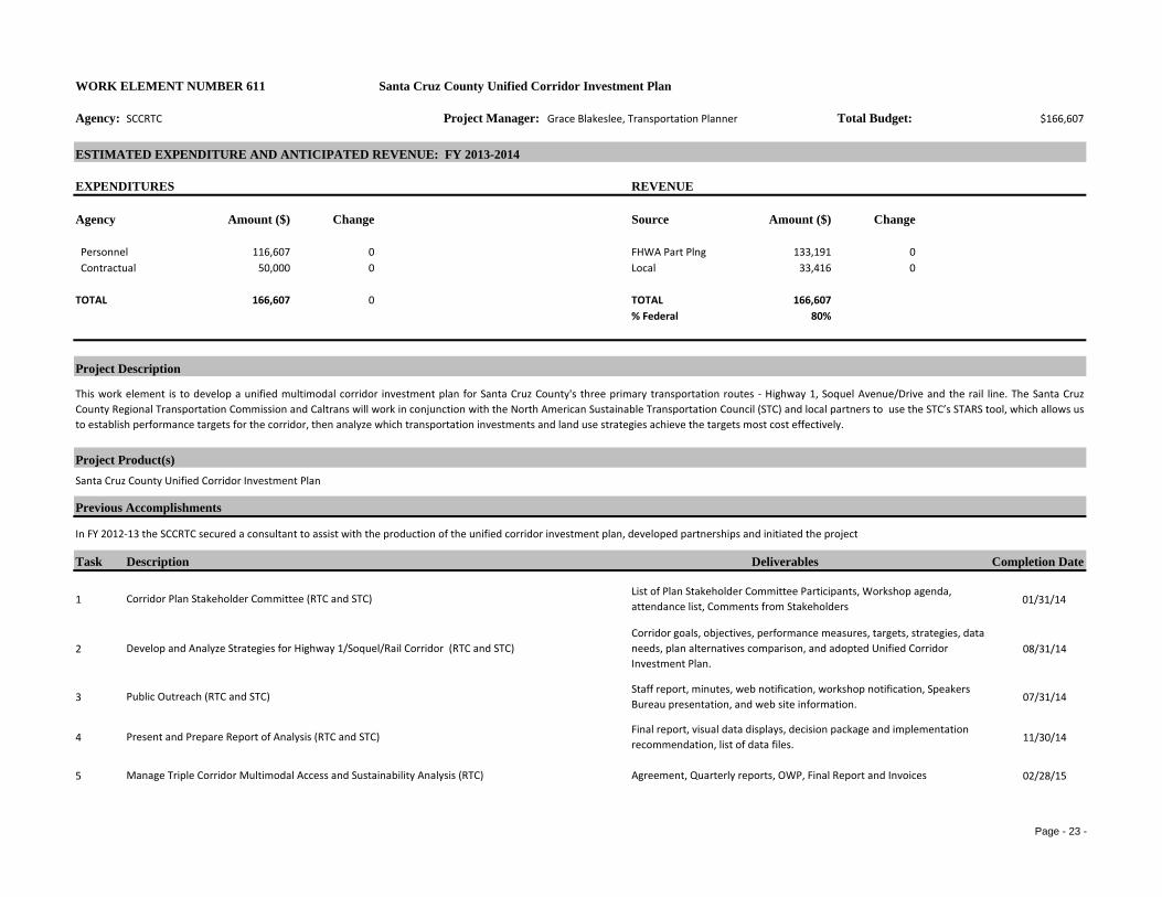
Page - 23 -
WORK ELEMENT NUMBER 611 Santa Cruz County Unified Corridor Investment Plan
Agency: SCCRTC Project Manager: Grace Blakeslee, Transportation Planner Total Budget: $166,607
ESTIMATED EXPENDITURE AND ANTICIPATED REVENUE: FY 2013-2014
EXPENDITURES REVENUE
Agency Amount ($) Change Source Amount ($) Change
Personnel 116,607 0 FHWA Part Plng 133,191 0 Contractual 50,000 0 Local 33,416 0
TOTAL 166,607 0 TOTAL 166,607% Federal 80%
Project Description
Project Product(s)
Previous Accomplishments
Task Description Deliverables Completion Date
1 01/31/14
2 08/31/14
3 07/31/14
4 11/30/14
5 02/28/15Manage Triple Corridor Multimodal Access and Sustainability Analysis (RTC) Agreement, Quarterly reports, OWP, Final Report and Invoices
This work element is to develop a unified multimodal corridor investment plan for Santa Cruz County's three primary transportation routes - Highway 1, Soquel Avenue/Drive and the rail line. The Santa CruzCounty Regional Transportation Commission and Caltrans will work in conjunction with the North American Sustainable Transportation Council (STC) and local partners to use the STC’s STARS tool, which allows usto establish performance targets for the corridor, then analyze which transportation investments and land use strategies achieve the targets most cost effectively.
Santa Cruz County Unified Corridor Investment Plan
In FY 2012-13 the SCCRTC secured a consultant to assist with the production of the unified corridor investment plan, developed partnerships and initiated the project
Corridor Plan Stakeholder Committee (RTC and STC)List of Plan Stakeholder Committee Participants, Workshop agenda, attendance list, Comments from Stakeholders
Develop and Analyze Strategies for Highway 1/Soquel/Rail Corridor (RTC and STC)Corridor goals, objectives, performance measures, targets, strategies, data needs, plan alternatives comparison, and adopted Unified Corridor Investment Plan.
Public Outreach (RTC and STC)Staff report, minutes, web notification, workshop notification, Speakers Bureau presentation, and web site information.
Present and Prepare Report of Analysis (RTC and STC)Final report, visual data displays, decision package and implementation recommendation, list of data files.
Page - 24 -
6 02/28/15Coordinate and Manage Project (RTC) Meeting agendas and summaries, invoices and billing reports
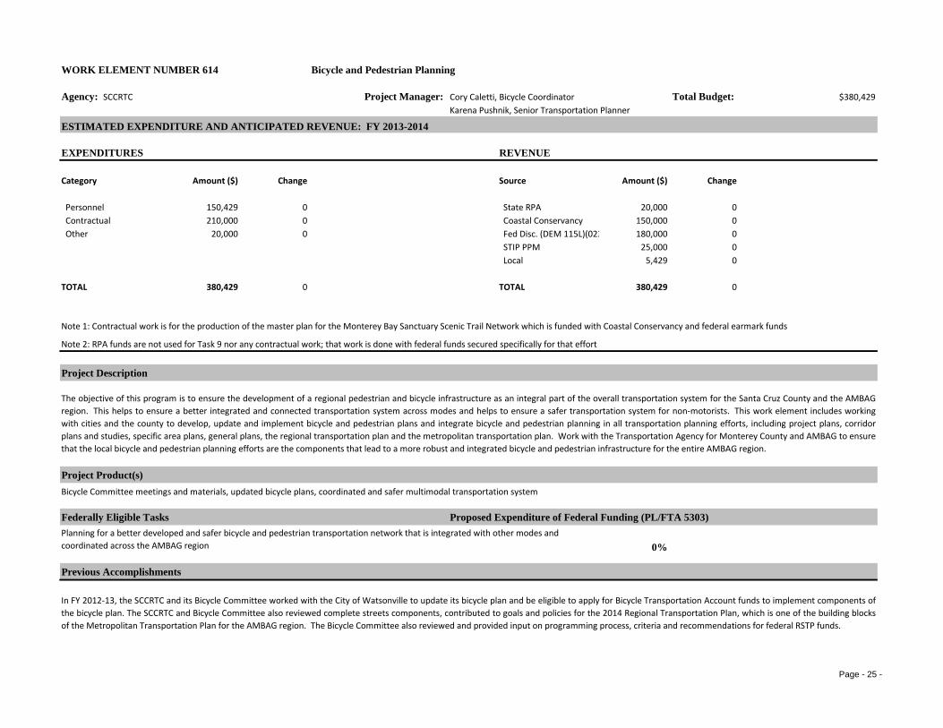
Page - 25 -
WORK ELEMENT NUMBER 614 Bicycle and Pedestrian Planning
Agency: SCCRTC Project Manager: Cory Caletti, Bicycle Coordinator Total Budget: $380,429Karena Pushnik, Senior Transportation Planner
ESTIMATED EXPENDITURE AND ANTICIPATED REVENUE: FY 2013-2014
EXPENDITURES REVENUE
Category Amount ($) Change Source Amount ($) Change
Personnel 150,429 0 State RPA 20,000 0 Contractual 210,000 0 Coastal Conservancy 150,000 0 Other 20,000 0 Fed Disc. (DEM 115L)(023 180,000 0
STIP PPM 25,000 0 Local 5,429 0
TOTAL 380,429 0 TOTAL 380,429 0
Project Description
Project Product(s)Bicycle Committee meetings and materials, updated bicycle plans, coordinated and safer multimodal transportation system
Federally Eligible Tasks Proposed Expenditure of Federal Funding (PL/FTA 5303)
0%
Previous Accomplishments
The objective of this program is to ensure the development of a regional pedestrian and bicycle infrastructure as an integral part of the overall transportation system for the Santa Cruz County and the AMBAGregion. This helps to ensure a better integrated and connected transportation system across modes and helps to ensure a safer transportation system for non-motorists. This work element includes workingwith cities and the county to develop, update and implement bicycle and pedestrian plans and integrate bicycle and pedestrian planning in all transportation planning efforts, including project plans, corridorplans and studies, specific area plans, general plans, the regional transportation plan and the metropolitan transportation plan. Work with the Transportation Agency for Monterey County and AMBAG to ensurethat the local bicycle and pedestrian planning efforts are the components that lead to a more robust and integrated bicycle and pedestrian infrastructure for the entire AMBAG region.
Planning for a better developed and safer bicycle and pedestrian transportation network that is integrated with other modes and coordinated across the AMBAG region
In FY 2012-13, the SCCRTC and its Bicycle Committee worked with the City of Watsonville to update its bicycle plan and be eligible to apply for Bicycle Transportation Account funds to implement components ofthe bicycle plan. The SCCRTC and Bicycle Committee also reviewed complete streets components, contributed to goals and policies for the 2014 Regional Transportation Plan, which is one of the building blocksof the Metropolitan Transportation Plan for the AMBAG region. The Bicycle Committee also reviewed and provided input on programming process, criteria and recommendations for federal RSTP funds.
Note 2: RPA funds are not used for Task 9 nor any contractual work; that work is done with federal funds secured specifically for that effort
Note 1: Contractual work is for the production of the master plan for the Monterey Bay Sanctuary Scenic Trail Network which is funded with Coastal Conservancy and federal earmark funds

Page - 26 -
Step Description Deliverables Completion Date
1
08/12/2013 10/21/2013 12/9/2013
02/10/2014 04/14/2014 06/9/2014
206/30/14
3
06/30/14
4
06/30/14
506/30/14
612/31/13
706/30/14
8
06/30/14
9
11/30/14
Meetings, presentations, and information materials in English and Spanish
Phone calls, emails, meetings, and information materials
Agendas, agenda packets, meetings and minutes
Updated City of Santa Cruz and UCSC bicycle plans
Coordinate and provide staff support for SCCRTC's Bicycle Committee including the production of agendas, staff reports and minutes for six meetings per year.
Work with the City of Santa Cruz and the University of California at Santa Cruz (UCSC) to update and certify their bicycle plans ensuring that federal and state requirements are met and that bicycle facilities are coordinated with other modes and facilities across the region.Engage the public in the bicycle and transportation planning efforts including the Watsonville community through coordination with Jovenes Sanos, County of Santa Cruz Health Services Agency and other community groups
Work with the Cities of Santa Cruz and Watsonville on implementation of their recent general plan updates to ensure that bicycle and pedestrian travel is adequately integrated and coordinated with other modes and across the region and with overall development to ensure a better integrated and safer multimodal transportation system and employment of a complete streets approach as required by AB 1358.
Pursue continued collection of bicycle count and mode split data
Phone calls, emails and meetings
Coordinate with local, regional, state and federal agencies on bicycle and pedestrian planning and funding efforts
Work with the County of Santa Cruz, Caltrans, local community groups, businesses and the public on planning for improved bicycle and pedestrian access and facilities in the San Lorenzo Valley that is coordinated with the regional bicycle and pedestrian infrastructure and other transportation modes
In coordination with local jurisdictions and other public agency partners complete the master plan for the Monterey Bay Sanctuary Scenic Trail (MBSST) Network and develop the draft EIR to analyze potential environmental impacts and offer appropriate mitigations.
Bicycle transportation network consistent with approved general plans and bicycle plans
Bicycle counts and mode split data
Phone calls, emails, meetings, analysis of bicycle use data
Final master plan and environmental document for trail network
continue working with AMBAG in its efforts to improve the regional travel demand model to include a bicycle component

Page - 27 -
WORK ELEMENT NUMBER 615 Bicycle and Pedestrian Projects and Programs
Agency: SCCRTC Project Manager: Cory Caletti, Bicycle Coordinator Total Budget: $397,524Karena Pushnik, Senior Transportation Planner
ESTIMATED EXPENDITURE AND ANTICIPATED REVENUE: FY 2013-2014
EXPENDITURES REVENUE
Category Amount ($) Change Source Amount ($) Change
Personnel 26,500 0 RSTP Exchange 81,024 0 Contractual 371,024 0 New Freedom Gran 165,000 0 Other 0 Local 151,500 0
TOTAL 397,524 0 TOTAL 397,524 0% Federal 0%
Project Description
Project Product(s)Improved awareness and expanded bicycle and pedestrian transportation alternatives.
Federally Eligible Tasks Proposed Expenditure of Federal Funding (PL/FTA 5303)0%
Previous Accomplishments
Task Description Deliverables Completion Date
106/30/14
206/30/14
306/30/14
406/30/14
Digitized map information
Expanded bike and ped facilities
The objective of this program is to encourage a safer bicycle and pedestrian transportation network through the funding, support and implementation of bicycle and pedestrian safety and education programsand projects working in partnership with the Community Traffic Safety Coalitions, Bike to Work, partner agencies, the local jurisdictions, the business community and the community at large.
Coordinate and advance bicycle and pedestrian projects and programs in Santa Cruz County
In FY 2010-11, the SCCRTC secured a New Freedom Grant to implement pedestrian improvements to transit identified through the work with Pedestrian Safety Work Group. SCCRTC also produced a draft bicyclesignage plan with the assistance of an intern. In 2010, working with the Elderly and Disabled Transportation Advisory Committee's Pedestrian Safety work Group, the SCCRTC produced a report titled "Improvingthe Safety and Accessibility of Sidewalks in Santa Cruz County" funded in part by an Environmental Justice Planning Grant. In FY 2012-13 the RTC completed Phase III of the bicycle parking subsidy program.
Continue financial support of the Bike to Work/School program, and the Community Traffic Safety Coalition (CTSC)
Continue funding and promoting bilingual bicycle and pedestrian safety education program (Ride N' Stride) at schools
Investigate methods to reduce vehicle travel by expanding and enhancing bicycle and pedestrian travel
Continue to compile and update digitized bikeway information to be provided to the public as a roadway layer through the County’s GIS webpage
Approved allocations
Bike week 2013
Page - 28 -
506/30/14
606/30/14
706/30/14
806/30/14
906/30/14
1006/30/14
Pedestrian facility improvements
Improvements to sidewalks
Completed reports
Updated bikeways map
Bike rack applications and rack installations
Bike route signage plan
Continue outreach and administration of Bicycle Hazard and Pedestrian Access Reports to identify network deficiencies
Continue working with the Pedestrian Safety Task Force to implement the findings of the report "Improving Safety and Accessibility of Sidewalks in Santa Cruz County"
Work with the Pedestrian Safety Work Group and local jurisdictions to make pedestrian facility improvements with funds secured through a New Freedom Grant
Implement a Bicycle Route Signage system through coordination with local jurisdictions, bicycle advocates and community members. Identify routes and seek funding.
Implement, promote and seek funding for the Bikes Secure bicycle parking subsidy program
Continue updating and distributing the Santa Cruz County Bikeways Map

Page - 29 -
Elderly & Disabled & Americans with Disabilities Act
Agency: SCCRTC Project Manager: Karena Pushnik, Senior Transportation Planner Total Budget: $50,959
ESTIMATED EXPENDITURE AND ANTICIPATED REVENUE: FY 2013-2014
EXPENDITURES REVENUE
Category Amount ($) Change Source Amount ($) Change
Personnel 50,959 0 State RPA 44,584 0 Local 6,375 0
TOTAL 50,959 0 TOTAL 50,959 0% Federal 0%
Project Description
Project Product(s)
Federally Eligible Task Proposed Expenditure of Federal Funding (PL/FTA 5303)
Previous Accomplishments
Step Description Deliverables Completion Date
1 06/30/14
206/30/14
Agenda, agenda packet and minutes
Annual report summarizing activities
WORK ELEMENT NUMBER 621
To plan and coordinate the delivery of transportation services to the elderly and persons with disabilities, and to achieve economies of scale among human service and transportation agencies. Additionally, thiswork element identifies the transportation needs of traditionally underserved groups (elderly, persons with disabilities, persons of color, and low-income) and assesses the adequacy of the transportationsystem to meet those needs.
Agenda packets and minutes of the Elderly and Disabled Transportation Advisory Committee
Inclusion of transportation needs of elderly and disabled into transportation planning and programming efforts and documents
Administer and conduct Elderly and Disabled Transportation Advisory Committee meetings 0%
SCCRTC worked with AMBAG and other regional and local partner agencies to produce the SAFETEA-LU required Coordinated Public Transit Human Services Transportation Plan. The SCCRTC Elderly andDisabled Transportation Advisory Committee established the Pedestrian Safety Work Group to work on accessible pedestrian planning. SCCRTC holds E&D Transportation Advisory Committee meetingsregularly to coordinate with public transit operators and social service providers. In FY 2011-12, the RTC completed a report title "Safe Paths of Travel: Projects, Results and Continuing Efforts" funded by andEnvironmental Justice Planning Grant through the California Department of Transportation.
Provide staff support to the E&D Transportation Advisory Committee
Implement the accessible pedestrian planning program through the Pedestrian Safety Work Group (subcommittee)
Page - 30 -
306/30/14
406/30/14
506/30/14
606/30/14
Work with the E&D Transportation Advisory Committee to conduct outreach to the elderly, disabled and low income communities in the region on transportation needs to be included in RTP, MTP, RTIP and FTIP.
Update the Guide for Specialized Transportation and provide other public information materials on transportation planning and programming for specialized transportation
Phone calls, meetings, reports and presentations
Work to ensure that transportation planning and programming at all levels in the region consider and incorporate the needs of the elderly, disabled and low income communities
Public meetings, outreach materials, reports and presentations
Updated public information materials
Improved planning and programming documents
Continue to coordinate with local public, private, and non-profit entities involved in providing specialized transportation, including Community Bridges, the Volunteer Center, SCMTD and its Metro Advisory Committee (MAC)

Page - 31 -
Transportation Planning for the Region
Agency: SCCRTC Project Manager: Grace Blakeslee, Senior Transportation Planner Total Budget: $302,950
ESTIMATED EXPENDITURE AND ANTICIPATED REVENUE: FY 2013-2014
EXPENDITURES REVENUE
Category Amount ($) Change Source Amount ($) Change
Personnel 233,450 0 FHWA PL 50,000 0 Contractual 57,500 0 RPA 80,021 0 Other 12,000 0 STIP PPM 23,033 0
Local 149,896 0
TOTAL 302,950 0 TOTAL 302,950 0% Federal 17%
Note: Contractual work under this work element is for the production of the required environmental document for the metropolitan and regional transportation plans
Project Description
Project Product(s)
Environmental review of 2014 MTP
Federally Eligible Task Proposed Expenditure of Federal Funding (PL/FTA 5303)Update the Metropolitan Transportation Plan (MTP) to produce a 2014 MTP
Previous Accomplishments
Task Description Deliverable Completion Date
1
06/30/14
In FY 2012-13 SCCRTC worked with AMBAG and regional partners to produce various components for the 2014 MTP including goals, policies and a project list through a public process that includedsustainability considerations and significant outreach to the entire community. SCCRTC also worked with AMBAG and other regional partners to initiate the environmental review for the 2014 MTP.
Components of 2014 MTP and RTPWork with other entities in the region on long-range transportation planning activities within the region, including timelines, public participation efforts, updated project costs and revenue estimates, environmental documentation, and other efforts that may produce economies of scale in the production of the 2014 MTP
WORK ELEMENT NUMBER 622
The focus of this work element is implementation of the existing transportation plans for the region, preparation of the 2014 Metropolitan Transportation Plan (MTP) for the three-county AMBAG region andensuring the relevant components of the 2014 MTP are incorporated into the 2014 RTP and other planning documents within the region. Additionally, rules regarding regional transportation planningestablished by the federal transportation acts (SAFETEA-LU and MAP-21), will continue to be implemented. This work element also includes working with local jurisdictions to ensure that regional transportationpolicies and projects are included in local jurisdiction planning activities. Staff will also continue work on incorporating sustainability into all transportation planning documents and activities for the region.
2014 Metropolitan Transportation Plan (MTP) and updates
17%

Page - 32 -
2
09/30/13
3
10/31/13
4
11/15/13
5
06/30/14
606/30/14
706/30/14
8
06/30/14
906/30/14
1006/30/14
1106/30/14
1207/01/14
1306/30/14
Work with AMBAG, local jurisdictions, the public and other entities in the region to finalize the investment program for the Santa Cruz County sections of the 2014 MTP employing sustainability analysis and public outreach strategies that include bilingual outreach and public meetings
Work with AMBAG, local jurisdictions, the public and other entities in the region to finalize the financial element for the Santa Cruz County sections of the 2014 MTP employing public outreach strategies that include bilingual outreach and public meetings
Implement a comprehensive public participation and outreach program for production and completion of the various components of the 2014 MTP that includes public workshops, public meetings, printed materials, web site information, public surveying, segments of the Transportation Cafe television program, bilingual outreach, Facebook posts, media releases, radio, etc.
Outreach materials, surveys, questionnaires, community TV program, and internet content, including Spanish materials
Programming documents that reflect MTP and RTP policies
Public outreach and other materials and draft financial element for MTP and RTP
Work with local jurisdictions, Caltrans, AMBAG, the Metropolitan Transportation Commission, and the Transportation Agency for Monterey County (TAMC) on long-range transportation planning activities in our region consistent with the Metropolitan Transportation Plan
Work to develop potential new transportation revenues to help meet continuously increasing funding shortfalls listed in the MTP and that will help to implement the MTP
Work with Caltrans and AMBAG on implementing regional planning requirements enacted through the federal transportation acts
Public outreach and other materials and final goals and policies for the 2014 MTP and RTP
Public outreach and other materials and final investment program for MTP and RTP
Planning documents consistent with federal requirements
Continue to work with AMBAG, Caltrans and local agencies to implement the Metropolitan Transportation Plan’s projects and policies through the various planning and capital improvement programming actions
Identify and document transportation facilities, projects and services required to meet regional and interregional mobility and access needs consistent with the Metropolitan Transportation Plan
Apply the Sustainable Transportation Analysis and Rating System (STARS) process to the development of the 2014 MTP sections for Santa Cruz County to ensure a more sustainable 2014 MTP
Ensure that projects proposed for federal, state or local funding are consistent with the MTP
Ensure that relevant goals, policies, projects, funding and other elements of the MTP are incorporated into other planning documents within the region such as the RTP, general plans, etc. to ensure that all other planning documents that include transportation are consistent with the MTP.
Work with AMBAG, local jurisdictions, the public and other entities in the region to finalize the goals and policies for the Santa Cruz County sections of the 2014 MTP employing sustainability analysis and public outreach strategies that include bilingual outreach and public meetings
Analysis of revenue options
STARS analysis of MTP and RTP
Planning documents consistent with MTP and RTP
Programming documents consistent with MTP and RTP
Phone calls, emails, meetings, outreach materials
Integrated transportation planning across region

Page - 33 -
WORK ELEMENT NUMBER 641 Transportation Improvement Programs (TIP)
Agency: SCCRTC Project Manager: Rachel Moriconi, Senior Transportation Planner Total Budget: $238,173
ESTIMATED EXPENDITURE AND ANTICIPATED REVENUE: FY 2013-2014
EXPENDITURES REVENUE
Category Amount ($) Change Source Amount ($) Change
Personnel 188,173 0 FHWA PL 10,000 0 Contractual 50,000 0 State RPA 16,933 0 Other 0 STIP PP&M 100,504 0 Contingency 0 0 Local 110,736 0
TOTAL 238,173 0 TOTAL 238,173 0% Federal 4%
Note: FHWA PL and RPA funds are not used for the administration of capital programs included in Steps 13 -17 belowNote: Contractual work under this work element is paid for by local funds and is for assistance with the analysis of programming criteria or potential development of funding sources
Project Description
Project Product(s)
Funding applications and decisions for Regional Surface Transportation Program (RSTP)Amendments to the 2012 Regional Transportation Improvement Program and State Transportation Improvement ProgramDevelopment of the 2014 Regional Transportation Improvement Program (RTIP) and 2014 State Transportation Improvement Program (STIP)Development of the Transportation Alternatives Program (TAP) and Active Transportation Program
Federally Eligible Task Proposed Expenditure of Federal Funding (PL)
Previous Accomplishments
Production and maintenance of the MTIP and other programming documents to secure funding and delivery of federally funded andregionally significant projects.
In FY 2012-13 SCCRTC programmed Regional Surface Transportation Program (RSTP) funds for projects on federal-aid routes and regionally significant projects. SCCRTC also assisted project sponsors indelivering federally funded projects.
Administer and monitor federal aid funding programs whose projects are included in the federal transportation improvement program, including programs identified in MAP-21 such as the Regional SurfaceTransportation Program (RSTP), Transportation Alternatives Program (TAP), Highway Safety Improvement Program (HSIP) and State Transportation Improvement Program (STIP). This includes the production,maintenance and amendments of programming documents required for federally funded and regionally significant projects. The work also includes assisting project sponsors with compliance of requirements toreceive the funds and deliver the federally funded and regionally significant projects. This work element also includes leveraging the federal funds to secure any required match and funding from other sourcesto deliver as many regionally significant transportation projects as possible. Produce and implement the Regional Transportation Improvement Program (RTIP) to secure State Transportation ImprovementProgram (STIP) funds for federally funded and regionally significant projects to ensure delivery of as many regionally significant projects as possible that are included in the Metropolitan Transportation Plan(MTP) and the Metropolitan Transportation Improvement Program (MTIP). Work with regional and state partners on appropriate implementation of the federal transportation act, MAP-21, in California.
FY 2012/13 to FY 2015/16 Metropolitan Transportation Improvement Program (MTIP) and amendments
Implementation, administration and monitoring of federal aid funding programs4%

Page - 34 -
Task Description Deliverables Completion Date
1 08/31/13
2 08/31/13
3 10/01/13
4 10/15/13
5 06/30/14
6 06/30/14
7 06/30/14
8 06/30/14
9 06/30/14
10 06/30/14
11 06/30/14
12 06/30/14
13 06/30/14
14 06/30/14
15 06/30/14
16 06/30/14
Initiate preparation of the 2014 Regional Transportation Improvement Program (RTIP) to ensure full funding and delivery of projects in the MTP and MTIP
Prepare application and programming process for the Regional Surface Transportation Program (RSTP) and State Transportation Improvement Program (STIP)
Solicit and receive projects for the Regional Surface Transportation Program (RSTP) and State Transportation Improvement Program (STIP)
Review and rate projects for RTIP and STIP; produce draft programming recommendations and program funds
Work with AMBAG to Prepare amendments to the MTIP and any supporting programming documents such as the RTIP and STIP as needed
Prepare state and federally-mandated information and reports for AMBAG, Caltrans, FHWA, and the CTC
Coordinate with AMBAG, Caltrans and other entities as needed on all Federal Transportation Improvement Program (FTIP) amendments and amendments of other programming documents such as the Regional Transportation Improvement and the State Transportation Improvement Program (STIP) that impact the FTIP
Conduct planning and project activities (including corridor studies, and other transportation planning studies) to identify and develop candidate projects for the Federal Transportation Improvement Program (FTIP)
Monitor the state and federal transportation budgets and work with Caltrans and the California Transportation Commission on obtaining funding for federally funded and regionally significant projects included in the FTIP, STIP and RTIP
Monitor federal actions with regard to federal transportation act reauthorization, extensions and appropriations to ensure full funding and delivery of projects in the MTP and MTIP
Program funds for projects through federal and state funding programs that provide funding for regionally significant projects included in the MTIP such as the State Transportation Improvement Program (STIP) and the Regional Surface Transportation Program (RSTP)
Monitor the implementation of RSTP, CMAQ, STIP, STIP TE, HSIP, and HBR-funded projects, with an emphasis on project delivery, timely use of funds and compliance with all Federal and state laws and California Transportation Commission guidelines to ensure delivery of federally funded and regionally significant projects
To streamline delivery of qualifying and approved regionally significant projects, exchange federal RSTP funds for State funds through the State’s RSTP Exchange program
Assist local agencies in filing and monitoring funding allocation requests to deliver regionally significant projects
Work with AMBAG and Caltrans to monitor both major and minor state highway projects and to fulfill project monitoring and project delivery responsibilities
Work with AMBAG, our counterpart regional agencies, Caltrans and the California Transportation Commission (CTC) on the development of implementation policies and procedures for federal and state funding programs
Application and timeline
Initial materials and timeline
Transportation improvement program documents
Materials and reports, teleconferences phone calls
State and federal transportation budget information materials and reports
Planning studies
FTIP amendments
Materials for MTIP amendments
Recommendations and staff reports and materials
Funding applications
Improved funding procedures
Communications with partner agencies
Allocation requests
Reports, resolutions, and agreements
Communications with project sponsors
Reports

Page - 35 -
17 06/30/14
18 06/30/14
19 06/30/14
Implement a comprehensive public participation and outreach program for production of the various programming documents and funding decisions that includes public workshops, public meetings, printed materials, web site information, public surveying, segments of the Transportation Cafe television program, bilingual outreach, social media, media releases,
Monitor development of performance measures as part of MAP-21 implementation to maximize efficiency of implementation of the MTP and MTIP
Work with Caltrans and regional partners to produce the Transportation Alternatives Program (TAP) and Active Transportation Program (ATP) consistent with MAP-21
TAP and ATP
Outreach materials including materials in Spanish and to traditionally underrepresented communities
Reports, communications with state and federal agencies

Page - 36 -

Page - 37 -
WORK ELEMENT NUMBER 682 Rail/Trail Authority (SCCRTC)
Agency: SCCRTC Project Manager: Luis Mendez, SCCRTC Total Budget: $5,535,000
ESTIMATED EXPENDITURE AND ANTICIPATED REVENUE: FY 2013-2014
EXPENDITURES REVENUE
Category Amount ($) Change Source Amount ($) Change
Personnel 180,000 0 STIP 5,240,000 0 Construction 5,225,000 0 Local 160,000 0 Services & Supplies 100,000 0 Reserves 135,000 0 Contingency 30,000 0
TOTAL 5,535,000 0 TOTAL 5,535,000 0
Project Description
Project Product(s)
SCCRTC meeting materials; Implementation plan for recreational rail service; Agreements with operators; leases
Other Task (nonfederal)
Previous Accomplishments
Task Description Deliverables Completion Date
1 06/30/14
2 06/30/14
3 06/30/14
This work element involves management and development of the Santa Cruz Branch Rail Line right-of-way and planning for improved future uses. The Regional Transportation Commission is also planning toinstitute recreational passenger rail service. The possibility of potential bicycle and pedestrian paths using the right-of way adjacent to the rail line is shown within the Bicycle/Pedestrian Planning Work Element.
Ownership and management of Santa Cruz Branch Rail Line right-of-way and its operation
Establish contracts and systems to effectively, efficiently and reliably operate the freight service, maintain the rail line and manage the ownership of the property
In FY 2012-13, the SCCRTC completed the purchase of the Santa Cruz Branch Rail Line from Union Pacific and selected Santa Cruz & Monterey Bay Railway (a company of Iowa Pacific Holdings) to operate freight and passenger service. Working with SCCRTC and the community, SC&MB Railway initiated a tourist train service for the Christmas holiday period.
Service contracts, leases, property management policies
Updated leases
Operation agreements
Investigate lease possibilities, update old leases and secure new leases
Coordinate operation of the Santa Cruz Branch Rail Line, including current and future uses, with operators, shippers, partner agencies and local jurisdictions

Page - 38 -
4 06/30/14
5 06/30/14
6 06/30/14
7 06/30/14
8 06/30/14
Work with rail service operators on the development of additional recreational rail service between Santa Cruz and Davenport
Continue to work with the Transportation Agency for Monterey County, the Coast Rail Coordinating Council, Caltrain, AMTRAK and Caltrans Division of Rail to support the establishment of a rail station at the Pajaro station for any new or expanded rail passenger service on the coast mainline
Seek planning grants funds for the production of feasibility studies and implementation plans for various types of passenger and transit service on the Santa Cruz Branch Rail Line
Guide consultant and contractor work on the rehabilitation of structures of the Santa Cruz Branch Rail Line and other improvements in cooperation with SC&MB Railway
Seek funding for other necessary improvements to the Santa Cruz Branch Rail Line in cooperation with SC&MB Railway and other regional partners
Rail service plan and implementation
Grant applications
Meetings, agendas, minutes, phone calls
Funding applications and requests
Meetings, phone calls, email, reports, presentations
Page - 39 -
WORK ELEMENT NUMBER 683 Highway and Roadway Planning (SCCRTC)
Agency: SCCRTC Project Manager: Rachel Moriconi, Senior Transportation Planner Total Budget: $74,000
ESTIMATED EXPENDITURE AND ANTICIPATED REVENUE: FY 2013-2014
EXPENDITURES REVENUE
Category Amount ($) Change Source Amount ($) Change
Personnel 74,000 0 State RPA 54,287 0 Other 0 Local 19,713
TOTAL 74,000 0 TOTAL 74,000 0% Federal 0%
Project Description
Project Product(s)
Federally Eligible Task Proposed Expenditure of Federal Funding (PL/FTA 5303)
0%
Task Description Deliverables Completion Dates
1
06/30/14
206/30/14
Highway 17 corridor study
Soquel Drive corridor plan
This work element is for the planning work necessary to maintain and improve the roadway and highway system. The work includes participation and coordination with Caltrans on the State Highway Operations andProtection program and any other planning documents and efforts to improve the operation and safety of the state highway system. The work also includes participation with local jurisdictions and other partneragencies in their planning efforts for an improve the operation and safety of the highway and roadway system and intersections of the system.
Improved operation, safety and mobility on the region's highway and roadway system
Work with Caltrans and local jurisdictions and other entities on planning for improved roadways and highways
Communications with partner agencies and information materials
Local and regional roads assessment and updates
Work with Caltrans and local agencies on the development of the State Highway Operation and Protection Program (SHOPP) to ensure that well in advance of its drafting the regional and interregional safety and mobility needs of the Santa Cruz County highway system are considered for inclusion in the draft document. This includes discussion with Caltrans at quarterly meetings and with the Interagency Technical Advisory Committee.
Work with local jurisdictions on preparation and update of a regional and local roads assessment to establish roadway funding needs and priorities for inclusion in programming documents.
Project concept report for Highway in the north coast

Page - 40 -
3
06/30/14
4
06/30/14
5
06/30/14
606/30/14
706/30/14
Public outreach materials and Highway 17 corridor study
Prepare public information materials for identified highway and roadway needs and priorities to communicate to decision makers and the public the need for funding these priorities.
Work with Caltrans, the CHP and other transportation partners through the Traffic Operation Systems (TOS) Oversight Committee and Safe on 17 Task Force to identify safety, mobility and operations needs, priorities and improvements for inclusion in planning and programming documents.
Public information materials, reports and presentations
Communications with partner agencies and meetings
Work with Caltrans, resource agencies and local partners to produce a project concept report for Highway 1 in the north coast
Meetings, communications, project concept report
Meetings, communications, Soquel Drive Corridor Plan
Work with Caltrans, the CHP, County Public Works and the community to produce a Highway 17 corridor study
Work with the County of Santa Cruz on the Soquel Drive Corridor plan and ensure inclusion of sustainability principles, complete streets strategies as required by AB 1358 and land use and transportation coordination and identify needs and priorities for inclusion in programming documents.

Page - 41 -
WORK ELEMENT NUMBER 684 Highway 1 Projects (SCCRTC)
Agency: SCCRTC Project Manager: Kim Shultz Senior Transportation Planner Total Budget: $3,291,248
ESTIMATED EXPENDITURE AND ANTICIPATED REVENUE: FY 2013-2014
EXPENDITURES REVENUE
Agency Amount ($) Change Source Amount ($) Change
Personnel 275,000 0 RSTP Exchange 981,248 0 Other 2,805,000 0 STIP 317,729 0 Contingencies 211,248 0 CMIA 1,992,271 0
TOTAL 3,291,248 0 TOTAL 3,291,248 0% Federal 0%
Project Description
Project Product(s)
Other Task
Task Description Deliverables Completion Date
1
06/30/14
209/30/13
3 06/30/14
Meetings, agendas, minutes
Meetings, agendas, minutes
Communication with team members
Guide the consultant work, in cooperation with the Project Development Team, Caltrans, local, and regional agencies on the completion of the tiered environmental documents for the Highway 1 HOV Lanes project and 41st to Soquel auxiliary lanes
Guide the consultant work with the Project Development Team, Caltrans, local, and regional agencies, on the construction of the Highway 1 Soquel-Morrissey Auxiliary Lanes project
Participate in the Project Development Team (PDT) oversight
SCCRTC is responsible for tasks including the implementation of the Project Approval/ Environmental Documents (PA/ED) phase for the Highway 1 HOV Lanes project which will produce a tiered environmentaldocument with project level environmental review for auxiliary lanes between 41st Avenue and Soquel Drive and a bicycle and pedestrian overcrossing at Chanticleer. SCCRTC is also responsible for theconstruction of the Highway 1 Soquel-Morrissey Auxiliary Lanes project.
Tiered environmental documents for the Highway 1 HOV Lanes project and with project level analysis for the Highway 1 41st-Soquel Auxiliary Lanes project
Construction of the Highway 1 Soquel to Morrissey Auxiliary Lanes project
Project Approval/ Environmental Documents (PA/ED) for the Highway 1 HOV Lanes project and the Highway 1 41st-Soquel Auxiliary Lanes project

Page - 42 -
406/30/14
506/30/14
606/30/14
709/30/13
Coordinated outreach, responses to public
Construction agreements and amendments
Reports, invoices
Public meetings, outreach materials in English and Spanish
Implement public outreach plans for the environmental documents project and construction project including outreach to traditionally underrepresented communities
Coordinate public outreach efforts with other RTC projects and other local and regional agencies, and respond to concerns from residents and businesses
Complete necessary agreements to manage and construct the Highway 1 Soquel-Morrissey Auxiliary Lanes project and ensure adequate as-built plans after construction is complete
Coordinate with Caltrans and the consultant team to meet all funding and project reporting requirements including those of the Corridor Mobility Improvement Account (CMIA).

AGENDA: June 26, 2013
TO: Regional Transportation Commission Transportation Policy Workshop FROM: Heather Adamson, Principal Planner, AMBAG RE: 2014 Metropolitan Transportation Plan (MTP)/Sustainable Communities
Strategy: Scenario Development
RECOMMENDATIONS The Regional Transportation Commission is asked to discuss and provide input on the initial Sustainable Communities Strategy scenarios. BACKGROUND/DISCUSSION As the federally designated Metropolitan Planning Organization (MPO) for the tri-county Monterey Bay area region, AMBAG is required to adopt and submit an updated Metropolitan Transportation Plan (MTP) every four years. The MTP and its Sustainable Communities Strategy (SCS) will contain specific public policies and strategies, as well as projects and programs aimed at meeting the diverse mobility needs of our growing and changing region. According to AMBAG projections, by the year 2035 the tri-county region of Monterey, San Benito, and Santa Cruz counties will see an increase of more than 150,000 people, 40,000 housing units, and nearly 65,000 jobs. The SCS component is a new element of the MTP that is required by California Senate Bill 375, the Sustainable Communities and Climate Protection Act of 2008 (SB 375). SB 375 mandates regional greenhouse gas (GHG) reduction targets for passenger vehicles and, pursuant to that law, the California Air Resources Board (CARB) has established 2020 and 2035 GHG reduction targets for each region covered by one of the state’s metropolitan planning organizations (MPOs). AMBAG is required to prepare an SCS that demonstrates how GHG reduction targets could be met through integrated land use, housing, and transportation planning. If the SCS is unable to meet the GHG reduction targets, then an Alternative Planning Scenario must be prepared. An integrated work program, policy goals, and performance measures have been developed to guide the development of the MTP/SCS. The MTP/SCS six policy goals are: 1) Accessibility and Mobility, 2) Economic Vitality, 3) Environment, 4) Healthy Communities, 5) Social Equity, and 6) System Preservation and Safety. AMBAG has been working collaboratively with the RTPAs, transit agencies, local jurisdictions, and community members to develop initial SCS scenarios that are framed by the MTP policies and goals.
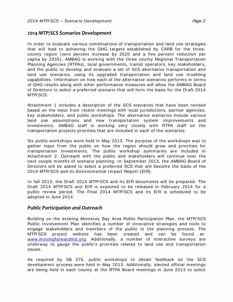
2014 MTP/SCS – Scenario Development Page 2 2014 MTP/SCS Scenarios Development In order to evaluate various combinations of transportation and land use strategies that will lead to achieving the GHG targets established by CARB for the three-county region (zero percent increase by 2020 and a five percent reduction per capita by 2035), AMBAG is working with the three county Regional Transportation Planning Agencies (RTPAs), local governments, transit operators, key stakeholders, and the public to develop and evaluate a set of SCS alternative transportation and land use scenarios, using its upgraded transportation and land use modeling capabilities. Information on how each of the alternative scenarios performs in terms of GHG results along with other performance measures will allow the AMBAG Board of Directors to select a preferred scenario that will form the basis for the Draft 2014 MTP/SCS. Attachment 1 includes a description of the SCS scenarios that have been revised based on the input from recent meetings with local jurisdictions, partner agencies, key stakeholders, and public workshops. The alternative scenarios include various land use assumptions and new transportation system improvements and investments. AMBAG staff is working very closely with RTPA staff on the transportation projects priorities that are included in each of the scenarios. Six public workshops were held in May 2013. The purpose of the workshops was to gather input from the public on how the region should grow and priorities for transportation investments. The public workshop summaries are included in Attachment 2. Outreach with the public and stakeholders will continue over the next couple months of scenario planning. In September 2013, the AMBAG Board of Directors will be asked to select a preferred SCS that will become the basis of the 2014 MTP/SCS and its Environmental Impact Report (EIR). In fall 2013, the Draft 2014 MTP/SCS and its EIR documents will be prepared. The Draft 2014 MTP/SCS and EIR is expected to be released in February 2014 for a public review period. The Final 2014 MTP/SCS and its EIR is scheduled to be adopted in June 2014. Public Participation and Outreach Building on the existing Monterey Bay Area Public Participation Plan, the MTP/SCS Public Involvement Plan identifies a number of innovative strategies and tools to engage stakeholders and members of the public in the planning process. The MTP/SCS project website has been created and can be found at: www.movingforwardmb.org. Additionally, a number of interactive surveys are underway to gauge the public’s priorities related to land use and transportation issues. As required by SB 375, public workshops to obtain feedback on the SCS development process were held in May 2013. Additionally, elected official meetings are being held in each county at the RTPA Board meetings in June 2013 to solicit

2014 MTP/SCS – Scenario Development Page 3 feedback and input for the development of the SCS. Another round of public workshops including the EIR scoping meetings are being planned for July 2013. The purpose of the July workshops is to obtain feedback on the SCS scenario results and collect input for a hybrid or preferred SCS scenario. In Monterey on July 15, 2013 from 6:00 PM to 7:30 PM at the Monterey
City Hall Council Chambers, 580 Pacific Street In Greenfield on July 16, 2013 from 6:00 PM to 7:30 PM at the City of
Greenfield Council Chambers, 599 El Camino Real In Hollister on July 17, 2013 from 6:00 PM to 7:30 PM at the City of
Hollister Council Chambers, 375 Fifth Street In Watsonville on July 18, 2013 from 6:00 PM to 7:30PM at the City of
Watsonville Community Room, 275 Main Street, 4th Floor In Santa Cruz on July 22, 2013 from 6:00 PM to 7:30 PM at the Santa
Cruz Police Department Community Room, 155 Center Street In Salinas on July 23, 2013 from 6:00 PM to 7:30 PM at the Salinas
Agricultural Center, 1432 Abbott Street. Next Steps Staff will continue to work with the various working groups, advisory committees, and the public to evaluate the alternative scenarios for the SCS. The alternative scenarios will be brought back to the AMBAG Board of Directors in August for input and recommendations for a hybrid(s) scenario. The AMBAG Board of Directors will be asked to select a preferred scenario in September 2013.
1. MTP-SCS Scenario Descriptions & Placetype Menu Attachments:
2. MTP-SCS Community Workshop Notes – May 2013

2014 MTP/SCS Scenario Descriptions
Attachment 1
Future Alternative SCS Scenarios The following future Alternative SCS Scenarios have been developed to assess how future land use and transportation changes could affect the regional transportation system as well as travel demands or needs. These alternative scenarios combine the trends and variables identified in the 2014 MTP/SCS Policy Goals as adopted by the AMBAG Board.
These alternatives are used to communicate broad concepts for consideration by all stakeholders to weigh and consider transportation choices and priorities. They also provide a common framework for all parties to discuss the economic, social, and environmental costs and benefits of transportation decisions while taking future uncertainties into consideration.
For each of these scenarios, it is assumed that the AMBAG Regional Growth Forecast (three county total) is a constraint (fixed upper limit) to the amount of total development in the region.
2035 SCS Scenario #1 – Regional Transit Corridors
Land Use
Focus future development adjacent to existing and proposed rail and regional/intercity transit corridors and opportunity areas.
Encourage higher density urban centers in existing cities. Locate higher density residential and mixed use development at transit stations
along the transit corridors. Strong emphasis on farmland preservation and watershed restoration.
Specific Land Use Changes
Place types1 along rail and transit corridors currently designated as "town" or "neighborhood" (whether residential, commercial or mixed use) increase in density/intensity within the existing place type designation.
Consider new transit oriented development (TOD) style development around high frequency Bus Rapid Transit (BRT), transit centers, or rail transit stops.
1 Place type categories are meant to act as a common “language” so that the diverse general and specific plans across the Monterey Bay region may be compared in a consistent and standard manner. The place types were developed in preparation for the SCS development process in consultation with the local jurisdictions. The place type menu is included in this attachment.
2014 MTP/SCS Scenario Descriptions | Page 2 6/13/2013
Transportation
Major investment in regional transit and rail transportation infrastructure. Transit improvement to create better connections from housing to regional job
centers. BRT and regional express between major cities within and around region with
dedicated lanes, where possible, or the use of bus on shoulders, to provide time savings.
Transportation system management strategies that support regional BRT such as queue jumps.
Investments in high occupancy toll (HOT), high occupancy vehicle (HOV), and reversible lanes to support transit.
Create transit linkages to/from the proposed High Speed Rail Stations (Gilroy and Diridon).
Improve commuter rail access within the Monterey Bay region and to the San Francisco Bay Area.
Re-establish the Coast Daylight/Starlight Express. Provide shuttles from passenger rail stations to tourist attractions.
2035 SCS Scenario #2 – Expanded Community Centers/Livable Communities
Land Use
Focus additional growth within existing neighborhood communities in and adjacent to existing commercial corridors. (Focus on localization vs. regional mobility.)
Encourage/facilitate a better jobs/housing balance. Encourage mixed use development that supports walkability and convenient
access to services within community centers. Encourage business incubators and green tech businesses. (Emphasis on small
business and start ups instead of large scale businesses as referenced in Scenario 4.)
Support the housing and transportation needs of workers in the hospitality industry, particularly along the Monterey peninsula.
Improve access to educational facilities, particularly for higher-learning.
Specific Land Use Changes
In areas currently designated as mixed use, keep the mixed use, but upgrade the density/intensity. Areas currently designated as "neighborhood mixed use" become "town mixed use" and areas currently designated as "town mixed use" become "urban mixed use."
Transition commercial areas to mixed use. Areas currently designated as "town commercial" become "town mixed use" and areas designated as "neighborhood commercial" become "neighborhood mixed use."

2014 MTP/SCS Scenario Descriptions | Page 3 6/13/2013
In specific locations previously identified by local jurisdictions to encourage infill development. For example, "Industrial" or "Institutional" place types become "Residential" or "Commercial" place types.
Transportation
Focus on creating more “Complete Streets” and encouraging “active” transportation such as walking and biking that are commonly associated with the first and last mile of travel.
Close local transit gaps and invest in local bus transit services and facilities. Significantly improve traffic safety through traffic calming, streetscape
landscaping, etc. Increase investment in local serving rapid or express bus services Facilitate and fund development of new dedicated bicycle and pedestrian
facilities that connect key destinations. Encourage the development of roundabouts to improve safety and air quality. Encourage the development of pedestrian trails. Encourage/expand bikes on bus to help with first and last mile of trips. Improve access for pedestrians and bicyclists in areas identified for intensified
use
2035 SCS Scenario #3 – Dispersed Growth
Land Use
Encourage future growth in new “greenfield” development areas and expand growth in existing unincorporated communities.
Focus on opportunities to expand and improve access to tourism.
Specific Land Use Changes
Areas currently designated as "agricultural" or "open space" may become "exurban-rural" or "rural-town residential” based on input received from local jurisdictions.
Areas currently designated as “exurban” to “suburban single-family residential” based on input received from local jurisdictions.
In specific locations, unincorporated areas increase in intensity of use based on input received from local jurisdictions.
Transportation
Focus on roadway improvements that reduce congestion and travel time. Develop improved roadway and transit access that support tourism related jobs. Improve/expand highway access between cities particularly at "choke points"
with strategies such as BRT, HOV/HOT lanes, auxiliary lanes, ramp metering,

2014 MTP/SCS Scenario Descriptions | Page 4 6/13/2013
interchanges, left turn lanes, park-and-ride lots and safety improvements for at-grade crossings.
Construct safety enhancement projects on highways.
2035 SCS Scenario #4 – Targeted Growth and Economic Diversity
Land Use
Concentrate growth and development for both housing and employment in cities that support low income and minority populations, inclusive of proposed annexations and sphere of influence amendments.
Improve the jobs/housing balance in those areas that support low income and minority populations.
Encourage sustainable, pedestrian oriented development that is responsive to the economic needs and social heritage of each respective community.
Promote housing that supports local economic development, particularly workforce housing.
Encourage economic development that diversifies the economy instead of promoting one particular industry such as tourism related services, processing and manufacturing, healthcare and medical services as well as general retail businesses.
Promote access to workforce investment opportunities such as vocational training centers.
Expand land use development around existing and proposed airport facilities to accommodate goods movement.
Specific Land Use Changes
Areas currently designated as "exurban", "rural" or “suburban single-family” become "town" or "suburban" place types including commercial and residential uses with additional changes based on input received from the local jurisdictions.
Growth may be included in areas beyond current spheres of influence/city limits in this scenario.
Transportation
Focus transportation investments along highways in underserved areas. Examples include: Commuter express services (e.g. express bus, vanpools, etc.) Interchange improvements Safety improvements at at-grade crossings
Focus transit/transportation services that cater to students as well as low income and minority populations.
2014 MTP/SCS Scenario Descriptions | Page 5 6/13/2013
Develop a regional rail transfer facility to enable more efficient transport of goods, particularly produce.
2035 SCS Scenario #5 – System Preservation
Land Use
Allocate growth according to existing general plans designations for each respective jurisdiction assuming the AMBAG 2035 Regional Growth Forecast for population, housing, and employment. (No specific land use changes proposed for this scenario.)
Transportation
Focus transportation funding on safety, maintenance, and rehabilitation of existing roadway and transit facilities throughout the region.

1
Urban Place Types
IntensityGeneral Characteristics
ExamplesLand Use Transportation
U-1 Urban Single-Family Residential Low to Medium Intensity (6 to 18 units per acre)
Single-family homes in close proximity to urban centers, typically laid out in a grid block pattern. Includes occasional duplexes, accessory units, and/or small multi-unit buildings.
Compact development pattern with small lots, limited setbacks, and close proximity of structures.
Short blocks, grid street pattern, and proximity to destinations support non-motorized modes of transportation. Complete sidewalks and bicycle infrastructure typically present.
Neighborhoods served by bus service with typical 30-minute headways; occasional proximity to multi-modal, regional, or intercity transit stations.
Chestnut Street, Santa Cruz
Hellam Street, Monterey
U-2 Urban Multi-Family Residential Medium Intensity
(12 to 30 units per acre)
Small and large apartment buildings, duplexes, accessory units, and limited single-family homes in close proximity to urban centers. Well-integrated into the surrounding urban fabric.
One- to five-story residential buildings on small to medium lots with minimal setbacks from property lines and adjacent structures. Building entrances typically oriented to the street.
Short blocks, grid street pattern, land-use diversity, and proximity of destinations support non-motorized modes of transportation. Complete sidewalks and bicycle infrastructure typically present.
Neighborhoods served by bus service with typical 30-minute headways; occasional proximity to multi-modal, regional or intercity transit stations.
Clay Street, Monterey
3rd Street, Santa Cruz
U-3 Urban Commercial Low Intensity (FAR 1.0 or less)
A high concentration of retail, service, and office uses organized in a grid block pattern.
A pedestrian-friendly environment supported by active ground floor building frontages, entrances oriented to the street, parking located to the rear of lots, and buildings placed at or near property lines.
Short blocks, grid street pattern, land-use diversity, and proximity of destinations support non-motorized modes of transportation. Wide sidewalks support pedestrian circulation; motorists frequently park once to visit multiple destinations.
Multiple bus routes typically with 30-minute headways; occasional presence of multi-modal, regional or intercity transit stations.
Downtown Santa Cruz
Downtown Monterey

2
Suburban Place Types
IntensityGeneral Characteristics
ExamplesLand Use Transportation
S-1 Single-Family Residential Low Intensity
(3 to 8 units per acre)
Single-family homes in self-contained residential neighborhoods.
One- to two-story buildings typically on 5,000 to 15,000 square foot lots with moderate to large setbacks.
Automobile-oriented with resident-serving local, collector, and occasionally arterial streets.
Limited local transit service and park-and-ride lots. Sidewalks and bicycle facilities for recreational use.
Cliffwood Heights neighborhood, Capitola
Deer Flats neighborhood, Monterey
Hillcrest neighborhood, Hollister
S-2 Multi-Family Residential Low to Medium Intensity
(10 to 25 units per acre)
Duplexes, apartment complexes, subdivided houses, and mobile home parks in a generally low-density setting.
Generally one- to four-story buildings on lots of varying sizes, often inward-oriented.
Automobile-oriented, most often found along collector or arterial streets.
Limited local transit service and park-and-ride lots. Sidewalks and bicycle facilities for recreational use.
Bay Tree Apartments, Scotts Valley
Caputo Court, Hollister
Footprints on the Bay, Monterey
U-4 Urban Mixed Use Medium to High Intensity (FAR greater than 2.0)
Commercial, office, and residential uses in medium- to large-scale buildings. Vertical mixed use with residential or office above ground floor retail is typical.
A pedestrian-friendly environment supported by active ground floor building frontages, entrances oriented to the street, parking located to the rear of lots, and buildings placed at or near property lines.
High-quality pedestrian infrastructure supports pedestrian circulation. Short blocks, grid street pattern, land-use diversity, and proximity of destinations support non-motorized modes of transportation; motorists frequently park once to visit multiple destinations.
Transit typically includes modest to robust bus service, with headways averaging 15 to 30 minutes.
Downtown Santa Cruz
Downtown Monterey
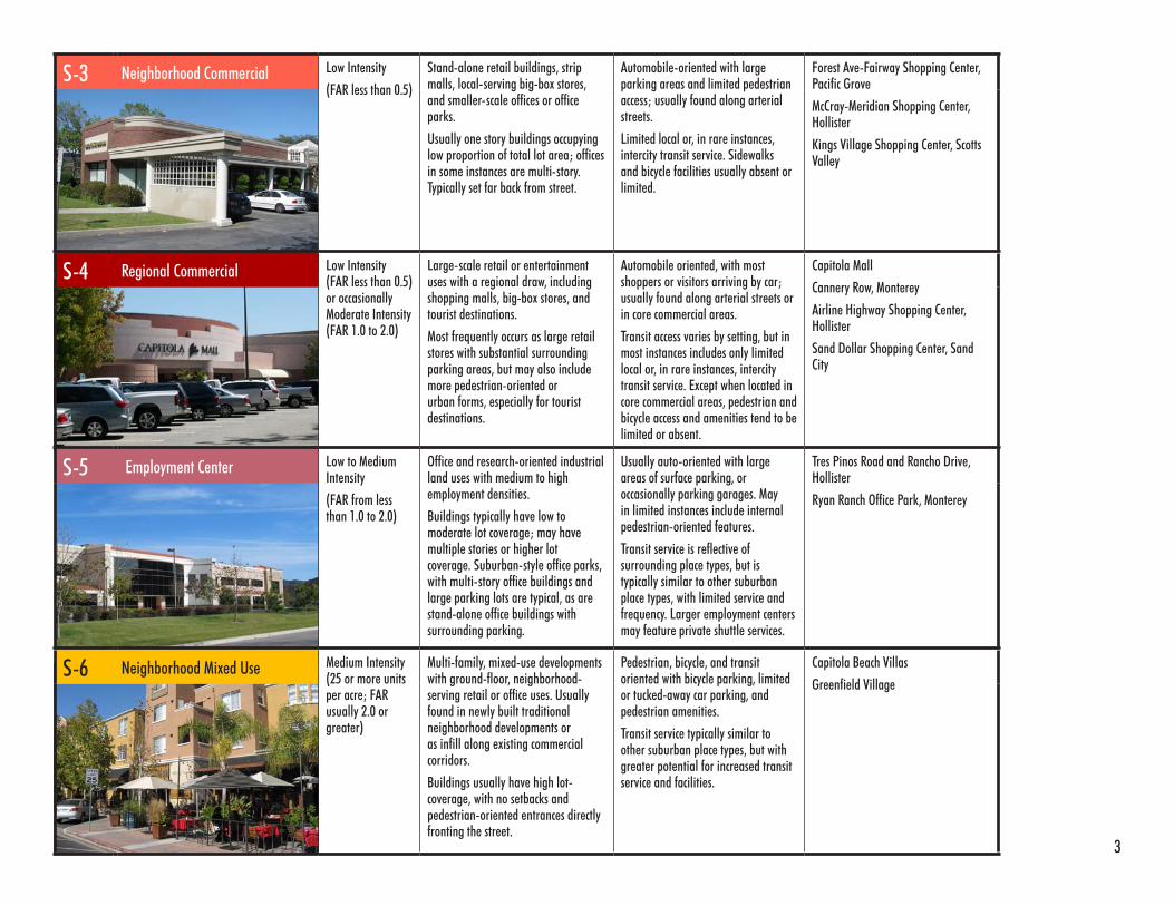
3
S-3 Neighborhood Commercial Low Intensity
(FAR less than 0.5)
Stand-alone retail buildings, strip malls, local-serving big-box stores, and smaller-scale offices or office parks.
Usually one story buildings occupying low proportion of total lot area; offices in some instances are multi-story. Typically set far back from street.
Automobile-oriented with large parking areas and limited pedestrian access; usually found along arterial streets.
Limited local or, in rare instances, intercity transit service. Sidewalks and bicycle facilities usually absent or limited.
Forest Ave-Fairway Shopping Center, Pacific Grove
McCray-Meridian Shopping Center, Hollister
Kings Village Shopping Center, Scotts Valley
S-4 Regional Commercial Low Intensity (FAR less than 0.5) or occasionally Moderate Intensity (FAR 1.0 to 2.0)
Large-scale retail or entertainment uses with a regional draw, including shopping malls, big-box stores, and tourist destinations.
Most frequently occurs as large retail stores with substantial surrounding parking areas, but may also include more pedestrian-oriented or urban forms, especially for tourist destinations.
Automobile oriented, with most shoppers or visitors arriving by car; usually found along arterial streets or in core commercial areas.
Transit access varies by setting, but in most instances includes only limited local or, in rare instances, intercity transit service. Except when located in core commercial areas, pedestrian and bicycle access and amenities tend to be limited or absent.
Capitola Mall
Cannery Row, Monterey
Airline Highway Shopping Center, Hollister
Sand Dollar Shopping Center, Sand City
S-5 Employment Center Low to Medium Intensity
(FAR from less than 1.0 to 2.0)
Office and research-oriented industrial land uses with medium to high employment densities.
Buildings typically have low to moderate lot coverage; may have multiple stories or higher lot coverage. Suburban-style office parks, with multi-story office buildings and large parking lots are typical, as are stand-alone office buildings with surrounding parking.
Usually auto-oriented with large areas of surface parking, or occasionally parking garages. May in limited instances include internal pedestrian-oriented features.
Transit service is reflective of surrounding place types, but is typically similar to other suburban place types, with limited service and frequency. Larger employment centers may feature private shuttle services.
Tres Pinos Road and Rancho Drive, Hollister
Ryan Ranch Office Park, Monterey
S-6 Neighborhood Mixed Use Medium Intensity (25 or more units per acre; FAR usually 2.0 or greater)
Multi-family, mixed-use developments with ground-floor, neighborhood-serving retail or office uses. Usually found in newly built traditional neighborhood developments or as infill along existing commercial corridors.
Buildings usually have high lot-coverage, with no setbacks and pedestrian-oriented entrances directly fronting the street.
Pedestrian, bicycle, and transit oriented with bicycle parking, limited or tucked-away car parking, and pedestrian amenities.
Transit service typically similar to other suburban place types, but with greater potential for increased transit service and facilities.
Capitola Beach Villas
Greenfield Village

4
Town Place Types
IntensityGeneral Characteristics
ExamplesLand Use Transportation
T-1 Town Single-Family Residential Low to Medium Intensity (6 to 15 units per acre)
Single-family homes in close proximity to town centers or pedestrian-oriented commercial corridors, typically laid out in a grid block pattern. Includes some duplexes, accessory units, or small multi-unit buildings.
Compact development pattern with small lots, limited setbacks, and close proximity of structures.
Short blocks, grid street pattern, and proximity to destinations support non-motorized modes of transportation. Complete sidewalks often present; bicycle infrastructure typically limited.
Neighborhoods served by bus service with 30-minute or more headways; occasional proximity to regional or intercity transit service.
Jewel Box, Capitola
Maple Street, Salinas
6th Street, Hollister
T-2 Town Multi-Family Residential Medium Intensity
(12 to 30 units per acre)
Combination of apartment buildings, duplexes, accessory units, and some single-family homes. Usually located in areas with traditional street patterns.
One- to three-story residential buildings, typically with small setbacks from the street and property lines.
Short blocks, grid street pattern, and proximity to destinations support non-motorized modes of transportation. Complete sidewalks often present; bicycle infrastructure typically limited.
Neighborhoods served by bus service with 30-minute or more headways; occasional proximity to regional or intercity transit service.
Laine Street, New Monterey Neighborhood
East Riverside Drive, Watsonville
T-3 Town Commercial Low intensity (FAR 1.0 or less)
Pedestrian-oriented commercial uses in town core commercial areas or along commercial corridors. Usually in areas with traditional street patterns.
One-story buildings, often with no setbacks and sometimes with full lot coverage. Entrances usually face the street. Lots occasionally include parking, usually located at rear.
Short blocks, grid street pattern, and nearby residential uses support non-motorized modes of transportation. Complete sidewalks often present; bicycle infrastructure typically limited.
Transit typically includes limited local service, with headways as short as 30 minutes. Many visitors arrive by car, particularly when traveling long distances.
Bay and Misstion Street, Santa Cruz
Downtown Carmel

5
T-4 Town Mixed Use Low to Medium Intensity (FAR 1.0 to 3.0)
Small-scale, mixed-use buildings typically in core commercial areas or along commercial corridors. Usually in areas with traditional street patterns.
Vertical mixed use buildings common with residential and office above ground-floor commercial. Buildings typically built to property lines; parking may be included, usually to the rear of buildings.
Short blocks, grid street pattern, and nearby residential uses support non-motorized modes of transportation. Complete sidewalks often present; bicycle infrastructure typically limited.
Transit typically includes limited local service, with headways as short as 30 minutes. Many visitors arrive by car, particularly when traveling long distances.
Capitola Village
5th Street, Hollister
Lighthouse Avenue, Pacific Grove
Non-Urban Place Types
IntensityGeneral Characteristics
ExamplesLand Use Transportation
NU-1 Agriculture Very Low Intensity (1 unit per acre or less)
Isolated single-family homes, farm houses, and other agriculture-related structures in an agricultural or rural setting.
Various building heights and sizes, frequently 2-stories or less, often with expansive setbacks from roads and property lines.
Automobile dependent with widely-spaced, generally rectilinear road patterns.
Transit absent or restricted to limited and infrequent regional or inter-city service. Sidewalks and other pedestrian/bicycle infrastructure usually absent.
Outlying portions of Greenfield
Outlying portions of San Juan Bautista
NU-2 Rural-Town Commercial Low Intensity (FAR usually less than 1.0, up to 2.0 in rare instances)
Variety of small commercial buildings usually located in centers of compact, rural towns.
Buildings usually one-story with parking at front or rear. In some cases may not include parking and may include second story with upstairs use.
Mixture of pedestrian- and automobile-oriented. Short blocks, grid street pattern, and nearby residential uses support non-motorized modes of transportation; however, cars may be more commonly used, especially by visitors traveling regionally.
Transit absent or restricted to limited and/or infrequent regional or inter-city service. Sidewalks generally present, but may be absent in some cases. Dedicated bicycle infrastructure usually absent.
3rd Street, San Juan Bautista
Merritt Street, Castroville
Alta Street, Gonzales

6
Other Place Types
IntensityGeneral Characteristics
ExamplesLand Use Transportation
IND Industrial and Manufacturing Various Intensities (FAR from less than 1.0 to 4.0 or higher)
Various industrial and manufacturing uses, including factories, storage facilities, industrial and commercial suppliers, and some research and development uses.
Street patterns and building forms vary, ranging from traditional blocks and pedestrian-oriented configurations to isolated facilities inaccessible by non-motorized transportation.
Transportation characteristics vary, with both pedestrian- and auto-oriented development patterns
Availability of transit, pedestrian access, and bicycle infrastructure vary depending upon setting.
Industrial Drive, Hollister
Los Coches Road, Soledad
Estates Drive, Aptos
NU-3 Rural-Town Residential Low Intensity (3 to 8 units per acre)
Single-family homes in areas with grid street patterns; close proximity to central areas of compact, rural towns. May include-small multi-family buildings such as duplexes or homes with accessory units.
One- or two-story buildings on small- to medium-sized lots. Homes have variable setbacks from property lines and other buildings.
Short blocks, grid street pattern, and proximity to local destinations support non-motorized modes of transportation for intracity trips; however, cars may be more commonly used, especially for regional trips.
Transit absent or restricted to limited and infrequent regional or inter-city service. Sidewalks may be absent, but generally low traffic may promote non-motorized transportation. Dedicated bicycle infrastructure usually absent.
6th Street, San Juan Bautista
Scott Street, Chualar
9th Street, Gonzales
NU-4 Exurban and Rural Residential Very Low to Low Intensity
(usually 1 unit per acre or less, on rare occasions up to 6 units per acre)
Single-family homes located in neighborhoods on urban fringe. Frequently characterized by non-grid street patterns and relatively long distances to noncontiguous urban or town centers.
One or two story buildings on large lots with deep setbacks. In rare instances may include smaller “suburban” style lots located far from central areas of towns or cities.
Automobile oriented, often with long distances separating different land uses. Non-grid, typically low-connectivity street patterns discourage non-motirized transportation for non-recreational trips.
Transit absent or restricted to limited and infrequent express or regional service; park-and-rides occasionally present. Sidewalks and dedicated bike paths typically for recreational use.
Pasadera Neighborhood, Monterey
Fairview Road, Hollister
Crescent Drive, Scotts Valley

7
AT Airport N/A Airports. Transportation characteristics vary. Monterey Peninsula Airport
Hollister Municipal Airport
INS Institutional Various Intensities (FAR from less than 1.0 to 4.0 or higher)
Various institutional, civic, public, educational, hospital, and utilities uses located in various settings.
Built forms vary by specific use and location.
Transportation characteristics vary, with both pedestrian- and auto-oriented development patterns
Availability of transit, pedestrian access, and bicycle infrastructure are all variable, depending upon setting.
UC Santa Cruz
Salinas High School
Public Libraries
Wastewater Treatment Plants
OSR Open Space / Recreation N/A Open space and recreational uses, including local and regional parks, nature preserves, and beaches.
Transit characteristics highly variable. Isolated regional parks or wilderness areas may lack transit connections and pedestrian/bicycle access. Parks in urban centers may have frequent transit service and complete bicycle/pedestrian infrastructure.
Village Green, Greenfield
Ramsay Park, Watsonville
Calaveras Park, Hollister

2014 MTP/SCS
Community Workshops May 2013
Workshop Notes
Attachment 2
Salinas (City Hall Rotunda)
May 13, 2013
Attendance approximately 15‐20 people
Land Use/Housing
Housing needs: hard to meet with low wage jobs. Causes impacts on transportation system with
low cost housing to and from their jobs.
Suggests “affordable” is equivalent to “subsidized” housing, society equity is not desired.
Inequity is a great thing. Halton Canyon should have been built.
How to balance water resources on coast with housing demand.
We have oversubscribed water resources. Water allotment should be similar to the cap and
trade system so there is a financial incentive to conserve.
Affordable housing: high concentration of farm workers in small area. Need for housing, prices
dictate where to live.
Sub‐regional issues. We have numerous agriculture processing plants, but workers live
elsewhere. Some bike lanes/projects which is great, and the new bridge helps. Match up where
jobs and housing are so it’s closer together.
Where should growth go?
I am against development – don’t want to lose agriculture land. There aren’t enough jobs or
water for growth.
Car represents freedom. Population decline represents death. We have water, water can be
solved.
Parks and green spaces are important for children’s health.
Growth should be northeast of Salinas. What’s wrong with saying leave it alone. Maintain it; we
have a pleasant life, let’s save it.
Need green space.
(Development) In high density areas.
Employment
What employment trends should be considered? (e.g., industry, agriculture, hospitality). There
are a lot of jobs, but they are low paying.
2 2014 MTP/SCS May 2013 Workshop Notes
Transportation
How we should get around – priorities. Do modeling first, and then weigh in.
Likes Hwy 156/101 Interchange and Hwy 1/Salinas new interchange. Overall, likes what he is
seeing.
Big concerns of hospitality industry on Peninsula. How to get people to and from Peninsula.
Bus system should be private to respond to needs of individual. Bus shelters example: privatized
is the way to go to respond to needs.
Vanpool for farm workers is a good idea. Get input from farm worker community directly.
Getting people who have limited transportation to their destinations is a big challenge and
hardship for them.
How can public roads stay public when toll road are only access to funding?
LED lighting.
Safer for bikes and pedestrians.
Capacity for basics – e.g. safety and maintenance on existing system.
Hollister (Community Center)
May 14, 2013
Attendance approximately 10‐15 people
Land Use/Housing
Preservation of agricultural space.
Livable sustainable communities.
More planning development for walkability and bike access.
Very auto‐oriented; other areas have infrastructure for walking; sustainable communities.
Employment
More jobs paying a living wage.
Can transportation help bring jobs to Monterey Bay area?
o Hi‐tech in suburbs in Bay Area, need critical mass
o Ag. tourism; wine industry: wine overlay in the (Monterey County) General Plan
o Need more hotels
o We are the “Exciting backyard to Silicon Valley”
Hollister Airport
o Access for business
o Internet
o Parcels too small
o Aerial commuters
o Tourism
San Juan Bautista: jobs within walking/biking distance to ag processing.
3 2014 MTP/SCS May 2013 Workshop Notes
Home‐based businesses: no commute
Transportation
Complete streets
More regional transit
Funding for planned bike/pedestrian plans
More voices
More planning near transportation hubs
Not having to rely on a car to get around
Don’t want to commute, but also don’t want to move
Carpool/rideshare (currently use 511)
Vanpool/carpool matching program
Regional transit
Gonzales (City Hall Chambers)
May 15, 2013
Attendance approximately 50‐55 people
Land Use/Housing
Agriculture is located in the Salinas Valley (Salinas), but residents work elsewhere.
Working from home needs to be considered as part of the forecast analysis.
Business address in Spreckles/Salinas, but employees live/work south; those cities miss out on
benefits (tax, etc.). Need to address this fact in the forecasting analysis.
Public/private cooperation for transportation and housing.
Models are based (biased) on urban (not rural) needs.
Both rural and urban in Monterey County.
“Agriculture” and “open space” are not the same thing.
Ag = jobs, innovation, finance, industry.
How to incentivize housing – help get services (police, etc.).
Need to take care of local resident or they will move.
Re‐investment in communities.
Experience the community first had.
Necessities of community
o Transportation
o Understand Latino communities
o Translate flyer/summary of process
Internal growth, live near family, stay local.
City of Gonzales does not support AMGAG’s numbers.
Business (example) adjacent.

4 2014 MTP/SCS May 2013 Workshop Notes
Missed opportunity because of lack of infrastructure.
Need regional support to grow.
Trend analysis need to address adjustments for down‐turn/booms.
Growth is a market condition.
Lack of land available for development, which limits growth.
Needs:
o Place to leave kids when at work
o More housing
Don’t use flat land for housing (this should be for agriculture.) – go to hills.
Employment
Gap: Job attraction programs.
o Agriculture needs to thrive as an industry
o Provide more agricultural supporting businesses
More jobs in smaller communities where people live. Decentralization is important.
Transportation
Safer paths for students.
Terminals for produce to less dense areas.
o Produce to rail
o Efficiency
Bridge to high school: takes 10‐20 minutes to cross.
o Stop light needed
o Representing students
Students commuting north towards Salinas; buses are full now.
Expand public transportation in rural areas south of King City.
Provide Wi‐Fi and power outlets on all transit buses.
Rail: Hwy 101 is overused; greater use of rail, especially for goods movement would help get
trucks off the roads.
Centralization of services and transportation; produce could be sent to a rail transfer center, and
then shipped out.
MST buses are full for students.
o Growing issues
o Standing room only – safety concern
o #23 line MST, long‐time issue. Need to upgrade service, more frequency, longer
vehicles, more appropriate vehicle type
Unincorporated areas – lack of resources, but these areas are most at need:
o Vanpool is a good option for agriculture and students
o San Lucas to King City to bus
o Labor camps
5 2014 MTP/SCS May 2013 Workshop Notes
o Aging populations, need for paratransit
o More transit options for correctional officers
o 120 + vanpools in south county
Education
Bring education to Salinas Valley communities to minimize travel need.
Good relationship already with high schools.
Gaps between classes: long but students can’t leave; what to do?
Want Hartnell classes locally.
Seaside (Community Center)
May 16, 2013
Attendance approximately 20‐25 people
Land Use/Housing
Infill, smart development, livable communities, work, live, shop, etc. in your neighborhood.
o Less traffic
o Rail tracks: add trains from the Bay Area
o We need tourists; not congestion
Cul‐de‐sac with trail connections. If people telecommunicate they will still want to get out.
o Don’t want to rely on cars
Employment
Need more jobs in Moss Landing and other areas between Santa Cruz and Monterey Peninsula
to serve students going to CSUMB or UCSC.
o Trip Wise is used at CSUMB
Transportation
Highway 1 Corridor is important.
o Access to neighborhoods
o Coastal trail/natural corridors
o Connections to monument
Tourists should go to Gilroy and park; then get to Monterey Bay by transit/rail.
o Simple backbone line
o Currently difficult to get here
o Get people to stay longer: more money to the local economy
o Open space/recreation means jobs and money to the local economy
Bikes
o Getting between towns is okay but it’s more difficult and less safe once in town
6 2014 MTP/SCS May 2013 Workshop Notes
o More transit or more mixed use needed?
o Infill
Want one system for the entire region: ease of getting around and artificial boundaries now.
Subregional ideas (heard from different meetings).
o Can’t get around; bad commutes without dealing with mass transit
o Commuters from the valley, etc.
o Must be significantly quicker on transit to be desirable
o Balanced approach with transit and roadway improvements
CSUMB has free bus service, but does this adequately serve students?
No convenient routes to CSUMB.
Long distance bike commute: issue of safety while biking.
San Jose light rail works there, but issues here because of dispersed development.
o 1st/last mile issues
o Lots of local destinations/stops each day
Are we going to be commuting or on our computer? Need better internet, telecommunications.
Technology is one method to reduce vehicle miles traveled; not for all, but a component.
1st/last mile: car and bike sharing helps. Cheap and easy.
Not all bikeways are equal (bike lane vs. trail, etc.).
Provide for airport ground access infrastructure improvements.
Provide for transit access and connections.
Provide for continued airport capacity.
Provide for continued air carrier capabilities.
Other
Social equity is an issue.
Regional collaboration – one solution can help others too.
Look at other areas for good examples.
Is there strengthening of regional planning?
Opportunity with climate issue; we should set a target much higher. This region is well‐suited to
meet the challenge.
o Bold and audacious leadership
o Other areas are looking to Monterey Bay to be a leader in sustainability
o Efforts to reduce CHG’s help with all goals
o Santa Barbara set ambitious target
o Goal should be for Monterey Bay to far exceed target
Watsonville (Community Room)
May 20, 2013
Attendance approximately 20‐25 people

7 2014 MTP/SCS May 2013 Workshop Notes
Land Use/Housing
Proximity to healthcare.
Japan got by in terms of energy for one year by installing wind turbines.
Need more mixed‐use zoning, already a good start.
Not much housing at UCSC.
Need more “mom and pop” stores on UCSC campus.
Imbalance of where people live/work.
o Would be less people on Highway 1 and other roads if people lived close to where they
work (and/or worked from home)
Employment
High unemployment in Watsonville.
o Industry
o Lack of education
o Out‐commuting
Market needs vs. local skills, apprenticeship opportunities.
Shortage of entry‐level agricultural labor/jobs.
2008 lost a lot due to recession; have we recovered any jobs?
New tech center as part of Cabrillo College, solar industry training.
o Construction jobs
o Used existing downtown space (not fringe/ag land)
o Watsonville has great potential with solar technology
North Star Biodiesel plant (used Redwood City as example). Model for future plants, point of
sale revenue.
Agriculture business: social drain, no tax revenue, housing, education, etc. provided by
businesses.
Concern that plan is intrusive.
Solar/wind is good but not much longevity for jobs (once built, that’s it).
o Mining has longer potential for economic benefit
Need to educate as to why 50% of Watsonville residents leave to work elsewhere.
Transportation
Santa Cruz rail line (in terms of freight) is a good opportunity for Watsonville, has existing
infrastructure.
o Transfer facility potential
o Need operator that knows local economy
Manabe‐Ow property is adjacent to rail.
Much of the Watsonville’s industrial areas are near rail.
Airport is a big opportunity for growth, economic development, and transportation.
800 employees (service) work at UCSC.

8 2014 MTP/SCS May 2013 Workshop Notes
o Many live in Watsonville (200+ people)
o Solution to help reduce commute
o Commute by car or vanpool
Highway 1
o Quality of life
o HOT/HOV lanes
o Incentives for businesses to transport workers
o Example with business that has 20 workers who live in Salinas and commute; this results
in 20 trucks on the road
If there was a vanpool/shuttle, this could take many of these trucks off the road
Better for environment/traffic
o Accidents with trucks, narrow roads
o Backups are inefficient, wasteful
o Need to distribute information on alternatives to people
Santa Cruz Rail Line
o Potential source of revenue; services
o Shopping centers and freeways
o Rail can serve retail and office jobs
o Sometimes we need to take a step back to go forward (rail)
o Potential for freight
o Connection and cooperation between Watsonville and Pajaro
o Freight rail would take trucks off of roads
o Could also use rail for commuting
o Rail is underutilized now
o Rail for tourism
Pajaro could be a hub; used to serve tourists and produce (by ship)
Rail line would go to bus station and many tourist destinations
Stay in Watsonville, then train to tourist destinations
Rail to San Jose (tunnels still there)
o Lots of trucks go through Watsonville daily; rail would take many off the road
Santa Cruz (Police Department Community Room)
May 23, 2013
Attendance approximately 45‐50 people
Land Use/Housing
2035: Want transporter rooms, but until then, the planning department needs improvements.
Spread out services in other areas. Services support spreading out for development.

9 2014 MTP/SCS May 2013 Workshop Notes
Sister COG (ABAG) ¼ million dollars; requires variety, priority developed areas, walkable,
vertical, single family units are prohibited. Concern that AMGAG will duplicate the ABAG
program.
Santa Cruz: “chicken and egg” with density and transit. Which will come first? Neighbors don’t
want density. How do we get there?
Employment
Jobs dots: observation that people live and work here, yet feel we need more jobs. Need a
balance of jobs and housing.
Transportation
Future water transit (ferry) services.
Rail project: will it be taken by eminent domain?
Rail: how would people get to station? Car? Parking? Concern with limited frequency.
Electric vehicles use coal or whatever is used for energy generation.
There is excellent work being done to develop transit alternatives:
o Solar Skyways Challenge: overhead vehicle suspended below beam
Stellar assets: tourism, jobs, agriculture, etc. Transit plan should reflect all of these assets.
Grower’s needs are different than resident’s needs.
VMT: is this related to commute times or is it so people will naturally drive less when jobs and
housing is more balanced?
Consider intelligent transportation systems (real time data) to let people know where
bottlenecks are without calling 511. Trains, buses, real time travel information is important.
Density makes choices different. Density supports BART‐like transit system. Paid parking has
seen resistance, but people have to experience it before the change occurs. Our mindset is auto‐
focused. Gas price increase has caused change. Incentive and economics play a role.
Common sense signage is needed for tourists and transit users.
Over time, the significance has moved from highway‐centric to sustainability.
Veteran and electric vehicle driver: grateful for transportation alternatives for this County.
Other
Will a survey be sent out to the full community?
o Website; online survey and other information; telephone survey; surveys are bilingual
What is the AMBAG Regional Advisory Committee make‐up? Unelected representatives?
o The Regional Advisory Committee is made up of stakeholders representing the
hospitality, education, planning, business communities, etc. The membership was
approved by the AMBAG Board of Directors.
o People want to vote – disagree with approach of the Regional Advisory Committee
AMBAG is a COG and COGs can control local agencies. COGs are inverting government (top‐
down). This process is not representative government.
10 2014 MTP/SCS May 2013 Workshop Notes
Where can I obtain background information?
o Information is available at the MTP/SCS Project website, AMBAG website, and at the
AMBAG offices.
Mandates: What happens if we don’t meet the SB 375 reduction goals? Are economic issues
accounted for?
o Yes, economic issues are accounted for. Not meeting the targets under SB 375 could
mean a loss of potential future funding since future funding may be tied to GHG
reduction.
Concern regarding the plan: creative process can’t make everyone act/behave a certain way.
Businesses profit from people having car mobility. Concern that this project is using power to
change things and inhibit personal freedom. Seeing more and more regulation; worried that the
vision will take away our joy and premise that by its nature misses vibrant; choice oriented
This is a long‐term process using today’s data points. What additional data will be used over
time (update every 4 years)? There are more people out there and their needs should be
considered as well (web, Facebook, etc.)
People who are not here are the young people. Who will have to move toward this future? The
number of agencies involved is confusing. It is about all of it moving forward. Need more
coordination between government.
Need to build trust.
Terms in tagline on the workshop banner: walkable, vibrant, sustainable, etc. are all subjective;
what is the basis? SB 375? AB 32?
o These terms are goals that were set by AMBAG board and were specifically defined. The
goals also are in federal and state guidance
Government spending: as a tax payer, you can find it; check register, it’s there and you can get a
comprehensive view. Expenditures by more stats.
How will we be accounting for different measures (carbon footprint etc.)? Electric vehicle
studies. Do efficiencies measures play a role? Interest to track electric vehicles, even if this is not
counted by SB 375 mandate.
I don’t believe in climate change. There is a concern about polluting the earth.
Is this Plan “suggested” or “binding”?
o Implementation will be by cities and transportation agencies
Where are our local elected officials?
o The local jurisdictions are very involved in the MTP/SCS process. The AMBAG Board is
made up of local elected officials from each of the 21 local jurisdictions in the region.
How does the AMGAG Blueprint Plan fit in?
o This is building on past planning efforts.
Energy part of AMGAG: controlled by PG & E, ICLEI (International Council for Local
Environmental Initiatives), and Agenda 21. There has been distortion; not democratic
Joint Venture Silicon Valley: why isn’t AMBAG as forward thinking as ABAG?
People don’t trust government because of SB 375. Computer models have fallen flat. Institutions
have said no global warming for 14 years. Peer reviewed report showing that science were

11 2014 MTP/SCS May 2013 Workshop Notes
basing rules on isn’t accurate. We shouldn’t be basing our rules and activities on scientists.
Scientists have had their work suppressed in violent ways.

AGENDA: June 26, 2013
TO: Regional Transportation Commission (RTC) – Policy Workshop FROM: Rachel Moriconi, Senior Transportation Planner RE: 2014 Regional Transportation Plan (RTP): Financial Estimates RECOMMENDATIONS Staff recommends that the Regional Transportation Commission (RTC) provide input on funding projections for the draft 2014 Regional Transportation Plan (RTP) (Attachment 1). BACKGROUND RTC staff has been working with the Association of Monterey Bay Area Governments (AMBAG) and partner agencies in Santa Cruz, San Benito and Monterey Counties, including local jurisdictions, Santa Cruz Metro, Caltrans, and other project sponsors, to develop the “Financial Element” for the long range (20+ year) Regional Transportation Plan (RTP) and Metropolitan Transportation Plan (MTP). The “Financial Element” is fundamental to the development and implementation of the RTP. It identifies the current and anticipated public and private revenue sources available to fund the planned transportation investments described in the Action Element (project list). The intent of the Financial Element is to define realistic funding constraints and evaluate investment alternatives for limited transportation revenues, internally consistent with the goals and policies and Sustainable Communities Strategy (SCS). The Financial Element also identifies any additional financing strategies that could address funding gaps for projects and programs, including new funding sources and strategies. Transportation programs and projects in Santa Cruz County are funded from a variety of local, state and federal funding programs. The public and businesses contribute to these funding programs through taxes primarily collected at the gas pump and at cash registers. Truck weight fees and a small portion of automobile registration fees also help fund some local transportation projects. Depending on the federal transportation act (currently MAP-21), annual appropriations bills, the California and local budgets, gasoline consumption, and the general condition of the local and global economy, funding levels for most funding programs change from year to year. With adoption of the federal transportation act in July 2012 (MAP-21), formulas for distribution of some federal funding programs changed significantly and many funding programs were eliminated completely from what was assumed in the 2010 RTP.

2014 RTP – Financial Estimates Page 2 DISCUSSION Projected Revenues The draft revenue projections for the 2014 Regional Transportation Plan (RTP) (Attachment 1) include a list of funding sources which can be reasonably assumed to be available for transportation projects in Santa Cruz County through 2035. The projections are based on a combination of historical averages, current trends, and/or state and federal actions. Staff from agencies in the Monterey Bay region worked collectively to develop the draft financial projections. All of Santa Cruz County’s projects on the constrained “within projected funds” list must fit within this estimate. The draft revenue projections show that $2.8 billion in local, state, and federal funds will be available for transportation projects in Santa Cruz County through 2035, including $350 million in revenues from a new ½ cent local sales tax (see discussion below). This is half of the revenues that would be needed to fully fund the over $5.6 billion in projects that have been identified for the RTP. Highlights of the financial projections are provided below:
$2.8 billion over 22 years (approximately $125 million/year) Nearly 70% of available revenues are from local sources; 18% state and
12% federal Discretionary, relatively flexible funding typically available to a variety of
types of projects, makes up approximately 25% of the local, state and federal funding ($690 million, includes $350 million from a new half cent sales tax measure).
75% of projected revenues are dedicated for specific uses or types of projects (e.g. SHOPP funds can only be used for highway maintenance and safety projects)
$1 billion is restricted (or dedicated) for use on transit projects/operations (includes local transit sales tax and rider fares, and federal transit funds)
In most instances, base-year figures for formula funding sources (those that the region typically receives every year according to population, road miles, or fixed factors) reflect the amount of funding received in FY 12/13. In other instances, historical averages were used to calculate anticipated revenues.
Actual revenues will vary from year to year. The draft financial plan reflects revenue estimates in current year dollars. For the final RTP, revenue estimates will include an inflation rate that reflects the “year of expenditure dollars”, as required by federal statute. Escalated project costs in “year of expenditure” will also be included in the final RTP. Since adoption of the 2010 RTP, several funding sources that local agencies had historically relied upon have been eliminated, such as redevelopment funds and the sales tax on gasoline for transportation (Proposition 42). Changes in the economy, state and federal laws, and fuel consumption/gas taxes, can make predicting exactly how much funding will be available from year-to-year very challenging, let alone through 2035. Therefore, the financial estimates reflects the best estimates
2014 RTP – Financial Estimates Page 3 currently available, to be used as a tool to assist the RTC, local jurisdictions and project sponsors in determining what projects are reasonable to pursue and prioritize in the short and long term. Staff recommends that the RTC review and provide input on the financial projections (Attachment 1). New Sales Tax Measure Since 2005, the RTP has included revenues from a future half-cent sales tax measure in the financial estimates. Staff recommends that the RTC continue to assume that a new half-cent sales tax for transportation will be approved by Santa Cruz County voters. The 2014 RTP financial projections assume that voters in Santa Cruz County will approve a new half-cent sales tax by 2016 that will raise approximately $350 million (in current year dollars) through 2035. While not an existing revenue source, it is reasonable to include revenues from a new local source such as a sales tax in the RTP for several reasons:
A local transportation sales tax is one of the more feasible funding sources to adopt logistically, as state law already authorizes voters to raise such taxes.
Over the past decade the RTC and local agencies have worked with the community to evaluate options to increase funding for transportation. Polling and significant work with stakeholder groups, including the 2012 Vehicle Registration Fee process and Transportation Funding Task Force (TFTF) process, has demonstrated broad based support for new taxes to fund transportation projects.
While current state law requires that two-thirds of voters approve any new local sales tax which includes a specific list of projects, legislative efforts are underway to reduce the two-thirds (66.67%) vote requirement for special taxes to 55% which will make it reasonable to assume a local sales tax measure will be approved.
As fewer state and federal dollars are going towards transportation, local communities are increasingly supportive of local transportation funding initiatives.
33% of counties in California representing 84% of the population are self help counties benefiting from increased locally sourced transportation revenues and those that are not continue efforts to become self help counties; therefore, it is reasonable to assume that this trend will continue over the next 25 years.
Next Steps The draft financial projections (Attachment 1) are used to divide the RTP project list into a “constrained” list (projects that could be implemented with foreseeable revenues, including a new local sales tax, short and long term through 2035) and “unconstrained” list (projects that could be funded if new revenues, above and beyond projections, are generated). As discussed under a separate agenda item, a scenario planning process is being used to determine which projects will be on the “constrained” list based on how well projects advance the sustainable communities strategy and RTP goals and targets.

2014 RTP – Financial Estimates Page 4 Prior to RTC adoption of the final 2014 RTP, updates will be made to funding projections to reflect any new state or federal legislative or policy actions, including those related to MAP-21 implementation, the final 2014 State Transportation Improvement Program and State Highway Operation and Protection Program (SHOPP) Fund Estimate, and the state cap-and-trade revenue distribution agreements and projections. As required by federal rules, growth projections and escalation rates will be applied to all revenue sources and shown in the RTP document. Project costs will also be escalated to year of expenditure for the RTP document. SUMMARY RTC staff has been working with AMBAG and partner agencies to develop financial projections for the 2014 Regional Transportation Plan and 2014 Metropolitan Transportation Plan. Staff recommends that the RTC provide input on the financial projections. Attachment:
1. Draft Financial Projections
s:\tpw\tpw 2013\0613 special meeting\rtpfundest\sr_rtpfinancialelementjune13tpw.docx

6/18/2013 S:\RTP\2014\FundEst\FundEstDRAFT2014rtpFundEstDRAFT2014rtp
REVENUE SOURCES (all figures in 1000's) Restriction on use Assumptions/ Source Notes Base Year 2014-2035 (Not
Escalated)
$86,972 $1,878,391
City of Santa Cruz Sales Tax - Measure H used on transp. City of SC projects only
Based on City budgets, CIPs, and other documents. Portion typically used on transportation.
$1,700 $37,400
City/County Developer Fees Local projects - any mode From local jurisdictions, based on their budgets $1,450
City of SV Developer Fees From local jurisdictions, based on their budgets $50 $1,100
City of SC Traffic Impact Fee Fund Based on annual average. 225/226 $950 $20,900City of Watsonville Developer Fees Based on avg $35 $770
County of SC: RIF/TIF Developer Fees Based on 2010 info (updates not received) $415 $9,130
City/County General Funds for Transportation Projects Local projects - any mode From local jurisdictions, based on their
budgets $7,005
City of Capitola - Gen Fund Includes sales tax measure funds $400 $8,800
City of Capitola - Parking Fees/fines City of Capitola PW staff $75 $1,650
City of SC - Gen Fund CIP (311/317); base annual average $2,700 $59,400County of SC: CSA 9-Hwy Safety & Lighting CSA 9 $1,130 $24,860
County of SC: CSA 9D - Road Maintenance CSA 9D1,2,3 $2,700 $59,400
Ecology Action Member Fees, Sponsorships, Inkind Donations Dedicated - B2W & EA Based on annual average. $50 $1,100
Gas Tax (Highway User Tax (HUTA) to locals) Dedicated-LSR
State Controller reports (http://www.sco.ca.gov/ard_payments_highway.html) & http://www.californiacityfinance.com/HUTAupdate120807.pdf
$10,462
HUTA Capitola http://www.californiacityfinance.com/HUTAupdate120807.pdf $262 $5,772
HUTA SC http://www.californiacityfinance.com/HUTAupdate120807.pdf $1,559 $34,296
HUTA SV http://www.californiacityfinance.com/HUTAupdate120807.pdf $305 $6,709
HUTA Watshttp://www.californiacityfinance.com/HUTAupdate120807.pdf; per City of W only $800K used for transp projects though
$1,324 $29,127
PRELIMINARY DRAFT FINANCIAL ELEMENT: Funding projections through 2035 for the 2014 RTP
LOCAL REVENUE SOURCES

6/18/2013 S:\RTP\2014\FundEst\FundEstDRAFT2014rtpFundEstDRAFT2014rtp
REVENUE SOURCES (all figures in 1000's) Restriction on use Assumptions/ Source Notes Base Year 2014-2035 (Not
Escalated)
HUTA CO of SC http://www.californiacityfinance.com/HUTAupdate120807.pdf $7,012 $154,267
LiftLine Specialized Transportation - Other Funds Dedicated - Lift Line Operations Lift Line FY13 budget, includes multiple
sources $840 $18,480
MTC Contribution to Hwy 17 Safety Project (Santa Cruz County) Dedicated - Safe on 17 CHP RTC Budget - always $50K/year, does not
escalate $50 $1,100
Rail Line Lease Revenue: RTC Dedicated - Rail projects RTC budget $60 $1,320Santa Cruz County 2016 Transportation Sales Tax Discretionary - TBD in ballot measure Based on SC METRO receipts, projections $17,500 $350,000
Transit Passenger Fares: SC METRO SC Metro projectsSC METRO budget. Includes all passenger fares - including Contract (UCSC,), Highway 17, & ADA Paratransit
$9,400 $206,800
Transit non-fare revenue: SC METRO SC Metro projects SC METRO. Includes Commissions, Advertising Income, Rent Income, Interest Income + $550 $12,100
Transit Sales Tax: SC METRO SC Metro projects SC METRO $17,500 $385,000
Transportation Development Act/LTF Transit, bike/ped, RTC admin/planning
http://www.boe.ca.gov/legdiv/localTaxAllocations.htm $7,500 $165,000
UCSC Revenues (Santa Cruz County): Transit Fees Dedicated - UCSC
Includes Student Transit Fee, other Bus Pass sales revenue, and an annual contribution from University Housing. Increases with enrollment and occupied on-campus bedspaces.
$6,400 $140,800
UCSC Parking Fees Dedicated - UCSC Includes both Parking and Event Parking revenues. Source: UCSC TAPS office $3,900 $85,800
UCSC Vanpool Lease Dedicated - UCSC 23 12-passenger vanpool routes during 2012-13. $105 $2,310
Watsonville Airport Revenues Dedicated - Airport Revenues used for operation & maintenance of Airport. Does not include one-time grants. $2,500 $55,000
REGIONAL REVENUE SOURCES $641 $14,102AB2766 Discretionary/Flex -AQ Based on Sept 2012 awards $641 $14,102STATE REVENUE SOURCES $23,204 $510,492
Airport Improvement Program match Dedicated - Airport Annual average of last 8 years of funding $4 $88
Cal Aid to Airports program Dedicated - Airport Dedicated to all public use airports. $10K annually. $10 $220
Freeway Service Patrol Dedicated - FSP program FY12 allocations $206 $4,532
SAFE: SC Dedicated-SAFE (motorist aide)Registered vehicles (http://www.dmv.ca.gov/about/profile/est_fees_pd_by_county.pdf)
$245 $5,390
6/18/2013 S:\RTP\2014\FundEst\FundEstDRAFT2014rtpFundEstDRAFT2014rtp
REVENUE SOURCES (all figures in 1000's) Restriction on use Assumptions/ Source Notes Base Year 2014-2035 (Not
Escalated)
SHOPP: Santa Cruz Dedicated-SHOPP hwy projectsAvg. based on programmed 2008 through 10-year SHOPP (2023); 2024-2035, based on annual avg.
$15,148 $333,253
State Transit Assistance (STA) Dedicated-TransitFY12/13 SCO estimates. http://www.sco.ca.gov/ard_payments_transit.html
$3,301 $72,622
STIP - Regional Share Santa Cruz Discretionary - any modeBased on statewide 2012 FE & percent of STIP for each county; excluding TE after 2014. Assumes no new Prop 1B program.
$3,460 $76,127
Active Transportation Program (SRTS, BTA, Rec Trails, TAP) Semi-discretionary-bike, ped Based on statewide estimates, Gov Budget
proposal $830 $18,260
$5,888 $129,536
Bus and Bus Related Grants (5309c) Dedicated-Transit MAP-21 estimates $100 $2,200
Enhanced Mobility of Seniors and Individuals with Disabilities (5310) Dedicated-Transit MAP-21 estimates $150 $3,300
FTA Section 5304 Dedicated-Transit MAP-21 estimates $48 $1,056Intercity Bus (5311f) Dedicated-Transit MAP-21 estimates $25 $550
Rural Area Formula Program (5311) Dedicated-Transit MAP-21 estimates $156 $3,432
Urbanized Area Formula Program (5307) Dedicated-Transit MAP-21 estimates $4,847 $106,634
Bus and Bus Facilities Formula Grants (5339) Dedicated-Transit MAP-21 estimates $562 $12,364
$10,053 $224,666
Earmarks Dedicated - MBSST Programmed old earmarks. No new earmarks anticipated. $0 $3,500
High Risk Rural Road (HR3) Rural safety road projects MAP-21 estimates $51 $1,122
Highway Bridge Program (HBP) Dedicated - Seismic Retrofit of bridges MAP-21 estimates $3,157 $69,454
Highway Safety Improvement Program (HSIP)
Dedicated - Safety projects targeting fatal and injury collision MAP-21 estimates $483 $10,626
Regional Surface Transportation Program (RSTP) Discretionary - any mode MAP-21 estimates $3,562 $78,364
FEMA/CALEMA/ER - Emergency Road Repair Funding
Dedicated - Emergency repairs on local roads $2,800 $61,600
$40 $880FAA Airport Improvement Program (AIP) Dedicated - Airport MAP-21 estimates $40 $880
GRAND TOTALS $126,799 $2,758,068
FAA Airport Improvement Program (AIP)
FEDERAL HIGHWAY REVENUE SOURCES
FEDERAL TRANSIT REVENUE SOURCES
AGENDA: June 26, 2013
TO: Regional Transportation Commission FROM: Ginger Dykaar, Transportation Planner and Grace Blakeslee, Senior
Transportation Planner RE: Scenario Planning for 2014 Transportation Plans – STARS
Transportation Investment Analysis RECOMMENDATIONS Staff recommends that the Regional Transportation Commission:
1. Receive information on the results of the initial scenario analysis for the Santa Cruz County Regional Transportation Plan and provide input on the transportation investments that will be considered for the hybrid scenarios as part of the scenario planning for the 2014 Regional Transportation Plan and 2014 Metropolitan Transportation Plan.
BACKGROUND As the transportation planning agency for Santa Cruz County, the Regional Transportation Commission (RTC) is responsible for developing, implementing, and regularly updating the Regional Transportation Plan (RTP) for Santa Cruz County. RTC staff has been working with the Sustainable Transportation Council (STC) to incorporate a sustainability framework into the 2014 Regional Transportation Plan. This approach was approved by the RTC in January 2012. The goals, policies and targets for the RTP have been developed based on the Sustainable Transportation Analysis and Rating System (STARS) (see agenda item 9 for the revised draft goals, policies and targets). Strategies for advancing these goals/targets will be identified in the scenario planning process. The RTC also works with the Association of Monterey Bay Area Governments (AMBAG) to produce and implement the Metropolitan Transportation Plan (MTP) for the Monterey Bay region. As part of the 2014 MTP, Senate Bill 375 requires AMBAG to develop a coordinated land use and transportation plan called the Sustainable Communities Strategy (SCS) to show how per capita vehicle miles traveled and associated greenhouse gas emissions will be reduced. To more efficiently and effectively complete the two transportation plans, the RTC works with AMBAG and regional partners to develop components that can be used for both transportation plans. These long range transportation plans include a policy
Scenario Planning for 2014 Transportation Plans Page 2
element, an action element and a financial element. The Action Element identifies the list of transportation needs in the region through 2035. The preliminary project list was approved by the RTC in March 2013. Scenario Planning The Draft RTP project list will be divided into a “constrained” list (projects that could be implemented with foreseeable revenues through 2035) and “unconstrained” list (projects that could be funded if new revenues, above and beyond projections, are generated). In order to determine which projects will be on the “constrained” list in the RTP and MTP, RTC staff has been working closely with AMBAG staff on a scenario planning process. Scenario planning supports both the development of the MTP Sustainable Communities Strategy as well as the STARS analysis for advancing the sustainability goals of the RTP. The scenario planning has started with five initial scenarios that identify distinctly different land use and transportation investments. AMBAG, with input from the tri-county Regional Transportation Planning Agency staff, Planning Directors, the AMBAG Regional Advisory Committee, and the public have drafted the themes and descriptions of the initial land use patterns and transportation investments to be considered in the Future Alternative SCS Scenarios. (See item 6, attachment 1 for these descriptions). From the analysis of the initial scenarios, hybrid scenarios will be created that will bring together a mix of land use and transportation projects that best achieve regional goals and SB375 greenhouse gas emission targets. The final preferred scenario, selected from the hybrid scenarios, will be the land use and transportation vision for 2035 and will define the transportation projects that are on the constrained list in the RTP and MTP. At each step of the scenario planning process, the scenarios will be analyzed for their ability to advance the RTP and MTP goals. The scenario descriptions only identify investments proposed for discretionary funding and are above and beyond what would be implemented using dedicated funds. Discretionary, relatively flexible funding makes up approximately 25% of the funding identified for the Santa Cruz County Regional Transportation Plan (including a half cent sales tax measure). The remaining 75% of funding is dedicated to specific types of projects based on federal, state or local regulations. (See agenda item 7 for additional information on revenues projections.) DISCUSSION
Analysis of Transportation Investment Alternatives As part of the STARS analysis, the transportation investments for the initial scenarios have been analyzed for their ability to advance the targets of the RTP. Transportation projects in the Draft RTP project list have been grouped into financially “constrained” packages of projects under each of the initial scenarios for Santa Cruz County. A qualitative analysis was performed to compare how the package of transportation projects in each of the initial scenarios advances the targets. The results of the analysis can be found in Attachment 1. This analysis

Scenario Planning for 2014 Transportation Plans Page 3
does not include the affect of any land use changes associated with these scenarios. For each of the 5 initial scenarios, Attachment 1 lists the types of transportation investments for Santa Cruz County, the funding breakdown based on mode, a comparative assessment of how the targets are being advanced due solely to transportation investments and a brief discussion on the key points of the results. Projects that receive dedicated funding or have already been programmed have been analyzed separately for their ability to advance the targets in order to be able to see more clearly how the affects of the transportation projects funded with discretionary funds vary between scenarios. Analysis of the distinctly different initial scenarios provides information about, “what if funding is invested in…, how will the goals and targets of the RTP be advanced?” The analysis was performed by scoring all the projects on their ability to advance the targets that have been identified for the RTP. Each project was given an effectiveness rating of either no ability (0), low (1), medium (2), or high (3) ability to advance each of the RTP targets. The effectiveness ratings for transportation project types particular for Santa Cruz County were determined by the Sustainable Transportation Council based on research and best practices. The effectiveness of the entire scenario for advancing the target was then determined by summing the project ratings (weighted by the cost of the project) for all the projects in each scenario. The results provide a rating of how effective each scenario is in advancing each of the targets. A more detailed analysis of the effectiveness ratings were performed for the Highway 1 High Occupancy Vehicle (HOV) Lane alternative project and the Highway 1Transportation System Management Alternative project to determine how these projects would advance the targets. This qualitative analysis is useful for seeing how the transportation investments in the different scenarios compare in advancing the targets but does not quantify how close we are to meeting the targets. For the hybrid and preferred scenarios, a more detailed quantitative analysis will be performed to quantify how the different scenarios advance the RTP targets. Transportation Investments for Hybrid Scenarios AMBAG will be soliciting input on the hybrid scenarios from the tri-county Regional Transportation Planning Agency staff, Planning Directors, the Regional Advisory Committee, and the public. The RTC Bicycle Committee recommends a subset of transportation investments from initial scenarios 1 (transit), 2 (complete streets) and 5 (system preservation) to be combined into the hybrid scenarios. Strong public support for maintaining our current transportation system has been shown through a phone survey performed by EMC Research for the scenario planning effort. (See agenda item 10 for results of telephone survey.) Given the results of the STARS analysis of the transportation projects identified for Santa Cruz County and input received to date, RTC staff proposes the following types of projects be considered for the discretionary funds under the hybrid scenarios.
Scenario Planning for 2014 Transportation Plans Page 4
Transportation Investments for Hybrid Scenario #1 Regional and Local Bus Service Expansion Pedestrian Facilities that Support Transit Transit Maintenance Roadway Maintenance Projects that Promote Safety Transportation Demand & System Management that Supports Transit Transportation Investments for Hybrid Scenario #2 Bicycle and Pedestrian Facilities Intersection Improvements in Key Destination Areas that support Complete Streets Traffic Calming Auxiliary Lanes on Highway 1, which facilitate HOV lanes beyond 2035 Transportation Demand & System Management that Supports Complete Streets The above mix of transportation projects proposed for each of the hybrid scenarios strive to advance the majority of the targets through the 2035 timeframe. Staff recommends that the RTC receive information on the results of the initial scenario analysis and provide input on the types of transportation projects to consider under the hybrid scenarios as part of the scenario planning for the 2014 Regional Transportation Plan and 2014 Metropolitan Transportation Plan. NEXT STEPS • July 2013 – AMBAG, with participation from the Regional Transportation
Planning Agencies, will provide a series of workshops throughout the tri-county region to solicit input from the public on the hybrid scenarios. There will be two workshops in Santa Cruz County: Thursday, July 18 in Watsonville at 275 Main Street, 4th floor 6:00–7:30 pm and Monday, July 22 in Santa Cruz at the Santa Cruz Police Department Community Room, 155 Center Street, 6:00–7:30 pm.
• July 2013 – RTC staff will work with RTC committee members to provide input on the hybrid scenarios.
• August 2013 - RTC staff will present the hybrid scenarios to the RTC and RTC Committees and receive input on the preferred scenarios.
• September 2013 - AMBAG staff will bring the preferred scenario to their board for approval which will determine the transportation projects on the “constrained” list that will be evaluated in the program-level Environmental Impact Report (EIR) for the MTP/RTP. RTC staff will bring the RTP project list to the RTC at the September Transportation Policy Workshop.
• February 2014 - The draft RTP, MTP and EIR released for public review.
• June 2014 - Final RTP approved by the RTC and SCS/MTP approved by AMBAG.
Scenario Planning for 2014 Transportation Plans Page 5
SUMMARY
RTC and AMBAG staff are engaged in scenario planning to determine the projects that will be on the “constrained” (within projected revenues/higher priority) project list in the 2014 Regional Transportation Plan and 2014 Metropolitan Transportation Plan. Staff recommends that the RTC receive information on the analysis of the initial scenarios and provide input on the transportation investments that will be considered under the hybrid scenarios as part of the scenario planning for the 2014 Transportation Plans.
Attachments:
1. STARS Qualitative Analysis of Transportation Investments in Alternative Scenarios through 2035
S:\TPW\TPW 2013\0613 Special Meeting\RTP scenario planning\SR_RTP-TPW20130626.docx

ATTACHMENT 1
Santa Cruz County 2014 Regional Transportation Plan STARS Qualitative Analysis of Transportation Investments
In Alternative Scenarios through 2035 An analysis of the transportation investments in Santa Cruz County for the five initial scenarios has been performed to assess where best to use discretionary funds. Discretionary, relatively flexible funding makes up approximately 25% of the funding identified for the Santa Cruz County Regional Transportation Plan ($690 million which includes a half cent sales tax measure). The remaining 75% of funding ($2.11 billion) is dedicated to specific types of projects based on federal, state or local regulations and will continue to be funded under all scenarios. Analysis of the five distinctly different initial scenarios provides information about, “what if funding is invested in…, how will the goals and targets of the RTP be advanced?” Projects that receive dedicated funding or have already been programmed have been analyzed separately for their ability to advance the targets in order to be able to see more clearly how the transportation projects in each scenario can advance the targets.
Dedicated and Programmed Projects (Included in all Scenarios)
Transportation Investments – Maintain at existing levels:
• Regional and Local Bus Service • Specialized Transportation • UCSC Shuttle Service • Highway SHOPP projects • Highway 1 Auxiliary Lanes (41st to Soquel) and Chanticleer Bike/Ped Bridge • Roadway Maintenance • Other Previously Programmed Projects
5% 5%
52% 11%
3%
19%
5%
Distribution of Dedicated Revenues
Bike/Ped Local Streets&Roads Transit Hwy TDSM Road Rehab Other

Ability to advance the RTP targets…..
Key Points: The transportation investments for Santa Cruz County from dedicated funds show that almost all the targets are being advanced with the exception of bicycle/pedestrian network quality. Local roadway maintenance is being invested in at existing levels which is only about half of the funds that are needed to maintain local roads.
Low
High
Medium

Scenario #1 Regional Transit Corridors
Transportation Investments
• Regional Bus/Rail Service Expansion • Local Bus Service Expansion • Pedestrian Facilities that Support Transit • Transportation Demand & System Management
Ability to advance the RTP targets…..
Key Points: Investing primarily in transit will provide benefits to improving access within key destinations, reducing greenhouse gas emissions and improving economic benefits due to reduced fuel consumption, and improving transit travel time reliability and improve health by providing more options for taking transit instead of driving alone. A transit focus does not provide as much benefit in improving the safety of our transportation system or increase the level of service for bicyclists and pedestrians.
High
Medium
Low
13% 1%
75%
0% 5% 1%
4%
Distribution of Discretionary Funds
Bike/Ped Local Streets&Roads Transit Hwy TDSM Road Rehab Other
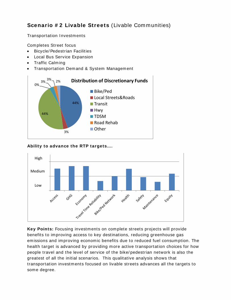
Scenario #2 Livable Streets (Livable Communities)
Transportation Investments
Completes Street focus • Bicycle/Pedestrian Facilities • Local Bus Service Expansion • Traffic Calming • Transportation Demand & System Management
Ability to advance the RTP targets….
Key Points: Focusing investments on complete streets projects will provide benefits to improving access to key destinations, reducing greenhouse gas emissions and improving economic benefits due to reduced fuel consumption. The health target is advanced by providing more active transportation choices for how people travel and the level of service of the bike/pedestrian network is also the greatest of all the initial scenarios. This qualitative analysis shows that transportation investments focused on livable streets advances all the targets to some degree.
44%
3%
44%
0% 3% 3% 2% Distribution of Discretionary Funds
Bike/Ped Local Streets&Roads Transit Hwy TDSM Road Rehab Other
High
Medium
Low

Scenario #3 Highway/Local Street & Roads (Dispersed Growth)
Transportation Investments
• Local Streets & Road Intersection Improvements • Highway 1 Corridor Transportation System Management Alternative (Auxiliary
Lanes, Interchanges, Ramp Meters) • Transportation Demand & System Management
Ability to advance the RTP targets…
Key Points: An emphasis on intersection improvements on local streets & roads and the Highway 1 Corridor Transportation System Management Alternative provides the least amount of benefit in advancing the RTP targets. The improved safety from the auxiliary lanes projects and intersection improvements is evident in the safety target but the low benefit in the greenhouse gas emission reduction and bike/ped/transit access improvements to key destinations is the lowest of all the scenarios except for the system preservation scenario.
15%
24%
3%
30%
17%
10%
0% Distribution of Discretionary Funds
Bike/Ped Local Streets&Roads Transit Hwy TDSM Road Rehab Other
High
Medium
Low

Scenario #4 Highway and Regional Transit (Targeted Growth)
Transportation Investments
• Highway 1 High Occupancy Vehicle lanes • Regional Bus Service Expansion • Rail Facility Upgrades • Park & Ride and Carpool/Vanpool Programs • Transportation Demand & System Management
Ability to advance the RTP targets…
Key Points: An emphasis on the Highway 1 Corridor HOV Lane Alternative coupled with more frequent regional transit provides the greatest benefit in travel time reliability. Although there may be a small amount of increased VMT due to the HOV lane project, the increased benefit in faster travel speeds (less stop and go and improved efficiency reduces greenhouse gas emissions and improves the economy through less expenditure on fuel. The safety target is also advanced due to the improved safety from the auxiliary lanes that are part of the larger HOV lane project. The bicycle/pedestrian network are not advanced in this scenario.
2% 0%
12%
58%
25%
0% 2% Distribution of Discretionary Funds Bike/Ped Local Streets&Roads Transit Hwy TDSM Road Rehab Other
Medium
Low
High

Scenario #5 System Preservation
Transportation Investments
• Local Street and Road Maintenance (increased from existing levels) • Transit Maintenance (increased from existing levels)
Ability to advance the RTP targets…
Key Points: The transportation investments for the system preservation scenario in Santa Cruz County focus solely on roadway and transit maintenance. If all the discretionary funding (in addition to the dedicated funding that is available directly to the local jurisdictions) would go towards roadway and transit maintenance, the back log of maintenance would be brought to a minimum. Transportation investments in roadway and transit maintenance do not advance the other RTP targets.
S:\TPW\TPW 2013\0613 Special Meeting\RTP scenario planning\Att1-scenario analysis results.docx
17%
6%
39% 0%
0%
38%
0% Distribution of Discretionary Funds
Bike/Ped Local Streets&Roads Transit Hwy TDSM Road Rehab Other
Medium
Low
High
AGENDA: June 26, 2013
TO: Regional Transportation Commission FROM: Grace Blakeslee, Transportation Planner RE: 2014 Regional Transportation Plan – Updates to Draft Goals, Policies,
Targets and Draft Project List
RECOMMENDATIONS Staff recommends that the Regional Transportation Commission:
1. Approve revisions to the draft transportation plan targets and policies (Attachment 1); and,
2. Approve revisions to the preliminary draft project list to reflect results of complete streets assessment (Attachment 2).
BACKGROUND As the transportation planning agency for Santa Cruz County, the Regional Transportation Commission (RTC) is responsible for developing, implementing, and regularly updating the Regional Transportation Plan (RTP) for Santa Cruz County. The RTC also works with the Association of Monterey Bay Area Governments (AMBAG) to produce and implement the Metropolitan Transportation Plan (MTP) for the Monterey Bay region. The RTP is the state-mandated long range (20+ year) transportation plan and the MTP is the federally-mandated long range transportation plan. The RTP serves as the Santa Cruz County component of the Metropolitan Transportation Plan (MTP). The RTP and MTP include goals, targets and policies that are used to prioritize projects for funding (Policy Element); identify the area’s transportation needs and plans (Action Element); and estimate the amount of state, federal, and local funds that may be available (Financial Element).
DISCUSSION RTP Goals, Targets, Policy At its January 2012 meeting, the Regional Transportation Commission approved the sustainability framework that was utilized to support development of transportation plan goals and policies. Extensive outreach was conducted to encourage input on the draft transportation goals, targets and policies from a wide sector of the community, including public workshops and online surveys. Draft transportation goals, policies, and targets were presented and approved by the Commission in May 2012. The draft policy elements are supportive of the Sustainable Communities Strategy and Metropolitan Transportation Plan goals including coordinating land use

Updates to Draft RTP Targets and Policy and Draft Project List Page 2
and transportation investments to reduce vehicle miles traveled and greenhouse gas emissions. An overview of the purpose and development of the transportation goals, targets, policies and strategies is available on the RTP webpage (http://sccrtc.org/funding-planning/long-range-plans/rtp/). Generally the 2035 horizon year is used for meeting targets. Using a mid-term horizon, such as 2020, will demonstrate progress that can be achieved more quickly and provide a gauge for meeting the 2035 targets. RTC staff recommends that the RTC consider revisions to the Draft RTP goals, policies, and targets (Attachment 1) to address the following:
o include additional targets for the 2020 time horizon; and, o reflect additional information resulting from refinement of methodologies
used to measure progress. However, varying levels of information still exist amongst different targets due to resource constraints or data limitations.
Preliminary Draft Project List -Complete Streets Assessment A complete streets analysis is being funded by a Strategic Growth Council planning grant to support development of the three-county sustainable communities’ strategy, which will be incorporated into the MTP. The complete streets analysis consists of both a needs assessment and development of complete streets guidelines. The preliminary draft project list approved by the RTC at the March 2013 meeting included a place holder for complete streets projects. Since then, a draft complete streets project list was developed in consultation with local jurisdictions based on the complete street assessment undertaken by the Santa Cruz County Regional Transportation Commission, Transportation Agency for Monterey County, and the San Benito Council of Governments, in coordination with the Association of Monterey Bay Area Governments. The primary purpose of the complete streets assessment was to identify transportation improvements which will provide safe mobility for all users and reduce congestion, particularly in areas identified for growth, in a manner that reduces vehicle miles traveled and greenhouse gas emissions. Nineteen locations were identified as candidates for the complete streets assessment based on: AMBAG place type designations, general plan land use descriptions, local area plans, employment density data, trip destination data and input from the Interagency Technical Advisory Committee, Bicycle Committee, and Elderly and Disabled Transportation Advisory Committee. Not all locations were analyzed due to resource constraints. The draft complete streets projects shown in Attachment 2 reflect those investments which provided enhanced bicycle, pedestrian and transit environments and serve all user groups, including less experienced bicyclists and pedestrians within the areas analyzed. To achieve this, a focus was given to identifying opportunities to develop what are often referred to as “low stress routes”; to give greater emphasis to the quality, comfort and convenience of bicycle, pedestrian and transit facilities; and to support alternatives to driving for shorter trips.

Updates to Draft RTP Targets and Policy and Draft Project List Page 3
The complete streets project list shown in Attachment 2 is a combination of:
“Existing Projects” - projects already included in the Draft RTP project list, “Modified Projects” - projects for which RTC staff is recommending revisions
to the project description to address complete streets project objectives; and “New Projects” - projects not previously included that emphasize bicycle,
pedestrian and transit facilities in focus areas. Projects must be included in the Draft RTP project list in order for projects to be considered in the scenario planning effort. The draft complete streets project list reflects input from the Interagency Technical Advisory Committee, Bicycle Committee, and Elderly and Disabled Transportation Advisory Committee. Staff recommends that the RTC approve revisions to the preliminary draft project list to reflect results of the complete streets assessment, including changes to projects shown as “modified projects” and approve inclusion of “new projects” listed in Attachment 2. To support implementation of complete streets projects, the Santa Cruz County Regional Transportation Commission, Transportation Agency for Monterey County, and the San Benito Council of Governments, in coordination with the Association of Monterey Bay Area Governments, are working together to develop complete street guidelines. The guidelines are currently being reviewed by RTC committees and will be brought to the RTC for approval at the September meeting.
SUMMARY
The RTP and MTP include goals, targets and policies that are used to prioritize projects for funding (Policy Element); identify the area’s transportation needs and plans (Action Element); and estimate the amount of state, federal, and local funds that may be available (Financial Element). The proposed draft policy element for the next Regional Transportation Plan (RTP) addresses the role of transportation in supporting sustainable communities and provides guidance to decision makers about what course of actions will achieve transportation plan goals. A draft complete streets project list was developed as a result of the complete street assessment for the purposes of identifying transportation improvements which will provide safe mobility for all users and reduce congestion, particularly in areas identified for growth. Staff recommends that the RTC approve revisions to the draft transportation plan targets and policies and the preliminary draft project list to reflect results of complete streets assessment. Attachments:
1. Revised Draft Targets and Policies 2. Draft Complete Street Project List
S:\RTP\2014\StaffReports\RTC\2013-6TPW\SR_RTP-TPW20130626-GPT-CS-GB.docx
Revised Draft Transportation Plan Goals, Targets1 and Policies Underline/strikeout reflects substantative revisions since RTC approval (May 2012) to provide clarification.
GOAL 1. Improve people's access to jobs, schools, health care and
other regular needs in ways that improve health, reduce pollution and retain money in the local economy. There is a strong relationship between achieving access, health, economic benefit, climate and energy goals and meeting targets. In many cases actions to achieve one goal or target will assist in achieving other goals and targets. For example, providing more carpool, transit and bicycle trips reduces fuel consumption, retains money in the local Santa Cruz County economy and reduces congestion.
TARGETS: Improve people’s ability to meet most of their daily needs without having to drive. Improve access and proximity to employment centers.
1A. Increase the percentage of people that can travel to key destinations2 within a 30-minute walk, bike or transit trip by 20 percent by 2020 and 40 percent by 2035.
Re-invest in the local economy by reducing transportation expenses from vehicle ownership, operation and fuel consumption. Reduce smog-forming pollutants and greenhouse gas emissions.
1B. Reduce per capita fuel consumption and greenhouse gas emissions by 1 percent by 2020 and 5 percent by 20353. 1C. Re-invest in the local economy $5 million/year4 by 2020 and $10 million/year by 2035 from savings resulting from lower fuel consumption due to a reduction in vehicle miles traveled.5
Improve the convenience and quality of trips, especially for walk, bicycle, transit, freight and carpool/vanpool trips.
1Di. Improve travel time reliability6 for vehicle trips.7 1Dii. Improve multimodal level of service8 for walk and bicycle trips to and within key destinations.9
Improve health by increasing the percentage of trips made using active transportation options, including bicycling, walking and transit.
1 Base years have been identified for most targets to allow for qualitative analysis. Base years vary by target between 2001 and 2010, depending on available data. 2 Key destinations consider employment and population centers, and multimodal trip destinations. 3 Through a reduction in vehicle miles traveled and improved speed consistency. 4 2012 dollars 5 10 million per year equates to $107 per household per year. Assumes $4 per gallon. 6 Travel time reliability is important since being late to work, an appointment, or for a delivery has substantial repercussions for travelers and businesses. Literature from the Federal Highway Administration (FHWA) and many academic journals cite travel time reliability as a more important measure than average travel time between destinations because people must try to plan around the unpredictable nature of travel. 7 Qualitative target to be further developed in future planning effort. 8 Multimodal level of service for walk and bike trips considers, but is not limited to, roadways speeds, presence and quality of bicycle and pedestrian facilities including crossings and buffers from traffic. 9 Qualitative target to be further developed in future planning effort.
Attachment 1

1E. Decrease single occupancy mode share by 4 percent by 2020 and by 8 percent by 203510.
POLICIES:
1.1. Transportation Demand Management (TDM): Expand demand management programs that decrease the number of vehicle miles traveled and result in mode shift.
1.2. Transportation System Management: Implement Transportation System Management programs and projects on major roadways across Santa Cruz County that increases the efficiency of the existing transportation system.
1.3. Transportation Infrastructure: Improve multimodal access to and within key
destinations.
1.4. Transportation Infrastructure: Ensure network connectivity by closing gaps in the bicycle, pedestrian and transit networks
1.5. Land Use: Support land use decisions that locate new facilities close to
existing services, particularly those that service transportation disadvantaged populations.
GOAL 2. Reduce transportation related fatalities and injuries for all
transportation modes
Safety is a fundamental outcome from transportation system investments and operations. Across the United States, pedestrians and bicyclists (vulnerable users) are killed and injured at a significantly higher rate than the percentage of trips they take.
TARGETS:
Improve transportation safety, especially for the most vulnerable users. 2A. Reduce injury and fatal collisions by mode by 20 percent by 2020 and by 50 percent by 2035. 2B. Reduce total number of high collision locations11.
POLICIES: 2.1 Safety: Prioritize funding for safety projects and programs that will
reduce fatal or injury collisions. 2.2 Safety: Encourage projects that improve safety for youth, vulnerable
users, and transportation disadvantaged. 2.3 Emergency Services: Support projects that provide access to emergency
services. 2.4 System Design: Reduce the potential for conflict between bicyclists,
pedestrians and vehicles.
10 An 8 percent decrease in single occupancy vehicle mode share includes increasing bicycle trip mode share to 10 percent and pedestrian mode share to 14 percent by 2035 and bicycle trip mode share to 6 percent and pedestrian trip mode share to 8 percent by 2020. 11 Qualitative target to be further developed in future planning effort.

GOAL 3. Deliver access and safety improvements cost effectively, within available revenues, equitably and responsive to the needs of all users of the transportation system, and beneficially for the natural environment. The manner in which access and safety outcomes referenced in Goal 1 and Goal 2 are delivered can impact cost-effectiveness, distribution of benefits amongst population groups, and ecological function.
TARGETS: Maintain the existing system and improve the condition of transportation facilities.
3A. Increase the average local road pavement condition index to 57 by 2020 and 70 by 2035. 3B. Reduce the lane miles number of transportation facilities in “distressed” condition12 by 3 percent by 2020 and 5 percent by 2035.
Enhance healthy, safe access to key destinations for transportation-disadvantaged populations.
3C. Increase the percentage of people who are transportation disadvantaged due to income, age, race, disability, or limited English proficiency that are within a 30-minute walk, bike or transit trip to key destinations by 20% by 2020 and 40% by 2035. 3D. Ensure transportation services (and impacts) are equitably distributed to all segments of the population.
Solicit broad public input.
3E. Maximize participation from diverse members of the public in RTC planning and project implementation activities.13
POLICIES:
3.1 Cost Effectiveness & System Maintenance: Maintain and operate the existing transportation system cost-effectively and in a manner that adapts the current transportation system to maximize existing investments.
3.2 Coordination: Improve coordination between agencies in a manner that improves efficiencies, reduces, and duplication (e.g. paratransit and transit; road repairs; signal synchronization; TDM programs).
3.3 System Financing: Support new or increased taxes and fees that reflect the cost to operate and maintain the transportation system.
3.4 Equity: Demonstrate that planned investments will reduce disparities in
safety and access for transportation disadvantaged populations.
3.5 Ecological Function: Deliver transportation investments in a way that increases tree canopy, where appropriate, improves habitat and water quality, and enhances sensitive areas.
12 Includes street (pavement, sidewalks, bike lanes, and other road components) and transit facilities. “Distressed” pavement has a Pavement Condition Index under 50. 13 Qualitative target to be further developed in future planning effort.

3.6 Public Engagement: Solicit broad public input on all aspects of regional and local transportation plans, projects and funding actions.
S:\RTP\2014\STARS\RTPSustainabilityGoalDev\Goals&Policies_FinalDraft\RTPGoalsPolicyNarrativePossibleRevisions-GB0613.docx
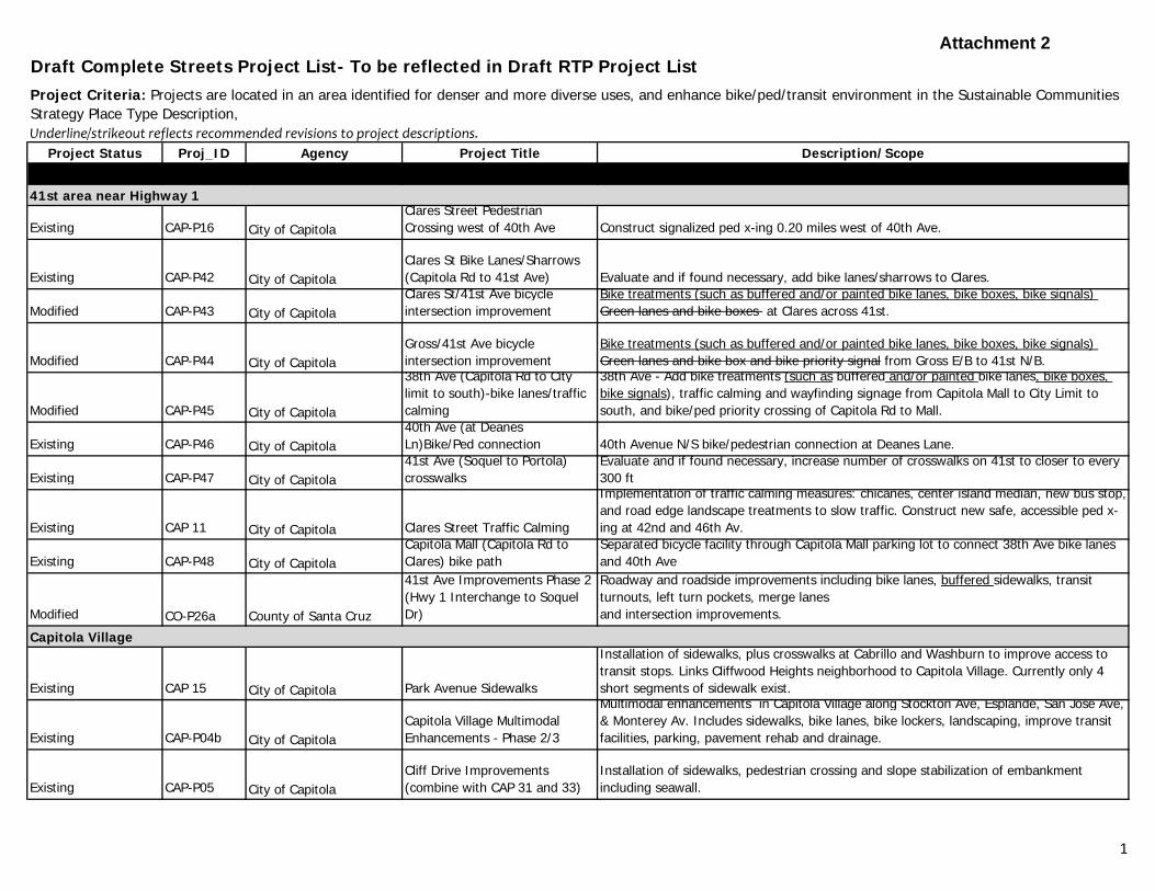
Draft Complete Streets Project List- To be reflected in Draft RTP Project List
Underline/strikeout reflects recommended revisions to project descriptions.
Project Status Proj_ID Agency Project Title Description/Scope
41st area near Highway 1
Existing CAP-P16 City of CapitolaClares Street Pedestrian Crossing west of 40th Ave Construct signalized ped x-ing 0.20 miles west of 40th Ave.
Existing CAP-P42 City of CapitolaClares St Bike Lanes/Sharrows (Capitola Rd to 41st Ave) Evaluate and if found necessary, add bike lanes/sharrows to Clares.
Modified CAP-P43 City of CapitolaClares St/41st Ave bicycle intersection improvement
Bike treatments (such as buffered and/or painted bike lanes, bike boxes, bike signals) Green lanes and bike boxes at Clares across 41st.
Modified CAP-P44 City of CapitolaGross/41st Ave bicycle intersection improvement
Bike treatments (such as buffered and/or painted bike lanes, bike boxes, bike signals) Green lanes and bike box and bike priority signal from Gross E/B to 41st N/B.
Modified CAP-P45 City of Capitola
38th Ave (Capitola Rd to City limit to south)-bike lanes/traffic calming
38th Ave - Add bike treatments (such as buffered and/or painted bike lanes, bike boxes, bike signals), traffic calming and wayfinding signage from Capitola Mall to City Limit to south, and bike/ped priority crossing of Capitola Rd to Mall.
Existing CAP-P46 City of Capitola40th Ave (at Deanes Ln)Bike/Ped connection 40th Avenue N/S bike/pedestrian connection at Deanes Lane.41st Ave (Soquel to Portola) Evaluate and if found necessary, increase number of crosswalks on 41st to closer to every
Project Criteria: Projects are located in an area identified for denser and more diverse uses, and enhance bike/ped/transit environment in the Sustainable Communities Strategy Place Type Description,
Existing CAP-P47 City of Capitola crosswalks 300 ft
Existing CAP 11 City of Capitola Clares Street Traffic Calming
Implementation of traffic calming measures: chicanes, center island median, new bus stop, and road edge landscape treatments to slow traffic. Construct new safe, accessible ped x-ing at 42nd and 46th Av.
Existing CAP-P48 City of CapitolaCapitola Mall (Capitola Rd to Clares) bike path
Separated bicycle facility through Capitola Mall parking lot to connect 38th Ave bike lanes and 40th Ave
Modified CO-P26a County of Santa Cruz
41st Ave Improvements Phase 2 (Hwy 1 Interchange to Soquel Dr)
Roadway and roadside improvements including bike lanes, buffered sidewalks, transit turnouts, left turn pockets, merge lanesand intersection improvements.
Capitola Village
Existing CAP 15 City of Capitola Park Avenue Sidewalks
Installation of sidewalks, plus crosswalks at Cabrillo and Washburn to improve access to transit stops. Links Cliffwood Heights neighborhood to Capitola Village. Currently only 4 short segments of sidewalk exist.
Existing CAP-P04b City of CapitolaCapitola Village Multimodal Enhancements - Phase 2/3
Multimodal enhancements in Capitola Village along Stockton Ave, Esplande, San Jose Ave, & Monterey Av. Includes sidewalks, bike lanes, bike lockers, landscaping, improve transit facilities, parking, pavement rehab and drainage.
Existing CAP-P05 City of CapitolaCliff Drive Improvements (combine with CAP 31 and 33)
Installation of sidewalks, pedestrian crossing and slope stabilization of embankment including seawall.
1
Attachment 2
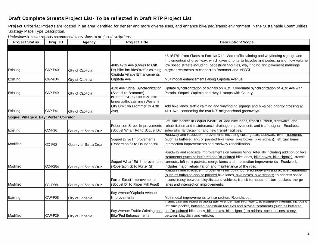
Draft Complete Streets Project List- To be reflected in Draft RTP Project List
Underline/strikeout reflects recommended revisions to project descriptions.
Project Status Proj_ID Agency Project Title Description/Scope
Project Criteria: Projects are located in an area identified for denser and more diverse uses, and enhance bike/ped/transit environment in the Sustainable Communities Strategy Place Type Description,
Existing CAP-P40 City of Capitola46th/47th Ave (Clares to Cliff Dr) bike facilities/traffic calming
46th/47th from Clares to Portola/Cliff - Add traffic calming and wayfinding signage and implemention of greenway, which gives priority to bicycles and pedestrians on low volume, low speed streets including, pedestrian facilities, way finding and pavement markings, bicycle treatments to connect to Brommer and MBSST.
Existing CAP-P34 City of CapitolaCapitola Village Enhancements: Capitola Ave Multimodal enhancements along Capitola Avenue.
Existing CAP-P49 City of Capitola41st Ave Signal Synchronization (Soquel to Brommer)
Update synchronization of signals on 41st. Coordinate synchronization of 41st Ave with Portola, Soquel, Capitola and Hwy 1 ramps with County.
Existing CAP-P41 City of Capitola
Brommer/Jade/Topaz St bike lanes/traffic calming (Western City Limit on Brommer to 47th Ave)
Add bike lanes, traffic calming and wayfinding signage and bike/ped priority crossing at 41st Ave, connecting the two N/S neighborhood greenways.
Soquel Village & Bay/Porter Corridor
Existing CO P16 C t f S t CRobertson Street Improvements (Soquel Wharf Rd to Soquel Dr )
Left turn pocket at Soquel Wharf Rd. Add bike lanes, transit turnout, sidewalks, and rehabilitation and maintenance, drainage improvements and traffic signal. Roadside: sidewalks landscaping and new transit facilitiesExisting CO-P16 County of Santa Cruz (Soquel Wharf Rd to Soquel Dr.) sidewalks, landscaping, and new transit facilities.
Modified CO-P62 County of Santa CruzSoquel Drive Improvements (Roberston St to Daubenbiss)
Roadway and roadside improvements including curb, gutter, sidewalk, bike treatments (such as buffered and/or painted bike lanes, bike boxes, bike signals), left turn lanes, intersection improvements and roadway rehabilitation.
Modified CO-P28g County of Santa CruzSoquel-Wharf Rd Improvements (Robertson St to Porter St)
Roadway and roadside improvements on various Minor Arterials including addition of bike treatments (such as buffered and/or painted bike lanes, bike boxes, bike signals), transit turnouts, left turn pockets, merge lanes and intersection improvements. Roadwork includes major rehabilitation and maintenance of the road.
Modified CO-P26r County of Santa CruzPorter Street Improvements (Soquel Dr to Paper Mill Road)
Roadway and roadside improvements including buffered sidewalks and bicycle treatments (such as buffered and/or painted bike lanes, bike boxes, bike signals) to address speed inconsistency between bicyclists and vehicles, transit turnouts, left turn pockets, merge lanes and intersection improvements.
Existing CAP-P08 City of CapitolaBay Avenue/Capitola Avenue Improvements Multimodal improvements to intersection. Roundabout
Modified CAP-P29 City of CapitolaBay Avenue Traffic Calming and Bike/Ped Enhancements
Traffic calming features along Bay Avenue from Highway 1 to Monterey Avenue, including left turn pocket, buffered pedestrian facilities and bicycle treatments (such as buffered and/or painted bike lanes, bike boxes, bike signals) to address speed inconsistency between bicyclists and vehicles.
2

Draft Complete Streets Project List- To be reflected in Draft RTP Project List
Underline/strikeout reflects recommended revisions to project descriptions.
Project Status Proj_ID Agency Project Title Description/Scope
Project Criteria: Projects are located in an area identified for denser and more diverse uses, and enhance bike/ped/transit environment in the Sustainable Communities Strategy Place Type Description,
Modified CAP-P32 City of CapitolaBay Avenue/Monterey Avenue Intersection Modification
Multimodal improvements to the intersection. Include signalization or roundabout along with pedestrian, bicycle treatments (such as buffered and/or painted bike lanes, bike boxes, bike signals) and transit access.
Seacliff/Racho Del Mar/Aptos Village
Existing CO 64 County of Santa Cruz Aptos Village Plan Improvements
Modifications to ped, bike, and auto traffic. Add pedestrian facilities on south side of Soquel Dr; maintain existing bike lanes; new bus pullout and shelter on north side. Trout Gulch: Replace sidewalks with standard sidewalks on east side, ADA upgrades
Modified CO-P20 County of Santa CruzState Park Drive Improvements Phase 2
Transit turnouts, two way left turn, merge lanes, signal at Searidge, and intersection improvements, fill gaps in bike and ped facilities including pedestrian crossing improvements, bike treatments (such as buffered and/or painted bike lanes, bike boxes, bike signals). Plus, major rehabilitation and maintenance, drainage improvements, landscaping.
Existing CO-P09 County of Santa Cruz East Cliff
Roadway rehab, add left turn pockets at 26th and 30th Ave, fill gaps in bikeways and sidewalks, add transit turnouts,intersection improvements. Some landscaping and drainage improvements.
Existing CO-P27j County of Santa CruzSeacliff Drive Improvements (entire length)
Roadway and roadside improvements on various Major Collectors including bike lanes, transit turnouts, left turn pockets, merge lanes and intersection improvements.
Modified CO-P33f County of Santa Cruz
Mar Vista Dr Improvements (entire length-just before Seacliff Dr to Soquel Dr)
Roadway and roadside improvements on various Minor Collectors including addition of bike lanes, buffered sidewalks, transit turn outs, left turn pockets, merge lanes and intersection improvements. Roadwork includes major rehabilitation and maintenance of road.
NEW NA County of Santa CruzMar Vista to State Park Dr New Ped/Bike Connection
Evaluate and if feasible, develop new bike/ped connection from Mar Vista to State Park (via Sailfish or Caterberry) to connect neighborhood to State Park goods, services and transit.
NEW NA County of Santa CruzSeacliff Dr/North Avenue Bike/Ped Connection to MBSST
Evaluate and if feasible, develop new bike/ped connection from North Street to Aptos Village Square and Soquel Drive across MBSST to connect neighborhood to State Park goods, services and transit.
Existing CO-P26h County of Santa Cruz
Center Ave/Seacliff Dr Improvements (Broadway to Aptos Beach Dr)
Roadway and roadside improvements including bike lanes, sidewalks, transit turnouts, left turn pockets, merge lanes and intersection improvements.
NEW NA County of Santa CruzSearidge Drive (Mar Vista to State Park) Bike Improvements
Install bike treatments (such as buffered and/or painted bike lanes, bike boxes, bike signals)
Existing CO-P33g County of Santa Cruz
McGregor Dr. Improvements (Capitola city limits to Searidge Rd)
Roadway and roadside improvements on various Minor Collectors including addition of bike lanes, transit turnouts, left turn pockets, merge lanes and intersection improvements. Roadwork includes major rehabilitation and maintenance of the road.
3

Draft Complete Streets Project List- To be reflected in Draft RTP Project List
Underline/strikeout reflects recommended revisions to project descriptions.
Project Status Proj_ID Agency Project Title Description/Scope
Project Criteria: Projects are located in an area identified for denser and more diverse uses, and enhance bike/ped/transit environment in the Sustainable Communities Strategy Place Type Description,
NEW NA County of Santa Cruz
Rancho Del Mar Shopping Center (Rail Line to State Park) bike/ped path
Separated bicycle facility through Rancho Del Mar Shopping Center to connect MBSST to goods and services in shopping center and State Park Drive.
Soquel Drive near Dominican Hospital
Existing CO-P26i County of Santa CruzChanticleer Ave. Improvements (Hwy 1 to Soquel Dr)
Roadway and roadside improvements including bike lanes, sidewalks, drainage and intersection improvements.
Existing CO-P26p County of Santa CruzMattison Ln Improvements (Chanticleer Ave to Soquel Ave)
Roadway and roadside improvements including bike lanes, sidewalks, transit turnouts, left turn pockets, merge lanes and intersection improvements.
Existing CO-P28c County of Santa CruzCommercial Way Improvements (Mission Dr. to Soquel Dr.)
Roadway and roadside improvements on various Minor Arterials including addition of bike lanes, transit turnouts, left turn pockets, merge lanes and intersection improvements. Roadwork includes major rehabilitation and maintenance of the road.
Existing CO-P27l County of Santa CruzWinkle Ave Improvements (entire length from Soquel Dr)
Roadway and roadside improvements on various Major Collectors including bike lanes, transit turnouts, left turn pockets, merge lanes and intersection improvement.
Existing CO-P28h County of Santa CruzThurber Ln Improvements (entire length)
Roadway and roadside improvements on various Minor Arterials including addition of bike lanes, transit turnouts, left turn pockets, merge lanes and intersection improvements. Roadwork includes major rehabilitation and maintenance of the road.
Existing SC-P21 City of Santa CruzBrookwood Drive Bike and Pedestrian Path Provide 2-way bicycle and pedestrian travel.
Lower 41st Area
Modified CO-P27a County of Santa Cruz
37th/38th Ave (Brommer to Eastcliff) Multimodal Circulation Improvements and Greenway
Evaluate and if feasible improve vehicle and transit access on 38th Avenue from East Cliff to Brommer and develop greenway on 37th Avenue from East Cliff to Portola. Roadway improvements may include roadway and roadside improvements including sidewalks, bike treatments (such as buffered and/or painted bike lanes, bike boxes, bike signals), transit turnouts, left turn pockets, and intersection improvement.
Modified CO-P31a County of Santa Cruz26th Ave Improvements (Portola to East Cliff)
Roadway and roadside improvements including sidewalks, bike lanes, transit turnouts, left turn pockets, merge lanes and intersection improvements.
Modified CO-P31j County of Santa Cruz
Roland Dr. (30th to 35th) Roadway improvements and greenway
Roadway and roadside improvements and implemention of greenway, which gives priority to bicycles and pedestrians on low volume, low speed streets including, pedestrian facilities, way finding and pavement markings, bicycle treatments to connect to new bike/ped connection to 41st. on various Major Collectors including bike lanes, transit turnouts, left turn pockets, merge lanes and intersection improvements.
4
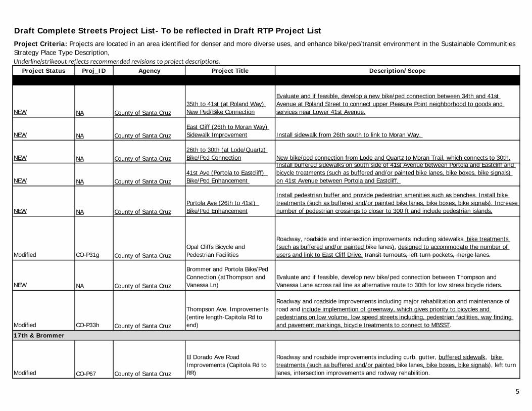
Draft Complete Streets Project List- To be reflected in Draft RTP Project List
Underline/strikeout reflects recommended revisions to project descriptions.
Project Status Proj_ID Agency Project Title Description/Scope
Project Criteria: Projects are located in an area identified for denser and more diverse uses, and enhance bike/ped/transit environment in the Sustainable Communities Strategy Place Type Description,
NEW NA County of Santa Cruz35th to 41st (at Roland Way) New Ped/Bike Connection
Evaluate and if feasible, develop a new bike/ped connection between 34th and 41st Avenue at Roland Street to connect upper Pleasure Point neighborhood to goods and services near Lower 41st Avenue.
NEW NA County of Santa CruzEast Cliff (26th to Moran Way) Sidewalk Improvement Install sidewalk from 26th south to link to Moran Way.
NEW NA County of Santa Cruz26th to 30th (at Lode/Quartz) Bike/Ped Connection New bike/ped connection from Lode and Quartz to Moran Trail, which connects to 30th.
NEW NA County of Santa Cruz41st Ave (Portola to Eastcliff) Bike/Ped Enhancement
Install buffered sidewalks on south side of 41st Avenue between Portola and Eastcliff and bicycle treatments (such as buffered and/or painted bike lanes, bike boxes, bike signals) on 41st Avenue between Portola and Eastcliff.
NEW NA County of Santa CruzPortola Ave (26th to 41st) Bike/Ped Enhancement
Install pedestrian buffer and provide pedestrian amenities such as benches. Install bike treatments (such as buffered and/or painted bike lanes, bike boxes, bike signals). Increase number of pedestrian crossings to closer to 300 ft and include pedestrian islands.
Modified CO-P31g County of Santa CruzOpal Cliffs Bicycle and Pedestrian Facilities
Roadway, roadside and intersection improvements including sidewalks, bike treatments (such as buffered and/or painted bike lanes), designed to accommodate the number of users and link to East Cliff Drive. transit turnouts, left turn pockets, merge lanes.
NEW NA County of Santa Cruz
Brommer and Portola Bike/Ped Connection (atThompson and Vanessa Ln)
Evaluate and if feasible, develop new bike/ped connection between Thompson and Vanessa Lane across rail line as alternative route to 30th for low stress bicycle riders.
Modified CO-P33h County of Santa Cruz
Thompson Ave. Improvements (entire length-Capitola Rd to end)
Roadway and roadside improvements including major rehabilitation and maintenance of road and include implemention of greenway, which gives priority to bicycles and pedestrians on low volume, low speed streets including, pedestrian facilities, way finding and pavement markings, bicycle treatments to connect to MBSST.
Modified CO-P67 County of Santa Cruz
El Dorado Ave Road Improvements (Capitola Rd to RR)
Roadway and roadside improvements including curb, gutter, buffered sidewalk, bike treatments (such as buffered and/or painted bike lanes, bike boxes, bike signals), left turn lanes, intersection improvements and rodway rehabilition.
17th & Brommer
5
Draft Complete Streets Project List- To be reflected in Draft RTP Project List
Underline/strikeout reflects recommended revisions to project descriptions.
Project Status Proj_ID Agency Project Title Description/Scope
Project Criteria: Projects are located in an area identified for denser and more diverse uses, and enhance bike/ped/transit environment in the Sustainable Communities Strategy Place Type Description,
Ocean Street Corridor
NEW NA City of Santa Cruz
Ocean St and San Lorenzo River Levee Bike/Ped Connections (Felker, Kennan, Blain, Barson Streets)
Improve pedestrian and bicycle facilities on side streets to connect Ocean Street with San Lorenzo River Levee path system
NEW NA City of Santa CruzRiverside Avenue (Barson to Soquel)
Implement pedestrian and bicycle facilities on this low volumne, low speed street or parallel local route to better connect and provide an alternative to Ocean Street. This could include way finding, pavement marketings, bicycle treatments, and a ped/bike activiated flashers at Riverside and Broadway
NEW NA City of Santa CruzOcean Sreet Corridor Multiuse Transit Lane
Consider restricting parking to develop business access and transit (BAT) lane to serve tourism and improving transit facilities.
NEW NA City of Santa Cruz
Soquel/Branciforte/Water (San Lorenzo River to Branciforte) bike lane treatments
Consider bike treatments (such as buffered and/or painted bike lanes, bike boxes, bike signals) to address speed inconsistency and parking conflicts between bicyclists and vehicles.
NEW NA Cit f S t COcean Street/San Lorenzo River Levee Area Wayfinding Install signage on the bike/ped scale to bike/ped facilities connecting key destinationsNEW NA City of Santa Cruz Levee Area Wayfinding Install signage on the bike/ped scale to bike/ped facilities connecting key destinations.
Modified SC 46 City of Santa CruzBranciforte Creek Bike/Ped Crossing
Install a bicycle/pedestrian bridge over Branciforte Creek and multi-use paths connecting the levee paths in the vicinty of San Lorenzo Park and Soquel Avenue
Existing SC-P95 City of Santa Cruz
Branciforte Creek Pedestrian Path Connections
Fill gaps in pedestrian and bike paths along and across Branciforte Creek in the Ocean-Lee-Market-May Streets area.
Modified SC-P66 City of Santa CruzOcean Street Widening from Soquel to East Cliff
Implement this phase of the Ocean Street plan that includes utility undergounding, bike lanes, wider sidewalks, pedestrian crossing islands/bulb outs, transit improvements, pedestrian scale street lights, street trees and left turn lanes at Broadway and a right-turn lane at San Lorenzo Blvd. This includes pedestrian and bicycle crossing improvements and detection and connectivity to the pedestrian and bicycle path on the San Lorenzo River and adjacent neighborhoods.
Modified SC-P84 City of Santa CruzOcean St Streetscape and Intersection, Water to Soquel
Implement this phase of the adopted Ocean Street plan including adding turn lanes on Ocean Street at the Water Street intersections, wider sidewalks, pedestrian crossing islands/bulb outs, transit improvements, street trees, pedestrian scale street lights, street lighting and medians improvements, way finding, and pedestrian and bicycle connectivity to San Lorenzo Park and neighborhoods. Both streets are arterial streets. Ocean Street is a Local Coastal Access Route.
6
Draft Complete Streets Project List- To be reflected in Draft RTP Project List
Underline/strikeout reflects recommended revisions to project descriptions.
Project Status Proj_ID Agency Project Title Description/Scope
Project Criteria: Projects are located in an area identified for denser and more diverse uses, and enhance bike/ped/transit environment in the Sustainable Communities Strategy Place Type Description,
Modified SC-P86 City of Santa CruzOcean St Streetscape and Intersection, Plymouth to Water
Implement this phase of the Ocean Street plan and modify Plymouth St to provide separate turn lanes and through lanes, widen sidewalks, pedestrian islands/bulbouts, transit improvements, street trees, street lighting and medians landscaping improvemnts. This includes pedestrian and bicycle crossing improvements and detection and connectivity to the pedestrian and bicycle path on the San Lorenzo River and adjacent neighborhoods. Include Gateway treatment. Bothstreets are arterial streets. Ocean St is an arterial on the Local Coastal access system.
Downtown Watsonville
NEW NA City of WatsonvilleMain St (Freedom to Riverside) Ped/Bike Enhancements
Evaluate and if feasible improve ped facilities and bike treatments (such as buffered and/or painted bike lanes, bike boxes, bike signals) and bike boxes and bicycle priority at intersections on Main Street intersections.
NEW NA City of WatsonvilleDowntown Watsonville Universal Streets
Evaluate and if feasible, implement universal streets, which are designed for pedestrians and restrict vehicular access, which facilitate new ped access.
Repair, replace and install curb, gutter, and curb ramps; replace and upgrade signage and
Modified WAT-P40 City of WatsonvilleMain St Modifications (500 Block: Fifth St to East Lake Ave)
Repair, replace and install curb, gutter, and curb ramps; replace and upgrade signage and striping. Evaluate and if feasible, provide bike treatments (such as buffered and/or painted bike lanes, bike boxes, bike signals), and buffered sidewalk.
Existing WAT-P41 City of WatsonvilleWest Lake Ave Modifications (Main St to Rodriguez St)
Repair, replace and install curb, gutter, sidewalk and curb ramps; replace and upgrade signage and striping
Existing WAT-P49 City of Wastonville
2nd/Maple Ave (Lincoln to Walker) Traffic Calming and Greenway
Evaluate and if feasible, add traffic calming/bicycle traffic priority with wayfinding signage to provide access to MBSST and create low stress grid around downtown.
Existing WAT-P50 City of Wastonville5th St (Lincoln to Walker) - traffic calming and Greenway
Evaluate and if feasible, add traffic calming/bicycle traffic priority with wayfinding signage to provide access to MBSST and create low stress grid around downtown.
Existing WAT-P39 City of WatsonvilleEast Fifth St (Main St to Lincoln St)
Repair, replace and install curb, gutter, sidewalk and curb ramps; replace and upgrade signage and striping
Existing WAT-P51 City of WastonvilleRodriguez St (Main St to Riverside)- buffered bike lane
Evaluate and if feasible, improve bike lane striping, add buffered lanes on Rodriguez St to delineate bike lane from vehicle parking and traffic
Existing WAT-P52 City of WastonvilleUnion/Brennan (Freedom to Riverside) - sharrows Evaluate and if feasible, add sharrows to Union/Brennan.
Existing WAT-P53 City of WastonvilleKearney/Rodriguez - ped crossing
Evaluate and if feasible, add traffic calming to existing pedestrian crossing at Kearney and Rodriguez with traffic calming for access to Radcliffe Elementary.
Existing WAT-P54 City of Wastonville Main St - 3 HAWK signals Evaluate and if feasible, add Hawk signals in 3 locations on Main St
7

Draft Complete Streets Project List- To be reflected in Draft RTP Project List
Underline/strikeout reflects recommended revisions to project descriptions.
Project Status Proj_ID Agency Project Title Description/Scope
Project Criteria: Projects are located in an area identified for denser and more diverse uses, and enhance bike/ped/transit environment in the Sustainable Communities Strategy Place Type Description,
Existing WAT-P55 City of Wastonville
Main/Rodriguez/Union/Brennan (Freedom to Riverside) - crosswalks
Evaluate and if feasible, increase the number of crosswalks on Main St, Rodriguez, and Union/Brennan to aim for 300 ft distance between crossings. Update pattern of crosswalks to block pattern.
Modified WAT-P47 City of WastonvilleMain St Modifications (City Limit to Lake Ave)
Repave roadway and bike lanes; repair, replace and install curb, gutter, sidewalk and curb ramps: replace and upgrade signage and striping. Evaluate and if feasible, provide bike treatments (such as buffered and/or painted bike lanes, bike boxes, bike signals) and buffered sidewalks.
Existing WAT-P57 City of WastonvilleEast Lake/Madison - ped crossing
Evaluate and if feasible, add pedestrian crossing (HAWK signal if ped volume warrants) at E Lake & Madison for better access to Hall Middle School.
Freedom Corridor
NEW NA City of WatsonvillleHillside Ave to Freedom Blvd Ped/Bike Connection
Evaluate and if feasible, install new bike/ped connection between from Carey Avenue to Freedom Bouldevard between Roache Road and Green Valley Road to connect neighborhood to goods, services and transit on Freedom Boulevard. Include new crossing from new bicycle/pedestrian facilitiy to east side of Freedom Boulevard.
F d Bl d (G V ll RdEvaluate and if feasible, install bike treatments (such as buffered and/or painted bike l bik b bik i l ) t dd d i i t b t bi li t d
NEW NA City of Watsonville
Freedom Blvd (Green Valley Rd to Lincoln) Bicycle and Pedestrian Improvements
lanes, bike boxes, bike signals) to address speed inconsistency between bicyclists and vehicles. Complete sidewalks, including pedestrian buffer, and pedestrian islands at crossings.
Modified WAT-39 City of WatsonvilleFreedom Blvd Reconstruction (Alta Vista to Broadis )
Full depth rehab (reuse existing materials), relocate utilites, traffic signal detection upgrades/install traffic cameras, concreate pads at bus stop, signage and stiping, including sharros for bikes., ADA upgrades to curbs and driveways, replacement of existing curb, gutter, sidwalk; modification to retaining wall between Crewtview and Alta Vista. Evaluate and if feasible, install bike treatments (such as buffered and/or painted bike lanes, bike boxes, bike signals) to address speed inconsistency between bicyclists and vehicles. Complete sidewalks, including pedestrian buffer, and pedestrian islands at crossings.
Modified WAT-P11 City of Watsonville
Freedom Blvd Improvements (Green Valley Rd to Compton Terrace)
Pavement reconstruction, operation imporvements (turn lanes), installation of bike lanes, sidewalks, signing and striping. Evaluate and if feasible, install bike treatments (such as buffered and/or painted bike lanes, bike boxes, bike signals) to address speed inconsistency between bicyclists and vehicles. Complete sidewalks, including pedestrian buffer, and pedestrian islands at crossings.
Modified WAT-P33 City of WatsonvilleFreedom Blvd Reconstruction (Davis to Alta Vista)
Reconstruct roadway, pedestrian and bicycle facilities. Evaluate and if feasible, install bike treatments (such as buffered and/or painted bike lanes, bike boxes, bike signals) to address speed inconsistency between bicyclists and vehicles. Complete sidewalks, including pedestrian buffer, and pedestrian islands at crossings.
8

Draft Complete Streets Project List- To be reflected in Draft RTP Project List
Underline/strikeout reflects recommended revisions to project descriptions.
Project Status Proj_ID Agency Project Title Description/Scope
Project Criteria: Projects are located in an area identified for denser and more diverse uses, and enhance bike/ped/transit environment in the Sustainable Communities Strategy Place Type Description,
Modified WAT-P45 City of WatsonvilleGreen Valley (Freedom to City Limits)
Reconstruct or repave roadway and bikelanes; repair, replace and install curb gutter, sidewalk and curb ramps; replace and upgrade striping. Evaluate and if feasible, including pedestrian buffer and bike treatments (such as buffered and/or painted bike lanes, bike boxes, bike signals).
NEW City of WatsonvilleFreedom Blvd Pedestrian Crossings (Airport to Lincoln)
Evaluate and if feasible, install new and improve existing uncontrolled pedestrian crossings at Roach Road, Davis Avenue, Clifford Lane, Mariposa Avenue, Alta Vista Street, Crestview Drive, Martinelli Street and Marin Street).
NEW City of WatsonvillePajaro Lane to Freedom Blvd Ped/Bike Connection
Evaluate and if feasible, new bike/ped connection between from Pajaro Lane to Freedom Blvd between to connect neighborhood to goods, services and transit on Freedom Boulevard. Include new crossing from new bicycle/pedestrian facilitiy to west side of Freedom Boulevard.
Freedom to Green Valley (at Hillside Avenue, Davis Avenue, Blanca Lane, Clifford Avenue, Mariposa Avenue, Crestview Drive, Martinelli Street, Marin
Evaluate and if feasible, implement greenway, which gives priority to bicycles and pedestrians on low volume, low speed streets including, pedestrian facilities, way finding
NEW City of WatsonvilleStreet) Neighborhood Bicycle and Pedestrian Connections
and pavement markings, bicycle treatments to connect neighborhoods to goods and services on Freedom Bouldevard.
Soquel/Water/Morrisey
Existing SC-P106 City of Santa CruzArana Gulch Bicycle/Pedestrian Connection (at Agnes St) Bike and Pedestrian multi-purpose trail from Agnes to the Arana Gulch N-S Trail
Existing SC-P117 City of Santa CruzWater St (at Branciforte and Center) signal synchronization
Synchronize signals on Water to include Branciforte and Center to existing synchronized signals.
Existing SC-P119 City of Santa CruzSoquel/Water (Branciforte to Morrissey) crosswalks
Evaluate and if found necessary implement additional crosswalks on Soquel/Water striving for 300 ft distance between crosswalks with consideration for safety, update crosswalks to more visible pattern (block).
Existing SC-P22 City of Santa Cruz Chestnut St. PathwayInstall a Class 1 bicycle/pedestrian facility to connectthe east side of Neary Lagoon Park with the Depot Park path.
Existing SC-P29 City of Santa CruzMorrissey Blvd. Bike Path over Hwy 1 Install a Class 1 bicycle and pedestrian facility on freeway overpass.
Existing SC-P47 City of Santa Cruz Chestnut Street Bike Lanes
Install Class 2 bike lanes to provide connection from existing bike lanes on Laurel Street and upper Chestnut Street to proposed Class 1 bike path connections to Bay Street and Pacific Avenue/Beach Street.
9

Draft Complete Streets Project List- To be reflected in Draft RTP Project List
Underline/strikeout reflects recommended revisions to project descriptions.
Project Status Proj_ID Agency Project Title Description/Scope
Project Criteria: Projects are located in an area identified for denser and more diverse uses, and enhance bike/ped/transit environment in the Sustainable Communities Strategy Place Type Description,
Modified SC-P87 City of Santa CruzSoquel Ave Corridor Widening (Branciforte-Morrissey)
Minor widening and signal modifications along Soquel Ave corridor from Branciforte to Morrissey Blvd to widen sidewalks, transit improvements, improve pedestrian and bicycle detection and crossings, add a travel lane, maintain some commercial parking and improve exitsing bike lanes. Replacing the split phasing with protected left-turns at Branciforte to reduce delays for all modes of travel and GHG.
Scotts Valley Mt. Hermon Road/Scotts Valley Drive
Existing SV-P30A City of Scotts ValleyMt. Hermon Road Sidewalk Connections Add sidewalks to fill gaps in business district.
Existing SV-P32 City of Scotts Valley Bluebonnet Lane Bike Lanes Add bike lanes on Bluebonnet (Bean Ck, through Skypark to Mt. Hermon/Lockewood).
Existing SV-P33 City of Scotts Valley Civic Center Drive Bike Lanes Add bike la bike lanes to narrow road.
Existing SV-P39 City of Scotts Valley Glenwood Dr. Bike Lanes Widen road to accommodate bike lanes from Scotts Valley High School to City limits.
Existing SV-P40 City of Scotts ValleyLockwood Lane Sidewalk and Bike Lanes Construct Bike Lanes and add sidewalk on the west side from Mt. Hermon to the City limit.Scotts Valley Town Center
Existing SV-P45 City of Scotts Valley Bicycle/Pedestrian Facilities Bicycle and pedestrian facilities and circulation elements within planned development.
Existing SV-P46 City of Scotts ValleyMt Hermon/King's Village Rd-Transit Signal priority Transit signal priority at Kings Village Rd/Mt Hermon Rd.
Existing SV-P47 City of Scotts ValleyMt Hermon/Scotts Valley - transit queue jump
Evaluate and if found to be beneficial, remove right turn islands at Mt Hermon Rd/Scotts Valley Road to add transit queue jump lanes/signals.
Existing SV-P49 City of Scotts ValleyMt Hermon Rd and Scotts Valley Drive - crosswalks
Increase number of crosswalks on Mt Hermon/Scotts Valley Dr, update crosswalks to block pattern, add pedestrian treatments where necessary at intersections to decrease distance across using refuge islands. Add crosswalks to all sides of intersections (par
Existing SV-P50 City of Scotts Valley
Mt Hermon/Scotts Valley - intersection improvements for bicycle treatment Add green lane bicycle treatments at Mt Hermon/Scotts Valley Dr intersection
Existing SV-P52 City of Scotts ValleyKings Village Rd/Town Center Entrance Traffic Signal
Install new traffic signal at the intersection of Kings Village Rd and new Town Center entrance (near transit center) with protected pedestrian crossings and transit signal priority. New Signalization of the intersection on Kings Village Rd at the transit
New NA City of Scotts ValleyMt Hermon Rd to El Rancho Drive bike/ped connection
New bike/ped connection between Mt Hermon Road and El Rancho Drive whichcould include improved bike/ped facilities on existing interchange or new bike/ped crossing.
New NA City of Scotts Valley
Mt Hermon Rd/ Spring Hill Road Pedestrian Intersection Improvements Improve pedestrian crossing at Spring Hills Drive and Mt. Hermon Road.
10

Draft Complete Streets Project List- To be reflected in Draft RTP Project List
Underline/strikeout reflects recommended revisions to project descriptions.
Project Status Proj_ID Agency Project Title Description/Scope
Project Criteria: Projects are located in an area identified for denser and more diverse uses, and enhance bike/ped/transit environment in the Sustainable Communities Strategy Place Type Description,
Citywide
Existing WAT-P56 City of Wastonville Watsonville-wide HOV priority Evaluate HOV priority at signals and HOV queue bypass.
Existing SV-P48 City of Scotts ValleyScotts Valley-wide - greenway signage Add signage for neighborhood greenways
Existing SV-P28 City of Scotts Valley Neighborhood Traffic Calming Citywide traffic calming devices.
Existing WAT-P13 City of WatsonvilleNeighborhood Traffic Plan Implementation
Address concerns about traffic complaints through Education, Enforcement, and Engineering solutions. Install traffic calming devices that do not impede bicyclist access ($20k/yr).
Existing WAT-P04 City of Watsonville Neighborhood Traffic PlanPlan to identify and address concerns regarding speeding, bicycle and pedestrian access and safety, and other neighborhood traffic issues ($5k/yr).
Existing CAP-P50 City of Capitola Capitola-wide HOV priority Evaluate HOV priority at signals and HOV queue bypass.
Countywide
NEW NA VAR Complete Streets Area Plan
Detailed complete street circulation and design plans, including consideration of greenways, fo specific areas identified for intensitified development in Sustainable Communities StrategyNEW NA VAR Complete Streets Area Plan Communities Strategy.
NEW NA VAR
Public/Private Partnership Bicycle and Pedestrian Connection Plan
Develop model for assisting local jurisdictions in working with private property owners to allow bicycle and pedestrian access through private property in areas identified for more intensified development in Sustainable Communities Strategy.
NEW NA VARPublic/Private Partnership Transit Stops and Pull Outs Plan
Develop model for assisting local jurisdictions in working with busninesses to install transit pullouts and shelters on property in areas identified as high quality transit corridors in Sustainable Communities Strategy.
NEW NA VARUncontrolled Pedestrain Crossing Improvements
Implement improvements to uncontrolled pedestrian crossing such as painted and/or raised crosswalks, flashing beacons and pedestrian islands.
NEW NA VAR
Bicycle Treatments for intersection improvements (ADD)
Add painted bike treatments (such as buffered and/or painted bike lanes, bike boxes, bike detection and signals), at major intersections.
NEW NA VAR Neighborhood Greenways
Implement greenways which gives prioritiy to bicycles and pedestrians on low volume, low speed streets including, way finding and pavement markings, bicycle treatments in areas identified for more intensified development in Sustainable Communities Strategy.
Existing RTC 16 SCCRTC Bike Parking Subsidy Program
Subsidies for bicycle racks and lockers for businesses, schools, government agencies, and non-profit organizations are all eligible. Recipients are responsible for installation and maintenance of the equipment.
NEW VAR Transit Priority Install transit ques at major intersections
11
Draft Complete Streets Project List- To be reflected in Draft RTP Project List
Underline/strikeout reflects recommended revisions to project descriptions.
Project Status Proj_ID Agency Project Title Description/Scope
Project Criteria: Projects are located in an area identified for denser and more diverse uses, and enhance bike/ped/transit environment in the Sustainable Communities Strategy Place Type Description,
NEW NA VARSchool Complete Streets Projects Implement ped/bike programs and facilities near schools.
Existing RTC 02 SCCRTCCommute Solutions Rideshare Program
Transportation demand management outreach, education and incentives. Includes matching service for carpools, vanpools, and bicyclists. Provides services and information about availability and benefits of alternative transportation modes, including sharing rides, transit, walking, bicycling, telecommuting, alternative work schedules, alternative fuel vehicles, and park-n-ride lots. Avg annual cost: $250k.
Existing RTC-P53 SCCRTC
TDM individualized employer/multiunit housing program
Implement individualized employer and multiunit housing TDM programs with incentives for existing development.
Existing RTC-27a SCCRTC
Monterey Bay Sanctuary Scenic Trail Network - Design, EnvironmentalClearance, and Construction
Design, environmental clearance and construction of a 50+ mile network of bicycle and pedestrian facilities on ornear the coast, with the rail trail as the spine and additional spur trails to connect to key destinations.
Transportation Demand Management Ordinance and
Develop Model TDM Ordinance and User Guide to include provisions for both residental and non-residential projects and address program and facilities improvements in return for
NEW NA SCCRTCManagement Ordinance and User Guide
and non residential projects and address program and facilities improvements in return for reductions in off-street parking requirements.
NEW NA SCCRTC Shared Parking Program Develop tools to allow adjacent property owners to develop and share parking facilities.
NEW NA SCCRTC Real-Time Transit Info
Develop and maintain distrubution channel for disseminating real time transit arrival and deparutre information to Santa Cruz Metro users. To be developed in coordination with Santa Cruz Metro.
NEW NA SCCRTCInterchange Bike/Ped Enhancements
Identify effective strategies for enhancing safety of bicyclist and pedestrians at and near roadway interchanges.
Transit
Existing MTD-P06 METROTransit Technological Improvements
Automatic Vehicle Locator system on all METRO buses. Real time bus arrival/departure displays at stops. IT softwareand hardware upgrades for scheduling, customer service, planning systems. Development of mobile application to communicate real time transit information to transit riders. Upgrades every 5 years.
Existing MTD-P09 METRO Bus Stop Upgrades Install, replace, repair and otherwise improve bus shelters and stops.
Existing MTD-P10 METRO
Local Transit - Continuation of Existing Service Levels 2010-2035
Operation & maintenance cost of existing local fixed route bus service (Based on 2010budget-$34M/year). $850,000
Existing MTD-P10B METROHwy 17 Express Service - Cont. of Existing Service Levels Operation & maintenance cost of existing bus service. Avg annual cost: $2.4M. $60,000
12
Draft Complete Streets Project List- To be reflected in Draft RTP Project List
Underline/strikeout reflects recommended revisions to project descriptions.
Project Status Proj_ID Agency Project Title Description/Scope
Project Criteria: Projects are located in an area identified for denser and more diverse uses, and enhance bike/ped/transit environment in the Sustainable Communities Strategy Place Type Description,
Existing MTD-P12 METROHwy 17 Express Service Expansion
Add trips to extend service hours for Highway 17 express. Capital and Operating costs. Annual expansion cost:$175K/yr., 4500
Existing MTD-P14 METROLocal Transit Service Restoration and Expansion
Restore local service to 2001 levels, then expand service 10% including expanded service within SLV, City of SC and Watsonville, express buses, improved service to industrial areas. $6.7M/yr operating, $9M capital costs (9 buses & onetime replacement)
Existing MTD-P20 METRO Bikes on Buses Expansion Add additional space for bikes on buses when/if new technology becomes available.
Existing MTD-P21 METROSignal Priority/Pre-Emption for Buses MTD-P21
Enable coach operators to actuate traffic signals to prolong green or change red lights to improve transit running time.
Existing MTD-P23 METRO Bike Station at Capitola MallEstablish bike station at Capitola Mall, especially to serve UCSC. Would be joint mall, UCSC, MTD project.
Existing MTD-P27 METRO Hwy 1 Express Buses Hwy 1 express bus replacements - 6 Buses @ $500k ea. Replace every 12 years $6,000
NEW NA METRO Pacific Station- Bike Station Establish bike station at Pacific Station.
13

AGENDA: June 26, 2013
TO: Regional Transportation Commission Transportation Policy Workshop FROM: Karena Pushnik, Senior Transportation Planner RE: Metropolitan Transportation Plan (MTP) Sustainable Communities
Strategy (SCS) Priorities and Preferences RECOMMENDATIONS Staff recommends that the Regional Transportation Commission receive a presentation on the results of the tri-county Metropolitan Transportation Plan (MTP) Sustainable Communities Strategy (SCS) Priorities and Preferences survey. BACKGROUND Development of the long range Santa Cruz County Regional Transportation Plan (RTP), federally-mandated tri-county Monterey Bay Area Metropolitan Transportation Plan (MTP), and state-mandated Sustainable Communities Strategy (SCS) a component of the MTP, includes a robust public outreach program. Public input is being sought on elements of these transportation planning efforts through online surveys, workshops, meetings with advisory committees and stakeholders, as well as a telephone survey. The Association of Monterey Bay Governments convened all three transportation planning agencies in the region – the Regional Transportation Commission for Santa Cruz County, Transportation Agency for Monterey County and the San Benito Council of Governments -- to develop a survey to be used as one of the tools for engaging the public in evaluation of transportation improvements that support the regional Sustainable Communities Strategies (SCS). The SCS is a component of the state Senate Bill 375 greenhouse gas emission reduction requirements. The firm of EMC Research was hired to perform the survey and staff from all four agencies worked together to develop questions. In addition, each county was able to tailor a few questions related to local projects. EMC Research also conducted a voter survey for the RTC in 2007. DISCUSSION A statistically valid sample of 450 voters from Santa Cruz County was surveyed by phone from May 28 to June 6, 2013. In addition, 450 voters were surveyed in Monterey County and 301 in San Benito County. The margin of error for Santa Cruz county surveys is approximately +/- 4.6%.

MTP SCS Priorities & Preferences Survey Page 2 The survey probes for information from the public regarding:
• Level of concern about community issues • Use of the local transportation system • Awareness of transportation infrastructure needs • Proposed projects for transportation investment • Themes or messages that may assist public information efforts • Attitudes regarding tax measures generally
Representatives from EMC Research will present the results of the phone survey at this meeting. Information from the survey is one of the many elements being considered in development of the Regional Transportation Plan (RTP) and Sustainable Communities Strategy (SCS). It is important to note that this survey was not designed to assess the viability of a local funding measure to pay for transportation projects/programs and the results of this survey do not directly translate into tools for that purpose. Rather this survey was designed to understand what types of shift in individual transportation uses are possible that will enable the region to meet greenhouse gas emission and sustainability targets. SUMMARY As one of the tools to collect public input during development of long range transportation plans in the tri-county Monterey Bay region, a telephone survey of voters was conducted. The results will be presented at the meeting.
S:\TPW\TPW 2013\0613 Special Meeting\SR_SCSsurvey_tpwJun13.docx