special paper: an ecological history of the charles l ... · 1 center for sustainable forestry at...
TRANSCRIPT
1
CENTER FOR SUSTAINABLE FORESTRY AT PACK FOREST
Special Paper: An Ecological History of the Charles L. Pack Experimental Forest, Eatonville, Washington: Natural History, Landscape Ecology, and Forest Management
by Mark Swanson
INTRODUCTION
Ecological history, as an area of forest research, encompasses a number of possible themes and analytical methods. These may range from qualitative historical approaches to statistical analyses of biological parameters such as changes in biomass, diameter distributions, species composition and landscape structure (Swetnam et al. 1999; Foster 2000).
This document presents the ecological history of the Charles Lathrop Pack Experimental Forest (Pack Forest), located near Eatonville, WA, and belonging to the University of Washington’s College of Forest Resources. It addresses the ecological backdrop against which modern management activities have played out, and describes significant natural and anthropogenic changes. Ecological history is one of the most derived of disciplines, incorporating fields such as geology, topography, plant and animal ecology, disturbance ecology, spatial analysis, anthropology, and history (Russell 1997). The ecological history of a region may be explored on different time scales, including the evolutionary, the adaptive, and the assortive (historical), and has relevance for future land management decision-making (Foster 2000).
METHODS
A number of literature searches were conducted in a variety of fields related to the ecological history of Pack Forest, the Nisqually River watershed, and western Washington. The natural history and resource science literature was reviewed to inform a discussion of the geological, physical, and biological factors that have convened to create Pack Forest as observed over time. The anthropological and historical literature contributed knowledge regarding the human history (Native American, Euro-american, and other) of Pack Forest. Historical maps were obtained from the University of Washington Libraries, the archives of Pack Forest, and other sources. Brief field visits were made to Pack Forest in June of 2006, and included walking censuses of important indicator plant species.
A GIS analysis was performed to assess changes in the spatial pattern of the forest stands at Pack Forest. The 2002 Land Cover Classification (U.W. Department of Urban Planning) is also used to compare Pack Forest to two other landscapes in the region. Methods are further described in the section dealing with landscape spatial pattern.
RESULTS
Climate The climate in the Puget Lowlands of western Washington is characterized by cool, wet winters and warm, dry summers with an extended summer drought (Franklin and Dyrness 1973). Mean annual temperature is 10.7º C. Average January and July temperatures are 3.9 and 18.3º C, respectively. Temperatures only exceed 35º C 2.3 days
We welcome comments on this paper and suggestions for future papers. The author is a PhD candidate at the College of Forest Re-sources at the University of Washington.
2
a year on average, and the frost-free period is 315 days. Annual precipitation averages 978 mm, with 88% of this falling between September and May. Annual snowfall averages only 107 mm. All data cited are sourced from Western Regional Climate Center summaries. An orographic rain shadow cast by the Coast Range keeps the Puget Trough relatively drier in terms of annual precipitation than either the Coast Range to the west or the west Cascades slopes to the east.
Geology Geology is one of the key influences on ecosystem composition and dynamics (Kruckeberg 2002), and is the component of ecological history with the longest temporal record. The geological substrate that underlies Pack Forest is predominantly composed of older Oligocene-Miocene basalts and andesites (United States Geological Survey 1966; Schasse 1987), with recent Pleistocene glacial materials and Holocene alluvium locally superimposed (Bretz 1913; Schasse 1987). The materials of both origins have distinct influences on the development of soil and rock substrates for plant and animal life at Pack Forest. The following is a list of the predominant geological formations at Pack Forest.
Oligocene-Eocene tuffs and breccias (OEvt) are comprised of welded volcanic ash, and are the oldest of lithologies identified at Pack Forest. Usually dacitic in origin, this parent material is relatively acidic upon decomposition. Oligocene-Eocene volcaniclastics (OEvc), indicative of relatively energetic volcanism in the Pacific Rim, are also found in the area.
Oligocene basaltic andesite flow (OEvba) are associated with the subduction zone-related basalts and andesites responsible for the formation of the central and south Washington Cascades Range. Basalts and andesites, classed among the mafic rock formations, are rich in base-forming minerals such as calcium, iron, and magnesium. These rocks comprise the exposed uplands of Pack Forest, where the elevation prevented fluvio-glacial and glacial materials from being deposited.
Mid-upper Miocene continental sedimentary deposits are present as a conglomerate known as the Mashel Formation (Mc(m)). Uplift of the Cascades would have initiated erosional-depositional processes, resulting in a material subsidy to lowland sites in western Washington. Cementation of these sediments produced the Mashel Formation, one of the chief geologic features of Pack Forest. This base-rich formation underlies the flats to the west of Highway 7, and is also found underlying glacial deposits along the length of the Mashel River.
The importance of the Pleistocene glaciations to the development of the soils and landforms at Pack Forest cannot be underestimated. According to Bretz (1913), the contact line between the continental ice sheet and the cordilleran glaciers of Cascadian origin ran along a line connecting modern-day Eatonville and La Grande. This accounts for the diversity of glacial and glacio-fluvial materials at Pack Forest. In general, Fraser-stade continental outwash and ground moraine materials predominate the northern and western portions of the property, while the southern and western areas bear more evidence of alpine glaciation in the form of pre-Fraser drift.
During the glacial recession immediately pre-dating the Fraser period of the Pleistocene, cordilleran glaciers increased their extent to portions of the Puget Lowlands. The alpine glaciers extending to the vicinity of Pack Forest would have probably have been associated with Mount Rainier and the Nisqually Glacier. These glaciers left behind a mantle of pre-Fraser alpine glacial drift known as the Wingate Hill Drift (Qow). During the Fraser period, (Fraser-era) Pleistocene glacial drift (Qgd) was deposited in the north and west portions of Pack Forest. These date to the Vashon Stade (most recent Fraser-period advance) in western Washington. These materials are coarse and well-drained, enhancing the droughtiness of some sites at Pack Forest.
Pleistocene continental glacial outwash, gravel, Fraser-age. Mostly Vashon Stade in western WA. (Qgo). As the continental glaciers receded, the meltwater carried and deposited relatively finer sands and gravels. Some of these are found in the vicinity of the Administrative Site. During the recession of the continental ice sheet, drainage in the southern Puget Sound was impeded by the margin of the ice sheet and the terminal moraine blocking the Chehalis River drainage. The formation of late-glacial Lake Russell and Lake Puyallup contributed glacio-lacustrine sands, silts, and clays all around the south Puget Sound (Booth et al. 2003), including some places at Pack Forest (C.D. Oliver, 1998, pers. comm.).
3
Holocene alluvium (Qa) tends to be poorly sorted, well-drained materials with small to large clasts. Found in abundance in the active river channels of the Nisqually and Mashel Rivers, these constantly reworked deposits provide habitat for a shifting community of deciduous, riparian tree species. Little active management will likely ever occur in the surfaces of these deposits.
Despite proximity to Mt. Rainier, 30 miles to the east, ashfall from the Pleistocene stratovolcanoes is unlikely to have been an important subsidy to soil formation. Prevailing westerly winds tend to move ash to the east of the major volcanic peaks, as evidenced by the 1980 eruption of Mt. St. Helens. Glacio-fluvial materials, as well as in situ decomposition of andesitic-basaltic materials, are therefore the two primary processes responsible for primary material for soil formation at Pack Forest.
The greatest importance of geology to Pack Forest, besides being the primary formative force behind topography, is the prevalence of glacial materials, which tend to form well-drained soils, and the periodic occurrence of poorly-drained materials, such as the lacustrine silts and clays, which promote wetland formation and maintenance.
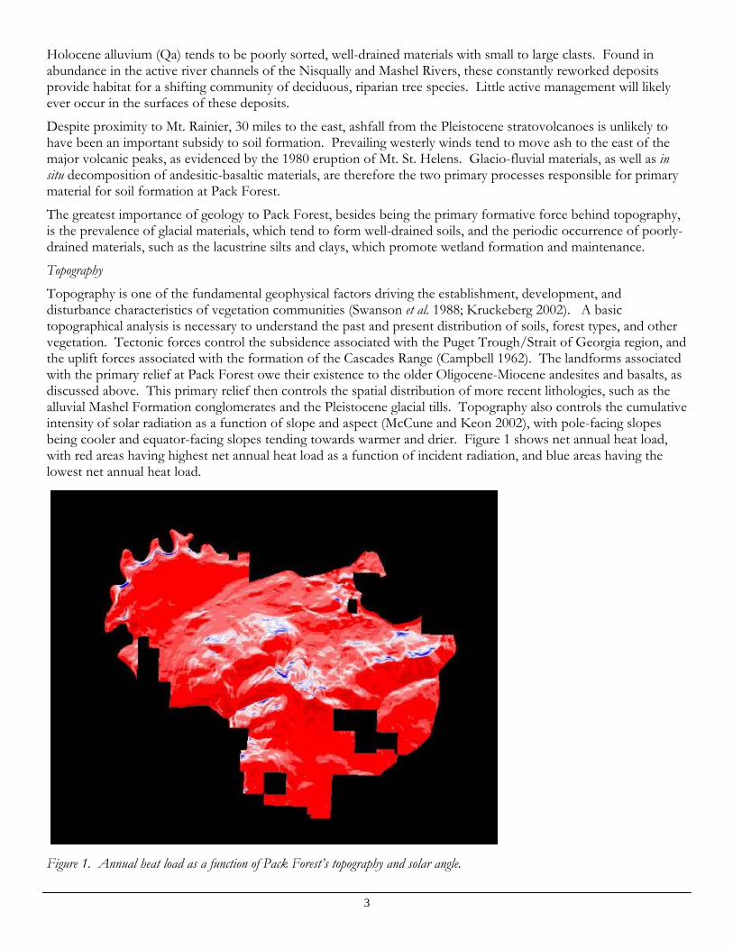
Topography Topography is one of the fundamental geophysical factors driving the establishment, development, and disturbance characteristics of vegetation communities (Swanson et al. 1988; Kruckeberg 2002). A basic topographical analysis is necessary to understand the past and present distribution of soils, forest types, and other vegetation. Tectonic forces control the subsidence associated with the Puget Trough/Strait of Georgia region, and the uplift forces associated with the formation of the Cascades Range (Campbell 1962). The landforms associated with the primary relief at Pack Forest owe their existence to the older Oligocene-Miocene andesites and basalts, as discussed above. This primary relief then controls the spatial distribution of more recent lithologies, such as the alluvial Mashel Formation conglomerates and the Pleistocene glacial tills. Topography also controls the cumulative intensity of solar radiation as a function of slope and aspect (McCune and Keon 2002), with pole-facing slopes being cooler and equator-facing slopes tending towards warmer and drier. Figure 1 shows net annual heat load, with red areas having highest net annual heat load as a function of incident radiation, and blue areas having the lowest net annual heat load.
Figure 1. Annual heat load as a function of Pack Forest’s topography and solar angle.

4
Pack Forest has fairly evenly distributed aspect, with no one aspect predominating. Steep slopes tend to be associated with the steep river canyons of the Nisqually and Mashel Rivers and with the upper slopes of the Hugo Peak-High Point massif. The primary flats are at mid-elevation, being the Mashel Flats west of Hwy. 7 and the broad sloping plateau that comprises the southern portion of the property. An analysis with a 10-m resolution digital terrain model showed that the 100-ft. elevation bands comprising the greatest area of the property were these two areas.
Soils The soil series of Pack Forest and appropriate management practices for each series are well described by the soil survey for Pierce County (Zulauf 1979). River terraces on the Nisqually and Mashel rivers are composed of Aquic Xerofluvents, poorly developed and seasonally droughty soils. Steep riverbank areas are dominated by the Kapowsin gravelly loams. The Mashel plateau is comprised of the Barneston gravelly coarse sandy loams. Forested slopes in roughly the northern half of the property are underlain by well-drained Wilkeson gravelly silt loams, while the broad, gently sloping plateau of the southern half is dominated by the occasionally poorly-drained Scamman silt loams. The Pheeney soil series is a ridgetop soil, having developed in situ from the decomposition of andesitic parent materials and minor components of volcanic tephra. Bellingham silty clay loams are found in depressions and terraces, especially in the northeastern part of Pack Forest on the bench plateau above the Mashel River. Rock outcrops may also be found where soil development is limited. Very hydric humaquepts may be found along the upper part of the Little Mashel River. Soils tend to be poor in nitrogen and moderately erodible. The drier Everett soil series is present in the Mashel Flats. Grass-dominated prairies and their associated Spanaway soil series (Ugolini and Schlichte 1973) do not appear to have been present in any part of Pack Forest’s current property extent.
Biosolids, or treated sewage sludge, have been applied to about 400 acres at Pack Forest in an experimental fashion. This treatment influences soil characteristics and nutrient content, and has been shown to have a measurable positive influence on tree radial growth in both young plantations and mature stands (Henry et al. 1994). There are relatively few negative impacts, but heavy metals were found to be higher in the tissues of small mammals inhabiting treatment units than in untreated controls (Hegstrom and West 1989). The maintenance of records on the biosolids program is a critical factor in aiding present and future researchers to isolate associated impacts on experimental and empirical results.
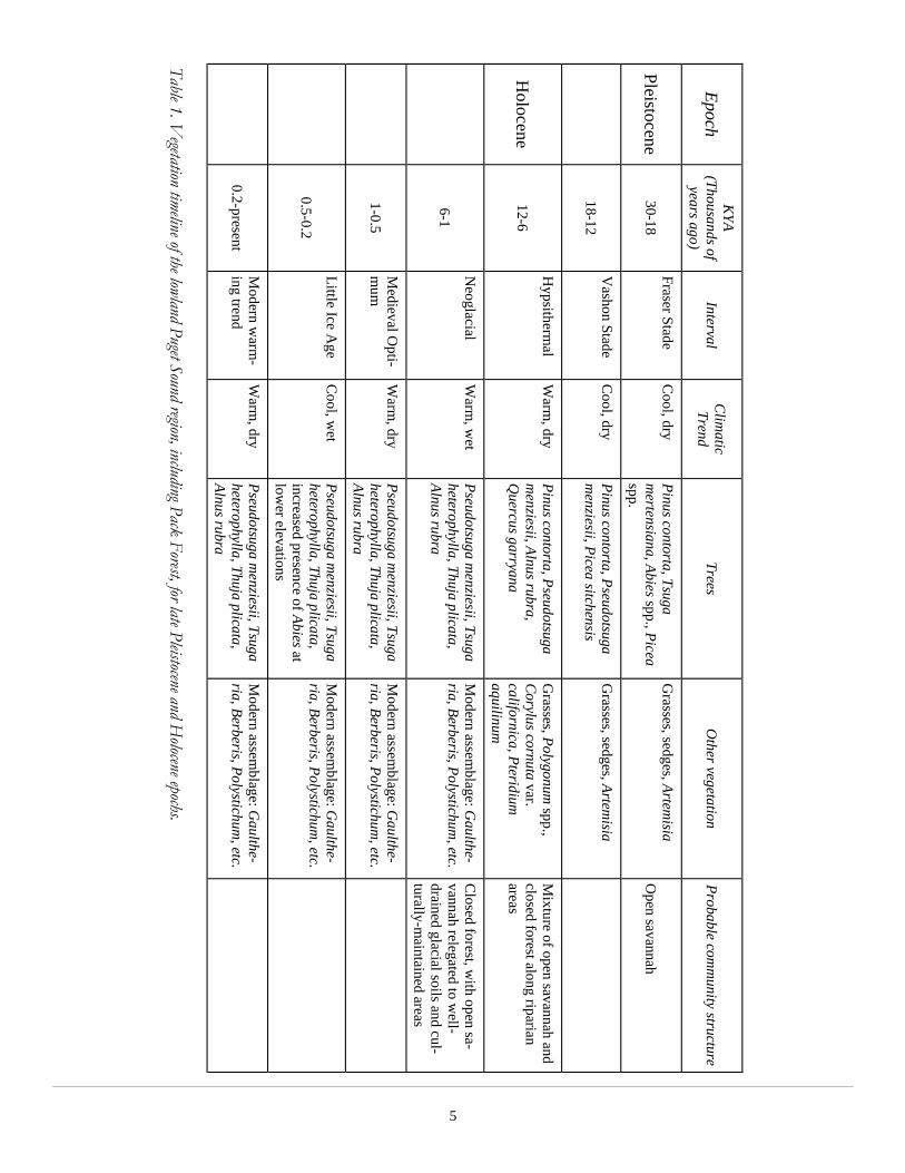
Prehistoric vegetation Historic trends of the vegetation of western Washington since the recession of the Pleistocene glaciers has been inferred from pollen records in lake sediments (Brubaker 1991). The lowland forests of the Puget Sound during the Pleistocene glacial maximum, 30,000-18,000 years BP, were composed of mountain hemlock (Tsuga mertensiana (Bong.) Carr.), spruces (Picea A. Dietr. spp.), and pines (Pinus L. spp.). Grass (Gramineae), sedge (Carex L. spp.), and sagebrush (Artemisia L. spp.) pollen was also present, indicating an open steppe community. As climate warmed between 18,000 and 12,000 years BP, pine pollen increased, and Douglas-fir and Sitka spruce are present as well. The Holocene, or modern interglacial period, marked a series of changes culminating in the modern vegetation assemblage. The early Holocene period (10,000-6,000 BP) was likely warmer and drier than at present, and was characterized by Douglas-fir, red alder, oak (Quercus spp., likely Quercus garryana Dougl. ex Hook), bracken fern (Pteridium aquilinum L.), grasses (Gramineae), and various prairie herbs. This community type is still present in the Puget Trough today, likely sustained through the more mesic late Holocene period by a combination of edaphic factors (Thysell and Carey 2001) and application of fire by Native American groups (Leopold and Boyd 1999). Cooling temperatures and increasing precipitation in the late Holocene Neoglaciation, or last 4-6,000 years, ushered in a final set of changes to the regional forest composition (Whitlock 1992). Douglas-fir, western hemlock, and red alder increase dramatically in the pollen profile, and western red-cedar joins the assemblage about 5,000 BP in the southern Puget Lowlands. More recent climatic fluctuations are temporally correlated with sunspot activity (Stuiver and Quay 1980), and have had impacts on the vegetation of the region ranging from variations in the elevational distribution of tree species (Hinckley 2006) to changes in fire frequency and intensity
5
Epoch K
YA (Thousands of
years ago) Interval
Clim
atic Trend
Trees O
ther vegetation Probable com
munity structure
Pleistocene 30-18
Fraser Stade C
ool, dry Pinus contorta, Tsuga m
ertensiana, Abies spp., Picea spp.
Grasses, sedges, Artem
isia O
pen savannah
18-12
Vashon Stade
Cool, dry
Pinus contorta, Pseudotsuga m
enziesii, Picea sitchensis G
rasses, sedges, Artemisia
Holocene
12-6
Hypsitherm
al W
arm, dry
Pinus contorta, Pseudotsuga m
enziesii, Alnus rubra, Q
uercus garryana
Grasses, Polygonum
spp., C
orylus cornuta var. californica, Pteridium
aquilinum
Mixture of open savannah and
closed forest along riparian areas
6-1
Neoglacial
Warm
, wet
Pseudotsuga menziesii, Tsuga
heterophylla, Thuja plicata, Alnus rubra
Modern assem
blage: Gaulthe-
ria, Berberis, Polystichum, etc.
Closed forest, w
ith open sa-vannah relegated to w
ell-drained glacial soils and cul-turally-m
aintained areas
1-0.5
Medieval O
pti-m
um
Warm
, dry Pseudotsuga m
enziesii, Tsuga heterophylla, Thuja plicata, Alnus rubra
Modern assem
blage: Gaulthe-
ria, Berberis, Polystichum, etc.
0.5-0.2
Little Ice Age
Cool, w
et Pseudotsuga m
enziesii, Tsuga heterophylla, Thuja plicata, increased presence of Abies at low
er elevations
Modern assem
blage: Gaulthe-
ria, Berberis, Polystichum, etc.
0.2-present
Modern w
arm-
ing trend W
arm, dry
Pseudotsuga menziesii, Tsuga
heterophylla, Thuja plicata, Alnus rubra
Modern assem
blage: Gaulthe-
ria, Berberis, Polystichum, etc.
Table 1. Vegetation timeline of the lowland Puget Sound region, including Pack Forest, for late Pleistocene and H
olocene epochs.
6
(Agee 1993). Changes in vegetation over the late Pleistocene and Holocene epochs are summarized in Table 1.
The most localized pollen core analysis was performed on cores from Mineral Lake and Nisqually Lake, respectively 10 miles southeast and 30 miles northwest of Pack Forest (Hibbert 1979). The Nisqually Lake core reveals the vegetation assemblage located in the area previously covered by the Puget Lobe of the continental glacier during the Vashon Stade (14,000 BP). Since Pack Forest was located at the edge of the Vashon Glaciation (Bretz 1913), experiencing the deposition of till and glacial outwash, this core is likely most relevant to the ecological history of Pack Forest. The compositional trends evidenced by the Mineral Lake core, however, are important because they reveal the history of the adjacent Cascade foothills which experienced only minor Cordilleran glaciation.
The Nisqually core reveals an initial community of pine, spruce, and mountain hemlock due to the post-glacial outwash conditions. Western hemlock is present, but is a minor component of the arboreal pollen record until the cooler period of the late Holocene (4000 years BP until present). Oregon oak and California hazelnut (Corylus cornuta var. cornuta (DC.) Sharp) play a prominent role in the middle portion of the profile, indicating the arrival of the warmer, dryer Hypsithermal period of the Holocene (10,000-5,000 years BP). Western redcedar (Thuja plicata Donn ex D. Don) is the last major tree species to arrive on the scene, completing the modern assemblage.
The Mineral Lake core reveals the presence of a grass/sedge/sagebrush steppe before the Fraser Stade glacial maximum, followed by the arrival of lodgepole pine (Pinus contorta Dougl. ex Loud.), spruce, true firs (Abies L. spp.), willow (Salix L. spp.) and alder (Alnus L. spp.). The approach of the Puget Lobe to within 20 km of Mineral Lake (ie, occupying the western portion of Pack Forest) is indicated by a decrease in the levels of all pollen except that of sagebrush. Spruces, true firs, and pines recover somewhat following the glacial maximum, but Douglas-fir, Oregon oak, and California hazelnut soon dominate as climate warms in the Hypsithermal period. Alder plays an important role in the pollen record throughout. It is not until ~6500 years BP that western hemlock becomes well-represented in the pollen record. The period of relatively modern composition begins about 4,000 years ago, with an increase in the prominence of western hemlock and declines in the Oregon oak and hazelnut.
A major realization here is that Pack Forest has the arboreal diversity necessary to adjust to climatic change, as it has many times before. The key difference today is that there is a broader range of anthropogenic impacts than ever before which will influence the response of the biotic community to changes in moisture and temperature regimes.
The vegetation of Pack Forest may experience dramatic changes over the next millennium due to climate change and forest management, but a few species will certainly be represented. Douglas-fir and red alder would be present, and likely support substantial timber harvest, in almost any foreseeable scenario. Western redcedar and western hemlock may be restricted to north aspects in the face of continued warming, and possibly could be relegated to elevations higher than those present at Pack Forest. Modern vegetation Native vegetation. Pack Forest is located in the Tsuga heterophylla Zone (Franklin and Dyrness 1973), but not far from the edge of the vegetation subtype associated with the Puget Sound. Forest vegetation develops following disturbance according to the typical successional sequence in the Tsuga heterophylla Zone. Douglas-fir, red alder, bigleaf maple, and black cottonwood are shade intolerant seral dominants, while western hemlock and western red-cedar represent the shade-tolerant, late-successional component. Since Pack Forest is located on the edge of the climatically and edaphically drier Puget Sound area, compositional elements of this subtype are present at Pack Forest. Grand fir (Abies grandis (Dougl. ex D. Don) Lindl.) is present across the landscape and madrone (Arbutus menziesii Pursh) is present on dry ridges. Oregon ash (Fraxinus latifolia Benth.) can be found in some riparian areas, and in a nearly pure stand adjacent to the 1000 Road. Western white pine (Pinus monticola Dougl. ex D. Don) was historically present, and is receiving focus in regeneration operations, notably in the Mashel Flats and the Phellinus Demo units. Pacific dogwood (Cornus canadensis Audubon ex Torr. & Gray) is uncommonly found as a shade-tolerant understory tree. Sitka spruce (Picea sitchensis (Bong.) Carr.) is occasionally present in riparian forest along the Nisqually and Mashel rivers, is a major constituent of the small western redcedar stand in the Cedar Ecological Area, and is represented by a single disjunct individual in the Ecological Area at Kirkland Pass.
7
Early-successional shrubs include Ribes sanguineum, Salix scouleriana, and Sambucus racemosa var. racemosa. Common forest understory shrubs include Gaultheria shallon, Acer circinatum, Corylus cornuta var. californica, Vaccinium parvifolium, and Rubus ursinus. As noted in a timber assessment of Pack Forest (Holtby 1950), the relative abundances of two common understory plants, Gaultheria shallon and Polystichum munitum, are indicative of edaphic conditions. Personal observation confirmed that sites on north aspects and closer to creek drainages, thus having deeper, moister soils, tended to have a much higher proportion of Polystichum, while drier sites on south aspects and ridges were dominated by Gaultheria. Other significant indicator plant species (Klinka et al. 1989) noted in personal field observations are found in Table 2.
Table 2. Indicator plants of Pack Forest. Cryptogams. Since Pack is a relatively dry, low-elevation site, bryophyte diversity is not high. Still, Kindbergia oregana, Isothecium myosuroides, Rhizomnium glabrescens, Plagiothecium undulatum, and other mosses are found in forests, and Polytrichum juniperinum is found on mineral soil in clearcuts. Cladonia club lichens are found on woody debris, and canopy lichens include Platismatia glauca, Usnea spp., and Hypogymnia spp. Conspicuous foliose lichens such as Lobaria oregana are likely absent from Pack Forest due to both the scarcity of late-successional habitat (Sillett et al. 2000) and atmospheric pollutants from nearby urban and suburban areas (Ra et al. 2005).
Common Name Scientific Name Indicated Conditions
Sword fern Polystichum munitum Higher site class (Low site I, and site II-III), generally with adequate soil moisture, nitrogen, and soil organic material.
Salal Gaultheria shallon Typically lower site class (low site III-V), drier or water-shedding sites or those gen-erally deficient in nitrogen.
Madrone Arbutus menziesii Dry; low nitrogen.
Black cottonwood Populus trichocarpa Moist conditions; medium-high nitrogen.
Oregon boxwood Pachystima myrsinites Very dry conditions; thin, rocky soils. Generally south aspects at Pack, e.g. Nis-qually Canyon.
Red elder Sambucus racemosa var. racemosa
Abundant moisture; medium-high nitro-gen. North-facing or water-receiving slopes at Pack; canyon bottoms and draws on any aspect.
Lady fern Athyrium filix-femina Abundant moisture; medium-high nitro-gen. Moisture-receiving sites.
Western fescue Festuca occidentalis Dry, open forest, often on rocky soils. Typical of partially-burned sites and clear-cuts.
Foamflower Tiarella trifoliata var. trifo-liata
High site class- abundant moisture and nitrogen. Indicates fairly ideal conditions for development of Douglas-fir. Exem-plary occurrence along Trail of the Giants.
8
Invasive plants. Himalayan blackberry (Rubus discolor Weihe & Nees) occurs in moist areas, and can present a significant impediment to personnel as well as to regeneration. Pack Forest, being a relatively dry site for western Washington, may not be as susceptible to total site domination by Himalayan blackberry as some other sites. However, the potential for serious problems does exist on moister sites and more organic soils. The Murphy’s Ranch area in northeastern Pack has experienced significant invasion in localized areas by this serious plant pest. Scotch broom (Cytisus scoparius L.) has invaded some roadsides at Pack Forest, and maintains a significant presence in open areas in the dry soils of the Mashel Flats area. Scotch broom, like many other members of the Leguminosae (pea family), can acquire atmospheric nitrogen via rhizobial cyanobacteria symbionts. This confers a distinct advantage in the relatively nitrogen-limited soils of the Pacific Northwest. Reed canary grass (Phalaris arundinacea L.) has been identified in wet areas of Pack Forest. Native to Eurasia and the Rocky Mountain region of North America, this has become an important weed in wetlands and moist meadows of western Washington. Eurasian water-milfoil (Myriophyllum spicatum L.) has been a problem in some ponds at Pack Forest. Other very minor non-native plants occur at Pack Forest, including several thistles (Cirsium L.), dandelions (Taraxacum officinale), cat’s-ear (Hypochaeris radicata L.), wild carrot (Daucus carota L.), stinging nettle (Urtica dioica L.), self-heal (Prunella vulgaris L.) and creeping-Charlie (Glecoma hederacea L.) can be found along roads and in clearcuts. Tansy ragwort (Senecio jacobea L.) has appeared at Pack Forest, but has been kept largely in check by a targeted spraying program. Consistent with most ecosystems in the Pacific Northwest, exotic plants are primarily an issue in disturbed areas such as roadcuts and harvest units.
Pathogens. Historic records refer to “Poria weirii”, or laminated root rot (Phellinus weirii (Murr.) Gilb.), in many stands at Pack Forest (Zumwalt 1938; Holtby 1950; Archie et al. 1981). This pathogen causes heaviest damage to Douglas-fir, and managers have attempted to remove it at Pack and elsewhere by stumping and burning infected units. Hemlock dwarf mistletoe (Arceuthobium tsugense [Rosendahl] G.N. Jones subsp. tsugense) is present at places at Pack Forest.
Wildlife Blacktailed deer (Odocoileus hemonius ssp. sitchensis) and elk (Cervus elaphus) are the dominant mammal browsers at Pack Forest. The elk likely have a high degree of genetics from the Rocky Mountain elk that were introduced to the Mt. Rainier region in 1913 to replace the locally-extirpated Roosevelt elk (Toweill et al. 2002). These two animals are responsible for varying levels of damage to natural and artificial regeneration at Pack Forest, but also consitute an important recreational resource for the local community. Black bears (Ursus americana) are increasingly common on the forest, and are of serious concern to management due to their spring feeding activities on the cambium of sapling to pole-sized conifers. A feeding program has been initiated, but whether or not this will have the desired effect of sparing trees is unknown. Mountain lions (Felis concolor) are occasional visitors to the forest. Coyotes (Canis latrans) are common, and likely exert a controlling effect on rodents, such as meadow voles, that are known to cause damage to plantations.
Rodents include the Douglas squirrel (Tamiasciurus douglasii), Trowbridge’s shrews (Sorex trowbridgii), shrew-moles (Neurotrichus gibbsi), and deer mice (Peromyscus maniculatus). Northern flying squirrels (Glaucomys sabrinus) have been observed on the forest. Microtine voles (Microtus spp.) inhabit grassy, open areas, and may cause damage to conifer seedlings. Myotis bats are also common, and require cavities or loose bark sheets on snags for roosting. Predatory birds include the northern goshawk (Accipiter gentilis), great horned owls (Bubo virginianus), great gray owl (Strix nebulosa), northern saw-whet owl (Aegiolus acadicus), western screech owl (Otus kennicottii), and the northern pygmy-owl (Glaucidium gnoma). The northern spotted owl (Strix caurina) has not been observed at Pack Forest. It may have inhabited the area in the centuries following the 1500 fires, but the 1823 fire likely disrupted the connectivity of late-successional habitat sufficiently to remove Pack Forest from its functional range. Timber harvest in the 19th and 20th centuries continued this trend. The barred owl (Strix varia) is also present at Pack Forest, further decreasing the likelihood that spotted owls use the area. An assortment of songbirds, both resident and migratory, are found at Pack Forest. Resident birds include the winter wren (Troglodytes troglodytes), the
9
red-shafted flicker (Colaptes auratus), dark-eyed junco (Junco hyemalis), hairy and downy woodpeckers (Picoides pubescens and P. villosus), varied thrush (Ixoreus naevius), red-breasted nuthatch (Sitta canadensis), American crow (Corvus brachyrhynchos), and the pileated woodpecker (Dryocopus pileatus). The pileated woodpecker plays an important ecological role in forest ecosystems as a primary excavator of snags and woody debris, creating abundant cavities for other organisms to occupy. The riparian areas along the Nisqually and Mashel rivers are frequented by bald eagles (Haliaeetus leucocephalus) and ospreys (Pandion haliaetus), which rely upon the freshwater fish resource. Four salmon species utilize the Nisqually and Mashel Rivers: pink (Onchorhynchus gorbusha), chum (O. keta), coho (O. kisutch), and chinook (O. tshawytscha) (Washington State Department of Ecology 1981). Steelhead (O. mykiss) and cutthroat trout (Salmo gairdnerii) also utilize both rivers. Historically, anadromous fish represented a significant transfer of marine-derived nutrients to riparian ecosystems (Helfield and Naiman 2001), a nutrient flux which is now much reduced in the Nisqually Basin. Pack Forest currently has no fish-bearing streams, according to the legal definition. Historically, the Little Mashel had a fish population up to the falls, which constituted a geological barrier to further upstream migration. Anadromous fish in the Nisqually were found up to the current location of the Alder Dam, but no further.
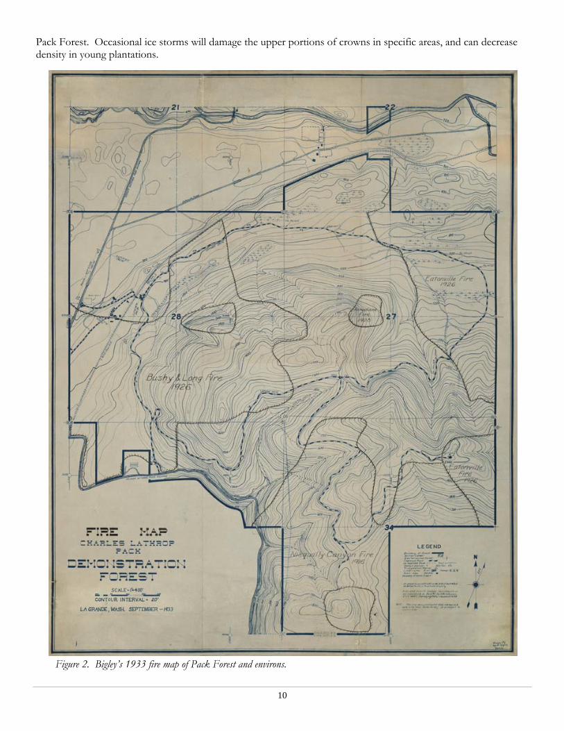
Disturbance history Fire was present in the landscapes of the Pacific Northwest since relatively shortly after recession of continental glacial ice, as demonstrated by charcoal in the palynological record (Agee 1993; Brown and Hebda 2003). Native American seasonal burning may have played a role in the maintenance and structuring of Puget Lowland prairies and Oregon oak/Douglas-fir woodlands (Ewing 1997; Leopold and Boyd 1999), but there is minimal surviving evidence of this type of structural influence at Pack Forest. The Nisqually and Mashel Rivers may have played a role in preventing most Native American-set fires from accessing the Mashel Flats or other portions of the forested property. In 1823, a fire burned much of eastern Pack Forest (Archie et al. 1981; Li 1985). The tall stands of Douglas-fir found in west Hugo Peak and the mature stand north of the Ecological Area both established following this event. Survey notes from 1893 contain evidence of a fire in the vicinity of the present-day Canyon Loop. In 1916, a fire burned up from the Nisqually Canyon. The forest burned by this event was bounded by Newton Creek on the northwest side, the flat ridgetops of the Bethel Ridge complex on the north and northeast, and may have burned eastward into territory later burned in the Eatonville fire. A 30-acre patch of unburned forest survived on the hilltop in the SW ¼ of section 34. On July 18, 1926, a fire began along the railroad, and burned along the railroad corridor, eventually consuming about 400 acres of second-growth at Pack Forest (Zumwalt 1938; Schmitz 1973). This fire, the Bushy & Long Fire, extended along the railroad, and also up Newton Creek towards the Ecological Area. This fire crept into the understory of the West Hugo ridge stand (Bigley 1933), thus accounting for its open structure. The fires at Pack Forest from 1916 through 1926 are well documented in a 1933 map by Bigley (Figure 2). Zumwalt states that four fires between 1842 and 1926 were dated from tree rings in the northeast quarter of Section 33, likely indicating some anthropogenic influence; however, it would be difficult (or impossible) to say whether Native Americans or settlers were responsible for all of them. It is certain, however, that the frequency of late-season fires increased with the coming of the white settlers, whose logging and field-clearing activities increased the number of ignitions during the dry season. In September of 1924, warm, dry conditions enabled the spread of the Eatonville Fire, which proceeded to burn sections 26 and 35 on the east side of what is now Pack Forest. This fire, which burned with stand-replacing intensity, was bounded by the margin of the Nisqually Canyon Fire in the south, the cooler north slope of the Bethel Ridge complex and 27 Creek to the west, and the Mashel River to the north. An historic photograph from the High Point Lookout shows the resultant open condition (Figure 3).
Mass movements are possible in the steeper topography of the Mashel River and Nisqually River corridors. This type of disturbance has doubtless played a role in structuring ecosystems over time, especially following other disturbances such as fire.
Wind does not play as dominant a role in the overall disturbance regime in the Puget Lowlands as it does along the Pacific coast, but it can have localized impacts. The Inaugural Day Storm of January 1993 damaged some stands at
10
Pack Forest. Occasional ice storms will damage the upper portions of crowns in specific areas, and can decrease density in young plantations.
Figure 2. Bigley’s 1933 fire map of Pack Forest and environs.

11
Figure 3. Panoramic view of Pack Forest from High Point, September 15th, 1934, showing the effects of the Eatonville Fire.
12
Human history The ecological history of a region cannot be realistically assessed without consideration of anthropogenic impacts. Archaeological evidence shows that Native Americans, and their salmon-based economy, have been present in the Pacific Northwest since the early Holocene (Butler and O'Connor 2004). Native American societies exerted significant influences on the landscapes of the Puget Lowlands and parts of the Cascades Range, primarily via their use of fire to maintain open prairies and oak savannas on glacial outwash soils (Thysell and Carey 2001; Whitlock and Knox 2002). These impacts probably did not extend to Pack Forest itself in terms of creating structures outside of the natural range of stand-replacing fires. A major village of the Nisqually tribe existed at the confluence of the Nisqually and Mashel rivers (Nisqually Indian Tribe 2006). This village, “Me-Schal”, was an important fishing ground, and one of the lower camps of the “mountain Nisqually” Indians (Carpenter 1994; Carpenter 2002). It is unlikely that this village had major impacts on forest composition and structure at Pack Forest for several reasons. Native activities were focused on salmon fishing in the rivers and root/bulb extraction in areas to the west. Use of wood products would have likely been limited to firewood collection and the felling of an occasional cedar for canoe construction, and thus been localized to areas near villages and along rivers. Native hunting of big game undoubtedly occurred from time to time at Pack Forest, but would not have played a major role in driving compositional or structural changes. Lastly, fire, perhaps the greatest anthropogenic influence associated with Neolithic peoples, was unlikely to be applied deliberately to the landscape around Pack Forest, especially with a more fire-responsive resource base on the deep outwash soils of the “Puget prairies”. However, the occasional escaped fire may have burned across the Mashel Flats and crept into the understory on the west slope of Pack Forest. Any ecological influences associated with the Mashel band likely ceased following the massacre of the village by Capt. J.H. Maxon’s Washington Mounted Rifles during the 1855-1856 Indian War. Some Nisqually natives, including the famed “Indian Henry”, eventually resettled on the Mashel Prairie (Carpenter 1994), but any interaction with the lands associated with Pack Forest had fundamentally ceased. The emphasis of early agricultural settlement in the Pierce County area was along major river valleys, since access to settlers was superior, and the alluvial soils were agriculturally superior to the glacial till of the surrounding uplands (Hartwich 1972). T.C. Van Eaton filed a claim in the modern-day Eatonville area in 1889, and platted a town in 1897. Land clearing associated with homesteads began in the Alder-La Grande-Eatonville area in the
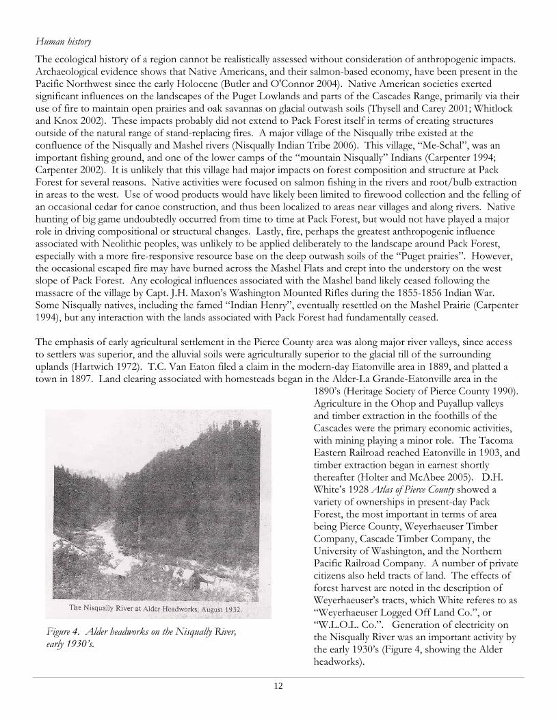
1890’s (Heritage Society of Pierce County 1990). Agriculture in the Ohop and Puyallup valleys and timber extraction in the foothills of the Cascades were the primary economic activities, with mining playing a minor role. The Tacoma Eastern Railroad reached Eatonville in 1903, and timber extraction began in earnest shortly thereafter (Holter and McAbee 2005). D.H. White’s 1928 Atlas of Pierce County showed a variety of ownerships in present-day Pack Forest, the most important in terms of area being Pierce County, Weyerhaeuser Timber Company, Cascade Timber Company, the University of Washington, and the Northern Pacific Railroad Company. A number of private citizens also held tracts of land. The effects of forest harvest are noted in the description of Weyerhaeuser’s tracts, which White referes to as “Weyerhaeuser Logged Off Land Co.”, or “W.L.O.L. Co.”. Generation of electricity on the Nisqually River was an important activity by the early 1930’s (Figure 4, showing the Alder headworks).
Figure 4. Alder headworks on the Nisqually River, early 1930’s.
13
In 1925, under the auspices of Charles Lathrop Pack, a prominent lumberman, Dean Hugo Winkenwerder of the University of Washington’s College of Forestry initiated the purchase of 334 acres of land that would become the nucleus of today’s Pack Forest (Schmitz 1973). Over the next four years, a number of tracts of land were purchased to bring the total acreage of the property to 2,000 acres. Tax defaults associated with the Great Depression (and very likely the fires of 1926) aided in acquisitions of about 500 acres (Kennedy 1963). A key purchase was that of Section 27, which includes much of the Ecological Area and Hugo Peak mature stands, and which was acquired from Weyerhaueser Corporation at a price very favorable to the College. By the 1970’s, Pack Forest was comprised of 2,300 acres, and subsequent additions have brought the property to 4,374 acres (Center for Sustainable Forestry at Pack Forest 2006). As of this writing, the property boundaries of Pack Forest have reached their maximum foreseeable extent. They are commensurate with a reasonable set of natural boundaries: the Nisqually River, the Mashel River, and the topographic path of least resistance defined by the Alder-Eatonville cutoff road. A few private inholdings remain, totaling about 275 acres, but these present few obstacles to the management of Pack as an integrated whole. Landscape spatial patterns A timber and regeneration map dating to 1937 (Zumwalt 1938) was digitally photographed at a resolution of 300 dpi at the University of Washington Classroom Support Services Photography Division using an overhead-mounted digital camera. This map was registered to the survey corner grid using the ERDAS Imagine software package, and timber stands and regeneration density zones were digitized to a shapefile within ArcView 3.2.
Mean patch (stand) area decreased 64.5% from 1937 to 1999. It should be noted that this is actually an underestimate of mean patch size reduction, since the boundaries of early fire events extended far beyond the extent of analysis (that is, Pack Forest). Additionally, landscape structure in 1937 had already been impacted by timber harvest across much of the landscape.
Stand boundaries display much sharper contrast from patch to patch in the modern forest management era. Residual old-growth tree patterns on the edges of the 1924 and 1926 display a gradient in density from typical 1823-age class density to the edge of the stand-replacing fire, as shown by both field inspection (M. Swanson, pers. obs., May 2006) and historic survey maps (Bigley 1933). This is typical of drier sites in the Willamette-Puget Trough, and contributes substantially to diverse stand structures (Weisberg 2004).
Landscape statistics were calculated using the Patch Analyst extension of ArcView 3.2 (Elkie et al. 1999). Area-weighted mean patch fractal dimension was used as an index for shape complexity. The 1937 vector coverage has an AWMPFD of 1.32, while the 1999 vector coverage has an AWMPFD of 1.24. While this does not indicate extreme differences, this does indicate that mean shape complexity was higher in the 1937 landscape. Total edge is three times higher in the 1999 vector coverage, indicating a landscape that is likely more influenced by edge effects.
One of the clear changes in Pacific Northwestern forest landscape spatial patterns that forest patch or stand sizes were larger prior to the advent of modern forest management (Spies et al. 1994; Kennedy and Spies 2004). While a finer-scale fire-induced landscape mosaic may be expected for a lower-elevation landscape near the Puget Trough, it is doubtful that the pre-settlement mosaic would have had the same degree of fine-scale patchwork such as that imposed by regeneration harvest management over the last 80 years.
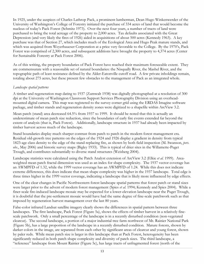
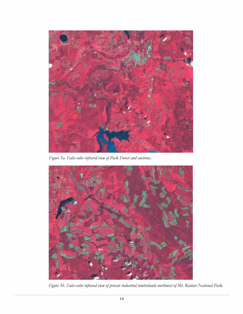
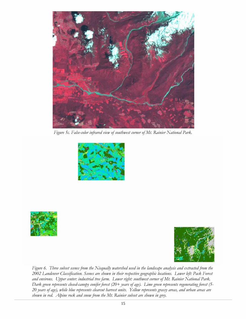
False-color infrared Landsat satellite imagery clearly shows the differences in spatial pattern between three landscapes. The first landscape, Pack Forest (Figure 5a), shows the effects of timber harvest in a relatively fine-scale patchwork. Only a small percentage of the landscape is in a recently disturbed condition (non-vegetated clearcut). The second landscape, a portion of a major industrial tree farm northwest of Mt. Rainier National Park (Figure 5b), has a large proportion of the landscape in a recently disturbed condition. Mature forests, shown by darker colors in the image, are separated from each other by significant areas of clearcut and young forest, shown by paler reds. While mean patch size is larger in this landscape than at Pack Forest, heterogeneity has been significantly reduced in both patch shape complexity and diversity of patch sizes. The third landscape, a “reference” landscape from Mount Rainier (Figure 5c), has large tracts of unfragmented forest (north of the
14
Figure 5a. False-color infrared view of Pack Forest and environs.
Figure 5b. False-color infrared view of private industrial timberlands northwest of Mt. Rainier National Park.
15
Figure 5c. False-color infrared view of southwest corner of Mt. Rainier National Park.
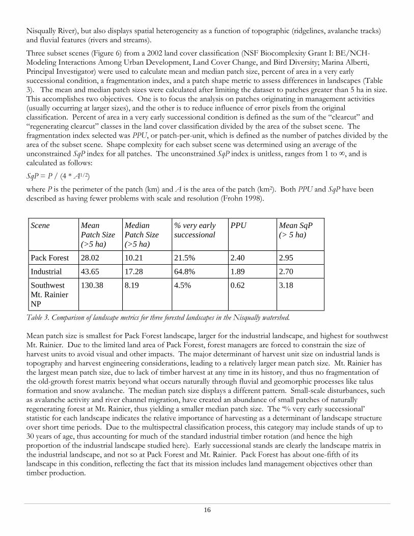
Figure 6. Three subset scenes from the Nisqually watershed used in the landscape analysis and extracted from the 2002 Landcover Classification. Scenes are shown in their respective geographic locations. Lower left: Pack Forest and environs. Upper center: industrial tree farm. Lower right: southwest corner of Mt. Rainier National Park. Dark green represents closed-canopy conifer forest (20+ years of age). Lime green represents regenerating forest (5-20 years of age), while blue represents clearcut harvest units. Yellow represents grassy areas, and urban areas are shown in red. Alpine rock and snow from the Mt. Rainier subset are shown in grey.
16
Nisqually River), but also displays spatial heterogeneity as a function of topographic (ridgelines, avalanche tracks) and fluvial features (rivers and streams).
Three subset scenes (Figure 6) from a 2002 land cover classification (NSF Biocomplexity Grant I: BE/NCH- Modeling Interactions Among Urban Development, Land Cover Change, and Bird Diversity; Marina Alberti, Principal Investigator) were used to calculate mean and median patch size, percent of area in a very early successional condition, a fragmentation index, and a patch shape metric to assess differences in landscapes (Table 3). The mean and median patch sizes were calculated after limiting the dataset to patches greater than 5 ha in size. This accomplishes two objectives. One is to focus the analysis on patches originating in management activities (usually occurring at larger sizes), and the other is to reduce influence of error pixels from the original classification. Percent of area in a very early successional condition is defined as the sum of the “clearcut” and “regenerating clearcut” classes in the land cover classification divided by the area of the subset scene. The fragmentation index selected was PPU, or patch-per-unit, which is defined as the number of patches divided by the area of the subset scene. Shape complexity for each subset scene was determined using an average of the unconstrained SqP index for all patches. The unconstrained SqP index is unitless, ranges from 1 to ∞, and is calculated as follows:
SqP = P / (4 * A1/2)
where P is the perimeter of the patch (km) and A is the area of the patch (km2). Both PPU and SqP have been described as having fewer problems with scale and resolution (Frohn 1998).
Table 3. Comparison of landscape metrics for three forested landscapes in the Nisqually watershed. Mean patch size is smallest for Pack Forest landscape, larger for the industrial landscape, and highest for southwest Mt. Rainier. Due to the limited land area of Pack Forest, forest managers are forced to constrain the size of harvest units to avoid visual and other impacts. The major determinant of harvest unit size on industrial lands is topography and harvest engineering considerations, leading to a relatively larger mean patch size. Mt. Rainier has the largest mean patch size, due to lack of timber harvest at any time in its history, and thus no fragmentation of the old-growth forest matrix beyond what occurs naturally through fluvial and geomorphic processes like talus formation and snow avalanche. The median patch size displays a different pattern. Small-scale disturbances, such as avalanche activity and river channel migration, have created an abundance of small patches of naturally regenerating forest at Mt. Rainier, thus yielding a smaller median patch size. The ‘% very early successional’ statistic for each landscape indicates the relative importance of harvesting as a determinant of landscape structure over short time periods. Due to the multispectral classification process, this category may include stands of up to 30 years of age, thus accounting for much of the standard industrial timber rotation (and hence the high proportion of the industrial landscape studied here). Early successional stands are clearly the landscape matrix in the industrial landscape, and not so at Pack Forest and Mt. Rainier. Pack Forest has about one-fifth of its landscape in this condition, reflecting the fact that its mission includes land management objectives other than timber production.
Scene Mean Patch Size (>5 ha)
Median Patch Size (>5 ha)
% very early successional
PPU Mean SqP (> 5 ha)
Pack Forest 28.02 10.21 21.5% 2.40 2.95
Industrial 43.65 17.28 64.8% 1.89 2.70
Southwest Mt. Rainier NP
130.38 8.19 4.5% 0.62 3.18
17
Spatial pattern is here studied with the use of PPU and and mean patch SqP. The PPU index, which indicates the level of fragmentation within a scene, was lowest for Mt. Rainier, higher for the industrial landscape, and highest for Pack Forest. This reflects the spatial constraints of the smaller landscape to which Pack Forest managers are limited. It also underscores the difficulty of incorporating all aspects of the pre-European fire regime, where fire-originated patches were frequently larger than the extent of the property. The small mean patch size at Pack, however, combined with the somewhat fragmented nature, means that inter-patch distances are lower, and thus forest-dependent organism dispersal may be less of a problem than in the industrial landscape. Shape complexity, as measured by SqP, shows another aspect of spatial pattern in the three landscapes. Mt. Rainier has the highest level of patch complexity, likely due to influences of avalanche gullies, large fluvial systems, and rock-slide areas. While these features are not necessarily complex in their own exterior shape, their irregular distribution across the landscape creates reciprocal complexity in the matrix patch of old-growth forest. The presence of an alpine timberline in part of this scene accentuates the complexity originating in geophysical influences. The industrial landscape has the lowest shape complexity, which is unsurprising, given the economic incentive to design large and easily harvested units. Pack Forest has an intermediate level of shape complexity between these two extremes. Although many of the harvest units are simplified in shape, the existence of experimental cuttings and likely a greater responsiveness of managers to meso-scale topography have given Pack Forest a more complex landscape pattern. This may benefit some organisms such as blacktailed deer, which thrive where edge complexity is higher (Nyberg and Janz 1990). Changes in forest structure and composition The settlement of the Puget Trough, the construction of a railroad and several highways, and the development of a thriving forest products industry all have driven significant changes in the structure and composition of forests in western Washington. Pack Forest is no exception. Planting in the wake of the early 20th-century fires has obscured the high levels of variation in regeneration density typical of most post-fire environments (Zumwalt 1938). Thinning operations throughout the Forest’s history has tended to reduce spatial variability in tree density within stands, thus homogenizing physical and biological conditions.
Species composition at Pack Forest has been influenced by both historic disturbances and modern forest management. The prevalence of Douglas-fir has been favored by forest harvest and artificial regeneration. Historic disturbances associated with settlement patterns and early logging favored red alder in many places in the vicinity of Pack Forest, giving rise to the namesake for the town of Alder. Shade tolerants such as redcedar and western hemlock have likely diminished due to dense planting of Douglas-fir seedlings, and broadleaf trees have been the target of aerial herbicide applications, as shown by operations contracts. Pack Forest is relatively unique, however, in its commitment to conserve stands of different composition, such as the Oregon ash stand adjacent to the 1000 Road (NW ¼ NE ¼ Section 28), and a mature stand of red alder in the 27 Creek drainage. Recent regeneration efforts in some harvest units have included the western white pine, thus remedying the absence of an ecologically and economically important shade-intolerant conifer.
The establishment and growth of shade-tolerant trees in the understory is a significant step in the structural and compositional development of forest stands (Harmon and Franklin 1989; Oliver and Larson 1996; Franklin et al. 2002). The high density of the many young stands at Pack Forest indicates that this development is not imminent in many forest stands. Some stands, such as the Silviculture Demo, Oliver’s Folly, and west Hugo Peak, are experiencing the development of a significant shade-tolerant component due to either natural stand succession following wildfire or the application of silvicultural methods that encourage this important process. Oliver’s Folly is one of the few remaining stands at Pack Forest to regenerate naturally following the 1926 wildfires (Emmons 2006), and it has a high representation of shade tolerants, long-lived hardwoods such as bigleaf maple, and a relatively complex stand structure.
Forest structure has also changed significantly at Pack Forest due to historic logging, land clearing, and modern forest management. It can be seen in photos dating to the mid-1930’s (Zumwalt 1938) that the post-fire stands had significant amounts of biological legacy in the form of standing snags and coarse woody debris. Figures 7a-7c, taken from Zumwalt (1938), show planting lots at Pack Forest, many with significant biological legacies.

18
Figure 7a. Planting lots at Pack Forest, showing post-fire structure.
Figure 7c. Planting lots at Pack Forest, showing post-fire structure.

19
Even some of the logged areas had abundant legacies in the form of less-merchantable trees left for economic reasons by early loggers, which had the unintended consequence of provided structural diversity in the stand. The implementation of scientific forestry, as it then existed, at Pack Forest meant that sites were to be cleared of structure to the degree possible in order to establish quickly-growing plantations of Douglas-fir. The presence of large woody debris, large diameter soft snags, and large live legacy trees is consistent with stand-replacement fire regimes in coastal Pacific Northwest Douglas-fir forests (Franklin et al. 2002). Pack Forest has recently implemented some level of variable retention in harvest units.
Mean diameter and height of the timber has likely declined from the long-term mean in the pre-forest management landscape due to rotation periods being substantially shorter than the fire return interval calculated by researchers working in Mt. Rainer National Park (Hemstrom and Franklin 1982). Harvest rotation lengths of 60-80 years, as at Pack Forest, do not allow Douglas-fir individuals to attain maximum height, usually attained around 150-200 years, or maximum volume, attained at 500+ years. Economically, of course, this is not an issue, but the ecological values foregone by not allowing some portion of the growing crop to attain larger size are significant. This could be accomplished via longer rotations over some portion of the landscape (Harris 1984; Curtis 1997), using variable retention to conserve some larger living trees in harvested stands (Hansen et al. 1991; Franklin et al. 1997), or using silvicultural practices to favor the development of some larger individual structures (DeBell et al. 1997; Carey 2000; Hunter 2001).
Other management issues Pack Forest is situated at the confluence of the Nisqually and Mashel rivers, and has significant riparian areas along both. This means that significant portions of Pack are influenced by the presence of major rivers, and reciprocally influence the aquatic ecosystem both physically and biologically. Physical influences include shading and
Figure 7b. Planting lots at Pack Forest, showing post-fire structure.

20
thermoregulation of the aquatic environment (Naiman et al. 2000) and regulation of timing and magnitude of water flows within the watershed (Ziemer and Lisle 1998). Biological influences include the contribution of large woody debris as a stabilizing and geomorphic structure (Harmon et al. 1986; Sedell et al. 1988) and the contribution of fine litter as allochthonous material (Cummins et al. 1989; Wipfli 2005). Pack Forest has significant older forest adjacent to both rivers, and thus makes important ecological contributions to a regional riverscape that has experienced great reductions in late successional riparian conifer forest (Collins and Montgomery 2002; Collins et al. 2002).
CONCLUSION
The Charles Lathrop Pack Experimental Forest has a rich legacy of human and natural history, and is endowed with a relatively diverse landscape when compared to the surrounding industrial forest lands. However, it has experienced significant changes in terms of species composition, human influences, and expected societal role. The forest managers appointed by the University, both today and in the future, have many challenges that they must engage proactively, including expectations of higher output of all values, climate change, invasive plants, and many more. A profound understanding of the natural history of Pack Forest is crucial to the continued fulfillment of Mr. Pack’s vision for the property as productive timberland, as a place for the demonstration of the latest forestry methods, and as a diverse forest landscape with representative ecosystem types.

21
ACKNOWLEDGEMENTS
I appreciate the invaluable on-site help and freely shared knowledge of Duane Emmons, Manager of Forest Operations at Pack Forest. Terri McCauley, the Conference Center Manager at Pack Forest, rendered cheerful and much-appreciated assistance with lodging and access to the road system. Nancy Hines of the University of Washington Classroom Support Services Photographic Division made excellent digital reproductions of key historic maps and documents, thus securing them for future generations. And finally, Alicia Robbins of the Center for Sustainable Forestry at Pack Forest was very helpful in communicating the necessary scope and content of this document in all stages of work. –MS
22
REFERENCES Agee, J. K. (1993). Fire ecology of Pacific Northwest forests. Washington, D.C., Island Press. Archie, S. G., D. G. Halme and M. E. Wilbert (1981). Charles L. Pack Forest comprehensive management and
development plan. Seattle, Washington, University of Washington, College of Forest Resources, Center for Ecosystem Studies: 108 pp.
Bigley, M. (1933). Fire map of the Charles Lathrop Pack Forest, 1933. Eatonville, WA, College of Forestry, University of Washington.
Booth, D. B., K. G. Troost, J. J. Clague and R. B. Waitt (2003). "The cordilleran ice sheet." Developments in Quaternary science 1: 17-43.
Bretz, J. H. (1913). Glaciation of the Puget Sound Region. Olympia, Washington, Washington Geological Survey. Brown, K. J. and R. J. Hebda (2003). "Coastal rainforest connections disclosed through a Late Quaternary
vegetation, climate, and fire history investigation from the Mountain Hemlock Zone on southern Vancouver Island, British Columbia, Canada." Review of Palaeobotany and Palynology 123: 247-269.
Brubaker, L. B. (1991). Climate change and the origin of old-growth Douglas-fir forests in the Puget Sound lowland. Wildlife and vegetation of unmanaged Douglas-fir forests. L. F. Ruggiero, K. B. Aubry, A. Carey and M. H. Huff. Portland, OR, U.S. Department of Agriculture, Forest Service. Pacific Northwest Research Station. General Technical Report PNW-GTR-285: 17-24.
Butler, V. L. and J. E. O'Connor (2004). "9000 years of salmon fishing on the Columbia River, North America." Quaternary Research 62(1): 1-8.
Campbell, C. D. (1962). Introduction to Washington geology and resources. Information Circular No. 22R. Olympia, Washington, Division of Mines and Geology.
Carey, A. B. (2000). "Effects of new forest management strategies on squirrel populations." Ecological applications 10(1): 248-257.
Carpenter, C. S. (1994). Where the waters begin: the traditional Nisqually Indian history of Mt. Rainier. Seattle, Washington, Northwest Interpretive Association.
Carpenter, C. S. (2002). The Nisqually, my people: the traditional and transitional history of the Nisqually Indian people. Tacoma, Washington, Tahoma Research Service, Inc.
Center for Sustainable Forestry at Pack Forest (2006). Pack Forest Historical Timeline. Website: http://www.packforest.org/about/timeline.htm. Eatonville, WA.
Collins, B. D. and D. R. Montgomery (2002). "Forest development, wood jams, and restoration of floodplain rivers in the Puget Lowland, Washington." Restoration Ecology 10(2): 237-247.
Collins, B. D., D. R. Montgomery and A. D. Haas (2002). "Historical changes in the distribution and functions of large wood in Puget Lowland rivers." Canadian Journal of Fisheries and Aquatic Sciences 59: 66-76.
Cummins, K. W., M. A. Wilzbach, D. M. Gates, J. B. Perry and W. B. Taliaferro (1989). "Shredders and riparian vegetation: leaf litter that falls into streams influences communities of stream invertebrates." Bioscience 39(1): 24-30.
Curtis, R. O. (1997). The role of extended rotations. Creating a forestry for the 21st century: the science of ecosystem management. K. A. Kohm and J. F. Franklin. Washington, D.C., Island Press: 165-170.
DeBell, D. S., R. O. Curtis, C. A. Harrington and J. C. Tappeiner (1997). Shaping stand development through silvicultural practices. Creating a forestry for the 21st century: the science of ecosystem management. K. A. Kohm and J. F. Franklin. Washington, D.C., Island Press: 141-150.
Elkie, P., R. Remple and A. Carr (1999). Patch Analyst user's manual. Thunder Bay, Ontario, Ontario Ministry of Natural Resources.
Emmons, D. (2006). Personal communication regarding natural regeneration of some stands at the Charles Lathrop Pack Experimental Forest. Eatonville, WA.
Ewing, K. (1997). Managment and restoration of south Puget Sound prairies and woodlands. Ecology and conservation of the South Puget Sound prairie landscape. P. Dunn and K. Ewing. Seattle, WA, Nature Conservancy of Washington: 3-9.
Foster, D. R. (2000). "Conservation lessons and challenges from ecological history." Forest History Today Fall 2000: 2-11.
23
Franklin, J. F., D. R. Berg, D. A. Thornburgh and J. C. Tappeiner (1997). Alternative silvicultural approaches to timber harvesting: variable retention harvest systems. Creating a forestry for the 21st century: the science of ecosystem management. K. A. Kohm and J. F. Franklin. Washington, D.C., Island Press: 111-139.
Franklin, J. F. and C. T. Dyrness (1973). Natural vegetation of Oregon and Washington. Corvallis, Oregon, Oregon State University Press.
Franklin, J. F., T. A. Spies, R. Van Pelt, A. B. Carey, D. A. Thornburgh, D. R. Berg, D. B. Lindenmayer, M. E. Harmon, W. S. Keeton, D. C. Shaw, K. Bible and J. Chen (2002). "Disturbances and structural development of natural forest ecosystems with silvicultural implications, using Douglas-fir forests as an example." Forest Ecology and Management 155(1-3): 399-423.
Frohn, R. C. (1998). Remote sensing for landscape ecology. Boca Raton, Florida, Lewis Publishers. Hansen, A. J., T. A. Spies, F. J. Swanson and J. L. Ohmann (1991). "Conserving biodiversity in managed forests."
Bioscience 41(6): 382-392. Harmon, M. E. and J. F. Franklin (1989). "Tree seedlings on logs in Picea-Tsuga forests of Oregon and
Washington." Ecology 70(1): 48-59. Harmon, M. E., J. F. Franklin, F. J. Swanson, P. Sollins, S. V. Gregory, J. D. Lattin, N. H. Anderson, S. P. Cline,
N. G. Aumen, J. R. Sedell, G. W. Lienkaemper, K. Cromack and K. W. Cummins (1986). "Ecology of coarse woody debris in temperate ecosystems." Advances in Ecological Research 15: 133-302.
Harris, L. D. (1984). The fragmented forest: island biogeography theory and the preservation of biotic diversity. Chicago, Illinois, University of Chicago Press.
Hartwich, G. (1972). Early settlements in the Puyallup Valley. M.A. Thesis. Seattle, Washington, University of Washington.
Hegstrom, L. J. and S. D. West (1989). "Heavy metal accumulation in small mammals following sewage sludge application to forests." Journal of Environmental Quality 18(3): 345-349.
Helfield, J. M. and R. J. Naiman (2001). "Effects of salmon-derived nitrogen on riparian forest growth and implications for stream productivity." Ecology 82(9): 2403-2409.
Hemstrom, M. A. and J. F. Franklin (1982). "Fire and other disturbances of the forests in Mount Rainier National Park." Quaternary Research 18: 32-51.
Henry, C. L., D. W. Cole and R. B. Harrison (1994). "Use of municipal sludge to restore and improve site productivity in forestry: the Pack Forest sludge research program." Forest Ecology and Management 66(1-3): 137-149.
Heritage Society of Pierce County (1990). A history of Pierce County, Washington, 1990. Tacoma, Washington, Heritage Society of Pierce County.
Hibbert, D. M. (1979). Pollen analysis of late-Quaternary sediments from two lakes in the southern Puget Lowland, Washington. M.S. Thesis, Department of Geology. Seattle, Washington, University of Washington: 37 pp.
Hinckley, T. M. (2006). Personal communication regarding climate variation influencing elevational distribution of tree species in the Pacific Northwest. M. Swanson. Seattle, Washington.
Holtby, B. E. (1950). A timber management plan for Pack Forest. College of Forestry. Seattle, Washington, University of Washington: 82 pp.
Holter, R. H. and J. C. McAbee (2005). Rails to Paradise: the history of the Tacoma Eastern Railroad, 1890-1919. Rochester, Washington, Gorham Printing.
Hunter, M. G. (2001). Management in young forests. Corvallis, Oregon, Cascade Center for Ecosystem Management, Department of Forest Science, Oregon State University.
Kennedy, A. R. (1963). Charles Lathrop Pack Demonstration Forest chronological land acquisition. La Grande, Washington, Charles Lathrop Pack Demonstration Forest files.
Kennedy, R. S. H. and T. A. Spies (2004). "Forest cover changes in the Oregon Coast Range from 1939 to 1993." Forest Ecology and Management 200(1/3): 129-147.
Klinka, K., V. J. Krajina, A. Ceska and A. M. Scagel (1989). Indicator plants of coastal British Columbia. Vancouver, B.C., University of British Columbia Press.
Kruckeberg, A. R. (2002). Geology and plant life. Seattle, Washington, University of Washington Press. Leopold, E. B. and R. Boyd (1999). An ecological history of old prairie areas in southwestern Washington. Indians,
24
Fire, and the Land in the Pacific Northwest. R. Boyd. Corvallis, OR, Oregon State University. Li, H. (1985). A description of environmental gradients in relation to growth variations of Douglas-fir along Hugo
Peak, Pack Forest, Washingon. M.S. Thesis, College of Forest Resources. Seattle, Washington, University of Washington.
McCune, B. and D. Keon (2002). "Equations for potential annual direct incident radiation and heat load." Journal of Vegetation Science 13: 603-606.
Naiman, R. J., R. E. Bilby and P. A. Bisson (2000). "Riparian ecology and management in the Pacific coastal rain forest." Bioscience 50(11): 996-1011.
Nisqually Indian Tribe (2006). Nisqually Indian Tribe official website. http://www.nisqually-nsn.gov/about.html. Nyberg, J. B. and D. W. Janz, Eds. (1990). Deer and elk habitats in coastal forests of southern British Columbia.
Victoria, British Columbia, British Columbia Ministry of Forests. Oliver, C. D. and B. C. Larson (1996). Forest stand dynamics (update edition). New York, New York, John Wiley
and Sons, Inc. Ra, H. S. Y., L. H. Geiser and R. F. E. Crang (2005). "Effects of season and low-level air pollution on physiology
and element content of lichens from the U.S. Pacific Northwest." Science of the Total Environment 343: 155-167.
Russell, E. W. B. (1997). People and the land through time: linking ecology and history. New Haven, Yale University Press.
Schasse, H. W. (1987). Geologic map of the Centralia quadrangle, Washington: Washington Division of Geology and Earth Resources Open File Report 87-11. Olympia, Washington, Washington Division of Geology and Earth Resources.
Schmitz, H. (1973). The long road traveled: an account of forestry at the University of Washington. Seattle, Washington, The Arboretum Foundation, University of Washington.
Sedell, J. R., P. A. Bisson, F. J. Swanson and S. V. Gregory (1988). What we know about large trees that fall into streams and rivers. From the forest to the sea: a story of fallen trees. C. Maser, R. F. Tarrant, J. M. Trappe and J. F. Franklin. Portland, Oregon, Pacific Northwest Range and Experiment Station. USDA Forest Service General Technical Report PNW-GTR-229.
Sillett, S. C., B. McCune, J. E. Peck, T. R. Rambo and A. Ruchty (2000). "Dispersal limitations of epiphytic lichens result in species dependent on old-growth forests." Ecological applications 10(3): 789-799.
Spies, T. A., W. J. Ripple and G. A. Bradshaw (1994). "Dynamics and pattern of a managed coniferous forest landscape in Oregon." Ecological Applications 4(3): 555-568.
Stuiver, M. and P. Quay (1980). "Changes in atmospheric carbon-14 attributed to a variable sun." Science 207: 11-19.
Swanson, F. J., T. J. Kratz, N. Caine and R. G. Woodmansee (1988). "Landform effects on ecosystem patterns and processes." Bioscience 38(2): 92-98.
Swetnam, T. W., C. D. Allen and J. L. Betancourt (1999). "Applied historical ecology: using the past to manage for the future." Ecological applications 9(4): 1189-1206.
Thysell, D. and A. Carey (2001). "Quercus garryana communities in the Puget Trough, Washington." Northwest Science 75(3): 219-235.
Toweill, D. E., J. W. Thomas and R. E. McCabe, Eds. (2002). North American elk: ecology and management. Washington, D.C., Smithsonian Institution Press.
Ugolini, F. C. and A. K. Schlichte (1973). "The effect of Holocene environmental changes on selected western Washington soils." Soil Science 116(3): 218-227.
United States Geological Survey (1966). Mineral and water resources of Washington. Washington, D.C., United States Geological Survey, U.S. Govt. Printing Office.
Washington State Department of Ecology (1981). Nisqually River Basin instream resources protection program, including proposed administrative rules. W.W.I.R.P. Series, No. 9. Olympia, Washington, Water Resources Policy Development Section.
Weisberg, P. J. (2004). "Importance of non-stand-replacing fire for development of forest structure in the Pacific Northwest, USA." Forest Science 50(2): 245-258.
Whitlock, C. (1992). "Vegetational and climatic history of the Pacific Northwest during the last 20,000 years:
25
CENTER FOR SUSTAINABLE FORESTRY AT PACK FOREST
9010 435rd Street East Eatonville, WA 98328 www.packforest.org
Seattle: 206.685. 4485 Tacoma: 253.692.4485 Local: 360.832.6534
implications for understanding present-day biodiversity." Northwest Environmental Journal 8: 5-28. Whitlock, C. and M. A. Knox (2002). Prehistoric burning in the Pacific Northwest: human versus climatic
influences. Chapter 6 in:. Fire, native peoples, and the natural landscape. T. R. Vale. Washington, D.C., Island Press: 195-231.
Wipfli, M. S. (2005). "Trophic linkages between headwater forests and downstream fish habitats: implications for forest and fish management." Landscape and Urban Planning 72(1-3): 205-213.
Ziemer, R. R. and T. E. Lisle (1998). Chapter 3. Hydrology. River ecology and management: lessons from the Pacific Coastal Ecoregion. R. J. Naiman and R. E. Bilby. New York, NY, Springer-Verlag: pp. 43-68.
Zulauf, A. S. (1979). Soil survey of Pierce County area, Washington. Washington, D.C., Dept. of Agriculture, Soil Conservation Service.
Zumwalt, E. V. (1938). Planting records and program on the Charles Lathrop Pack Demonstration Forest. College of Forestry. Seattle, WA, University of Washington: 89 pp.