spoils management plan -...
TRANSCRIPT
SPOILS MANAGEMENT PLAN
BENNINGTON PFOA REMEDIATION TRENCH SPOILS
DISPOSAL SITES
Prepared For:
VTANR/DEPT OF ENVIRONMENTAL CONSERVATION
Waste Management and Prevention DIV
1 National Life Drive ‐ Davis 1
Montpelier, VT 05620‐3704
Prepared By:
MS&K, Inc. P.O. Box 139
Bennington, VT 05201
October 17, 2017
Updated: November 8, 2017 (Addendum A)

2 | P a g eM S & K , I n c
SPOILS MANAGEMENT PLAN BENNINGTON NW EXTENSION PFOA REMEDIATION TRENCH SPOILS DISPOSAL SITES
TABLE OF CONTENTS
1.0 INTRODUCTION 1.1 Project Background and Overview – Page 3 1.2 Purpose and Need – Page 4
SPOILS SITES CONSIDERED
2.0 Walloomsac – Hill Shadow Farm Roads Spoils Site– Page 5 2.1 Walloomsac (east (a‐c)) Road Spoils Site – Page 6 2.2 Murphy Road Spoils Site – Page 7 2.3 Silk‐ Bridge Roads Spoils Site– Page 8 2.4 Vail Road Spoils Site – Page 9 2.5 Harrington Road Spoils Site ‐ Page 112.6 Conclusion – Page 12
3.0 APPENDICES, FIGURES, ADDENDUM A
3 . 1 Appendix A: Aerial Map of Each Proposed Spoils Site3.2 Addendum A: Addition of Walloomsac - Pippin Knolls Spoils Site (added November 1, 2017)
3 | P a g eM S & K , I n c
1.0 INTRODUCTION
1.1 PROJECT BACKGROUND AND OVERVIEW
This Spoils Management Plan provides for the placement of soils that are presumed to contain perflourooctanaic acid (PFOA) from trench spoils generated by construction related to the installation of water main and service lines in the Town of Bennington and adjacent Village of North Bennington to properties affected by the presence of PFOA in private drinking wells.
The construction of the water mains will run under five (5) separate projects: four (4) to be serviced by the Town of Bennington municipal water system and one (1) to be serviced by the Village of North Bennington water system. Construction for both projects is scheduled to commence in October of 2017 and will continue for approximately one (1) year.
Construction of the water mains will involve trenching and/or directional drilling and will generate excess spoils which require disposal. The presence of PFOA in the spoils is assumed based on the results of the site investigation work that has taken place for the areas where water lines will be expanded.
Proposed is the placement of up to 50,000 cubic yards (CY) (approximately 44,000 CY) total spoils along properties adjacent to Walloomsac Road, Murphy Road, Silk Road, Harrington Road, and Vail Road in the Town of Bennington, Bennington County, Vermont.
On November 1, 2017, this Spoils Management Plan was updated to include the Walloomsac - Pippin Knoll Roads Spoils Site (Addendum A).
4 | P a g eM S & K , I n c
1.2 PURPOSE AND NEED
Purpose:
The purpose of the project is to ensure a suitable location for the placement of excess soils (spoils) presumed to contain PFOA from trenches dug during construction of new water mains and service lines in North Bennington and Bennington, VT.
Need:
Although the preferred alternative for soils removed during water line installation is to put these soils back into the water line trench, there will be excess soils. For this reason, suitable locations are needed for spoils generated during the waterline extension work.
2.0 VT ANR Criteria to Be Met
The Vermont Agency of Natural Resources (VT ANR) identified the need to manage the disposal of the construction spoils generated by the five (5) construction projects. VT ANR has determined that the following siting criteria is required to be met for each proposed spoils location:
1. Areas where water lines are being expanded within Corrective Action Area I (CAA IOU A) as identified in the Consent Order;2. On public land/in public right of way area, if possible;3. Areas with limited erosion potential;4. Greater than 100 feet from wetlands, river corridor, and Federal EmergencyManagement Agency (FEMA) floodplains;5. Outside of public water supply source protection areas; and6. Distal from homes with private wells that will not be replaced with municipal water.
Construction of the water main lines will include the excavation of trenches approximately seven (7) feet deep and four (4) to six (6) feet wide. Where possible, soil will be backfilled into trenches but excess spoils will be generated and will require proper disposal. Six (6) potential spoils sites have been identified, which meet five of the six requirements. These spoils areas are located on private land except for a right of way (ROW) adjacent to Hill Shadow Farm. Criteria 2.0 states, “if possible”, a spoils area is to be on public land/in public right of way. After extensive review, sites have been selected that are in close proximity to the areas where spoils are being generated. This selection process has required the review and assessment team and contractors to work closely with willing private landowners throughout the project area.
5 | P a g eM S & K , I n c
2.1 WALLOOMSAC‐HILL SHADOW FARM ROADS SPOILS SITE
This potential permanent placement area is located within CAA I OU A.
Vegetation: The proposed area in the ROW adjacent to Hill Shadow Farm Road is primarily vegetated with White Pine and shrub‐scrub vegetation.
Wetlands and Aquatic Features: A qualified environmental scientist assessed the site for potential state and federal wetlands utilizing the methodology set forth in the U.S. Army Corps Federal Manual for Identifying and Delineating Jurisdictional Wetlands, as amended, and in supplemental guidance documents. No hydrophytic vegetation, hydric soils, nor hydrological features were found at the proposed site. No Class I, II, III, or federal wetlands were found at this proposed spoils site. Streams and other aquatic features were also not found at the proposed site. This site drains from the southeast to the northwest.
Topography and Soils: At this proposed spoils site, topography slopes gently to the northwest with a slope mapped between 2% and 8%. The Natural Resources Conservation Service (NRCS) has mapped this site to include the Stockbridge loam, 2 to 8% percent slopes (100.0% of proposed site). Erosion potential is slight for 100% proposed site. (The NRCS Erosion Hazards are described as “slight”, “moderate”, “severe”, and “very severe”.)
Best Management Practices: All applicable standards and conditions in the Vermont Construction General Permit 3‐9020 will be met and best management practices will be utilized for this project. A construction entrance will be constructed and silt fence will be installed on the western downslope side of the proposed spoils area upslope of the vegetated area prior to any site disturbance.
VT ANR Criteria:
1. This placement option is located within CAA I OU A as identified in the Consent Order (met criteria);2. This is private property;3. This area has a gentle slope and with limited erosion potential. The Natural Resources Conservation Service maps 100.0% of this proposed site as slightly erosive (met criteria);4. This area has no wetlands, streams, rivers and is not with a FEMA Flood Hazard Area (met criteria);5. This area is outside of public water supply source protection areas (met criteria); and6. All homes in this area will be supplied by the installation of new water main so no wells will be affected (met criteria).
6 | P a g eM S & K , I n c
Criteria met: 5/6
Spoils accommodated by the site: 2,000 to 3,000 CY
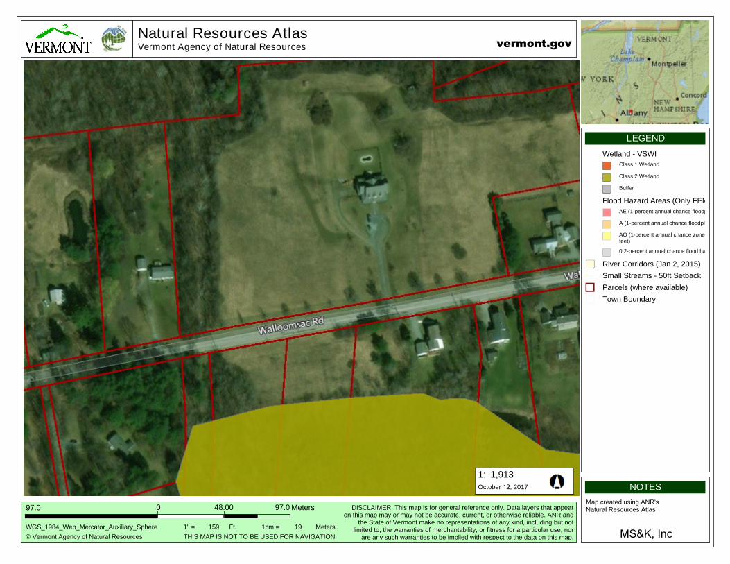
2.2 WALLOOMSAC (east (a‐c)) ROAD SPOILS SITE
This potential permanent placement area is located within CAA I OU A.
Vegetation: This proposed spoils area south of Walloomsac Road has been regularly mowed and is primarily vegetated with field and meadow grasses.
Wetlands and Aquatic Features: A qualified environmental scientist assessed the site for potential state and federal wetlands utilizing the methodology set forth in the U.S. Army Corps Federal Manual for Identifying and Delineating Jurisdictional Wetlands, as amended, and in supplemental guidance documents. Immediately south and to the west of the proposed spoils areas and south of Walloomsac Road exists a forested wetland. This wetland is mapped as a Vermont Class II wetland. The wetland boundary has been flagged at the site and all project activities will occur 100 feet from the wetland boundary (outside of the 100 ft. buffer). This wetland system drains north under Walloomsac Road via culverts and into an intermittent stream channel located to the west of the most northern proposed spoils area at this site. This stream channel drains from the south to the north. All proposed project activities will occur 100 ft. from the top of the streambank of this intermittent stream channel. The proposed site drains from the south to a northwesterly direction.
Topography and Soils: The proposed spoils areas at this site and south of Walloomsac Road slope to the south and west with a gentle slope mapped between 0% and 3%. The proposed spoils area north of Walloomsac Road slopes towards the northwest with a gentle slope mapped between 0% and 5%. NRCS has mapped this site to include the Georgia loam, 3 to 8 percent slopes, (67.5% of the proposed site), and the Massena silt loam, 0 to 3 percent slopes (32.5% of proposed site). Erosion potential is slight for 100% of the proposed sites, north and south of Walloomsac Road.
Best Management Practices: All applicable standards and conditions in the Vermont Construction General Permit 3‐9020 will be met and best management practices will be utilized for this project. For this site, a construction entrance will be constructed and silt fence will be installed upslope of the 100 ft. buffer on the south and west of the proposed spoils areas prior to any site disturbance.
7 | P a g eM S & K , I n c
VT ANR Criteria: 1. This placement option is located within CAA I OU A as identified in the Consent Order (met criteria);2. This is private property;3. This area has a gentle slope and with limited erosion potential. NRCS maps 100% of this proposed site as slightly erosive (met criteria);4. This is not with a FEMA Flood Hazard Area. Project activities will not occur within the 100 ft. buffer located 100 feet from the wetlands and streams adjacent to the proposed project areas. (met criteria);5. This area is outside of public water supply source protection areas (met criteria); and6. All homes in this area will be supplied by the installation of new water main so no wells will be affected (met criteria).
Criteria met: 5/6
Spoils accommodated by this site: 7,000 CY
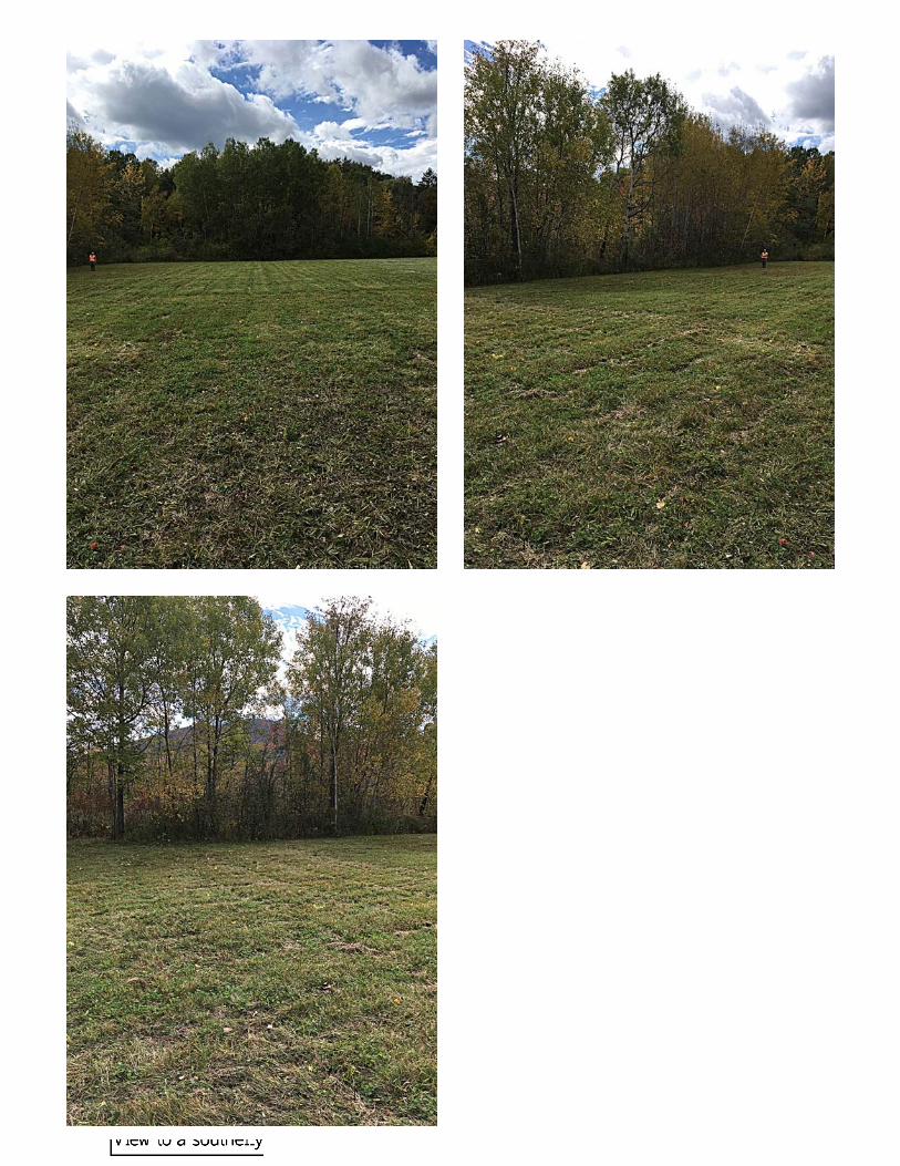
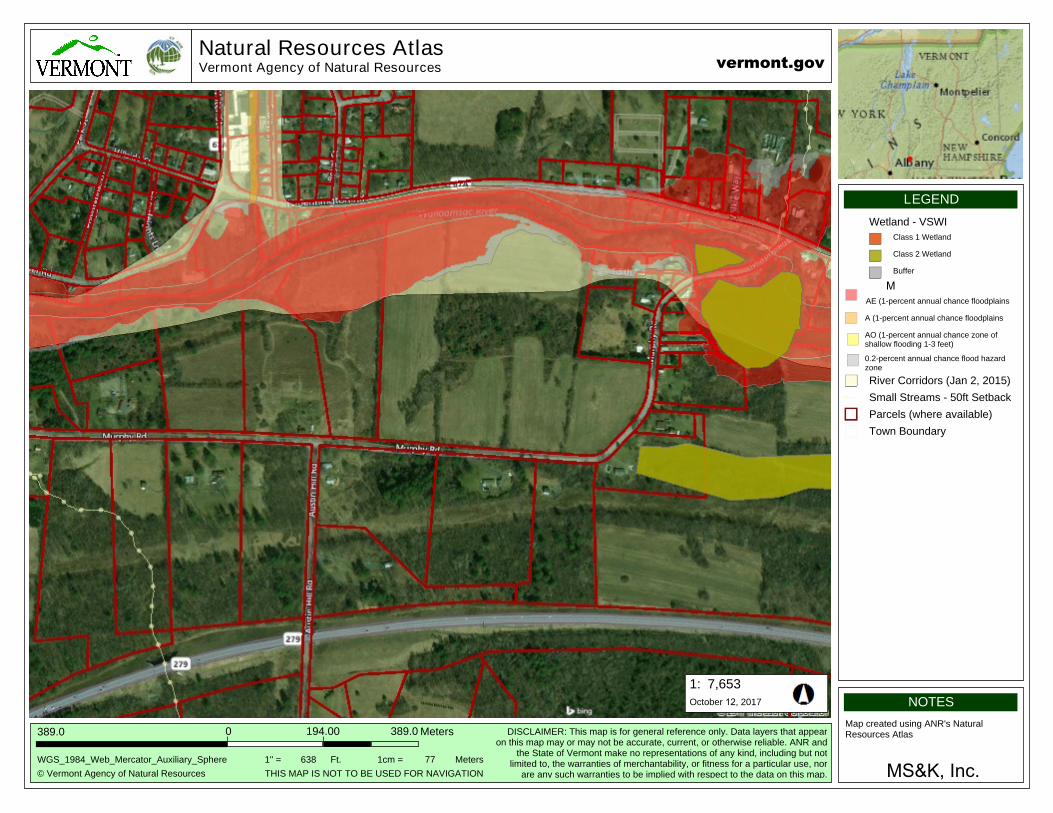
2.3 MURPHY ROAD SPOILS SITE
This potential permanent placement area is located within CAA I OU A, south of the Walloomsac River and north of Route 279.
Vegetation: The majority of this spoils site has been mowed and is primarily vegetated with field and meadow grasses with a small (1/2 acre) area of forested area to be removed (approximately 15‐20 trees).
Wetlands and Aquatic Features: A qualified environmental scientist assessed the site for potential state and federal wetlands utilizing the methodology set forth in the U.S. Army Corps Federal Manual for Identifying and Delineating Jurisdictional Wetlands, as amended, and in supplemental guidance documents. No hydrophytic vegetation, hydric soils, nor hydrological features were found at the proposed site. No Class I, II, III, or federal wetlands were found at this proposed spoils site. Streams and other aquatic features were not found at the proposed site. Drainage from this site is from the east to the northwest.
Topography and Soils: Topography slopes gently down to the northwest with a slope mapped between 8% and 15%. NRCS has mapped this site to include the Galway‐Nellis‐Farmington complex, 8 to 15% percent slopes, rocky (12.5% of the proposed site), and the Stockbridge loam, 8 to 15% percent slopes (87.5% of proposed site) (Appendix B). Erosion potential is slight for 87.5% of the proposed area with an increase to moderate for approximately 12.5% of the site.
8 | P a g eM S & K , I n c
Best Management Practices: All applicable standards and conditions in the Vermont Construction General Permit 3‐9020 will be met and best management practices will be utilized for this project. A construction entrance will be constructed and silt fence will be installed on the western downslope side of the proposed spoils area prior to site disturbance.
VT ANR Criteria: 1. This placement option is located within CAA I OU A as identified in the Consent Order (met criteria);2. This is private property;3. This area has a gentle slope and with limited erosion potential. NRCS maps 87% of this proposed site as slightly erosive (Appendix B) (met criteria);4. This area has no wetlands, streams, rivers and is not with a FEMA Flood Hazard Area (met criteria);5. This area is outside of public water supply source protection areas (met criteria); and6. All homes in this area will be supplied by the installation of new water main so no wells will be affected (met criteria).
Criteria met: 5/6
Spoils accommodated by this site: 9,000 CY
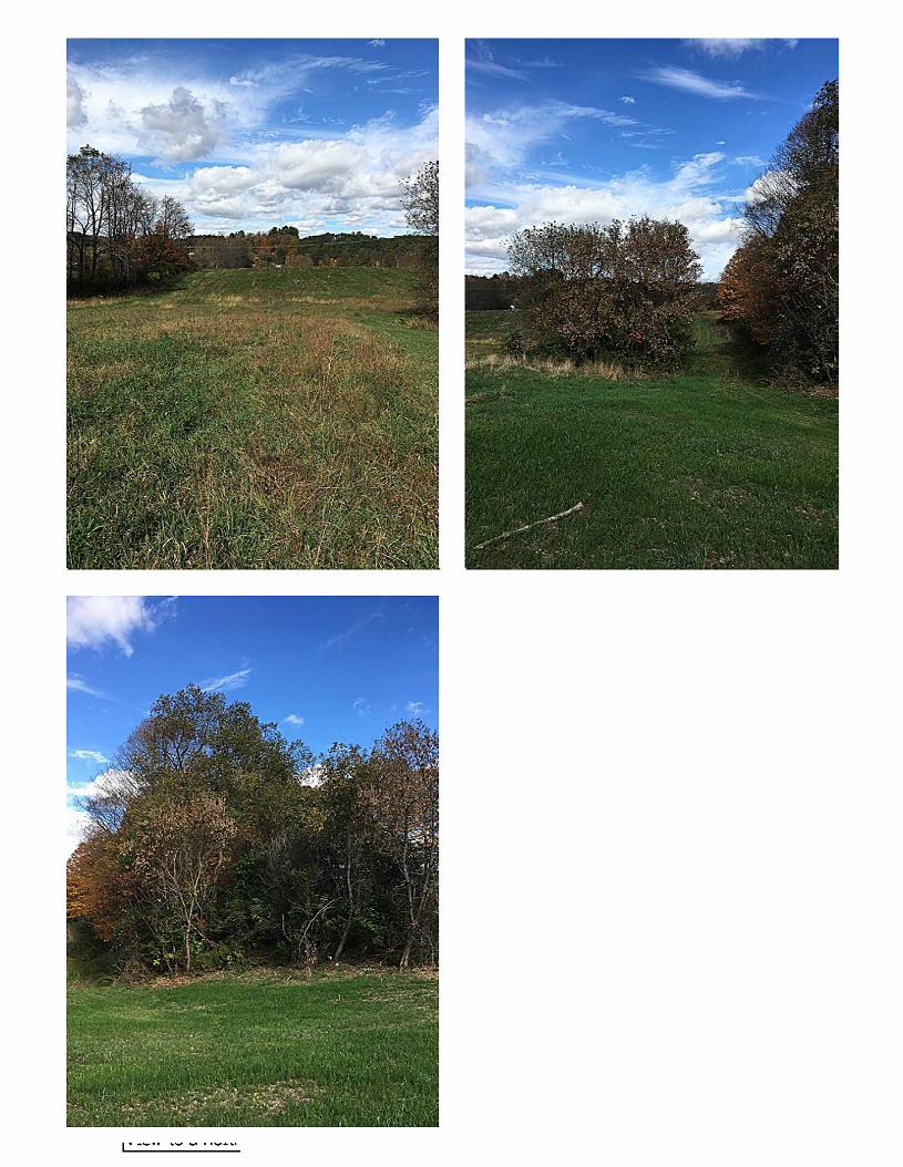
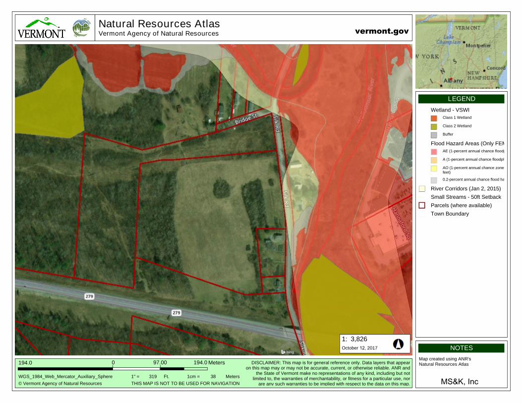
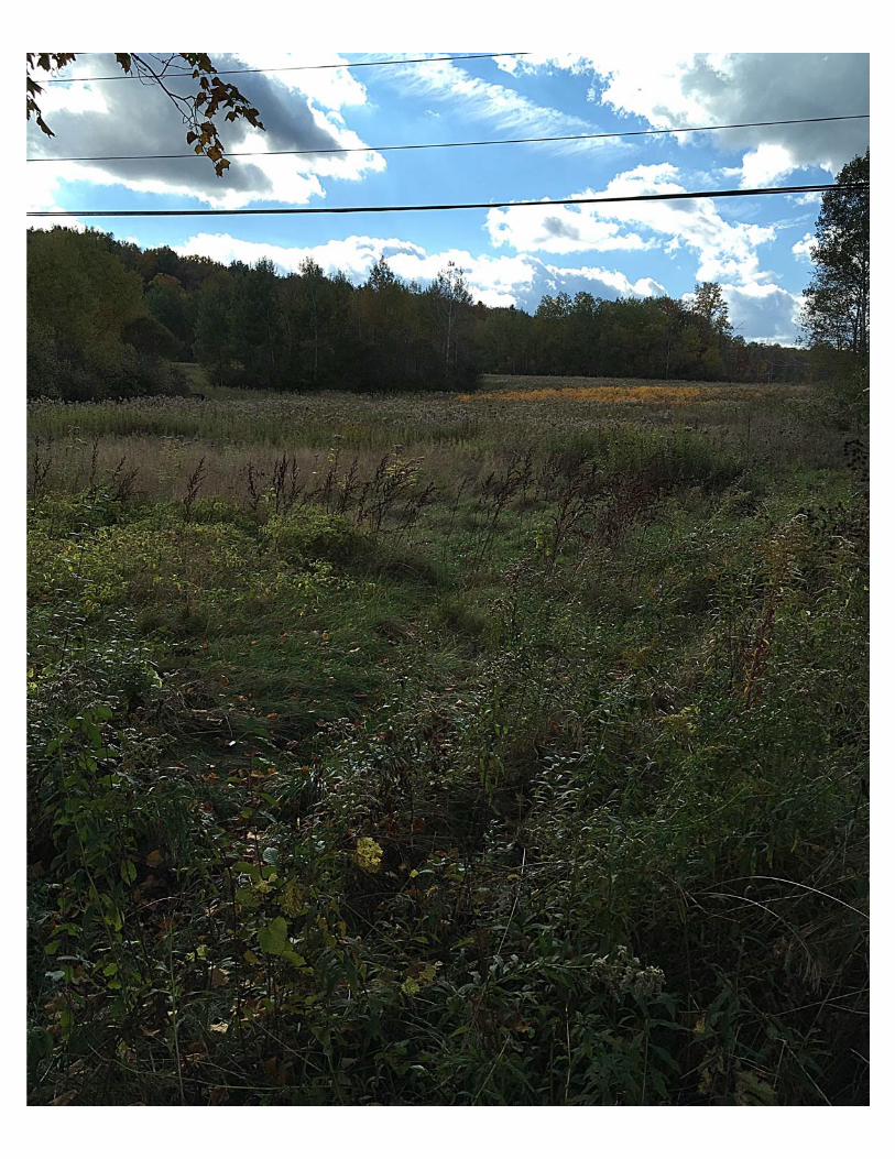
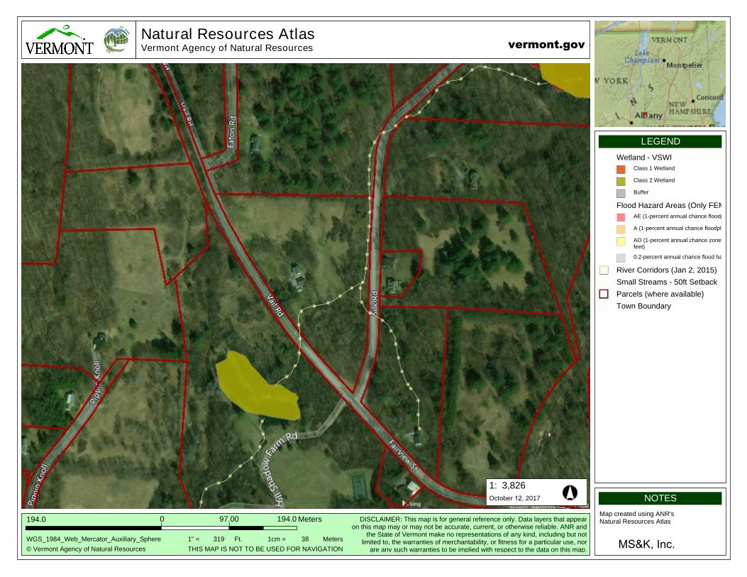
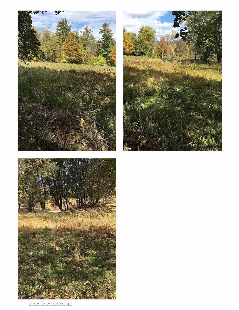
2.4 SILK - BRIDGE ROADS SPOILS SITE
This potential permanent placement area is located within CAA I OU A, south of the Walloomsac River and north of Route 279.
Vegetation: The majority of this spoils site is primarily vegetated with field and meadow grasses and herbaceous material indicative of upland areas.
Wetlands and Aquatic Features: A qualified environmental scientist assessed the site for potential state and federal wetlands utilizing the methodology set forth in the U.S. Army Corps Federal Manual for Identifying and Delineating Jurisdictional Wetlands, as amended, and in supplemental guidance documents. No hydrophytic vegetation, hydric soils, nor hydrological features were found at the proposed site. No Class I, II, III, or federal wetlands were found at this proposed spoils site. Streams and other aquatic features were not found at the proposed site. Drainage from this site is from the west to east. A FEMA Flood Hazard Area exists on the adjacent side of Silk Road, but proposed site activity will be 100 feet from this Hazard Area.
9 | P a g eM S & K , I n c
Topography and Soils: Topography slopes to the east with a slope mapped between 3% and 15%. NRCS has mapped this site to include the Copake gravelly fine sandy loam, 3 to 8 percent slopes (28.6% of the proposed site), the Stockbridge loam, 8 to 15 percent slopes (5.6% of the proposed site), the Georgia loam, 3 to 8 percent slopes (48.4% of the proposed site), and Massena silt loam, 3 to 8 percent slopes (17.5% of the proposed site). Erosion potential is slight for 100% of the proposed site.
Best Management Practices: Applicable standards and conditions in the Vermont Construction General Permit 3‐9020 will be met and best management practices will be utilized for this project. A construction entrance will be constructed and silt fence will be installed on the eastern downslope side of the proposed spoils area prior to site disturbance.
VT ANR Criteria: 1. This placement option is located within CAA I OU A as identified in the Consent Order (met criteria);2. This is private property;3. This area has a gentle slope with limited erosion potential. NRCS maps 100% of this proposed site as slightly erosive (met criteria);4. This area has no wetlands, streams, rivers and is not with a FEMA Flood Hazard Area. All proposed work will be 100 ft. from the Flood Hazard Area on the adjacent side of Silk Road.(met criteria);5. This area is outside of public water supply source protection areas (met criteria);6. All homes in this area will be supplied by the installation of new water main so no wells will be affected (met criteria).
Criteria met: 5/6
Spoils accommodated by this site: 8,000 to 9,000 CY
2.5 VAIL ROAD SPOILS SITE
This potential permanent disposal area is located within CAA I OU A, south of the Walloomsac River and south of Route 279.
Vegetation: The majority of this spoils site is primarily vegetated with field and meadow grasses and herbaceous material indicative of upland areas. A federal jurisdictional emergent wetland exists immediately southeast of the proposed spoils area.
10 | P a g eM S & K , I n c
Wetlands and Aquatic Features:
A qualified environmental scientist assessed the site for potential state and federal wetlands utilizing the methodology set forth in the U.S. Army Corps Federal Manual for Identifying and Delineating Jurisdictional Wetlands, as amended, and in supplemental guidance documents. A federal jurisdictional emergent wetland exists to the immediately southeast of the proposed spoils area. All three wetland criteria (hydrology, soils, vegetation) were met during this delineation. The wetland boundary adjacent to the proposed spoils area the proposed spoils area has been demarcated with flagging in the field and no material will be deposited within a 100 ft. buffer of this wetland. No Class I, II, or III state wetlands or streams were found at this proposed spoils site. Drainage from this site is from a northwesterly to southeasterly direction. A FEMA Flood Hazard Area does not exist at the proposed spoils site nor in the near vicinity.
Topography and Soils: Topography slopes to the southeast with a slope mapped between 3% and 15%. NRCS has mapped this site to include the Stockbridge loam, 8 to 15 percent slopes (35.6% of the proposed site) and a Georgia loam, 3 to 8 percent slopes (64.4% of the proposed site). Erosion potential is slight for 100% of this proposed site.
Best Management Practices: Applicable standards and conditions in the Vermont Construction General Permit 3‐9020 will be met and best management practices will be utilized for this project. A construction entrance will be constructed and silt fence will be installed on the southeastern downslope side of the proposed spoils area just upslope of the 100 ft. wetland buffer prior to site disturbance.
VT ANR Criteria:
1. This placement option is located within CAA I OU A as identified in the Consent Order (met criteria);2. This is private property;3. This area has a gentle slope with limited erosion potential. NRCS maps 100% of this proposed site as slightly erosive (met criteria);4. A federal wetland exists immediately southeast of the proposed spoils area. A 100 ft. buffer will separate the spoils area and wetland. A silt fence will insure that no sediment enters the 100 ft. buffer area. No streams or FEMA Flood Hazard Areas exist on or near the vicinity of the proposed spoils area. (met criteria);5. This area is outside of public water supply source protection areas (met criteria);6. All homes in this area will be supplied by the installation of new water main so no wells will be affected (met criteria).
Criteria met: 5/6
Spoils accommodated by this site: 9,000 to 10,000 CY
11 | P a g eM S & K , I n c
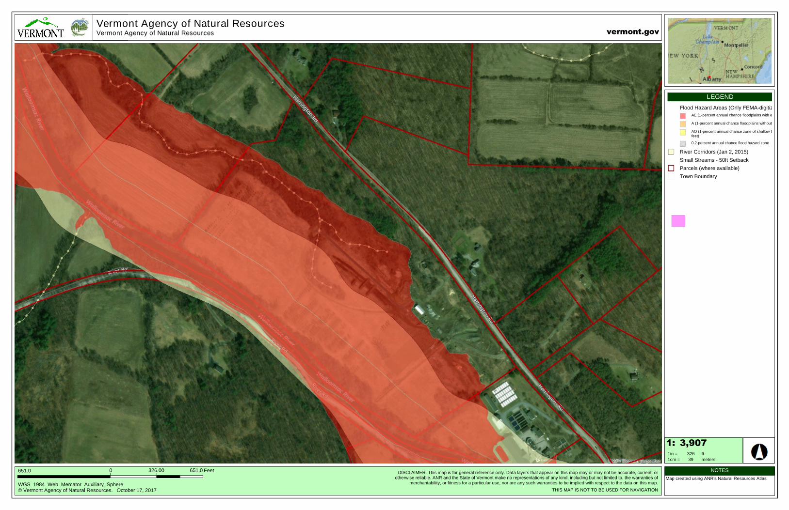
2.6 HARRINGTON ROAD SPOILS SITE
This potential permanent placement area is located within CAA I OU A, north of the Walloomsac River.
Vegetation: The majority of this spoils site is primarily vegetated with field and meadow grasses and herbaceous material indicative of upland areas. The 100 year floodplain for the Walloomsac River exists downslope of this spoils site separated by a 100 ft. buffer.
Wetlands and Aquatic Features: A qualified environmental scientist assessed the site for potential state and federal wetlands utilizing the methodology set forth in the U.S. Army Corps Federal Manual for Identifying and Delineating Jurisdictional Wetlands, as amended, and in supplemental guidance documents. No Class I, II, or III state and federal jurisdictional wetlands or streams were found at this proposed spoils site. Drainage from this site is from a northeasterly to southeasterly direction. A FEMA Flood Hazard Area exists in the near vicinity of the project area, but is separated by a 100 ft. buffer.
Topography and Soils: Topography slopes to the southeast with a slope mapped between 8% and 15%. NRCS has mapped this site to include the Stockbridge loam, 8 to 15 percent slopes (100.0% of the proposed site). Erosion potential is slight for 100% of this proposed site.
Best Management Practices: Applicable standards and conditions in the Vermont Construction General Permit 3‐9020 will be met and best management practices will be utilized for this project. A construction entrance will be constructed and silt fence will be installed on the southwestern downslope side of the proposed spoils area just upslope of the 100 ft. floodplain buffer prior to site disturbance.
VT ANR Criteria: 1. This placement option is located within CAA I OU A as identified in the Consent Order (met criteria);2. This is private property;3. This area has a gentle slope with limited erosion potential. NRCS maps 100% of this proposed site as slightly erosive (met criteria);4. A 100 year floodplain exists immediately southwest of the proposed spoils area. A 100 ft. buffer will separate the spoils area and the 100 year floodplain. A silt fence will insure that no sediment enters the 100 ft. buffer area. No wetlands or streams exist within 150 ft. of the proposed spoils site. Drainage from this spoils site would not enter these wetlands or streams that are greater than 150 ft. from the spoils site. (met criteria);
12 | P a g eM S & K , I n c
5. This area is outside of public water supply source protection areas (met criteria);6. All homes in this area will be supplied by the installation of new water main so no wellswill be affected (met criteria).
Criteria met: 5/6
Spoils accommodated by this site: 2,000 CY
2.6 CONCLUSION The purpose of the project is to ensure a suitable location for placement of excess soils (spoils) presumed to contain PFOA from trenches dug during construction of new water mains and service lines in North Bennington and Bennington, VT. This Spoils Management Report addresses five permanent locations that are suitable for the excess soil for this water main and service line project. All six sites have met 5 of the 6 VT ANR siting criteria. Criteria 2.0 has not been met at each site because each location is privately owned except for the ROW adjacent to Hill Shadow Farm Road. In the VR ANR guidance, Criteria 2.0 includes the wording, “if possible”. All publicly owned land and public ROW’s have been analyzed for this spoils management project, but have not been found to be suitable locations. An extensive review of the project area has shown that private land is more suited as spoils sites for this project in Correction Area I. These sites were carefully selected due to their proximity to the generation of the spoils material and that the fact that they met 5/6 of the VT ANR siting criteria.
APPENDIX A
CORRECTIVE ACTION AREA I
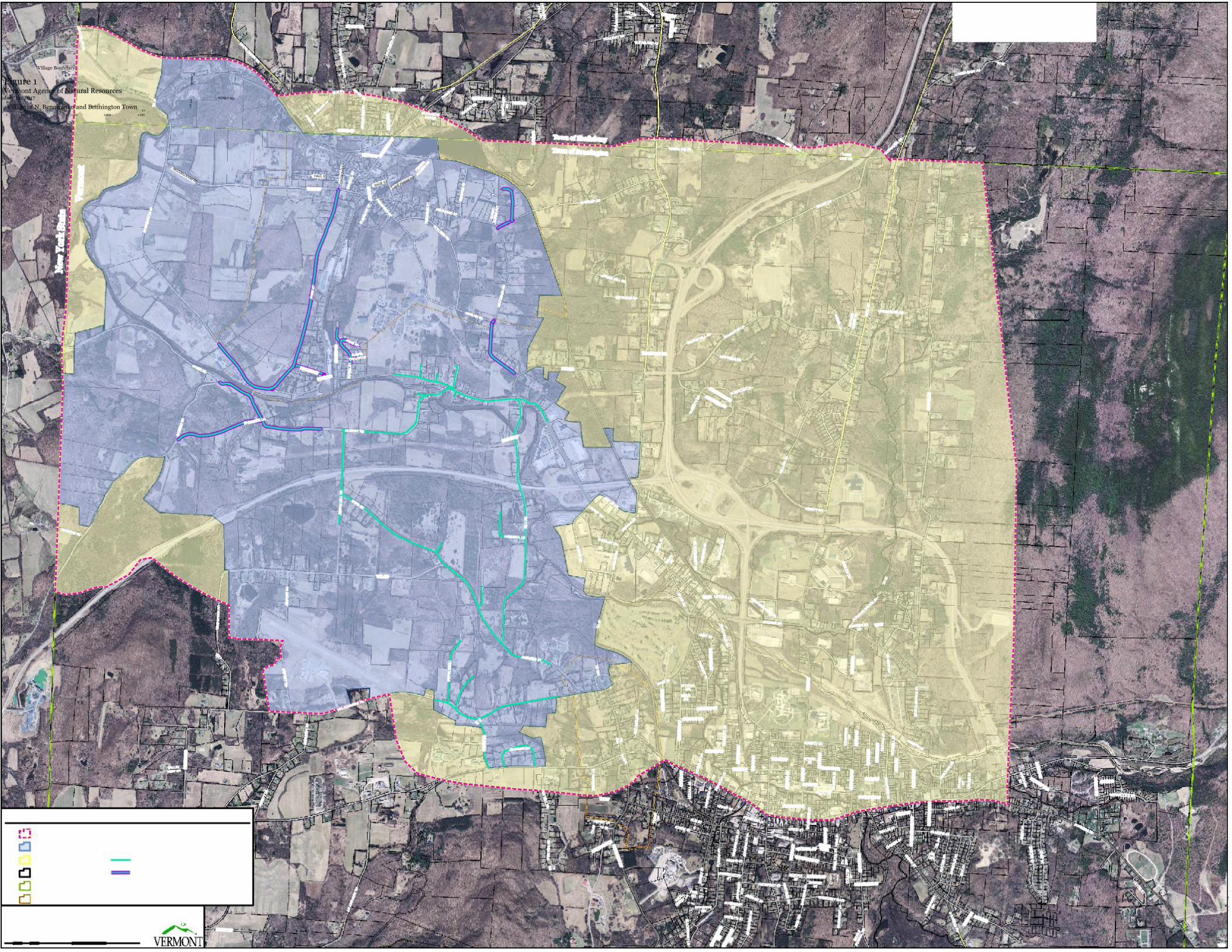
14 | P a g eM S & K , I n c
A S A E L P
4 4
H TH110
T
Village Boundary
Figure 1 Vermont Agency of Natural Resources July 14, 2017
Village of N. Bennington and Bennington Town FT
HARWOOD DR
0 500 1,000 2,000 3,000 4,000 VCGI
APPENDIX B
MAP & PHOTOS OF EACH SPOILS SITE LOCATION
5,051
256.6
Natural Resources AtlasVermont Agency of Natural Resources
3,826
© Vermont Agency of Natural Resources
194.0
1:
WGS_1984_Web_Mercator_Auxiliary_Sphere
Meters194.00
NOTES
Map created using ANR's Natural Resources Atlas
MS&K, Inc.
LEGEND
97.00
vermont.gov
DISCLAIMER: This map is for general reference only. Data layers that appearon this map may or may not be accurate, current, or otherwise reliable. ANR and
the State of Vermont make no representations of any kind, including but notlimited to, the warranties of merchantability, or fitness for a particular use, nor
are any such warranties to be implied with respect to the data on this map.
October 12, 2017
THIS MAP IS NOT TO BE USED FOR NAVIGATION
1" = 319 1cm = 38Ft. Meters
Wetland - VSWI
Class 1 Wetland
Class 2 Wetland
Buffer
Flood Hazard Areas (Only FEMA-digitized data)
AE (1-percent annual chance floodplains with elevations)
A (1-percent annual chance floodplains without elevations)
AO (1-percent annual chance zone of shallow flooding 1-3 feet)
0.2-percent annual chance flood hazard zone
River Corridors (Jan 2, 2015)
Small Streams - 50ft Setback
Parcels (where available)
Town Boundary
2,526
128.3
Natural Resources AtlasVermont Agency of Natural Resources
1,913
© Vermont Agency of Natural Resources
97.0
1:
WGS_1984_Web_Mercator_Auxiliary_Sphere
Meters97.00
NOTES
Map created using ANR's Natural Resources Atlas
MS&K, Inc
LEGEND
48.00
vermont.gov
DISCLAIMER: This map is for general reference only. Data layers that appearon this map may or may not be accurate, current, or otherwise reliable. ANR and
the State of Vermont make no representations of any kind, including but notlimited to, the warranties of merchantability, or fitness for a particular use, nor
are any such warranties to be implied with respect to the data on this map.
October 12, 2017
THIS MAP IS NOT TO BE USED FOR NAVIGATION
1" = 159 1cm = 19Ft. Meters
Wetland - VSWI
Class 1 Wetland
Class 2 Wetland
Buffer
Flood Hazard Areas (Only FEMA-digitized data)
AE (1-percent annual chance floodplains with elevations)
A (1-percent annual chance floodplains without elevations)
AO (1-percent annual chance zone of shallow flooding 1-3 feet)
0.2-percent annual chance flood hazard zone
River Corridors (Jan 2, 2015)
Small Streams - 50ft Setback
Parcels (where available)
Town Boundary

10,103
513.2
Natural Resources AtlasVermont Agency of Natural Resources
7,653
© Vermont Agency of Natural Resources
389.0
1:
WGS_1984_Web_Mercator_Auxiliary_Sphere
Meters389.00
NOTES
Map created using ANR's Natural Resources Atlas
MS&K, Inc.
LEGEND
194.00
vermont.gov
DISCLAIMER: This map is for general reference only. Data layers that appearon this map may or may not be accurate, current, or otherwise reliable. ANR and
the State of Vermont make no representations of any kind, including but notlimited to, the warranties of merchantability, or fitness for a particular use, nor
are any such warranties to be implied with respect to the data on this map.
October 12, 2017
THIS MAP IS NOT TO BE USED FOR NAVIGATION
1" = 638 1cm = 77Ft. Meters
Wetland - VSWI
Class 1 Wetland
Class 2 Wetland
Buffer
FEMA Flood Hazard Areas AE (1-percent annual chance floodplains
A (1-percent annual chance floodplains
AO (1-percent annual chance zone of shallow flooding 1-3 feet)
0.2-percent annual chance flood hazard zone
River Corridors (Jan 2, 2015)
Small Streams - 50ft Setback
Parcels (where available)
Town Boundary
5,051
256.6
Natural Resources AtlasVermont Agency of Natural Resources
3,826
© Vermont Agency of Natural Resources
194.0
1:
WGS_1984_Web_Mercator_Auxiliary_Sphere
Meters194.00
NOTES
Map created using ANR's Natural Resources Atlas
MS&K, Incl
LEGEND
97.00
vermont.gov
DISCLAIMER: This map is for general reference only. Data layers that appearon this map may or may not be accurate, current, or otherwise reliable. ANR and
the State of Vermont make no representations of any kind, including but notlimited to, the warranties of merchantability, or fitness for a particular use, nor
are any such warranties to be implied with respect to the data on this map.
October 12, 2017
THIS MAP IS NOT TO BE USED FOR NAVIGATION
1" = 319 1cm = 38Ft. Meters
Wetland - VSWI
Class 1 Wetland
Class 2 Wetland
Buffer
Flood Hazard Areas (Only FEMA-digitized data)
AE (1-percent annual chance floodplains with elevations)
A (1-percent annual chance floodplains without elevations)
AO (1-percent annual chance zone of shallow flooding 1-3 feet)
0.2-percent annual chance flood hazard zone
River Corridors (Jan 2, 2015)
Small Streams - 50ft Setback
Parcels (where available)
Town Boundary
5,051
256.6
Natural Resources AtlasVermont Agency of Natural Resources
3,826
© Vermont Agency of Natural Resources
194.0
1:
WGS_1984_Web_Mercator_Auxiliary_Sphere
Meters194.00
NOTES
Map created using ANR's Natural Resources Atlas
MS&K, Inc.
LEGEND
97.00
vermont.gov
DISCLAIMER: This map is for general reference only. Data layers that appearon this map may or may not be accurate, current, or otherwise reliable. ANR and
the State of Vermont make no representations of any kind, including but notlimited to, the warranties of merchantability, or fitness for a particular use, nor
are any such warranties to be implied with respect to the data on this map.
October 12, 2017
THIS MAP IS NOT TO BE USED FOR NAVIGATION
1" = 319 1cm = 38Ft. Meters
Wetland - VSWI
Class 1 Wetland
Class 2 Wetland
Buffer
Flood Hazard Areas (Only FEMA-digitized data)
AE (1-percent annual chance floodplains with elevations)
A (1-percent annual chance floodplains without elevations)
AO (1-percent annual chance zone of shallow flooding 1-3 feet)
0.2-percent annual chance flood hazard zone
River Corridors (Jan 2, 2015)
Small Streams - 50ft Setback
Parcels (where available)
Town Boundary
5,158
859.7
DISCLAIMER: This map is for general reference only. Data layers that appear on this map may or may not be accurate, current, orotherwise reliable. ANR and the State of Vermont make no representations of any kind, including but not limited to, the warranties of
merchantability, or fitness for a particular use, nor are any such warranties to be implied with respect to the data on this map.
3,907
© Vermont Agency of Natural Resources.
651.0
THIS MAP IS NOT TO BE USED FOR NAVIGATION
LEGEND
WGS_1984_Web_Mercator_Auxiliary_Sphere
Feet0 651.0326.00
Map created using ANR's Natural Resources Atlas
NOTES
vermont.govVermont Agency of Natural Resources
October 17, 2017
Vermont Agency of Natural Resources
1in = 326 ft.
1cm = 39 meters
1:
Flood Hazard Areas (Only FEMA-digitized data)
AE (1-percent annual chance floodplains with elevations)
A (1-percent annual chance floodplains without elevations)
AO (1-percent annual chance zone of shallow flooding 1-3 feet)
0.2-percent annual chance flood hazard zone
River Corridors (Jan 2, 2015)
Small Streams - 50ft Setback
Parcels (where available)
Town Boundary
ADDENDUM A
WALLOOMSAC - PIPPIN KNOLL ROADS SPOILS SITE
1 | P a g eM S & K , I n cADDENDUM A
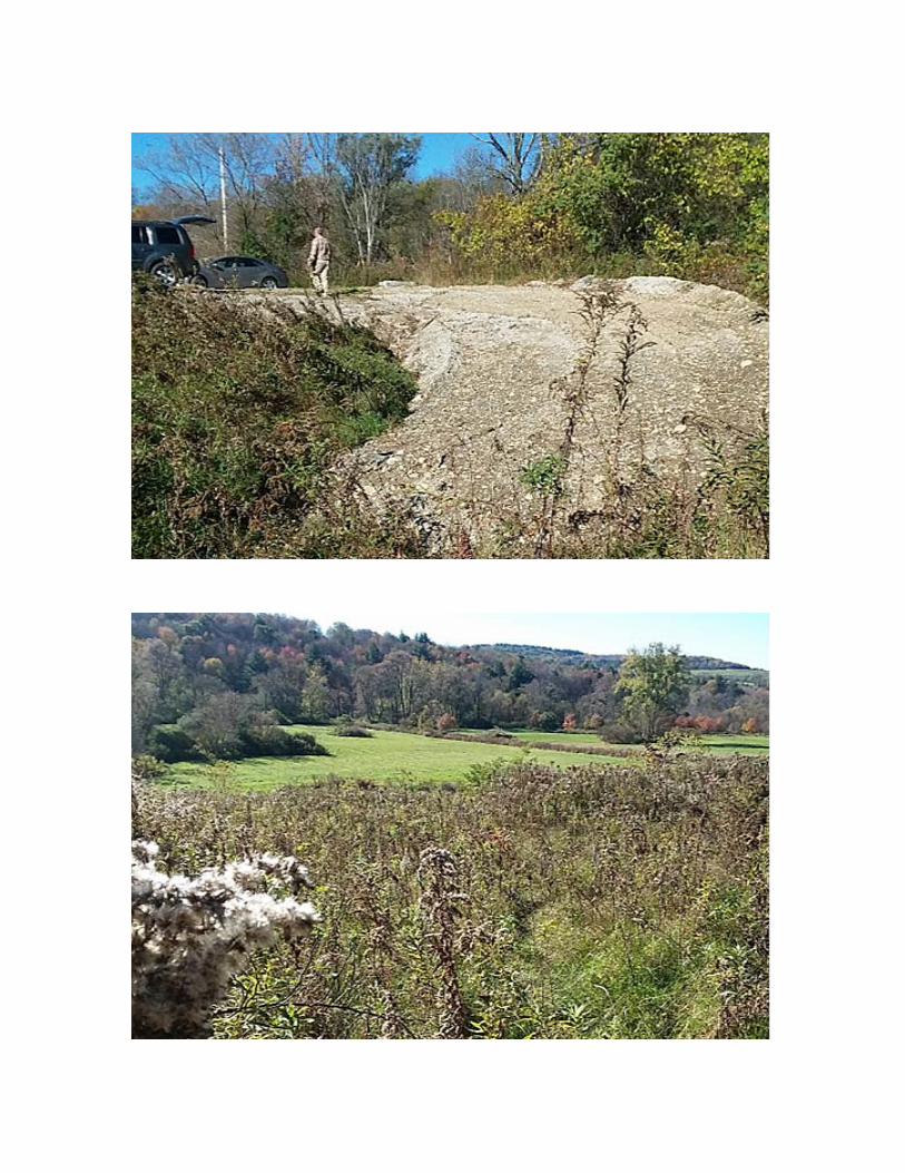
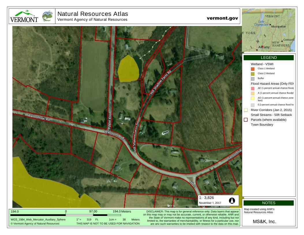
3.2 WALLOOMSAC ‐ PIPPIN KNOLL ROADS SPOILS SITE This potential permanent disposal area is located on the southwestern area of Corrective Action Area II, but is contiguous with areas demarcated as Corrective Action Area I (CAA I OU A).
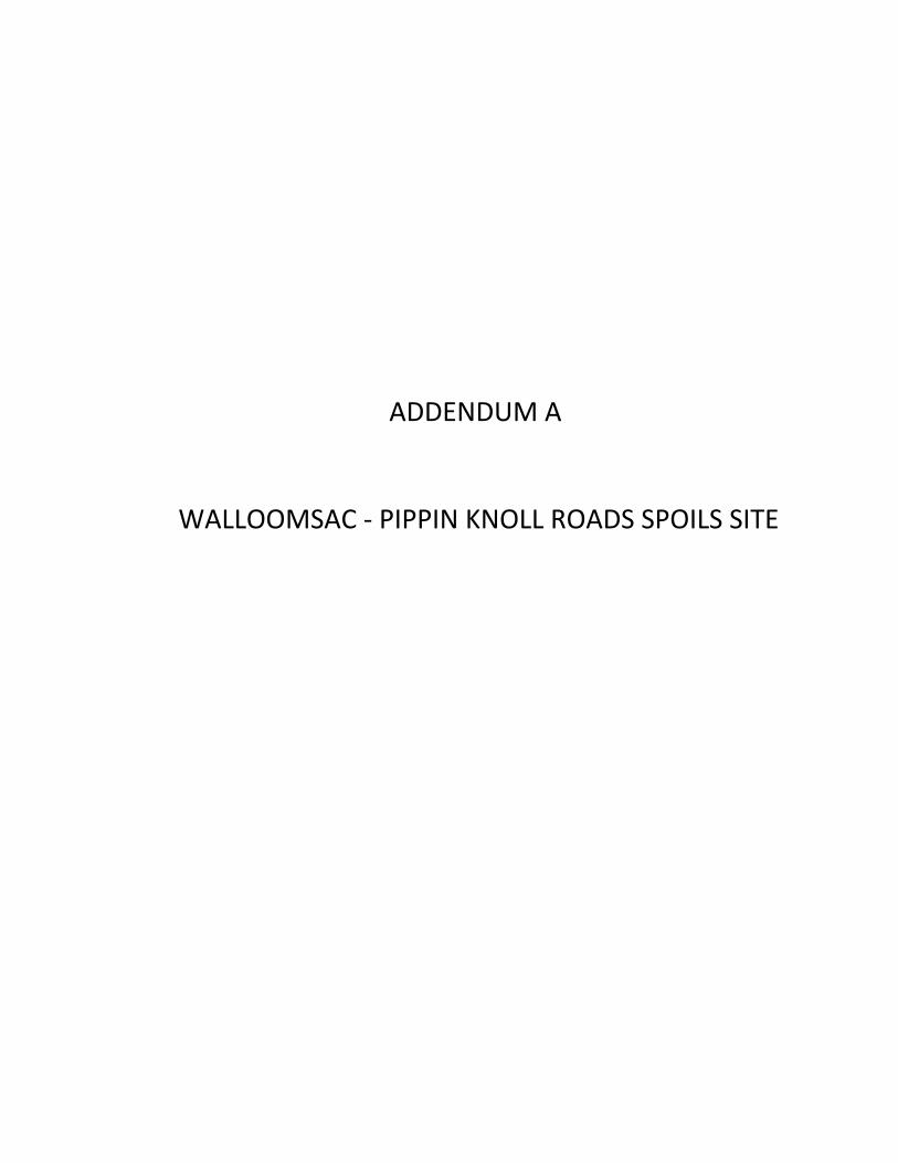
Vegetation: The proposed area located to the north of Walloomsac Road and to the west of Pippin Knoll Road is primarily vegetated with Common Buckthorn (Rhamnus cathartica), Silky Dogwood (Cornus amomum), and other shrub‐scrub vegetation.
Wetlands and Aquatic Features: A qualified environmental scientist assessed the site for potential state and federal wetlands utilizing the methodology set forth in the U.S. Army Corps Federal Manual for Identifying and Delineating Jurisdictional Wetlands, as amended, and in supplemental guidance documents. No hydrophytic vegetation, hydric soils, nor hydrological features were found at the proposed site. No Class I, II, III, or federal wetlands were found at this proposed spoils site. Streams and other aquatic features were also not found at the proposed site. This site drains from the northeast to the southwest.
Topography and Soils: At this proposed spoils site, topography slopes gently to the northeast to the southwest with a slope mapped between 2% and 8%. The Natural Resources Conservation Service (NRCS) has mapped this site to include the Stockbridge loam, 2 to 8% percent slopes (100.0% of proposed site). Erosion potential is slight for 100% proposed site.
Best Management Practices: All applicable standards and conditions in the Vermont Construction General Permit 3‐9020 will be met and best management practices will be utilized for this project. A construction entrance will be constructed and silt fence will be installed on the western downslope side of the proposed spoils area upslope of the vegetated area prior to any site disturbance.
VT ANR Criteria:
1. This disposal option is located within the central area of Corrective Action Area II, butcontiguous with areas demarcated as Corrective Action Area I (CAA I OU A);2. This is private property;3. This area has a gentle slope and with limited erosion potential. The Natural ResourcesConservation Service maps 100% of this proposed site as slightly erosive (met criteria);4. This area has no wetlands, streams, rivers and is not with a FEMA Flood Hazard Area (metcriteria);5. This area is outside of public water supply source protection areas (met criteria); and6. All homes in this area will be supplied by the installation of new water main so no wellswill be affected (met criteria).
2 | P a g eM S & K , I n cADDENDUM A
Criteria met: 4/6
Spoils accommodated by the site: 7,000 to 9,000 CY
5,051
256.6
Natural Resources AtlasVermont Agency of Natural Resources
3,826
© Vermont Agency of Natural Resources
194.0
1:
WGS_1984_Web_Mercator_Auxiliary_Sphere
Meters194.00
NOTES
Map created using ANR's Natural Resources Atlas
MS&K, Inc.
LEGEND
97.00
vermont.gov
DISCLAIMER: This map is for general reference only. Data layers that appearon this map may or may not be accurate, current, or otherwise reliable. ANR and
the State of Vermont make no representations of any kind, including but notlimited to, the warranties of merchantability, or fitness for a particular use, nor
are any such warranties to be implied with respect to the data on this map.
November 1, 2017
THIS MAP IS NOT TO BE USED FOR NAVIGATION
1" = 319 1cm = 38Ft. Meters
Wetland - VSWI
Class 1 Wetland
Class 2 Wetland
Buffer
Flood Hazard Areas (Only FEMA-digitized data)
AE (1-percent annual chance floodplains with elevations)
A (1-percent annual chance floodplains without elevations)
AO (1-percent annual chance zone of shallow flooding 1-3 feet)
0.2-percent annual chance flood hazard zone
River Corridors (Jan 2, 2015)
Small Streams - 50ft Setback
Parcels (where available)
Town Boundary