spring 2011 pacific islands fishery news
DESCRIPTION
Newsletter of the Western Pacific Regional Fishery Management CouncilTRANSCRIPT
Spring 2011 1 Pacific Islands Fishery News
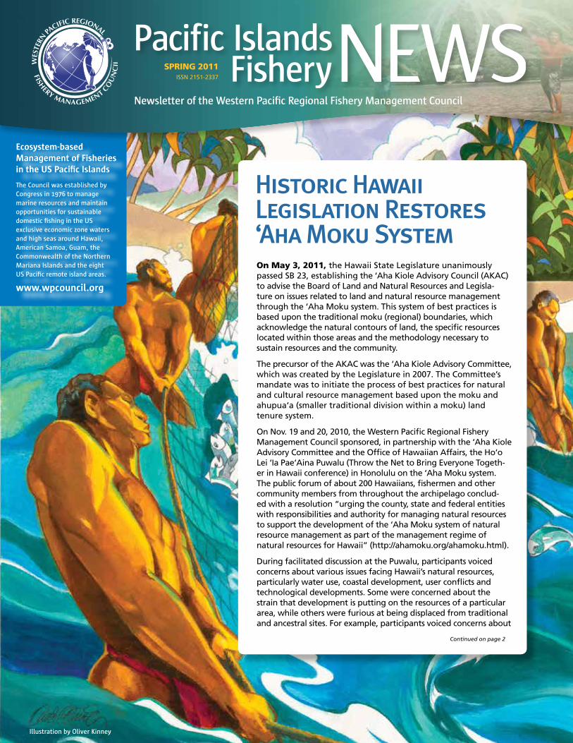
Historic Hawaii Legislation Restores ‘Aha Moku SystemOn May 3, 2011, the Hawaii State Legislature unanimously passed SB 23, establishing the ‘Aha Kiole Advisory Council (AKAC) to advise the Board of Land and Natural Resources and Legisla-ture on issues related to land and natural resource management through the ‘Aha Moku system. This system of best practices is based upon the traditional moku (regional) boundaries, which acknowledge the natural contours of land, the specific resources located within those areas and the methodology necessary to sustain resources and the community.
The precursor of the AKAC was the ‘Aha Kiole Advisory Committee, which was created by the Legislature in 2007. The Committee’s mandate was to initiate the process of best practices for natural and cultural resource management based upon the moku and ahupua‘a (smaller traditional division within a moku) land tenure system.
On Nov. 19 and 20, 2010, the Western Pacific Regional Fishery Management Council sponsored, in partnership with the ‘Aha Kiole Advisory Committee and the Office of Hawaiian Affairs, the Ho‘o Lei ‘Ia Pae‘Aina Puwalu (Throw the Net to Bring Everyone Togeth-er in Hawaii conference) in Honolulu on the ‘Aha Moku system. The public forum of about 200 Hawaiians, fishermen and other community members from throughout the archipelago conclud-ed with a resolution “urging the county, state and federal entities with responsibilities and authority for managing natural resources to support the development of the ‘Aha Moku system of natural resource management as part of the management regime of natural resources for Hawaii” (http://ahamoku.org/ahamoku.html).
During facilitated discussion at the Puwalu, participants voiced concerns about various issues facing Hawaii’s natural resources, particularly water use, coastal development, user conflicts and technological developments. Some were concerned about the strain that development is putting on the resources of a particular area, while others were furious at being displaced from traditional and ancestral sites. For example, participants voiced concerns about
Illustration by Oliver Kinney
Continued on page 2
Ecosystem-based Management of Fisheries in the US Pacific Islands
The Council was established by Congress in 1976 to manage marine resources and maintain opportunities for sustainable domestic fishing in the US exclusive economic zone waters and high seas around Hawaii, American Samoa, Guam, the Commonwealth of the Northern Mariana Islands and the eight US Pacific remote island areas.
www.wpcouncil.org
Newsletter of the Western Pacific Regional Fishery Management Council
SPRING 2011 ISSN 2151-2337

Spring 2011Pacific Islands Fishery News 2
development of places like Mo‘omomi and Lana‘i for windmill projects as well as the issue of outsiders fishing around Ni‘ihau. Other concerns included offshore aquaculture, expansion of sanctuaries and protected areas, and minimum-size/bag limits for coral reef species.
More than ever, community engagement in management decisions is of utmost importance. The ‘Aha Moku system will provide a forum for discussion among natural and cultural resource managers and communities for the benefit
of Hawaii. It will also support the objectives of the Hawaii Archipelago Fishery Ecosystem Plan (FEP), which addresses the management of fisheries in federal waters (3 to 200 miles offshore). Developed, monitored and amended by the West-ern Pacific Regional Fishery Management Council, the Hawaii Archipelago FEP relies on enhanced community involvement and incorporates consideration of not only Western science but also traditional knowledge and ecosystem factors not typically associated with contemporary fisheries management.
Above: Supporting the ‘Aha Moku bill at the Hawaii Legislature (l-r): Bill Aila, chair, Department of Land and Natural Resources; Vanda Wahinekuipua Hanakahi, chair, ‘Aha Kiole Advisory Com-mittee; Kitty Simonds, executive director, Western Pacific Regional Fishery Management Council; Leimana DaMate, coordinator, ‘Aha Kiole Advisory Committee; Sen. Donovan Dela Cruz, chair, and Sen. Malama Solomon, vice chair (seated), Senate Committee on Water, Land and Housing.
Left: Puwalu participants at the Hawaii Convention Center.
Legislation Restores ‘Aha Moku System from page 1
Ecosystem-Based Fisheries Management in the Western Pacific
Edited by Edward Glazier (hardback; 312 pages) To be released August 2011 by Wiley-Blackwell ISBN: 978-0-8138-2154-2
Ecosystem-Based Fisheries Management in the Western Pacific is the outgrowth of a series of three workshops convened by the Western Pacific Regional Fishery Management Council. Contributed by experts from the US, UK, Australia and various Pacific Island regions, this book is one of the first available compen-diums on this important movement and will be useful for fisheries scientists and researchers, fisheries managers, policy makers and social scientists worldwide.
Foreword by Michael K. Orbach, Professor of Marine Affairs and Policy, Duke University Marine Laboratory
In late 2004 my old friend and colleague Kitty Simonds, the exec-utive director of the Western Pacific Regional Fishery Management Council, asked me to attend and synthesize discussions during a workshop on ecosystem-based fishery management in the Western Pacific. … In the middle of the second day of the meeting, I began to be uncomfortable about the fact that the workshop attendees were discussing not only biophysical science issues but also issues involving the human dimensions of fishery ecosystems,
and related policy and management issues. I approached Kitty about this and said, offhandedly, “You need two more workshops: One with social scientists focused on the human dimensions, and one that brings both biophysical and social scientists together with stakeholders, policy-makers and managers.” … Thus was born the three workshop series detailed in this book.
Two notable developments occurred during the subsequent workshops. The first was the idea of three separate but relat-ed “ecological systems”—the biophysical, the human, and the institutional. … The second development was the emergence of the ahupua’a as a conceptual model for modern fishery ecosystem management. … This is, essentially, the modern con-cept of integrated coastal management, a companion concept to ecosystem-based management. It was suggested that our task might be not to invent something completely new, but to take advantage of concepts embodied in the ancient Hawaiian sys- tem that had governed “fishery ecosystems” for centuries. …
These two developments set the stage for the success of the workshops. Without the organizing concept of the “total ecology” of Western Pacific fishery ecosystems and the ahupua’a model of holistic resource management, the discussions would not have been as complete, fulfilling, and productive as they were. With those concepts in hand, the workshops produced an ideal lens through which to view and deliberate upon ecosystem-based fisheries management in the Western Pacific.

Spring 2011 � Pacific Islands Fishery News
WCPFC7 Fails to Adopt New Tuna Measures
The Western and Central Pacific Fisheries Commission convened its Seventh Regular Session (WCPFC7) Dec. 6-10, 2010, in Honolulu. The meeting was hosted by the US gov-ernment and locally organized by the Western Pacific Regional Fishery Management Council. Foremost in the minds of the country delegations was the need to renew Conservation and Management Measure (CMM) 2008-01 for bigeye and yellowfin tuna, which is due to expire after 2011.
CMM 2008-01 is probably not meeting its objective of reducing the bigeye fishing mortality rate by 30 percent and needs significant revision and enhancement.
Eight proposals to modify CMM 2008-01 were submitted, but none were adopted. Japan proposed a freeze on purse seine capacity and fishing effort, but this was opposed by the Forum Fisheries Agency (FFA) and the PNA Group. Instead, the PNA Group unsuccessfully backed a proposal by Papua New Guinea to close a large area of high seas in the east of the Convention Area to purse seine fishing.
Among the CMMs that were adopted at WCPFC7 was a measure put forth by the Cook Islands to deal with the eastern high seas pocket adjacent to its EEZ. Rather than closing the area, the proposal enhanced a measure of
control of vessels fishing within the pocket to curtail illegal, unreported and unregulated (IUU) fishing within the Cook Islands EEZ. The measure requires fishing vessels to inform the Commission Secretariat how much catch is on board prior to entering and after exiting the eastern high seas pocket. The Secretariat will maintain a ‘live list’ of all vessels reported to be in the pocket. Commission Members and Cooperating Non-Members shall also encourage their flagged vessels operating in the eastern high seas pocket to report sightings of any fishing vessel to the Commission Secretariat.
Another measure that was adopted by WCPFC7 addresses North Pacific striped marlin. Under the CMM, the total catch of North Pacific striped marlin will be subject to a phased reduction such that by Jan. 1, 2013, the catch is 80 percent of the highest catch taken between 2000 and 2003 for all fisheries, not just longline fisheries. This means that the measure may apply to such pelagic fisheries as commercial trollers and charter vessels.
WCPFC7 also approved a shark assessment and research program to determine the stock status of key Commission-managed shark species.
The WCPFC7 concluded with the election of Charles Karnella, from the National Marine Fisheries Service’s
Pacific Islands Regional Office, as the Commission’s chair and Matthew Hooper of New Zealand as its vice- chair for 2011-2012.
WCPFC8 is scheduled to meet Dec. 5-9, 2011, in Koror, Palau. Commission members include Australia, China, Canada, Cook Islands, European Union, Federated States of Micronesia, Fiji, France, Japan, Kiribati, Korea, Republic of Marshall Islands, Nauru, New Zealand, Niue, Palau, Papua New Guinea, Philippines, Samoa, Solomon Islands, Chinese Taipei, Tonga,
Tuvalu, United States of America and Vanuatu. Participating territories are American Samoa, Commonwealth of the Northern Mariana Islands, French Polynesia, Guam, New Caledonia, Tokelau, and Wallis and Futuna. Coop-erating non-member countries include Belize, Indonesia, Senegal, Mexico, El Salvador, Ecuador and Vietnam.
More than 400 delegates and observers participated in WCPFC7.
Council Executive Director Kitty Simonds welcomes Commission Executive Director Glenn Hurry, Chairman Satya Nandan and the international delegates and observers.
In celebration of the first 10 years of the Western and Central Pacific Highly Migratory Fish Stocks Convention, which established the WCPFC, the Western Pacific Regional Fishery Management Council published and distributed a history on the Convention. For a copy of Ten Years and Counting: The First 10 Years of the Western and Central Pacific Highly Migratory Fish Stocks Convention, Pacific Islands Fishery Monograph No. 2, contact the Council or go to www.wpcouncil.org/media.

Spring 2011Pacific Islands Fishery News �
CMSP 101: What does it mean for fisheries?
?In June 2010, President Obama issued the “Stewardship of the Ocean, Our Coasts and the Great Lakes” Executive Order, creating a National Ocean Policy and the National Ocean Council (NOC). The Executive Order also adopted “The Framework for Effective Coastal and Marine Spatial Planning” (CMSP). As defined in the Framework, CMSP is a comprehensive, adaptive, integrated, ecosystem-based and transparent spatial planning process, based on sound science, for analyzing current and anticipated uses of ocean, coastal and Great Lakes areas. The Framework states that the CMSP process is to identify areas most suitable for various types or classes of activities in order to reduce conflicts among users, reduce environmental impacts, facilitate compatible uses and preserve critical ecosystem services to meet economic, environmental, security and social objectives. Further, the Framework maintains that CMSP provides a public policy process for society to better determine how the ocean, coasts and Great Lakes are sustainably used and protected—now and for future generations.
Based on the above, CMSP sounds like a cure all for the nation’s coastal and marine resources. However, the
Administration’s CMSP initiative has been criticized for its added layers of bureaucracy, centralized control, implementation costs and underlying objectives.
The Framework directs CMSP to be implemented at the large marine eco-system (LME) level. The nation’s entire US exclusive economic zone (EEZ) and con-tinental shelf are split into nine regional planning areas cor-responding to the Northeast, Mid-Atlantic, South Atlantic, Gulf Coast, West Coast, Alaska, Pacific Islands, Caribbean and Great Lakes LMEs. According to the Framework, the NOC will work with the States (including Territories and Commonwealth) and federally recognized tribes, including Alaska native villages, to create region-al planning bodies—coinciding with the regional planning areas—for the development of regional CMS Plans, which must meet NOC standards. The membership of each of the nine
regional planning bodies will consist of federal, state and tribal authorities relevant to CMSP for that region (e.g., resource management, including coastal zone management and fisher-ies management, science, homeland and national security, transportation, and public health).
The regional planning bodies are directed to engage other indigenous community representatives with juris-dictional responsibilities or interests relevant to CMSP, as well as coordin-ate with appropriate local authorities throughout the CMSP process. Engaging indigenous communities in the Western Pacific Region is very important as they lack federal recognition and associated rights and privileges to that of the federally recognized tribes.
CMSP as it relates to the management of fisheries in the US EEZ and under the regional fishery management council (RFMC) process is currently being questioned. The Framework
states that the regional planning bodies will provide a formal mechan-ism for consultation with the RFMCs across their respective regions on fishery related issues given their unique statutory responsibilities under the Magnuson-Stevens Fishery Conservation and Management Act and quasi-regulatory role in fisheries management. Because the RFMCs have jurisdiction over fisheries in the
Lawaia Ad 10/28/10for Western Pacific Regional Fishery Management Council
The Northwestern Hawaiian Islands were kept pristine with healthy fisheries by the management regime of the WesternPacific Fishery Management Council — banning foreign fishing, bottom trawling, dredging, tangle nets, drift gill nets and longlining; establishing limited entry and quotas; restricting vessel size and permits; and pioneering use of Vessel Monitoring Systems for fisheries.
The Council has sustainably and success-fully managed fisheries in the US Pacific Islands since 1976.
GET INVOLVED! To learn how, contact the Western Pacific Fishery Management Council at (808) 522-8220 or email [email protected].
Jim Potemra of the Pacific Islands Integrated Ocean Observing System explains online tools that are available for public use during the Council’s October 2010 Fishers Forum on Coastal and Marine Spatial Planning.
Spring 2011 � Pacific Islands Fishery News
?PACIFIC ISLANDS FISHERY NEWS is published by the Western Pacific Regional Fishery Management Council 1164 Bishop St., Suite 1400 Honolulu, HI 96813.
All rights reserved. Unsolicited material will not be returned unless accompanied by a self-addressed stamped envelope.
Telephone: (808) 522-8220 Fax: (808) 522-8226 [email protected] www.wpcouncil.org
CHAIR Manuel Duenas (Guam)
VICE CHAIRS Stephen Haleck (American Samoa)
David Itano (Hawaii)
Benigno Sablan (Northern Mariana Islands)
EXECUTIVE DIRECTOR Kitty M. Simonds
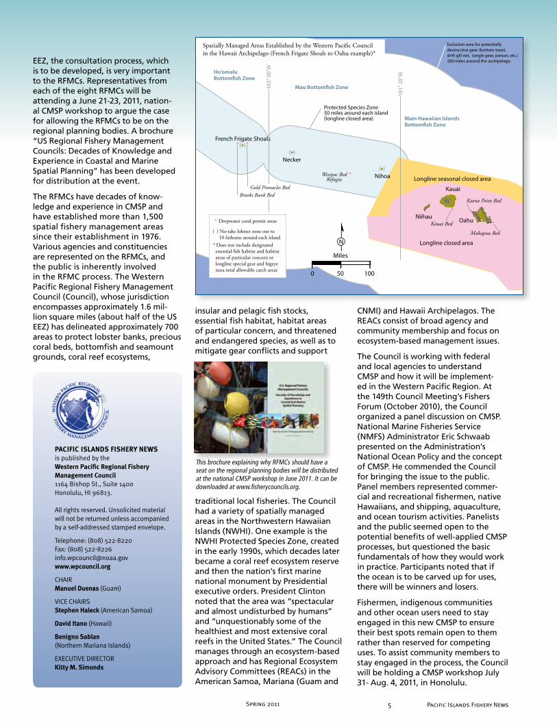
EEZ, the consultation process, which is to be developed, is very important to the RFMCs. Representatives from each of the eight RFMCs will be attending a June 21-23, 2011, nation-al CMSP workshop to argue the case for allowing the RFMCs to be on the regional planning bodies. A brochure “US Regional Fishery Management Councils: Decades of Knowledge and Experience in Coastal and Marine Spatial Planning” has been developed for distribution at the event.
The RFMCs have decades of know-ledge and experience in CMSP and have established more than 1,500 spatial fishery management areas since their establishment in 1976. Various agencies and constituencies are represented on the RFMCs, and the public is inherently involved in the RFMC process. The Western Pacific Regional Fishery Management Council (Council), whose jurisdiction encompasses approximately 1.6 mil-lion square miles (about half of the US EEZ) has delineated approximately 700 areas to protect lobster banks, precious coral beds, bottomfish and seamount grounds, coral reef ecosystems,
insular and pelagic fish stocks, essential fish habitat, habitat areas of particular concern, and threatened and endangered species, as well as to mitigate gear conflicts and support
traditional local fisheries. The Council had a variety of spatially managed areas in the Northwestern Hawaiian Islands (NWHI). One example is the NWHI Protected Species Zone, created in the early 1990s, which decades later became a coral reef ecosystem reserve and then the nation’s first marine national monument by Presidential executive orders. President Clinton noted that the area was “spectacular and almost undisturbed by humans” and “unquestionably some of the healthiest and most extensive coral reefs in the United States.” The Council manages through an ecosystem-based approach and has Regional Ecosystem Advisory Committees (REACs) in the American Samoa, Mariana (Guam and
CNMI) and Hawaii Archipelagos. The REACs consist of broad agency and community membership and focus on ecosystem-based management issues.
The Council is working with federal and local agencies to understand CMSP and how it will be implement-ed in the Western Pacific Region. At the 149th Council Meeting’s Fishers Forum (October 2010), the Council organized a panel discussion on CMSP. National Marine Fisheries Service (NMFS) Administrator Eric Schwaab presented on the Administration’s National Ocean Policy and the concept of CMSP. He commended the Council for bringing the issue to the public. Panel members represented commer-cial and recreational fishermen, native Hawaiians, and shipping, aquaculture, and ocean tourism activities. Panelists and the public seemed open to the potential benefits of well-applied CMSP processes, but questioned the basic fundamentals of how they would work in practice. Participants noted that if the ocean is to be carved up for uses, there will be winners and losers.
Fishermen, indigenous communities and other ocean users need to stay engaged in this new CMSP to ensure their best spots remain open to them rather than reserved for competing uses. To assist community members to stay engaged in the process, the Council will be holding a CMSP workshop July 31- Aug. 4, 2011, in Honolulu.
Niihau
161°
20’
W
165°
00’
W
Protected Species Zone 50 miles around each island(longline closed area)
French Frigate Shoals
Longline seasonal closed area
Longline closed area
Westpac Bed *
Kauai Bed
Kaena Point Bed
Makapuu Bed
Ho‘omalu Bottom�sh Zone
Mau Bottom�sh Zone
Main Hawaiian Islands Bottom�sh Zone
( )
Refugia
( )
( )
Spatially Managed Areas Established by the Western Pacific Council in the Hawaii Archipelago (French Frigate Shoals to Oahu example)*
*
**
* *
Exclusion area for potentiallydestructive gear (bottom trawl, drift gill net, tangle gear, poison, etc.) 200 miles around the archipelago
Brooks Bank BedGold Pinnacles Bed
* Deepwater coral permit areas
( ) No-take lobster zone out to 10 fathoms around each island* Does not include designated essential fish habitat and habitat areas of particular concern or longline special gear and bigeye tuna total allowable catch areas
This brochure explaining why RFMCs should have a seat on the regional planning bodies will be distributed at the national CMSP workshop in June 2011. It can be downloaded at www.fisherycouncils.org.

Spring 2011Pacific Islands Fishery News �
For more than three decades, the Western Pacific Regional Fishery Management Council has used spatial management as a tool to conserve marine resources while maintaining opportunities for domestic fishing in the US exclusive economic zone (EEZ) waters around the US Pacific islands. Now, three additional spatially managed areas created by the Council are poised to be implemented and one existing management area may be modified. Amendments to the Pelagic Fisheries Ecosystem Plan (FEP) for the Western Pacific Region are with the Secretary of Commerce for review. If approved, they would prohibit purse seine fishing in the US EEZ within 75 nautical miles (nm) of shore around American Samoa and within 200 nm around the Mariana Archipelago. Longlining within 30-nm from shore around the CNMI would also be banned. In addition, the Council has taken final action to modify the boundaries of the prohibited area for large pelagic fishing vessels around American Samoa.
The intent of the purse seine and longline exclusion areas is to prevent catch competition and gear conflicts between those fisheries and the local troll and small-scale pelagic fleets and to conserve important stocks such as bigeye, yellowfin, and skipjack tuna. Research suggests localized depletion may occur when large-scale fishing operations, such as purse seine, compete with small-
scale fishing operations, triggering catch competition for a single resource in a limited area. Reductions in fish density and catch rate could cause small vessels to travel farther and for longer durations to maintain catch rates, resulting in lost revenue due to increased expenses as well as possible safety-at-sea issues. Moreover, juvenile bigeye tuna caught by purse seines may be contributing to the overfish- ing status of bigeye tuna in the west-ern and central Pacific Ocean.
About 36 US purse seine vessels operate in the western and central Pacific Ocean, targeting skipjack and yellowfin tuna. They fish on the high seas, in foreign EEZs and in the US EEZ around American Samoa and the US Pacific Remote Island Areas (i.e., Wake, Baker, Howland, and Jarvis Islands, Johnston Atoll, Kingman Reef, and Palmyra Atoll). Purse seine vessels range from 164 to 377 feet (50 to 115 m) in length and have fish-carrying capacities of about 2.2 million to 3.9 million lbs (800 to 1,500 mt). The fishery is sophisticated and efficient, utilizing natural and man-made fish aggregating devices (FADs) to accumulate tuna. The purse seines are set near or around the FADs to catch the schools, harvesting on average about 2.4 mt (5,308 lbs) of tuna per set.
While conditions for purse seine fish-ing in the EEZ waters around American Samoa are less favorable than areas north and northwest of the EEZ, 11
US purse seine vessels are endorsed to fish in US EEZ waters, including those around American Samoa. While no US purse seine catches have been recorded within the EEZ waters around the Mariana Archipelago, two US purse seine vessels are based in Guam and limited purse seine activity has occurred adjacent to the EEZ around Guam since 1980.
Unlike the purse seine vessels, America Samoa’s trolling fleet of mostly small vessels is incapable of safely traveling long distances or holding large quan-tities of fish. They target skipjack and yellowfin tuna and are limited to day trips less than 50 nm (93 km) from shore. Similarly, American Samoa longline vessels less than 50 feet (15 m) in length are able to operate only within the near-shore area. Larger longline vessels are banned from this near-shore area and are limited to operating elsewhere in the EEZ and beyond. Longline vessels usually set one line per day, target albacore tuna and retain non-target skipjack tuna.
Guam’s pelagic fishery of about 300 to 400 mostly small trolling boats catches skipjack tuna, yellowfin tuna, mahimahi, wahoo and Pacific blue marlin. Trolling is also the primary fishing method in the CNMI pelagic fishery. About 50 to 100 small vessels catch skipjack and yellowfin tuna and mahimahi. The troll fleet typically utilizes the area within 30 nm (55.6 km) of shore.
Pacific Islands Fishery News � Spring 2011
Marine Spatial Planning & BycatchThe proceedings of the Fifth International Fishers Forum on Marine Spatial Planning and Managing Fisheries Bycatch (IFF5) are now available at the Council website at www.wpcouncil.org/news and the IFF website at www.fishersforum.net. The IFF series focuses on improving the sustainability of fish stocks and protected species with which these fisheries interact. The central objective of IFF5, held Aug. 3 to 5, 2010, in Taipei, was to bring the fishing industry into the relatively recent dialogue of marine spatial planning and management. The Forum co-hosts were the Western Pacific Regional Fishery Management Council and the Fisheries Agency, Council of Agriculture, Taiwan.
taipei
Spatial Management Evolves to Include Purse Seines

Spring 2011 � Pacific Islands Fishery News
Pelagic longline vessels in the Marianas are typically larger than 50 feet in length and can fish for more than 30 days. Interest in the longline fishery has been variable. Currently two federally permitted longline vessels are based in the CNMI. Longliners target yellowfin and bigeye tuna and retain incidental catches of albacore, blue marlin, mahimahi, skipjack tuna and spearfish.
Other spatial management measures on which the Council has taken final action is the modification of the boundaries for the existing large pelagic fishing vessel (>50 feet in length) exclusion area around the islands of Tutuila, Manua and Rose Atoll. Following the establishment of this exclusion area, the Rose Atoll Marine National Monument (MNM) was created by Presidential executive order, closing an additional 10,000 square km of waters to the American Samoa longline fleet, due to mismatch of the monument bound-aries and the large vessel area closure. The modification will make the northern, eastern and southern boundaries of the longline exclusion area congruent to those of the Rose Atoll MNM. This mea-sure maintains protection of the various banks and seamounts important for the American Samoa troll and sport fisheries.
� Pacific Islands Fishery NewsSpring 2011
Purse seine vessel operating in Pacific waters.
0 50 100
Nautical Miles
W E
N
S
Manu’a Group
Tutuila
American Samoa4-B
4-A
3-A
3-B
SwainsIsland
Western Samoa
Proposed Purse Seine Prohibited Area
Existing Large Vessel Prohibited Area
Exclusive Economic Zone (EEZ)
Proposed prohibited Area Coordinate
Japan
F) 144˚ 19’ E 20˚ 39’ N
G) 145˚ 6’ E 21˚ 4’ N
E) 145˚ 9’ E 19˚ 7’ NH) 146˚ 4’ E 19˚ 19’ N
D) 145˚ 22’ E 17˚ 3’ N
C) 145˚ 6’ E 16˚ 21’ N
B) 145˚ 29’ E 15˚ 49’ NI) 146˚ 32’ E 16˚ 0’ N
A) 144˚ 34’ E 14˚ 0’ N J) 145˚ 32’ E 13˚ 32’ N
GuamGuam Longline
Prohibited Area
Nautical Miles
Micronesia0 50 100 200
N
EEZ
CN
MI
EEZ
Proposed CNMI Longline Prohibited Area
Proposed Purse Seine Prohibited Area

Spring 2011Pacific Islands Fishery News 8
Fuel shortage is a continuous problem for fishermen in the Manua Islands, American Samoa. That complaint came through loud and clear to Ray Tulafono, director of the American Samoa Department of Marine and Wildlife Resources (DMWR), and
member of the Western Pacific Regional Fishery Management Council, during his visit to those islands in January 2011 with Ueta Faasili, the Council’s project coordinator for American Samoa. With only one fuel supplier, the island of Tau always runs dry before the next
shipment arrives. On Ofu and Olosega, there is no supplier, so fishermen purchase fuel from the island of Tutuila and ship it in by ferry boat.
To resolve this problem, the Council is working with DMWR and the Manua Council of Chiefs to develop a fuel storage facility on Tau and another on Ofu, which will
also service Olosega. Each facility will contain four 500-gallon fuel storage tanks.
Manua fishermen also face problems maintaining the quality of their fish because there is no ice making mach-ine in Manua. Therefore, the Council is also in process of establishing ice making facilities on Tau and Ofu. With ice for use during fishing trips and the transport of fish to Tutuila markets, the fishermen should see an increase in the value of their catches.
The fuel storage and ice-making facil-ities will be run by a Manua Fishermen Cooperative, which the Council is also helping Manua to establish. During its 150th meeting in American Samoa in March 2011, Council staff met with several Manua chiefs to provide them with an update on these projects.
At its March 2011 meeting in American Samoa, the Western Pacific Regional Fishery Management Council took final action to reduce programmatic barriers that may be limiting small vessel participation in the American Samoa longline limited entry program. The goal is to help sustain community and indigenous American Samoan participation in the longline fishery.
Under the modified regime, two vessel classes would replace the current four vessel classes. The “small” class
would include the current Class A and B vessels, and the “large” class would comprise the current Class C and D vessels. The minimum annual harvest landings of managed pelagic fish caught with longline gear in the exclusive economic zone (EEZ) around American Samoa within a three-year period for the “small” vessel class would be lowered to 500 lbs. The minimum requirement for the large vessel class would remain at the existing 5,000 lbs.
Criteria for having documented history of participation in the fishery to be eligible for owning a permit or receiving a transferred permit would be eliminated. Consideration of prior documented history of fish- ing participation in a vessel class size would be maintained, however, to prioritize applicants.
Council staff is working with NOAA Fisheries to finalize the amendment for transmission to the Secretary of Commerce for final approval.
Council to Assist Manua Fishermen
DMWR Director / Council Member Ray Tualfono (far right) met with Manua fishermen in January 2011 to hear their concerns and needs.
Fishing boats in Manua. Sustaining quality and marketability of fish is difficult due to lack of fuel and ice making facilities in this group of outer islands.
Programmatic Barriers Lifted for Small Longline Vessels
Council Chair Manuel Duenas (standing) and Executive Director Kitty Simonds (seated center) met with Manua chiefs in March 2011 to discuss ongoing fishery development projects and the proposed Manua Fishermen Cooperative.
Spring 2011Pacific Islands Fishery News 8

Spring 2011 � Pacific Islands Fishery News
Council Reaches Out to American Samoa Students, CommunitiesIn conjunction with its March 2011 meeting in American Samoa, the Western Pacific Regional Fishery Management Council hosted a symposium for high school students at the Fale Laumei in Utulei, giving them the opportunity to learn about coral reefs and marine fishery issues outside of the formal school setting. Among the guest lecturers were marine science major Iolani Kauhane from the University of Hawaii at Hilo, who presented on the relationship between moon phases and fisheries; Lucas Moxey from NOAA Ocean Watch in Honolulu, on watershed monitoring; Marlowe Sabater, the Council’s marine ecosystem scientist and former chief scientist for the American Samoa Department of Marine and Wildlife Resources (DMWR), on humphead wrasse habitat and population distri-butions; Phil Wiles from the American Samoa Environmental Protection Agency, on coastal currents and fish larvae dispersion; and Selaina H. Vaitautolu, DMWR, on community-based marine protected areas. The students also met resource people and participated in small group discussions at informational booths staffed by the National Resources Conservation Service (US Department of Agriculture), Fagatele Bay National Marine Sanctuary, American Samoa Department of Education Lunch Program, American Samoa DMWR biosampling and community-based marine protected area programs, NOAA Ocean Watch, Samoan Studies Institute and the Council. At the end of the day, students who demonstrated information they learned during the event won fishing poles, mask and snorkel sets, water sampling kits, GPS units and more. The event concluded with awards presented to the winners of a poster competition on the coral reef ecosystem, which was held in conjunction with the symposium. First place was awarded to Travis Pavihi,
10th grade, Tafuna High School; 2nd place to Nila Faalawelawe, 9th grade, Samoana High School; 3rd place to Ruta Faalavelave, 11th grade, Tafuna High School; and 4th place to Fia Vaeoso, 11th grade, Samoana High School.
Also during March in American Samoa, the Council hosted a meeting for the villages of Matu‘u and Faganeanea at the Christian Congregational Church Hall, a meeting for more than 50 mayors at the Office of Samoan Affairs in Utulei and a Fishers Forum at the Fale Laumei in Utulei. These events focused on sustainable fisheries development and ecosystem management and why public involvement is important. The participants were interested in the information and expressed a need for more support with outreach and education, enforcement, ecosystem monitoring and fisheries development.
The NOAA Coral Reef Conservation Program assisted in the funding for the symposium, some of the meetings and some of the studies presented. The events were well covered by the local media throughout the week.
Top: American Samoa Department of Education Lunch Program demonstrated how to make oka and provided students with samples of the delicious traditional tuna dish. Find the recipe in the Pacific Islands Fishery News Summer 2010 issue. Below: The pastor, pulenu‘u (village mayor), residents and young students attended the Matu’u and Faganeanea community meeting on sustainable fisheries development and ecosystem management hosted by the Council.
Above: Young students learn about watershed monitoring from Lucas Moxey, NOAA Ocean Watch, during the community meeting at the Matu’u church hall hosted by the Council.
Left: Marine science major Iolani Kauhane from the University of Hawaii at Hilo explains the relationship between moon phases and fisheries during the American Samoa Student Symposium.
Pacific Islands Fishery News

Spring 2011Pacific Islands Fishery News 10
For a copy of these publications and studies recently released by the Western Pacific Regional Fishery Management Council, please go to www.wpcouncil.org/media or contact our Honolulu office at info.
[email protected] or (808) 522-5341 or the Council’s onsite coordinator in American Samoa, Fini Aitaoto, at (684) 633-5892 or 633-5102 or [email protected].
O Le Fuafuaga fa’ale – Ikosite I le Pasefika mo faiva i le Foga-tai (Samoan version of Pacific Pelagic Fishery Ecosystem Plan brochure)
Fuafuaga (FEP) o Vaega Faapitoa Tau Faigafaiva o Atumotu o Amerika Samoa e Faasino i Le Ikosite (Samoan version of American Samoa Archipelago Fishery Ecosystem Plan brochure)
American Samoa Archipelagic Fishery Ecosystem Report, Pacific Islands Fishery Monograph #3 by Marlowe Sabater and Ray Tulafono (April 2011). This report provides an initial framework for the reporting of fish catches and catch per unit effort (CPUE) trends for the territory. It assesses the condition of the harvested insular fish stocks using data collected from the boat- and shore-based fisheries and underwater census surveys. The report does not cover fisheries for tuna and other highly migratory, open-water pelagic species. The report indicates that the coral reef fish stocks in American Samoa are not being subject to intense fishing pressure given that (1) fishing effort has been declining for over three decades; (2) fish biomass and abundance are increasing; and (3) CPUE and fishing mortality remain stable.
Mapping and Assessing Critical Habitats for the Pacific Humphead Wrasse (Cheilinus undulates) by Marlowe Sabater (2010). In American Samoa, the Pacific humphead wrasse (Cheilinus undulatus) is called “lalafi,” meaning “good at hiding.” The name aptly describes the fish, which is wary of human presence so quickly hides. This behavior results in the species’ very low
detectability, i.e., ability to see the fish, even though it grows to more than a meter in size. The Department of Marine and Wildlife Resources, through funding from the Western Pacific Regional Fishery Management Council’s grant from the NOAA Coral Reef Conservation Program, conducted a fish population survey of the juvenile to determine its status, detect-ability and spatial distribution along the shallow reef flats in the islands of Tutuila, Ofu-Olosega and Tau. The results show that the species’ habitat of shallow sandy substrates with corals along the peri-meter comprises merely 1% of the total reef flat area.
Current Surveys between Potential Marine Managed Areas in American Samoa by Philip Wiles et al. (2010). The American Samoa Environmental Protection Agency and Department of Marine and Wildlife Resources, through funding from the Western Pacific Region-al Fishery Management Council’s grant from the NOAA Coral Reef Conservation Program, conducted a survey of the coast-al circulation patterns around Tutuila, American Samoa. The project provides valuable information on larval transport and could be used to design a network of marine managed areas.
New American Samoa Resources Available
What We Now Know about BottomfishUp until a couple years ago, fishery scientist and managers thought opakapaka grew quite fast, reached sexual maturity by 3 to 5 years of age and lived to about 20 years old. That was before Dr. Robert Humphreys and his team from the Pacific Islands Fisheries Science Center’s Life History Program used a different approach to take another look at aging opakapaka. Their findings indicate the maximum estimated age
Plot of preliminary age-at-length findings from bomb radiocarbon dating of opakapaka (Pristipomoides filamentosus), with data from previous studies that were considered reliable (provided by Allen Andrews, PIFSC, NOAA Fisheries).

Spring 2011 11 Pacific Islands Fishery News
exceeds 40 years, more than twice the previous estimate of nearly 20 years.
“We were lucky there were some old otoliths from opakapaka sampled in the 1970s and ’80s in the archives that allowed us to go back and test them using a new aging technique,” Dr. Humphreys explained. The new method of aging fish uses bomb radiocarbon and lead radiocarbon decay to date the otoliths, or fish ear bones. In the 1950s and ’60s, the Pacific islands were used as test bed for the nuclear bombs, which allows this method to be used for opakapaka. More age data is being collected using bomb radiocarbon dating on opakapaka and will be presented in a scientific publication in the near future.
Dr. Humphreys’ group is also working with the bottomfish fishing community to collect samples of hard-to-get sizes of commercially important bottomfish species. The markets will typically sell only medium to large bottomfish. Some species have minimum size limits, which prohibit the sale of small sizes. The absence of colleting and aging small fish samples creates a void in building a complete growth curve for these species.
Once the call for help went out, Hawaii fishermen responded by providing samples of juvenile onaga, ehu, uku and other species. Preliminary results suggest that a 25-cm (10-inch) ehu (fork length) is more than 2 years old. With these samples, longstanding gaps in the growth curves of opakapaka, ehu, onaga, and other bottomfish species will be a thing of the past.
The closing of the main Hawaiian Islands (MHI) bottomfish fishery on March 12, 2011, marked the end of the fourth season that the fishery has been managed under a fleet-wide total allowable catch (TAC). The fishery will reopen on Sept. 1, 2011, under a new quota and run through Aug. 30, 2012, or until the quota is reached. The question is will the 2011-12 quota remain a TAC, as voted on by the Western Pacific Regional Fishery Management Council during its March 8-10, 2011, meeting in American Samoa or will it be changed into an annual catch limit (ACL). To the layperson, this difference may not mean much, but to the bureaucrat it is a key element to the evolving management for this fishery.
For one thing, if it is managed under an ACL, the MHI bottomfish will be the first fishery under the authority of the Council to comply with the 2006 Congressional mandate to establish ACLs for all federally managed fish-eries. To manage this fishery as an ACL, the Council and its Scientific and Statistical Committee (SSC) must select an acceptable level of risk to avoid overfishing and then adjust that level to take into consideration economic, ecological and social factors. The Council created two working groups to tackle these issues and provide recommendations at the June 2011 SSC and Council meetings to be held in Honolulu. It is anticipated that the MHI bottomfish ACL for the 2011-2012
season, if established, will be less than the TAC of 383,000 lbs for the 2011-2012 season already adopted by the Council.
The 2011-2012 TAC was based on a recent stock assessment produced by the National Marine Fisheries Service (NMFS) Pacific Islands Fisheries Science Center. To satisfy the comments from the SSC and independent reviewers on previous stock assessments, PIFSC made the following significant changes in the recent assessment:
• Separated the MHI stock from the Northwestern Hawaiian Islands stock;
• Separated the Deep-7 species (opakapaka, onaga, hapuupuu, ehu, kalekale, gindai and lehi) from other managed bottomfish species (kahala, uku, taape, ulua, etc.);
• Included the estimated contribution of non-reported bottomfish catch to the catch per unit effort from 1948–2007; and
• Updated the life history information to extend the longevity of bottomfish from 20+ years to over 40 years.
For a copy of the 2010 stock assessment draft report, go to the Scientific Reports section of www.hawaiibottomfish.info. For more background on the stock assessment, visit the NMFS PIFSC bottomfish research and stock assessment website at www.pifsc.noaa.gov/bottomfish.
Year Total allowable
catch
Final
landings
Opening
date
Closing date Season length
catch landings date
2007-2008 178,000 lbs 195,861 lbs Oct. 1, 2007 April 16, 2008 6.5 months
2008-2009 241,000 lbs 258,544 lbs Nov. 15, 2008 July 6, 2009 7.75 months
2009-2010 254,050 lbs 208,369 lbs* Sept. 1, 2009 April 20, 2010 7.75 months
2010-2011 254,050 lbs 267,569 lbs** Sept. 1, 2010 March 12, 2011 6.5 months
1102 ,1 .tpeS***sbl 000,3832102-1102
Main Hawaiian Islands Bottomfish Fishing Season Summaries
Reported as of June 8, 2010; corrected for double counting errorAs of May 9, 2011. Source: HDARWestern Pacific Regional Fishery Management Council recommendation. To be approved by Commerce Secretary. Might be replaced by an ACL (see article).
***
***
Illustrations courtesy of Hawaii Division of Aquatic Resources
Fine-Tuning Hawaii’s Bottomfish Management
Spring 2011Pacific Islands Fishery News 12
Identifying and designating essential fish habitat (EFH) and habi-tat areas of particular concern (HAPC) for federally managed fish stocks is required by the Magnuson-Stevens Fishery Conservation and Management Act (MSA). For bottomfish, the Western Pacific Regional Fishery Management Council currently designates EFH as 0-400 meters (0-200 fathoms) for all bottomfish species and their associated life stages, which include egg, larval, juvenile and adult life stages. For HAPC, it currently designates all escarp-ments/slopes between 40-280 m as well as three known areas of juvenile opakapaka habitat (two off Oahu and one off Molokai).
On April 5-7, 2011, the Council hosted an independent review of a series of reports and recommendations produced by Dr. Chris Kelley, University of Hawaii Undersea Research Lab-oratory and his team, who were contracted by the National Marine Fisheries Service’s Pacific Islands Regional Office (NMFS PIRO) to review the specifications EFH and HAPC for Hawaii bottomfish and groundfish. Under the contract, Kelley reviewed and summarized new information from published and unpublished sources on the early life history stages, reproductive cycles, preferred habitats (both depths and substrate types), movement patterns, community composition and prey species of bottomfish and groundfish. From this, he evaluated the appropriateness of species complexes along with potential designation revisions for bottomfish EFH and HAPC.
The independent review panel was chaired by Dr. Robert Skillman, a member of the Council’s Scientific and Statistical Committee (SSC) and a retired NMSF PIFSC scientist, and included Dr. Ashley Williams (Secretariat of the Pacific Community), Robert Moffitt (NMFS PIFSC retired) and Donald Kobayashi (NMFS PIFSC and SSC member). It recommended that the 14 federally managed bottomfish species be parceled into three general
subgroups based on their depth ranges and life history characteristics. It additionally recommended that an additional kahala species (Seriola rivoliana) be added as a managed species. The three bins include Shallow (EFH 0–240 meters/0–120 fathoms), Intermediate (EFH 0–320 meters/0–160 fathoms) and Deep (EFH 0-400 meters/0–200 fathoms). Shallow species were identified as white ulua, uku and taape; intermediate species as kahala (Seriola dumerili and S. rivoliana), lehi, opaka, butaguchi, hapuupuu and black ulua; and deep species as yellow-tail kalekale, kalekale, gindai, onaga and ehu.
Regarding HAPC, the independent review panel prioritized the criteria by which HAPCs are considered, with top priority given to the ecosystem importance of the habitat type. Addi-tional factors that were, therefore, considered included habitat sensitiv-ity to human-induced disturbance, development activities stressing habitat and rarity of habitat type.
The panel noted that the State of Hawaii’s Bottomfish Restricted Fishing Areas (BRFAs), the Papaha-naumokua-
kea Marine National Monument and the Kahoolawe Island Reserve are not criteria by which EFH or HAPC would be considered.
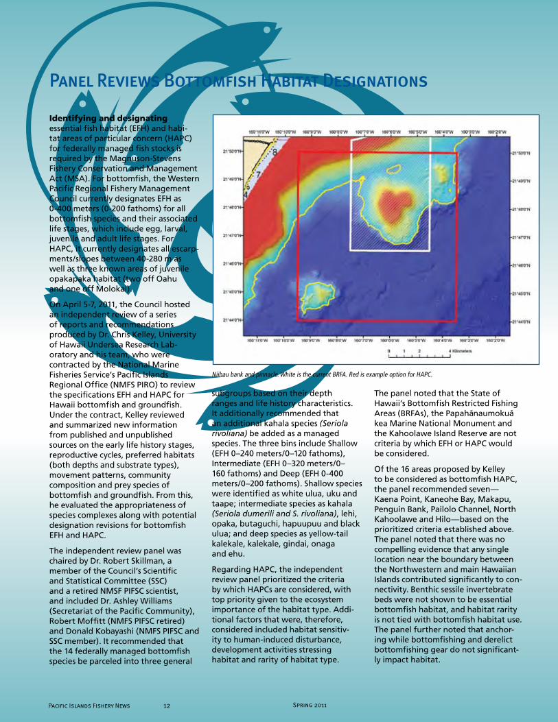
Of the 16 areas proposed by Kelley to be considered as bottomfish HAPC, the panel recommended seven— Kaena Point, Kaneohe Bay, Makapu, Penguin Bank, Pailolo Channel, North Kahoolawe and Hilo—based on the prioritized criteria established above. The panel noted that there was no compelling evidence that any single location near the boundary between the Northwestern and main Hawaiian Islands contributed significantly to con-nectivity. Benthic sessile invertebrate beds were not shown to be essential bottomfish habitat, and habitat rarity is not tied with bottomfish habitat use. The panel further noted that anchor-ing while bottomfishing and derelict bottomfishing gear do not significant- ly impact habitat.
Panel Reviews Bottomfish Habitat Designations
Niihau bank and pinnacle. White is the current BRFA. Red is example option for HAPC.
Pacific Islands Fishery News 12 Spring 2011
Spring 2011 1� Pacific Islands Fishery News
Recommendations for future work included the following:
• Improve information on spawning grounds and nursery grounds of bottomfish
• Develop better delineation of critical areas
• Identify areas of high adult abundance, not just high catch catches
• Maintain separation of criteria for establishing EFH and HAPCs from that of BRFAs
The recommendations from the panel will be considered by the Council at its June 2011 meet-ing in Honolulu. For additional information on this issue or to provide your comments, visit www.hawaiibottomfish.info and/or the Council’s website at www.wpcouncil.org or contact the Council by phone (808) 522-8220, fax (808) 522-8226 or email [email protected].
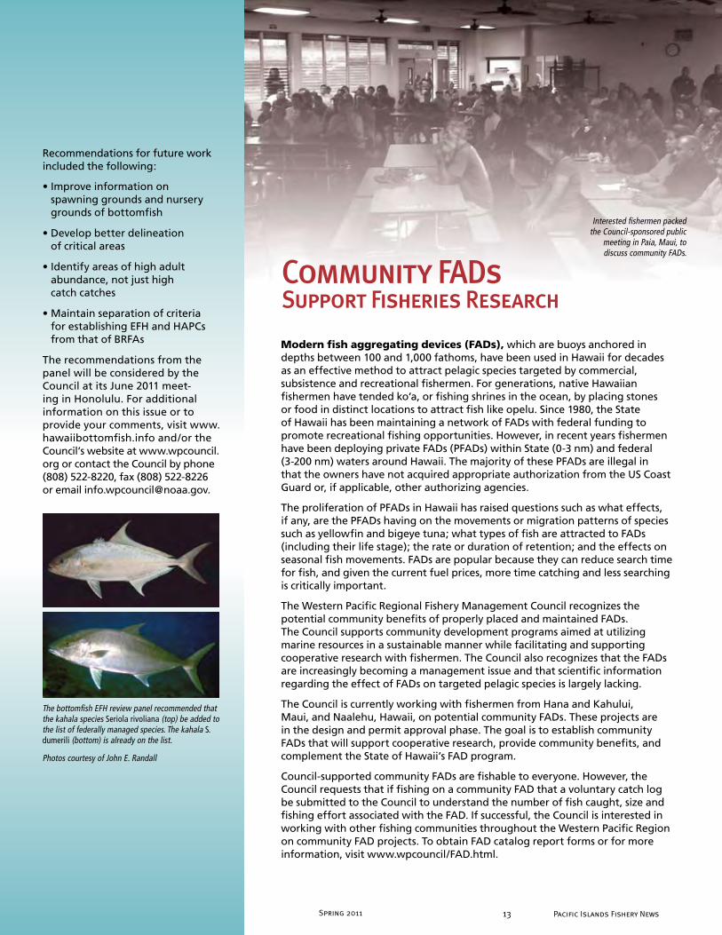
Modern fish aggregating devices (FADs), which are buoys anchored in depths between 100 and 1,000 fathoms, have been used in Hawaii for decades as an effective method to attract pelagic species targeted by commercial, subsistence and recreational fishermen. For generations, native Hawaiian fishermen have tended ko‘a, or fishing shrines in the ocean, by placing stones or food in distinct locations to attract fish like opelu. Since 1980, the State of Hawaii has been maintaining a network of FADs with federal funding to promote recreational fishing opportunities. However, in recent years fishermen have been deploying private FADs (PFADs) within State (0-3 nm) and federal (3-200 nm) waters around Hawaii. The majority of these PFADs are illegal in that the owners have not acquired appropriate authorization from the US Coast Guard or, if applicable, other authorizing agencies.
The proliferation of PFADs in Hawaii has raised questions such as what effects, if any, are the PFADs having on the movements or migration patterns of species such as yellowfin and bigeye tuna; what types of fish are attracted to FADs (including their life stage); the rate or duration of retention; and the effects on seasonal fish movements. FADs are popular because they can reduce search time for fish, and given the current fuel prices, more time catching and less searching is critically important.
The Western Pacific Regional Fishery Management Council recognizes the potential community benefits of properly placed and maintained FADs. The Council supports community development programs aimed at utilizing marine resources in a sustainable manner while facilitating and supporting cooperative research with fishermen. The Council also recognizes that the FADs are increasingly becoming a management issue and that scientific information regarding the effect of FADs on targeted pelagic species is largely lacking.
The Council is currently working with fishermen from Hana and Kahului, Maui, and Naalehu, Hawaii, on potential community FADs. These projects are in the design and permit approval phase. The goal is to establish community FADs that will support cooperative research, provide community benefits, and complement the State of Hawaii’s FAD program.
Council-supported community FADs are fishable to everyone. However, the Council requests that if fishing on a community FAD that a voluntary catch log be submitted to the Council to understand the number of fish caught, size and fishing effort associated with the FAD. If successful, the Council is interested in working with other fishing communities throughout the Western Pacific Region on community FAD projects. To obtain FAD catalog report forms or for more information, visit www.wpcouncil/FAD.html.
Community FADs Support Fisheries Research
Interested fishermen packed the Council-sponsored public
meeting in Paia, Maui, to discuss community FADs.
The bottomfish EFH review panel recommended that the kahala species Seriola rivoliana (top) be added to the list of federally managed species. The kahala S. dumerili (bottom) is already on the list.
Photos courtesy of John E. Randall

Spring 2011Pacific Islands Fishery News 1�
The 5th annual Hawaii Fishing and Seafood Festival at Pier 38 in Honolulu on Oct. 10, 2010, featured an indigenous tent, organized by the Western Pacific Regional Fishery Management Council. Cultural practitioners at the tent provid-ed demonstrations, displays and activities on Hawaiian and Mariana fishing prac-tices. Kanikapila music was performed throughout the day with an assortment of musicians, including Richard Hoopii, Leslie Kuloloio and Wade Lee among others. Cecilio Rakiulipliy demonstrated Carolinian kite fishing. Charlie Perreira taught net-making as he wove a throw net. Keeaumoku Kapu crafted traditional shrimp traps to demonstrate traditional basket weaving, and Frank Farm provid-ed examples of modern era fish traps. Children learned how to make luhe‘e, traditional Hawaiian octopus fishing lures, and could practice net tying while viewing displays of traditional fishing gear. Aku Hauanio demonstrated the gear and talk-ed about kau la‘au ulua fishing techniques. Families sat and enjoyed endless videos of traditional fishing and ocean practices.
Disaster struck the indigenous tent in the late afternoon when a strong wind found its way under the tent, lifted it in the air and blew it 25 feet into the parking lot at the pier. Miraculously, no one was hurt and no equipment was damaged.
Established in 2009 to celebrate the 50th anniversary of the Hawaiian International Billfish Tournament (HIBT), the Great Marlin Race combines billfish anglers with Stanford University marine biologists to help solve the mysteries of where these magnificent fish go and what they do as they journey across the ocean.
As part of the HIBT, opportunities are provided to sponsor popup satellite tags to be deployed during the tournament. Each tag records depth, temperature and location data and is programmed to release itself from the fish after 120 days. The tag that reports furthest from the point at which it was deployed wins the race, and the HIBT provides their team with complimentary entry into the following year’s tournament.
The winner of the 2010 Great marlin Race was the Western Pacific Regional Fishery Management Council. One of the two tags it sponsored, deployed on Fish #1, won the Race by reporting from 2,282 nautical miles east-southeast of Kona, Hawaii, 120 days after it was deployed during the HIBT.
Fish #1 was a 150-lb fish caught by angler Kerry Kurz of the Laguna Niguel Billfish Club #1 on Aug. 3, 2010, and tagged by his brother Bob Kurz, both on board the Sea Baby III with Capt. Doug Pattengill and crewman A.J. Friend. The data transmitted from the tag suggest that this marlin began its journey by heading almost due south of Hawaii for the first month following its release, to a point about 750 nautical miles south of the islands. It then turned east, meandering along the 10-degree latitude line across over 2,000 nautical miles before
reaching the point at which its tag released and floated to the surface. A map of all the marlin tracks from 2010 can be found on the Great Marlin Race website (http://greatmarlinrace.org).
Of the 10 tags deployed during the 2010 Great Marlin Race, nine successfully reported—at distances ranging from 85 to 2,282 nautical miles (157 to 4,226 km) from where they were deployed. The combined dataset from the first two years of the race reveals broad variety among individual marlin’s migratory behaviors—with some remaining near the Hawaiian Islands for extended time periods, and others moving towards the Line Islands, the Marquesas Islands or even Central America. Two marlin in the 2010 race appeared to stay right near the Hawaiian Islands—one of them for the entire 120-day deployment period.
Clockwise from above: Council staff Josh DeMello teaching net throwing; Keiki enjoy the reef fish exhibit on display at the Honolulu fish auction; Keeaumoku Kapu with traditional Hawaiian hook; Traditional Hawaiian fisherman Aku Hauanio; Charlie Perreira demonstrates net-making.
Council Wins 2010 Great Marlin Race
Seafood FestivalC u l t u r a l F i s h i n g K e p t A l i v e a t

Spring 2011 1� Pacific Islands Fishery News
Council and HPU Partner to Improve Region’s Fisheries Management CapacityUndergraduate and graduate students, faculty and others can now enroll in a 12-session seminar series on fisheries management at Hawaii Pacific University (HPU). The seminar was developed and sponsored by the Western Pacific Regional Fishery Management Council and HPU to expose students to the latest and contemporary fishery issues facing resource users, researchers and managers in the Western Pacific Region. Two seminar series have been held so far during the fall 2010 and spring 2011 sessions at HPU’s windward campus. Student participation was strong with more than 20 students enrolled during each session. Professionals from the fishing community, fisheries research and resource management provided students a glimpse into the depth and complexity of managing fisheries in the Western Pacific Region.
In addition to the seminar series, the Council has also partnered with HPU to develop curriculum and lesson plans for an undergraduate level, three-credit course in fisheries management. The goal is to implement such courses in local colleges and universities in the region. Through programs like these, the Council in partnership with academic institutions can build local capacity by recruiting, educating and placing local Pacific island students to enter the numerous fields that support fisheries management in the Western Pacific Region.
Utilizing the Council’s approach to increase coral reef fishery science and manage-ment capacity building, the Council contracted with a HPU graduate student to characterize and provide an assessment of the Kona crab fishery in Hawaii. Kona crab was listed by the Council’s Plan Team during its risk-ranking exercise in developing annual catch limits (ACLs). Using State of Hawaii commercial Kona crab landings data from 1948 to 2009, the student was able to develop a stock assessment of the fishery in the main Hawaiian Islands. The assessment produced a model and an index of stock abundance, which shows a general decline in the Kona crab stock over the last 18 years. Changes in environmental conditions, changes in fishing effort and an overexploitation of the stock are all likely factors contributing to the decline; however the exact cause is unknown. This report and its stock assessment will be reviewed by the Council for the develop-ment of ACLs and other management measures in the future.
Funding for these projects was provided by the NOAA Coral Reef Conservation Program, Award No. NA09NMF4410038.
The findings from the two races illustrate how important it is to tag as many marlin as possible and to repeat this process over multiple years. With so much variability from individual to individual and year to year, it is impossible with just a few isolated tracks to begin to understand the broader migration patterns of these fish and the external forces that shape their behavior.
The Stanford team is now working with the International Game Fish Association (IGFA) and various corporations, found-ations and individuals to explore the opportunities to carry out additional bill-fish research in other parts of the world where adventurous anglers seek out these magnificent and mysterious fish. The team will also be at the 52nd HIBT, July 25-29, 2011, in Kailua-Kona.
Commercial MHI Kona Crab Landings, Fiscals 1948 - 2009
250
300
350
400
No. trips
200250
300
bs)
rips
Lbs. per trip
150
150
200
Wei
ght p
er T
rip (l
Num
ber o
f Tr
50
100
50
100
WN
00
50
1948
1951
1954
1957
1960
1963
1966
1969
1972
1975
1978
1981
1984
1987
1990
1993
1996
1999
2002
2005
2008
1 1 1 1 1 1 1 1 1 1 1 1 1 1 1 1 1 1 2 2 2
Fiscal YearClockwise from above: Council staff Josh DeMello teaching net throwing; Keiki enjoy the reef fish exhibit on display at the Honolulu fish auction; Keeaumoku Kapu with traditional Hawaiian hook; Traditional Hawaiian fisherman Aku Hauanio; Charlie Perreira demonstrates net-making.
Seafood Festival
1� Pacific Islands Fishery NewsSpring 2011

Spring 2011Pacific Islands Fishery News 1�
The status of green turtles in the Mariana Archipelago is not well known due to the lack of long-term data on nesting and foraging populations. Without consistent monitoring to document the long-term population trend data both at nesting and foraging habitats, these island areas will not have sufficient green turtle data to be evaluated against current or any future revised recovery criteria set forth under the Endangered Species Act (ESA) recovery plans. In addition, international collaboration must be strengthened
with areas with shared green turtle stocks to ensure the sustainability of populations throughout their range. Further, a balance between recovery goals and cultural needs must be achieved to gain public support needed for a successful sea turtle conservation and management program.
Given this status, the Western Pacific Regional Fishery Management Council convened a workshop to address the status and recovery of green turtles in the Mariana Archipelago. This workshop aimed to strengthen international collaborations with areas with known common green turtle stocks and to identify the cultural needs and traditions associated with green turtles and develop methods to integrate such needs into green turtle conservation activities in the Commonwealth of the Northern Mariana Islands (CNMI) and
Guam. Approximately 50 participants including cultural practitioners, fisher-men, researchers, biologists, environ-mentalists and government rep-resentatives gathered from CNMI, Guam, American Samoa, Hawaii, Japan and the Philippines for the three-day workshop in Saipan on Jan. 25- 27, 2011.
Researchers presented ongoing studies and current knowledge of green turtles in their respective areas. Participants made commitments to one another to share data and information to further the understanding of green turtles in the region and also suggested that a regional ecosystem management plan be developed to include the Mariana Archipelago, Japan, Philippines and the broader Micronesian region.
The workshop also provided a unique opportunity to learn from the practitioners about the importance and significance of sea turtles in their culture and to begin a dialogue to balance cultural
needs and modern-day conservation. Because some cultural knowledge is passed down according to protocol and shared only among the keepers of knowledge, the practitioners would speak among themselves to decide what pieces of knowledge to share with others. Among the knowledge they shared were three ways in which sea turtles hold significance in their culture: 1) turtles as a symbol of peace; 2) important use in the women’s menstruation house; and 3) use in navigation. One practitioner shared that traditional navigators know of 184 migratory paths of turtles, with each route having its own name. Practition-ers are able to tell where turtles will go, based on the sex of the turtle, season and other known factors. Modern science of satellite tracking and flipper tag recoveries, they said, are confirm-ing what they have known all along.
The process of finding a balance between such rich cultural knowledge and modern-day conservation will take patience and understanding among all of those involved. This workshop start-ed that process.
Mariana Archipelago Green Turtle Workshop
Carolinian cultural practitioners discuss in their native tongue what knowledge to share with others at the green turtle workshop in Saipan.
A diverse group of traditional leaders, cultural practitioners, and federal and local sea turtle programs partners from the Marianas, American Samoa, Hawaii, Federated States of Micronesia, Belau, Philippines and Japan posed for a group picture during the Marianas Archipelago Sea Turtle Workshop held at World Resort Hotel in Saipan, Jan. 25-27, 2011.

Spring 2011 1� Pacific Islands Fishery News
Festival Celebrates CHamoru Lunar New Year
The 3rd Annual Gupot Fanha’aniyan Pulan CHamoru (Chamorro Lunar Calendar Festival) was held Jan. 30, 2011, on the grounds of the Guam Fishermen’s Co-operative Association (GFCA), near the Hagåtña Marina and Boat Basin and the Chamorro Village. The event celebrated the start of the lunar New Year and promoted the perpetuation of the Chamorro culture and sustainable use of natural resources. Cultural practitioners were provided with the opportunity to share their talents and promote their crafts and skills.
The event was organized by the CHamoru Lunar Calendar Committee, which was initiated by the Western Pacific Regional Fishery Management Council in 2006 to provide advice on the development of
a traditional lunar calendar for Guam. The Committee has partnered with the Council to develop the annual calendars ever since.
During the event, the Council distributed 2,000 copies of the 2011 Chamorro traditional lunar calendar. Additionally, the Council exhibit featured cultural and subsistence uses of local shells and displayed pictures of ecosystem threats on Guam as well as good cultural practices.
Other exhibits, demonstrations and entertainment highlighted the indigenous language and featured special student projects. The Guam Community College Culinary Arts Academy showcased cultural recipes they have developed. The Department of Chamorro Affairs exhibit featured cultural artifacts. Other exhibitors included federal agencies, the University of Guam and other Government of Guam agencies. Local artisans demonstrated their crafts, and Chamorro cultural organizations provided continuous visual stimulation and entertainment through chants, song and movement. Carabao (water buffalo) rides were provided by John Aguon (a fisherman and farmer) and his family. The Marianas Paddlesports Racing Association was to provide canoe rides; however poor sea conditions discouraged this activity.
A major highlight of the festival was the CHåhan, which is the ancient way of cooking underground. At 4 p.m., the CHåhan was ceremoniously opened with a procession of food to the feast tables. The procession included representation from each of the island’s villages with the mayors and ambassadors leading their villages with their food contribution for the feast. Once done, in the spirit of the Chamorro culture, the feast was shared with those in attendance. The event was free to the public.
The event was made possible through the guidance, sponsorship and support from the Council, GFCA, Guam Visitors Bureau, Mayor’s Council of Guam, Guam Hotel & Restaurant Association, Farmer’s Cooperative Association of Guam, Pacific Daily News, Ambros, SPPC, BankPacific and other government and private sector partners.
Left: The night before the Festival, Selina Onedera Salas, Ewy Taitano and Mariana Guzman joined others to weave and stuff 500 katupat (rice baskets) for the CHåhan.
Left: US Rep. Madeleine Bordallo of Guam picked up her copy of the 2011 Chamorro Lunar Calendar from Council staff Sylvia Spalding and Charles Kaaiai.
Below: Simon Sanchez High School honors marine biology students and Sharks Made Club members helped prepare and staff the Council booth.
Villagers carried their donated food during the ceremonial procession from the CHåhan (traditional underground cooking pit) to the feast tables.
Photos by Eric Woo
1� Pacific Islands Fishery NewsSpring 2011

Spring 2011Pacific Islands Fishery News 18
For fishermen on Guam who have tradi-tionally fished inshore, a major concern is the loss of accessible fishing grounds caused in part by the establishment of five marine preserve areas (MPAs) in 1997. Fishermen have reported that the MPAs have displaced them from traditional fish-ing grounds, prevent them from teaching fishing techniques in a safe environment to the younger generation and impact the future of their local culture. Now a report released by the Centers for Disease Control and Prevention, National Institute for Occupational Safety and Health (NIOSH), provides concrete evidence on how dangerous fishing has become for the indigenous Chamorro fishermen since fishing restrictions in the MPAs at Tumon Bay, Piti Bomb Holes, Sasa Bay, Achang Reef Flat and Pati Point have been enforced.
“The major finding of the study was that, for Chamorro fishermen, the risk of drowning more than doubled after MPAs were enforced in 2001,” note authors Devin Lucas and Jennifer Lincoln, PhD. On the other hand, non-Chamorro fishermen experienced a sharp decrease in the risk of drowning after MPAs were established.
The NIOSH report “The Impact of Marine Preserve Areas on the Safety of Fishermen on Guam” also found that the proportion of drowning deaths to Chamorro fishermen that occurred on the East Coast (in more hazardous waters) increased from 20 percent during 1986-2000 to 63 percent during 2001-2009.
The report concludes: “Before the MPAs were established, Guam residents fished primarily in the protected areas of the Western (leeward side) and Southern Coasts. Non-Chamorro fishermen were predominately recreational users, while Chamorro fishermen were more likely to subsist on the resource. As MPAs were established and enforced, the traditional and popular fishing grounds on the West Coast and Southern tip of the island were restricted. Non-Chamorro recreational fishermen most likely scaled back their fishing activities since few accessible, safe areas remained open. At the same time, Chamorro subsistence fishermen began fishing more heavily on the East Coast
(windward side of the island). … That increased exposure to more hazardous conditions resulted in higher risk of drowning.”
The report was prepared by the NIOSH for the Western Pacific Regional Fishery Management Council and released on Dec. 31, 2010. It was widely reported on by international media, public safety, fishermen and indigenous groups. How-ever, some local agencies on Guam quickly dispelled the study as non-relevant. A former senator interviewed on a local television station questioned the “validity and intent” of the study. Tino Aguon, chief of the Division of Aquatic and Wildlife Resources of the Department of Agriculture also questioned the accuracy of the study during the Guam Regional Ecosystem Advisory Committee (REAC) meeting on Jan. 21, 2011. The REAC recommended that the Council develop follow-up studies to determine additional factors in drowning (e.g., wave conditions, currents, swimming ability, etc.) and provide recommendations to improve safety at sea. Several Senators from the 31st Guam Legislature as well as the Governor’s office are still looking into the matter.
In March 2011, the American Samoa REAC reviewed the report and questioned how other areas in the Pacific could utilize the safety lessons learned from this study to enhance management. Council staff were thanked because assessing side effects of MPAs, such as safety concerns related to displaced fishermen, has not previously been considered. One American Samoa REAC member stated that village experts know the currents, cross currents and undercurrents and warn people about where to not go. However, the
population of these knowledgeable people is decreasing as the younger people drift away from their environment.
The Council, which met after the American Samoa REAC, commended Lucas and Lincoln for completing the study and requested that follow-up studies be conducted to address comments heard on the other social and economic factors that may improve the findings of the report. The Council also endorsed the recommendations of the Mariana Archipelago Advisory Panel to facilitate consideration of human safety as it moves forward in coastal and marine spatial planning efforts and to request the appropriate federal agency to provide funding for additional fire/rescue units on east Guam to help mitigate the deaths of fishermen along that remote coast.
For a copy of the report, go to www.wpcouncil.org/news or contact the Council at [email protected].
Study on MPA’s Impact on Fishermen Drowning Risk Draws Wide Interest
Figure 1. Location of Drowning of Chamorro Residents of Guam While Fishing Pre and Post MPAs
Spring 2011 1� Pacific Islands Fishery News
CNMI Open-Ocean Cage Culture Symposium
More than 200 government leaders, agency personnel, business people and other interested parties attended the Open Ocean Cage Culture Symposium, Jan. 26-27, 2011, in Saipan, Commonwealth of the Northern Mariana Islands (CNMI). Persons from Tinian and Rota participated via live video teleconference. The symposium was also webcast via Ustream and continues to be accessible at www.ustream.tv/channel/open-ocean-cage-culture-symposium. The public event addressed the potential development of an economically and environmentally sustainable offshore aquaculture industry in the territory. It was co-hosted by the Western Pacific Regional Fishery Management Council and the Northern Marianas College Cooperative Research Extension and Education Services (NMC CRES).
NMC CREES took this opportunity to unveil the CNMI’s Aquaculture Development Plan. It was developed with the assistance of the Secretariat of the Pacific Community and is available on the CREES website (www.crees.org).
Leaders in the offshore aquaculture industry from Hawaii and Korea held lively discussions with the local participants that provided insight for the CNMI as it prepares to possibly develop offshore aquaculture as an industry. The expert panelists agreed that potential for this industry in CNMI exists, but they advised that baseline oceanographic data be collected and a small-scale pilot project be developed first. They also said the CNMI government will need to support this industry, and issues regarding labor, logistics, shipping costs and regulations must be identified and settled to provide a hospitable environment to potential aquaculture investors and businessmen.
For more information on the Symposium, go to the CREES website or contact Joshua DeMello, fishery analyst for the Council, at (808) 522-7493.
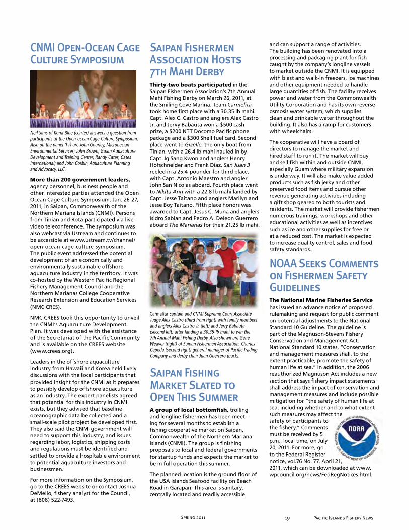
Neil Sims of Kona Blue (center) answers a question from participants at the Open-ocean Cage Culture Symposium. Also on the panel (l-r) are John Gourley, Micronesian Environmental Services; John Brown, Guam Aquaculture Development and Training Center; Randy Cates, Cates International; and John Corbin, Aquaculture Planning and Advocacy. LLC.
Saipan Fishermen Association Hosts 7th Mahi DerbyThirty-two boats participated in the Saipan Fishermen Association’s 7th Annual Mahi Fishing Derby on March 26, 2011, at the Smiling Cove Marina. Team Carmelita took home first place with a 30.35 lb mahi. Capt. Alex C. Castro and anglers Alex Castro Jr. and Jervy Babauta won a $500 cash prize, a $200 NTT Docomo Pacific phone package and a $300 Shell fuel card. Second place went to Gizelle, the only boat from Tinian, with a 26.4 lb mahi hauled in by Capt. Ig Sang Kwon and anglers Henry Hofschneider and Frank Diaz. San Juan 3 reeled in a 25.4-pounder for third place, with Capt. Antonio Maestro and angler John San Nicolas aboard. Fourth place went to Nikita Ann with a 22.8 lb mahi landed by Capt. Jesse Taitano and anglers Marilyn and Jesse Boy Taitano. Fifth place honors was awarded to Capt. Jesus C. Muna and anglers Isidro Sablan and Pedro A. Deleon Guerrero aboard The Marianas for their 21.25 lb mahi.
Carmelita captain and CNMI Supreme Court Associate Judge Alex Castro (third from right) with family members and anglers Alex Castro Jr. (left) and Jerry Babauta (second left) after landing a 30.35-lb mahi to win the 7th Annual Mahi Fishing Derby. Also shown are Gene Weaver (right) of Saipan Fishermen Association, Charles Cepeda (second right) general manager of Pacific Trading Company and derby chair Juan Guerrero (back).
Saipan Fishing Market Slated to Open This SummerA group of local bottomfish, trolling and longline fishermen has been meet-ing for several months to establish a fishing cooperative market on Saipan, Commonwealth of the Northern Mariana Islands (CNMI). The group is finishing proposals to local and federal governments for startup funds and expects the market to be in full operation this summer.
The planned location is the ground floor of the USA Islands Seafood facility on Beach Road in Garapan. This area is sanitary, centrally located and readily accessible
and can support a range of activities. The building has been renovated into a processing and packaging plant for fish caught by the company’s longline vessels to market outside the CNMI. It is equipped with blast and walk-in freezers, ice machines and other equipment needed to handle large quantities of fish. The facility receives power and water from the Commonwealth Utility Corporation and has its own reverse osmosis water system, which supplies clean and drinkable water throughout the building. It also has a ramp for customers with wheelchairs.
The cooperative will have a board of directors to manage the market and hired staff to run it. The market will buy and sell fish within and outside CNMI, especially Guam where military expansion is underway. It will also make value added products such as fish jerky and other preserved food items and pursue other revenue generating activities including a gift shop geared to both tourists and residents. The market will provide fishermen numerous trainings, workshops and other educational activities as well as incentives such as ice and other supplies for free or at a reduced cost. The market is expected to increase quality control, sales and food safety standards.
NOAA Seeks Comments on Fishermen Safety GuidelinesThe National Marine Fisheries Service has issued an advance notice of proposed rulemaking and request for public comment on potential adjustments to the National Standard 10 Guideline. The guideline is part of the Magnuson-Stevens Fishery Conservation and Management Act. National Standard 10 states, ”Conservation and management measures shall, to the extent practicable, promote the safety of human life at sea.” In addition, the 2006 reauthorized Magnuson Act includes a new section that says fishery impact statements shall address the impact of conservation and management measures and include possible mitigation for “the safety of human life at sea, including whether and to what extent such measures may affect the safety of participants to the fishery.” Comments must be received by 5 p.m., local time, on July 20, 2011. For more, go to the Federal Register notice, vol.76 No. 77, April 21, 2011, which can be downloaded at www.wpcouncil.org/news/FedRegNotices.html.

Spring 2011Pacific Islands Fishery News 20
respective island areas. The calendars are used as an outreach and education tool to promote sustainable fisheries and management that is community- and ecosystem-based and incorporates traditional knowledge and Western science. The calendars were produced with funding assistance from the NOAA Coral Reef Conserva-tion Program and are available for download at www.wpcouncil.org/education.
In American Samoa, the Council’s calendar partners were the Department of Marine and Wildlife Resources (DMWR) and the American Samoa Community College’s Samoan Studies Institute (ASCC SSI). The theme of the art contest was the “American Samoa archipelago ecosystem.” The winners included students from Manumalo Baptist School, Pavaiai Elementary School, Coleman Elementary School, Fa‘asao Marist High School and Nuuuli Vocational-Technical High School. The judges were Okenaisa Fauolo (director, ASCC SSI), Donald L. Hoffman (art director, American Samoa Department of Education), Maria Mauga-Vaofanua (environmental information coordinator, American Samoa DMWR), Fatima Sauafea–Leau (coral ecologist, NOAA), Veni Sopoaga (art specialist, American Samoa Department of Education) and Va‘asa Ta‘amu (American Samoa Environmental Protection Agency).
The 2011 Fanha‘aniyan Pulan CHamoru (Chamorro Lunar Calendar) features the contributions of the Chamorro Lunar Calendar Committee on Guam. The theme of the art competition was Fino’ Gualåffon: Respeta I Tano’ yan I Tasi (Moonlight Talk: Respect the Land and the Ocean). The students with the winning posters came from Mercy Heights, Agana Heights Elementary School, Bishop Baumgartner
Memorial Catholic School, Benavente Middle School, Father Duenas Memorial School and Simon Sanchez High School. The judging was held in November at the Univers-ity of Guam. The students were presented their awards on Jan. 30, 2011, at the Gupot Fanha`aniyan Pulan CHamoru (Chamorro Lunar Calendar Festival). Prizes were provided by Fish Eye Marine Park, Docomo Pacific and UnderWater World.
The 2011 Refaluwasch Pápáál Maram (Refaluwasch Lunar Calendar) features the contributions and advice of the CNMI Lunar Calendar Committee. The calendar highlights traditional fishing and conservation practices of the Refaluwasch, who along with the Chamorro, are the indigenous people of the Mariana Archipelago. The Refaluwasch calendar features the winning entries from an art competition on the theme of Awawel Kikilil Pungil Maram Ngely Malawas, Set Me Bwel, which means understanding moon phases in relation to our natural resources. The winning posters were submitted by CNMI students from Grace Christian Academy, Oleai Elemen-tary School, Hopwood Jr. High School and Marianas High School. The students received their awards on Jan. 28, 2011, during the Traditional Lunar Calendar Workshop on Saipan. Prizes were provided by the Council, Docomo Pacific, Fiesta Resort & Spa Saipan, McDonalds of Saipan and Micronesian Environmental Services.
The tide charts with the moon rise and set times for the Guam and CNMI calendars were provided by Barry Smith, retired, University of Guam’s Marine Laboratory. The seasonal fishing predictions were provided by the fishermen on CNMI and Guam.
For the fifth consecutive year, lunar calendars in Samoan, Chamorro and Refaluwasch have been produced
by the Western Pacific Regional Fishery Management Council in partnership with local committees and
organizations in American Samoa, Guam and the Commonwealth of the Northern Mariana Islands (CNMI).
As in past years, the 2011 calendars feature winning art from student poster contests conducted in the
Ignacio Dela Cruz, Council member and CNMI Department of Lands and Natural Resources secretary, with the students and teachers of the winning CNMI posters.
Left: Art by Julea L. Asi, Coleman Elementary School (honorable mention, grade levels 6-8), graces the cover of the 2011 American Samoa calendar.
Right: The cover of the 2011 Guam calendar features the art of Ralph Eurich S. Patascsil, Father Duenas Memorial High School, Guam (1st place, grade levels 9-12)
2011 Lunar Calendars and Art Contests
Spring 2011Pacific Islands Fishery News 20

Spring 2011 21 Pacific Islands Fishery News
The Traditional Lunar Calendar Workshop was convened by the Western Pacific Regional Fishery Management Council on Jan. 27 and 28, 2011, on Saipan, Commonwealth of the Northern Mariana Islands (CNMI). The participants in this first of its kind meeting came from American Samoa, Palau, Yap, Guam, Rota, Saipan, Oahu, Maui, Molokai and Moku o Keawe (the Big Island of Hawaii). They included approximately 30 indigenous practitioners, island fishermen, West-ern scientists, cultural educators, researchers, academics, designers and publishers who support the use of traditional lunar calendars to guide the ways we use, manage and educate others about natural resources and indigenous language and cultures.
The participants shared common challenges faced while trying to inte-grate traditional lunar calendars into today’s Western-dominated culture. They noted that the Western concept of learning is to write it down, while in traditional societies, knowledge is passed orally and a lot of information, including those related to moon phases, is kept in the family. They agreed that the traditional way of learning is to go out in the field, while the modern classroom is indoors. The participants pondered how to move educational institutions to include and mandate traditional ways of learning, to incorporate both ways of knowing, and to have more activities requiring
students to be outdoors and/or with the family and observing.
Another challenge noted was the lack of experts in traditional knowledge. Discussion included ways to teach not only the students, but also the teachers and the parents. Focus was also given to the importance of cultural authenticity as well as deciding what to share and what not to share. For example, it was noted that letting others know when the fish are running and turtles are nesting could lead to inappropriate harvesting.
The participants pointed out the simi-larities and differences in the lunar calendars being produced throughout the US flag and associated Pacific islands. They acknowledged that the goal is not to produce one product because different places have different objectives for developing their calendars.
The participants were highly satisfied with the workshop, appreciated the formation of a network to discuss these issues and were inspired to produce calendars that include more comprehensive information (e.g., farming as well as fishing, stars as well as moon and sun). The workshop also inspired indigenous language teachers to share how the lunar calendar is something that the Pacific community has in common.
The outcomes of the workshop will be considered by the Council as it
creates its 2012 lunar calendars, including one for Hawaii. The Council will also consider the results of one-on-one interviews and mini-focus groups being conducted by contractor QMark Research on the effectiveness of traditional lunar calendars as an outreach and management tool in Guam, CNMI, American Samoa and Hawaii.
Council Sponsors Fish Talk Radio in Hawaii, CNMIIn continuing efforts to reach out to fishermen, the Western Pacific Regional Fishery Management Council is sponsoring fish talk radio programs in Hawaii and the Commonwealth of the Northern Mariana Islands (CNMI). The Mike Buck “Go Fish” Show airs at 6 a.m. Saturdays in Hawaii on KHVH 830. The Council coordinates speakers and discussion topics for a 15-minute segment of the program. In the CNMI, the Council coordinates an hour-long program aired weekly in English, Chamorro and Refaluwasch on KKMP 1440 AM or 92.1 FM. You can also tune in via the web at www.cnmiradio.com. Interested in a show on a particular topic? Contact the Council at [email protected], and we will try to arrange it.
Workshop Inspires Lunar Calendar Creators and Users
Among the Lunar Calendar Workshop participants were (l-r) Cecilio Raiukiulipiy and Lino Olopai (CNMI Lunar Calendar Committee members), Manny Sikau (Guam Lunar Calendar Committee member), Margie Falanruw (Yap Almanac Calendar publisher), Valerio Mality and Andrew Rapou (CNMI Lunar Calendar Committee members) and Leo Racheilug (Council of Tamol and Yap Traditional Navigation Society, Federated States of Micronesia).
Spring 2011 21 Pacific Islands Fishery News
Phot
o by
Eric
Woo
Spring 2011Pacific Islands Fishery News 22
Finding Common Ground in Bycatch ManagementAt the 31st Annual Symposium on Sea Turtle Biology and Conservation, April 12, 2011, eight panelists of var-ious backgrounds gathered to search for common ground in fisheries by-catch management. Bycatch is one of the many threats to sea turtles, and the reduction of sea turtle by-catch has been a primary thrust of conservationists worldwide. However, a trusting dialogue among the primary stakeholders to reach this goal has remained elusive. In the United States, like elsewhere, these parties include state and federal fisheries manage-ment agencies, the fishing industry, environmental groups, seafood consumers and the general public.
The panel featured Marydele Donnelly, Sea Turtle Conservancy; Pete Dupuy, California commercial fisherman; Mark Helvey, National Marine Fisheries Service (NMFS) Southwest Regional Office; Ray Hilborn, University of Washington; Steve Kennelly, New South Wales Department of Primary Industries, Australia; Sean Martin, Hawaii Longline Association; Dale Squires, NMFS Southwest Fisheries Science Center (SWFSC); and Todd Steiner, Turtle Island Restoration Network.
With Stewart Allen from NMFS Pacific Islands Fisheries Science Center (PIFSC) as an engaging moderator, the three-hour special session attracted nearly 1,000 symposium participants. The panel highlighted the complex perceptions that surround the issue and shed light on how solutions may be derived. It became clear that one roadblock is disagreement about the nature of the problem and its scale.
On one hand, the key concern is the number of turtles caught, whereas others view the primary issue as sustain-able fisheries or global food supply. On one hand, some view a 90 percent reduction of sea turtle bycatch achieved in the Hawaii longline fishery as a success, whereas others believe that a problem persists until zero bycatch has been achieved. Some see techno-fixes and economic solutions as the key to solving sea turtle bycatch issues, whereas others see such solutions as inadequate unless all players recognize overfishing as the problem. But then again, others proffer that overfishing is not as big of an issue as once thought and one that is being addressed. These views expressed by the panelists reflect the types of opposing views underlying conservation issues.
However, not all was about disagree-ments. One strong theme that resurfaced many times and which all panelists agreed to is that objective science is a necessary tool for reaching common ground. The use of biased science in pursuit of one’s agenda was frowned upon.
This special session was organized by Allen, Asuka Ishizaki (Western Pacific Regional Fishery Management Council), T. Todd Jones (Joint Institute of Marine and Atmospheric Research), Jeff Seminoff (NMFS SWFSC) and Bryan Wallace (Conservation International). A report and video of the session will be made available at a later date. For more information, contact Ishizaki at [email protected].
Workshop Investigates Link between Seabirds and Pelagic Fish A workshop on the ecological interactions of seabirds, pelagic fishes and their prey was convened by the Marine Conservation Biology Institute (MCBI) between April 5 and 7, 2011, in Honolulu. The workshop was funded by NOAA as part of an award granted to MCBI to make recommendations regarding the management of the resources of the Pacific Remote Islands Marine National Monument (PRI MNM). Seabird and pelagic fish science experts participated, including Paul Dalzell, senior scientist for the Western Pacific Regional Fishery Management Council.
The workshop examined the link between seabirds and pelagic fishes to determine the degree by which tuna biomass affects seabird reproductive performance in the Western and
protected species

Spring 2011 2� Pacific Islands Fishery News
Central Pacific Ocean (WCPO). The link between seabirds and pelagic fishes is better understood in the Eastern Tropical Pacific but lacks scientific evidence in the WCPO. Workshop participants were asked to recommend research to expand understanding of seabird and pelagic fish inter-relationships in the WCPO, as they relate to the Monument management objectives. Five research topics were explored:
• Foraging ranges of seabirds breed-ing in the WCPO and their inter-annual and intra-annual variability and associations with oceanographic conditions.
• Food habits of breeding seabirds in the WCPO and their inter-annual and intra-annual variability and associations with oceanographic conditions.
• Distribution and behavior of epipelagic fishes with respect to oceanographic conditions to look for relationships with inter- and intra-annual variability in seabird populations and breed- ing performance.
• Methods to ascertain and measure the limiting factors for seabird reproductive performance in the WCPO.
• Importance of subsurface predators to tropical seabird foraging.
The workshop report will summarize hypotheses to be tested and research methods that would provide science to guide long-term seabird, pelagic fisheries and ecosystem management decisions.
As part of the NOAA grant, MCBI is also tasked to conduct 1) a scientific review of large marine protected areas (MPAs) that have relevant lessons for PRI MNM, including MPAs designed to protect pelagic and highly migratory species as well as large marine eco-systems; and 2) a rapid assessment of the ecological history of the central Pacific region to summarize what is known about the status and trends of natural resources of the islands and their surrounding waters.
The PRI MNM was established on Jan. 6, 2009, through presidential executive order. The monument incorporates approximately 86,888 square miles within its boundaries, which extend 50 nautical miles from the mean low water lines of Howland, Baker, and Jarvis Islands; Johnston, Wake, and Palmyra Atolls; and Kingman Reef.
Industry Sues After NMFS Settles with E-NGOs on TurtlesOn April 8, 2011, the Hawaii Longline Association filed suit against the Nation-al Marine Fisheries Service (NMFS) and Gary Locke, in his official capacity as Secretary of the Department of Commerce, for allegedly imposing incidental take limits for loggerhead sea turtle interactions and related fishery closure requirements for the Hawaii-based commercial longline shallow-set fishery without due process, in contravention of the best available science and in violation of applicable procedural and substantive requirements.
The suit addresses the Jan. 31, 2011, order by US District Judge David Alan Ezra implementing a settlement between NMFS and the plaintiffs that vacated and remanded portions of a 2008 biological opinion and a 2009 regulation that set the limit for Hawaii shallow-set longline fishery’s annual interaction with loggerhead sea turtles at 46. Under the settlement agreement terms approved by the Court, NMFS was required to initiate appropriate
rule-making to reinstate the annual incidental take for loggerheads at 17, consistent with the previous 2004 biological opinion and regulation.
The court order entered the settle-ment agreement terms between Turtle Island Restoration Network, the Center for Biological Diversity and Kahea: The Hawaiian Environmental Alliance (collectively the “Plaintiffs”) and the Commerce Department, NMFS and Locke (collectively the “Federal Defendants”). For a copy of the terms, go to www.wpcouncil.org/news.
NMFS was also ordered to issue a new biological opinion and incidental take statement for the Hawaii-based shallow-set longline fishery no later than 135 days after NMFS’ final determination on its proposed listing of nine distinct population segments (DPSs) of loggerhead sea turtles under the Endangered Species Act (ESA).
NMFS and the US Fish and Wildlife Service have proposed the designation of seven loggerhead DPSs worldwide as endangered (North Pacific Ocean, South Pacific Ocean, Northwest
Atlantic Ocean, Northeast Atlantic Ocean, Mediterranean Sea, North Indian Ocean, and Southeast Indo-Pacific Ocean) and two as threatened (Southwest Indian Ocean and South Atlantic Ocean). The Services extended the deadline for determining the ESA status and listing of the nine DPSs of loggerhead sea turtles is Sept. 16, 2011. For more information, visit the NOAA Fisheries Office of Protected Resources website at http://www.nmfs.noaa.gov/pr/.
Actual interactions in swordfish fishery since reopening in 2004
Species
Loggerhead
Leatherback
Olive Ridley
Green
2004
1
1
0
0
2005
12
8
0
0
2006
17
5
1
0
2007
15
5
1
0
2008
0
2
2
1
2009
3
9
0
1
2010
7
8
0
0
100% observer coverage of Hawaii shallow-set longline vessels has been conducted since 2004. No turtle mortalities have been observed, and all turtles have been released alive.

Spring 2011Pacific Islands Fishery News 2�
Addressing issues related to the indigenous fishing rights of US Pacific Islanders has been a major part of the work of the Western Pacific Regional Fishery Management Council since its inception in 1976. These efforts contributed to amendments in the 1996 reauthorized Magnuson-Stevens Fishery Conservation
and Management Act (MSA) that recognized special fishing practices for native peoples in American Samoa, Guam, Hawaii and the Commonwealth of the Northern Mariana Islands (CNMI), including establishment of the Western Pacific Community Development Program (CDP). The CDP promotes the participation of island communities in fisheries that they traditionally depended upon, but in which they may not have had the capabilities to support continued and substantial participation. The authority for the Western Pacific CDP was reaffirmed in Section 305(i)(2) of the 2006 reauthorization of the MSA.
Recognizing the potential for a broad variety of comm-unity initiatives to come forward for consideration under the CDP, the Council began in 2008 to develop a standard procedure to receive, review, approve and
implement future CDP initiatives. These procedures were transmitted to the Secretary of Commerce for final approval as amendments to the Council’s Fishery Ecosystem Plans. They were published as a final rule in the Federal Register on Sept. 3, 2010 (FR 75 54044) and Nov. 5, 2010 (FR 75 68119). They outline the major pieces of information that must be provided to apply for a CDP project. These include a community development plan that identifies the fishery that the community wishes to participate in, the challenges facing the community in gaining access to the fishery, the anticipated benefits to the community by gaining access to the fishery and the principal individuals participating in the project. The applicant must also provide documentation of eligibility based on six criteria, a description of the proposed fishing activities and justification for the proposed fish-ing access. If a vessel is to be used by the community to conduct fishing activities, a community must also provide the vessel’s name and official number (USCG documentation, state, territory, or other registration number), vessel length overall, displacement, fish hold-ing capacity, any valid federal fishing permit number(s) and the name, address and telephone number of the vessel owner(s) and operator(s).
For more information, contact the Council’s indigenous coordinator, Charles Kaaiai, at [email protected].
The eight Regional Fishery Management Councils (RFMCs) and the National Marine Fisheries Service (NMFS) continue efforts to implement the new mandates in the
2006 reauthorized Magnuson-Steven Fisheries Management Act. Among these directives are the establishment of annual catch limits (ACLs) for all federally managed species (unless exempted) and improving the collection of recreational catch data. Life history information of the species coupled with recreational and commercial catch data are used to produce stock assessments, upon which the ACLs are based.
Currently, the state of scientific information that directly relates to setting ACLs in the Western Pacific Region can be considered as “data-poor.” Stock assessments have been conducted for the seven main Hawaiian Island deepwater bottomfish; for American Samoa, Guam and Commonwealth of the Northern Mariana Islands bottomfish; and for Northwestern Hawaiian Island lobsters; but none have been completed for any of the hundreds of coral reef fish. Compared to other US fish-ery regions, the Western Pacific Region has had the fewest stock assessments for its managed stocks.
Steps Refined to Support Communities in Traditional Fishing
Pacific Islands Fishery News 2� Spring 2011
Regional Update on National Initiatives

Spring 2011 2� Pacific Islands Fishery News
The Western Pacific Region is not alone in its need for better scientific information to implement ACLs. To address this issue, nationally recognized experts from various universities, representatives from the RFMCs and NMFS stock assessment scientists met Feb. 15 to 17, 2011, in Silver Spring, Md. The Pacific Islands/Western Pacific Region was represented by Western Pacific Regional Fishery Management Council staff members Sarah Pautzke and Marlowe Sabater and NMFS scientists Dr. Gerard DiNardo and Dr. Jon Brodziak. A report is being prepared by NOAA and the RFMCs that documents the discussions and will provide guidance for future ACL developments. Meanwhile, the Council staff prepared an internal report on the outcomes of the workshop, which is available at www.wpcouncil.org/library.html.
The Western Pacific Council is also in the process of amend-ing its five fishery ecosystem plans (FEPs) to establish a mechanism for specifying ACLs and accountability measures (AMs), to adopt the ecosystem component species classification described in the NMFS advisory guidelines for National Standard 1, and to identify management unit species that have statutory exceptions to the ACL and AM requirements. On March 16, 2011, NMFS announced the Council’s proposed amendment in the Federal Register notice. For a copy, go to http://edocket.access.gpo.gov/2011/pdf/2011-6151.pdf.
In its effort to improve the collection and reporting of recreational fishing data, NMFS hosted a Recreational Data Timeliness Workshop on March 15 and 16, 2011. Concerns regarding the timeliness of the data, especially with respect to its impact on ACLs and AMs, served as a discussion point among representatives from NMFS, the RFMCs, Marine Fisheries Commissions, States and the recreational community. Results of the workshop will be posted on the Marine Recreational Information Program (MRIP) website at www.countmyfish.noaa.gov.
In April 2011, the MRIP Operations Team reviewed proposals for pilot projects that will continue revising the existing Marine Recreational Fishing Statistical Survey (MRFSS), as recommended by the National Research Council, to improve recreational fishery catch and effort estimates. Among the proposals was one submitted by the Western Pacific Council and its partners to test the efficacy of collecting data from vessel owners/captains rather than individual anglers. Noti-fications of project approvals and potential funding will be provided in the summer or fall 2011.
On May 2, 2011, the MRIP Registry Team met by telecon-ference with the Western Pacific Council to discuss exempt-ing main Hawaiian Islands (MHI) non-commercial bottomfish federal permit holders from the National Saltwater Angler Registry. Like MRIP, the Registry was mandated as part of
the 2006 reauthorized Magnuson Act and is part of the redesign of the MRFSS. The Registry serves as a phone book of recreational fishermen, providing NMFS with a tool to survey them. Information collected through the Registry is combined with information collected by the MRIP angler intercept survey to provide estimates of recreational fishing catch and effort. All fishermen and spearfishermen over the age of 16 must register if they fish in the exclusive economic zone (in Hawaii, 3 to 200 miles offshore) or for anadromous species (ascend rivers from the sea for breeding).
Exemptions to the Registry were made for States and Terri-tories that can provide the information that the Registry would be collecting from either local licenses/registries or through a regionally based survey. Guam, CNMI and American Samoa all applied for, and received, exemptions to the Registry based on their local creel surveys qualifying as a regionally based survey. Nearly all other coastal States
have received exemptions also, with the exception of Hawaii, New Jersey, the US Virgin Islands (USVI) and Puerto Rico. New Jersey has recently passed legislation to create a free state-based fishing registry, and USVI and Puerto Rico are working on potential exemptions. Hawaii could seek an exemption to the Registry if it develops a fishing registry/license or a regional survey.
The Registry was implemented in 2010 with 2,512 registered fishermen in the State of Hawaii. In 2011, an annual fee of $15 was applied to the registry with indigenous Hawaiian fishermen exempted from paying the fee. Those fishermen who held a federal MHI Non-commercial Bottomfish Permit by December 2010 were automatically registered and avoided having to pay the fee. Fishermen who received a federal permit after December must register and pay the fee. Fishermen are concerned about having to pay federal fees for both the permit and the Registry. They also note that having both the permit and the Registry is redundant, as the end result would be collecting the same catch data from the fishermen.
Later this spring, NOAA will release the first wave of MRIP data using its new method, which aims to sync the estimation design with the sampling design, to eliminate unpredictable biases in the estimates. This new methodology will be applied to historical MRFSS surveys dating back to 2003 as well as to all future estimates beginning in early 2011. This represents the first step in the change from MRFSS to MRIP.
For more information on MRIP, the Registry and other nation-al recreational fishing initiatives, visit www.countmyfish.noaa.gov or contact Joshua DeMello, MRIP Operations Team participant, at (808) 522-7493.
2� Pacific Islands Fishery NewsSpring 2011

Spring 2011Pacific Islands Fishery News 2�
EARTHQ
UAKE &
TSUNA
MI
Pacific Islands Fishery News 2� Spring 2011
Japan’s Earthquake, Tsunami Severely Impact Coastal Fisheries
For fishermen of Miyagi, Iwate and Fukushima prefectures in northeastern Japan, March 11, 2011, started as just another day of bringing their harvest back to port and preparing for their next trip out to sea or tending to their aquaculture facilities. That is, until the biggest earthquake in Japan’s recorded history hit at 2:46 p.m. Within 30 minutes everything they built and cherished over generations was washed away by a tsunami so large and strong that it reached 10 miles inland in some areas and cleared some of the tallest sea walls built to protect port towns from exactly this type of disaster.
Prior to the earthquake, Miyagi had the fourth highest fisheries and aquaculture production combined of all prefectures in Japan and the second highest production in processed seafood industry (such as kamaboko products). Off the northeast coast of Japan, the Kuroshio and Oyashio Currents collide to create productive fishing grounds for species such as Pacific saury, mackerel and skipjack tuna. The area also had high aquaculture productions of oysters, scal-lops, wakame seaweed and nori seaweed. Coastlines of Miyagi, Iwate, and Fukushima are dotted with numerous fishing towns and ports of various sizes, many of which were unknown to the world until the recent tsunami.
The initial assessment of damage conducted in the weeks following the tsunami confirmed the fear of many regarding the fate of coastal fisheries in northeastern Japan. As of March 31, 2011, estimate of damage to marine fisheries, aquaculture and marine processed product industries in Miyagi, Iwate and Aomori was at 476.4 billion yen (US$5.67 billion).
All 142 fishing ports in Miyagi suffered damage, and many were completely destroyed. According to Miyagi Prefecture’s marine industry promotion department, only 1,404 of the 13,409 registered small fishing vessels (less than 20 tons) remained in “usable condition.” In addition, most of the aquaculture facilities had been washed away or damaged in the tsunami. Miyagi alone suffered 374.2 billion yen (~US$4.45 billion) in loss. According to some estimates, the full recovery from the tsunami will take more than 10 years.
In Iwate, all 31 ports managed by the prefecture suffered damage. The estimated damage to the marine product industry is approximately 98 billion yen. Much of Iwate’s 14,300 vessels operating in 12 coastal municipalities were damaged or destroyed. Damage to the industry in Fukushima is unknown, as assessment of damage has been delayed due to the nuclear power plant situation.
In the meantime, some fisheries associations have begun work to get their operations back together to lend hope to northern Japan. Shinetsu Kikuchi, a 65-year old leader of the Watari Town fisheries association in Miyagi, wants to resume fisheries in Watari Town as early as May of this year. The association lost 10 of its 197 members, and many more town residents have been lost or are still missing. Watari Town was known for its salmon pound-net fisheries, flounder/halibut bottom trawl fisheries and nori seaweed aquaculture. Of the 84 vessels registered to the association, all but two sank or were pushed on land. After surveying the vessels that ended up on land, they determined that about 10 could be repaired.
Many challenges remain for this small fishing port before vessels can leave port again. Larger ports such as Kesennuma and Ishimaki have received the government’s immediate attention for restoration, but government support for smaller ports will likely come later. Further, many of Watari’s association members, with its aging membership, have expressed their intention to retire from fishing as a result of the disaster. Kikuchi expects the association’s membership to decline to less than 100 as a result of this disaster.
“Because of this, we should not ‘restore’ the port to its original state, but instead ‘reconstruct’ into something new,” Kikuchi was quoted saying in the March 29, 2011, edition of the Japanese newspaper Sankei Shinbun. He has already decided on the vessel that will be the first to resume fishing: Seikou-Maru, a bottom trawl vessel that miraculously remained just a few meters away from the sea wall. “The owner of the vessel lost his wife,” Kikuchi noted. “[For Seikou-Maru to be the first to return to sea] will be the best tribute to her too.”
Spring 2011 2� Pacific Islands Fishery News
Three members have recently joined the Western Pacific Regional Fishery Management Council. William Aila represents the Hawaii Department of Land and Natural Resources; Mariquita Taitague, the Guam Department of Agriculture; and RAdm. Charles W. Ray, the US Coast Guard 14th District. These people replace Laura Thielen, Joseph Torres and RAdm. Manson Brown, respectively.
Two scientists have joined the Council’s Scientific and Statistical Committee. Dr. Domingo Ochavillo from the American Samoa Department of Marine and Wildlife Resources (DMWR) and Michael Tenorio from the Commonwealth of the Northern Mariana Islands (CNMI) Division of Fish and Wildlife (DFW). They replace Marlowe Sabater and Michael Trianni, respectively.
Former SSC member Sabater has joined the Council staff as its marine ecosystem scientist. He received a master’s degree in marine science at the Marine Science Institute of the University
of the Philippines. He worked at World Wildlife Fund in the Philippines and the American Samoa DMWR before joining the Council.
The CNMI Department of Lands and Natural Resources (DLNR) has recruited Arnold Palacios and Richard Seman to work at its Division of Fish & Wildlife as the director and the aquatic education and outreach specialist, respectively. Both are former data managers and directors for the division. Palacios is also a former member and speaker of the CNMI House of Representatives. Seman is a former secretary of the DLNR. Both have served as Council members representing the CNMI. Palacios graduated from Portland State University, Ore., and Seman from the University of Guam.
The Council recently bid a fond farewell to Jean Ilei Beniamina of Niihau and Clement “Junior” Kanuha Jr. of Kalaoa, Moku O Keawe (the Big Island). Both were active in the Council-sponsored Puwalu series
and strong supporters of the Aha Moku system of natural resource management on their respective islands, before passing away. Ilei is known statewide as an award-winning singer/songwriter and leading community organizer and liaison for Hawaiian education. She is one of the founders of Aha Punana Leo, which beckons Hawaiians to reclaim their native language and culture. Junior, a retired commercial diver and owner of Sunlights Hawaii, was the caretaker of Keolanahihi Heiau.
Spicy A’u TartareBy Chef Grant Sato Kapiolani Community College’s Culinary Institute of the Pacific
Serves 6
Ingredients:
1 lb Small diced a‘u (marlin) 1 Tbsp Salt 2 Tbsps Water ½ cup Chopped green onions 2 Tbsps Wasabi tobiko 1 tsp Sriracha sauce 1 Tbsp Oyster sauce 1 Tbsp Red ebi flakes 1 Tbsp Toasted sesame seeds 2 Tbsps Mayonnaise ¼ lb Sweet potato or taro chips
Method and Plating:
Salt the a‘u and sprinkle with water. Toss lightly and set aside for a minute. Place the a‘u in a bowl, add all of the other ingredients and stir well to combine. Serve chilled with chips.
Jean Ilei Beniamina Clement Kanuha Jr.
Message from the Executive Director
This year, 2011, is the 35th anniversary of the Magnuson-Stevens Fishery Conservation and Management Act, which created the eight Regional Fishery Management Councils (RFMCs). The Act also extended US federal jurisdiction to the 200-nautical-mile boundary of the US Exclusive Economic Zone (EEZ). The Act has had two major amendments, in 1996 and 2006, adding new requirements of fishermen and the RFMCs. The single most important feature of the revisions was the guideline requiring fishery managers to end overfishing of US fish stocks. Overfishing was defined initially as the level of fishing where a stock would become “recruitment overfished,” i.e., unable to replace removals from the population by natural and fishing mortality. The 1996 reauthorization set the overfishing bar a great deal higher by requiring the RFMCs to manage stocks so that fish biomass was greater than that required to generate the maximum sustainable yield (MSY). More stringent yet was the requirement in the 2006 reauthorization that required the Councils’ Scientific and Statistical Committees to set limits to catches that at the maximum could have only a 50% chance of overfishing the stock and include buffers that would maintain catches below this level.
The results of ending overfishing of US federally managed fish stocks has been the steady recovery of fish stocks that were already overfished from domestic and foreign fisheries prior to 1976 or became overfished in the years after 1976 when foreign fishing effort was replaced by domestic fishing. Every year, Congress receives a report on the status of US fish stocks, and every year the number of stocks that are overfished or subject to overfishing continues to shrink.
But no good deed goes unpunished. A substantial marine environmental advocacy sector grew up in the 1990s that has pursued numerous lawsuits against the National Marine Fisheries Service and the promotion of seemingly magic solutions to maintain sustainable fisheries. In the 1990s it was marine protected areas (MPAs) and, in this decade, it is catch shares or individual fishing quotas. Indeed one of the strongest proponents of catch shares is the current head of NOAA, Dr. Jane Lubchenco, who was previously Board of Trustees vice chair of the Environmental Defense Fund, an organization that has been at the forefront of advocating catch shares as the solution to overfishing.
Uncertainties arising from endless litigation, MPAs and catch shares have taken their toll on the US fishing industry, which continues to shrink. Fishing communities dwindle, and no young blood replaces fishermen when they retire or die. As American fishermen become scarce, less regulated foreign fleets will continue to fill the US market demand for seafood with even more negative consequences for fishery conservation. Consequently the 35th anniversary of the Magnuson Act and its success is tinged with anxiety for the future of US domestic fisheries and the realization that, while we may well conserve the fish, who will conserve our fishermen?
Kitty M. Simonds Executive Director
Council Family Updates
2� Pacific Islands Fishery NewsSpring 2011
Spring 2011Pacific Islands Fishery News 28
June
7-9 Capitol Hill Ocean Week, Washington, DC
8 NOAA Fish Fry, Washington, DC
8-9 Smithsonian Sustainable Seafood Conference, Washington, DC
13-15 107th Scientific and Statistical Committee Meeting, Honolulu
15-18 151st Western Pacific Regional Fishery Management Council Meeting, Honolulu
16 Fishers Forum “The Future of Honu Management,” Honolulu
21-23 National Coastal and Marine Spatial Planning Workshop, Washington, DC
29-July 3 National Marine Educators Association Conference, Boston, Mass.
29-July 8 Inter-American Tropical Tuna Commission, La Jolla, Calif.
July
12-14 Kobe 3 Meeting of the 5 Tuna Regional Fisheries Management Organizations, La Jolla, Calif.
17-21 Coastal Zone 2011 Conference, Chicago, Ill.
20-25 International Scientific Committee for Tuna and Tuna-like Species in the North Pacific Ocean, San Francisco, Calif.
23-24 Saipan International Fishing Tournament, Smiling Cove Marina, Saipan
25-29 Hawaii International Billfish Tournament, Kailua-Kona, Hawaii
August
July 31- Aug 4 Council’s Climate Change and Coastal and Marine Spatial Planning Workshops, Honolulu
1-5 Pacific Basin Development Council, Lanai City, Hawaii
9-17 7th Regular Session of the Scientific Committee of the Western and Central Pacific Fisheries Commission, Pohnpei, Federated States of Micronesia
12-13 Guam Organization of Saltwater Anglers Derby, Hagatna, Guam
14 Gupot Y Peskadot” (Fishermen’s Festival), Hagatna, Guam 20-21 Guam Marianas International Fishing Derby, Hagatna, Guam
23-25 Native Hawaiian Convention, Honolulu
27 Marianas Spearfishing Challenge, Hagatna, Guam
September
5-9 7th Regular Session of the Northern Committee of the WCPFC, TBD
14-17 27th Lowell Wakefield Fisheries Symposium (Fishing People of the North: Cultures, Economies, and Management Responding to Change), Anchorage, Alaska
19-22 OCEANS 2011 Conference (Oceans of Opportunity: International Cooperation and Partnership across the Pacific), Kona, Hawai‘i
28-Oct 4 Technical and Compliance Committee, Western and Central Pacific Fisheries Commission, Pohnpei, Federated States of Micronesia
October
4-6 4th National Scientific and Statistical Committee Workshop, Williamsburg, Va.
17-19 108th Scientific and Statistical Committee Meeting, Honolulu
19-22 152nd Western Pacific Regional Fishery Management Council Meeting, Honolulu
25-27 Marine Fisheries Advisory Committee Meeting, Washington, DC
25-27 New Council Member Training, Washington, DC
November
5-10 18th Annual Wildlife Society Conference, Waikoloa, Hawaii
18-20 22nd Japanese Sea Turtle Symposium, Okinoerabu, Japan
December
5-9 8th Regular Session of the Western and Central Pacific Fisheries Commission, Koror, Palau
Upcoming Events 107th SSC and 151st Council Meetings The public is invited to the Western Pacific Regional Fishery Management Council’s Scientific and Statistical Committee (SSC) meeting, 8:30 a.m. to 5 p.m., June 13 to 15, 2011; Standing Committee meeting, 3 to 5 p.m. June 15; and full Council meeting, 9 a.m. to 6 p.m., June 16 to 18, at the Waikiki Beach Marriott Resort & Spa, 2552 Kalakaua Ave., Honolulu, HI (ph. 808 922-6611). Among the key agenda items are annual catch limits for coral reef finfish, Kona crab, deepwater shrimp, lobster, mollusks, precious coral, Hawaii bottomfish and Hawaii akule/opelu; Acceptable biological catch for Hawaii squid; Bottomfish essential fish habitat and habitat areas of
particular concern; Management of shallow-set longline fishery for swordfish in American Samoa; Longline limited entry access to the American Samoa large pelagic vessel area closures; Pelagic fishing vessel landing requirements for American Samoa; Overfishing of Pacific bluefin tuna; Management of bigeye tuna in the Western and Central Pacific; Management of offshore aquaculture; Guam and CNMI Marine Conservation Plans; and Sustainable Fisheries Fund Marine Conservation Plan. For more information, go to www.wpcouncil.org/meetings or contact the Council at (808) 522-8220 or [email protected].
Fishers Forum “The Future of Honu Management” This public event is part of the 151st Council meeting and will be held 6 to 9 p.m., June 16, 2011, at 2933 Kalakaua Ave., Honolulu (oceanside of Kapiolani Park); ph. (808) 923-5722. Informational booths and a panel discussion of fishermen, Native Hawaiians, scientists, managers, tourist industry representatives and others will explore the status of the Hawaiian green sea turtle and begin a dialogue of how this species may be managed in the future, once the recovery of the species is recognized. What part will Native Hawaiians play? What do the fishermen and scientists say? Learn more, and voice your opinion. Parking is validated; refreshments will be served. Families welcome. Educational activities for children will be available.
2011 Council Calendar
Printed on recycled paperPacific Islands Fishery News 28
One student helps another to “hear” the shells in stereo at the Council booth during the Bishop Baumgartner School’s annual picnic, May 20, 2011, Ypao Beach, Guam.
Spring 2011