spring survey of caribou in the vicinity of the dso3
TRANSCRIPT

QUÉBEC : 57, chemin du Domaine, Beaumont QC G0R 1C0 • 418-649-3641
MONTRÉAL : 1453, rue Beaubien Est, bur. 301, Montréal QC H2G 3C6 • 514-509-6572
MONTÉRÉGIE : 252, de Normandie, St-Basile-le-Grand QC J3N 1V5 • 450-283-6026 www.hemis.ca
Tata Steel Minerals Canada Ltd.
Spring Survey of Caribou in the Vicinity of the DSO3 Sector
April 2011
Final Report
N/D: PR185-03-11
July 22, 2011


SPRING SURVEY OF CARIBOU IN THE VICINITY OF DSO3 SECTOR, APRIL 2011 FINAL REPORT
i
PROJECT TEAM
GROUPE HÉMISPHÈRES
Hugo T. Robitaille Biologist, M.Sc. Env, Project director, Review and quality control
Natalie D'Astous Consulting Biologist, M.Sc Biol., Survey and report review
Simon Barrette Biologist, M.Sc. Biol., Survey and report drafting
Julie Tremblay Biologist, B.Sc. Biol., DESS in Geomatics, Mapping
Myrtille Husson Project manager, BAA, Management and review
Collaborators
Donat Pinette Field assistant
(see also the list of personal communications in the Reference Section)
Cover page photographs: Foreground: Part of the sector surveyed, south-west of the Howells River Background: Old ptarmigan tracks in the crusted snow
Recyclable and made of 100% recycled paper. This report has been formatted for double-sided printing.
This document should be cited as :
Groupe Hémisphères (July 2011) Spring Survey of Caribou in the Vicinity of the DSO3 Sector. FInal Report submitted to Tata Steel Minerals Canada Ltd., 7 p. and 1 appendix.
RÉVISION AND PUBLICATION Number Date Modification or publication data
00 2011-07-19 Preliminary Technical Report 01 2011-07-22 Final Report

SPRING SURVEY OF CARIBOU IN THE VICINITY OF DSO3 SECTOR, APRIL 2011 FINAL REPORT
ii
TABLE OF CONTENTS
LIST OF FIGURES ............................................................................................................................................ II LIST OF APPENDICES..................................................................................................................................... II 1 CONTEXT................................................................................................................................................... 1
1.1 OBJECTIVES..........................................................................................................................................1 2 METHODOLOGY ....................................................................................................................................... 1
2.1 FIELD PREPARATION..............................................................................................................................1 2.2 FIELD TECHNIQUES ...............................................................................................................................2
3 RESULTS ................................................................................................................................................... 2 3.1 CARIBOU...............................................................................................................................................2 3.2 OTHER WILDLIFE...................................................................................................................................2
4 DISCUSSION.............................................................................................................................................. 2 5 CONCLUSION............................................................................................................................................ 5 6 REFERENCES ........................................................................................................................................... 6 PERSONAL COMMUNICATIONS .................................................................................................................... 6 BIBLIOGRAPHY................................................................................................................................................ 6 APPENDICES.................................................................................................................................................... 7
LIST OF FIGURES
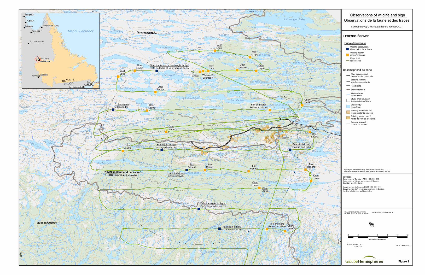
Figure 1. Observations of Wildlife and Sign....................................................................................................... 3
LIST OF APPENDICES
Appendix I............................................................................................................ Photo of the snow cover

SPRING SURVEY OF CARIBOU IN THE VICINITY OF DSO3 SECTOR, APRIL 2011 FINAL REPORT
1
1 CONTEXT
Tata Steel Minerals Canada Ltd. is the proponent of the Direct-Shipping Ore Project (“DSOP”), two components of which, known respectively as the Elross Lake Area Iron Ore Mine (“ELAIOM”) and the Joan Lake Direct Shipping Ore Project (“JLDSOP”), are located in the Province of Newfoundland and Labrador.
The ELAIOM was released from further environmental assessment by the Government of Newfoundland and Labrador (“GNL”) on January 5, 2011, while the JLDSOP was released on March 16, 2011.
In both cases, a condition of the release was that TSMC must continue the spring surveys carried out in 2009 and 2010 (D’Astous and Trimper 2009, 2010a, 2010b) to ascertain the presence of sedentary caribou in the vicinity of the proposed mines.
The area of the Ungava Peninsula, near the ELAIOM and the JLDSOP, includes the ranges of both migratory and sedentary caribou. The George River Caribou Herd (GRCH), a migratory ecotype, was estimated at 385 000 individuals in 2001 (based on a post-calving estimate) (Couturier et al. 2004) but was estimated at only 74 000 in 2010 (Dr Steeve Côté, Caribou-Ungava pers. comm.). When the herd migrates through the Schefferville area, hunting provides large quantities of country food for local residents. However satellite telemetry done by MRNF in 2009, 2010 and 2011 and observations by local residents (R. McKenzie, pers. comm.) confirmed that George River caribou did not migrate through this area during the fall and winter of 2008-2009, 2009-2010 and 2010-2011.
Sedentary caribou formerly occurred in the vicinity of Schefferville. The McPhadyen Caribou Herd (MCH) was identified in the area in the mid-1980s (Phillips 1982, Saint-Martin 1987, Bergerud et al. 2008). As sedentary caribou are classified as endangered in Canada and in Labrador (COSEWIC 2001, Newfoundland and Labrador Endangered Species Act), the GNL is concerned that those caribou may occur in the vicinity of the ELAIOM.
The present report describes the survey conducted by TSMC in April, 2011.
1.1 Objectives
The main objective of the survey was to determine whether sedentary caribou were present within a specified radius of the TSMC DSO project sites immediately prior to the calving season and to estimate the age and confirm the sex of each animal encountered. In the absence of GNL representatives, no capturing or collaring was planned during this survey.
2 METHODOLOGY
2.1 Field Preparation
In 2009, a survey area, delineated as a radius of 50 km centred on the ELAIOM, was established (D’Astous and Trimper 2009). The study area approved by GNL in 2010 (K. Miller, Ecosytem Management Ecologist, Government of Newfoundland and Labrador, pers. comm.) consisted of a radius of 20 km centred on the ELAIOM. This same 20 km radius was used in this survey.
As was the case in 2009 and 2010, before the start of the survey letters prepared by TSMC explaining its objectives were sent to the leaders of the First Nations concerned, namely Innu Nation, Innu Takuaikan Uashat mak Mani-Utenam (ITUM), Naskapi Nation of Kawawachikamach (NNK) and Nation Innu Matimekush-Lac John (NIMLJ). This contact was important for information purposes, but also to direct the survey aircraft away from spring hunting parties. Upon arrival in Schefferville, the Study Team received

SPRING SURVEY OF CARIBOU IN THE VICINITY OF DSO3 SECTOR, APRIL 2011 FINAL REPORT
2
confirmation that goose hunting would not begin until the following weekend. Because of this timing and the shorter radius of interest in 2010, the entire study area could be surveyed.
2.2 Field Techniques
The survey was completed on April 27, 2011. Survey lines were overflown with an Astar 350BA helicopter at an altitude of approximately 100 m (AGL) and at an average speed of 160-200 km/hr depending on conditions and/or habitat. Flight lines were spaced every 4 km, with transects oriented in a NW/SE direction consistent with the topography. All observations, tracks, land use and other relevant information, such as weather and start and end times of each transect, were recorded by the navigator. All tracks observed were identified if possible (e.g., ptarmigan, wolf, fox, etc.). If fresh caribou tracks were encountered, the tracks were to be followed off the survey line in an effort to locate the origin. A total of 14 hours was flown in the helicopter, including ferry from and return to Sept-Îles, Quebec. The spring conditions made it possible to take advantage of persistent snow cover and ice conditions for tracking (Appendix I).
3 RESULTS
3.1 Caribou
No caribou or confirmed tracks of caribou were observed (Figure 1).
3.2 Other Wildlife
A few other animals were observed, and the location of those observations are shown on Figure 1. First, a Bald eagle was seen between Lac Guillard and Lac Guillet, in the northern section of the study area. One hare was also seen on the east shore of Elross Lake. Also, a bear, freshly out of hibernation was seen walking near Evelin Lake, in the south-eastern section of the study area. Finally, seven ptarmigan were observed, all on the western side of the study area. Four of them were in flight, while the other three were on the ground.
Some tracks were also observed. Four sets of wolf tracks were observed between the north and the east limits of the study area. Fourteen otter tracks and seven fox tracks were also identified all over the study area, two of the fox tracks being associated with hare tracks. Finally, some possible weasel tracks were observed between Lac Deschabert and Lac la Miltière, but they were old, and this observation cannot be confirmed.
4 DISCUSSION
In 2009, only three sightings of caribou (Rangifer tarandus caribou) totalling seven individuals were confirmed over a much larger area than flown in 2010 and 2011 (i.e., approximately 50 km radius versus 20 km). No sightings were made in 2011.
The 2009 body measurements indicated that the two caribou measured in the study area probably belonged to the migratory ecotype (D’Astous and Trimper 2009). Moreover, the only caribou captured in 2009 had joined the GRCH (D’Astous and Trimper 2010a). Based on the absence of caribou observations in 2011 and based on the 2009 (D’Astous and Trimper 2009) and 2010 (D’Astous and Trimper 2010b) results accumulated to date, there has been no evidence that the study area is used by sedentary caribou during the pre-calving period in recent years.
Lac John
Lac Knob
Ruth Lake
Lac PeterLac Hanas
Lac Leroy
Gulch Lake
Howse Lake
Lac Trough
Lac Pluton
Lac Ham
ard
Lac Lilo
is
Barry LakeLac Vacher
Lac Fauves
Lac Rivals
Stork Lake
Lac MyrtleLac Jigsaw
Lac Weasel
Lac Harris
Lac Hameau
Lac Boutet
Stakit Lake
Lac Houston
Louise Lake
Astray Lake
Astray LakeGemini Lake
Lac Vulcain
Lac Bourdet
Rabbit Lake
Lac Haltère
Stakit Lake
Lac Placide
Elross Lake
Lac MalcolmLac La Cosa
Lac Denault
Lac Stinson
Evelyn Lake
Lac Bourdet
Lac Guillet
Lac Gillard
Lac Annabel
Lac du Canoë
Wishart Lake
Gilling Lake
Petitsikapau Lake
Petitsikapau Lake
Petitsikapau Lake
Lac de la Diorite
Billjoy Lake
Lac Johnston
Marygib Lake
Lac Pauperet
Cormier Lake
Lac B
ouca
ult
O'Nelly Lake
Lac La
Borde
Pinette Lake
Lac Sauvaget
Lac Matemace
Lac De Milly
Kivivic Lake
Lac Roullois
Lac Lespinay
Lac Bringadin
Ploughed Lake
Lac Guilla
ume
Lac L
ong-J
ohn
Rosemary Lake
Lac Gillespie
Lac Blackbird
Lac Pailleraut
Greenbush Lake
Lac Deschabert
Lac Partington
Lac à la Truite
Lac de la Squaw
Lac La Miltière
Lac La Tesserie
Attikamagen Lake
Attikamagen Lake
Attikamagen Lake
Lac Saint-Martin Lac de l' Ours Brun
Lac de la Frontière
Lac du Pied de la Montagne
Ploughed Lake
Lac Juin
Lac Bait
Lac Bazil
Dyke Lake
Mike Lake
Lac Nancy
Lac Hayot
Lac Bazil
Lac Bazil
Lac Bazil
Lac Bazil
Toms Pond
Bean Lake
Lac Goodwood
Lac Dry
Lac Wye
Lava BayLac Tait
Ruisseau Geren
Quebec/Québec
Newfoundland and Labrador/Terre-Neuve-et-Labrador
Quebec/Québec
Joan Brook
Joan Brook
Howells River
Kivivic Brook
Rivière Ferrum
Goodream CreekRuisseau GerenRuisseau Rocky
Ruisseau Lo
ttie
Rivière Goodwood
Rivière Goodwood
Rivière De Vezain
Ruisseau Lespinay
Rivière Swampy Bay
Ruisseau La Potardière
Elross Creek
Howells RiverKata Creek Gemini Creek
Gilling River
Wishart
Creek
WolfLoup
WolfLoup
WolfLoup
WolfLoup
FoxRenardFox
RenardFox
RenardFox
Renard
FoxRenard
OtterLoutre
OtterLoutre
OtterLoutre
OtterLoutre
OtterLoutre
OtterLoutre
OtterLoutre
OtterLoutre
OtterLoutre
OtterLoutre
OtterLoutre Otter
Loutre
OtterLoutre
Weasels?Belettes?
3 ptarmigans3 lagopèdes
Fox and hareRenard et lièvre
Fox and haresRenard et lièvres
Hare (individual)Lièvre (individu)
Bear (individual)Un ours (individu)
Ptarmigan in flightUn lagopède en vol
Ptarmigan in flightun lagopède en vol
Two ptarmigan in flightDeux lagopèdes en vol
Otter tracks and a bald eagle in flightPiste de loutre et un pygargue en vol
67°W
55°N
67°W
55°N
Mer du Labrador
NL/T.-N.-L.QC/QC
WabushFermont
Aupaluk
Tasiujaq
Lac-John
Kuujjuaq
Kangirsuk
Pakuashipi
Matimekosh
Blanc-SablonSaint-Augustin
Kangiqsualujjuaq
Fort Mackenzie
FILE, VERSION, DATE, AUTHOR/FICHIER, VERSION, DATE, AUTEUR:
SOURCES:Government of Canada, NTDB, 1:50,000, 1979Government of NL and government of Quebec, Boundary used for claimsGouvernement du Canada, BNDT, 1/50 000, 1979Gouvernement de T-N-L et gouvernement du Québec, frontière utilisée pour les titres miniers
Observations of wildlife and signObservations de la faune et des traces
Caribou survey 2011/inventaire du caribou 2011
0 2 4 6 8 10 12
kilometers/kilomètres
UTM 19N NAD 83SCALE/ÉCHELLE:1:200 000
LEGEND/LÉGENDE
Figure 1
*Hydronyms are oriented along the direction of water flow*Les hydronymes sont orientés selon le sens d'écoulement de l'eau
GH-0263-00, 2011-06-28, J.T.
Main access road/route d'accès principaleExisting railway/voie ferrée existanteRoad/routeBorder/frontièreWatercourse/cours d'eauStudy area boudary/limite de l'aire d'étudeWaterbody/plan d'eauExisting mined-out pit/fosse existante épuiséeExisting waste dump/halde de stériles existanteContour interval/courbe de niveau
Wildlife observation/observation de la fauneWildlife tracks/piste d'animauxFlight line/ligne de vol
Survey/inventaire
Basemap/fond de carte


SPRING SURVEY OF CARIBOU IN THE VICINITY OF DSO3 SECTOR, APRIL 2011 FINAL REPORT
5
5 CONCLUSION
The caribou observed in the 2009 were most probably all migratory caribou. The 2010 and 2011 surveys were completed under good tracking conditions, but no caribou were observed. The results from those three surveys indicate that it is unlikely that sedentary caribou are currently present in the study area during the pre-calving period.
This report was written by:
Simon Barrette, M.Sc.
Biologist
And reviewed by:
Natalie D'Astous, M.Sc. ABQ # 1591
Biologist, Project Manager
<Original signed by>

SPRING SURVEY OF CARIBOU IN THE VICINITY OF DSO3 SECTOR, APRIL 2011 FINAL REPORT
6
6 REFERENCES
Personal Communications
Dr. S. Côté Professor, Researcher for Caribou Ungava, Université Laval, QC
R. McKenzie Resident hunter, Matimekosh-Lac John, QC K. Miller Ecosytem Management Ecologist, Government of Newfoundland and
Labrador
Bibliography
Bergerud, A.T., S.N. Luttich and L. Camps. 2008. The Return of Caribou to Ungava. McGill- Queen’s Native and
Northern Series 50. McGill-Queen’s University Press, Montreal, PQ.
Boulet, M., S. Couturier, S. D. Côté, R. D. Otto and L. Bernatchez (2007) Integrative use of spatial, genetic, and demographic analyses for investigating genetic connectivity between migratory, montane, and sedentary caribou herds. Molecular Ecology 16: 4223-4240.
COSEWIC. 2001. Canadian species at risk. May 2001. Committee on the Status of Endangered Wildlife in Canada Available at http://www.cosewic.gc.ca/eng/sct1/index_e.cfm.
Couturier, S., D. Jean, R. Otto and S. Rivard. 2004. Démographie des troupeaux de caribous migrateurs-toundriques (Rangifer tarandus) au Nord-du-Québec et au Labrador. Ministère des Ressources naturelles, de la Faune et des Parcs, Direction de l’aménagement de la faune du Nord-du-Québec et Direction de la recherche sur la faune. Québec City. 71 p.
D’Astous, N. and P. Trimper. 2009. Spring Survey of Caribou in the Vicinity of Schefferville, May 2009. Prepared for New Millennium Capital Corp. and Labrador Iron Mines Limited. Final report – Without prejudice. November 2009. 19 p. and appendix.
D’Astous, N. and P. Trimper. 2010a. Spring Survey of Caribou in the Vicinity of Schefferville, May 2009. Addendum concerning Blue 331. Prepared for New Millennium Capital Corp. And Labrador Iron Mines Limited. Final report – Without prejudice. April 2010. 3 p.
D’Astous, N. and P. Trimper. 2010b. Spring Survey of Caribou in the Vicinity of Schefferville, April-May 2010. Prepared for New Millennium Capital Corp. and Labrador Iron Mines Limited. Final report.
Newfoundland and Labrador Endangered Species Act, SNL2001 Chapter E-10.1. No date. Available at http://www.env.gov.nl.ca/env/wildlife/wildlife_at_risk.htm. Consulted on February 15, 2008.
Phillips, F. 1982. Late Winter 1981 Distribution of McPhadyen River Caribou. Newfoundland and Labrador Wildlife Division. Project No. 4204.
Saint-Martin, Guy. 1987. The Ecology of the East-Central Quebec and Western Labrador Caribou Population As It Relates to a Proposed Road Development. Thesis, University of Waterloo. Ontario, Canada.

SPRING SURVEY OF CARIBOU IN THE VICINITY OF DSO3 SECTOR, APRIL 2011 FINAL REPORT
7
APPENDICES


APPENDIX I
PHOTO OF THE SNOW COVER


Photo 1. Snow Condition Prevailing at the Time of the 2011 Survey