spro denmark release notes 2017 03 - pitney...
TRANSCRIPT

StreetPro Denmark2017.03
Release NotesThis document contains information about 2017.03 Release. Complete documentation is located at our support site.
Contents:
Summary BenefitsFeaturesProductsVintage InformationMetadataWhats's New in StreetPro Denmark 2017.03 StreetPro Denmark 2017.03 Address and Mapping Updates StreetPro Denmark Feature Count Statistics StreetPro Denmark Street Length StatisticsKnown Issues Fixes
a
222223356777
Is this release mandatory? YES.
Pitney Bowes Software UK and EMEA Headquarters:The Smith Centre, The FairmileHenley-on-Thames, OxfordshireRG9 6AB, United KingdomTelephone: +44 (0) 800 840 0001E-mail: [email protected]://www.pitneybowes.com/uk
© 2006 - 2017 TomTom. All rights reserved. This material is proprietary and thesubject of copyright protection, database rightprotection, and other intellectual property rights ownedby Lepton or its suppliers. The use of this material issubject to the terms of a License Agreement. Anyunauthorized copying or disclosure of this material will
lead to criminal and civil liabilities.
Adobe Acrobat® is a registered trademark of AdobeSystems.
2017 Pitney Bowes, Inc.

StreetPro® Denmark Release Notes 2017.03
2
Summary
StreetPro® suite of data products offers up-to-date premium street-level vector maps, with over 40 layers ofinformation. These provide the realworld display and detailed quality needed to provide a flexible multipurposefoundation for critical business use.
Benefits
• Maintain the accuracy of data used in your applications - this data update will give you access to the lateststreet level mapping.
• Provide your customers with detailed spatial information, show them simple maps of your locations, facilitiesand assets, and make savings through understanding your spread of customers, real estate, fleet of vehicles,workforce, etc.
• Expand your coverage with StreetPro data that is available in the same format for over 30 countries. Contactyour local Pitney Bowes Software reseller or visit for more details.
• Stay up to the minute: you can deploy StreetPro® with the very latest Pitney Bowes software, using a range ofprovided workspace formats.
Features
• Over 40 layers of data structured logically to help you choose what is important and useful for your particularapplication.
• Workspaces are pre-defined and included. These can take the form of any of the following: WOR files foruse with MapInfo Professional, or MWS files for use with MapXtreme.
• The inclusion of the workspaces means that you can benefit from Pitney Bowes Software's data expertise byaccessing them straight away to get data loaded, and in use immediately.
Products
The StreetPro® suite consists of two related products:
• StreetPro Display (1:10,000) : A large scale digital map base that includes all the layers in StreetProhowever the street network is “chained” and simplified to provide faster rendering and simplified labelling.Streetpro display is ideal for map and tile rendering where a complete, detailed Street map is required. Streetnetwork is split by road classification layers to enhance map display. StreetPro display does not containaddress ranges.
• StreetPro Classic (1:10,000) : A large scale digital map base containing a complete street network andcomprehensive geographical points of interest. The street network is topologically correct with streetsegments terminating at intersections. Street network is split by road classification layers to enhance mapdisplay. Street Address ranges are included in StreetPro Classic. StreetPro Classic is only available whereAddress Ranges are available.
Vintage Information
Pitney Bowes Software's data products explicitly show the 'vintage' of source data in unambiguous terms.'Vintage' refers to the currency of the data as of a specific date and does not correspond exactly to the time of

StreetPro® Denmark Release Notes 2017.03
3
product release because of data-to-product production time.
The format is:
YYYY.MM
where:
YYYY is the four-digit year; and
MM is the data vintage's calendar month (01-12)
Metadata
• A metadata xml file - SPro_Metadata_2017_03.xml - is included to provide information about the data.
• A stylesheet is included to make the metadata xml file easier to read and understand.
• StreetPro metadata xml files are ISO 19139-compliant.
What’s New in StreetPro Denmark 2017.03
Installation Folder Structure changes
From 2017.03, we have implemented new folder structure for data installation to align with the upcomingglobal installer release. The "Bonus" folder has been removed and content of it is available under the "Data"folder. Following installation, the directory structure shown overleaf should have been automatically created inthe selected location.
_basemaps folder contains:• marinelabels layer (Contains label for Seas and Oceans of the world)• ocean layer (Refer Product Guide for details)• wrlda0 layer (Refer Product Guide for details)
_metadata folder contains:• metadata xml of the product ('SPro_Metadata_2017_03.xml and stylesheet)
_docs folder contains:• SPro_Product_Guide.pdf• SPro_Denmark_Release_Notes_2017_03.pdf
Data folder contains:

StreetPro® Denmark Release Notes 2017.03
4
• Data Layers (Refer Product Guide for details)• miCodemaster table (PBS internal feature code for the product layers - micodemaster.*)• Language Code (lng.*)• Gazetteer Full• Workspaces (*.mws and *.wor)
Table Structure Changes
The table structure have been changed for thirteen (13) tables (if available) such as xxxxap, xxxxb, xxxxfi, xxxxr,xxxxlc, xxxxlu, xxxxnf, xxxxp, xxxxpu, xxxxre, xxxxst, xxxxw, xxxxwm. These changes have been done tooptimize display and rendering of workspaces in Spectrum Spatial (dnk_streetpro.mws).
Refer Product Guide for details in Table Structure Changes.
Spectrum enabled mws workspace
From 2017.03, we have implemented a new *.mws workspace file designated as dnk_streetpro.mws andxxx_streetpro_local.mws (for Non Latin countries), where xxx represents three (3) letter country code.
The workspace has been optimised to enable raster tile generation within Spectrum Spatial; focusing on bothtile rendering speed and representation of key geographical features at appropriate scales within the mapview. This allows users to overlay their data providing geographical context and insight into what’s importantto them.
Workspace Changes • The dnk_streetpro.wor workspaces make use of the enhanced rendering features in MapInfo Professional12.5.
Caution: Any workspace file with " dnk_streetpro.wor " in its name can only be usedwith MapInfo Professional 12.5.

StreetPro® Denmark Release Notes 2017.03
5
StreetPro Denmark 2017.03 Address and Mapping Updates
• In 3 cities (Copenhagen, Aarhus, Odense) improvements are done for their Land Use features and related
POI’s

StreetPro® Denmark Release Notes 2017.03
6
StreetPro Denmark Feature Count Statistics
Table Description Local Names Count 2016.09 Count 2017.03
dnmka0 Administrative Level 0 Denmark 121* 111*
dnmka1 Administrative Level 1 Region 5 5
dnmka2 Administrative Level 2 Kommune 99 99
dnmka3 Administrative Level 3 NA NA NA
dnmka4 Administrative Level 4 NA NA NA
dnmka5 Administrative Level 5 NA NA NA
dnmkaa Address Areas NA 219 219
dnmkap Airports NA 20 20
dnmkb Business Locations NA 134437 139489
dnmkcr Crossroads NA 188375 188569
dnmkf Ferry Routes NA 189 187
dnmkfi Freeway Interchanges NA 457 459
dnmkfr Frontier Crossings NA 8 8
dnmkg1 Gazetteer Level 1 NA 1 1
dnmkg2 Gazetteer Level 2 NA 4 4
dnmkg3 Gazetteer Level 3 NA 90 90
dnmkg4 Gazetteer Level 4 NA 487 487
dnmkg5 Gazetteer Level 5 NA 8459 8457
dnmkg6 Gazetteer Level 6 NA 2844 2844
dnmkgf Gazetteer Full NA 11885 11883
dnmklc Land Cover NA 6803 6803
dnmklu Land Use NA 745 751
dnmknf Natural Features NA 12563 12563
dnmkow Oneways NA 5981 6026
dnmkp Parking NA 2508 2517
dnmkpu Public Locations NA 16214 19969
dnmkr Railways NA 193 193
dnmkre Recreation Places NA 13012 15181
dnmkst Stations NA 30888 30880
dnmku Urban Areas NA 8970 8968
dnmkwm Water Major NA 145 135
dnmkw Water NA 8058 8047
dnmkzl Additional Names NA 5485 7032
dnmkzp Address detail for Points NA 152699 158401
* Administrative Layer 0 [A0] count represents gridded polygon counts. Actual count of A0 is 2 viz. 1 for land and 1 for Sea (if applicable).

StreetPro® Denmark Release Notes 2017.03
7
StreetPro Denmark Street Length Statistics
Table Street Levels Street Length 2016.09 (in km)
Street Length 2017.03 (in km)
dnmks1 Street Level 1 2782.58 2781.76
dnmks2 Street Level 2 5262.27 5271.51
dnmks3 Street Level 3 6711.36 6724.20
dnmks4 Street Level 4 7484.32 7487.54
dnmks5 Street Level 5 98013.03 98141.07
dnmks6 Street Level 6 9343.77 9699.69
Known Issues
• Not Applicable
Fixes
• Not Applicable

StreetPro Deutschland2017.03
Release NotesThis document contains information about 2017.03 Release. Complete documentation is located at our support site.
Contents:
Summary BenefitsFeaturesProductsVintage InformationMetadataWhats's New in StreetPro Deutschland 2017.03 StreetPro Deutschland 2017.03 Address and Mapping Updates StreetPro Deutschland Feature Count Statistics StreetPro Deutschland Street Length StatisticsKnown Issues Fixes
a
222223356777
Is this release mandatory? YES.
Pitney Bowes Software UK and EMEA Headquarters:The Smith Centre, The FairmileHenley-on-Thames, OxfordshireRG9 6AB, United KingdomTelephone: +44 (0) 800 840 0001E-mail: [email protected]://www.pitneybowes.com/uk
© 2006 - 2017 TomTom. All rights reserved. This material is proprietary and thesubject of copyright protection, database rightprotection, and other intellectual property rights ownedby Lepton or its suppliers. The use of this material issubject to the terms of a License Agreement. Anyunauthorized copying or disclosure of this material will
lead to criminal and civil liabilities.
Adobe Acrobat® is a registered trademark of AdobeSystems.
2017 Pitney Bowes, Inc.

StreetPro® Deutschland Release Notes 2017.03
2
Summary
StreetPro® suite of data products offers up-to-date premium street-level vector maps, with over 40 layers ofinformation. These provide the realworld display and detailed quality needed to provide a flexible multipurposefoundation for critical business use.
Benefits
• Maintain the accuracy of data used in your applications - this data update will give you access to the lateststreet level mapping.
• Provide your customers with detailed spatial information, show them simple maps of your locations, facilitiesand assets, and make savings through understanding your spread of customers, real estate, fleet of vehicles,workforce, etc.
• Expand your coverage with StreetPro data that is available in the same format for over 30 countries. Contactyour local Pitney Bowes Software reseller or visit for more details.
• Stay up to the minute: you can deploy StreetPro® with the very latest Pitney Bowes software, using a range ofprovided workspace formats.
Features
• Over 40 layers of data structured logically to help you choose what is important and useful for your particularapplication.
• Workspaces are pre-defined and included. These can take the form of any of the following: WOR files foruse with MapInfo Professional, or MWS files for use with MapXtreme.
• The inclusion of the workspaces means that you can benefit from Pitney Bowes Software's data expertise byaccessing them straight away to get data loaded, and in use immediately.
Products
The StreetPro® suite consists of two related products:
• StreetPro Display (1:10,000) : A large scale digital map base that includes all the layers in StreetProhowever the street network is “chained” and simplified to provide faster rendering and simplified labelling.Streetpro display is ideal for map and tile rendering where a complete, detailed Street map is required. Streetnetwork is split by road classification layers to enhance map display. StreetPro display does not containaddress ranges.
• StreetPro Classic (1:10,000) : A large scale digital map base containing a complete street network andcomprehensive geographical points of interest. The street network is topologically correct with streetsegments terminating at intersections. Street network is split by road classification layers to enhance mapdisplay. Street Address ranges are included in StreetPro Classic. StreetPro Classic is only available whereAddress Ranges are available.
Vintage Information
Pitney Bowes Software's data products explicitly show the 'vintage' of source data in unambiguous terms.'Vintage' refers to the currency of the data as of a specific date and does not correspond exactly to the time of

StreetPro® Deutschland Release Notes 2017.03
3
product release because of data-to-product production time.
The format is:
YYYY.MM
where:
YYYY is the four-digit year; and
MM is the data vintage's calendar month (01-12)
Metadata
• A metadata xml file - SPro_Metadata_2017_03.xml - is included to provide information about the data.
• A stylesheet is included to make the metadata xml file easier to read and understand.
• StreetPro metadata xml files are ISO 19139-compliant.
What’s New in StreetPro Deutschland 2017.03
Installation Folder Structure changes
From 2017.03, we have implemented new folder structure for data installation to align with the upcomingglobal installer release. The "Bonus" folder has been removed and content of it is available under the "Data"folder. Following installation, the directory structure shown overleaf should have been automatically created inthe selected location.
_basemaps folder contains:• marinelabels layer (Contains label for Seas and Oceans of the world)• ocean layer (Refer Product Guide for details)• wrlda0 layer (Refer Product Guide for details)
_metadata folder contains:• metadata xml of the product ('SPro_Metadata_2017_03.xml and stylesheet)
_docs folder contains:• SPro_Product_Guide.pdf• SPro_Deutschland_Release_Notes_2017_03.pdf
Data folder contains:

StreetPro® Deutschland Release Notes 2017.03
4
• Data Layers (Refer Product Guide for details)• miCodemaster table (PBS internal feature code for the product layers - micodemaster.*)• Language Code (lng.*)• Gazetteer Full• Workspaces (*.mws and *.wor)
Table Structure Changes
The table structure have been changed for thirteen (13) tables (if available) such as xxxxap, xxxxb, xxxxfi, xxxxr,xxxxlc, xxxxlu, xxxxnf, xxxxp, xxxxpu, xxxxre, xxxxst, xxxxw, xxxxwm. These changes have been done tooptimize display and rendering of workspaces in Spectrum Spatial (deu_streetpro.mws).
Refer Product Guide for details in Table Structure Changes.
Spectrum enabled mws workspace
From 2017.03, we have implemented a new *.mws workspace file designated as deu_streetpro.mws andxxx_streetpro_local.mws (for Non Latin countries), where xxx represents three (3) letter country code.
The workspace has been optimised to enable raster tile generation within Spectrum Spatial; focusing on bothtile rendering speed and representation of key geographical features at appropriate scales within the mapview. This allows users to overlay their data providing geographical context and insight into what’s importantto them.
Workspace Changes • The deu_streetpro.wor workspaces make use of the enhanced rendering features in MapInfo Professional12.5.
Caution: Any workspace file with " deu_streetpro.wor " in its name can only be usedwith MapInfo Professional 12.5.

StreetPro® Deutschland Release Notes 2017.03
5
StreetPro Deutschland 2017.03 Address and Mapping Updates
• In deutA2 admin area "Osterode am Harz" merged into District "Göttingen"
• Municipalities Adenstedt, Almstedt, Eberholzen and Westfeld merged into Sibesse, Geversdorf merged into
Cadenberge, Süstedt merged into Bruchausen-Vilsen, Harbarnsen, Neuhof, Sehlem and Woltershausen
merged into Lamspringe, Banteln, Betheln, Brüggen, Despetal and Rheden merged into Gronau,
Coppengrave, Hoyershausen, Marienhagen and Weenzen merged into Duingen, Everode, Landwehr and
Winzenburg merged into Freden (Leine), Twieflingen and Ingeleben merged into Söllingen, Remlingen and
Semmenstedt merged into Remlingen-Semmenstedt, and Wieda and Zorge merged into Walkenried. In total
28 municipalities merged into 10 municipalities leading to 27 less municipalities.
• In deutA4 Stadtteile in city of Wuppertal has been fully updated. Former 69 (representing so called"Wohnquartiere") have been replaced by 10 new Administrative Area.
• In 24 cities improvements are done for their Land Use features and related POI’s.
• In deutA4 administrative area updated for the city of Ingolstadt.

StreetPro® Deutschland Release Notes 2017.03
6
StreetPro Deutschland Feature Count Statistics
Table Description Local Names Count 2016.09 Count 2017.03
deuta0 Administrative Level 0 Deutschland 276* 273*
deuta1 Administrative Level 1 Bundesland 16 16
deuta2 Administrative Level 2 Kreis 402 401
deuta3 Administrative Level 3 Gemeinde 11160 11133
deuta4 Administrative Level 4 Staddteil 1557 1484
deuta5 Administrative Level 5 NA NA NA
deutaa Address Areas NA 2273 2271
deutap Airports Flughäfen 175 174
deutb Business Locations Unternehmensstandorte 1707306 1777128
deutcr Crossroads Kreuzung 2080552 2079993
deutf Ferry Routes Fährlinien 567 567
deutfi Freeway Interchanges Anschlussstellen 7172 7194
deutfr Frontier Crossings Anschlussstellen 352 352
deutg1 Gazetteer Level 1 Haupstadt 1 1
deutg2 Gazetteer Level 2 Landeshauptstadt Großstadt 21 21
deutg3 Gazetteer Level 3 Kreisstadt 348 347
deutg4 Gazetteer Level 4 Kleinstadt 2583 2589
deutg5 Gazetteer Level 5 Stadtteil Zentrum 9639 9536
deutg6 Gazetteer Level 6 Vorort Dörfer 77690 77745
deutgf Gazetteer Full Gazetteer Vollständige 90282 90239
deutlc Land Cover Landbedeckung 86933 86916
deutlu Land Use Landnutzung 11206 11357
deutnf Natural Features Naturmerkmale 612 696
deutow Oneways Einbahnstraßen 121507 122258
deutp Parking Parkmöglichkeit 26623 27274
deutpu Public Locations Öffentliche Einrichtungen 284568 285101
deutr Railways Eisenbahnlinien 5771 5794
deutre Recreation Places Freizeit und Erholung 77782 81036
deutst Stations Bahnhöfe Fährhäfen 8051 8206
deutu Urban Areas Siedlungsfläche 78403 78411
deutwm Water Major Bedeutende Gewässer 424 426
deutw Water Gewässer 19237 19262
deutzl Additional Names NA 938779 938184
deutzp Address detail for Points NA 1976556 2048808
* Administrative Layer 0 [A0] count represents gridded polygon counts. Actual count of A0 is 2 viz. 1 for land and 1 for Sea (if applicable).

StreetPro® Deutschland Release Notes 2017.03
7
StreetPro Deutschland Street Length Statistics
Table Street Levels Street Length 2016.09 (in km)
Street Length 2017.03 (in km)
deuts1 Street Level 1 29379.02 29454.72
deuts2 Street Level 2 49943.82 49741.05
deuts3 Street Level 3 120580.25 120841.14
deuts4 Street Level 4 147427.72 147417.49
deuts5 Street Level 5 863813.12 864273.37
deuts6 Street Level 6 86962.51 87274.75
Known Issues
• Not Applicable
Fixes
• Not Applicable

StreetPro España2017.03
Release NotesThis document contains information about 2017.03 Release. Complete documentation is located at our support site.
Contents:
Summary BenefitsFeaturesProductsVintage InformationMetadataWhats's New in StreetPro España 2017.03 StreetPro España 2017.03 Address and Mapping Updates StreetPro España Feature Count Statistics StreetPro España Street Length StatisticsKnown Issues Fixes
a
222223356777
Is this release mandatory? YES.
Pitney Bowes Software UK and EMEA Headquarters:The Smith Centre, The FairmileHenley-on-Thames, OxfordshireRG9 6AB, United KingdomTelephone: +44 (0) 800 840 0001E-mail: [email protected]://www.pitneybowes.com/uk
© 2006 - 2017 TomTom. All rights reserved. This material is proprietary and thesubject of copyright protection, database rightprotection, and other intellectual property rights ownedby Lepton or its suppliers. The use of this material issubject to the terms of a License Agreement. Anyunauthorized copying or disclosure of this material will
lead to criminal and civil liabilities.
Adobe Acrobat® is a registered trademark of AdobeSystems.
2017 Pitney Bowes, Inc.

StreetPro® España Release Notes 2017.03 2
Summary
StreetPro® suite of data products offers up-to-date premium street-level vector maps, with over 40 layers ofinformation. These provide the realworld display and detailed quality needed to provide a flexible multipurposefoundation for critical business use.
Benefits
• Maintain the accuracy of data used in your applications - this data update will give you access to the lateststreet level mapping.
• Provide your customers with detailed spatial information, show them simple maps of your locations, facilitiesand assets, and make savings through understanding your spread of customers, real estate, fleet of vehicles,workforce, etc.
• Expand your coverage with StreetPro data that is available in the same format for over 30 countries. Contactyour local Pitney Bowes Software reseller or visit for more details.
• Stay up to the minute: you can deploy StreetPro® with the very latest Pitney Bowes software, using a range ofprovided workspace formats.
Features
• Over 40 layers of data structured logically to help you choose what is important and useful for your particularapplication.
• Workspaces are pre-defined and included. These can take the form of any of the following: WOR files foruse with MapInfo Professional, or MWS files for use with MapXtreme.
• The inclusion of the workspaces means that you can benefit from Pitney Bowes Software's data expertise byaccessing them straight away to get data loaded, and in use immediately.
Products
The StreetPro® suite consists of two related products:
• StreetPro Display (1:10,000) : A large scale digital map base that includes all the layers in StreetProhowever the street network is “chained” and simplified to provide faster rendering and simplified labelling.Streetpro display is ideal for map and tile rendering where a complete, detailed Street map is required. Streetnetwork is split by road classification layers to enhance map display. StreetPro display does not containaddress ranges.
• StreetPro Classic (1:10,000) : A large scale digital map base containing a complete street network andcomprehensive geographical points of interest. The street network is topologically correct with streetsegments terminating at intersections. Street network is split by road classification layers to enhance mapdisplay. Street Address ranges are included in StreetPro Classic. StreetPro Classic is only available whereAddress Ranges are available.
Vintage Information
Pitney Bowes Software's data products explicitly show the 'vintage' of source data in unambiguous terms.'Vintage' refers to the currency of the data as of a specific date and does not correspond exactly to the time of

StreetPro® España Release Notes 2017.03 3
product release because of data-to-product production time.
The format is:
YYYY.MM
where:
YYYY is the four-digit year; and
MM is the data vintage's calendar month (01-12)
Metadata
• A metadata xml file - SPro_Metadata_2017_03.xml - is included to provide information about the data.
• A stylesheet is included to make the metadata xml file easier to read and understand.
• StreetPro metadata xml files are ISO 19139-compliant.
What’s New in StreetPro España 2017.03
Installation Folder Structure changes
From 2017.03, we have implemented new folder structure for data installation to align with the upcomingglobal installer release. The "Bonus" folder has been removed and content of it is available under the "Data"folder. Following installation, the directory structure shown overleaf should have been automatically created inthe selected location.
_basemaps folder contains:• marinelabels layer (Contains label for Seas and Oceans of the world)• ocean layer (Refer Product Guide for details)• wrlda0 layer (Refer Product Guide for details)
_metadata folder contains:• metadata xml of the product ('SPro_Metadata_2017_03.xml and stylesheet)
_docs folder contains:• SPro_Product_Guide.pdf• SPro_España_Release_Notes_2017_03.pdf
Data folder contains:

StreetPro® España Release Notes 2017.03 4
• Data Layers (Refer Product Guide for details)• miCodemaster table (PBS internal feature code for the product layers - micodemaster.*)• Language Code (lng.*)• Gazetteer Full• Workspaces (*.mws and *.wor)
Table Structure Changes
The table structure have been changed for thirteen (13) tables (if available) such as xxxxap, xxxxb, xxxxfi, xxxxr,xxxxlc, xxxxlu, xxxxnf, xxxxp, xxxxpu, xxxxre, xxxxst, xxxxw, xxxxwm. These changes have been done tooptimize display and rendering of workspaces in Spectrum Spatial (esp_streetpro.mws).
Refer Product Guide for details in Table Structure Changes.
Spectrum enabled mws workspace
From 2017.03, we have implemented a new *.mws workspace file designated as esp_streetpro.mws andxxx_streetpro_local.mws (for Non Latin countries), where xxx represents three (3) letter country code.
The workspace has been optimised to enable raster tile generation within Spectrum Spatial; focusing on bothtile rendering speed and representation of key geographical features at appropriate scales within the mapview. This allows users to overlay their data providing geographical context and insight into what’s importantto them.
Workspace Changes • The esp_streetpro.wor workspaces make use of the enhanced rendering features in MapInfo Professional12.5.
Caution: Any workspace file with " esp_streetpro.wor " in its name can only be usedwith MapInfo Professional 12.5.

StreetPro® España Release Notes 2017.03 5
StreetPro España 2017.03 Address and Mapping Updates
• In 11 cities in Spain (Alicante, Bilbao, Coruna, Gijon, Granada, Madrid, Palma de Mallorca, Valencia,
Valladolid, Zaragoza, Barcelona) improvements are done for their Land Use features
• Land Use features Airport Ground and Airport Runway have been reviewed and updated
• 5 new Administrative Areas espaa3 captured according to reality: Balanegra, Guadiana del Caudillo, Tiétar,Domingo Pérez de Granada and Játar

StreetPro® España Release Notes 2017.03 6
StreetPro España Feature Count Statistics
Table Description Local Names Count 2016.09 Count 2017.03
espaa0 Administrative Level 0 España 414* 414*
espaa1 Administrative Level 1 Comunidad 21 21
espaa2 Administrative Level 2 Provincia 54 54
espaa3 Administrative Level 3 Municipio 8128 8133
espaa4 Administrative Level 4 NA NA NA
espaa5 Administrative Level 5 NA NA NA
espaaa Address Areas NA 6449 6484
espaap Airports Aeropuertos 81 81
espab Business Locations Servicios 1523440 1523440
espacr Crossroads Encrucijada 1476788 1478217
espaf Ferry Routes Líneas Ferrys 405 405
espafi Freeway Interchanges InterseccionAutovias 7801 7826
espafr Frontier Crossings InterseccionAutovias 32 32
espag1 Gazetteer Level 1 Capital 3 3
espag2 Gazetteer Level 2 Capital de Comunidad Autónom 19 19
espag3 Gazetteer Level 3 Capital de Provincia 38 38
espag4 Gazetteer Level 4 Municipio Grande 1263 1256
espag5 Gazetteer Level 5 Municipio Pequeño 6836 6840
espag6 Gazetteer Level 6 Punto Poblado 57026 56742
espagf Gazetteer Full Diccionario geográfico completo 65185 64980
espalc Land Cover Tipo Suelo 83573 83573
espalu Land Use Explotación Suelo 11036 11036
espanf Natural Features NombrGeográficos 5778 5780
espaow Oneways Vias Sentido Unico 368429 369682
espap Parking Aparcamientos 5841 5850
espapu Public Locations Edificios Públicos 76991 77102
espar Railways Ferrocarriles 1263 1264
espare Recreation Places LugarEntretenimiento 18740 18799
espast Stations Estaciones 7664 7664
espau Urban Areas Áreas Urbanas 34357 34340
espawm Water Major Hidrológicos Principales 353 353
espaw Water Elementos Hidrológicos 5800 5801
espazl Additional Names NA 44993 NA
espazp Address detail for Points NA 1613344 1588487
* Administrative Layer 0 [A0] count represents gridded polygon counts. Actual count of A0 is 2 viz. 1 for land and 1 for Sea (if applicable).

StreetPro® España Release Notes 2017.03 7
StreetPro España Street Length Statistics
Table Street Levels Street Length 2016.09 (in km)
Street Length 2017.03 (in km)
espas1 Street Level 1 28476.92 28568.13
espas2 Street Level 2 16496.74 16425.76
espas3 Street Level 3 49224.64 49295.81
espas4 Street Level 4 159209.17 159278.76
espas5 Street Level 5 630096.86 631208.99
espas6 Street Level 6 184834.80 184817.02
Known Issues
• Not Applicable
Fixes
• Not Applicable

StreetPro Estonia2017.03
Release NotesThis document contains information about 2017.03 Release. Complete documentation is located at our support site.
Contents:
Summary BenefitsFeaturesProductsVintage InformationMetadataWhats's New in StreetPro Estonia 2017.03 StreetPro Estonia 2017.03 Address and Mapping Updates StreetPro Estonia Feature Count Statistics StreetPro Estonia Street Length StatisticsKnown Issues Fixes
a
222223356777
Is this release mandatory? YES.
Pitney Bowes Software UK and EMEA Headquarters:The Smith Centre, The FairmileHenley-on-Thames, OxfordshireRG9 6AB, United KingdomTelephone: +44 (0) 800 840 0001E-mail: [email protected]://www.pitneybowes.com/uk
© 2006 - 2017 TomTom. All rights reserved. This material is proprietary and thesubject of copyright protection, database rightprotection, and other intellectual property rights ownedby Lepton or its suppliers. The use of this material issubject to the terms of a License Agreement. Anyunauthorized copying or disclosure of this material will
lead to criminal and civil liabilities.
Adobe Acrobat® is a registered trademark of AdobeSystems.
2017 Pitney Bowes, Inc.

StreetPro® Estonia Release Notes 2017.03 2
Summary
StreetPro® suite of data products offers up-to-date premium street-level vector maps, with over 40 layers ofinformation. These provide the realworld display and detailed quality needed to provide a flexible multipurposefoundation for critical business use.
Benefits
• Maintain the accuracy of data used in your applications - this data update will give you access to the lateststreet level mapping.
• Provide your customers with detailed spatial information, show them simple maps of your locations, facilitiesand assets, and make savings through understanding your spread of customers, real estate, fleet of vehicles,workforce, etc.
• Expand your coverage with StreetPro data that is available in the same format for over 30 countries. Contactyour local Pitney Bowes Software reseller or visit for more details.
• Stay up to the minute: you can deploy StreetPro® with the very latest Pitney Bowes software, using a range ofprovided workspace formats.
Features
• Over 40 layers of data structured logically to help you choose what is important and useful for your particularapplication.
• Workspaces are pre-defined and included. These can take the form of any of the following: WOR files foruse with MapInfo Professional, or MWS files for use with MapXtreme.
• The inclusion of the workspaces means that you can benefit from Pitney Bowes Software's data expertise byaccessing them straight away to get data loaded, and in use immediately.
Products
The StreetPro® suite consists of two related products:
• StreetPro Display (1:10,000) : A large scale digital map base that includes all the layers in StreetProhowever the street network is “chained” and simplified to provide faster rendering and simplified labelling.Streetpro display is ideal for map and tile rendering where a complete, detailed Street map is required. Streetnetwork is split by road classification layers to enhance map display. StreetPro display does not containaddress ranges.
• StreetPro Classic (1:10,000) : A large scale digital map base containing a complete street network andcomprehensive geographical points of interest. The street network is topologically correct with streetsegments terminating at intersections. Street network is split by road classification layers to enhance mapdisplay. Street Address ranges are included in StreetPro Classic. StreetPro Classic is only available whereAddress Ranges are available.
Vintage Information
Pitney Bowes Software's data products explicitly show the 'vintage' of source data in unambiguous terms.'Vintage' refers to the currency of the data as of a specific date and does not correspond exactly to the time of

StreetPro® Estonia Release Notes 2017.03 3
product release because of data-to-product production time.
The format is:
YYYY.MM
where:
YYYY is the four-digit year; and
MM is the data vintage's calendar month (01-12)
Metadata
• A metadata xml file - SPro_Metadata_2017_03.xml - is included to provide information about the data.
• A stylesheet is included to make the metadata xml file easier to read and understand.
• StreetPro metadata xml files are ISO 19139-compliant.
What’s New in StreetPro Estonia 2017.03
Installation Folder Structure changes
From 2017.03, we have implemented new folder structure for data installation to align with the upcomingglobal installer release. The "Bonus" folder has been removed and content of it is available under the "Data"folder. Following installation, the directory structure shown overleaf should have been automatically created inthe selected location.
_basemaps folder contains:• marinelabels layer (Contains label for Seas and Oceans of the world)• ocean layer (Refer Product Guide for details)• wrlda0 layer (Refer Product Guide for details)
_metadata folder contains:• metadata xml of the product ('SPro_Metadata_2017_03.xml and stylesheet)
_docs folder contains:• SPro_Product_Guide.pdf• SPro_Estonia_Release_Notes_2017_03.pdf
Data folder contains:

StreetPro® Estonia Release Notes 2017.03 4
• Data Layers (Refer Product Guide for details)• miCodemaster table (PBS internal feature code for the product layers - micodemaster.*)• Language Code (lng.*)• Gazetteer Full• Workspaces (*.mws and *.wor)
Table Structure Changes
The table structure have been changed for thirteen (13) tables (if available) such as xxxxap, xxxxb, xxxxfi, xxxxr,xxxxlc, xxxxlu, xxxxnf, xxxxp, xxxxpu, xxxxre, xxxxst, xxxxw, xxxxwm. These changes have been done tooptimize display and rendering of workspaces in Spectrum Spatial (est_streetpro.mws).
Refer Product Guide for details in Table Structure Changes.
Spectrum enabled mws workspace
From 2017.03, we have implemented a new *.mws workspace file designated as est_streetpro.mws andxxx_streetpro_local.mws (for Non Latin countries), where xxx represents three (3) letter country code.
The workspace has been optimised to enable raster tile generation within Spectrum Spatial; focusing on bothtile rendering speed and representation of key geographical features at appropriate scales within the mapview. This allows users to overlay their data providing geographical context and insight into what’s importantto them.
Workspace Changes • The est_streetpro.wor workspaces make use of the enhanced rendering features in MapInfo Professional12.5.
Caution: Any workspace file with " est_streetpro.wor " in its name can only be usedwith MapInfo Professional 12.5.

StreetPro® Estonia Release Notes 2017.03 5
StreetPro Estonia 2017.03 Address and Mapping Updates
• In 1 city in Estonia (Tallinn) improvements are done for its Land Use features and related POI’s
• Update of postal districts for the entire country

StreetPro® Estonia Release Notes 2017.03 6
StreetPro Estonia Feature Count Statistics
Table Description Local Names Count 2016.09 Count 2017.03
estia0 Administrative Level 0 Estonia 94* 85*
estia1 Administrative Level 1 Maakond 17 17
estia2 Administrative Level 2 Linn 218 218
estia3 Administrative Level 3 Linnosa 4710 4710
estia4 Administrative Level 4 NA NA NA
estia5 Administrative Level 5 NA NA NA
estiaa Address Areas NA 1 1
estiap Airports NA 8 8
estib Business Locations NA 8702 8684
esticr Crossroads NA 21213 21213
estif Ferry Routes NA 19 19
estifi Freeway Interchanges NA 53 53
estifr Frontier Crossings NA 16 16
estig1 Gazetteer Level 1 NA 1 1
estig2 Gazetteer Level 2 NA 14 14
estig3 Gazetteer Level 3 NA 34 34
estig4 Gazetteer Level 4 NA 141 141
estig5 Gazetteer Level 5 NA 4522 4522
estig6 Gazetteer Level 6 NA 203 203
estigf Gazetteer Full NA 4915 4913
estilc Land Cover NA 1704 1700
estilu Land Use NA 480 464
estinf Natural Features NA 2474 2477
estiow Oneways NA 2164 2164
estip Parking NA 2622 2637
estipu Public Locations NA 9286 9624
estir Railways NA 154 154
estire Recreation Places NA 5218 5241
estist Stations NA 14377 14355
estiu Urban Areas NA 3488 3488
estiwm Water Major NA 21 22
estiw Water NA 4501 4501
estizl Additional Names NA 1118 1118
estizp Address detail for Points NA 38943 38943
* Administrative Layer 0 [A0] count represents gridded polygon counts. Actual count of A0 is 2 viz. 1 for land and 1 for Sea (if applicable).

StreetPro® Estonia Release Notes 2017.03 7
StreetPro Estonia Street Length Statistics
Table Street Levels Street Length 2016.09 (in km)
Street Length 2017.03 (in km)
estis1 Street Level 1 578.75 578.75
estis2 Street Level 2 1607.17 1607.17
estis3 Street Level 3 2506.35 2506.35
estis4 Street Level 4 12947.06 12947.06
estis5 Street Level 5 59746.63 59746.63
estis6 Street Level 6 610.14 610.14
Known Issues
• Not Applicable
Fixes
• Not Applicable

StreetPro Finland2017.03
Release NotesThis document contains information about 2017.03 Release. Complete documentation is located at our support site.
Contents:
Summary BenefitsFeaturesProductsVintage InformationMetadataWhats's New in StreetPro Finland 2017.03 StreetPro Finland 2017.03 Address and Mapping Updates StreetPro Finland Feature Count Statistics StreetPro Finland Street Length StatisticsKnown Issues Fixes
a
222223356777
Is this release mandatory? YES.
Pitney Bowes Software UK and EMEA Headquarters:The Smith Centre, The FairmileHenley-on-Thames, OxfordshireRG9 6AB, United KingdomTelephone: +44 (0) 800 840 0001E-mail: [email protected]://www.pitneybowes.com/uk
© 2006 - 2017 TomTom. All rights reserved. This material is proprietary and thesubject of copyright protection, database rightprotection, and other intellectual property rights ownedby Lepton or its suppliers. The use of this material issubject to the terms of a License Agreement. Anyunauthorized copying or disclosure of this material will
lead to criminal and civil liabilities.
Adobe Acrobat® is a registered trademark of AdobeSystems.
2017 Pitney Bowes, Inc.

StreetPro® Finland Release Notes 2017.03 2
Summary
StreetPro® suite of data products offers up-to-date premium street-level vector maps, with over 40 layers ofinformation. These provide the realworld display and detailed quality needed to provide a flexible multipurposefoundation for critical business use.
Benefits
• Maintain the accuracy of data used in your applications - this data update will give you access to the lateststreet level mapping.
• Provide your customers with detailed spatial information, show them simple maps of your locations, facilitiesand assets, and make savings through understanding your spread of customers, real estate, fleet of vehicles,workforce, etc.
• Expand your coverage with StreetPro data that is available in the same format for over 30 countries. Contactyour local Pitney Bowes Software reseller or visit for more details.
• Stay up to the minute: you can deploy StreetPro® with the very latest Pitney Bowes software, using a range ofprovided workspace formats.
Features
• Over 40 layers of data structured logically to help you choose what is important and useful for your particularapplication.
• Workspaces are pre-defined and included. These can take the form of any of the following: WOR files foruse with MapInfo Professional, or MWS files for use with MapXtreme.
• The inclusion of the workspaces means that you can benefit from Pitney Bowes Software's data expertise byaccessing them straight away to get data loaded, and in use immediately.
Products
The StreetPro® suite consists of two related products:
• StreetPro Display (1:10,000) : A large scale digital map base that includes all the layers in StreetProhowever the street network is “chained” and simplified to provide faster rendering and simplified labelling.Streetpro display is ideal for map and tile rendering where a complete, detailed Street map is required. Streetnetwork is split by road classification layers to enhance map display. StreetPro display does not containaddress ranges.
• StreetPro Classic (1:10,000) : A large scale digital map base containing a complete street network andcomprehensive geographical points of interest. The street network is topologically correct with streetsegments terminating at intersections. Street network is split by road classification layers to enhance mapdisplay. Street Address ranges are included in StreetPro Classic. StreetPro Classic is only available whereAddress Ranges are available.
Vintage Information
Pitney Bowes Software's data products explicitly show the 'vintage' of source data in unambiguous terms.'Vintage' refers to the currency of the data as of a specific date and does not correspond exactly to the time of

StreetPro® Finland Release Notes 2017.03 3
product release because of data-to-product production time.
The format is:
YYYY.MM
where:
YYYY is the four-digit year; and
MM is the data vintage's calendar month (01-12)
Metadata
• A metadata xml file - SPro_Metadata_2017_03.xml - is included to provide information about the data.
• A stylesheet is included to make the metadata xml file easier to read and understand.
• StreetPro metadata xml files are ISO 19139-compliant.
What’s New in StreetPro Finland 2017.03
Installation Folder Structure changes
From 2017.03, we have implemented new folder structure for data installation to align with the upcomingglobal installer release. The "Bonus" folder has been removed and content of it is available under the "Data"folder. Following installation, the directory structure shown overleaf should have been automatically created inthe selected location.
_basemaps folder contains:• marinelabels layer (Contains label for Seas and Oceans of the world)• ocean layer (Refer Product Guide for details)• wrlda0 layer (Refer Product Guide for details)
_metadata folder contains:• metadata xml of the product ('SPro_Metadata_2017_03.xml and stylesheet)
_docs folder contains:• SPro_Product_Guide.pdf• SPro_Finland_Release_Notes_2017_03.pdf
Data folder contains:

StreetPro® Finland Release Notes 2017.03 4
• Data Layers (Refer Product Guide for details)• miCodemaster table (PBS internal feature code for the product layers - micodemaster.*)• Language Code (lng.*)• Gazetteer Full• Workspaces (*.mws and *.wor)
Table Structure Changes
The table structure have been changed for thirteen (13) tables (if available) such as xxxxap, xxxxb, xxxxfi, xxxxr,xxxxlc, xxxxlu, xxxxnf, xxxxp, xxxxpu, xxxxre, xxxxst, xxxxw, xxxxwm. These changes have been done tooptimize display and rendering of workspaces in Spectrum Spatial (fin_streetpro.mws).
Refer Product Guide for details in Table Structure Changes.
Spectrum enabled mws workspace
From 2017.03, we have implemented a new *.mws workspace file designated as fin_streetpro.mws andxxx_streetpro_local.mws (for Non Latin countries), where xxx represents three (3) letter country code.
The workspace has been optimised to enable raster tile generation within Spectrum Spatial; focusing on bothtile rendering speed and representation of key geographical features at appropriate scales within the mapview. This allows users to overlay their data providing geographical context and insight into what’s importantto them.
Workspace Changes • The fin_streetpro.wor workspaces make use of the enhanced rendering features in MapInfo Professional12.5.
Caution: Any workspace file with " fin_streetpro.wor " in its name can only be usedwith MapInfo Professional 12.5.

StreetPro® Finland Release Notes 2017.03 5
StreetPro Finland 2017.03 Address and Mapping Updates
• In 1 city (Helsinki) improvements are done for its Land Use features and related POI’s
• Merge of 6 Administrative Areas into 3 new ones: Kuopio and Juankoski merged into Kuopio, Eurojoki and
Luvia merged into Eurojoki, and Kitee and Rääkylä merged into Kitee

StreetPro® Finland Release Notes 2017.03 6
StreetPro Finland Feature Count Statistics
Table Description Local Names Count 2016.09 Count 2017.03
finla0 Administrative Level 0 Finland 394* 394*
finla1 Administrative Level 1 Maakunta 19 19
finla2 Administrative Level 2 Kunta 313 311
finla3 Administrative Level 3 NA NA NA
finla4 Administrative Level 4 NA NA NA
finla5 Administrative Level 5 NA NA NA
finlaa Address Areas NA 6 6
finlap Airports NA 37 36
finlb Business Locations NA 89004 88778
finlcr Crossroads NA 272075 271940
finlf Ferry Routes NA 332 325
finlfi Freeway Interchanges NA 724 729
finlfr Frontier Crossings NA 16 16
finlg1 Gazetteer Level 1 NA 1 1
finlg2 Gazetteer Level 2 NA 17 17
finlg3 Gazetteer Level 3 NA 161 161
finlg4 Gazetteer Level 4 NA 596 596
finlg5 Gazetteer Level 5 NA 5279 5279
finlg6 Gazetteer Level 6 NA 126744 126742
finlgf Gazetteer Full NA 132798 132796
finllc Land Cover NA 17373 17367
finllu Land Use NA 6505 6667
finlnf Natural Features NA 170 170
finlow Oneways NA 3503 3556
finlp Parking NA 1199 1207
finlpu Public Locations NA 15331 15477
finlr Railways NA 1011 1010
finlre Recreation Places NA 2748 2915
finlst Stations NA 49587 49585
finlu Urban Areas NA 6053 6052
finlwm Water Major NA 212 212
finlw Water NA 38393 38393
finlzl Additional Names NA 54127 53970
finlzp Address detail for Points NA 154102 154197
* Administrative Layer 0 [A0] count represents gridded polygon counts. Actual count of A0 is 2 viz. 1 for land and 1 for Sea (if applicable).

StreetPro® Finland Release Notes 2017.03 7
StreetPro Finland Street Length Statistics
Table Street Levels Street Length 2016.09 (in km)
Street Length 2017.03 (in km)
finls1 Street Level 1 9235.35 9246.81
finls2 Street Level 2 8557.25 8565.72
finls3 Street Level 3 51761.59 51776.70
finls4 Street Level 4 16237.25 16246.13
finls5 Street Level 5 251248.70 251397.57
finls6 Street Level 6 85480.08 85571.54
Known Issues
• Not Applicable
Fixes
• Not Applicable

StreetPro France2017.03
Release NotesThis document contains information about 2017.03 Release. Complete documentation is located at our support site.
Contents:
Summary BenefitsFeaturesProductsVintage InformationMetadataWhats's New in StreetPro France 2017.03 StreetPro France 2017.03 Address and Mapping Updates StreetPro France Feature Count Statistics StreetPro France Street Length StatisticsKnown Issues Fixes
a
222223356777
Is this release mandatory? YES.
Pitney Bowes Software UK and EMEA Headquarters:The Smith Centre, The FairmileHenley-on-Thames, OxfordshireRG9 6AB, United KingdomTelephone: +44 (0) 800 840 0001E-mail: [email protected]://www.pitneybowes.com/uk
© 2006 - 2017 TomTom. All rights reserved. This material is proprietary and thesubject of copyright protection, database rightprotection, and other intellectual property rights ownedby Lepton or its suppliers. The use of this material issubject to the terms of a License Agreement. Anyunauthorized copying or disclosure of this material will
lead to criminal and civil liabilities.
Adobe Acrobat® is a registered trademark of AdobeSystems.
2017 Pitney Bowes, Inc.

StreetPro® France Release Notes 2017.03 2
Summary
StreetPro® suite of data products offers up-to-date premium street-level vector maps, with over 40 layers ofinformation. These provide the realworld display and detailed quality needed to provide a flexible multipurposefoundation for critical business use.
Benefits
• Maintain the accuracy of data used in your applications - this data update will give you access to the lateststreet level mapping.
• Provide your customers with detailed spatial information, show them simple maps of your locations, facilitiesand assets, and make savings through understanding your spread of customers, real estate, fleet of vehicles,workforce, etc.
• Expand your coverage with StreetPro data that is available in the same format for over 30 countries. Contactyour local Pitney Bowes Software reseller or visit for more details.
• Stay up to the minute: you can deploy StreetPro® with the very latest Pitney Bowes software, using a range ofprovided workspace formats.
Features
• Over 40 layers of data structured logically to help you choose what is important and useful for your particularapplication.
• Workspaces are pre-defined and included. These can take the form of any of the following: WOR files foruse with MapInfo Professional, or MWS files for use with MapXtreme.
• The inclusion of the workspaces means that you can benefit from Pitney Bowes Software's data expertise byaccessing them straight away to get data loaded, and in use immediately.
Products
The StreetPro® suite consists of two related products:
• StreetPro Display (1:10,000) : A large scale digital map base that includes all the layers in StreetProhowever the street network is “chained” and simplified to provide faster rendering and simplified labelling.Streetpro display is ideal for map and tile rendering where a complete, detailed Street map is required. Streetnetwork is split by road classification layers to enhance map display. StreetPro display does not containaddress ranges.
• StreetPro Classic (1:10,000) : A large scale digital map base containing a complete street network andcomprehensive geographical points of interest. The street network is topologically correct with streetsegments terminating at intersections. Street network is split by road classification layers to enhance mapdisplay. Street Address ranges are included in StreetPro Classic. StreetPro Classic is only available whereAddress Ranges are available.
Vintage Information
Pitney Bowes Software's data products explicitly show the 'vintage' of source data in unambiguous terms.'Vintage' refers to the currency of the data as of a specific date and does not correspond exactly to the time of

StreetPro® France Release Notes 2017.03 3
product release because of data-to-product production time.
The format is:
YYYY.MM
where:
YYYY is the four-digit year; and
MM is the data vintage's calendar month (01-12)
Metadata
• A metadata xml file - SPro_Metadata_2017_03.xml - is included to provide information about the data.
• A stylesheet is included to make the metadata xml file easier to read and understand.
• StreetPro metadata xml files are ISO 19139-compliant.
What’s New in StreetPro France 2017.03
Installation Folder Structure changes
From 2017.03, we have implemented new folder structure for data installation to align with the upcomingglobal installer release. The "Bonus" folder has been removed and content of it is available under the "Data"folder. Following installation, the directory structure shown overleaf should have been automatically created inthe selected location.
_basemaps folder contains:• marinelabels layer (Contains label for Seas and Oceans of the world)• ocean layer (Refer Product Guide for details)• wrlda0 layer (Refer Product Guide for details)
_metadata folder contains:• metadata xml of the product ('SPro_Metadata_2017_03.xml and stylesheet)
_docs folder contains:• SPro_Product_Guide.pdf• SPro_France_Release_Notes_2017_03.pdf
Data folder contains:

StreetPro® France Release Notes 2017.03 4
• Data Layers (Refer Product Guide for details)• miCodemaster table (PBS internal feature code for the product layers - micodemaster.*)• Language Code (lng.*)• Gazetteer Full• Workspaces (*.mws and *.wor)
Table Structure Changes
The table structure have been changed for thirteen (13) tables (if available) such as xxxxap, xxxxb, xxxxfi, xxxxr,xxxxlc, xxxxlu, xxxxnf, xxxxp, xxxxpu, xxxxre, xxxxst, xxxxw, xxxxwm. These changes have been done tooptimize display and rendering of workspaces in Spectrum Spatial (fra_streetpro.mws).
Refer Product Guide for details in Table Structure Changes.
Spectrum enabled mws workspace
From 2017.03, we have implemented a new *.mws workspace file designated as fra_streetpro.mws andxxx_streetpro_local.mws (for Non Latin countries), where xxx represents three (3) letter country code.
The workspace has been optimised to enable raster tile generation within Spectrum Spatial; focusing on bothtile rendering speed and representation of key geographical features at appropriate scales within the mapview. This allows users to overlay their data providing geographical context and insight into what’s importantto them.
Workspace Changes • The fra_streetpro.wor workspaces make use of the enhanced rendering features in MapInfo Professional12.5.
Caution: Any workspace file with " fra_streetpro.wor " in its name can only be usedwith MapInfo Professional 12.5.

StreetPro® France Release Notes 2017.03 5
StreetPro France 2017.03 Address and Mapping Updates
• In 23 cities (Bordeaux, Cannes, Dijon, Grenoble, Le Havre, Le Mans, Lille, Limoges, Lyon, Marseille,
Monaco, Montpellier, Nantes, Nice, Orleans, Reims, Rennes, Strasbourg, Toulouse, Tours, Caen, Paris,
Calais) improvements are done for their Land Use features and related POI’s
• Land Use features Airport Ground and Airport Runway have been reviewed and updated
• 22 regions were merged into 13 regions in reality. Respective changes in our data include changes/mergesof Administrative Areas, Centre of Settlement Order 1 update where needed to get a new region capital, andregion name changes

StreetPro® France Release Notes 2017.03 6
StreetPro France Feature Count Statistics
Table Description Local Names Count 2016.09 Count 2017.03
frana0 Administrative Level 0 France 407* 406*
frana1 Administrative Level 1 Région 23 14
frana2 Administrative Level 2 Département 97 97
frana3 Administrative Level 3 Commune 35766 35660
frana4 Administrative Level 4 Arrondissement Communal 1116 1275
frana5 Administrative Level 5 NA NA NA
franaa Address Areas NA 3394 3394
franap Airports Aeroports 203 202
franb Business Locations Business 2462011 2403715
francr Crossroads Carrefour 2391169 2400087
franf Ferry Routes Ferry 758 758
franfi Freeway Interchanges EchangeursAutoroutiers 7747 7760
franfr Frontier Crossings EchangeursAutoroutiers 186 185
frang1 Gazetteer Level 1 Capitale 2 2
frang2 Gazetteer Level 2 VillesPrincipales 21 12
frang3 Gazetteer Level 3 VillesImportantes 74 83
frang4 Gazetteer Level 4 Villes 1959 1961
frang5 Gazetteer Level 5 VillesSecondaires 34518 34517
frang6 Gazetteer Level 6 VillesAutres 81192 81186
frangf Gazetteer Full Gazetteer complet 117766 117761
franlc Land Cover EspaceNaturels 54604 54602
franlu Land Use EspaceAmenages 18719 20139
frannf Natural Features EspacesVerts 6007 6008
franow Oneways RoutesSensUnique 282170 282699
franp Parking Parkings 21720 21664
franpu Public Locations LieuxPublics 569756 570282
franr Railways VoiesFerrees 4844 4846
franre Recreation Places Loisirs 118714 118855
franst Stations Gares 61064 61076
franu Urban Areas ZonesUrbaines 88898 88897
franwm Water Major HydrographiePrincipale 378 378
franw Water Hydrographie 25521 25518
franzl Additional Names NA NA NA
franzp Address detail for Points NA NA NA
* Administrative Layer 0 [A0] count represents gridded polygon counts. Actual count of A0 is 2 viz. 1 for land and 1 for Sea (if applicable).

StreetPro® France Release Notes 2017.03 7
StreetPro France Street Length Statistics
Table Street Levels Street Length 2016.09 (in km)
Street Length 2017.03 (in km)
frans1 Street Level 1 33793.42 33801.75
frans2 Street Level 2 51013.72 51036.48
frans3 Street Level 3 111963.30 111986.71
frans4 Street Level 4 268773.66 268820.69
frans5 Street Level 5 993157.96 994413.74
frans6 Street Level 6 111239.25 111235.80
Known Issues
• Not Applicable
Fixes
• Not Applicable

StreetPro Italy2017.03
Release NotesThis document contains information about 2017.03 Release. Complete documentation is located at our support site.
Contents:
Summary BenefitsFeaturesProductsVintage InformationMetadataWhats's New in StreetPro Italy 2017.03 StreetPro Italy 2017.03 Address and Mapping Updates StreetPro Italy Feature Count Statistics StreetPro Italy Street Length StatisticsKnown Issues Fixes
a
222223356777
Is this release mandatory? YES.
Pitney Bowes Software UK and EMEA Headquarters:The Smith Centre, The FairmileHenley-on-Thames, OxfordshireRG9 6AB, United KingdomTelephone: +44 (0) 800 840 0001E-mail: [email protected]://www.pitneybowes.com/uk
© 2006 - 2017 TomTom. All rights reserved. This material is proprietary and thesubject of copyright protection, database rightprotection, and other intellectual property rights ownedby Lepton or its suppliers. The use of this material issubject to the terms of a License Agreement. Anyunauthorized copying or disclosure of this material will
lead to criminal and civil liabilities.
Adobe Acrobat® is a registered trademark of AdobeSystems.
2017 Pitney Bowes, Inc.

StreetPro® Italy Release Notes 2017.03 2
Summary
StreetPro® suite of data products offers up-to-date premium street-level vector maps, with over 40 layers ofinformation. These provide the realworld display and detailed quality needed to provide a flexible multipurposefoundation for critical business use.
Benefits
• Maintain the accuracy of data used in your applications - this data update will give you access to the lateststreet level mapping.
• Provide your customers with detailed spatial information, show them simple maps of your locations, facilitiesand assets, and make savings through understanding your spread of customers, real estate, fleet of vehicles,workforce, etc.
• Expand your coverage with StreetPro data that is available in the same format for over 30 countries. Contactyour local Pitney Bowes Software reseller or visit for more details.
• Stay up to the minute: you can deploy StreetPro® with the very latest Pitney Bowes software, using a range ofprovided workspace formats.
Features
• Over 40 layers of data structured logically to help you choose what is important and useful for your particularapplication.
• Workspaces are pre-defined and included. These can take the form of any of the following: WOR files foruse with MapInfo Professional, or MWS files for use with MapXtreme.
• The inclusion of the workspaces means that you can benefit from Pitney Bowes Software's data expertise byaccessing them straight away to get data loaded, and in use immediately.
Products
The StreetPro® suite consists of two related products:
• StreetPro Display (1:10,000) : A large scale digital map base that includes all the layers in StreetProhowever the street network is “chained” and simplified to provide faster rendering and simplified labelling.Streetpro display is ideal for map and tile rendering where a complete, detailed Street map is required. Streetnetwork is split by road classification layers to enhance map display. StreetPro display does not containaddress ranges.
• StreetPro Classic (1:10,000) : A large scale digital map base containing a complete street network andcomprehensive geographical points of interest. The street network is topologically correct with streetsegments terminating at intersections. Street network is split by road classification layers to enhance mapdisplay. Street Address ranges are included in StreetPro Classic. StreetPro Classic is only available whereAddress Ranges are available.
Vintage Information
Pitney Bowes Software's data products explicitly show the 'vintage' of source data in unambiguous terms.'Vintage' refers to the currency of the data as of a specific date and does not correspond exactly to the time of

StreetPro® Italy Release Notes 2017.03 3
product release because of data-to-product production time.
The format is:
YYYY.MM
where:
YYYY is the four-digit year; and
MM is the data vintage's calendar month (01-12)
Metadata
• A metadata xml file - SPro_Metadata_2017_03.xml - is included to provide information about the data.
• A stylesheet is included to make the metadata xml file easier to read and understand.
• StreetPro metadata xml files are ISO 19139-compliant.
What’s New in StreetPro Italy 2017.03
Installation Folder Structure changes
From 2017.03, we have implemented new folder structure for data installation to align with the upcomingglobal installer release. The "Bonus" folder has been removed and content of it is available under the "Data"folder. Following installation, the directory structure shown overleaf should have been automatically created inthe selected location.
_basemaps folder contains:• marinelabels layer (Contains label for Seas and Oceans of the world)• ocean layer (Refer Product Guide for details)• wrlda0 layer (Refer Product Guide for details)
_metadata folder contains:• metadata xml of the product ('SPro_Metadata_2017_03.xml and stylesheet)
_docs folder contains:• SPro_Product_Guide.pdf• SPro_Italy_Release_Notes_2017_03.pdf
Data folder contains:

StreetPro® Italy Release Notes 2017.03 4
• Data Layers (Refer Product Guide for details)• miCodemaster table (PBS internal feature code for the product layers - micodemaster.*)• Language Code (lng.*)• Gazetteer Full• Workspaces (*.mws and *.wor)
Table Structure Changes
The table structure have been changed for thirteen (13) tables (if available) such as xxxxap, xxxxb, xxxxfi, xxxxr,xxxxlc, xxxxlu, xxxxnf, xxxxp, xxxxpu, xxxxre, xxxxst, xxxxw, xxxxwm. These changes have been done tooptimize display and rendering of workspaces in Spectrum Spatial (ita_streetpro.mws).
Refer Product Guide for details in Table Structure Changes.
Spectrum enabled mws workspace
From 2017.03, we have implemented a new *.mws workspace file designated as ita_streetpro.mws andxxx_streetpro_local.mws (for Non Latin countries), where xxx represents three (3) letter country code.
The workspace has been optimised to enable raster tile generation within Spectrum Spatial; focusing on bothtile rendering speed and representation of key geographical features at appropriate scales within the mapview. This allows users to overlay their data providing geographical context and insight into what’s importantto them.
Workspace Changes • The ita_streetpro.wor workspaces make use of the enhanced rendering features in MapInfo Professional12.5.
Caution: Any workspace file with " ita_streetpro.wor " in its name can only be usedwith MapInfo Professional 12.5.

StreetPro® Italy Release Notes 2017.03 5
StreetPro Italy 2017.03 Address and Mapping Updates
• Change in Administrative area performed to reflect reality. Two municipalities (Menarola and Prestine) have
been merged into 2 already present itala3 (Gordona and Bienno)
• 74 municipalities have been merged into 27 new itala3 (municipalities): Alpago, Altavalle, Alto Reno Terme,
Altopiano della Vigolana, Amblar-Don, Borgo Chiese, Borgo Lares, Borgomezzavalle, Campiglia Cervo,
Castel Ivano, Cembra Lisignago, Contà, Corteolona e Genzone, Dimaro Folgarida, Lessona, Madruzzo,
Montescudo - Montecolombo, Pieve di Bono-Prezzo, Polesine Zibello, Porte di Rendena, Primiero San
Martino di Castrozza, Sella Giudicarie, Tre Ville, Val di Zoldo, Vallelaghi, Ventasso, Ville d’Anaunia
• Introduction of Administrative Areas itala2 ("Area Metropolitana") for the areas of Palermo, Catania,Messina, Cagliari and Reggio di Calabria

StreetPro® Italy Release Notes 2017.03 6
StreetPro Italy Feature Count Statistics
Table Description Local Names Count 2016.09 Count 2017.03
itala0 Administrative Level 0 Italia 374* 373*
itala1 Administrative Level 1 Regione 22 22
itala2 Administrative Level 2 Provincia 112 112
itala3 Administrative Level 3 Comune 8057 8008
itala4 Administrative Level 4 NA NA NA
itala5 Administrative Level 5 NA NA NA
italaa Address Areas NA 5708 5703
italap Airports Aeroporti 79 72
italb Business Locations Aree Commerciali 1311190 1378617
italcr Crossroads Crocevia 1549006 1559752
italf Ferry Routes Linee Dei Traghetti 869 871
italfi Freeway Interchanges Svincoli 7189 7200
italfr Frontier Crossings Svincoli 36 36
italg1 Gazetteer Level 1 Capitale 3 3
italg2 Gazetteer Level 2 Capoluogo di Regione 19 19
italg3 Gazetteer Level 3 Capoluogo di Provincia 90 92
italg4 Gazetteer Level 4 Città 2301 2305
italg5 Gazetteer Level 5 Piccola Città 5644 5591
italg6 Gazetteer Level 6 Altre Località 60533 60605
italgf Gazetteer Full Gazetteer completo 68590 68615
itallc Land Cover Caratteristiche Territorio 55655 55651
itallu Land Use Destinazione Territorio 9234 9493
italnf Natural Features Siti Natur 4401 4399
italow Oneways Via Sensi Unici 299011 299759
italp Parking Parcheggi 15888 17242
italpu Public Locations Luoghi Pubblici 197785 185847
italr Railways Ferrovie 2368 2373
italre Recreation Places Strutture Ricreative 40694 25549
italst Stations Stazioni 27723 32157
italu Urban Areas Aree Urbane 36072 36082
italwm Water Major Idrografia Principale 275 274
italw Water Bacini Idrici 8001 8001
italzl Additional Names NA 131199 157673
italzp Address detail for Points NA 1562879 1610217
* Administrative Layer 0 [A0] count represents gridded polygon counts. Actual count of A0 is 2 viz. 1 for land and 1 for Sea (if applicable).

StreetPro® Italy Release Notes 2017.03 7
StreetPro Italy Street Length Statistics
Table Street Levels Street Length 2016.09 (in km)
Street Length 2017.03 (in km)
itals1 Street Level 1 17774.25 17811.02
itals2 Street Level 2 23945.51 23522.31
itals3 Street Level 3 47928.74 49168.65
itals4 Street Level 4 133111.67 132460.35
itals5 Street Level 5 731803.15 732086.42
itals6 Street Level 6 29616.82 29710.64
Known Issues
• Not Applicable
Fixes
• Not Applicable

StreetPro Lithuania2017.03
Release NotesThis document contains information about 2017.03 Release. Complete documentation is located at our support site.
Contents:
Summary BenefitsFeaturesProductsVintage InformationMetadataWhats's New in StreetPro Lithuania 2017.03 StreetPro Lithuania 2017.03 Address and Mapping Updates StreetPro Lithuania Feature Count Statistics StreetPro Lithuania Street Length StatisticsKnown Issues Fixes
a
222223356777
Is this release mandatory? YES.
Pitney Bowes Software UK and EMEA Headquarters:The Smith Centre, The FairmileHenley-on-Thames, OxfordshireRG9 6AB, United KingdomTelephone: +44 (0) 800 840 0001E-mail: [email protected]://www.pitneybowes.com/uk
© 2006 - 2017 TomTom. All rights reserved. This material is proprietary and thesubject of copyright protection, database rightprotection, and other intellectual property rights ownedby Lepton or its suppliers. The use of this material issubject to the terms of a License Agreement. Anyunauthorized copying or disclosure of this material will
lead to criminal and civil liabilities.
Adobe Acrobat® is a registered trademark of AdobeSystems.
2017 Pitney Bowes, Inc.

StreetPro® Lithuania Release Notes 2017.03
2
Summary
StreetPro® suite of data products offers up-to-date premium street-level vector maps, with over 40 layers ofinformation. These provide the realworld display and detailed quality needed to provide a flexible multipurposefoundation for critical business use.
Benefits
• Maintain the accuracy of data used in your applications - this data update will give you access to the lateststreet level mapping.
• Provide your customers with detailed spatial information, show them simple maps of your locations, facilitiesand assets, and make savings through understanding your spread of customers, real estate, fleet of vehicles,workforce, etc.
• Expand your coverage with StreetPro data that is available in the same format for over 30 countries. Contactyour local Pitney Bowes Software reseller or visit for more details.
• Stay up to the minute: you can deploy StreetPro® with the very latest Pitney Bowes software, using a range ofprovided workspace formats.
Features
• Over 40 layers of data structured logically to help you choose what is important and useful for your particularapplication.
• Workspaces are pre-defined and included. These can take the form of any of the following: WOR files foruse with MapInfo Professional, or MWS files for use with MapXtreme.
• The inclusion of the workspaces means that you can benefit from Pitney Bowes Software's data expertise byaccessing them straight away to get data loaded, and in use immediately.
Products
The StreetPro® suite consists of two related products:
• StreetPro Display (1:10,000) : A large scale digital map base that includes all the layers in StreetProhowever the street network is “chained” and simplified to provide faster rendering and simplified labelling.Streetpro display is ideal for map and tile rendering where a complete, detailed Street map is required. Streetnetwork is split by road classification layers to enhance map display. StreetPro display does not containaddress ranges.
• StreetPro Classic (1:10,000) : A large scale digital map base containing a complete street network andcomprehensive geographical points of interest. The street network is topologically correct with streetsegments terminating at intersections. Street network is split by road classification layers to enhance mapdisplay. Street Address ranges are included in StreetPro Classic. StreetPro Classic is only available whereAddress Ranges are available.
Vintage Information
Pitney Bowes Software's data products explicitly show the 'vintage' of source data in unambiguous terms.'Vintage' refers to the currency of the data as of a specific date and does not correspond exactly to the time of

StreetPro® Lithuania Release Notes 2017.03
3
product release because of data-to-product production time.
The format is:
YYYY.MM
where:
YYYY is the four-digit year; and
MM is the data vintage's calendar month (01-12)
Metadata
• A metadata xml file - SPro_Metadata_2017_03.xml - is included to provide information about the data.
• A stylesheet is included to make the metadata xml file easier to read and understand.
• StreetPro metadata xml files are ISO 19139-compliant.
What’s New in StreetPro Lithuania 2017.03
Installation Folder Structure changes
From 2017.03, we have implemented new folder structure for data installation to align with the upcomingglobal installer release. The "Bonus" folder has been removed and content of it is available under the "Data"folder. Following installation, the directory structure shown overleaf should have been automatically created inthe selected location.
_basemaps folder contains:• marinelabels layer (Contains label for Seas and Oceans of the world)• ocean layer (Refer Product Guide for details)• wrlda0 layer (Refer Product Guide for details)
_metadata folder contains:• metadata xml of the product ('SPro_Metadata_2017_03.xml and stylesheet)
_docs folder contains:• SPro_Product_Guide.pdf• SPro_Lithuania_Release_Notes_2017_03.pdf
Data folder contains:

StreetPro® Lithuania Release Notes 2017.03
4
• Data Layers (Refer Product Guide for details)• miCodemaster table (PBS internal feature code for the product layers - micodemaster.*)• Language Code (lng.*)• Gazetteer Full• Workspaces (*.mws and *.wor)
Table Structure Changes
The table structure have been changed for thirteen (13) tables (if available) such as xxxxap, xxxxb, xxxxfi, xxxxr,xxxxlc, xxxxlu, xxxxnf, xxxxp, xxxxpu, xxxxre, xxxxst, xxxxw, xxxxwm. These changes have been done tooptimize display and rendering of workspaces in Spectrum Spatial (ltu_streetpro.mws).
Refer Product Guide for details in Table Structure Changes.
Spectrum enabled mws workspace
From 2017.03, we have implemented a new *.mws workspace file designated as ltu_streetpro.mws andxxx_streetpro_local.mws (for Non Latin countries), where xxx represents three (3) letter country code.
The workspace has been optimised to enable raster tile generation within Spectrum Spatial; focusing on bothtile rendering speed and representation of key geographical features at appropriate scales within the mapview. This allows users to overlay their data providing geographical context and insight into what’s importantto them.
Workspace Changes • The ltu_streetpro.wor workspaces make use of the enhanced rendering features in MapInfo Professional12.5.
Caution: Any workspace file with " ltu_streetpro.wor " in its name can only be usedwith MapInfo Professional 12.5.

StreetPro® Lithuania Release Notes 2017.03
5
StreetPro Lithuania 2017.03 Address and Mapping Updates
• In 1 city in Lithuania (Vilnius) improvements are done for its Land Use features and related POI’s

StreetPro® Lithuania Release Notes 2017.03
6
StreetPro Lithuania Feature Count Statistics
Table Description Local Names Count 2016.09 Count 2017.03
litua0 Administrative Level 0 Lithuania 62* 56*
litua1 Administrative Level 1 Apskritis 10 10
litua2 Administrative Level 2 Rajono 60 60
litua3 Administrative Level 3 Senjunija 206 216
litua4 Administrative Level 4 NA NA NA
litua5 Administrative Level 5 NA NA NA
lituaa Address Areas NA 1 1
lituap Airports NA 7 7
litub Business Locations NA 23904 24079
litucr Crossroads NA 42861 43022
lituf Ferry Routes NA 10 12
litufi Freeway Interchanges NA 225 229
litufr Frontier Crossings NA 37 39
litug1 Gazetteer Level 1 NA 1 1
litug2 Gazetteer Level 2 NA 9 9
litug3 Gazetteer Level 3 NA 48 48
litug4 Gazetteer Level 4 NA 197 197
litug5 Gazetteer Level 5 NA 1148 1147
litug6 Gazetteer Level 6 NA 14489 14484
litugf Gazetteer Full NA 15892 15886
litulc Land Cover NA 7806 7806
litulu Land Use NA 451 437
litunf Natural Features NA 40 40
lituow Oneways NA 2201 2218
litup Parking NA 874 938
litupu Public Locations NA 5484 5460
litur Railways NA 155 154
liture Recreation Places NA 2352 2355
litust Stations NA 284 228
lituu Urban Areas NA 1338 1337
lituwm Water Major NA 21 21
lituw Water NA 2190 2190
lituzl Additional Names NA 557 590
lituzp Address detail for Points NA 31969 32084
* Administrative Layer 0 [A0] count represents gridded polygon counts. Actual count of A0 is 2 viz. 1 for land and 1 for Sea (if applicable).

StreetPro® Lithuania Release Notes 2017.03
7
StreetPro Lithuania Street Length Statistics
Table Street Levels Street Length 2016.09 (in km)
Street Length 2017.03 (in km)
litus1 Street Level 1 2158.70 2103.86
litus2 Street Level 2 539.49 579.77
litus3 Street Level 3 5168.41 5193.99
litus4 Street Level 4 16856.08 16858.58
litus5 Street Level 5 50474.69 50521.55
litus6 Street Level 6 306.13 307.38
Known Issues
• Not Applicable
Fixes
• Not Applicable

StreetPro Norway2017.03
Release NotesThis document contains information about 2017.03 Release. Complete documentation is located at our support site.
Contents:
Summary BenefitsFeaturesProductsVintage InformationMetadataWhats's New in StreetPro Norway 2017.03 StreetPro Norway 2017.03 Address and Mapping Updates StreetPro Norway Feature Count Statistics StreetPro Norway Street Length StatisticsKnown Issues Fixes
a
222223356777
Is this release mandatory? YES.
Pitney Bowes Software UK and EMEA Headquarters:The Smith Centre, The FairmileHenley-on-Thames, OxfordshireRG9 6AB, United KingdomTelephone: +44 (0) 800 840 0001E-mail: [email protected]://www.pitneybowes.com/uk
© 2006 - 2017 TomTom. All rights reserved. This material is proprietary and thesubject of copyright protection, database rightprotection, and other intellectual property rights ownedby Lepton or its suppliers. The use of this material issubject to the terms of a License Agreement. Anyunauthorized copying or disclosure of this material will
lead to criminal and civil liabilities.
Adobe Acrobat® is a registered trademark of AdobeSystems.
2017 Pitney Bowes, Inc.

StreetPro® Norway Release Notes 2017.03 2
Summary
StreetPro® suite of data products offers up-to-date premium street-level vector maps, with over 40 layers ofinformation. These provide the realworld display and detailed quality needed to provide a flexible multipurposefoundation for critical business use.
Benefits
• Maintain the accuracy of data used in your applications - this data update will give you access to the lateststreet level mapping.
• Provide your customers with detailed spatial information, show them simple maps of your locations, facilitiesand assets, and make savings through understanding your spread of customers, real estate, fleet of vehicles,workforce, etc.
• Expand your coverage with StreetPro data that is available in the same format for over 30 countries. Contactyour local Pitney Bowes Software reseller or visit for more details.
• Stay up to the minute: you can deploy StreetPro® with the very latest Pitney Bowes software, using a range ofprovided workspace formats.
Features
• Over 40 layers of data structured logically to help you choose what is important and useful for your particularapplication.
• Workspaces are pre-defined and included. These can take the form of any of the following: WOR files foruse with MapInfo Professional, or MWS files for use with MapXtreme.
• The inclusion of the workspaces means that you can benefit from Pitney Bowes Software's data expertise byaccessing them straight away to get data loaded, and in use immediately.
Products
The StreetPro® suite consists of two related products:
• StreetPro Display (1:10,000) : A large scale digital map base that includes all the layers in StreetProhowever the street network is “chained” and simplified to provide faster rendering and simplified labelling.Streetpro display is ideal for map and tile rendering where a complete, detailed Street map is required. Streetnetwork is split by road classification layers to enhance map display. StreetPro display does not containaddress ranges.
• StreetPro Classic (1:10,000) : A large scale digital map base containing a complete street network andcomprehensive geographical points of interest. The street network is topologically correct with streetsegments terminating at intersections. Street network is split by road classification layers to enhance mapdisplay. Street Address ranges are included in StreetPro Classic. StreetPro Classic is only available whereAddress Ranges are available.
Vintage Information
Pitney Bowes Software's data products explicitly show the 'vintage' of source data in unambiguous terms.'Vintage' refers to the currency of the data as of a specific date and does not correspond exactly to the time of

StreetPro® Norway Release Notes 2017.03 3
product release because of data-to-product production time.
The format is:
YYYY.MM
where:
YYYY is the four-digit year; and
MM is the data vintage's calendar month (01-12)
Metadata
• A metadata xml file - SPro_Metadata_2017_03.xml - is included to provide information about the data.
• A stylesheet is included to make the metadata xml file easier to read and understand.
• StreetPro metadata xml files are ISO 19139-compliant.
What’s New in StreetPro Norway 2017.03
Installation Folder Structure changes
From 2017.03, we have implemented new folder structure for data installation to align with the upcomingglobal installer release. The "Bonus" folder has been removed and content of it is available under the "Data"folder. Following installation, the directory structure shown overleaf should have been automatically created inthe selected location.
_basemaps folder contains:• marinelabels layer (Contains label for Seas and Oceans of the world)• ocean layer (Refer Product Guide for details)• wrlda0 layer (Refer Product Guide for details)
_metadata folder contains:• metadata xml of the product ('SPro_Metadata_2017_03.xml and stylesheet)
_docs folder contains:• SPro_Product_Guide.pdf• SPro_Norway_Release_Notes_2017_03.pdf
Data folder contains:

StreetPro® Norway Release Notes 2017.03 4
• Data Layers (Refer Product Guide for details)• miCodemaster table (PBS internal feature code for the product layers - micodemaster.*)• Language Code (lng.*)• Gazetteer Full• Workspaces (*.mws and *.wor)
Table Structure Changes
The table structure have been changed for thirteen (13) tables (if available) such as xxxxap, xxxxb, xxxxfi, xxxxr,xxxxlc, xxxxlu, xxxxnf, xxxxp, xxxxpu, xxxxre, xxxxst, xxxxw, xxxxwm. These changes have been done tooptimize display and rendering of workspaces in Spectrum Spatial (nor_streetpro.mws).
Refer Product Guide for details in Table Structure Changes.
Spectrum enabled mws workspace
From 2017.03, we have implemented a new *.mws workspace file designated as nor_streetpro.mws andxxx_streetpro_local.mws (for Non Latin countries), where xxx represents three (3) letter country code.
The workspace has been optimised to enable raster tile generation within Spectrum Spatial; focusing on bothtile rendering speed and representation of key geographical features at appropriate scales within the mapview. This allows users to overlay their data providing geographical context and insight into what’s importantto them.
Workspace Changes • The nor_streetpro.wor workspaces make use of the enhanced rendering features in MapInfo Professional12.5.
Caution: Any workspace file with " nor_streetpro.wor " in its name can only be usedwith MapInfo Professional 12.5.

StreetPro® Norway Release Notes 2017.03 5
StreetPro Norway 2017.03 Address and Mapping Updates
• In 3 cities (Bergen, Trondheim, Stavanger) improvements are done for their Land Use features and related
POI’s
• 3 Administrative Areas (Stokke, Andebu and Sandefjord) were merged into one Administrative Area
(Sandefjord)

StreetPro® Norway Release Notes 2017.03 6
StreetPro Norway Feature Count Statistics
Table Description Local Names Count 2016.09 Count 2017.03
norwa0 Administrative Level 0 Norway 1138* 1102*
norwa1 Administrative Level 1 Fylke 20 20
norwa2 Administrative Level 2 Kommune 430 428
norwa3 Administrative Level 3 NA NA NA
norwa4 Administrative Level 4 NA NA NA
norwa5 Administrative Level 5 NA NA NA
norwaa Address Areas NA 35 35
norwap Airports NA 58 58
norwb Business Locations NA 137739 139987
norwcr Crossroads NA 144975 146558
norwf Ferry Routes NA 498 498
norwfi Freeway Interchanges NA 849 848
norwfr Frontier Crossings NA 22 22
norwg1 Gazetteer Level 1 NA 1 1
norwg2 Gazetteer Level 2 NA 19 19
norwg3 Gazetteer Level 3 NA 181 182
norwg4 Gazetteer Level 4 NA 317 318
norwg5 Gazetteer Level 5 NA 2351 2349
norwg6 Gazetteer Level 6 NA 81482 81483
norwgf Gazetteer Full NA 84351 84352
norwlc Land Cover NA 18181 18181
norwlu Land Use NA 934 1105
norwnf Natural Features NA 703 703
norwow Oneways NA 3833 3865
norwp Parking NA 2592 2588
norwpu Public Locations NA 11162 11666
norwr Railways NA 229 229
norwre Recreation Places NA 2883 2992
norwst Stations NA 18754 18754
norwu Urban Areas NA 2862 2862
norwwm Water Major NA 1219 1217
norww Water NA 63026 63024
norwzl Additional Names NA 15815 16537
norwzp Address detail for Points NA 136925 139721
* Administrative Layer 0 [A0] count represents gridded polygon counts. Actual count of A0 is 2 viz. 1 for land and 1 for Sea (if applicable).

StreetPro® Norway Release Notes 2017.03 7
StreetPro Norway Street Length Statistics
Table Street Levels Street Length 2016.09 (in km)
Street Length 2017.03 (in km)
norws1 Street Level 1 9779.76 9781.76
norws2 Street Level 2 11829.94 11871.50
norws3 Street Level 3 22359.31 22361.08
norws4 Street Level 4 7615.45 7624.19
norws5 Street Level 5 138959.54 139390.29
norws6 Street Level 6 32028.63 31857.11
Known Issues
• Not Applicable
Fixes
• Not Applicable

StreetPro Republic of Ireland2017.03
Release NotesThis document contains information about 2017.03 Release. Complete documentation is located at our support site.
Contents:
Summary BenefitsFeaturesProductsVintage InformationMetadataWhats's New in StreetPro Republic of Ireland 2017.03 StreetPro Republic of Ireland 2017.03 Address and Mapping Updates StreetPro Republic of Ireland Feature Count Statistics StreetPro Republic of Ireland Street Length StatisticsKnown Issues Fixes
a
222223356777
Is this release mandatory? YES.
Pitney Bowes Software UK and EMEA Headquarters:The Smith Centre, The FairmileHenley-on-Thames, OxfordshireRG9 6AB, United KingdomTelephone: +44 (0) 800 840 0001E-mail: [email protected]://www.pitneybowes.com/uk
© 2006 - 2017 TomTom. All rights reserved. This material is proprietary and thesubject of copyright protection, database rightprotection, and other intellectual property rights ownedby Lepton or its suppliers. The use of this material issubject to the terms of a License Agreement. Anyunauthorized copying or disclosure of this material will
lead to criminal and civil liabilities.
Adobe Acrobat® is a registered trademark of AdobeSystems.
2017 Pitney Bowes, Inc.

StreetPro® Republic of Ireland Release Notes 2017.03
2
Summary
StreetPro® suite of data products offers up-to-date premium street-level vector maps, with over 40 layers ofinformation. These provide the realworld display and detailed quality needed to provide a flexible multipurposefoundation for critical business use.
Benefits
• Maintain the accuracy of data used in your applications - this data update will give you access to the lateststreet level mapping.
• Provide your customers with detailed spatial information, show them simple maps of your locations, facilitiesand assets, and make savings through understanding your spread of customers, real estate, fleet of vehicles,workforce, etc.
• Expand your coverage with StreetPro data that is available in the same format for over 30 countries. Contactyour local Pitney Bowes Software reseller or visit for more details.
• Stay up to the minute: you can deploy StreetPro® with the very latest Pitney Bowes software, using a range ofprovided workspace formats.
Features
• Over 40 layers of data structured logically to help you choose what is important and useful for your particularapplication.
• Workspaces are pre-defined and included. These can take the form of any of the following: WOR files foruse with MapInfo Professional, or MWS files for use with MapXtreme.
• The inclusion of the workspaces means that you can benefit from Pitney Bowes Software's data expertise byaccessing them straight away to get data loaded, and in use immediately.
Products
The StreetPro® suite consists of two related products:
• StreetPro Display (1:10,000) : A large scale digital map base that includes all the layers in StreetProhowever the street network is “chained” and simplified to provide faster rendering and simplified labelling.Streetpro display is ideal for map and tile rendering where a complete, detailed Street map is required. Streetnetwork is split by road classification layers to enhance map display. StreetPro display does not containaddress ranges.
• StreetPro Classic (1:10,000) : A large scale digital map base containing a complete street network andcomprehensive geographical points of interest. The street network is topologically correct with streetsegments terminating at intersections. Street network is split by road classification layers to enhance mapdisplay. Street Address ranges are included in StreetPro Classic. StreetPro Classic is only available whereAddress Ranges are available.
Vintage Information
Pitney Bowes Software's data products explicitly show the 'vintage' of source data in unambiguous terms.'Vintage' refers to the currency of the data as of a specific date and does not correspond exactly to the time of

StreetPro® Republic of Ireland Release Notes 2017.03
3
product release because of data-to-product production time.
The format is:
YYYY.MM
where:
YYYY is the four-digit year; and
MM is the data vintage's calendar month (01-12)
Metadata
• A metadata xml file - SPro_Metadata_2017_03.xml - is included to provide information about the data.
• A stylesheet is included to make the metadata xml file easier to read and understand.
• StreetPro metadata xml files are ISO 19139-compliant.
What’s New in StreetPro Republic of Ireland 2017.03
Installation Folder Structure changes
From 2017.03, we have implemented new folder structure for data installation to align with the upcomingglobal installer release. The "Bonus" folder has been removed and content of it is available under the "Data"folder. Following installation, the directory structure shown overleaf should have been automatically created inthe selected location.
_basemaps folder contains:• marinelabels layer (Contains label for Seas and Oceans of the world)• ocean layer (Refer Product Guide for details)• wrlda0 layer (Refer Product Guide for details)
_metadata folder contains:• metadata xml of the product ('SPro_Metadata_2017_03.xml and stylesheet)
_docs folder contains:• SPro_Product_Guide.pdf• SPro_Republic of Ireland_Release_Notes_2017_03.pdf
Data folder contains:

StreetPro® Republic of Ireland Release Notes 2017.03
4
• Data Layers (Refer Product Guide for details)• miCodemaster table (PBS internal feature code for the product layers - micodemaster.*)• Language Code (lng.*)• Gazetteer Full• Workspaces (*.mws and *.wor)
Table Structure Changes
The table structure have been changed for thirteen (13) tables (if available) such as xxxxap, xxxxb, xxxxfi, xxxxr,xxxxlc, xxxxlu, xxxxnf, xxxxp, xxxxpu, xxxxre, xxxxst, xxxxw, xxxxwm. These changes have been done tooptimize display and rendering of workspaces in Spectrum Spatial (irl_streetpro.mws).
Refer Product Guide for details in Table Structure Changes.
Spectrum enabled mws workspace
From 2017.03, we have implemented a new *.mws workspace file designated as irl_streetpro.mws andxxx_streetpro_local.mws (for Non Latin countries), where xxx represents three (3) letter country code.
The workspace has been optimised to enable raster tile generation within Spectrum Spatial; focusing on bothtile rendering speed and representation of key geographical features at appropriate scales within the mapview. This allows users to overlay their data providing geographical context and insight into what’s importantto them.
Workspace Changes • The irl_streetpro.wor workspaces make use of the enhanced rendering features in MapInfo Professional15.2.
Caution: Any workspace file with " irl_streetpro.wor " in its name can only be usedwith MapInfo Professional 15.2.

StreetPro® Republic of Ireland Release Notes 2017.03
5
StreetPro Republic of Ireland 2017.03 Address and Mapping Updates
• In 2 cities (Cork, Dublin) improvements are done for their Land Use features and related POI’s.
• Land Use features Airport Ground and Airport Runway have been reviewed and updated.

StreetPro® Republic of Ireland Release Notes 2017.03
6
StreetPro Republic of Ireland Feature Count Statistics
Table Description Local Names Count 2016.09 Count 2017.03
irela0 Administrative Level 0 Ireland 116* 116*
irela1 Administrative Level 1 County 26 26
irela2 Administrative Level 2 District 29 29
irela3 Administrative Level 3 NA NA NA
irela4 Administrative Level 4 NA NA NA
irela5 Administrative Level 5 NA NA NA
irelaa Address Areas NA 3 3
irelap Airports NA 13 13
irelb Business Locations NA 121312 95193
irelcr Crossroads NA 61580 62227
irelf Ferry Routes NA 82 82
irelfi Freeway Interchanges NA 297 297
irelfr Frontier Crossings NA 15 15
irelg1 Gazetteer Level 1 NA 1 1
irelg2 Gazetteer Level 2 NA 25 25
irelg3 Gazetteer Level 3 NA 3 3
irelg4 Gazetteer Level 4 NA 279 279
irelg5 Gazetteer Level 5 NA 1306 1307
irelg6 Gazetteer Level 6 NA 5505 5504
irelgf Gazetteer Full NA 7119 7119
irellc Land Cover NA 3352 3351
irellu Land Use NA 805 804
irelnf Natural Features NA 361 361
irelow Oneways NA 4258 4259
irelp Parking NA 355 369
irelpu Public Locations NA 17251 18887
irelr Railways NA 138 138
irelre Recreation Places NA 8719 9091
irelst Stations NA 10031 10791
irelu Urban Areas NA 1612 1615
irelwm Water Major NA 70 72
irelw Water NA 823 825
irelzl Additional Names NA 10832 8970
irelzp Address detail for Points NA 148998 127311
* Administrative Layer 0 [A0] count represents gridded polygon counts. Actual count of A0 is 2 viz. 1 for land and 1 for Sea (if applicable).

StreetPro® Republic of Ireland Release Notes 2017.03
7
StreetPro Republic of Ireland Street Length Statistics
Table Street Levels Street Length 2016.09 (in km)
Street Length 2017.03 (in km)
irels1 Street Level 1 3699.39 3699.65
irels2 Street Level 2 3183.88 3183.35
irels3 Street Level 3 12995.58 12995.65
irels4 Street Level 4 7998.57 7999.05
irels5 Street Level 5 84826.15 84901.29
irels6 Street Level 6 625.94 628.48
Known Issues
• Not Applicable
Fixes
• Not Applicable

StreetPro Sweden2017.03
Release NotesThis document contains information about 2017.03 Release. Complete documentation is located at our support site.
Contents:
Summary BenefitsFeaturesProductsVintage InformationMetadataWhats's New in StreetPro Sweden 2017.03 StreetPro Sweden 2017.03 Address and Mapping Updates StreetPro Sweden Feature Count Statistics StreetPro Sweden Street Length StatisticsKnown Issues Fixes
a
222223356777
Is this release mandatory? YES.
Pitney Bowes Software UK and EMEA Headquarters:The Smith Centre, The FairmileHenley-on-Thames, OxfordshireRG9 6AB, United KingdomTelephone: +44 (0) 800 840 0001E-mail: [email protected]://www.pitneybowes.com/uk
© 2006 - 2017 TomTom. All rights reserved. This material is proprietary and thesubject of copyright protection, database rightprotection, and other intellectual property rights ownedby Lepton or its suppliers. The use of this material issubject to the terms of a License Agreement. Anyunauthorized copying or disclosure of this material will
lead to criminal and civil liabilities.
Adobe Acrobat® is a registered trademark of AdobeSystems.
2017 Pitney Bowes, Inc.

StreetPro® Sweden Release Notes 2017.03 2
Summary
StreetPro® suite of data products offers up-to-date premium street-level vector maps, with over 40 layers ofinformation. These provide the realworld display and detailed quality needed to provide a flexible multipurposefoundation for critical business use.
Benefits
• Maintain the accuracy of data used in your applications - this data update will give you access to the lateststreet level mapping.
• Provide your customers with detailed spatial information, show them simple maps of your locations, facilitiesand assets, and make savings through understanding your spread of customers, real estate, fleet of vehicles,workforce, etc.
• Expand your coverage with StreetPro data that is available in the same format for over 30 countries. Contactyour local Pitney Bowes Software reseller or visit for more details.
• Stay up to the minute: you can deploy StreetPro® with the very latest Pitney Bowes software, using a range ofprovided workspace formats.
Features
• Over 40 layers of data structured logically to help you choose what is important and useful for your particularapplication.
• Workspaces are pre-defined and included. These can take the form of any of the following: WOR files foruse with MapInfo Professional, or MWS files for use with MapXtreme.
• The inclusion of the workspaces means that you can benefit from Pitney Bowes Software's data expertise byaccessing them straight away to get data loaded, and in use immediately.
Products
The StreetPro® suite consists of two related products:
• StreetPro Display (1:10,000) : A large scale digital map base that includes all the layers in StreetProhowever the street network is “chained” and simplified to provide faster rendering and simplified labelling.Streetpro display is ideal for map and tile rendering where a complete, detailed Street map is required. Streetnetwork is split by road classification layers to enhance map display. StreetPro display does not containaddress ranges.
• StreetPro Classic (1:10,000) : A large scale digital map base containing a complete street network andcomprehensive geographical points of interest. The street network is topologically correct with streetsegments terminating at intersections. Street network is split by road classification layers to enhance mapdisplay. Street Address ranges are included in StreetPro Classic. StreetPro Classic is only available whereAddress Ranges are available.
Vintage Information
Pitney Bowes Software's data products explicitly show the 'vintage' of source data in unambiguous terms.'Vintage' refers to the currency of the data as of a specific date and does not correspond exactly to the time of

StreetPro® Sweden Release Notes 2017.03 3
product release because of data-to-product production time.
The format is:
YYYY.MM
where:
YYYY is the four-digit year; and
MM is the data vintage's calendar month (01-12)
Metadata
• A metadata xml file - SPro_Metadata_2017_03.xml - is included to provide information about the data.
• A stylesheet is included to make the metadata xml file easier to read and understand.
• StreetPro metadata xml files are ISO 19139-compliant.
What’s New in StreetPro Sweden 2017.03
Installation Folder Structure changes
From 2017.03, we have implemented new folder structure for data installation to align with the upcomingglobal installer release. The "Bonus" folder has been removed and content of it is available under the "Data"folder. Following installation, the directory structure shown overleaf should have been automatically created inthe selected location.
_basemaps folder contains:• marinelabels layer (Contains label for Seas and Oceans of the world)• ocean layer (Refer Product Guide for details)• wrlda0 layer (Refer Product Guide for details)
_metadata folder contains:• metadata xml of the product ('SPro_Metadata_2017_03.xml and stylesheet)
_docs folder contains:• SPro_Product_Guide.pdf• SPro_Sweden_Release_Notes_2017_03.pdf
Data folder contains:

StreetPro® Sweden Release Notes 2017.03 4
• Data Layers (Refer Product Guide for details)• miCodemaster table (PBS internal feature code for the product layers - micodemaster.*)• Language Code (lng.*)• Gazetteer Full• Workspaces (*.mws and *.wor)
Table Structure Changes
The table structure have been changed for thirteen (13) tables (if available) such as xxxxap, xxxxb, xxxxfi, xxxxr,xxxxlc, xxxxlu, xxxxnf, xxxxp, xxxxpu, xxxxre, xxxxst, xxxxw, xxxxwm. These changes have been done tooptimize display and rendering of workspaces in Spectrum Spatial (swe_streetpro.mws).
Refer Product Guide for details in Table Structure Changes.
Spectrum enabled mws workspace
From 2017.03, we have implemented a new *.mws workspace file designated as swe_streetpro.mws andxxx_streetpro_local.mws (for Non Latin countries), where xxx represents three (3) letter country code.
The workspace has been optimised to enable raster tile generation within Spectrum Spatial; focusing on bothtile rendering speed and representation of key geographical features at appropriate scales within the mapview. This allows users to overlay their data providing geographical context and insight into what’s importantto them.
Workspace Changes • The swe_streetpro.wor workspaces make use of the enhanced rendering features in MapInfo Professional12.5.
Caution: Any workspace file with " swe_streetpro.wor " in its name can only be usedwith MapInfo Professional 12.5.

StreetPro® Sweden Release Notes 2017.03 5
StreetPro Sweden 2017.03 Address and Mapping Updates
• In 4 cities (Stockholm, Gothenburg, Malmö, Uppsala) improvements are done for their Land Use features
and related POI’s
• Standard updates and maintenance done spread over entire country on all network types

StreetPro® Sweden Release Notes 2017.03 6
StreetPro Sweden Feature Count Statistics
Table Description Local Names Count 2016.09 Count 2017.03
sweda0 Administrative Level 0 Sweden 544* 540*
sweda1 Administrative Level 1 Län 21 21
sweda2 Administrative Level 2 Kommun 290 290
sweda3 Administrative Level 3 NA NA NA
sweda4 Administrative Level 4 NA NA NA
sweda5 Administrative Level 5 NA NA NA
swedaa Address Areas NA 199 199
swedap Airports NA 63 64
swedb Business Locations NA 229482 231744
swedcr Crossroads NA 334139 335893
swedf Ferry Routes NA 605 606
swedfi Freeway Interchanges NA 1238 1241
swedfr Frontier Crossings NA 21 21
swedg1 Gazetteer Level 1 NA 1 1
swedg2 Gazetteer Level 2 NA 20 20
swedg3 Gazetteer Level 3 NA 254 254
swedg4 Gazetteer Level 4 NA 1061 1061
swedg5 Gazetteer Level 5 NA 4327 4326
swedg6 Gazetteer Level 6 NA 115512 115521
swedgf Gazetteer Full NA 121175 121183
swedlc Land Cover NA 39630 39631
swedlu Land Use NA 3384 3540
swednf Natural Features NA 6090 6274
swedow Oneways NA 9508 9625
swedp Parking NA 2363 2363
swedpu Public Locations NA 20696 21447
swedr Railways NA 7729 7697
swedre Recreation Places NA 3566 3666
swedst Stations NA 50232 50228
swedu Urban Areas NA 5663 5663
swedwm Water Major NA 178 173
swedw Water NA 66122 66117
swedzl Additional Names NA 5194 4819
swedzp Address detail for Points NA 297578 300868
* Administrative Layer 0 [A0] count represents gridded polygon counts. Actual count of A0 is 2 viz. 1 for land and 1 for Sea (if applicable).

StreetPro® Sweden Release Notes 2017.03 7
StreetPro Sweden Street Length Statistics
Table Street Levels Street Length 2016.09 (in km)
Street Length 2017.03 (in km)
sweds1 Street Level 1 12377.44 12374.19
sweds2 Street Level 2 10095.15 10128.68
sweds3 Street Level 3 15536.62 15550.33
sweds4 Street Level 4 43900.46 43883.18
sweds5 Street Level 5 515970.69 516558.07
sweds6 Street Level 6 17070.72 17208.20
Known Issues
• Not Applicable
Fixes
• Not Applicable

StreetPro United Kingdom2017.03
Release NotesThis document contains information about 2017.03 Release. Complete documentation is located at our support site.
Contents:
Summary BenefitsFeaturesProductsVintage InformationMetadataWhats's New in StreetPro United Kingdom 2017.03 StreetPro United Kingdom 2017.03 Address and Mapping Updates StreetPro United Kingdom Feature Count Statistics StreetPro United Kingdom Street Length StatisticsKnown Issues Fixes
a
222223356777
Is this release mandatory? YES.
Pitney Bowes Software UK and EMEA Headquarters:The Smith Centre, The FairmileHenley-on-Thames, OxfordshireRG9 6AB, United KingdomTelephone: +44 (0) 800 840 0001E-mail: [email protected]://www.pitneybowes.com/uk
© 2006 - 2017 TomTom. All rights reserved. This material is proprietary and thesubject of copyright protection, database rightprotection, and other intellectual property rights ownedby Lepton or its suppliers. The use of this material issubject to the terms of a License Agreement. Anyunauthorized copying or disclosure of this material will
lead to criminal and civil liabilities.
Adobe Acrobat® is a registered trademark of AdobeSystems.
2017 Pitney Bowes, Inc.

StreetPro® United Kingdom Release Notes 2017.03
2
Summary
StreetPro® suite of data products offers up-to-date premium street-level vector maps, with over 40 layers ofinformation. These provide the realworld display and detailed quality needed to provide a flexible multipurposefoundation for critical business use.
Benefits
• Maintain the accuracy of data used in your applications - this data update will give you access to the lateststreet level mapping.
• Provide your customers with detailed spatial information, show them simple maps of your locations, facilitiesand assets, and make savings through understanding your spread of customers, real estate, fleet of vehicles,workforce, etc.
• Expand your coverage with StreetPro data that is available in the same format for over 30 countries. Contactyour local Pitney Bowes Software reseller or visit for more details.
• Stay up to the minute: you can deploy StreetPro® with the very latest Pitney Bowes software, using a range ofprovided workspace formats.
Features
• Over 40 layers of data structured logically to help you choose what is important and useful for your particularapplication.
• Workspaces are pre-defined and included. These can take the form of any of the following: WOR files foruse with MapInfo Professional, or MWS files for use with MapXtreme.
• The inclusion of the workspaces means that you can benefit from Pitney Bowes Software's data expertise byaccessing them straight away to get data loaded, and in use immediately.
Products
The StreetPro® suite consists of two related products:
• StreetPro Display (1:10,000) : A large scale digital map base that includes all the layers in StreetProhowever the street network is “chained” and simplified to provide faster rendering and simplified labelling.Streetpro display is ideal for map and tile rendering where a complete, detailed Street map is required. Streetnetwork is split by road classification layers to enhance map display. StreetPro display does not containaddress ranges.
• StreetPro Classic (1:10,000) : A large scale digital map base containing a complete street network andcomprehensive geographical points of interest. The street network is topologically correct with streetsegments terminating at intersections. Street network is split by road classification layers to enhance mapdisplay. Street Address ranges are included in StreetPro Classic. StreetPro Classic is only available whereAddress Ranges are available.
Vintage Information
Pitney Bowes Software's data products explicitly show the 'vintage' of source data in unambiguous terms.'Vintage' refers to the currency of the data as of a specific date and does not correspond exactly to the time of

StreetPro® United Kingdom Release Notes 2017.03
3
product release because of data-to-product production time.
The format is:
YYYY.MM
where:
YYYY is the four-digit year; and
MM is the data vintage's calendar month (01-12)
Metadata
• A metadata xml file - SPro_Metadata_2017_03.xml - is included to provide information about the data.
• A stylesheet is included to make the metadata xml file easier to read and understand.
• StreetPro metadata xml files are ISO 19139-compliant.
What’s New in StreetPro United Kingdom 2017.03
Installation Folder Structure changes
From 2017.03, we have implemented new folder structure for data installation to align with the upcomingglobal installer release. The "Bonus" folder has been removed and content of it is available under the "Data"folder. Following installation, the directory structure shown overleaf should have been automatically created inthe selected location.
_basemaps folder contains:• marinelabels layer (Contains label for Seas and Oceans of the world)• ocean layer (Refer Product Guide for details)• wrlda0 layer (Refer Product Guide for details)
_metadata folder contains:• metadata xml of the product ('SPro_Metadata_2017_03.xml and stylesheet)
_docs folder contains:• SPro_Product_Guide.pdf• SPro_United Kingdom_Release_Notes_2017_03.pdf
Data folder contains:

StreetPro® United Kingdom Release Notes 2017.03
4
• Data Layers (Refer Product Guide for details)• miCodemaster table (PBS internal feature code for the product layers - micodemaster.*)• Language Code (lng.*)• Gazetteer Full• Workspaces (*.mws and *.wor)
Table Structure Changes
The table structure have been changed for thirteen (13) tables (if available) such as xxxxap, xxxxb, xxxxfi, xxxxr,xxxxlc, xxxxlu, xxxxnf, xxxxp, xxxxpu, xxxxre, xxxxst, xxxxw, xxxxwm. These changes have been done tooptimize display and rendering of workspaces in Spectrum Spatial (gbr_streetpro.mws).
Refer Product Guide for details in Table Structure Changes.
Spectrum enabled mws workspace
From 2017.03, we have implemented a new *.mws workspace file designated as gbr_streetpro.mws andxxx_streetpro_local.mws (for Non Latin countries), where xxx represents three (3) letter country code.
The workspace has been optimised to enable raster tile generation within Spectrum Spatial; focusing on bothtile rendering speed and representation of key geographical features at appropriate scales within the mapview. This allows users to overlay their data providing geographical context and insight into what’s importantto them.
Workspace Changes • The gbr_streetpro.wor workspaces make use of the enhanced rendering features in MapInfo Professional15.2.
Caution: Any workspace file with " gbr_streetpro.wor " in its name can only be usedwith MapInfo Professional 15.2.

StreetPro® United Kingdom Release Notes 2017.03
5
StreetPro United Kingdom 2017.03 Address and Mapping Updates
• Land Use features Airport Ground and Airport Runway have been reviewed and updated.
• In 18 cities (Belfast, Bradford, Bristol, Cardiff, Coventry, Edinburgh, Kingston upon Hull, Leeds, Leicester,
Liverpool, Manchester, Newcastle, Sheffield, York, Glasgow, London, Southampton, Birmingham)
improvements are done for their Land Use features and related POI’s.

StreetPro® United Kingdom Release Notes 2017.03
6
StreetPro United Kingdom Feature Count Statistics
Table Description Local Names Count 2016.09 Count 2017.03
gbria0 Administrative Level 0 United Kingdom 410* 410*
gbria1 Administrative Level 1 Nation 7 7
gbria2 Administrative Level 2 County or Unitary Authority 210 210
gbria3 Administrative Level 3 District or Unitary Authority 440 440
gbria4 Administrative Level 4 Parish Boundaries 11293 11293
gbria5 Administrative Level 5 NA NA NA
gbriaa Address Areas NA 122 122
gbriap Airports NA 73 74
gbrib Business Locations NA 1666837 1817145
gbricr Crossroads NA 1193162 1198488
gbrif Ferry Routes NA 1037 1100
gbrifi Freeway Interchanges NA 2810 2813
gbrifr Frontier Crossings NA 15 15
gbrig1 Gazetteer Level 1 NA 1 1
gbrig2 Gazetteer Level 2 NA 10 10
gbrig3 Gazetteer Level 3 NA 214 214
gbrig4 Gazetteer Level 4 NA 210 210
gbrig5 Gazetteer Level 5 NA 11047 11064
gbrig6 Gazetteer Level 6 NA 21241 21241
gbrigf Gazetteer Full NA 32723 32740
gbrilc Land Cover NA 20056 20056
gbrilu Land Use NA 9360 9360
gbrinf Natural Features NA 1359 1365
gbriow Oneways NA 65195 65323
gbrip Parking NA 15337 15472
gbripu Public Locations NA 117065 138513
gbrir Railways NA 2296 2299
gbrire Recreation Places NA 82279 83494
gbrist Stations NA 363703 366210
gbriu Urban Areas NA 16164 16276
gbriwm Water Major NA 461 464
gbriw Water NA 6660 6663
gbrizl Additional Names NA 126041 118238
gbrizp Address detail for Points NA 2184970 2358096
* Administrative Layer 0 [A0] count represents gridded polygon counts. Actual count of A0 is 2 viz. 1 for land and 1 for Sea (if applicable).
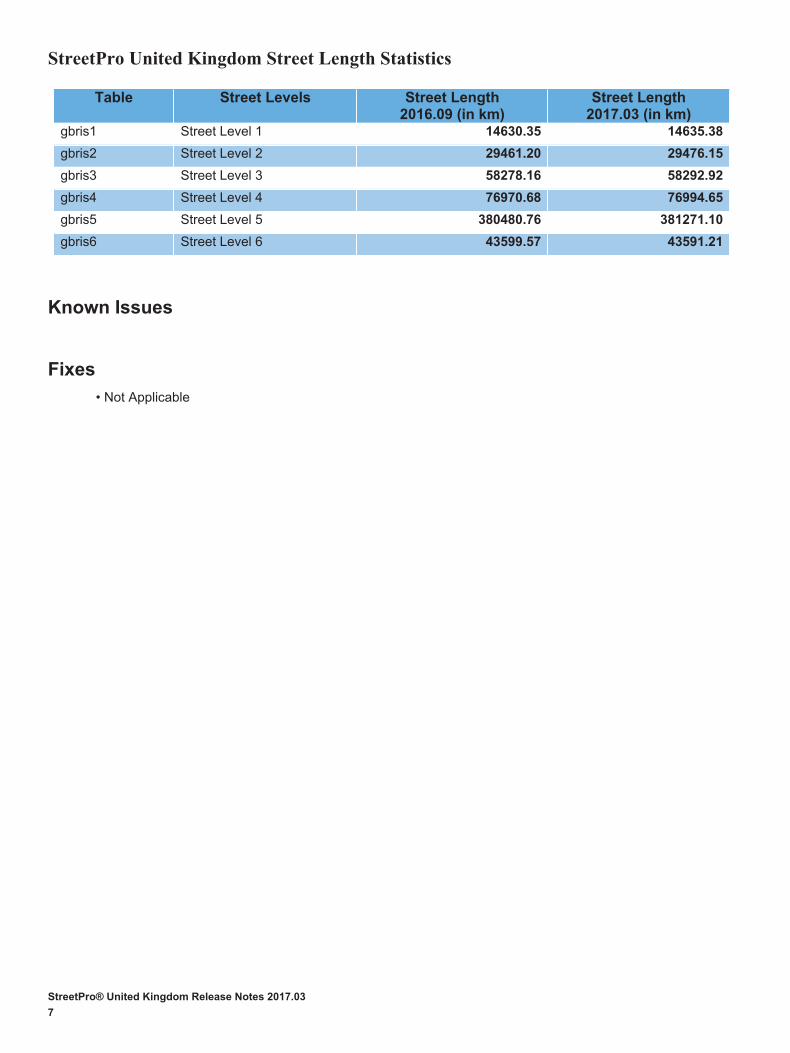
StreetPro® United Kingdom Release Notes 2017.03
7
StreetPro United Kingdom Street Length Statistics
Table Street Levels Street Length 2016.09 (in km)
Street Length 2017.03 (in km)
gbris1 Street Level 1 14630.35 14635.38
gbris2 Street Level 2 29461.20 29476.15
gbris3 Street Level 3 58278.16 58292.92
gbris4 Street Level 4 76970.68 76994.65
gbris5 Street Level 5 380480.76 381271.10
gbris6 Street Level 6 43599.57 43591.21
Known Issues
Fixes
• Not Applicable