spurring nation’s economy through smartkadastergeosmartasia.org/2017/ppts/kamali.pdf · spurring...
TRANSCRIPT

SPURRING NATION’S ECONOMY THROUGH SmartKADASTER
SR MOHAMAD KAMALI BIN ADIMIN DIVISION DIRECTOR (CADASTRE)
DEPARTMENT OF SURVEY AND MAPPING MALAYSIA
Pre-Conference on ‘Socio-Economic Value of Geospatial for National and Regional Development’
Session III: Economic Value and Impact of Geospatial

Pre-Conference on ‘Socio-Economic Value of Geospatial for National and Regional Development’
Session III: Economic Value and Impact of Geospatial
THE NEED TO TRANSFORM
TRANSFORMATION AGENDA
EMPOWERING ECONOMY THROUGH GEOSPATIAL
SmartKADASTER
FUNDAMENTALS OF SmartKADASTER
SKiP
NBOS VIA SmartKADASTER
CONCLUSION

oTowards the aim to achieve developed nation status by 2020, Government of Malaysia has initiated a dynamic plan of transformation.
oThe transformation plan has taken into account various aspects to be revamped.
oAnd one of its many aspirations is to strengthen and drive nations’ current economic landscape.
Pre-Conference on ‘Socio-Economic Value of Geospatial for National and Regional Development’
Session III: Economic Value and Impact of Geospatial
Current State Future State

oEconomic Transformation Programme (ETP) is formulated as part of Vision 2020 and Malaysia’s National Transformation Programme.
oThe implementation of ETP applied new economic model with the hopes to develop a high income, inclusive and sustainable nation.
Pre-Conference on ‘Socio-Economic Value of Geospatial for National and Regional Development’
Session III: Economic Value and Impact of Geospatial
Source: MIDA Malaysia
7 National Key
Result Areas
(NKRAs)
6 Strategic
Reform Initiatives
(SRIs)

ETP is segmented into 12 potential sectors.
It is known as 12 National Key Economic Areas (NKEAs). Each of these NKEAs has its own Entry Point Projects (EPPs) with the intention to explore new growth areas, and business opportunities which enable the related sectors to move further up the value chain.
Pre-Conference on ‘Socio-Economic Value of Geospatial for National and Regional Development’
Session III: Economic Value and Impact of Geospatial
12 NKEAs •2020 GNI – 41,440.5 mil
•Jobs – 234,001 Attracting 100 of the World’s Most
Dynamic Firms
•2020 GNI – 118,212.1 mil
•Jobs – 560 Attracting Internal and External Talents
•2020 GNI – 6,223.8
•Jobs – 28,700 Connecting KL to Singapore via a High
Speed Rail System
•2020 GNI – 24,630.28
•Jobs – 20,000 Building an Integrated Urban Mass
Rapid Transit System
•2020 GNI – 4,280.5
•Jobs- 17,041
Revitalizing the Klang and Gombak Rivers into a Heritage and Commercial
Centre
•2020 GNI- 991.5
•Jobs - 2,817 Greening Greater KL to Ensure
Residents Enjoy Sufficient Green Space
•2020 GNI – 460
•Jobs – 13,500 Creating Iconic Places and Attractions
•2020 GNI – 6.4
•Jobs – 279 Creating a Comprehensive Pedestrian
Network
•2020 GNI - 156.5
•Jobs –N/A Developing an Efficient Solid Waste
Management System
9 EPPs
Source: PEMANDU

TN5050 focusing on 5 Trends
Technology & Connectivity – Government has realised the importance of Geospatial Technology and heading to Smart City enablement in Malaysia.
Pre-Conference on ‘Socio-Economic Value of Geospatial for National and Regional Development’
Session III: Economic Value and Impact of Geospatial
Source: PEMANDU
TN50
Source: mytn50.com

o Decision making has become more informed and scientific and 'Geospatial Technology' has emerged as a leading application in various undertakings.
o It also helps to heighten economy value in diverse sectors. US economic landscape: Geospatial Industry generated $73 billion in revenue in 2011.
Pre-Conference on ‘Socio-Economic Value of Geospatial for National and Regional Development’
Session III: Economic Value and Impact of Geospatial
Source: snaptrends.com
o Innovative geospatial technologies
derived from rapid advancement of
technology.
The advent of
technology
helps to spur
economic landscape

Pre-Conference on ‘Socio-Economic Value of Geospatial for National and Regional Development’
Session III: Economic Value and Impact of Geospatial
Maximize Geospatial Potential
o SmartKADASTER adopts FIG’s vision of Cadastre 2.0 drawn from the Web 2.0.
open map culture using mobile technologies through collaboration and citizen engagement (Manohar
and Sharma, 2016).
o The main purpose of the project is to establish a multi-purpose cadastral based spatial analysis platform. The spatial analysis can be performed in 2D and/or 3D interface; according to user’s preference.
o Established based on 6 fundamentals that has the similarity with the attribute of Cadastre 2.0 concept and enhanced by JUPEM to accommodate local requirements.
Analysis
Data
Infrastructure
Geospatial Component
3D City Model & multi-purpose cadastral based spatial analysis platform

Pre-Conference on ‘Socio-Economic Value of Geospatial for National and Regional Development’
Session III: Economic Value and Impact of Geospatial
SmartKADASTER
Real world
Service Oriented
Architecture
Multi Device
Data Interoperability
Geoinformation for Citizen
Cadastral Based
Representing
Real world
Pre-Conference on ‘Socio-Economic Value of Geospatial for National and Regional Development’
Session III: Economic Value and Impact of Geospatial
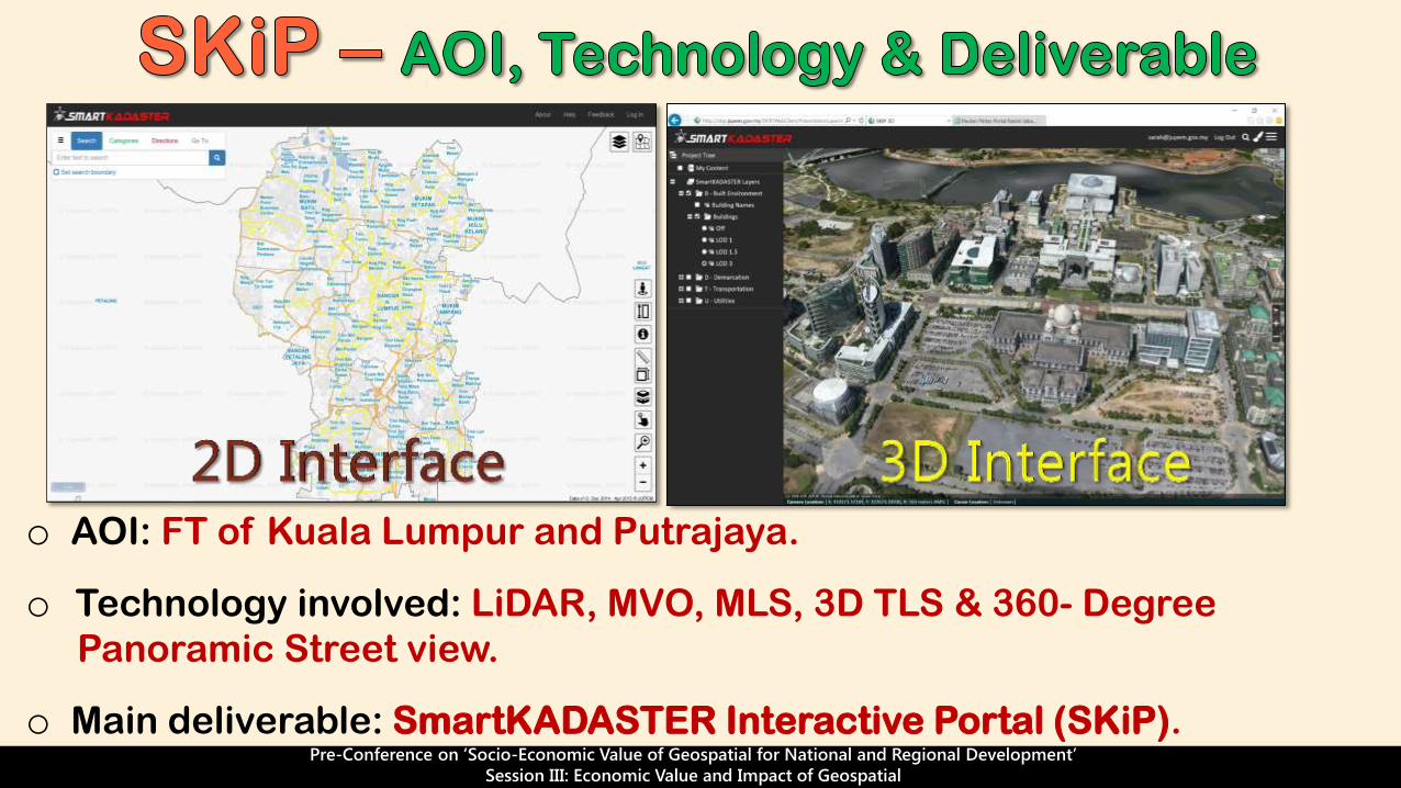
o AOI: FT of Kuala Lumpur and Putrajaya.
o Technology involved: LiDAR, MVO, MLS, 3D TLS & 360- Degree
Panoramic Street view.
o Main deliverable: SmartKADASTER Interactive Portal (SKiP).

Pre-Conference on ‘Socio-Economic Value of Geospatial for National and Regional Development’
Session III: Economic Value and Impact of Geospatial
Directions

Pre-Conference on ‘Socio-Economic Value of Geospatial for National and Regional Development’
Session III: Economic Value and Impact of Geospatial

Pre-Conference on ‘Socio-Economic Value of Geospatial for National and Regional Development’
Session III: Economic Value and Impact of Geospatial
Measure Distance
Measure Area
Info Tools

Pre-Conference on ‘Socio-Economic Value of Geospatial for National and Regional Development’
Session III: Economic Value and Impact of Geospatial
Terrain Profile
Viewshed
3D Analysis Tools

Pre-Conference on ‘Socio-Economic Value of Geospatial for National and Regional Development’
Session III: Economic Value and Impact of Geospatial
3D Analysis Tools
Measure Area
Contour Map

Pre-Conference on ‘Socio-Economic Value of Geospatial for National and Regional Development’
Session III: Economic Value and Impact of Geospatial
LOD 1
LOD 2
LOD 3
3D City Model

Pre-Conference on ‘Socio-Economic Value of Geospatial for National and Regional Development’
Session III: Economic Value and Impact of Geospatial
Benefits:
o Building Maintenance - reduce cost
o Property Marketing – allow
visualization
o BIM Cycle Compliance – up to
demolition and refurbishment

Pre-Conference on ‘Socio-Economic Value of Geospatial for National and Regional Development’
Session III: Economic Value and Impact of Geospatial
Commercial
Terrain Area
overlay with
NDCDB Lot

Pre-Conference on ‘Socio-Economic Value of Geospatial for National and Regional Development’
Session III: Economic Value and Impact of Geospatial
Benefits:
Geoinformation for Citizen
• PRIMA/PPA1M/MAWIP
Commercial
Terrain Area
overlay with
1. NDCDB Lot
2. 3D Model and
Crowd Sourcing
Benefits:
New Infrastructure Development for Public
Transport
(Rail/Highway)
Shortest Route

Pre-Conference on ‘Socio-Economic Value of Geospatial for National and Regional Development’
Session III: Economic Value and Impact of Geospatial
oCatalogue offers complete metadata of the acquired data in SmartKADASTER.
oApplying Service Oriented Architecture (SOA) concept.
oConsequently, accessing, sharing and using geospatial information can be simplified with ample provision of geospatial infrastructure.

Pre-Conference on ‘Socio-Economic Value of Geospatial for National and Regional Development’
Session III: Economic Value and Impact of Geospatial
Beneficial to PRIMA
o Initial evaluation, suitability and terrain assessment for development projects without having to go on site.
o Initial site planning , produce land assessment report using analysis in SKiP – Provide Land Information, Produce Contour Map and Terrain Profile Analysis
Perbadanan PR1MA Malaysia was established
under the PR1MA Act 2012 to plan, develop,
construct and maintain high-quality housing with
lifestyle concepts for middle-income households
in key urban centres.
PR1MA Property Listing throughout
Malaysia
Source: PR1MA website Source: PR1MA website

Pre-Conference on ‘Socio-Economic Value of Geospatial for National and Regional Development’
Session III: Economic Value and Impact of Geospatial
Perbadanan Putrajaya / Putrajaya Corporation
(PPJ) was established under the Perbadanan
Putrajaya 1995 (Act 536) for the purpose of
managing and administering the Federal
Territory of Putrajaya. Perbadanan Putrajaya is
also entrusted with the functions of a local
authority and local planning authority by various
orders and notifications,.
Source: Putrajaya Corporation website
Beneficial to Putrajaya Corporation
oLOD 4 information aids PPJ in building renovation and maintenance
oUtilizing LiDAR Orthophoto, 360 Street View Image from SmartKADASTER for planning purposes
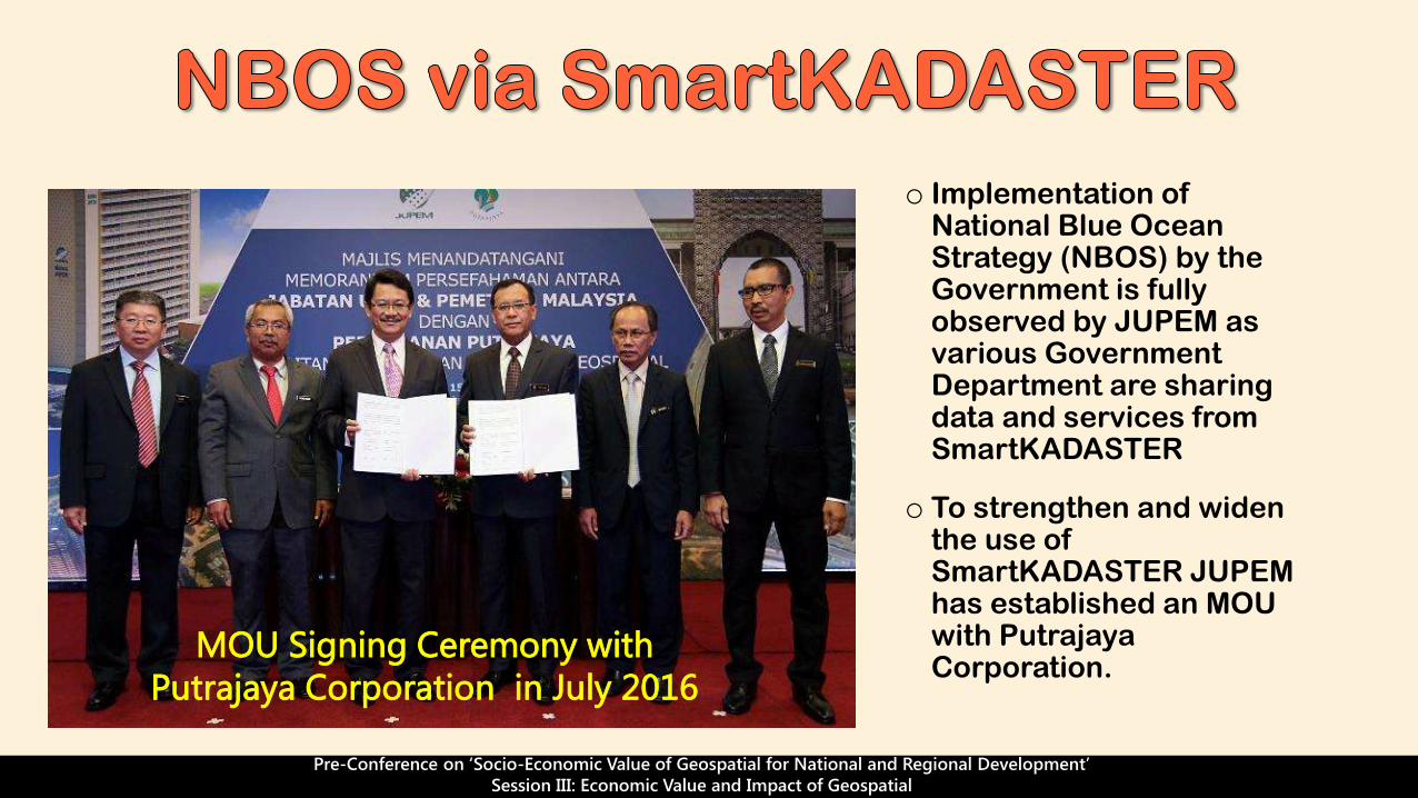
o Implementation of National Blue Ocean Strategy (NBOS) by the Government is fully observed by JUPEM as various Government Department are sharing data and services from SmartKADASTER
o To strengthen and widen the use of SmartKADASTER JUPEM has established an MOU with Putrajaya Corporation.
MOU Signing Ceremony with
Putrajaya Corporation in July 2016
Pre-Conference on ‘Socio-Economic Value of Geospatial for National and Regional Development’
Session III: Economic Value and Impact of Geospatial

Increase efficiency
Decision making (minimize cost and time in
pre- planning & designing)
Improved productivity (time/labour/cost)
Integrate and visualize spatial information
o SmartKADASTER is in compliance with Cadastre 2.0 concept envisioned by
FIG.
Pre-Conference on ‘Socio-Economic Value of Geospatial for National and Regional Development’
Session III: Economic Value and Impact of Geospatial
o It is in line with Government role to facilitate, coordinate, track and monitor the
successful implementation of ETP (NKEAs).
o In addition, more integrated knowledge system and smarter solutions related to
geospatial technology is in need for Government’s future transformation plan.
o SmartKADASTER tools and functionality are enablers to:
Factors that enabling
efficiencies that will
thrive nation’s
economy