sspc, weathering remote sensing and levee · pdf filesspc, weathering remote sensing and levee...
TRANSCRIPT

SSPC, WEATHERINGREMOTE SENSING AND LEVEE STABILITY
ROBERT HACK
ENGINEERING GEOLOGY, ESA,
ITC, FACULTY OF GEO-INFORMATION SCIENCE AND EARTH OBSERVATION,
UNIVERSITY OF TWENTE,
THE NETHERLANDS. PHONE:+31 (0)6 24505442; EMAIL: [email protected]
Mississippi State University, Starkville, Mississippi, USA
7 October 2016
CONTENTS
Weathering
Rock mass classification
Slope Stability Probability Classification (SSPC)
Remote sensing of weathering
Remote sensing of levees for stability assessment
07/10/2016Weathering SSPC levee - Mississippi - Hack 2

WEATHERING - FUTURE DEGRADATIONOF SOIL AND ROCK MASSES
Main processes involved in degradation:
Loss of structure due to stress release
Weathering (In-situ change by inside or outside influences)
Erosion (Material transport with no chemical or structural
changes)
07/10/2016Weathering SSPC levee - Mississippi - Hack 3

INTACT ROCK WEATHERING
07/10/2016Weathering SSPC levee - Mississippi - Hack 4
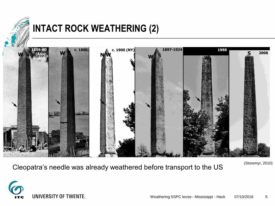
Cleopatra’s needle, Central Park, New York
(needle actually from Thutmosis III)
18812011
(Winkler, 1980)
INTACT ROCK WEATHERING (2)
07/10/2016Weathering SSPC levee - Mississippi - Hack 5
(Storemyr, 2010)
Cleopatra’s needle was already weathered before transport to the US

INTACT ROCK WEATHERING (3)
Classical: Weathering of Cleopatra's needle started after erection
of the needle in New York (Winkler, 1980)
but
Likely Cleopatra's needle was already weathered before transport
to the US (Storemyr, 2010)
What caused its severe weathering on some surfaces: largely
unknown, but direction of face with respect to wind and rain, being
buried, or salt influence may all have had an influence
07/10/2016Weathering SSPC levee - Mississippi - Hack 6

FUTURE DEGRADATION OF A SLOPE
07/10/2016Weathering SSPC levee - Mississippi - Hack 7

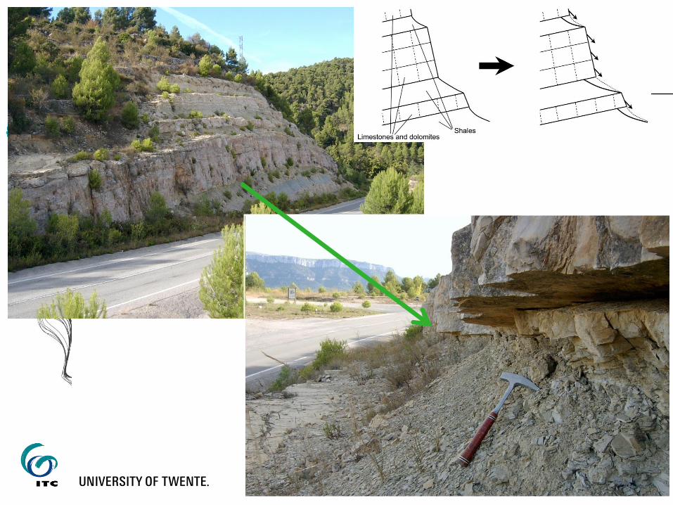
FUTURE DEGRADATION OF A SLOPE (2)
A simple small slope in Spain
Rock mass:
Calcareous marls (calcareous clayey, silt) interbedded with very
thin limestone beds
Excavated with an excavator at a slope dip of about 70º
07/10/2016Weathering SSPC levee - Mississippi - Hack 8

FUTURE DEGRADATION OF A SLOPE (3)
Reduction in
slope angle
due to
weathering,
erosion and
ravelling
(after
Huisman,
2006)
07/10/2016Weathering SSPC levee - Mississippi - Hack 9
1.0
1.5
2.0
2.5
3.0
3.5
7.0 7.5 8.0 8.5 9.0 9.5
y [m]
z [
m]
Excavated 1999 May 2001 May 2002
1999: 70º
2002: 68º

FUTURE DEGRADATION CAUSINGSLOPE SLIDING FAILURE
Another simple slope in Spain:
Rock mass:
Limestone (partially dolomitic) (medium bedded, widely jointed)
Excavated with blasting at a slope dip of about 90º in the 1950’s
07/10/2016Weathering SSPC levee - Mississippi - Hack 10
07/10/2016Weathering SSPC levee - Mississippi - Hack 11Slope Stability by Classification - Hack 11
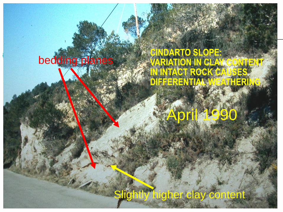
CINDARTO SLOPE:VARIATION IN CLAY CONTENT IN INTACT ROCK CAUSES DIFFERENTIAL WEATHERING
bedding planes
Slightly higher clay content
April 1990

07/10/2016Weathering SSPC levee - Mississippi - Hack 12Slope Stability by Classification - Hack 12
CINDARTO SLOPEVARIATION IN CLAY CONTENT IN INTACT ROCK CAUSES DIFFERENTIAL WEATHERING
April 1992
mass slid

FUTURE DEGRADATION CAUSINGSLOPE SLIDING FAILURE (4)
Dissolution of CaCO3 at bedding plane by percolating water, caused
reduction of CaCO3 while clay stayed behind; hence
bedding plane got an infill of clay-rich material with a lower shear
strength than the original CaCO3 bedding plane
07/10/2016Weathering SSPC levee - Mississippi - Hack 13
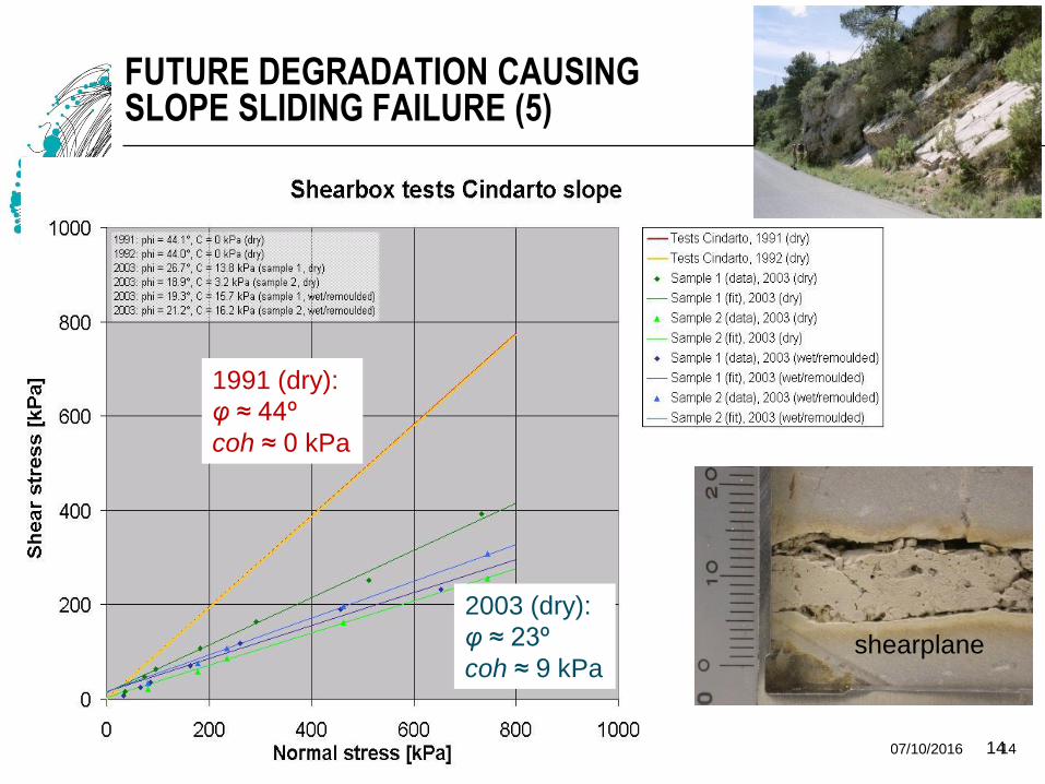
FUTURE DEGRADATION CAUSINGSLOPE SLIDING FAILURE (5)
07/10/2016Weathering SSPC levee - Mississippi - Hack 1414
1991 (dry):
φ ≈ 44º
coh ≈ 0 kPa
2003 (dry):
φ ≈ 23º
coh ≈ 9 kPashearplane

AGAIN ANOTHER SLOPE IN SPAIN
Fine-grained limestone (containing some organic material) falls
apart in a couple of years from:
medium to small cubical blocky structure
to
very small flaky material
07/10/2016Weathering SSPC levee - Mississippi - Hack 15
07/10/2016Weathering SSPC levee - Mississippi - Hack 16

How to quantify the influence of weathering and the future
influence?
07/10/2016Weathering SSPC levee - Mississippi - Hack 17

ROCK MASS CLASSIFICATION SYSTEMS
Classification systems are empirical relations that relate rock mass
properties either directly or via a rating system to an engineering
application, e.g. slope, tunnel
07/10/2016Weathering SSPC levee - Mississippi - Hack 18
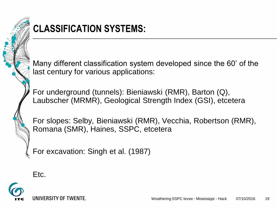
CLASSIFICATION SYSTEMS:
Many different classification system developed since the 60’ of the last century for various applications:
For underground (tunnels): Bieniawski (RMR), Barton (Q), Laubscher (MRMR), Geological Strength Index (GSI), etcetera
For slopes: Selby, Bieniawski (RMR), Vecchia, Robertson (RMR), Romana (SMR), Haines, SSPC, etcetera
For excavation: Singh et al. (1987)
Etc.
07/10/2016Weathering SSPC levee - Mississippi - Hack 19

EXAMPLE: ROCK MASS RATING (RMR)
Based on a combination of five parameters
Each parameter is expressed by a point rating
07/10/2016Weathering SSPC levee - Mississippi - Hack 20

RMR(2)
addition of the points results in the RMR rating
reduction factors for: orientation, excavation damage, etc.
related (empirically) to rock mass cohesion, friction angle of the
rock mass, and other rock mass properties
07/10/2016Weathering SSPC levee - Mississippi - Hack 21
)(sfactorreductionr)groundwateconditionspacingRQDRMR =(IRS
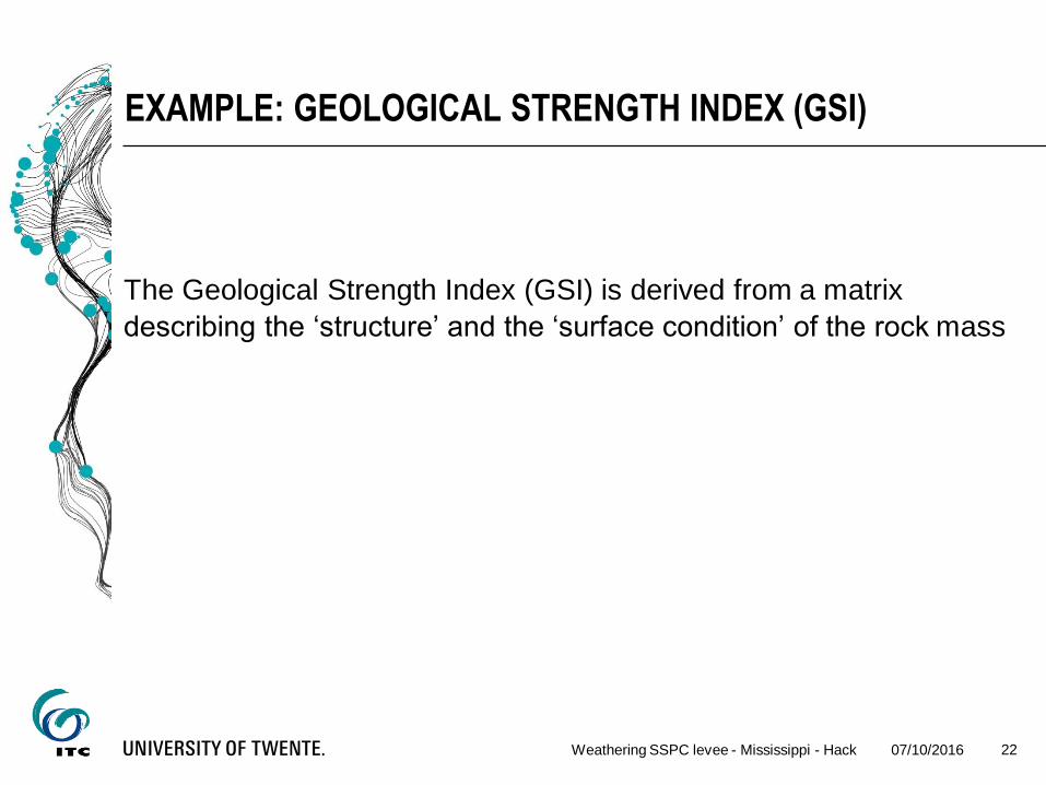
EXAMPLE: GEOLOGICAL STRENGTH INDEX (GSI)
The Geological Strength Index (GSI) is derived from a matrix
describing the ‘structure’ and the ‘surface condition’ of the rock mass
07/10/2016Weathering SSPC levee - Mississippi - Hack 22

GSI(2)
07/10/2016Weathering SSPC levee - Mississippi - Hack 23
‘structure’ is related to
the block size and the
interlocking of rock
blocks
‘surface condition’ is
related to weathering,
persistence, and
condition of
discontinuities.

SLOPE STABILITY PROBABILITY CLASSIFICATION (SSPC)
Slope Stability probability Classification (SSPC):
three step classification system
based on probabilities
independent failure mechanism assessment
07/10/2016Weathering SSPC levee - Mississippi - Hack 24
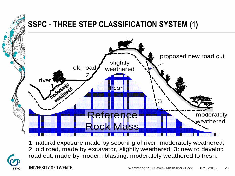
SSPC - THREE STEP CLASSIFICATION SYSTEM (1)
07/10/2016Weathering SSPC levee - Mississippi - Hack 25
river
old road
proposed new road cut
slightly weathered
moderately
weathered
1 2
3
Reference
Rock Mass
fresh
1: natural exposure made by scouring of river, moderately weathered; 2: old road, made by excavator, slightly weathered; 3: new to develop
road cut, made by modern blasting, moderately weathered to fresh.
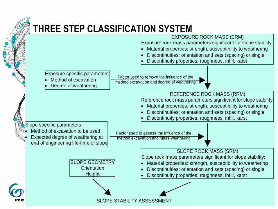
THREE STEP CLASSIFICATION SYSTEM
07/10/2016Weathering SSPC levee - Mississippi - Hack 26
EXPOSURE ROCK MASS (ERM) Exposure rock mass parameters significant for slope stability:
Material properties: strength, susceptibility to weathering
Discontinuities: orientation and sets (spacing) or single Discontinuity properties: roughness, infill, karst
REFERENCE ROCK MASS (RRM) Reference rock mass parameters significant for slope stability:
Material properties: strength, susceptibility to weathering
Discontinuities: orientation and sets (spacing) or single Discontinuity properties: roughness, infill, karst
SLOPE ROCK MASS (SRM) Slope rock mass parameters significant for slope stability:
Material properties: strength, susceptibility to weathering
Discontinuities: orientation and sets (spacing) or single
Discontinuity properties: roughness, infill, karst
Exposure specific parameters:
Method of excavation Degree of weathering
Slope specific parameters:
Method of excavation to be used
Expected degree of weathering at end of engineering life-time of slope
SLOPE GEOMETRY Orientation
Height
SLOPE STABILITY ASSESSMENT
Factor used to remove the influence of the
method excavation and degree of weathering
Factor used to assess the influence of the
method excavation and future weathering

SSPC
Excavation specific parameters for the excavation which is used to
characterize the rock mass:
Degree of weathering
Method of excavation
07/10/2016Weathering SSPC levee - Mississippi - Hack 27

SSPC
Rock mass Parameters:
Intact rock strength
Spacing and persistence of discontinuities
Shear strength along discontinuities:
- Roughness - large scale
- small scale
- tactile roughness
- Infill in discontinuities
- Karst along discontinuities
Susceptibility to weathering
07/10/2016Weathering SSPC levee - Mississippi - Hack 28
SSPC
Slope specific parameters for the new slope to be made:
Expected degree of weathering at end of lifetime of the slope
Method of excavation to be used for the new slope
07/10/2016Weathering SSPC levee - Mississippi - Hack 29
SSPC
Intact rock strength (IRS)
By simple means test:
hammer blows, crushing by hand, etcetera
07/10/2016Weathering SSPC levee - Mississippi - Hack 30
SSPC
Spacing and persistence of discontinuities:
Determine block size and block form by:
visual assessment, followed by:
quantification (measurement) of the characteristic spacing and
orientation of each set
07/10/2016Weathering SSPC levee - Mississippi - Hack 31

SSPC
Shear strength – roughness
07/10/2016Weathering SSPC levee - Mississippi - Hack 32
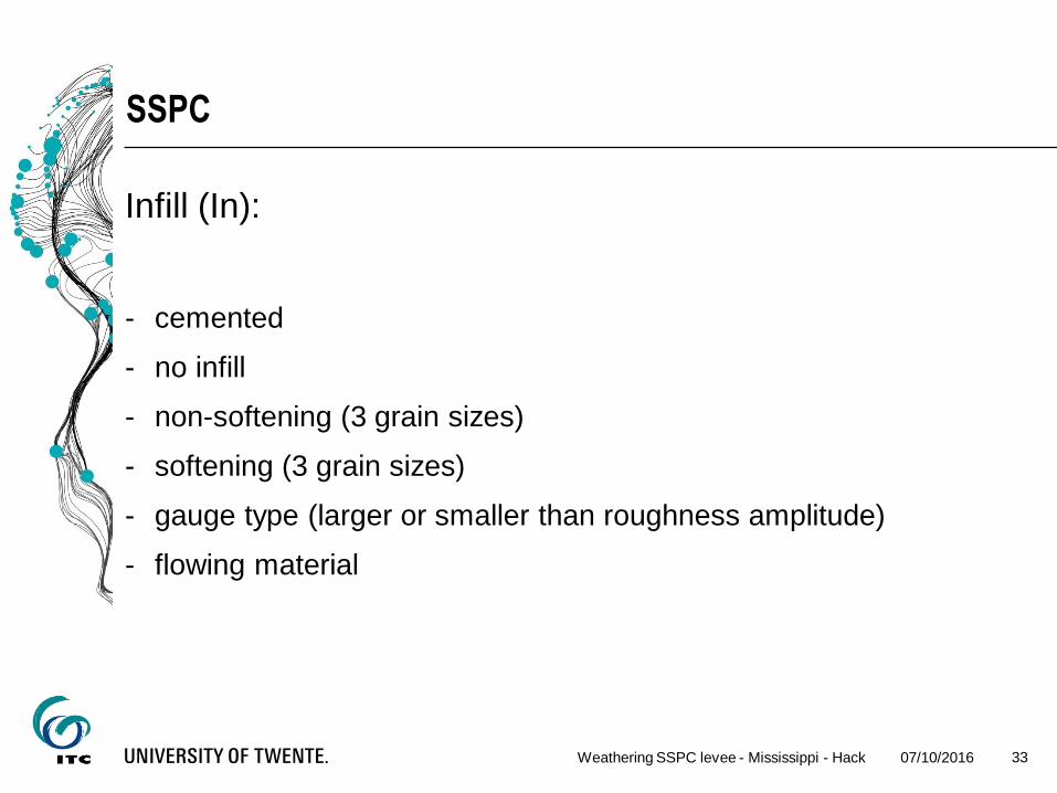
SSPC
Infill (In):
- cemented
- no infill
- non-softening (3 grain sizes)
- softening (3 grain sizes)
- gauge type (larger or smaller than roughness amplitude)
- flowing material
07/10/2016Weathering SSPC levee - Mississippi - Hack 33

07/10/2016Weathering SSPC levee - Mississippi - Hack 34
CONDITION OF DISCONTINUITY factor
Roughness
large scale (Rl)
(visual area > 0.2 x 0.2 and <
1 x 1 m2)
wavy
slightly wavy
curved
slightly curved
straight
1.00
0.95
0.85
0.80
0.75
Roughness
small scale (Rs)
(tactile and visual on an area
of
20 x 20 cm2)
rough stepped/irregular
smooth stepped
polished stepped
rough undulating
smooth undulating
polished undulating
rough planar
smooth planar
polished planar
0.95
0.90
0.85
0.80
0.75
0.70
0.65
0.60
0.55
Infill
material (Im)
cemented/cemented infill
no infill - surface staining
1.07
1.00
non softening
& sheared
material, e.g.
free of clay,
talc, etc.
coarse
medium
fine
0.95
0.90
0.85
soft sheared
material, e.g.
clay, talc, etc.
coarse
medium
fine
0.75
0.65
0.55
gouge < irregularities
gouge > irregularities
flowing material
0.42
0.17
0.05
Karst (Ka)none
karst
1.00
0.92
Discontinuity
Condition (TC)
factors:

SSPC - SHEAR STRENGTH - CONDITION FACTOR
Discontinuity condition factor (TC) is a multiplication of the ratings
for:
small-scale roughness
large-scale roughness
infill
karst
07/10/2016Weathering SSPC levee - Mississippi - Hack 35

SLIDING CRITERION
Condition of Discontinuity (TC) is related to friction along plane by:
(comparable to a “tilt test” but on a larger scale)
07/10/2016Weathering SSPC levee - Mississippi - Hack 36
0113.0
*KaImRl*Rs*anglesliding

SLIDING CRITERION (EXAMPLE)
bedding plane description factor
large scale straight 0.75
small scale & tactile rough stepped 0.95
infill fine soft sheared 0.55
karst none 1.00
07/10/2016Weathering SSPC levee - Mississippi - Hack 37
degrees3501130
001550950750
01130
Im
..*.*.*.
.
*KaRl*Rs*
anglesliding
Bedding dip angle ≈ 35.5º
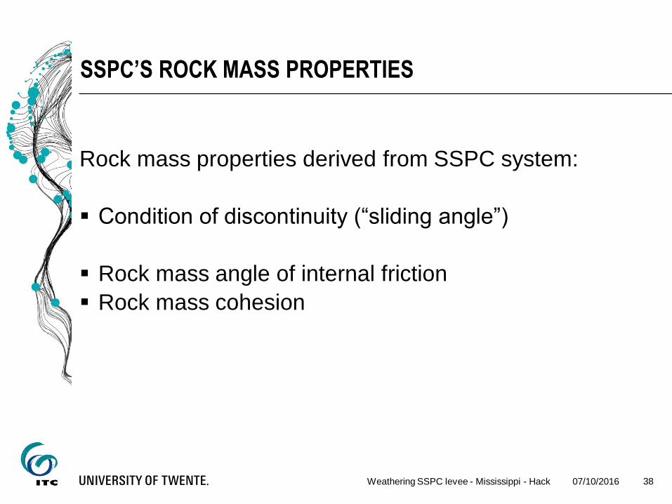
SSPC’S ROCK MASS PROPERTIES
Rock mass properties derived from SSPC system:
Condition of discontinuity (“sliding angle”)
Rock mass angle of internal friction
Rock mass cohesion
07/10/2016Weathering SSPC levee - Mississippi - Hack 38

Quantification of weathering influence
07/10/2016Weathering SSPC levee - Mississippi - Hack 39

IMPACT OF WEATHERING
07/10/2016Weathering SSPC levee - Mississippi - Hack 40

But if possible to assess the influence quantitatively than also the
relation with time if the time of exposure is known
07/10/2016Weathering SSPC levee - Mississippi - Hack 41

TIME RELATION - WEATHERING
The susceptibility to weathering is a concept that is frequently
addressed by “the” weathering rate of a rock material or mass.
Weathering rates may be expected to decrease with time, as the
state of the rock mass becomes more and more in equilibrium with
its surroundings.
07/10/2016Weathering SSPC levee - Mississippi - Hack 42

TIME RELATION – WEATHERING (2)
07/10/2016Weathering SSPC levee - Mississippi - Hack 43
log 1app
init WEWE t WE R t
WE(t) = degree of weathering at time t
WEinit = (initial) degree of weathering at time t = 0
RappWE = weathering intensity rate (= material-environment
property)
WE as function of time, initial weathering and
the weathering intensity rate

07/10/2016Weathering SSPC levee - Mississippi - Hack 44Slope Stability by Classification - Hack 44
WEATHERING RATES
Middle Muschelkalk near Vandellos (Spain)
•Material:
Gypsum layers
Gypsum cemented siltstone layers

SSPC system with applying weathering intensity rate:
- original slope cut about 50º (1998)
- in 15 years decrease to 35º
07/10/2016Weathering SSPC levee - Mississippi - Hack 45

KOTA KINABALU, MALAYSIA
07/10/2016Weathering SSPC levee - Mississippi - Hack 4646
10 years
old
(after Tating, Hack, & Jetten, 2011)
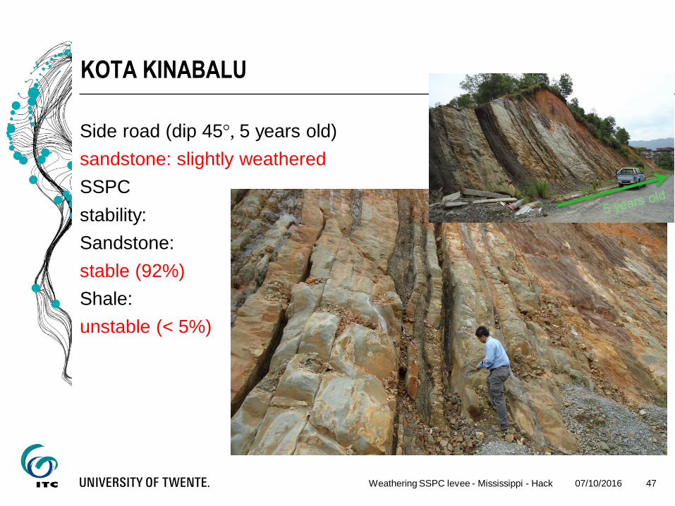
KOTA KINABALU
Side road (dip 45°, 5 years old)
sandstone: slightly weathered
SSPC
stability:
Sandstone:
stable (92%)
Shale:
unstable (< 5%)
07/10/2016Weathering SSPC levee - Mississippi - Hack 47
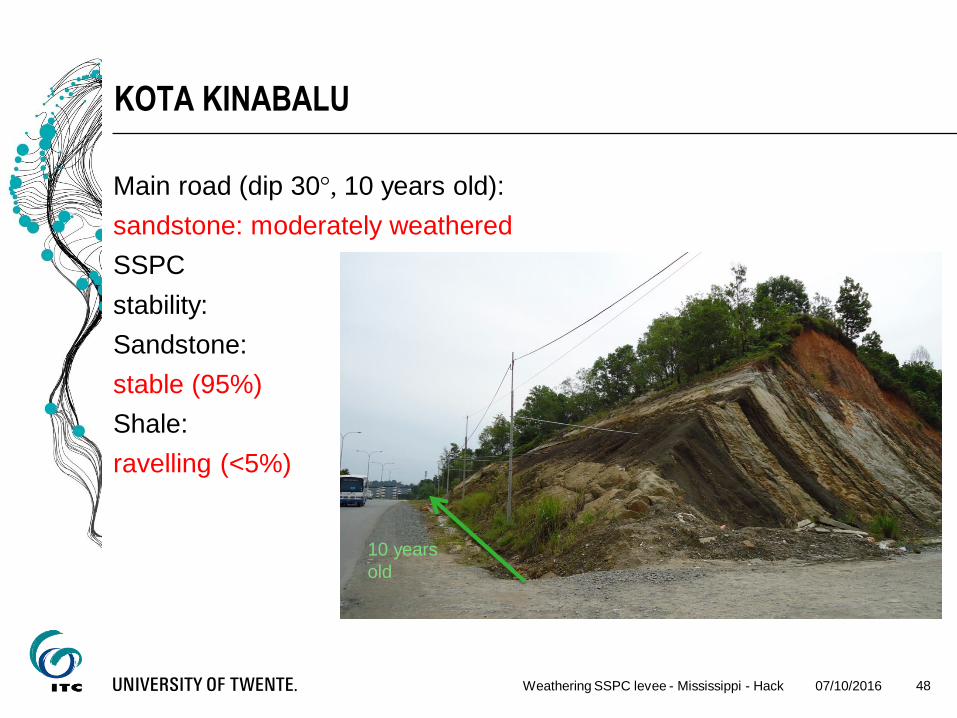
KOTA KINABALU
Main road (dip 30°, 10 years old):
sandstone: moderately weathered
SSPC
stability:
Sandstone:
stable (95%)
Shale:
ravelling (<5%)
07/10/2016Weathering SSPC levee - Mississippi - Hack 48
10 years
old

KOTA KINABALU
time
[years]
dip
[degrees]
SSPC visual
unit RM friction RM cohesion
[degrees] [kPa]
shale
Slightly
weathered
5 45 4 2.4 unstable
Moderately
weathered
10 30 2 1.1 unstable
sandstone
Slightly
weathered
5 45 20 10.0 stable
Moderately
weathered
10 30 11 6.3 stable
07/10/2016Weathering SSPC levee - Mississippi - Hack 49

SSPC
SSPC system in combination with degradation forecasts gives:
reasonable design for slope stability
with minimum of work and
in a short time
(likely a reasonable tool to forecast susceptibility to weathering)
07/10/2016Weathering SSPC levee - Mississippi - Hack 50
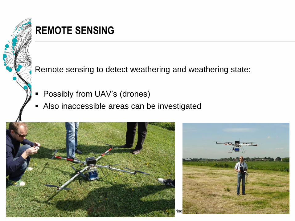
REMOTE SENSING
Remote sensing to detect weathering and weathering state:
Possibly from UAV’s (drones)
Also inaccessible areas can be investigated
07/10/2016Weathering SSPC levee - Mississippi - Hack 51
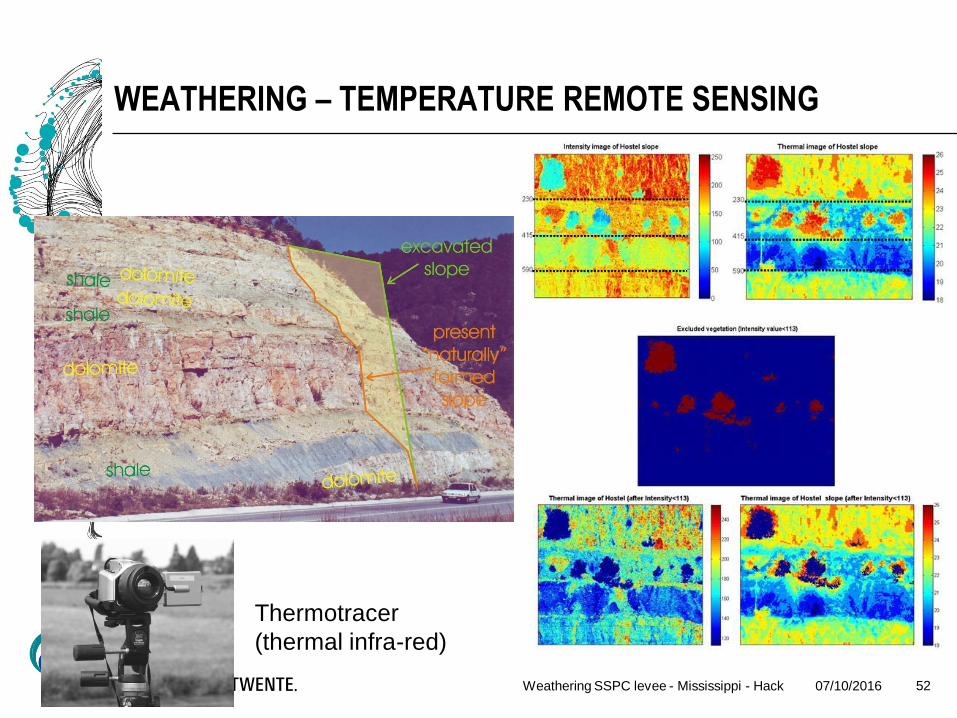
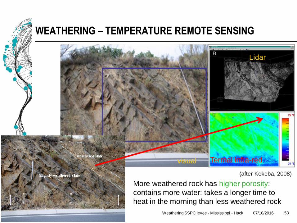
WEATHERING – TEMPERATURE REMOTE SENSING
07/10/2016Weathering SSPC levee - Mississippi - Hack 52
Thermotracer
(thermal infra-red)
WEATHERING – TEMPERATURE REMOTE SENSING
07/10/2016Weathering SSPC levee - Mississippi - Hack 53
visual Termal infra-red
Lidar
More weathered rock has higher porosity:
contains more water: takes a longer time to
heat in the morning than less weathered rock
(after Kekeba, 2008)

LEVEES
If remote sensing is an option to establish weathering than also it
may be to establish geology in levees
07/10/2016Weathering SSPC levee - Mississippi - Hack 54
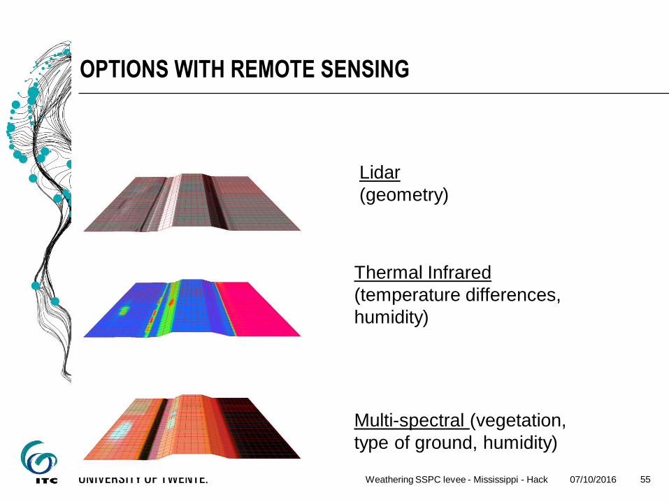
OPTIONS WITH REMOTE SENSING
07/10/2016Weathering SSPC levee - Mississippi - Hack 55
Lidar
(geometry)
Thermal Infrared
(temperature differences,
humidity)
Multi-spectral (vegetation,
type of ground, humidity)

REFLECTANCE VERSUS VEGETATION STRESS
07/10/2016Weathering SSPC levee - Mississippi - Hack 56

REFLECTANCE VERSUS VEGETATION STRESS
Vegetation stress may be due to:
Excess water
Shortage water
Vegetation unfriendly minerals or fluids (environmental pollution)
Shortage or excess of water may indicate weak areas in a dike
07/10/2016Weathering SSPC levee - Mississippi - Hack 57

07/10/2016Weathering SSPC levee - Mississippi - Hack 58
PEAT EXCAVATION
Peat was excavated “under water”
by scooping the peat down to a
depth of about 4 - 6 m below the
water level
The peat was brought by boat to
not-excavated strips of land with
paths and roads left behind in-
between the excavation areas
The Reeuwijk area in the Netherlands, is a typical “polder” area
Peat has been excavated for fuel and sometimes table salt since
the early Medieval times (since 800 AD)
scooping peat
07/10/2016Weathering SSPC levee - Mississippi - Hack 59
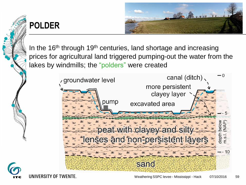
POLDER
In the 16th through 19th centuries, land shortage and increasing
prices for agricultural land triggered pumping-out the water from the
lakes by windmills; the “polders” were created
07/10/2016Weathering SSPC levee - Mississippi - Hack 60
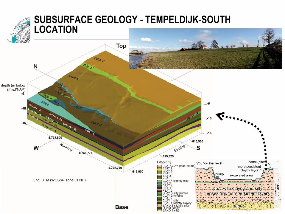
SUBSURFACE GEOLOGY - TEMPELDIJK-SOUTH LOCATION
07/10/2016Weathering SSPC levee - Mississippi - Hack 61
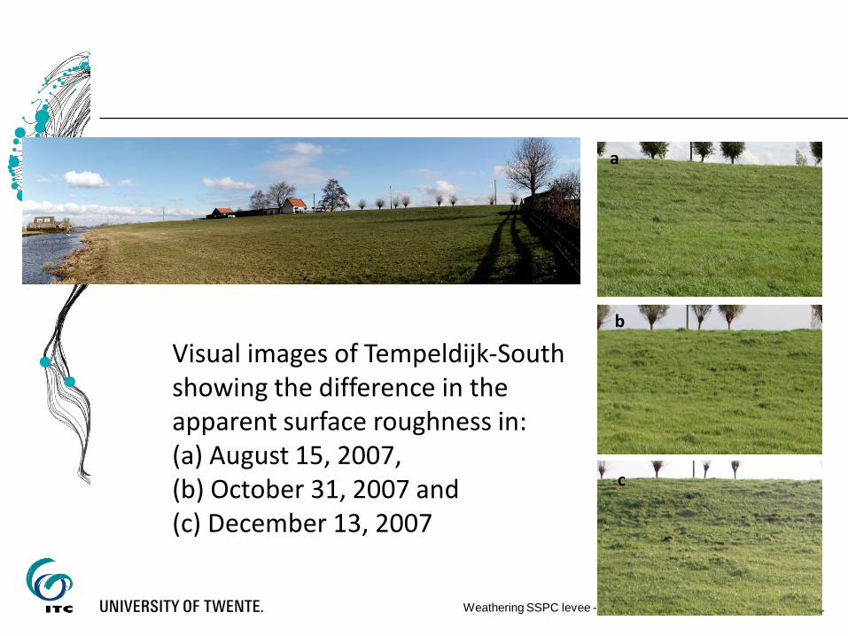
a
b
c
Visual images of Tempeldijk-South showing the difference in the apparent surface roughness in:(a) August 15, 2007,(b) October 31, 2007 and(c) December 13, 2007

TEMPERATURE
07/10/2016Weathering SSPC levee - Mississippi - Hack 62
c
b
a
c
b
a
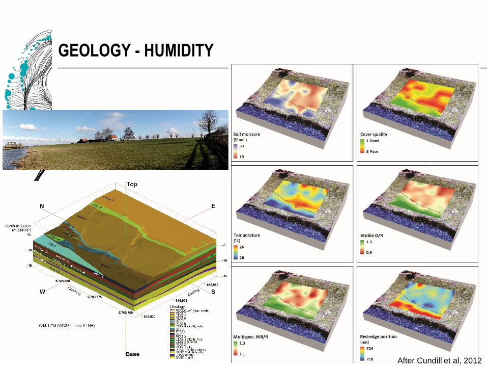
GEOLOGY - HUMIDITY
07/10/2016Weathering SSPC levee - Mississippi - Hack 63
After Cundill et al, 2012
CONCLUSIONS
Weathering can be quantified with help of rock mass classification
systems
SSPC seems suitable
Quantified effects of weathering can be forecasted
Remote sensing may be an option to establish different degrees
of weathering
Remote sensing may (with the same methodology) be suitable to
detect weak areas in levees
07/10/2016Weathering SSPC levee - Mississippi - Hack 64

REFERENCES
Cindarto, L., 1992. Rock slope stability; Research project report on rock slope stability in Falset, Spain. MSc thesis. Engineering Geology, International Institute for Aerospace Survey and Earth Observation
(ITC), Delft, The Netherlands. p. 169.
Cundill, S. L., M. Meijde, and H. R. G. K. Hack. 2014. "Investigation of Remote Sensing for Potential Use in Dike Inspection." Selected Topics in Applied Earth Observations and Remote Sensing, IEEE
Journal of 7 (2):733-46. doi: 10.1109/jstars.2013.2293617.
Cundill, S. L., H. M. A. van der Werff, and M. van der Meijde. 2014. "Cross-Calibration of Indices by Spectrally Convolving Field Spectra to Simulate Very High Spatial Resolution Sensors." Manuscript
submitted for publication.
Cundill, S.L., H.R.G.K. Hack, M. van der Meijde, J. van der Schrier, and D.J.M. Ngan-Tillard. 2013. "Quality of peat dykes evaluated by remote sensing." In: Comprehensiver flood risk management / ed. by. F.
Klijn and T. Schweckediek. London : Taylor & Francis, 2013. ISBN 978-0-415-62144-1. pp. 463-469.
De Mulder, E.J.F., Hack, H.R.G.K., Van Ree, C.C.D.F., 2012. Sustainable Development and Management of the Shallow Subsurface. The Geological Society, London. ISBN: 978-1-86239-343-1. p. 192.
Hack, H.R.G.K., 2002. An evaluation of slope stability classification; Keynote lecture. In: Dinis Da Gama, C., Ribeira E Sousa, L. (Eds) ISRM EUROCK 2002, Funchal, Madeira, Portugal. Sociedade
Portuguesa de Geotecnia, Av. do Brasil, 101, 1700-066 Lisboa, Portugal, pp. 3–32.
Hack, H.R.G.K., Price, D.G., Rengers, N., 2003. A new approach to rock slope stability : a probability classification SSPC. Bulletin of Engineering Geology and the Environment. 62 (2). DOI: 10.1007/s10064-
002-0155-4. pp. 167-184.
Hack, H.R.G.K., Price, D., Rengers, N., 2005. Una nueva aproximación a la clasificación probabilística de estabilidad de taludes (SSPC). In: Proyectos, U.D., Minas, E.T.S.I. (Eds), Ingeniería del terreno :
ingeoter 5 : capítulo 6. Universidad Politécnica de Madrid, Madrid. ISBN: 84-96140-14-8. p. 418. (in Spanish)
Hack, H.R.G.K., Price, D.G. & Rengers, N., 2003. 研究岩质边坡稳定性新方法—概率分级法 (Translation of "A new approach to rock slope stability - A probability classification (SSPC)"). Original in:
Bulletin of Engineering Geology and the Environment. 62 (2). DOI: 10.1007/s10064-002-0155-4. ISSN: 1435-9529; 1435-9537. pp. 167-184. (in Chinese)
Hack, H. R. G. K., M. van der Meijde, J. S. van der Schrier, Y. H. Awaju, J. Rupke, S. Barritt, J. van 'T Hof, et al. 2008. "Strength of peat dykes evaluated by remote sensing (Gebiedsdekkende dijksterkte
bepaling met remote sensing): Pilot project: RSDYK2008, Program Flood Control 2015." In, 135. Delft: Flood Control 2015
Hoek, E., Marinos, P., Benissi, M., 1998. Applicability of the geological strength index (GSI) classification for very weak and sheared rock masses. The case of the Athens Schist Formation. Bulletin of
Engineering Geology and the Environment. 57 (2). DOI: 10.1007/s100640050031. pp. 151-160.
Huisman, M., Hack, H.R.G.K., Nieuwenhuis, J.D., 2006. Predicting Rock Mass Decay in Engineering Lifetimes: The Influence of Slope Aspect and Climate. Environmental & Engineering Geoscience. 12 (1).
DOI: 10.2113/12.1.39. pp. 39-51.
Kekeba, A.D., 2008. Establishing relationship between thermal radiation and intensity of 3D terrestrial laser scan data of weathered rock surface for sloper stability analysis. Hack, H.R.G.K. & Van Der Meijde,
M. (Advs). MSc thesis. Engineering Geology, University Twente-ITC, Enschede, The Netherlands. p. 84.
Marinos, P., Hoek, E., 2000. GSI: A geologically friendly tool for rock mass strength estimation. In: Drinan, J., Geom Australian (Eds) GeoEng2000 - International Conference on Geotechnical & Geological
engineering, Melbourne, 19-24 November 2000. Technomic Publishing Co, Lancaster, PA, USA, pp. 1422–1446.
Marinos, V., Marinos, P. & Hoek, E. 2005. The geological strength index: applications and limitations. Bull. of Engineering Geology and the Environment 64/1, doi: 10.1007/s10064-004-0270-5, 55-65.
Price, D.G., De Freitas, M.H., Hack, H.R.G.K., Higginbottom, I.E., Knill, J.L., Maurenbrecher, M., 2009. Engineering geology : principles and practice. De Freitas, M.H. (Ed.). Springer-Verlag, Berlin,
Heidelberg. ISBN: 978-3-540-29249-4. p. 450.
Storemyr, P., 2010. Archaeology & Conservation Services, Myklebustfeltet, N-6957 Hyllestad, Hyllestad, Norway. https://per-storemyr.net/2010/12/12/cleopatra%E2%80%99s-needle-tracing-obelisk-
weathering-with-old-photos/ [Accessed: 5 October 2016]
Tating, F.F., Hack, H.R.G.K. & Jetten, V., 2013. Engineering aspects and time effects of rapid deterioration of sandstone in the tropical environment of Sabah, Malaysia. Engineering Geology. 159. DOI:
10.1016/j.enggeo.2013.03.009. ISSN: 0013-7952. pp. 20-30.
Tating, F.F., Hack, H.R.G.K. & Jetten, V., 2015. Weathering effects on discontinuity properties in sandstone in a tropical environment: case study at Kota Kinabalu, Sabah Malaysia. Bulletin of Engineering
Geology and the Environment. 74 (2). DOI: 10.1007/s10064-014-0625-5. ISSN: 1435-9529. pp. 427-441.
White, A.F., Blum, A.E., Schulz, M.S., Vivit, D.V., Stonestrom, D.A., Larsen, M., Murphy, S.F., Eberl, D., 1998. Chemical Weathering in a Tropical Watershed, Luquillo Mountains, Puerto Rico: I. Long-Term
Versus Short-Term Weathering Fluxes. Geochimica et Cosmochimica Acta. 62 (2). DOI: 10.1016/s0016-7037(97)00335-9. pp. 209-226.
Winkler, E.M., 1980. Historical implications in the complexity of destructive salt weathering: Cleopatra's Needle, New York. Bulletin Association for Preservation Technology. XII (2). ISSN: 0848-8525. pp.
94-102.
07/10/2016Weathering SSPC levee - Mississippi - Hack 65