st marychurch - torbay · 1.1 st marychurch, a substantial suburb of torquay, is situated on high...
TRANSCRIPT

St MarychurchConservation AreaCharacter Appraisal
APRIL 2005

ST MARYCHURCH
CONSERVATION AREA
CHARACTER APPRAISAL
RevisedHal Bishop BA MA Cert Ecol & Cons
April 2005
TORBAY COUNCILOriginally compiled by John Fisher BA MA MRTPI IHBC
March 2001

1
CONTENTS PAGE
1. Location and Essential Characteristics 2
2 Historic Environment, Origins and Development 2
3 Character Areas 53.3 The Town Centre & Ecclesiastical Quarter3.4 19th Century Terraced Housing3.5 19th Century Villas
4. Architectural and Historic Qualities 54.1 Listed & Other Key Buildings 54.2 Building Form, Ornament 94.3 Use Of Materials 94.4 Condition of Buildings 104.5 Local Details 10
5. Character and Relationship of Spaces 11
6. Green Landscape and Trees 12
7 The Setting and Features of Special Importance 13
8 Extent of Loss, Damage and Intrusion 14
9 Summary 15
10 Conservation Area Policies 16
Bibliography 18
PHOTOGRAPHS
EARLY EDITION ORDNANCE SURVEY 1: 2500 scale maps (not to scale)- Ordnance Survey County Series First Edition surveyed 1862-87- Ordnance Survey County Series Second Edition surveyed 1904- Ordnance Survey County Series Third Edition surveyed 1933
APPRAISAL MAPS- Map One: Historic Buildings- Map Two: Age of Buildings- Map Three: Building Materials - Roofs- Map Four Building Materials - Walls- Map Five Important Features

2
1 LOCATION AND ESSENTIAL CHARACTERISTICS
1.1 St Marychurch, a substantial suburb of Torquay, is situated on high ground about 2 km(1½ miles) north of the town centre; it is a long-established and distinct community witha parish that originally included part of Torquay. The 19th century former town hall is areminder of its separate administration before it was subsumed into the much largerVictorian resort, which now overshadows it. The conservation area is closely linked withthe neighbouring ones of Babbacombe Downs and Cary Park – although they do notinterlock as tightly as the central group of ten in Torquay, for there are undesignatedpockets between them, in the York and Palermo Roads area. St Marychurch stillpossesses the largest and most varied local shopping centre within Torquay; one that isnow largely pedestrianised.
1.2 The present town has resulted from several separate phases of development, whilst theconservation area contains a large majority of buildings that had already beenconstructed by the end of the 19th century. Later development within the conservationarea has been relatively limited, consisting mainly of a group of shops dating from the1920s at the southern end of Fore Street, and a short row of 1930s houses in TrumlandsRoad. One contemporary building that makes an effective contribution to the townscapeat the junction with St Marychurch Road is an office block built c.1980 and finished inribbed concrete. Several shop and office re-developments dating from the 1960s in ForeStreet, and a number of later major extensions to 19th century buildings have been muchless successfully integrated.
2 THE HISTORIC ENVIRONMENT, ORIGINS AND DEVELOPMENT
2.1 There has been human activity and settlement in the St Marychurch area sinceprehistoric times; within the parish and no more than 1km southeast of the conservationarea boundary is the remarkably well preserved prehistoric field system of Walls Hills.A series of individual fields and their boundary banks survive above the thin calcareoussoil; remnants of what will have once been a much larger field system, dating from theLate Bronze- and Early Iron Ages c.1200-800 BC.
2.2 The urban centre today has its origins in the Saxon settlement from the 8th centuryonwards; the pre-Conquest manorial structure, recorded in Domesday, was probablyestablished here by the 10th century. St Marychurch is first mentioned during BishopLeofric’s occupation of the see of Exeter 1050-1072; in 1086 the Domesday Bookrecorded two manors at St Marychurch: æcc am S MARIÆ held by Osbern Bishop ofExeter may be identified as that at Combe Pafford. The other SCÆ MARIÆ cerce whichwe can identify as St Marychurch proper, was held by one Richard son of Thorulf fromits tenant-in-chief, the Count of Mortain. Both forms of the placename imply thepresence of a church of some antiquity. It is one of the few churches in Devon mentionedin Domesday and is also the mother church of the adjoining parishes of Kingskerswelland Coffinswell, itself indicative of a large Saxon estate. The tradition that St Mary’s

3
Church was the first to be founded in the county was current as early the late 18th
century.
2.3 There is now no above ground evidence of the early settlement apart from the presumedSaxon location of the church on the hilltop. The present church is at least the fourth, ifnot the fifth on the site. The medieval church was substantially, and indifferently, rebuiltbetween 1856 and 1861, and a new tower added in 1872. In May 1943 the churchsustained serious damage with tragic loss of life as a result of enemy action; rebuildingin a traditional gothic style in the local grey limestone was undertaken 1952-56.
2.4 The present urban topography then reflects the mainly 19th century patterns ofsettlement. An estate map compiled in 1775 for the Carys (Lords of the manor since1595) shows the axis of settlement as stretching southwest down what was Westhill (nowBarewell Road) and across Blacks Hill (confusingly now Westhill Road) into ChattoRoad; some sites are situated on the south side of Church Road; and others are locatedon the east side of Fore Street south of the curtilage of the Snooty Fox Public House.Here four parallel blocks between Petitor and Rowley Roads – remnants of burgage orother tenement plots – are preserved in the present land boundaries and curtilages, withlate-medieval pottery of Totnes type being found in a boundary ditch in 2004 off RowleyRoad.
2.5 The estate map depicts a non-nucleated village streching down Barewell and ChattoRoads, westwards from the church ‘block’ formed by Trumlands, St Catherine’s andPriory Roads – Church Road is an early 19th century formation. This is very likely to beunchanged from medieval times. Settlement is likely to have existed east of the churchacross Fore Street to north of the Snooty Fox and to the north of Petitor Road also, butthese are unfortunately no indications from the estate map as that land lay in theadjoining ‘second’ manor of St Marychurch, that of Combe Pafford. The public car parkaccessed from Chilcote Close may cover much of one such plot; although the maprecords that the land here south to Hampton Lane was in the possession of ‘sundrypersons’, perhaps indicating that it was a collection of medieval strips.
2.6 The 1775 map shows no obvious industrial activity with the exception of a lime kiln atsome distance to the northwest on Yearndon common. However from the end of theeighteenth century a considerable quarrying industry grew up in the area betweenBarton and the coast at Petitor; this activity contributed to the earlier development of StMarychurch compared with elsewhere in Torquay. This supply of locally quarriedbuilding material predates access to the railway system by over half a century.
2.7 The Reverend John Swete, a dilettante Clergyman who undertook a number ofperegrinations around Devon in the late 18th century recorded that ‘marble’ was beingsent to London in 1793. The use of limestone extended from the coarse, as buildingmaterial and its burning down as an agricultural improver, to the fine, as marble forsmaller household goods. The first universal census in 1801 recorded 172 housesthroughout the (large) parish were occupied by 801 souls. This is thought to be double

4
that in Queen Anne’s time a hundred years previously and reflects the numbersemployed in working the limestone; many skilled workers having moved from theAshburton area into workshops located in the lanes on the seaward side of Fore Street.
2.8 The First Edition Ordnance Survey County Series maps surveyed between 1860-87 (thesouthern part of the parish was part of the earlier Torquay survey) show St Marychurchas an established small town. This was partly due to the quarrying and marbleindustries, and later to the terracotta works, but also to the Victorian zeal for ‘Fresh Air’(‘Fun’ came later). Black’s Guide to Devonshire, which ran to 16 editions by the end ofthe century, describes the health inducing properties as:
“… those making some stay here will have no difficulty in finding airierregions, especially at St Mary Church, which stands high towards the eastern neckof the peninsula … Fresh air has come so much into fashion now that on this morebracing side, though two or three miles from any railway station, the town isquickly developing, both St Mary Church and Babbicombe having becomepractically included in Torquay.”
Most development had already taken place in the conservation area by the early 1880swhen St Marychurch became an Urban District Council with its own town hall. Only afew parts of St Marychurch consist of villa developments similar to elsewhere inTorquay; they are much less ambitious and the somewhat later High Victorian styles,such as those found at Chelston or Cary Park are largely absent.
2.9 Among the famous names that have graced St Marychurch is Edmund Gosse who gave achild’s view of Oddicombe in the 1850s in Father and Son; the father Philip Henrycompleted his Manual of Marine Zoology here and waged his lonely spiritual struggleagainst Darwinism on the sea shore. There are several commemorative memorials toother worthies. In the town centre is a granite obelisk with a portrait of the respectedlocal physician, Herbert Chilcote who died at the relatively early age of 46. In the parishchurch is a memorial to Sir Thomas Louis, one of Nelson’s Band of Brothers, whocommanded the Canopus at the time of Trafalgar but missed the battle as Nelson hadordered him to collect supplies at Gibraltar.
2.10 In Park Road there is a drinking fountain dated 1885 given in memory of Thomas andMary Kitson, though it is no longer in use. Thomas was a clergyman whose father andgrandfather between them had been Vicars of Torre from 1763 to 1811; Thomas was alsothe elder brother of William Kitson – Steward to the Palk estates until 1874 and a majorfigure in the development of Torquay in his own right. As Mark Girouard succinctly putit ‘... even in towns largely owned by great families, it is often the middle-class servantsof the great, rather than their employers, who set the pace’ (The English Town, 1990).
2.11 In 1900 the Parish (with the exceptions of the two manors of Shiphay and Edginswellwhich were transferred to Cockington) and the Urban District Council were absorbedinto the new Borough of Torquay.

5
3. CCHARACTER AREAS
3.1 The Conservation Area includes a number of distinct areas characterised by function:ecclesiastical, commercial or residential. While the original street layout formed by thespine of Fore Street and Babbacombe Road, with Trumlands Road forming a dog-leg atthe north end is of medieval origin, there is very little evidence remaining of pre-18thcentury development in any of the existing buildings. The historic built environment islargely a product the 19th century, being a combination of modest terraced housing atrelatively high densities provided for industrial workers and spacious villas for Victorianmiddle-class families, many of which were sited to take advantage of the outward views.
3.2 The Conservation Area may further be characterised by distinct, and dispersedcontrasting character sub-areas. These are indicated on Appraisal Map One and can besummarised:
3.3 (1) The Town Centre and Ecclesiastical QuarterThis part of the conservation area contains the main commercial area, including theshopping area, offices, two schools, and the adjoining Anglican and Roman Catholicchurches; the latter includes a presbytery and a former orphanage. Some incidentalhousing, mostly in terrace form, is included, most notably the grade II listed terrace in StMargaret’s Road and the semi-detached villas, mainly on the north side of Rowley Road.
3.4 (2) 19th Century Terraced HousingThere are several streets of modest terrace housing built mainly between about 1850 and1880. These are located north of the town centre, and mainly north and east of ParkRoad, and also in parts of Teignmouth Road, These were probably built to house thelocal quarry workers from Grant’s, and Blackler’s Marble Works and those from theWatcombe Terra Cotta Works, which was established after 1867. There was also abrewery dating from the mid-19th century adjoining the Palk Arms public house inTeignmouth Road.
3.5 (3) 19th Century VillasThe main concentration of villa development lies on the west and southwest sides of theconservation area, some sited to take advantage of the outward views. There are also twoisolated groups, one in Petitor Road to the east, the other in York Road to the southeast
4 ARCHITECTURAL AND HISTORIC QUALITIES
4.1 LISTED & OTHER KEY BUILDINGS
4.1.1 The conservation area has 20 listed entries for 45 separate properties with 4 otherentries covering such features as monuments and street furniture. All those designated inthe listing are denoted here in bold; they are all listed grade II except where notedotherwise.

6
4.1.2 In Fore Street dominating the skyline are the tower of the Anglican and the spire of theRoman Catholic churches; the former, the PParish Church of St Mary is largely 20th
century, rebuilt on the ancient site (2.3). A rare survival from its medieval precursor isthe fine 12th century font of richly carved stonework depicting, among other things, ahunting scene. Immediately to the north lies the former Vicarage, now converted for useas a medical centre, which was built within the glebe in 1827. Extended in the 1850s, itis still set well back from Fore Street behind trees – although the street here wasdoubled in size 1867-8. The adjoining Parish Church Hall in Church Road, an early 20th
century building has late Arts and Crafts features.
4.1.3 The church of OOur Lady Help of Christians and St Denis (grade II*) forms part of animpressive ensemble, which includes the PPresbytery and fformer Dominican Priory - nowMargaret Clitheroe House. All are the work of Joseph Hansom and date from c.1865. Thechurch is built in a particularly lavish Gothic style; its soaring spire being in the bestVictorian revivalist tradition. The entire group is built of the local grey rock-facedlimestone with ashlar quoins and freestone dressings; the list description is enthusiastic‘a remarkably intact 19th century Roman Catholic church, part of good group andretaining lavish stone and other fittings internally. Located in Babbacombe Road is theFurroughs Cross United Reformed Church; established in 1853 as a Free EpiscopalChurch “for parishioners who objected to the Tractarian character of TorquayAnglicanism … its modest design contrasting with the High Church architecture of mostof Torquay’s 19th century churches”. The church is built of coursed local grey limestone,and with its attendant SSchoolroom to the rear, forms an attractive group. Its firstminister, Reverend John E Gladstone was a cousin of W. E. Gladstone.
4.1.4 On the prominent southeast corner of Fore Street and Manor Road is another landmarkbuilding, the former TTown Hall built in 1883 by G. S. Bridgman. It is constructed ofsnecked rock-faced local limestone with Ham Hill dressings. The attractive recessedcircular entrance tower has fish-scale slates, additionally there is much other typical late19th century ornament, little altered, including strong roof profiles that consist of hipped,gabled and mansarded sections. Another prominent town centre building is the AAbbeySchool - formerly Hampton Court Preparatory School - but originally built as HamptonHouse c.1840. The late 20th century road network which was constructed to bypass thehistoric centre sweeps round the north side of Fore Street here as the continuation of StMarychurch Road. Unfortunately this modern extension of St Marychurch Street hasseparated off a number of Hampton House’s former outbuildings on the far side of theroad. Nevertheless the main building, set well back from Fore Street, with its castellatedpicturesque style forms an important break in an otherwise continuous frontage.
4.1.5 Within the town centre area there are other groups of buildings, not all listed, whichnevertheless are significant, either in their own right, or as groups or terraces, that havean impact on the overall townscape. A largely unaltered group of sixteen terracedhouses, Nos 19-49 St Margaret’s Road, faces the Roman Catholic complex of church andpriory. Tucked behind the former Town Hall and overlooking Tessier Gardens is MedinaTerrace (Lindridge Road) a symmetrical 1860s quartet of plain rendered terraces. Nos

7
1-4 Lindridge Road on the corner with Babbacombe Road is an earlier well-proportionedstuccoed short terrace, probably of the late 1850s, although somewhat spoiled by lateralterations and additions.
4.1.6 Other key buildings are mainly clustered around the lower end of Fore Street and intoBabbacombe Road. The former Hampton Place, now 2-14a Fore Street, opposite theAbbey School is a good terrace with bold corner treatment at its northern junction with StMarychurch Road. This 1860s terrace, probably built to accommodate shops, has a well-defined two-storey stuccoed frontage with dormers containing semi-circular archedwindows. Other features include, broad eaves with cornices and kneelers; tall sashwindows between rusticated columns; and a further cornice between console bracketswith pilastered doorways having plain fanlights over.
4.1.7 On the opposite, north-eastern, side of Fore Street is a somewhat out of character neo-Tudor three-storey development of the 1920s containing shops at ground level.Although most have altered frontages – the museum was built as a cinema – the TudorCafé retains its original frontage in its entirety, including a shop-front with typical half-timbering to upper floors, recessed doorway and square-pane leaded-light windows.Visually linked, and adjacent to the TTown Hall is a third group of shops in BabbacombeRoad, apparently part of the Bridgman scheme of the 1880s, which exhibits a similaruse of stone, and some original dressed shop-front features (fascia cornices and consolebrackets). These three building groups, although each is quite separate in style and useof materials, nevertheless provide strong townscape elements to an early and onceseparate community which still retains a strong local identity. There are no otherbuildings considered to be of special merit in the town centre, apart from a good 19th
century group, Nos 68-72 Fore Street either side of its junction with Priory Road, wherethere is more good corner treatment.
4.1.8 There are a number of listed and other noteworthy buildings outside the town centre andecclesiastical quarter which are concentrated at the conservation area’s periphery and tosome degree determined its irregular shape. At the northeastern boundary may be foundthe Brewery complex between Lummaton Place and Teignmouth Road. TThe Palk Arms,352 Teignmouth Road is a pleasing L-shaped building at the corner with Fore Street,Barton but spoilt by the blocking of its entrance and one side of the Teignmouth Roadfaçade; the 2-storey skittle alley with 5 ground-storey windows with rusticatedarchitraves and 6 sashes at first-storey level is a solid statement of the traditional game.The 3-storey brewery building behind was once listed, but when it fell out of use rapidlybecame dilapidated. Despite retaining some attractive features, such as the skilful use ofstone rubble including semi-circular and segmental arched openings with keystones, andsome original iron-framed glazing bars it was delisted. Its disrepair continues, itsdemolition rather than re-use and restoration would be a loss, removing an importantfeature, and a good example of local industrial archaeology from the street scene.
4.1.9 Also at the north end may be found 339-47 Park Road a terrace of 5 houses c.1840;these are plastered, having a gabled slate roof in a neo-Tudor style. Each has a

8
symmetrical 3:1:3 window front, with a projecting gabled centre bay. The mouldedarched doorways have plank doors with cover strips, and Tudor-arch headed windowswith 2-3 light casements. NNo 45 has succumbed to replacement glazing. Nearby, and ofsimilar date, 22-8 Park Crescent, Cambridge Road is a terrace of four houses, also in asimilar picturesque neo-Tudor style; it forms a shallow crescent with long gardens tothe front. Their situation at the junction of Cambridge Road where there is a highretaining wall, fronting Park Road and where the end elevation of NNo.2 has an adjoiningthree-storey frontage is an imaginative treatment of the corner and makes effective useof the differences in level. There is a variation in window forms, from 12- and 16-panedsashes to tall iron casements, some with lozenge panes where thay have not beenreplaced.
4.1.10 Another local landmark CCary Castle is situated in a commanding but isolated positionon a spur at the western edge of the conservation area; it was built in the 1840s in thepicturesque stuccoed neo-Gothic style with tall casement windows. The house and itsoutbuildings have suffered to some extent from being subdivided into flats and theaddition of extensions which are out of place with the spirit of the original althoughsome original joinery, plasterwork, and a staircase survive.
4.1.11 Of the approximately eighty detached and semi-detached 19th century villas in theconservation area, only a few are listed. Many have lost their original proportions as aresult of large-scale adaptations or extensions. Although extended to the side and rear,and now subdivided, one of the few unspoiled frontages is 2205 St Marychurch Road builtin the 1840s; it is stuccoed with a symmetrical 2-window garden front, and deep boxedeaves with an eaves band. Elsewhere there are cohesive groups of mid-late 19th centurydetached and semi-detached villas: Nos 2, 4 & 8, and 3, 5 & 9-21 St Margaret’s Road,which are of stucco or pebble-dash and have largely unaltered frontages; Nos 16-22, and31-37 Petitor Road; Nos 115, 17-19, 223 and 71 Park Road, also 67-69 Park Road, asemi-detached pair of Cary Park type; Nos 37, 41, 45, 49, and 40-44 Trumlands Road;and the adjoining Nos 6, and 12-20 Western Road. All make a good solid contribution tothe distinctiveness and attractiveness of the conservation area.
4.1.12 There are a few listed terraces of considerable merit scattered over the conservationarea: the 1860s 77-10 York Road forms a shallow crescent of four houses, all arestuccoed with segmental-headed panels, pilasters, round-headed doorways, and 4-paneldoors with fanlights over. This group with their integral ffront garden walls and gate piersare a good example of a classical style Torquay terrace.
4.1.13 Others though not listed are significant for the impact they have upon the overall qualityof the townscape. These tend to be mainly short terraces with considerable survivingperiod character. This is being eroded by altered openings using mainly PVCu glazing insometimes discordant styles. The most noteworthy examples are a stuccoed group Nos 1-21 Western Road on its southern loop; and a short terrace in stone and render Nos 21-29 Petitor Road. Finally there is the symmetrical group of four Nos 19-25 Manor Roadprobably of the mid-1880s.

9
4.2 BUILDING FORM & ORNAMENT
4.2.1 The handsome frontages of the stucco or later pebble-dash villas are a feature of severalparts of the conservation area; typically they have hipped slate roofs and occasionalprojecting gables, or hips incorporating bay windows. Chimney stacks rising from theeaves, or larger squatter ones which span the ridge are also typical. Openings can varywidely in detail, some sash windows have narrow glazing bars which may either be withone horizontal and no vertical glazing bars, or with anything up to three horizontal andvertical bars. Other original detail consists of four-panelled doors usually with plainsemi-circular fanlights above, these are recessed within porches sometimes framed bystucco detail which typically includes moulded pilasters and pediments with keystones.The corner detail of buildings, especially at road junctions can be quite subtle withsymmetrical frontages, for example at the junction of Park and Petitor Roads.
4.2.2 Some villas have side or rear main entrances deliberately designed to maximise the frontwindow views; those villas in Manor Road served from St Marychurch Road, and thoseeither side of Western Road are the best examples. Although they are robust buildingtypes no one villa can withstand complete transformation; historic character is beingconsistently eroded by insensitive alterations and additions. The neighbouring villas of205 and 207 St Marychurch Road seen from Manor Road are a case in point: the onerightfully listed, the other sporting the monstrous frontage of Kennleigh Court.
4.2.3 Additional ornament on buildings can include rusticated quoins; string courses;bracketed eaves and decorative barge boards; canopies; glazed porches; shop-fronts (56Park Road), and ironwork balconies.
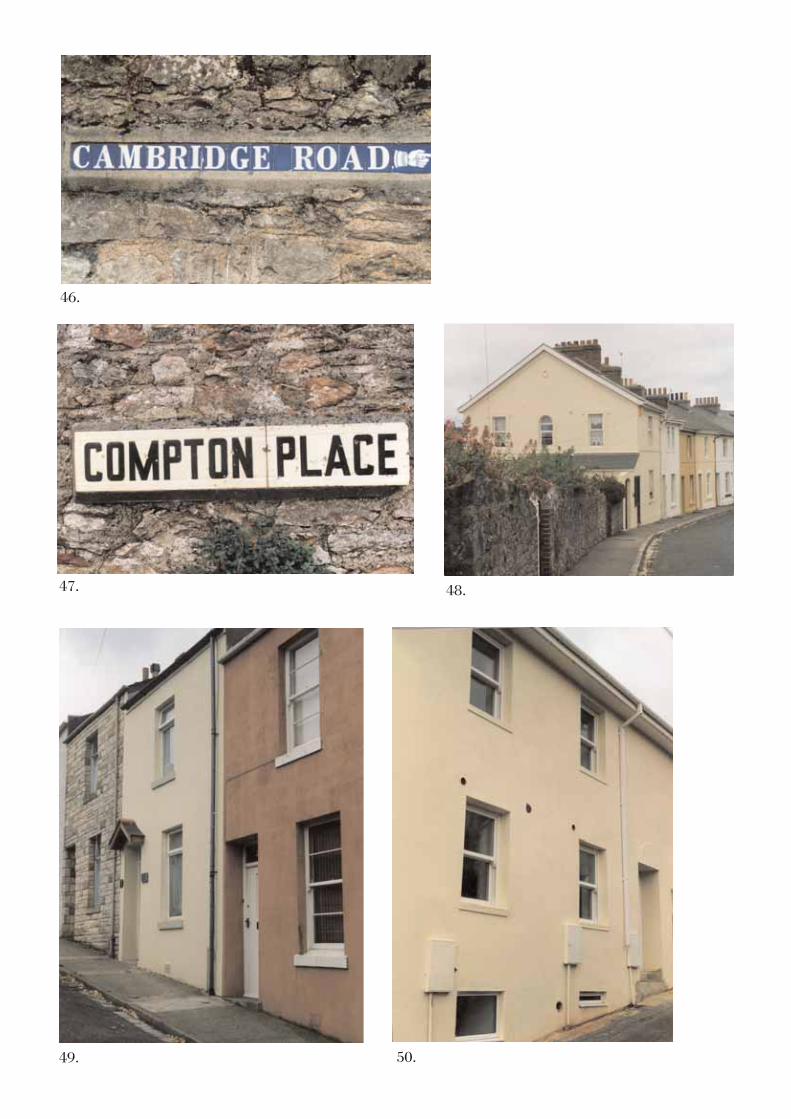
4.2.4 The extensive boundary walls, mostly made of limestone and randomly coursed, areanother important feature of the historic built environment. These are normallyfreestanding but where there are sharp changes of level, they are transformed intoretaining walls. The walls are interspersed with gate piers, in stucco or stone, some flat-and some pyramidal-capped. A number of street names are marked by Victorian blueceramic tiles set into walls, a tile per letter, often with decorative finger elements addedas at Cambridge Road; there are also examples of a later ceramic style with a word to apanel, as at Compton Place. As elsewhere in 19th century Torquay there are scatteredexamples of cast iron street-light columns, probably originally carrying gas lamps andembossed with local foundry names.
4.3 USE OF MATERIALS
4.3.1 Stucco or plain render on stone and a slate roof are the predominant building materials;occasionally red clay ridge tiles, some crested, and very occasionally displayingdecorative finials are also found. Some of the later buildings are partially or completelybrick built, with pebble-dash rendering and plain tile roofs, although these are verymuch in the minority. Other than where indicated on Map Four the use of exposed stone

10
is also quite rare, with only two or three villas so built, although there are a number ofshort terraces and outbuildings of the locally quarried grey Devonian limestone tocomplement the ubiquitous stone boundary walls.
4.3.2 Many examples of original joinery are still in evidence: detailing on the eaves andgables, panelled doors, and double-hung sash windows is found in a variety of forms. Alljoinery was an integral part of the original elevation and thus related to the building as awhole; and in the case of semi-detached villas the mirror halves are of deliberate design.The long terrace groups on, for example, Western Road show instances of the disastrousresults that occur when the retention of traditional materials, window forms and glazingbars are dispensed with. Not only is an occupant’s decision to carry out such drasticchanges regrettable, but that in the absence of Article 4(2) directions there are fewstatutory means to control such deleterious alterations.
4.3.3 The dominant roofing material of the 19th century developers was Welsh slate; today wellover half of the buildings of this age have had replacements by artificial substitutes,especially in the case of the plainer terraces, such as Compton Place, Western Road andCambridge Road where the figure rises to over 90%. Likewise, the large majority ofthose houses with plainer frontages have had their original doors and windows replaced,mostly with PVCu double-glazing. Even the long terrace in St Margaret’s Road has lostmost of its original roofing slates and the original openings on several frontages.
4.4 CONDITION OF BUILDINGS
4.4.1 Most domestic and commercial buildings are well maintained. Where a building hasbeen neglected long enough it may lead to a lamentable loss: the former brewerybuildings behind the Palk Arms at the north end of the conservation area are underthreat; there are also two town centre buildings, one in Fore Street facing Church Road,the other in Hampton Close, off Fore Street which are in a dilapidated condition. Thesemerit restoration that respects their present form, rather than outright demolition.
4.4.2 When period features lack maintenance and start to deteriorate, the potential for furtherloss through decay is high, with little protection from unsympathetic replacement. Theinherent character of some of the principal large villas, for example, those in StMargaret’s, St Marychurch, and Manor Roads remains vulnerable to frontage alterationsthat are permitted under current regulations for permitted development, yet are hugelydetrimental to the conservation area’s historic character and townscape quality. Furtherthroughout the conservation area, re-roofing in artificial slates and the substitution ofperiod joinery with PVCu double-glazed windows and doors is quite widely underminingwhat remains of the Victorian character. There is an urgent need to encourage owners torenovate their properties restoring and re-using as much historic material as possible.
4.5 LOCAL DETAILS

11
4.5.1 There is strong contrast between white stucco, the mainly pale grey limestone walls andthe rich vegetation cover, much of which is evergreen. The elevated position of StMarychurch with its sloping or undulating topography, giving more distant glimpses ofadjoining suburbs, especially to the north and west provides much of the inherentcharacter of this part Torquay. The two churches, one with its tower, the other with itsspire, in close proximity are dominant landmarks both within and far beyond theconservation area. By contrast, the several streets of close knit 19th century terraces,mainly in the northern half of the conservation area, provide a pleasing intimacy of scaleand sense of enclosure, including some recent sensitive infill at the junction of the lowerpart of Western Road and Havelock Road.
4.5.2 The typical one-over-one-light double-hung sash windows, some with semi-circularheads, is a largely local characteristic and is strongly represented here. The earlierTorquay style of Italianate villa, invariably stuccoed and built between the 1850s andthe 1880s is represented, as is the later style with canted bays and other materialsincluding stone and pebble-dash. In Rowley Road, early 20th century semi-detachedhouses with segmental arched openings with keystones and rustication hark back to aprevailing earlier style. St Marychurch is relatively rich in commemorative streetfurniture, and possesses an overall street layout that identifies its status as an importantmid-late 19th century small town in its own right. In addition to a main street of medievalorigins, there is an artisan-based northern suburb, several significant villa developmentsto the south and west dating from around the late1840s onwards, and a new civic andcommercial focus dating from the late 1870s and 1880s.
5 CHARACTER AND RELATIONSHIP OF SPACES
5.1 There are pleasing contrasts between the broad, straight, boulevard-style streets, and thegently curving, sometimes undulating, and generally quieter back roads. The layout andorientation of much of the villa development gives rise to a well founded air ofspaciousness. Apart from a few exceptions the original scale and proportion of the villadevelopments, mostly of two-storeys, has been maintained. In contrast to the villas,much of the northern part of the conservation area, and locally elsewhere ischaracterised by a much greater density of development consisting of close-kit terracedhouses fronting directly onto the pavement with largely contained views and occasionalglimpses of more distant skylines.
5.2 Some quite distinct differences in level enliven the relationship between buildings andprovide both containment as well as some significant outward views over, or betweenbuildings, both to near (less than half a mile) and more distant skylines. The upper partsof Barewell, Western, and Trumland Roads show wide westward views while there areviews to the north and east from parts of Park Road, Hartop Road and Lummaton Place.There is a complex, and possibly early pattern of back lanes, largely enclosed by walls,and with sharp differences in level, just to the south and west of the twin churches, andtheir scale and dominance on a hill crest is most evident in this part of the conservation

12
area. Much of the southern half of the conservation area is situated on relatively levelground where outward views are limited.
5.3 A limited amount of demolition and subsequent redevelopment has occurred within andclose to the town centre, including that associated with provision of the town centre by-pass – St Marychurch Road north of Fore Street. Nevertheless, one of the majorcharacterisitics of the conservation area is the very limited amount of additional or infilldevelopment that has occurred within the conservation area beyond the early 20th
century.
6 GREEN LANDSCAPE AND TREES
6.1 The most significant open space in the conservation area is Tessier Gardens, some 2½acres, which contains several fine specimen trees and connects St Marychurch to theCary Park conservation area to the south. It is however somewhat hidden and does notmake a great impact upon the street scene except where trees act as a backdrop tobuildings. More prominent are the trees in the churchyard and in front of the formervicarage which are an important feature in Fore Street. In the villa areas, the overallimpression is of a rich, almost park-like setting, made up mainly of deciduous treesinterspersed with evergreens, most notably holm oak (Quercus Ilex). In Manor Road andSt Margaret’s Road, street trees were planted, probably as part of the original layout, tocreate a boulevard affect. These are all deciduous, and some young trees have beenplanted among the mature specimens.
6.2 There are substantial numbers of other mature trees and large shrubs within the groundsof villas and some walls are topped by hedges or shrubbery. Amongst the villas in theTrumlands Road and Western Road area the distribution of trees and shrubs issomewhat more informal. The same is true of the villas in York Road. Both the long driveand surroundings of Cary Castle contain a further concentration of trees: the drivewaycontains a very significant avenue of lime trees (Tilea x europea) running the length of itscentre, which would benefit from full restoration; and on the slope immediately west ofthe Castle there is a good conifer group, clearly a deliberate piece of late 19th centurylandscaping. The seemingly ubiquitous palm trees are mainly confined to the grounds ofthe larger villas and guest-houses, but even mature specimens tend to be limited in sizeand spread and are only locally prominent.
6.3 Several individual trees or tree groups are important individual components of thetownscape. Noteworthy examples are the holm oak at the junction of Park andCambridge Roads; those trees fronting Fore Street near the Parish Church; the maturehorse chestnut (Aesculus hippocasternum) at the rear of the Snooty Fox; and the avenueat the northern end of St Margaret’s Road. A deciduous group at the junction of Hamptonand Babbacombe Roads which is just beyond the conservation area boundary, has animpact upon the vista from the south end of Fore Street. Substantial numbers of youngtrees have been planted adjoining the by-pass to augment those already bordering thepublic car park east of Fore Street. Young street trees planted at the south end of Fore

13
Street blend into the overall street scene somewhat more successfully than those plantedin the pedestrian precinct where space is more confined. Although most trees appear tobe in a healthy condition, a few older specimens may be approaching senescence andwill require monitoring. Tree conservation and replacement will be an important part ofstreetscape management in the future.
7 THE SETTING AND FEATURES OF SPECIAL IMPORTANCE
7.1 The conservation area largely defines the historic development of what is now asignificant suburb of Torquay. Close by are several of the quarries that supplied much ofthe building materials for the rest of Torquay, as well as being central to the equallyimportant marble and terracotta industries, whose products went further afield. Theseindustries were the springboard for the rapid change of St Marychurch from a relict ruralsettlement to a close-knit industrial settlement from the 1840s onwards. There is littleconcession to its proximity to the sea, until villa developments began to appear on theTorquay side of the town in the latter half of the 19th century, when the planting of palmsand other evergreens more commonly associated with a ‘seaside’ setting began. Thesituation of the southern half of the conservation area on a plateau with a hint of the seato the east gives it a more spacious and suburban quality. This form of developmentextends well beyond the boundary to the adjoining Cary Park conservation area, andbeyond to the Lincombes and Warberries, either side of Babbacombe Road.
7.2 It is possible to summarise the features that give the conservation area its specialcharacter as follows:
the elevated setting of the conservation area with significant outward views;
prominent landmarks, notably the adjoining Anglican and Roman Catholic churches,and to a lesser extent, Cary Castle, the Town Hall, and the Palk Arms site;
the planned developments of c.1860 onwards, including parts of the town centre, whichprovides attractive townscape and several important vistas, enhanced by street trees, andextensive boundary walls;
the close-knit network of mid-19th century terraced houses representing the formerartisan/industrial housing originally built for workers employed in local industries;
the considerable number of good quality unlisted (complementing the listed) mid-late19th century buildings which retain a large proportion of period detail and inherentcharacter – especially the case where villas remain in private residential use away fromthe major thoroughfares;
the survival of boundary walls, ornamental gate piers, some original ironwork, timberdetail to doors, windows, porches, and glazed canopies. The extent of mid-to-late

14
Victorian detail in stucco and complementary period embellishments such as carvedeaves brackets and gable-end barge-boards, semi-circular and segmental-archedopenings, and significant corner treatment such as rusticated quoins;
several good examples of commemorative and other forms of period street furniture,including two listed traditional K6 red telephone kisoks near the Abbey School.
8 EXTENT OF LOSS, DAMAGE AND INTRUSION
8.1 Towards the northern end of Fore Street there is some evidence of commercial declinewhile the shopping centre as a whole has lost the majority of its traditional shop-fronts.Upper floors have retained more original detail, mainly sash windows with glazing bars,although there are indications of poor maintenance and under use. Little attention hasbeen given to the design of ground floor fascias in relation to the building as a whole,and some insensitive examples of 1960s commercial redevelopment with large horizontalfascias are evident. These changes have left a legacy of intrusive townscape completelyalien to the underlying historic character of tightly packed small-scale shops, workshopsand houses directly abutting the street.
8.2 Regrettably there are no longer any commercially available sources of local stone; this ismost evident in the absence of any natural stone flags or setts used in the relativelyrecently pedestrianised areas. The only evidence of the former thriving stone quarryingindustry is a base of Petitor marble supporting the commemorative cast iron street-lampat the junction of Fore Street and St Margaret’s Road.
8.3 Elsewhere in the conservation area, there are other elements detrimental to its characteror appearance. While the following list may not be exhaustive, the major detractions areconsidered to be:
unsympathetic extensions or additions to 19th century buildings, some of single-storeyconstruction with flat roofs, others out of scale with the original design;
the gradual erosion of traditional materials and finishes – this is especially the case withroofs where the original slates have been partially or completely replaced with artificialsubstitutes, some of which are but very poor imitations of the original;
the loss of historic joinery, including sash windows and panelled doors, and theirreplacement with unco-ordinated substitutes often in aluminium, PVCu, or timber whichis most often of a quality far inferior to the original; even failing joinery, should in mostcases be repairable, and with regular maintenance, should continue to rival thedurability of many replacements;
untidy, disused or poorly integrated backland sites especially on the periphery of thetown centre;

15
some loss of symmetry in semi-detached villas, where there have been marked frontagechanges to elevations and boundaries;
street lamps which have little or no bearing to historic precedent;
9 SUMMARY
9.1 St Marychurch is an important settlement in its own right and has a strong sense of itsown identity. The almost universal use of stucco or rendered finish on buildings withrather understated but widely variable period detail is one of its chief features. Thelimestone rubble boundary walls; and the large number of trees, shrubs and hedgesespecially in the areas of villa development, in Tessier Gardens, and within theecclesiastical curtilages also contribute to its underlying attractive and historiccharacter.
9.2 Within the town centre there are several features defining local identity, and a generallywell-balanced interface between buildings and the green landscape. The dominantimpact of the churches and bold urban space at the southern end of Fore Street; and thespaciousness of the villa developments, sometimes in close proximity to areas where thehousing is of smaller scale within a denser street pattern has produced an interestingand contrasting townscape.
9.3 To some extent the original 19th century character has been compromised by subsequentalterations and additions, which is also typical of some other Torbay conservation areas.The Adopted Local Plan acknowledges this:
many of Torbay’s Conservation Areas have been designated ‘warts and all’ andcontain areas of very mixed quality, including past development that is totally outof context with the surrounding area. Redevelopment or alterations to existingbuildings may provide opportunities to design more appropriate new buildings orto restore lost or degraded features. (Torbay Local Plan 1995-2011, The BuiltEnvironment 14.8)
9.4 Since the 1980s some 19th century villas and terrace blocks have deteriorated. This oftenbegins with unsympathetic insertions in window and door openings and continues withunsatisfactory and inappropriate extensions. It is unlikely that any conservationjustification can be made for the further redevelopment of villa sites. Currentconservation area legislation and advice places a strong emphasis on the need topreserve or enhance the character or appearance of Conservation Areas. This is alsoseen as a crucial criterion when assessing applications for development in ConservationAreas (Torbay Local Plan 2004, The Built Environment 14.9).

16
9.5 Thus conservation planning advice will always aim to improve the quality of newbuilding, or to restore lost or degraded features from historic ones. Additionally it willaim to preserve boundary features and the surviving historic elements of design andornament including the sympathetic use or re-use of appropriate materials. To ensurethat the case for demolition, or thoughtless change, cannot be substantiated in future,there needs to be a greater emphasis on proper maintenance and repair using traditionalmethods, especially in the case of those buildings which do not have statutory protectionyet form an integral part of the historic built environment.
9.6 It will require determination to ensure that the erosion of historic detail does notcontinue. This will necessitate designation of Article 4(2) Directions in order to protecthistoric frontage and boundary detail, much of which is not statutorily listed. Hand inhand with regulation, it is considered important, given the increase in the loss oftraditional shop fronts, to assist owners in seeking solutions which will aid thesympathetic conservation or restoration without necessitating PVCu or otherinapporpriate replacements. Not only are such alterations detrimental to the historiccharacter of individual buildings but they also create anti-aesthetic discords at thestreetscape level.
10 CONSERVATION AREA POLICIES
10.1 Conservation Area policies are addressed in the adopted local plan:
Policy BE5 - Development within or affecting a Conservation Area will only bepermitted where it will preserve or enhance the character or appearance of thatarea.
The Policy outlines the Council’s strategy for Conservation Areas. It includes issuessuch as the control of demolition, alterations and extensions, boundary featuresand design aspects, as well as the control of development in adjacent areas whichcould impact significantly on the townscape and environmental qualities withinConservation Areas. (The Built Environment 14.9)
further it is recognised that:
Roof materials, chimneys, cornices and mouldings, original windows andshopfronts, railings and boundary walls can all make an important contribution tothe character of a Conservation Area. The Council will introduce Article 4(2)Directions to bring such items under normal development control. (The BuiltEnvironment 14.56)
10.2 To frame specific policies within the St Marychurch Area:
(1) All unlisted buildings identified as key buildings or groups of buildings thatcontribute to the historic built environment (see Map One) should be included

17
within Article 4(2) Directions to control inappropriate changes to the principalelevations.
(2) Protect from detrimental loss all key local features of special importance (seeSection 7), which need to be safeguarded or enhanced, when determiningdevelopment proposals within the conservation area; and where in future,Conservation Area, or Article 4 consent may be required.
(3) Give due consideration to other key local factors which make up the features ofspecial importance, such as the building groups of special merit outside theconservation area – or more practically exstend the conservation area to includeseveral more streets which retain areas of relatively unscathed late 19th to early20th century character.

18
BIBLIOGRAPHYEngland - Black’s Guide Books for Tourists Adam & Charles Black Edinburgh 1857
Ward, C.S., & Baddeley, M.J.B. South Devon & South Cornwall - Thorough Guide Series (thirdedition) Dulau & Co., London 1889
Hope-Moncrieff, A.R (Ed.) Black’s Guide to Devonshire (sixteenth edition) Adam & CharlesBlack London 1898
Baedeker, K. Great Britain - Handbook for Travellers (sixth edition) Karl Baedeker, Leipzig1906
Ward, C.S., & Baddeley, M.J.B. (Compilers). South Devon & South Cornwall (ninth edition)Ward Lock & Co. Ltd. London c.1923
Red Guides: Torquay & South Devon Ward Lock & Co. Ltd. London (Twelfth Edition) 1923-24; (Fifteenth Edition) 1939-40
Winbolt, S. E. Devon - Bell’s Pocket Guides G. Bell & Sons Ltd. London 1929
Ellis, Arthur C. An Historical Survey of Torquay 1930
Red Guides: Paignton & South Devon Ward Lock & Co. Ltd. London (ThirteenthEdition)1931-32
Mee, Arthur (Ed.) Devon (The King’s England Series) Hodder & Stoughton London (5thImpression) 1951; revised edition 1965
Hoskins, W.G. Devon William Collins London 1954; (revised edition) Devon Books 1992
Russell, Percy A History of Torquay and the Famous Anchorage ofvTorbay Torquay NaturalHistory Society 1960
Clifton-Taylor, Alec The Pattern of English Building Faber & Faber London 1975
Betjeman, John (Ed.) Parish Churches of England & Wales Collins London 1980
Barrett, Helen & Phillips, John Suburban Style - The British Home, 1840 –1960 Macdonald &Co. London 1987
Le Messurier, Brian The Visitor’s Guide to Devon Moorland Publishing Co. Ashbourne1988 (2nd. edition) ISBN 0 861890 232 7
Born, Anne, The Torbay Towns Phillimore 1989 ISBN 0 85033 694 5

19
Cherry, Bridget and Pevsner, Nikolaus The Buildings of England, Devon Penguin (secondedition) 1989 ISBN 0 14 071050 7
Toulson, Shirley The Companion Guide to Devon Harper Collins London 1991ISBN 0-00-215135-9
Travis, John F. The Rise of the Devon Seaside Resorts University of Exeter Press 1993ISBN 0-85989-398-8
City of Westminster, Department of Planning and Environment Stucco:A Guide to Care andMaintenance 1994
Department of National Heritage Revised List of Buildings of Special Architectural or HistoricInterest - Borough of Torbay, Devon, Area of Torquay May 1994
Quality in Town and Country Department of the Environment June 1994
Catalytic Conversion - Revive Historic Buildings to Regenerate Communities SAVE Britain’sHeritage/Architectural Heritage Fund November 1998
Enabling Development and the Conservation of Heritage Assets English Heritage June 1999
Pike, John Time Traveller - 1000 years of South Devon History Herald Express NewspapersJanuary 29th 2000
Power of Place - The future of the historic environment English Heritage December 2000
Building Regulations – Balancing the needs for energy conservation with those of buildingconservation: an Interim Guidance Note on the application of Part L English Heritage March2004
Torbay Local Plan 1995-2011 Adopted Version Torbay Council April 2004

PHOTOGRAPHS

Civic and Ecclesiastical Buildings1 In the late-18th century St. Marychurch began to develop from its medieval origins
as a result of the marble trade; during the 19th century it expanded greatly into aseparate and sizeable community becoming an urban district council in the 1880s.This was made manifest by the rebuilding of the medieval parish church 1856-61,the tower being added in 1877 by J Hugall; the establishment of a large RomanCatholic Church and Priory in 1865 by Joseph Hansom, with its impressive spire ona single block; and G S Bridgeman's Town Hall of 1883 (4). Both tower and spire aredominant landmarks, emphasised by their elevated location. A large presbytery andformer orphanage adjoin the latter.
2 The early 20th century Parish Memorial Hall north of the Church.
3 Looking southeast along Fore Street from the Chilcote Memorial towards the 1883Town Hall; here the lower end of Fore Street is all 19th century planneddevelopment.
4 The former Town Hall at the junction of Manor and Babbacombe Roads from thesouthwest; Bridgeman's 1883 design used coursed local limestone (41) with thebanding, reveals, cornices and other detailing in Ham Stone
5 Behind the town centre are quiet residential streets, some with outward views fromhigh ground. This northeastward view from the top of Barewell Road shows what isnow a footpath link to Church Road; this was the historic boundary to the glebeblock before the 19th century extension of Church Road south and east reduced itsextent.

1.
4.
5.
2.
3.
6 East of the parish church the frontage at the northeast junction of Park and PetitorRoads shows good corner treatment, the pub and terraces beyond contributing to thewell-proportioned townscape.
Building Forms7 One of the three simple terrace groups in Compton Place built by the mid-19th
century, probably for workers employed in the nearby quarries or marble industries.
8 Another mid-19th century terrace; this group of eleven in Western Road is of higherstatus with much original ornamentation including segmental and semicirculararched openings, and horizontal glazing bars in the characteristic local style. Whilea later bay extension at No. 15 preserves the sash-pane style, the top-hung PVCureplacements at No. 17 are ungainly and out of place, No.19 shows the completenessof the original design.
9 205 St Marychurch Road, a listed and largely unaltered villa of c.1850, facessouthwest towards Manor Road; although extended to the sides and rear this hasbeen sensitively accomplished, the retained boundary wall reinforces the sense ofseclusion and integrity.
10 The southfacing aspect of 207 St Marychurch Road by contrast has beenoverwhelmed by the post-war extension which is Kennleigh Court. The hipped roofof the original villa has lost its context and its dignity.

7.
9.
8.
10.
6.

11 The crescentic 7-10 York Road is a listed stucco 4-house terrace of c.1860; the3-bay fronts preserve all the original details: segmental-headed panels, pilasters,round-headed doorways, and 4-panel doors with fanlights. The integral front gardenwalls and gate piers too are part of the original design - a classical Torquay styleterrace
12 1-4 Lindridge Road is short 2-storey stucco terrace of two mirrored-pairs withsemicircular arched openings at each level beneath a gable. The sash windows withtheir narrow glazing bars are also typical mid-19th century features.
13 1-4 Priory Road is a simple 2-bay terrace group (No. 4 has three bays) with longtapering rear gardens imaginatively designed for the unusual wedge-shaped plot.Two of the four show replacement windows, compare the thick PVCu horizontalelements of No. 1 with the original delicate glazing bars of No. 3's sashes.
14 A semi-detached pair at the corner of St Margaret's and Priory Roads; the boundarywall has been breached and lowered to provide vehicular access, thereby destroyingthe front garden at a significant junction. Fortunately the sashes in the bay frontsappear to be in good repair.
15 One side of a former semi-detached pair in Greenway Road shows the cumulativeerrosive effect of poorly designed extensions, inappropriate materials andunsympathetic replacement glazing forms.

14.
13.
15.
12.
11.

16 At the northern end of the conservation area, with the exception of the solitary villaof 71 Park Road, and the adjoining semi-detached pair Nos 67-69 (23) all thebuildings are terraces: here at the junction of Western and Park Roads the two-storeymid-19th century terrace with only the barest detail and ornamentation is typical ofthe area. The quarried face of Lummaton Hill rises in the background.
17 Some of the existing terraces have been refurbished, as here on the south side ofLummaton Place where the only detailing is the plat band between the storeys. No18 in the foreground would have been greatly improved still more if the sashwindows and panelled door had been retained.
18 The terrace groups here at Cambridge Road are more elaborate with wide gables,gardens and boundary walls and piers.
19 The most elaborate northern terrace of all is the irregular listed group of 2-8 ParkCrescent of c.1840, because it is set back from Cambridge Road by long frontgardens the topography allows an additional storey on the Park Road side.
20 The early 19th century terrace with cottage orneé features is dwarfed by the rear ofthe adjoining Park Crescent.

19. 20.
17.
18.
16.
21 In Hartop Road the earlier 1880 terraces are largely unadorned, here only thevariation in glazing bars makes any statement, simple but effective.
22 In Park Road the terraces are largely mid-19th century; that to the left with its 6-pane sash windows and door hood on console brackets remains unchanged, on theright the late 19th century alterations: an inserted bay and single-pane sashesrespects the aesthetic.
23 A large semi-detached villa of c.1900 at 67-69 Park Road is a late and solitary infillin this part of the conservation area. With its roughcast red render it is a loneexample in St Marychurch of the characteristic Cary Park type, ¾ mile to the south.
24 The 1860/70s semi-detached pair of 20-22 Petitor Road shows much typical perioddetail such as pronounced quoins, plat and sill bands, hood moulds, semi-circulararched windows, brackets, boxed eaves, and sash windows with single horizontalglazing bars.
25 On the edge of the conservation area where the St Marychurch Road extensioncrosses Petitor Road the former villa of Torleigh preserves some of its originaldetailing in rustication, cornicing and strap work; the rebuilding and alteration of itswestern part shows an utter disregard for historical precedent, aesthetics and taste.The loss of curtilage and adequate boundary walls to the road extension has alsobeen to its severe disadvantage.

25.
21.
24.
23.
22.

26 In Rowley Road there are 13 semi-detached pairs of this type; all are Edwardian yetthey show an earlier style with rustication, paired-segmental windows, brackets andbands. The replacement door and windows detract from the modest perfection of thetype.
27 Cary Castle c.1850 with its many neo-Gothic features is a prominent local landmark,now converted to flats. It is listed though this has not prevented some unfortunatealterations.
28 The Tudor-Gothick, former Hampton House c.1840-1850, now the listed AbbeySchool contains some fine interior features including staircases, panelled doors andfireplaces. Its rubble-faced frontage with Roman cement has survived the StMarychurch Road extension which has otherwise removed its rear wing and left someof its outbuildings isolated on the far side of the road (29).
29 This large stone building with an asbestos roof in Hampton Lane is semi-derelict; itwas formerly an outbuilding, probably stabling, of Hampton House (28).
Commercial Frontages30 Four shops adjacent to, and contemporary with, Bridgeman's Town Hall in
Babbacombe Road preserve much of their original detail, although there arereplacement PVCu windows at first floor level.

27.
26.
29. 30.
28.

31 Purpose built shops in Fore Street c.1880, with second floor dormers. Almost allhave late-20th century inserted shopfronts yet the original design otherwise surviveswith moulded console brackets and cornices together with doorways and fanlightsover, between pilasters giving access to the upper living quarters.
32 Curiously this Victorian Street 'attraction' in Fore Street is contained behind an inter-war façade, rather than one of the many actual contemporary frontages.
33 This café in Fore Street is a particularly fine example of interwar mock-Tudor, fit forpurpose.
34 The shop front of the listed 71 Park Road is a former carriage entry framed bypanelled pilasters, with a dentilled cornice and parapet with urn finials surmountingterminal piers over. It is empty, supported by acrow-props and in sore need of repair.
35 56 Park Road shows a fine well preserved shopfront, but its future is uncertain asthe viability of many local shops continues to be reduced.

33.
32.
35.
34.
31.

36-38 For a length of 135m of Fore Street's shopping area has been pedestrianised; mostshops are small in scale, some have surving traditional shop fronts as well as first-floor sash windows (36); the commemorative monument is a street lamp utilising asalvaged 19th century ornate column set on a plinth of local polished marble (37);the 1960s shopping centre is a particularly unfortunate addition to the street scene(38).
DetailsThere are many fine examples of surviving historic detail and ornamentation withinthe conservation area.
39-40 Random rubble walls of local limestone are common boundary features; the repair atthe junction of St. Margaret's Road and Priory Road (40) with cementitious mortar isnot only unpleasing to the eye but will exacerbate the problem.

39.
38.
40.
37.
36.

41 The snecked limestone wall of the Town Hall (4) shows a high level of craftmanship.
42 A 19th century cast-iron street lamp in Trumlands Road, originally gas lit; anothertype has been used in the Fore Street memorial (37).
43 Iron railings close to the junction of Fore Street and Park Road; these are in poorcondition and require renovation. Such authentic period street furniture is animportant element of the historic built environment and should be conserved.
44 23 Park Road is listed, preserving both sash windows and its first-floor decorativeironwork balconies; unfortunately it has lost its original doors to inferior modernreplacements.
45 Park Cottage, 44 Park Road has a fine original glazed porch with decorative finialsover - the ironwork is far superior to that of the replacement gate and fence.

45.44.
43.
41.
42.

46-47 A number of street name plates survive: a late 19th century single-letter blueceramic type; and a more unusual single word-type of the early 20th century. Thereare five different types of ceramic lettering in the Torbay area.
48 26-32 Western Road c.1870s, part of a terrace group of seven forming a slightcrescent; the end gable has been thoughtfully designed, ornamented and fenestrated.
49 Detail subverted and destroyed: the inherent character of these simple terraces isextremely vulnerable to alterations and additions that have little regard for historicprecedent, use of local materials, or building methods. Contrast the simple charm ofthe nearest house with its 2-pane sash windows with its neighbours: the poor PVCureplacement glazing and twee porch hood of one, and the totally unsuitable claddingof the other.
50 Near plain with only the simplest detailing yet this new housing in Havelock Roaddoes pay attention to local building forms and historic detail.
47.
46.
48.
50.49.
Ambience51 Manor Road and St. Margaret's Road both have street trees which in combination
with limestone walls contribute important elements to the townscape.
52 Large specimen trees such as this example in Trumlands Road are not as evident assome other parts of Torquay. Whilst the conservation area contains a wealth of trees,their height and dominance may be limited by the relatively exposed location.
Threats53 The former brewery attached to the Palk Arms in Lummaton Place; this has been
delisted and has now fallen into very poor state of repair, though not yetirrecoverable. Demolition rather than re-use would be a loss to the townscape and tolocal history.
Potential54 The north side of Teignmouth Road, which comprises terraces of the late 1880s, lies
within the conservation area. On the south side the later Edwardian terraces (Nos369-405), which retain better historic detail, are actually outside the boundary. Thedoor and window detail, the majority of which survives, is very typical of theEdwardian era. These with the late Victorian terraces of the upper part of HartopRoad (Nos. 64-106) would be a logical extension to the conservation area.

51.
53.
52.
54.

This map is based upon Ordnance Survey material with the permission of Ordnance Survey on behalf of the Controller of HMSOffice © Crown copyright.
Unauthorised reproduction infringes Crown copyright and may lead to prosecution or civil proceedings. Torbay Council. LA079782. 2005.
1862-1887Ordanace Survey County Series First Edition Surveyed 1:2500ST MARYCHURCH

This map is based upon Ordnance Survey material with the permission of Ordnance Survey on behalf of the Controller of HMSOffice © Crown copyright.
Unauthorised reproduction infringes Crown copyright and may lead to prosecution or civil proceedings. Torbay Council. LA079782. 2005.
Ordanace Survey County Series1:2500ST MARYCHURCH
Second Edition surveyed 1904

This map is based upon Ordnance Survey material with the permission of Ordnance Survey on behalf of the Controller of HMSOffice © Crown copyright.
Unauthorised reproduction infringes Crown copyright and may lead to prosecution or civil proceedings. Torbay Council. LA079782. 2005.
Ordanace Survey County Series1:2500ST MARYCHURCH
Edition surveyedThird 1933

3
3
3
1
2
3
14
11
Norcliffe Hotel
Meadlands
Hotel
Foxlands
Hotel
Foxlands
Intercombe
Close
Oswalds Hotel
El Sub Sta
Kestrel Court
House
1
1 to 17
Devonshire
18
47
1 to 16
Rose Court
7
Holly House
14
Burnham
11
41
1
5to8
45
4
5
9
12 2
6
Linden Lea
10
10
7
6
3
Babbacombe House1
Blue Mist
Mertoun
Cliff Edge
Rancliffe
Littlecombe
Crag Lodge
Oddicliff
Glenhurst
Clovercombe
Ticket Office
10
Hotel Blue Conifer
New
ton
Villa Marina
End
Homefield
Lodge
Far
The Cedars
Trendlebere
Hampton
Grenville
Lynton
Revelstoke
Kinrose
Lodge
Charnwood
Leafield
Peticombe
Bay House
Kidbrooke
Fairways
4a
6
6a
4
Courtlands
1to
41
1
Cha
rlwood
Cou
rt
Blue Haze
Little Croft
Surgery
Cornerstone
Model Village
Dewerstone
PO
Bank
Surgery
Dennington
Museum
El
3
Sub Sta
The Abbey School
Three Hills
Redlands
Manor
6
3
Hotel
22
(PH)
5
5
1
Club
8
7
Foxlan
ds
4
3
5
2
Hou
se
10
141to
12
St Mar
tin's
Mew
s
13
30
PH 34
11
57
36
13a
19
27
25
40
73
77
6967
51
75
71
56
52
55
44
Hou
se
2
1
Chapelstones
Dom
inican
Conv
ent
38a
38b
Marg
aret
Clit
her
oe
49
61
21a
Cottage
21
Priory
33
12
11
3 to 10
Pat
hway
s
3
Cloisters Cottage
Presby
Spire
Cottage
4
RC
Chu
rch
ofO
ur
and
St D
eni
s
Lad
yH
elp
ofC
hris
tians
St M
ary
's
La Ronde
12
10
Mapleholme
Villa Pax
Fordington
Pax
Lodge
Lorna House
Avalon
Lyndhurst
29
39
24
36
8
4
Parkfield
Castle Court
House
House
Redcliffe
Coridon House
Cheriton
11
63
Coach House
53
49
43
Cranbrook
51
61
3
63
1
7
57El Sub Sta
The Bourne
Narrow Water
13
16
10
6
11a
11
22Village
Model
Cleeve Lodge
37
37a
1
10
Belthorne
55
4
6
5 Coppins
30
19
27
25
40
4
8
9
12
19
2
8 10 27
Garage
21
31
21
3
12
14
Sunnyside Flats
16
Primary School
St Marychurch
2 4c
79to
81
65
Row
leyC
ourt 1
Mew
s
15
17to
24
11
to16
35
22
33
C of E
1
Pe
titor
2
14
St Ann's
14a
Snooty Fox
93
Snooty Fox
3to
5
68
72
1
Hote
l
70
87
83
7to10
21
1
5
PH
2to4
105
1
56
5
1
ThePaddock
24
32
1 to5
Fairway
16a
16
7 5
13
11
3
9
1
Forge
Cottage
Church
Mew
sCottage
Lych
Gate
5
32
St Mar
y's
1
Cou
rt
8
3
Cha
rlotte
7
Compton House
Trecarn Hotel
The
Haven Court
Cary Dale Court
Tree
1 to 11
Tops
Westhome
1 to 14
Barholme
2
Babbacombe House
Rathlin
Parkside Villas
1 to 11
1 to 12
Imperial Court
Beechcroft
33
Refo
rmed
Churc
hUnite
d
10
35
31
10a
15
8
FurroughCourt
1to
6
24
15a
Cot
t
14
Sun
nyside
Stamford House
Willenhall
House
Wrenwood
Lincoln
Harewood
House
1
2
Penlee
3
16
29
4
17
11
1
Town
Hall
9
CourtSunnyhill
Essfay
14
Carl
11
St
Dancing School
Ludwell
Oakleigh Lodge
Glendourgan
Nicholas
The Anchorage
Oakleigh
Hotel
24
22
Bank
18
2
PC
PC
20
31
Hadleigh Court
Hadleigh
Court
1to
33S
tanle
yC
ourt
Court
Stanley
1 to 33
Walderlea
Lorrens
Club
29
25
19
Bank
217
Bank
14a
16
14
Chilcote House
1 to 6
213
Alderbourne
Buildings
General
17
Cary Park Lodge
Sandhurst
Kennleigh
Court
El S
ub
Sta
Sandhurst
Court 8
Court
Seabury Hotel
Tre
leig
h
House
Woodstock
Corinea
Tre
leig
h
Clifton
Seabury
Hotel
Caradoc
2
1
StO
swin
s
Kingsbridge
2
1
13
7
1
Chalex House
207
1 to 4
209
205
203
7
11
5
Mews
Garden
Close
8
St Marys
1
Abbey Mews
186
to
184
Shanawan
4
19
1
6
Red Braes
3
65
52
Petitor
Cottage
46
50
48
1
Knebworth Cottage
La
Maisonette
to
4
Wincot
61
Elmhurst
Club House
34
Farthings
Paxholme
Tedbury
Pippin
Hill
59
57
24a
26
44
3a
5
1
1a
2a
Babbacombe
Vicarage
PH
7to
12
2
13
to18
17
12
1to
6
Warb
roC
ourt
6
123
121
118
27
1to
9
117
107
104
116
6
159
4
Mew
s
Exc
elsior
183
171
156
175
144
185
181
164
179
168
29
142
151
140
138
136
157
2
1
7
4
15
2
4
199
197
203a(Home for the Aged)
Dunboyne
1
12
6
5
11
178
18
17
Orchard Dene
137
15
Malvernleigh
2
9
16
8
3
14
10
6
19
14
12
Vellore
Whiteleaf
Brancaster
ChurchEastcombe
1
4
Zero
Sub
8
View
South Devon Hotel
11
Greytrees
St Margaret's
3
Beech
to
The
Court
Hall
The
Willows
1
5
Masonic
St Margaret's
Mews
TheSycam
ore
The
165
1to
18
55
Kilworthy
Hollies
171
173
El
Sub Sta
124
124a 2
124b
School
Sub Sta
El
St Margaret's
8
3
60
6
48
2
66
62
18
9
1
7
Court
10
Drakes
2
School
145
114
Homelands Primary
143
Tele
phone
14
137
129
24
Exc
hange
6
5
3
1
Centre
4
The Medical
2
St Mary's Church
19
2
21
64
6
8
Campion Court
72
Hall
Hall
53
55
14
1
49
56
50
60
80
St C
athe
rines
24
25
Hall
Lod
ge
92
Priory
RC School
(Primary)
34
27
28c
2
28
The
Clo
se
Fairwinds
Ryans Cottage
46
44
119
7
Garage
42
45
Little Spinney
12
Tintern
4
Maldon
10
94
1
19
13
2
42
11
House
5
41
37
The Coach
17
14
40
Woodgate
4
6
StK
itts
The
Forg
e
6a
15
23
12
10
33
34
15
26
31
13
Cou
rtHeber
Corbiere
Cottages
1to
6
26
26
36
1
41
23
32
21
38
62
El SubSta
46
50
27
76
12
43
64
88
1
5
The Coach House
73
57
69
14
33
24
45
40
20
100
102
405
81
106
83
81a
1
30
2
7
18
20
1
3
5
2
8
11
5
8
Forte
14
14
Marie14a
48
34
34
48
4
2
Nursing
6
Home
8
46
55
10
Petitor
381
340
21
64
65
6277 57
328
16
316
365
18
369
71
14
El Sub Sta
76
69
67
67a
31
1
PH
63
32
44
69
46
29
88
363
306
57
55
42
4
1
3
17
7
11
1
12
302
PH
300
296
349
StableLane Cotta
ge
2
53
Chapel Mews
40
43
Works
24
9
13
123
129
117
282
325
329
321
Coombe Dene
317
276
House274
335
1 to 14
7
15
Cary Castle
32
30
1
54
64
Moose Hall
18
2 45
43
44
36
1
Beech
119
96
100
104
House
5
22a
22
20a
20
331
29
33
38
34
El S
ub
Sta
El Sub Sta
42
33
41
37
11
41a
15
30
24
92
20
10
88
97
97a
22
102
94
Surgery
104
Surgery
111
101
99
24
27
32
28
14
45
24
34
25
26
46
21
30
23
33
266
301
396
400
Shelter
29
27
3
354
to35
8
Garage
2
85
5
Store
1
3
PH
352
393
15
11
7
18
386
10
33
Polhawn
31a
Strathmore
Pippins
19
16
1
15
18
31
El Sub Sta
39
11
37
27
21
29
22
31
20 1
21
8
17
23
2
14
1
13
6
34
31
13
3135
15
30
18
106
12
18
10
98
2
17
115
107
14
2
334
2
26
24
2to
16
7
1to
5a
3
10
1
2
14
Court
4
Wes
thi ll
20
37
6
17
8
23
18
15
18
5
4948
52
42
39
45
39
29
21
36
33
40
44
40
54
48
17
26
17a
23
21
24
6
21a
16
14a
24
26
46
1
36
19
27
37
1
41
43
2
11
12
49
52
50
73
75
54
71
57
45
57
Garage
59
96a
96
Lodge
The
Shelter
Westhill
House
98
11
1
53
53
53a
55
57
70
84
54
John
(PH)
Bull
88
72
1
90
82
STALBANSROAD
85.0m
YORKROAD
BM95.59m
96.3m
82.3m
BM 84.80m
88.7m
93.3m
DOWNS ROAD
BABBAC
OMBE
HAMPTONAVENUE
CLIFFSIDE
ROAD
Track
FB
Pond
Tra
ck
FBTank
Rises
Path
Path
ST MARYCHURCH
Car Park
STMARYCHURCHROAD
Car Park
LB
93.0m
STMARYCHURCH
ROAD
ROAD
GREEN
WAY
Shelter
BM 93.15m Car Park
HIGHERDOW
NS
ROAD
LB
94.2m
HamptonClose
Monument
FORESTREET
TCBs
LB
Hampton
Place
HAMPTON
LANE
Foxland
sW
alk
CHILCOTECLOSE
Mon
The Links
PETITOR
ROAD
ROWLEY
ROAD
ROWLEY
ROAD
ForeStreet
Posts
FORESTREET
ROWLEY
ROAD
99.1mCar Park
95.1m
STDOM
INIC'SCLOSE
LANE
GREENWAY
GREENWAYLANE
FORESTREET
BM 104.02m
102.4m
War Meml
TCB
102.1m
LB
ST MARGARET'S CLOSE
89.9m
BM
92.1
0m
STMARGARET'SROAD
PRIORYROAD
GREENW
AYROAD
PRIORYROAD
Posts
100.3m
STCATHERINE'S
ROAD
Posts
93.9m
CHURCHROAD
PRIORYROAD
BRADLE
Y PARK
ROAD
ROAD
ROAD
TRUMLANDS
CHURCH
82.0m
BM 93.03m
BAREWELLCLOSE
BAREWELLROAD
Tenn
isCou
rt
73.5m
Pool
97.2m
LB
96.6m
BABBACOMBE ROAD
TCB
El Sub
Sta
Shelte
r
BM
95.3
3m
88.1m
PALERMO ROAD
YORKROAD
BM 87.33m
Playground
Cary Park
CARY AVENUE
YORK CRESCENT
FURROUGH
CROSS
YORK
Stone
YORKCRESCENT
ROAD
York Villas
87.2m
El Sub Sta
BM
86.3
0m
LB
85.3m
94.2m
FURROUGH CROSS
BM
95.4
2m
CROSS
FURROUGH
LINDRIDGEROAD
91.4m
MANORROAD
Pond
Shelter
Shelter
Tessier Gardens
SD
Shelter
CARY PARK
ROAD
STANLEY
ESS
CARY PARK
Cary Park
GUESTLANDROAD
90.2m
CARY PA
RK
MANORROAD
Cary Park
CARYPARK
D Fn
87.8m
FORTU
NEWAY
BM
88.6
4m
WARBROROAD
88.7m
GREYSTO
NEWAY
STMARYCHURCHROAD
90.8m
TCB
CARY PARK
MANORROAD
WESTH
ILLRD
mund'sRoad
STEDMUND'SROAD
Posts
Tank
STMARGARET'SAVENUE
89.3m
91.1m
Playground
LB
TCB
84.7m
ROAD
HAYTOR
Playground
TRAMWAYS
DAISON CRESCENT
TCB86.0m
86.9m
WESTHILL ROAD
BM 99.94m
Path
101.2m
REDCLIFFE
ROAD
94.5m
93.3m
92.0m
Pet
Pa
th
92.0m
Path
Slo
pe
Coasta
l
Coasta
Slope
94.5m
95.7m
Kelvin
Court
PETIT
ORROAD
Path (um)
Track
89.6
m
STMARYCH
URCHROAD
98.5m
LB
BM
96.4
8m
99.7m
82.6m
95.7m
BM
96.04m
D Fn
COMPTO
NPLACE
Sub
Sta
El
98.1m
BM
90.21m
89.3m
99.4m
PARKROAD
BM100.36m
TRUMLA
NDSROA
D
ROAD
PAVOR
72.2m
FORE
STREET
El
LB
Sub Sta87.8m
89.3m
Post
BM
90.48m
FB
STMARYCHURCH
ROAD
LANE
Drain
FB
Torquay Golf Course
FB
Drain
Torquay Golf Course
SD
Drain
PathTank
Path
BM
78.9
3m
CAMBRID
GEROAD
BOROUGHROAD
78.0m PETIT
HARTOPROAD
WELL
Dra
in
ROAD
Issues
Sinks
Pond
Tk
MARYCHURCHST
SD
70.7m
WardBdy
Torquay Golf Course
Dra
in
SD
BM
70.4
6m
HILLY
GARDENSROAD
70.7m
BM 71.38m
71.9m
69.5m
73.5m
Chy
Sinks
Issues
GRASM
ERECLOSE
FORE ST
BIGBUR
Y WAY
WEMBURY DRI
VE
Issues
BM73.41m
LUMM
ATON
PLACE
TCB
HAVELOCKROAD
STABLE
LANE 83.2m
BM
84.1
7m
HAPPAWAY ROAD
SM
Playing Field
67.4m
74.4m
BM73.54m
TEIGN
MOUTH R
OAD
76.5m
COMBE R
OAD
COMBE ROAD
COMBELANE
Issues
HAPPAWAYROAD
FIRLANDSROAD
FIRLAN
DSROAD
FIRLAN
DS
ROAD
Sinks
LB
COMBELANE
ROADHAPPAW
AY
66.1m
BM 66.17m
68.3m
GREENWAYGARDENS
GREENWAYCLOSE
71.9m
Playing Field
Posts
Posts
94.2m
WardBdy
Quarry(disused)
WESTE
RNROAD
BM 76.14m
80.8m
SHELLEY AVENUE
BYRON
BLAKECLOSE
ROAD
IDEW
BRADLEYPARK
ROAD
BRADLEY
PARKROAD
69.8m
07m
ROAD
BYRON
WESTHILL
AVENUE
BM82.74m
80.8m
DAISO
N
80.8m
AVENU
E CLOS
E
CRESCENT
STMARGARET'SAVENUE
Post
WESTHILL
Post 82.6m
ROAD
CHATTO
81.1m
WESTHILLROAD
LB
BM84.58m
83.8m
65.5m
BM
77.8
5m
WESTHILL AVENUE
74.7m
EMPIREROAD
WESTHILL AVENUE
TCB
71.3m
CHATTOROAD
El Sub
Sta
75.0
m
82.6m
79.6m
BM71.40m70.1m
Posts
71.9m
ROAD
RE
ST. MARYCHURCH CONSERVATION AREA
Reproduced from the Ordnance Survey mapping with the permission of the Controller of HMSO. (c) Crown Copyright.
Unauthorised reproduction infringes crown copyright and may lead to prosecution or civil proceedings.
Torbay Council LA079782
MAP ONE HISTORIC BUILDINGS
Conservation Area Boundary
Listed Buildings - Grade I
Listed Buildings - Grade II*
Listed Buildings - Grade II
Sub Divisions (refer to text)
Other key buildings and building groups of architectural importance or which make a significant contribution to the townscape
Historic buildings at risk
Number 3 Designated: 29 April 1980
Extended: 17 November 1982 and 21 January 1987
CARY PARK
Adjoining Conservation Area
250m

House
Homecombe
Brymore
2
Villas
Surgery
1
Kirkham
Kirkham
1
1to5
Glen Devon
Mews
Viscount
Croxley
14
11
Norcliffe Hotel
Hall Ho
Oddicom
Meadlands
Hotel
Foxlands
Hotel
Foxlands
Intercombe
Close
Oswalds Hotel
El Sub Sta
Kestrel Court
House
1
1 to 17
Devonshire
18
47
1 to 16
Rose Court
7
Holly House
14
Burnham
11
41
1
5to8
45
4
5
9
12 2
6
Linden Lea
10
10
7
6
3
Babbacombe House1
41
Shelter
47
Blue Mist
Mertoun
Cliff Edge
Rancliffe
Littlecombe
Crag Lodge
Oddicliff
Glenhurst
Clovercombe
Ticket Office
10
Hotel Blue Conifer
New
ton
Villa Marina
End
Homefield
Lodge
Far
The Cedars
Trendlebere
Hampton
Grenville
Lynton
Revelstoke
Kinrose
Lodge
Charnwood
Leafield
Peticombe
Bay House
Kidbrooke
Fairways
4a
6
6a
4
Courtlands
1to
41
1
Cha
rlwood
Cou
rt
Blue Haze
Little Croft
Surgery
Cornerstone
Model Village
Dewerstone
PO
Bank
Surgery
Dennington
Museum
El
3
Sub Sta
The Abbey School
Three Hills
Redlands
Manor
6
3
Hotel
22
(PH)
5
5
1
Club
8
7
Foxlan
ds
4
3
5
2
Hou
se
10
141to
12
St Mar
tin's
Mew
s
13
30
PH 34
11
57
36
13a
19
27
25
40
73
77
6967
51
75
71
56
52
55
44
Hou
se
2
1
Chapelstones
Dom
inican
Conv
ent
38a
38b
Marg
aret
Clit
her
oe
49
61
21a
Cottage
21
Priory
33
12
11
3 to 10
Pat
hway
s
3
Cloisters Cottage
Presby
Spire
Cottage
4
RC
Chu
rch
ofO
urand
St D
eni
s
Lad
yH
elp
ofC
hris
tians
St M
ary
's
La Ronde
12
10
Mapleholme
Villa Pax
Fordington
Pax
Lodge
Yarra
Court
Lorna House
Gorswen
Alpine
Avalon
Rio Vista
Lyndhurst
29
39
24
36
8
4
Parkfield
Castle Court
House
House
Redcliffe
Coridon House
Cheriton
11
63
Coach House
Tor Cottage
Ridgem
14
53
49
43
Cranbrook
51
61
3
63
1
7
57El Sub Sta
The Bourne
Narrow Water
13
16
10
6
11a
11
22Village
Model
Cleeve Lodge
37
37a
1
10
Belthorne
55
4
6
5 Coppins
30
19
27
25
40
4
8
9
12
19
2
8 10 27
Garage
21
31
21
3
12
14
Sunnyside Flats
16
Primary School
St Marychurch
2 4c
79to
81
65
Row
leyC
ourt 1
Mew
s
15
17to
24
11
to16
35
22
33
C of E
1
Pe
titor
2
14
St Ann's
14a
Snooty Fox
93
Snooty Fox
3to
5
68
72
1
Hote
l
70
87
83
7to10
21
1
5
PH
2to4
105
1
56
5
1
ThePaddock
24
3 2
1 to5
Fairway
16a
16
7 5
13
11
3
9
1
Forge
Cottage
Church
Mew
s
Cottage
Lych
Gate
5
32
St Mar
y's
1
Cou
rt
8
3
Cha
rlotte
7
Compton House
Trecarn Hotel
The
Haven Court
Cary Dale Court
Tree
1 to 11
Tops
Zephyrs
Westhome
1 to 14
Barholme
2
Babbacombe House
Rathlin
Parkside Villas
1 to 11
1 to 12
Imperial Court
Beechcroft
33
Refo
rmed
Churc
hUnite
d
10
35
31
10a
15
8
FurroughCourt
1to
6
24
15a
Cot
t
14
Sun
nyside
Stamford House
Willenhall
House
Wrenwood
Lincoln
Harewood
House
1
2
Penlee
3
16
29
4
17
11
1
Town
Hall
9
CourtSunnyhill
Essfay
14
Carl
11
St
Dancing School
Ludwell
Oakleigh Lodge
Glendourgan
Nicholas
The Anchorage
Oakleigh
Hotel
24
22
Bank
18
2
PC
PC
20
31
Hadleigh Court
Hadleigh
Court
1to
33Sta
nle
yC
ourt
Court
Stanley
1 to 33
Walderlea
Lorrens
Club
29
25
19
Bank
217
Bank
14a
16
14
Chilcote House
1 to 6
213
Alderbourne
Buildings
General
17
Cary Park Lodge
Sandhurst
Kennleigh
Court
El S
ub
Sta
Sandhurst
Court 8
Court
Seabury Hotel
Tre
leig
h
House
Woodstock
Corinea
Tre
leig
h
Clifton
Seabury
Hotel
Caradoc
2
1
StO
swin
s
Kingsbridge
2
1
13
7
1
Chalex House
207
1 to 4
209
205
203
7
11
5
Mews
Garden
Close
8
St Marys
1
Abbey Mews
186
to
184
Shanawan
4
19
1
6
Shelter
Red Braes
6
365
52
Petitor
Cottage
46
50
48
1
Knebworth Cottage
La
Maisonette
to
4
Wincot
61
Elmhurst
Club House
34
Farthings
Paxholme
Tedbury
Pippin
Hill
59
57
24a
26
44
46
45
50
43
3a
5
1
1a
2a
Babbacombe
Vicarage
PH
7to
12
2
13
to18
17
12
1to
6
Warb
roC
ourt
6
123
121
118
27
1to
9
117
107
104
116
6
159
4
Mew
s
Exc
elsior
92
90
1 97
10
8
183
171
156
175
144
185
181
164
179
168
29
142
151
143
140
138
136
157
2
1
7
4
15
2
4
199
197
203a(Home for the Aged)
Dunboyne
1
12
6
5
11
178
18
17
Orchard Dene
137
15
Malvernleigh
2
9
16
8
3
14
10
6
19
14
12
Vellore
Whiteleaf
Brancaster
ChurchEastcombe
1
4
Zero
Sub
8
View
South Devon Hotel
11
Greytrees
St Margaret's
3
Beech
to
The
Court
Hall
The
Willows
1
5
Masonic
St Margaret's
Mews
TheSycam
ore
The
165
1to
18
55
Kilworthy
Hollies
171
173
El
Sub Sta
124
124a 2
124b
School
Sub Sta
El
St Margaret's
8
3
60
6
48
2
66
62
18
9
1
7
Court
10
Drakes
2
School
145
114
Homelands Primary
143
Tele
phone
14
137
129
24
Exc
hange
6
5
3
1
Centre
4
The Medical
2
St Mary's Church
19
2
21
64
6
8
Campion Court
72
Hall
Hall
53
55
14
1
49
56
50
60
80
St C
athe
rines
24
25
Hall
Lod
ge
92
Priory
RC School
(Primary)
34
27
28c
2
28
The
Clo
se
Fairwinds
Ryans Cottage
46
44
119
7
Garage
42
45
Little Spinney
12
Tintern
4
Maldon
10
94
1
19
13
2
42
11
House
5
41
37
The Coach
17
14
40
Woodgate
4
6
StK
itts
The
Forg
e
6a
15
23
12
10
33
34
15
26
31
13
Cou
rtHeber
Corbiere
Cottages
1to
6
26
26
36
1
41
23
32
21
38
62
El SubSta
46
50
27
76
12
43
64
88
1
5
The Coach House
73
57
69
14
33
24
45
40
20
100
102
405
81
106
83
81a
1
30
2
7
18
20
1
3
5
2
8
11
5
8
Forte
14
14
Marie14a
48
34
34
48
4
2
Nursing
6
Home
8
46
55
10
Petitor
381
340
21
64
65
6277 57
328
16
316
365
18
369
71
14
El Sub Sta
76
69
67
67a
31
1
PH
63
32
44
69
46
29
88
363
306
57
55
42
4
1
3
17
7
11
1
12
302
PH
300
296
349
StableLane Cotta
ge
2
53
Chapel Mews
40
43
Works
24
9
13
123
129
117
282
325
329
321
Coombe Dene
317
276
House274
335
1 to 14
7
15
Cary Castle
32
30
1
54
64
Moose Hall
18
2 45
43
44
36
1
Beech
119
96
100
104
House
5
22a
22
20a
20
331
29
33
38
34
El S
ub
Sta
El Sub Sta
42
33
41
37
11
41a
15
30
24
92
20
10
88
97
97a
22
102
94
Surgery
104
Surgery
101
99
24
27
32
28
14
45
34
25
26
46
21
30
23
33
396
Works
400
Shelter
6
29
8
27
2
1
48
3
39
3
354
to35
8
Garage
2
85
5
Store1
3
PH
352
393
15
11
7
18
386
10
33
Polhawn
31a
Strathmore
Pippins
19
16
1
15
18
31
El Sub Sta
39
11
37
27
21
29
22
31
20 1
21
8
17
23
2
14
1
13
6
34
31
13
3135
15
30
18
106
12
10
98
2
115
107
14
2
42
26
116
118
24
2to
16
7
2
1to
5a
3
10
1
2
14
Court
4
Wes
thi ll
12
11
20
37
6
17
8
23
18
15
18
5
4948
52
42
39
45
39
29
21
36
33
40
44
40
54
48
17
26
17a
23
21
24
6
21a
16
14a
24
26
46
1
36
19
27
37
1
41
43
2
11
12
49
52
50
73
75
54
71
57
45
57
Garage
59
96a
96
Lodge
The
Shelter
Westhill
House
98
11
1
53
53
53a
55
57
70
84
2754
88
90
82
D Fn
BEACHHILL
Coastal Slope
BM 68.47m
ODDICOMBE
Path
Coastal Slope
Co
Cliff Railway
STALBANSROAD
85.0m
ST ANNE'S ROAD
CHURCHWAY
YORKROAD
BM95.59m
96.3m
92.0m
STALBANSROAD
SM
82.3m
BM 84.80m
SM
88.7m
93.3m
DOWNS ROAD
BABBAC
OMBE
HAMPTONAVENUE
CLIFFSIDE
ROAD
Track
FB
Pond
Tra
ck
FBTank
Rises
Path
Path
ST MARYCHURCH
Car Park
STMARYCHURCHROAD
Car Park
LB
93.0m
STMARYCHURCH
ROAD
ROAD
GREEN
WAY
Shelter
BM 93.15mCar Park
HIGHERDOW
NS
ROAD
LB
94.2m
HamptonClose
Monument
FORESTREET
TCBs
LB
Hampton
Place
HAMPTON
LANE
Foxland
sW
alk
CHILCOTECLOSE
Mon
The Links
PETITOR
ROAD
ROWLEY
ROAD
ROWLEY
ROAD
ForeStreet
Posts
FORESTREET
ROWLEY
ROAD
99.1mCar Park
95.1m
STDOM
INIC'SCLOSE
LANE
GREENWAY
GREENWAYLANE
FORESTREET
BM 104.02m
102.4mWar Meml
TCB
102.1m
LB
ST MARGARET'S CLOSE
89.9m
BM
92.1
0m
STMARGARET'SROAD PRIORY
ROAD
GREENW
AYROAD
PRIORYROAD
Posts
100.3m
STCATHERINE'S
ROAD
Posts
93.9m
CHURCHROAD
PRIORYROAD
BRADLE
Y PARK
ROAD
ROAD
ROAD
TRUMLANDS
CHURCH
82.0m
BM 93.03m
BAREWELLCLOSE
BAREWELLROAD
Tenn
isCou
rt
73.5m
Pool
97.2m
LB
96.6m
BABBACOMBE ROAD
TCB
El Sub
Sta
Shelte
r
BM
95.3
3m
88.1m
PALERMO ROAD
YORKROAD
BM 87.33m
Playground
Cary Park
CARY AVENUE
Bowling Green
YORK CRESCENT
FURROUGH
CROSS
YORK
Stone
YORKCRESCENT
ROAD
York Villas
87.2m
El Sub Sta
BM
86.3
0m
LB
FS
85.3m
94.2m
FURROUGH CROSS
BM
95.4
2m
CROSS
FURROUGH
LINDRIDGEROAD
91.4m
MANORROAD
Pond
Shelter
Shelter
Tessier Gardens
SD
Shelter
GREYSTONE WAY
DEVONS'ROAD
CARY PARK
ROAD
STANLEY
ESS
CARY PARK
Cary Park
GUESTLANDROAD
90.2m
CARY PA
RK
MANORROAD
Cary Park
CARYPARK
D Fn
89.3m
87.8m
SPRIN
GFIELD R
OAD
BM
89.66m
FORTU
NEWAY
BM
88.6
4m
WARBROROAD
88.7m
GREYSTO
NEWAY
STMARYCHURCHROAD
90.8m
TCB
CARY PARK
MANORROAD
WESTH
ILLRD
StEdmund'sRoad
STEDMUND'SROAD
Posts
Posts
Tank
STMARGARET'SAVENUE
89.3m
91.1m
Playground
LB
TCB
81.1m
Posts
84.7m
ROAD
HAYTOR
Playground
TRAMWAYS
DAISON CRESCENT
TCB86.0m
86.9m
WESTHILL ROAD
BM 99.94m
Path
101.2m
115.2mPat
h
BM 117.53m
Coastal Slop
REDCLIFFE
ROAD
87.8m
86.9m
Path
94.5m
Coastal Slope
93.3m
92.0m
Coastal Slope
Petit Tor Downs
BM
93
Boulders
Rock
BM 111.93m
Blackler's
Quarry
(disused)
Petit Tor
Coastal Slope
Pa
th
92.0m
Coastal Slope
Slope
Coastal
Coastal
Slope
Path
Slo
pe
Coasta
l
Coastal
Slope
94.5m
95.7m
Kelvin
CourtPETIT
ORROAD
Path (um)
Track
89.6
m
STMARYCH
URCHROAD
98.5m
LB
BM
96.4
8m
99.7m
82.6m
95.7m
BM
96.04m
D Fn
COMPTO
NPLACE
Sub
Sta
El
98.1m
BM
90.21m
89.3m
99.4m
PARKROAD
BM100.36m
TRUMLA
NDSROA
D
ROAD
El
PAVOR
Sub Sta
72.2m
FORE
STREET
El
LB
Sub Sta87.8m
89.3m
Post
BM
90.48m
FB
STMARYCHURCH
ROAD
LANE
Drain
FB
Torquay Golf Course
FB
Drain
Torquay Golf Course
SD
Drain
Path Tank
Path
BM
78.9
3m
CAMBRID
GEROAD
BOROUGHROAD
78.0m PETIT
HARTOPROAD
WELL
Dra
in
ROAD
Issues
Sinks
Pond
Tk
MARYCHURCHST
SD
70.7m
WardBdy
74.7m
Torquay Golf Course
Dra
in
SD
BM
70.4
6m
HILLY
GARDENSROAD
70.7m
BM 71.38m
71.9m
69.5m
73.5m
Chy
Sinks
Issues
GRASM
ERECLOSE
FORE ST
BIGBUR
Y WAY
WEMBURY DRI
VE
Issues
BM73.41m
LUMM
ATON
PLACE
TCB
HAVELOCKROAD
STABLE
LANE 83.2m
BM
84.1
7m
HAPPAWAY ROAD
SM
Playing Field
67.4m
74.4m
BM73.54m
TEIGN
MOUTH R
OAD
76.5m
COMBE R
OAD
COMBE ROAD
COMBELANE
Issues
HAPPAWAYROAD
FIRLANDSROAD
FIRLAN
DSROAD
FIRLAN
DS
ROAD
Sinks
LB
COMBELANE
ROADHAPPAW
AY
66.1m
BM 66.17m
68.3m
Playing Field
94.2m
WardBdy
Quarry(disused)
WESTE
RNROAD
BM 76.14m
80.8m
SHELLEY AVENUE
BYRON
BLAKECLOSE
ROAD
ROAD
IDEWELLROAD
BRADLEYPARK
ROAD
BRADLEY
PARKROAD
69.8m
OAD
WESTHILL
AVENUE
BM82.74m
80.8m
El S
ubSta
DAISO
N
80.8m
AVENU
E CLOS
E
CRESCENT
STMARGARET'SAVENUE
Post
WESTHILL
Post 82.6m
ROAD
CHATTO
81.1m
WESTHILLROAD
LB
BM84.58m
83.8m
BM
77.8
5m
WESTHILL AVENUE
74.7m
EMPIREROAD
WESTHILL AVENUE
TCB
71.3m
CHATTOROAD
El Sub
Sta
75.0
m
79.6m
BM71.40m70.1m
Posts
71.9m
ROAD
Reproduced from the Ordnance Survey mapping with the permission of the Controller of HMSO.
(c) Crown Copyright. Unauthorised reproduction infringes crown copyright and may lead to
prosecution or civil proceedings. Torbay Council LA079782
MAP TWO AGE OF BUILDINGS
Conservation Area Boundary
Before 1500
1500 - 1690s
1700 - 1820s
1830 - 1860s
1870 - 1915
After 1915
ST MARYCHURCH CONSERVATION AREA
Number 3 - Designated: 29 April 1980
Extended: 17 November 1982 and 21 January 1987
CARY PARK
Adjoining Conservation Area
250m

Hou
Homecom
1to5
Glen Devon
14
11
Norcliffe Hotel
Meadlands
Hotel
Foxlands
Hotel
Foxlands
Intercombe
Close
Oswalds Hotel
El Sub Sta
Kestrel Court
House
1
1 to 17
Devonshire
18
47
1 to 16
Rose Court
7
Holly House
14
Burnham
11
41
1
5to8
45
4
5
9
12 2
6
Linden Lea
10
10
7
6
3
Babbacombe House1
47
Blue Mist
Mertoun
Cliff Edge
Rancliffe
Littlecombe
Crag Lodge
Oddicliff
Glenhurst
Clovercombe
Ticket Office
10
Hotel Blue Conifer
New
ton
Villa Marina
End
Homefield
Lodge
Far
The Cedars
Trendlebere
Hampton
Grenville
Lynton
Revelstoke
Kinrose
Lodge
Charnwood
Leafield
Peticombe
Bay House
Kidbrooke
Fairways
4a
6
6a
4
Courtlands
1to
41
1
Cha
rlwood
Cou
rt
Blue Haze
Little Croft
Surgery
Cornerstone
Model Village
Dewerstone
PO
Bank
Surgery
Dennington
Museum
El
3
Sub Sta
The Abbey School
Three Hills
Redlands
Manor
6
3
Hotel
22
(PH)
5
5
1
Club
8
7
Foxlan
ds
4
3
5
2
Hou
se
10
141to
12
St Mar
tin's
Mew
s
13
30
PH 34
11
57
36
13a
19
27
25
40
73
77
6967
51
75
71
56
52
55
44
Hou
se
2
1
Chapelstones
Dom
inican
Conv
ent
38a
38b
Marg
aret
Clit
her
oe
49
61
21a
Cottage
21
Priory
33
12
11
3 to 10
Pat
hway
s
3
Cloisters Cottage
Presby
Spire
Cottage
4
RC
Chu
rch
ofO
urand
St D
eni
s
Lad
yH
elp
ofC
hris
tians
St M
ary
's
La Ronde
12
10
Mapleholme
Villa Pax
Fordington
Pax
Lodge
Lorna House
29
39
24
36
8
4
Parkfield
Castle Court
House
House
Redcliffe
Coridon House
Cheriton
11
63
Coach House
Tor Cottage
53
49
43
Cranbrook
51
61
3
63
1
7
57El Sub Sta
The Bourne
Narrow Water
13
16
10
6
11a
11
22Village
Model
Cleeve Lodge
37
37a
1
10
Belthorne
55
4
6
5 Coppins
30
19
27
25
40
4
8
9
12
19
2
8 10 27
Garage
21
31
21
3
12
14
Sunnyside Flats
16
Primary School
St Marychurch
2 4c
79to
81
65
Row
leyC
ourt 1
Mew
s
15
17to
24
11
to16
35
22
33
C of E
1
Pe
titor
2
14
St Ann's
14a
Snooty Fox
93
Snooty Fox
3to
5
68
72
1
Hote
l
70
87
83
7to10
21
1
5
PH
2to4
105
1
56
5
1
ThePaddock
24
32
1 to5
Fairway
16a
16
7 5
13
11
3
9
1
Forge
Cottage
Church
Mew
sCottage
Lych
Gate
5
32
St Mar
y's
1
Cou
rt
8
3
Cha
rlotte
7
Compton House
Trecarn Hotel
The
Haven Court
Tree
1 to 11
Tops
Zephyrs
Westhome
1 to 14
Barholme
2
Babbacombe House
Rathlin
Parkside Villas
1 to 11
1 to 12
Imperial Court
Beechcroft
33
Refo
rmed
Churc
hUnite
d
10
35
31
10a
15
8
FurroughCourt
1to
6
24
15a
Cot
t
14
Sun
nyside
Stamford House
Willenhall
House
Wrenwood
Lincoln
Harewood
House
1
2
Penlee
3
16
29
4
17
11
1
Town
Hall
9
CourtSunnyhill
Essfay
14
Carl
11
St
Dancing School
Ludwell
Oakleigh Lodge
Glendourgan
Nicholas
The Anchorage
Oakleigh
24
22
Bank
18
2
PC
PC
20
31
Hadleigh Court
Hadleigh
Court
1to
33S
tanle
yC
ourt
Court
Stanley
1 to 33
Walderlea
Lorrens
Club
29
25
19
Bank
217
Bank
14a
16
14
Chilcote House
1 to 6
213
Alderbourne
Buildings
General
17
Cary Park Lodge
Sandhurst
Kennleigh
Court
El S
ub
Sta
Sandhurst
Court 8
Court
Seabury Hotel
Tre
leig
h
House
Woodstock
Corinea
Tre
leig
h
Clifton
Seabury
Hotel
Caradoc
2
1
StO
swin
s
Kingsbridge
2
1
13
7
1
Chalex House
207
1 to 4
209
205
203
7
11
5
Mews
Garden
Close
8
St Marys
1
Abbey Mews
186
to
184
Shanawan
4
19
1
6
Red Braes
6
3
65
52
Petitor
Cottage
46
50
48
1
Knebworth Cottage
La
Maisonette
to
4
Wincot
61
Elmhurst
Club House
34
Farthings
Paxholme
Tedbury
Pippin
Hill
59
57
24a
26
44
3a
5
1
1a
2a
Babbacombe
Vicarage
PH
7to
12
2
13
to18
17
12
1to
6
Warb
roC
ourt
6
123
121
118
27
1to
9
117
4
116
6
159
4
Mew
s
Exc
elsior
183
171
156
175
144
185
181
164
179
168
29
142
140
138
136
2
1
7
4
15
2
4
199
197
203a(Home for the Aged)
Dunboyne
1
12
6
5
11
178
18
17
Orchard Dene
137
15
Malvernleigh
2
9
16
8
3
14
10
6
19
14
12
Vellore
Whiteleaf
Brancaster
ChurchEastcombe
1
4
Zero
Sub
8
View
South Devon Hotel
11
Greytrees
St Margaret's
3
Beech
to
The
Court
Hall
The
Willows
1
5
Masonic
St Margaret's
Mews
TheSycam
ore
The
165
1to
18
55
Kilworthy
Hollies
171
173
El
Sub Sta
124
124a 2
124b
School
Sub Sta
El
St Margaret's
8
3
60
6
48
2
66
62
18
9
1
7
Court
10
Drakes
2
School
145
114
Homelands Primary
143
Tele
phone
14
137
129
24
Exc
hange
6
5
3
1
Centre
4
The Medical
2
St Mary's Church
19
2
21
64
6
8
Campion Court
72
Hall
Hall
53
55
14
1
49
56
50
60
80
St C
athe
rines
24
25
Hall
Lod
ge
92
Priory
RC School
(Primary)
34
27
28c
2
28
The
Clo
se
Fairwinds
Ryans Cottage
46
44
119
7
Garage
42
45
Little Spinney
12
Tintern
4
Maldon
10
94
1
19
13
2
42
11
House
5
41
37
The Coach
17
14
40
Woodgate
4
6
StK
itts
The
Forg
e
6a
15
23
12
10
33
34
15
26
31
13
Cou
rtHeber
Corbiere
Cottages
1to
6
26
26
36
1
41
23
32
21
38
62
El SubSta
46
50
27
76
12
43
64
88
1
5
The Coach House
73
57
69
14
33
24
45
40
20
100
102
405
81
106
83
81a
1
30
2
7
18
20
1
3
5
2
8
11
5
8
Forte
14
14
Marie14a
48
34
34
48
4
2
Nursing
6
Home
8
46
55
10
Petitor
381
340
21
64
65
6277 57
328
16
316
365
18
369
71
14
El Sub Sta
76
69
67
67a
31
1
PH
63
32
44
69
46
29
88
363
306
57
55
42
4
1
3
17
7
11
1
12
302
PH
300
296
349
StableLane Cotta
ge
2
53
Chapel Mews
40
43
Works
24
9
13
123
129
117
282
325
329
321
Coombe Dene
317
276
House274
335
1 to 14
7
15
Cary Castle
32
30
1
54
64
Moose Hall
18
2 45
43
44
36
1
Beech
119
96
100
104
House
5
22a
22
20a
20
331
29
33
38
34
El S
ub
Sta
El Sub Sta
42
33
41
37
11
41a
15
30
24
92
20
10
88
97
97a
22
102
94
Surgery
104
Surgery
111
101
99
24
27
32
28
14
45
24
34
25
26
46
21
30
23
33
301
396
Works
400
Shelter
6
29
8
427
2
1
48
3
39
43
354
to35
8
Garage
2
85
5
Store
1
3
PH
352
393
15
11
7
18
386
10
33
Polhawn
31a
Strathmore
Pippins
19
16
1
15
18
31
El Sub Sta
39
11
37
27
21
29
22
31
20 1
21
8
17
23
2
14
1
13
6
34
31
13
3135
15
30
18
106
12
18
10
98
2
17
115
107
14
2
334
2
26
24
2to
16
7
3
10
1
2
14
4
20
37
6
17
8
23
18
15
18
5
4948
52
42
39
45
39
29
21
36
33
40
44
40
54
48
17
26
17a
23
21
24
6
21a
16
14a
24
26
46
1
36
19
27
37
1
41
43
2
11
12
49
52
50
73
75
54
71
57
45
57
Garage
59
96a
96
Lodge
The
Shelter
Westhill
House
98
11
1
53
53
53a
55
57
70
84
54
88
90
82
B
Coastal Slope
BM 68.47m
ODDICOMBE
Cliff Railway
STALBANSROAD
85.0m
YORKROAD
BM95.59m
96.3m
92.0
SM
82.3m
BM 84.80m
SM
88.7m
93.3m
DOWNS ROAD
BABBAC
OMBE
HAMPTONAVENUE
CLIFFSIDE
ROAD
Track
FB
Pond
Tra
ck
FBTank
Rises
Path
Path
ST MARYCHURCH
Car Park
STMARYCHURCHROAD
Car Park
LB
93.0m
STMARYCHURCH
ROAD
ROAD
GREEN
WAY
Shelter
BM 93.15m Car Park
HIGHERDOW
NS
ROAD
LB
94.2m
HamptonClose
Monument
FORESTREET
TCBs
LB
Hampton
Place
HAMPTON
LANE
Foxland
sW
alk
CHILCOTECLOSE
Mon
The Links
PETITOR
ROAD
ROWLEY
ROAD
ROWLEY
ROAD
ForeStreet
Posts
FORESTREET
ROWLEY
ROAD
99.1mCar Park
95.1m
STDOM
INIC'SCLOSE
LANE
GREENWAY
GREENWAYLANE
FORESTREET
BM 104.02m
102.4m
War Meml
TCB
102.1m
LB
ST MARGARET'S CLOSE
89.9m
BM
92.1
0m
STMARGARET'SROAD PRIORY
ROAD
GREENW
AYROAD
PRIORYROAD
Posts
100.3m
STCATHERINE'S
ROAD
Posts
93.9m
CHURCHROAD
PRIORYROAD
BRADLE
Y PARK
ROAD
ROAD
ROAD
TRUMLANDS
CHURCH
82.0m
BM 93.03m
BAREWELLCLOSE
BAREWELLROAD
Tenn
isCou
rt
73.5m
Pool
97.2m
LB
96.6m
BABBACOMBE ROAD
TCB
El Sub
Sta
Shelte
r
BM
95.3
3m
88.1m
PALERMO ROAD
YORKROAD
BM 87.33m
Playground
Cary Park
YORK CRESCENT
FURROUGH
CROSS
YORK
Stone
YORKCRESCENT
ROAD
York Villas
87.2m
El Sub Sta
LB
85.3m
94.2m
FURROUGH CROSS
BM
95.4
2m
CROSS
FURROUGH
LINDRIDGEROAD
91.4m
MANORROAD
Pond
Shelter
Shelter
Tessier Gardens
SD
Shelter
CARY PARK
ROAD
STANLEY
ESS
CARY PARK
Cary Park
GUESTLANDROAD
90.2m
CARY PA
RK
MANORROAD
Cary Park
CARYPARK
D Fn
87.8m
FORTU
NEWAY
BM
88.6
4m
WARBROROAD
88.7m
GREYSTO
NEWAY
STMARYCHURCHROAD
90.8m
TCB
CARY PARK
MANORROAD
WESTH
ILLRD
STEDMUND'SROAD
Posts
Tank
STMARGARET'SAVENUE
89.3m
91.1m
Playground
LB
TCB
84.7m
ROAD
HAYTOR
Playground
TRAMWAYS
DAISON CRESCENT
TCB86.0m
86.9m
WESTHILL ROAD
BM 99.94m
Path
101.2m
115.2m
BM 117.53m
REDCLIFFE
ROAD
94.5m
93.3m
92.0m
Rock
BM 111.93m
Blackler's
Quarry
(disused)
Petit Tor
Pa
th
92.0m
C
Path
Slo
pe
Coasta
l
Coastal
Slope
94.5m
95.7m
Kelvin
CourtPETIT
ORROAD
Path (um)
Track
89.6
m
STMARYCH
URCHROAD
98.5m
LB
BM
96.4
8m
99.7m
82.6m
95.7m
BM
96.04m
D Fn
COMPTO
NPLACE
Sub
Sta
El
98.1m
BM
90.21m
89.3m
99.4m
PARKROAD
BM100.36m
TRUMLA
NDSROA
D
ROAD
El
PAVOR
Sub Sta
72.2m
FORE
STREET
El
LB
Sub Sta87.8m
89.3m
Post
BM
90.48m
FB
STMARYCHURCH
ROAD
LANE
Drain
FB
Torquay Golf Course
FB
Drain
Torquay Golf Course
SD
Drain
PathTank
Path
BM
78.9
3m
CAMBRID
GEROAD
BOROUGHROAD
78.0m PETIT
HARTOPROAD
WELL
Dra
in
ROAD
Issues
Sinks
Pond
Tk
MARYCHURCHST
SD
70.7m
WardBdy
74.7m
Torquay Golf Course
Dra
in
SD
BM
70.4
6m
HILLY
GARDENSROAD
70.7m
BM 71.38m
71.9m
69.5m
73.5m
Chy
Sinks
Issues
GRASM
ERECLOSE
FORE ST
BIGBUR
Y WAY
WEMBURY DRI
VE
Issues
BM73.41m
LUMM
ATON
PLACE
TCB
HAVELOCKROAD
STABLE
LANE 83.2m
BM
84.1
7m
HAPPAWAY ROAD
SM
Playing Field
67.4m
74.4m
BM73.54m
TEIGN
MOUTH R
OAD
76.5m
COMBE R
OAD
COMBE ROAD
COMBELANE
Issues
HAPPAWAYROAD
FIRLANDSROAD
FIRLAN
DSROAD
FIRLAN
DS
ROAD
Sinks
LB
COMBELANE
ROADHAPPAW
AY
66.1m
BM 66.17m
68.3m
LOSE
71.9m
Playing Field
Posts
94.2m
Tank
WardBdy
Quarry(disused)
WESTE
RNROAD
BM 76.14m
80.8m
SHELLEY AVENUE
BYRON
BLAKECLOSE
ROAD
FIRLANDSROAD
IDEWELLROAD
BRADLEYPARK
ROAD
BRADLEY
PARKROAD
69.8m
ROAD
RON
WESTHILL
AVENUE
BM82.74m
DAISO
N
80.8m
AVENU
E CLOS
E
CRESCENT
GARET'SAVENUE
Post
WESTHILL
Post 82.6m
ROAD
CHATTO
81.1m
WESTHILLROAD
LB
BM84.58m
83.8m
BM
77.8
5m
WESTHILL AVENUE
74.7m
EMPIREROAD
WESTHILL AVENUE
TCB
71.3m
CHATTOROAD
El Sub
Sta
75.0
m
82.6m
79.6m
BM71.40m70.1m
Posts
71.9m
LEAD ROOF
Reproduced from the Ordnance Survey mapping with the permission of the Controller of HMSO. (c) Crown Copyright.
Unauthorised reproduction infringes crown copyright and may lead to prosecution or civil proceedings.
Torbay Council LA079782
MAP THREEBUILDING MATERIALS - ROOFS
Thatch
Natural Slate
Bitumen covered ("Turnerised") slate
Artificial slate
Plain Tiles (including concrete tiles)
Pantiles, Double Roman and derivatives
Corrugated iron or asbestos
Lead Roof
ST MARYCHURCH CONSERVATION AREA
Number 3 - Designated: 29 April 1980
Extended: 17 November 1982 and 21 January 1987
CARY PARK
Conservation Area Boundary
Adjoining Conservation Area
250m

Hous
Homecom
1to5
Glen Devon
14
11
Norcliffe Hotel
Meadlands
Hotel
Foxlands
Hotel
Foxlands
Intercombe
Close
Oswalds Hotel
El Sub Sta
Kestrel Court
House
1
1 to 17
Devonshire
18
47
1 to 16
Rose Court
7
Holly House
14
Burnham
11
41
1
5to8
45
4
5
9
12 2
6
Linden Lea
10
10
7
6
3
Babbacombe House1
Blue Mist
Mertoun
Cliff Edge
Rancliffe
Littlecombe
Crag Lodge
Oddicliff
Glenhurst
Clovercombe
Ticket Office
10
Hotel Blue Conifer
New
ton
Villa Marina
End
Homefield
Lodge
Far
The Cedars
Trendlebere
Hampton
Grenville
Lynton
Revelstoke
Kinrose
Lodge
Charnwood
Leafield
Peticombe
Bay House
Kidbrooke
Fairways
4a
6
6a
4
Courtlands
1to
41
1
Cha
rlwood
Cou
rt
Blue Haze
Little Croft
Surgery
Cornerstone
Model Village
Dewerstone
PO
Bank
Surgery
Dennington
Museum
El
3
Sub Sta
The Abbey School
Three Hills
Redlands
Manor
6
3
Hotel
22
(PH)
5
5
1
Club
8
7
Foxlan
ds
4
3
5
2
Hou
se
10
141to
12
St Mar
tin's
Mew
s
13
30
PH 34
11
57
36
13a
19
27
25
40
73
77
6967
51
75
71
56
52
55
44
Hou
se
2
1
Chapelstones
Dom
inican
Conv
ent
38a
38b
Marg
aret
Clit
her
oe
49
61
21a
Cottage
21
Priory
33
12
11
3 to 10
Pat
hway
s
3
Cloisters Cottage
Presby
Spire
Cottage
4
RC
Chu
rch
ofO
urand
St D
eni
s
Lad
yH
elp
ofC
hris
tians
St M
ary
's
La Ronde
12
10
Mapleholme
Villa Pax
Fordington
Pax
Lodge
9
24
Castle Court
Redcliffe
Coridon House
Cheriton
11
63
Coach House
Tor Cottage
53
49
43
Cranbrook
51
61
3
63
1
7
57El Sub Sta
The Bourne
Narrow Water
13
16
10
6
11a
11
22Village
Model
Cleeve Lodge
37
37a
1
10
Belthorne
55
4
6
5 Coppins
30
19
27
25
40
4
8
9
12
19
2
8 10 27
Garage
21
31
21
3
12
14
Sunnyside Flats
16
Primary School
St Marychurch
2 4c
79to
81
65
Row
leyC
ourt 1
Mew
s
15
17to
24
11
to16
35
22
33
C of E
1
Pe
titor
2
14
St Ann's
14a
Snooty Fox
93
Snooty Fox
3to
5
68
72
1
Hote
l
70
87
83
7to10
21
1
5
PH
2to4
105
1
56
5
1
ThePaddock
24
32
1 to5
Fairway
16a
16
7 5
13
11
3
9
1
Forge
Cottage
Church
Mew
sCottage
Lych
Gate
5
32
St Mar
y's
1
Cou
rt
8
3
Cha
rlotte
7
Compton House
Trecarn Hotel
The
Haven Court1 to 11
Zephyrs
Westhome
1 to 14
Barholme
2
Babbacombe House
Rathlin
Parkside Villas
1 to 11
1 to 12
Imperial Court
Beechcroft
33
Refo
rmed
Churc
hUnite
d
10
35
31
10a
15
8
FurroughCourt
1to
6
24
15a
Cot
t
14
Sun
nyside
Stamford House
Willenhall
House
Wrenwood
Lincoln
Harewood
House
1
2
Penlee
3
16
29
4
17
11
1
Town
Hall
9
CourtSunnyhill
Essfay
14
Carl
11
St
Dancing School
Oakleigh Lodge
Glendourgan
Nicholas
24
22
Bank
18
2
PC
PC
20
31
Hadleigh Court
Hadleigh
Court
1to
33Sta
nle
yC
ourt
Court
Stanley
1 to 33
Walderlea
Lorrens
Club
29
25
19
Bank
217
Bank
14a
16
14
Chilcote House
1 to 6
213
Alderbourne
Buildings
General
17
Cary Park Lodge
Sandhurst
Kennleigh
Court
El S
ub
Sta
Sandhurst
Court 8
Court
Seabury Hotel
Tre
leig
h
House
Woodstock
Corinea
Tre
leig
h
Clifton
Seabury
Hotel
Caradoc
2
1
StO
swin
s
Kingsbridge
2
1
13
7
1
Chalex House
207
1 to 4
209
205
203
7
11
5
Mews
Garden
Close
8
St Marys
1
Abbey Mews
186
to
184
Shanawan
4
19
1
6
Red Braes
6
3
65
52
Petitor
Cottage
46
50
48
1
Knebworth Cottage
La
Maisonette
to
4
Wincot
61
Elmhurst
Club House
34
Farthings
Paxholme
Tedbury
Pippin
Hill
59
57
24a
26
44
3a
5
1
1a
2a
Babbacombe
Vicarage
PH
7to
12
2
13
to18
17
12
1to
6
Warb
roC
ourt
6
118
27
1to
9
183
171
156
175
144
185
181
164
179
168
29
2
1
7
4
15
2
4
199
197
203a(Home for the Aged)
Dunboyne
1
12
6
5
11
178
18
17
Orchard Dene
137
15
Malvernleigh
2
9
16
8
3
14
10
6
19
14
12
Vellore
Whiteleaf
Brancaster
ChurchEastcombe
1
4
Zero
Sub
8
View
South Devon Hotel
11
Greytrees
St Margaret's
3
Beech
to
The
Court
Hall
The
Willows
1
5
Masonic
St Margaret's
Mews
TheSycam
ore
The
165
1to
18
55
Kilworthy
Hollies
171
173
El
Sub Sta
124
124a 2
124b
School
Sub Sta
El
St Margaret's
8
3
60
6
48
2
66
62
18
9
1
7
Court
10
Drakes
2
School
145
114
Homelands Primary
143
Tele
phone
14
137
129
24
Exc
hange
6
5
3
1
Centre
4
The Medical
2
St Mary's Church
19
2
21
64
6
8
Campion Court
72
Hall
Hall
53
55
14
1
49
56
50
60
80
St C
athe
rines
24
25
Hall
Lod
ge
92
Priory
RC School
(Primary)
34
27
28c
2
28
The
Clo
se
Fairwinds
Ryans Cottage
46
44
119
7
Garage
42
45
Little Spinney
12
Tintern
4
Maldon
10
94
1
19
13
2
42
11
House
5
41
37
The Coach
17
14
40
Woodgate
4
6
StK
itts
The
Forg
e
6a
15
23
12
10
33
34
15
26
31
13
Cou
rtHeber
Corbiere
Cottages
1to
6
26
26
36
1
41
23
32
21
38
62
El SubSta
46
50
27
76
12
43
64
88
1
5
The Coach House
73
57
69
14
33
24
45
40
20
100
102
405
81
106
83
81a
1
30
2
7
18
20
1
3
5
2
8
11
5
8
Forte
14
14
Marie14a
48
34
34
48
4
2
Nursing
6
Home
8
46
55
10
Petitor
381
340
21
64
65
6277
57
328
16
316
365
18
369
71
14
El Sub Sta
76
69
67
67a
31
1
PH
63
32
44
69
46
29
88
363
306
57
55
42
4
1
3
17
7
11
1
12
302
PH
300
296
349
StableLane Cotta
ge
2
53
Chapel Mews
40
43
Works
24
9
13
123
129
117
282
325
329
321
Coombe Dene
317
276
House274
335
1 to 14
7
15
Cary Castle
32
30
1
54
64
Moose Hall
18
2 45
43
44
36
1
Beech
119
96
100
104
House
5
22a
22
20a
20
331
29
33
38
34
El S
ub
Sta
El Sub Sta
42
33
41
37
11
41a
15
30
24
92
20
10
88
97
97a
22
102
94
Surgery
104
Surgery
111
101
99
24
27
32
28
14
45
24
34
25
26
46
21
30
23
33
301
396
Works
400
Shelter
Dressing Room
Shelter
49
43
50
6
29
8
4
27
2
1
48
3
66
39
62
43
53
354
to35
8
Garage
2
85
5
Store
1
3
PH
352
393
15
11
7
18
386
10
33
Polhawn
31a
Strathmore
Pippins
19
16
1
15
18
31
El Sub Sta
39
11
37
27
21
29
22
31
20 1
21
8
17
23
2
14
1
13
6
34
31
13
3135
15
30
18
106
12
18
10
98
2
17
115
107
14
2
334
2
20
37
6
17
8
23
18
15
18
5
4948
52
42
39
45
39
29
21
36
33
40
44
40
54
48
17
26
17a
23
24
16
14a
26
46
1
36
19
27
37
1
41
43
2
11
12
49
52
50
73
75
54
71
57
45
57
Garage
59
96a
96
Lodge
The
Shelter
Westhill
House
98
11
1
53
53
53a
55
57
70
84
88
90
82
BE
Coastal Slope
BM 68.47m
ODDICOMBE
Cliff Railway
STALBANSROAD
85.0m
YORKROAD
BM95.59m
96.3m
92.0m
SM
82.3m
BM 84.80m
SM
88.7m
93.3m
DOWNS ROAD
BABBAC
OMBE
HAMPTONAVENUE
CLIFFSIDE
ROAD
Track
FB
Pond
Tra
ck
FBTank
Rises
Path
Path
ST MARYCHURCH
Car Park
STMARYCHURCHROAD
Car Park
LB
93.0m
STMARYCHURCH
ROAD
ROAD
GREEN
WAY
Shelter
BM 93.15m Car Park
HIGHERDOW
NS
ROAD
LB
94.2m
HamptonClose
Monument
FORESTREET
TCBs
LB
Hampton
Place
HAMPTON
LANE
Foxland
sW
alk
CHILCOTECLOSE
Mon
The Links
PETITOR
ROAD
ROWLEY
ROAD
ROWLEY
ROAD
ForeStreet
Posts
FORESTREET
ROWLEY
ROAD
99.1mCar Park
95.1m
STDOM
INIC'SCLOSE
LANE
GREENWAY
GREENWAYLANE
FORESTREET
BM 104.02m
102.4mWar Meml
TCB
102.1m
LB
ST MARGARET'S CLOSE
89.9m
BM
92.1
0m
STMARGARET'SROAD PRIORY
ROAD
GREENW
AYROAD
PRIORYROAD
Posts
100.3m
STCATHERINE'S
ROAD
Posts
93.9m
CHURCHROAD
PRIORYROAD
BRADLE
Y PARK
ROAD
ROAD
ROAD
TRUMLANDS
CHURCH
82.0m
BM 93.03m
BAREWELLCLOSE
BAREWELLROAD
Tenn
isCou
rt
73.5m
Pool
97.2m
LB
96.6m
BABBACOMBE ROAD
TCB
El Sub
Sta
Shelte
r
BM
95.3
3m
88.1m
PALERMO ROAD
YORKROAD
BM 87.33m
Playground
YORK CRESCENT
FURROUGH
CROSS
YORK
Stone
YORKCRESCENT
ROAD
York Villas
87.2m
El Sub Sta
LB
94.2m
FURROUGH CROSS
BM
95.4
2m
CROSS
FURROUGH
LINDRIDGEROAD
91.4m
MANORROAD
Pond
Shelter
Shelter
Tessier Gardens
SD
Shelter
CARY PARK
ROAD
STANLEY
ESS
CARY PARK
Cary Park
GUESTLANDROAD
90.2m
CARY PA
RK
MANORROAD
Cary Park
CARYPARK
D Fn
87.8m
FORTU
NEWAY
BM
88.6
4m
WARBROROAD
88.7m
GREYSTO
NEWAY
STMARYCHURCHROAD
90.8m
TCB
CARY PARK
MANORROAD
WESTH
ILLRD
AD
Tank
STMARGARET'SAVENUE
89.3m
91.1m
Playground
LB
84.7m
ROAD
HAYTOR
Playground
TRAMWAYS
DAISON CRESCENT
TCB86.0m
86.9m
WESTHILL ROAD
BM 99.94m
Path
101.2m
115.2mP
BM 117.53m
REDCLIFFE
ROAD
94.5m
93.3m
92.0m
Torquay Golf Course
82.6m
Rock
BM 111.93m
Blackler's
Quarry
(disused)
Petit Tor
Pa
th
92.0m
Co
Path
Slo
pe
Coasta
l
Coastal
Slope
94.5m
95.7m
Kelvin
CourtPETIT
ORROAD
Path (um)
Track
89.6
m
STMARYCH
URCHROAD
98.5m
LB
BM
96.4
8m
99.7m
82.6m
95.7m
BM
96.04m
D Fn
COMPTO
NPLACE
Sub
Sta
El
98.1m
BM
90.21m
89.3m
99.4m
PARKROAD
BM100.36m
TRUMLA
NDSROA
D
ROAD
El
PAVOR
Sub Sta
72.2m
FORE
STREET
El
LB
Sub Sta87.8m
89.3m
Post
BM
90.48m
FB
STMARYCHURCH
ROAD
LANE
Drain
FB
Torquay Golf Course
FB
Drain
Torquay Golf Course
SD
Drain
Path Tank
Path
BM
78.9
3m
CAMBRID
GEROAD
BOROUGHROAD
78.0m PETIT
HARTOPROAD
WELL
Dra
in
ROAD
Issues
Sinks
Pond
Tk
MARYCHURCHST
SD
70.7m
WardBdy
74.7m
Torquay Golf Course
Dra
in
SD
BM
70.4
6m
HILLY
GARDENSROAD
70.7m
BM 71.38m
71.9m
69.5m
73.5m
Chy
Sinks
Issues
GRASM
ERECLOSE
FORE ST
BIGBUR
Y WAY
WEMBURY DRI
VE
Issues
BM73.41m
LUMM
ATON
PLACE
TCB
HAVELOCKROAD
STABLE
LANE 83.2m
BM
84.1
7m
HAPPAWAY ROAD
SM
Playing Field
67.4m
74.4m
BM73.54m
TEIGN
MOUTH R
OAD
76.5m
COMBE R
OAD
COMBE ROAD
COMBELANE
Issues
HAPPAWAYROAD
FIRLANDSROAD
FIRLAN
DSROAD
FIRLAN
DS
ROAD
Sinks
LB
COMBELANE
ROADHAPPAW
AY
66.1m
BM 66.17m
68.3m
OSE
71.9m
Playing Field
osts
94.2m
Tank
BM
TEIGNMOUTHROAD
76.5m
74.4m
EASTERFIELD LANE
WardBdy
Quarry(disused)
WESTE
RNROAD
BM 76.14m
80.8m
SHELLEY AVENUE
BYRON
BLAKECLOSE
ROAD
FIRLANDSROAD
67.4m
BM
69.4
4m
IDEWELLROAD
BRADLEYPARK
ROAD
BRADLEY
PARKROAD
69.8m
ROAD
ON
WESTHILL
AVENUE
BM82.74m
DAISO
N
80.8m
AVENU
E CLOS
E
CRESCENT
Post
WESTHILL
Post 82.6m
ROAD
CHATTO
81.1m
WESTHILLROAD
LB
BM84.58m
83.8m
BM
77.8
5m
WESTHILL AVENUE
74.7m
EMPIREROAD
WESTHILL AVENUE
TCB
71.3m
CHATTOROAD
El Sub
Sta
75.0
m
82.6m
79.6m
BM71.40m70.1m
Posts
71.9m
Reproduced from the Ordnance Survey mapping with the permission of the Controller of HMSO. (c) Crown Copyright.
Unauthorised reproduction infringes crown copyright and may lead to prosecution or civil proceedings.
Torbay Council LA079782
MAP FOUR BUILDING MATERIALS - WALLS
Exposed stone
Brick
Painted stone or brick
Stucco or render
Other walls (specified)
Conservation Area Boundary
ST MARYCHURCH CONSERVATION AREA
Number 3 - Designated: 29 April 1980
Extended: 17 November 1982 and 21 January 1987
CARY PARK
Adjoining Conservation Area
250m

House
Homecombe
S
Kirkha
1to5
Mews
Viscou
14
11
Norcliffe Hotel
Meadlands
Hotel
Foxlands
Hotel
Foxlands
Intercombe
Close
Oswalds Hotel
El Sub Sta
Kestrel Court
House
1
1 to 17
Devonshire
18
47
1 to 16
Rose Court
7
Holly House
14
Burnham
11
41
1
5to8
45
4
5
9
12 2
6
Linden Lea
10
10
7
6
3
Babbacombe House1
Blue Mist
Mertoun
Cliff Edge
Rancliffe
Littlecombe
Crag Lodge
Oddicliff
Glenhurst
Clovercombe
Ticket Office
10
Hotel Blue Conifer
New
ton
Villa Marina
End
Homefield
Lodge
Far
The Cedars
Trendlebere
Hampton
Grenville
Lynton
Revelstoke
Kinrose
Lodge
Charnwood
Leafield
Peticombe
Bay House
Kidbrooke
Fairways
4a
6
6a
4
Courtlands
1to
41
1
Cha
rlwood
Cou
rt
Blue Haze
Little Croft
Surgery
Cornerstone
Model Village
Dewerstone
PO
Bank
Surgery
Dennington
Museum
El
3
Sub Sta
The Abbey School
Three Hills
Redlands
Manor
6
3
Hotel
22
(PH)
5
5
1
Club
8
7
Foxlan
ds
4
3
5
2
Hou
se
10
141to
12
St Mar
tin's
Mew
s
13
30
PH 34
11
57
36
13a
19
27
25
40
73
77
6967
51
75
71
56
52
55
44
Hou
se
2
1
Chapelstones
Dom
inican
Conv
ent
38a
38b
Marg
aret
Clit
her
oe
49
61
21a
Cottage
21
Priory
33
12
11
3 to 10
Pat
hway
s
3
Cloisters Cottage
Presby
Spire
Cottage
4
RC
Chu
rch
ofO
ur
and
St D
eni
s
Lad
yH
elp
ofC
hris
tians
St M
ary
's
La Ronde
12
10
Mapleholme
Villa Pax
Fordington
Pax
Lodge
Redcliffe
Coridon House
Cheriton
11
63
Coach House
Tor Cottage
53
49
43
Cranbrook
51
61
3
63
1
7
57El Sub Sta
The Bourne
Narrow Water
13
16
10
6
11a
11
22Village
Model
Cleeve Lodge
37
37a1
10
Belthorne
55
4
6
5 Coppins
30
19
27
25
40
4
8
9
12
19
2
8 10 27
Garage
21
31
21
3
12
14
Sunnyside Flats
16
Primary School
St Marychurch
2 4c
79to
81
65
Row
leyC
ourt 1
Mew
s
15
17to
24
11
to16
35
22
33
C of E
1
Pe
titor
2
14
St Ann's
14a
Snooty Fox
93
Snooty Fox
3to
5
68
72
1
Hote
l
7087
83
7to10
21
1
5
PH
2to4
105
1
56
5
1
ThePaddock
24
3 2
1 to5
Fairway
16a
16
7 5
13
11
3
9
1
Forge
Cottage
Church
Mew
sCottage
Lych
Gate
5
32
St Mar
y's
1
Cou
rt
8
3
Cha
rlotte
7
Trecarn Hotel
The
Westhome
1 to 14
Barholme
2
Babbacombe House
Imperial Court
33
Refo
rmed
Churc
hUnite
d
10
35
31
10a
15
8
FurroughCourt
1to
6
24
15a
Cot
t
14
Sun
nyside
Stamford House
Willenhall
House
Wrenwood
Harewood
1
2
Penlee
3
16
29
4
17
11
1
Town
Hall
9
CourtSunnyhill
Essfay
14
Carl
11
24
22
Bank
18
2
PC
PC
20
31
Hadleigh Court
Hadleigh
Court
1to
33Sta
nle
yC
ourt
Court
Stanley
1 to 33
Walderlea
Lorrens
Club
29
25
19
Bank
217
Bank
14a
16
14
Chilcote House
1 to 6
213
Alderbourne
Buildings
General
17
Cary Park Lodge
Sandhurst
Kennleigh
Court
El S
ub
Sta
Sandhurst
Court 8
Court
Seabury Hotel
Clifton
Seabury
Hotel
Caradoc
2
1
StO
swin
s
Kingsbridge
2
1
13
7
1
Chalex House
207
1 to 4
209
205
203
7
11
5
Mews
Garden
Close
8
St Marys
1
Abbey Mews
186
to
184
Shanawan
4
19
1
6
Red Braes
6
3
65
52
Petitor
Cottage
46
50
48
1
Knebworth Cottage
La
Maisonette
to
4
Wincot
61
Elmhurst
Club House
34
Farthings
Paxholme
Tedbury
Pippin
Hill
59
57
24a
26
44
3a
5
1
1a
2a
Babbacombe
Vicarage
PH
7to
12
2
13
to
1to
6
156
175
164
168
1
15
2
4
199
197
203a(Home for the Aged)
Dunboyne
1
12
6
5
11
178
18
17
Orchard Dene
137
15
Malvernleigh
2
9
16
8
3
14
10
6
19
14
12
Vellore
Whiteleaf
Brancaster
ChurchEastcombe
1
4
Zero
Sub
8
View
South Devon Hotel
11
Greytrees
St Margaret's
3
Beech
to
The
Court
Hall
The
Willows
1
5
Masonic
St Margaret's
Mews
TheSycam
ore
The
165
1to
18
55
Kilworthy
Hollies
171
173
El
Sub Sta
124
124a 2
124b
School
Sub Sta
El
St Margaret's
8
3
60
6
48
2
66
62
18
9
1
7
Court
10
Drakes
2
School
145
114
Homelands Primary
143
Tele
phone
14
137
129
24
Exc
hange
6
5
3
1
Centre
4
The Medical
2
St Mary's Church
19
2
21
64
6
8
Campion Court
72
Hall
Hall
53
55
14
1
49
56
50
60
80
St C
athe
rines
24
25
Hall
Lod
ge
92
Priory
RC School
(Primary)
34
27
28c
2
28
The
Clo
se
Fairwinds
Ryans Cottage
46
44
119
7
Garage
42
45
Little Spinney
12
Tintern
4
Maldon
10
94
1
19
13
2
42
11
House
5
41
37
The Coach
17
14
40
Woodgate
4
6
StK
itts
The
Forg
e
6a
15
23
12
10
33
34
15
26
31
13
Cou
rtHeber
Corbiere
Cottages
1to
6
26
26
36
1
41
23
32
21
38
62
El SubSta
46
50
27
76
12
43
64
88
1
5
The Coach House
73
57
69
14
33
24
45
40
20
100
102
405
81
106
83
81a
1
30
2
7
18
20
1
3
5
2
8
11
5
8
Forte
14
14
Marie14a
48
34
34
48
4
2
Nursing
6
Home
8
46
55
10
Petitor
381
340
21
64
65
6277
57
328
16
316
365
18
369
71
14
El Sub Sta
76
69
67
67a
31
1
PH
63
32
44
69
46
29
88
363
306
57
55
42
4
1
3
17
7
11
1
12
302
PH
300
296
349
StableLane Cotta
ge
2
53
Chapel Mews
40
43
Works
24
9
13
123
129
117
282
325
329
321
Coombe Dene
317
276
House274
335
1 to 14
7
15
Cary Castle
32
30
1
54
64
Moose Hall
18
2 45
43
44
36
1
Beech
119
96
100
104
House
5
22a
22
20a
20
331
29
33
38
34
El S
ub
Sta
El Sub Sta
42
33
41
37
11
41a
15
30
24
92
20
10
88
97
97a
22
102
94
Surgery
104
Surgery
11
101
99
24
27
32
28
14
45
4
34
25
26
46
21
30
23
33
396
Works
400
Shelter
1
416
6
Dressing Room
Depot
16
Shelter
51
49
43
50
6
29
8
4
27
2
1
48
3
66
39
62
43
76
53
354
to35
8
Garage
2
85
5
Store
1
3
PH
352
393
15
11
7
18
386
10
33
Polhawn
31a
Strathmore
Pippins
19
16
1
15
18
31
El Sub Sta
39
11
37
27
21
29
22
31
20 1
21
8
17
23
2
14
1
13
6
34
31
13
3135
15
30
18
106
12
10
98
2
17
115
107
14
2
334
2
20
37
23
4948
52
42
39
45
39
29
21
36
33
40
44
40
54
48
46
36
27
37
1
41
43
2
11
12
49
52
50
73
75
54
71
57
Garage
59
96a
96
Lodge
The
Shelter
Westhill
House
98
11
1
53
53
53a
55
57
70
84
88
90
82
BEACHHIL
Coastal Slope
BM 68.47m
ODDICOMBE
P
Cliff Railway
YORKROAD
BM95.59m
96.3m
92.0m
SM
82.3m
BM 84.80m
SM
88.7m
93.3m
DOWNS ROAD
BABBAC
OMBE
HAMPTONAVENUE
CLIFFSIDE
ROAD
Track
FB
Pond
Tra
ck
FBTank
Rises
Path
Path
ST MARYCHURCH
Car Park
STMARYCHURCHROAD
Car Park
LB
93.0m
STMARYCHURCH
ROAD
ROAD
GREEN
WAY
Shelter
BM 93.15m Car Park
HIGHERDOW
NS
ROAD
LB
94.2m
HamptonClose
Monument
FORESTREET
TCBs
LB
Hampton
Place
HAMPTON
LANE
Foxland
sW
alk
CHILCOTECLOSE
Mon
The Links
PETITOR
ROAD
ROWLEY
ROAD
ROWLEY
ROAD
ForeStreet
Posts
FORESTREET
ROWLEY
ROAD
99.1mCar Park
95.1m
STDOM
INIC'SCLOSE
LANE
GREENWAY
GREENWAYLANE
FORESTREET
BM 104.02m
102.4mWar Meml
TCB
102.1m
LB
ST MARGARET'S CLOSE
89.9m
BM
92.1
0m
STMARGARET'SROAD PRIORY
ROAD
GREENW
AYROAD
PRIORYROAD
Posts
100.3m
STCATHERINE'S
ROAD
Posts
93.9m
CHURCHROAD
PRIORYROAD
BRADLE
Y PARK
ROAD
ROAD
ROAD
TRUMLANDS
CHURCH
82.0m
BM 93.03m
BAREWELLCLOSE
BAREWELLROAD
Tenn
isCou
rt
73.5m
Pool
97.2m
LB
96.6m
BABBACOMBE ROAD
TCB
El Sub
Sta
Shelte
r
BM
95.3
3m
88.1m
PALERMO ROAD
YORKROAD
YORK CRESCENT
FURROUGH
CROSS
YORK
Stone
YORKCRESCENT
ROAD
York Villas
87.2m
94.2m
FURROUGH CROSS
BM
95.4
2m
CROSS
FURROUGH
LINDRIDGEROAD
91.4m
MANORROAD
Pond
Shelter
Shelter
Tessier Gardens
SD
Shelter
CARY PARK
ROAD
STANLEY
ESS
Cary Park
GUESTLANDROAD
90.2m
CARY PA
RK
MANORROAD
Cary Park
CARYPARK
D Fn
BM
88.6
4m
88.7m
STMARYCHURCHROAD
90.8m
TCB
CARY PARK
MANORROAD
WESTH
ILLRD
Tank
STMARGARET'SAVENUE
89.3m
91.1m
Playground
LB
HAYTOR
Playground
DAISON CRESCENT
TCB86.0m
86.9m
WESTHILL ROAD
BM 99.94m
Path
101.2m
115.2mPat
h
BM 117.53m
REDCLIFFE
ROAD
94.5m
93.3m
92.0m
Coast
BM 128.75m
Torquay Golf Course
82.6m
Rock
BM 111.93m
Blackler's
Quarry
(disused)
Petit Tor
Coas
Pa
th
92.0m
Coastal S
C
Path
Slo
pe
Coasta
l
Coastal
Slope
94.5m
95.7m
Kelvin
CourtPETIT
ORROAD
Path (um)
Track
89.6
m
STMARYCH
URCHROAD
98.5m
LB
BM
96.4
8m
99.7m
82.6m
95.7m
BM
96.04m
D Fn
COMPTO
NPLACE
Sub
Sta
El
98.1m
BM
90.21m
89.3m
99.4mPARK
ROAD
BM100.36m
TRUMLA
NDSROA
D
ROAD
El
PAVOR
Sub Sta
72.2m
FORE
STREET
El
LB
Sub Sta87.8m
89.3m
Post
BM
90.48m
FB
STMARYCHURCH
ROAD
LANE
Drain
FB
Torquay Golf Course
FB
Drain
Torquay Golf Course
SD
Drain
Path Tank
Path
BM
78.9
3m
CAMBRID
GEROAD
BOROUGHROAD
78.0m PETIT
HARTOPROAD
WELL
Dra
in
ROAD
Issues
Sinks
Pond
Tk
MARYCHURCHST
SD
70.7m
WardBdy
74.7m
Torquay Golf Course
Dra
in
SD
BM
70.4
6m
HILLY
GARDENSROAD
70.7m
BM 71.38m
71.9m
69.5m
73.5m
Chy
Sinks
Issues
GRASM
ERECLOSE
FORE ST
BIGBUR
Y WAY
WEMBURY DRI
VE
Issues
BM73.41m
LUMM
ATON
PLACE
TCB
HAVELOCKROAD
STABLE
LANE 83.2m
BM
84.1
7m
HAPPAWAY ROAD
SM
Playing Field
67.4m
74.4m
BM73.54m
TEIGN
MOUTH R
OAD
76.5m
COMBE R
OAD
COMBE ROAD
COMBELANE
Issues
HAPPAWAYROAD
FIRLANDSROAD
FIRLAN
DSROAD
FIRLAN
DS
ROAD
Sinks
LB
COMBELANE
ROADHAPPAW
AY
66.1m
BM 66.17m
68.3m
.9m
Playing Field
94.2m
Tank
LB
BM
74
.09m
Playground
TEIGNMOUTHROAD
76.5m
74.4m
EASTERFIELD LANE
WardBdy
Quarry(disused)
WESTE
RNROAD
BM 76.14m
80.8m
SHELLEY AVENUE
BYRON
BLAKECLOSE
ROAD
LB
TCB
ROAD
FIRLANDSROAD
72.8m
Post
MEDWAY
67.4m
BM
69.4
4m
IDEWELLROAD
BRADLEYPARK
ROAD
BRADLEY
PARKROAD
69.8m
ROAD
DAISO
N
80.8m
CRESCENT
ROAD
CHATTO
81.1m
WESTHILLROAD
LB
BM84.58m
83.8m
BM
77.8
5m
WESTHILL AVENUE
74.7m
EMPIREROAD
WESTHILL AVENUE
TCB
71.3m
CHATTOROAD
El Sub
Sta
75.0
m
m
79.6m
BM71.40m70.1m
Reproduced from the Ordnance Survey mapping with the permission of the Controller of HMSO. (c) Crown Copyright.
Unauthorised reproduction infringes crown copyright and may lead to prosecution or civil proceedings. Torbay Council LA079782
MAP FIVE IMPORTANT FEATURES
Conservation Boundary
Largely unspoilt frontages retaining significant
period detail (including original shop fronts)
Important building groups, normally of a similar date, or character of frontage detail.
Main tree groups and individual trees
Open Space - largely unrestricted public access
Feature of Special InterestSignificant Landmark
Open Space - limited or restricted public access
Useful pedestrian links
Main Hedgerow Prominent walls
Viewpoint - open Viewpoint - enclosed
ST. MARYCHURCH CONSERVATION AREA
Number 3 - Designated: 29 April 1980 Extended: 17 November 1982 and 21 January 1987
CARY PARK
Adjoining Conservation Area
250m