stakeholder engagement outcomes summary
TRANSCRIPT
Appendix DD
Stakeholder Engagement Outcomes Summary
Stakeholder
Engagement Outcomes
Summary Report Sydney Metro Northwest –
Tallawong Station South
May 2018
Stakeholder Engagement Outcomes Summary Report Pg 2/43
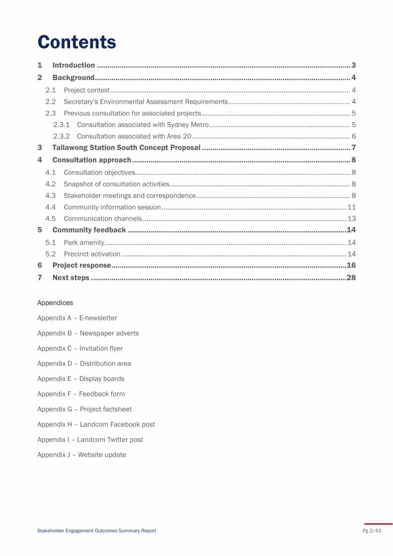
Contents 1 Introduction ........................................................................................................................... 3
2 Background ............................................................................................................................ 4
2.1 Project context .............................................................................................................................. 4
2.2 Secretary’s Environmental Assessment Requirements ................................................................ 4
2.3 Previous consultation for associated projects .............................................................................. 5
2.3.1 Consultation associated with Sydney Metro .......................................................................... 5
2.3.2 Consultation associated with Area 20 ................................................................................... 6
3 Tallawong Station South Concept Proposal ........................................................................ 7
4 Consultation approach .......................................................................................................... 8
4.1 Consultation objectives................................................................................................................. 8
4.2 Snapshot of consultation activities............................................................................................... 8
4.3 Stakeholder meetings and correspondence ................................................................................. 8
4.4 Community information session ................................................................................................. 11
4.5 Communication channels ........................................................................................................... 13
5 Community feedback .......................................................................................................... 14
5.1 Park amenity ............................................................................................................................... 14
5.2 Precinct activation ...................................................................................................................... 14
6 Project response .................................................................................................................. 16
7 Next steps ............................................................................................................................ 28
Appendices
Appendix A – E-newsletter
Appendix B – Newspaper adverts
Appendix C – Invitation flyer
Appendix D – Distribution area
Appendix E – Display boards
Appendix F – Feedback form
Appendix G – Project factsheet
Appendix H – Landcom Facebook post
Appendix I – Landcom Twitter post
Appendix J – Website update
Stakeholder Engagement Outcomes Summary Report Pg 3/43
This Report has been developed to inform the preparation of an Environmental Impact Statement (EIS)
to accompany a State Significant Development Application (SSDA) for Tallawong Station South.
Transport for NSW (TfNSW) is seeking to deliver residential and other development on surplus
government land in the Tallawong Station South (the subject site). The site is located immediately south
of the Tallawong Station South within the broader Tallawong Station South.
In its role as master developer, Landcom on behalf of TfNSW, is preparing a concept proposal and EIS
for the site. The concept proposal is for approximately 1,100 dwellings and 9,000 square metres of
retail, commercial and community uses. It also includes a central park, new streets and supporting
public domain.
Consultation with stakeholders was required prior to lodging the SSDA with the Department of Planning
and Environment (DPE). This Report summarises the pre-lodgement consultation undertaken for
Tallawong Station South. It details:
planning requirements for stakeholder consultation
consultation process undertaken, including key meetings with stakeholders
summary of feedback received and issues raised by specific stakeholders
demonstration of how feedback has been considered in the development of the concept
proposal.
1 Introduction
Stakeholder Engagement Outcomes Summary Report Pg 4/43
2.1 Project context
The NSW Government is currently building the Sydney Metro Northwest (SMNW) that is due to start
operations in 2019. The SMNW is Stage 1 of the overall Sydney Metro project and involves the
construction of seven new metro stations and supporting infrastructure between Cudgegong Road and
Epping and converting five existing stations between Epping and Chatswood. Stage 2 will deliver a new
metro rail line from Chatswood through Sydney’s CBD to Sydenham (Sydney Metro City and Southwest).
Construction of SMNW started in 2016 and services are due to commence operating in the first half of
2019.
Landcom and the Sydney Metro Delivery Office (SMDO) (part of TfNSW) are working together to develop
walkable, attractive, mixed use places on surplus government-owned land around the seven new
Sydney Metro Northwest (SMNW) stations and at Epping Station under the Sydney Metro Northwest
Places Program. The program will enable staged planning, development, and disposal, of the 65
hectares of TfNSW owned land around the new SMNW stations. This land provides the capacity to
deliver approximately 11,000 dwellings and 350,000sqm of non-residential floor space – generating up
to 20,000 direct job opportunities. The program includes TfNSW owned land located around the
Tallawong Station South.
The subject site, named Tallawong Station South, is located between Cudgegong Road, Tallawong Road,
Schofields Road and the Metro corridor, and comprises around 7.8 hectares of land. The site is within
the southern part of the broader Tallawong Station precint (Area 20).
The Tallawong Station South is located north of Schofields Road within the suburb of Rouse Hill,
approximately 33 kilometres northwest of Sydney CBD. The Precinct is part of the North West Priority
Growth Area which is intended to provide substantial land release areas for homes and jobs in Sydney’s
northwest.
The Precinct provides the opportunity for transit oriented development located adjacent to the SMNW
rail line and in close proximity to the Rouse Hill Strategic Centre.
As part of works to build Tallawong Station, TfNSW is delivering:
two new internal access roads between Tallawong Road and Cudgegong Road, providing access
to the station and car park areas with 1,000 commuter parking spaces
construction of a road overbridge midway between Tallawong Road and Cudgegong Road linking
the access roads
new traffic lights off Cudgegong Road and Tallawong Road
pedestrian bridge across the rail line
weather protected kiss-and-ride, bus and taxi areas
access for emergency, delivery and maintenance vehicles.
2.2 Secretary’s Environmental Assessment Requirements
The Secretary’s Environmental Assessment Requirements (SEARs) for the concept proposal were issued
on 16 February 2018. They require consultation with the relevant local, State or Commonwealth
Government authorities, service providers and community groups during preparation of the EIS. In
particular, consultation needed to be undertaken with:
Government Architect of NSW (GANSW)
2 Background
Stakeholder Engagement Outcomes Summary Report Pg 5/43
Blacktown Council
Roads and Maritime Services (RMS)
Office of Environment and Heritage (OEH)
NSW Rural Fire Service
TfNSW (Sydney Coordination Office, Sydney Trains and Sydney Metro)
Surrounding residents, businesses and local community groups.
The EIS must include a report describing the pre-submission consultation undertaken, including a
record of the stakeholders consulted, the issues raised during the consultation and how the proposal
responds to those issues. Where amendments have not been made to address an issue, a short
explanation should be provided.
In issuing the SEARs the Secretary for the Department of Environment and Planning emphasised:
“the importance of effective and genuine community consultation where a comprehensive, detailed
and genuine community consultation engagement process must be undertaken during the preparation
of the EIS. This process must ensure that the community is:
provided with a good understanding of what is proposed and description of any potential
impacts; and
engaged in issues of concern to them”.
2.3 Previous consultation for associated projects
Planning for infrastructure and development in the North West Priority Growth Area has been ongoing
for more than a decade. This has been accompanied by a significant amount of consultation with the
local community and key stakeholders to inform the planning policy framework and project plans. This
consultation has informed subsequent consultation during the preparation of the SSDA for Tallawong
Station South.
2.3.1 Consultation associated with Sydney Metro
A rail link servicing Sydney’s northwest was originally proposed by the NSW Government as a priority
infrastructure project in 1998 and was eventually approved in 2012 as the SMNW project (formerly the
North West Rail Link).
To support planning for the SMNW project, two EISs were prepared with association stakeholder
consultation:
EIS 1 – Major Civil Construction Works.
EIS 2 – Stations, Rail Infrastructure and Systems.
EIS 2 Stations, Rail Infrastructure and Systems described and assessed the operation of the railway as
well as the construction of stations, including additional land required for station precinct works such as
road works, pedestrian / cycle facilities and landscaping.
EIS 2 was publicly exhibited in late 2012. During the exhibition, TfNSW hosted a range of consultation
activities including five drop-in sessions and numerous stakeholder meetings. In total 333 submissions
were received. Key issues raised through submissions related to parking, traffic congestion and the
capacity of local roads, and safety at station precincts.
Stakeholder Engagement Outcomes Summary Report Pg 6/43
Following approval for the SMNW project, Sydney Metro has conducted consultation activities to ensure
that the local community are kept informed about construction timelines and management, as well as
to provide an ongoing opportunity for the local community to ask questions and provide feedback.
Activities have included letterbox drops, project newsletters, and the operation of a community
information line.
2.3.2 Consultation associated with Area 20
Proposed amendments to State Environmental Planning Policy (Sydney Regional Growth Centres) 2006
relevant to the Area 20 Precinct Plan were exhibited by DPE in late 2014. Amendments included
changes to planning controls relating to land zoning, residential floor space controls, heights of
buildings, lot sizes and land acquisition to accommodate the design of Tallawong Station South and
surrounding precinct.
During the public exhibition of the SSDA, DPE hosted a drop-in session and received 26 submissions.
Key issues raised through submissions related to feasibility of height and floor space controls,
accessibility for pedestrians and cyclists and the capacity of local roads.
Stakeholder Engagement Outcomes Summary Report Pg 7/43
The Tallawong Station South concept proposal is for a mixed use centre that includes retail,
commercial, and residential uses with:
approximately –1100 dwellings with a mix of apartments and townhouses, including more than
5% affordable housing
varying building heights up to 8 storeys
a new 2,900 square metre public park and landscaped zones
walking and cycling networks connecting to the station and precinct
9,000 square metres of retail, commercial and community uses with provision for local retail
and cafes and childcare and community facilities
The proposal is generally consistent with approved planning controls for the site with a minor
exceedance of overall building heights.
3 Tallawong Station South Concept
Proposal
Stakeholder Engagement Outcomes Summary Report Pg 8/43
Over the past few years Landcom and Sydney Metro have undertaken significant engagement with a
range of stakeholders, to discuss planning controls for the site, the Sydney Metro Northwest project,
and to inform the current concept proposal. Landcom is committed to continued meaningful
engagement with stakeholders who have an interest in the development. To inform the SSDA, Landcom
has sought to ensure the interests of stakeholders are identified and addressed through a range of
consultation activities.
4.1 Consultation objectives
The objectives of the pre-lodgement consultation process for Tallawong Station South were to:
ensure consistent messaging about the SSDA was shared with all stakeholders
ensure stakeholders were well informed of the SSDA and its impact on the local community,
services and infrastructure
provide local community members, businesses and other key stakeholders with an opportunity
to provide feedback on the proposal to inform the SSDA
ensure stakeholder views are identified, understood and considered during the preparation of
the SSDA.
4.2 Snapshot of consultation activities
Consultation to date has been undertaken to satisfy the objectives outlined above, as well as to satisfy
the SEARs for the concept proposal. Consultation activities were designed to build upon previous
engagement undertaken by both TfNSW and DPE, and planned to suit the scale of the project. Activities
included a series of stakeholder meetings (details provided in Table 1) and a community information
session for all residents, landowners and local stakeholders within an approximate radius of 800m from
the site.
Communications to support consultation activities included the delivery letters and flyers to local
residents, as well as the ongoing operation of the community information line and project email. In
addition, the Landcom website continues to be updated with relevant project information to ensure that
a wide audience has access to information about the project.
4.3 Stakeholder meetings and correspondence
Landcom held a number of meetings with key stakeholders during the development of the concept
proposal. A summary of the feedback received during correspondence with key stakeholders is detailed
in Table 1.
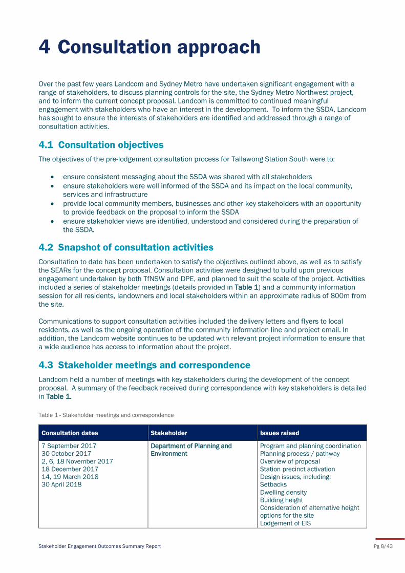
Table 1 - Stakeholder meetings and correspondence
Consultation dates Stakeholder Issues raised
7 September 2017
30 October 2017
2, 6, 18 November 2017
18 December 2017
14, 19 March 2018
30 April 2018
Department of Planning and
Environment
Program and planning coordination
Planning process / pathway
Overview of proposal
Station precinct activation
Design issues, including:
Setbacks
Dwelling density
Building height
Consideration of alternative height
options for the site
Lodgement of EIS
4 Consultation approach
Stakeholder Engagement Outcomes Summary Report Pg 9/43
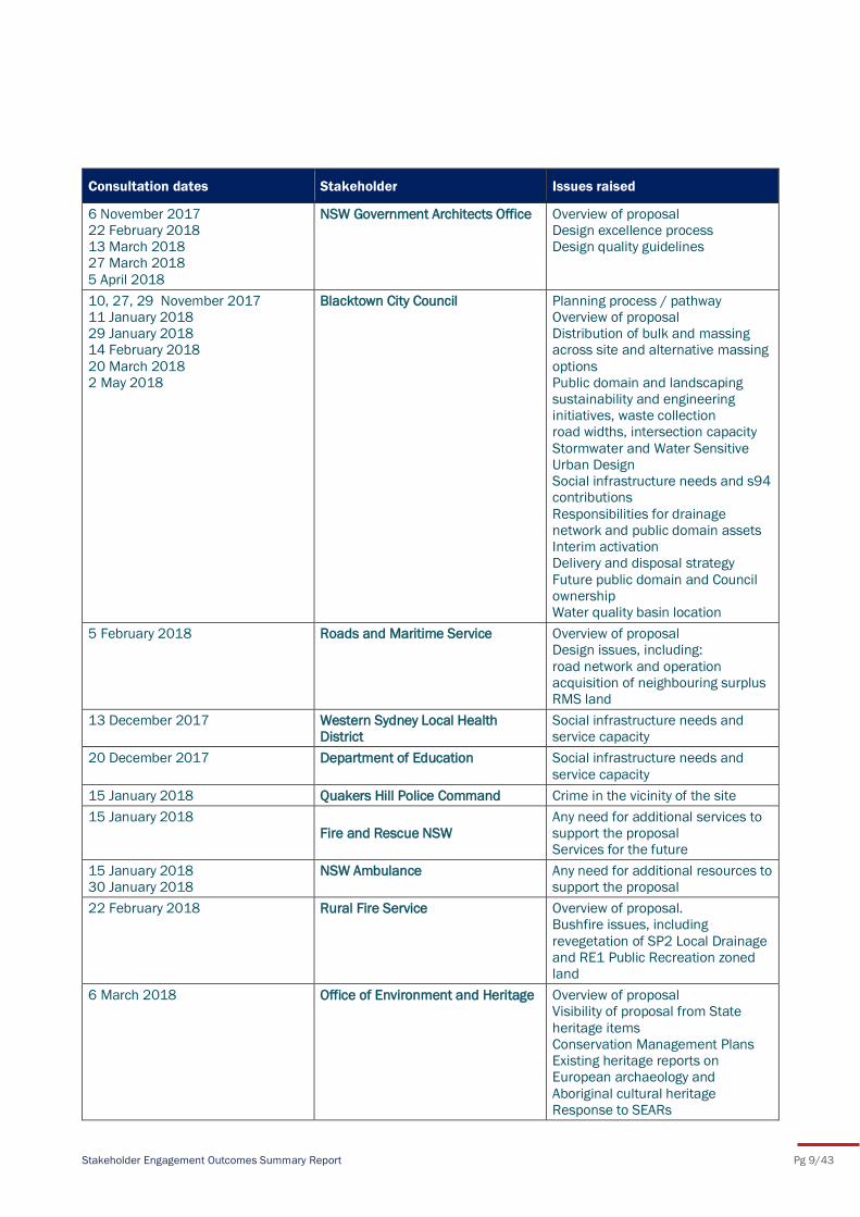
Consultation dates Stakeholder Issues raised
6 November 2017
22 February 2018
13 March 2018
27 March 2018
5 April 2018
NSW Government Architects Office Overview of proposal
Design excellence process
Design quality guidelines
10, 27, 29 November 2017
11 January 2018
29 January 2018
14 February 2018
20 March 2018
2 May 2018
Blacktown City Council Planning process / pathway
Overview of proposal
Distribution of bulk and massing
across site and alternative massing
options
Public domain and landscaping
sustainability and engineering
initiatives, waste collection
road widths, intersection capacity
Stormwater and Water Sensitive
Urban Design
Social infrastructure needs and s94
contributions
Responsibilities for drainage
network and public domain assets
Interim activation
Delivery and disposal strategy
Future public domain and Council
ownership
Water quality basin location
5 February 2018 Roads and Maritime Service Overview of proposal
Design issues, including:
road network and operation
acquisition of neighbouring surplus
RMS land
13 December 2017 Western Sydney Local Health
District
Social infrastructure needs and
service capacity
20 December 2017 Department of Education Social infrastructure needs and
service capacity
15 January 2018 Quakers Hill Police Command Crime in the vicinity of the site
15 January 2018
Fire and Rescue NSW
Any need for additional services to
support the proposal
Services for the future
15 January 2018
30 January 2018
NSW Ambulance Any need for additional resources to
support the proposal
22 February 2018 Rural Fire Service Overview of proposal.
Bushfire issues, including
revegetation of SP2 Local Drainage
and RE1 Public Recreation zoned
land
6 March 2018 Office of Environment and Heritage Overview of proposal
Visibility of proposal from State
heritage items
Conservation Management Plans
Existing heritage reports on
European archaeology and
Aboriginal cultural heritage
Response to SEARs
Stakeholder Engagement Outcomes Summary Report Pg 10/43
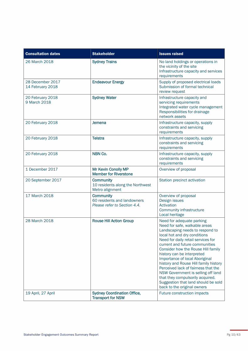
Consultation dates Stakeholder Issues raised
26 March 2018 Sydney Trains No land holdings or operations in
the vicinity of the site
Infrastructure capacity and services
requirements
28 December 2017
14 February 2018
Endeavour Energy Supply of proposed electrical loads
Submission of formal technical
review request
20 February 2018
9 March 2018
Sydney Water Infrastructure capacity and
servicing requirements
Integrated water cycle management
Responsibilities for drainage
network assets
20 February 2018 Jemena Infrastructure capacity, supply
constraints and servicing
requirements
20 February 2018 Telstra Infrastructure capacity, supply
constraints and servicing
requirements
20 February 2018 NBN Co. Infrastructure capacity, supply
constraints and servicing
requirements
1 December 2017 Mr Kevin Conolly MP
Member for Riverstone
Overview of proposal
20 September 2017 Community
10 residents along the Northwest
Metro alignment
Station precinct activation
17 March 2018 Community
60 residents and landowners
Please refer to Section 4.4.
Overview of proposal
Design issues
Activation
Community infrastructure
Local heritage
28 March 2018 Rouse Hill Action Group Need for adequate parking
Need for safe, walkable areas
Landscaping needs to respond to
local hot and dry conditions
Need for daily retail services for
current and future communities
Consider how the Rouse Hill family
history can be interpreted
Importance of local Aboriginal
history and Rouse Hill family history
Perceived lack of fairness that the
NSW Government is selling off land
that they compulsorily acquired.
Suggestion that land should be sold
back to the original owners
19 April, 27 April Sydney Coordination Office,
Transport for NSW
Future construction impacts
Stakeholder Engagement Outcomes Summary Report Pg 11/43
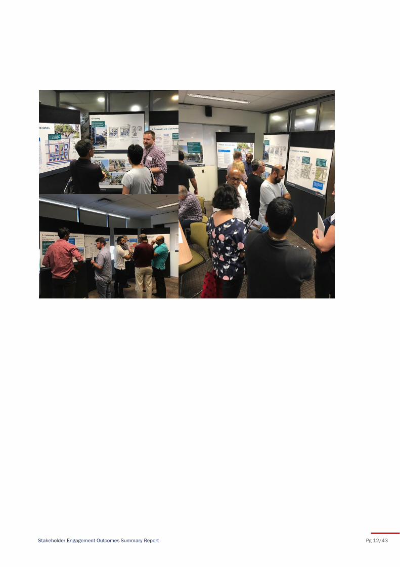
4.4 Community information session
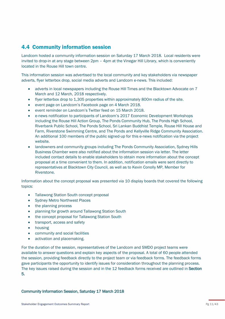
Landcom hosted a community information session on Saturday 17 March 2018. Local residents were
invited to drop-in at any stage between 2pm – 4pm at the Vinegar Hill Library, which is conveniently
located in the Rouse Hill town centre.
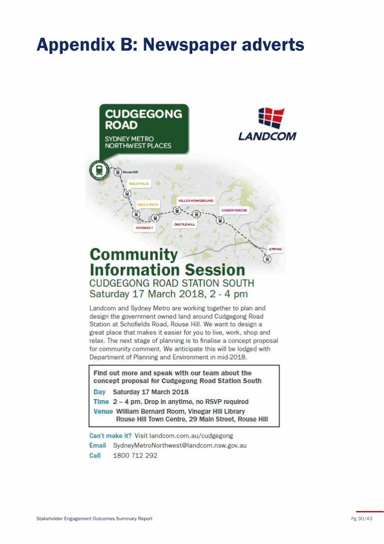
This information session was advertised to the local community and key stakeholders via newspaper
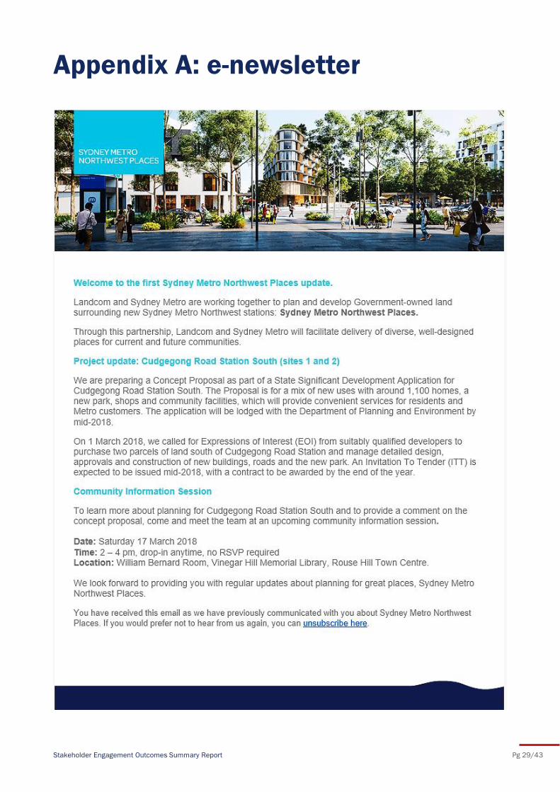
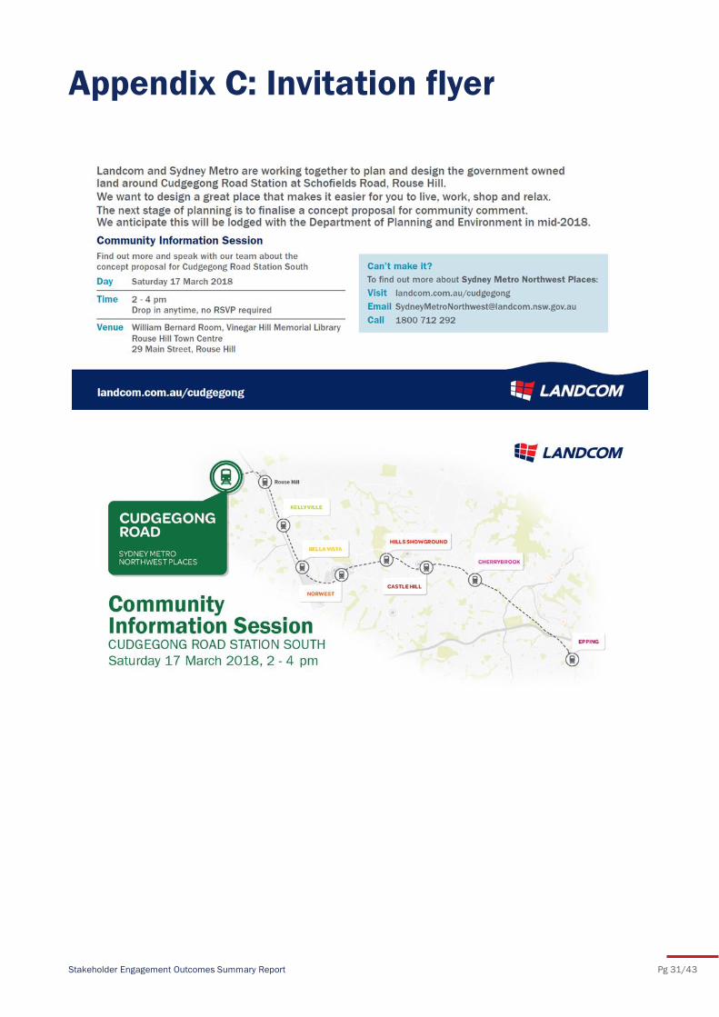
adverts, flyer letterbox drop, social media adverts and Landcom e-news. This included:
adverts in local newspapers including the Rouse Hill Times and the Blacktown Advocate on 7
March and 12 March, 2018 respectively.
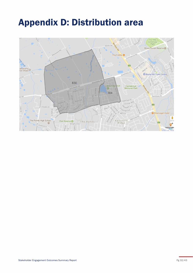
flyer letterbox drop to 1,305 properties within approximately 800m radius of the site.
event page on Landcom’s Facebook page on 4 March 2018.
event reminder on Landcom’s Twitter feed on 15 March 2018.
e-news notification to participants of Landcom’s 2017 Economic Development Workshops
including the Rouse Hill Action Group, The Ponds Community Hub, The Ponds High School,
Riverbank Public School, The Ponds School, Sri Lankan Buddhist Temple, Rouse Hill House and
Farm, Riverstone Swimming Centre, and The Ponds and Kellyville Ridge Community Association.
An additional 100 members of the public signed-up for this e-news notification via the project
website.
landowners and community groups including The Ponds Community Association, Sydney Hills
Business Chamber were also notified about the information session via letter. The letter
included contact details to enable stakeholders to obtain more information about the concept
proposal at a time convenient to them. In addition, notification emails were sent directly to
representatives at Blacktown City Council, as well as to Kevin Conolly MP, Member for
Riverstone.
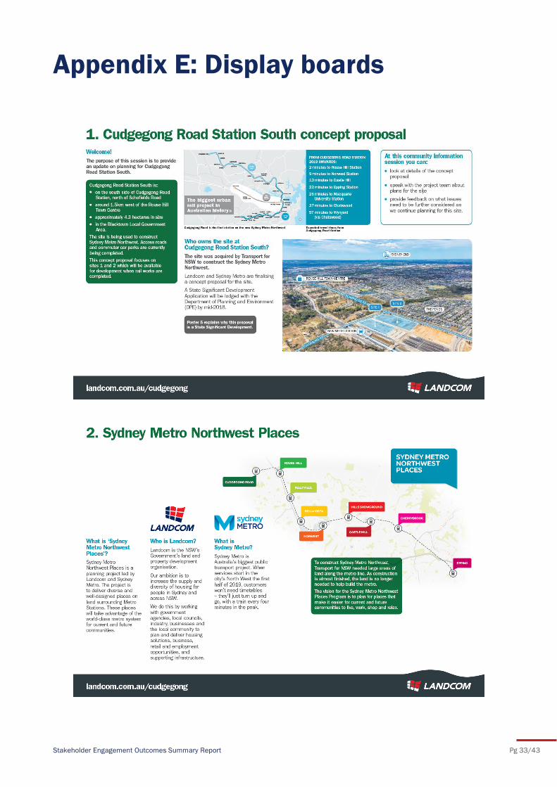
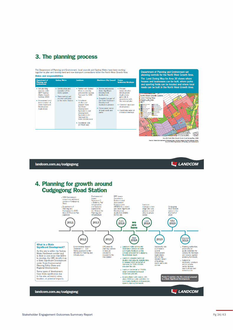
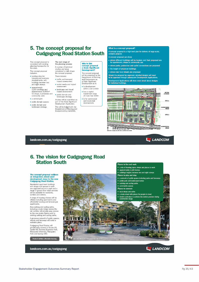
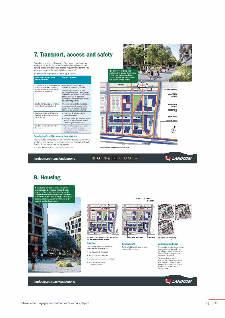
Information about the concept proposal was presented via 10 display boards that covered the following
topics:
Tallawong Station South concept proposal
Sydney Metro Northwest Places
the planning process
planning for growth around Tallawong Station South
the concept proposal for Tallawong Station South
transport, access and safety
housing
community and social facilities
activation and placemaking.
For the duration of the session, representatives of the Landcom and SMDO project teams were
available to answer questions and explain key aspects of the proposal. A total of 60 people attended
the session, providing feedback directly to the project team or via feedback forms. The feedback forms
gave participants the opportunity to identify issues for consideration throughout the planning process.
The key issues raised during the session and in the 12 feedback forms received are outlined in Section
5.
Community Information Session, Saturday 17 March 2018
Stakeholder Engagement Outcomes Summary Report Pg 12/43
Stakeholder Engagement Outcomes Summary Report Pg 13/43
4.5 Communication channels
Communication channels were made available to complement face-to-face consultation activities with
the community and key stakeholders. Information about the Sydney Metro Northwest Places Program
and the Tallawong Station South concept proposal was available through:
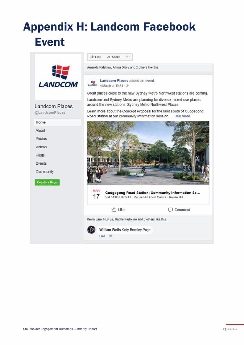
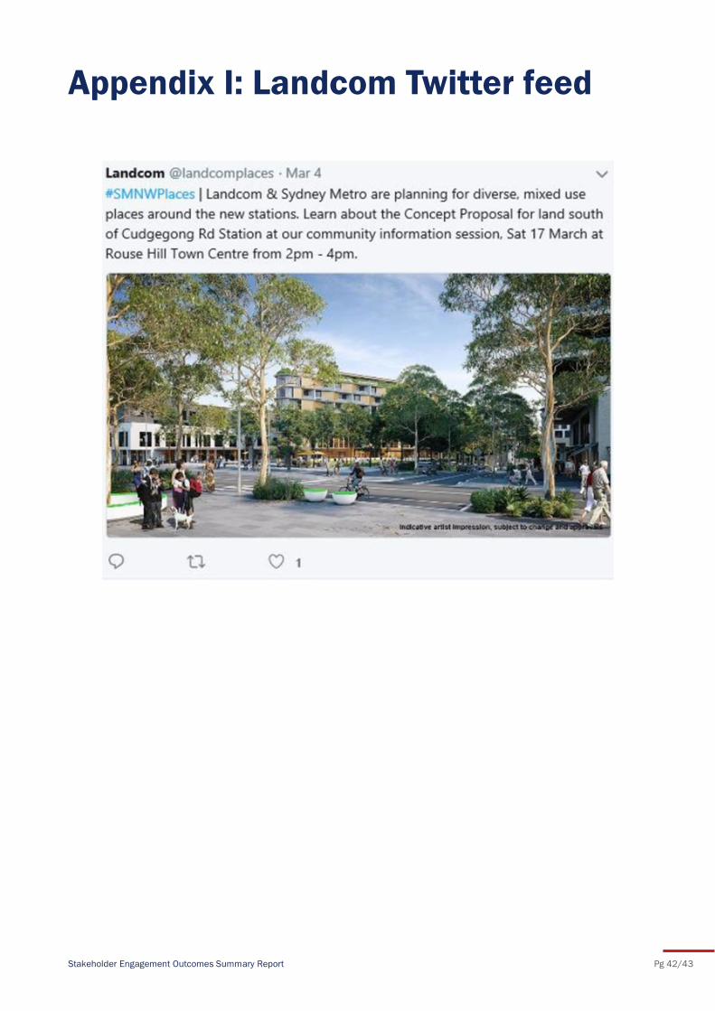
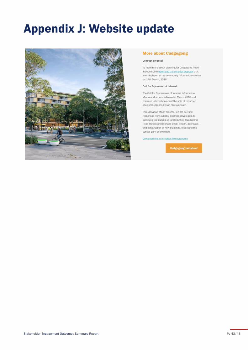
Landcom’s Facebook page, Twitter feed and website (please refer to Appendix H, I, and J)
operation of a toll-free 1800 community information line and project email
Sydney Metro Northwest Places program and Tallawong Station South specific factsheets
(please refer to Appendix G)
These communication channels provided stakeholders with information and contact details for the
project team to ask questions about the concept proposal and/or provide feedback. Both the
community information line and project email address were advertised in the flyer letterbox drop to
1,305 neighbouring residents (please refer to Appendix C and D), and in newspaper adverts published
in the Rouse Hill Times and the Blacktown Advocate (please refer to Appendix B).
Stakeholder Engagement Outcomes Summary Report Pg 14/43
Feedback received during consultation activities with the local community has identified key issues of
community interest for consideration during the preparation of the concept proposal for Tallawong
Station South. Key issues included:
development timeframes
housing density
provision of community facilities
open spaces and green infrastructure
commuter parking and shuttle bus services
frequency of new metro services
retail offering
precinct activation
heritage
safety.
Feedback forms combined opportunities to provide open feedback, as well as to provide specific
suggestions for the activation of the precinct. Several common themes were evident and are outlined in
the sections below.
5.1 Park amenity
Participants were asked to provide suggestions for the use of the park. Feedback was gathered using
open and multiple-choice questions. Key issues included the provision of adequate shading and safety
lighting, as well as off-street vehicle and bicycle parking. The top four features suggested for the park
included:
1. kids playground (5-12 yrs)
2. food and drink
3. toilet block
4. landscaping for shade.
Feedback received indicated that the preferred use of the park (in order of preference) was as follows:
1. adventure (tricky activities, exploration)
2. water play
3. fitness equipment.
The least preferred uses of the park included a table tennis table; a giant chess set; and sensory
elements (music, touch and feel). Additional suggestions for the park included a heated indoor pool,
walking track, bicycle parking, a skateboard area, bins with lids and trees for natural shade. Wheelchair
access and night-time lighting were also raised as being important.
5.2 Precinct activation
Community feedback provided useful suggestions for the successful activation of the precinct.
Feedback indicated that the most popular uses for the precinct were retail and open space with
wayfinding and sustainability considered to be important factors for consideration.
More specifically, participants were asked which essential shops and services they would most like
included in the precinct. The top four shops and services chosen (in order of preference), were:
5 Community feedback
Stakeholder Engagement Outcomes Summary Report Pg 15/43
1. supermarket
2. café
3. restaurant
4. chemist.
An important component of the concept proposal will be the proposed community space. Feedback
gathered from the community indicated that most community members would prefer this space to be a
community healthcare clinic. Other uses suggested for the community space were venue hire for
kids/family/community events, childcare, a co-working space, aged care facilities, and a Catholic school
or Church.
Additionally, participants were invited to suggest local stories, history or local features for interpretation
in the precinct. Suggestions included the Battle of Vinegar Hill, the Rouse family history and local
Aboriginal heritage and justice.
Participants of the community information session were largely aged between 36-55 years old and lived
mostly in Rouse Hill and The Ponds. The majority of participants indicated that they used Sydney Metro
Northwest most days.
Feedback received suggested that most participants felt that the information provided at the community information session was easy to understand and relevant, and that the project team
members were knowledgeable and helpful. Most participants felt that their feedback would be
accurately reported and meaningfully considered, and indicated that given the opportunity they would
attend a similar event in the future.
Stakeholder Engagement Outcomes Summary Report Pg 16/43
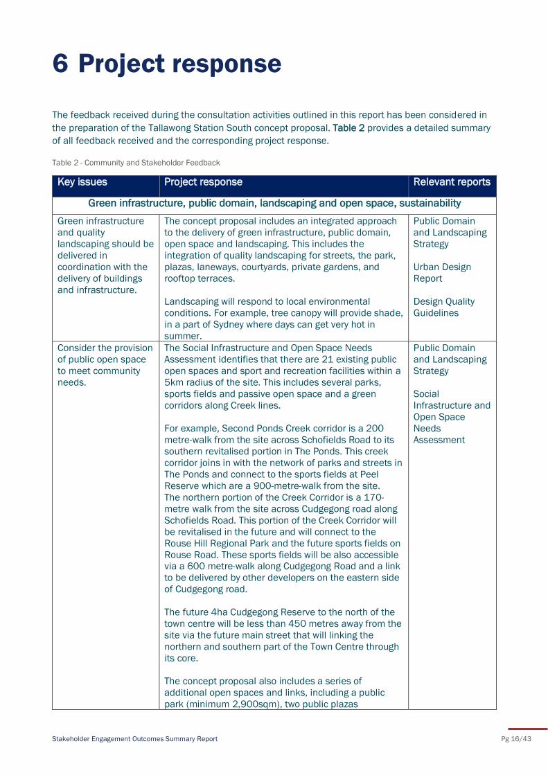
The feedback received during the consultation activities outlined in this report has been considered in
the preparation of the Tallawong Station South concept proposal. Table 2 provides a detailed summary
of all feedback received and the corresponding project response.
Table 2 - Community and Stakeholder Feedback
6 Project response
Key issues Project response Relevant reports
Green infrastructure, public domain, landscaping and open space, sustainability
Green infrastructure
and quality
landscaping should be
delivered in
coordination with the
delivery of buildings
and infrastructure.
The concept proposal includes an integrated approach
to the delivery of green infrastructure, public domain,
open space and landscaping. This includes the
integration of quality landscaping for streets, the park,
plazas, laneways, courtyards, private gardens, and
rooftop terraces.
Landscaping will respond to local environmental
conditions. For example, tree canopy will provide shade,
in a part of Sydney where days can get very hot in
summer.
Public Domain
and Landscaping
Strategy
Urban Design
Report
Design Quality
Guidelines
Consider the provision
of public open space
to meet community
needs.
The Social Infrastructure and Open Space Needs
Assessment identifies that there are 21 existing public
open spaces and sport and recreation facilities within a
5km radius of the site. This includes several parks,
sports fields and passive open space and a green
corridors along Creek lines.
For example, Second Ponds Creek corridor is a 200
metre-walk from the site across Schofields Road to its
southern revitalised portion in The Ponds. This creek
corridor joins in with the network of parks and streets in
The Ponds and connect to the sports fields at Peel
Reserve which are a 900-metre-walk from the site.
The northern portion of the Creek Corridor is a 170-
metre walk from the site across Cudgegong road along
Schofields Road. This portion of the Creek Corridor will
be revitalised in the future and will connect to the
Rouse Hill Regional Park and the future sports fields on
Rouse Road. These sports fields will be also accessible via a 600 metre-walk along Cudgegong Road and a link
to be delivered by other developers on the eastern side
of Cudgegong road.
The future 4ha Cudgegong Reserve to the north of the
town centre will be less than 450 metres away from the
site via the future main street that will linking the
northern and southern part of the Town Centre through
its core.
The concept proposal also includes a series of
additional open spaces and links, including a public
park (minimum 2,900sqm), two public plazas
Public Domain
and Landscaping
Strategy
Social
Infrastructure and
Open Space
Needs
Assessment
Stakeholder Engagement Outcomes Summary Report Pg 17/43
(1,600sqm) and other landscaped zones for residents,
workers and visitors.
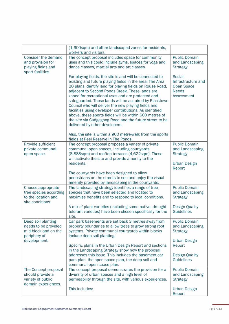
Consider the demand
and provision for
playing fields and
sport facilities.
The concept proposal includes space for community
uses and this could include gyms, spaces for yoga and
dance classes, martial arts and art classes.
For playing fields, the site is and will be connected to
existing and future playing fields in the area. The Area
20 plans identify land for playing fields on Rouse Road,
adjacent to Second Ponds Creek. These lands are
zoned for recreational uses and are protected and
safeguarded. These lands will be acquired by Blacktown
Council who will deliver the new playing fields and
facilities using developer contributions. As identified
above, these sports fields will be within 600 metres of
the site via Cudgegong Road and the future street to be
delivered by other developers.
Also, the site is within a 900 metre-walk from the sports
fields at Peel Reserve in The Ponds.
Public Domain
and Landscaping
Strategy
Social
Infrastructure and
Open Space
Needs
Assessment
Provide sufficient
private communal
open space.
The concept proposal proposes a variety of private
communal open spaces, including courtyards
(8,888sqm) and rooftop terraces (4,622sqm). These
will activate the site and provide amenity to the
residents.
The courtyards have been designed to allow pedestrians on the streets to see and enjoy the visual
amenity provided by landscaping in the courtyards.
Public Domain
and Landscaping
Strategy
Urban Design
Report
Choose appropriate tree species according
to the location and
site conditions.
The landscaping strategy identifies a range of tree species that have been selected and located to
maximise benefits and to respond to local conditions.
A mix of plant varieties (including some native, drought
tolerant varieties) have been chosen specifically for the
site.
Public Domain and Landscaping
Strategy
Design Quality
Guidelines
Deep soil planting
needs to be provided
mid-block and on the
periphery of
development.
Car park basements are set back 3 metres away from
property boundaries to allow trees to grow strong root
systems. Private communal courtyards within blocks
include deep soil planting.
Specific plans in the Urban Design Report and sections
in the Landscaping Strategy show how the proposal
addresses this issue. This includes the basement car
park plan, the open space plan, the deep soil and
communal open space plan.
Public Domain
and Landscaping
Strategy
Urban Design
Report
Design Quality
Guidelines
The Concept proposal
should provide a
variety of public
domain experiences.
The concept proposal demonstrates the provision for a
diversity of urban spaces and a high level of
permeability through the site, with various experiences.
This includes:
Public Domain
and Landscaping
Strategy
Urban Design
Report
Stakeholder Engagement Outcomes Summary Report Pg 18/43
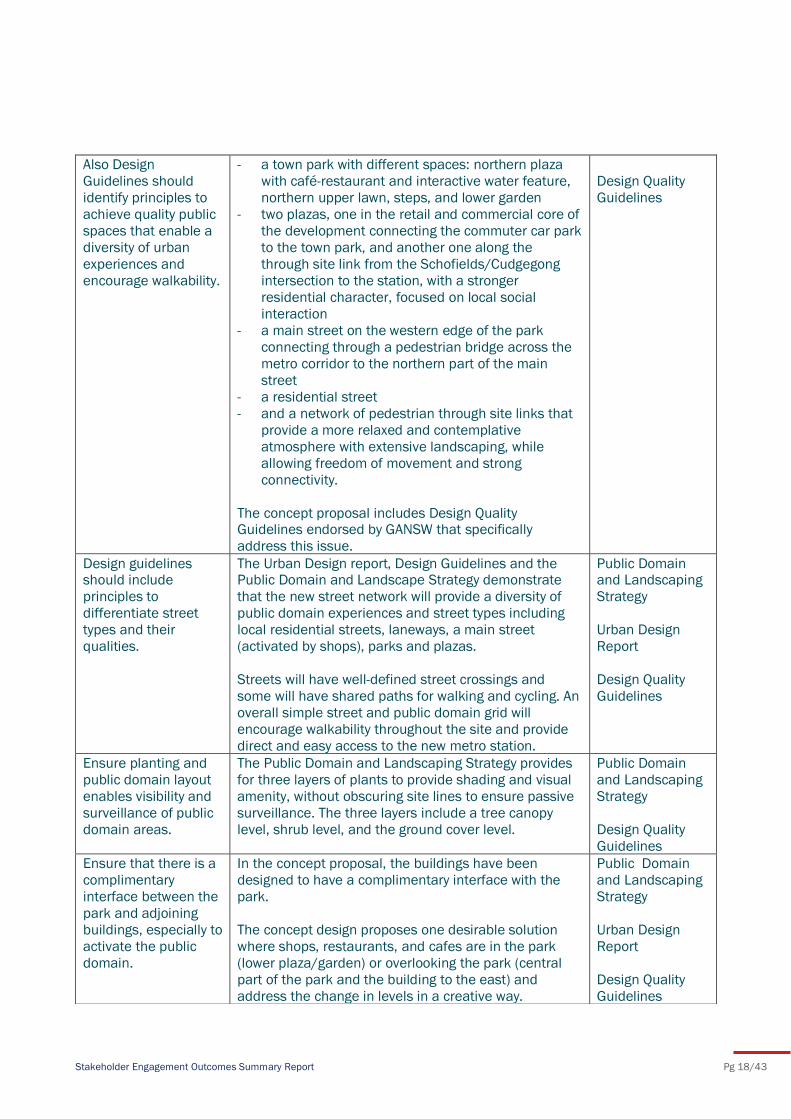
Also Design
Guidelines should
identify principles to
achieve quality public
spaces that enable a
diversity of urban
experiences and
encourage walkability.
- a town park with different spaces: northern plaza
with café-restaurant and interactive water feature,
northern upper lawn, steps, and lower garden
- two plazas, one in the retail and commercial core of
the development connecting the commuter car park
to the town park, and another one along the
through site link from the Schofields/Cudgegong
intersection to the station, with a stronger
residential character, focused on local social
interaction
- a main street on the western edge of the park
connecting through a pedestrian bridge across the
metro corridor to the northern part of the main
street
- a residential street
- and a network of pedestrian through site links that
provide a more relaxed and contemplative
atmosphere with extensive landscaping, while
allowing freedom of movement and strong
connectivity.
The concept proposal includes Design Quality Guidelines endorsed by GANSW that specifically
address this issue.
Design Quality
Guidelines
Design guidelines should include
principles to
differentiate street
types and their
qualities.
The Urban Design report, Design Guidelines and the Public Domain and Landscape Strategy demonstrate
that the new street network will provide a diversity of
public domain experiences and street types including
local residential streets, laneways, a main street
(activated by shops), parks and plazas.
Streets will have well-defined street crossings and
some will have shared paths for walking and cycling. An
overall simple street and public domain grid will
encourage walkability throughout the site and provide
direct and easy access to the new metro station.
Public Domain and Landscaping
Strategy
Urban Design
Report
Design Quality
Guidelines
Ensure planting and
public domain layout
enables visibility and
surveillance of public
domain areas.
The Public Domain and Landscaping Strategy provides
for three layers of plants to provide shading and visual
amenity, without obscuring site lines to ensure passive
surveillance. The three layers include a tree canopy
level, shrub level, and the ground cover level.
Public Domain
and Landscaping
Strategy
Design Quality
Guidelines
Ensure that there is a
complimentary
interface between the
park and adjoining
buildings, especially to
activate the public
domain.
In the concept proposal, the buildings have been
designed to have a complimentary interface with the
park.
The concept design proposes one desirable solution
where shops, restaurants, and cafes are in the park
(lower plaza/garden) or overlooking the park (central
part of the park and the building to the east) and
address the change in levels in a creative way.
Public Domain
and Landscaping
Strategy
Urban Design
Report
Design Quality
Guidelines
Stakeholder Engagement Outcomes Summary Report Pg 19/43
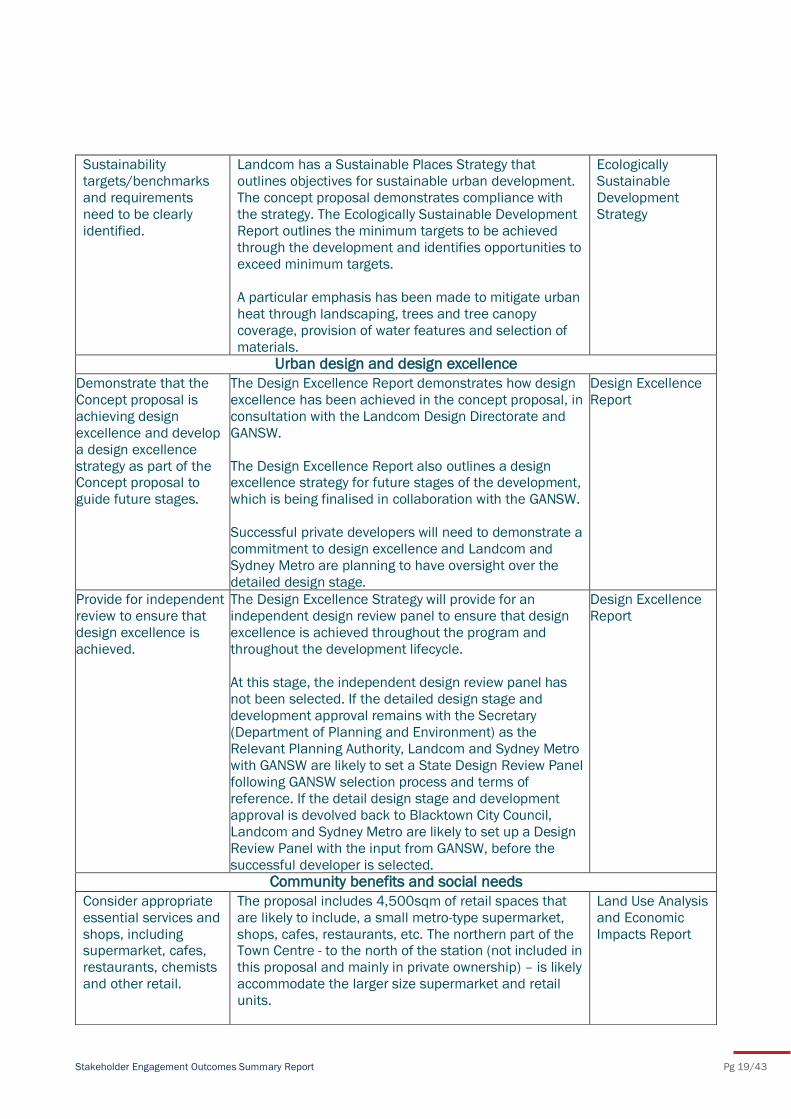
Sustainability
targets/benchmarks
and requirements
need to be clearly
identified.
Landcom has a Sustainable Places Strategy that
outlines objectives for sustainable urban development.
The concept proposal demonstrates compliance with
the strategy. The Ecologically Sustainable Development
Report outlines the minimum targets to be achieved
through the development and identifies opportunities to
exceed minimum targets.
A particular emphasis has been made to mitigate urban
heat through landscaping, trees and tree canopy
coverage, provision of water features and selection of
materials.
Ecologically
Sustainable
Development
Strategy
Urban design and design excellence
Demonstrate that the
Concept proposal is
achieving design
excellence and develop
a design excellence
strategy as part of the Concept proposal to
guide future stages.
The Design Excellence Report demonstrates how design
excellence has been achieved in the concept proposal, in
consultation with the Landcom Design Directorate and
GANSW.
The Design Excellence Report also outlines a design excellence strategy for future stages of the development,
which is being finalised in collaboration with the GANSW.
Successful private developers will need to demonstrate a
commitment to design excellence and Landcom and
Sydney Metro are planning to have oversight over the
detailed design stage.
Design Excellence
Report
Provide for independent
review to ensure that
design excellence is
achieved.
The Design Excellence Strategy will provide for an
independent design review panel to ensure that design
excellence is achieved throughout the program and
throughout the development lifecycle.
At this stage, the independent design review panel has
not been selected. If the detailed design stage and
development approval remains with the Secretary
(Department of Planning and Environment) as the
Relevant Planning Authority, Landcom and Sydney Metro
with GANSW are likely to set a State Design Review Panel
following GANSW selection process and terms of
reference. If the detail design stage and development
approval is devolved back to Blacktown City Council,
Landcom and Sydney Metro are likely to set up a Design
Review Panel with the input from GANSW, before the
successful developer is selected.
Design Excellence
Report
Community benefits and social needs
Consider appropriate
essential services and
shops, including supermarket, cafes,
restaurants, chemists
and other retail.
The proposal includes 4,500sqm of retail spaces that
are likely to include, a small metro-type supermarket,
shops, cafes, restaurants, etc. The northern part of the Town Centre - to the north of the station (not included in
this proposal and mainly in private ownership) – is likely
accommodate the larger size supermarket and retail
units.
Land Use Analysis
and Economic
Impacts Report

Stakeholder Engagement Outcomes Summary Report Pg 20/43
Future residents, workers and visitors should have all
convenient retail options to accommodate their daily
needs.
This proposal also includes 3,000sqm of commercial
space. Of the commercial land uses, 1,000sqm is
intended for small commercial suites and doctor suites,
and 2,000sqm are intended for a smart work hub
where people, companies and organisations can
subscribe to spaces to work remotely from a central
office while still benefitting from a productive work
environment. This smart work hub is also likely to
include incubation and innovation programs to foster
value creation and business growth in the area. This will
be confirmed in the detail design and development
application stage.
Consider the need for
community space
within the site, as well
as rooms for hire.
The proposal includes 300sqm of flexible community
space/communal indoor spaces which is more than
Council’s draft benchmark of 80sqm per 1,000
residents. These spaces could be leased by various
community group short or long term and could include
art classes, dance classes, for diverse age group.
Social
Infrastructure and
Open Space
Needs
Assessment
Consider the provision
of food and drink,
water play, lidded
bins, toilets, natural
shading, and night-time lighting in the
proposed park.
The concept for the park, plazas and public domain
includes an interactive water feature and kiosk, and an
all-day dining restaurant in the northern portion of the
park.
An extensive number of trees are planned to be planted
early to provide natural shade to various areas of the
park and the public domain.
The detailed design for the park and public domain will
consider needs including waste collection, toilets,
lighting, and shading.
Public Domain
and Landscaping
Strategy
Consider the
interpretation of local
heritage, including the
Rouse family history,
the Battle of Vinegar
Hill, and Aboriginal
justice.
The detailed design of the public domain will consider
ways to embed interpretation of local heritage and
history. The community is encouraged to contact
Landcom to provide specific ideas and stories that
could be considered for public domain and public art
design and programming.
Provide sufficient
recreational facilities
for children, such as
play spaces.
The concept proposal includes a new park that provides
opportunities for children to play, including shaded
grass areas and an interactive water feature. There will
be additional plaza areas in shaded, safe locations that
provide opportunities to cycle, scoot, skate, or play.
Public Domain
and Landscaping
Strategy
Urban Design
Report
Preference for a
community facility
within the precinct.
Council’s s94 plan identifies a site in Riverstone East
for a community facility along Tallawong road. It is
understood that Blacktown City Council has also
received a proposal for a new community facility to be
Social
Infrastructure and
Open Space
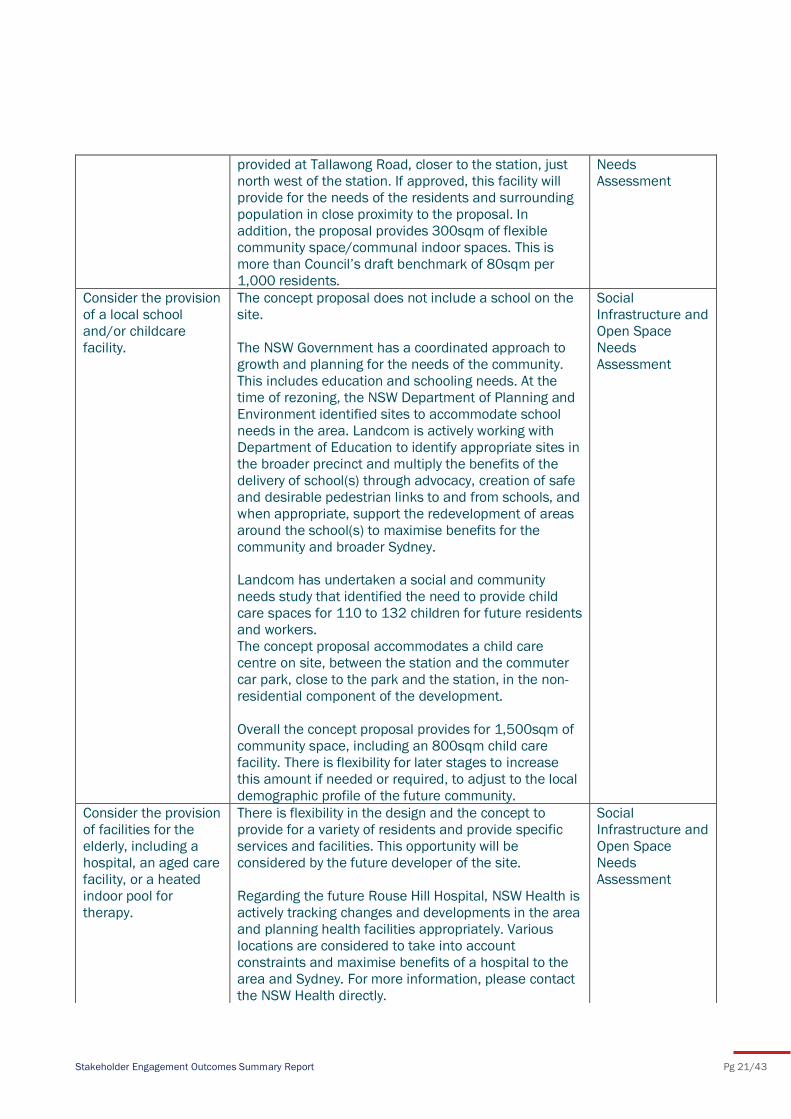
Stakeholder Engagement Outcomes Summary Report Pg 21/43
provided at Tallawong Road, closer to the station, just
north west of the station. If approved, this facility will
provide for the needs of the residents and surrounding
population in close proximity to the proposal. In
addition, the proposal provides 300sqm of flexible
community space/communal indoor spaces. This is
more than Council’s draft benchmark of 80sqm per
1,000 residents.
Needs
Assessment
Consider the provision
of a local school
and/or childcare
facility.
The concept proposal does not include a school on the
site.
The NSW Government has a coordinated approach to
growth and planning for the needs of the community.
This includes education and schooling needs. At the
time of rezoning, the NSW Department of Planning and
Environment identified sites to accommodate school
needs in the area. Landcom is actively working with
Department of Education to identify appropriate sites in
the broader precinct and multiply the benefits of the
delivery of school(s) through advocacy, creation of safe
and desirable pedestrian links to and from schools, and
when appropriate, support the redevelopment of areas
around the school(s) to maximise benefits for the
community and broader Sydney.
Landcom has undertaken a social and community
needs study that identified the need to provide child
care spaces for 110 to 132 children for future residents
and workers.
The concept proposal accommodates a child care
centre on site, between the station and the commuter
car park, close to the park and the station, in the non-
residential component of the development.
Overall the concept proposal provides for 1,500sqm of
community space, including an 800sqm child care
facility. There is flexibility for later stages to increase
this amount if needed or required, to adjust to the local
demographic profile of the future community.
Social
Infrastructure and
Open Space
Needs
Assessment
Consider the provision
of facilities for the
elderly, including a
hospital, an aged care
facility, or a heated
indoor pool for
therapy.
There is flexibility in the design and the concept to
provide for a variety of residents and provide specific
services and facilities. This opportunity will be
considered by the future developer of the site.
Regarding the future Rouse Hill Hospital, NSW Health is
actively tracking changes and developments in the area
and planning health facilities appropriately. Various
locations are considered to take into account
constraints and maximise benefits of a hospital to the
area and Sydney. For more information, please contact
the NSW Health directly.
Social
Infrastructure and
Open Space
Needs
Assessment
Stakeholder Engagement Outcomes Summary Report Pg 22/43
Consider the provision
of a Catholic Church
or Catholic school.
Whilst a Catholic Church or Catholic School is not part
of the concept proposal, zoning permits this use. The
future developers have the opportunity to develop
places of public worship and private schools that are
permissible within this zoning.
Social
Infrastructure and
Open Space
Needs
Assessment
Planning matters
Justify the proposed
density.
Extensive details are provided in the EIS and the Urban
Design Report compliance statement for principle 3.
Density to justify the proposed density.
As a summary, the proposed density is appropriate
because it complies with gazetted planning controls
and is desirable because the proposed development:
- is located in direct proximity to the new Sydney
Metro and is connected to other places and job
centres in the Northwest and broader Sydney via an
outstanding and expanding transport infrastructure
- provides homes for our city’s growing population in one the most appropriate locations where the
impact of development is best controlled and
generates more positive economic, social and
environmental impacts than in other locations.
- attains critical mass to provide local services and
daily destinations within walking distance of every
dwelling and accessible to others living in
surrounding suburbs
- offers easy access to a rich and diverse open
spaces’ experiences within and in close proximity to
the site
- follows an ecologically sustainable approach to
development ensuring the density creates a strong
local economy and inclusive community, and is
appropriate for the infrastructure and the
environment.
Environment
Impact Statement
All Reports
DPE considers that a
household size of 3.2
persons per dwelling
has to be considered
as it is the Blacktown
LGA average.
Blacktown Council has provided varying advice, from
census information review indicating 2.5 persons per
dwelling for high density, to 2.8 persons for medium
density in the Blacktown LGA, to 1.9 persons per
dwelling for 2 bedroom medium density as an assumed
occupancy rate included in Council’s contribution plan
22W.
GHD has also undertaken a review of comparable
transit oriented development at Epping Park and
Macquarie Park. These centres have an average
household size of 2.7 to 2.1 respectively. Using this
information combined with Council’s census
information review the project has adopted an average
household size of 2.5 to 2.7 persons per dwelling. The average household size of 3.2 persons per dwelling, the
Social
Infrastructure and
Open Space
Needs
Assessment
Public Domain
and Landscaping
Strategy
Stakeholder Engagement Outcomes Summary Report Pg 23/43
average size for the Blacktown LGA which is mostly
detached dwellings, is not considered appropriate.
Amend the acquisition
plan for the park and
drainage zone through
a planning proposal.
DPE has advised that these matters can be addressed
by DPE through a housekeeping SEPP amendment,
should the proposal be approved.
Environmental
Impact Statement
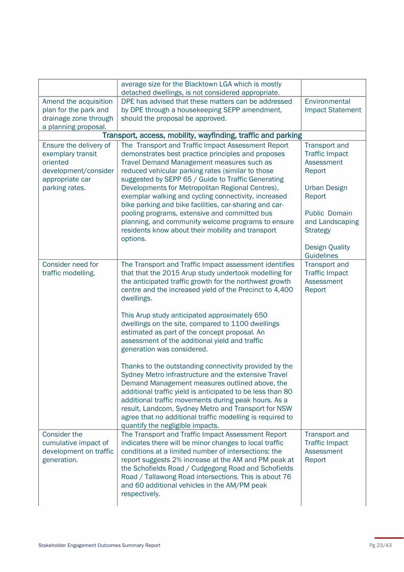
Transport, access, mobility, wayfinding, traffic and parking
Ensure the delivery of
exemplary transit
oriented
development/consider
appropriate car
parking rates.
The Transport and Traffic Impact Assessment Report
demonstrates best practice principles and proposes
Travel Demand Management measures such as
reduced vehicular parking rates (similar to those
suggested by SEPP 65 / Guide to Traffic Generating
Developments for Metropolitan Regional Centres),
exemplar walking and cycling connectivity, increased
bike parking and bike facilities, car-sharing and car-
pooling programs, extensive and committed bus
planning, and community welcome programs to ensure
residents know about their mobility and transport
options.
Transport and
Traffic Impact
Assessment
Report
Urban Design
Report
Public Domain
and Landscaping
Strategy
Design Quality
Guidelines
Consider need for
traffic modelling.
The Transport and Traffic Impact assessment identifies
that that the 2015 Arup study undertook modelling for
the anticipated traffic growth for the northwest growth centre and the increased yield of the Precinct to 4,400
dwellings.
This Arup study anticipated approximately 650
dwellings on the site, compared to 1100 dwellings
estimated as part of the concept proposal. An
assessment of the additional yield and traffic
generation was considered.
Thanks to the outstanding connectivity provided by the
Sydney Metro infrastructure and the extensive Travel
Demand Management measures outlined above, the
additional traffic yield is anticipated to be less than 80
additional traffic movements during peak hours. As a
result, Landcom, Sydney Metro and Transport for NSW
agree that no additional traffic modelling is required to
quantify the negligible impacts.
Transport and
Traffic Impact
Assessment Report
Consider the
cumulative impact of
development on traffic
generation.
The Transport and Traffic Impact Assessment Report
indicates there will be minor changes to local traffic
conditions at a limited number of intersections: the
report suggests 2% increase at the AM and PM peak at
the Schofields Road / Cudgegong Road and Schofields
Road / Tallawong Road intersections. This is about 76
and 60 additional vehicles in the AM/PM peak
respectively.
Transport and
Traffic Impact
Assessment
Report
Stakeholder Engagement Outcomes Summary Report Pg 24/43
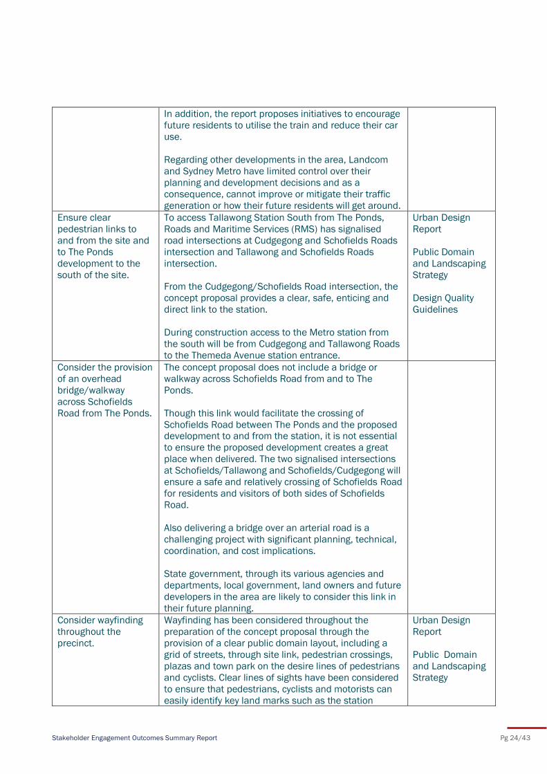
In addition, the report proposes initiatives to encourage
future residents to utilise the train and reduce their car
use.
Regarding other developments in the area, Landcom
and Sydney Metro have limited control over their
planning and development decisions and as a
consequence, cannot improve or mitigate their traffic
generation or how their future residents will get around.
Ensure clear
pedestrian links to
and from the site and
to The Ponds
development to the
south of the site.
To access Tallawong Station South from The Ponds,
Roads and Maritime Services (RMS) has signalised
road intersections at Cudgegong and Schofields Roads
intersection and Tallawong and Schofields Roads
intersection.
From the Cudgegong/Schofields Road intersection, the
concept proposal provides a clear, safe, enticing and
direct link to the station.
During construction access to the Metro station from
the south will be from Cudgegong and Tallawong Roads
to the Themeda Avenue station entrance.
Urban Design
Report
Public Domain
and Landscaping
Strategy
Design Quality
Guidelines
Consider the provision
of an overhead
bridge/walkway
across Schofields
Road from The Ponds.
The concept proposal does not include a bridge or
walkway across Schofields Road from and to The
Ponds.
Though this link would facilitate the crossing of
Schofields Road between The Ponds and the proposed development to and from the station, it is not essential
to ensure the proposed development creates a great
place when delivered. The two signalised intersections
at Schofields/Tallawong and Schofields/Cudgegong will
ensure a safe and relatively crossing of Schofields Road
for residents and visitors of both sides of Schofields
Road.
Also delivering a bridge over an arterial road is a
challenging project with significant planning, technical,
coordination, and cost implications.
State government, through its various agencies and
departments, local government, land owners and future
developers in the area are likely to consider this link in
their future planning.
Consider wayfinding
throughout the
precinct.
Wayfinding has been considered throughout the
preparation of the concept proposal through the
provision of a clear public domain layout, including a
grid of streets, through site link, pedestrian crossings,
plazas and town park on the desire lines of pedestrians
and cyclists. Clear lines of sights have been considered
to ensure that pedestrians, cyclists and motorists can
easily identify key land marks such as the station
Urban Design
Report
Public Domain
and Landscaping
Strategy
Stakeholder Engagement Outcomes Summary Report Pg 25/43
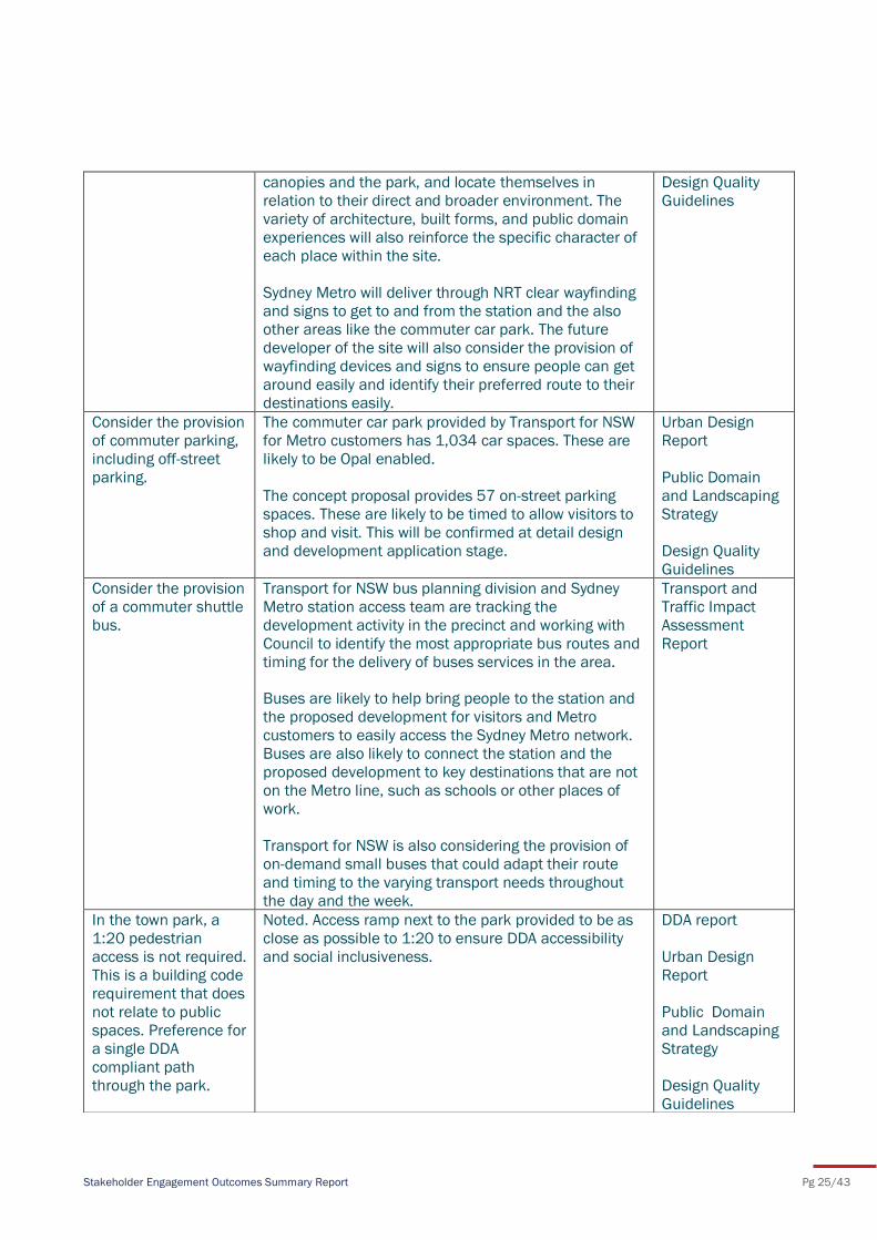
canopies and the park, and locate themselves in
relation to their direct and broader environment. The
variety of architecture, built forms, and public domain
experiences will also reinforce the specific character of
each place within the site.
Sydney Metro will deliver through NRT clear wayfinding
and signs to get to and from the station and the also
other areas like the commuter car park. The future
developer of the site will also consider the provision of
wayfinding devices and signs to ensure people can get
around easily and identify their preferred route to their
destinations easily.
Design Quality
Guidelines
Consider the provision
of commuter parking,
including off-street
parking.
The commuter car park provided by Transport for NSW
for Metro customers has 1,034 car spaces. These are
likely to be Opal enabled.
The concept proposal provides 57 on-street parking
spaces. These are likely to be timed to allow visitors to
shop and visit. This will be confirmed at detail design
and development application stage.
Urban Design
Report
Public Domain
and Landscaping
Strategy
Design Quality
Guidelines
Consider the provision
of a commuter shuttle
bus.
Transport for NSW bus planning division and Sydney
Metro station access team are tracking the
development activity in the precinct and working with
Council to identify the most appropriate bus routes and
timing for the delivery of buses services in the area.
Buses are likely to help bring people to the station and
the proposed development for visitors and Metro
customers to easily access the Sydney Metro network.
Buses are also likely to connect the station and the
proposed development to key destinations that are not
on the Metro line, such as schools or other places of
work.
Transport for NSW is also considering the provision of
on-demand small buses that could adapt their route
and timing to the varying transport needs throughout
the day and the week.
Transport and
Traffic Impact
Assessment
Report
In the town park, a
1:20 pedestrian
access is not required.
This is a building code
requirement that does
not relate to public
spaces. Preference for
a single DDA
compliant path
through the park.
Noted. Access ramp next to the park provided to be as
close as possible to 1:20 to ensure DDA accessibility
and social inclusiveness.
DDA report
Urban Design
Report
Public Domain
and Landscaping
Strategy
Design Quality
Guidelines
Stakeholder Engagement Outcomes Summary Report Pg 26/43
Define the key
vehicular access
routes to the site
The main access to the site from the south are at the
Cudgegong and Schofields intersection and Tallawong
and Schofields intersection.
The main access to the site from the north are
Cudgegong and Tallawong roads.
Transport and
Traffic Impact
Assessment
Report
Urban Design
Report
Public Domain
and Landscaping
Strategy
Ensure roads are wide
enough for emergency
services vehicles.
The Civil Report and Drawings and Transport and Traffic
Impact Assessment Report demonstrate that key
access roads will be suitable for use by emergency
vehicles.
Transport and
Traffic Impact
Assessment
Report
Pedestrian crossings
should be provided.
Pedestrian crossings are proposed across Themeda
Avenue and Conferta Avenue and new proposed streets
on major pedestrian routes to encourage pedestrian /
cyclist movements.
There will be two signalised intersections in place at the
Cudgegong and Schofields intersection and Tallawong
and Schofields intersection.
Transport and
Traffic Impact
Assessment
Report
Urban Design
Report
Public Domain
and Landscaping
Strategy
Design Quality
Guidelines
Infrastructure capacity and servicing
Ensure that
stormwater and
drainage
infrastructure is
provided, such as
easements with
drainage swale, pipes
and building pad
levels.
Noted. All information regarding drainage and civil
works are provided in the Civil Report and Integrated
Water Management Report.
Civil Design
Report
Integrated Water
Cycle
Management
Strategy
Provide a diagram
showing proposed
dedication of land to
Council.
Proposed ownership, including land proposed for
Council ownership, is indicated within the Urban Design
Report.
Urban Design
Report
The radius of street
intersections should
be similar to those
found in City of
Sydney to suit an
urban context.
Street intersections have been reduced, with vehicle
tracking undertaken and provided in the Civil Design
Report.
Civil Design
Report
Waste collection must
be in basements with
Noted. Urban Design
Report
Stakeholder Engagement Outcomes Summary Report Pg 27/43
sufficient head
clearance.
Civil Design
Report
Waste Strategy
Show garbage truck
tracking and road
width cross sections.
Noted. Urban Design
Report
Civil Design
Report
Waste Strategy
Stakeholder Engagement Outcomes Summary Report Pg 28/43
To date, Landcom has kept all stakeholders, including the local community, adjoining landowners and
government authorities informed about the development of the concept proposal. Landcom will
continue to engage with stakeholders, including the community, during the statutory exhibition of the
SSDA as well as during future stages of the planning and development process. Specifically, Landcom
will continue to work closely with Department of Planning and Environment and Blacktown City Council
to plan and coordinate activation and renewal of land around Tallawong Station. Landcom will also
update its website with program updates and produce regular program updates to send to stakeholders
who register an interest.
7 Next steps
Stakeholder Engagement Outcomes Summary Report Pg 29/43
Appendix A: e-newsletter
Stakeholder Engagement Outcomes Summary Report Pg 30/43
Appendix B: Newspaper adverts
Stakeholder Engagement Outcomes Summary Report Pg 31/43
Appendix C: Invitation flyer
Stakeholder Engagement Outcomes Summary Report Pg 32/43
Appendix D: Distribution area
Stakeholder Engagement Outcomes Summary Report Pg 33/43
Appendix E: Display boards
Stakeholder Engagement Outcomes Summary Report Pg 34/43
Stakeholder Engagement Outcomes Summary Report Pg 35/43
Stakeholder Engagement Outcomes Summary Report Pg 36/43
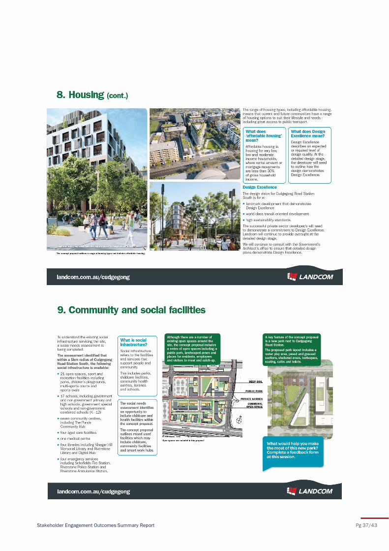
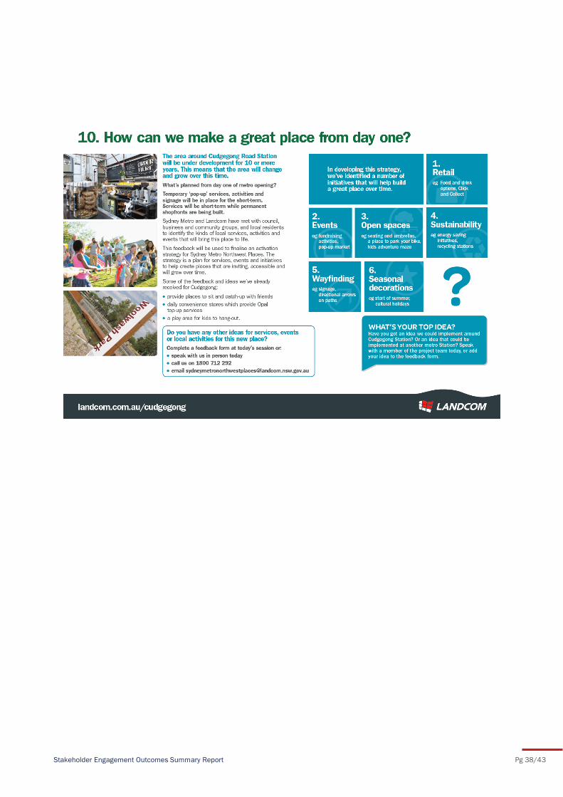
Stakeholder Engagement Outcomes Summary Report Pg 37/43
Stakeholder Engagement Outcomes Summary Report Pg 38/43
Stakeholder Engagement Outcomes Summary Report Pg 39/43
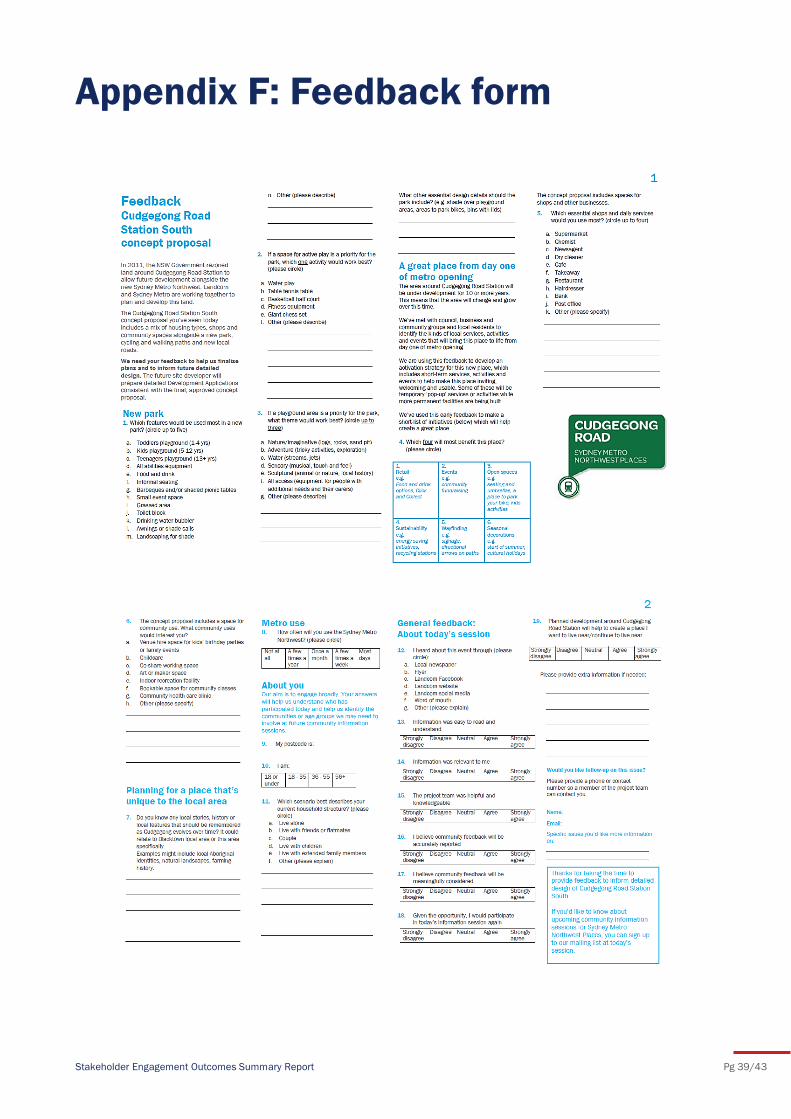
Appendix F: Feedback form
Stakeholder Engagement Outcomes Summary Report Pg 40/43
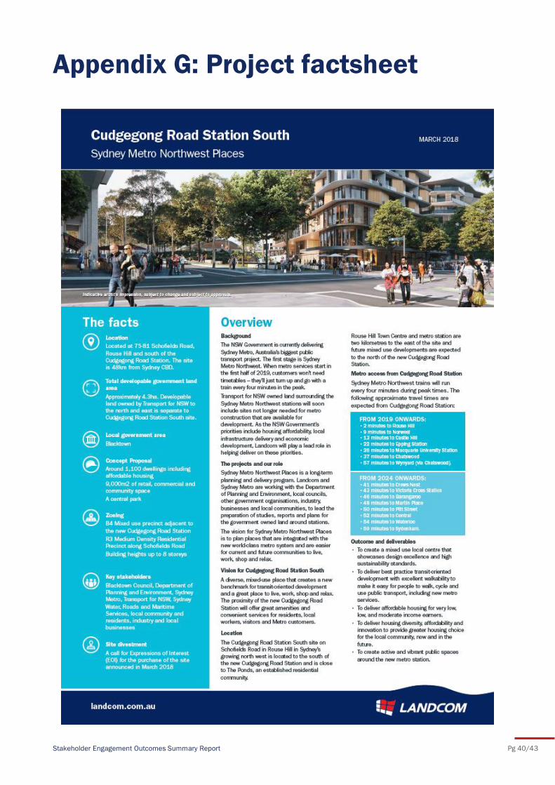
Appendix G: Project factsheet
Stakeholder Engagement Outcomes Summary Report Pg 41/43
Appendix H: Landcom Facebook
Event
Stakeholder Engagement Outcomes Summary Report Pg 42/43
Appendix I: Landcom Twitter feed
Stakeholder Engagement Outcomes Summary Report Pg 43/43
Appendix J: Website update