state board of equalization property and special …
TRANSCRIPT

STATE OF CALIFORNIA
STATE BOARD OF EQUALIZATION PROPERTY AND SPECIAL TAXES DEPARTMENT 450 N STREET, SACRAMENTO, CALIFORNIA
PO BOX 942879, SACRAMENTO, CALIFORNIA 94279-0064
916 445-4982 FAX 916 323-8765
www.boe.ca.gov
BETTY T. YEE First District, San Francisco
MICHELLE STEEL
Third District, Rolling Hills Estates
JEROME E. HORTON Fourth District, Los Angeles
JOHN CHIANG State Controller _______
BARBARA ALBY
Acting Member Second District, Sacramento
_______
RAMON J. HIRSIG Executive Director
No. 2010/023
April 28, 2010
TO COUNTY ASSESSORS AND INTERESTED PARTIES:
ASSESSORS' HANDBOOK SECTION 215, ASSESSMENT MAP STANDARDS FOR MANUAL SYSTEMS
Attached is Assessors' Handbook Section 215, Assessment Map Standards for Manual Systems, which was approved by the Board on April 13, 2010.
On September 23, 2009, a draft of the proposed handbook was distributed via Letter To Assessors 2009/044 requesting comments from interested parties. A second draft, with suggested language changes and/or proposed additions, was distributed in strikeout and underscore format in Letter To Assessors 2010/006 on January 19, 2010. No further comments or proposed changes were received.
Due to budgetary issues, no complimentary hard copies will be distributed. AH 215 is posted on the Board's website at www.boe.ca.gov/proptaxes/pdf/ah215.pdf. You may purchase a copy of the handbook using the order form at www.boe.ca.gov/proptaxes/pdf/boe663ah.pdf.
If you have questions regarding this publication, you may contact Mr. Michael McDade at 916-445-3150 or at [email protected].
Sincerely, /s/ David J. Gau David J. Gau Deputy Director Property and Special Taxes Department DJG:mm Attachment

ASSESSORS' HANDBOOK SECTION 215
ASSESSMENT MAP STANDARDS FOR MANUAL SYSTEMS
APRIL 2010
CALIFORNIA STATE BOARD OF EQUALIZATION
BETTY T. YEE, SAN FRANCISCO FIRST DISTRICT
MICHELLE STEEL, ROLLING HILLS ESTATES THIRD DISTRICT
JEROME E. HORTON, LOS ANGELES FOURTH DISTRICT
JOHN CHIANG, SACRAMENTO STATE CONTROLLER
BARBARA ALBY, ACTING MEMBER SECOND DISTRICT
RAMON J. HIRSIG, EXECUTIVE DIRECTOR

FOREWORD
The purpose of this handbook is to establish the fundamental requirements and specifications for a map system that will permit efficient operation of a county assessor's office and the preparation of a complete and equalized assessment roll. The handbook also contains instructions on writing legal descriptions.
The subject matter in this handbook was originally contained in five separate publications (former Assessors' Handbook sections 071, 210, 211, 212, and 214). Those manuals were combined into a single manual – AH 215 – in 1984.
Prior to this revision, Assessors' Handbook section 215 was most recently updated in 1992, and reprinted in 1997. This revision updates statutory references and revises some text sections.
Although most counties have developed digital cadastral mapping capabilities, the basic underlying characteristics of a manual system remain relevant. With this revision, AH 215 has been renamed Assessment Map Standards for Manual Systems.
A subsequent handbook section will address digital and geographic information systems.
Section 15606, subdivision (c), of the Government Code directs the State Board of Equalization (Board) to prescribe rules and regulations governing county assessors in the performance of the duties, and subdivision (f) provides that the Board shall issue instructions, such as those set forth in this handbook section. While rules and regulations adopted by the Board are binding as law, Board-adopted handbook sections are advisory only. Nevertheless, courts have held that they may be properly considered as evidence in the adjudicatory process.1
The citations and law references in this publication were current as of the writing of the manual. Board staff met with members of the California Assessors' Association, County Counsels' Association of California, and industry representatives to solicit input for this handbook section. The Board approved this handbook section on April 13, 2010.
/s/ David J. Gau
David J. Gau Deputy Director Property and Special Taxes Department California State Board of Equalization April 2010
1 Coca-Cola Co. v State Board of Equalization (1945) 25 Cal.2d 918; Prudential Ins. Co. v. City and County of San Francisco (1987) 191 Cal.App.3d 1142; Hunt-Wesson Foods, Inc. v. County of Alameda (1974) 41 Cal.App.3d 163.
AH 215 i April 2010

TABLE OF CONTENTS
CHAPTER 1: DESCRIPTION OF REAL PROPERTY .......................................................... 1
BASIC REQUIREMENTS................................................................................................................. 1 BASIC METHODS OF DESCRIBING REAL PROPERTY...................................................................... 1
Description by Metes and Bounds .......................................................................................... 1 Description by Reference to Recorded Maps ......................................................................... 1
U.S. Government Township Plats....................................................................................... 2 Spanish Land Grants ........................................................................................................... 5 Subdivision Maps ............................................................................................................... 5 Official Maps ...................................................................................................................... 6 Assessor's Maps .................................................................................................................. 6 Miscellaneous Official Maps .............................................................................................. 7
Description Standardization ................................................................................................... 7
CHAPTER 2: PURPOSE AND FUNDAMENTALS OF ASSESSOR'S MAPS ..................... 9
MAPS – THE ASSESSOR'S BASIC RECORD..................................................................................... 9 Definition ................................................................................................................................ 9
REQUIREMENTS, USES, AND DESIGN OF ASSESSOR'S MAPS ......................................................... 9 Basic Requirements................................................................................................................. 9 Uses of Assessor's Maps ....................................................................................................... 11 Design of Maps ..................................................................................................................... 11 Legal and Practical Requirements for Assessor's Maps ...................................................... 12
ASSESSOR'S MAP SYSTEM.......................................................................................................... 12 General System ..................................................................................................................... 12 Elements of the System.......................................................................................................... 13 County Subdivision Indexes .................................................................................................. 13 Map Book Subdivision Index (Optional) .............................................................................. 13 Information To Be Shown on Detailed Maps........................................................................ 13 Scale of Maps........................................................................................................................ 14
STANDARDS AND SPECIFICATIONS FOR MAP CONSTRUCTION.................................................... 15 General Map Standards........................................................................................................ 15
Size of Maps and Scale ..................................................................................................... 15 Standard Symbols ............................................................................................................. 15 Titles ................................................................................................................................. 15
Plotting and Line Designations ............................................................................................ 15 Accuracy ........................................................................................................................... 15 Line Designations ............................................................................................................. 16
Lettering................................................................................................................................ 16 Adjoining Map References and Titles................................................................................... 16
REVISION OF MAPS .................................................................................................................... 16 FILING AND CARE OF MAPS ....................................................................................................... 16 DESCRIBING PROPERTY ON THE TAX ROLL................................................................................ 16 MISCELLANEOUS ....................................................................................................................... 18
General Rules for Descriptions ............................................................................................ 18
AH 215 ii April 2010

When the Boundary is a Public Road ............................................................................... 19 Rights of Owner of Property Abutting a Highway ........................................................... 19 Areas Computed to Street Centers.................................................................................... 20 When a Boundary is a Stream........................................................................................... 20 The Words "Except" and "Reserving" as Used in Description......................................... 20 When a Deed to a City or a County for a Road Conveys the Fee and When it Conveys an Easement ........................................................................................................................... 20 Words "North" or "Northerly," etc. .................................................................................. 20
Types of Instruments Transferring Title ............................................................................... 20 Errors in Deed Descriptions................................................................................................. 21
ACREAGE COMPUTATIONS......................................................................................................... 21 TABLE 2-2 – MEASUREMENTS ................................................................................................... 22
CHAPTER 3: PURPOSE AND SYSTEM FOR NUMBERING ASSESSOR'S PARCELS 23
PURPOSE OF DESCRIPTION BY PARCELS ..................................................................................... 23 DEFINITION OF ASSESSMENT PARCEL ........................................................................................ 24 PARCEL NUMBERING SYSTEM.................................................................................................... 25
Parcel Number .................................................................................................................. 25 Original Numbering .......................................................................................................... 26 Divisions and Combinations ............................................................................................. 26
DESCRIPTION BY PARCELS ON ROLL .......................................................................................... 26
CHAPTER 4: STANDARD MAP SYSTEM............................................................................ 27
INTRODUCTION .......................................................................................................................... 27 LAYOUT MAPS........................................................................................................................... 27
Paging ................................................................................................................................... 27 Booking ................................................................................................................................. 28 Assigning Preliminary Map Book and Page Numbers ......................................................... 28 Map Page Base Information ................................................................................................. 28 Preliminary Map Book Index................................................................................................ 28 Plotting of Source Data ........................................................................................................ 28 Description Ties .................................................................................................................... 29 Subdivision Boundaries ........................................................................................................ 29 Tax Rate Area Boundaries .................................................................................................... 29 Recorded Map Book Numbers .............................................................................................. 29 Quasi-Public Streets ............................................................................................................. 29 Subdivision Errors ................................................................................................................ 29
PLOTTING FROM PROPERTY DESCRIPTIONS................................................................................ 29 Conflicting Lines................................................................................................................... 29 Overlaps and Hiatuses.......................................................................................................... 30 Temporary Parcel Numbers.................................................................................................. 30 Conflicting Dimensions......................................................................................................... 30 Dimensions............................................................................................................................ 30 Parcel in Road ...................................................................................................................... 30 Road Easement or Right-of-Way .......................................................................................... 31
CREATION OF SECURED MASTER FILE INFORMATION................................................................ 31
AH 215 iii April 2010

MINERAL RIGHTS....................................................................................................................... 31 Surface and Mineral Rights in One Ownership.................................................................... 31 Mineral Rights Separately Owned........................................................................................ 32 Undivided Interests in Mineral Rights.................................................................................. 32
TIMBER RIGHTS ......................................................................................................................... 32 POSSESSORY INTERESTS............................................................................................................. 32 PARCELING ................................................................................................................................ 32
Publicly Owned Property...................................................................................................... 32 Federal Land ..................................................................................................................... 32 Federally Owned Large Acreage ...................................................................................... 33 Federally Owned Small Acreage ...................................................................................... 33
Parcel Acreage ..................................................................................................................... 33 State Board of Equalization Parcels..................................................................................... 33 Parcels Assessed on Mileage Basis ...................................................................................... 33 Urban Parcels....................................................................................................................... 34
MAP BOOK INDEX...................................................................................................................... 34 TRACINGS .................................................................................................................................. 34
Foreword............................................................................................................................... 34 Detail to Show on Tracings .................................................................................................. 34 Inking Standards ................................................................................................................... 34 Map Preparation to Scales 1" = 800' and 1" = 1200'.......................................................... 35
Government Lots .............................................................................................................. 35 Bearings and Dimensions ................................................................................................. 35 Unsurveyed ....................................................................................................................... 35
Urban Areas.......................................................................................................................... 36 Lettering................................................................................................................................ 36
Sans Serif .......................................................................................................................... 36 Letter Heights ................................................................................................................... 36 Line and Letter Clearances ............................................................................................... 36 Direction of Lettering ....................................................................................................... 36 Section, Township, and Range Numbers.......................................................................... 36 Subdivision Names, Tract Numbers, Map Reference....................................................... 36 Original Block and Lot Numbers...................................................................................... 36 Property Dimensions......................................................................................................... 37 Street Names ..................................................................................................................... 37 Names of Undedicated Roads........................................................................................... 37 Changed Street Names...................................................................................................... 37 Acreages, Gross, and Net.................................................................................................. 37 Public and Semi-Public Lands .......................................................................................... 37 Abbreviations.................................................................................................................... 37 Adjoining Map References ............................................................................................... 37
Original Lot Numbers ........................................................................................................... 38 Assessor's Parcel Numbers ................................................................................................... 38 Tax Rate Area Boundaries .................................................................................................... 38 Map Page Titles .................................................................................................................... 38 Other Standard Information on Map Page........................................................................... 39
AH 215 iv April 2010

Disclaimer............................................................................................................................. 39 Index Map to Book................................................................................................................ 39
SUBDIVISION INDEXES FOR MAP BOOKS (OPTIONAL) ................................................................ 40 Detail Map Books ................................................................................................................. 40 Federal Land......................................................................................................................... 40
WALL MAPS AND INDEXES ........................................................................................................ 40 Wall Map............................................................................................................................... 40 Indexes .................................................................................................................................. 40
Subdivision Index ............................................................................................................. 40 Numerical Book Index...................................................................................................... 40
CHAPTER 5: TAX RATE AREA SYSTEM ........................................................................... 41
GENERAL ................................................................................................................................... 41 TAX RATE AREA MAPS.............................................................................................................. 41 TAX RATE AREA REPORTS......................................................................................................... 43
APPENDIX 1: ATTORNEY GENERAL'S OPINION 45/326, "SYSTEM FOR DESCRIPTION OF REAL PROPERTY PARCELS BY REFERENCE TO ASSESSORS' MAPS"......................................................................................................................................... 45
APPENDIX 2: STANDARDS - SAMPLE MAPS AND EXHIBITS...................................... 51
STANDARD 1: SIZE AND SCALES, TITLE AND CROSS-REFERENCE TRACINGS FOR ASSESSOR'S
DETAILED MAPS ........................................................................................................................ 52 STANDARD 2: RECOMMENDED SYSTEM FOR LAYING OUT AND NUMBERING DETAIL MAPS...... 53 STANDARD 3: COUNTY INDEX TO ASSESSOR'S MAP BOOKS....................................................... 54 STANDARDS 4, 5 AND 6: MAP BOOK INDEX MAP – OUTSIDE AND INSIDE .................................. 57
Information To Be Shown ..................................................................................................... 57 STANDARD 7: DETAILED MAP – URBAN PROPERTY................................................................... 61
Information To Be Shown On Tracing.................................................................................. 61 STANDARD 8: DETAILED MAP – LARGE URBAN AND SMALL FARM PROPERTY ......................... 63
Information To Be Shown On Tracing.................................................................................. 63 STANDARD 9: DETAILED MAP – ORCHARD AND SMALL FARM PROPERTY................................. 65
Information To Be Shown On Tracing.................................................................................. 65 STANDARD 10: DETAILED MAP – LARGE ORCHARD AND MEDIUM-SIZE FARM PROPERTY........ 67
Information To Be Shown On Tracing.................................................................................. 67 STANDARDS 11 AND 12: DETAILED MAP – LARGE-SIZE FARM PROPERTY................................. 69
Information To Be Shown On Tracing.................................................................................. 69 STANDARD 13: DETAILED MAP - MOUNTAIN AREAS................................................................. 73
Information To Be Shown On Tracing.................................................................................. 73 STANDARD 14: DETAILED MAP – CANALS, PIPELINES AND TOLL ROADS AND STATE BOARD OF
EQUALIZATION PARCELS ........................................................................................................... 75 STANDARD 15: DETAILED MAP – CONDOMINIUM PROPERTY .................................................... 77
Information To Be Shown On Tracing.................................................................................. 77 STANDARD 16: STANDARD SYMBOLS ........................................................................................ 81 STANDARD 17: STANDARD ABBREVIATIONS.............................................................................. 82 STANDARD 18: LETTERING FOR ASSESSOR'S DETAIL MAPS....................................................... 85
AH 215 v April 2010

AH 215 vi April 2010
STANDARD 19: MAP BOOK INDEX TO SUBDIVISIONS ................................................................. 87 STANDARD 20: REVENUE DISTRICTS, TAX RATE AREA CODE NUMBERS, DESCRIPTION OF
PROPERTY.................................................................................................................................. 88 Tax Rate Area Code Numbers .......................................................................................... 88 Description of Property and Parcel System ...................................................................... 88
APPENDIX 3: DISTRICTS LISTED ON BOARD ROLL OF STATE-ASSESSED PROPERTY................................................................................................................................. 90
APPENDIX 4: STATUTORY PROVISIONS.......................................................................... 91
REVENUE AND TAXATION CODE SECTIONS................................................................................ 91 GOVERNMENT CODE SECTIONS ................................................................................................. 95 CIVIL CODE SECTIONS ............................................................................................................. 124
APPENDIX 5: SUMMARY OF RELATED COURT CASES ............................................. 126
APPENDIX 5: GLOSSARY OF TERMS............................................................................... 128

Chapter 1
CHAPTER 1: DESCRIPTION OF REAL PROPERTY
BASIC REQUIREMENTS
The basic requirement in describing property on the assessment roll is that it clearly designates the property assessed. A description which could be construed as referring to more than one assessment parcel, or for any other reason is insufficient to identify the property, jeopardizes the validity of the assessment.
BASIC METHODS OF DESCRIBING REAL PROPERTY
There are two basic legal methods of describing land for assessment purposes. These methods are by metes and bounds and by reference to maps.
DESCRIPTION BY METES AND BOUNDS
The oldest form of legal description is by metes and bounds. "Metes" means measurements or distances, and "bounds" means boundaries. The metes and bounds system continues to be used, particularly for irregular parcels.
A metes and bounds description gives the distance and compass direction of each boundary line of the property. It starts at a "point of beginning" and traces all the way around the property boundary back to that point. The earliest metes and bounds descriptions did not use compass directions or distances, but instead referred to identifiable physical features such as rivers or fences that "bounded" the property in question. Any parcel of land can be described using a metes and bounds description, for example,
Beg. At a point 30 ft. N. Of the S. W. Cor. Of Sec. 18,T. 6 S.R. 8 E. Mt. Diablo B. & M., th. N. along the section line 396.36 ft., th. N. 89° 35' E. 210.14 ft., th. S 396.36 ft., th. S.89° 35' W. 210.14 ft to beg.
DESCRIPTION BY REFERENCE TO VARIOUS MAPS AND PLATS
A map is a graphic representation of one or more numbered or lettered lots of land showing bearings, distances, and ties to established points. A map is more satisfactory for practical use than a narrative description because a narrative description must be mapped before it has any practical value to the owner, county assessor, or appraiser.
A narrative description is often necessary for use in writing deeds to identify the property. Since a narrative description is a simple reference by numbers or letters to a map, it is far more practical and efficient for routine use than a metes and bounds description.
Descriptions by map reference are much less subject to error than descriptions by metes and bounds or other methods and provide the simplest and most common method of describing property. Maps generally show the location of parcels with respect to streets, highways, official
AH 215 1 April 2010

Chapter 1
survey points, and district boundaries. Since the description need only identify the map and designate the parcel of land as it appears thereon, much clerical work is avoided and the possibility of error reduced.
Example: Jones Sub. – M. B. 16-86, Lot 16 Blk. 10
When a portion of a lot is being described, it is important that it clearly state exactly what portion is covered. For example, a description reading "one-half of Lot 12, Block 132" could be held void because it does not clearly designate how the lot was divided. In many instances a metes and bounds description may be necessary.
There are numerous types of recorded maps that a county assessor can use in describing property for assessment purposes. The following are some examples:
1. Official U.S. Government Township Plats
2. Official Spanish Land Grants Maps or Plats
3. Subdivision Maps
4. Official Maps (Section 325 of the Revenue and Taxation Code)
5. Assessor's Maps
6. Owner's Maps
7. Miscellaneous Official Maps
U.S. Government Township Plats
Description by township, range, and section refers to the United States System of Surveying the Public Lands, which was inaugurated in 1785 and modified since by various acts of Congress. The acts require that the public lands:
Shall be divided by north and south lines, run according to true meridian, and by others crossing them at right angles, so as to form townships six miles square, also that the townships shall be divided into 36 sections, each which shall contain 640 acres, as nearly as may be, by a system of two sets of parallel lines, one governed by true meridian and the others by parallel of latitudes, the latter intersecting the former at right angles at intervals of a mile.
Since the meridians converge, it is evident that it is mathematically impossible to comply with the requirements that the lines shall conform to true meridian and that townships shall be six miles square. In order to conform as nearly as practical to the spirit of the law and also to make its application both uniform and effective, an elaborate system of subdivision has been worked out. The work of the public land surveys is under the direction of the Director of the Bureau of Land Management.
AH 215 2 April 2010

Chapter 1
The initial work in surveying the public lands was to establish a base line and an intersecting point for the principal meridian. In California there are three such points:
1. Mt. Diablo Base and Meridian, whose intersecting monument is at the summit of Mt. Diablo in Contra Costa County;
2. San Bernardino Base and Meridian, whose intersecting monument is in the San Bernardino Mountains just north of the City of San Bernardino; and
3. Humboldt Base and Meridian, whose intersecting monument is in Humboldt County about four miles south of the city of Scotia.
The greater portion of Central and Northern California is within the Mt. Diablo Base and Meridian, and Southern California is within the San Bernardino Base and Meridian.
Each township is designated by the number of the six-mile tiers north or south of the base line and by the range, which is the number of the six-mile tiers east or west of the meridian. Each township is then divided into 36 sections commencing with No. 1 at the northeast corner of the township and proceeding west to No. 6, then across to the east, and back and forth to section 36 in the southeast corner. Irregularities in the size of the townships are taken care of in the west and north tier of sections and in the west, or north quarter mile of that tier. Whenever a quarter of a quarter section is not a true 40 acres according to the original survey, it is given a lot number. Therefore, there are government lots in some sections as well as the fractional section.
Cadastral surveyors have done some resurveying to correct the crude surveys made in the early days. Whenever this is done, a new township or fractional township plat is issued. Often when a section is found to be not a true section according to the resurvey, fractions of that section are given lot numbers. Lot numbers are also used where the fractional quarter-quarter sections are not true 40 acres because of rivers, Rancho lines, coast lines, etc.
Figure 1-1 depicts the grid system defined by the Public Land Survey System.
AH 215 3 April 2010

Chapter 1
FIGURE 1-1: PUBLIC LAND SURVEY GRID
AH 215 4 April 2010
Chapter 1
Spanish Land Grants
Section 323 of the Revenue and Taxation Code states:
If held under Spanish grant, land may be described by the exterior boundaries of the grants, or by the name of the grants, and the divisions, subdivisions, and acreage claimed.
Spanish and Mexican land grants originate from Spanish occupation of California in 1769, which vested the title to the land in the King of Spain. During the Spanish period, the first concessions of ranch property were made before the end of the Eighteenth Century. These concessions were in the nature of grazing permits, rather than absolute grants.
Between 1822 and 1846 (and particularly after the year 1828), the Mexican government granted many ranch titles, some of them confirming prior Spanish concessions.
These grants, Spanish and Mexican, later were approved or disapproved by the Board of Land Commissioners appointed by Congress in 1851. Successful claimants received a confirming patent (which included all mineral rights) from the United States.
When the federal government surveyed the land, Spanish land grants were excluded from the survey. Being privately owned when California became part of the United States, only the exterior boundaries of the ranches were surveyed as a necessity of sectionalizing all adjoining land; however, many ranches were sectionalized by the owners who hired private surveyors.
If a Spanish grant has been sectionalized according to the United States System of Surveying the Public Lands, it is not sufficient to describe the property by section, township, and range. Since it was not surveyed under the authority of the United States, it is necessary to give the name of the Rancho, such as:
Rho. El Sobrante Sec. 16 T. 8 S., R. 12 W., M. D. B. & M. – 640 acres.
The Rancho name should always be used in a description of property within a Rancho unless the description is by reference to a map.
Subdivision Maps
Subdivision maps are prepared by licensed surveyors or civil engineers, approved by the local governing body, city council, or board of supervisors, and filed in the county recorder's office. Their preparation and filing is subject to the provisions of sections 66425 through 66472.1 of the Government Code. The maps are filed by the subdivider and must be prepared by an engineer or surveyor after making a field survey and setting stakes at lot corners. They must also be checked by the county surveyor or city engineer, county recorder, and approved by the governing body.
Copies of maps generally may be obtained from the county recorder, county surveyor, or city engineer.
AH 215 5 April 2010
Chapter 1
Section 327.12 permits the filing of digital subdivision maps, as follows:
The board of supervisors of any county may enact, by a majority vote of its membership, an ordinance, resolution, or board order that requires any party that records a digital subdivision map with the county recorder to also file a duplicate digital copy of that map with the county assessor.
Official Maps
Section 325 states:
When a map has been adopted as an official map under Division 3 (commencing with Section 66499.50) of Title 7 of the Government Code, land may be described by numbers or letters as shown on the official map.
Official maps are made by the city engineer or county surveyor under the direction of the city council or board of supervisors. Each map must be properly certified and filed. The size and scale of maps are not specified by law.
Assessor's Maps
Section 327 provides for the existence and organization of assessor's maps as follows:
Where any county or county officer possesses a complete, accurate map of any land in the county, or whenever such a complete, accurate map has been made in compliance with Sections 27556 to 27560, inclusive, of the Government Code, the assessor may number or letter the parcels in a manner approved by the board of supervisors. The assessor may renumber or reletter the parcels or prepare new map pages for any portion of such map to show combinations or divisions of parcels in a manner approved by the board of supervisors, so long as an inspection of such map will readily disclose precisely what land is covered by any particular parcel number or letter in the current or any prior fiscal year. This map or copy shall at all times be publicly displayed in the office of the assessor.
Land may be described by a reference to this map except that land shall not be described in any deed or conveyance by a reference to any such map unless such map has been filed for record in the office of the county recorder of the county in which such land is located.
All such maps in the possession of county assessors on August 27, 1937, and used for assessment purposes only, are deemed to have been numbered or lettered and approved properly.
2 All section references are to the Revenue and Taxation Code unless otherwise noted.
AH 215 6 April 2010

Chapter 1
Owner's Maps
Section 326 provides that whenever a map, other than an official map, has been furnished by the owner, claimant or user of land, and it contains sufficient information clearly to identify the land, and is properly identified by and filed with the assessor or board, the land may be described by reference to this map.
A typical example of an owner’s map commonly furnished to the assessor, might be a simple hand drawn sketch entitled ‘Jones Life Estate Boundaries’, signed by the life tenant, remainder persons and any other affected parties, that is of sufficient size, scale and detail to show the dimensions, shape, area and location of an area of land subject to a life estate relative to the rest of the parcel of land within which it is located. Such maps can aid the assessor in understanding the intent of the parties, and therefore, accurately delineate and assign assessment parcel numbers to areas that were ambiguously or poorly described in land sale contracts, leases, court orders and other written documents affecting title to land.
Miscellaneous Official Maps
There are various types of miscellaneous maps resulting from court decrees or court orders, or official actions for which official records are on file. Such maps include those made as a result of an official survey by the county surveyor and maps that have been filed in either the county clerk's or county recorder's office. Many such maps have been recognized over a period of years as legal surveys of specific properties. Such maps, having a permanent official record status and available for public inspection, may be used for describing property by reference thereto.
DESCRIPTION STANDARDIZATION
Each description must have various combinations of the following data.
1. Subdivision number/name
2. Subdivision reference
3. Block number
4. Lot number
5. Division/range
6. Township/range
7. Section number
8. Rancho name (except when description refers to a recorded map)
Some examples are:
1. Descriptions with a subdivision number/name and related reference:
AH 215 7 April 2010

Chapter 1
AH 215 8 April 2010
TR 12345 Blk 1 Lot 1
PM 12-45-46 Lot 1
Jones Sub MB 16-86 Blk 10 Lot 16
2. Metes and bounds descriptions that do not refer to a recorded deed will at least contain the subdivision information to the lot level and a referral note to see Assessor's Map for the metes and bounds information.
New Depot Tr Blk 3 por Lots 4 and 7 For desc see AM
3. Description with a Rancho name:
Ro El Sobrante T8S R12W Sec 16 SW ¼
4. Descriptions with a recorded deed:
T5N R11W Sec 20 por NE ¼, NE ¼ desc in Doc 0371835 770413
Tr 34896 por Lots 5 and 6 desc in Doc 9999999 YYMMDD
Tr 40120 Lot 1 condo Airspace desc in Doc 0487779 840423
5. Deletion of long subdivision name utilizing the reference only:
MR 21-15 Blk 4 Lot 9 E 5 ft of W 1280 ft of S 105 ft of N 210 ft (Ex Sts)
MB 10-178 Blk 3 lots 4 thru 11, 12 thru 18 (Ex Sts), 19 thru 21
6. Deletion of subdivision reference utilizing subdivision number only:
Tr 2378 Lots 2 thru 5 por SE of Alameda St and ½ vac Alley (und 96% Int)
Tr 1953 Blk 4 Lots 2 and 3 and ½ vac St adj on NE and vac St adj on N
7. Sectional property description:
T5N R11W Sec 21 S ½, NE ¼, SE ¼ (Ex Sts and Ex T/L Ease)
8. Description for same ownership in two tax rate areas:
Tr 42101 Lot 1 Condo Unit 1 That por in TRA 130068
Tr 42101 Lot 1 Condo Unit 1 That por in TRA 004056

Chapter 2
CHAPTER 2: PURPOSE AND FUNDAMENTALS OF ASSESSOR'S MAPS
MAPS – THE ASSESSOR'S BASIC RECORD
Any task involving a consideration of land requires maps. Maps are the language used in any study of land; therefore, maps are the basic tool for the performance of the assessment task which involves locating, inventorying, and appraising of all land and other property.
The first requirement for an assessor's office is a properly designed set of maps wherein all map and survey information is coordinated into an efficient map system.
It is essential that the best possible map procedures and standards are used. Maps should also be designed with consideration for other potential uses so that they will permit the most extensive use possible without interfering with the basic assessor's use including the design control of the map system. Other uses might include index maps for surveyors on which to show all survey data and its source, roads and highways, deeds and other data, planning commission zoning, and many other comparable purposes.
DEFINITION
A map is a graphical representation on a flat surface of some portion of the earth's surface. It is a visual representation of land. It shows the relative size and position of the land with respect to other properties, to roads and highways, and to major topographic features.
REQUIREMENTS, USES, AND DESIGN OF ASSESSOR'S MAPS
BASIC REQUIREMENTS
In the 1936 progress report3 of the Assessors' Standards Committee, the following minimum requirements were recommended and adopted by county assessors:
(1) A set of office maps.
a. To show governmental and recorded map, boundary lines, and property ownership lines.
b. To show other information convenient for county assessors.
(2) A property record card, to show:
a. Record ownership (present and previous year).
b. Description of property.
3 First progress report of Assessors' Standards Committee.
AH 215 9 April 2010

Chapter 2
c. Assessed values
i. Land
ii. Buildings
iii. Trees and vines
d. In geographical order.
(3) A set of field maps.
a. To correspond to and have the same indexes as office maps.
b. To be designed to meet basic requirements and to be as convenient as possible for field appraisers and deputies.
(4) A geographical index to maps and ownership records.
a. A map index for township, range and section.
b. An alphabetical index for recorded subdivision and tracts.
The requirements adopted by the assessors in 1936 served well to build the county assessors' map systems. Today, with the map systems in place, the basic requirements for assessors' maps are:
1. Must be in sufficient detail to accurately show assessment boundaries.
2. Maps of acreage must be drawn at a scale suitable to show topography, soil, highways, acreage, and other necessary appraisal information.
3. The maps should cover geographic and economic areas rather than recorded subdivision areas or tax rate areas. When prepared in this order, they provide a better geographic property index. An alphabetical index of recorded subdivisions, giving the assessor's map book number and page, furnishes a simple and efficient method of referring to subdivisions.
4. Boundary lines of maps should be street or survey lines that are generally also property lines, such as section, fractional section, Rancho lines, etc. Map boundary lines should seldom cut through lot or property lines.
5. The maps should be carefully cross-indexed and "tied" together by showing the map number of each adjoining map, street lines, section lines, etc.
6. The maps should be in an area system adaptable to systematic division into maps of larger scales.
AH 215 10 April 2010

Chapter 2
USES OF ASSESSOR'S MAPS
A county assessor's primary uses of maps are to inventory, locate, identify, and appraise taxable property.
1. Inventory – The maps provide a systematic, visual means of identifying all taxable parcels in the county. This minimizes the possibility that taxable parcels will escape assessment.
2. Locate – The maps assist the assessor's appraisers in locating properties. They are particularly helpful for locating properties where street addresses are not available.
3. Identify – The maps display the property boundaries and configuration.
4. Appraise – Appraisers use the maps extensively both for noting subject property characteristics and comparative data for similar, nearby properties. The appraiser's use is discussed in more detail below.
In addition to the assessor's uses of the maps, numerous individuals and agencies make a wide variety of uses of the assessor's maps. Fee appraisers, property owners, planning agencies, and many other private and public agencies use the maps.
DESIGN OF MAPS
The suitability of the maps for field appraisal use is one of the most important elements in a well-designed map system.
For field use, the maps must be designed so the field appraiser can quickly and conveniently refer to adjoining properties and, when possible, to nearby properties (this implies large-size pages and/or small-scale parcel boundaries). The parcel boundaries must be sufficiently large in scale so that essential data can be printed within the parcel (for example, parcel number, lot number, dimensions) and so the appraiser can write appropriate data within the parcel boundary (this implies large-scale parcel boundaries). Each map page must contain considerable information but must remain uncluttered.
When determining map book and page boundaries, the assessor should follow natural geographic lines and other lines of property influence (such as subdivision boundaries). These lines, if not permanent, are at least enduring in contrast to political district lines. This feature minimizes the redrawing of maps and changing parcel numbers. It also assists the appraisers by keeping areas of similar economic influence within the same map book.
School, political district, and other boundaries can easily be shown or highlighted on copies of maps without redrawing or reorganizing the assessor's map system.
AH 215 11 April 2010

Chapter 2
LEGAL AND PRACTICAL REQUIREMENTS FOR ASSESSOR'S MAPS
The Revenue and Taxation Code provides that "The board of supervisors shall furnish the assessor with the necessary office equipment, consisting of...maps..."4 and "The maps shall show the private lands owned or claimed in the county...."5 Assessment to the owner of record, if known, is also required. To comply with these legal provisions, the assessor must have the proper maps and ownership records.
Deed descriptions are not always clear. They are also often long and cumbersome. Portions of parcels are constantly being deeded, and new highways are being constructed. Acreages must often be corrected. All this requires that the maps be accurately drawn and kept up-to-date. The assessor must use every available, authentic source of information to keep the maps and the assessment roll as accurate as possible. In addition to using the recorded deed descriptions, the assessor should also use recorded maps, road and highway surveys, and licensed surveys.
Neither the assessor nor the surveyor is given authority to make, or to have made, field surveys of private property to correct descriptions except for the purpose of preparing official maps6 and for subdividing large parcels7. If the assessor's information is confusing or incomplete to the extent that a proper description cannot be prepared, the assessor should obtain the needed description or map from the property owner.
The assessor's maps are official records constituting a compilation of land assessment data.
ASSESSOR'S MAP SYSTEM
GENERAL SYSTEM
In order to meet the foregoing requirements, a comprehensive, uniform, and coordinated set of maps for the entire county is essential. This system is achieved by dividing the county into geographical areas following established and recognized permanent boundary lines, such as township and range lines, Rancho lines, section lines, and similar types of survey boundary lines.
Each map book area is assigned a map book number. Map book pages are prepared, using suitable scales, covering the entire area of the map book. Each map in a book is assigned a number and every assessment parcel on each map is assigned a unique number.
With the map books covering the county systematically, and with each map book area being similarly accounted for by detailed maps, a complete and efficient map system is provided for the entire county.
Tax rate areas (TRAs) are indicated for each book and on each detail map. If the TRAs are changed, the indications on a specific map can be altered without revising the basic map or
4 Section 1251. 5 Section 1255. 6 Government Code section 66499.53. 7 Section 458.
AH 215 12 April 2010

Chapter 2
reorganizing the map system. Also, since the map boundaries are based on permanent and fixed survey boundary lines, the system is not constantly disrupted by changes to tax rate areas.
The greatest advantage of such a map system is that it permits the assignment of unique and permanent parcel identification numbers, allowing for the efficient filing of all data relevant to each parcel.
ELEMENTS OF THE SYSTEM
The standard map system contains the following elements:
A county index map showing the area of the county covered by each map book. The area covered by each map book follows fixed geographic boundaries insofar as practicable. See Standard 3 in Appendix 2.
A map book index for each map book on a more detailed map scale. This index map shows the area covered by each assessor's detail map as well as the map number. Each map book index is placed in the front of its respective book. See Standards 4, 5, and 6 in Appendix 2.
Assessor's detailed maps that cover the area on the map book index in a general rectangular system irrespective of school district or other special district lines. The boundaries of the maps follow, insofar as practicable, street and natural geographic lines such as township, range, section, Rancho, and property lines, etc., that best divide the area into convenient appraisal units. See Standards 7 to 13 in Appendix 2.
COUNTY SUBDIVISION INDEXES
A subdivision index for all recorded subdivisions and tracts in the county, in alphabetical order by subdivision name, and a tract index by numerical order, are required.
Licensed surveys should be included in these indexes. The subdivision index indicates the map book and pages where located.
MAP BOOK SUBDIVISION INDEX (OPTIONAL)
The front of each map book should contain a listing in alphabetical order of the subdivisions appearing in the book, showing the pages on which the subdivisions are located. The recorder's map book and page should also be shown for convenience.
INFORMATION TO BE SHOWN ON DETAILED MAPS
The following should be shown on all detailed map pages:
Dimensions of property
Widths of streets
Acreage
Name of subdivisions, tract number, section, township and range or Rancho, tracts, etc.
AH 215 13 April 2010

Chapter 2
Subdivision corners
Book and page of recorded subdivision and tract
Such additional description information as is necessary to identify any parcel of property. The map should be sufficiently complete for a simple description to be written directly from the map.
Title
North arrow
Scale
Basis of bearings
Adjoining map book and page numbers
Street names
Tax rate areas
Any unnecessary detail should be avoided to leave space for appraisal purposes.
SCALE OF MAPS
The following scales for maps (Table 2-1) are recommended. The sizes of parcels and convenience for field use have been the controlling factors in influencing these recommendations.
TABLE 2-1 – MAP BOOK SCALES
Type of Property
Size of Parcels
Scale to be Used
Acres Per Map Maps
Pages Per Map Book
Sections/ Map Book
Condo, etc Under 25 Ft 1" = 30' 3.86 166/sec. 42 1/4
Subdivision 25 Ft 1" = 50' 5 128/sec. 32 1/4
Subdivision 50 Ft 1" = 100' 20 32/sec. 32 1 Residential, Urban, Etc. .5 - 5 Ac. 1" = 200' 80
8 per section 24 3
Orchard, farm (small) 5 - 20 Ac. 1" = 400' 320
2 per section 24 12
Orchard, farm (small-med.) 10 - 80 Ac. 1" = 800' 1,280
18 per township 24 48
Large farm — 1" = 1200' 3,820 6/twp 24 144 Grazing, Timber, Desert — 2" = 1 mi. 11,520
2 pertownship 24 432
The above scales should be changed as necessary to supply adequate survey detail. When a more detailed scale is used, it should be one of the standard scales on the 11 inch x 17 inch size map.
AH 215 14 April 2010

Chapter 2
STANDARDS AND SPECIFICATIONS FOR MAP CONSTRUCTION
GENERAL MAP STANDARDS
Size of Maps and Scale
Principal items to be considered in determining size are:
Most convenient size for field and office use.
Geographic area.
Standard scales for maps.
Recommended standard scales are:
1" = 30' 1" = 1000'
1" = 50' 1" = 1200'
1" = 100' 1" = 1600' (rarely used)
1" = 200' 2" = 1 mile (rarely used)
1" = 400' 1" = 1 mile (rarely used)
1" = 600' 1" = 2 miles (rarely used)
1" = 800' 1" = 4 miles (rarely used)
Considering these scales, geographic areas, and assessors' experience, the 11 inch x 17 inch size map is recommended for office and field use. See Appendix 2, Standard 1.
Standard Symbols
Standard symbols have been compiled from U.S.G.S., U.S. Board of Surveys and Map Standards, National Resources Committee Standards, Los Angeles County Surveyor, and existing practices in making assessors' maps in California. The standard symbols as shown on Standard 16 in Appendix 2 are recommended.
Titles
Titles as shown in Standards are recommended. See Appendix 2, Standard 1.
PLOTTING AND LINE DESIGNATIONS
Accuracy
Since the assessor's maps constitute a permanent official record, the maps must be as accurate as possible, considering basic survey data available, and should be neatly and uniformly drawn by an experienced cadastral mapping technician.
The maps should be made following certain basic controls such as the U.S. Geological Survey or other controls. This will assist in providing accurate maps and assure that all land area in the county is covered on the maps.
AH 215 15 April 2010
Chapter 2
Line Designations
Standard and uniform line designations should be used for survey and boundary lines and standard symbols should be consistently used.
LETTERING
For uniformity, standard lettering guides should be used by all cadastral mappers. Standard 18 in Appendix 2 defines the manual standards.
ADJOINING MAP REFERENCES AND TITLES
The adjoining map book or page should always be indicated.
REVISION OF MAPS
The map system is designed to permit constant revision and updating through the subdivision and creation of supplemental maps on a larger scale.
It may be necessary to divide a 400' map into four 100' scale maps or combinations of 200' scale maps and 100' scale maps. Whenever there is a need to enlarge certain areas of maps, the enlarged map should constitute a quarter of the next larger map if possible.
The maps should always be revised to include new parcels, thereby keeping the maps current.
Recorded maps are a primary source of data for incorporating changes into the map system.
FILING AND CARE OF MAPS
Assessors' maps are official records and as such are subject to considerable use by the assessor's staff. They are also used by other county offices, title company personnel, real estate brokers, real estate appraisers, engineers, and others. Copies, arranged in map book order, should be filed in an accessible part of the office for public access.
The map originals should not be subject to daily use. They should be used only when being revised or for reference by the mapping technician. Prints should be made for daily staff use.
Plans for protection of original maps should be a part of a comprehensive disaster recovery plan.
DESCRIBING PROPERTY ON THE TAX ROLL
In accordance with Property Tax Rule 252,8 the assessment roll will contain the following information:
1. County name.
8 All references to Rules or Property Tax Rules are from Title 18, Public Revenues, California Code of Regulations.
AH 215 16 April 2010
Chapter 2
2. Either the calendar year in which the roll is prepared, or the fiscal year for which the taxes are levied.
3. An explanation of abbreviations and legends appearing on the roll.
4. On the secured roll:
The assessor's parcel number or other legal description that identifies each parcel of taxable land.
Each parcel for which an exemption is enrolled.
Each taxable possessory interest in tax-exempt real estate to which the exemption authorized by section 218 has been applied. The assessment of the taxable possessory interest shall not be a lien on the tax-exempt real estate, and that fact shall be noted.
5. On the unsecured roll, the assessor's parcel number or other legal description that sufficiently identifies the location of each taxable possessory interest, improvement, or personal property.
6. The name of the assessee, if known.
7. The latest mailing address of the assessee contained in the assessor's records.
8. The separately stated assessed values of all land, improvements, and personal property subject to taxation at general property tax rates, or payments in lieu of property tax computed by applying general property tax rates to fixed or variable "assessed values," and the separately assessed values of any privately owned land, improvements, and personal property which is exempt from taxation, but is subject to ad valorem special assessments when within a district levying such assessments. If real property is situated within a resource conservation district that is levying a special assessment, the assessed value of mineral rights must be separated from the land value.
9. The tax rate area in which each piece of property assessed is situated.
10. The penalties imposed upon such assessments, in the form required by Rule 261.
11. The assessed value of any property that escaped assessment in a prior year.
12. The exempt amount of any assessed values required by (8) to be enrolled, with identifying legends or distinctive positions for amounts allowed pursuant to any reimbursable exemption.
13. The total net taxable value.
AH 215 17 April 2010

Chapter 2
14. In a separate section, the assessed value of any personal property for which tax revenues are subject to allocation in a manner different from that provided for general property tax revenues.
15. A cross-reference notation on the secured roll that is adjacent to the assessment of any taxable land when a possessory interest in such land, or an improvement thereon, is separately assessed to another owner pursuant to section 2188.2.
16. Upon a determination by the assessor of a change in ownership or completion of new construction, a notice of the pending supplemental billing shall be placed on the roll being prepared. The assessor shall notify the auditor, who shall place a notation on the current roll, or on a separate document accompanying the roll, that a supplemental billing may be forthcoming.
17. After each assessment of tax-defaulted property, the assessor shall enter that fact and the date of declaration of the default.
18. Any other items required by the State Board of Equalization.
MISCELLANEOUS
GENERAL RULES FOR DESCRIPTIONS
If the language is sufficient to identify the property on the ground, the description is valid.
Indefinite particulars in a description do not invalidate definite particulars.
Boundaries or monuments are paramount to lines or angles if the latter are inconsistent with the former. Ties always overrule distances or courses.
Lines are paramount to angles if the latter are inconsistent with the former.
A map is paramount to other particulars that are inconsistent if it appears that the parties acted with reference to the map.
When a road or unnavigable stream of water is the boundary in a deed, the title to the center of the road or thread of the stream is conveyed unless title from the edge to the center is held by a party other than the grantor.
When tide water is the boundary in a deed, title conveyed is to the mean high tide mark.
With a navigable lake or stream where there is no tide, title conveyed is to the edge at low water mark.
Where there are conflicting descriptions of the same property, the more definite one should be given preference.
A detailed or metes and bounds description will control a general description unless the former is inaccurate.
AH 215 18 April 2010

Chapter 2
An inaccurate statement as to acreage in a description may be ignored unless the language of the deed shows that only a specific quantity of land was intended to be conveyed.
The United States Government establishes control, and the section lines, corners, and monuments thereby established are conclusive. For example, the "northwest quarter" of a certain section is that portion established as the northwest quarter by the located monuments even if the area is not the mathematical one quarter of the section.
Where a description is followed by an uncertain exception, the main description will stand.
Example: The southwest quarter, etc., "except one acre," describes the whole southwest quarter if there is nothing to show what particular acre was intended.
A reference to another deed or map of record has the effect of incorporating in the deed the instrument referred to.
If there is a conflict in a description between a number of a lot, block, tract, etc. as spelled out and as referred to in figures, the spelled out word will prevail over the figures.
When the Boundary is a Public Road
The owner of land abutting a road is presumed to own to the center of the road, but the contrary may be shown.
A deed of a lot in a subdivision showing a dedicated street adjoining will, unless a contrary intent appears, carry the title of the grantor to the center of the street, subject to the rights of the public to use the street. Even after vacation of the street, the grantor's title to the center of the vacated street will also pass in a deed of an adjoining lot.
Words or terms in a description that will carry title to the center of the street, provided grantor has title, include:
To the east line of 'A' Street and thence along 'A' Street; Along 'A' Street; to or along 'the street line'; to or along 'the line of Lot 'B'.
Words or terms in a description that will not carry title to the center of the street include:
To the east line of 'A' Street and thence along the east line of 'A' Street. Along the east line of 'A' Street.
Exception of "the south 10 feet within the lines of 'A' Street." (This exception in a deed will absolutely except the fee.)
Rights of Owner of Property Abutting a Highway
An owner of property abutting a public highway has a peculiar right in that highway distinct from the public, whether or not the property owner has the fee title therein. Upon vacation, the owner might still have the right of ingress and egress.
AH 215 19 April 2010

Chapter 2
Areas Computed to Street Centers
A deed of the "east half of Lot A" or the "east 50 feet of Lot A" ordinarily conveys an area computed within lot lines unless the further wording of the deed or a recital on the recorded map indicates that the area or distance is computed to the center of the street adjoining Lot A.
When a Boundary is a Stream
Words or terms in a description that will carry title to the center (or thread) of the stream (provided grantor has title) include:
Bounded by; running along; with the stream; running by; to the stream; to the line of the stream; with the meander line; fronting on; lying along.
Words or terms in a description that will not carry title to the center (or thread) of the stream include:
The margin; the edge; the bank; the side; the east line; outer line; near line; to the east line of the stream.
The Words "Except" and "Reserving" as Used in Description
Neither the word "except" nor "reserving" is conclusive in determining whether or not the fee title to the portion in question is being conveyed.
When a Deed to a City or a County for a Road Conveys the Fee and When it Conveys an Easement
A deed will be construed to convey the fee unless it clearly appears that the intention was to grant a right-of-way or easement only. Thus a grant of land "to be used for a road" will ordinarily convey the fee unless the words are used as a limitation upon the interest conveyed; but a grant of land as a right-of-way only creates an easement.9
Words "North" or "Northerly," etc.
The words "north," "east," "west," and "south," unless qualified or controlled by other words, mean due north, east, west, or south; and the words "northerly," "easterly," "westerly," or "southerly," where there is no object to direct inclination, mean due north, east, west, or south.10
TYPES OF INSTRUMENTS TRANSFERRING TITLE
The following types of instruments transfer title:
Deeds (grant, director, etc.)
Trustee's Deed
Quit Claim Deed
9 Pellissier v. Corker (1894) 103 Cal. 516; Parks v. Gates (1921) 186 Cal. 151. 10 Currier v. Nelson (1892) 96 Cal. 505, and sections 23071 and 23072 of the Government Code.
AH 215 20 April 2010

Chapter 2
Patent
Commissioner's Deed
Sheriff's Deed
Executor's Deed or Administrator's Deed
Tax Collector's Deed
Judgment Quieting Title
Forfeiture (School Lands)
Order Distributing Estate
Affidavit or Decree Terminating Joint Tenancy or Life Estate
Note: Some agreements and trust indentures are worded such that title is conveyed. Examine such agreements carefully.
ERRORS IN DEED DESCRIPTIONS
Errors in deed descriptions should be checked with the new property owner. A corrected deed must be filed with the county recorder.
ACREAGE COMPUTATIONS
Acreage should be calculated for all parcels of one acre or over. In computing acreage, the following should be excluded:
Deeded highways or streets unless later vacated
Dedicated streets or highways
The following acreage should be included:
Vacated streets
Vacated alleys
Vacated highways
AH 215 21 April 2010

Chapter 2
AH 215 22 April 2010
TABLE 2-2 – MEASUREMENTS
Land Measure – Linear
1 foot = 12 inches 1 furlong = 10 chains = 660 feet
1 yard = 3 feet 1 furlong = 1/8 mile
1 mile = 1,760 yards 1 mile = 80 chains
1 mile = 5,280 feet 1 mile = 320 rods
1 link = 7.92 inches 1 league = 3 miles
1 rod = 25 links = 16.5 feet 1 league = (Spanish) = 2.6 miles
1 chain = 4 rods = 100 links = 66 feet 1 vara = 33 inches = 2.75 feet
Land Measure – Area
1 square foot = 144 square inches 1 acre = 4 roods
1 square yard = 9 square feet 1 acre = 10 square chains
1 acre = 43,560 square feet 1 square mile = 640 acres
1 acre = 4,840 square yards 1 square mile = 1 section
1 acre = 160 square rods 36 sections = 1 township
Area of Roads To determine acreage in a road:
Width Multiply Length in Feet by: Width Multiply Length in Feet by:
20 feet 0.00045913 55 feet 0.00126262
25 feet 0.00057392 60 feet 0.00137741
30 feet 0.00068870 66 feet 0.00151515
33 feet 0.00075757 70 feet 0.00160697
40 feet 0.00091827 80 feet 0.00183654
45 feet 0.00103305 90 feet 0.00206611
50 feet 0.00114784 100 feet 0.00229568
An acre is 43,560 square feet.
An area 208.71 feet square = 1 acre
An area 66 feet by 660 feet = 1 acre
An area 198 feet by 220 feet = 1 acre
An area 165 feet by 264 feet = 1 acre
To obtain acres: Multiply square feet by 0.000022956. Divide square feet by 43,560.

Chapter 3
CHAPTER 3: PURPOSE AND SYSTEM FOR NUMBERING ASSESSOR'S PARCELS
PURPOSE OF DESCRIPTION BY PARCELS
The assessor's work, in both office and field, requires constant filing of and reference to information relative to particular parcels of property. This reference to properties is for updating ownership, entering appraisals on office records, recording appraisal data, etc.
Property can be more efficiently indexed and more readily referred to by numerical reference than by metes and bounds descriptions or by subdivision description. Organizations dealing with large numbers of property descriptions assign a number to the property by one system or another. Records cannot be accurately or efficiently maintained without doing so.
The system presented herein is simply description by numerical reference to the land parcels on the assessor's master maps or to a basic survey.
With such a system, a particular parcel of property in the county can be referred to by giving the respective map book, map page, and the parcel number. If the maps are properly made, they show the basic survey information such as section corners, subdivision names, block numbers, lot numbers, dimensions, etc. Description by the assessor's parcel number refers to a basic map record on which all basic survey information is shown and from which the property can be clearly and definitely identified.
Any satisfactory system for describing property by parcel number must be flexible and must be adapted to accommodate both subdivided and acreage property. Unless a complete new set of maps is to be made and filed with each assessment roll, the maps referred to must be the assessor's basic maps, which are kept constantly updated. It is also important that the map and parcel system be a single coordinated system.
The advantages of using a parcel numbering system for describing property are:
1. It provides a simple numerical description for referring to a parcel of property and for listing it on the numerous records.
2. It provides a property description that is not subject to question. Description by parcel is description by reference to a basic set of maps. Inadequacy in description is eliminated when the maps have been properly made.
3. It provides an efficient, coordinated record system.
All assessors' records must be tied to particular parcels of land. The following records are indexed by property description:
Assessor's parcel maps
AH 215 23 April 2010

Chapter 3
Master property records
Appraisal records
Transfer records
A simple description in numerical order provides the basis for an efficient index and cross-reference number for all files and records. Once the parcel number is known, all records and information are immediately available without checking further indexes or cross indexes.
4. It lessens the chance of error in description of parcels. Where an error does occur, it can easily be discovered and corrected, whereas an error in a lengthy metes and bounds description will not be so readily detected and, therefore, may be unknowingly continued for a period of years.
5. It saves time in describing land, in preparing records that relate to realty, and in producing the assessment roll. Efficiency in routine clerical work requires simplicity and straightforwardness in the particular task to be performed. Transferring information from one record to another is simplified and efficient as both records are in identical numerical order and only a number is needed for identification.
DEFINITION OF ASSESSMENT PARCEL
An "assessment parcel" of land is an area of land in one ownership and one general use. A parcel shows land area as it is actually owned and used rather than as it may have been plotted on subdivision or other maps. It is an area of land that in the opinion of the assessor should be included under one description for assessment purposes after consideration of all legal factors.
A parcel may have been conveyed by one deed or by several deeds, and it may contain several lots or fractions of lots.
The following are examples of parcels:
Several subdivision lots covered by an office or other building and in one ownership.
An entire block subdivided into lots but used as a unit and in one ownership.
An area covered by an industrial plant and in one ownership. It might consist of several subdivision lots or even parts of two or more subdivisions.
An area covered by a store building with a parking lot used in connection therewith and in the same ownership.
A number of large holdings, the legal descriptions of which consist of several individual parcels, considered to be one "assessment parcel."
AH 215 24 April 2010

Chapter 3
An area in one ownership but actually two distinct properties should be considered as separate parcels. For example, two separate and distinct residences on separate lots but owned by the same person, or a new subdivision in one ownership but which will be sold by individual lots.
When any tract of land is situated in two or more revenue districts, the part in each district shall be separately assessed, except in cases where the size, use and/or value of the parts meet the criteria stated in section 606.
PARCEL NUMBERING SYSTEM
The two basic requirements for a parcel numbering system are simplicity and flexibility. Efficiency requires simplicity, and flexibility is necessary to take care of the constant subdividing or combining of areas of land.
For simplicity, the parcel number should automatically refer to an assessor's map and to a particular parcel of land on that map.
Parcel Number
The parcel number consists of the following three parts:
1. The assessor's map book number.
2. The page number in that particular map book; or if property has been divided into blocks, the block on that particular map book page.
3. The number assigned to a specific parcel on the map book page or to a specific parcel in a block on that page.
There are two digits allowed for the page number; and two digits must always be used. Page numbers under 10 must carry the "0" in front as "01, 02, 03," etc. This is necessary for the block numbering system explained below.
Blocks are numbered consecutively from one up to but not exceeding nine blocks on any one map book page. The assigned block number is a combination of the map page number and the block number. For example, the first block on map book page 36 would be block "361," and the fifth block would be "365." The first block on map book page 9 would be block "091," etc.
For property that has been divided into blocks, the parcels are described as "Book - map page and block number - parcel in block." A parcel number for example would be "3-091-12." When property is not divided into blocks, the block digit is zero and parcels are described by "Book - map page plus zero - parcel on map page." A parcel number for example would be "2-080-09."
Under this system, city property can be described by book, block, and parcel number, and individual blocks may be separately identified. Individual block maps may be used under this
AH 215 25 April 2010

Chapter 3
AH 215 26 April 2010
numbering system while still preserving the map page and parcel number for acreage property descriptions.
Assessor's block numbers should not be assigned to a map page indiscriminately. Only when the limit of 99 parcel numbers per page is approached should the block numbers be applied and only to pages with map scales of 1" = 100'.
Original Numbering
For areas not divided into blocks, the parcel numbers should be assigned starting at the upper left corner, then across the top, then left again and across, etc. In the arrangement of parcel numbers, one consideration should be for the convenience of the appraiser in the field.
For areas divided into blocks, the block numbers should be developed by assigning number 1 to the upper left hand block on each map. The other blocks are numbered consecutively downward by columns as shown in the following diagram:
Book 2 Page 08
081 083 085
082 084 086
Divisions and Combinations
Once a number is used for a particular parcel, it must not be used again for a portion of the parcel or for another parcel. Once a parcel number is used on the assessment roll, it becomes a legal description for tax purposes. Thereafter, if the boundaries of a parcel are changed, the parcel should have a new number. For example, if parcel 2 in a block that originally was numbered up to 8 is divided, the respective parts of the original parcel 2 would be numbers 9 and 10.
Similarly, if parcels 2 and 3 were combined, the parcel could be given number 9.
DESCRIPTION BY PARCELS ON ROLL
The standard abbreviation for assessor's parcel number is "APN"; therefore, the description of a parcel on the assessment roll would be APN 18-042-08.

Chapter 4
CHAPTER 4: STANDARD MAP SYSTEM
INTRODUCTION
All California counties currently have a map system in place. That system is either manual, electronic, or a hybrid of both. This chapter presents a step-by-step method for establishing a coordinated system, as if the county is just beginning its design, and is presented for historical reference.
The assessor's maps are the foundation of the assessor's record system and provide the legal description for the assessment of all parcels of real property for taxation. The maps, therefore, should be as accurate as the available data makes possible.
All basic boundary information needed and used in plotting each individual assessment parcel, as well as in plotting historically related groups of abutting parcels, should be first diligently gathered, analyzed, checked and given due consideration and weight, making reasonable adjustments for any differences in data due to the age of the technology used to collect the data, the basis of bearings of individual descriptions and other factors. Conflicts and/or inaccuracies in parcel boundary data that cannot be reasonably resolved after considering all of the available data should be annotated on the maps and in the assessment parcel(s)’ records.
As previously defined in Chapter 2, a map is a graphic description or visual representation showing the boundaries of land as it is owned. The following standards have been established to promote consistency and uniformity.
LAYOUT MAPS
PAGING
The determination of preliminary page boundaries should be done by utilizing county planning maps, U.S.G.S. quadrangles, city plats, Department of Transportation planning maps, etc., and whatever existing assessor's maps are available. The assessor's maps are used to determine probable map scale, and the more comprehensive scale maps are used to plot the probable page boundaries.
See Standard 211 for the number of pages per book and the numerical sequence of pages.
The area delineated on a map page should be oriented with north pointing toward the top of the map page. The exception for varying the north indicator is when an area too large for one map page when north is top oriented will fit the page at a slight angle.
11 See Appendix 2 for all standards.
AH 215 27 April 2010

Chapter 4
BOOKING
Following completion of the pages for the entire county, contiguous groups of map pages should be outlined for a preliminary map book boundary. Whenever possible, the map book boundary should conform to major geographic divisions.
ASSIGNING PRELIMINARY MAP BOOK AND PAGE NUMBERS
All map books should be numbered using either all odd or all even numbers. The map pages within the map book will be assigned preliminary numbers. The map pages are to be numbered consecutively; do not allow for future expansion at this point.
MAP PAGE BASE INFORMATION
Compile all base data into map book order. Recorded subdivision maps, records of survey, U.S.G.S. quadrangles, deeds, and other relevant data are used for reference material. Parcel all deeds with the preliminary map book and page number. Subdivisions and records of survey maps should have the map page boundaries delineated on them. If a subdivision or record of survey is a portion of a map page, record this information on the map.
Subdivision maps which require scale changes should be made at this time. A reproduction at the desired scale is the most economical and effective way to obtain the scale change.
PRELIMINARY MAP BOOK INDEX
When the map page boundaries are established and all adjustments made, a preliminary map book index should be prepared. The index format can be flexible, a cutout of an existing map, a pencil sketch, or any other expediently prepared map. The primary concern at this point is to show the relationships of each map page to each other and the map book boundary.
PLOTTING OF SOURCE DATA
The next step is to plot all available map data. The general procedure is to plot the source data in the following order:
1. Township Plat Maps
2. Subdivision Maps
3. Licensed Survey Maps
4. Highway Maps
5. Railroad and State Board of Equalization Parcel Maps
6. Forestry and Forest Subdivision Maps
7. Mineral Surveys
8. Swamp and Overflow Surveys
AH 215 28 April 2010

Chapter 4
However, where necessary, the plotting procedure should be changed to facilitate the mapping of data in the most accurate and efficient way. Generally, the most accurate and most recent maps should be plotted first.
DESCRIPTION TIES
Show curve radii, etc., that are necessary for state and federal highways and railroads. Show any such data that may be used as a reference for future description of divided parcels.
SUBDIVISION BOUNDARIES
Subdivision lines are shown by standard lines where they actually fall. A line that runs down the center of the street is to be shown running down the center line of the street. See Standard 7.
TAX RATE AREA BOUNDARIES
The boundaries of tax rate areas may be indicated by standard line designations on the layout map.
RECORDED MAP BOOK NUMBERS
Since recorded map book numbers must be included on the detail maps, it is well to sort recorded maps according to number and record all numbers on the layout map. They are then easily referred to if necessary and can be a great help in tracing.
QUASI-PUBLIC STREETS
Streets indicated on Licensed Survey Maps but not offered for public dedication, or streets which are known and used by the public although not dedicated, should be shown on the maps in dash lines.
SUBDIVISION ERRORS
Average adjustments should be made in the position of lot lines in subdivisions which cannot be accurately determined because of errors so that overlapping of lots will not result.
PLOTTING FROM PROPERTY DESCRIPTIONS
CONFLICTING LINES
The most important thing to remember is to draw what is most probably there. Thus, two lines beginning at a live oak and continuing along an old board fence are obviously supposed to be the same line even though they may be given bearings which differ by several degrees in different parcel descriptions. Similarly, a parcel description which says, "Th. S. 7 W. along the Easterly edge of the Highway," should be drawn along the edge of the highway even though its bearing may run it into the highway slightly.
Differences in the bearing and/or length of the same, exact, intended line from various boundary information sources, or in some cases the same sources, are common, and are likely a result of
AH 215 29 April 2010

Chapter 4
the use of a different basis of bearings, older/newer land survey collection technology, land movement, and in rare cases, human mistakes in reading, recording and writing land boundary descriptions. Every reasonable attempt should be made to harmonize the information gathered from various sources, rather than just merely delineating a hiatus or overlap that was never intended and does not actually exist. See Overlaps and Hiatuses.
OVERLAPS AND HIATUSES
In those rare cases where plotted descriptions or land survey data result in lines or areas that clearly create overlaps or hiatuses (gaps/breaks) which cannot be reasonably reconciled, and/or have been noted or recognized on a recorded map or other land title document, then any such overlap or hiatus should be delineated and noted on the map page and related assessment records.
TEMPORARY PARCEL NUMBERS
Parcels are plotted beginning with number 1; temporary parcel numbers are assigned within the borders of the area plotted. These numbers are temporary designations until the entire map page area is parceled. The numbers also act as a control between the property description (which contains owner's name) and the parcel plotted. When the map page area is completed, the permanent parcel number is assigned to both the mapped parcel and its description.
CONFLICTING DIMENSIONS
Where dimensions on one parcel conflict with those of another along the same line, they must be reconciled. Attempt to determine which one may be right and note the conflict and correct distance in pencil. The conflict will be apparent to all users of the maps. Show the dimension used on the line within the area of the parcel from which the description originates. Show conflicting courses or dimensions in parentheses. If no dimension is given, the technician calculates it and follows the dimension with "(Calc.)."
DIMENSIONS
Avoid duplicating the same dimension on both sides of the line or the same dimensions on the opposite sides of a rectangular parcel described on all four sides. Changes in the direction of a boundary line of a parcel that is not a street and which does intersect with other lines must be indicated by a circle .05" in diameter. Changes in the direction of street center line when it is not an intersection must also be indicated by a circle .05" in diameter.
PARCEL IN ROAD
When the description of a parcel includes a portion of the road and the description describes the road as not dedicated for public use, outline the parcel to the side of the road and show the standard indication that the parcel actually extends into the road.
When the description includes a portion of a public road, outline the parcel to be the side of the road and make a reference note on the parcel record "less area in road," and show standard
AH 215 30 April 2010

Chapter 4
indication. When the scale of the map is too small and it is impractical, do not show standard indication.
ROAD EASEMENT OR RIGHT-OF-WAY
When an easement or right-of-way, which restricts the fee owner's use, is granted over or through a parcel, the boundaries of the easement or right-of-way may be shown in dashed lines and the area calculation noted to assist the appraiser. The area should not be deducted from the area of the parcel through which it passes.
CREATION OF SECURED MASTER FILE INFORMATION
A byproduct of the mapping operation should be a compilation of information for each individual parcel. The format of the data is relatively unimportant. The information to be compiled is a follows:
Assessee's name and address
Date of property transfer
Parcel acreage
Tax rate area number
Deed or document reference number or numbers
Assessor's parcel number
Include all deed-reference numbers which are necessary to plot the parcel. If ten deeds are necessary to compile the property description of a parcel, ten deed reference numbers should be listed. If a single deed carries more than one parcel, each parcel will be given the same deed reference number.
In the event of undivided interest ownerships, assign the largest interest holder's name to the parcel followed by the Latin term "et al".12 If the ownership is equal, the first alphabetic name should be assigned to the parcel assessment followed by "et al."
MINERAL RIGHTS
SURFACE AND MINERAL RIGHTS IN ONE OWNERSHIP
In many instances, the surface rights and the mineral rights are in the same ownership, and no reference is made to differentiate the mineral rights and surface rights.
12 Et al. is the abbreviated form of the Latin phrase et alia, meaning "and others." Et ux. is the abbreviated form of et uxor, meaning "and wife."
AH 215 31 April 2010

Chapter 4
MINERAL RIGHTS SEPARATELY OWNED
When the mineral rights are in a different ownership than the surface rights, both information records carry the same parcel number except that the mineral rights record has "M/R" written after the parcel number i.e., "2-080-15 M/R." The surface assessment is designed "2-080-15 Ex. M/R."
When the mineral rights to only a portion of a parcel are separately assessed, the property is divided into two parcels as per description of the separate mineral rights; one parcel being treated as in the section "Surface and Mineral Rights in One Ownership" and the other parcel as in the section "Mineral Rights Separately Owned" above.
When the mineral rights to several adjoining parcels belong to one owner, the surface ownerships are parceled each to its individual owner and "Ex. M/R" shown after each parcel number. The mineral rights ownership, which covers all the parcels above, is outlined with the mineral right line and given a separate parcel number followed by the letters "M/R." See Standard 11.
UNDIVIDED INTERESTS IN MINERAL RIGHTS
Undivided fractional interests are treated the same as any ordinary parcel. For example:
2-080-15 Ex. Und. 1/2 int. M/R
2-080-15 Und. 1/2 int. M/R
TIMBER RIGHTS
Timber rights are handled in the same manner as mineral rights with the parcel number being followed by "Ex. T" or "T."
POSSESSORY INTERESTS
A possessory interest in a publicly owned parcel is treated on the information record in the same manner as any other interest, such as mineral, timber, etc. The parcel number is followed by the letters "Poss. Int."
PARCELING
PUBLICLY OWNED PROPERTY
Federal Land
After an area has been paged and before parcel numbers have been assigned, the Government-Owned Land Parcel Record should be checked and a record made for any government-owned land. Failure to do this at this time may result in the late discovery of unknown land and a consequent shuffling of parcel numbers on the layout map. All government-owned land parcels
AH 215 32 April 2010

Chapter 4
should indicate use if known; i.e., Trinity National Forest must be listed separately from Shasta National Forest, General Land Office, and Indian Allotments.
Federally Owned Large Acreage
National forest lands are bounded by the forest boundary line and the land is parceled on the maps. Where it is difficult to distinguish it as forest land, it is lettered "U.S.F." across the parcel. General land office acreage is indicated by lettering "U.S.A." across the parcel.
Indian reservations are labeled on the map pages; for example, "Hoopa Indian Reservation."
Indian allotments are labeled on the map pages "Indian Allotment" or "I.A.," and parceled.
Federally Owned Small Acreage
In counties where the various federal agency holdings are small, the land is parceled and is treated the same as any other parcel.
PARCEL ACREAGE
All parcels containing an acre or more of land should show acreage. If acreage appears on the parcel card, map book, or government plat and seems to be correct, that acreage should be used. If acreage appears erroneous, as may often be the case with large sectional portions of seldom-used land, or if no acreage is given, acreage may be measured with the planimeter and the planimeter acreage used on the maps. Acreage on the parcel record should be corrected in pencil and the source of correction noted; i.e., "This is undersize section – U.S. Forest Service Map, 1947." Whenever planimeter acreage is used, it should be followed by the + sign to indicate that acreage is not exact, i.e., 24.30 + ac.
STATE BOARD OF EQUALIZATION PARCELS
State Board of Equalization (SBE) parcels are given parcel numbers and information records as would any other property. The SBE parcel number is also given in the description on the record. The SBE designation should not be added to or removed from a parcel without official notification from the SBE of the parcel's changed status.
PARCELS ASSESSED ON MILEAGE BASIS
Canals, pipelines, and toll roads assessed on a mileage basis are shown on a copy of the map book index map. A parcel number is assigned to the portion in each tax rate area. See Standard 14.
Alternatively, an assessor’s parcel number may be assigned to a particular segment of any such canal, pipeline or toll road that appears on one of the detail maps in the map book through which it passes, indicating and representing the entire mileage assessed. For example, APN 123-450-067 (2.33 mi.). The remaining segments of the same canal, pipeline or toll road that appear on other detail map pages in that same map book through which it passes would be merely annotated "ASSESSED WITH APN 123-450-067."
AH 215 33 April 2010
Chapter 4
URBAN PARCELS
For urban parcels, with page direction in mind, the blocks are numbered from top to bottom and from left to right for that page direction, and the parcels are numbered clockwise around the blocks. Where a block is easily accessible from all sides, begin in the upper left and parcel clockwise.
MAP BOOK INDEX
Each map book has an index map which covers just the area included in the book and should be drawn to the most suitable scale within the standards limitation. Often much time may be saved by utilizing a map already in existence such as U.S.G.S., U.S. Forest Service, various county maps of towns and cities, etc.
TRACINGS
FOREWORD
The tracing is the finished product from which the prints are made and must be accurate and neat. The tracing must follow established standards for weight and type of lines, symbols, and lettering. Enough ink must be used so that the tracings reproduce exceptionally well. The tracings are to be inked on 11 inch x 17 inch media.
The maps should match with adjoining maps so that they could be trimmed and maps combined. There are many factors which oppose this feature; namely, inaccuracy in plotting, errors in record dimensions, shrinkage in tracing cloth, and contraction and expansion of prints in the printing process.
Errors are partially overcome or made nearly uniform by careful plotting with an accurately graduated scale and by uniform use of Standard 16, which is designed to produce uniformity in weights, spacing of lines and letters, and as a guide to conventional symbols.
DETAIL TO SHOW ON TRACINGS
All drainages, creeks, rivers, etc., must be shown on 1" = 800' and 1" = 1200' scale work. Any points whose locations are known accurately will prove helpful; for example, guard stations, lookouts, mountain peaks, marked section corners, mineral monuments, highway engineer stations, transmission lines, and other marks of identification (including any information which may be helpful in identifying the land). The question of what information is helpful and what is superfluous involves exercising a certain amount of judgment.
INKING STANDARDS
The scale of the map determines the standards to be used for inking the various maps.
AH 215 34 April 2010

Chapter 4
Drawing time can be saved if all is in readiness before tracing is started, and each step for the entire layout is completed before going on to the next step.
1. See Standard 1 for placement of the drawing on the page.
2. Draw all the line work for all the pages.
3. Do all the lettering of a specific template and pen size on all pages before using the next size.
4. The page number appears in upper right-hand corner of the page.
5. Note the placement of page numbers and direction arrows in relationship to each other and to the trim line. See Standards 1 and 13.
6. Indicate directional arrow if not printed on the page.
7. See the page of specifications for the size of lettering and the type of lines to be used.
8. The title on each page must be centered and must show the portion of section, township and range, base and meridian, and/or other legal description.
SBE Information – Since SBE map parcels must be shown, the drawing of SBE information first may save corrections later.
MAP PREPARATION TO SCALES 1" = 800' AND 1" = 1200'
Government Lots
Show acreage and lot number in government lots as per Standard 11.
Bearings and Dimensions
Authentic bearings and dimensions on sectional land must be shown on the ink tracings whether in U.S. forests or elsewhere. (The delineation of bearings is optional. In many counties, only the dimensions are delineated on the map pages.)
Omit dimensions only when they appear definitely incongruous; for example, when a U.S. Forest Service Map has been used for section lines that appear at an angle and only the direct north and south and east and west bearings and dimensions are available from the old government plats.
Unsurveyed
In unsurveyed areas, letter the page "unsurveyed" and dash in lines. For pages where only part of the surrounding area is surveyed, letter other areas "unsurveyed" and dash in the lines.
For forest subdivisions with no definite ties, refer to Standard 13.
AH 215 35 April 2010

Chapter 4
URBAN AREAS
The scales 1" = 50' (rare), 1" = 100', 1" = 200', and 1" = 400' are used for urban areas and for any rural or mining areas that have been divided into small parcels.
Both sides of streets around each block are to be shown with all streets and alley breaks. The street names are shown at the extremities of the map on each map.
All dimensions and bearings are shown in freehand lettering 1/16" in height and at the same slant as other lettering. See Standard 7.
LETTERING
Sans Serif
Serif or fancy lettering should not be used. All street names should be lettered in accordance with the schedule as shown in Standard 18. For tract names and numbers, LeRoy, Wrico or similar guides as shown in Standard 18 should be used exclusively.
Letter Heights
All letter heights should conform insofar as is practicable to Standard 18. Balance and general appearance of the map should always be considered.
Line and Letter Clearances
Where possible, leave .03" space between letters and between letters and lines.
Direction of Lettering
The direction of the lettering should be such that it will appear right side up when read from the bottom or right-hand edge of the map except along lines that form an angle of 30 degrees or more to the left of the vertical where the lettering must be from the top downward. This turning point may be varied somewhat to permit a series of dimensions to be read from the same direction.
Section, Township, and Range Numbers
The section numbers shall be shown at the section corners for scales 1" = 50', 1" = 100', 1" = 200', and 1" = 400' and at the center of the section for scales 1" = 800', 1" = 1200', and 2" = 1 mile. For township and range lettering, see Standard 18. For abbreviations, see Standard 17.
Subdivision Names, Tract Numbers, Map Reference
Subdivision names and tract numbers are listed at the bottom of the map and the boundaries indicated by subdivision book and page number. See Standard 7.
Original Block and Lot Numbers
Block numbers should be solid slant numbers or letters of suitable size. The block numbers are to be placed near the center of the block and in a position to leave the lots as open as possible for
AH 215 36 April 2010

Chapter 4
use of the assessor. The lot numbers should be slant numbers placed in the center of the lots. See Standard 7.
Property Dimensions
Property dimensions shall be shown, without arrows where possible. See Standard 7. Street widths should be the same weight as property dimensions.
Street Names
Street names may be printed in solid slant lettering. See Standard 7.
The words "Street," "Avenue," "Road," "Place," "Boulevard," and "Drive" should be respectively abbreviated, "St.," "Ave.," "Rd.," "Pl.," "Blvd.," and "Dr." Alleys should be named as such only when they are legally designated alleys.
Names of Undedicated Roads
The names of undedicated roads shown and named on licensed survey maps and legally dedicated streets should be shown on the map.
Changed Street Names
Whenever a street name is changed, the old name should be neatly ruled out with a single line and replaced with the new name. References to ordinances changing names of streets should be shown on the survey map.
Acreages, Gross, and Net
The net acreage of each parcel is to be shown when the parcel contains one acre or more. Net acreage is the acreage owned in fee less the acreage of all public street easements. When the gross acreage is shown on the recorded map, it should be shown on the assessor's map, neatly ruled out with the net acreage entered below. Abandoned street areas should be included in the net acreage. The acreage should be entered directly under the parcel number. See Standard 9.
Public and Semi-Public Lands
School, park, playground, recreational, cemetery, administrative, public building, and golf course sites should be indicated on the map by lettering across the area the descriptive name, such as "Grant School," "Veterans' Cemetery," "Private Golf Course," etc. All public property should be indicated upon the map with the name of the public body having jurisdiction.
Abbreviations
See Standard 17 for recommended abbreviations.
Adjoining Map References
References to adjoining maps should be shown in accordance with Standard 1.
AH 215 37 April 2010

Chapter 4
ORIGINAL LOT NUMBERS
For purposes of property identification, it is often necessary that both original lot and present parcel boundaries be known. In order to make both of these clear, the following system is suggested for tracing.
Identification of a parcel "split" by original lot lines should not be difficult since all parcel lines are solid, while lot lines are dashed. However, if the situation is confusing, a solid tie-link may be used to connect portions of land that are part(s) of the same parcel. It may also prove helpful to use a tie-link across section lines, subdivision boundaries, etc.
Identification of original lot boundaries "split" by parcel lines is often more difficult. In this event, a dashed tie-link should be used across the parcel lines. The lot number should be placed in the center of the lot. See Standard 7 for illustration.
Section corners, quarter corners, and quarter-quarter corners should be shown on large scale maps if they are part of the parcel boundaries or a survey point for parcel descriptions.
ASSESSOR'S PARCEL NUMBERS
The circle for the assessor's parcel number is to be placed at the back of each parcel if the parcel fronts on a street, but room should be left along the parcel lines for the insertion of distances and bearings where necessary. See Standard 7 for correct location of parcel circles for urban areas. For areas where the parcels contain one or more acres, the parcel circle is placed in the center of the parcel and the acreage entered below. See Standard 9. For the size of the standard circle, see Standards 16 and 18 for lettering to be used.
The ellipse for the assessor's block number is to be placed just below the center of the block. If there is an alley through the block, it should be placed in the alley.
TAX RATE AREA BOUNDARIES
The boundaries and numbers of tax rate areas may be delineated on a mylar overlay of the map book index. Where a map page is "split" by a tax rate area line, a reproduction of the detail map pages involved may be obtained and the tax rate area line and number delineated. In other words, the tax rate area maps are a composite print showing the tax rate area lines in conjunction with the map page boundaries and reproductions of the detail map pages of those areas that have more than one tax rate area per page.
MAP PAGE TITLES
The titles at the top of each page should show the portion of section, township, and range or other legal description and should be centered. Use LeRoy No. 2 pen and No. 175 template with all capital letters. The title at the top of the page is the same for both parcel and detail maps. See Standard 10. For the detail maps, the subdivision or tract names and R.M. numbers are added at the bottom left of the page. Use LeRoy No. 1 pen, No. 140 template, and upper and lower case letters. R.M. (recorded map) numbers are lettered at extremities of the subdivision on the map using a No. 80 template, LeRoy No. 00 pen (i.e., R.M. 8-5). Where an entire page is covered by
AH 215 38 April 2010

Chapter 4
one subdivision or tract, the subdivision name is centered above the sectional description at the top of the page with its R.M. number directly below it. If part of the map covers a city or a townsite, the name is added at the bottom of the page on the right above "Assessor's Map Bk-Pg."
See the various map page titles illustrated on Standards 7 through 13.
OTHER STANDARD INFORMATION ON MAP PAGE
"Note – Assessor's Block Numbers Shown in Ellipses, Assessor's Parcel Numbers Shown in Circles" appears at the bottom of the page. This note and the north arrow are usually printed on the tracing sheets.
The title on the right at the bottom of the page should include the city or townsite name, if any, book and page number, and the county and name. See the various standards in Appendix 2.
Each map must show adjoining page and book numbers, correct location of north arrow, page number, subdivision names, etc. See Standards 16 and 18 for standard lines and lettering.
DISCLAIMER
Because the assessor's map is extensively used by many public and private agencies such as planning departments, public works departments, fire departments, public utilities, title companies, and realtors, each assessor's map should show a disclaimer statement. The disclaimer should state that the map is an assessor's cadastral map, and should contain the statement:
This map was prepared for assessment purposes only.
The disclaimer may also include additional statements such as:
No liability is assumed for the accuracy of the data shown.
or
Assessor's parcels may not comply with local lot-split or building site ordinances.
An example of a disclaimer statement and its location on the assessor's map can be found in Standard 1.
INDEX MAP TO BOOK
Each map book must have an index map. Draw the map of the area covered by the book to the most suitable scale within the standards limitations. See Standard 1. It must show a north arrow and scale, title, year, meridian and base initials, townships, ranges, sections, Ranchos, and national forests. Adjoining pages and book numbers must be referenced. Also show highways, roads, railroads, towns, principal creeks, rivers, etc. Page numbers in circles should be approximately centered in the area of each principal page. As a guide, refer to Standard 4 for a typical index map and to Standards 16 and 18 for standard lines and lettering to be used.
AH 215 39 April 2010
Chapter 4
AH 215 40 April 2010
SUBDIVISION INDEXES FOR MAP BOOKS (OPTIONAL)
DETAIL MAP BOOKS
Detail map books can have an index sheet listing all subdivisions in true alphabetical order, showing the page number and the recorded map book number.
FEDERAL LAND
Federal land, such as national forests, general land office, Indian lands, etc., is listed under each agency and then by township, range, and section, providing that there are no Master Property Record cards covering it.
Privately owned sectional property must not be listed on the index sheet.
WALL MAPS AND INDEXES
WALL MAP
A print of any large suitable county map will serve for this purpose.
Outline the territory covered by each book and put the circled book number in the center. See Standard 3.
INDEXES
Subdivision Index
A subdivision index should list all subdivisions in the county, with the assessor's map book and page number shown for each.
Numerical Book Index
A numerical index of all the books should depict the contents of each book listed, indicating the township, range, and subdivisions.
Chapter 5
CHAPTER 5: TAX RATE AREA SYSTEM
GENERAL
Article XIII, section 14 of the California Constitution states:
All property taxed by local government shall be assessed in the county, city, and district in which it is situated.
Therefore, if a parcel of real property spans more than one revenue district, the portion lying within each district is taxable in that district.
A tax rate area is a specific area of land within which there are a unique combination of tax levies yielding a given composite tax rate.
Each tax rate area is assigned a number. The numerical designation is based on a six-digit numbering system. The first three digits refer to primary areas, and the last three digits identify secondary areas.
The cities and school districts are the primary areas. The cities within a county were originally listed alphabetically and numbered from 1 to 50. A city which was subsequently incorporated was assigned the next higher number. Elementary school districts outside of cities were listed alphabetically and similarly numbered from 51 on. When the number of cities in Los Angeles exceeded 49, an additional digit was allowed for the primary districts and the new cities were given numbers beginning with 200.
The secondary areas are comprised of all other special districts, i.e., high school, community college, fire protection, water, drainage, etc. Since the boundaries of special districts do not conform to those of primary districts, they create subdivisions within a primary area which are numbered 001, 002, 003, etc. Los Angeles County is an exception; it maintains its own numbering system which does not wholly differentiate cities from other districts.
TAX RATE AREA MAPS
The specific areas of land, together with their numerical designation, are depicted upon a set of maps (see Figure 1). The maps are both comprehensive in nature to portray the large tax rate areas and detailed in scale to depict the tax rate areas in regions of dense development.
The boundaries of the primary areas are symbolized by heavy solid lines having open circles for city limits and solid dots for school districts. The boundaries of the special districts are denoted by dot-and-dash lines.
AH 215 41 April 2010
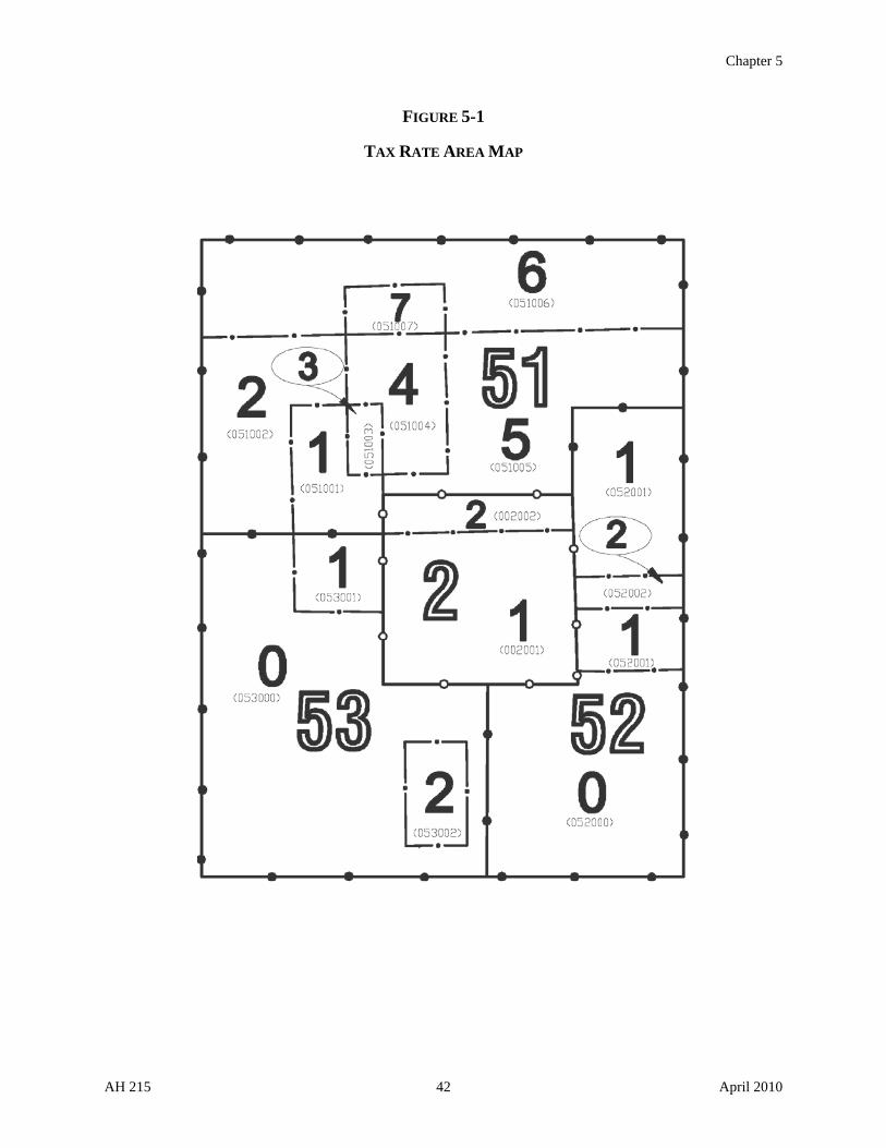
Chapter 5
FIGURE 5-1
TAX RATE AREA MAP
AH 215 42 April 2010

Chapter 5
TAX RATE AREA REPORTS
The Board annually publishes both a tax rate area chart and a summary of districts with TRAs by county. Examples of these charts are shown in figures 5-2 and 5-3.
FIGURE 5-2
AH 215 43 April 2010

Chapter 5
AH 215 44 April 2010
FIGURE 5-3

Appendix 1
APPENDIX 1: ATTORNEY GENERAL'S OPINION 45/326, "SYSTEM FOR DESCRIPTION OF REAL PROPERTY PARCELS BY
REFERENCE TO ASSESSORS' MAPS"
State of California DEPARTMENT OF JUSTICE 600 State Building San Francisco 2 July 11, 1946
Board of Equalization Business and Professions Bldg. Sacramento 14, California Attention: Dixwell L. Pierce, Secretary
Gentlemen:
You have submitted to us a pamphlet designated AH-212 entitled, "System for Description of Real Property Parcels by Reference to Assessors' Maps", which has been prepared by you for inclusion in the Assessors' Handbook. After numerous conferences with a representative of your office, this pamphlet has been redrafted and revised in keeping with the suggestions made by us, and you now ask our opinion as to whether or not the material set forth in this pamphlet conforms to the law and will achieve its apparent purposes.
The pamphlet explains a system for description of real property parcels by reference to assessors' maps pursuant to the provisions of section 327, Revenue and Taxation Code. Section 327 Revenue and Taxation Code provides:
Where any county or county officer possesses a complete, accurate map of any land in the county, or whenever such a complete, accurate map has been made in compliance with Section 4218 of the Political Code, the assessor may number or letter the parcels in a manner approved by the board of supervisors. This map or a copy shall at all times be publicly displayed in the office of the assessor.
Land may be described by reference to this map.
All such maps in the possession of the county assessor on August 27, 1937, and used for assessment purposes only, are deemed to have been numbered or lettered and approved properly.
The pamphlet explains the purpose of such system, its advantages, and by exhibits and suggested form of resolution to be passed by the board of supervisors sets forth the procedure for adopting
AH 215 45 April 2010

Appendix 1
the system. In essence, it contemplates that whenever the county assessor has a complete and accurate map of any property located within a county, which map consists of index maps and master maps of particular areas which contain the basic survey information as outlined in "Assessors' Standard Committee Report No. 6", concerning assessors' maps, the assessor shall delineate parcels upon such master maps and assign a parcel number in the manner therein described. Parcels will be delineated and assigned a number in accordance with use and ownership and according to taxing agencies and revenue districts, as required by the Revenue and Taxation Code for purposes of assessment. The system of numbering is so designed that there would never be a duplication of parcel numbers. For example, Parcel No. 3-36-9 would mean Book 3 of the Assessor's Maps, Map page 36, and Parcel 9 on that map. If the area on any particular map page was blocked, Parcel No. 3-362-9 would mean Book 3 of the Assessor's Maps, Block 362 (that is, Map Page 36, Block 2 thereon), and Parcel 9 within that block. This parcel number with appropriate explanation on the roll would be used to describe the land for purposes of assessment. The same parcel number would then be used to key and index the master property record, appraisal records, transfer records, field maps, and other records maintained by the assessor. The same parcel number could also be used to key and index the records of the tax collector and the redemption officer.
The system contemplates that whenever parcels are divided or combined a new parcel number immediately following the last used parcel number for that block or map page shall be assigned to the new parcel or parcels, so that there would never be a duplication of parcel numbers. For example, in the event of a division, Parcel 3-36-9 would become Parcels 3-36-10 and 3-36-11 if the parcel designated 9 were the highest individual parcel number on that particular map. The assessor need only delineate new parcels resulting from divisions or combinations once each year in order to prepare the new assessment roll, except that it should be done immediately when necessary for the payment of current taxes on part of the assessment as provided for by Chapter 3, Part 5, Division 1 of the Revenue and Taxation Code, or a partial redemption of property as provided for by Chapter 2, Part 7, Division 1 of the Revenue and Taxation Code. Appropriate markings would be made in colored ink on the master map so that at all times one could readily ascertain from an inspection of the map what area of land was covered by any particular parcel number. It is contemplated that where changes become too numerous on any one particular map page, a new map page would be inserted over the old map page and that appropriate reference be made on the old and new map pages referring one to the other, so that likewise an inspection would readily disclose the area covered by any particular parcel number. As contemplated by section 327, such map would be known as the Assessor's Map and it or a copy would at all times be publicly displayed in the office of the assessor.
The advantages in economy and efficiency as explained in the pamphlet in describing real property on the rolls by parcel number and keying all other records to this parcel number are at once apparent. The description of land on the assessment roll by use of a parcel number referring to such map presents the question whether such description constitutes a legal description for purposes of assessment. A further question as to whether all land in the county might be
AH 215 46 April 2010

Appendix 1
described in this manner is also presented. Unless all land in the county can be described by such parcel number some of the advantages in economy and efficiency will be lost.
Section 602 of the Revenue and Taxation Code provides that the roll shall show "land, by legal description." Sections 321-328 of the Revenue and Taxation Code set forth the requirements as to the description of land, and provide the various means by which land may be described for assessment purposes, such as by reference to government sections, Spanish Grants, city lots, official maps, unofficial maps, assessor's maps, or by metes and bounds or other description sufficient to identify the property. Section 327 of the Revenue and Taxation Code expressly provides that land may be described by reference to a map prepared in accordance with the system described in your pamphlet AH-212. There can be no doubt but that a description of land by a parcel number referring to such a map is legally sufficient for all purposes in the taxing process, including description on the roll, notices, and deeds. (See Morton v. Sloan, 96 Cal. App. 747; Schainman v. All Persons, 96 Cal. App. 753; Smith v. Addiego, 54 Cal. App. (2d) 230, and the cases cited in these cases. See also 51 Am. Jur. "Taxation", Sections 676-680, and cases collected in the annotation "Sufficiency of Description of Property on Tax Rolls or in Tax Proceedings, by Reference to Map, Plat, or Survey", (137 A.L.R. 184.)
The basic requirement in describing land by reference to a map is that the land shall be positively identified. In Smith v. Addiego, 54 Cal. App. (2d) 230, at 242, the Court sets forth this principle as follows:
In Lummer v. Unruh, 25 Cal. App. 97, 104 (142 Pac. 914), the following is quoted from Cooley on Taxation: 'The designation of the land will be sufficient if it affords the owner a means of identification and does not positively mislead him, or is not calculated to mislead him.' The Flood case, the Pennie case, and Best v. Wohlford, supra, (64 Cal. 504; 93 Cal. 465; 144 Cal. 733) are cited to the same effect. In the very recent case of Biaggi v. Phillips, 50 Cal. App. (2d) 92, 98, (122P. (2d) 619) the same passage is repeated.
Description of land by use of the parcel number as herein explained clearly meets such test.
It is to be borne in mind that the assessor's map to be used in parceling the land within a county is a basic survey map, and an inspection thereof will readily enable any person to locate the land on the surface of the earth. The system of parcel numbering is so designed that there will never be duplicate parcel numbers, and hence no confusion can possibly arise as to the exact property indicated, and an inspection of the map will readily disclose precisely what land is covered by any particular parcel number in the current or any prior fiscal year. Even though new parcel numbers may appear on the map by combinations and divisions of existing parcels, the system is so designed that no confusion can result as to what particular property is covered by any particular parcel number. It is to be noted in this connection that map pages and the areas shown thereon remain fixed. The only changes that would be made from time to time would be in the size of parcels to reflect divisions and combinations of ownership.
AH 215 47 April 2010

Appendix 1
The map "shall at all times be publicly displayed in the office of the assessor." Such map is accordingly available to the public for inspection at all times.
There is nothing in section 327 of the Revenue and Taxation Code, or any other provision of the law, which would prohibit the assessor from showing changes in ownership by division or combinations of existing parcels. Unless such changes can be shown as they occur, the usefulness of such a system would be greatly impaired and a new set of maps would be required for each year. We accordingly are of the opinion that there is nothing illegal in describing real property by parcel numbers by referring to such assessor's map, even though portions of such map are changed from time to time to reflect changes in ownership by combination or division of existing parcels thereon.
As already pointed out, parcels delineated should conform to the other requirements of law. For example, if a tract of land in one ownership is situated in two or more revenue districts the part in each district shall be separately assessed (Revenue and Taxation Code, section 606), and the area in each district should be assigned a separate parcel number.
There remains for discussion the further question whether all lands within the county may be described by such parcel number. This raises the question whether sectionized land containing more than six hundred and forty acres may be parceled.
Article XIII, section 3 of the Constitution provides:
Every tract of land containing more than six hundred and forty acres, and which has been sectionalized by the United States Government, shall be assessed, for the purposes of taxation, by sections or fractions of sections. The legislature shall provide by law for the assessment, in small tracts, of all lands not sectionized by the United States Government.
Section 322 of the Revenue and Taxation Code provides:
If surveyed under the authority of the United States, land may be described by township, range, section, and fractional section, with its acreage.
If a parcel of such land contains more than 640 acres, it shall be described only as prescribed in this section.
Section 322 of the Revenue and Taxation Code is derived from Political Code sections 3628, 3650, and 3658. In 1939 at the time of the adoption of the Revenue and Taxation Code, and for many years prior thereto, the pertinent provisions of these Political Code sections read as follows:
Section 3628, providing where and how property was to be assessed, provided:
...Land shall be assessed in parcels, or subdivisions, not exceeding six hundred forty acres each and tracts of land containing more than six hundred forty acres
AH 215 48 April 2010

Appendix 1
which have been sectionized by the United States government, shall be assessed by sections or fractions of sections….
Section 3650, providing for the contents of the assessment book, provided that the assessment book shall provide for listing under appropriate headings:
…Land by township, range, section, or fractional section; and when such land is not a congressional division, or subdivision, by metes and bounds, or other description sufficient to identify it, giving an estimate of the number of acres, not exceeding in any tract six hundred forty acres, locality, and the improvements thereon….
Section 3658, providing for the board of supervisors to furnish maps to the assessor, provided:
…Such maps and plat-books shall show the private lands owned or claimed in the county, and if surveyed under the authority of the United States, the divisions and subdivisions thereof, with their acreage, according to such survey; if held under Spanish grant, the exterior boundaries of such grants, the divisions and subdivisions and number of acres claimed….
It is to be noted that section 327 of the Revenue and Taxation Code is based upon former Political Code section 3658b, which was first adopted in 1937 in substantially the same form as now contained in the Revenue and Taxation Code section. Upon the adoption of section 3658b of the Political Code in 1937, the legislature thereby provided another means of describing real property on the assessment roll.
Accordingly, a tract of sectionalized land containing more than six hundred and forty acres should be assessed by sections or fractional sections, as required by the Constitution (see Lake County v. Sulphur Bank Quicksilver Mining Co., 66 Cal. 17; Best v. Wohlford, 144 Cal. 733; Savings & Loan Society v. Burke, 151 Cal. 616; see also 24 Cal. Jur. "Taxation", section 179).
Before the 1937 addition of Political Code Section 3658b, such sectionized land containing more than six hundred forty acres would of course have been described on the roll by township, range, section, or fractional section, but after the addition of section 3658b to the Political Code in 1937 it could also have been described by reference to the assessor's map so long as it was assessed by sections or fractional sections, as required by the Constitution.
Although section 322 of the Revenue and Taxation Code purports to mandatorily require the description of land by township, range, section, and fractional section when it contains more than six hundred forty acres, we are of the opinion that a tract of sectionized land containing more than six hundred forty acres might be legally described, for the purposes of assessment, by reference to a map under section 3658b of the Political Code, or the present section 327 of the Revenue and Taxation Code, provided that such tract of land is assessed by sections or fractions of sections as required by the constitutional provision and that parcel numbers are assigned which are co-extensive with such sections or fractions of sections. In other words, it is our view
AH 215 49 April 2010

Appendix 1
AH 215 50 April 2010
that, in light of the historical development of the code sections involved, the provision of section 322 of the Revenue and Taxation Code, that such land shall be described only as prescribed in that section, has reference to the area of land to be assessed rather than the manner in which the land is actually described on the assessment roll. The foregoing conclusion is apparent when it is noted that those portions of Political Code Sections 3628, 3650, 3658, heretofore quoted, which according to the code commissioner's note is the basis of the codification of present section 322 Revenue and Taxation Code, dealt with three separate subjects and did not mandatorily require that sectionized land containing more than 640 acres be described only by township, range, section, and fractional sections, but only required that such land "shall be assessed by sections or fractions of sections." There is nothing to indicate that in codifying section 322 Revenue and Taxation Code there was any intent to change the existing law. The apparent mandatory requirement in the second paragraph of section 322 must be considered as an inadvertence occurring in codification. Accordingly, the provisions of section 322 Revenue and Taxation Code should be construed as a restatement and continuation of the previous statutory provisions (section 2 Revenue and Taxation Code).
This conclusion as to the effect of section 322 is strengthened by the language contained in the first sentence of section 322 to the effect that a tract of sectionized land containing less than six hundred forty acres may be described by township, range, section or fraction of section with its acreage. There is no doubt but that sectionized land containing less than 640 acres may be described by reference to a parcel number. This conclusion is also supported by the other provisions contained in Chapter 2, Part 2, Division 1, Revenue and Taxation Code (sections 321-328) providing other means for legally describing property for assessment purposes.
Although we are satisfied that land may be legally described for assessment purposes by a system of parcel numbers, as herein discussed, it is possible that clarifying legislation, particularly with reference to sectionized land, should be proposed in order to remove all doubt from the subject.
Very truly yours,
(Signed) Robert W. Kenny
ROBERT W. KENNY, Attorney General
(Signed) E.G. Benard
E.G. BENARD, Deputy Attorney General
EGB:FTB

Appendix 2
APPENDIX 2: STANDARDS - SAMPLE MAPS AND EXHIBITS
AH 215 51 April 2010

Appendix 2
STANDARD 1: SIZE AND SCALES, TITLE AND CROSS-REFERENCE TRACINGS FOR
ASSESSOR'S DETAILED MAPS
AH 215 52 April 2010

Appendix 2
STANDARD 2: RECOMMENDED SYSTEM FOR LAYING OUT AND NUMBERING DETAIL MAPS
Standard 2 shows the recommended system for laying out and numbering detail maps. The numbering system in general is from left to right starting at the upper left-hand corner of the section, township, or other geographic area. Cities should constitute a geographic area and be divided into one or more map books. For rural areas the maps should be numbered by townships or Ranchos so that the books for such areas will be in township order or Rancho order.
The system recommended for scales 1 inch = 800 feet, 1 inch = 1200 feet, and 2 inches = 1 mile will put the maps in section order insofar as practicable.
The above scales should be considered as base scales, and all areas should be mapped on the most suitable of these scales. The base scale will serve as subindex maps of areas that are mapped in greater detail on scales 1 inch = 100 feet, 1 inch = 200 feet and 1 inch = 400 feet.
If an area was being mapped on scale 1 inch = 800 feet, the maps in the first township would be numbered 1 to 18, the second 19 to 36, etc. The maps for each map book should be numbered consecutively starting with number 1 in each book.
When it becomes necessary to map a portion of the area covered by a map on a larger scale, the area to be enlarged should follow in numbering sequence the page from which it was extracted. See sample on scale 1 inch = 400 feet. See Standards 10 and 12.
AH 215 53 April 2010

Appendix 2
AH 215 54 April 2010

Appendix 2
STANDARD 3: COUNTY INDEX TO ASSESSOR'S MAP BOOKS
For the base of the county index map, the best available wall map should be obtained. Generally, a scale of ½" or 1" to the mile will be most satisfactory.
On this general county map the area covered by each map book should be outlined with a heavy red line, and in the center of each area the book number should be shown in red. See sample map Standard 3.
The first step in laying out the map books is to mark out the areas on a general county map that should be mapped at the various standard scales. This is determined by the type of property and sizes of parcels. See Standards 1 and 2.
The second step is to lay out the map books so that each map book will have between 24 and 32 detail maps. Cities should first be checked and laid out, generally following city limit lines. The rural map book should next be outlined covering about 24 to 30 maps, generally following township, range, or Rancho lines. The areas covered by each book should, insofar as practicable, be in a systematic rectangular blocked-out area. No attempt should be made to follow school or other taxing district boundaries.
The third step is the numbering of the map books or areas. In general we recommend they be numbered from left to right, starting at the upper left-hand corner. Sometimes it will be desirable to assign a city area and its map book numbers before the rural map book numbers are assigned.
The county index to assessor's map books should be put on the wall or other place convenient for users of the map books. Often two copies will be found most convenient – one for public use in the outer office and one for office use in the office work room.
AH 215 55 April 2010

Appendix 2
AH 215 56 April 2010
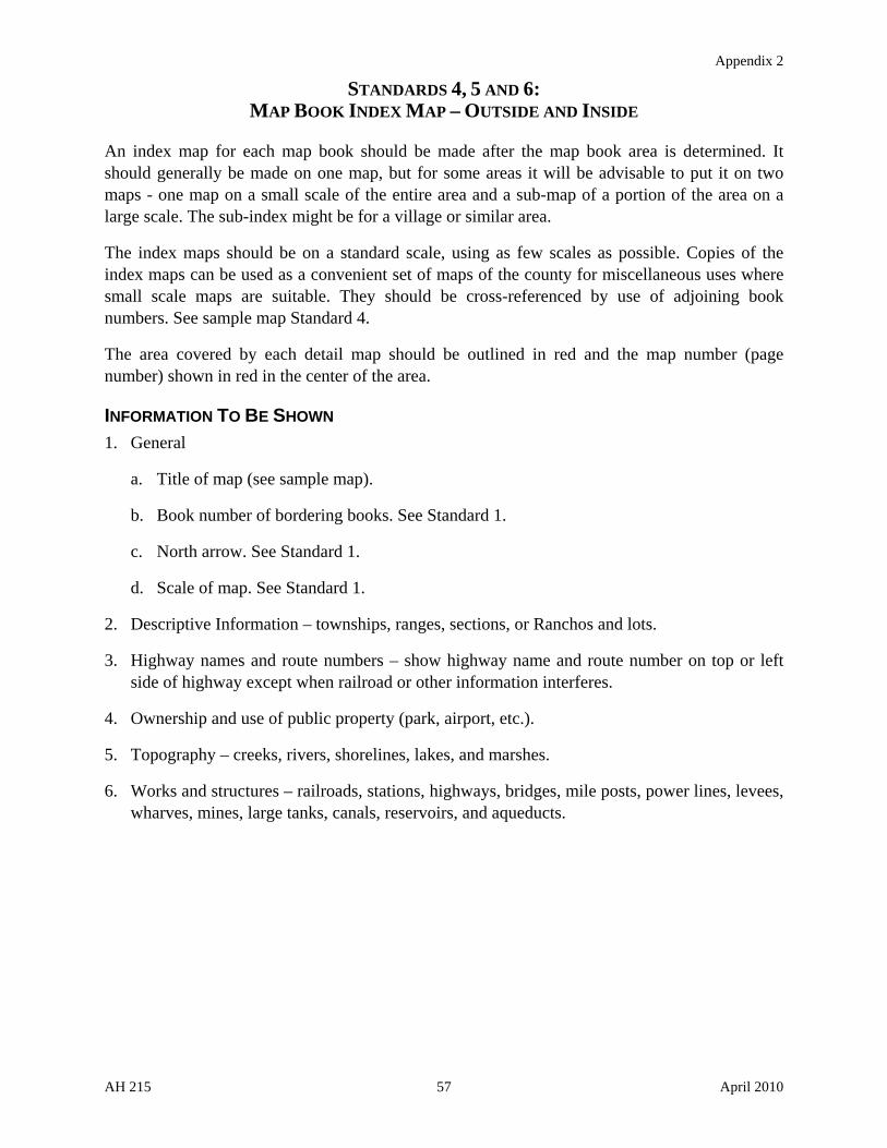
Appendix 2
STANDARDS 4, 5 AND 6: MAP BOOK INDEX MAP – OUTSIDE AND INSIDE
An index map for each map book should be made after the map book area is determined. It should generally be made on one map, but for some areas it will be advisable to put it on two maps - one map on a small scale of the entire area and a sub-map of a portion of the area on a large scale. The sub-index might be for a village or similar area.
The index maps should be on a standard scale, using as few scales as possible. Copies of the index maps can be used as a convenient set of maps of the county for miscellaneous uses where small scale maps are suitable. They should be cross-referenced by use of adjoining book numbers. See sample map Standard 4.
The area covered by each detail map should be outlined in red and the map number (page number) shown in red in the center of the area.
INFORMATION TO BE SHOWN
1. General
a. Title of map (see sample map).
b. Book number of bordering books. See Standard 1.
c. North arrow. See Standard 1.
d. Scale of map. See Standard 1.
2. Descriptive Information – townships, ranges, sections, or Ranchos and lots.
3. Highway names and route numbers – show highway name and route number on top or left side of highway except when railroad or other information interferes.
4. Ownership and use of public property (park, airport, etc.).
5. Topography – creeks, rivers, shorelines, lakes, and marshes.
6. Works and structures – railroads, stations, highways, bridges, mile posts, power lines, levees, wharves, mines, large tanks, canals, reservoirs, and aqueducts.
AH 215 57 April 2010

Appendix 2
AH 215 58 April 2010

Appendix 2
AH 215 59 April 2010

Appendix 2
AH 215 60 April 2010

Appendix 2
STANDARD 7: DETAILED MAP – URBAN PROPERTY
(Scale - 1" = 100')
This scale is recommended for almost universal use for urban or subdivided suburban property. In business locations or other areas where ownerships are lots 20 to 30 feet in width, scale A –– 1" = 50' is recommended.
The system of numbering maps shown in Standard 2 is recommended but may be varied to meet unusual layouts.
INFORMATION TO BE SHOWN ON TRACING
1. General
a. Title of map - subdivision; township and range; section; or Rancho and lot.
b. Book and page numbers.
c. City.
d. North arrow.
e. Basis of bearings.
f. Scale of map.
g. Page number of bordering maps.
2. Descriptive Information
a. Township, range, and section, or Rancho and lot if needed.
b. Subdivision names, tract names or numbers with recorded book and page when they cover only a portion of the map and are not the title. Such title and its recorded book and page should be shown in the border whenever possible.
c. Property ownership lines with essential courses and distances.
d. Dimensions of lots.
e. Lot numbers (center of lot).
f. Parcel numbers (to be placed when possible to the rear of parcel).
g. Original block numbers.
h. Assessor's block numbers.
i. Acreage of any parcel of an acre or more.
j. Widths of streets.
3. Street names, highway names, and route numbers.
4. Ownership and use of public property (city hall, library, park, etc.).
5. Creeks, rivers, bridges, shorelines, etc.
AH 215 61 April 2010

Appendix 2
AH 215 62 April 2010

Appendix 2
STANDARD 8: DETAILED MAP – LARGE URBAN AND SMALL FARM PROPERTY
(Scale - 1" = 200')
This scale is recommended for urban or suburban property where the parcels range from one-half acre to five acres in area. Often such areas will be subdivided for high-class residential or suburban residential lots.
The system of numbering maps shown in Standard 2 is recommended but may be varied to meet unusual layouts.
INFORMATION TO BE SHOWN ON TRACING
1. General
a. Title of map - subdivision; township and range; section; or Rancho and lot.
b. Book and page numbers.
c. City.
d. North arrow.
e. Basis of bearings.
f. Scale of map.
g. Page number of bordering maps.
2. Descriptive Information
a. Township, range, and section, or Rancho and lot if needed.
b. Subdivision names, tract names or numbers with recorded book and page when they cover only a portion of the map and are not the title. Such title and its recorded book and page should be shown in the border whenever possible.
c. Property ownership lines with essential courses and distances.
d. Dimensions of lots.
e. Lot numbers (center of lot).
f. Parcel numbers (to be placed when possible to the rear of parcel).
g. Original block numbers.
h. Assessor's block numbers.
i. Acreage of any parcels of an acre or more.
j. Widths of streets.
3. Street names, highway names and route numbers.
4. Ownership and use of public property (city hall, library, park, etc.).
5. Creeks, rivers, bridges, shorelines, etc.
AH 215 63 April 2010

Appendix 2
AH 215 64 April 2010

Appendix 2
STANDARD 9: DETAILED MAP – ORCHARD AND SMALL FARM PROPERTY
(Scale - 1" = 400')
This scale is recommended for orchard and small farm property where the parcels range from 5 to 20 acres in area. It is a suitable scale for orchard areas and for areas with other intensive farming activities as well as small farms for chickens, etc.
The system of numbering maps shown in Standard 2 is recommended but may be varied to meet unusual layouts.
INFORMATION TO BE SHOWN ON TRACING
1. General
a. Title of map -subdivision; township and range; section; or Rancho and lot.
b. Book and page numbers.
c. City.
d. North arrow.
e. Basis of bearings.
f. Scale of map.
g. Page number of bordering maps.
2. Descriptive Information
a. Township, range, and section, or Rancho and lot if needed.
b. Subdivision names, tract names or numbers with recorded book and page when they cover only a portion of the map and are not the title. Such title and its recorded book and page should be shown in the border whenever possible.
c. Property ownership lines with essential courses and distances.
d. Dimensions of lots.
e. Lot numbers (center of lot).
f. Parcel numbers (lower rear or rear of parcel for small parcels and center for larger parcels).
g. Acreage of any parcels of an acre or more.
h. Widths of streets.
3. Street names, highway names, and route numbers.
4. Ownership and use of public property (city hall, library, park, etc.).
5. Creeks, rivers, bridges, shorelines, etc.
AH 215 65 April 2010

Appendix 2
AH 215 66 April 2010

Appendix 2
STANDARD 10: DETAILED MAP – LARGE ORCHARD AND MEDIUM-SIZE FARM PROPERTY
(Scale - 1" = 800")
This scale is recommended for large orchard and medium-size farm property where parcels range from 10 to 80 acres in area. It is a suitable scale for orchard areas and for areas with other types of farming activities such as vineyards, dairies, etc.
The system of numbering maps shown in Standard 2 is recommended but may be varied to meet unusual layouts.
INFORMATION TO BE SHOWN ON TRACING
1. General
a. Title of map -subdivision; township and range; section; or Rancho and lot.
b. Book and page numbers.
c. North arrow.
d. Basis of bearings.
e. Scale of map.
f. Page number of bordering maps.
2. Descriptive Information
a. Township, range and section, or Rancho and lot if needed.
b. Subdivision names, tract names or numbers with recorded book and page, when they cover only a portion of the map and are not the title. Such title and its recorded book and page should be shown in the border whenever possible.
c. Property ownership lines with essential courses and distances.
d. Dimensions of lots.
e. Lot numbers (center of lot).
f. Parcel numbers (lower rear or rear of parcel for small parcels and center for larger parcels).
g. Acreage of any parcels of an acre or more.
h. Widths of streets.
3. Street names, highway names and route numbers.
4. Ownership and use of public property (city hall, library, park, etc.).
5. Creeks, rivers, bridges, shorelines, etc.
AH 215 67 April 2010

Appendix 2
AH 215 68 April 2010

Appendix 2
STANDARDS 11 AND 12: DETAILED MAP – LARGE-SIZE FARM PROPERTY
(Scale - 1" = 1200')
This scale is recommended for detail maps for large-size farm properties generally. It is for areas where the average farm contains 40 acres or more.
Where any areas are divided into parcels ranging from 1 to 40 acres, it is recommended that a sub-map of that area be made on scales, 1 inch = 200 feet, 1 inch = 400 feet or 1 inch = 800 feet, whichever is the most suitable.
INFORMATION TO BE SHOWN ON TRACING
1. General
a. Title of map - township and range, base and meridian or Rancho and lot; assessor's map no., County, California, and year.
b. Book and page numbers.
c. Page number of bordering maps.
d. North arrow.
e, Basis of bearings.
f. Scale of map.
2. Descriptive Information
a. Township, range, and section or Rancho and lot when not part of the title.
b. Subdivision names, tract names or numbers with recorded book and page, when they cover only a portion of the map and are not the title. Such title and its recorded book and page should be shown in the border whenever possible.
c. Property ownership lines with essential courses and distances.
d. Section dimensions if known.
e. Acreage of sections or Rancho lots and net acreage of parcels. Show gross acreage of section or Rancho lot immediately under section number or Rancho lot number. Show net acreage of ownership immediately under parcel number.
f. Widths of highways.
g. Parcel numbers to be shown in center of parcel in circle .20" diameter.
3. Highway names and route numbers. Show highway name and route number on top or left side of highway except when railroad or other information interferes.
4. Ownership and use of public property (park, airport, etc.).
AH 215 69 April 2010

Appendix 2
5. Topography – creeks, rivers, shorelines, lakes, and marshes.
6. Works and structures – railroads, stations, packing sheds, highways, bridges, mile posts, power lines, levees, wharves, mines, large tanks, canals, reservoirs, and aqueducts.
AH 215 70 April 2010
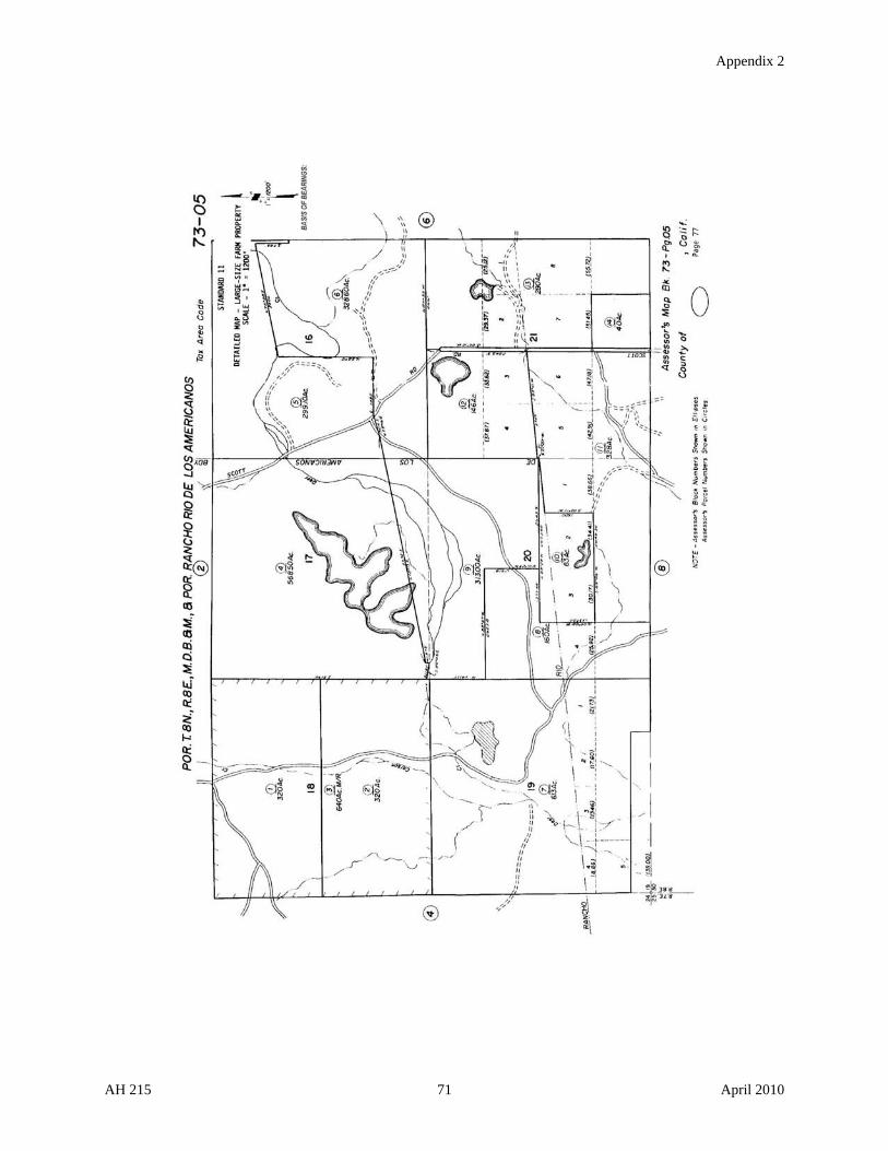
Appendix 2
AH 215 71 April 2010

Appendix 2
AH 215 72 April 2010

Appendix 2
STANDARD 13: DETAILED MAP - MOUNTAIN AREAS
(Scale - 2" = 1 mile)
This scale is recommended for detail maps for mountain areas generally. It is for areas used principally for grazing and timber.
Sub-maps should be used for areas divided for farming or other purposes where a larger scale map is desirable.
INFORMATION TO BE SHOWN ON TRACING
1. General
a. Title of map – township, range, base and meridian or Rancho and lot; assessor's map no., County, California, and year.
b. Book and page numbers.
c. Page number of bordering maps.
d. North arrow.
e. Basis of bearings.
f. Scale of map.
2. Descriptive Information
a. Township, range, and section, or Rancho and lot when not part of the title.
b. Subdivision names, tract names or numbers with recorded book and page, when they cover only a portion of the map and are not the title. Such title and its recorded book and page should be shown in the border whenever possible.
c. Property ownership lines.
d. Section dimensions if known.
e. Acreage of sections or Rancho lots and net acreage of parcels. Show gross acreage of section or Rancho lot immediately under section number or Rancho lot number. Show net acreage of ownership immediately under parcel number.
3. Highway names and route numbers, Show highway name and route number on top or left side of highway except when railroad or other information interfere.
4. Ownership and use of public property (park, airport, etc.).
5. Topography – creeks, rivers, shorelines, lakes, and marshes.
6. Works and structures – railroads, stations, packing sheds, highways, bridges, mile posts, power lines, levees, wharves, mines, large tanks, canals, reservoirs, and aqueducts.
AH 215 73 April 2010

Appendix 2
AH 215 74 April 2010
Appendix 2
STANDARD 14: DETAILED MAP – CANALS, PIPELINES AND TOLL ROADS
AND STATE BOARD OF EQUALIZATION PARCELS
Where an assessor's map book contains canals, pipelines, or toll roads that are assessed on the mileage basis pursuant to section 984 of the Revenue and Taxation Code, a copy map for the book should be prepared and assigned a page number. The page number should preferably be the first page in the book. The canal, pipeline, or toll road should be clearly indicated on this index map, and a parcel number assigned to the portion in each tax rate area. The parcel number can be put centrally on the canal, pipeline, or toll road within the tax rate area, using the usual parcel number designation. An arrow may be added if it appears advisable to indicate that it covers the canal, pipeline, or the toll road.
AH 215 75 April 2010

Appendix 2
AH 215 76 April 2010

Appendix 2
STANDARD 15: DETAILED MAP – CONDOMINIUM PROPERTY
(Scale, Flexible, 1" = 100' to 1" = 20" as needed)
This scale is recommended for urban or suburban property where the parcels are subdivisions of air space (units) held in fee title plus an interest in the common area of the condominium project.
The system of numbering maps shown in Standard 2 is recommended, but may be varied to meet unusual layouts.
INFORMATION TO BE SHOWN ON TRACING
1. General
a. Book and page numbers.
b. City.
c. North arrow.
d. Basis of bearings.
e. Scale of map.
f. Page number of bordering maps.
2. Descriptive Information
a. Subdivision name with recorded book and page.
b. Property ownership lines, boundary of the project lot(s), building footprint outline, unit airspace outline is optional.
c. Dimensions of lot(s), generally the boundary of the project. Building and unit dimensions are optional.
d. Lot numbers of common area, center of lot, may be varied to meet layout needs.
e. Acreage of any parcel of common area an acre or more.
f. Common area location.
g. Building and unit location, delineation of building footprint noting units located in the building.
h. Assessor's block numbers.
i. General condominium notes.
j. Assessor's parcel numbers shown in a schedule opposite each unit number.
3. Street, route, and highway names.
4. Creeks, rivers, bridges, shoreline, etc.
AH 215 77 April 2010
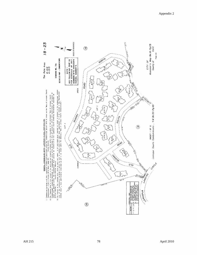
Appendix 2
AH 215 78 April 2010

Appendix 2
AH 215 79 April 2010

Appendix 2
AH 215 80 April 2010

Appendix 2
AH 215 81 April 2010
STANDARD 16: STANDARD SYMBOLS

Appendix 2
STANDARD 17: STANDARD ABBREVIATIONS
Ac. Acre or Acres Cr. Creek
Add. Addition C.S.B-600-2 County Surveyor's Map No. B-600, Sheet 2
Adj. Adjoining (D:87-3) County Surveyor's "D" Book 87, page 16
Alg. Along D:475-16 Deed Book 475, page 16
Amd. Amended Deg. Degree or Degrees
& And Des. Described or Description
Anx. Annex or Annexation Dir. Direction
Ave. Avenue Dist. Distance
Bdy. Boundary Div. Division
Beg. Beginning D:OR 617-10 Deed in Official Records Book 617, page 10
Bet. Between Dr. Drive
Blk. Block E., El'y. East, Easterly
Blvd. Boulevard Ea. Each
Bk. Book Ease. Easement
Calc. Calculated Elem. Elementary
Calif. California Engr. Engineer
Cen. Center Est. Estate
Ch. Chain or Chains Et al And others
Cl. Centerline Etc. And so forth
Co. County Et ux And wife
Col. Colony Exc. Except
Com. Commencing Ext. Extension
Contg. Containing F.B. 118-16 County Surveyor's Field Book 118, page 16
Cor. Corner Fm. From
AH 215 82 April 2010

Appendix 2
Fol. Following M/L More or Less
Frac. Fraction M.P.R. Cards
Master Property Record Cards
Fract'l. Fractional M.R. Miscellaneous Records
Ft. Feet or Foot M/R Mineral Rights
H.B.&M Humboldt Base & Meridian
N., Nl'y. North, Northerly
Hts. Heights Nat. National
Hwy. Highway N.E. Northeast
I.A. Indian Allotment No. Number
Imp. Improvements N.W. Northwest
In. Inch or Inches O.M. Official Maps
Incl. Inclusive O.R. Official Records
Int. Interest P. 2-16 Patents Book 2, page 16
L.B. 116-18 County Surveyor's Level Book 116, page 18
Pac. Pacific
Ld. Land Par. Parcel
L.S. 32-18 Licensed Surveyor's MapBook 32, page 18
Parl. Parallel
Lks. Links Pg. Page
M. Meridian Pl. Place
Mag. Magnetic + Plus or Minus
M.B. Map Book P.O.B. Point of Beginning
M.D.B.&M. Mt. Diablo Base & Meridian
Por. Portion
Mi. Mile or Miles Poss. Possessory
Min. Minute or Minutes PP. Personal Property
Misc. Miscellaneous Prop. Property
Misc. Sur. Miscellaneous Survey Pt. Point
AH 215 83 April 2010

Appendix 2
R. or Rge. Range Sd. Said
Rad. Radius S.D. School District
Rch. Ranch S.E. Southeast
Rd. Road Sec. Section
Reg. Region SLS Swamp Land Survey
Res. Reservation S & O Swamp and Overflow
ReSub. Resubdivision Sq. Ft. Square Feet
R.F.M. Recorder's Field Map St. Street
Riv. River Std. Standard
R.M. Recorded Map Sub. Subdivision
Ro. Rancho Sur. Survey
R.P. Ranch Plats S.W. Southwest
R.R. Railroad T. or Twp. Township
R.S. Record of Survey Ter. Terrace
Rt. Right Th. Thence
Run. Running Tim. Timber
MR/W Right of Way Tr. Tract
Ry. Railway Und. Undivided
S., Sl'y. South, Southerly U.S.A. United States of America
S.B.B.&M. San Bernardino Base and Meridian
U.S.F. United States Forest Service
S.B.E. State Board of Equalization W., Wl'y. West, Westerly
S.C.C. 278, 643
Superior Court Case No. 278, 643
x By
AH 215 84 April 2010

Appendix 2
STANDARD 18: LETTERING FOR ASSESSOR'S DETAIL MAPS
U=Upper Case, L=Lower Case, N=Number,
S=Slant, V=Vertical, F=Freehand,
* = Larger or Smaller if Necessary.
TYPE
&
SLANT
(10)
LEROY
1" = 1200'
& 1" = 800'
1" = 400'
to 1" = 50'
WRICO
1" = 1200'
& 1" = 800'
1" = 400'
to 1" = 50'
SUBJECT PEN GUIDE
PEN GUIDE
PEN GUIDE
PEN GUIDE
Acreage, Parcel U-L-N S 00 100 00 100 7 100 7 100
Acreage, Gov. Lot N S- 00 080 00 080 7 080 7 080
Base & Meridian Name (Along Line) U S 00 100 00 100 7 100 7 100
Base & Meridian Name (Under N. Arrow) U V 00 080 00 080 7 080 7 080
Basis of Bearings U S 00 080 00 080 7 080 7 080
Bearings & Dimensions U-N S F 1/16" F 1/16" F 1/16" F 1/16"
Block Number (Assessor's) N S 2 175 5 175
Block Number (Orginal) U-N S 1 175 6 175
Book Number (Adjoining) U-L-N S 1 140 1 140 6 140 6 140
Book & Page Number (Bottom Right) N S 1 140 1 140 6 140 6 140
Book & Page Number (Top Right) N S 3 240 3 240 4 240 4 240
Canal or Waterway Name* U S 00 100 00 100 7 100 7 100
Cemetery Name U S 00 100 00 100 7 100 7 100
City or Town Limits (Along Line) U-L S 00 100 00 100 7 100 7 100
City or Townsite Name (Bottom Right) U S 1 140 1 140 6 140 6 140
County & State Name (Along Boundary) U S 0 120 0 120 7 120 7 120
County & State Name (Bottom Right) U-L S 1 140 1 140 6 140 6 140
Creek Name * U-L S 00 100 00 100 7 100 7 100
Date (Bottom Right) N S 1 140 1 140 6 140 6 140
Government Land Reference (U.S.A., Etc.) U S 00 100 00 100 7 100 7 100
Government Lot Number N S 00 080 00 080 7 080 7 080
Highway Name * U-N S 00 100 1 140 7 100 6 140
Highway Stations U-N S 000 060 000 060 7 080 7 080
Lake or Reservoir * U S 00 100 1 140 7 100 6 140
Lot Number U-N S 00 080 00 080 7 080 7 080
Meridians & Parallels N S 00 080 00 080 7 080 7 080
Nat'l. or State Forest Name Along Bdy. U S 00 100 00 100 7 100 7 100
Nat'l., State or Muni. Park Name Along Bdy. U S 00 100 00 100 7 100 7 100
Note (Assessor's Block & Parcel) Bottom U-L S 00 100 00 100 7 100 7 100
AH 215 85 April 2010
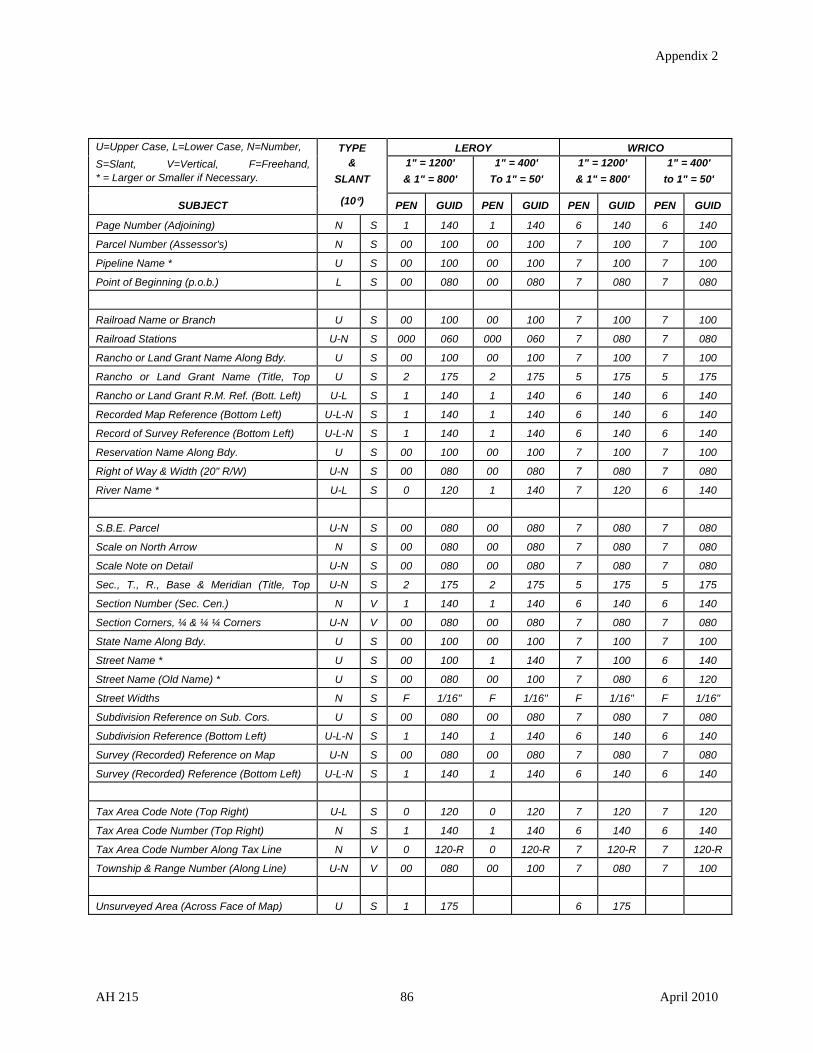
Appendix 2
U=Upper Case, L=Lower Case, N=Number,
S=Slant, V=Vertical, F=Freehand, * = Larger or Smaller if Necessary.
TYPE &
SLANT
(10)
LEROY 1" = 1200'
& 1" = 800'
1" = 400'
To 1" = 50'
WRICO 1" = 1200'
& 1" = 800'
1" = 400'
to 1" = 50'
SUBJECT PEN GUIDE
PEN GUIDE
PEN GUIDE
PEN GUIDE
Page Number (Adjoining) N S 1 140 1 140 6 140 6 140
Parcel Number (Assessor's) N S 00 100 00 100 7 100 7 100
Pipeline Name * U S 00 100 00 100 7 100 7 100
Point of Beginning (p.o.b.) L S 00 080 00 080 7 080 7 080
Railroad Name or Branch U S 00 100 00 100 7 100 7 100
Railroad Stations U-N S 000 060 000 060 7 080 7 080
Rancho or Land Grant Name Along Bdy. U S 00 100 00 100 7 100 7 100
Rancho or Land Grant Name (Title, Top U S 2 175 2 175 5 175 5 175
Rancho or Land Grant R.M. Ref. (Bott. Left) U-L S 1 140 1 140 6 140 6 140
Recorded Map Reference (Bottom Left) U-L-N S 1 140 1 140 6 140 6 140
Record of Survey Reference (Bottom Left) U-L-N S 1 140 1 140 6 140 6 140
Reservation Name Along Bdy. U S 00 100 00 100 7 100 7 100
Right of Way & Width (20" R/W) U-N S 00 080 00 080 7 080 7 080
River Name * U-L S 0 120 1 140 7 120 6 140
S.B.E. Parcel U-N S 00 080 00 080 7 080 7 080
Scale on North Arrow N S 00 080 00 080 7 080 7 080
Scale Note on Detail U-N S 00 080 00 080 7 080 7 080
Sec., T., R., Base & Meridian (Title, Top U-N S 2 175 2 175 5 175 5 175
Section Number (Sec. Cen.) N V 1 140 1 140 6 140 6 140
Section Corners, ¼ & ¼ ¼ Corners U-N V 00 080 00 080 7 080 7 080
State Name Along Bdy. U S 00 100 00 100 7 100 7 100
Street Name * U S 00 100 1 140 7 100 6 140
Street Name (Old Name) * U S 00 080 00 100 7 080 6 120
Street Widths N S F 1/16" F 1/16" F 1/16" F 1/16"
Subdivision Reference on Sub. Cors. U S 00 080 00 080 7 080 7 080
Subdivision Reference (Bottom Left) U-L-N S 1 140 1 140 6 140 6 140
Survey (Recorded) Reference on Map U-N S 00 080 00 080 7 080 7 080
Survey (Recorded) Reference (Bottom Left) U-L-N S 1 140 1 140 6 140 6 140
Tax Area Code Note (Top Right) U-L S 0 120 0 120 7 120 7 120
Tax Area Code Number (Top Right) N S 1 140 1 140 6 140 6 140
Tax Area Code Number Along Tax Line N V 0 120-R 0 120-R 7 120-R 7 120-R
Township & Range Number (Along Line) U-N V 00 080 00 100 7 080 7 100
Unsurveyed Area (Across Face of Map) U S 1 175 6 175
AH 215 86 April 2010

Appendix 2
STANDARD 19: MAP BOOK INDEX TO SUBDIVISIONS
AH 215 87 April 2010

Appendix 2
STANDARD 20: REVENUE DISTRICTS, TAX RATE AREA CODE NUMBERS,
DESCRIPTION OF PROPERTY
In the county there are cities, schools, and other taxing districts. Each district is created by law and has a name and definite boundaries. The districts for which the county officers assess property and collect taxes or assessments on the assessment roll are referred to as revenue districts. Each parcel of property is situated within more than one of these revenue districts and always is in some combination of such districts.
For the proper tax rates to be applied, it is necessary for property to be arranged in the assessment roll according to cities, elementary schools and other revenue districts.
TAX RATE AREA CODE NUMBERS
For the purpose of simplicity and accuracy, a number is assigned to each different combination of revenue districts, such number being termed the "tax rate area code" number. The county is a revenue district in addition to those designated for each tax rate area.
The tax rate area code number is in two parts, the first part indicating the city or, for areas outside cities, the school district, and the second part, the various combinations of revenue districts within the respective city or school district.
Printed at the top right of each map page are the code numbers of the tax rate areas in which the property on that page is located. The boundaries of each tax rate area where the area covered by a map is in more than one tax rate area are indicated on the respective map by distinctive lines.
The revenue districts for each tax rate area within this map book are indicated on a subsequent page.
DESCRIPTION OF PROPERTY AND PARCEL SYSTEM
In the map book the legal description, whether it is by the federal system of surveys of township and range, section and fractional section, by reference to maps either recorded or otherwise legally provided, or by metes and bounds, is indicated on each respective map. Bearings, distances, subdivision names and other descriptive data are indicated.
A written description of each parcel of property, together with the ownership, the owner's address, if known, and the assessed value, is available from a companion record known as the master property record which is readily referred to by use of the parcel number.
To provide an efficient and automatic file number for the indexing of records, for the filing of records, for cross reference of field and office records and for simplicity of description in the preparation of the assessment roll and other records, a parcel numbering system has been installed as a part of the map system. The parcel number consists of three parts, the first part indicating the map book number within the county; the second part, the map page number in the
AH 215 88 April 2010

Appendix 2
AH 215 89 April 2010
particular book and the block number on that page (if the area is divided into blocks), the first two digits indicating the page number and the third digit the block number; and the third part, the parcel number on the map page or within the block if there is one.
A parcel number, as for example 3-160-09, would mean book 3 of the assessor's maps, map page 16 (0 indicates no block) and parcel 9 on that page. A parcel number, as for example 3-163-05, would mean book 3 of the assessor's maps, block 163 (map 16, block 3), and parcel 5 within that block.
The map book and page number are indicated in the upper right-hand corner of each map. The block number, if there is a block, is shown within a circle or oval centrally located within the block, and the parcel number of each parcel is shown within a circle within the boundaries of the parcel. The boundary lines of each parcel are shown in solid lines and, should a parcel cross a solid line, connecting ties are indicated.
Adjoining page and book numbers are indicated in circles on the exterior boundaries of each respective map.
Cuts and divisions in parcels are indicated by colors, and a new parcel number is always assigned whenever the boundaries of a parcel are changed.
The areas covered by each map book in the county are indicated on a wall map in the assessor's office, entitled "Index to Map Books."13 Any recorded subdivisions within this map book and the pages on which they are shown are indicated on the subdivision index which follows the index map.
The parcel numbering system is adopted by the county in conformity with the provisions of section 327 of the Revenue and Taxation Code.
The maps constitute a permanent official record and a parcel number always indicates a specific parcel of property. If the boundaries of a parcel of property are changed, a new parcel number is assigned to describe the changed parcel.
13 See Standard 3: County Index to Assessor's Map Books.
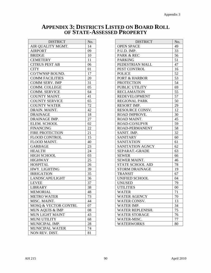
Appendix 3
APPENDIX 3: DISTRICTS LISTED ON BOARD ROLL OF STATE-ASSESSED PROPERTY
DISTRICT No. AIR QUALITY MGMT. 14 AIRPORT 09 BRIDGE 10 CEMETERY 11 CITRUS PEST AB 06 CITY 01 CO/TWNSP BOUND. 17 COMM FACILITIES 20 COMM SERV. IMP 31 COMM. COLLEGE 05 COMM. SERVICE 64 COUNTY MAINT. 41 COUNTY SERVICE 65 COUNTY WATER 72 DRAIN. MAINT. 42 DRAINAGE 18 DRAINAGE IMP. 27 ELEM. SCHOOL 02 FINANCING 22 FIRE PROTECTION 21 FLOOD CONTROL 15 FLOOD MAINT. 40 GARBAGE 23 HEALTH 24 HIGH SCHOOL 03 HIGHWAY 25 HOSPITAL 26 HWY. LIGHTING 39 IRRIGATION 35 LANDSCAPE/LIGHT 36 LEVEE 37 LIBRARY 38 MEMORIAL 48 METRO WATER 73 MISC. MAINT. 44 MOSQ & VECTOR CONTRL 07 MUN AQUIS & IMP 08 MUN LIGHT MAINT 43 MUNI UTILITY 68 MUNICIPAL IMP. 28 MUNICIPAL WATER 74 NON REV. DIST. 81
DISTRICT No. OPEN SPACE 49 P.U.D. IMP. 33 PARK & REC 56 PARKING 51 PEDESTRIAN MALL 47 PEST CONTROL 16 POLICE 52 PORT & HARBOR 53 PROTECTION 54 PUBLIC UTILITY 69 RECLAMATION 55 REDEVELOPMENT 57 REGIONAL PARK 50 RESORT IMP. 29 RESOURCE CONSV. 12 ROAD IMPROVE. 30 ROAD MAINT. 45 ROAD-CO/SUPVR 59 ROAD-PERMANENT 58 SANIT. IMP. 32 SANITARY 60 SANITATION 61 SANITATION AGNCY 62 SEPARAT.-GRADE 63 SEWER 66 SEWER MAINT. 46 STATE SCHOOL AID 78 STORM DRAINAGE 19 TRANSIT 67 UNIFIED SCHOOL 04 UNUSED 79 UTILITIES 00 WATER 71 WATER AGENCY 70 WATER CONSV. 13 WATER IMP. 34 WATER REPLENISH. 75 WATER STORAGE 76 WATER-MISC. 77 WATERWORKS 80
AH 215 90 April 2010

Appendix 4
APPENDIX 4: STATUTORY PROVISIONS
REVENUE AND TAXATION CODE SECTIONS
95. Definitions. (g) Except as otherwise provided in this subdivision, "tax rate area" means a specific
geographic area all of which is within the jurisdiction of the same combination of local agencies and school entities
for the current fiscal year.
In the case of a jurisdictional change pursuant to Section 99, the area subject to the change shall constitute a new tax
rate area, except that if the area subject to change is within the same combinations of local agencies and school
entities as an existing tax rate area, the two tax rate areas may be combined into one tax rate area.
Existing tax rate areas having the same combinations of local agencies and school entities may be combined into
one tax rate area. For the combination of existing tax rate areas, the factors used to allocate the annual tax increment
pursuant to Section 98 shall be determined by calculating a weighted average of the annual tax increment factors
used in the tax rate areas being combined.
116. "Map." "Map" includes plat.
122. "Revenue district." "Revenue district" includes every city and district for which the county officers
assess property and collect taxes or assessments.
321. Land description. Land shall be legally described for tax purposes pursuant to this chapter.
322. Federal surveys. If surveyed under the authority of the United States, land may be described by township,
range, section, and fractional section, with its acreage.
323. Spanish grants. If held under Spanish grant, land may be described by the exterior boundaries of the
grants, or by the name of the grants, and the divisions, subdivisions, and acreage claimed.
324. City lots. City lots may be described by naming the city and giving the number of the lot and block,
according to the system of numbering in the city.
325. Official maps. When a map has been adopted as an official map under Division 3 (commencing with
Section 66499.50) of Title 7 of the Government Code, land may be described by numbers or letters as shown on the
official map.
326. Owner’s maps. Whenever a map, other than an official map, has been furnished by the owner, claimant,
or user of land, and it contains sufficient information clearly to identify the land, and it is properly identified by and
filed with the assessor or the board, the land may be described by reference to this map.
327. Assessor’s maps. Where any county or county officer possesses a complete, accurate map of any land in
the county, or whenever such a complete, accurate map has been made in compliance with Sections 27556 to 27560,
inclusive, of the Government Code, the assessor may number or letter the parcels in a manner approved by the
board of supervisors. The assessor may renumber or reletter the parcels or prepare new map pages for any portion of
AH 215 91 April 2010

Appendix 4
such map to show combinations or divisions of parcels in a manner approved by the board of supervisors, so long as
an inspection of such map will readily disclose precisely what land is covered by any particular parcel number or
letter in the current or any prior fiscal year. This map or copy shall at all times be publicly displayed in the office of
the assessor.
Land may be described by a reference to this map except that land shall not be described in any deed or conveyance
by a reference to any such map unless such map has been filed for record in the office of the county recorder of the
county in which such land is located.
All such maps in the possession of county assessors on August 27, 1937, and used for assessment purposes only, are
deemed to have been numbered or lettered and approved properly.
327.1. Subdivision maps; digital copies. The board of supervisors of any county may enact, by a majority vote
of its membership, an ordinance, resolution, or board order that requires any party that records a digital subdivision
map with the county recorder to also file a duplicate digital copy of that map with the county assessor.
327.5. Subdivisions; existing residential structure prohibitions. Notwithstanding any other provision of law,
the assessor shall not assign any parcel numbers or prepare a separate assessment or separate valuation to divide any
existing residential structure into a subdivision, as defined in Section 66424 of the Government Code, until a
subdivision final map or parcel map, as described in Sections 66434 and 66445, respectively, of the Government
Code has been recorded as required by law. If the requirement for a parcel map is waived pursuant to subdivision
(b) of Section 66428 of the Government Code, then the assessor shall not assign any parcel numbers or prepare a
separate assessment or separate valuation, unless the applicant provides a copy of the finding made by the
legislative body or advisory agency, as required by that subdivision.
328. Other descriptions. Land may be described by metes and bounds, or other description sufficient to
identify it, giving the locality and an estimate of the number of acres.
455. Parcels; sold to the state. The assessor shall not combine parcels into a single assessment when any of
those parcels have been declared to be tax defaulted for delinquent taxes. This section does not apply to subdivided
land reverted to acreage in accordance with provisions of the Subdivision Map Act and local ordinances.
456. Demand for description. If the assessor has not received from the owner of a tract of land a legal
description or a description which geographically locates the property, he may require such a description from the
owner or his agent, or, in case they cannot be found or are unknown, the person in possession. Such legal
description may be by reference to the assessor's map and parcel number.
457. Citation. If the owner, agent, or person in possession neglects to furnish the assessor with the description
within 10 days after the request, the assessor shall cite him to appear before the superior court of the county where
the land is situated within five days after service of the citation. On the day named in the citation, to the exclusion of
all other business, the court shall proceed to hear his return and answer to the citation.
458. Survey on court order. If the court finds the land has not been surveyed or divided so that it can be
legally described, the court shall, by order duly entered in open court, direct the county surveyor to make a survey,
and define the boundaries and location of the land by parcels not exceeding six hundred and forty acres each, and
deliver it to the assessor.
AH 215 92 April 2010

Appendix 4
459. Expense of survey. The expense of making the survey and description by the county surveyor is a lien on
the land, and, when approved by the superior court, shall be certified by it to the board of supervisors who shall, by
resolution, direct the auditor to add the expense to the taxes on the land, to be collected like other taxes.
459.5. Applicability of Sections 457, 458, and 459. Sections 457, 458, and 459 are applicable when the
owner, his agent, or person in possession neglects to furnish the assessor of any taxing agency, including a taxing
agency having its own system for the levying and collection of taxes or assessments, with a requested description of
any tract of land.
601. Preparation of roll. The assessor shall prepare an assessment roll, as directed by the board, in which shall
be listed all property within the county which it is the assessor's duty to assess.
602. Contents. This local roll shall show:
(a) The name and address, if known, of the assessee. The assessor is not required to maintain electronic mail
addresses.
(b) Land, by legal description.
(c) A description of possessory interests sufficient to identify them.
(d) Personal property. A failure to enumerate personal property in detail does not invalidate the assessment.
(e) The assessed value of real estate, except improvements.
(f) The assessed value of improvements on the real estate.
(g) The assessed value of improvements assessed to any person other than the owner of the land.
(h) The assessed value of possessory interests.
(i) The assessed value of personal property, other than intangibles.
(j) The revenue district in which each piece of property assessed is situated.
(k) The total taxable value of all property assessed, exclusive of intangibles.
(l) Any other things required by the board.
606. Land in multiple revenue districts.
(a) Except as provided in subdivisions (b) and (c), when any tract of land is situated in two or more revenue
districts, the part in each district shall be separately assessed.
(b) Where the owner of two or more contiguous parcels comprising the tract is identical, and the full value of any
parcel is less than twenty-five thousand dollars ($25,000), that parcel may be combined with the contiguous
parcel with the greatest assessed valuation.
AH 215 93 April 2010

Appendix 4
(c) Where the owner of two or more contiguous parcels comprising the tract is identical, and the tract of land is
being used for a single-family residence and constitutes 45,000 square feet or less, the smallest parcel may be
combined with the largest contiguous parcel.
984. Water ditches. Water ditches constructed for mining, manufacturing, or irrigation purposes and toll roads
shall be assessed like real estate, at a rate per mile for that portion of the property lying within the county.
985. Toll bridges. Every toll bridge connecting two or more counties shall be assessed in equal proportions in
the counties it connects.
1251. Supervisors’ duties. The board of supervisors shall furnish the assessor with the necessary office
equipment, consisting of proper books, blanks, maps, office room, furniture, and stationery.
1252. Board’s duties. If the board of supervisors fails to furnish the assessor with the necessary office
equipment, then, on the assessor's application, the State Board of Equalization shall furnish it.
1253. Cost. In any event, the cost of furnishing the assessor's necessary office equipment is a county charge,
payable like other county charges from the county general fund.
1254. Forms. The State Board of Equalization shall prescribe the forms for the books, blanks, and maps, and
may require the map books to:
(a) Be indexed by owners' names.
(b) Show improvements and assessed value.
1255. Maps. The maps shall show the private lands owned or claimed in the county so as to provide a legal
description of the lands.
1256. Preparation of maps and block-books. At the request of the assessor, the board of supervisors shall
authorize and direct the assessor to prepare, or to supervise the preparation of, maps and block-books as may be
needed for the assessor's office to meet the requirements of the state board with respect thereto. All costs incurred in
connection therewith shall be a charge against the county general fund, payable in the same manner as other county
charges. This procedure shall be in addition to any other procedure relating to matters as may otherwise be provided
by law.
2215. ‘‘Special district.’’ "Special district" means any agency of the state for the local performance of
governmental or proprietary functions within limited boundaries. "Special district" includes a county service area, a
maintenance district or area, an improvement district or improvement zone, or any other zone or area, formed for the
purpose of designating an area within which a property tax rate will be levied to pay for a service or improvement
benefiting that area.
"Special district" does not include a city, a county, a school district or a community college district. "Special
district" does not include any agency which is not authorized by statute to levy a property tax rate or receive an
allocation of property tax revenues.
AH 215 94 April 2010
Appendix 4
However, for the purpose of the allocation of property taxes pursuant to Chapter 6 (commencing with Section 95) of
Part 0.5, and notwithstanding Section 2237, any special district authorized to levy a property tax or receive an
allocation of property tax by the statute under which the district was formed shall be considered a special district.
11911.1. Requirement of parcel number. Any ordinance which imposes the documentary transfer tax may
require that each deed, instrument or writing by which lands, tenements, or other realty is sold, granted, assigned,
transferred, or otherwise conveyed, shall have noted upon it the tax roll parcel number. The number will be used
only for administrative and procedural purposes and will not be proof of title and in the event of any conflicts, the
stated legal description noted upon the document shall govern. The validity of such a document shall not be
affected by the fact that such parcel number is erroneous or omitted, and there shall be no liability attaching to any
person for an error in such number or for omission of such number.
GOVERNMENT CODE SECTIONS
23070. The terms and definitions contained in this article apply to the boundary descriptions of the several
counties, unless otherwise declared.
23071. In describing courses, "north," "south," "east," and "west," mean true courses, and refer to the true
meridian.
23072. "Northerly," "southerly," "easterly," and "westerly," mean due north, due south, due east, and due west,
unless controlled by other words, or by lines, monuments, or natural objects.
23073. "To," "on," "along," "with," or "by" a mountain or ridge, mean summit point or summit line.
23074. "To," "by," "along," "with," "in," "up," or "down" a creek, river, slough, strait, or bay, mean the middle
of the main channel thereof.
23075. "In," "to," or "from" the ocean shore mean a point three miles seaward from the shore. "Along," "with,"
"by," or "on" the ocean shore, mean on a line parallel with and three miles seaward from the shore.
23076. The mouth of a creek, river, or slough which empties into another creek, river, or slough, is the point
where the middle of the channels intersect.
23077. The use of a county name specified in this division, without further description, is a reference to the
county of that name.
27279. (a) "Instrument," as used in this chapter, means a written paper signed by a person or persons
transferring the title to, or giving a lien on real property, or giving a right to a debt or duty.
(b) The recorder of any county may, in lieu of a written paper, accept for recording digitized images, digital
images, or both, of a recordable instrument, paper, or notice if both of the following conditions are met:
(1) The image conforms to all other applicable statutes that prescribe recordability, except the requirement of
original signatures in subdivision (b) of Section 27201.
AH 215 95 April 2010

Appendix 4
(2) The requester and addressee for delivery of the recorded images are the same and can be readily identified
as a local or state government entity, or an agency, branch, or instrumentality of the federal government.
27279.1. (a) The recorders of San Bernardino County and Orange County may accept, in lieu of a written paper
document, a digitized image of a recordable instrument if both of the following conditions are met:
(1) The requester and addressee for delivery of the recorded image meets the criteria set forth in either
Section 27279.2 or 27279.3.
(2) The county recorder determines that accepting electronically recorded documents from the requester is in
the best interest of the county and the public. Factors the county recorder shall consider include, but are not
limited to, both of the following:
(A) Whether or not the volume and quality of digitized instruments submitted by the requester will be
sufficient to warrant electronic recordation.
(B) Whether, in order to protect the county and the public, the requester has effective security precautions
addressing potential fraud and forging of documents in the electronic recordation process.
(b) The Legislature finds and declares that, because of the unique circumstances applicable to the counties
referenced in subdivision (a), as regards the present ability of these counties to process digitized images for
electronic recordation, a statute of general applicability cannot be enacted within the meaning of subdivision
(b) of Section 16 of Article IV of the California Constitution.
27556. The surveyor shall copy, plat, or trace each map filed for record in the office of the county recorder, at
the cost of the party filing the map, and is ex officio deputy recorder for the county for such purposes. All maps or
plats filed by a licensed land surveyor and such other maps and plats as are filed and are thereby made a record are
exempt from this section.
27557. The surveyor shall plat, trace, blueprint, or otherwise make all county, road, district, and other maps
and, at the request of the assessor, make all assessors' block-books for the county.
27558. The board of supervisors may provide and pay from county funds for the making or purchase of the
maps and block-books by contract with some other competent person, if any of the following conditions exist:
(a) The office of the assessor is not provided with maps and block-books.
(b) The maps or block-books in the office of the assessor are insufficient or defective and the surveyor neglects
or refuses to make them.
(c) The facilities of the surveyor's office are inadequate to do so.
27559. In the preparation of assessors' maps and block-books the surveyor shall make all investigations and
surveys necessary to provide complete and accurate maps.
27560. All maps which are platted, traced, blueprinted, or otherwise so made for the county and all data
obtained by the surveyor or person making them from other sources is the property of the county.
AH 215 96 April 2010

Appendix 4
27561. The board of supervisors may provide for the sale at not less than cost of copies of maps prepared for
the use of the assessor.
27562. The surveyor shall make such surveys of county roads and perform such other engineering work as the
board of supervisors directs. All surveys shall be tied by courses and distances to the corners of legal subdivisions
through which they pass or to natural or artificial monuments. All such maps and field notes of surveys shall be
filed in the office of the surveyor and are the property of the county.
27563. In all surveys the courses shall be expressed according to the true meridian, and the variation of the
magnetic meridian from the true meridian shall be expressed on the plat with the date of the survey.
54900. When there is a change in boundaries (1) of a city, (2) of a district, or special zone thereof, within a city
the tax levy of which is carried on the regular city assessment roll, or (3) of a district, or special zone thereof, the tax
or special assessment levy of which is carried on the regular county assessment roll, or when a city or any district,
or special zone thereof, is created the tax or special assessment levy of which is carried on the regular county
assessment roll, or when a district previously levying and collecting taxes or special assessments based upon its own
assessment utilizes the regular city or county assessment roll, the tax or assessment levying authority of the city or
district shall file or cause to be filed a statement of the creation or change, or of the exterior boundaries of the
district and the special zones therein newly utilizing the regular city or county assessment roll. The city or district
shall prepare the statement and forward it to the tax or assessment levying authority for filing.
Any filing as required by this section by the executive officer of a local agency formation commission pursuant to
Section 57204 shall be deemed to satisfy the requirements of this chapter.
54900.1. The tax or assessment levying authority as used in this chapter shall be the governmental body
required to levy taxes or assessments by the principal act of the city or district as defined in Section 56065.
54901. (a) The statement shall be in the form required by the Board of Equalization and include a certified copy
of the ordinance or resolution ordering the creation of or change in boundary of the city, district or zone thereof, a
legal description of said boundaries and a map or plat indicating the boundaries.
(b) If the proceedings require the executive officer of a local agency formation commission to execute a certificate
of completion of proceedings, the statement shall set forth the effective date of the proceeding. The statement shall
also specify whether or not the affected property will be taxed for any existing bonded indebtedness or contractual
obligations, and specify the change associated with each affected agency.
(c) For changes of organization or reorganizations which include the incorporation of, annexation to, or detachment
from a city, the statement shall also include the estimated population of the affected territory and include a map or
plat showing limiting addresses on streets within the affected territory.
54902. On or before December 1 of the year immediately preceding the year in which the assessments or taxes
are to be levied, the statement shall be filed with the auditor of each levying county, and the statement and the map
or plat shall be filed with each assessor whose roll is used for the levy and with the State Board of Equalization in
Sacramento.
AH 215 97 April 2010

Appendix 4
54902.1. In the event that any statement, map or plat required by this chapter is filed after the deadline specified
in Section 54902, the provisions of Section 54903 shall apply to the territory described in such statement, map or
plat and the boundary changes indicated therein shall not be effective for tax or assessment purposes for the fiscal
year beginning on the following July 1.
Any city or district, or zone thereof, to which this section applies may borrow an amount of money equivalent to the
anticipated tax revenue which would have been collected during such fiscal year within the territory described in the
statement, map or plat, if such statement, map or plat had been filed on or before the deadline specified in Section
54902.
During succeeding fiscal years a tax or assessment may be levied by, or on behalf of, any city or district, or zone
thereof, in order to repay such borrowed funds, including the cost of interest charges connected therewith. The tax
shall be levied, after notice of the intent to levy the tax to the State Board of Equalization in such time and manner
as prescribed by the board, only on that property described in the statement, map or plat. Such an amount of money
may be raised during a single fiscal year or, at the discretion of the affected local agency, a portion of such amount
may be raised in each of several fiscal years. The tax or assessment rate authorized by this section shall be in
addition to any maximum property tax rate established pursuant to Chapter 3 (commencing with Section 2201) of
Part 4 of Division 1 of the Revenue and Taxation Code.
54902.2. Notwithstanding any other provision of law, whenever a taxing agency elects to become a revenue
district within the meaning of Section 122 of the Revenue and Taxation Code or elects to utilize the regular city
assessment roll, it shall do so by the adoption of a resolution to that effect. The clerk of the legislative body of such
district shall file a certified copy of such resolution, together with the statements as required by this chapter, with
each assessor whose roll is to be used for the levy of assessment or taxes and with the State Board of Equalization in
Sacramento.
54902.5. (a) Notwithstanding Section 6103, the State Board of Equalization shall establish a schedule of fees
for filing and processing the statements and maps or plats that are required to be filed with the board pursuant to
Section 54902.
(1) The schedule shall not include any fee that exceeds the reasonably anticipated cost to the board of performing
the work to which the fee relates, or an amount equal to 25 percent of the anticipated total tax revenue that
will be collected by the city or district during the first full fiscal year, beginning on July 1, that the boundary
changes are effective, as determined by the county auditor, whichever amount is less.
(2) For purposes of this subdivision, "anticipated total tax revenue" means the tax revenues that will be allocated
to the city or district from all property located within the boundaries of the city or district, including the area
affected by the boundary change.
(b) The city, district, or executive officer of a local agency formation commission, forwarding the statement to the
tax or assessment levying authority for filing pursuant to Section 54900, shall accompany the statement with the
necessary fee for transmittal to the board. However, with respect to a newly created city or district, no fee shall be
required until the time that the city or district receives its first revenues.
AH 215 98 April 2010
Appendix 4
54903. The creation of any city, district or zone thereof or the change in its boundaries is not effective for
assessment or taxation purposes nor shall the tax or the special assessment levy of a district previously levying and
collecting taxes or special assessments based on its own assessment be carried on a city or county assessment roll
unless the statement and map or plat is filed pursuant to this chapter.
54903.1. When a statement of the creation or change of boundaries of a school district and a map or plat thereof
is required to be filed with the State Board of Equalization, the authority required to file the statement and map or
plat shall, at the same time, file a copy of the statement and map or plat with the Superintendent of Public
Instruction and the county superintendent of schools of the county in which the school district is located.
54904. This chapter does not apply to sanitary districts organized, consolidated, or whose boundaries are
changed, pursuant to Part 1 of Division 6 of the Health and Safety Code if the district levies and collects taxes based
upon its own assessment without taking advantage of Sections 6780 to 6787 of the Health and Safety Code.
54905. This chapter does not apply to any community facilities district organized pursuant to the Mello-Roos
Community Facilities Act of 1982 (Chapter 2.5 (commencing with Section 53311) of Part 1 of Division 2 of Title 5)
if the district does not provide for the collection of special taxes by reference to tax rate areas.
54906. This chapter does not apply to any zones within a permanent road division created pursuant to Section
1162.6 of the Streets and Highways Code, where the zones are formed for a specific permanent road project.
54915. Notwithstanding Sections 54902 and 54903, any change in the boundaries of a fire protection district
formed or operating under Part 2.7 (commencing with Section 13801) of Division 12 of the Health and Safety Code
as the result of an annexation to a city, the proceedings for which were completed in 1972, and as the result of the
withdrawal of territory of the district by action taken prior to March 1, 1973, pursuant to Section 13952 of the
Health and Safety Code, by the city council of a city to which such territory has been annexed shall be effective for
assessment and taxation purposes for the 1973 -74 fiscal year if the required statements and map or plat is filed on
or before March 1, 1973.
The district from which the territory has been withdrawn shall have no power to furnish fire protection services to
such territory on or after July 1, 1973, and no taxes shall be levied by or on behalf of the district on any property in
such territory in order to furnish fire protection services to such territory on or after July 1, 1973.
54915.5. Notwithstanding the provisions of Section 54902, 54902.1, or 54903, the approval of any formation of
a fire protection district by the voters at an election held on June 8, 1982, shall be effective for assessment and
taxation purposes for the 1982-83 fiscal year if the required statements and map or plat are filed on or before July
15, 1982.
54916.5. Notwithstanding the provisions of Section 54902, 54902.1, or 54903, any county service area which is
formed for the purpose of providing fire protection and emergency medical services, the formation of which is
completed on March 3, 1982, shall be effective for assessment and taxation purposes for the 1982-83 fiscal year if
the required statements and map or plat are filed on or before March 17, 1982.
66410. This division may be cited as the Subdivision Map Act.
AH 215 99 April 2010

Appendix 4
66411. Regulation and control of the design and improvement of subdivisions are vested in the legislative
bodies of local agencies. Each local agency shall, by ordinance, regulate and control the initial design and
improvement of common interest developments as defined in Section 1351 of the Civil Code and subdivisions for
which this division requires a tentative and final or parcel map. In the development, adoption, revision, and
application of such ordinance, the local agency shall comply with the provisions of Section 65913.2.
The ordinance shall specifically provide for proper grading and erosion control, including the prevention of
sedimentation or damage to offsite property. Each local agency may by ordinance regulate and control other
subdivisions, provided that the regulations are not more restrictive than the regulations for those subdivisions for
which a tentative and final or parcel map are required by this division, and provided further that the regulations shall
not be applied to short-term leases (terminable by either party on not more than 30 days' notice in writing) of a
portion of the operating right-of-way of a railroad corporation as defined by Section 230 of the Public Utilities Code
unless a showing is made in individual cases, under substantial evidence, that public policy necessitates the
application of the regulations to those short-term leases in individual cases.
66411.1. (a) Notwithstanding Section 66428, whenever a local ordinance requires improvements for a division
of land which is not a subdivision of five or more lots, the regulations shall be limited to the dedication of rights-of-
way, easements, and the construction of reasonable offsite and onsite improvements for the parcels being created.
Requirements for the construction of offsite and onsite improvements shall be noticed by a statement on the parcel
map, on the instrument evidencing the waiver of the parcel map, or by a separate instrument and shall be recorded
on, concurrently with, or prior to the parcel map or instrument of waiver of a parcel map being filed for record.
(b) Notwithstanding Section 66428, fulfillment of the construction requirements shall not be required until the time
a permit or other grant of approval for development of the parcel is issued by the local agency or, where provided
by local ordinances, until the time the construction of the improvements is required pursuant to an agreement
between the subdivider and the local agency, except that in the absence of an agreement, a local agency may require
fulfillment of the construction requirements within a reasonable time following approval of the parcel map and prior
to the issuance of a permit or other grant of approval for the development of a parcel upon a finding by the local
agency that fulfillment of the construction requirements is necessary for either of the following reasons:
(1) The public health and safety.
(2) The required construction is a necessary prerequisite to the orderly development of the surrounding area.
66411.5. (a) Notwithstanding any other provision of this division, whenever a parcel map or final map is
required to effectuate a judicial partition of property pursuant to subdivision (b) and pursuant to Section 872.040 of
the Code of Civil Procedure, the local agency approving the parcel map or final map may establish the amount of
any monetary exaction or any dedication or improvement requirement authorized by law as a condition of approving
the parcel map or final map, but shall not require payment of the exaction, the undertaking of the improvement, or
posting of security for future performance thereof and shall not accept any required offer of dedication until the time
specified in subdivision (b).
(b) This section applies to judicial partition of real property which is subject to a contract under Article 3
(commencing with Section 51240) of Chapter 7 of Part 1 of Division 1 of Title 5 and which will remain subject to
that contract subsequent to the filing of the parcel map or final map. With respect to any parcel created by a parcel
AH 215 100 April 2010

Appendix 4
map or final map subject to this section, payment of exactions and acceptance of offers of dedication under this
section shall be deferred by the local agency until the contract terminates or is canceled as to that parcel, except that
no deferral is required under this subdivision as to fees and assessments that are due and payable for governmental
services provided to the parcel prior to termination or cancellation of the contract. The applicants for a parcel map
or final map subject to this section shall be personally liable for performance of obligations deferred under this
section at the time they become due.
66412. This division shall be inapplicable to any of the following:
(a) The financing or leasing of apartments, offices, stores, or similar space within apartment buildings, industrial
buildings, commercial buildings, mobilehome parks, or trailer parks.
(b) Mineral, oil, or gas leases.
(c) Land dedicated for cemetery purposes under the Health and Safety Code.
(d) A lot line adjustment between four or fewer existing adjoining parcels, where the land taken from one parcel
is added to an adjoining parcel, and where a greater number of parcels than originally existed is not thereby
created, if the lot line adjustment is approved by the local agency, or advisory agency. A local agency or
advisory agency shall limit its review and approval to a determination of whether or not the parcels resulting
from the lot line adjustment will conform to the local general plan, any applicable specific plan, any
applicable coastal plan, and zoning and building ordinances. An advisory agency or local agency shall not
impose conditions or exactions on its approval of a lot line adjustment except to conform to the local general
plan, any applicable specific plan, any applicable coastal plan, and zoning and building ordinances, to require
the prepayment of real property taxes prior to the approval of the lot line adjustment, or to facilitate the
relocation of existing utilities, infrastructure, or easements. No tentative map, parcel map, or final map shall
be required as a condition to the approval of a lot line adjustment. The lot line adjustment shall be reflected in
a deed, which shall be recorded. No record of survey shall be required for a lot line adjustment unless
required by Section 8762 of the Business and Professions Code.
(e) Boundary line or exchange agreements to which the State Lands Commission or a local agency holding a
trust grant of tide and submerged lands is a party.
(f) Any separate assessment under Section 2188.7 of the Revenue and Taxation Code.
(g) Unless a parcel or final map was approved by the legislative body of a local agency, the conversion of a
community apartment project, as defined in Section 1351 of the Civil Code, to a condominium, as defined in
Section 783 of the Civil Code, but only if all of the following requirements are met:
(1) At least 75 percent of the units in the project were occupied by record owners of the project on March 31,
1982.
(2) A final or parcel map of the project was properly recorded, if the property was subdivided, as defined in
Section 66424, after January 1, 1964, with all of the conditions of that map remaining in effect after the
conversion.
AH 215 101 April 2010

Appendix 4
(3) The local agency certifies that the above requirements were satisfied if the local agency, by ordinance,
provides for that certification.
(4) Subject to compliance with subdivision (e) of Section 1351 of the Civil Code, all conveyances and other
documents necessary to effectuate the conversion shall be executed by the required number of owners in
the project as specified in the bylaws or other organizational documents. If the bylaws or other
organizational documents do not expressly specify the number of owners necessary to execute the
conveyances and other documents, a majority of owners in the project shall be required to execute the
conveyances or other documents. Conveyances and other documents executed under the foregoing
provisions shall be binding upon and affect the interests of all parties in the project.
(h) Unless a parcel or final map was approved by the legislative body of a local agency, the conversion of a stock
cooperative, as defined in Section 1351 of the Civil Code, to a condominium, as defined in Section 783 of the
Civil Code, but only if all of the following requirements are met:
(1) At least 51 percent of the units in the cooperative were occupied by stockholders of the cooperative on
January 1, 1981, or individually owned by stockholders of the cooperative on January 1, 1981. As used in
this paragraph, a cooperative unit is "individually owned" if and only if the stockholder of that unit owns or
partially owns an interest in no more than one unit in the cooperative.
(2) No more than 25 percent of the shares of the cooperative were owned by any one person, as defined in
Section 17, including an incorporator or director of the cooperative, on January 1, 1981.
(3) A person renting a unit in a cooperative shall be entitled at the time of conversion to all tenant rights in
state or local law, including, but not limited to, rights respecting first refusal, notice, and displacement and
relocation benefits.
(4) The local agency certifies that the above requirements were satisfied if the local agency, by ordinance,
provides for that certification.
(5) Subject to compliance with subdivision (e) of Section 1351 of the Civil Code, all conveyances and other
documents necessary to effectuate the conversion shall be executed by the required number of owners in
the cooperative as specified in the bylaws or other organizational documents. If the bylaws or other
organizational documents do not expressly specify the number of owners necessary to execute the
conveyances and other documents, a majority of owners in the cooperative shall be required to execute the
conveyances or other documents. Conveyances and other documents executed under the foregoing
provisions shall be binding upon and affect the interests of all parties in the cooperative.
(i) The leasing of, or the granting of an easement to, a parcel of land, or any portion or portions thereof, in
conjunction with the financing, erection, and sale or lease of a windpowered electrical generation device on
the land, if the project is subject to discretionary action by the advisory agency or legislative body.
(j) The leasing or licensing of a portion of a parcel, or the granting of an easement, use permit, or similar right
on a portion of a parcel, to a telephone corporation as defined in Section 234 of the Public Utilities Code,
exclusively for the placement and operation of cellular radio transmission facilities, including, but not limited
to, antennae support structures, microwave dishes, structures to house cellular communications transmission
AH 215 102 April 2010
Appendix 4
equipment, power sources, and other equipment incidental to the transmission of cellular communications, if
the project is subject to discretionary action by the advisory agency or legislative body.
(k) Leases of agricultural land for agricultural purposes. As used in this subdivision, "agricultural purposes"
means the cultivation of food or fiber, or the grazing or pasturing of livestock.
(l) The leasing of, or the granting of an easement to, a parcel of land, or any portion or portions thereof, in
conjunction with the financing, erection, and sale or lease of a solar electrical generation device on the land,
if the project is subject to review under other local agency ordinances regulating design and improvement or,
if the project is subject to other discretionary action by the advisory agency or legislative body.
66412.1. This division shall also be inapplicable to:
(a) The financing or leasing of any parcel of land, or any portion thereof, in conjunction with the construction of
commercial or industrial buildings on a single parcel, unless the project is not subject to review under other
local agency ordinances regulating design and improvement.
(b) The financing or leasing of existing separate commercial or industrial buildings on a single parcel.
66412.2. This division shall not apply to the construction, financing, or leasing of dwelling units pursuant to
Section 65852.1 or second units pursuant to Section 65852.2, but this division shall be applicable to the sale or
transfer, but not leasing, of those units.
66412.3. In carrying out the provisions of this division, each local agency shall consider the effect of
ordinances and actions adopted pursuant to this division on the housing needs of the region in which the local
jurisdiction is situated and balance these needs against the public service needs of its residents and available fiscal
and environmental resources.
66412.5. When so provided by local ordinance, this division shall be inapplicable to subdivisions of four
parcels or less for construction of removable commercial buildings having a floor area of less than 100 square feet.
66412.6. (a) For purposes of this division or of a local ordinance enacted pursuant thereto, any parcel created
prior to March 4, 1972, shall be conclusively presumed to have been lawfully created if the parcel resulted from a
division of land in which fewer than five parcels were created and if at the time of the creation of the parcel, there
was no local ordinance in effect which regulated divisions of land creating fewer than five parcels.
(b) For purposes of this division or of a local ordinance enacted pursuant thereto, any parcel created prior to March
4, 1972, shall be conclusively presumed to have been lawfully created if any subsequent purchaser acquired that
parcel for valuable consideration without actual or constructive knowledge of a violation of this division or the local
ordinance. Owners of parcels or units of land affected by the provisions of this subdivision shall be required to
obtain a certificate of compliance or a conditional certificate of compliance pursuant to Section 66499.35 prior to
obtaining a permit or other grant of approval for development of the parcel or unit of land. For purposes of
determining whether the parcel or unit of land complies with the provisions of this division and of local ordinances
enacted pursuant thereto, as required pursuant to subdivision (a) of Section 66499.35, the presumption declared in
this subdivision shall not be operative.
AH 215 103 April 2010
Appendix 4
(c) This section shall become operative January 1, 1995.
66412.7. A subdivision shall be deemed established for purposes of subdivision (d) of Section 66499.30 and
any other provision of this division on the date of recordation of the final map or parcel map, except that in the case
of (1) maps filed for approval prior to March 4, 1972, and subsequently approved by the local agency or (2)
subdivisions exempted from map requirements by a certificate of exception (or the equivalent) applied for prior to
such date and subsequently issued by the local agency pursuant to local ordinance, the subdivision shall be deemed
established on the date the map or application for a certificate of exception (or the equivalent) was filed with the
local agency.
66412.8. (a) A project located in Los Angeles County that is approved by a public agency before the effective
date of the act adding this section is not in violation of any requirement of this division by reason of the failure to
construct a roadway across the property transferred to the state pursuant to subdivision (c) of Section 21080.29 of
the Public Resources Code and to construct a bridge over the adjacent Ballona Channel in Los Angeles County,
otherwise required as a condition of approval of a vesting tentative map or a tentative map, if all of the following
conditions apply:
(1) The improvements specified in subdivision (a) are not constructed, due in whole or in part, to the project
owner's or developer's relinquishment of easement rights to construct the improvements.
(2) The easement rights specified in paragraph (1) are relinquished in connection with the acquisition by the
State of California, acting by and through the Wildlife Conservation Board of the Department of Fish and
Game, of a wetlands project that is a minimum of 400 acres in size and located in the coastal zone.
(b) Where the easement rights have been relinquished, any municipal ordinance or regulation adopted by a
charter city or a general law city shall be inapplicable to the extent that the ordinance or regulation requires
construction of the transportation improvements specified in subdivision (a), or would otherwise require
reprocessing or resubmittal of a permit or approval, including, but not limited to, a final recorded map, a
vesting tentative map, or a tentative map, as a result of the transportation improvements specified in
subdivision (a) not being constructed.
66413. (a) When any area in a subdivision as to which a final map has been finally approved by a board of
supervisors and filed for record pursuant to this division is thereafter annexed to a city, the final map and any
agreements relating to the subdivision shall continue to govern the subdivision.
(b) When any area in a subdivision or proposed subdivision as to which a tentative map or vesting tentative map has
been filed but a final map has not been finally approved, or as to which a parcel map is required by this division or
local ordinance but the final act required to make the parcel map effective has not been taken, is annexed to a city,
all procedures and regulations required by this division or by local ordinance of the annexing city shall be deemed
to commence as of the effective date of the annexation and the map shall comply with the requirements of any
applicable ordinance of the city to which the area is annexed.
66413.5. (a) When any area in a subdivision or proposed subdivision as to which a tentative map meeting the
criteria of this section has been approved by a board of supervisors is incorporated into a newly incorporated city,
the newly incorporated city shall approve the final map if it meets all of the conditions of the tentative map and
AH 215 104 April 2010

Appendix 4
meets the requirements and conditions for approval of final maps as provided in Article 4 (commencing with
Section 66456), and other requirements of this division.
(b) When any area in a subdivision or proposed subdivision as to which a vesting tentative map meeting the criteria
of this section has been approved by a board of supervisors is incorporated into a newly incorporated city, the newly
incorporated city shall approve the final map and give effect to the vesting tentative map as provided in Chapter 4.5
(commencing with Section 66498.1), if the final map meets all of the conditions of the vesting tentative map and
meets the requirements and conditions for approval of final maps as provided in Article 4 (commencing with
Section 66456), Chapter 4.5 (commencing with Section 66498.1), and other requirements of this division.
(c) Notwithstanding subdivisions (a) and (b), the newly incorporated city may condition or deny a permit, approval,
or extension, or entitlement if it determines either of the following:
(1) Failure to do so would place the residents of the subdivision or the immediate community, or both, in a
condition dangerous to their health or safety, or both.
(2) The condition or denial is required, in order to comply with state or federal law.
(d) The rights conferred by this section shall expire if a final map application is not timely filed prior to the
expiration of the tentative or vesting tentative map. Prior to the approval of the final map, the rights conferred by
this section shall be subject to the applicable time periods set forth in Section 66452.6, which shall not exceed eight
years from the date of the incorporation unless an applicant and the newly incorporated city mutually agree to a
longer period provided by this division.
(e) An approved tentative map or vesting tentative map shall not limit a newly incorporated city from imposing
reasonable conditions on subsequent required approvals or permits necessary for the development, and authorized
by the ordinances, policies, and standards described in Section 66474.2.
(f) Except as otherwise provided in subdivision (g), this section applies to any approved tentative map or approved
vesting tentative map that meets both of the following requirements:
(1) The application for the tentative map or the vesting tentative map is submitted prior to the date that the first
signature was affixed to the petition for incorporation pursuant to Section 56704, regardless of the validity of
the first signature, or the adoption of the resolution pursuant to Section 56800, whichever occurs first.
(2) The county approved the tentative map or the vesting tentative map prior to the date of the election on the
question of incorporation.
(g) This section does not apply to any territory for which the effective date of the incorporation is prior to January 1,
1999.
(h) It is not the intent of the Legislature to influence or affect any litigation pending on or initiated before January 1,
1999.
66414. The definitions in this article apply to the provisions of this division only and do not affect any other
provisions of law.
AH 215 105 April 2010
Appendix 4
66415. "Advisory agency" means a designated official or an official body charged with the duty of making
investigations and reports on the design and improvement of proposed divisions of real property, the imposing of
requirements or conditions thereon, or having the authority by local ordinance to approve, conditionally approve or
disapprove maps.
66416. "Appeal board" means a designated board or other official body charged with the duty of hearing and
making determinations upon appeals with respect to divisions of real property, the imposition of requirements or
conditions thereon, or the kinds, nature and extent of the design or improvements, or both, recommended or decided
by the advisory agency to be required.
66416.5. (a) "City engineer" means the person authorized to perform the functions of a city engineer. The land
surveying functions of a city engineer may be performed by a city surveyor, if that position has been created by the
local agency. (b) A city engineer registered as a civil engineer after January 1, 1982, shall not be authorized to
prepare, examine, or approve the surveying maps and documents. The examinations, certifications, and approvals of
the surveying maps and documents shall only be performed by a person authorized to practice land surveying
pursuant to the Professional Land Surveyors Act (Chapter 15 (commencing with Section 8700) of Division 3 of the
Business and Professions Code) or a person registered as a civil engineer prior to January 1, 1982, pursuant to the
Professional Engineers Act (Chapter 7 (commencing with Section 6700) of Division 3 of the Business and
Professions Code).
(c) Nothing contained in this provision shall prevent a city engineer from delegating the land surveying functions to
a person authorized to practice land surveying. Where there is no person authorized to practice land surveying
within the city or agency, nothing shall prevent the city engineer from contracting with a person who is authorized
to practice land surveying to perform the land surveying functions.
66417. (a) "County surveyor" includes county engineer, if there is no county surveyor.
(b) A county engineer registered as a civil engineer after January 1, 1982, shall not be authorized to prepare,
examine, or approve the surveying maps and documents. The examinations, certifications, and approvals of the
surveying maps and documents shall only be performed by a person authorized to practice land surveying pursuant
to the Professional Land Surveyors Act (Chapter 15 (commencing with Section 8700) of Division 3 of the Business
and Professions Code) or a person registered as a civil engineer prior to January 1, 1982, pursuant to the
Professional Engineers Act (Chapter 7 (commencing with Section 6700) of Division 3 of the Business and
Professions Code).
66418. "Design" means: (1) street alignments, grades and widths; (2) drainage and sanitary facilities and
utilities, including alignments and grades thereof; (3) location and size of all required easements and rights-of-way;
(4) fire roads and firebreaks; (5) lot size and configuration; (6) traffic access; (7) grading; (8) land to be dedicated
for park or recreational purposes; and (9) other specific physical requirements in the plan and configuration of the
entire subdivision that are necessary to ensure consistency with, or implementation of, the general plan or any
applicable specific plan as required pursuant to Section 66473.5.
66418.1. "Development" means the uses to which the land which is the subject of a map shall be put, the
buildings to be constructed on it, and all alterations of the land and construction incident thereto.
AH 215 106 April 2010

Appendix 4
66418.2. (a) "Environmental subdivision" means a subdivision of land pursuant to this division for biotic and
wildlife purposes that meets all of the conditions specified in subdivision (b).
(b) Prior to approving or conditionally approving an environmental subdivision, the local agency shall find each of
the following:
(1) That factual biotic or wildlife data, or both, are available to the local agency to support the approval of the
subdivision, prior to approving or conditionally approving the environmental subdivision.
(2) That provisions have been made for the perpetual maintenance of the property as a biotic or wildlife habitat, or
both, in accordance with the conditions specified by any local, state, or federal agency requiring mitigation.
(3) That an easement will be recorded in the county in which the land is located to ensure compliance with the
conditions specified by any local, state, or federal agency requiring the mitigation. The easement shall contain a
covenant with a county, city, or nonprofit organization running with the land in perpetuity, that the landowner shall
not construct or permit the construction of improvements except those for which the right is expressly reserved in
the instrument. Where the biotic or wildlife habitat, or both, are compatible, the local agency shall consider
requiring the easement to contain a requirement for the joint management and maintenance of the resulting parcels.
This reservation shall not be inconsistent with the purposes of this section and shall not be incompatible with
maintaining and preserving the biotic or wildlife character, or both, of the land.
(4) The real property is at least 20 acres in size, or if it is less than 20 acres in size, the following conditions are met:
(A) The land is contiguous to other land that would also qualify as an environmental subdivision.
(B) The other land is subject to a recorded perpetual easement that restricts its use to a biotic or wildlife habitat,
or both.
(C) The total combined acreage of the lands would be 20 acres or more.
(D) Where the biotic or wildlife habitat, or both, are compatible, the land and the other land will be jointly
managed and maintained.
(c) Notwithstanding subdivision (a) of Section 66411.1, any improvement, dedication, or design required by the
local agency as a condition of approval of an environmental subdivision shall be solely for the purposes of ensuring
compliance with the conditions required by the local, state, or federal agency requiring the mitigation.
(d) After recordation of an environmental subdivision, a subdivider may only abandon an environmental subdivision
by reversion to acreage pursuant to Chapter 6 (commencing with Section 66499.11) if the local agency finds that all
of the following conditions exist:
(1) None of the parcels created by the environmental subdivision has been sold or exchanged.
(2) None of the parcels is being used, set aside, or required for mitigation purposes pursuant to this section.
(3) Upon abandonment and reversion to acreage pursuant to this subdivision, the easement for biotic and wildlife
purposes is extinguished.
AH 215 107 April 2010

Appendix 4
(e) If the environmental subdivision is abandoned and reverts to acreage pursuant to subdivision (d), all local, state,
and federal requirements shall apply.
(f) This section shall apply only upon the written request of the landowner at the time the land is divided. This
section is not intended to limit or preclude subdivision by other lawful means for the mitigation of impacts to the
environment, or of the land devoted to these purposes, or to require the division of land for these purposes.
66419. (a) "Improvement" refers to any street work and utilities to be installed, or agreed to be installed, by the
subdivider on the land to be used for public or private streets, highways, ways, and easements, as are necessary for
the general use of the lot owners in the subdivision and local neighborhood traffic and drainage needs as a condition
precedent to the approval and acceptance of the final map thereof.
(b) "Improvement" also refers to any other specific improvements or types of improvements, the installation of
which, either by the subdivider, by public agencies, by private utilities, by any other entity approved by the local
agency, or by a combination thereof, is necessary to ensure consistency with, or implementation of, the general plan
or any applicable specific plan.
66420. "Local agency" means a city, county or city and county.
66421. "Local ordinance" refers to a local ordinance regulating the design and improvement of subdivisions,
enacted by the legislative body of any local agency under the provisions of this division or any prior statute,
regulating the design and improvements of subdivisions, insofar as the provisions of the ordinance are consistent
with and not in conflict with the provisions of this division.
66422. "Certificate of exception" means a valid authorization to subdivide land, issued by the County of Los
Angeles pursuant to an ordinance thereof, adopted between September 22, 1967, and March 4, 1972, and which at
the time of issuance did not conflict with this division or any statutory predecessor thereof.
66423. "Subdivider" means a person, firm, corporation, partnership or association who proposes to divide,
divides or causes to be divided real property into a subdivision for himself or for others except that employees and
consultants of such persons or entities, acting in such capacity, are not "subdividers."
66424. "Subdivision" means the division, by any subdivider, of any unit or units of improved or unimproved
land, or any portion thereof, shown on the latest equalized county assessment roll as a unit or as contiguous units,
for the purpose of sale, lease or financing, whether immediate or future. Property shall be considered as contiguous
units, even if it is separated by roads, streets, utility easement or railroad rights-of-way. "Subdivision" includes a
condominium project, as defined in subdivision (f) of Section 1351 of the Civil Code, a community apartment
project, as defined in subdivision (d) of Section 1351 of the Civil Code, or the conversion of five or more existing
dwelling units to a stock cooperative, as defined in subdivision (m) of Section 1351 of the Civil Code.
66424.1. Nothing in Section 66424 shall prevent a purchaser of a unit of land created under the provisions of
this division or a local ordinance enacted pursuant thereto, from subdividing the land one or more times, pursuant to
the provisions of this division prior to the time that an equalized county assessment roll has been completed
reflecting the creation of the unit proposed to be subdivided.
AH 215 108 April 2010

Appendix 4
Nothing contained in this chapter shall prevent the same subdivider of a unit of land created under the provisions of
this division, or a local ordinance enacted pursuant thereto, from making consecutive subdivisions of the same
parcel or any portion thereof.
Further, local agencies shall not, by ordinance or policy, prohibit consecutive subdivision of the same parcel or any
portion thereof either by the same subdivider or a subsequent purchaser because the parcel was previously
subdivided.
Nothing contained in this section shall limit the authority of a local agency to impose appropriate conditions or
requirements on the consecutive subdivisions.
66424.5. (a) "Tentative map" refers to a map made for the purpose of showing the design and improvement of a
proposed subdivision and the existing conditions in and around it and need not be based upon an accurate or
detailed final survey of the property.
(b) "Vesting tentative map" refers to a map which meets the requirements of subdivision (a) and Section 66452.
66424.6. (a) When a subdivision, as defined in Section 66424, is of a portion of any unit or units of improved
or unimproved land, the subdivider may designate as a remainder that portion which is not divided for the purpose
of sale, lease, or financing. Alternatively, the subdivider may omit entirely that portion of any unit of improved or
unimproved land which is not divided for the purpose of sale, lease, or financing. If the subdivider elects to
designate a remainder, the following requirements shall apply:
(1) The designated remainder shall not be counted as a parcel for the purpose of determining whether a parcel or
final map is required.
(2) For a designated remainder parcel described in this subdivision, the fulfillment of construction requirements for
improvements, including the payment of fees associated with any deferred improvements, shall not be required until
a permit or other grant of approval for development of the remainder parcel is issued by the local agency or, where
provided by local ordinance, until the construction of the improvements, including the payment of fees associated
with any deferred improvements, is required pursuant to an agreement between the subdivider and the local agency.
In the absence of that agreement, a local agency may require fulfillment of the construction requirements, including
the payment of fees associated with any deferred improvements, within a reasonable time following approval of the
final map and prior to the issuance of a permit or other grant of approval for the development of a remainder parcel
upon a finding by the local agency that fulfillment of the construction requirements is necessary for reasons of:
(A) The public health and safety; or
(B) The required construction is a necessary prerequisite to the orderly development of the surrounding area.
(b) If the subdivider elects to omit all or a portion of any unit of improved or unimproved land which is not divided
for the purpose of sale, lease, or financing, the omitted portion shall not be counted as a parcel for purposes of
determining whether a parcel or final map is required, and the fulfillment of construction requirements for offsite
improvements, including the payment of fees associated with any deferred improvements, shall not be required until
a permit or other grant of approval for development is issued on the omitted parcel, except where allowed pursuant
to paragraph (2) of subdivision (a).
AH 215 109 April 2010

Appendix 4
(c) The provisions of subdivisions (a) and (b) providing for deferral of the payment of fees associated with any
deferred improvements shall not apply if the designated remainder or omitted parcel is included within the
boundaries of a benefit assessment district or community facilities district.
(d) A designated remainder or any omitted parcel may subsequently be sold without any further requirement of the
filing of a parcel map or final map, but the local agency may require a certificate of compliance or conditional
certificate of compliance.
66425. The necessity for tentative, final and parcel maps shall be governed by the provisions of this chapter.
66426. A tentative and final map shall be required for all subdivisions creating five or more parcels, five or
more condominiums as defined in Section 783 of the Civil Code, a community apartment project containing five or
more parcels, or for the conversion of a dwelling to a stock cooperative containing five or more dwelling units,
except where any one of the following occurs:
(a) The land before division contains less than five acres, each parcel created by the division abuts upon a
maintained public street or highway, and no dedications or improvements are required by the legislative body.
(b) Each parcel created by the division has a gross area of 20 acres or more and has an approved access to a
maintained public street or highway.
(c) The land consists of a parcel or parcels of land having approved access to a public street or highway, which
comprises part of a tract of land zoned for industrial or commercial development, and which has the approval of the
governing body as to street alignments and widths.
(d) Each parcel created by the division has a gross area of not less than 40 acres or is not less than a quarter of a
quarter section.
(e) The land being subdivided is solely for the creation of an environmental subdivision pursuant to Section
66418.2.
(f) A parcel map shall be required for those subdivisions described in subdivisions (a), (b), (c), (d), and (e).
66426.5. Any conveyance of land to a governmental agency, public entity, public utility or subsidiary of a
public utility for conveyance to that public utility for rights-of-way shall not be considered a division of land for
purposes of computing the number of parcels. For purposes of this section, any conveyance of land to a
governmental agency shall include a fee interest, a leasehold interest, an easement, or a license.
66427. (a) A map of a condominium project, a community apartment project, or of the conversion of five or
more existing dwelling units to a stock cooperative project need not show the buildings or the manner in which the
buildings or the airspace above the property shown on the map are to be divided, nor shall the governing body have
the right to refuse approval of a parcel, tentative, or final map of the project on account of the design or the location
of buildings on the property shown on the map that are not violative of local ordinances or on account of the manner
in which airspace is to be divided in conveying the condominium.
AH 215 110 April 2010

Appendix 4
(b) A map need not include a condominium plan or plans, as defined in subdivision (e) of Section 1351 of the Civil
Code, and the governing body may not refuse approval of a parcel, tentative, or final map of the project on account
of the absence of a condominium plan.
(c) Fees and lot design requirements shall be computed and imposed with respect to those maps on the basis of
parcels or lots of the surface of the land shown thereon as included in the project.
(d) Nothing herein shall be deemed to limit the power of the legislative body to regulate the design or location of
buildings in a project by or pursuant to local ordinances.
(e) If the governing body has approved a parcel map or final map for the establishment of condominiums on
property pursuant to the requirements of this division, the separation of a three-dimensional portion or portions of
the property from the remainder of the property or the division of that three-dimensional portion or portions into
condominiums shall not constitute a further subdivision as defined in Section 66424, provided each of the following
conditions has been satisfied:
(1) The total number of condominiums established is not increased above the number authorized by the local
agency in approving the parcel map or final map.
(2) A perpetual estate or an estate for years in the remainder of the property is held by the condominium owners
in undivided interests in common, or by an association as defined in subdivision (a) of Section 1351 of the
Civil Code, and the duration of the estate in the remainder of the property is the same as the duration of the
estate in the condominiums.
(3) The three-dimensional portion or portions of property are described on a condominium plan or plans, as
defined in subdivision (e) of Section 1351 of the Civil Code.
66427.1. (a) The legislative body shall not approve a final map for a subdivision to be created from the
conversion of residential real property into a condominium project, a community apartment project, or a stock
cooperative project, unless it finds as follows:
(1) Each tenant of the proposed condominium, community apartment project, or stock cooperative project, and each
person applying for the rental of a unit in the residential real property, has received or will have received all
applicable notices and rights now or hereafter required by this chapter or Chapter 3 (commencing with Section
66451).
(2) Each of the tenants of the proposed condominium, community apartment project, or stock cooperative project
has received or will receive each of the following notices:
(A) Written notification, pursuant to Section 66452.18, of intention to convert, provided at least 60 days prior to the
filing of a tentative map pursuant to Section 66452.
(B) Ten days' written notification that an application for a public report will be, or has been, submitted to the
Department of Real Estate, that the period for each tenant's right to purchase begins with the issuance of the final
public report, and that the report will be available on request.
AH 215 111 April 2010
Appendix 4
(C) Written notification that the subdivider has received the public report from the Department of Real Estate. This
notice shall be provided within five days after the date that the subdivider receives the public report from the
Department of Real Estate.
(D) Written notification within 10 days after approval of a final map for the proposed conversion.
(E) One hundred eighty days' written notice of intention to convert, provided prior to termination of tenancy due to
the conversion or proposed conversion pursuant to Section 66452.19, but not before the local authority has
approved a tentative map for the conversion. The notice given pursuant to this paragraph shall not alter or abridge
the rights or obligations of the parties in performance of their covenants, including, but not limited to, the provision
of services, payment of rent, or the obligations imposed by Sections 1941, 1941.1, and 1941.2 of the Civil Code.
(F) Notice of an exclusive right to contract for the purchase of his or her respective unit upon the same terms and
conditions that the unit will be initially offered to the general public or terms more favorable to the tenant pursuant
to Section 66452.20. The exclusive right to purchase shall commence on the date the subdivision public report is
issued, as provided in Section 11018.2 of the Business and Professions Code, and shall run for a period of not less
than 90 days, unless the tenant gives prior written notice of his or her intention not to exercise the right.
(b) The written notices to tenants required by subparagraphs (A) and (B) of paragraph (2) of subdivision (a) shall be
deemed satisfied if those notices comply with the legal requirements for service by mail.
(c) This section shall not diminish, limit, or expand, other than as provided in this section, the authority of any city,
county, or city and county to approve or disapprove condominium projects.
(d) If a rental agreement was negotiated in Spanish, Chinese, Tagalog, Vietnamese, or Korean, all required written
notices regarding the conversion of residential real property into a condominium project, a community apartment
project, or a stock cooperative project shall be issued in that language.
66427.2. Unless applicable general or specific plans contain definite objectives and policies, specifically
directed to the conversion of existing buildings into condominium projects or stock cooperatives, the provisions of
Sections 66473.5, 66474, and 66474.61, and subdivision (c) of Section 66474.60 shall not apply to condominium
projects or stock cooperatives, which consist of the subdivision of airspace in an existing structure, unless new units
are to be constructed or added.
A city, county, or city and county acting pursuant to this section shall approve or disapprove the conversion of an
existing building to a stock cooperative within 120 days following receipt of a completed application for approval of
such conversion.
This section shall not diminish, limit or expand, other than as provided herein, the authority of any city, county, or
city and county to approve or disapprove condominium projects.
66427.4. (a) At the time of filing a tentative or parcel map for a subdivision to be created from the conversion
of a mobilehome park to another use, the subdivider shall also file a report on the impact of the conversion upon the
displaced residents of the mobilehome park to be converted. In determining the impact of the conversion on
displaced mobilehome park residents, the report shall address the availability of adequate replacement space in
mobilehome parks.
AH 215 112 April 2010

Appendix 4
(b) The subdivider shall make a copy of the report available to each resident of the mobilehome park at least 15
days prior to the hearing on the map by the advisory agency or, if there is no advisory agency, by the legislative
body.
(c) The legislative body, or an advisory agency which is authorized by local ordinance to approve, conditionally
approve, or disapprove the map, may require the subdivider to take steps to mitigate any adverse impact of the
conversion on the ability of displaced mobilehome park residents to find adequate space in a mobilehome park.
(d) This section establishes a minimum standard for local regulation of conversions of mobilehome parks into other
uses and shall not prevent a local agency from enacting more stringent measures.
(e) This section shall not be applicable to a subdivision which is created from the conversion of a rental mobilehome
park to resident ownership.
66427.5. At the time of filing a tentative or parcel map for a subdivision to be created from the conversion of a
rental mobilehome park to resident ownership, the subdivider shall avoid the economic displacement of all
nonpurchasing residents in the following manner:
(a) The subdivider shall offer each existing tenant an option to either purchase his or her condominium or
subdivided unit, which is to be created by the conversion of the park to resident ownership, or to continue residency
as a tenant.
(b) The subdivider shall file a report on the impact of the conversion upon residents of the mobilehome park to be
converted to resident owned subdivided interest.
(c) The subdivider shall make a copy of the report available to each resident of the mobilehome park at least 15 days
prior to the hearing on the map by the advisory agency or, if there is no advisory agency, by the legislative body.
(d) (1) The subdivider shall obtain a survey of support of residents of the mobilehome park for the proposed
conversion.
(2) The survey of support shall be conducted in accordance with an agreement between the subdivider and a
resident homeowners' association, if any, that is independent of the subdivider or mobilehome park owner.
(3) The survey shall be obtained pursuant to a written ballot.
(4) The survey shall be conducted so that each occupied mobilehome space has one vote.
(5) The results of the survey shall be submitted to the local agency upon the filing of the tentative or parcel map, to
be considered as part of the subdivision map hearing prescribed by subdivision (e).
(e) The subdivider shall be subject to a hearing by a legislative body or advisory agency, which is authorized by
local ordinance to approve, conditionally approve, or disapprove the map. The scope of the hearing shall be limited
to the issue of compliance with this section.
(f) The subdivider shall be required to avoid the economic displacement of all nonpurchasing residents in
accordance with the following:
AH 215 113 April 2010

Appendix 4
(1) As to nonpurchasing residents who are not lower income households, as defined in Section 50079.5 of the
Health and Safety Code, the monthly rent, including any applicable fees or charges for use of any preconversion
amenities, may increase from the preconversion rent to market levels, as defined in an appraisal conducted in
accordance with nationally recognized professional appraisal standards, in equal annual increases over a four-year
period.
(2) As to nonpurchasing residents who are lower income households, as defined in Section 50079.5 of the Health
and Safety Code, the monthly rent, including any applicable fees or charges for use of any preconversion amenities,
may increase from the preconversion rent by an amount equal to the average monthly increase in rent in the four
years immediately preceding the conversion, except that in no event shall the monthly rent be increased by an
amount greater than the average monthly percentage increase in the Consumer Price Index for the most recently
reported period.
66428. (a) Local ordinances may require a tentative map where a parcel map is required by this chapter. A
parcel map shall be required for subdivisions as to which a final or parcel map is not otherwise required by this
chapter, unless the preparation of the parcel map is waived by local ordinance as provided in this section.
A parcel map shall not be required for either of the following:
(1) Subdivisions of a portion of the operating right-of-way of a railroad corporation, as defined by Section 230 of
the Public Utilities Code, that are created by short-term leases (terminable by either party on not more than 30 days'
notice in writing).
(2) Land conveyed to or from a governmental agency, public entity, public utility, or for land conveyed to a
subsidiary of a public utility for conveyance to that public utility for rights-of-way, unless a showing is made in
individual cases, upon substantial evidence, that public policy necessitates a parcel map. For purposes of this
subdivision, land conveyed to or from a governmental agency shall include a fee interest, a leasehold interest, an
easement, or a license.
(b) A local agency shall, by ordinance, provide a procedure for waiving the requirement for a parcel map, imposed
by this division, including the requirements for a parcel map imposed by Section 66426.
The procedure may include provisions for waiving the requirement for a tentative and final map for the construction
of a condominium project on a single parcel. The ordinance shall require a finding by the legislative body or
advisory agency, that the proposed division of land complies with requirements established by this division or local
ordinance enacted pursuant thereto as to area, improvement and design, floodwater drainage control, appropriate
improved public roads, sanitary disposal facilities, water supply availability, environmental protection, and other
requirements of this division or local ordinance enacted pursuant thereto. In any case, where the requirement for a
parcel map is waived by local ordinance pursuant to this section, a tentative map may be required by local
ordinance.
(c) If a local ordinance does not require a tentative map where a parcel map is required by this division, the
subdivider shall have the option of submitting a tentative map, or if he or she desires to obtain the rights conferred
by Chapter 4.5 (commencing with Section 66498.1), a vesting tentative map.
AH 215 114 April 2010

Appendix 4
66428.1. (a) When at least two-thirds of the owners of mobilehomes who are tenants in the mobilehome park
sign a petition indicating their intent to purchase the mobilehome park for purposes of converting it to resident
ownership, and a field survey is performed, the requirement for a parcel map or a tentative and final map shall be
waived unless any of the following conditions exist:
(1) There are design or improvement requirements necessitated by significant health or safety concerns.
(2) The local agency determines that there is an exterior boundary discrepancy that requires recordation of a new
parcel or tentative and final map.
(3) The existing parcels which exist prior to the proposed conversion were not created by a recorded parcel or final
map.
(4) The conversion would result in the creation of more condominium units or interests than the number of tenant
lots or spaces that exist prior to conversion.
(b) The petition signed by owners of mobilehomes in a mobilehome park proposed for conversion to resident
ownership pursuant to subdivision (a) shall read as follows:
MOBILEHOME PARK PETITION AND DISCLOSURE STATEMENT
SIGNING THIS PETITION INDICATES YOUR SUPPORT FOR CONVERSION OF THIS MOBILEHOME
PARK TO RESIDENT OWNERSHIP. THIS DISCLOSURE STATEMENT CONCERNS THE REAL
PROPERTY SITUATED IN THE CITY OF ____, COUNTY OF ____, STATE OF CALIFORNIA,
DESCRIBED AS ____. THE TOTAL COST FOR CONVERSION AND PURCHASE OF THE PARK IS
$____ TO $____, EXCLUDING FINANCING COSTS. THE TOTAL COST TO YOU FOR CONVERSION
AND PURCHASE OF YOUR OWNERSHIP INTEREST IS $____ TO $____, EXCLUDING FINANCING
COSTS. IF TWO-THIRDS OF THE RESIDENTS IN THIS PARK SIGN THIS PETITION INDICATING
THEIR INTENT TO PURCHASE THE MOBILEHOME PARK FOR PURPOSES OF CONVERTING IT TO
RESIDENT OWNERSHIP, THEN THE REQUIREMENTS FOR A NEW PARCEL, OR TENTATIVE AND
FINAL SUBDIVISION MAP IN COMPLIANCE WITH THE SUBDIVISION MAP ACT MUST BE
WAIVED, WITH CERTAIN VERY LIMITED EXCEPTIONS. WAIVING THESE PROVISIONS OF LAW
ELIMINATES NUMEROUS PROTECTIONS WHICH ARE AVAILABLE TO YOU.
_____________ __________
Buyer, unit #, Petitioner,
date date
(c) The local agency shall provide an application for waiver pursuant to this section. After the waiver application is
deemed complete pursuant to Section 65943, the local agency shall approve or deny the application within 50 days.
The applicant shall have the right to appeal that decision to the governing body of the local agency.
(d) If a tentative or parcel map is required, the local agency shall not impose any offsite design or improvement
requirements unless these are necessary to mitigate an existing health or safety condition. No other dedications,
AH 215 115 April 2010

Appendix 4
improvements, or in-lieu fees shall be required by the local agency. In no case shall the mitigation of a health or
safety condition have the effect of reducing the number, or changing the location, of existing mobilehome spaces.
(e) If the local agency imposes requirements on an applicant to mitigate a health or safety condition, the applicant
and the local agency shall enter into an unsecured improvement agreement. The local agency shall not require
bonds or other security devices pursuant to Chapter 5 (commencing with Section 66499) for the performance of that
agreement. The applicant shall have a period of one year from the date the agreement was executed to complete
those improvements.
(f) If the waiver application provided for in this section is denied by the local agency pursuant to the provisions of
subdivision (a), the applicant may proceed to convert the mobilehome park to a tenant-owned, condominium
ownership interest, but shall file a parcel map or a tentative and final map. The local agency may not require the
applicant to file and record a tentative and final map unless the conversion creates five or more parcels shown on
the map. The number of condominium units or interests created by the conversion shall not determine whether the
filing of a parcel or a tentative and final map shall be required.
(g) For the purposes of this section, the meaning of "resident ownership" shall be as defined in Section 50781 of the
Health and Safety Code.
66429. Of the maps required by this division, only final and parcel maps may be filed for record in the office of
the county recorder.
66430. No final map or parcel map required by this chapter or local ordinance which creates a subdivision shall
be filed with the local agency without the written consent of all parties having any record title interest in the real
property proposed to be subdivided, except as otherwise provided in this division.
66431. Upon mutual agreement of their respective legislative bodies, the county surveyor may perform any or
all of the duties assigned to the city engineer, including required certifications or statements. Whenever these duties
have been divided between the county surveyor and city engineer, each officer shall state the duties performed by
him or her.
66433. The content and form of final maps shall be governed by the provisions of this article.
66434. The final map shall be prepared by or under the direction of a registered civil engineer or licensed land
surveyor, shall be based upon a survey, and shall conform to all of the following provisions:
(a) It shall be legibly drawn, printed, or reproduced by a process guaranteeing a permanent record in black on
tracing cloth or polyester base film. Certificates, affidavits, and acknowledgments may be legibly stamped or
printed upon the map with opaque ink. If ink is used on polyester base film, the ink surface shall be coated with a
suitable substance to assure permanent legibility.
(b) The size of each sheet shall be 18 by 26 inches or 460 by 660 millimeters. A marginal line shall be drawn
completely around each sheet, leaving an entirely blank margin of one inch or 025 millimeters. The scale of the
map shall be large enough to show all details clearly and enough sheets shall be used to accomplish this end. The
particular number of the sheet and the total number of sheets comprising the map shall be stated on each of the
sheets, and its relation to each adjoining sheet shall be clearly shown.
AH 215 116 April 2010
Appendix 4
(c) All survey and mathematical information and data necessary to locate all monuments and to locate and retrace
any and all interior and exterior boundary lines appearing on the map shall be shown, including bearings and
distances of straight lines, and radii and arc length or chord bearings and length for all curves, and any information
which may be necessary to determine the location of the centers of curves and ties to existing monuments used to
establish the subdivision boundaries.
(d) Each parcel shall be numbered or lettered and each block may be numbered or lettered. Each street shall be
named or otherwise designated. The subdivision number shall be shown together with the description of the real
property being subdivided.
(e) The exterior boundary of the land included within the subdivision shall be indicated by distinctive symbols and
clearly so designated. The map shall show the definite location of the subdivision, and particularly its relation to
surrounding surveys.
If the map includes a "designated remainder" parcel, and the gross area of the "designated remainder" parcel or
similar parcel is five acres or more, that remainder parcel need not be shown on the map and its location need not be
indicated as a matter of survey, but only by deed reference to the existing boundaries of the remainder parcel.
A parcel designated as "not a part" shall be deemed to be a "designated remainder" for purposes of this section.
(f) On and after January 1, 1987, no additional requirements shall be included that do not affect record title interests.
However, the map shall contain a notation or reference to additional information required by a local ordinance
adopted pursuant to Section 66434.2.
(g) Any public streets or public easements to be left in effect after the subdivision shall be adequately delineated on
the map. The filing of the final map shall constitute abandonment of all public streets and public easements not
shown on the map, provided that a written notation of each abandonment is listed by reference to the recording data
or other official record creating these public streets or public easements and certified to on the map by the clerk of
the legislative body or the designee of the legislative body approving the map. Before a public easement vested in
another public entity may be abandoned pursuant to this section, that public entity shall receive notice of the
proposed abandonment. No public easement vested in another public entity shall be abandoned pursuant to this
section if that public entity objects to the proposed abandonment.
66434.1. In the event that an owner's development lien has been created pursuant to the provisions of Article
2.5 (commencing with Section 17430) of Chapter 4 of Part 10.5 of the Education Code on the real property or
portion thereof subject to the final map, a notice shall be placed on the face of the final map specifically referencing
the book and page in the county recorder's office in which the resolution creating the owner's development lien was
recorded. The notice shall state that the property subdivided is subject to an owner's development lien and that each
parcel created by the recordation of the final map shall be subject to a prorated amount of the owner's development
lien on a per acre or portion thereof basis.
66434.2. (a) On or after January 1, 1987, a city or county may, by ordinance, require additional information to
be filed or recorded simultaneously with a final or parcel map. The additional information shall be in the form of a
separate document or an additional map sheet which shall indicate its relationship to the final or parcel map, and
shall contain a statement that the additional information is for informational purposes, describing conditions as of
AH 215 117 April 2010

Appendix 4
the date of filing, and is not intended to affect record title interest. The document or additional map sheet may also
contain a notation that the additional information is derived from public records or reports, and does not imply the
correctness or sufficiency of those records or reports by the preparer of the document or additional map sheet.
(b) Additional survey and map information may include, but need not be limited to: building setback lines, flood
hazard zones, seismic lines and setbacks, geologic mapping, and archaeological sites.
66434.5. When a soils report, geologic report, or soils and geologic report has been prepared specifically for the
subdivision, each report shall be kept on file for public inspection by the city or county having jurisdiction.
66435. Prior to filing, those certificates, statements, and acknowledgments set forth in this article shall appear
on the final map and may be combined where appropriate.
66435.1. Notwithstanding any other provision of this article, local agencies may require that those certificates,
statements, and acknowledgments required by Sections 66436 and 66443, be made by separate instrument to be
recorded concurrently with the final map being filed for record.
66435.2. Whenever a certificate, statement, or acknowledgment is made by separate instrument, there shall
appear on the final map a reference to the separately recorded document. This reference shall be completed by the
county recorder pursuant to Section 66468.1.
66436. (a) A statement, signed and acknowledged by all parties having any record title interest in the
subdivided real property, consenting to the preparation and recordation of the final map is required, except in the
following circumstances:
(1) A lien for state, county, municipal, or local taxes or special assessments, a trust interest under bond indentures,
or mechanics' liens do not constitute a record title interest in land for the purpose of this chapter or any local
ordinance.
(2) The signature of either the holder of beneficial interests under trust deeds or the trustee under the trust deeds, but
not both, may be omitted. The signature of either shall constitute a full and complete subordination of the lien of the
deed of trust to the map and any interest created by the map.
(3) Signatures of parties owning the following types of interests may be omitted if their names and the nature of
their respective interests are stated on the final map:
(A) (i) Rights-of-way, easements or other interests which cannot ripen into a fee, except those owned by a public
entity, public utility, or subsidiary of a public utility for conveyance to the public utility for rights-of-way. If,
however, the legislative body or advisory agency determines that division and development of the property in the
manner set forth on the approved or conditionally approved tentative map will not unreasonably interfere with the
free and complete exercise of the public entity or public utility right-of-way or easement, the signature of the public
entity or public utility may be omitted. Where that determination is made, the subdivider shall send, by certified
mail, a sketch of the proposed final map, together with a copy of this section, to any public entity or public utility
which has previously acquired a right-of-way or easement.
AH 215 118 April 2010

Appendix 4
(ii) If the public entity or utility objects to either recording the final map without its signature or the determination
of the legislative body or advisory agency that the division and development of the property will not unreasonably
interfere with the full and complete exercise of its right-of-way or easement, it shall so notify the subdivider and the
legislative body or advisory agency within 30 days after receipt of the materials from the subdivider.
(iii) If the public entity or utility objects to recording the final map without its signature, the public entity or utility
so objecting may affix its signature to the final map within 30 days of filing its objection with the legislative body or
advisory agency.
(iv) If the public entity or utility either does not file an objection with the legislative body or advisory agency or
fails to affix its signature within 30 days of filing its objection to recording the map without its signature, the local
agency may record the final map without the signature.
(v) If the public entity or utility files an objection to the determination of the legislative body or advisory agency
that the division and development of the property will not unreasonably interfere with the exercise of its right-of-
way or easement, the legislative body or advisory agency shall set the matter for public hearing to be held not less
than 10 nor more than 30 days of receipt of the objection. At the hearing, the public entity or public utility shall
present evidence in support of its position that the division and development of the property will unreasonably
interfere with the free and complete exercise of the objector's right-of-way or easement.
(vi) If the legislative body or advisory agency finds, following the hearing, that the development and division will in
fact unreasonably interfere with the free and complete exercise of the objector's right-of-way or easement, it shall
set forth those conditions whereby the unreasonable interference will be eliminated and upon compliance with those
conditions by the subdivider, the final map may be recorded with or without the signature of the objector. If the
legislative body or advisory agency finds that the development and division will in fact not unreasonably interfere
with the free and complete exercise of the objector's right-of-way or easement, the final map may be recorded
without the signature of the objector, notwithstanding the objections.
(vii) Failure of the public entity or public utility to file an objection pursuant to this section shall in no way affect its
rights under a right-of-way or easement.
(viii) No fee shall be charged by a public entity, public utility, subsidiary of a public utility, or objector for signing,
omitting a signature, or objecting pursuant to this section.
(B) Rights-of-way, easements, or reversions, which by reason of changed conditions, long disuse, or laches appear
to be no longer of practical use or value and signatures are impossible or impractical to obtain. A statement of the
circumstances preventing the procurement of the signatures shall also be stated on the map.
(C) Interests in, or rights to, minerals, including but not limited to, oil, gas, or other hydrocarbon substances.
(4) Real property originally patented by the United States or by the State of California, which original patent
reserved interest to either or both of those entities, may be included in the final map without the consent of the
United States or the State of California to the map or to dedications made by it.
AH 215 119 April 2010

Appendix 4
(b) No monetary liability shall be incurred by, and no cause of action shall arise against, a local agency, a party, the
subdivider, the subdivider's agent, or the engineer or land surveyor who prepared the map, on account of the
omission of any signature, which omission is authorized by this section.
(c) A notary acknowledgment shall be deemed complete for recording without the official seal of the notary, so long
as the name of the notary, the county of the notary's principal place of business, and the notary's commission
expiration date are typed or printed below or immediately adjacent to the notary's signature in the acknowledgment.
66439. (a) Dedications of, or offers to dedicate interests in, real property for specified public purposes shall be
made by a statement on the final map, signed and acknowledged by those parties having any record title interest in
the real property being subdivided, subject to the provisions of Section 66436.
(b) In the event any street shown on a final map is not offered for dedication, the statement may contain a
declaration to this effect. If the statement appears on the final map and if the map is approved by the legislative
body, the use of the street or streets by the public shall be permissive only.
(c) An offer of dedication of real property for street or public utility easement purposes shall be deemed not to
include any public utility facilities located on or under the real property unless, and only to the extent that, an intent
to dedicate the facilities is expressly declared in the statement.
66440. The final map shall contain a certificate or statement for execution by the clerk of each approving
legislative body stating that the body approved the map and accepted, accepted subject to improvement, or rejected,
on behalf of the public, any real property offered for dedication for public use in conformity with the terms of the
offer of dedication.
66441. A statement by the engineer or surveyor responsible for the survey and final map is required. His or her
statement shall give the date of the survey, state that the survey and final map were made by him or her or under his
or her direction, and that the survey is true and complete as shown.
The statement shall also state that all the monuments are of the character and occupy the positions indicated, or that
they will be set in those positions on or before a specified later date. The statement shall also state that the
monuments are, or will be, sufficient to enable the survey to be retraced.
66442. (a) If a subdivision for which a final map is required lies within an unincorporated area, a certificate or
statement by the county surveyor is required. If a subdivision lies within a city, a certificate or statement by the city
engineer or city surveyor is required. The appropriate official shall sign, date, and, below or immediately adjacent to
the signature, indicate his or her registration or license number with expiration date and the stamp of his or her seal,
state that:
(1) He or she has examined the map.
(2) The subdivision as shown is substantially the same as it appeared on the tentative map, and any approved
alterations thereof.
(3) All provisions of this chapter and of any local ordinances applicable at the time of approval of the tentative map
have been complied with.
AH 215 120 April 2010

Appendix 4
(4) He or she is satisfied that the map is technically correct.
(b) City or county engineers registered as civil engineers after January 1, 1982, shall only be qualified to certify the
statements of paragraphs (1), (2), and (3) of subdivision (a). The statement specified in paragraph (4) shall only be
certified by a person authorized to practice land surveying pursuant to the Professional Land Surveyors' Act
(Chapter 15 (commencing with Section 8700) of Division 3 of the Business and Professions Code) or a person
registered as a civil engineer prior to January 1, 1982, pursuant to the Professional Engineers' Act (Chapter 7
(commencing with Section 6700) of Division 3 of the Business and Professions Code). The county surveyor, the
city surveyor, or the city engineer, as the case may be, or other public official or employee qualified and authorized
to perform the functions of one of those officials, shall complete and file with his or her legislative body his or her
certificate or statement, as required by this section, within 20 days from the time the final map is submitted to him
or her by the subdivider for approval.
(c) As used in this section, "certificate," "certify," and "certified" shall have the same meaning as provided in
Sections 6735.5 and 8770.6 of the Business and Professions Code.
66442.5. The following statements shall appear on a final map:
(a) Engineer's (surveyor's) statement:
This map was prepared by me or under my direction and is based upon a field survey in conformance with the
requirements of the Subdivision Map Act and local ordinance at the request of (name of person authorizing map) on
(date). I hereby state that all the monuments are of the character and occupy the positions indicated or that they will
be set in those positions before (date), and that the monuments are, or will be, sufficient to enable the survey to be
retraced, and that this final map substantially conforms to the conditionally approved tentative map.
(Signed) _____________________
R.C.E. (or L.S.) No. _____________________
(b) Recorder's certificate or statement.
Filed this ___ day of ____, 20__, at ____m. in Book ____ of ____, at page ____, at the request of ________.
Signed _________________________
County Recorder
66443. In addition to the certificates, statements, and acknowledgments required herein for final maps, the
maps shall contain other certificates and acknowledgments as are required by local ordinance.
66444. The content and form of parcel maps shall be governed by the provisions of this article.
66445. The parcel map shall be prepared by, or under the direction of, a registered civil engineer or licensed
land surveyor, shall show the location of streets and property lines bounding the property, and shall conform to all
of the following provisions:
(a) It shall be legibly drawn, printed, or reproduced by a process guaranteeing a permanent record in black on
tracing cloth or polyester base film. Certificates or statements, affidavits, and acknowledgments may be legibly
AH 215 121 April 2010

Appendix 4
stamped or printed upon the map with opaque ink. If ink is used on polyester base film, the ink surface shall be
coated with a suitable substance to assure permanent legibility.
(b) The size of each sheet shall be 18 by 26 inches or 460 by 660 millimeters. A marginal line shall be drawn
completely around each sheet, leaving an entirely blank margin of one inch or 025 millimeters. The scale of the
map shall be large enough to show all details clearly and enough sheets shall be used to accomplish this end. The
particular number of the sheet and the total number of sheets comprising the map shall be stated on each of the
sheets, and its relation to each adjoining sheet shall be clearly shown.
(c) Each parcel shall be numbered or lettered and each block may be numbered or lettered. Each street shall be
named or otherwise designated. The subdivision number shall be shown together with the description of the real
property being subdivided.
(d) (1) The exterior boundary of the land included within the subdivision shall be indicated by distinctive symbols
and clearly so designated.
(2) The map shall show the location of each parcel and its relation to surrounding surveys. If the map includes a
"designated remainder" parcel or similar parcel, and the gross area of the "designated remainder" parcel or similar
parcel is five acres or more, that remainder parcel need not be shown on the map and its location need not be
indicated as a matter of survey, but only by deed reference to the existing boundaries of the remainder parcel.
(3) A parcel designated as "not a part" shall be deemed to be a "designated remainder" for purposes of this section.
(e) Subject to the provisions of Section 66436, a statement, signed and acknowledged by all parties having any
record title interest in the real property subdivided, consenting to the preparation and recordation of the parcel map
is required, except that less inclusive requirements may be provided by local ordinance.
With respect to a division of land into four or fewer parcels, where dedications or offers of dedications are not
required, the statement shall be signed and acknowledged by the subdivider only.
If the subdivider does not have a record title ownership interest in the property to be divided, the local agency may
require that the subdivider provide the local agency with satisfactory evidence that the persons with record title
ownership have consented to the proposed division. For purposes of this paragraph, "record title ownership" means
fee title of record unless a leasehold interest is to be divided, in which case "record title ownership" means
ownership of record of the leasehold interest. Record title ownership does not include ownership of mineral rights
or other subsurface interests that have been severed from ownership of the surface.
(f) Notwithstanding any other provision of this article, local agencies may require that those statements and
acknowledgments required pursuant to subdivision (e) be made by separate instrument to be recorded concurrently
with the parcel map being filed for record.
(g) On and after January 1, 1987, no additional survey and map requirements shall be included on a parcel map that
do not affect record title interests. However, the map shall contain a notation of reference to survey and map
information required by a local ordinance adopted pursuant to Section 66434.2.
AH 215 122 April 2010

Appendix 4
(h) Whenever a certificate or acknowledgment is made by separate instrument, there shall appear on the parcel map
a reference to the separately recorded document. This reference shall be completed by the county recorder pursuant
to Section 66468.1.
(i) If a field survey was performed, the parcel map shall contain a statement by the engineer or surveyor responsible
for the preparation of the map that states that all monuments are of the character and occupy the positions indicated,
or that they will be set in those positions on or before a specified date, and that the monuments are, or will be,
sufficient to enable the survey to be retraced.
(j) Any public streets or public easements to be left in effect after the subdivision shall be adequately delineated on
the map. The filing of the parcel map shall constitute abandonment of all public streets and public easements not
shown on the map, provided that a written notation of each abandonment is listed by reference to the recording data
or other official record creating these public streets or public easements and certified to on the map by the clerk of
the legislative body or the designee of the legislative body approving the map. Before a public easement vested in
another public entity may be abandoned pursuant to this section, that public entity shall receive notice of the
proposed abandonment. No public easement vested in another public entity shall be abandoned pursuant to this
section if that public entity objects to the proposed abandonment.
66447. If dedications or offers of dedication are required, they may be made either by a statement on the parcel
map or by separate instrument, as provided by local ordinance. If dedications or offers of dedication are made by
separate instrument, the dedications or offers of dedication shall be recorded concurrently with, or prior to, the
parcel map being filed for record.
The dedication or offers of dedication, whether by statement or separate instrument, shall be signed by the same
parties and in the same manner as set forth in Section 66439 for dedications by a final map.
66448. In all cases where a parcel map is required, the parcel map shall be based upon a field survey made in
conformity with the Land Surveyors Act when required by local ordinance, or, in absence of that requirement, shall
be based either upon a field survey made in conformity with the Land Surveyors Act or be compiled from recorded
or filed data when sufficient recorded or filed survey monumentation presently exists to enable the retracement of
the exterior boundary lines of the parcel map and the establishment of the interior parcel or lot lines of the parcel
map.
66449. The following statements shall appear on a parcel map:
(a) Engineer's (surveyor's) statement:
This map was prepared by me or under my direction (and was compiled from record data) (and is based upon a field
survey) in conformance with the requirements of the Subdivision Map Act and local ordinance at the request of
(name of person authorizing map) on (date). I hereby state that this parcel map substantially conforms to the
approved or conditionally approved tentative map, if any.
(Signed) ___________________________
R.C.E. (or L.S.) No. __________________
(b) Recorder's certificate or statement.
AH 215 123 April 2010

Appendix 4
Filed this ___ day of ____, 20__, at ____m. in Book ____ of ____, at page ____, at the request of ________.
Signed _________________________________
County Recorder
66450. (a) If a subdivision for which a parcel map is required lies within an unincorporated area, a certificate or
statement by the county surveyor is required. If a subdivision lies within a city, a certificate or statement by the city
engineer or city surveyor is required. The appropriate official shall sign, date, and, below or immediately adjacent to
the signature, indicate his or her registration or license number with expiration date and the stamp of his or her seal
and state that:
(1) He or she examined the map.
(2) The subdivision as shown is substantially the same as it appeared on the tentative map, if required, and any
approved alterations thereof.
(3) All provisions of this chapter and of any local ordinances applicable at the time of approval of the tentative map,
if required, have been complied with.
(4) He or she is satisfied that the map is technically correct.
(b) City or county engineers registered as civil engineers after January 1, 1982, shall only be qualified to certify the
statements of paragraphs (1), (2), and (3) of subdivision (a). The statement specified in paragraph (4) of subdivision
(a) shall only be certified by a person authorized to practice land surveying pursuant to the Professional Land
Surveyors' Act (Chapter 15 (commencing with Section 8700) of Division 3 of the Business and Professions Code)
or a person registered as a civil engineer prior to January 1, 1982, pursuant to the Professional Engineers' Act
(Chapter 7 (commencing with Section 6700) of Division 3 of the Business and Professions Code).
(c) The county surveyor, city engineer, or city surveyor, as the case may be, or other public official or employee
qualified and authorized to perform the functions of one of those officials, shall complete his or her certificate or
statement, as required by this section, within 20 days from the time the parcel map is submitted to him or her by the
subdivider for approval. The completed parcel map shall be delivered to the county recorder or, if required by local
ordinance, filed with the legislative body prior to delivery to the county recorder, within the same 20-day period.
CIVIL CODE SECTIONS
1091. An estate in real property, other than an estate at will or for a term not exceeding one year, can be
transferred only by operation of law, or by an instrument in writing, subscribed by the party disposing of the same,
or by his agent thereunto authorized by writing.
1092. A grant of an estate in real property may be made in substance as follows:
"I, AB, grant to CD all that real property situated in (insert name of county) County, State of California,
bounded (or described) as follows: (here insert property description, or if the land sought to be conveyed has a
descriptive name, it may be described by the name, as for instance, "The Norris Ranch.')
AH 215 124 April 2010

Appendix 4
AH 215 125 April 2010
Witness my hand this (insert day) day of (insert month), 20__.
AB"
1093. Absent the express written statement of the grantor contained therein, the consolidation of separate and
distinct legal descriptions of real property contained in one or more deeds, mortgages, patents, deeds of trust,
contracts of sale, or other instruments of conveyance or security documents, into a subsequent single deed,
mortgage, patent, deed of trust, contract of sale, or other instrument of conveyance or security document (whether
by means of an individual listing of the legal descriptions in a subsequent single instrument of conveyance or
security document, or by means of a consolidated legal description comprised of more than one previously separate
and distinct legal description), does not operate in any manner to alter or affect the separate and distinct nature of
the real property so described in the subsequent single instrument of conveyance or security document containing
either the listing of or the consolidated legal description of the parcels so conveyed or secured thereby.
This section does not constitute a change in, but is declaratory of, the existing law.
1095. When an attorney in fact executes an instrument transferring an estate in real property, he must subscribe
the name of his principal to it, and his own name as attorney in fact.
1096. Any person in whom the title of real estate is vested, who shall afterwards, from any cause, have his or
her name changed, must, in any conveyance of said real estate so held, set forth the name in which he or she derived
title to said real estate. Any conveyance, though recorded as provided by law, which does not comply with the
foregoing provision shall not impart constructive notice of the contents thereof to subsequent purchasers and
encumbrancers, but such conveyance is valid as between the parties thereto and those who have notice thereof.
1104. A transfer of real property passes all easements attached thereto, and creates in favor thereof an easement
to use other real property of the person whose estate is transferred in the same manner and to the same extent as
such property was obviously and permanently used by the person whose estate is transferred, for the benefit thereof,
at the time when the transfer was agreed upon or completed.
1105. A fee simple title is presumed to be intended to pass by a grant of real property, unless it appears from
the grant that a lesser estate was intended.
1106. Where a person purports by proper instrument to grant real property in fee simple, and subsequently
acquires any title, or claim of title thereto, the same passes by operation of law to the grantee, or his successors.
1107. Every grant of an estate in real property is conclusive against the grantor, also against every one
subsequently claiming under him, except a purchaser or incumbrancer who in good faith and for a valuable
consideration acquires a title or lien by an instrument that is first duly recorded.
1108. A grant made by the owner of an estate for life or years, purporting to transfer a greater estate than he
could lawfully transfer, does not work a forfeiture of his estate, but passes to the grantee all the estate which the
grantor could lawfully transfer.
1109. Where a grant is made upon condition subsequent, and is subsequently defeated by the non-performance
of the condition, the person otherwise entitled to hold under the grant must reconvey the property to the grantor or
his successors, by grant, duly acknowledged for record.

Appendix 5
APPENDIX 5: SUMMARY OF RELATED COURT CASES
Christian v. Flora (2008) 164 Cal.App.4th 539. Where parcels in a subdivision are re-subdivided by a subsequent parcel map, recorded in compliance with the Subdivision Map Act, the new parcel map amends the provisions of any previously recorded parcel map made in compliance with the Act.
Claudino v. Periera (2008) 165 Cal.App.4th 1282. The legal description in a grant deed, referring to a lot described according to the official map or plat, is not an adequate legal description under the Townsite Acts unless it is read as a reference to "such plats, field notes and records."
County of Santa Clara, et. al. v. The Superior Court of Santa Clara County (2009) 170 Cal.App.4th 1301. There is no statutory basis for copyrighting a GIS base map or for conditioning its release on a licensing agreement.
Currier v Nelson (1892) 96 Cal. 505. The word "north" is to be construed as meaning due north.
Fishback v. County of Ventura (2005) 133 Cal.App.4th 896. The Subdivision Map Act defined a subdivision as a division of land into five or more parcels in any one-year period. On the creation of a fifth parcel within a one-year period, the previous four parcels created during that same one-year period are a subdivision. Lands retained by the subdivider are parcels within the definition of a subdivision.
Fripp v Walters (2005) 132 Cal.App.4th 656. A conveyance referring to a parcel map cannot convey more property than was owned.
Gardner v. County of Sonoma (2003) 29 Cal.4th 990. The 1865 recordation of the subdivision map did not establish or create legally cognizable subdivisions for purposes of the Subdivision Map Act, notwithstanding the map's claimed accuracy and its inclusion in the 1877 atlas.
Kalway v. City of Berkeley (2007) 151 Cal.App.4th 827. Local agencies may look past paper title in determining whether properties are under common ownership for purposes of the merger statutes.
E. E. McCalla Co. v. Sleeper (1930) 105 Cal.App. 562. In describing property for assessment purposes, the assessor may use parcel numbers rather than metes and bounds.
Parks v. Gates (1921) 186 Cal. 151. There is a vast difference between a grant for purposes of "right of way" for a road and a grant of land "to be used for a road." The latter grant may be entirely consistent with the conveyance of a fee simple title, but the grant of land as a right of way recognizes nothing but an easement.
Pelissier v. Corker (1894) 103 Cal. 516. The deed granted an easement, rather than a fee interest.
AH 215 126 April 2010

Appendix 5
AH 215 127 April 2010
Sixells, LLC v. Cannery Business Park (2008) 170 Cal.App.4th 648. The Subdivision Map Act prohibits the sale of a parcel of real property until a parcel map has been filed, unless the contract to sell the property is expressly conditioned upon the approval and filing of a final map.
Witt Home Ranch, Inc. v. County of Sonoma (2008) 165 Cal.App.4th 543. A subdivision map approved and recorded in 1915, where lots were never sold, is not valid under the terms of the grandfather clause of the Subdivision Map Act

Appendix 5
APPENDIX 5: GLOSSARY OF TERMS
TERM DEFINITION Boundary A line of demarcation between adjoining parcels of land. The
parcels of land may be of the same or of different ownership, but distinguished at some time in the history of their descent by separate legal descriptions. A land boundary may be marked on the ground by material monuments placed primarily for the purpose; by fences, roads, and other service structures along the line – or defined by astronomically described points and lines.
Easement An interest or right in land owned by another that entitles its holder
to a specific limited use; such as laying a sewer, crossing over property or putting up power lines.
Improvement Buildings, structures, fixtures, and fences erected on or affixed to
land; planted fruit and nut trees and vines that are taxable, other than date palms between four and eight years of age; and planted ornamental trees and vines.
Map A graphic representation of one or more numbered or lettered lots of
land showing bearings, distances and ties to established points. Metes and Bounds A legal method of describing land for assessment purposes. "Metes"
means measurements or distances; "bounds" means boundaries. Monument A physical structure, such as an iron post, marked stone or tree in
place, which marks the location of a corner point established by a Cadastral Survey. Objects, to be ranked as monuments, should have certain physical properties such as visibility, durability and stability, and they must define location without resorting to measurements. “Monument” and “corner” are not synonymous, although the two terms are often used largely in the same sense.
Parcel Split The creation of one or more new parcels from the original parcel. Personal Property "Personal property" includes all property except real estate. Planimeter A device for measuring small areas by mechanical integration. Radii, Curve The center line radius of curves, in feet. Rancho Land held under Spanish or Mexican grant.
AH 215 128 April 2010

Appendix 5
AH 215 129 April 2010
TERM DEFINITION Range A grid line in the Public Land Survey System that runs parallel to
the principal meridian .
Right-of-Way The legal right to cross the lands of another. Also used to indicate the strip of land for a road, railroad or power line. A permit or an easement which authorizes the use of public lands for certain specified purposes, commonly for pipe lines, roads, telephone lines or power lines. Also, the lands covered by such an easement or permit.
Section The division of a township, equivalent to 1 square mile or 640 acres. Subdivision Map A map used to subdivide real property into smaller parcels. Taxable Possessory Interest
Possessory interests in publicly owned real property. Excluded from the meaning of taxable possessory interests, however, are any possessory interests in real property located within an area to which the United States has exclusive jurisdiction concerning taxation. Such areas are commonly referred to as federal enclaves.
Tie-Link A symbol used to indicate connection of portions of land that are
part(s) of the same parcel. Township A 36 square mile unit of land. Trim line An outer border that frames the entire map.