state of geoserver
TRANSCRIPT
State ofGeoServer 2016
FOSS4G Bonn
Andrea AimeTechnical [email protected]@geowolf
GeoSolutionsInnovative, robust and cost-effective solutions leveraging best-of-breed Open Source products.
WelcomeOpen Source ProjectsGeoToolsGeoServerImageIO-ExtJAI-ExtJAI Tools
OSGeo FoundationCharter Member

Jody GarnettCommunity [email protected]@jodygarnett
BoundlessProvides geospatial tools and services for managing data and building applications.
WelcomeOpen Source ProjectsGeoToolsGeoServeruDig
OSGeo FoundationBoard MemberOSGeo Incubation ChairGeoTools Project Officer
Eclipse FoundationLocationTech Steering CommitteeLocationTech Technology Project

GeoServer 2016
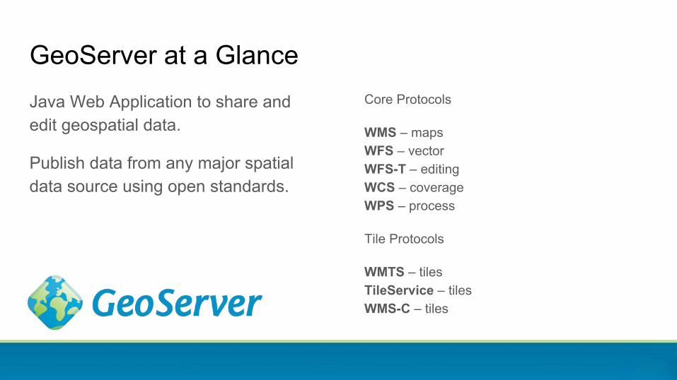
GeoServer at a GlanceJava Web Application to share and edit geospatial data.
Publish data from any major spatial data source using open standards.
Core Protocols
WMS – mapsWFS – vector WFS-T – editing WCS – coverageWPS – process
Tile Protocols
WMTS – tilesTileService – tilesWMS-C – tiles
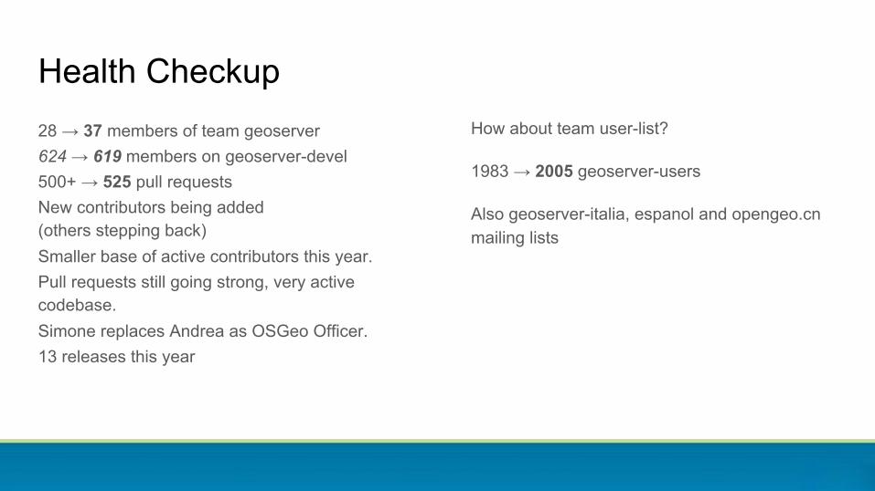
28 → 37 members of team geoserver624 → 619 members on geoserver-devel500+ → 525 pull requestsNew contributors being added(others stepping back)Smaller base of active contributors this year.Pull requests still going strong, very active codebase.Simone replaces Andrea as OSGeo Officer.13 releases this year
Health CheckupHow about team user-list?
1983 → 2005 geoserver-users
Also geoserver-italia, espanol and opengeo.cn mailing lists
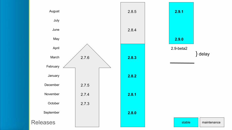
August 2.8.5 2.9.1
July
June 2.8.4
May 2.9.0
April 2.9-beta2
March 2.7.6 2.8.3
February
January 2.8.2
December 2.7.5
November 2.7.4 2.8.1
October 2.7.3
September 2.8.0
Releases stable maintenance
} delay
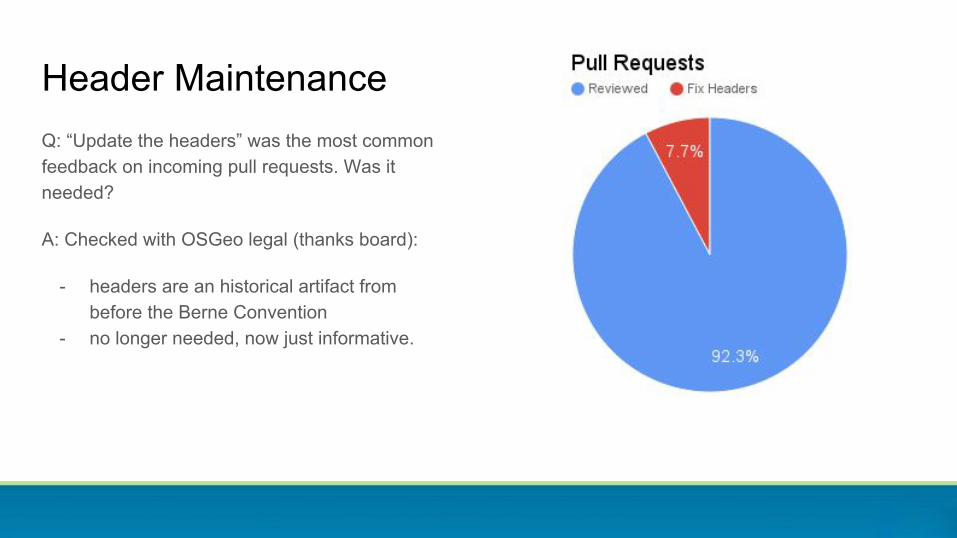
Q: “Update the headers” was the most common feedback on incoming pull requests. Was it needed?
A: Checked with OSGeo legal (thanks board):
- headers are an historical artifact from before the Berne Convention
- no longer needed, now just informative.
Header Maintenance
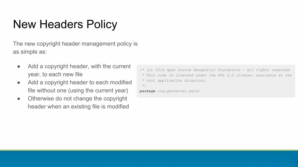
/* (c) 2016 Open Source Geospatial Foundation - all rights reserved * This code is licensed under the GPL 2.0 license, available at the * root application directory. */package org.geoserver.main;
New Headers PolicyThe new copyright header management policy is as simple as:
● Add a copyright header, with the current year, to each new file
● Add a copyright header to each modified file without one (using the current year)
● Otherwise do not change the copyright header when an existing file is modified

Configuration and management
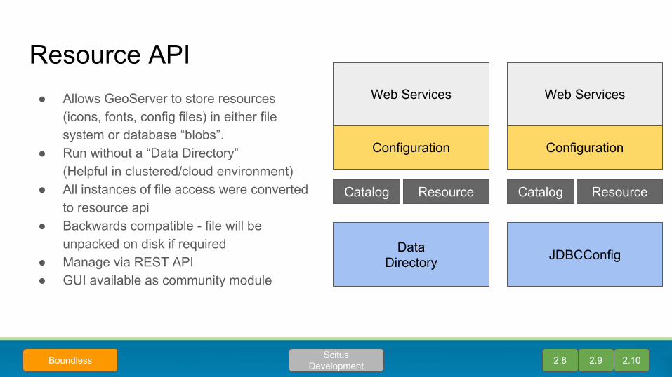
● Allows GeoServer to store resources(icons, fonts, config files) in either file system or database “blobs”.
● Run without a “Data Directory”(Helpful in clustered/cloud environment)
● All instances of file access were converted to resource api
● Backwards compatible - file will be unpacked on disk if required
● Manage via REST API● GUI available as community module
Resource API
2.8 2.9 2.10Scitus DevelopmentBoundless
Web Services
Configuration
DataDirectory
ResourceCatalog
Web Services
Configuration
JDBCConfig
ResourceCatalog
● Management of icons, fonts, configuration via REST API only?
● Community module provides a wicket user interface
Resource browser community module
2.10Scitus DevelopmentBoundless
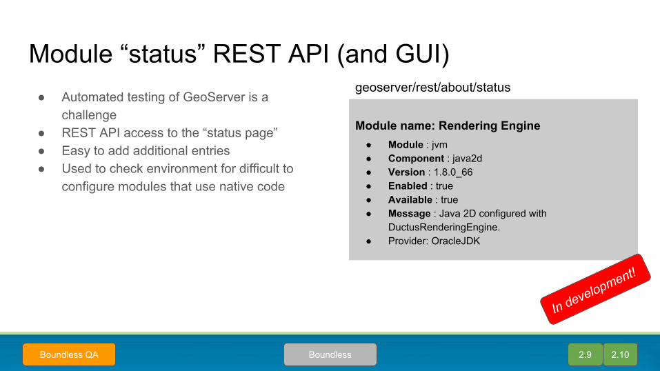
Module “status” REST API (and GUI)● Automated testing of GeoServer is a
challenge● REST API access to the “status page”● Easy to add additional entries● Used to check environment for difficult to
configure modules that use native code
2.9 2.10BoundlessBoundless QA
Module name: Rendering Engine● Module : jvm● Component : java2d● Version : 1.8.0_66● Enabled : true● Available : true● Message : Java 2D configured with
DuctusRenderingEngine.● Provider: OracleJDK
geoserver/rest/about/status
In development!
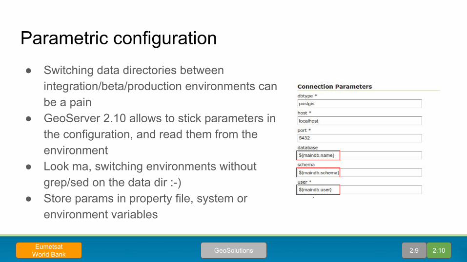
Parametric configuration● Switching data directories between
integration/beta/production environments can be a pain
● GeoServer 2.10 allows to stick parameters in the configuration, and read them from the environment
● Look ma, switching environments without grep/sed on the data dir :-)
● Store params in property file, system or environment variables
2.9 2.10GeoSolutionsEumetsatWorld Bank
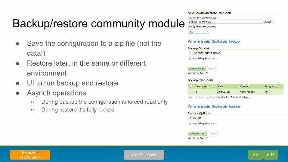
Backup/restore community module● Save the configuration to a zip file (not the
data!)● Restore later, in the same or different
environment● UI to run backup and restore● Asynch operations
○ During backup the configuration is forced read only○ During restore it’s fully locked
2.9 2.10GeoSolutionsEumetsatWorld Bank
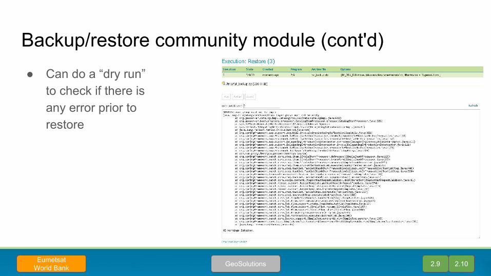
Backup/restore community module (cont'd)● Can do a “dry run”
to check if there is any error prior to restore
2.9 2.10GeoSolutionsEumetsatWorld Bank
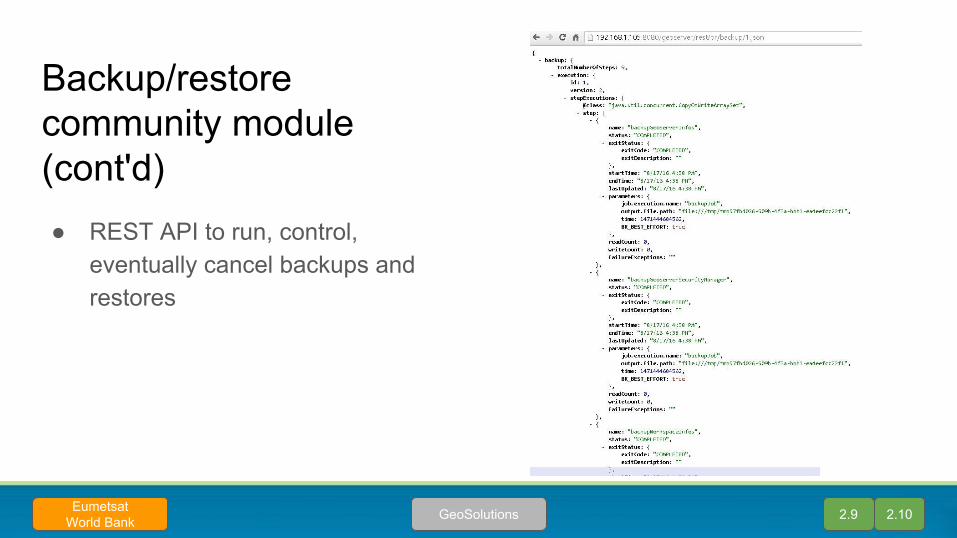
Backup/restore community module (cont'd)● REST API to run, control,
eventually cancel backups and restores
2.9 2.10GeoSolutionsEumetsatWorld Bank

Raster data sources
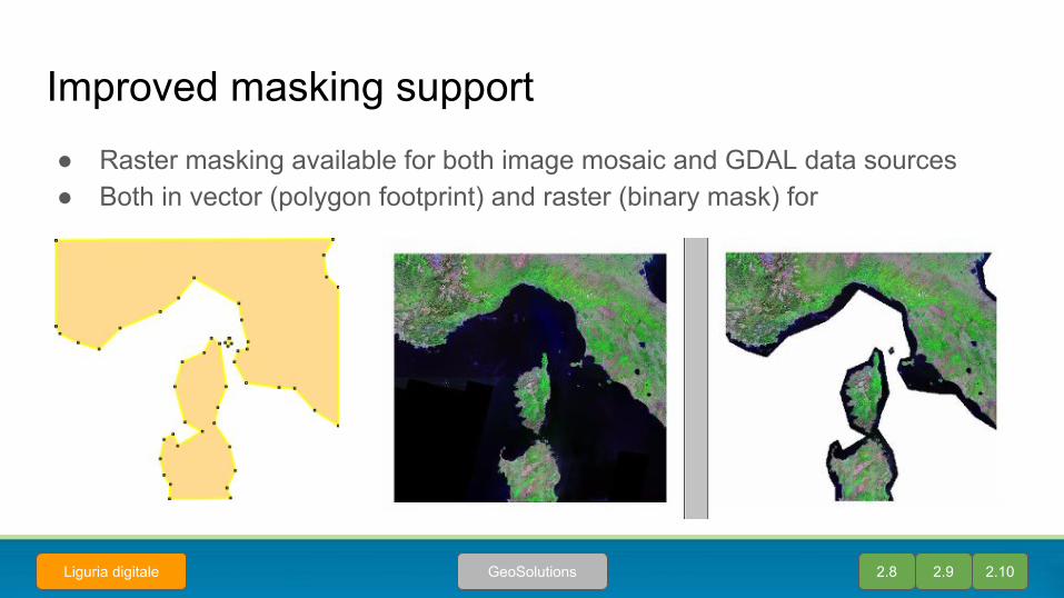
Improved masking support● Raster masking available for both image mosaic and GDAL data sources● Both in vector (polygon footprint) and raster (binary mask) for
2.8 2.9 2.10GeoSolutionsLiguria digitale

Heterogeneous mosaics - color models● Support for mosaics with sources in multiple color models
(RGB, gray, indexed), since 2.8.x
2.8 2.9 2.10GeoSolutions
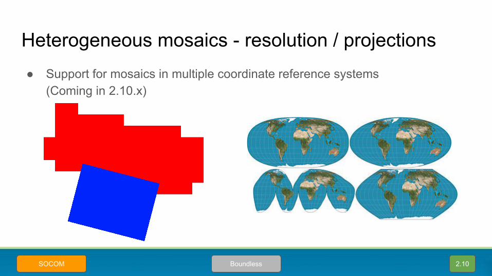
Heterogeneous mosaics - resolution / projections
2.10BoundlessSOCOM
● Support for mosaics in multiple coordinate reference systems(Coming in 2.10.x)
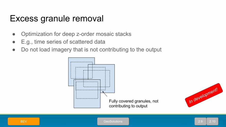
Excess granule removal ● Optimization for deep z-order mosaic stacks● E.g., time series of scattered data● Do not load imagery that is not contributing to the output
2.9 2.10GeoSolutionsBEV
In development!
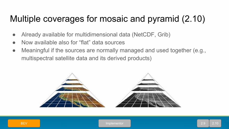
Multiple coverages for mosaic and pyramid (2.10)● Already available for multidimensional data (NetCDF, Grib)● Now available also for “flat” data sources● Meaningful if the sources are normally managed and used together (e.g.,
multispectral satellite data and its derived products)
2.9 2.10ImplementorBEV

Coverage view optimizations (2.10)● A coverage view allows to bind together bands from different coverages
coming from the same source (e.g., NetCDF)● Optimization to avoid reading all sources if the style is only using a subset of
the bands
A
B
C
CombinerSLD Style
selecting only A
Map
Hint about which bands are actually going to be
used
GeoSolutionsBEV 2.9 2.10
In development!
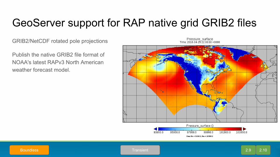
GeoServer support for RAP native grid GRIB2 files
2.9
GRIB2/NetCDF rotated pole projections
Publish the native GRIB2 file format of NOAA's latest RAPv3 North American weather forecast model.
2.10TransientBoundless

Maintenance &Technical Debt
● Relying on volunteer time to keep an eye on the codebase was not working out
○ team busy on customer work?○ backlog of bugs piling up
● Trying an experiment○ Once a month meeting○ Distributed, on-line code sprint
● When:○ First edition in July○ Second at the end of FOSS4G
Monthly bug fixing code sprints
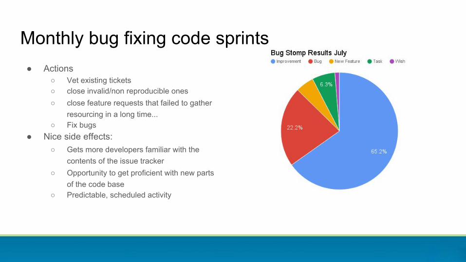
Monthly bug fixing code sprints● Actions
○ Vet existing tickets○ close invalid/non reproducible ones○ close feature requests that failed to gather
resourcing in a long time...○ Fix bugs
● Nice side effects:○ Gets more developers familiar with the
contents of the issue tracker○ Opportunity to get proficient with new parts
of the code base○ Predictable, scheduled activity
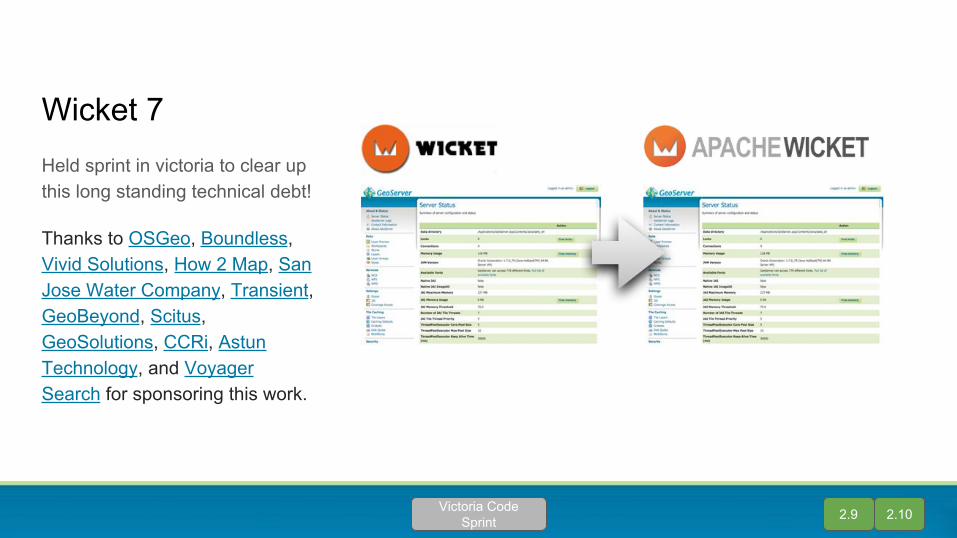
Wicket 7Held sprint in victoria to clear up this long standing technical debt!
Thanks to OSGeo, Boundless, Vivid Solutions, How 2 Map, San Jose Water Company, Transient, GeoBeyond, Scitus, GeoSolutions, CCRi, Astun Technology, and Voyager Search for sponsoring this work.
2.9 2.10Victoria Code Sprint

Java 8GeoServer now requires Java 8.
Why? What changed ...
- Traditionally GeoServer takes forever to support the latest Java- Oracle now charges for Java 7 security updates
2.9 2.10Joint EffortCommunity
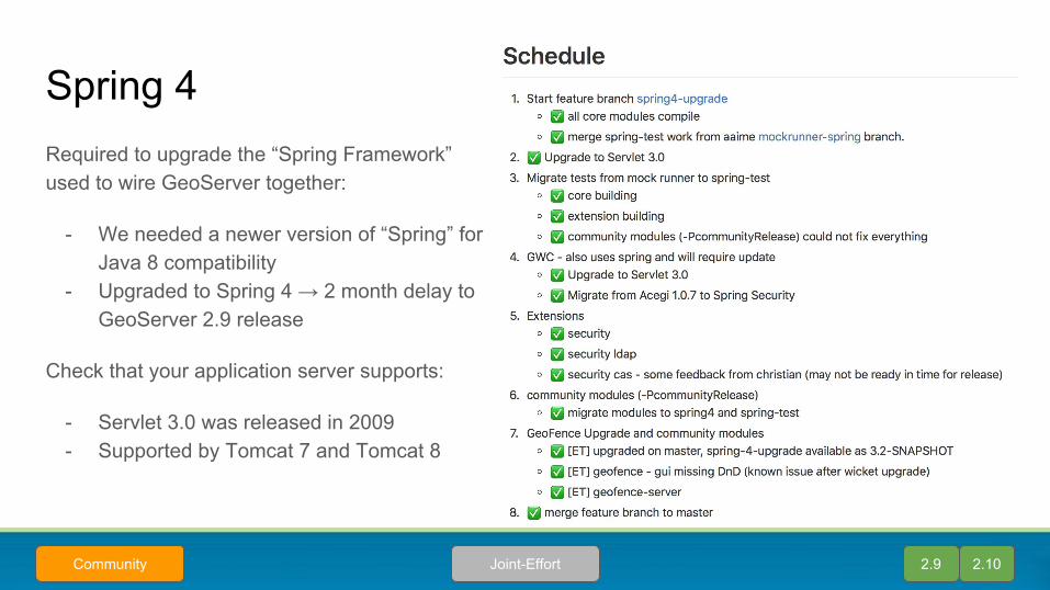
Required to upgrade the “Spring Framework” used to wire GeoServer together:
- We needed a newer version of “Spring” for Java 8 compatibility
- Upgraded to Spring 4 → 2 month delay to GeoServer 2.9 release
Check that your application server supports:
- Servlet 3.0 was released in 2009 - Supported by Tomcat 7 and Tomcat 8
Spring 4
2.9 2.10Joint-EffortCommunity
Styling
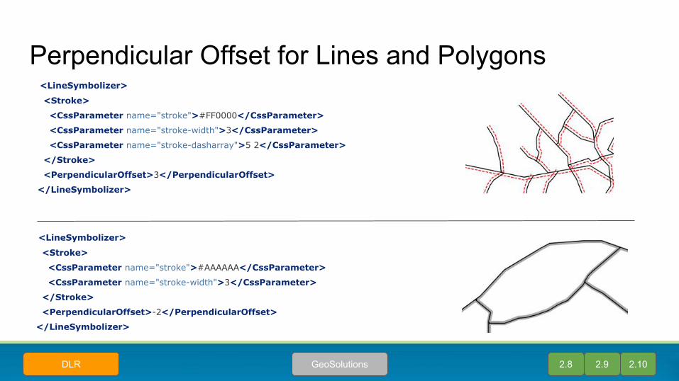
Perpendicular Offset for Lines and Polygons
<LineSymbolizer>
<Stroke>
<CssParameter name="stroke">#AAAAAA</CssParameter>
<CssParameter name="stroke-width">3</CssParameter>
</Stroke>
<PerpendicularOffset>-2</PerpendicularOffset>
</LineSymbolizer>
<LineSymbolizer>
<Stroke>
<CssParameter name="stroke">#FF0000</CssParameter>
<CssParameter name="stroke-width">3</CssParameter>
<CssParameter name="stroke-dasharray">5 2</CssParameter>
</Stroke>
<PerpendicularOffset>3</PerpendicularOffset>
</LineSymbolizer>
2.8 2.9 2.10GeoSolutionsDLR
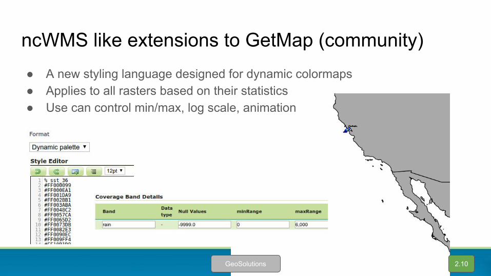
ncWMS like extensions to GetMap (community)● A new styling language designed for dynamic colormaps● Applies to all rasters based on their statistics● Use can control min/max, log scale, animation
2.10GeoSolutions
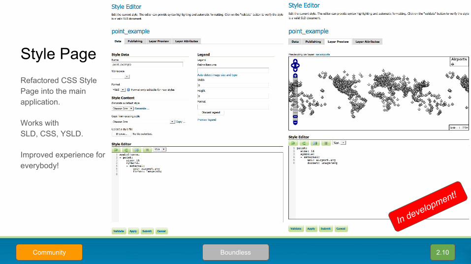
Style Page
2.10BoundlessCommunity
Refactored CSS Style Page into the main application.
Works withSLD, CSS, YSLD.
Improved experience for everybody!
In development!
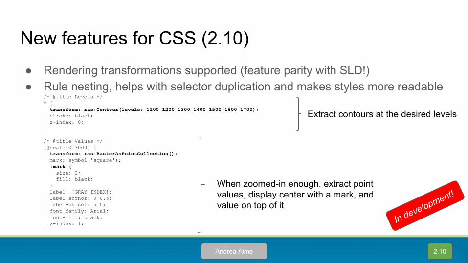
New features for CSS (2.10)● Rendering transformations supported (feature parity with SLD!)● Rule nesting, helps with selector duplication and makes styles more readable
/* @title Levels */* { transform: ras:Contour(levels: 1100 1200 1300 1400 1500 1600 1700); stroke: black; z-index: 0;}
/* @title Values */[@scale < 3000] { transform: ras:RasterAsPointCollection(); mark: symbol('square'); :mark { size: 2; fill: black; } label: [GRAY_INDEX]; label-anchor: 0 0.5; label-offset: 5 0; font-family: Arial; font-fill: black; z-index: 1;}
Extract contours at the desired levels
When zoomed-in enough, extract point values, display center with a mark, and value on top of it
2.10Andrea Aime
In development!
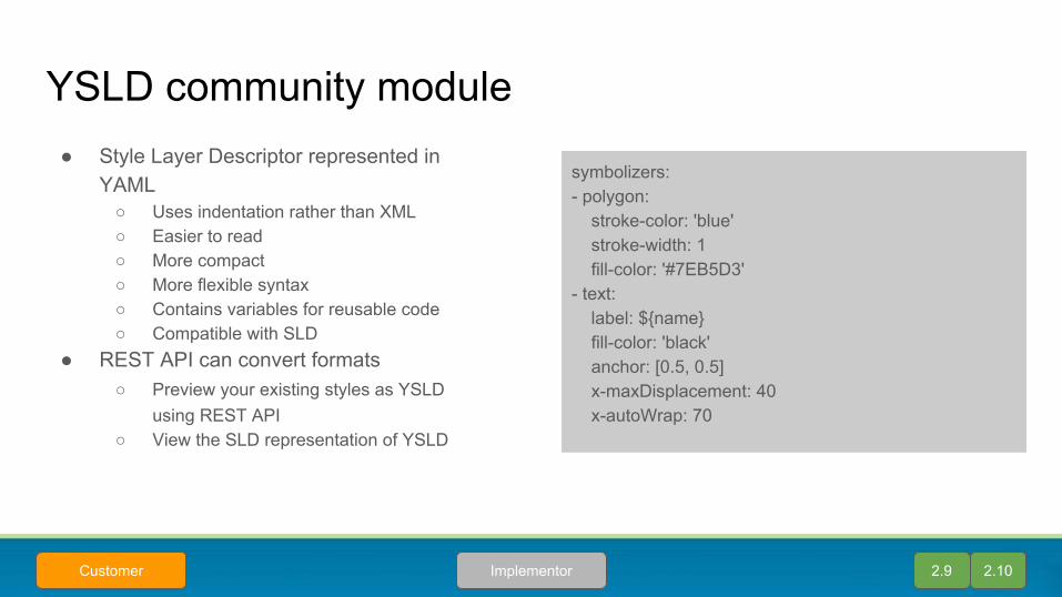
YSLD community module● Style Layer Descriptor represented in
YAML○ Uses indentation rather than XML○ Easier to read○ More compact○ More flexible syntax○ Contains variables for reusable code○ Compatible with SLD
● REST API can convert formats○ Preview your existing styles as YSLD
using REST API○ View the SLD representation of YSLD
2.9 2.10ImplementorCustomer
symbolizers:- polygon: stroke-color: 'blue' stroke-width: 1 fill-color: '#7EB5D3'- text: label: ${name} fill-color: 'black' anchor: [0.5, 0.5] x-maxDisplacement: 40 x-autoWrap: 70
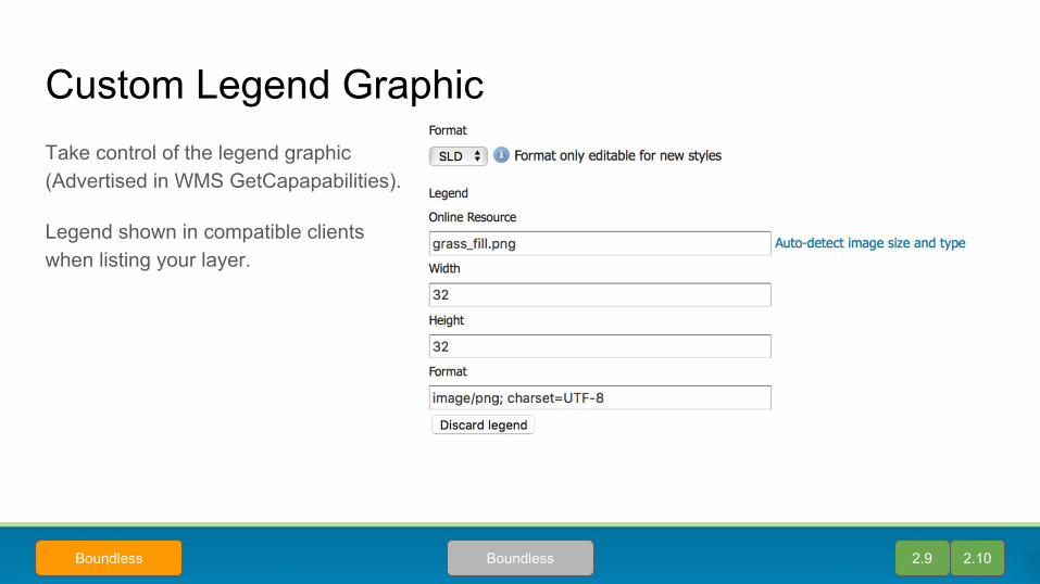
Custom Legend GraphicTake control of the legend graphic(Advertised in WMS GetCapapabilities).
Legend shown in compatible clients when listing your layer.
2.9 2.10BoundlessBoundless
WMS

image/vnd.jpeg-png● Smart format, chooses
between JPEG and PNG depending on image contents
● JPEG for max compression on fully opaque images
● PNG when transparency is needed
● Supported both in WMS and WMTS
PNG PNG PNG
PNG JPEG JPEG
2.9 2.10GeoSolutions
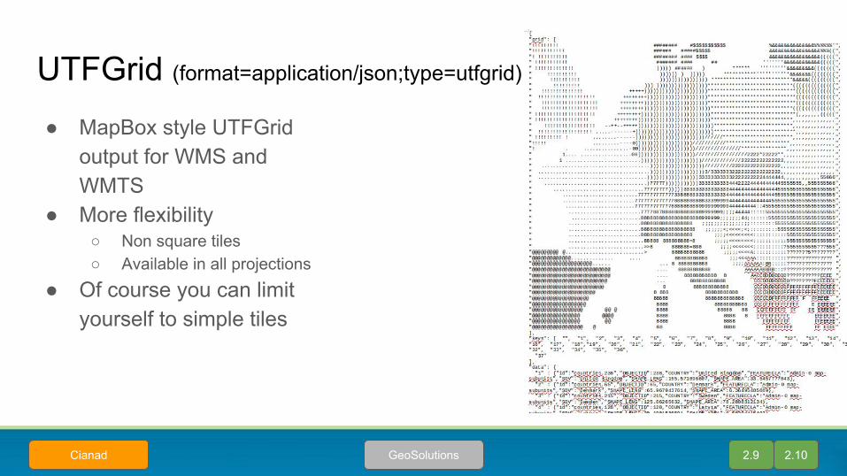
UTFGrid (format=application/json;type=utfgrid)
● MapBox style UTFGrid output for WMS and WMTS
● More flexibility○ Non square tiles○ Available in all projections
● Of course you can limit yourself to simple tiles
2.9 2.10GeoSolutionsCianad
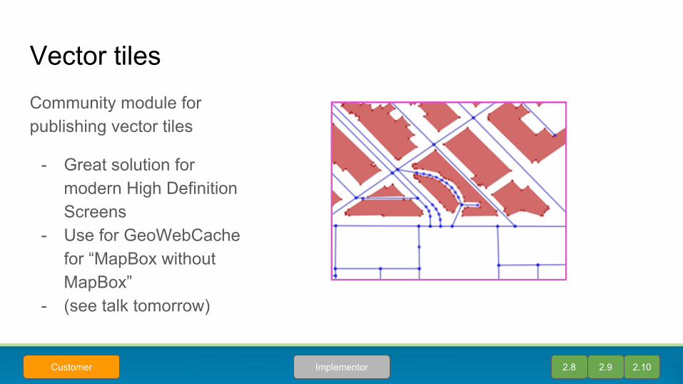
Vector tilesCommunity module for publishing vector tiles
- Great solution for modern High Definition Screens
- Use for GeoWebCache for “MapBox without MapBox”
- (see talk tomorrow)
2.8 2.9 2.10ImplementorCustomer
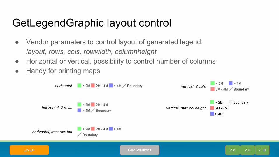
GetLegendGraphic layout control● Vendor parameters to control layout of generated legend:
layout, rows, cols, rowwidth, columnheight● Horizontal or vertical, possibility to control number of columns● Handy for printing maps
horizontal
horizontal, 2 rows
horizontal, max row len
vertical, 2 cols
vertical, max col height
2.8 2.9 2.10GeoSolutionsUNEP

WFS
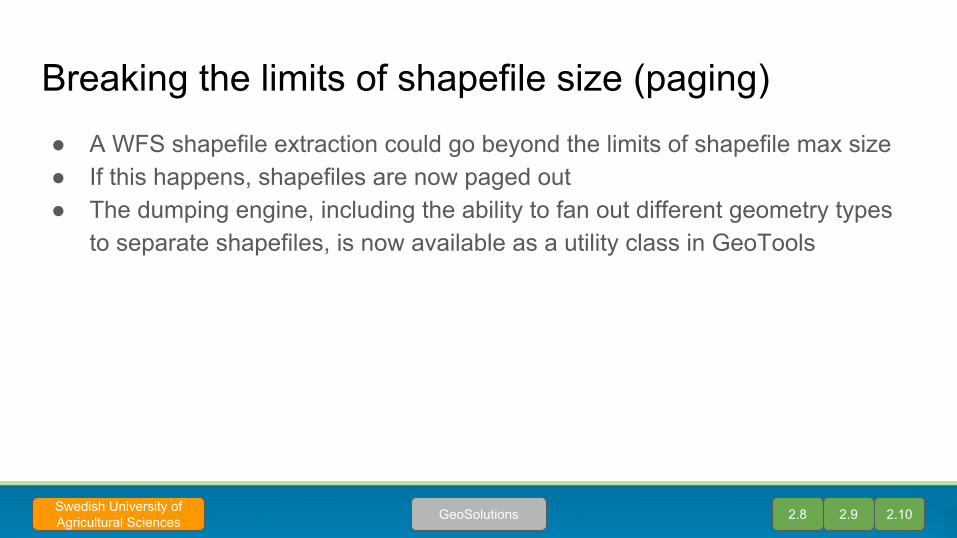
Breaking the limits of shapefile size (paging)● A WFS shapefile extraction could go beyond the limits of shapefile max size● If this happens, shapefiles are now paged out● The dumping engine, including the ability to fan out different geometry types
to separate shapefiles, is now available as a utility class in GeoTools
2.8 2.9 2.10GeoSolutionsSwedish University of Agricultural Sciences
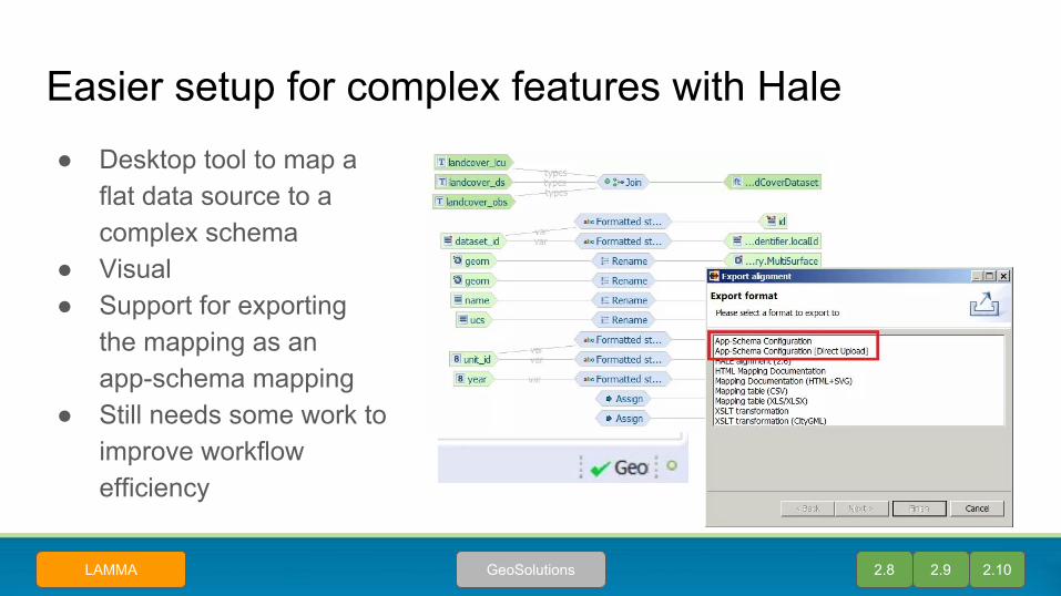
Easier setup for complex features with Hale● Desktop tool to map a
flat data source to a complex schema
● Visual● Support for exporting
the mapping as an app-schema mapping
● Still needs some work to improve workflow efficiency
2.8 2.9 2.10GeoSolutionsLAMMA
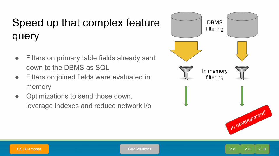
Speed up that complex feature query
● Filters on primary table fields already sent down to the DBMS as SQL
● Filters on joined fields were evaluated in memory
● Optimizations to send those down, leverage indexes and reduce network i/o
2.8 2.9 2.10GeoSolutionsCSI Piemonte
In memoryfiltering
DBMSfiltering
In development!

Tiling
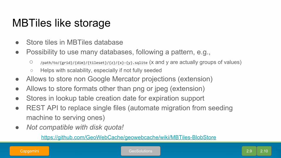
MBTiles like storage● Store tiles in MBTiles database● Possibility to use many databases, following a pattern, e.g.,
○ /path/to/{grid}/{dim}/{tileset}/{z}/{x}-{y}.sqlite (x and y are actually groups of values)○ Helps with scalability, especially if not fully seeded
● Allows to store non Google Mercator projections (extension)● Allows to store formats other than png or jpeg (extension)● Stores in lookup table creation date for expiration support● REST API to replace single files (automate migration from seeding
machine to serving ones)● Not compatible with disk quota!
https://github.com/GeoWebCache/geowebcache/wiki/MBTiles-BlobStore
2.9 2.10GeoSolutionsCapgemini
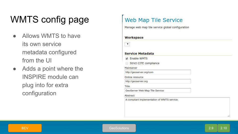
WMTS config page● Allows WMTS to have
its own service metadata configured from the UI
● Adds a point where the INSPIRE module can plug into for extra configuration
2.9 2.10GeoSolutionsBEV
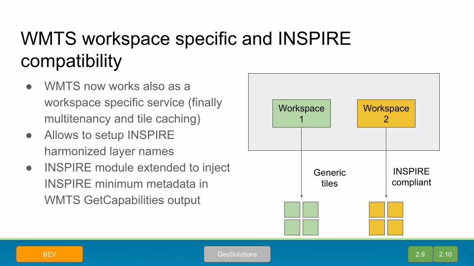
WMTS workspace specific and INSPIRE compatibility● WMTS now works also as a
workspace specific service (finally multitenancy and tile caching)
● Allows to setup INSPIRE harmonized layer names
● INSPIRE module extended to inject INSPIRE minimum metadata in WMTS GetCapabilities output
Workspace1
Workspace 2
INSPIREcompliant
Generic tiles
2.9 2.10GeoSolutionsBEV
WMS/WMTS ND discovery extensions
● Data with N dimensions (time, elevation, custom ones)● Dimensions can be related (forecasts, time and run time), the data can be
scattered (remote sensing)● Add extra calls to query the domains. Like, if I fix a given time and bbox, what
residual ranges of elevations and run-times are available?● Add extra calls to list specific items in a small domain (full enumeration of
possible combinations
2.9 2.10GeoSolutionsBEV

WPS
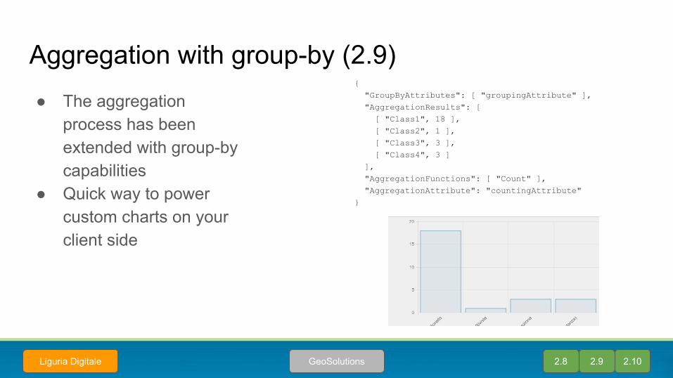
Aggregation with group-by (2.9)● The aggregation
process has been extended with group-by capabilities
● Quick way to power custom charts on your client side
{ "GroupByAttributes": [ "groupingAttribute" ], "AggregationResults": [ [ "Class1", 18 ], [ "Class2", 1 ], [ "Class3", 3 ], [ "Class4", 3 ] ], "AggregationFunctions": [ "Count" ], "AggregationAttribute": "countingAttribute"}
2.8 2.9 2.10GeoSolutionsLiguria Digitale

Improved WPS resource control (2.10)● Processes are run in thread pools, they
can wait for their execution slot in queue● Separate control for total time, and pure
execution time
2.10utas.edu.au
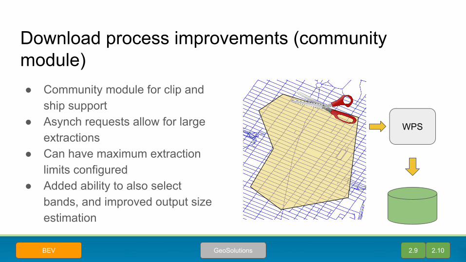
Download process improvements (community module)● Community module for clip and
ship support● Asynch requests allow for large
extractions● Can have maximum extraction
limits configured● Added ability to also select
bands, and improved output size estimation
WPS
2.9 2.10GeoSolutionsBEV

Large raster extraction optimizations
● Optimizing many concurrent large masked raster extractions via Download process (e.g. 128 concurrent requests at the bigtiff threshold)
● Improved both scalability and reliability under sustained load on a “big iron” (40 cores, 128GB memory)
2.9 2.10GeoSolutions 2.8

Security
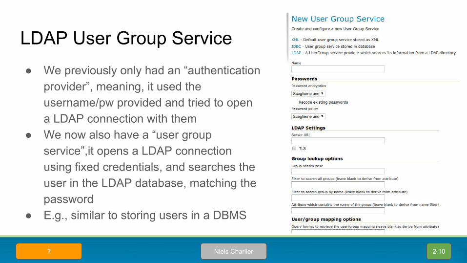
LDAP User Group Service● We previously only had an “authentication
provider”, meaning, it used the username/pw provided and tried to open a LDAP connection with them
● We now also have a “user group service”,it opens a LDAP connection using fixed credentials, and searches the user in the LDAP database, matching the password
● E.g., similar to storing users in a DBMS
2.10Niels Charlier?
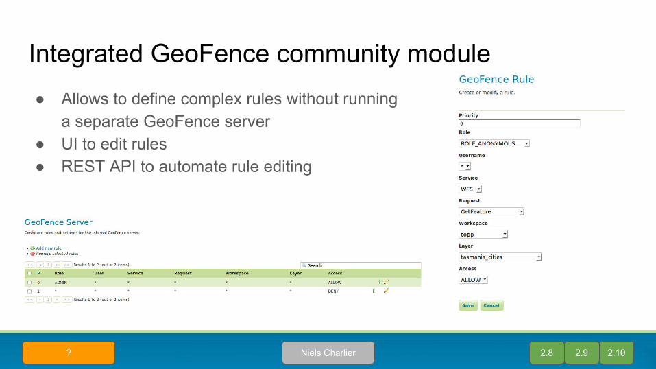
Integrated GeoFence community module● Allows to define complex rules without running
a separate GeoFence server● UI to edit rules● REST API to automate rule editing
2.8 2.9 2.10Niels Charlier?

Integrated GeoFence community module (cnt’d)● Separate page for “admin” rules, that is, rules
controlling administration level access● Used to setup workspace specific admins and
the like
2.8 2.9 2.10GeosolutionsCamp2Camp

Research, Developmentand other news
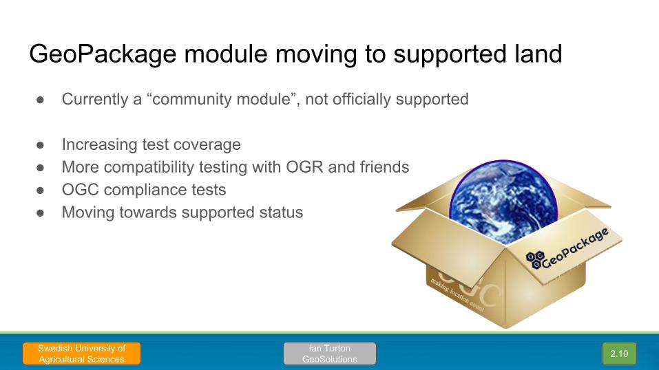
GeoPackage module moving to supported land● Currently a “community module”, not officially supported
● Increasing test coverage● More compatibility testing with OGR and friends● OGC compliance tests● Moving towards supported status
2.10Ian TurtonGeoSolutions
Swedish University of Agricultural Sciences
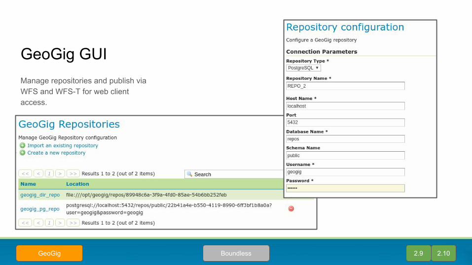
GeoGig GUIManage repositories and publish via WFS and WFS-T for web client access.
2.9 2.10BoundlessGeoGig
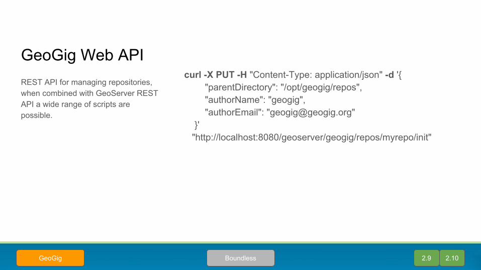
GeoGig Web APIcurl -X PUT -H "Content-Type: application/json" -d '{ "parentDirectory": "/opt/geogig/repos", "authorName": "geogig", "authorEmail": "[email protected]" }' "http://localhost:8080/geoserver/geogig/repos/myrepo/init"
REST API for managing repositories, when combined with GeoServer REST API a wide range of scripts are possible.
2.9 2.10BoundlessGeoGig

Looking Ahead
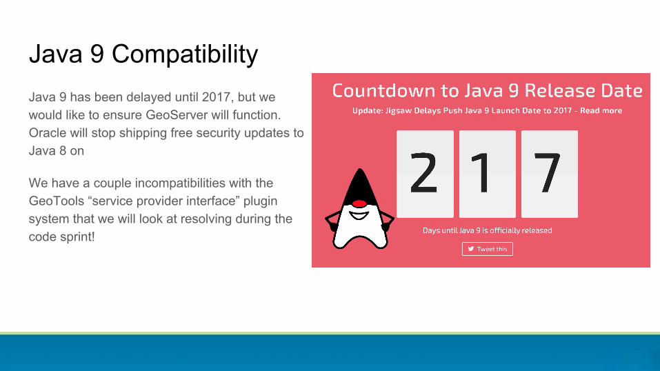
Java 9 CompatibilityJava 9 has been delayed until 2017, but we would like to ensure GeoServer will function. Oracle will stop shipping free security updates to Java 8 on
We have a couple incompatibilities with the GeoTools “service provider interface” plugin system that we will look at resolving during the code sprint!

The Java Advanced Imaging library enables GeoServer to do all kinds of great image processing! The JAI-EXT project extends this library with replacement no-data / footprint aware operations.
Sadly Oracle has not maintained the project, and has not released it as open source.
(see Replace-JAI on GeoTools wiki)
Raster Processing EngineJoint OSGeo / LocationTech game plan:
● Raster Processing Engine APIdefinition of raster-processing-api
● Raster Processing Enginereference pure-java implementation
● Raster Processing Wrapperbenchmark jai-wrapper implementation
● GeoTools Replace JAImigrate to raster processing engine api and coordinate transition affected projects (GeoServer, GeoNode, uDig, GeoScript, etc...)

Thanks!