state of geospatial bigdata - university of redlands...@mraad 2016 hql drop table if exists logs;...
TRANSCRIPT

@mraad 2016
Mansour Raad thunderheadxpler.blogspot.com
[email protected] @mraad
State of Geospatial BigData

@mraad 2016
“WHERE” IS UBIQUITOUS !

@mraad 2016
• Where is the closest ATM ?
• Where is the best location to place my store ?
• Where is UBL ?
• Where is the next Ebola/Zika outbreak ?

@mraad 2016
A BIT OF HISTORY…
With Esri Specifically :-)

@mraad 2016
~1990

@mraad 2016
http://en.wikipedia.org/wiki/Shapefile

@mraad 2016
1995

@mraad 2016
RDBMS ID,Name,Address,Lat,Lon
Spatial Data Engine
APITCP/IP
SQL

@mraad 2016
>1996-2005

@mraad 2016
RDBMS ID,Name,Address,Lat,Lon
xDBC

@mraad 2016
SPATIAL INDEXING
http://en.wikipedia.org/wiki/Spatial_database#Spatial_index

@mraad 2016
QUADTREE
http://en.wikipedia.org/wiki/Quadtree

@mraad 2016
R-TREE
http://en.wikipedia.org/wiki/R-tree

@mraad 2016
(NOT SO) MODERN DAY…

@mraad 2016
STORY TIME…

@mraad 2016
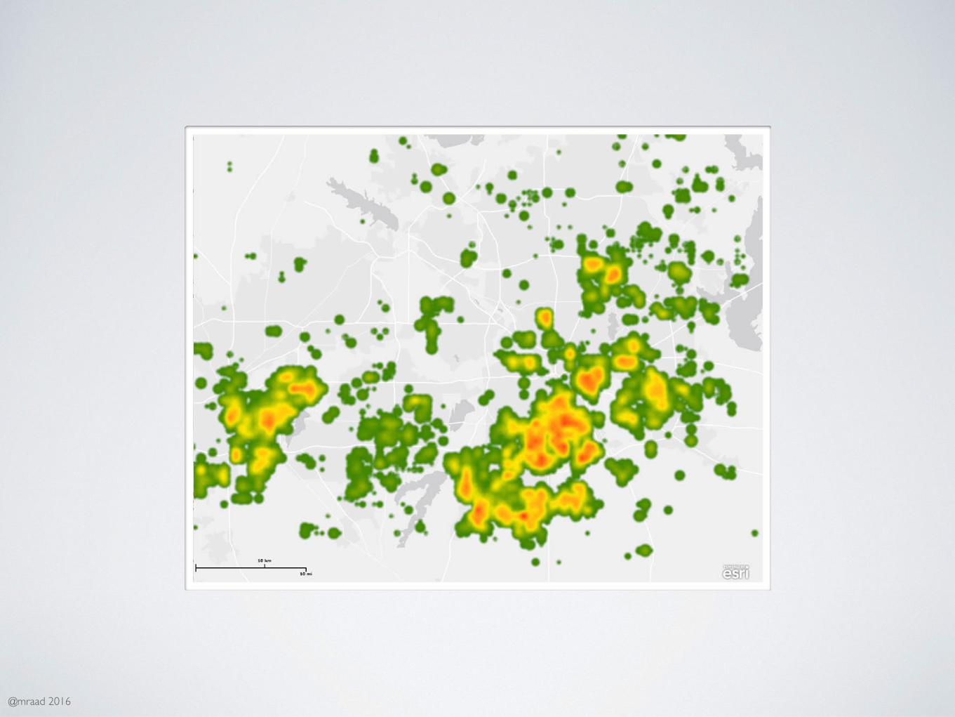
U.S.Demographic
Data

@mraad 2016

@mraad 2016
FOR EACH LOCATIONFOR EACH DEMOGRAPHIC
⬇50 MILE HEATMAP
@mraad 2016

@mraad 2016
TRADITIONAL MEANS…
14 Days
850 GB Raster Files

@mraad 2016
BETTER WAY ?

@mraad 2016

@mraad 2016

@mraad 2016

@mraad 2016

@mraad 2016

@mraad 2016
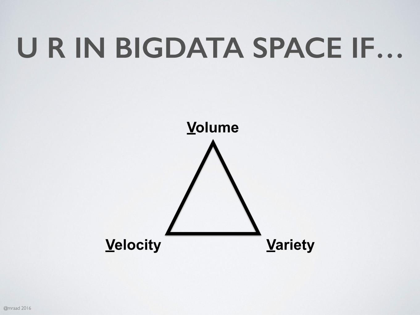
BIG DATA ?
@mraad 2016
U R IN BIGDATA SPACE IF…
Volume
Velocity Variety

@mraad 2016
BUT THEN I’VE SEEN…
Volume Velocity Variety
Veracity Validity
Visualization Vulnerability
Value
→ data at rest → data in motion → many types → data in doubt → data that is correct → data in patterns → data at risk → data that is meaningful

@mraad 2016
I’M STICKING WITH…
Volume
Velocity Variety

@mraad 2016

@mraad 2016
NOSQL(NOT ONLY SQL :-)

@mraad 2016
GEOJSON
http://geojson.org/

@mraad 2016
{ "type": "Feature", "geometry": { "type": "Point", "coordinates": [125.6, 10.1] }, "properties": { "name": "Dinagat Islands" }}

@mraad 2016
• Points
• Lines
• Polygons
• Multipoints
• Multilines
• Multipolygons
• Geometry Collection

@mraad 2016
Key1→Value1Key2→Value2…KeyN→ValueN
Sorted
byte[] byte[]

@mraad 2016
GEOHASH
http://en.wikipedia.org/wiki/Geohash

@mraad 2016
00 10-180 180
-90
90
01 11
if left of vertical center set left bit to 0 else 1if lower of horizontal center set right bit 0 else 1

@mraad 2016
0000 1000-180 180
-90
90
0100 1100
0010
0001 0011
1111

@mraad 2016
0000 1000-180 180
-90
90
0100 1100
0010
0001 0011
1111

@mraad 2016
0000 1000-180 180
-90
90
0100 1100
0010
0001 0011
1111

@mraad 2016
SPACE FILLING CURVES~ 1880

@mraad 2016
N DIM→1DIM

@mraad 2016
HILBERT CURVE
http://en.wikipedia.org/wiki/Space-filling_curve

@mraad 2016
SPACE LINEARIZATION
@mraad 2016
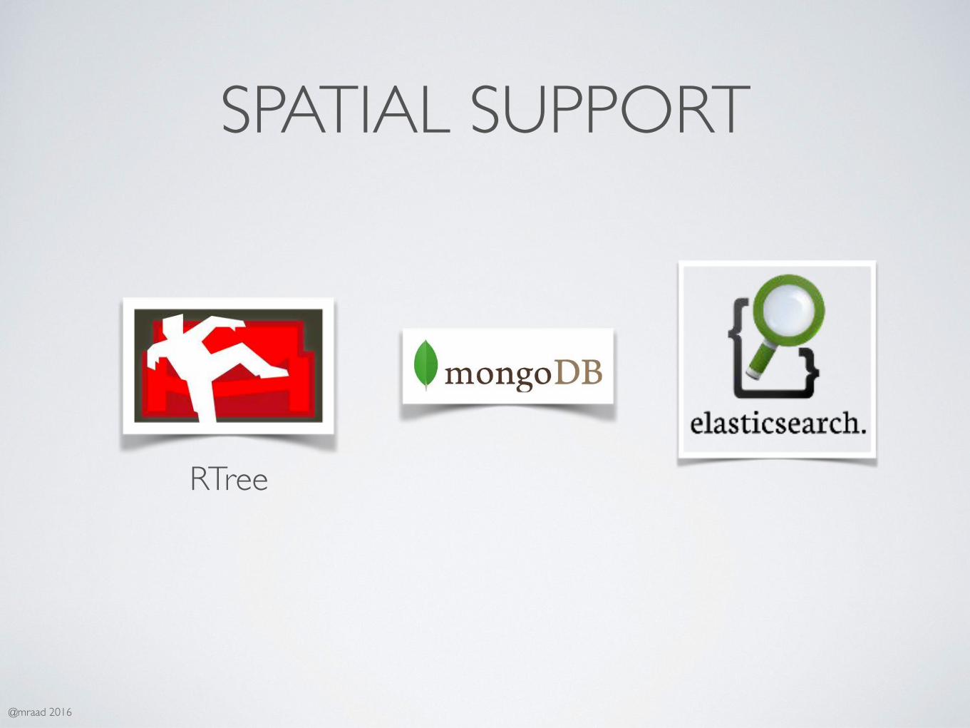
SPATIAL SUPPORT
RTree

@mraad 2016
INDIRECT SUPPORT

@mraad 2016
WHAT IS OLD…IS NEW AGAIN !

@mraad 2016
SPATIAL MIDDLEWARE

@mraad 2016
NoSQL ID,Name,Address,Lat,Lon
Spatial Data Engine
http://ws://
NoSQLAPI

@mraad 2016
NOT A BIGGER OX…

@mraad 2016
HADOOP.APACHE.ORG

@mraad 2016
WHAT’S IN A NAME ?
http://blog.pivotal.io/pivotal/products/demystifying-hadoop-in-5-pictures

@mraad 2016
WHAT IS HADOOP ?
• Library / Framework
• Very Very Large Un/Structured Dataset
• Multi Node Distributed Processing
• Resilient To Commodity Hardware Failure

@mraad 2016
HADOOP BASIC STACK
Hadoop Distributed File System (HDFS)
Yet Another Resource Negotiator (YARN)
Commodity Servers
MapReduce

@mraad 2016
OTHER HADOOP PROJECTS• Avro - Serialization / RPC System
• HBase - Distributed Columnar Database
• Hive - Ad Hoc “SQL” Interface
• Pig - Data Flow Parallel Execution (AML)
• ZooKeeper - Coordination Service
• More….

@mraad 2016
HDFS• Distributed File System
• Lots and Lots of Commodity Drives
• Fault Tolerant
• Loves Big Files
• “POSIX” Like Interface

@mraad 2016
HDFS
NameNode
DataNode DataNode DataNode
HDFS Client

@mraad 2016
HDFS Resilience !HDFS
DataNode DataNode DataNode

@mraad 2016
BigData
Program
☓

@mraad 2016
BigData
Program

@mraad 2016
MAPREDUCE
http://hadoop.apache.org/docs/r1.2.1/mapred_tutorial.html

@mraad 2016
WHAT IS MAPREDUCE ?• Parallel Fault Tolerant Framework
• Splits Large Input
• Invoke User Defined “Map” Function
• Shuffle and Sort
• Invoke User Defined “Reduce” Function

@mraad 2016
MAPREDUCE & HDFS
Data Node
Task Tracker
Data Node
Task Tracker
Data Node
Task Tracker
Name Node
Job TrackerClient
.jar

@mraad 2016
WRITING MR IS HARD…

@mraad 2016
HOW ABOUT….NO PROGRAMING ???

@mraad 2016

@mraad 2016
APACHE HIVE
“SQL” ⬇
MapReduce Job

@mraad 2016
HQLdrop table if exists logs;
create external table if not exists logs( ip string, method string, uri string, status string, bytes int, time_taken int, referrer string, user_agent string ) partitioned by (year int, month int, day int, hour int) row format delimitedfields terminated by '\t' lines terminated by '\n' stored as textfile location ‘hdfs://hadoop:8020/logs/';

@mraad 2016
OTHER ADHOC ENGINES
• Cloudera Impala
• Facebook Presto
• SparkSQL
• Bypass MR generation / Direct HDFS Access

@mraad 2016
WHAT ABOUT SPATIAL ?

@mraad 2016

@mraad 2016
GIS TOOLS FOR HADOOP
• Computational Geometry Library
• Hive Spatial UDF Functions
• GeoProcessing Extensions to ArcMap

@mraad 2016
GEOMETRY LIBRARY• Points / Lines / Polygons
• I/O (GeoJSON,WTK,WBT,Shape)
• Spatial Relations (inside, touches, intersects,…)
• Spatial Operations (buffer, cut, convex hull,…)
• In-Memory Spatial Index
@mraad 2016
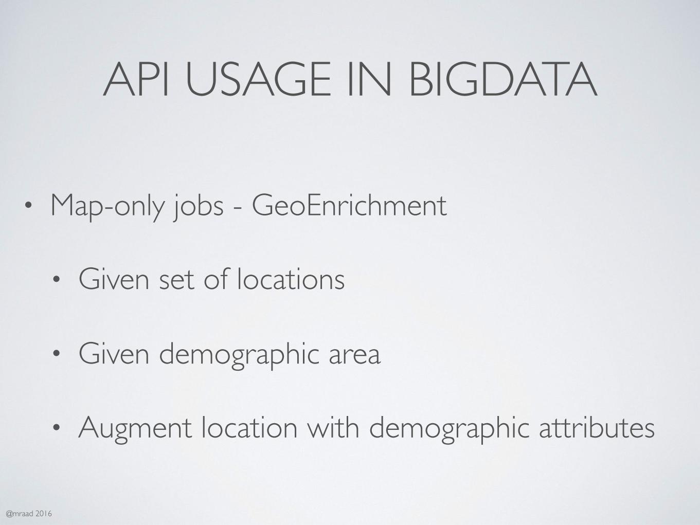
API USAGE IN BIGDATA
• Map-only jobs - GeoEnrichment
• Given set of locations
• Given demographic area
• Augment location with demographic attributes

@mraad 2016

@mraad 2016

@mraad 2016

@mraad 2016
TELCO• CDR - Call Data Record
• DateTime, UUID, LatLon, Duration, Status, etc…
• Drop Call Emerging HotSpot
• Street Traffic Condition
• Massive Spatial Join million x million polygon
• Overlay with Demographic polygons
• Overlay with Current Weather
• Overlay with Social Media

@mraad 2016
TELEMATICS• Feedback to Engineering
• Car to Car Communication
• Street Condition Detection
• Best Route Prediction (EV)
• Overlay with weather

@mraad 2016
Insurance as you drive !

@mraad 2016
Observations

@mraad 2016

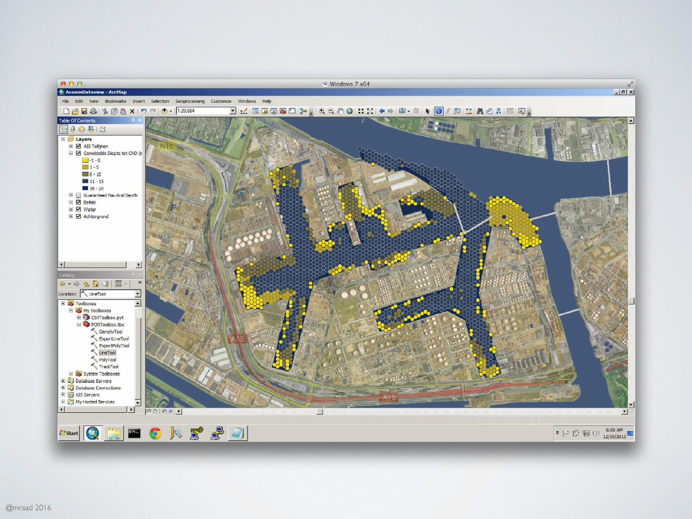
‹#›A Hadoop-enabled Ship Tracking Application for the Port of Rotterdam, Hadoop Summit Brussels, 15 April 2015 © Copyright - Port of Rotterdam
Title
Frank Cremer (Geomatik) Mansour Raad (ESRI)
A Hadoop-enabled Ship Tracking Application for the Port of Rotterdam
Hadoop Summit, Brussels, 15 April 2015

‹#›A Hadoop-enabled Ship Tracking Application for the Port of Rotterdam, Hadoop Summit Brussels, 15 April 2015 © Copyright - Port of Rotterdam
Image
Access information in three clicks

‹#›A Hadoop-enabled Ship Tracking Application for the Port of Rotterdam, Hadoop Summit Brussels, 15 April 2015 © Copyright - Port of Rotterdam
Text
Usage of ship position data
• Harbour master • Incident analysis • Safety checks
• Capacity management • Identifying bottlenecks • Planning decision support
• Environmental management • Pollution (NOx) calculations • Speed measures to reduce pollutions
?

@mraad 2016
DdΔ
(Lat,lon)
WhereisΔ≃0?
@mraad 2016

@mraad 2016

@mraad 2016

@mraad 2016
Selected'pickups' Corresponding'drop2offs' Density'of'passenger'drop2offs'
Turtle'Bay'–'UN'

@mraad 2016
Shu$le'Loca,ons'!!!!!!!!!!Pickup!!!!!!!!!!!Drop+off!

Mission: Fast Dynamic Segmentation for Linear Referencing

Segment (L-M) has Green, Blue, Red attributes
Event From Mile M to P
Mile M Mile PMile L

Step 1 - Clean and Bulk Load Roads
Roads.gdb Features
ElasticSearch { roadid:”state_code_road_id”, shape: “wkt-string” }
BulkLoad Feature - {json}

Step 2 - New Dyn-Seg GeoProcess
10M Eventsyear statecode routeid mile1 mile2 key val
Parallel Distributed
Share-Nothing “GeoProcessing”
Clean Roads ElasticSearchIndex Every Document/Field { roadid=“xxx” wkt=“multilinestring(((x y,…) IRI=1 F_SYSTEM=2 …. }
{json}

Step 3 - Query and Display
ArcPy
ArcGISElasticSearch

DataCenters


ArcGIS → Nerdalize
sshd
ElasticSearch DynSeg GP
nerdalize.comArcPy


@mraad 2016
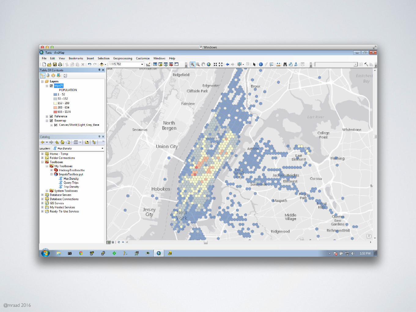
YOU CAN DO IT TOO !

@mraad 2016

@mraad 2016

@mraad 2016

@mraad 2016
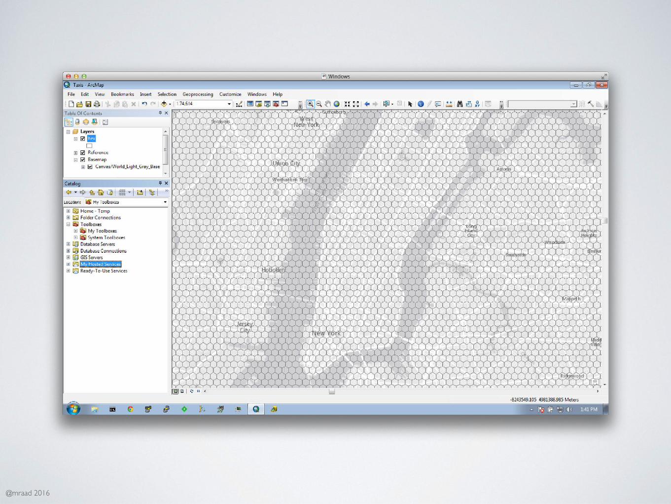
~180 million entries - small :-)

@mraad 2016
IMPORT BY TIME/SPACE
*.csv MRImport hdfs://…/yyyy/mm/dd/hh/uuid.csv
@mraad 2016
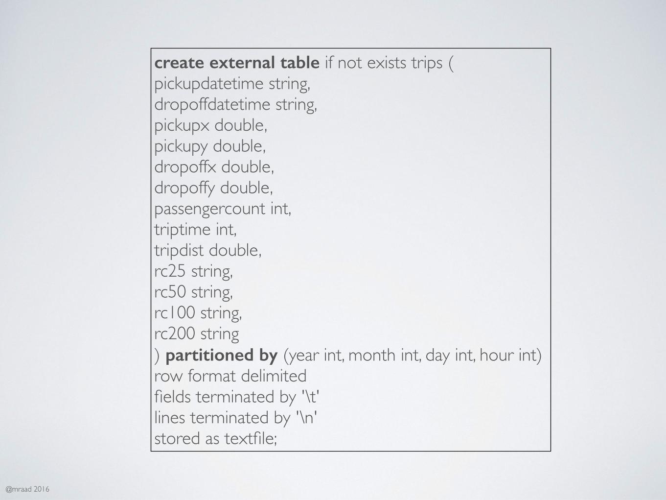
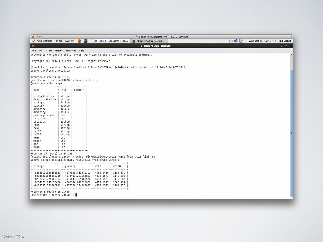
create external table if not exists trips (pickupdatetime string,dropoffdatetime string,pickupx double,pickupy double,dropoffx double,dropoffy double,passengercount int,triptime int,tripdist double,rc25 string,rc50 string,rc100 string,rc200 string) partitioned by (year int, month int, day int, hour int)row format delimitedfields terminated by '\t'lines terminated by '\n'stored as textfile;

@mraad 2016

@mraad 2016

@mraad 2016

@mraad 2016

@mraad 2016

@mraad 2016
@mraad 2016
@mraad 2016
@mraad 2016

@mraad 2016
STATISTICAL SIGNIFICANCE ?

@mraad 2016
HOTSPOT ANALYSIS
http://resources.arcgis.com/en/help/main/10.1/index.html#//005p00000010000000

@mraad 2016
PROCESSING EVOLUTION
Transaction - Batch
Operational - Dashboard
Analytics - Exploration
Intelligent - Realtime / Predictive

@mraad 2016
WHAT IS NEXT ?• In Memory
• Native Spatial Index In NoSQL DB
• Native Spatial Types (Point, Line, …)
• Out-of-the-box Spatial Operators / Operations
• Distributed/Disconnected GPU Integration
• Visualization via Gamification
