state of idaho department of environmental …
TRANSCRIPT
( If, .2
BLUE GULCH PRELIMINARY ASSESSMENT REPORT
OWYHEE COUNTY, IDAHO
STATE OF IDAHO
DEPARTMENT OF ENVIRONMENTAL QUALITY
December 2004
Submitted to: U.S. Environmental Protection Agency
Region 10 1200 Sixth Avenue Seattle, WA 98101

TABLE OF CONTENTS
TABLE OF CONTENTS 2
LIST OF FIGURES 3
LIST OF TABLES 3
LIST OF ACRONYMS 3
1. INTRODUCTION 4
2. SITE BACKGROUND 5
2.1. SITE LOCATION 5
2.2. SITE DESCRIPTION/OWNERSHIP HISTORY 6
2.3 SITE OPERATIONS AND WASTE CHARACTERISTICS 9
2.4 DEQ ACTIONS 9
3. MIGRATION/EXPOSURE PATHWAYS AND TARGETS 15
3.1 GROUND WATER MIGRATION PATHWAY 15
3.2 AIR MIGRATION PATHWAy 16
3.3 SOIL EXPOSURE PATHWAY 16
3.4 SURFACE WATER MIGRATION PATHWAY 17
4.0 SUMMARY AND CONCLUSIONS 18
REFERENCES 22
APPENDIX A SITE PHOTOGRAPHS 23
APPENDIX B ANALYTICAL RESULTS 37
2

LIST OF FIGURES
Figure 2-1 Figure 2-2 Figure 2-3 Figure 3-1 Figure 3-2 Figure 3-3
Site Vicinity Map Blue Gulch Site Map Site Map and Soil Sampling Locations 4-Mile Radius Map IS-Mile Map I-Mile Radius Map
8 13 14 19 20 21
LIST OF TABLES
Table 1 Soil and Surface Water Sample Data 38
LIST OF ACRONYMS
Acronym
amsl
Definition
above mean sea level
ATV
BLM
DEQ
EPA
gpm
PPE
TDL
TMDL
All Terrain Vehicle
United States Bureau of Land Management
Department of Environmental Quality
United States Environmental Protection Agency
gallons per minute
Probable Point of Entry
Target Distance Limit
Total Maximum Daily Load
3

1. INTRODUCTION
The Idaho Department of Environmental Quality (DEQ) was contracted by Region 10 of the United States Environmental Protection Agency (EPA) to provide technical support for completion of a preliminary assessment (PA) of Blue Gulch located near Silver City, Idaho in Owyhee County. DEQ completed PA activities in accordance with the goals listed below.
The specific goals for the Blue Gulch PA, identified by DEQ, are to:
• Determine the potential threat to public health or the environment posed by the site. • Determine the potential for a release of hazardous constituents into the environment. • Determine the potential for placement of the site on the National Priorities List.
Completion of the PA included reviewing existing site information, collecting receptor information within the site's range of influence, determining regional characteristics, and conducting a site visit. This document includes a discussion of site background information (Section 2), a discussion of migration/exposure pathways and potential targets (Section 3), a summary and conclusions (Section 4), and a list of pertinent references. Photographic documentation is included as Appendix A and sample lab results are included in Appendix B.
4

2. SITE BACKGROUND
2.1. SITE LOCATION
Site Name:
CERCUS ID No.:
Location:
Latitude:
Longitude:
Legal Description:
Congressional District:
Site Owner:
Site Contact:
Blue Gulch
NA
Owyhee County, Idaho
43 01 23N
1164542W
Section 36, Township 4S, Range 4W, Boise Meridian and Section 1, Township 5S, Range 4W, Boise Meridian
Idaho
Kinross Gold USA, Inc. 681 Sierra Rose Drive Suite B Reno, NV 89511-2077
Kinross Gold USA, Inc. 681 Sierra Rose Drive Suite B Reno, NV 89511-2077
5

2.2. SITE DESCRIPTION/OWNERSHIP HISTORY
Blue Gulch is a north-draining tributary of Jordan Creek near its headwaters at Florida Mountain, and is located approximately 1.25 miles west of Silver City in Owyhee County, Idaho (Figure 2.1). Between 1883 and 1910, $12.85 million of gold and silver were produced from the mines within the drainage. Most of the ore was extracted from silica-rich veins associated with three faults within Negro Gulch, Blue Gulch's only significant tributary. Currently Blue Gulch contains land owned by the State of Idaho, Bureau of Land Management (BLM), and private parties.
Blue Gulch can be accessed on public roads from Silver City, Idaho. Silver City can be reached by turning west off highway 78 onto a maintained road that heads towards the hills, approximately five miles south of Murphy. The paved road becomes dirt at the base of the hills, and approximately one mile after crossing a summit, a right-hand turn should be taken at the "T" intersection (beside an outhouse). Approximately 1.8 miles downstream from the outhouse is a non-descript left-hand turnoff for Blue Gulch. Blue Gulch lies between an elevation of 6800 to 7300 feet above mean sea level.
Geologically, three layers of bedrock material were fractured and filled with silicious gangue materials from a deep source. Piper and Laney (1924) describe granodiorite in the deepest workings, basalt in the intermediate levels, and rhyolite near the peak. They also describe the veins as "clearly" younger than the bedrock and genetically unrelated.
The veins are thought to originate deep within the earth (Piper and Laney, 1924), and are of the same age and composition as mineral deposits found within the Great Basin region ofNevada. Because of their deep origins, Piper and Laney (1924) expected the veins to extend far below mineable depths.
Most of the ore bodies are thought to be a result of primary mineralization, although some secondary enrichment has occurred, of mostly silver, along the former water table depths (Piper and Laney, 1924).
The region was originally discovered in 1863 when a party of 29 men led by Michael Jordan discovered gold in Jordan Creek (Asher, 1968). This initial discovery prompted hundreds of prospectors to migrate to Owyhee County in search for gold. This initial rush was the origination of the town of Silver City (Asher, 1968).
Placer operations were the initial mining practices used in the first years in the Silver City area. Placers were placed along Jordan Creek for four (4) to ten (10) miles, that averaged $15 to $18 per day during the wet months of the summer of 1863 (Asher, 1968). These placer operations were short lived, with majority of them abandoned by the end of the 1864 season. Only the Chinese continued to operate placers past the end of the 1864 season (Asher, 1968). In 1863, the Oro Fino and Morning Star veins were discovered, prompting a beginning in the lode mining era.
6

By 1866, 12 mills were operating in the region, totaling 132 stamps after numerous more rich veins were discovered, including the Poorman, the Ida Elmore, the Golden Chariot, the Mahagony, and the Minnesota (Ahser, 1968). The earliest lode discoveries led to claiming conflicts due to individual claims being staked on the same vein by different individuals. Many of the claim conflicts led to physical altercations, including the Owyhee War in 1868. This event occurred when the workings of the Ida Elmore and Golden Chariot veins intercepted each other. Both parties thought they were entitled to the ore they were working, which led to numerous underground gun fights. Such conflicts or "wars" were common in the area due to the high value of the veins and the overlapping manner in which the claims were staked.
Due to the abundance of rich ore veins discovered in the Silver City area, numerous privately owned and corporate mines were established. Within Blue Gulch, many dog holes and smaller mines exist (Figure 2-2), however extensive workings exist in Negro Gulch, along the Black Jack-Trade Dollar, Empire, and Alpine veins (Figure 2-3). Asher (1968) noted that the Alpine and Empire State veins branch from the Black Jack-Trade Dollar vein and were explored from the workings of the Black Jack-Trade Dollar mine.
According to Piper and Laney (1924), the three mines (Booneville, Black Jack, and Trade Dollar) working the Negro Gulch veins were consolidated by the Trade Dollar Mining and Milling Company in 1899. Between 1903 and 1910, the mines were worked by Trade Dollar Consolidated Mining Company, before being abandoned until 1917, when Florida Mountain Mines Company acquired the claims. After only three years, the enterprise failed and was acquired in 1923 by Silver City. More than 60,000 feet of workings and 2,000,000 square feet of vein area were stoped in the veins of Negro Gulch.
7

FIGURE 2-1
FIGURE 2-1. Site Vicinit:y Map of Blue Gulch
STATE OF IDAHO
o 50 100 150 Miles i i
N
A SILVER CITY ARE
FALLS
8

2.3 SITE OPERATIONS AND WASTE CHARACTERISTICS
The mining activity that has occurred in the Blue Gulch drainage has left the area with extensive piles of waste rock. From the original placer operations occurring within Blue Gulch stream, to the extensive tunneling operations that soon followed, piles of waste rock were developed and abandoned. Many of the smaller unnamed mines produced relatively small waste piles, most likely the cuttings derived from the original exploration. Other larger mines produced much larger scale waste piles, due to the extensive workings of the veins and milling operations. Three major mines existed in Blue Gulch. Idaho Mine was lowest in the draw, Black Jack-Trade Dollar was in the middle, and Empire Mine was highest of the three.
Asher (1968) noted that Black Jack-Trade Dollar mine was the most extensively developed mine in the region and that it was the only mine of real importance on Florida Mountain. This mine covered the central portion of the Trade Dollar vein between the Booneville Group and the summit of Florida Mountain. A mill was associated with this mine that produced over $20,000,000 in precious metals.
Currently, a waste pile measuring approximately 40 meters wide and 100 meters long is present below the caved-in adit. A road has been carved through the waste pile and the area leveled (photos #22 and #24). A pond is present from water exiting the adit.
Most of the waste pile consists of benign bedrock waste. Trees, shrubs and flowers are growing over much of the site, however an area of the waste pile (soil sample IDSSl) Figure 2-2 and Figure 2-3) has a noticeably finer texture and a yellowish-whitish color. No samples were collected from this waste pile. Despite a slope gentle enough to grow vegetation, and vegetation growing in close proximity, none is growing in this area.
Groundwater (less than 1 cubic foot per second) is exiting Black Jack's lower adit. The water flows into a man-made pond approximately 15 meters in diameter, then overflows and soaks into the waste pile within approximately 30 meters. The water resurfaces in the bottom of the draw below the waste pile and flows as surface water into Blue Gulch. A water sample (lDW6) was taken at the pond and where water exists the waste rock pile in the draw. The water at both the pond and in the draw was stained bluish-gray (photo #21). Brown filamentous algae grew along the pond's border and in the stream where the current was slower. Despite the water's discoloration, willows, sedges, and grasses were growing along the pond's edge. Mormon crickets were very abundant, and many (perhaps 100) had died/drowned in the pond, possibly contributing to some, but not all of the water's coloration.
2.4 DEQ ACTIONS DEQ conducted site visits on June 17 and 22, 2004, which included a visual inspection of the Blue Gulch mines and collection of one (1) soil sample and eight (8) surface water samples (Appendix B). During DEQ's June 17 and 22 visits, the mine waste piles within
9

Blue Gulch ranged from very small, such as UlU1amed #1 and Summit Mine, to very large, such as those existing near Idaho, Black Jack and Empire Mines.
From the lower end of Blue Gulch, a few waste piles can be seen protruding from the hillsides, and many small roads can be seen on the draw's eastern side. The open pit DeLamar Mine can be seen at the top of the draw.
Unnamed #1, UlU1amed #3, Unnamed #4, Unnamed #5, Unnamed #6, Humbolt Mine and Summit Mine were each mines with relatively small waste piles, collapsed adits, and little, ifany scrap metal lying about (Photos #1 and #4-13). None of these adits produced surface water. Based on the size of their waste piles, the mines appeared to be only prospects, or unproductive mines.
UlU1amed #2, thought to be the Alta Vista Property, was also a relatively small mine. Currently, a waste pile measuring approximately 30 meters wide, 45 meters long, and 30 meters high is present directly below acollapsed adit (Photo #2). Plants have begun to reestablish themselves across the top and side of the waste pile, but not the front. Groundwater is seeping from the adit, however no discoloration is present in the water or bedload, and the hydrophilic vegetation does not appear to be adversely affected by any potential contaminants. Some building rubble (metal roof and walle?) boards) is present near the former adit. A few pieces of porcelain were found, indicating the potential presence of a kiln.
Unnamed #3, although relatively small, contained much debris (Photos #4, 5, and 6). Perhaps this was a crosscutting channel to the Idaho Mine or Black Jack-Trade Dollar mines. Strewn about near the collapsed adit and waste pile are many red bricks which appear to be from a collapsed structure. A concrete foundation also exists, as does some metal piping. Some of the piping is still projecting out of the hillside, suggesting it was used for dewatering. Seasonal water flows from the adit, however no discoloration is present along flow pathways. Vegetation has begun to reclaim the site. No samples were collected from this waste pile.
The most southern mine visited was the Brunzel Mine, located in the headwaters of Blue Gulch. A waste pile measuring approximately 50 meters by 50 meters is located adjacent to a half-collapsed adit. A standing structure is present that appears to have been a living residence. The structure appears old enough to have been used during the mining operation. Adjacent to the adit are remnants of a sheet metal roofed, rock walled building that was built into the hillside. Directly in front of the adit is a concrete foundation, most likely of a former mill, as evidenced by the finer-grained waste rock just downgradient of it. Much mining operation waste is strewn along the waste pile's base, such as pipes, sheet metal, cans, lumber, and a shattered porcelain. Despite the amount of debris strewn about, the Brunzel Mine was not considered a very big mine. New vegetation is reclaiming the site, and preexisting vegetation downstream of the waste pile does not show signs of being adversely affected by any potential contaminants leaching from the waste pile.
10

The largest operations of Blue Gulch were located in Negro Gulch, and although much of the waste piles are still present, many roads have been built in the area, making all the former mining piles difficult to distinguish between present-day road building waste.
The Idaho Mine contains many structural remnants, most likely due to its location away from all the more recent road building activities that occurred up the hillside. On the mine site's northern portion, a walk-in sized cavity is exposed in bedrock, and appears to have been a root cellar rather than a mining adit. The site's eastern side contains at least three buildings. One is barely standing and only remnants remain of the other two. The adit and mill foundation are located on the southern portion of the mine site. The waste pile extends approximately 150 meters downhill to Blue Gulch Stream and is approximately 60 meters wide (Photo #20). A tributary stream to Blue Gulch flows through the mining site adjacent to the waste pile and structures that still remain on site. Water samples were collected from this stream upgradient of the waste dump (lOWl), along the base of the dump (lOW2), upstream of the confluence of this tributary and Blue Gulch stream (lOW4), and downstream of the confluence of the tributary and Blue Gulch stream (lOW3) on 6/17/04.
The Black Jack-Trade Dollar Mine consists of an upper adit and a lower adit. The upper adit presently consists of nothing more than a small (5 meters wide and 10 meters long) waste pile, however the area has been disturbed by more recent road building, so the number and size of previous structures is unknown (Photo #22). The lower adit has collapsed and produces surface water. The surface water has been ponded near the adit, and currently overflows its dike (Water Sample IOW6 taken at this point), soaking into the waste pile before resurfacing in the draw below the waste pile (Water Sample IOW7). Brown filamentous algae are growing in the bluish-gray adit water. A road has been constructed through the waste pile (which now measures approximately 100 meters long and 40 meters wide), presumably covering many of the mining structures. Although the mill foundation is gone, one can see the fine textured waste produced by it. Soil Sample (lOSS 1) was taken at this location on the waste pile, in part because no vegetation was growing in this area, despite good conditions. Vegetation has begun to reclaim the soil on all formerly disturbed areas except the one previously mentioned. A few metal pipes are strewn about the hillside on the waste pile.
The Empire Mine location has had extensive road building in its vicinity, destroying much of the potential mining-related deposits and structures. Despite all the post-mining activity, the uncollapsed adit is still exposed in the hillside and the waste pile is still present. The waste pile currently measures approximately 100 meters long and 80 meters wide, however, those dimensions are undoubtedly wider than the original waste pile due to spreading that has occurred during road building activities.
During the site visits, surface waters emanating from closed mines were sampled as well as naturally occurring surface water streams. Water Sample IOW5 was taken on 6/22/04 from Blue Gulch, downstream of all mining activity. At this location, the relatively small perennial stream averages 2-3 feet wide and 3-4 inches deep. At this lower sampling
II

point, the creek's water shows no sign of obvious discoloration. The bedload particle sizes and percentages appear consistent with perennial streams that are subject to seasonal runoff. The bedload does not contain an obvious overabundance of sediment or oversized cobbles.
Water Sample IDW8 was collected on 6/22/04 in Blue Gulch stream upstream of all mining waste dumps and adits. The purpose of this sample was to determine background water quality in Blue Gulch stream.
Human activity is present within Blue Gulch. The Silver City area is a popular ATV riding area due to the amount of public land and number of trails. Although some of the access points are gated, ATVs have driven around them, and many of the roads have ruts created by vehicles with short axles, such as 4-wheelers. Hunters also utilize this area, as evidenced by the Mule Deer antler skull plate found at Brunzel Mine. Some campfire rings were present at Idaho Mine, most likely from hunters or campers.
Many animals utilize the area that can potentially be consumed by humans. Blue Gulch is fantastic Mule Deer and elk habitat with it's open south-facing slopes and timbered north-facing slopes. Many hoof prints of both animals were witnessed at all locations visited during the site visit, and a young deer buck was flushed from it's bed,just uphill from Unnamed #4. An elk calf was also witnessed near the Idaho Mine. Although none were witnessed during the site visit, it is expected that game birds, including grouse (blue, forest, sage, and ruffed) inhabit the area, as well as the occasional chukars, Hungarian Partidge, and California Quail. Free-range cattle are seasonally present in the gulch as well.
12

Blue Gulch Mines Site Map
o i
0.2 0.4 0.6 0.8 Miles N
13

Figure 2-3. Negro Gulch Mine Sites and Sampling Locations
0.2 Miles i N
14

3. MIGRATION/EXPOSURE PATHWAYS AND TARGETS
The following sections describe migration/exposure pathways and potential targets within the site's range of influence (Figures 3-1,3-2 and 3-3).
3.1 GROUND WATER MIGRATION PATHWAY
Ground water flow is expected to be limited to preferential pathways of faults and brecciated zones within the country rock and come to the surface in the form of springs. In the Blue Gulch drainage, no springs were witnessed due to most of the underground workings in the drainage would most likely have discharges closer to Jordan Creek, due to the elevation of the workings. Two adits, Unnamed #2 and Lower Black Jack-Trade Dollar had water exuding from them. Unnamed #2 had only a small trickle that was reabsorbed within 20 feet of reaching the surface. Black Jack-Trade Dollar's Lower adit released approximately 3-4 gallons per minute, enough to maintain a small pond (photo #21) and contribute to the perennial stream which began below the mine's tailing pile.
Contributions to the aquifer in close proximity to the Blue Gulch mines are probably a direct result of precipitation or surface water. Blue Gulch is an influent stream. As the region is semi-arid, it receives only limited annual precipitation, mostly in the winter months. Annual precipitation for Silver City, Idaho, located approximately 1.5 miles to the east, is 21.05 inches, with a maximum 24-hour rainfall event of 2.7 inches.
Dry-season rainfall occurs almost exclusively in relatively short bursts, usually related to thunderstorm activity. It is expected that except for flash flood-type events, almost all dry-season rainfall events would be completely absorbed by the soils and plants, without much, if any, contributions to the ground water. However, because the waste rock piles have limited soil percentages, and many exist in or adjacent to draws, a higher percentage of rainfall would be expected to drain into the stream.
According to Idaho Department of Water Resources July 2002 records, no drinking water wells are reported to be located within a 4-mile radius of the site. However, an active spring on Florida Mountain (between Idaho City and Blue Gulch), approximately 1.2 miles north-southeast from Negro Gulch, has been developed as a public water system (PWS # 3370019) that serves approximately 33 people through 17 connections (figure 33).
Public water systems are required to periodically test their water for potential contamination and the results are housed in the State Drinking Water Information System's (SDWIS) database. Tested water has detected concentrations of nitrates (as high as 1.88 milligrams per liter (mg/L)), fluoride (as high as 0.08 mg/L), sodium (as high as 1.66 mg/L), and arsenic (once (April, 2003) at 0.004 mg/L). Each of these constituents were in concentrations significantly below the maximum contaminant level (MCL) set by the Environmental Protection Agency (EPA), except for arsenic. The MCL
15

for arsenic is 0.005. If the arsenic concentration begins to be an issue, the system may need to implement engineering controls to monitor and/or maintain concentration levels.
No irrigation wells were identified within a 4-mile radius of the site, and the site is not located within a wellhead protection area (DEQ, 2003).
3.2 AIR MIGRATION PATHWAY
The nearest permanent residence to Blue Gulch is approximately 1.5 miles east of the site, however hunters/campers have used the waste piles for camp sites and people often camp along Jordan Creek, which Blue Gulch flows into approximately 1 mile to the north.
The mining sites are comprised of unconsolidated tailing piles varying in degrees of compaction. The waste rock is primarily confined to dumps. The fine-grained waste within some of the waste piles could be subject to wind dispersal within the immediate area; however, no significant dispersion is expected.
Natural aerial dispersal from the dumps is expected to be a very rare occurrence, however dust from ATVs and the occasional ground-moving activities, are a definite possibility for airborne potential contaminants.
No reclamation or other activities to establish plant growth have occurred, however natural plant succession is beginning to take place in many affected areas.
3.3 SOIL EXPOSURE PATHWAY
Access to the mine site is essentially unrestricted despite a gate across one of the roads. ATVs can drive around the gate, and the gated land can be accessed by other ungated roads. Some signage indicating that private land is present and other signage warning of potential mining activity exists, but only in select locations. All of the private land surrounding the mine is not posted with trespass information in accordance with IDAPA 36-1603. The mines are relatively close (l mile) to a public corridor (Jordan Creek Road).
Potential receptors include hunters, cattlemen, trail riders (motorized and non-motorized), campers, and rarely, tourists. Cattle activity surrounding and within the mine site is quite high, as they utilize water from Blue and Negro Gulches, eat grass growing on the hillsides, and lie on the flat bulldozed former adit sites.
The land within Blue Gulch is almost equally distributed between the State of Idaho and the Federal Government (Bureau of Land Management) (USGS, 1991). The small parcels of land that occupy the mines and waste dumps are leased or owned by private parties.
16

There are no schools, day-care facilities, or private residences within 200 feet of the site, however, workers may occasionally be within 200 feet of the site.
Soil sample IDSS I contained arsenic at concentrations of 42.3 mg/kg and lead at concentrations of 25.7 mg/kg (Appendix B). No reclamation or other activities to establish plant growth have occurred.
Soil exposure at Blue Gulch is expected to be low for all receptors.
3.4 SURFACE WATER MIGRATION PATHWAY
Blue Gulch drains northward towards the westerly flowing Jordan Creek. A potential Probable Point of Entry (PPE) exists at the waste piles located with Blue Gulch, but especially within Negro Gulch. Overland flow across or in the vicinity of the waste piles would flow directly into Blue Gulch.
Water is discharging from two former shafts (Unnamed #2 and Black Jack-Trade Dollar's lower adit). Water from Unnamed #2 is barely a trickle, and returns to the soil within about 20 feet of coming to the surface. The water from Black Jack-Trade Dollar's adit fills and overflows a diked pond, seeps back into the waste rock pile, and reappears downgradient in the draw as surface water which eventually ends up in Jordan Creek. EPA lists Jordan Creek as a current member of the 303(d) list (DEQ2, 2000), a courtordered list of potentially impacted streams.
Commercial or subsistence fishing does not occur within the IS-mile downstream distance, but sport fishing does. As camping occurs in many places along Jordan Creek, it is expected that fishing occurs, at least occasionally. Signs are present along the stream indicating that some fish have been tagged. Redband trout are present within Jordan Creek (lDFG, 2000), and rainbow trout, whitefish, and brown trout may also be present.
One plant species listed as a species of concern (F&G, 2002), was identified at five locations within a 4-mile radius of Blue Gulch (Figure 3-1). Least Phacella (Phacelia minutissima) was found 1.6 miles southwest, 3.18 miles north-northeast, 3.16 and 3.08 miles north, and 3.65 miles north-northwest of the site.
The use of surface water for watering of livestock and wildlife is expected. Crop irrigation is not considered a significant use locally, however, in the lower reaches of Jordan Creek, water may be diverted to fields.
Primary targets for surface water include campers along Jordan Creek. It is expected that Jordan Creek's water is utilized for domestic activities such as bathing, cooking, and drinking. Secondary targets include livestock, wildlife and fish. No sensitive environments were noted during the site visit, however some potential wetland areas may exist along Jordan Creek.
17

Surface water sample results (Appendix B) from waters collected in Blue Gulch indicate that elevated metal concentrations do not currently exist in this drainage.
4.0 SUMMARY AND CONCLUSIONS
The mines in Blue Gulch were operated in the late 1800's and early 1900's, mining silver and gold. Approximately $12.85 million was extracted from the mines of Blue Gulch, which entailed approximately 60,000 feet of tunneling removed approximately 2,000,000 square feet of vein area.
Most structures relating to mining activity have fallen or been burned or covered. Waste rock piles and a few collapsed adits can be seen along the hillsides. A few adits still remain open and majority of the open adits were properly restricted with locking gates and warning signs (Photo #8). A soil sample taken from the fine-grained tailings pile did not contain elevated concentrations of any contaminants. The water samples collected throughout the drainage also show no significant signs of water quality degradation. Based on limited sampling data, air, soil, and water pathways do not represent a significant threat to primary targets or secondary targets.
18

PUblic 'Waler Sytems
Groundwater Under influence of • Groundwater Surface Wliiter (GWUDI)
• Spring. Groundwater Spnng·Groundwaler GWUDI
• Surface Waler
... Mannoring Wells
Id 303(d) Slreams A J 1998 Delieled 303(d) 'A",/~9g8 303(d) l1.ddilians
f ij,vE L~~:~~;~3(d) ~ No Candidate Species
• Listed Endangered
o Listed Threatened
o Species of Concern
£,. Walch Specie,
o Walc~/Sp8cies of Cancern Experimental Species
o 1 2 3 Miles i
19

FIGURE 3-2 _-~ ,,>_, t' I .. ,
Miles
I'
20

Public Water Sy1ems Groundwater Under Inlluence of Surface Water (GWUDI)
• Groundwater • Spnng-Groundwater
Spnng-Groundwater GWUDI • Surface Water ... Monltonng Wells
Id 303(d) Streams 1998 Dellsted 303( 0)
N 1998 303(d) AdditIOns /'V Current 303(d)
o 0.2 04 06 0.8 Miles N
i
21

REFERENCES
Asher, R.R., 1968. Geology and Mineral Resources of a Portion of the Silver City Region, Owyhee County, Idaho. Idaho Bureau of Mines and Geology, Moscow, Idaho.
Environmental Protection Agency (EPA), 2002. Preliminary Remediation Goals. http://www.epa.gov/region9/waste/sfund/prg/index.htm
Idaho Department ofFish and Game (lDF&G), 2002. http://www2.state.id.us/fishgame/info/cdc/plants/vascplants&statusn-r.htm
Idaho Department of Environmental Quality (DEQ), 2000. 1998 303(d) list.
Idaho Department of Water Resources (lDWR), 1997. COVERAGE IDOWN -- Idaho Surface Ownership
IDWR2,2002. GIS shapefile of well database.
Owyhee County Tax Assessor's Office and County Clerk.
Piper, A.M. and F. B. Laney, 1926, Geology and metalliferous resources of the region about Silver City, Idaho: Idaho Bureau of Mine and Geology Bulletin II, 165 p.
Redband Trout Distribution, IDF&G, 2000
United States Geological Survey (USGS), 1991. Digital map file of major land uses in the United States
United States Department of Commerce (DOC), United States Census Bureau, 2000, General Housing Characteristics, Gem County, Idaho.
Western Regional Climate Center (WRCC), 2002. http://www.wrcc.dri.edu/cgibinicliMAIN.pl?idsilv
22
APPENDIX A
SITE PHOTOGRAPHS
BLUE GULCH
23

Photo 1
Unnamed #1. South side of Blue Gulch. Collapsed adit and waste pile measuring approximately 100 feet long and 50 feet wide. No water exiting former adit. Some scrap metal (piping) strewn about.
Photo 2
Unnamed #2. North side of Blue Gulch. Collapsed adit and waste pile approximately 90 feet wide and 135 feet long. Very small amount of water exiting shaft, but no soil discoloration. Delapidated building on waste pile and pieces of porcelain found at site.
24

Photo #3
UlUlamed #2, with UlUlamed #1 in background. Very small adit leakage occurs just to the right of building remnants.
Photo #4
UlUlamed #3. View looking down on waste pile.
25

Photo #5
Unnamed #3. Collapsed adit
Photo #6
Unnamed #3. Possible dewatering pipes.
26

Photo #7
~:::ZZh. j
Unnamed #3. Remnants of possible mill foundation.
Photo #8
Unnamed #4. Timbered adit. No water exuding from adit. No sanples taken.
27

Photo #9
Uilllamed #5. Waste pile present, however more recent road building covered adit.
Photo #10
~-~~~.Unnamed #5. Metal pipe protruding from hillside. Possible dewatering pipe. Scrap metal found nearby stamped "No. 818 E 1887".
28

Photo #11
Unnamed #6. Photo taken while looking uphill at collapsed adit from waste pile. Waste pile measures approximately 30 feet wide and 30 feet long.
Photo #12 -~-----------~--,
Humboldt Mine. No samples taken and no water exuding from adit.
29

Photo #13
Humboldt Mine collapsed adit. Despite existing on South-facing slope and in summertime SUll,
the snow persists. Adit possibly still open.
Photo #14
-Brunzel Mine. Collapsed adit next to collapsed structure.
30

Photo #15
Living residence (?) 100 feet north of Brunzel adit.
Photo #16
Brunzel Mine. Mill foundation.
31

Photo #17
Brunzel waste pile. Looking downhill from top of pile, near adit.
Photo #18
Idaho mine. Cold storage (?) location. Photo facing north.
32
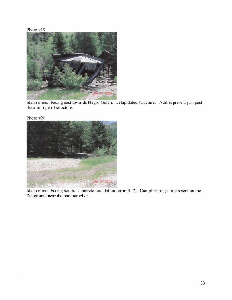
Photo #19
Idaho mine. Facing east towards Negro Gulch. Delapidated structure. Adit is present just past draw to right of structure.
Photo #20
Idaho mine. Facing south. Concrete foundation for mill (?). Campfire rings are present on the flat ground near the photographer.
33

Photo #21
Black Jack-Trade Dollar mine site. Facing north. Collapsed adit is present to east of pond. Water sample collected at location of DEQ employee. Adit water overflows pond to north and seeps back into waste pile within 30 yards.
Photo #22
Black Jack-Trade Dollar waste pile. Facing South. Location of Soil Sample IDSS 1. Notice lack of vegetation, even at upper end where gradient is not as steep.
34

Photo #23
.~~\im~
Below Black Jack-Trade Dollar waste pile where water resurfaces. Adjacent to Water Sample IDW7. Notice filamentous algae.
Photo #24
Black Jack-Trade Dollar upper adit site. Picture taken Southwesterly direction from top of waste pile in Photo #25.
35
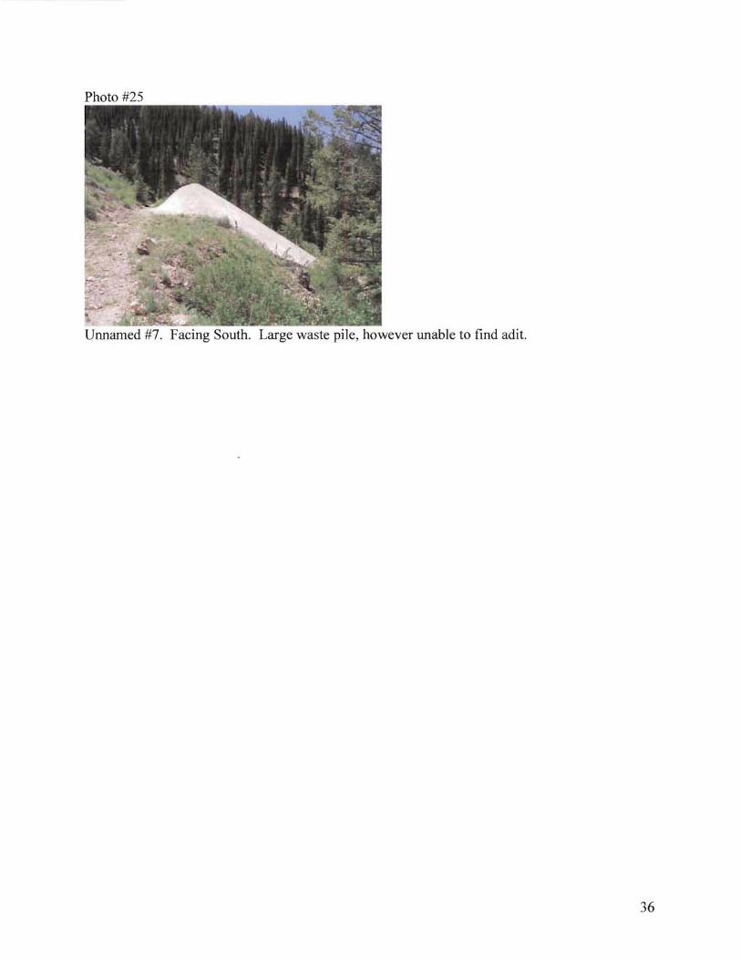
Photo #25
Unnamed #7. Facing South. Large waste pile, however unable to find adit.
36

APPENDIX B
ANALYTICAL RESULTS
37

Table 1 Soil and Surface Water Sample Data for Blue Gulch,
Owyhee County, Idaho Analyte Surface Surface Surface Surface Surface Surface Surface Surface Soil
Water Water Water Water Water Water Water Water Sample Sample Sample Sample Sample Sample Sample Sample Sample IDSS1 IDW1 IDW2 IDW3 IDW4 IDW5 IDW6 IDW7 IDW8 (mg/kg) (mg/L) (mg/L) (mg/L) (mg/L) (mg/L) (mg/L) (mg/L) (mg/L)
Arsenic <0.010 <0.010 <0.010 <0.010 <0.010 <0.010 <0.010 <0.010 42.3 Barium 0.226 0.213 0.0862 0.0672 0.0752 0.130 0.104 0.226 73.7
Cadmium <0.002 <0.002 <0.002 <0.002 <0.002 <0.002 <0.002 <0.0626 <0.02 Chromium <0.006 <0.006 <0.006 <0.006 <0.006 <0.006 <0.006 <0.006 1.72
Lead <0.005 <0.005 <0.005 <0.005 <0.005 <0.005 <0.005 <0.005 25.7 Mercury <0.0002 <0.0002 <0.0002 <0.0002 <0.0002 <0.0002 <0.0002 <0.0002 0.402 Selenium <0.01 <0.01 <0.01 <0.01 <0.01 <0.01 <0.01 <0.01 8.6
Silver <0.005 <0.005 <0.005 <0.005 <0.005 <0.005 <0.005 <0.005 63.2 NA = not analyzed
38