state of maryland board of natural …msa.maryland.gov/megafile/msa/speccol/sc6000/sc... ·...
TRANSCRIPT

STATE OF MARYLAND BOARD OF NATURAL RESOURCES
DEPARTMENT OF GEOLOGY, MINES AND WATER RESOURCES Joseph T. Singewald, Jr., Director
BULLETIN 8
THE WATER RESOURCES
OF
CALVERT COUNTY
SURFACE-WATER RESOURCES
by V. R. Bennion and D. F. Dougherty
GROUND-WATER RESOURCES
by Robert M. Overbeck
BALTIMORE, MARYLAND 1951

COMPOSED AND PRINTED AT THE VVAVERLY PRESS, INC.
BALTIMORE, MD., U.S.A.

COMMISSION ON
GEOLOGY, MINES AND WATER RESOURCES
Arthur B. Stewart, Chairman Baltimore
G. Victor Cushwa Williamsport
Harry R. Hall Hyattsville
Joseph C. Lore, Jr Solomons Island
MerviN A. Pentz Denton


PREFACE
The Calvert County report in the series of county reports was published in 19()7, long before a systematic study of the water resources of the State was undertaken. In 1945, investigations of the groundwater resources of Southern Maryland were initiated. The results of the investigations in Charles County were published in 1948 in the Charles County report, and those in Anne Arundel County were published in 1949 in Bulletin 5. This bulletin on the Water Resources of Calvert County supplements the 1907 Calvert County report.
The bulletin is based on investigations conducted jointly by the United States Geological Survey and the Maryland Department of Geology, Mines and Water Resources and is published with the permission of the United States Geological Survey.
The section on Surface-Water Resources was prepared by Mr. V. K. Reunion, former District Engineer, and Mr. D. F. Dougherty, of the United States Geological Survey, in charge of cooperative surface-water measurements in Maryland. The section on Ground-Water Resources was prepared by Dr. Robert M. Overbeck of the cooperative ground-water staff.
The descriptions of the sub-surface formations may be supplemented by the more comprehensive descriptions of these formations in the previously pub- lished systematic reports. These are in descending order of the formations, the Pliocene and Pleistocene (1906), the Miocene (1904), the Upper Cretaceous (1916), and the Lower Cretaceous (1911). More recent information on these formations is in a report on Cretaceous and Tertiary Subsurface Geology (Bulletin 2, 1948). Additional information on the Eocene is contained in a report on Eocene Stratigraphy and Aquia Foraminifera (Bulletin 3, 1948).
The areal distribution of the formations is shown on the geologic map of Calvert County published in 1903. Surface elevations are shown on the county topographic map published in 1949.
The report lists and gives the locations of over 200 artesian wells in Calvert County. Data on the sub-surface formations and the water-bearing beds are presented in the drillers' logs of 52 wells and in the descriptions of well cuttings from 18 wells. The quality of the water in the water-bearing sands is shown in 11 water analyses.
The data presented in this report enable a well driller and a prospective well owner to determine the depths at which ground-water may be obtained, the quantity of water obtainable, and the probable quality of the water. However, the Department of Geology, Mines and Water Resources can be called upon at any time for such information.
Joseph T. Singewald, Jr., Director.


CONTENTS
Preface The Surface-Water Resources. By V. R. Bennion and D. F. Dougherty.
General Discussion Surface-water resources of Calvert County
Streams in Calvert County The Ground-Water Resources. By Robert M. Over beck.
Abstract Introduction
Location of area Purpose and scope of the investigation Physical features Climate Population and industries Previous ground-water investigations Acknowledgments Maps
General principles of ground-water occurrence Geologic formations and their water-bearing properties
General statement Basement complex Cretaceous system
Lower Cretaceous series Upper Cretaceous series
Tertiary system Eocene series
Paleocene rocks Aquia greensand
Quality of water Nanjemoy formation
Quality of water Salt water encroachment
Rocks of Jackson age Quality of water
Miocene series (Chesapeake group) Calvert formation Choptank formation St. Marys formation
Quaternary system Pleistocene series
Terrace deposits Quality of water
Water-level fluctuations Well logs
LIST OF TABLES Table 1. Geologic formations in Calvert County 2. Records of wells in Calvert County
v
1 3 3
4 4 6 6 7 8 8 9 9 9
10 10 10 10 10 13 13 13 13 IS 18 19 22 22 23 24 24 24 25 25 26 26 26 27 28 42
11 30
VUl Contents
3. Drillers' logs of wells in Calvert County 42 4. Logs of wells in Calvert County from which well-cutting samples were obtained 53 5. Chemical analyses of ground water in Calvert County 95
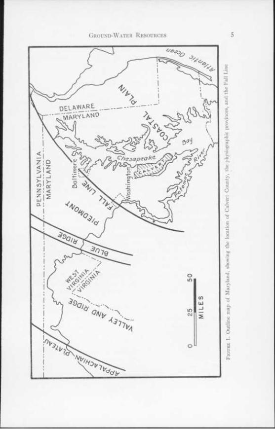
LIST OF FIGURES Figure 1. Outline map of Maryland, showing the location of Calvert County, the physiographic
provinces, and the Fall Line 5 2. Cross-section, Indian Head to Ocean City, showing probable position of the top of the
Basement Complex 12 3. Outcrop distribution of the Eocene formations of Maryland 14 4. Section A-A' through Calvert County showing approximate positions of geologic for-
mations 15 5. Section B-B' through Calvert County showing approximate positions of geologic for-
mations 17
LIST OF PLATES Plate 1. Map of Calvert County showing location of water wells and section lines A-A'
and B-B' In pocket 2. Map of Calvert County showing by contour lines the approximate altitude of
the bottom of the Calvert formation In pocket 3. Map of Calvert County showing by contour lines the approximate altitude of the
top of the Aquia formation In pocket

THE SURFACE-WATER RESOURCES OF
CALVERT COUNTY
GENERAL DISCUSSION
BY
V. R. BENNION
Water is the natural resource most vital to man's existence. It determines those places on the face of the earth where he can live. If there is insufficient water, as in the desert, he cannot live, or if there is too much water or a con- tinual threat of it, as in the flood plains of the streams, he cannot live except in fear of his life. Without water the average man would live but a few days, and most of the modern industrial processes would cease operation immediately.
Many of the people of this country, and especially those in the eastern sec- tion, seem to assume that the water supply is inexhaustible. Actually the water supply is definitely limited and already in many places its scarcity has become an acute problem and it has been necessary to establish laws governing the use and conservation of this valuable resource. The quantity of available water in any region varies from year to year, month to month, and day to day. It cannot be adequately determined by measurements covering a period of only a few months or even of a few years. The immediate source of nearly all water is precipitation from the clouds, and the wide variations in this factor are known to all. The relation between rainfall and the resulting surface-water and ground-water supplies is also variable and complex; therefore, the records of rainfall alone do not serve as a measure of the water supply available for use.
The earth has a fixed amount of water, which circulates in an endless cycle maintained in approximate balance by several processes, the principal of which are precipitation, evaporation, transpiration from vegetation, and runoff in streams. This vast movement of water from the atmosphere to the land, from the land to the ocean, and from land and ocean back to the atmosphere is known as the hydrologic cycle.
The water resources of principal concern to man may be classified as surface water and ground water. Surface water is the water present on the earth's solid surface, such as streams, lakes, and ponds. Ground water is the water that accumulates in the ground in the zone of saturation. Although both surface water and ground water originate from precipitation, there is a distinct difference in their occurrence and behavior. The methods and science involved in their investigation and utilization are also distinctive. Ground-water investi- gation and utilization are discussed in another section of this report.
Surface water is easily accessible and has a wide variety of uses, including 1

2 Water Resources of Cat,vert County
production of power. The force of gravity causes surfacc water to flow along the path of least resistance, so long as the ground surface is sloping or until it is halted by some barrier to form a lake or pond. Essential to considering the utilization of surface water is a knowledge of the quantity and quality of the water, the topography of the drainage basin, the type of soil, and the land-use practices.
The development of any region is directly dependent upon the availability of an adequate water supply. The history of any country or community shows the importance of water resources, and the future development and expansion will depend to a great extent on the wise use of those resources. Generally, as a community develops in density of population and scope of industry, little thought is given to the prospect that there may not be sufficient water in nearby streams to satisfy the demands. It then becomes' necessary to extend the water supply system to more distant streams. Many of the larger cities of the country are faced with an acute water problem today, whch threatens to stall their future development.
Streams may serve a community in several ways. Many streams are used as a municipal water supply, as a source of water for industrial uses, and for sewage disposal. Streams have an important role in the conservation of fish and wild- life. Improvement of streams and adjacent areas and the construction of arti- ficial ponds and pools contribute to the program of recreation as well as to the conservation of fish and wildlife. In recent years greater attention has been directed to this improvement, and the efforts of conservationists have produced good results. However, many of our scenic streams are laden with waste and pollution that have resulted in the killing of vegetable and fish life. Under favorable conditions streams purify themselves in a relatively short distance; but when they become overloaded with pollution, the bacteria supplied by nature for purification are killed, the natural oxygen content of the water is depleted, and a so-called dead river results.
The flow of streams is subject to great fluctuation, depending upon the amount and intensity of the precipitation, and during floods a large portion of the water runs off without serving any useful purpose. In addition, the periodic flood damage to cities, highways, and other developments is tremendous. Much of this damage can be averted if there are proper planning and adequate knowledge of stream flow at the time the developments are made. In the early days, nearly all cities and municipalities were located along streams so as to have a readily accessible water supply or means of transportation. As the towns grew into cities, the flood plains of the streams were encroached upon by struc- tures of all kinds. The streams were crowded into narrow channels of insufficient size to carry the flood flows, with resulting large damages in each major flood. In order to reduce or eliminate these damages, it is necessary to build Hood- control works, and these cannot be properly designed unless a record of the stream flow is available for a sufficient number of years to determine the flood-flow characteristics of the stream.

SURFACE-WATER RESOURCES
BY
D. F. DOUGHERTY
Calvert County is almost completely surrounded by tidal waters. Its only land boundary is the narrow one on the north with Anne Arundel County. The eastern boundary is Chesapeake Bay and the western is the Patuxent River, which is tidal throughout this reach. The Patuxent River flows into Chesapeake Bay at the southern tip of Calvert County, thus forming the southern boundary also. Many of the county streams, therefore, are tidal for a large portion of their length, and a large number of the tributary streams flow directly into tidewater. The entire county is part of the west Chesapeake Bay drainage area. The more important streams and their drainage areas are:
Streams in Calvert Coimly
Stream Patuxent River basin;
Lyons Creek Hall Creek Hunting Creek Battle Creek St. Leonard Creek
Chesapeake Bay drainage area: Fishing Creek
All the streams are small and relatively short, nearly all having both their source and mouth within the county. The slopes are generally flat and are marked by numerous swampy areas. During periods of medium and high flows the streams overtop the low banks and flow over wide flood plains. This tends to reduce the peak discharges and increase the low-water flow. Because of this characteristic, streams of this type are reliable sources of water supply.
The topography of Calvert County consists of low rolling hills. The divide between Patuxent River drainage and Chesapeake Bay drainage runs roughly north and south through the county, the Patuxent area being generally wider and having flatter slopes.
No gaging stations are maintained in the county at present. However, gaging stations are maintained on Chaptico Creek near Chaptico and on St. Marys River at Great Mills, in St. Marys County, and on Bacon Ridge Branch near Chesterfield, and on North River near Annapolis, in Anne Arundel County. The runoff from these streams should be similar to that from streams in Calvert County. The records for these stations are published in their respective county reports.
3
Drainage area (sq. mi.)
... 19.5
... 20.0
... 28.7
... 18.9
... 22.5
... 17.9
THE GROUND-WATER RESOURCES OF
CAE VERT COUNTY
BY
ROBERT M. OVERBECK
Abstract
Calvert County is in southern Maryland, and hence in the Western Shore portion of the Coastal Plain province. The Chesapeake Bay lies along the eastern side of the county and the Patuxent River along its western side. Rocks that crop out in Calvert County are of Pleistocene, Miocene, and Eocene age. The Pleistocene formations consist of sand and sandy clay, but contain minor amounts of gravel; those of Miocene age consist chiefly of sandy clay, and at places are very fossiliferous and diatomaceous; the outcropping Eocene formation (Nanjemoy) consists chiefly of greensand. The Miocene and Eocene formations have strikes varying between north and east and very low dips to the east and south. The Pleistocene deposits are generally terrace deposits.
The sediments from which ground water is being produced in Calvert County are of Pleistocene, Jackson, Nanjemoy, and Aquia age. Cretaceous rocks underlie the county and are a possible source of water for deep wells. It is estimated that about 2,000,000 gallons of ground water are used per day in the county. This water is for domestic and farm purposes chiefly, as there are no large industries in the county. The Nanjemoy formation is the source of most of the water in the northeastern and eastern parts of the county, and the Nanjemoy formation and rocks of Jackson age in the southern part. The Aquia formation is the source in the northern and western parts of the county and for a few wells in the southern part.
The aquifers yield water that is satisfactory for most uses.
Introduction
LOCATION OF THE AREA
Calvert County is one of the tidewater counties of the Western Shore of the Chesapeake Bay of southern Maryland (fig. 1). It lies between parallels 38°19' and 38046' north latitude, and 76023' and 76042' west longitude. Its land area is about 217 square miles; and its water area, 153 square miles.1
1 Gazetteer of Maryland: Maryland State Planning Commission and Department of Geology, Mines and Water Resources, p. 239, 1941.
4
6 Water Resources of Calvert County
To the north of Calvert County lies Anne Arundel County, to the west Prince Georges and Charles Counties, and to the southwest and south St. Marys County. Chesapeake Bay lies along the east side.
PURPOSE AN'D scope or the investigation
The purpose of this investigation was to determine the factors that govern the availability of ground water in Calvert County. These include the extent, thickness, depth, and water-bearing properties of the geologic formations; the chemical quality of the water; and the development of ground-water sup- plies. Field work was started in May 1946, and carried on intermittently to the latter part of 1949.
Well cuttings were studied thoroughly to determine geologic markers and the physical characteristics of the aquifers. Samples taken by drillers were obtained from some of the wells. Cuttings from wells which were most im- portant for an understanding of the subsurface geology were collected by a geologist.
Water samples were taken from only a few wells. Many of the drilled wells are producing a mixed water from two aquifers of different geologic age that may be hydrologically connected.
An inventory was made of both dug and drilled wells (table 2). The inventory although not complete gives an overall picture of the distribution of the wells and their utilization.
The wells inventoried are plotted on a Calvert County map (PI. 1). This map is divided into 5-minute quadrangles which are lettered alphabetically by capital letters from north to south and by small letters from west to east. A well is designated in the text and tables by the abbreviation of the county name (Cal) followed by the letters indicating the quadrangle, followed by the well number; thus, Cal-Bb 1.
Plates 2 and 3 are subsurface contour maps. Plate 3 shows the approximate depth below sea level and configuration of the contact surface at the top of the Aquia formation and Plate 2 at the base of the Calvert formation.
PHYSICAL FEATURES
Calvert County lies on a long narrow peninsula bounded on the east by Chesapeake Bay and on the west and south by the Patuxent River, an estuary of the Bay. The peninsula is about 33 miles long and averages about 6| miles wide. Its northern portion is about 8 miles wide and its southern portion about 4 miles. The northern two-thirds of the peninsula trends north-south and the southern one-third trends northwest-southeast.
Calvert County lies in the Coastal Plain physiographic province of Maryland (fig. 1). The Fall Line, which separates the Piedmont Province from the
Ground-Water Resources 7
Coastal Plain Province, does not pass through the county, but is about 12 miles to the northwest.
Calvert County is well dissected by streams, most of which are short and are tidal in their lower portions. The land surface is generally rolling and shows a marked contrast to the low-lying and nearly flat Eastern Shore Coastal Plain topography. The maximum altitude in the county, about 190 feet, is in the northern part near Mt. Harmony. The maximum altitude in the southern part of the county is about 135 feet.
A broad terrace, having an altitude of 30 to 50 feet and reaching nearly a mile in width at places, borders the Patuxent River in Calvert County.
The Calvert Cliffs, which at places have a sheer drop of a hundred feet, extend for nearly thirty miles along the Chesapeake Bay side of the county. Erosion has been very rapid locally along the Cliffs.2
CLIMATE
The climate of Calvert County has been described in some detail by Von Herrmann.3 More recent information is included in reports by Weeks4 and the U. S. Weather Bureau.5
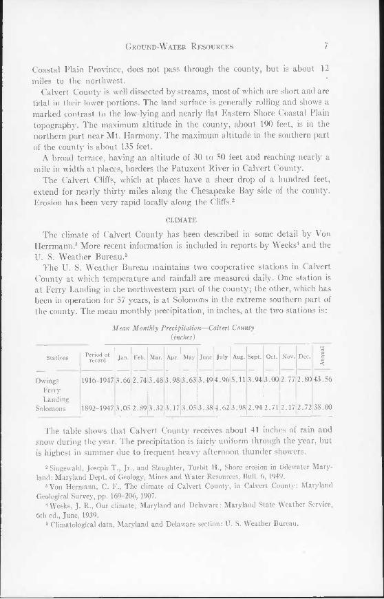
The U. S. Weather Bureau maintains two cooperative stations in Calvert County at which temperature and rainfall are measured daily. One station is at Ferry Landing in the northwestern part of the county; the other, which has been in operation for 57 years, is at Solomons in the extreme southern part of the county. The mean monthly precipitation, in inches, at the two stations is:
Mean Monthly Precipitation—Calvert County {inches)
Stations Period of record Jan. Feb. Mar. Apr. May June July Aug. Sept. Oct. Nov. Dec.
e4 3 C C <
Owings Ferry Landing
Solomons
1916-1947
1892-1947
3.66
3.05
2.74
2.89
3.48
3.32
3.98
3.17
3.63
3.05
3.49
3.38
4.96
4.62
5.11
3.98
3.94
2.94
3.00
2.71
2.77
2.17
2.80
2.72
43.56
38.00
The table shows that Calvert County receives about 41 inches of rain and snow during the year. The precipitation is fairly uniform through the year, but is highest in summer due to frequent heavy afternoon thunder showers.
! Singewald, Joseph T., Jr., and Slaughter, Turbit H., Shore erosion in tidewater Mary- land: Maryland Dept. of Geology, Mines and Water Resources, Bull. 6, 1949.
3 Von Hermann, C. F., The climate of Calvert County, in Calvert County: Maryland Geological Survey, pp. 169-206, 1907.
4 Weeks, J. R., Our climate; Maryland and Delaware: Maryland State Weather Service, 6th ed., June, 1939.
5 Climatological data, Maryland and Delaware section: U. S. Weather Bureau.

Water Resources of Calvert County
The mean monthly temperatures at the two stations are:
Mean Monthly Temperature—Calvert County (" F.)
Stations
Owings Ferry Landing
Solomons
Period of record
1916-1947
1892-1947
Jan.
35.3
Feb.
36.8
36.3136.4
Mar.
45.5
45.0
Apr.
53.8
54.8
May
64.1
65.3
June I July
72.8176.3
73.7 78.2
Aug-
74.6
77.2
Sept. | Oct.
69.058.0
Nov.
71.8
47.6
60.449.1
Dec.
37.7
39.0
56.4
57.3
The table shows the mean annual temperature to be between 56.4°F. and 57.30F. July, the hottest month, has a mean temperature of about 770F. and January, the coldest month, about 360F.
POPULATION AND INDUSTRIES
The population of Calvert County according to the 1950 census is 12,272. The county has no large towns. The two incorporated towns, Chesapeake Beach and North Beach, had populations in 1940 of 326 and 246, respectively. Prince Frederick, the county seat, has an estimated population (1949) of about 200, and Solomons of about 270. During the summer the population of the county is much larger owing to the influx of vacationers.
The chief industry of Calvert County is agriculture. Tobacco is the most important crop. The vacation trade is also an important source of income. No large industrial plants are located in the county.
PREVIOUS GROUND-WATER INVESTIGATIONS
One of the first published accounts of ground water in Calvert County is included in a report by N. H. Darton.6 His statement is as follows:
"Solomons Island, Calvert County.—There are four flowing wells on this island, and another at Rousby on the mainland just north. They average about 250 feet in depth and furnish good supplies of excellent water. The water horizon is the basal Chesapeake beds, the same as in the St. Mary's County wells, and at Denton and Cambridge on the Eastern Shore."
In the period 1896-1912, maps were published in U. S. Geological Survey folios' on which the approximate location of water-bearing beds was shown.
6 Darton, N. H., Artesian well prospects in the Atlantic Coastal Plain region: U. S. Geo- logical Survey Bull. 138, pp. 136, 150-151, 1896.
7 Darton, N. H., U. S. Geological Survey Geol. Atlas, Nomini folio (No. 23) 1896; Shattuck, G. B., and Miller, B. L., U. S. Geological Survey Geol. Atlas, St. Marys
folio (No. 136), 1906; Miller, B. L., U. S. Geological Survey Geol. Atlas, Choptank folio (No. 182), 1912.

Ground-Water Resources 9
In 1918, the Maryland Geological Survey issued a report8 on the water resources of the State, including a discussion of the ground-water resources of Calvert County. Since that time no reports have been published that bear directly on the ground-water resources of Calvert County.
ACKNOWLEDGMENTS
Acknowledgment is made here to the well drillers in Calvert County for their help in collecting well cuttings and for furnishing information on wells drilled before 1945; and to Mr. Glascock for data given on water-level fluctua- tions, for use of a well as a permanent observation well, and for other material help.
Thanks are also due to Dr. Harold Yokes for helpful discussions of Coastal Plain geology; to Dr. Elaine Shifflett and Miss Doris Malkin for the determina- tion of the microfossils in some of the well cuttings; and to Dr . Julia Gardner for the personal interest she has shown in problems of Coastal Plain geology.
The investigation was made under the general supervision of A. N. Sayre, Geologist in Charge of the Ground Water Branch of the U. S. Geological Survey, and under the immediate supervision of R. R. Bennett, District Geologist of the U. S. Geological Survey in charge of the cooperative ground- water investigations in Maryland.
MAPS
The 1949 Calvert County topographic map of the Department of Geology, Mines and Water Resources (scale 1:62,500) is used as the base from which the maps with this report were drawn. In the field the 7^ minute topographic quadrangle maps of the Corps of Engineers, U. S. Army, and the U. S. Geo- logical Survey, on a scale of 1:31,680 and 1:25,000 were used for those parts of the county where available.
A geologic map of the county, issued in 1903 by the Maryland Geological Survey, was used extensively in the field.
General Principles of Ground-Water Occurrence
The general principles of the occurrence of ground water are discussed in reports on the water resources of Charles and Anne Arundel Counties.9,10
Specific application of the principles in Calvert County will be noted in the section on geologic formations and their hydrologic properties.
8 Clark, W. B., Mathews, E. B., and Berry, E. W., The surface and underground water resources of Maryland, including Delaware and the District of Columbia: Maryland Geo- logical Survey, vol. 10, pt. 2, 1918.
9 Overbeck, Robert M., Maryland Department of Geology, Mines and Water Resources, Charles County Report, 1948, pp. 138-143.
10 Brookhart, J. W., The Water Resources of Anne Arundel County: Maryland Dept. of Geology, Mines and Water Resources, Bull. 5, pp. 32-35, 1949.
10 Water Resources of Calvert County
Geologic Formations and their Hydrologic Properties
GENERAL STATEMENT
Meinzer11 says, "Geology affords the framework on which ground-water hydrology is built." It is essential, therefore, to know in detail the geology of the area under investigation.
A historical account of the geologic work done on the Western Shore Coastal Plain has been given in previous reports.12'13
Rocks that crop out in Calvert County belong in the Tertiary and Quaternary systems. The type locality of the Miocene Calvert formation is the Calvert Cliffs along the Chesapeake Bay. The Pleistocene Sunderland formation is named for the village of Sunderland in Calvert County.
Rocks that lie in the subsurface under the county but do not crop out in the county, as shown by well cuttings and identified as to geologic age, are Aquia greensand and deposits of Jackson age. Some deep wells have undoubtedly penetrated Cretaceous rocks, but samples are lacking to verify this.
Lithologically the rocks of Calvert County are unconsolidated sand, clay, and gravel, and, rarely, indurated lime- or iron-cemented sand.
Table 1 shows the geologic sequence and summarizes the lithology and water- bearing properties of the formations.
Figures 4 and 5 are cross sections of the geologic formations in Calvert County. The location of these sections is shown on Plate 1.
BASEMENT COMPLEX
Crystalline rocks of the Basement Complex do not crop out in Calvert County. They lie at great depth and have no value there as potential sources of water. Geophysical data14 from two stations in Chesapeake Bay just north of the mouth of the Patuxent River indicate that the surface of these rocks lies approximately 3,050 feet below sea level (fig. 2).
CRETACEOUS SYSTEM
LOWER CRETACEOUS SERIES
Patuxent formation.—Little is known of the physical or hydrologic properties of the Patuxent formation under Calvert County. Its base lies between two and three thousand feet below the surface, and no wells in the county have pene- trated it.
The Patuxent formation is considered a potential source of water in Calvert County, though its sediments may contain highly mineralized water.
11 Meinzer, O. E., and others, Physics of the Earth, IX, Hydrology, p. 386, 1949. 12 Shattuck, G. B., Calvert County: Maryland Geological Survey, pp. 25-38, 1907. 13 Dryden, L., The physical features of Charles County, pp. 6-9, 1948. 1, Evving, Maurice, Woollard, George P., Vine, A. C., and Worzel, J. L., Recent results
in submarine geophysics: Geol. Soc. Amer. Bull., vol. 57, pp. 909-934, 1946.

TABLE 1 Geologic formations in Calvert County
Syste
m
Serie
s a 3 O O
Formation Thickness (feet) General Character Water-Bearing Properties
Quate
r- na
ry
Pleis
to-
cene
Talbot
Wicomico Sunderland
0-132
38 (?) 40 (?)
Clay, silt, sand, little gravel.
Marine Talbot contains sea shells and much wood.
Yields water to dug wells in Calvert County.
Mioc
ene
Ches
apea
ke
St. Marys 50± Clay, silt, and sand; fossilif- erous.
Possibly yields water to dug wells in the southern part of the county. Not an im- portant water-bearer.
Choptank lOOi Sandy clay; sand; fossilifer- ous.
Possibly yields water to shal- low dug wells. Not an im- portant water-bearer in Calvert County.
Calvert 150± Sandy clay; fossiliferous; diatomaceous earth.
Possibly yields water to shal- low dug wells. Not an im- portant water-bearer in Calvert County.
Terti
ary
0) c 0) 1
Rocks of Jackson age
0-43 Hard lime-cemented beds in- tercalated with sand beds.
A water-bearing formation. May be hydrologically con- nected with Nanjemoy for- mation.
Pamu
nkey
Nanjemoy 126-240 Chiefly greensand, some clay. The bottom 20 feet are pink
and gray clay.
Chief aquifer in eastern and southern Calvert County. Not widely used as a source of water in the northern and northwestern part of the county.
Aquia 81+ Chiefly greensand, some clay, interbedded sand and lime rock in upper part of the formation.
An excellent water-bearing formation. Used in only a few wells in county.
Pale-
oc
ene — 70+ Glauconitic sandy clay. Probably not a water-bearing
formation.
Creta
ceou
s
Uppe
r
Monmouth Dark gray sandy clay with some glauconite.
Not considered a water-bear- ing formation.
Matawan Do. Do.
Magothy Gray sand and brown clay. Potential source of ground water.
Raritan Sand, gravel, and clay. Do.
Patapsco Do. Do.
Arundel Clay. Not considered a water-bear- ing formation.
Lowe
r Patuxent Sand, gravel, and clay. Potential source of ground water. Water may be highly mineralized.
Pre-
Ca
m—
brian
(?) Hard crystalline rocks such
as granite, gneiss, gabbro, etc.
Not considered a potential source of ground water in Calvert County.
11

12 Water Resources of Calvert County

Ground-Water Resources 13
UPPER CRETACEOUS SERIES
The Upper Cretaceous series in Maryland comprises the Arundel, Patapsco, Raritan, Magothy, Matawan, and Monmouth formations. None of these formations crops out in Calvert County. Although some deep wells in the county probably have been drilled into the uppermost part of the Upper Cretaceous series, no samples of these sediments are available. The extent, thickness, and hydrologic properties of the Upper Cretaceous rocks underlying Calvert County are therefore not well known.
A rough estimate of the depth of the top of the Cretaceous rocks in ("alvert County is 30() feet below sea level in the northwest corner of the county, 450 feet at Prince Frederick , and more than 550 feet at Solomons.
No data are available on the thickness of the Upper Cretaceous rocks in Calvert County. In Anne Arundel County the Magothy formation is 40-60 feet thick and its top is about 100 feet below the base of the Aquia greensand. The Raritan formation which lies under the Magothy formation and in contact with it is about 100 feet thick.16
The quality of the water from Upper Cretaceous aquifers under Calvert County is not well known. In Anne Arundel County according to Brookhart16
water from the Raritan and Patapsco formations is generally low in dissolved solids near the outcrop but increases somewhat in dissolved solids toward the southeast; and the water from the Magothy formation is generally more highly mineralized than water from the Raritan and Patapsco formations, and locally is high in iron.
The Upper Cretaceous rocks are considered potential sources of ground water in Calvert County as the Magothy, Raritan, and Patapsco formations are excellent water-bearing formations to the north in Anne Arundel County.
TERTIARY SYSTEM
EOCENE SERIES
Paleocene rocks.—Paleocene rocks do not crop out in Calvert County, nor were any wells drilled deep enough there to obtain samples of them. Paleocene deposits probably underlie the county, for they are reported by Shifflett" to occur in wells in Prince Georges County and in wells on the Eastern Shore of Maryland.
Paleocene rocks in Prince Georges County are argillaceous greensands which are very similar in appearance to the marine Upper Cretaceous rocks of
16 Little, H. P., Physical features of Anne Arundel County; Maryland Geological Survey, p. 71, 1917.
16 Brookhart, J. W., The water resources of Anne Arundel County: Maryland Dept. of Geology, Mines and Water Resources, Bull. 5, ppC. 43, 46, 1949.
" Shifflett, Elaine, op. cit., pp. 23, 26.

Ground-Water Resources 15
the Monmouth formation, although the faunas of the two formations are distinct.
The thickness of the Paieocene deposits in Calvert County is not well known. In a well in Prince Georges County they have a thickness of about 70 feet and in a well18 on the Eastern Shore they have a thickness of 170 feet.
The Paieocene deposits in Prince Georges County and Eastern Shore wells contain much clay and do not appear to be water-bearing.
A quia greensand.—The Aquia greensand takes its name from the type lo- cality at Aquia Creek, Stafford County, Virginia. It does not crop out in Cal- vert County, and well cuttings are available from only a few wells drilled into the formation. A discussion of the Eocene rocks of Maryland and those of Calvert County are given in publications of the Maryland Geological Survey.19'20 Their areal distribution in Maryland is shown in Figure 3. I'orami- nifera from Calvert County wells are described by Shifllett.21
Detailed descriptions of well samples from the Aquia greensand are given in Table 4. (See wells Bb 9, Ca 2, Db 3, and Dc 17.)
The Aquia greensand is a glauconitic sand containing some beds of sandy clay. Hard beds composed of lime-cemented quartz and glauconite grains are rather common near the top of the formation. Green-black glauconite of various degrees of coarseness, and subrounded quartz grains, many of them yellow-stained, make up the sandy fractions of the well cuttings.
The Aquia greensand lies under the Marlboro clay member of the Nanjemoy formation. A sharp lithologic change is shown by the well samples. The presence of pieces of indurated greensand and of much yellow-stained quartz further characterizes the Aquia greensand cuttings.
The thickness of the Aquia greensand under Calvert County is not known, as no sampled drilled wells have gone completely through it. The maximum thickness penetrated is 168 feet in well Cal-Ca 2. In Charles County to the west the thickness ranges between 86 and 170 feet; and in Anne Arundel County to the north, between 75 and 150 feet. Sediments of the Aquia formation are not known to have been encountered in drilled wells on the southern Eastern Shore; a thinning of the formation south-eastward across Calvert County is, therefore, suggested.
The subsurface contour map (PI. 3) represents the approximate depth below sea level and the shape of the surface at the top of the Aquia formation. The strike of this surface varies between east-west and north-south. Its dip in the
18 Shifflett, Elaine, op. cit., p. 26. 19 Clark, W. B., and Martin, G. C., Eocene: Maryland Geological Survey, 1901. 20 Shatluck, G. B., Calvert County: Maryland Geological Survey, 1907. 21 Shifflett, Elaine, Eocene stratigraphy and foraminifera of the Aquia formation: Mary-
land Dept. of Geology, Mines and Water Resources, Bull. 3, 1948.


18 Water Resources of Calvert County
northern part of the county is about 21 feet to the mile and in the southern part of the county about 10 feet to the mile.
The Aquia greensand is a good water-bearing formation. The following wells are known to produce water from this sand: Bb 9, Ca 2, Db 3, Db 5, Db 11, Db 12, Dc 17; and wells Fd 1 and Gd 36 probably produce from the Aquia greensand. Wells Db 3, Ca 2, Db 11, Db 12 were flowing in 1949. Well Ca 2 was flowing at an altitude of 36 feet, and well Db 12 was flowing 22 gallons a minute at an altitude of 12 feet.
The water yielded by the Aquia greensand does not come from any one sand, but chiefly from a series of sands interbedded with hard lime-cemented layers. The water-bearing material penetrated by well Db 12 is in the uppermost part of the Aquia greensand and is in contact with the overlying Marlboro clay member. Well Dc 17 is screened from 67 to 79 feet below the top of the forma- tion, and well Db 3 from 79 to 88 feet below the top of the formation.
Some wells ending in the Aquia greensand are of large diameter and they have large yields. For example, well Fd 1 is reported to yield 125 gallons a minute; well Gd 6, 150; and Gd 7, 350. The specific capacities are respectively 0.8, 2.0, and 3.5 gallons per minute per foot of drawdown.
R. R. Bennett, in 1944, conducted a pumping test at the Naval establish- ments in the Solomons-Patuxent River area.22 He says the following about the tests in the Aquia aquifer in the Solomons area;
"Three pumping tests were run on wells drilled to the Aquia but one was unsuccessful. A pumping test was run on the Amphibious Training Base well 3 (Gd 6), and by using the Theis recovery method the coefficient of transmissibility was determined to be 5,650. "
"A recovery test was run on Amphibious Training Base well 4 (Gd 7) and the coefficient of transmissibility was determined to be 5,500."
Quality of water.—Samples of water from three wells (Cal-Db 3 and 5 and Gd 6) that are believed to be producing from the Aquia formation were analyzed chemically. The results of the analyses are shown in Table 5.
The table shows a very close similarity in the analyses of the waters from wells Db 3 and Db 5. These wells are about 4 miles apart and both yield water from a sand or sands 80 to 90 feet below the top of the Aquia greensand. The waters are both bicarbonate waters and have total hardnesses of 108.0 parts per million (Cal-Db 3) and 104.0 parts per million (Cal-Db 5). They are medium hard. The principal difference lies in the greater amount of magnesium in Db 5.
The analysis of the water from well Gd 6 shows some differences from those of Db 3 and Db 5. It is lower in calcium and magnesium, much higher in so- dium, and has a hardness of only 9 parts per million. The dissolved solids con-
22 Bennett, Robert R., Ground-water resources at the Naval establishments in the Solo- mons-Patuxent River area, Maryland. Report on file at Maryland Dept. of Geology, Mines and Water Resources, 1944.
Ground-Water Resources 19
tent of Gd 6, however, is almost the same as that of Db 3. Well Gd 6 is about 17 miles southeast of well Db 3. The change in character of the water from a hard water to a very soft water is probably due to the presence of abundant glauconite, which is one of the most important base exchange minerals in the Aquia greensand. The difference between the two waters was probably brought about as the water moved down dip, by the exchange of calcium in the water nearer the outcrop for sodium in the glauconite.
The water from the Aquia greensand is satisfactory for general use, although it contains a small amount of iron.
Nanjemoy formation.—The Nanjemoy formation is named for Nanjemoy Creek in Charles County where the rocks were first studied by Clark and Mar- tin.23 Outcrops of the rocks in Charles County are described by Dryden.24
In Calvert,County the Nanjemoy formation crops out only in the northwest corner of the county. Exposures occur along the Patuxent River for a short distance south of the mouth of Lyons Creek; and also at places eastward along Lyons Creek.
Figure 3 shows the areas of outcrops of the Aquia and Nanjemoy formations in Maryland.
Most of the drilled wells in the county penetrate Nanjemoy rocks. Detailed descriptions of well cuttings from the Nanjemoy formation are given in Table 4.
The Nanjemoy formation consists chiefly of greensand and glauconitic sandy clay. The lowest 20-25 feet of the formation is a distinctive pale-brown clay bed—the Marlboro clay member. This member does not crop out in Calvert County. Exposures of the clay in Prince Georges and Anne Arundel County show that it is homogeneous, without sand, and of rather uniform thickness. Although the color is generally pale-brown, gray beds occur at places in the upper part of the member.
In the northern two-thirds of the county the Nanjemoy formation is overlain by the Fairhaven diatomaceous earth member of the Calvert formation. In the southern third of the county it is overlain by deposits of Jackson age.
The contact between the Calvert and the Nanjemoy formation is well ex- posed at the Kaylor diatomite property on Patuxent River. The section there is:
Geologic section of formations on Patuxent River, Md.
Location: Kaylor diatomite deposit, 2 miles southwest of Dunkirk, on Route 525. Altitude: Sea level to 60 feet above sea level.
Altitude (feet) Thickness
Top-Bottom (feet) Pleistocene series:
Sand and clay; thin gravel bed at base 60.0-32.5 27.5
23 Clark, W. B., and Martin, G. C., Eocene: Maryland Geological Survey, 1901. 21 Dryden, L., and others, The physical features of Charles County: Dept. of Geology,
Mines and Water Resources, 1948.
20 Water Resources of Calvert County
Altitude (feet) Thickness
Top-Bottom (feet) Miocene series:
Calvert formation; Fairhaven member
Diatomaceous earth; olive-brown, where damp; yellow- ish-gray, where dry; yellow-orange, where iron-stained 32.5-22.5 10
Sand, admixed clay; yellowish-orange color due chiefly to iron-staining; upper portion more clayey and grada- tional to diatomaceous earth. Washed material shows coarse quartz, clear, subangular to rounded; medium- grained quartz, clear, angular to subangular; also a little medium-grained glauconite (green-black and pale-olive) 22.5-19.5 3
Clay, sandy; yellowish-orange; a little green-black glau- conite, botryoidal, and flattened; a little clear quartz in subangular lo subrounded grains. Sand grains are medium fine-grained 19.5-18.5 1
Eocene series: Nanjemoy formation;
Greensand, pale-olive, somewhat clayey; a few hard rod- like concretions up to 6 inches long, bleached on out- side, pale-brown in center; concretions are lime- cemented quartz grains and glauconite. In a washed sample the sand residue is large; medium-sized grains predominate; a fair amount of it coarse- and fine- grained and a little very coarse- and very fine-grained. The coarse fraction consists of about 40% glauconite, most of it green-black, somewhat shiny, botryoidal and flattish. A few of the glauconite grains are olive-brown. The quartz generally has dark inclusions. The medium- grained fraction contains about 90 per cent green-black glauconite, botryoidal, rounded, much of it shiny. A few of the quartz grains are stained yellow. 18.5-16.0 2.5
Greensand, pale-olive; streaks of iron stain, and at 15 feet a continuous 2-inch band of iron-cemented sand. The washed residue from this sample is large, and consists chiefly of medium-grained glauconite and quartz. The medium-grained fraction contains about 90 per cent glauconite. The glauconite is green-black, shiny, botryoidal to flattish. 16 -11 5
Concealed '' "0 11 Note; No megafossils were found in the outcrop. The contact between the Nanjemoy and
Calvert formations is placed at an altitude of 18.5 feet, at the top of the heavy greensand bed and at the base of the yellowish-orange sandy clay unit.
The thickness of the Nanjemoy formation shows a considerable range as indicated by the samples obtained from wells which were drilled completely through it. In well Bb 9, in the extreme northern part of the county it is 126 feet thick; in well Ca 2 in the northwest part, it is 240 feet thick; in well Db 3 in

Ground-Water Resources 21
the west-central part, it is 233 feet thick; and in well Dc 17, in the central part, it is 225 feet thick. No samples were obtained in the southern part of the county from drilled wells which went completely through the Nanjemoy forma- tion. The driller's log of well Fd 32, near Solomons, indicates a thickness of about 140 feet
Well AA-Ge 4, which lies in Anne Arundel County a short distance north of the Calvert County line, shows a thickness of 162 feet. A well at Hughesville in Charles County shows a thickness of 234 feet. Nanjemoy rocks are not known to be present in the subsurface in the southern part of the Eastern Shore.
The above figures on thickness suggest a thinning of the Nanjemoy formation toward the northeastern, eastern, and southern parts of the county from a maximum thickness of 240 feet in the northwestern part.
Plate 2 is a subsurface map showing the elevation of the base of the Calvert formation. In the northern two-thirds of the county this represents also the top of the Nanjemoy formation. In the southern third of the county, it repre sents the contact between the Calvert formation and underlying deposits of of Jackson age. The Nanjemoy formation has a generally northeast strike and a dip of about 12 feet to the mile to the southeast.
The Nanjemoy formation is a good aquifer throughout the northeastern, eastern, and southern parts of the county. Few wells have been drilled in the northern part of the county or along the Patuxent River north of Hallowing Point. Those that have been drilled from which data are available are producing from Aquia sands. Well Bb 9, in the extreme northern part of the county, was drilled through the Nanjemoy formation and encountered only one bed of sand. This sand bed was not considered thick enough to produce the desired quantity of water. On the other hand at North Beach, 6 miles east-southeast of well Bb 9, the Nanjemoy formation is very productive. Over a thousand wells in North Beach and vicinity produce from sands in the Nanjemoy forma- tion and no water shortage has been reported.
The wells which are producing from the Nanjemoy formation are so indicated in Table 2. Most of the Nanjemoy wells along the Chesapeake Bay shore that have an altitude of 5 feet or less are flowing. The hydrostatic head in the Nanje- moy formation, however, is less than that in the Aquia greensand.
In the southern third of the county, most of the drilled wells are open to both the Nanjemoy formation and to deposits of Jackson age. Therefore both formations are probably contributing water to the wells.
R. R. Bennett25 in 1944 supervised a pumping test on the water-bearing sands of the Nanjemoy formation at Solomons. He says:
"A pumping test was run on the Amphibious Training Base well 1 [Gd 5] which draws water from the Nanjemoy26 aquifer. The coefficient of transmissibility of the Nanjemoy at this locality was determined by ob- ,6 Bennett, R. R., op. cit. 26 Probably from deposits of Jackson age or from both these and Nanjemoy rocks.

22 Water Resources of Calvert County
serving the recovery of the water level in well 1 after the pumping was shut off. ... By using the Theis recovery formula the coefficient of transmissibility of the Nanjemoy at well 1 was determined to be 2,046." Well 1 (Gd 5) is reported to have a yield of 100 gallons a minute, and a
specific capacity of 1.0; and well 2 (Gd 4), 120 gallons a minute, and a specific capacity of 1.8 gallons per minute per foot of drawdown.
The figures show that the coefficient of transmissibility of this formation is less than half that of the Aquia greensand.
Quality of the water.—A chemical analysis of the water from well Cc 28, producing from the Nanjemoy formation, is shown in Table 5. The well is located in the northeastern part of the county about 9 miles southeast of the Nanjemoy outcrop along the Patuxent River. This analysis shows the following differences in chemical composition from the analyses of Aquia waters: It is much higher in dissolved solids, in silica, and in calcium; the sodium-potassium ratio is different; its hardness (239 parts per million) is much greater.
In the southern part of the county, as already noted, the wells are open to water from both the Nanjemoy formation and from deposits of Jackson age. The analyses of water from wells Ec 3, Fd 3, and Gd 4 probably represent water from this aquifer of two different ages. The analyses show a somewhat higher silica content than those of water from the Aquia formation, and a somewhat lower silica content than the water from well Cc 28 in the Nanjemoy formation. The water from the Nanjemoy-Jackson aquifer is softer than that from well Cc 28; but these samples were taken much farther down dip, and base exchange, due to the presence of glauconite, has probably altered the water from a hard water to a soft and medium-hard water.
It is probable that the water-bearing sands of the Nanjemoy formation and the deposits of Jackson age are hydrologically connected. On the other hand, the aquifers of the Aquia and Nanjemoy formations are separated hydrologically by the persistent Marlboro clay member.
Salt-water encroachment.—The chief danger of salt-water encroachment into Nanjemoy aquifers is from wells drilled close to sea level along the Chesa- peake Bay or Patuxent River shore. Due to rapid shore erosion some of these wells now lie under the bay; others are close enough to tide to have their casing perforated by salt water corrosion. Except in the extreme southern part of the county, all drilled wells having an altitude of five feet or less are flowing wells, so there is no danger of encroachment through them. If, however, the aquifers were heavily pumped, water levels in the wells would decline and salt water could then enter the wells. Just how seriously this would affect the aquifers would depend on the amount of pumpage. At present there are no large in- dustries in Calvert County and ground water is used almost entirely for do- mestic purposes. The danger of encroachment under these conditions is slight.
Ground-Water Resources 23
In the southern part of the county the Eocene aquifers were heavily pumped during the war. As a result some salt-water encroachment took place. Attention was first called to the situation in May 1946. Well Gd 8, drilled in January 1946, was reported to be salty. It was found that the water from well Gd 8 carried 884 parts per million of chloride, and that water from another well (Gd 27) 250 feet to the south contained 3584 parts per million. Well Gd 9, which lies between the two contaminated wells, showed 17 parts per million. R. R. Bennett investigated the situation and concluded "that the presence of the salt water in wells Gd 8 and Gd 27 was caused by heavy pumpage fiom the Pleistocene sands during 1943-1944 causing the salt water to move into this formation. The salt water corroded the casings or entered the wells through openings at the couplings or moved downward outside the casings. This could occur because the artesian head on the Eocene sands had also been reduced by the pumpage at the Naval establishments."
Heavy pumping stopped in 1945, and water levels in the wells rose. The following record indicates that the contamination is not spreading.
No. Depth (feet) Salinity (Cl-p.p.m.)
Remarks May 1946 June 1947
Gd 27 Gd 8 Gd 9
Gd 10
224 300 300
320
3584-2368 884
17 386
5
4
At strand line.
Lies about 75 feet south of Gd 8 Lies about 125 feet north of Gd 27 Lies about 100 feet northeast of Gd 27
Rocks of Jackson age. Rocks of Jackson (upper Eocene) age are not known to crop out anywhere in the Maryland Coastal Plain. Recent work on oil-well and water-well cuttings shows, however, that these rocks are present in the subsurface. Microfossils of Jackson age are found in well samples from Calvert, Dorchester, Somerset,27 and St. Marys Counties.
A formation of Jackson age in Virginia, there called Chickahominy forma- tion, has been described by Cushman28 and Cederstrom.29 The Chickahominy formation cannot yet be definitely correlated with rocks of Jackson age in Maryland.
Detailed descriptions of well samples from the deposits of Jackson age are given in the section on well samples (see Table 4).
27 Shifflett, Elaine, op. cit., pp. 25-30. 28 Cushman, J. A., and Cederstrom, D. J., An upper Eocene foraminiferal fauna from deep
wells in York County, Virginia: Virginia Geol. Survey Bull. 67, 1945. 29 Cederstrom, D, J., Selected well logs in the Virginia Coastal Plain north of James River:
Virginia Geol. Survey Circular 3, p. 82, 1945.

24 Water Resources of Calvert County
The deposits of Jackson age are a series of alternating hard lime-cemented beds and unconsolidated sandy shell beds. The hard beds are generally 6 inches or less in thickness and the unconsolidated beds a foot or more. Well cuttings from the deposits are composed of fragments of lime-cemented quartz-glauco- nite rock; shell fragments, chiefly medium-gray in color; quartz grains and small amounts of fine-grained green-black shiny glauconite. Glauconite is scarce near the top of the deposit, but is fairly abundant near the bottom.
The rocks of Jackson age are overlain by the Fairhaven diatomaceous earth member of the Calvert formation and underlain by the Nanjemoy formation. Both contacts are indicated by the lithologic change in the well cuttings: the upper contact by a change from diatomaceous earth to hard indurated rocks; the lower contact by the change from hard indurated rocks, carrying a fair amount of green-black glauconite, to argillaceous greensand containing much brown glauconite and some yellow-brown stained quartz.
The thickness of the deposits of Jackson age is shown by well logs to range from 15 feet in well Ec 3, the most northerly of the wells in which it is known to occur, to 43 feet in wells in the southern part of the county. On the southern Eastern Shore it is, according to Anderson,30 110 feet thick. As cuttings from these deposits are not found in wells Dc 17 at Prince Frederick and Db 3 near Hallowing Point nor in any sampled wells north of these wells, it is assumed that the deposits pinch out between St. Leonard and Prince I' rederick.
Nothing very definite is known about the water-bearing properties of the rocks of Jackson age. Physically they are very sandy and carry very little clay; they are, therefore, likely aquifers. Since nearly all the drilled wells in which deposits of Jackson age occur are uncased in both the Jackson and Nanjemoy rocks, it is probable that both formations are yielding water to the wells.
Well Gd 34 at Drum Point and wells Gd 4 and Gd 5 at Solomons may be getting their water from rocks of Jackson age only.
Quality of the water.—No analyses were obtained of water known definitely to come from deposits of Jackson age unmixed with water from the Nanjemoy formation. The depth of well Gd 4 at Solomons indicates that it ends in de- posits of Jackson age. However, the analysis is very similar to that of Fd 3 which is believed to be of water from both geologic formations. This suggests that the rocks of Jackson age and those of the Nanjemoy formation are hydro- logically connected.
MIOCENE SERIES (CHESAPEAKE GROUP)
Calvert formation.—The Calvert formation takes its name from Calvert County because of its typical development there. It is well exposed for many
30 Anderson, J. L., Cretaceous and Tertiary subsurface geology: Maryland Dept. Geology, Mines and Water Resources, Bull. 2, p. 18, 1948.

Ground-Water Resources ■"
miles along the Calvert Cliffs and at places along the Patuxent River. Most of the wells drilled in Calvert County penetrate the Calvert formation.
The Calvert formation is separated lithologically into two members: an upper, the Plum Point marl; and a lower, the Fairhaven diatomaceous earth. The Plum Point marl consists of a rather homogeneous sandy clay, containing several persistent fossil beds. The Fairhaven diatomaceous earth member is characterized by an abundance of diatoms in a fine-grained siliceous and argillaceous matrix. Diatoms are especially abundant near the base of the member. At places a thin sandy bed carrying phosphate nodules, bone, and sea shells lies at the base of the Calvert formation. A sandy bed at the base of the formation is reported by Shattuck at an unspecified locality in Calvert County. In the Kaylor outcrop, the basal bed is a sandy clay. Sandy beds are reported in several well logs (Ca 2, Cc 1).
No attempt was made to determine the Calvert-Choptank contact from well cuttings, as both formations are very similar lithologically.
Foraminifera and diatoms are well preserved in the cuttings and are helpful in determining the age of the rocks. Foraminifera from the Maryland Miocene have been described by Cushman31 and Dorsey32 and the diatoms by Lohman.
No drilled wells in the county are known to be producing water from Calvert rocks. Well logs and surface exposures show that the rocks are very argillaceous and that sand beds are scarce.
Some dug wells in the county are probably getting water from sandy beds in the Calvert and other Miocene formations, as their depths are greater than the thickness of the Pleistocene or Recent deposits in which they start.
Quality of water.—No analyses of water from Miocene rocks were made. The water from dug wells in the Miocene formation should be little different from that from Pleistocene rocks.
Choptank formation.—-The Choptank formation is present on the hills under- lying the Pleistocene deposits in the northern part of the county. It occurs in and near the bottom of the stream valleys in the central part of the county and passes under the St. Marys formation in the southern part of the county.
Choptank rocks are very similar lithologically to Calvert rocks. Their hydro- logic properties in Calvert County are similar. They are probably the source of water for some dug wells.
St. Marys formation.—The sediments of the St. Marys formation crop out in the stream valleys and are obscured by Pleistocene terrace deposits on the
31 Anderson, J. L., Cretaceous and Tertiary subsurface geology; Maryland Dept. of Geology, Mines and Water Resources, Bull. 2, pp. 214-225, 267-268, 1948.
32 Anderson, J. L., op cit., pp. 268-321. 32' Anderson, L. J., op. cit., pp. 151-187.

26 Water Resources of Calvert County
uplands in the extreme southern part of the county. Lithologically they are similar to the sediments of the Calvert and Choptank formations.
I he St. Marys formation is not an important water producer in Calvert ( ounty. Some dug wells probably obtain their water from the sands of this formation.
QUATERNARY SYSTEM
PLEISTOCENE SERIES Terrace deposits. Most of the surface of Calvert County is covered by a
veneer of Pleistocene sediments. Along the Chesapeake Bay and along the stream valleys these sediments have been eroded to form terraces at several different levels. The origin of these terraces and the materials of which they were formed have been discussed by Shattuck,33 Cooke,34 Campbell,36 Went- worth,36 Dryden,37 Flint,38 and others.
Shattuck separated the Pleistocene series in Calvert County into three for- mations; the Sunderland (oldest), Wicomico, and Talbot (youngest). The formations, composed of sand, clay, silt, and gravel, form terraces distinguished by their differences in altitude. The Sunderland formation occupies the high central part of the county; the Wicomico, the sides of the valleys; and the Tal- bot, the shore and near-shore areas of Chesapeake Bay and the Patuxent River.
I here is still some doubt as to the origin of the older terraces. The Talbot formation at places contains sea shells and is in part, at least, of marine origin.
I he upper terrace deposits of Calvert County consist chiefly of sandy clay and silt. Gravel beds are found at scattered localities and their distribution and strongly cross-bedded texture suggest their deposition by streams. Gravel is more abundant in the southern half of the county than in the northern half.
I he Talbot deposits are better exposed than the Sunderland or Wicomico deposits. They consist largely of sand with some gravel. At Dares Beach roughly parallel sand beds make up the formation; and north of Drum Point sticky
l^33 Shattuck, G. B., and others. Pliocene and Pleistocene: Maryland Geological Survey,
34 Cooke, C. W., Pleistocene seashores: Washington Acad. Sci. Jour., vol 20 nn 389- 395, 1930. '
■,J Campbell, M. R., Alluvial fan of Potomac River: Geol. Soc. America Bull vol 42 nn 825-852, 1931. ' ' 11 "
36 Wentworth, C. K., Sand and gravel resources of the Coastal Plain of Virginia: Virginia Geological Survey Bull. 32, 1930.
37 Dryden, L., The physical features of Charles County: Maryland Dept. of Geology Mines and Water Resources, 1948.
38 Flint, R. F., Pleistocene features of the Atlantic Coastal Plain: Am. four Sci vol 238, pp. 752-787, 1940. ''
Ground-Water Resources 27
clay, containing marine sea shells, characterizes the formation. At Drum Point a bed consisting of tree trunks and other vegetable matter is over two feet thick.
The thicknesses of the Pleistocene deposits in Calvert County given by Shattuck are:
Sunderland feet
Wicomico 38 feet
He does not give a thickness of the Talbot formation. At Dares Beach, where the Talbot formation is seen in contact with Miocene rocks, the thickness is 32 feet. The Pleistocene series may, however, be much thicker at places near the Chesapeake Bay and its estuaries. In the Baltimore area, for example, the Pleistocene series attains a thickness of about 150 feet, and in St. Marys County39 a thickness of about 140 feet. Well Fd 7 in the southern part of Calvert County showed well cuttings of typical Pleistocene sediments to a depth of 132 feet; well Fe 2 at Cove Point, to a depth of 65 feet.
In many wells the base of the Pleistocene deposits is marked by a thin gravel bed. Chert is characteristically present with the quartz gravel. Where the gravel is absent, particularly in the northern part of the county, it is not possible to determine with any degree of certainty the base of the Pleistocene series.
Pleistocene deposits are the source of water for many of the dug wells in the county and for springs; but no drilled wells are known to produce from them. As already noted some of the deep dug wells may get water from the sands of Miocene age. The Pleistocene deposits are usually a reliable source of water as few wells obtaining water from them have been reported to go dry.
Springs are of minor importance as a source of water for domestic or farm use in the county as their production in low and not dependable. Springs com- monly occur where the land surface cuts the water table. They are found, therefore, generally along rather steep slopes of stream valleys or along the eroded shore line of Chesapeake Bay and its estuaries. Springs having a strong tlow that persists through the year were noted at Sollers.
Quality of the water.—Chemical analyses of water from wells Bb 1, Bb 6, and Db 6 producing from Pleistocene rocks are given in Table 5.
These analyses show that the waters differ from one another and from the waters of the other formations. All the waters are lower in dissolved solids than those from other formations; well Bb 1 yields water very high in iron; and wells Bb 1 and Db 6 yield water high in nitrate. The water from these wells is soft with the total hardness ranging from 0.71 to 28.0 parts per million.
39 Ferguson, H. F., Ground water resources of St. Marys County: Dept. Geoolgy, Mines and Water Resources Bull, (in press).

28 Water Resources of Calvert County
Water-level Fluctuations
I he following wells have been maintained in Calvert County as observation wells:
Location
Dunkirk Route 2; 1.2 mi. south of Huntingtown Prince Frederick Mutual Route 265; 1.2 mi. south of Hardesty Corner.
Well dry—Feb. 1950 Back Creek, north of Solomons Solomons (discontinued) Solomons Solomons Solomons
Wells Gd 5 and Gd 6 are equipped with automatic recorders. The rest of the wells are measured periodically with a steel tape. Half of the wells provide water-level data on shallow non-artesian aquifers and half on artesian aquifers.
Fluctuations in water level in wells are caused by changes in the height of the water table in non-artesian aquifers and to changes in hydrostatic head in artesian aquifers. Fluctuation in non-artesian wells generally follows a seasonal pattern, where there is little or no pumpage, being high in the spring and low in late summer and fall. This seasonal rise and decline has been observed in wells Bb 1, Cb 4, Dc 18, and Ec 4, all of which yield water occurring under water- table conditions.
Fluctuations in artesian wells in Calvert County are not affected by seasonal differences in rate of recharge, for the wells are situated a long distance from the area of outcrop. In Calvert County at the present time there are no areas of heavy pumpage. During World War II, however, the Naval establish- ments at Solomons were areas of heavy pumpage from the Eocene aquifers. This caused a drop in water level in domestic wells to a level at which shallow well pumps could no longer be used. As the small diameter of the casing in the wells did not permit conversion of the shallow well pumps to deep well pumps, many well owners were forced to put in drive point wells and get their water from Pleistocene sands, or where possible to lower their pump bases. The situa- tion was relieved somewhat when the Naval authorities agreed to confine their heavy pumping to the Aquia greensands. The water level recovered in the Jackson-Nanjemoy aquifer from which most of the domestic wells in Solomons obtain water.

Ground-Water Resources 29
When at the end of the war heavy pumping in the Solomons area ceased, water levels in the artesian wells rose. A record that was made before the selec- tion of the observation wells listed above gives some data on the recovery of the water level at Solomons. The following table shows this recovery in well Gd 2 which is drilled to the sediments of Jackson age and possibly to sands of the Nanjemoy formation.
Water-level measurements—Well Gd 2, Solomons
Date
1944 9-25
10-13 10-20 10-27 11-3 11-13 11-22 11-28 12-18 1<>45 1-30 4-2
Depth to water surface (feet)
33.45 30.94 30.96 28.22 30.43 30.13 30.37 29.58 20.88
15.73 18.18
Observation well Fd 14, located near Solomons but not close to any heavily pumped wells, showed a rise in water level from April 30, 1947, to April 26, 1950, of 10.33 feet. Periodic tape measurements on wells Gd 5 and Gd 6 show very little variation in depth to water level between October 13, 1949, and September 7, 1950. The records of these two wells show also that the water surface in the well tapping the Aquia greensand averages about 8 feet lower than in that tapping the Jackson-Nanjetnoy aquifer.
Changes in tide level cause minor fluctuations of water levels in artesian wells near tide water. For example, the amplitude of fluctuations in wells Gd 5 and 6, between low and high tide, generally ranges from about 0.3 foot to 0.6 foot.
In summation, the observation wells tapping water-table reservoirs have fluctuations that range from less than 1 foot (well Dc 18) to over 15 feet (well Bb 1).
Water-level records on the artesian wells, all of which are in the Solomons area, show a recovery in level since heavy pumpage at the Naval establishments ceased. In well Fd 14 the recovery of the water level was approximately com- plete by June 1948; well Gd 4, by June 1947; and well Gd 22, by May 1947. Well Fd 14 is located much farther from the pumped area than the other two wells.

30 Water Resources of Calvert County
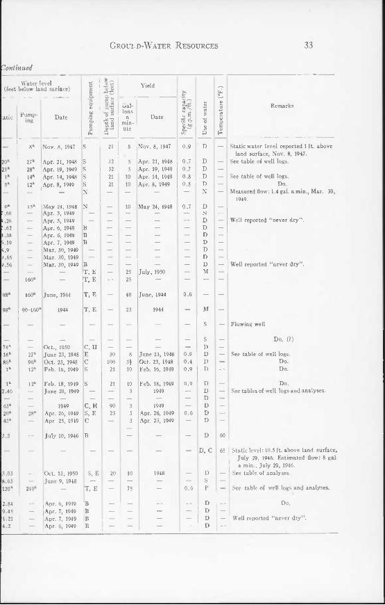
l Records of Wells in
Pumping equipment: B, bucket; C, cylinder; J, jet; N, none; S, suction; T, turbine. Use of water: C, commercial; D, domestic; F, farming; N, not used; P, public supply; S, school or camp; M, military. Static Water Level: reported depths are designated by a. Power; E, electric; G, gasoline; H, hand.
Well num- ber
Owner or name Driller Date com- pleted
V V •o 3 <
ToT well
Depth of
well (feet)
Diam- eter of
well (inches)
Depth of screen
below land surface (feet)
Water-bearing formation
Ba 1
Ba 2 Ba 3
Bb 1 Bb 2
Bb 3 Bb 4 Bb 5 Bb 6 Bb 7 Bb 8 Bb 9
Be 1 Be 2 Be 3
Be 4 Be 5 Be 6 Be 7 Be 8 Be 9
Ca 1 Ca 2
Cb 1 Cb 2 Cb 3 Cb 4 Cb 5 Cb 6 Cb 7 Cb 8
Cc 1
Kaylor Diatomite Plant
Vernon Whitington
Gorman Lyons Phil Harris
H. L. Hiekey G. Smith D. Rice B. McKenny Earl Hicks
M. King Charles M. Emerson Chesapeake Beach
Water System Do Do
Irving Catterton Charles Buckmaster W. J. Earle U. S. Navy
Y.M.C.A. of Balti- more
R. Smith M. Lacey Ed Cox J. Armiger Roland H. Trott J. Trott IV. E. Jones foseph F. Allen
William E. Day
Ward
Ward do
Leatherbury Washington Pump
& Well Co.
Shannahan
Leatherbury
do
1929
1929
1939 1950
1945
1949 1948 1948 1944
1949
1937
1944 1944 1922
1945 1949
1947
1
43 55
144 120
85 186 160 140 95
185 130
100 145
8
8 8
160 104 55 2
35 32
90 140 45
150 180 135 20 98
8
Drilled
Dug do
do do
do do do do do do
Drilled
Dug do
Drilled
do do do do do do
Dug Drilled
Dug do do do do do do
Drilled
Drilled
8.8 6.85
43.5 28.0
22.5 41 .8 17.1 24.55 36.9 39.0 285
43.8 41.0
357 260 230 335
23.05 468
36.9 50.9 26.2 31.35 44.4 34.8 27.8 290
211
48
2i
8
3
2i 2* 2 6
6
2
2
(none)
(none) do do
(none)
(none)
do
Pleistocene do
P leistocene-M iocer do
do do do do do do
Aquia
Pleistocene-Mioccn do
Aquia (?) Nanjemoy Nanjemoy Aquia
Pleistocene-Miocen Aquia
Pleistocene-Miocen do do do do do do
Nanjemoy
Manjemoy

Ground-Water Resources 31
County, M aryland
Water level (feet below land surface)
atic , Date mg
.75
.34
.87
.1
.7
.7
.67
.20
.75
.45 20®
A '.3
92* 95a
36a
;.54
.68
.9
.05
.87 > .7
12 98
60*
Mar. 29, 1949 (B Apr. 5. 1949 B
Jan. 13, 1947 C, H Mar. 29, 1949 B
Mar. 29, 1949 B Mar. 29, 1949 —
I Mar. 31, 1949 B I Apr. 5, 1949 Apr. 5, 1949 B Apr. 5, 1949 B May 20, 1950 C, E
Mar. 30, 1949 , B Mar. 29, 1949 B
100a
23a
Apr., 1949 C, E Oct., 1948 C, E Oct. 5, 1948 |C, H
T. E
Mar. 31, 1949 Nov. 7, 1949
Mar. 31, 1949 Mar. 31, 1949 Apr. 6, 1949 Apr. 6, 1949 Apr. 6, 1949 Apr. 6, 1949 Apr. 6, 1949 Mar. 2, 1949
Nov. 6, 1947
o w 2*
3
Yield
Gal- lons I mm- i ute
Date
138
B B B
B B B C, E
120
60
May 20, 1950
53
Apr., 1949 Oct., 1948 Oct. 5, 1948
Nov., 1949
" E S o.
0.6
4 | Mar. 2, 1949 , —
8 Nov. 6, 1947 0.9
Remarks
— Flowing well
56.5 See table of analyses. — Well reported "sometimes dry in hot
weather."
Well reported "never dry" See table of analyses.
Well reported "never dry" I See table of well logs.
Well reported "never dry" Do.
See table of well logs. Do
Estimated flow; 10-15 gal. a min., July 19, 1950.
Static level reported 4 ft. above land surface, Nov. 8, 1949. See table of well logs.
Well reported "never dry".
Well reported "never dry". Do. Do. Do. Do.
See table of well logs.
! Static water level reported 1 ft. above land surface, Nov. 6, 1947. See table of well logs.
32 Water Resources of Calvert County
TABL
Well num- ber
Owner or name Driller Date com- pleted V -a 3
<
ToT well
Depth of
well (feet)
Diam- eter of
well (inches)
Depth of screen
below land surface (feet)
Water-bearing formation
Cc 2
Cc 3 Cc 4 Cc 5 Cc 6 Cc 7
Cc 8 Cc 9 Cc 10 Cc 11 Cc 12 Cc 13 Cc 14 Cc 15 Cc 16 Cc 17 Cc 18
Cc 19
Cc 20
Cc 21
Cc 22 Cc 23 Cc 24 Cc 25 Cc 26
Cc 27 Cc 28 Cc 29 Cc 30 Cc 31 Cc 32
Db 1
Db 2
Db 3 Db 4 Db 5
Db 6 Db 7 Db 8 Db 9
William E. Day
Walter Dresser, Jr. Do
B. Trosell A. Seller Willow Beach De-
velopment Michael Anselmo
L. Jenkins — Ireland
Mrs. Carpenter H. Brown John Harlan U. S. Navy
Do
Do
Do
Boy Scouts of Amer- ica
Do Page Jett John Corbett — Abner Charles M. Cassidy
Co. Do
J. Cranston Mrs. Barr Frank F. Young Frank Buehler A. DeWitt Baker
Ralph E. Buchmeis- ter
— Parran
Mrs. Vertz Board of Education County Courthouse
G. Denton Wilton Freeland Leroy Bowens, Jr.
Leatherbury
do do do do
Leatherbury
Columbia Pump & Well Co.
Washington Pump & Well Co.
Columbia Pump & Well Co.
Ward (?)
Ward Leatherbury Ward Leatherbury
do Ward
do do
Leatherbury Ward
L. Rude & Son (?)
do
Washington Pump & Well Co.
1947
1948 1948 1948 1949
1948
1944 1948
1941
1944
1929
1937 1950 1948 1948 1949
1949 1948 1947 1949 1948 1949
1924
1939
1948
1935 1948
8
20 20
8 8 5
7 152 140 135 140 110 130 125 130 112 104
96
96
8
8 130 29 88
8
8 47
105 60 20 35
138
3
16 80
147
158 165 140
25
Drilled
do do do do do
do Dug do do do
Dug do do do
Drilled do
do
do
do
do do do do do
do do do do do do
Dug
Drilled
do Dug
Drilled
Dug do do do
211
231 231 210 210
210 33.0 30.0 25.1 29.55 31.65 60.11 47.75 16.00 472 476
462
500
260
260 356 231 268 210
210 273 340 280 231 250
35
365
419 30
552
23.02 33.7 28.85 15.3
2
2 2 2 2
2
6 4
6
4
2J
2i 2 2 2i 2
2 2* 2i 2J 2 2
2§
8
(none)
do do do do
(none)
462-476
448-462
486-500 \
(none) do do
do do
(none) do do
Nanjemoy
do do do do
Nanjemoy P leistocene-M iocer
do do do
Pleistocene-Miocei do do do
Aquia do
do
do
Nanjemoy
Nanjemoy do do do
do do do do do do
Aquia
do Pleistocene-M iocer Aquia
Pleistocene-M iocen do do do
Groui.d-Water Resources 33
'Continued
Water level (feet below land surface)
Pump- ing
27B
28* 14a
12*
160a
98* 160*
98* 90-160a
27* 96* 12*
Date
Nov. 8, 1947
Apr. 21, 1948 Apr. 19, 1949 Apr. 14, 1948 Apr. 8, 1949
May 24, 1948 Apr. 5, 1949 Apr. 5, 1949 Apr. 6, 1949 Apr. 6, 1949 Apr. 7, 1949 Mar. 30, 1949 Mar. 30, 1949 Mar. 30, 1949
12*
240*
June, 1944
1944
Oct., 1950 June 23, 1948 Oct. 23, 1948 Feb. 16, 1949
Feb. 18, 1949 June 20, 1949
1949 Apr. 26, 1949 Apr 25, 1949
July 10, 1946
Oct. 13, 1950 June 9, 1948
Apr. 6, 1949 Apr. 7, 1949 Apr. 7, 1949 Apr. 6, 1949
II
8-5 Q
B T. E T, E
T, E
T, E
C, H E C S
C, H S, E C
B
S, E
T, E
B B B B
30 100
21
Yield
Gal- lons i min- ute
Date
Apr. 21, 1948 Apr. 19, 1949 Apr. 14, 1949 Apr. 8, 1949
May 24, 1948
July, 1950
June, 1944
1944
June 23, 1948 Oct. 23, 1948 Feb. 16, 1949
Feb. 18, 1949 1949
1949 Apr. 26, 1949 Apr. 25, 1949
1948
oS S a
8 Nov. 8, 1947 ' 0.9
0.7 0.7 0.8 0.8
0.7
0.6
0.9 0.4 0.9
0.9
0.6
0.6
D, C
Remarks
Static water level reported 1 ft. above land surface, Nov. 8, 1947.
See table of well logs.
See table of well logs. Do.
Measured flow: 1.4 gal. a min., Mar. 30, 1949.
Well reported "never dry".
Well reported "never dry".
Flowing well
Do. (?)
See table of well logs. Do. Do.
Do. See tables of well logs and analyses.
60
65 Static level: 10.5 ft. above land surface, July 29, 1946. Estimated flow: 8 gal a min., July 29, 1946.
— See table of analyses.
— See table of well logs and analyses. (
— Do.
— Well reported "never dry".

34 Water Resources of Calvert County
TABL
Ec 4 Ec 5 Ec 6 Ec 7 Ec 8
Owner or name Driller
S. Rice L. R. Roberts — Frisco
James Bowen Mrs. Frank Par ran
L. Rude & Son Ward
Date com-
pleted
1944 1948
— Cassel
W. D. Dresser Ward
M. Kenneth Buckler'Leatherbury Nowell Dixon, Jr. F. L. Freeland Frank Mister J. G. Smith James Gott Robert Cairns D. and M. Ramsey G. W. Dorsey
W. D. Dresser J. G. Smith G. F. Gravatt
Do Do
A. Goldstein do
G. F. Gravatt Do
Vernon Hance
Thomas Parran
L. S. Bowen C. Cochran H. A. Crane
G. W. Dorsey
Do H. B. Trueman
i Lumber Co. Mrs. W. W. Ross Benjamin Parran
Do E. Gantt S. L. Barnett
do do
Bowen More Goman
Ward
L. Rude & Son
Columbia Pump & Well Co.
L. Rude & Son
Ward
do Columbia Pump
Well Co.
Leatherbury
1942 1940 1937
1896
1946 1931 1942 1938 1947
1947
Ward
1943 1944 1950
1920
1941 1946
1947 1945 1948
144 154 126 164
14 31
140 5
96
147 147 130 140 130 152 130
140 110 125
3 109
173 127
26 140
10
ToT well
40 16
145 3
1930 103 1945 |160 1932 160 1946 146
do Drilled
do
| Dug Drilled
Depth of
well (feet)
14.2 390 351
49.65 350
do
do
do do do
Dug do do do do
Drilled
do Drilled
Dug Drilled
do
do Dug Dug Dug do do do I
do 20 Drilled
1 Drilled
do do
Dug do
Drilled Dug
Drilled
204
340 350 340 34.2
28 35
60 225
37 180 360
555 25.99
40.37 34.45 41.65 39.55
do j 38.8 do 53.9
26.35 399
225 345
52.9 32.60 233
41.30 273
Diam- eter of
well (inches)
2i 2i
Depth of screen
below land surface i (feet)
Water-bearing formation
382-390 (none)
3-H
3-2
Pleistocene-Miocei Aquia
do
Aquia
(none) Nanjemoy
(none)
350-360
543-555
(none) Screen-no
depth
(none)
do do do
Pleistocene Miocer do do do do
Nanjemoy
do
Pleistocene-Mioccr Nanjemoy
do
Aquia Pleistocene-Miocen
do do do do do
Pleistocene-Miocen do do
I Aquia
jNanjemoy
do do
I do
Nanjemoy-Jackson Pleistocene-Miocen Nanjemoy-Jackson

Groukd-Water Resources 35
-Continued
Water 'evel (feet below land surface)
Pump
ing e
quip
men
t
Depth o
f pu
mp b
elow
land
surfa
ce (
feet)
Yield
Spec
ific
capa
city
(g.p.
m./f
t.)
Use
of
wate
r
4) E 3 rt | E (U H
59.5
61
60 60
60.5
60
Remarks
S^tic 1 '>7- Date Gal- lons
a min- ute
Date
9.9
39.56
14*
20-130ft
31.3
56.4
15a
5a
73.22 100a
130a
18.89
34.72 7.88
34.85 35.12
30.39
17.55 10a
125a
43.90 28.15
28a
35.85 5a
11
1
11 1
1 1111111M
- 1
1 1
1g 1
1 1
1 1
1 1
iiii
1 i|
1 11
1 3
Mar. 3, 1949
June 16, 1949
1930
1946 July 12, 1946
July 11, 1946
July 15, 1946 July, 1946
1942
May 6, 1947 May 15, 1947 July 15, 1947 July 9, 1947
May 19, 1949 Apr. 7, 1949 May 19, 1949 June 16, 1949
Apr. 7, 1949 Apr. 7, 1949 Apr. 7, 1949 May 30, 1950
Dec. 18, 1946
Apr. 7, 1947 May 6, 1947 Apr. 17, 1947 Apr. 7, 1949 Dec., 1948
B S, E S, E
E
S, G
C, E
C, E B
B C, E
S, E C, E
E
C H
H B B
B B B C
C, E T, E
E B E B S, E llgll
la
1 SI
M
MM
MI
Mill
alM
MIII
1 1
II
lSl
30
4
40
40
3
8J
60
3
15
1948
July 15, 1946
May 15, 1947
July 15, 1947
Dec. 18, 1946
Apr. 17, 1947
Dec., 1948
Ml
11 1
1 lllllllll
Mild
MM
MI
11 11
1 1
2 II
5 1
°
D D D
D N
D
P
D D D D D D D D C
P D D P P
D N D D D D D
D D D F
N
P C
D F D D D
Well reported "never dry". See table of well logs. Reported flow: 22 gal. a min., June 17,
1949
Flowing well.
Measured flow: 2.8 gal. a min., July 2, 1946.
Measured flow: 6 gal. a min., July 5, 1946.
Reported flow: 4 gal. a min., Aug. 12, 1946.
See table of well logs.
See table of well logs.
Well reported "never dry".
Well reported "never dry". Do.
See table of well logs.
Measured flow: 5 gal. a min., Jan. 13, 1947. See table of analyses.
Reported flow: 10 gal. a min. See tables of well logs and analyses.
See table of well logs. Well reported "never dry". See table of well logs.

36 Water Resources of Calvert County
TABLE
Well num- ber
Owner or name Driller Date com- pleted
Altit
ude
(fee
t)
TT well
Depth of
well (feet)
Diam- eter of
well (.inches)
Depth of screen
below land surface (feet)
Water-bearing formation
Ec 9 Ec 10 Ec 11 Ec 12 Ec 13 Ec 14
Ec 15
Ed 1
Ed 2
Ed 3
Ed 4
Ed 5
Ed 6
Ed 7 Ed 8 Ed 9
Ed 10
Fc 1
Fd l
Fd 2
Fd 3
Fd 4
Fd 5
Fd 6 Fd 7 Fd 8 Fd 9 Fd 10
Fd 11 Fd 12 Fd 13
Fd 14
H. Williams E. F. Reynolds Carroll C. Wood — Gray
Bert Bowen
Harry Parks
Y.M.C.A.—Camp Conoy
M. E. Rockhill
J. Cox
Robert C. Hall
Bancroft Estate Herbert Johnson Woodrow Hender-
son
George Gross
U. S. Navy
Mrs. Kenneth Lore
D. Barrett
G. D. Wait
Harry B. Richard- son
Mrs. H. Horseman Benjamin Dowell Dowell Cannery Mrs. Pendarvis — Nielson
Do Do
C. V. Short
W. B. Glascock
Ward
do
Shannahan
L. Rude & Son
Leatherbury
L. Rude & Son
Washington Pump & Well Co.
L. Rude & Son
do
Leatherbury
L. Rude & Son
L. Rude & Son do do
L. Rude & Son
1934 1948 1942
1948
1947
1931
1941
1948
1948
1944
1928
1942
1946
1932
1947
1946
1946 1926 1929
132 140 145 145 105
3
3
62
2
2
5
30
5
60 50 95
3
100
21
20
3
28
20
6 18.3 0 5
20 106
1
1.3
Dug do do do do
Drilled
do
do
do
do
do
do
do
Dug do
Dug
Drilled
do
do
Drilled
do
do do do do do
do Dug
Drilled
do
40.34 36.00 44.83 42.92 28.74 250
268
540
500
330
274
64.25 36.70 38.08
34.10
500.3
320
362
252
320
400 320 315 315
22.35
6-4i-3
3-2
3-2
2*
14
8-6
2i
a
2
3-2$
U 2| 2* U
u
(none)
520-540
(none)
do
476.5-500.3
(none)
do
(none)
(none) do
Pleistocene-Miocene do do do do
Nan jemoy-Jackson age
do
Aquia
Aquia
Nanjemoy-Jackson age
do
Pleistocene-Miocene do do
Pleistocene-Miocenc
Aquia
Nanjemoy-Jackson age
do
Nanjemoy-Jackson age
do
do do do do
Pleistocene-Miocene
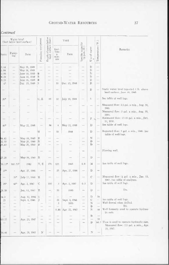
Ground-Water Resources 37
Continued
Water level (feet below land surface)
Date
May 19, 1949 May 19, 1949 June 16, 1949 June 16, 1949 June 16, 1949 Dec. 15, 1948
C, E
161.ya"
20*
40a
16.40 —
May 22, 1948
May 19, 1949 May 20, 1949 May 20, 1949
May 19, 1949
1942
Apr. 27, 1946
July 17, 1946
Apr. 2, 1947
Jan. 13, 1947
Aug. 12, 1946 Sept. 6, 1946
Apr. 23, 1947
Apr. 30, 1947
t-z: ■% Z _e E 2 O «« D- cij
B
T, E
Yield
170
Gal- lons min- ute
Date
— 10 Dec. 15, 1948
July 10, 1944
84 4
— 50
May 22, 1948
1948
uS S O.
1945 0.8
Apr. 27, 1946
Apr. 2, 1947
1946
Sept. 3, 1946 1926
Apr. 23, 1947
P S D
D
N D D
Remarks
Static water level reported 1 ft. above land surface, June 16, 1949.
See table of well logs.
Measured flow; 3.8 gal. a min., Aug. 19, 1946
Measured flow: 3 gal. a min., Aug. 19, 1946.
Estimated flow; 15-20 gal. a min., Oct. 13, 1950.
See table of well logs.
Reported flow; 5 gal. a min., 1948. See table of well logs.
Flowing well.
50 64.7
See table of well logs.
Measured flow; \ gal. a min., Jan. 13, 1947. See table of analyses.
See table of well logs.
Do.
See table of well logs. Well flowed when drilled.
Do. Well formerly used to operate hydrau-
lic ram.
Flow is used to operate hydraulic ram. Measured flow; 2.5 gal. a min., Apr. 23, 1947.

38 Water Resources of Calvert County
tabli
Well num- ber
Owner or name Driller Date com- pleted
O) V -o 3
<
18
28 28 28 28
17
20
136 30
134 100 25
120 120 125 115
18
6
5
5 130
5 5
3 5
5 5 5
5 5 5
100
12
13 15
14.5
9.5
ToT well
Depth of
well (feet)
Diam- eter of
well inches)
Depth of screen
below land surface (feet)
Water-bearing formation
Fd 15
Fd 16 Fd 17 Fd 18 Fd 19
Fd 20
Fd 21
Fd 22 Fd 23 Fd 24 Fd 25 Fd 26 Fd 27 Fd 28 Fd 29 Fd 30 Fd 31
Fd 32
Fe 1
Fe 2 Fe 3 Fe 4 Fe 5
Fe 6 Fe 7
Fe 8 Fe 9 Fe 10
Fe 11 Fe 12 Fe 13 Fe 14
Gd 1
Gd 2 Gd 3
Gd 4
Gd 5
Roy Minke
Duke Adams Do Do Do
U. S. Navy
W. C. Bond
William Rekar Howard L. Jones William Rekar Ernest Thompson Alec Barrett Arthur Dowell Edward Porch
Sarah C. Glascock
U. S. Navy
R. P. McConnell
Irene Michitoff Edgar Bowen Olga Morosoff Serge G. Koush-
nareff — McKencie — Ostenso
Don N. Harry T. A. Mourt Mrs. L. G. Tompt-
son J. B. Gainer L. DeFord Smith J. K. Wright G. W. Hagelin
G. Francis Beavan
T. V. Thomas U. S. Navy
U. S. Navy
Do
E. Rude & Son
L. Rude & Son
do
do
do do
L. Rude & Son
L. Rude & Son
do do do do
L. Rude & Son
do do do
do do do
Washington Pump & Well Co.
Washington Pump & Well Co.
do
1947
1947
Before 1942 1947
1948 1947
1945
1949
1949
1944
1946
1946 1946 1946 1946
1948
1948 1948 1948
1948 1948 1948 1919
1942
1942
1942
do
Dug do do
Drilled
do
do
do do
Dug do do do
Dug do do
Drilled
do
do
do do do do
do do
do do do
do do do
Dug
Drilled
do do
Drilled
do
315
36 36 36
300
315
461 375
50.81 45.35 22.05 51.85 38.55 22.78 19.0 320
490
320
320 400-425
320 320
315
315 315 375
315 315 315 68.50
275
250 247
250J
248
2*
2i
U
2i
3 3
5-3J
8-6
2§
2* 3 2i 2J
2i
2§ 2i 2J
2* 2* 2*
U
1* 6
8
8
(none)
(none)
do
do
do do
(none)
466-490
(none)
do do do do
(none)
do do do
do do do
234-247
235J-250J
233-248
Nanjemoy-Jackson age
Pleistocene-Miocen do do
Nanjemoy-Jackson age
Nanjemoy-Jackson age
do do
Pleistocene-Miocen do do do do do do
Nanjemoy-Jackson age
Aquia
Nanjemoy-Jackson age
do do do do
Nanjemoy-Jackson age
do do do
do do do
Pleistocene-Miocen
Nanjemoy-Jackson age
do do
Nanjemoy-Jackson age
do

Ground-Water Resources 39
—Continued
Water level (feet below land surface)
Pump
ing e
quipm
ent
Depth o
f pu
mp b
elow
land
surfa
ce (
feet)
Yield
Spec
ific
capa
city
(g.p.
ra./f
t.)
Use
of
wate
r
Tem
pera
ture (
0F.)
Remarks Static Pump-
ing Date Gal- lons
a min- ute
Date
35a
25a
38a
135a
45a
47.31 31.50 12.85 44.20 30.10 10.33 16.59
20a
3a
5a
145a
5a
5a
6a
6a
6a
6a
6a
6a
6a
6a
63.93
29.45
33.45 20a
50a
20a
40a
15a
56.5
47a
17a
150a
15a
15a
20a
20a
20a
20a
20a
20a
20a
55a
85.4a
129a
85.5a
131.5
May 24, 1947
June 4, 1947
June 25, 1947
June, 1948 June 15, 1947 June 4, 1948 May 20, 1949 'ay 20, 1949
May 20, 1949 May 20, 1949 May 20, 1949 May 20, 1949 Apr. 20, 1949
Apr. 22, 1946
July 20, 1946 Apr. 15, 1946 Aug. 13, 1946 Aug. 9, 1946
1948
1948 1948 1948
1948 1948 1948
May 20, 1949
Sept. 25, 1944
Sept 25, 1944 June 19, 1942 Jan. 13, 1944
1942 1944 1942 1944
J
J
J
C, H
T, E
S
S c s s
s
s s s
s s s B
s
s T
T, E
T, E
168 45
90
150
25
25 25 25
25 25 25
135.5
20
25
25
5 30
30
30
20 10 20 20
5
10 10 10
10 10 10
35 25
120 100 110 100
May 24, 1947
June 4, 1947
June 25, 1947
June, 1948 June 15, 1947
Apr. 20, 1949
Apr. 22, 1946
July 20, 1946 Apr. 15, 1946 Aug. 13, 1946 Aug. 9, 1946
1948
1948 1948 1948
1948 1948 1948
1942 1944 1942 1944 1942 1944
1.1
1.7 2.0 2.0 2.0
0.4
0.7 0.7 0.7
0.7 0.7 0.7
1.8 1.2 1.6 1.3
D
D D, F
D D
N
D
D D N D D D D D D C
D
D D D D
D
D D D
D D D D
D
D M
M
59
See table of well logs.
See table of well logs.
Well covered.
See table of well logs.
Do.
Pump capacity: 200 gal. a min. See table of well logs.
See table of well logs.
See table of well logs. Do.
See tables of well logs and analyses.
See table of well logs.

40 Water Resources of Calvert County
TABLE:
Well num- ber
Owner or name Driller Date com- pleted
V a> "O 3
ToT well
Depth of
well (feet)
Diam- eter of
well (inches)
Depth of screen
below land surface (feet)
Water-bearing formation
Gd 6
Gd 7
Gd 8
Gd 9 Gd 10
Gd 11 Gd 12
Gd 13 Gd 14
Gd IS Gd 16
Gd 17
Gd 18 Gd 19 Gd 20 Gd 21
Gd 22
Gd 23 Gd 24
Gd 25 Gd 26 Gd 27 Gd 28 Gd 29 Gd 30
Gd 31
Gd 32 Gd 33
Gd 34
Gd 35 Gd 36
Gd 37
U. S. Navy
Do
Mrs. H. Harrison
Mrs. Sadie Webster Mrs. Clarence E.
Davis Mrs. A. J. Elliott Chesapeake Bio-
logical Labora- tory
T. R. Langley T. E. Waggarman
Preston Woodburn Calvert Ice Co.
Mrs. Mamie Wood- burn
Benjamin Woodburn Alfred Hill G. Francis Beavan Kenneth Lore
Esso Standard Oil Co.
Rupert Olsen Methodist Episcopal
Parsonage George Cary U. S. Navy Edna Davis J. C. Webster's Store Rekar's Hotel Joseph Lore
Preston Woodburn
Do George Condiff
Drum Point Beach Cooperative
Do U. S. Navy
B. P. Lankford
Washington Pump & Well Co.
Layne-Atlantic
Leatherbury
L. Rude & Son do
do
L. Rude & Son
do Washington Pump
& Well Co. L. Rude & Son
do do
L. Rude & Son
L. Rude & Son Ward
L. Rude & Son do
L. Rude & Son
L. Rude & Son
L. Rude & Son
Washington Pump & Well Co.
Washington Pump & Well Co.
L. Rude & Son
1942
1943
1946
1946 1946
1931
1902 1946
1946 1943
1946
1946 1946 1944 1947
1947 1947
1948 1938
1948
1948
1949
1944
1948
10
17
10
7 3
14 14
4 11
13 5
8
8 8
15 3.9
0.8
12.8 13
8 9 0.8 2 2 5
13
13 10
30
40 16
13
Drilled
do
do
do do
do do
do do
do do
do
do do
Driven Drilled
do
do do
do do do
Drilled do do
do
Dug Drilled
do
Dug Drilled
do
493
551
269
320 320
320
320
320 505
350
320 320
12 333.8
320
315 290
315 320 224
315
10 315
285
17.70 505
315
8-6
10-8
3-2
2i 21
3
2i
2J 8-6
2i
2i 2i
21
3
21
2} 21 U
5-31
21
8
8-6
31
469-493
504-519 531-541 (none)
do do
(none)
do 494-505
(none)
do do
(none)
(none)
(none) do
(none)
(none)
272.5-285
(none)
Aquia
do
Nan jemoy-Jackson age
do do
Nanjemoy-Jackson age
Nanjemoy-Jackson age
do Aquia
N an jemoy-J ackson age
do do
Pleistocene Nanjemoy-Jackson
age do
do do
do do do
Nanjemoy-Jackson age
Pleistocene Nanjemoy-Jackson
age Jackson age
Pleistocene-Miocene Aquia
Nanjemoy-Jackson age

Ground-Water Resources 41
-Continued
Water level (feet below land surface) c V 6 o. "5
s1
00 J a B 3 eu
T, E
T
S S
E E
E J
J T
J
S S
J -
J
s N
J
C
N T
Yield
Spec
ific
capa
city
(g.p.
m./f
t.)
Use
of
wate
r
Tem
pera
ture (
0F.)
Remarks Static Date
e s 3 J5 3 O tn
•5T3 Q
Gal- lons
a min- ute
Date
0a
58.9* 17® 70a
25*
16a
15a
26a
0 23a
22a
23a
21a
2la
20a
13.9 30*
18.37
30a
22a
18.70 14.76
16a
27a
45a
13.21
25a
63.5a
134a
100a
139a
36a
19a
160a
1942 1944
Feb. 2, 1943 Feb. 2, 1944 Jan. 25, 1946
May 3, 1946 Aug. 23, 1946
1931
June 18, 1946 Aug. 20, 1946
Aug. 27, 1946
Sept. 8, 1946
Sept. 20, 1946 Aug. 30, 1946 Apr. 23, 1947 May 20, 1947
May 20, 1947
May 30, 1947
1948 Nov. 28, 1950 May 23, 1946
1948
1948
May 10, 1949
May 20, 1949
1948
170
160
63
25
60
40
200
60
135 150 200 300
5
10 25
25
25
25
25 25
15
25
20
50
20
180
30
1942 1944
Feb. 2, 1943 Feb. 2, 1944 Jan. 25, 1946
May 3, 1946 Aug. 23, 1946
Aug. 20, 1946
Aug. 27, 1946
Sept. 8, 1946
Sept. 20, 1946 Aug. 30, 1946
May 20, 1947
May 30, 1947
1948
1948
1948
May 10, 1949
1948 I II
£ 1
1 MM
MM
1 11
II
II
1 £
££•:
£"
M
D
D D
D D
C D
D C
D
D D N D
N
D
D N N C C c
N
D
P
N M
D
65.5 See tables of well logs and analyses
See table of well logs.
See table of well logs. Do.
Well was flowing in 1942.
Do. See table of well logs.
See table of well logs.
Do. Do.
See table of well logs.
See table of well logs. Well covered.
See table of well logs.
Abandoned because of decline in water level.
See table of well logs.
Do.
See table of well logs.
Do.
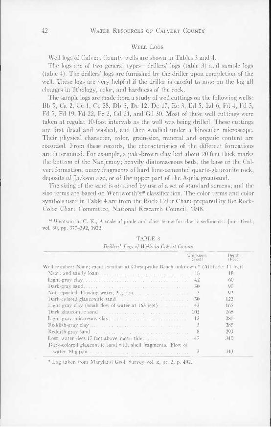
42 Water Resources of Calvert County
Well Logs
Well logs of Calvert County wells are shown in Tables 3 and 4. The logs are of two general types—drillers' logs (table 3) and sample logs
(table 4). The drillers' logs are furnished by the driller upon completion of the well. These logs are very helpful if the driller is careful to note on the log all changes in lithology, color, and hardness of the rock.
The sample logs are made from a study of well cuttings on the following wells: Bb 9, Ca 2, Cc 1, Cc 28, Db 3, Dc 12, Dc 17, Ec 3, Ed 5, Ed 6, Fd 4, Fd 5, Ed 7, Fd 19, Fd 22, Fe 2, Gd 21, and Gd 30. Most of these well cuttings were taken at regular 10-foot intervals as the well was being drilled. These cuttings are first dried and washed, and then studied under a binocular microscope. Their physical character, color, grain-size, mineral and organic content are recorded. From these records, the characteristics of the different formations are determined. For example, a pale-brown clay bed about 20 feet thick marks the bottom of the Nanjemoy; heavily diatomaceous beds, the base of the Cal- vert formation; many fragments of hard lime-cemented quartz-glauconite rock, deposits of Jackson age, or of the upper part of the Aquia greensand.
The sizing of the sand is obtained by use of a set of standard screens; and the size terms are based on Wentworth's40 classification. The color terms and color symbols used in Table 4 are from the Rock-Color Chart prepared by the Rock- Color Chart Committee, National Research Council, 1948.
40 Wentworth, C. K., A scale of grade and class terms for clastic sediments: Jour. Geol., vol. 30, pp. 377-392, 1922.
TABLE 3 Drillers' Logs of Wells in Calvert County
Thickness Depth (Feet) (Feet)
Well number: None; exact location at Chesapeake Beach unknown.* (Altitude: 11 feet) Muck and sandy loam 18 18 Light-gray clay 42 60 Dark-gray sand 30 90 Not reported. Flowing water, 3 g.p.m 2 92 Dark-colored glauconitic sand 30 122 Light-gray clay (small flow of water at 165 feet) 43 165 Dark glauconitic sand 103 268 Light-gray micaceous clay 12 280 Reddish-gray clay 5 285 Reddish-gray sand 8 293 Lost; water rises 17 feet above mean tide 47 340 Dark-colored glauconitic sand with shell fragments. Flow of
water 10 g.p.m 3 343
* Log taken from Maryland Geol. Survey vol. x, pt. 2, p. 402.

Ground-Water Resources
TABLE 3—Continued
43
Thickness Depth (Feet) (Feet)
Well Cal-Bb 9 (Altitude: 130 feet) Marl, blue 116 116 Sand, clayey, black 104 220 Clay, gray and pink 20 240 Clay and sand, black 17 257 Rock, hard 1 258 Sand, black, and rock, hard 25 283 Rock, hard (water under rock) 2 285
Well Cal-Bc 7 (Altitude: 104 feet) Clay, light-yellow, and sand, fine 30 30 Clay, gray 30 60 Clay, blue 120 180 Clay, dark-green 60 240 Sand, black, with traces of lime scale 20 260
Well Cal-Bc 8 (Altitude: 55 feet) Clay 15 is Marl 95 110 Sand, black (water) 120 230
Well Cal-Ca 2 (Altitude: 32 feet) Sandy 10 10 Clay, sandy, brown 10 20 Clay, sandy, green 10 30 Marl 10 40 Clay, green, with salt and pepper sand; clay, sandy 255 295 Sand, fine 16 311 Clay, green, and shells 23 334 Rock 1,5 335.5 Hard places and free streaks 10.5 346 Crusty places and free places 31 377 Clay and shells 11 388 Hard place 0.4 388.4 Sand, shell, clay streaks 37.6 426 Sand and shells 12 438 Rock 0.3 438.3 Sand, fine 29.7 468
Well Cal-Cb 8 (Altitude: 98 feet) Clay, sandy 40 40 Marl, blue 170 210 Sand, salt and pepper (water) 80 290

44 Water Resources of Calvert County
TABLE 3—Continued Thickness Depth
(Feet) (Feet) Well Cal-Cc 1 (Altitude: 8 feet)
Sand, coarse 38 38 Marl, sandy 12 50 Marl, blue 40 90 Sand mixed with marl (water) 121 211
Well Cal-Cc 3 (Altitude: 20 feet) Clay 20 20 Marl, blue 90 110 Shell, fine, and marl; sand, salt and pepper 121 231
Well Cal-Cc 5 (Altitude: 8 feet) Clay 4 4 Sand, white 16 20 Sand with marly clay (water) 23 43 Marl, blue 47 90 Shell, fine, and marl; sand, salt and pepper 120 210
Well Cal-Cc 6 (Altitude: 8 feet) Sand, white 22 22 Sand, marly, white, and clay 23 45 Marl, blue 45 90 Shell, fine; marl; sand, salt and pepper 120 210
Well Cal-Cc 24 (Altitude: 29 feet) Clay, brown 20 20 Marl, blue 90 110 Marl mixed with shell 20 130 Sand, salt and pepper; some coarse sand (water) 100 230
Well Cal-Cc 25 (Altitude: 88 feet) Clay, yellow 30 30 Clay, gray, a little sand 20 50 Clay, blue 130 180 Clay, blue, occasional shell beds 60 240 Sand, black 28 268
Well Cal-Cc 26 (Altitude: 8 feet) Sand, coarse 40 40 Marl 50 (?) 90 (?) Sand and shells 120 (?) 210
Well Cal-Cc 27 (Altitude: 8 feet) Sand, coarse 40 40 Marl 50 90 Sand, fine, and shells 6 96 Sand, salt and pepper (water) 114 210

Ground-Water Resources
TABLE 3—Continued
45
Thickness Depth (Feet) (Feet)
Well Cal-Db 3 (Altitude: 16 feet) Clay, yellow 10 10 Sand 10 20 Gravel 10 30 Clay 30 60 Sand and gravel. 20 80 Clay 30 110 Clay and sand, black 58 168 Sand, black, and clay 142 310 Clay, gray 37 347 Clay, pink 10 357 Sand, black 63 420
Well Cal-Db 11 (Altitude: 16 feet) Clay, yellow 10 10 Sand 10 20 Gravel 10 30 Clay 30 60 Sand and gravel 20 80 Clay 30 110 Clay, and sand, black 200 310 Clay, gray 37 347 Clay, pink 10 357 Sand, black (water) 33 390
Well Cal-Ec 3 (Altitude: 109 feet) Clay, sandy 20 20 Marl, blue 60 80 Marl, sandy 80 160 Shells, marl 30 190 Marl, blue 75 265 Marl, sandy 55 320 Marl, green 14 334 Sand (water) 8 342
Well Cal-Ec 6 (Altitude: 26 feet) Sand and gravel 42 42 Marl 158 200 Sand, salt and pepper (water) 33 233
Well Cal-Ec 8 (Altitude: 10 feet) Sand, reddish 10 10 Gravel 20 30 Clay, blue 110 140 Clay, blue, and shells 5 145 Rock 1 146 Sand and shell (water) 20 166
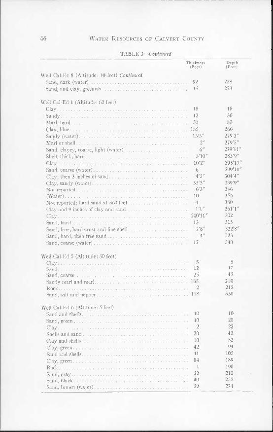
46 Water Resources of Calvert County
TABLE 3—Continued Thickness Depth
(Feet) (Feet) Well Cal-Ec 8 (Altitude: 10 feet) Continued
Sand, dark (water) 92 258 Sand, and clay, greenish 15 273
Well Cal-Ed 1 (Altitude; 62 feet) Clay 18 18 Sandy 12 30 Marl, hard 50 80 Clay, blue 186 266 Sandy (water) 13'3" 279'3" Marl or shell 2" 279'5" Sand, clayey, coarse, light (water) 6" 279'11" Shell, thick, hard 3'10* 283'9" Clay 10'2" 293'11" Sand, coarse (water) 6 299'11" Clay; then 3 inches of sand 4'5" 304'4" Clay, sandy (water) 35'5" 339'9" Not reported 6'3" 346 (Water) 10 356 Not reported; hard sand at 360 feet 4 360 Clay and 9 inches of clay and sand I'l" 361'1" Clay UO'U" 502 Sand, hard 13 515 Sand, free; hard crust and fine shell 7'8" 522'8" Sand, hard, then free sand 4" 523 Sand, coarse (water) 17 540
Well Cal-Ed 5 (Altitude: 30 feet) Clay 5 5 Sand 12 17 Sand, coarse 25 42 Sandy marl and marl 168 210 Rock 2 212 Sand, salt and pepper 118 330
Well Cal-Ed 6 (Altitude: 5 feet) Sand and shells 10 10 Sand, green 10 20 Clay 2 22 Shells and sand 20 42 Clay and shells 10 52 Clay, green 42 94 Sand and shells 11 105 Clay, green 84 189 Rock 1 190 Sand, gray 22 212 Sand, black 40 252 Sand, brown (water) 22 274

Ground-Water Resources 47
TABLE 3—Continued Thickness Depth
(Feet) (Feet) Well Cal-Fd 1 (Altitude: 20 feet)
Sand and gravel 55 55 Marl and shells 175 230 Sand, some shells 17 247
Well Cal-Fd 4 (Altitude: 28 feet) Sand, fine, white 40 40 Marl, blue 37 77 Rock 1 78 Marl 122 200 Sand and marl 52 252
Well Cal-Fd 5 (Altitude: 20 feet) Clay, brown 10 10 Sand and gravel 10 20 Sand, gray, with shells 105 125 Clay, blue 135 260 Sand, black (water) 60 320
Well Cal-Fd 7 (Altitude: 18 feet) Clay, brown 10 10 Sand and gravel 10 20 Clay 5 25 Sand, shells, some wood 35 60 ('lay, blue 60 120 Gravel 10 130 Clay and sand, green 38 168 Clay, blue 81 249 Sand, gray 36 285 Sand, black (water) 35 320
Well Cal-Fd 15 (Altitude: 18 feet) Clay, yellow 15 15 Sand, gray 10 25 Clay, blue 25 50 Sand and shells 60 110 Clay, blue; some shells 90 200 Sand, gray 62 262 Sand, black (water) 53 315
Well Cal-Fd 19 (Altitude: 28 feet) Clay, yellow 20 20 Sand and shells 10 30 Clay 7 37 Sand and shells 53 90 Clay, blue 80 170 Sand, gray 20 190 Sand, water 119 309
48 Water Resources of Calvert County
TABLE 3—Continued Thickness Depth
(Feet) (Feet) Well Cal-Fd 21 (Altitude; 20 feet)
Sand, yellow, and clay 18 18 Sand, gray 9 27 Clay, blue 8 35 Sand and shells 45 80 Clay and some shells 100 180 Sand, gray 70 250 Sand, black (water) 65 315
Well Cal-Fd 22 (Altitude: 136 feet) Clay and sand 10 10 Sand 95 105 Clay, blue 35 140 Sand and shells 70 210 Clay, blue 46 256 Sand and shells 7 263 Clay, green 94 357 Rock 1 358 Sand, gray 41 399 Sand, black 62 461
Well Cal-Fd 32 (Altitude; 6 feet) Sand, yellow, and clay 8 8 Clay, blue 68 76 Sand, coarse, and gravel 49 125 Marl 103 228 Sand and rock 42 270 Clay, blue 32 302 Sand 13 315 Clay, very sticky 125 440 Clay, gray, changing to light brown 15 455 Sand (water) 35 490
Well Cal-Fe 2 (Altitude; 5 feet) Sand and sea shells 20 20 Clay, gray 5 25 Sand, sea shells, gravel 60 85 Clay, blue mixed with some shell 187 272 Sand, black 48 320
Well Cal-Fe 4 (Altitude; 5 feet) Sand and sea shells 20 20 Clay, gray 5 25 Sand, sea shells, gravel 59 84 Clay, blue; some shells 188 272 Sand, black (water) 48 320
Well Cal-Fe 5 (Altitude; 5 feet) Sand and sea shells 20 20

Ground-Water Resources
TABLE 3—Continued
49
Thickness Depth (Feet) (Feet)
Well Cal-Fe 5 (Altitude: 5 feet) Continued Clay, gray 5 25 Sand, shells, and gravel 59 84 Clay mixed with some shells 188 272 Sand, black 48 320
Well Cal-Gd 4 (Altitude: 14.5 feet) Sandy clay 15 15 Sand and gravel 35 50 Marl 178 228 Sand (water) 23 251
Well Cal-Gd 5 (Altitude: 9.5 feet) Top soil 2 2 Clay, yellow 8 10 Sand, fine 4 14 Sandy, marl 20 34 Marl, sticky, blue 46 80 Sand 21 101 Marl, blue 6 107 Shells and gravel 5 112 Sandy marl 28 140 Marl, green 77 217 Sand 31 248
Well Cal-Gd 6 (Altitude: 10 feet) Clay 15 15 Sand and gravel 25 40 Marl 185 225 Rock, sand, and shells 35 260 Marl 191 451 Sand (water) 42 493
Well Cal-Gd 7 (Altitude: 17 feet) Clay, red 15 15 Sand, fine 15 30 Clay, blue, and shells 200 230 Mud, soft, black, and sand 137 367 Sand, black 8 375 Sand, silty, black 25 400 Clay, blue, and sand 66 466 Greensand (water) 59 525 Rock, hard 1 526 Sand, hard 4 530 Trap rock, hard 1 531 Sand, white (water) 11 542 Shale, hard 4 546 Sand, white 5 551 Clay, blue 19 570
50 Water Resources of Calvert County
TABLE 3—Continued
Thickness Depth (Feet) (Feet)
Well Cal-Gd 9 (Altitude: 7 feet) Clay, yellow 10 10 Sand, white, and gravel 30 40 Clay with some sand, gray 10 50 Sand, gray 25 75 Shells and sand mixed 25 100 Sand, mixed with clay 20 120 Clay, blue 10 130 Sand, white, with shells 60 190 Sand, black (water) 130 320
Well Cal-Gd 10 (Altitude: 3 feet) Sand and clay 10 10 Sand, white, and gravel 15 25 Clay, gray 7 32 Sand, gray, and shells 28 60 Clay, gray 30 90 Sand 10 100 Clay, blue 25 125 Sand, gray 125 250 Sand, black (water) 70 320
Well Cal-Gd 14 (Altitude; 11 feet) Clay, brown 12 12 Sand and gravel 10 22 Sand and shells 19 41 Sand, gray 84 12S Clay, blue 80 205 Sand, gray 67 272 Sand, black (water) 48 320
Well Cal-Gd 17 (Altitude: 8 feet) Clay, brown 10 10 Sand and gravel 30 40 Sand, sea shells, wood 30 70 Sand and gravel 48 118 Clay, blue 122 240 Sand, gray 45 285 Sand, black (water) 35 320
Well Cal-Gd 18 (Altitude: 8 feet) Clay, brown 10 10 Sand and gravel 30 40 Sand, sea shells, some wood 30 70

Ground-Water Resources
TABLE 3—Continued
51
Thickness Depth (Feet) (Feet)
Well Cal-Gd 18 (Altitude; 8 feet) Continued Sand and gravel 48 118 Clay, blue 122 240 Sand, gray 45 285 Sand, black 35 320
Well Cal-Gd 19 (Altitude: 8 feet) Clay, brown 5 5 Sand and gravel; rock at 40 feet 35 40 Sand and shells 20 60 Clay, gray 25 85 Clay, blue 165 250 Sand, gray 50 300 Sand, black (water) 20 320
Well Cal-Gd 21 (Altitude: 4 feet) Clay, yellow 15 15 Sand, gray 15 30 Clay, blue 15 45 Sand and shells 47 92 Clay, blue, and some shells 108 200 Sand, gray 115 315 Sand (water) 19 334
Well Cal-Gd 23 (Altitude: 13 feet) Clay, yellow 15 15 Sand, gray 10 25 Clay, blue 10 35 Sand and gravel 10 45 Clay 5 50 Sand and shells 60 110 Clay, some shells 80 190 Sand, gray 35 225 Sand, black (water) 90 315
Well Cal-Gd 25 (Altitude: 8 feet) Clay, yellow 10 10 Sand, gray 12 22 Clay, gray 6 28 Sand and shells 37 65 Clay, gray 21 86 Sand and shells 24 110 Clay, green 100 210 Sand, gray 60 270 Sand, black 45 315

52 Water Resources of Calvert County
TABLE 3—Concluded Thickness Depth
(Feet) (Feet)
Sand (water) 30 Marl.
Well Cal-Gd 30 (Altitude: 5 feet) Clay, yellow 10 10 Sand, blue 20 30 Clay, blue 15 45 Sand and sea shells 48 93 Clay, blue 107 200 Sand, gray 50 250 Sand (water) 65 315
11 Well Cal-Gd 33 (Altitude: 10 feet)
Clay, yellow 11 Sand, gray 13 24 Clay 6 30
Sand and shells 33 63 Clay, gray 22 85 Sand and shells 30 115 Clay, green 95 Sand, gray 6^ Sand, black 45
210 270 315
Well Cal-Gd 34 (Altitude: 30 feet) Sand 38 38 Clay, blue 33 71 Sand and shells 35 106 Marl 143 249 Marl and shells 14 263 Sand (water) 22 285
Well Cal-Gd 36 (Altitude: 10 feet) Clay 15
Sand, yellow, and gravel 40 55 Marl and sand 1^0 235
265 198 463
500 Sand (water) 37
Well Cal-Gd 37 (Altitude: 13 feet) Clay, yellow 10 Sand, yellow H Clay, gray 5 Sand and shells 39 Clay, gray 15 80
Sand and shells 38
10 21 26

Ground-Water Resources 53
TABLE 4 Logs of Welh in Calvert County from Which Well-cuttings Samples Were Obtained
Thickness (Feet) Depth (Feet)
Well Cal-Bb 9 (Altitude: 130 feet) Recent or Pleistocene series;
Sand and clay, weak yellowish-orange (10YR/7/6). Sand, chiefly fine-grained, but also much very fine-grained;
quartz grains, clear, somewhat iron-stained, subrounded to rounded; glauconite, scarce, green-black, smooth, rounded; a little kyanite 10 10
Sand and clay, very pale-brown (10YR/7/3); some gravel.... Sand, chiefly very fine-grained; quartz grains, chiefly clear,
some opaque white, subrounded and subangular; altered feldspar, scarce; chert, rare; some iron-cemented quartz aggregates;glauconite, very rare, fine and very fine 10 20
Miocene series: Calvert formation;
Sandy clay, pale-brown (2.5Y/6/2). Sand, chiefly fine-grained; quartz grains, clear
and cloudy, some black-stained, subangular; glauconite, scarce, very fine; pyrite, rare; bone fragments, common; sponge spicules and shell fragments, scarce 5 25
Sandy clay, sand, gravel, and shell fragments. Sand, chiefly fine-grained, but also much medium-grained;
quartz, clear, white, cloudy, iron-stained, subrounded to subangular; pyrite, fine-grained, rare; shell fragments, common, chiefly barnacles, rare Pectens; aragonite probably from Isognomom maxillala; sharks' teeth; Ostracoda, rare; sponge spicules, common 5 30
Sandy clay, yellowish-gray (5Y/7/2). Sand, chiefly fine-grained, but also much very fine-grained;
quartz, clear, subangular; glauconite, medium-grained, common, chiefly yellow-green, but also some green- black 10.5 40.5
Sand and clay, yellowish-gray (5Y/7/2). Sand, chiefly fine-grained, but also much very fine-grained;
quartz, clear; some quartz grains black-stained; bone fragments, rare; sponge spicules, rare 10.5 51
Sandy clay, yellowish-gray (5Y/8/1); some diatomaceous earth.
Sand, very fine-grained; quartz, chiefly clear; glauconite, rare; muscovite, fairly common; echinoid spines, rare; diatoms, common; Foraminifera, rather common 31.5 82.5
Sand and clay, light olive-gray (5Y/6/2); some phosphate nodules; shell fragments.
Sand, chiefly fine-grained; quartz grains, chiefly clear, sub- angular; phosphate nodules and casts, fairly common;

54 Water Resources of Calvert County
TABLE 4—Continued Thickness
(Feet) Depth (Feet) Well Cal-Bb 9—Continued
some bone fragments and teeth; radiolaria, common, diatoms, scarce 10.5 93
Sandy clay, pale-olive (5Y/6/2.5). Sand, chiefly very fine-grained; quartz, clear; glauconite,
very rare; bone fragments, rare 12 105 Sand and clay, weak yellow (5Y/7/3). Sand, chiefly medium and fine-grained; quartz, partly
cloudy, subangular; rose quartz, rare; glauconite, rare; phosphate nodules, rare; shell fragments, fairly common; bone, rare 10 115
Eocene series: Nanjemoy formation;
Greensand, olive-gray (5Y/4/1). Sand, chiefly medium-grained; quartz, clear and cloudy,
generally green-stained, subangular to subrounded; glauconite, chiefly medium- and fine-grained, but also some coarse and very fine-grained; coarse glauconite, green-black and yellowish-green, botryoidal, smooth, shiny; medium-grained glauconite, yellow-green, bot- ryoidal to rounded; fine-grained glauconite, yellow- green, pellet-like; very fine-grained glauconite, light green, pellet-like; pieces of lime-cemented greensand; some phosphate nodules; pyrite, rare; shell fragments, rare 21.5 136.5
Greensand, olive-gray (5Y/4/1). Sand, chiefly medium-grained; quartz, clear and cloudy,
commonly green-stained; pyrite, rare. Cf. sample at 136 for distribution of glauconite 10.5 147
Coarse greensand, olive-gray (5Y/4/1). Sand, chiefly very coarse-grained; quartz, chiefly cloudy
and green-stained, rounded; glauconite, very abundant, medium- to very fine-grained, chiefly dusky-green, botryoidal, rounded, and pellet-like 10.5 157.5
Greensand, olive-gray (5Y/4/1). Sand, chiefly medium-grained; abundant glauconite,
medium-to fine-grained; muscovite, fairly common 10.5 168 (No sample) 10 178 Clayey greensand, olive-gray (SY/4/1). Sand, chiefly fine-grained, but also much medium-grained;
glauconite, abundant, coarse- to very fine-grained; coarse glauconite, green-black; medium, dusky-green and green-black; fine, dusky-to yellow-green 11 189
Clayey greensand, olive-gray (5Y/4/1). Sand, medium- to fine-grained; glauconite, abundant,
coarse- to very fine-grained, dusky-green and yellowish- ereen 21 210

Ground-Water Resources 55
TABLE 4—Continued
Thickness (Feet) Depth (Feet) Well Cal-Bb 9—Continued
Sand, olive-gray (5Y/4/1); glauconitic. Sand, chiefly medium-grained, but also much fine-grained;
quartz, clear, some green-stained, subrounded to sub- angular; glauconite, rather abundant, coarse- to very fine-grained, dusky-green, dull, botryoidal to pellet- like 10.5 220.5
Sandy clay, olive-gray (5Y/4/1). Sand, medium- to fine-grained; glauconite about 60 per
cent of sample; mica, fine, rather common 10.5 231 Clay, very pale-brown (7.5YR/7.5/2). A little sand and
glauconite 10 s 241 5 Eocene series:
Aquia greensand: Greensand. Sand, chiefly medium-grained; quartz grains, chiefly dusky-
yellovv-stained, smooth, rounded; glauconite, about 40 per cent of sample, medium- to very fine-grained, chiefly dusky-green, but some green-black and dusky yellow... . 21 262.5
Greensand, bluish-gray. Sand, chiefly medium-grained, also much fine-grained;
quartz grains, chiefly green- and dusky-yellow-stained; glauconite, abundant, coarse- to fine-grained; some Foraminifera jq 5 273
Clayey greensand, light-olive-gray (5Y/5.5/1). Sand, chiefly medium-grained; glauconite, fairly abundant,
chiefly medium- and fine-grained, green-black and dusky-green, shiny, pellet-like; many fragments of lime- cemented quartz-glauconite rock; Foraminifera, fairly common 15 288
Well Cal- Ca 2 (Altitude: 32 feet) Recent and Pleistocene series:
Sand, gravel, and clay, weak yellowish-orange (10YR/7/3). Gravel, chiefly white opaque quartz; sand, quartz, cloudy
and clear, subrounded 20 20 Miocene series:
Sandy clay, pale-olive (5Y/6/2). Little sand; quartz, clear, pitted, subangular; glauconite,
rare, yellow-green; bone, common; diatoms, common. . . 10 30 Sandy clay-marl, pale-olive (5Y/6/2). Sand, chiefly medium- to fine-grained; quartz, clear, sub-
angular; glauconite, fairly common, fine-grained, chiefly light yellow-green; muscovite, fairly common; shell frag- ments, abundant; bone fragments, fairly common; Foraminifera, fairly common 10 40

56 Water Resources of Calvert County
v TABLE 4—Continued Thickness
(Feet) Depth (Feet)
70
80
Well Cal-Ca 2—Continued Somewhat sandy clay, pale-olive (5Y/5/2). Little sand; quartz, clear; glauconite, very rare; phosphatic
shell-casts, scarce; bone, rare 10 50 Eocene series:
Nanjemoy formation: Clayey greensand, weak-olive (5Y/4/2); micaceous. Sand, chiefly medium-grained; also much fine-grained;
quartz, clear, smooth; a little rose quartz; glauconite, fairly common, chiefly fine- and very fine-grained; moder- ate yellow-green; irregular to pellet-like; muscovite, fairly common 10 60
Glauconitic sand, weak-olive (5Y/4/2); micaceous. Sand, chiefly medium-grained; also much fine-grained;
quartz, clear, pitted, subangular to subrounded; rose quartz, rare; glauconite, fairly common, chiefly fine- and very fine-grained, moderate yellow-green, pellet- like; muscovite, rather common 10
Clayey greensand, weak-olive (SY/4/2); micaceous. Little sand, chiefly medium-and fine-grained; quartz, clear,
rounded; glauconite, fairly common, chiefly medium- to fine-grained, dark greenish-yellow and green-black, shiny, chiefly pellet-like; muscovite, fairly common 10
Clayey greensand, weak-brown (2.5Y/4/2). Sand, chiefly medium- and fine-grained; quartz, clear,
subangular to subrounded; a few light-yellowish quartz grains; glauconite, abundant, medium- to very fine- grained, greenish-yellow and dark-green; muscovite, common ^
Clayey greensand, weak-olive (5Y/4/2). Sand, chiefly medium- to very fine-grained; quartz, clear
and yellow-stained; glauconite, abundant, chiefly medium- and fine-grained, yellow-green, moderate yellow-green, dusky-green, and green-black, botryoidal and rounded to pellet-like; muscovite, rather common . 30 120
Clayey greensand, weak-olive (5Y/4/2). Sand, chiefly medium-grained; also much fine-grained;
quartz, clear and yellow-stained; glauconite, abundant, chiefly medium- and fine-grained, dusky-green chiefly, some green-black, shiny, botryoidal to pellet-like 10 130
Glauconitic clay, weak-olive (5Y/4/2) 10 Clayey greensand, weak-olive (5Y/4/2). Sand, chiefly medium-grained, also much fine-grained;
pebbles, few, quartz, smooth rounded (5 mm max. diam- eter); quartz grains, clear to cloudy, many stained green, smooth, rounded to subrounded; glauconite, very abundant, chiefly medium- and fine-grained, green-
140

Ground-Water Resources 57
TABLE 4—Continued
Thickness (Feet) Depth (Feet)
Well Cal-Ca 2—Continued black and dusky-green, shiny, botryoidal, rounded, and pellet-iike 20 160
Clay, weak-olive (5Y/4/2); glauconitic. Cf. sample at 160 10 ]70 Clayey greensand, weak-olive (SY/4/2). Sand, chiefly medium-, but also much fine-grained; some
quartz granules; glauconite, abundant, chiefly medium- and fine-grained, also some coarse-grained, green-black in medium and Hroarse grade, dusky green in fine grade, botryoidal, rounded, and pellet-like 10 180
Clayey greensand, olive-gray (5Y/4.5/1). Sand, grade about equal amounts of very coarse, coarse,
medium; very coarse, chiefly clear, rounded to sub- rounded quartz grains; glauconite, abundant, chiefly medium- and fine-grained, green-black in coarser grades, dusky-green in finer, botryoidal, rounded, and pellet- like 30 210
Greensand, olive-gray (5Y/4/1). Sand, chiefly medium-grained; glauconite, very abundant
in all grades from coarse to very fine; green-black in coarse and medium grade; dusky-green in fine and very fine; botryoidal, rounded, and pellet-like 30 240
Greensand, olive-gray (5Y/4/1); some clay. Sand, chiefly medium grade; glauconite, abundant,
coarse-, medium-, and fine-grained, green-black in coarse to dusky-green in fine grade, shiny, botryoidal, rounded, and pellet-like 30 270
Clay, light-olive-gray (5Y/6/1) 10 280 Clay, pale-brown (10YR/6/2) 20 300
Eocene series: Aquia greensand:
(No sample) 10 310 Clayey greensand; some shell fragments. Sand, chiefly medium-grained; quartz grains smooth,
rounded, many yellow-stained; glauconite, abundant, chiefly medium-grained, much fine-grained, chiefly dusky-green, some dark yellowish-green, and moderate yellow-brown, botryoidal, rounded, and pellet-like; some shell fragments and pieces of hard lime-cemented quartz- glauconite rock; Foraminifera scarce 10 320
Clay, glauconitic; a few shell fragments 10 330 Clayey greensand, pale-brown (2.5Y/5/2). Chiefly shell fragments and pieces of lime-cemented quartz-
glauconite rock; sand, chiefly medium-grained; quartz, clear, subangular to subrounded; yellow quartz grains, few; glauconite, fairly abundant, chiefly medium grade.

58 Water Resources of Calvert County
TABLE 4—Continued Thickness
(Feet) Depth (Feet) Well Cal-Ca 2—Continued
green-black, some yellow-brown, shiny, botryoidal, and rounded; Foraminifera, common 70 400
Clayey greensand, pale-olive (5Y/5/2.S). Chiefly pieces of lime-cemented quartz-glauconite rock;
many yellow-brown and yellow-stained quartz grains; glauconite, moderate yellow-brown, but in cemented rock, green-black; Foraminifera, fairly common 10 410
Greensand, pale-brown (2.5y/5.5/2); some clay. Sand, chiefly medium-grained; also much fine-grained; /
quartz, chiefly yellow-stained, subangular to sub- rounded; glauconite, rather abundant, chiefly medium- and fine-grained, yellow-green and dusky-green, some moderate yellow-brown, rounded, shiny; some shell fragments and pieces of lime-cemented quartz-giau- conite rock; Foraminifera, fairly common 32 442
Greensand, light brownish-gray (2.5Y/S/1); many shell fragments.
Sand, chiefly medium-grained, but also much fine-grained; constituents as in immediately preceding sample; Fo- raminifera, rather scarce 16 458
(No sample) 10 468
Well Cal-Cc 1 (Altitude: 8 feet) Pleistocene series:
(No sample) 8 8 Sand, weak-yellow (5Y/7/3), and gravel. Chiefly coarse gravel, and some coarse to medium sand.
Pebbles average about 5 mm in diameter, chiefly quartz pebbles, subangular to subrounded, about 30 per cent transparent, rest cloudy; medium-grained quartz, more rounded 14 22
(No sample) 6 28 Miocene series:
Calvert formation: Clay, sandy, pale-brown (2.5Y/6/2). Little sand; grains chiefly medium, but much fine; sand,
mostly clear, rounded to subrounded quartz grains; glauconite grains, very rare 4 32
(No sample) 6 38 Clay, sandy, pale-brown (2.5Y/6/2). Sand, fair amount; medium- and fine- grained, quartz grains,
subangular to rounded; some quartz grains black-stained and having black inclusions; glauconite, rare, dark- green ; some bone fragments 4 42
(No sample) 6 48 Sand, clayey, pale-brown (2.5Y/6/2).

Ground-Water Resources 59
TABLE 4—Continued Thickness
(Feet) Depth (Feet) Well Cal-Cc 1—Continued
Sand, medium-fine; cf. sample at 42 4 52 (No sample) 6 58 Diatomaceous earth, weak-yellow (5Y/7/2) 34 92 (No sample) 6 98 Sand, pale-olive (5Y/5/2), and shell fragments. Chiefly shell fragments; quartz sand, coarse medium-
grained; quartz grains generally clear, subangular to subrounded, pitted; bone, little; Foraminifera, few 4 102
(No sample) 6 108 Sand, pale-olive (5Y/5/2), and shell fragments. Sand, medium-fine; quartz grains, clear, subrounded,
pitted; glauconite grains, light-green, rare; pyrite, a little; bone fragments, few; Foraminifera, very few 4 112
Eocene series: Nanjemoy formation:
(No sample) 6 118 Sand, pale-olive (5Y/5/2.5); a little clay; a few shell
fragments. Sand, coarse; some brown pebbles (diameter, 6 mm); quartz
grains, rounded, pitted; glauconite, medium-grained, yellow-brown; Foraminifera, few 4 122
(No sample) 6 128 Sand, weak-olive (5Y/4/2.5); some clay. Sand, chiefly medium-grained, but also much coarse and
fine; quartz grains, clear, smooth, rounded and sub- rounded; glauconite, chiefly medium-grained, brown, a little dark-green, dull, rounded to irregular; a little pyrite; a little muscovite, fine-grained 4 132
(No sample) 6 138 Greensand, weak-olive (5Y/4/2). Sand, chiefly medium-grained, but also much fine-grained;
glauconite, abundant, chiefly medium- and fine-grained, green-black, irregularly rounded; a little yellow-brown glauconite; quartz, smooth rounded, clear, some grains yellow-stained; a little muscovite; Foraminifera, scarce.. 4 142
(No sample) 6 148 Clayey greensand, weak-olive (5Y/4/2). Sand, medium- and fine-grained; glauconite, very abun-
dant in medium- and fine-grained sizes; glauconite, chiefly green-black, irregular; quartz grains, yellow- stained, rounded; muscovite, rather common; Foraminif- era, few 4 152
(No sample) 6 158 Greensand, weak-olive (5Y/4/2). Sand, poorly sorted; glauconite, fairly abundant (about
30% of sample), medium- and fine-grained, green-
60 Water Resources of Calvert County
TABLE 4—Continued Thickness
(Feet) Depth (Feet) Well Cal-Cc 1—Continued
black and pale-olive, irregular; quartz, transparent, smooth, shiny, subrounded, somewhat pitted, some of the grains brown-stained; coarse-grained muscovite present, also flakes of green mica; Foraminifera, very few 4 162
(No sample). 6 168 Greensand, weak-olive (SY/4/2). Cf. sample at 162 4 172 (No sample) 6 178 Greensand, olive-gray (SY/4/1). Sand, chiefly medium, but also much coarse and fine; glau-
conite, abundant, chiefly medium- and fine-grained, chiefly green-black, a little pale-olive, rounded to disk- shaped; quartz, clear, shiny, irregularly rounded to sub- angular, some grains yellow-tinged; muscovite present, but less than in preceding sample; a little pyrite; Fo- raminifera, very scarce 4 182
(No sample) 6 188 Clay, olive-gray (5Y/3/1). Very little sand 4 192 (No sample) 6 198 Greensand, olive-gray (5Y/3.5/1). Cf. sample at 182 13 211
Well Cal-Cc 28 (Altitude: 47 feet) Recent and Pleistocene series:
Sand, very pale-orange (10YR/8/2). Sand, chiefly medium-but also much fine-grained 10 10 Sand, weak yellowish-orange (2.5Y/7/3); a little clay. Sand, chiefly fine-grained, but also much medium-grained;
coarse quartz gravel from 18-21 feet; Foraminifera, scarce. . 11 21
Miocene series; Calvert formation:
Clayey sand, weak-yellow (5Y/7/2); shell fragments. Sand, chiefly fine-grained quartz; Foraminifera, scarce . 10.5 31.5 Sand, weak-yellow (5Y/7/3); a few shell fragments. Sand, chiefly fine-grained; Foraminifera, scarce 10.5 42 Sandy clay, weak-yellow (5Y/8/2), diatomaceous- Chiefly clay; Foraminifera, scarce 10.5 52.5 Clay, weak yellow-green (10Y/6/2); a little sand. Foraminifera, scarce 21 73.5 Diatomaceous earth, weak yellow-green (10Y/7/2) 42 115.5 Clayey sand, dusky yellow-green (10Y/5/2); a few shell
fragments. Sand, chiefly medium-grained, but also much fine-grained;

Ground-Water Resources 61
TABLE 4—Continued Thickness
(Feet) Depth (Feet) Well Cal-Cc 28—Continued
quartz grains, clear, shiny, smooth, but lightly pitted surfaces, subrounded to subangular; a few clear ovoid grains; shell fragments, worn . 10.5 126
Eocene series: Nanjemoy formation:
Clayey greensand, pale-olive (5Y/5/2); a few shell frag- ments.
Sand, chiefly medium- and fine-grained; quartz, chiefly clear, subrounded to subangular; glauconite (about 50 per cent of sample), chiefly light-green, some green- black, rather irregularly shaped; pyrite, scarce; musco- vite, noticeable; Foraminifera, few. 21 147
Clayey sand, dusky yellow-green (10Y/5/2) 6 153 Clayey greensand, pale-olive (5Y/5/2). Sand, chiefly medium-grained, but also much fine-grained;
quartz grains, chiefly clear, but some cloudy and milky, subangular to subrounded; glauconite, much, chiefly fine- and very fine-grained, green-black, a few yellow- green grains, shiny, botryoidal 36 189
Clayey greensand, olive-gray (5Y/4/1). Sand, chiefly medium-grained; quarlz grains, clear and
cloudy, some of them yellow-stained; glauconite, abundant, chiefly fine- and very fine-grained, green- black, shiny, botryoidal 20 209
Greensand, olive-gray (5Y/3/1). Sand, chiefly medium but also much coarse-grained;
quartz, clear to cloudy, some green-stained, rounded; glauconite, chiefly medium- and fine-grained, a fair amount of coarse-grained, green-black, shiny, botryoidal. 23 232
Clayey greensand, olive-gray (5Y/3/1). Sand, chiefly medium grained; quartz, clear and partly
cloudy, subangular; glauconite, abundant, chiefly medium- and fine-grained, some coarse-grained 20 252
Clayey greensand, olive-gray (5Y/3.5/1). Sand, chiefly medium-grained, but much fine-grained;
glauconite, abundant, chiefly medium- to very fine- grained, green-black, rather dull, rounded to botryoidal; Foraminifera, fairly common 10.5 262.5
Clayey greensand, olive-gray (5Y/4/1). Sand, chiefly medium-grained; glauconite, abundant,
chiefly medium- and fine-grained, a small amount of coarse-grained; Foraminifera, few 10.5 273
Well Cal-I)b 3 (Altitude: 16 feet) Recent and Pleistocene series:
Sand, moderate-yellow (2.5Y/7.5/5), clay and gravel.

62 Water Resources of Calvert County
TABLE 4—Continued Thickness
(Feet) Depth (Feet) Well Cal-Db 3—Continued
Much sand, chiefly medium- and fine-grained; pebbles (8 mm max. diameter), chiefly opaque white and gray quartz; quartz sand grains, chiefly cloudy, some iron- stained, some gray; a little muscovite 10.5 10.5
Sand, weak yellowish-orange (10YR/7/5), gravel, a little clay.
Cf. sample at 10.5; somewhat more and coarse-grained muscovite 10.5 21.0
Sand and gravel. Quartz gravel, size up to 8 mm; most grains translucent,
iron-stained; some gray quartz 10.5 31.5 Miocene series:
Calvert formation: Sand and a little clay, light olive-gray (5Y/6/1.5); a little
gravel; some wood. Sand, chiefly fine-grained; quartz grains, chiefly trans-
lucent, some clear, a few white opaque, pitted, sub- rounded; glauconite, scarce, dark-green and yellow- brown, shiny; muscovite noticeable; vivianite, rare; diatoms, rare 21 52.5
Sandy clay, light yellowish-brown (2.5Y/6/3). Sand, chiefly medium and fine-grained; quartz, translucent,
subrounded; glauconite, scarce, dusky-green, rounded; muscovite, fairly common, coarse- and medium-grained . 10.5 63
Sand, light yellowish-brown (2.5Y/6/8). Sand, chiefly medium-grained; quartz, clear, smooth,
pitted; yellow and rose quartz grains, few; glauconite, fairly common, green-black, dull, smooth rounded 10.5 73.5
Sand, light yellowish-brown (2.SY/6/3). Sand, chiefly coarse- and medium-grained; quartz, trans-
lucent, rounded to subrounded, pitted, dull; quartz grains, green-stained, some light-yellow, a few rose quartz; glauconite, fine and very fine-grained abundant, much medium-grained, green-black, rounded, dull; some coarse-grained muscovite; diatoms, rare 10.5 84
Diatomaceous earth, weak-yellow (5Y/8/3). Diatoms, abundant; Radiolaria, rare 10.5 94.5 Clay, pale-olive (5Y/5/2.5). Not much sand, grade very coarse and very fine; phosphate
nodules; many bone fragments; quartz grains, clear, subangular to angular; Radiolaria, common 10.5 105
Eocene series: Nanjemoy formation:
Clayey greensand, olive-gray (5Y/4/1.5). Sand, poorly sorted, grade about equal parts from very
coarse to very fine; quartz, chiefly cloudy, smooth, ir-

Ground-Water Resources 63
TABLE 4—Continued
Thickness (Feet) Depth (Feet)
Well Cal-Db 3—Continued regularly rounded; glauconite, abundant, chiefly medium- and fine-grained, dull green, irregular; muscovite, com- mon; Foraminifera, fairly common, small 10.5 115.5
Clayey greensand, olive-gray; a little gravel. Sand, poorly sorted; chiefly medium- and fine-grained.
Cf. sample at 115.5; Radiolaria, few, Foraminifera, scarce and small 10.5 126
Greensand, moderate olive-brown (5Y/4.5/3). Sand, chiefly medium-grained; quartz, clear, subrounded,
generally yellow-stained; glauconite about 50 per cent of sample; coarse-, medium-, and fine-grained, olive-brown (2.5Y/4/4), somewhat shiny, irregular; muscovite, fairly common in all grade sizes; Foraminifera, rare 21 147
Clayey greensand, weak-olive (5Y/4/2). Sand, poorly sorted; quartz, smooth, rounded, chiefly
yellow-stained; glauconite (about 50 per cent of sample), chiefly medium- and fine-grained, larger sized grains are yellow-brown, smaller sized green-black, dull to barely shiny, rounded to irregular, and pellet-like; a few shell fragments; Foraminifera, scarce and very small 10.5 157.5
Clayey greensand, weak-brown (2.5Y/4/2). Sand, chiefly coarse and medium-grained; a few shell
fragments; cf. sample at 157.5; Foraminifera, abundant. 10.5 168 Clayey greensand, weak-brown (2.5Y/3/2.5). Sand, chiefly medium-grained; quartz, clear, subrounded,
much of it yellow-stained; glauconite, abundant, chiefly medium-grained, chiefly green-black, partly shiny, sub- rounded, pellet-like in fine grade; Foraminifera, scarce . 10.5 178.5
Clayey greensand, brownish-gray (2.5Y/3/1). Sand, chiefly medium-grained; glauconite, abundant,
chiefly medium- and fine-grained, green-black, rounded; Foraminifera, fairly common 5 183.5
(No sample) 5.5 189 Clay, olive-gray (5Y/3/1); some glauconite. Small amount of sand, chiefly medium-grained; glauconite,
green-black 63 252 Sandy clay, olive-gray; some gravel. (Thin streak of gravel
at 257 feet.) Much sand, chiefly very coarse- and coarse-grained;
glauconite abundant but less than in immediately pre- ceding samples; glauconite grains green-black, smooth, rounded 10.5 262.5
Clayey greensand, olive-gray (5Y/3/1). Sand, chiefly coarse-grained, but also much medium- and
very coarse-grained; quartz, clear, smooth, subrounded to subangular, some grains green-stained; glauconite.

64 Water Resources of Calvert County
TABLE 4—Continued Thickness
(Feet) Depth (Feet) Well Cal-Db 3—Continued
very abundant, chiefly medium- and fine-grained, but also much coarse-grained, green-black, hotryoidal to rounded, partly shiny . . 31.5 294
Clay, pale-olive (5Y/5/2); glauconitic. Sand in small amount; quartz, clear and cloudy, subangular
to subrounded, irregular; glauconile, much less than in immediately preceding samples, chiefly fine- and very fine-grained, green-black, rounded and pellet-like, rather dull; Foraminifera, scarce and small 21 315
Clay, light-olive-gray (5Y/6.5/1) 15.5 330.5 Clay, weak-orange (7.SYR/7/3); mixed gray and pale-
brown clay 7.5 338 Aquia greensand:
Greensand and clay, pale-brown (2.5Y/5/2). Chiefly medium-grained sand; quartz, subrounded, etched,
some yellow-stained grains; glauconite, abundant, chiefly fine- and very fine-grained, green-black, shiny, rounded to flattened 8.5 346.5
Greensand, light brownish-gray (10YR/5/1.5). Sand, chiefly medium-grained; quartz, subrounded, ir-
regular, much of it stained moderate-yellow or weak yellowish-orange; glauconite, abundant, chiefly fine- and very fine-grained, green-black, shiny, rounded to ir* regular, also rare moderate-brown glauconite 10.5 357
Greensand, pale-brown (10YR/S/2.5); fragments of lime rock.
Sand, chiefly medium-grained; quartz, much of it yellow- er brown-stained, some green-stained; glauconite, abundant, coarse- and medium-grained, chiefly green- black, some moderate-brown, shiny, botryoidal and rounded; fine-grained muscovite fairly common; pyrite, rare; shell fragments, rare 10.5 367.5
Greensand, pale-brown (10YR/5/2); pieces of lime rock. Sand, chiefly medium-grained, but also much coarse-
grained; quartz grains, irregular, some etched, many stained yellow or green; glauconite, abundant, coarse- and medium-grained, green-black, shiny, botryoidal; fragments of lime-cemented quartz and glauconite; Foraminifera, rare 10.5 378
Greensand, pale-brown (10YR/5/2); pieces of lime rock. Sand, chiefly medium-grained, but also much coarse. Cf.
sample at 378. Some Bryozoa; small Foraminifera, abundant 21 399
Greensand, pale-brown (10YR/5/2). Sand, chiefly medium-grained; quartz grains, clear, sub-
rounded to angular, many green-stained; glauconite, abundant, chiefly coarse- and medium-grained, green-
Ground-Water Resources 65
TABLE 4—Continued Thickness
(Feet) Depth (Feet) Well Cal-DI) 3—Continued
black, partly shiny, botryoidal lo rounded; pyrite, rare; muscovite, scarce; Foraminifera, scarce 20 419
Well Cal-Dc 12 (Altitude: 14 feet) Miocene series:
Calvert formation: (No sample) 100 100 Diatomaceous earth, weak-yellow (SY/8/2) 30 130 Sand; a few shell fragments. Sand, chiefly medium-grained; quartz, transparent, pitted,
subrounded; medium-gray shell fragments; some bone fragments; Foraminifera, rare and small 10 140
Sandy marl, pale-olive (SY/6/2); shell fragments, abun- dant.
Sand, chiefly medium-grained; quartz grains, clear, show- ing dark inclusions, smooth, pitted, subangular to rounded; many shell fragments; diatoms, fairly abun- dant; a few bone fragments 10 150
Eocene series: Nanjemoy formation:
Greensand, pale-olive (5Y/4/2). Sand, medium-grained; glauconite, fairly abundant, chiefly
medium- and fine-grained, yellow-brown, rounded; quartz grains, clear, subangular, some stained yellow-brown; muscovite, coarse, fairly abundant; a few shell and bone fragments; Foraminifera, common 10 160
Greensand, weak-brown (2.5Y/4.5/3). Sand, coarse and medium-grained; glauconite, abundant,
yellow-brown in coarse sizes, green-black in very fine size; a few shell fragments; muscovite, fairly common; Foraminifera, rare 10 170
Greensand, pale-brown (2.5Y/5/3). Much sand, medium and coarse-grained; cf. sample at 170
feet. Sand, predominantly medium and coarse-grained; glau-
conite, abundant, yellow-brown, shiny; quartz grains, many stained yellow-brown; Foraminifera, rare 40 210
Well Cal-Dc 17 (Altitude: 147 feet) Recent and Pleistocene series:
Sand, dusky yellowish-orange (7.5YR/5.5/6), and a little clay.
SanM, chiefly coarse- and medium-sized; rounded quartz grains, somewhat iron-stained 3 3
Pleistocene series: Sand, dusky yellowish-orange (7.5YR/S.5/6), and a little
clay.
66 Water Resources of Calvert County
TABLE 4—Continued Thickness
(Feet) Depth (Feet) Well Cal-Dc 17—Continued
Sand, chiefly coarse- and medium-sized quartz grains 3 6 Sand, dusky yellowish-orange (7.5YR/5.S/6), and a little
clay. Sand, chiefly coarse; some fine-grained, subangular quartz
grains 3 9 Sand, dusky yellowish-orange (7.5YR/6/8), and a little
clay. Sand, chiefly medium-sized quartz grains, subangular to
rounded; much of the quartz is translucent 3 12 Sand, dusky yellowish-orange (7.5YR/6/8), and a little
clay. Sand, chiefly medium-sized, subangular to rounded quartz
grains 3 15 (No sample). Drill encountered heavy gravel at 17 feet,
and well lost circulation; casing driven to 22 feet. The gravel probably marks the base of the Pleistocene series 6 21
Miocene series: Sand and clay, light yellow-brown (2.SY/6/4); some shell
fragments. Sand, medium- to fine-grained, subrounded quartz grains. . 1 22 Sandy clay, light olive-gray. Sand, fine- and very fine-grained; Foraminifera, rare;
echinoid spines, rare 10.5 32.5 Sandy-clay marl, light olive-gray (5Y/5/1); (shell bed
from 38 to 43 feet). Sample predominantly shell fragments; pecten, barnacle,
and mother-of-pearl fragments, common; also pieces of bone; Foraminifera are very rare and very small; quartz grains, fairly abundant, brilliant 10.5 43
Sand, yellowish- to light olive-gray (SY/6.5/1); many shell fragments.
Sand, chiefly medium and fine-grained quartz, much of it transparent and brilliant; Foraminifera, rare 10.5 53.5
Sand, light olive-gray (5Y/6/1); shell fragments. Sand, fine-grained; much mother-of-pearl 10.5 64 Sandy clay, light olive-gray (5Y/6.5/1); some shell frag-
ments. Sand, chiefly fine- and very-fine grained quartz; Foraminif-
era, rare and very small 10 74 Sandy clay, weak-yellow (5Y/7/2). Sand, medium and fine-grained quartz; much of the quartz
is sparkling; Foraminifera, rare and very small 10.2 84.2 Sandy clay, pale-olive (5Y/6.5/2). Sand, predominantly very fine-grained; Foraminifera, rare
and small 10.5 94.7

Ground-Water Resources
TABLE 4—Continued
67
Thickness (Feet) Depth (Feet)
Well Cal-Dc 17—Continued Sandy clay, weak-yellow (5Y/7/2). Sand, very fine-grained; Foraminifera, common 10.5 105.2 Sandy clay, light olive-gray (5Y/6/2); some shell frag-
ments. Sand, fine-and very fine-grained; Foraminifera, common.. 10.6 115.8 Sandy clay, pale-olive (5Y/6/2). Little sand in sample; Foraminifera, abundant 11.6 127.4 Sandy clay, pale-olive (5Y/5/2.5). Little sand in sample; Foraminifera, abundant 10.2 137.6 Sandy clay, pale-olive (5Y/5/2.5); shell fragments; hard,
cemented material. Sand is medium and fine-grained quartz; Foraminifera,
common. Drill encountered hard bed at 144 feet, fol- lowed by sea shell bed 10.2 147.8
Sand and clay, pale-olive (5Y/6.5/2); shell fragments abundant starting at 156 feet.
Chiefly shell fragments, much mother-of-pearl; Foraminif- era, fairly common 10.4 158.2
Sandy clay, pale-olive (SY/6.5/2); shell fragments abun- dant ending at 167 feet.
Chiefly shell fragments; sand, medium-fine-grained; Fo- raminifera, scarce and small; Ostracoda, rare 10.4 168.6
Sandy clay, dusky-yellow (5Y/6/3). Sand is fine- and very fine-grained quartz; a little fine
muscovite; Foraminifera, rare and very small 10.5 179.1 Sandy clay, weak-yellow (5Y/7/2.5); shell fragments. Sand, fine- to very fine-grained; Foraminifera, scarce,
small 10.5 189.6 Sandy clay, weak-yellow (2.5Y/7/2). Sand, very fine quartz grains; Foraminifera, scarce,
small 9.9 199.5 Sandy clay, weak-yellow (5Y/7/2.5). Sand, very fine-grained; a few shell fragments; a little
muscovite; Foraminifera, fairly common 9.9 209.4 Diatomaceous earth, weak-yellow (5Y/7/2.5). Diatoms, abundant; Foraminifera, rare 10.5 219.9 Diatomaceous clay, pale-olive (5Y/6/2). Diatoms, abundant; Foraminifera, fairly common, small 10.5 230.4 Diatomaceous earth, weak-yellow (5Y/7/2). Diatoms, abundant; Foraminifera, common 10.2 240.6 Clay and sand, pale-olive (5Y/6/2); some shell fragments;
clay to 246 feet, followed by sand. Sand, chiefly quartz of coarse- and medium-grain; most of
the quartz transparent; some carries black irregular inclusions 10.7 251.3

68 Water Resources or Calvert County
TABLE 4—Continued
Thickness (Feet) Depth (Feet)
Well Cal-Dc 17—Continued ocene series: Nanjemoy formation:
Sandy, glauconitic clay, pale-olive (5Y/5/2); some shell fragments.
Much sand, predominantly medium-grained, but also much fine-grained; glauconite, rather abundant (60 per cent), green-black, somewhat shiny; quartz is generally clear; a little pyrite and muscovite; a little lime-cemented quartz and glauconite; Foraminifera, rare, small; hard bed at 256 feet 9 260.3
Clayey greensand, light olive-gray (5Y/5/1); much sand. Sand, predominantly medium-grained; glauconite, chiefly
fine-grained, some medium-grained, green-black and a little moderate-green and moderate-yellow-brown, rounded and irregular; quartz, chiefly clear, some yel- low-stained, subrounded, pitted; pieces of lime-cemented quartz and glauconite; a little muscovite and pyrite 9.3 269.6
Clayey greensand, pale-olive (5Y/5/2). Sand grade, medium-coarse; glauconite, about SO per cent
weak brown (10YR/3/2) in coarse grains, green-black in fine grains, smooth, irregular; quartz, smooth, sub- rounded, much of it stained yellow-brown, much of it carrying black inclusions; a little muscovite; Forami- nifera, rare, small 21 x 290.6
Clayey greensand, sticky, olive-gray (5Y/4.5/1). A fair amount of sand in sample; grain size ranges from
very coarse to very fine; glauconite, moderate yellow- ish-brown (10YR/5/3) in coarse sizes, green-black in fine sizes; glauconite, most abundant in fine sizes; Foraminifera, rare 9,5 300.1
Clayey greensand, pale-olive (5Y/5/2). More sandy than preceding sample; grain size, medium-
fine; glauconite, about 50 per cent; little coarse glauco- nite, mostly medium-fine grain; coarse glauconite, yel- low-brown, rest chiefly green-black and olive-green, shapes irregular; some quartz grains, yellow-slained, some green-stained; muscovite, fine-grained, little; Fo- raminifera, rare 9.5 309.6
Clayey greensand, pale-olive (5Y/5/2). Cf. sample at 309.6, but muscovite more abundant; Fo-
raminifera, common 9.8 319.4 Clayey greensand, light olive-gray (5Y/5/1); shell frag-
ments. Sample very sandy; grain size predominantly medium;
shell fragments, fairly abundant; glauconite, more than 70 per cent, chiefly in medium size, pellet-like, dark-

335.2
345.4
Ground-Water Resources 69
TABLE 4—Continued Thickness
(Feet) Depth (Feet) Well Cal-Dc 17—Continued
green and yellow-green; very little quartzj Foraminifera, common ^24
(No sample) 1 ^2S
Greensand, olive-gray (5Y/4/1); a few shell fragments. Grain size chiefly medium, but also much fine; glauconite,
abundant, chiefly medium- to very fine-grained, little coarse; glauconite, disk-like and pellet-like, green-black, a few yellowish-green grains; quartz, smooth, trans- parent, subrounded, little of it yellow-stained; musco- vite, fine-grained, rather abundant 10.2
Clayey greensand, weak-olive (5Y/3/2). Cf. sample at 335.2 '0.2 Clayey greensand, weak olive-green (10Y/3/2). Very
sandy, grain size chiefly medium, but also much coarse and very fine; glauconite, abundant in all sizes; glauco- nite, predominantly green-black, partly rounded, bot- ryoidal, and disk-like in coarse size, irregular and shot- like in fine size '0.6 356
Clayey greensand, weak olive-green (10Y/3/2). Very sandy, chiefly medium-grained; glauconite, abundant;
cf. sample at 356 41.9 Clayey greensand, olive-gray (5Y/4/1). Very sandy, chiefly medium-grained sand; glauconite, very
abundant in all sizes except very coarse; glauconite, green-black, botryoidal, some disk shapes; quartz, chiefly in fine and very fine sizes; muscovite, fairly abundant, fine-grained 21
Clayey greensand, olive-gray (5Y/3.5/1). Very sandy, chiefly medium-grained; glauconite, abun-
dant, botryoidal to disk-shaped, green-black, dull; Fo- raminifera, very rare 21
Clayey greensand, light olive-gray (5Y/5/1). Very sandy, chiefly medium-grained, but also much fine;
glauconite forms about 50 per cent of the sample and is green-black
Clayey greensand, olive-gray (5Y/3.5/1). Very sandy, chiefly medium-grained, but much coarse-
and fine-grained; glauconite, abundant, green-black, irregular to rounded; fine-grained muscovite present; Foraminifera, very rare 21
(This sample contains material from both the Nanjemoy and Aquia formations.)
Clayey greensand and pale-olive (5Y/5/2.5) clay; some pale-brown clay.
The base of the Nanjemoy formation is probably marked by a hard cemented rock at 476 feet depth.
397.9
418.9
439.9
450.4
471.4

70 Water Resources of Calvert County
TABLE 4—Continued
Thickness (Feet) Depth (Feet)
Well Cal-Dc 17—Continued I he washed residue is chiefly medium-grained sand;
glauconite forms over 50 per cent; glauconite, green- black, rounded, botryoidal, shiny, shot-like in medium and fine grain; quartz, subangular, transparent, some grains yellow- or green-stained; some hard, cemented fraK,nen,s 10.5 481.9
Eocene series: Aquia greensand;
Greensand and pale-olive clay. Cf. sample at 481.9; Foraminifera, very rare 10.5 492 4 Clayey greensand, light-olive-brown (5Y/5/3); some hard
lime-cemented fragments; sea shells at 493 feet. Sand grain chiefly medium; glauconite, about 50 per cent
medium and fine grain, green-black, a few yellow-brown and dark yellowish-green grains; quartz grains sub- angular, many yellow-stained, some green-stained; Fo- raminifera, very rare 10 5 502 9
Clayey greensand, pale-olive (5Y/5/2.5). Very sandy, predominantly medium grain; glauconite,
about 65 per cent of the sand; glauconite, green-black, shiny, botryoidal to rounded; quartz, subangular, trans- parent, much of it etched, some stained yellow-brown; some muscovite, very fine-grained; Foraminifera, very rare 10.5 513.4
Clayey greensand, pale-olive (5Y/5/2); many pieces of lime-cemented quartz and glauconite.
Grain size of sand predominantly medium; glauconite, abundant, green-black, shiny, rounded; quartz, sub- angular, some of it yellow-brown and green-stained; Foraminifera, very rare; Ostracoda, rare 10 4 523 8
Glauconitic clay, pale-brown (2.5Y/5.5/2); some shell fragments; a few pieces of lime-cemented quartz and glauconite grains.
Little sand, medium-grained; glauconite, abundant, green- black, botryoidal to rounded; quartz grains etched, transparent; echinoid spines; some Ostracoda; Forami- nifera, abundant 31 5 544 g
Clayey greensand, pale-brown (2.5Y/5/2), much lime- cemented material.
Very sandy, grains chiefly medium; glauconite, abundant, medium grain, yellow-brown chiefly, some olive-green and green-black, shiny, pellet-like to botryoidal; quartz grains, angular to subrounded, some of them yellow- stained; pieces of lime-cemented yellow-brown glauco- nite and quartz; Foraminifera, scarce 10.5 555 3
Ground-Water Resources 71
TABLE 4—Continued Thickness
(Feet) Depth (Feet) Well Cal-Ec 3 (Altitude: 109 feet)
Recent and Pleistocene series: Coarse sand, dark yellowish-orange (7.5YR/6/8); a little
gravel. Gravel, chiefly quartz, 5 mm maximum diameter, smooth,
rounded to sharply angular, cloudy; a few pieces of chert, grains much iron-stained; sand, grain chiefly coarse 10 10
Miocene series: Sand and clay, dark yellowish-orange (10YR/6/6). Sand, chiefly fine-grained, rounded, pale milky and gray . . 10 20 Clay and sand, dusky yellowish-orange (7.5YR/6/6). Little sand; sand chiefly fine-grained, greatly iron-stained 10 20 Sand and clay, dusky yellowish-orange (7.5YR/6/6). Sand, rather abundant, fine-grained; quartz grains, bat-
tered, translucent and transparent 10 40 Clay and sand, dusky yellowish-orange (7.5YR/6/6). Sand grain, fine to very fine; quartz, subrounded, rather
dull, translucent, grains greatly iron-stained 10 50 Clay and sand, pale-brown (2.SY/6/3); a few shell frag-
ments. Little sand, grain very fine 10 60 Clay, light olive-gray (5Y/5.5/1) 10 70 Sandy clay, pale-olive (5Y/S.S/2.5); fragments of hard
lime-cemented quartz grains. Sand, chiefly fine-grained; most of sample hard pieces of
lime-cemented quartz grains; quartz, smooth, sub- rounded to subangular, pitted; a few shell fragments; a little bone 10 80
Sandy clay, light brownish-gray (2.5Y/5/1); some shell fragments.
Much sand, chiefly fine-grained; quartz grains, clear, sub- angular to subrounded, pitted; shell fragments chiefly pieces of pectens and barnacles; Foraminifera, scarce . . . 10 90
Marly clay, light brownish-gray; many shell fragments and pieces of hard rock.
Little sand, chiefly fine-grained 10 100 Sandy clay, light olive-gray (5Y/6/2). Little sand, chiefly fine-grained; quartz, clear, pitted,
subrounded; a few shell and bone fragments; a few echinoid spines; Foraminifera, common 20 120
Sandy clay, light olive-gray (5Y/6/2). Much sand, chiefly fine-grained; quartz, clear, subangular,
pitted; diatoms, few 10 130 Sandy clay, light olive-gray (5Y/6/2). Little sand; muscovite, common; Foraminifera, rare 10 140 Clay, slightly sandy, pale-olive (5Y/6/2.5).

72 Water Resources of Calvert County
TABLE 4—Continued
Thickness (Feet) Depth (Feet)
Well Cal-Ec 3—Continued Diatoms, few; Foraminifera, common S 145 Clay, slightly sandy, pale-olive (5Y/6/2). Diatoms, common 10 155 (No sample) 10 165 Clay, slightly sandy, pale-brown (2.5Y/S/2). Diatoms, scarce; Foraminifera, rare 10 175 Clay, weak-brown (2.5Y/4/2.5); a few shell fragments. Foraminifera, very rare 10 185 Shell fragments, clay, and sand, light brownish-gray. Sand, fine-grained; quartz, clear, pitted, angular to sub-
angular 10 195 Diatomaceous earth, light brownish-gray (5Y/6/S) 5 200 Diatomaceous earth, yellowish-gray (5Y/8/2) 20 220 Diatomaceous earth, pale-olive (5Y/6/2.5); somewhat
sandy 30 250 Diatomaceous earth, yellowish-gray 10 260 Diatomaceous earth, light olive-gray (5Y/6/2). A tooth and a piece of bone; phosphate internal cast of
gastropod shell 10 270 Eocene series;
Deposits of Jackson age: Sand, pale-brown (2.5Y/5/2); little clay. Sand, medium- and fine-grained; quartz grains, smooth,
transparent, irregular to subrounded, much pitted; bone fragments, scarce; Foraminifera, rare; a hard bed at 275 feet 10 280
Sand, pale-brown (2.5Y/5/2); a little clay; a few shell fragments.
Sand, medium-grained; quartz grains, clear, subangular, smoothly rounded edges, black inclusions in a few grains; pieces of hard lime-cemented sand; a little Pyrite 4 284
Sandy clay, pale-brown (2.5Y/5/2). Sand, medium- and fine-grained; quartz grains, rounded,
smooth and pitted; glauconite, scarce, chiefly fine- grained, light and dark green, rounded and botryoidal; muscovite, fairly common; a little pyrite; Ostracoda, rare; Foraminifera, scarce 6 290
Nanjemoy formation: Sandy clay, weak-brown (2.5Y/3/2). Sand grade, medium and fine; glauconite, abundant, yellow-
brown, botryoidal to irregular, somewhat shiny; quartz, chiefly coarse-grained, subrounded, much of it yellow- stained; Foraminifera, fair 10 300
Sandy clay, weak-brown (2.5Y/3/2).

Ground-Water Resources 73
TABLE 4—Continued Thickness
(Feel) Depth (Feet) Well Cal-Ec 3—Conlinued
Little sand, grade medium and fine; glauconite, yellow- brown, smooth rounded, and botryoidal rounded; quartz grains, chiefly yellow-stained; Foraminifera, rare. 20 320
Greensand, weak-brown (2.5Y/4/4), clayey. Sand, fair amount, grade medium- and fine-grained;
glauconite, fairly abundant, chiefly medium-grained; yellow-brown and olive, smooth, irregularly rounded... 7 327
Greensand, moderate yellowish-brown, clayey; a few shell fragments.
A fair amount of sand, coarse-grained; glauconite, fairly abundant, chiefly medium- and fine-grained, yellow- brown, a few green-black grains, rounded, partly shiny; quartz, subangular, clear, some grains yellow-stained 8 335
(No sample) 5 340 Clayey greensand, moderate yellow-brown (10YR/5/6.5);
a few shell fragments. Sand, grain coarse and medium; glauconite, abundant,
yellow-brown. At 345 feet a layer of gravel and granules (thickness not
known); about 50 per cent of this material is +2 mm, the maximum 5 mm 5 345
Well Cal-Ed 5 (Altitude: 30 feet) Pleistocene series:
(No sample) 8 8 Sand and clay, weak yellowish-orange (10YR/7.5/5). Sand, chiefly fine-grained; some medium- and very fine-
grained; quartz grains, clear and cloudy, subangular to subrounded, a few white opaque grains .4 12
(No sample) 6 18 Sand and clay, weak yellowish-orange (10YR/7.5/5). Sand, poorly sorted, very coarse- to medium-grained;
quartz granules, common; quartz sand grains, rounded to subangular; a few rounded gray quartz grains 4 22
(No sample) ^ Sand and a little clay, weak yellowish-orange (2.5Y/8/5). Sand, chiefly medium-grained, but also much fine-grained;
quartz grains, clear and brilliant, pitted, subangular; some grains slightly iron-stained 4
(No sample) ^ Sand and a little clay, yellowish-gray (5Y/7.5/2). Sand, medium- and fine-grained; quartz, clear, brilliant,
chiefly subangular 4 Miocene series:
(No sample) 6 48 Clay and sand, weak-yellow (SY/7/2).
28
32 38
42
74 Water Resources of Calvert County
Thickness (Feet) Depth (Feet)
TABLE 4—Continued
Well Cal-Ed 5—Continued Sand, chiefly fine and also much very fine; quartz grains,
subrounded, pitted; some quartz grains brilliant, some stained black 4 52
(No sample) 5 58 Clay and sand, pale-olive (5Y/6.S/2); a few shell frag-
ments. Sand, chiefly fine-grained 4 52 (No sample) 6 68 Sandy clay, pale-olive (5Y/6.5/2); many shell fragments. Sand, chiefly fine-grained; many shell fragments; a few
pieces of bone 4 72 (No sample) 6 78 Sandy clay, pale-olive (SY/6/2); shell fragments. Sand, chiefly fine 4 g2 (No sample) 6 gg Clay, pale-olive (SY/6/2.5) 34 122 (No sample) 6 128 Sandy clay, pale-olive (5Y/5/2.5); many shell fragments. Sand, chiefly medium- and fine-grained quartz; many shell
fragments and clay aggregates 24 152 (No sample) 6 158 Sandy clay, weak-yellow (5Y/7/2). Sand, chiefly fine-grained quartz; quartz, clear, pitted,
subangular 4 152 (No sample) 6 168 Sandy clay, pale-olive (5Y/6/2). Sand, chiefly fine-grained quartz; quartz, clear, pitted,
subangular; many of the quartz grains are black-stained . 4 172 (No sample) 6 178 Diatomaceous earth and clay, weak-yellow (5Y/7/2) 44 222
Eocene series: Deposits of Jackson age:
(No sample) 6 228 Clayey sand, light olive-gray (5Y/6/1); many fragments of
lime-cemented quartz rock. Sand, chiefly medium-grained; quartz, clear, smooth,
subrounded to subangular; many quartz grains carry inclusions; glauconite, fairly common, chiefly fine- grained, green-black, very shiny; lime-cement, chiefly brown; pyrite, common 14 242
(No sample) 6 248 Nanjemoy formation:
Greensand, olive-gray (5Y/4/1). Sand, poorly sorted, very coarse- to fine-grained; quartz
grains, clear, stained yellow-brown; glauconite, very abundant, coarse- to very fine-grained, yellow-brown, shiny, rounded; pyrite, scarce, fine-grained; fragments

Ground-Water Resources 75
TABLE 4—Continued Thickness
(Feet) Depth (Feet) Well Cal-Ed 5—Continued
of lime-cemented quartz-glauconite rock, fairly common 4 252 (No sample) 6 258 Clayey greensand, light olive-gray (5Y/S/1). Sand, chiefly medium-grained, but also much coarse- and
fine-grained. Cf. sample at 252 for constituents 4 262 (No sample) 6 268 Clayey greensand, olive-gray (5V/4.S/1). Sand, chiefly medium- and fine-grained; glauconite, very
abundant, coarse- to very fine-grained, chiefly yellow- brown, but a little dark-green, shiny, rounded, some botryoidal grains; quartz, rather scarce, chiefly yellow- stained; mica, noticeable 4 272
(No sample) 6 278 Clayey greensand, olive-gray (5Y/4/1). Sand, poorly sorted, very coarse-, medium- and fine-
grained fractions are about equal; very coarse part chiefly granules; glauconite, abundant, brown, shiny, smooth, rounded 4 282
(No sample) 6 288 Greensand, olive-gray (5Y/4.5/1) and weak-brown
(10YR/5/2). Sand, chiefly very coarse, but also much coarse; very
coarse part chiefly quartz of granule size, smooth, yel- low-stained; coarse part about 20 per cent glauconite, brown, very shiny, botryoidal and rounded; quartz, yellow-stained, smooth; glauconite in medium part, brown, very shiny 4 292
(No sample) 6 298 Clayey greensand, light olive-gray (5Y/5/1). Sand, chiefly medium- and fine-grained, but also much
coarse; quartz, chiefly clear, yellow-stained, smooth, round; glauconite, chiefly fine- and very fine-grained, but also much medium, chiefly brown, some dark-green, shiny, rounded to botryoidal; some fragments of hard rock 4 302
(No sample) 6 308 Clayey greensand, light olive-gray (5Y/S/1). Sand, not abundant, chiefly medium- and fine-grained but
also some granules 4 312 (No sample).. 6 318 Clayey greensand, light olive-gray (SY/5/1). Sand, chiefly medium-grained, but also much coarse and
fine; glauconite, chiefly fine- and very fine-grained, some medium-grained; constituents as at 302 4 322
(No sample) 6 328 Glauconitic clay, olive-gray (5Y/4.5/1). Sand part, small 2 330
76 Water Resources of Calvert County
TABLE 4—Continued
Thickness (Feet) Depth (Feet)
Well Cal-Ed 6 (Altitude: 5 feet) Recent and Miocene series:
Clay, pale-brown (10YR/6.5/2); a few shell fragments. Sand, little, chiefly medium grade; quartz grains, sub-
rounded, chiefly cloudy, some clear, pitted; glauconite, one piece only; shell and bone fragments, few 10 10
Miocene series: Clayey sand, pale-olive (5Y/6.5/2). Sand, much, chiefly fine-grained, but also much medium-
grained; quartz grains, chiefly clear, subrounded to subangular, a few ovoid quartz grains; a few shell frag- ments; some bone 11 21
Sandy marl, pale-olive (5Y/6.S/2); shell fragments, abun- dant.
Sand, chiefly medium-grained; quartz, clear, brilliant, subrounded; a few bone fragments; a few sponge spicules; Foraminifera, scarce 21 42
Sandy marl, pale-brown (2.5Y/6/2); many shell frag- ments.
Sand, chiefly fine-grained, but also much very fine; quartz, clear, subrounded, somewhat pitted; glauconite, very rare, yellow-green, rounded; bone fragments, fairly com- mon; sponge spicules, rare; Foraminifera, abundant. .. . 10.5 52.5
Sandy marl, pale-olive (5Y/5/2); many shell fragments. Sand, chiefly fine- to very fine-grained; quartz, subangular
to ovoid, clear, pitted; glauconite, very rare, yellow- brown, rounded; bone fragments, Ostracoda, sponge spicules, and Foraminifera, rare 10.5 63
Clay, pale-olive (5Y/6/2); shell fragments. Little sand; shell fragments, about 40 per cent of washed
sample; Foraminifera, rather abundant 10.5 73.5 Clay, pale-olive (5Y/5.5/2). Little sand; shell fragments, abundant; quartz, very little;
sponge spicules, scarce; echinoid spines, fairly common; Foraminifera, abundant 10.5 84
Sandy clay, pale-olive (5Y/5.5/2); many shell fragments. Sand, fairly abundant, chiefly medium- and fine-grained,
but also much very fine-grained; quartz, clear, sub- rounded to ovoid; bone, rare; sponge spicules and Fo- raminifera, rare 10.5 94.5
Sand, light olive-gray (5Y/6.5/1); shell fragments, abun- dant.
Sand, chiefly medium-grained; quartz, subangular to sub- rounded; Foraminifera, rare 10.5 105
Sandy clay, pale-olive (5Y/6/2.5); many shell fragments. Sand, medium- and fine-grained; quartz, clear, angular to
rounded, ovoid; bone fragments, scarce; sponge spicules.
Ground-Water Resources 77
TABLE 4—Continued Thickness
(Feet) Depth (Feet) Well Cal-Ed 6—Continued
rare; Foraminifera, very scarce and small 10.5 115.5 Sandy clay, dusky-yellow (5Y/6/3). Sand, chiefly fine- and very fine-grained, but also much
medium-grained; quartz, clear; shell fragments, com- mon; bone, scarce; echinoid spines, rare; Foraminifera, rare 10.5 126.0
Sandy clay, dusky-yellow (5Y/6.5/3). Little sand; shell and bone fragments, few; Foraminifera,
fairly abundant, small 10.5 136.5 Sandy clay, dusky-yellow (5Y/6/3). Sand, medium- to very fine-grained; quartz, clear and
cloudy, some pale milky, pitted; some shell fragments; a little bone; Foraminifera, rare 10.5 147
Clay, dusky-yellow (5Y/6/3); shell fragments. Foraminifera, small, fairly abundant 10.5 157.5 Clay, dusky-yellow (5Y/6.5/3); shell fragments. Diatoms, fairly common; Foraminifera, rather scarce 10.5 168 Clay, pale-olive (5Y/6/2); diatomaceous. Foraminifera, fairly abundant 10.5 178.5 Clay, dusky-yellow (5Y/6.5/3). Sand, very small amount, very fine-grained; diatoms, rare;
Foraminifera, scarce 10.5 189 Eocene series:
Deposits of Jackson age; Sand, light olive-gray (5Y/6/1); shell fragments. Much sand, chiefly coarse- and medium-grained; quartz,
clear, subrounded, smooth to shiny; glauconite, rare, medium- and fine-grained, green-black and light yellow- green, rounded, pellet-like; pyrite, fairly common; pieces of lime-cemented quartz-glauconite rock, scarce; shell fragments, chiefly medium-gray; Foraminifera, rare. . . . 10.5 199.5
Sand, pale-olive (5Y/6/2); shell fragments; pieces of lime- cemented quartz rock.
Sand, chiefly coarse- and medium-grained; quartz, clear, shiny, smooth, subangular to subrounded; glauconite, fairly common, chiefly medium- and fine-grained, mixed light-green and green-black, rounded and pellet-like, dull; pyrite, rather common; shell fragments, chiefly medium-gray; Foraminifera, scarce 10.5 210
Nanjemoy formation: Greensand, weak-brown (2.5Y/4/2). Sand, chiefly coarse- and medium-grained, but also much
coarse-grained; quartz, clear and yellow-stained, rounded to subangular; glauconite, abundant, coarse- to fine- grained, moderate yellow-brown, shiny, rounded and pellet-like 21 231

78 Water Resources of Calvert County
TABLE 4—Conlinued Thickness
(Feet) Depth (Feet) Well Cal-ED 6—Conlinued
Greensand, weak-brown (2.5Y/3/2). Sand, chiefly medium-grained; quartz, chiefly clear or yel-
low-stained, subrounded to subangular; glauconite, abundant, chiefly medium- and fine-grained, but also some coarse-grained, moderate yellow-brown,considerable green-black in fine-grained portion, rounded to pellet- like; shell fragments, few; pyrite, scarce 21 252
Greensand, weak-brown (2.5Y/4/2). Sand, chiefly very coarse- to coarse-grained; quartz, clear
and yellow-stained, smooth, subrounded; glauconite, abundant, coarse- to fine-grained, yellow-brown, some olive-brown, shiny, botryoidal to rounded and pellet- like (fine); lime-cemented fragments, rare; shell frag- ments, few 10.5 262.5
Greensand, moderate yellowish-brown (10YR/4.5/3). Sand, chiefly very coarse- and coarse-grained; quartz, clear,
yellow-stained, subangular to subrounded; glauconite, fairly abundant, chiefly fine-grained, yellow-brown, shiny, rounded to pellet-like (in fine grain) 10.5 273
Well Cal-Fd 4 (Altitude: 28 feet) Recent and Pleistocene series:
(No sample) 8 8 Sand, weak yellowish-orange (10YR/7.5/5). Sand, chiefly fine-grained; quartz grains, clear, rounded to
subangular, some quartz grains iron-stained; glauconite, scarce, rounded 4 12
(No sample) 6 18 Clayey sand, weak yellowish-orange (10YR/7/5). Sand, chiefly fine-grained; quartz, clear, rounded to sub-
angular; a few shell fragments and pieces of bone 4 22 (No sample) 6 28
Miocene series: Sandy marl, weak yellowish-orange (2.5Y/7/4). Sand, chiefly medium- and fine-grained; quartz, clear, sub-
rounded to subangular; shell and bone fragments, com- mon 4 32
(No sample) 6 38 Clayey sand, weak-yellow (5Y/7/2); shell fragments. Sand, poorly sorted; many shell fragments; quartz, clear
and cloudy, rounded to subangular 4 42 (No sample) 6 48 Sandy clay, weak-yellow (5Y/7/2). Sand, chiefly fine-grained; some shell fragments 4 52 (No sample) 6 58 Sandy clay, weak-yellow (5Y/8/2).
Ground-Water Resources 79
TABLE 4—Continued Thickness
(Feet) Depth (Feet) Well Cal-Fd 4—Continued
Chiefly shell fragments and lime-cemented quartz rocks; some diatoms 24 82
(No sample) 6 88 Clay, pale-olive (5Y/6/2); some shell fragments 14 102 (No sample) 6 108 Clay, pale-olive (5Y/5/2), diatomaceous 24 132 Clay, weak-yellow (5y/7/2.5), diatomaceous 70 202 (No sample) 6 208 Clayey sand, pale-olive (5Y/6/2). Sand, chiefly coarse-grained, but also much medium-
grained; quartz grains, clear, rounded to angular; bone, fairly common; Foraminifera, scarce 4 212
Eocene series: Deposits of Jackson age:
(No sample) 16 228 Sandy clay, dusky-yellow (5Y/6/3). Sand, a fair amount, chiefly very coarse- and coarse-
grained; quartz, clear, angular; glauconite, fairly com- mon, green-black, rounded 4 232
(No sample) 6 238 Clayey sand, weak-olive (2.5Y/4/2). Pieces of lime-cemented quartz-glauconite rock, abundant;
quartz grains, clear and cloudy, dull, rounded to an- gular; glauconite, fairly abundant, chiefly medium- and fine-grained, dull, green-black and brown, rounded; shell fragments, scarce 4 242
(No sample) 6 248 Greensand, weak-olive (2.5Y/4/2). Sand, chiefly coarse- and very coarse-grained; quartz,
chiefly brown, subrounded; glauconite, abundant, chiefly medium- and fine-grained, but also some coarse and very coarse-grained 4 252
Well Cal-Fd 5 (Altitude: 20 feet) Recent and Pleistocene series:
Sand and clay, weak yellowish-orange (10YR/7/6). Sand, chiefly very fine-grained, but also much fine-grained;
quartz, clear, cloudy and milky, chiefly subangular; a few siderite pellets; pieces of shell, scarce 10.5 10.5
Clay, yellowish-gray (5Y/7/1) 12.5 23.0 Miocene series:
Sand, pale-olive (5Y/6/2); abundant shell fragments. Sand, chiefly fine-grained; quartz grains, clear and cloudy,
subangular to subrounded, pitted; Foraminifera, scarce; Ostracoda, scarce 19 42
Sand, weak-yellow (5Y/7/2), abundant shell fragments.

80 Water Resources of Calvert County
TABLE 4—Continued Thickness
(Feet) Depth (Feel) Well Cal-Fd 5—Continued
Sand, chiefly medium- and fine-grained; quartz, clear and cloudy, subangular to subrounded; opalescent quartz grains, rare; bone fragments, scarce; Foraminifera, scarce 31.5 73.5
Sand, pale-olive (5Y/6/2); some clay. Sand, chiefly fine-grained; quartz, clear and cloudy, sub-
angular to subrounded 21 94.5 Sand, yellowish-gray; some clay; shell fragments, scarce. Sand, chiefly fine-grained; quartz, clear and cloudy, sub-
angular to subrounded 10.5 105 Sand, light olive-gray (5Y/6/1). Sand, chiefly fine-to very fine-grained 21 126 Sand, yellowish-gray (5Y/7/1); shell fragments, very
abundant. Sand, not abundant, fine- and very fine-grained; quartz,
transparent, subrounded; many barnacle fragments; Foraminifera, common 10.5 136.5
Sand, light olive-gray; a little clay; shell fragments, abun- dant.
Many shell fragments; pieces of hard lime-rock, common; bone-fragments, common; Foraminifera, common 10.5 147
Sandy clay, light olive-gray (5Y/5/1); shell fragments and hard lime-cemented rock.
Sand, chiefly medium- to very fine-grained; quartz, clear, smooth, rounded to subrounded; some quartz grains are black-stained; Foraminifera, common 42 189
Clay, weak-yellow (5Y/7/2.5). Foraminifera, fairly common 10.5 199.5 Clay, weak-yellow (5 Y/8/2), diatomaceous 21 220.5 Sand and clay, light olive-gray (5Y/6/1); shell fragments,
fairly abundant. Sand, chiefly fine-grained, but also much coarse-grained;
quartz grains, chiefly transparent, smooth, shiny, rounded to subrounded; a few quartz grains have black inclusions; glauconite, scarce, green-black, shiny, rounded; shell fragments, medium-gray, fairly abun- dant 10.5 231
Clay, weak-yellow (5Y/8/2.5). Sponge spicules, fairly common; Foraminifera, fairly
abundant 10.5 241.5 Clayey sand, light olive-gray (5Y/6/1.5); shell fragments,
abundant. Sand, poorly sorted, coarse- to fine-grained; quartz, clear,
brilliant, smooth, subrounded 10.5 252 Clayey sand, pale-olive (5Y/S/2); shell fragments, fairly
abundant.

Ground-Water Resources
TABLE 4—Continued
81
Thickness (Feet)
Well Cal-Fd 5—Continued Sand, chiefly medium-grained, but also much coarse-
grained; a few pebbles up to 6 mm; quartz grains, clear, subangular to subrounded 10.5
Diatomaceous clay (5Y/8/2.5) 2.5 Eocene series;
Deposits of Jackson age: Hard lime-cemented rock 8 Sand, light olive-gray (5y/6/l); abundant shell frag-
ments. Sand, chiefly medium and coarse-grained; quartz, clear,
brilliant, smooth, rounded; glauconite, rather scarce, green-black, rounded; pyrite, scarce 10.5
Nanjemoy formation: Greensand, weak-brown (2.5Y/4.5/2), and granules. Chiefly sand and granules; quartz, pebbles up to 6 mm in
diameter, stained yellow-brown, smooth, oval, clear to opaque; glauconite, medium-grained, common 21
Greensand, weak-brown (2.5Y/4.5/2); some clay. Sand, poorly sorted, very coarse- to fine-grained; cf.
sample at 304.5; muscovite, noticeable; Foraminifera, common 21
Well Cal-Fd 7 (Altitude; 18 feet) Pleistocene series;
(No sample) 10 Sand and gravel, yellowish-gray (2.5Y/6.5/2); some wood. Sand, grade chiefly medium, but also much granule and
coarse grade; gravel (9 mm maximum diameter), mixed white opaque and medium-light yellowish-gray quartz; coarse quartz, both transparent and translucent, many grains etched 11
Miocene series; Sand, yellowish-gray (5Y/7/2). Sand, grade medium, but also much fine; quartz grains
transparent and translucent, yellowish medium-gray, subrounded to subangular; a little chert; a small amount of muscovite 10
Sand, yellowish-gray (5Y/7/2); some bluish clay. Sand, grade chiefly medium, but also much fine; quartz,
subrounded to subangular, much of it pitted; trans- parent quartz fairly abundant; a little muscovite; a few Bryozoa 8
Sandy clay, light brownish-gray (10YR/6/1.5). Sand, grade chiefly fine; a little muscovite; Foraminifera,
very rare 12.5 Sticky clay, light olive-gray (5Y/6/1.S).
Depth (Feet)
262.5 265
273
283.5
304.5
325.5
10
21
31
39
51.5

82 Water Resources of Calvert County
TABLE 4—Continued Thickness
(Feet) Depth (Feet)
Well Cal-Fd 1—Continued A few diatoms and pieces of wood; Foraminifera, rare .22 73.5 Sandy clay, light olive-gray (5Y/6.5/1). Quartz, cloudy, subangular to rounded; glauconite grains,
few, dull green-black, ovoid; muscovite, a little; a few bone fragments; Foraminifera, rare 10.5 84
Sandy clay, light brownish-gray (2.5Y/6/1). Sand, grade chiefly fine; glauconite, about IS per cent of
sand, fine- and very fine-grained, dull, grcen-black; a fair amount of muscovite 10.5 94.5
Sand and clay, pale-brown (2.5Y/6/2); glauconitic and micaceous.
Much sand, chiefly medium- and fine-grained; quartz, sub- angular to subrounded, pitted; glauconite (about 20 per cent), green-black, smooth, pellet-like, shiny; some muscovite; vivianite, as a stain on sand grains, fairly widespread; a few large diatom frustules 10.5 1.05
Sand, pale-brown (2.5Y/6/2). Sand, grade chiefly coarse; quartz, chiefly yellowish-gray,
but some opaque white and yellow-orange grains, smooth, and pitted; glauconite (about 20 per cent), green-black, shiny, rounded to botryoidal, chiefly medium- and fine- grained 10.5 115.5
Sand, pale-brown (2.5Y/6/2); a little gravel. Sand, grade chiefly coarse, but also much medium; cf.
sample at 115.5 10.5 126 Sand and gravel, yellowish-gray (2.SY/6.S/2). Chiefly gravel and coarse sand; gravel (maximum diameter
9 mm), mixed opaque white, yellowish-gray quartz, and a little dark chert; coarse quartz grains, generally cloudy, subangular; glauconite, fairly abundant, chiefly medium- and fine-grained, green-black, disk-like and pellet-like; a little mica; a few pieces of kyanite 6 132
Miocene series: Sandy clay, light olive-gray (SY/5/2). Much sand, grade chiefly medium-, also much fine-grained;
quartz, smooth, clear, very shiny, somewhat pitted, subrounded; glauconite, scarce, flat, green-black; bone fragments, common; Foraminifera, common 4.5 136.5
Sandy clay, light olive-gray (5Y/6/2), and shell fragments. Much sand, chiefly medium grade; quartz stained, clear,
shiny to brilliant; shell fragments, not abundant; some bone fragments; Foraminifera, common 10.5 147
Sandy clay, pale-brown (2.5Y/5.5/2). A fair amount of sand, medium-grained but also much fine-
grained; quartz, clear, brilliant, rounded, smooth, some-

Ground-Water Resources 83
TABLE 4—Continued
Thickness (Feet) Depth (Feet)
Well Cal-Fd 7—Continued what stained; a few fragments of bone; Foraminifera, abundant 10.5 157.5
Sandy clay, light olive-gray (5Y/5/2). Much sand, fine-grained, but also much medium- and very
fine-grained; quartz, smooth, pitted, shiny; a fair amount of fine-grained muscovite; a few bone and shell frag- ments; Foraminifera, common 10.5 168
Diatomaceous earth, pale-olive (5Y/6/2.5); a little sand. Diatoms, very abundant; Foraminifera, rare 10.5 178.5 Diatomaceous earth, weak-yellow (5Y/6.5/3). Very small amount of sand; some bone fragments; very
abundant diatoms; Foraminifera, rare 31.5 210 Marl, light olive-gray (5Y/6/2). Sample chiefly shell fragments; a small amount of quartz;
quartz, clear, shiny to brilliant, subangular; a few pieces of glauconite, dark- and light-green; bone, fairly common; diatoms and Foraminifera, common 10.5 220.5
Eocene series: Deposits of Jackson age:
Sand, light brownish-gray (2.5Y/5/1). Sand, chiefly medium-grained, but also much coarse-
grained; quartz, brilliant, subangular to subrounded, pitted, somewhat stained; a few shell fragments; a little hard lime cement; a fair amount of bone; Foraminifera, rare 10.5 231
Sand and fragments of lime-cemented sand rock, light olive-gray (5Y/5.5/1); abundant shell fragments.
Chiefly fragments of rock consisting of quartz and glauco- nite grains set in a lime cement; quartz grains, clear, smooth, shiny, subrounded; glauconite, fine- and very fine-grained, green-black, shiny, pellet-like; a small amount of pyrite; abundant shell fragments; Forami- nifera, scarce 10.5 241.5
Lime rock and sand, light olive-gray (5Y/S.5/1). Cf. sample at 241.5 10.5 252 Sand and marl, pale-olive (SY/6/2); many shell fragments,
medium-gray. Sand, chiefly medium-grained, but also much quartz;
quartz grains, smooth, subrounded to subangular, edges rounded and polished; glauconite, fairly common, chiefly fine-grained, green-black, pellet-like, partly shiny to dull; a few fragments of echinoderm plates; Foraminifera, rare 10.5 262.5
Nanjemoy formation: Sand, pale-olive (5Y/5/2), and shell fragments; fragments
of lime rock.

84 Water Resources of Calvert County
TABLE 4—Continued Thickness
(Feet) Depth (Feet) We 1 Cal-Fd 7—Continued
Sand, much medium-grained; quartz, chiefly stained yellow- brown, smooth, rounded, battered; glauconite, abundant, chiefly medium- and fine-grained, chiefly shiny yellow- brown in medium grade and green-black in fine grade. pellet-like and rounded; Foraminifera, scarce 10.5 273
Greensand, brownish-gray (2.5Y/4/1). Sand, poorly sorted, grade from very coarse to fine; quartz,
chiefly stained yellow-brown; glauconite, abundant, coarse-, medium- and fine-grained, chiefly yellow-brown but much green-black in medium- and fine-grained sizes; a little muscovite; Foraminifera, rare 10.6 283.6
Greensand, weak-brown (2.5Y/4/1). Cf. sample at 283.6 10.4 294
(No samples) 26 320
Well Cal-Fd 19 (Altitude: 28 feet) Pleistocene series:
(No sample) 25 25 Sand, weak yellowish-orange (1Y/7/8); a little clay. Sand, chiefly fine-grained; quartz grains, clear and trans-
lucent (about 50 per cent each), subrounded, slightly iron-stained 6.5 31.5
Miocene series: Sand, weak yellowish-orange (1Y/7/8); a little clay. Sand, chiefly fine-grained, but also much medium-grained;
quartz, chiefly transparent, smooth, subrounded to subangular, slightly iron-stained 10.5 42
Sand, weak yellowish-orange (2.5Y/7/4.5); a few shell fragments.
Sand, chiefly fine-grained, but also much medium-grained; quartz, chiefly clear, subangular to subrounded; bone and shell fragments, rare; Foraminifera, rare 10.5 52.5
Sand, weak-yellow (5Y/7/2.5). Sand, chiefly fine-grained; quartz, chiefly clear, sub-
rounded; glauconite, very scarce; shell fragments, echi- noid spines, and Foraminifera, scarce 10.5 63
Sand, pale-olive (5Y/6/2); many shell fragments; a little clay.
Sand, chiefly fine-grained, clear, subangular; bone frag- ments, common; Foraminifera, scarce 10.5 73.5
Sand, pale-olive (5Y/6/2.5); much clay; some shell frag- ments.
Sand, fine- to very fine-grained 10.5 84 Sandy clay, pale-olive (5Y/5/2.5). Sand, fine-to very fine-grained; Foraminifera, scarce 21 105 Clay, pale-olive (5Y/5.5/2.S).

Ground-Water Resources 85
TABLE 4—Continued
Thickness (Feet) Depth (Feet)
Well Cal-Fd 19—Continued Foraminifera, fairly abundant 10.5 115. S Clay, pale-olive (SY/5/2); shell fragments, fairly common. Bone fragments, fairly common; echinoderm spines, rather
abundant; Foraminifera, fairly abundant 10.5 126 Sand, pale-olive (SY/5/2.5); fair amount of clay and shell
fragments. Sand, chiefly medium-grained; quartz, clear, smooth, sub-
rounded; some quartz grains black-stained and carry black inclusions; bone, scarce; diatoms, scarce; Forami- nifera, fairly common 10.5 136.5
Sandy clay, pale-olive (5Y/5/2.5). Sand, chiefly fine-grained, but also much medium-grained;
quartz, clear, smooth, subrounded, pitted; some quartz grains have black inclusions; a few shell and bone frag- ments; diatoms, fairly common; Foraminifera, rare. .. . 10.5 147
Clay, pale-olive (5Y/6/2.5); few shell fragments. Diatoms, common; Foraminifera, scarce 61.6 208.6 Clay, light olive-gray (5Y/6/2); some lime-cemented
quartz rock 10.2 218.8 Eocene series:
Deposits of Jackson age: Sand, pale-olive (5Y/6/2.5), and lime-cemented quartz
rock. Sand, chiefly medium-grained; quartz grains, clear, sub-
angular, somewhat pitted; Foraminifera, scarce 10.6 229.4 Sand, light olive-gray (5Y/6/1), and much lime-cemented
quartz glauconite rock; shell fragments. Sand, chiefly medium-grained; quartz, clear, subrounded,
smooth; some quartz grains contain inclusions; glauco- nite, common, medium- and fine-grained; green-black, shiny, in medium grade and light-green in fine grade; pyrite, scarce; shell fragments, common, medium-gray; bone, fairly common; Foraminifera, scarce 10.6 240
Sand, light olive-gray (5Y/6/1); much lime-cemented quartz-glauconite rock; medium-gray shell fragments.
Sand, chiefly medium- and fine-grained; quartz, clear, sub- angular, shiny; some ovoid quartz grains; glauconite, common, medium- and fine-grained, green-black and light-green; a few smooth, ovoid, brown glauconite grains; pyrite, scarce; Foraminifera, scarce 10.5 250.5
Nanjemoy formation: Greensand, weak-olive (5Y/4/2.5). Sand, coarse- to medium-grained; a few yellow-brown
quartz granules and pebbles (maximum diameter 9 mm); glauconite, very abundant, chiefly coarse and medium grade, yellow-brown, shiny, irregular to oval; a little

86 Water Resources or Calvert County
TABLE 4—Continued Thickness
(Feet) Depth (Feet) Well Cal-Fd 19—Continued
fine-grained green-black glauconite; quartz, not abun- dant, chiefly yellow-brown or stained yellow-brown. smooth, subrounded; Foraminifera, scarce 58.6 309.1
Well Cal-Fd 22 (Altitude; 136 feet) Recent and Pleistocene series:
Sand, dusky yellowish-orange (9YR/6/6). Sand, chiefly fine-grained; quartz, subrounded 10.5 10.5
Pleistocene series: Sand, weak yellowish-orange (10YR/8/5). Sand, chiefly medium-grained; quartz, subrounded to
subangular; some clear quartz grains; most grains slightly iron-stained 10.5 21
Sand, weak yellowish-orange (10YR/8/3.5). Sand, chiefly medium-grained; quartz, subrounded, clear. . 10.5 31.5
Miocene series: Sand, weak yellowish-orange (10YR/8/3.5). Sand, chiefly medium-grained, but also much fine-grained;
quartz, chiefly transparent 10.5 42 Sand, weak yellowish-orange (10YR/8/3.5). Sand, chiefly medium-grained; quartz, clear, subrounded,
a few pieces of gray quartz; a few shell fragments 10.5 52.5 Sand, weak yellowish-orange (1Y/8/5). Sand, chiefly medium-grained; quartz, subangular to sub-
rounded; some dark-gray quartz grains carrying inclu- sions 10.5 63
Sand, weak yellowish-orange (1Y/7/3). Sand, chiefly medium-grained; quartz grains, clear, sub-
rounded to rounded, smooth; a few gray quartz grains; a few limonite-cemented aggregates 10.5 73.5
Sand, weak yellowish-orange (1Y/7/4). Sand, chiefly medium-grained; quartz grains, smooth,
rounded to subangular, clear and cloudy, some gray grains 10.5 84
Sand, weak yellowish-orange (1Y/7/4). Sand, chiefly fine-grained, but also much medium-grained;
quartz, clear, subangular, some grains limonite-stained.. 10.5 94.5 Sand, weak yellowish-orange (2.5Y/7/3). Sand, chiefly fine-grained, but also much medium-grained;
quartz, clear, subrounded, smooth, pitted; a little gray quartz; a few grains of quartz carrying inclusions 10.5 105
Clayey sand, pale-brown (2.5Y/6/2). Sand in fair amount; quartz, clear and cloudy; a little pale
milky quartz; some gray quartz; some pyrite; muscovite, fairly common; some iron-cemented quartz aggregates. . 10.5 115.5
Sand and clay, pale-brown (2.5Y/5.5/2); granules.

Ground-Water Resources 87
TABLE 4—Continued
Thickness (Feet) Depth (Feet)
Well Cal-Fd22—Continued Sand chiefly granule size or very coarse; quartz, trans-
parent and cloudy, some white opaque and grayish, rainded, pitted; some pyrite and limonite; a little nuscovite, fine; bone and tooth fragments 10.5 126
Clyey sand, pale-brown (2.5Y/6/2). Said, much, chiefly coarse- and medium-grained; quartz,
ihiefly subangular, edges rounded, cloudy; a few medium- ;ray quartz grains; a few bone fragments 10.5 136.5
Cl.yey sand, pale-olive (5Y/6/2); shell fragments. Said, chiefly medium-grained; quartz, clear and cloudy,
ounded, smooth, pitted; shell fragments, abundant; a few bone fragments 21 157.5
Ckyey sand, pale-olive (5Y/6/2); some shell fragments. Mich sand, chiefly coarse- and medium-grained; quartz,
;lear, smooth, rounded and pitted; pieces of lime ce- ■nent 10.5 168
Ckyey sand, weak-yellow (5Y/7/2); shell fragments. Cliefly shell fragments; quartz grains, mostly medium-
drained; much lime-cemented quartz grains and bone ragments; Foraminifera, fairly common 10.5 178.5
Ckyey sand, weak-yellow (5Y/7/2). Vuch sand, chiefly medium- and fine-grained; quartz, very
clear, subangular to subrounded, pitted; some shell fragments; Foraminifera, scarce 31.5 210
Cayey sand, pale-olive (5Y/6/2). Ci. sample at 210; Foraminifera, common 10.5 220.5 Ckyey sand, pale-olive (5Y/6/2). Much sand, chiefly fine- and medium- to very fine-grained;
quartz, clear and brilliant, subrounded, etched; some pale-yellow quartz grains; some shell and bone frag- ments; Foraminifera, scarce 10.5 231
Clayey and sandy marl, pale-olive (5Y/6/2). Chiefly shell fragments; Foraminifera, abundant 21 252 Sandy clay, pale-olive (5Y/6.5/2); shell fragments. Much sand, chiefly medium- and fine-grained; quartz,
brilliant, subrounded, rounded edges; some quartz grains black-stained and some carrying black inclusions; diatoms, fairly abundant; Foraminifera, scarce 10.5 262.5
Clay, pale-olive (5Y/6/2); shell fragments. Shell fragments, abundant; diatoms and Foraminifera,
scarce 10.5 273 Sandy clay, weak-yellow (5Y/7/2.5); diatomaceous. Fair amount of sand, chiefly fine- and very fine-grained;
quartz, irregular, subrounded, clear; some pale yellow quartz grains; some black-stained quartz grains; shell

88 Water Resources of Calvert County
TABLE 4—Continued Thickness
(Feet) Depth (Feet) Well Cal-Fd 22—Continued
fragments, fairly abundant; diatoms, abundant; Fo- raminifera, rare 21 294
Sandy clay, weak yellow-green (10Y/7/2); diatomaceous; shell fragments.
A fair amount of sand, chiefly very fine-grained; quartz, subrounded, some clear grains, some rose quartz; musco- vite, fairly common; some bone and tooth fragments; diatoms, abundant; Foraminifera, rare to fairly com- mon 42 336
Sandy clay, weak yellow-green (10Y/7/2); diatomaceous; pebbly.
Pebbles, up to 14 mm in diameter; shell fragments, abundant; Foraminifera, abundant 10,5 346.5
Eocene series: Deposits of Jackson age:
Sandy clay, weak-yellow (5Y/7/2.5); diatomaceous; pebbly; shell fragments.
A fair amount of sand; chiefly shell fragments and pebbles; quartz grains, medium-sized, cloudy; Foraminifera, common 10.5 357
Sand, weak-yellow (5Y/7/2); pebbles; shell fragments. Quartz pebbles (6 ram maximum diameter); fragments
hard, yellowish lime-rock; medium-gray shell fragments; quartz, coarse- and medium-grained, clear, subangular to rounded, smooth; glauconite, common, chiefly fine- grained, green-black, shiny, rounded to rounded botry- oidal; some light-green glauconite as alteration of green- black; pyrite, rather scarce; Foraminifera, rare 10.5 367.5
Sand, light brownish-gray; shell fragments. Medium-gray shell fragments; a few pebbles; quartz
grains, chiefly clear, irregular, smooth; glauconite, fairly common, chiefly fine-grained but also some me- dium-grained, green-black, shiny, smooth, rounded;
' some pieces of hard lime-ceraented quartz and glauco- nite grains; Foraminifera, very rare 10.5 378
Sand, light olive-gray; shell fragments; a few pebbles. Sand, much, chiefly medium grade, but some pebbles have
maximum diameter of 10 rara; quartz grains, smooth, rounded, some grains stained yellow; glauconite, fairly common, medium- and fine-grained, chiefly green-black; a few light-green and brown glauconite grains; a little pyrite; Foraminifera, rather common, but poorly pre- servecl 10.5 388.5
Nanjeraoy formation: Greensand, pale-brown (10YR/5/2); a few pebbles and shell
fragments.

Ground-Water Resources 89
TABLE 4—Continued Thickness
(Feet) Depth (Feet) Well Cal-Fd 22—Continued
Much sand, chiefly very coarse-grained, but much coarse and medium-grained; quartz granules and pebbles up to 13 mm, smooth, shiny, chiefly yellow-brown or gray; glauconite, very abundant, coarse- and medium-grained. chiefly yellow-brown, but some green-black, shiny, rounded; Foraminifera, scarce 10.5 399
Greensand, moderate yellowish-brown (10YR/4/3). Sand, chiefly medium-grained; glauconite, very abundant,
yellow-brown, shiny, smooth, rounded; fine glauconite, mixed yellow-brown and green-black; Foraminifera, scarce 10.5 409.5
Greensand, brownish-gray (10YR/4/1). Chiefly coarse-and medium-grained. Cf. sample at 409.5. . 10.5 420 Greensand, weak-brown (2.SY/4/2). Chiefly medium-grade; yellow-brown glauconite, abun-
dant; Foraminifera, scarce 10.5 430.5 Greensand, weak-brown (2.5Y/4/2). Chiefly very coarse- to coarse-grained, but also much
medium; glauconite, abundant 10.5 441
Well Cal-Fe 2 (Altitude: 5 feet) Pleistocene series:
(No sample) 25 25 Clayey sand, weak-yellow (5Y/7/3); shell fragments. Sand, chiefly fine-grained; quartz, chiefly cloudy, some
pale milky and grayish, subangular to subrounded, smooth, dull; a little rose quartz; shell fragments, com- mon; a few bone fragments; Foraminifera, rare 5 30
Sand, yellowish-gray (2.5Y/8/2); a little clay; a few shell fragments.
Sand, chiefly medium-grained, but also much coarse- grained; cf. preceding sample for constituents 10 40
(No sample) 18 58 Sand, weak yellowish-orange (10YR/7.5/S); a little clay. Sand, chiefly medium-grained; quartz, chiefly cloudy,
subangular to subrounded, edges of grains rounded; some quartz grains yellow-stained; Foraminifera, rare 2 60
Sand, light yellowish-brown (10YR/6/3) ; gravel; a few shell fragments.
Sand, chiefly coarse-grained; quartz, chert, gneiss frag- ments; gravel, maximum 8 mm in diameter 5 65
Miocene series: Shell fragments; a little quartz sand; sponge spicules and
echinoderm plates, fairly abundant; Foraminifera, scarce 9 74
Clay, light olive-gray (5Y/6/1); shell fragments.

90 Water Resources of Calvert County
TABLE 4—Continued Thickness
(Feet) Depth (Feet) Well Cal-Fe 2—Continued
Sand, fine- and very fine-grained; quartz, clear and cloudy, angular; muscovite and biotite, fairly common; Forami- nifera, common 10 84
Clay, light olive-gray (5Y/S/1); shell fragments, abun- dant; Foraminifera, fairly common 10 94
Clay, pale-olive (5Y/5/2). Foraminifera, common 42.5 136.5 Clay, pale-olive (5Y/5/2); abundant shell fragments (shell
bed 144-147 feet). Chiefly shell fragments; a little quartz, clear, subrounded
to subangular, pitted, smooth; some quartz grains with dark inclusions; Foraminifera, common 10.5 147
Diatomaceous earth, weak-yellow (5Y/7/2.5); a little sand and clay.
Diatoms, common; Foraminifera, scarce 10.5 157.5 Sandy clay, weak-yellow (5Y/7.5/2.5); diatomaceous. Sand, fine-grained, but also much very fine-grained; quartz
grains, clear, shiny, pitted, subangular to subrounded; bone fragments, scarce; diatoms, fairly common; Foram- inifera, rare 10.5 168
Diatomaceous earth, weak-yellow (5Y/7.5/2) 73.5 241.5 Eocene series:
Deposits of Jackson age: Shell fragments and much lime-cemented quartz. Quartz grains, clear, rounded to subangular; muscovite,
fine-grained, little; shell fragments, chiefly medium-gray; bone, little; Foraminifera, common 10.5 252
Sand, pale-olive (5Y/6/1); medium-gray shell fragments. Chiefly shell fragments and some lime-cemented quartz;
quartz grains, chiefly clear, smooth, pitted, subangular to subrounded; glauconite, fairly common, chiefly me- dium- and fine-grained, green-black, smooth, rounded; Foraminifera, few 10-5 262.5
Sand, light olive-gray; medium-gray shell fragments. Sand, coarse medium-grained; quartz, clear, some milky
grains, subangular to subrounded; glauconite, fairly common, chiefly fine-grained, green-black, smooth, rounded; lime-cemented quartz and glauconite, common; Foraminifera, scarce 21 283.5
Nanjemoy formation: Greensand, pale-brown (2.5Y/5/2); shell fragments. Sand, medium- and fine-grained; quartz, smooth, etched,
subrounded, some stained yellow-brown; glauconite, very abundant, coarse- and medium-grained chiefly, brown in coarse grades, green-black in fine grade, smooth, rounded
Ground-Water Resources 91
TABLE 4—Conlinued Thickness
(Feet) Depth (Feet) Well Cal-Fe 2—-Continued
to pellet-like; shell fragments, common; Foraminifera, scarce 10.5 294
Greensand, pale-brown (2.5Y/S/2); shell fragments. Sand, medium- to coarse-grained; quartz, coarse, yellow-
stained; glauconite, very abundant, brown, shiny, smooth; Foraminifera, rare 10.5 304.5
Well Cal-Gd 21 (Altitude: 4 feet) (No sample) 231 231
Eocenc series: Deposits of Jackson age:
Sand, light olive-gray (5Y/6.5/1.5); shell fragments, fairly abundant.
Sand, chiefly medium- to fine-grained; quartz, clear, shiny, subrounded, somewhat pitted; glauconite, rather abun- dant, medium- and fine-grained, green-black, shiny, rounded; lime-cemented quartz-glauconite rock frag- ments, fairly common; medium-gray shell fragments, abundant; Foraminifera, scarce 21 252
Sand, light olive-gray (5Y/6.5/1); shell fragments. Sand, chiefly medium-grained; quartz, clear, smooth; glau-
conite, fairly common, medium- to fine-grained, shiny, green-black; lime-cemented quartz-glauconite rock com- mon, medium-gray shell fragments, abundant 21 273
Nanjemoy formation: Greensand, brownish-gray (2.5Y/4/1); some clay. Sand, chiefly medium- and fine-grained; quartz, stained
yellow-brown, opaque and clear; glauconite abundant, chiefly medium- and fine-grained, but also fairly common coarse-grained, chiefly yellow-brown, but considerable green-black, dull, pellet-like in fine-grained part; mus- covite, scarce; shell fragments, few; Foraminifera, fairly common 10.5 283.5
Greensand, brownish-gray (2.5Y/4/1); a little clay. Sand, medium- to fine-grained; glauconite, abundant,
chiefly medium- and fine-grained, moderate yellow- brown, glossy, some green-black pellets in fine-grained part 10.5 294
Greensand, weak-brown (2.5Y/4/2). Sand, poorly sorted, granules to fine; quartz, chiefly yellow-
brown, smooth, subrounded; glauconite, chiefly medium- and fine-grained, brown, glossy, rounded 30.3 324.3
Greensand, weak-brown (2.5Y/4/2). Sand, chiefly medium-grained; quartz, brown-stained;
glauconite, abundant, yellow-brown, glossy, rounded. . 9.4 333.7
92 Water Resources of Calvert County
TABLE 4—Conlinuei Thickness
(Feet) Depth (Feet)
Well Cal-Gd 30 (Altitude: 5 feet) Miocene series;
(No sample) 63 63 Clayey sand, pale-brown (2.5Y/5.5/2); micaceous. Sand, chiefly medium-grained, but also much fine-grained;
quartz grains, translucent, some rock quartz and milky quartz, shiny, subangular; glauconite, little, moderate olive-green (5GY/3/4), fairly shiny, smooth, rounded and pellet-like; muscovite, fairly common; phosphatic nodules, few 10.5 73.5
Clayey sand, pale-olive (5Y/5.5/2); micaceous. Sand, chiefly fine-grained; quartz grains, translucent and
clear, subangular to subrounded; glauconite, little, mod- erate olive-green (5GY/3/4), rounded and pellet-like; mica, common; phosphate nodules, few; limonite, scarce; bone, rare 10.5 84
Clayey sand, light brownish-gray (2.SY/5.5/1); slightly micaceous.
Sand, chiefly medium- and fine-grained; quartz, cloudy, dull, subrounded to subangular, etched; glauconite, little (about 10 per cent, moderate olive-green (5GY/3/4) and green-black, dull, rounded to pellet-like; mica, fairly common 10.5 94.5
Clayey sand, pale-olive (5Y/6/2); micaceous. Sand, chiefly fine-grained, but also much medium-grained;
quartz grains, cloudy or white opaque, some clear, dull to somewhat shiny, angular to rounded; glauconite, rather abundant, chiefly medium-grained, moderate olive-green (SGY/3/4), pellet-like; muscovite, coarse- and medium-grained; vivianite, rare; bone, rare 10.5 105
Sand, pale-brown (2.5Y/6.5/2). Sand, chiefly medium-grained; quartz grains, partly cloudy,
white, and yellowish opaque, some clear, smooth, rounded; glauconite, rather scarce, chiefly fine-grained, olive-green and green-black, shiny, smooth; muscovite, fairly common, coarse-grained 10.5 115.5
Sand, pale-brown (2.5Y/6/2); micaceous. Sand, chiefly coarse-grained; quartz grains, translucent,
some clear, pitted, subangular; glauconite, fairly abun- dant, chiefly fine- and medium-grained, green-black, somewhat shiny, rounded and botryoidal to pellet-like, a few disk-like pieces; muscovite, fairly common, me- dium-grained 10-5 126
Clayey sand, pale-olive (5Y/6/2); a few shell fragments. Sand, chiefly medium-grained; quartz grains, chiefly cloudy,
some grains black-stained, shiny, pitted, subrounded;

Ground-Water Resources 93
TABLE 4—Continued
Thickness (Feet) Depth (Feet)
Well Cal-Gd 30—Continued bone fragments, fairly common 10.5 136.5
Clayey sand, pale-olive (5Y/5/2). Sand, chiefly medium-grained; quarts grains, cloudy, also
a few clear rounded grains, chiefly subangular to angular; bone fragments, scarce 10.5 147
Clayey sand, pale-olive (5Y/5.5/2); shell fragments. Sand, chiefly medium-grained; quartz, clear, pitted, sub-
rounded to subangular, some partly black-stained quartz grains; shell fragments, few; bone fragments, scarce 21 168
Clay, dusky-yellow (5Y/6.5/3). A few quartz and green-blaci glauconite grains; bone frag-
ments, common 10.5 178.5 Clay, dusky-yellow (5Y/6.5/3). A little clear quartz and bone fragments 10.5 189 Clay, weak-yellow (5Y/7.5/3) 10.5 199.5 Clay, pale-olive (5Y/5.5/2) 10.5 210 Clayey sand, pale-olive (5Y/5.5/2). Sand, chiefly medium-grained; quartz grains, clear, sub-
rounded to subangular; bone fragments, common; some shell fragments 10.5 220.5
Clayey sand, pale-olive (5Y/6/2). Sand, chiefly medium-grained; quartz grains, chiefly clear,
some cloudy, pitted, subrounded to subangular; glau- conite, a trace, fine-grained, green-black; a few shell frag- ments; bone, rare 10.5 231
Eocene series: Deposits of Jackson age:
Sand, light olive-gray (5Y/6/1); shell fragments. Sand, chiefly medium-grained; quartz grains, clear, smooth;
glauconite, fairly abundant, medium- and fine-grained, green-black and moderate olive-green, shiny, smooth, pellet-like; shell fragments (medium-gray), abundant; pieces of lime-cemented quartz and glauconite grains, common; Ostracoda and Foraminifera, rare 10.5 241.5
Sand, light olive-gray (5Y/6/1); shell fragments. Sand, chiefly medium-grained; quartz grains, clear, smooth,
subrounded to subangular; glauconite, abundant, me- dium- and fine-grained, green-black, shiny, smooth, rounded; shell fragments, many, chiefly medium-gray; some pieces of hard lime-rock 21 262.5
Nanjemoy formation: Sand, light brownish-gray (2.5Y/5/1); shell fragments,
abundant. Sand, chiefly medium-grained; quartz grains, clear, sub-
rounded, irregular, some yellow-stained; glauconite.

94 Water Resources of Calvert County
TABLE 4—Concluded Thickness
(Feet) Depth (Feet) Well Cal-Gd 30—Continued
abundant; coarse-grained glauconik, moderate yellow- brown, smooth, shiny; medium-grained glauconite, mixed moderate yellow-brown and green-blick; fine-grained glauconite, green-black, pellet-like; shell fragments, abundant, medium-gray; Foraminifera, scarce 21 283.5
Sand, weak-brown (2.5Y/4/2). Sand, chiefly medium-grained; glauconite, abundant,
coarse- to medium-grained; coarse grained, moderate yellow-brown, shiny, subrounded, botryoidal, ind ovoid; medium-grained, yellow-brown, rounded, irregular; fine- grained, mixed brown and olive-green, pellet-lik? 21 304.5
Sand, moderate olive-brown (2.5Y/4.5/4); a few shell fragments.
Sand, chiefly very coarse to coarse-grained, but also much medium-grained; quartz, chiefly very coarse- and coarse- grained, yellow stained, smooth, subrounded; glauconi'e, abundant, chiefly medium- and fine-grained; medium- grained, moderate yellow-brown, somewhat shiny, sub- rounded; fine-grained, pellet-like, green-black 10.5 315

Ground-Water Resources 95
J* (4 C < C/DjOOOOOOO ^aQQQQQQ QQQ
Co .sz soi x s) ^ ^ ° aDu^pnpuoD Dgpadg ^ ^ S ! o o c>
'O fN ro fN <N »-H (Hd) uoiiBj^uaD -UOD uoi-uaSojpXH « ^ Ov O oo r^j i
•O **• 00 «o 00 I cm o r- 00 00 00
g
2^ s .2 IO —
w i-I CQ < H
■03»3 SB ss.)upjri[ ; O O O O O O ^ 00 00 "3 ^ jq O O CS —t o
spijos paAjossiQ Tf ro NO "T) I
CM (N (J) apuonij (N fS »-« es fN
CON) I ® 1 O -H \C 00 * «-<
(ID) 3P!JO1M3 7.8
3.2
4.2
2.0
1.1
14.0 2.2
2.5
1.5
3.1,
2.
6,
(♦OS) 3?13JlnS 1 ""t r«(Noo «-< 'r '-i «-! •-< »-i rs ^ (l03H) a^BUoqjBoig fN 1£5 >o oo O vO rM r» o JO >0 »— ooc^
en) uinissBjoj 7.3
6.8
11.0
15.0
16.0 3.6
12.0 1.6
12.0
13.0
: 6.
4 1
(BN) iimipos CN-O-^-OOOOOOv^ »OCNr^^C>OOr<>'~D
(8W) uinisauSBj^ o fs o »o o o O VO fN «•*)»-« »-I »N 00 1^. -J.
8
(«D) wropi'D 5.5
27.0
63.0
22.0
22.0 5.6
28.0
23.0 8.6
10.0 2.4
(^ UOJJ 6.8 .1 .46
.51
•.05 .16
Ml .21
*.02
3.8 .43
(l0!S) *>!ns 5.1
15
.0 57
.0 13
.0 9.8
8.2
40.0
40.0
18.0
19.0
11.0
01
^OOO^O^O* • lO ir, >r> ^2 in -v
rtw-jw-;*-, «}>-. CflteH
O* On 0> r*) add
Q- lOiOOOOOOO r»3-t(r<)0\0^i0'0
CS ^ O «N E 3 hJ
^ i^rSafeS.sb 11 S>^gQHu ^ Et«u « go^m Sm^ o • J- O • . • . O OO^SUOOK Qt>P
"3 S2
JD^J o^l^l-Q (J U -n "V "V ppaupopuu t- o c nJrtrtnjnJciJrtrt t^clni UUCJUUUUU uuu


INDEX*
Acknowledgments 9 Agriculture in county 8 Analyses, Chemical
Ground water Table 5 Water from well in Aquia formation 18;
Table 5 Water from well in Jackson? rocks 24 Water from well in Nanjemoy formation
22; Table 5 Water from well in Pleistocene 27; Table 5
Anderson, J. L. 24 Annapolis, Gaging station near 3 Aquia Creek 15 Aquia greensand 10, 13, 15; PI. 3, Table 4
Areas of outcrop Fig. 3 Quality of water from 18; Table 5 Water-bearing qualities of 18 Well samples from 18; Table 4
Arundel formation 13
Back Creek, Observation well at 28 Bacon Ridge Branch, Gaging station on 3 Basement complex 10; Fig. 2 Battle Creek 3 Bennett, R. R. 9, 18, 21, 23 Bennion, V. R. v, 1 Berry, E. W. 9 Brookhart, J. W. 9, 13
Calcium in water from Aquia formation 18; Table 5 Nanjemoy formation 22; Table 5 Calvert Cliffs 7, 10
Calvert formation along 25 Calvert formation 10, 19, 20, 24; PI. 2;
Table 4 Campbell, M. R. 26 Cederstrom, D. J. 23 Chaptico, Gaging station near 3 Chaptico Creek, Gaging station on 3 Chemical Analyses See Analyses Chert, Pleistocene 27 Chesapeake Bay drainage area 3
* Page numbers in italics indicate detailed descriptions.
Chesapeake Beach 8 Chesapeake group 24 Chesterfield, Gaging station near 3 Choptank formation 25 Chickahominy formation 23 Clark, W. B. 9, 15, 19 Clay 10; Tables 4, 5
Nanjemoy formation 19 Climate of county 7 Contour map. Subsurface 15; Plates 2, 3 Cooke, C. W. 26 Corps of Engineers 9 Cove Point 27 Cretaceous system 10; Table 4
Possible source of ground water 13 Cushman, J. A. 23, 25
Dares Beach 26, 27 Darton, N. H. 8 Definition of ground water 1 surface water 1 Diatoms See Fairhaven diatomaceous earth Dorsey, A. L. 25 Dougherty, D. F. v, 3 Drillers' logs Table 3 Drum Point 24, 26, 27 Dryden, Lincoln 10, 19, 26 Dunkirk 19
Observation well at 28
Eocene series 13, 20; Fig. 3; Table 4 Salt-water encroachment in aquifers 22
Ewing, Maurice 10
Fairhaven diatomaceous earth 19, 20, 24, 25 Ferguson, H. F. 27 Ferry Landing, Weather Bureau station at 7 Fishing Creek 3 Flint, R. F. 26 Flood control 2 Fluctuations of water level 28 Foraminifera See Table 4
Calvert formation 25 Eocene series 15
Fossils See Table 4 Jackson deposits 23 Plum Point marl (Miocene) 25

98 Index
Gaging stations 3 Gardner, Julia 9 Geologic section on Patuxent River 19 Geology of county 10; Figs. 4, 5; PI. 1; Table
1 Glascock, M, 9 Glauconite IS
Aquia formation 15 Effect on hardness of water 19 Jackson deposits 24 Nanjemoy formation 19
Gravel 10 Pleistocene 27
Great Mills, Gaging station at 3 Greensands
Aquia 13, 15 Jackson 24 Nanjemoy 19 Paleocene 13
Ground water Analyses Table 5 Definition 1
Ground-water investigations Earlier studies 8 Purpose of 6
— resources of county 4
Hall Creek 3 Hallowing Point 21, 24 Hardesty Corner, Observation well near 28 Hunting Creek 3 Huntingtown, Observation well near 28 Hydrologic cycle 1 — properties of rocks of county 10; Table 1
Industries in county 8 Iron in water
Aquia 19; Table 5 Pleistocene 27; Table 5
Jackson deposits 10, 19, 23; Table 4 Analysis of water from 24 Water-bearing qualities of 24 Wells in 22; Table 4
Kaylor diatomite 19 Kaylor outcrop, Calvert formation in 25
Land use. Relation to utilization of surface water 2
Lithology, Summary of Table 1
Little, H. P. 13 Location of county 3, 4; Fig. 1 Logs, Well 42; Tables 3, 4 Lohman, K. E. 25 Lyons Creek 3, 19
Magnesium in water from Aquia formation 18 Magothy formation 13 Malkin, Doris 9 Maps of county 9 Marlboro clay member (Nanjemoy) 15,18,19 Martin, G. C. 15, 19 Maryland Dept. Geology, Mines, Water Re-
sources v, 9, 15 Maryland Geological Survey See Maryland
Dept. Geology Matawan formation 13 Mathews, E. B. 9 Measured section on Patuxent River 19 Meinzer, O. E. 10 Miller, B. L. 8 Miocene series 10, 20, 24; Table 4 Monmouth formation 13 Mt. Harmony 7 Mutual, Observation well at 28
Nanjemoy Creek 19 Nanjemoy formation 15, 19, 20, 24; Fig. 3;
Table 4 Chemical analysis of water from well in 22;
Table 5 Water-bearing characteristics 21; PI. 2;
Table 2 Well cuttings from Table 4
Nitrate in water from wells in Pleistocene 27; Table 5
North Beach 8, 21 North River, Gaging station on 3
Observation wells 28 Overbeck, R. M. v, 4, 9
Paleocene rocks 13 Water-bearing possibilities 15
Patapsco formation 13 Patuxent formation as source of water 10 Patuxent River 3, 21
Calvert formation along 25 Geologic section on 19 Nanjemoy formation along 19
Patuxent River basin 3
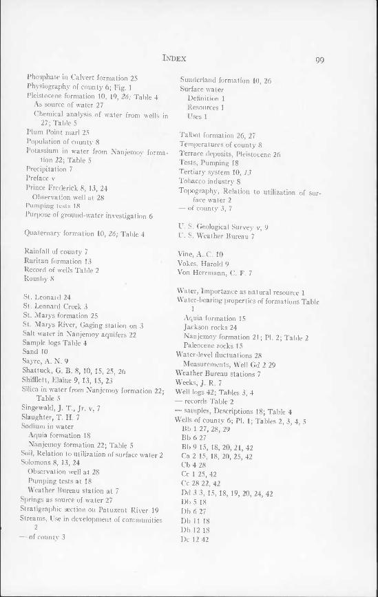
Index 99
Phosphate in Calvert formation 25 Physiography of county 6; Fig. 1 Pleistocene formation 10, 19, 26; Table 4
As source of water 27 Chemical analysis of water from wells in
27; Table 5 Plum Point marl 25 Population of county 8 Potassium in water from Nanjemoy forma-
tion 22; Table 5 Precipitation 7 Preface v Prince Frederick 8, 13, 24
Observation well at 28 Pumping tests 18 Purpose of ground-water investigation 6
Quaternary formation 10, 26; Table 4
Rainfall of county 7 Raritan formation 13 Record of wells Table 2 Rousby 8 '
St. Leonard 24 St. Leonard Creek 3 St. Marys formation 25 St. Marys River, Gaging station on 3 Salt water in Nanjemoy aquifers 22 Sample logs Table 4 Sand 10 Sayre, A. N. 9 Shattuck, G. B. 8, 10, 15, 25, 26 Shifflett, Elaine 9, 13, 15, 23 Silica in water from Nanjemoy formation 22;
Table 5 Singewald, J. T, Jr. v, 7 Slaughter, T. H. 7 Sodium in water
Aquia formation 18 Nanjemoy formation 22; Table 5
Soil, Relation to utilisation of surface water 2 Solomons 8, 13, 24
Observation well at 28 Pumping tests at 18 Weather Bureau station at 7
Springs as source of water 27 Stratigraphic section on Patuxent River 19 Streams, Use in development of communities
2 — of county 3
Sunderland formation 10, 26 Surface water
Definition 1 Resources 1 Uses 1
Talbot formation 26, 27 Temperatures of county 8 Terrace deposits, Pleistocene 26 Tests, Pumping 18 Tertiary system 10, 13 Tobacco industry 8 Topography, Relation to utilization of sur-
face water 2 — of county 3, 7
U. S. Geological Survey v, 9 U. S. Weather Bureau 7
Vine, A. C. 10 Vokes, Harold 9 Von Herrmann, C. F. 7
Water, Importance as natural resource 1 Water-bearing properties of formations Table
1 Aquia formation 15 Jackson rocks 24 Nanjemoy formation 21; PI. 2; Table 2 Paleocene rocks 15
Water-level fluctuations 28 Measurements, Well Gd 2 29
Weather Bureau stations 7 Weeks, J. R. 7 Well logs 42; Tables 3, 4 — records Table 2 — samples. Descriptions 18; Table 4 Wells of county 6; PI. 1; Tables 2, 3, 4, 5
Bb 1 27, 28, 29 Bb 6 27 Bb 9 15, 18, 20, 21, 42 Ca 2 15, 18, 20, 25, 42 Cb 4 28 Cc 1 25, 42 Cc 28 22, 42 Dd 3 3, 15, 18, 19, 20, 24, 42 Db 5 18 Db 6 27 Db 11 18 Db 12 18 Dc 12 42

100 Index
Wells of county {Continued) Dc 17 15, 18, 21, 24, 42 Dc 18 28, 29 Ec 3 22, 24, 42 Ec 4 28 Ec 5 28 Ed 5 42 Ed 6 42 Fd 1 18 Fd 3 22, 24 Fd 4 42 Fd 5 42 Fd 7 27, 42 Fd 14 28, 29 Fd 19 42 Fd 22 42 Fd 32 21 Fe 2 27, 42 Gd 4 22, 24, 28, 29
Gd 5 22, 24, 28, 29 Gd 6 18, 19, 28, 29 Gd 7 18 Gd 8 23 Gd 9 23 Gd 10 23 Gd 21 42 Gd 22 28, 29 Gd 27 23 Gd 30 42 Gd 34 24 Gd 36 18 Ge 4 21 Chemical analysis of water in Table 5 Observation 28
Wentworth, C. K. 26, 42 Wicomico 26 Woollard, G. P. 10 Worzel, J. L. 10


76<>30,
Lyons Wharf
Fairhaven
Dunkirk
North Beach Ferry Landing
Mt. Harmony West Beach
Chaneyville "5/4,5 Chesapeake Beach
Sunderland Randle Cliff Beach
Lower Marlboro
\ Camp Roosevelt
/Willow Beach Colony [24
Sharps Plum Point Beach (Breezy Point) Huntingtown 5>ANeeld Estate Z-yg 6.26,27 TfPlum Point Holland Cliff
Parran
Eagle Harbor
13 Dares Beach Stoakley Dares Wharf
[rince Frederick
Buena Vista Barstow
Benedict ^Hallowing Point
Port Republic JjA Governor Run
Bowens i\Kenwood Beach
Mutual St. Leonard Calvert Beach
.ong Beach
Island Creek
Broomes Island' Point of Rocks
Cape St. ^Leonard
Appeal
PUBLIC-SUPPLY OR COMMERCIAL WELL FARM, DOMESTIC OR SCHOOL WELL WELL DESTROYED OR NOT )N USE OBSERVATION WELL WELL FOR WHICH CHEMICAL ANALYSIS IS AVAILABLE WELL FOR WHICH LOG IS AVAILABLE
Johnstc wn
Jolomons Drum Point Island
Maryland Deportment of Geology, Mines and Water Resources

Maryland Department of Geology, Mines and Water Resources Bulletin 8 Plate 2
B B

Maryland Department of Geology, Mines and Wafer Resources Bulletin 8 Plate 3
B
D