statewide wetlands classification and … executive summary the comprehensive statewide wetlands...
TRANSCRIPT
Statewide Wetlands Classification and
Characterization
Final Report April 2003

ii
Statewide Wetlands Classification and Characterization
WETLAND PLANT ASSOCIATIONS OF COLORADO
Prepared for:
Colorado Department of Natural Resources 1313 Sherman Street, Room 718
Denver, Colorado 80203
April 2003
Prepared by: Kathy Carsey, David Cooper, Karin Decker, Denise Culver, and Gwen Kittel
Colorado Natural Heritage Program College of Natural Resources
Colorado State University 8002 Campus Delivery
254 General Services Building Fort Collins, CO 80523
(970) 491-1309 www.cnhp.colostate.edu
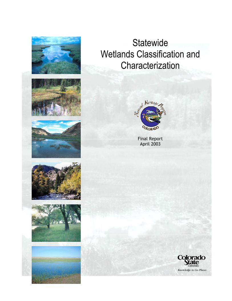
Front page photos (from top), HGM subclasses are discussed in the report:
1. Depressional (1) - Snow Mesa, Hinsdale Co. Colorado Natural Areas Program file photo. 2. Slope (1) - iron fen at Chattanooga, San Juan Co. Colorado Natural Areas Program file photo.
3. Flats (1) - Stinking Spring, Rio Blanco Co. Colorado Natural Areas Program file photo. 4. Riverine (3, 4) - North St. Vrain Creek, Boulder Co. By Ron West.
5. Riverine (5) - plains cottonwood riparian forest at Big Sandy Creek, Cheyenne Co. By Gwen Kittel. 6. Depressional (2, 3) - playa lake at Pawnee National Grasslands. By Ric Hupalo.
Background photo: Kettle Lakes Research Natural Area, Jackson Co. By Janet Coles

iii
ACKNOWLEDGMENTS Funding for the Comprehensive Statewide Wetlands Classification and Characterization was provided by a Wetland Program Grant from the Colorado Department of Natural Resources with funds from the U.S. Environmental Protection Agency, Region VIII. We would like to thank Alex Chappell, Division of Wildlife, Kimberly Seymour at the Department of Natural Resources, and Ed Stearns and Sarah Fowler at the U. S. Environmental Protection Agency for their continued support. Alex Chappell (CDOW) and Denise Culver (CNHP) deserve special mention here for their roles in conceiving this project, for their persistent efforts to secure funding to ensure its completion, for their advice and unflagging support during the process of developing the classification, and for their devotion to Colorado wetlands. This project was initiated with recommendations and advice of members of the Wetlands Task Force, which includes representatives from the private sector and from federal, state, and local agencies. They came together to share their expertise and offered counsel and encouragement. We thank all those who participated in those early discussions. Ric Hupalo managed Phase I of the project and wrote the Phase I report, from which much of the Methods section for this report is taken. We appreciate all that he did to establish, structure and organize the project. This project would not have been possible without the many landowners and managers, public, private, and tribal, who welcomed us on to their properties and provided invaluable information about their wetlands. Their cooperation made it possible to sample a broad range of Colorado’s wetland resources. Equally important were the field crews and volunteers who took the opportunity to gather the data for this project and to experience first hand Colorado’s wetlands, and all the joys and tribulations that are a part of field work. We greatly appreciate their contributions, their persistence, their dedication, their attention to detail, and their good cheer. We also appreciate Susan Hatch, Gavin Mahaley, Phillip Riggs, Cara Swanson and Sabrina Chartier who cheerfully and energetically contributed many hours in the office to produce this report. Several ecologists and wetland scientists reviewed the draft report. We thank Jim Von Loh, Janet Coles, and Don D’Amico for contributing their time and extremely valuable comments and suggestions. Finally, we would like to acknowledge our appreciation for the patience, support, encouragement, and ideas provided to us by the Colorado Natural Heritage Program staff, and especially all the Ecology Team members.
iv
EXECUTIVE SUMMARY The Comprehensive Statewide Wetlands Classification and Characterization (CSWCC) project is a three-year effort of the Colorado Natural Heritage Program (CNHP), in partnership with Colorado State University, and the Colorado Department of Natural Resources, Division of Wildlife (DOW) Wetlands Program to integrate previously collected data and develop a floristic classification for the wetlands of Colorado. Floristic classification and characterization of wetland types is an important step toward understanding the nature and dynamics of Colorado wetlands. It is an essential tool to help meet DOW Wetland Program goals for protecting wetland habitat and wetland-dependent wildlife. It also establishes a basis for focusing wetland research, land management, and conservation efforts where they will be most effective and beneficial. The first phase of this project (1999-2000) integrated previously collected data, especially from the CNHP Statewide Riparian Classification (Kittel et al.1999a), CNHP wetland inventories (1995-present), and Colorado State University (Dr. David Cooper) and grouped over 4,500 stands by hydrogeomorphic class and subclass (Hupalo et al. 2000). The second phase of the project (2000-01) defined plant associations within each of the hydrogeomorphic (HGM) subclasses (Colorado Geologic Survey et al. 1998) and classified them according to the National Vegetation Classification System (USNVC). Expanding on the Classification of Riparian Wetland Plant Associations of Colorado of Kittel et al. (1999), the second phase identifed and described wetland plant associations that occur outside riparian areas. The CSWCC includes both native and non-native vegetation from near- pristine sites and sites that have been altered by natural or anthropogenic disturbances. In the third and final phase of the project (2001-2003) the results of the classification were compiled for public distribution in the form of a printed field guide to the wetland and riparian plant associations of Colorado and an accompanying CD-ROM which includes new or updated descriptions (Community Characterization Abstracts) for all described associations, as well as a user-friendly database of all plot data used in the classification. One hundred and eighty-four plant associations in four HGM classes (Depressional, Flats, Riverine and Slope) and ten HGM subclasses (D1, D2/3, D4/5, F1, S1/2, S3/4, R1, R2, R3/4, R5) are described in the field guide. Fourty-four of the 184 associations included in the guide are newly described since the work of Kittel et al. (1999). Associations are arranged into forest, woodland, shrubland, and herbaceous types. Each plant association is ranked and prioritized in terms of imperilment and biodiversity significance with global and state ranks when available. The guide includes a dichotomous key which helps users to identify plant associations in the field. This report also includes tables of associations by HGM group and a list of undescribed associations.

v
TABLE OF CONTENTS
ACKNOWLEDGMENTS ........................................................................................................... iii EXECUTIVE SUMMARY ......................................................................................................... iv TABLE OF CONTENTS ............................................................................................................. v INTRODUCTION......................................................................................................................... 1
Vegetation Classification Methods: The US National Vegetation Classification System (USNVC) .................................................................................................................................... 2 Wetland definitions..................................................................................................................... 3 Previous wetland and riparian classification work in Colorado ................................................. 4
STUDY AREA............................................................................................................................... 5 Geology and geomorphology...................................................................................................... 5 Climate........................................................................................................................................ 6 Hydrology ................................................................................................................................... 7 Vegetation ................................................................................................................................... 7 Land ownership, management and uses...................................................................................... 8
CLASSIFICATION METHODS................................................................................................. 9 Data sources and preparation ...................................................................................................... 9 Treatment of large datasets ......................................................................................................... 9 HGM as a basis for stratification .............................................................................................. 10 Stratification: Methods for assignment of sampling units to HGM subclasses ....................... 11 Verification: Assessing the effectiveness of stratification....................................................... 13 Tabular Analysis and identification of associations ................................................................. 19
CLASSIFICATION RESULTS................................................................................................. 20 Wetlands by Hydrogeomorphic class and subclass .................................................................. 21 Further research needed ............................................................................................................ 24
COLORADO WETLAND PLANT ASSOCIATIONS............................................................ 26 literature cited ............................................................................................................................. 51 APPENDIX A – Data sources .................................................................................................... 60 APPENDIX B – HGM Indicator Species.................................................................................. 64 APPENDIX C: The Natural Heritage Network Ranking System......................................... 66

vi
LIST OF TABLES AND FIGURES List of Tables Figure 1. Outline of stratification and verification process. ......................................................... 14 Table 3. Indicator Species Analysis on HGM subclass membership. ......................................... 18 Table 4. Colorado Wetland Plant Associations by physiognomic group. ................................... 26 Table 5. Wetland Plant Associations of Colorado by HGM group ............................................. 39 Table 6. Undescribed associations which need more data........................................................... 49 Table C - 1. Definition of Natural Heritage Imperilment Ranks ................................................. 71 Table C-2. Federal and State Agency Special Designations........................................................ 72 List of Figures Figure 1. Outline of stratification and verification process. ......................................................... 14

1
INTRODUCTION A critical first step in understanding and defining the nature and dynamics of habitats across the landscape is cataloging and describing types. In order to manage, restore and protect Colorado wetlands adequately, we must know which types exist, their functions and attributes, relative frequency or rarity, and distribution across the landscape. This information is crucial to efforts to prioritize allocation of limited conservation resources. Information collected for this classification indicates that between one-third and one-half of Colorado flora occurs in wetland and riparian habitats. Preventing the loss of this valuable biodiversity is critical, particularly in the arid western United States (Dahl 2000). The U.S. Environmental Protection Agency (EPA), pursuant to section 104 (b)(3) of the Clean Water Act, has funded projects to assess, map, characterize and classify wetland and riparian habitats in Colorado in order to improve the management of Colorado wetland resources. One of those projects, the Statewide Wetlands Strategy, is a collaborative venture among the Colorado Department of Natural Resources Division of Wildlife (DOW), EPA Region VIII, and the Colorado Natural Heritage Program (CNHP) to provide a strategy for wetlands protection and to ensure the quality of life for Coloradans. As part of the Statewide Wetlands Strategy, this classification is intended to be a tool for community-based conservation and protection of Colorado wetlands and associated biodiversity. In 1999, CNHP, in partnership with the Colorado Department of Natural Resources DOW Wetlands Program, initiated the Statewide Wetlands Classification and Characterization project (CSWCC) as a key component of the on-going effort to define a Statewide Wetlands Strategy model for Colorado. The CSWCC project was developed with advice from a Wetlands Task Force convened by CNHP in April 1999. Attendees included representatives of federal, state, county, and city agencies and academia (Hupalo et al. 2000). This classification is an extension of research conducted by wetland scientists over the past twenty years. That work is integrated here, and new analyses are presented. The CSWCC was a three-phase project designed to develop a tool for community-based conservation and protection of Colorado wetlands and associated biodiversity. The three phases are described below. 1. Phase I (1999-2000)
a. Collect and synthesize existing wetland data (4,511 plots). b. Identify data gaps and begin collection of data from underrepresented wetland types. c. Stratify the entire dataset into nine hydrogeomorphic (HGM) subclasses, based on
hydrogeomorphic classification developed by David Cooper in 1998 (Colorado Geologic Survey et al. 1998, Hupalo et al. 2000).
2. Phase II (2000-2001)
a. Classifiy wetland vegetation according to the Unites States National Vegetation Classification System (USNVC) standard.
b. Identify plant associations within ten hydrogeomorphic (HGM) subclasses. c. Begin to compile or revise existing plant association descriptions (community
characterization abstracts) with known ecological and environmental data.
2
3. Phase III (2001-2003)
a. Complete the characterization of the wetland plant associations. b. Rank and prioritize wetland plant associations in terms of imperilment and
biodiversity significance according to the USNVC. c. Complete revision of existing descriptions (community characterization abstracts) for
previously identified associations and complete abstracts for newly described associations.
d. Identify associations for which data is still lacking. e. Produce a key and field guide to wetland types.
Vegetation Classification Methods: The US National Vegetation Classification System (USNVC) The CSWCC follows the format of the USNVC (Anderson et al. 1998), the accepted national standard for all federal agencies (Maybury 1999). The USNVC: 1) is vegetation-based, 2) uses a systematic approach, 3) emphasizes natural vegetation, 4) emphasizes existing vegetation, 5) uses a combined physiognomic-floristic hierarchy, identifying vegetation units at scales practical for conservation, and 6) is appropriate for mapping at multiple scales (Grossman et al. 1998). The upper levels of the USNVC (beginning with the most inclusive) including class, subclass, group, subgroup and formation are physiognomic, based on growth form characteristics and environmental factors. The lowest levels, alliance and association, are floristic, based on dominant or diagnostic species names. The association is considered the basic unit for vegetation classification, and is the focus of this project. (These syntaxa, e.g. alliance, are not used in accordance with the same terms in the Braun-Blanquet system or other vegetation classification schemes used around the world.) Although the terms plant association and community have been described by numerous ecologists, no general consensus of their meaning has developed. The terms are similar, somewhat overlapping, and are often used more or less interchangeably. The USNVC defines a community as an “assemblage of species that co-occur in defined areas at certain times and that have the potential to interact with one another” (The Nature Conservancy 1999), and a plant association as a type of plant community with “definite floristic composition, uniform habitat conditions, and uniform physiognomy” (Flahault and Schroter 1910). Vegetation classifications are necessary simplifications of the natural world, developed to facilitate understanding, planning, management, and conservation. Classifications of wetlands can be based on factors (e.g., vegetation, hydrology, landform) that are used either singly or jointly. Single factor classification systems, such as those based on vegetation, are generally easier to develop since less information is required, characteristics are less complex, and they can be tailored to specific objectives (Anderson et al. 1998). Vegetation is often chosen as the basis of a single factor system for classifying ecological systems because it generally integrates the ecological processes operating on a site or landscape more reliably and visibly than any other factor or set of factors (Mueller-Dumbois and Ellenberg 1974); (Kimmins 1997).

3
Characterizing and tracking communities provides many potential benefits to conservation. Ecological communities represent unique sets of natural interactions among species and their environment (Costanza R./d'Arge 1997), (Daily 1997). Community description and classification can be important tools for systematically characterizing the current pattern and condition of ecosystems and landscapes (Grossman 1998). By protecting communities, many species not generally targeted for conservation, including those from poorly known groups such as bryophytes and invertebrates, are protected. Change over time may be more efficiently monitored in communities than in component species. Changes may be detected by monitoring composition (changes in species abundance, richness, proportions of endemics or exotics), structure (canopy features), and function (productivity, nutrient cycling, and patch dynamics) (Noss 1990), (Max 1996). Community classification also provides the basis for monitoring by providing a systematic means to break the landscape continuum into recognizable units. The Nature Conservancy and the Natural Heritage Program Network, including CNHP, use a coarse filter/fine filter approach to prioritize management and conservation efforts (The Nature Conservancy 1996). This approach involves identification and protection of plant communities (coarse filter) and rare species (fine filter). Identifying and protecting representative examples of plant communities ensures conservation of a greater number of species, biotic interactions, and ecological processes. Using communities as a coarse filter has ensured that conservation efforts are working to protect a more complete spectrum of biological diversity. This project followed the quantitative analysis methods for classification suggested in Grossman et al. 1998. Data were stratified by hydrogeomorphic type. Ordination and cluster analysis were used to summarize the data in major groups. The summary also included the exploration of vegetation-environment relationships where such data were available. Tabular analysis was used to assign samples to plant associations. This process resulted in a floristic classification of Colorado wetland communities.
Wetland definitions The CSWCC follows the U.S. Fish and Wildlife Service (USFWS) definition of wetlands (Cowardin et al. 1979). According to that definition wetlands are “lands transitional between terrestrial and aquatic systems where the water table is usually at or near the surface or the land is covered by shallow water.” USFWS-defined wetlands must have one or more of the following three attributes: (1) at least periodically, the land supports predominantly hydrophytes (wetland plants); (2) the substrate is predominantly undrained hydric soil; and/or (3) the substrate is non-soil and is saturated with water or covered by shallow water at some time during the growing season of each year. The U. S. Army Corps of Engineers definition (US Army Corps of Engineers 1987), developed to define “jurisdictional” wetlands for the Clean Water Act permitting process, requires that a site have all three wetland attributes (vegetation, soil, and hydrology) to be classified as a jurisdictional wetland. For this classification, we use the USFWS definition because it recognizes that not all wetlands are “jurisdictional” wetlands. Riparian areas in particular often do not meet all three of the wetland criteria, but should be included in wetland classification and conservation programs. Riparian areas perform many of the same functions as do wetlands, including maintenance of water quality, storage of floodwaters, and enhancement of biodiversity, especially in the western United States (National Research Council 1995).

4
Previous wetland and riparian classification work in Colorado Researchers using a variety of methodologies have conducted wetland studies in scattered areas throughout Colorado and neighboring states (see summary in Kittel et al. 1999a). Dr. David Cooper has collected wetland plot data and classified wetland plant associations throughout the state for more than 15 years and contributed much of the data used for the CSWCC. Since 1994, CNHP, in cooperation with the DOW Wetlands Program, has systematically inventoried wetlands within Larimer, Routt, Summit, portions of Park, Pueblo, El Paso, Mesa, and Garfield, Rio Grande, and Conejos counties, as well as wetlands in broader watershed areas such as the San Luis Valley (Saguache and northern Alamosa counties) and the Uncompahgre River Basin (eastern Montrose and Ouray counties). Sanderson and Kettler (1996) produced a preliminary wetland vegetation classification for a portion of Colorado’s western slope (based on 152 plots). Kittel et al. (1999a) completed a separate classification for riparian wetland plant associations of all major drainage basins, two National Forests, and one National Grassland. Kittel and others (1999a). analyzed research data by drainage basin rather than on a statewide basis; the report includes summaries for each basin. Although wetlands have been studied in Colorado for many years, there has been no systematic inventory or comprehensive classification. In the absence of a comprehensive classification of Colorado wetlands, the CSWCC builds on previous studies and inventories of riparian and wetland plant associations in the state, especially those of Cooper and Kittel. Cooper has identified, described, and classified all wetland types of several regions or local areas of the state. His descriptions and classifications provide valuable resources for regional and local planners as well as conservation organizations. Kittel’s (1999a) focus was on riparian sites that were “relatively undisturbed by human activity, thereby limiting the classification to plant associations native to Colorado” with the hope that these areas would serve as reference areas for management and restoration activities, as well as potential sites for land conservation. The CSWCC is comprehensive in the sense of considering pristine and disturbed, riparian and non-riparian wetlands, and wetlands dominated by native and non-native plants. The CSWCC, however, must be considered preliminary. Although this project combines an unprecedented quantity of data from previous studies into a single, statewide classification, it should not be considered a final description of Colorado wetlands. The datasets used here do not constitute a comprehensive sample of Colorado geography or ecology. It is clear that many Colorado wetland types and localities still have not been adequately sampled. As a consequence, there are probably many plant associations that have yet to be described. In addition, some of the associations listed here will require further refinement and reclassification in order to accurately and completely describe Colorado wetlands. Therefore, this classification should be updated as more information becomes available.

5
STUDY AREA The state of Colorado forms a nearly perfect rectangle, roughly between 37° and 41° north latitude and 102° and 109° west longitude. The boundaries encompass 104,247 square miles (over 66.7 million acres or 27 million hectares) of plains, foothills, mountains, plateaus and canyons. Colorado's average elevation is 6,800 feet (2,073 m). The lowest point is 3,315 feet (1,011 m) on the Arikaree River at the Kansas border, and the highest point is Mt. Elbert at 14,431 feet (4,400 m )(Colorado State Archives 2001).
Geology and geomorphology The following description of the geologic history of Colorado is adapted from: Benedict 1991, Mutel and Emerick 1984, and Tweto 1979. The modern landforms of Colorado are the result of millions of years of geologic processes. The products of both gradual and cataclysmic events are evident throughout the state. Colorado’s oldest rocks, the Precambrian “basement” of metamorphic gneiss and schist, represent the base of long-vanished mountain ranges. Igneous intrusives such as granite and gabbro are visible in northern and central parts of Colorado. Following the Precambrian, mountain building ceased and erosion was widespread. As a result, rocks from certain geologic time periods are scarce in Colorado. The only period completely missing from the geologic record is the Silurian (410-440 million years ago). The upper Precambrian erosional surface in Colorado is generally overlain by much younger sediments. Paleozoic era geology in Colorado is represented primarily by sedimentary formations, now exposed throughout the central and western portions of the state. Some 300 million years ago during the Pennsylvanian period, renewed tectonic activity leading to the rise of the Ancestral Rocky Mountains produced block-fault mountains and adjacent basin subsidence. Basin-deposited sediments of this period include extensive “red beds” such as the Boulder Flatirons. By the end of the Paleozoic, the Ancestral Rocky Mountains had been almost completely buried in their own erosional debris. Beginning approximately 230 million years ago, the gradual breakup of the supercontinent of Pangaea led to renewed mountain building and the cyclic advance and retreat of inland seas. Sedimentary deposits of alluvial plains, sand dunes and both shallow and deep marine environments from this time are found throughout Colorado. The Cretaceous Pierre and Mancos formations in particular are widespread in the eastern and western non-mountain areas. Toward the end of the Mesozoic, some 70 million years ago, the Laramide Orogeny began the uplift that would result in the formation of the Southern Rocky Mountains. Most of Colorado’s current mountain ranges and drainages are a result of geologic activity during the Tertiary period, which began about 65 million years ago. The early or Paleocene part of the period witnessed the continued uplift of the Rocky Mountains as a result of the Laramide Orogeny, the emplacement of large igneous intrusions in what would become the Colorado Mineral Belt, as well as continued erosion and basin development. As Laramide activity subsided, the uplifted surface continued to erode, and extensive volcanic activity shaped the southern mountains. As the Tertiary period drew to a close, regional uplift accompanied by erosion and canyon cutting by rivers continued, and the Rio Grande Rift developed. In the last

6
two million years, glacial cycles of the Quaternary period have further sculpted the landscape of the Southern Rocky Mountains through erosion and wind-borne deposits. Much of Colorado falls into three primary physiographic regions: the Great Plains, Southern Rocky Mountains, and Colorado Plateau. The eastern forty percent of the state belongs to the Great Plains region, characterized by flat, high plains and rolling grasslands, rising gradually to the west to meet the foothills of the Southern Rocky Mountain ranges. The level plains are occasionally interrupted by buttes, escarpments, and larger remnants of the Eocene high plains surface, while in the southwest parts of the region, mesas and buttes of volcanic origin mark the border with New Mexico. Stretching from the mountain foothills to the high plains escarpment between Denver and Greeley, the Colorado piedmont has been extensively eroded by the South Platte River. The highland of the Palmer Divide south of Denver separates the South Platte drainage from the other major prairie river, the Arkansas. Where the Great Plains meet the mountain front, tilted sedimentary beds form a series of hogbacks and ridges, and in the northern part of state, the mountains beyond rise quickly to the continental divide. Surface geology is largely sedimentary rocks and unconsolidated deposits including Quaternary eolian dune fields and loess, Tertiary sandstones and basalt fields, and Cretaceous shales and limestones. The central mountainous portion of Colorado is part of the Southern Rocky Mountain region and contains a complex group of fairly well defined ranges, with more than fifty peaks greater than 14,000 feet (4,268 m) in elevation. Here the Continental Divide traces a winding path through west central Colorado, separating the state into eastern and western slopes. The northern end of the Rio Grande Rift cuts through the Southern Rocky Mountains, creating a series of large intermountain valleys. The Southern Rocky Mountains include the oldest rocks in the state, as well as extensive volcanic and sedimentary features, and are the result of alternating periods of mountain uplift and erosion during the past several hundred million years. Much of the topography we see today was formed within the last 70 million years by the most recent episodes of uplift, volcanism, erosion, and sedimentation. Mountain terrain above about 8,500 feet (2,591 m) has also been shaped by glacial activity of the past two million years. The western-most portions of the state in the Colorado Plateau region are characterized by high plateaus, wide valleys, and rugged canyons. The Colorado River and its tributaries have carved numerous scenic canyons through a variety of sedimentary formations. Elevations range from 5,000 feet to 10,000 feet (1,524 – 3,049 m). Major features of the region include the high elevation Uncompahgre Plateau, the basalt-capped Battlement Mesa and Grand Mesa, the eroded sandstone canyons of the Paradox and San Juan Basins, and the extensive Tertiary shales of the Piceance Basin and Roan Plateau. Extreme northwestern Colorado also includes a portion of the Wyoming Basin region where ancient tributaries of the Yampa River have deeply dissected much of the high elevation terrain.
Climate Elevation and topography are major factors influencing climate in Colorado. The climate is generally dry, due in part to the mid-latitude position in the continental interior. Annual precipitation in Colorado ranges from eight inches to over 60 inches (20 – 152 cm) with a statewide average of around 17 inches (43cm) (Daly and Taylor 1998). The San Luis Valley is the driest area of the state; areas receiving the most precipitation are the higher elevations of the Front Range, Park Range, West Elk, and San Juan Mountains. There are several different
7
patterns of annual precipitation influencing the development of native vegetation. The eastern plains area tends to receive the majority of precipitation in the spring. The northern mountains have the heaviest precipitation in the winter months. For the southern mountains, the monsoons of late summer also provide a large portion of annual precipitation. Much of the remainder of the state lacks a dominant precipitation season.
Hydrology Six major rivers have headwaters in the mountains of Colorado. On the western slope, the Colorado River and the major tributaries the White, Yampa, Gunnison, Dolores and San Juan flow toward the Gulf of California. On the eastern slope, the North Platte, South Platte, Arkansas, and Republican rivers are part of the Mississippi drainage which, with the Rio Grande River, eventually empties into the Gulf of Mexico. All or part of four major aquifer systems are present in Colorado: the Colorado Plateau, Rio Grande, High Plains, and Denver Basin. Precipitation falling on the land surface in Colorado either flows directly into streams and rivers as runoff, or infiltrates the soil and underlying aquifers and moves laterally to discharge into rivers and streams as baseflow. Surficial aquifers occur primarily at shallow depth in unconsolidated sediments along parts of major river valleys. With the exception of the South Platte and Arkansas River drainages, individual stream-valley aquifers are usually small and unconnected to aquifers in other valleys or to distant aquifers in the same valley. Only in the valleys of eastern Colorado are the aquifers large and continuous enough to form a major aquifer. For a detailed description of the hydrology of Colorado, see the U. S. Geologic Survey Ground Water Atlas of the United States for Arizona, Colorado, New Mexico and Utah (Robson and Banta 1995). Although there are few large natural lakes in Colorado, there are numerous small bodies of water in mountain areas. Many small natural lakes have been augmented by dams or diversions. Reservoirs and irrigation ditches are also common, especially on the eastern plains and in the San Luis Valley. Streams originating in the Southern Rockies usually flow year-round. Lower order streams in the non-mountainous areas of the state are often intermittent, flowing only during spring snowmelt or with local direct run-off. On the predominantly dry eastern plains, wetlands occur along drainages and in shallow depressions with at least periodically wet soils. Most naturally-occurring wetlands are in the Southern Rocky Mountain region where higher precipitation and varied geomorphology support a wide variety of wetlands on slopes, in ponds and shallow depressions, and along streams. The often saline or alkaline wetlands of the western plateaus and canyons occur along river terraces and floodplains, or in a variety of seeps, springs, and marshes.
Vegetation The eastern plains are dominated by grasslands, primarily shortgrass prairie. Especially in the northern plains, many native grasslands have been replaced by cereal crops. Large areas of stabilized sand dunes support shrubby grasslands. Trees are fairly rare on the plains, and in pre-settlement times would have been confined to riparian corridors, mesic draws, and higher buttes. The highly variable topography of the Southern Rocky Mountains supports a diversity of vegetation. Mountainous areas are chiefly characterized by coniferous woodlands and forests of ponderosa pine, Douglas-fir, Englemann spruce, and subalpine fir, interspersed with stands of

8
aspen, grasslands and meadows, and mountain shrublands. The highest elevations are dominated by a variety of alpine tundra communities. The western plateaus and canyons are characterized by shrublands of sagebrush and saltbush. Bunchgrass grasslands and piñon-juniper woodlands are also common.
Land ownership, management and uses More than 27 million acres (10.9 million hectares, or approximately 40%) of the 66.7 million acres within Colorado borders are in public ownership (Colorado GAP Project 1993). Public lands are concentrated in the western half of the state. Primary land managers for public lands in Colorado are the USDA Forest Service, administering more than 14 million acres (5.7 million hectares), the U. S. Bureau of Land Management administering more than eight million acres (3.2 million hectares), and the State of Colorado, with more than three million acres (1.2 million hectares) (Colorado GAP Project 1993). Throughout Colorado, valley bottoms and riparian areas are likely to be privately owned except at higher elevations. The availability of water is often the driving factor in determining land use. Most relatively flat areas in the state are used for agriculture. The Great Plains are dominated by dry and irrigated farming and livestock grazing. In the mountains and western plateaus ranching, mining, timber harvest, and irrigated crops in valleys are common land uses.
9
CLASSIFICATION METHODS
Data sources and preparation This classification is based on floristic data from samples collected in 4,527 vegetation stands throughout Colorado (Appendix A). All researchers who contributed data had the common goal of sampling homogenous stands of vegetation for the purpose of community classification. However, the scope of sampling and sampling methodology varied between researchers. Studies ranged from extensive inventories of primary watersheds to intensive studies of particular wetland complexes, and plot size and species abundance scales differed among studies. Although the lack of standardized field methods may contribute to unexplainable variation in the data, the additional error is an acceptable trade-off for the greatly increased representation of vegetation samples. Taxa not identified to species were removed from the dataset. Each species was assigned a unique code. Species nomenclature (with the exception of willows) follows Kartesz (Kartesz and Kartesz 1980), as reported and updated in the PLANTS database (U.S.D.A. NRCS ). The nomenclature of willows follows (Dorn 1997). The binomial names are cross-referenced in the database to the nomenclature of the regional floras (Weber and Wittman 1996; Weber and Wittmann 1996; Weber and Wittmann 1996; Weber and Wittman 1996). In some cases, common names are regionally recognized names rather than Kartesz and Kartesz names. The final combined data matrix was 4,527 sampling units by 1,269 species. Species abundance is represented by percent cover, ranging from zero to 100 percent. Accidental species, defined as species occurring in only one sampling unit and having a cover value of less than ten percent, were considered ecological noise and were removed from the data prior to analyses. This strategy avoided removing species that were rare but contributed significant cover in at least one sampling unit, this type of outlier may constitute unusual associations and were inspected in subsequent analyses. A relational database (Access 97 Relational Database ) was created to relate the stand data to environmental data (e.g. elevation) and to provide summary statistics. This database was used to generate datasets for analyses.
Treatment of large datasets Large datasets are usually heterogeneous if they represent large geographic areas or many types of vegetation. In such cases, treatment of all the data in a single ordination or in classification can be ineffective since many calculations would be based on sampling units sharing no species (Van der Maarel et al. 1987). It is not always apparent which hierarchical clustering or ordination program options provide optimum (ecologically interpretable) results when dealing with thousands of sampling units (Van der Maarel et al. 1987). Local communities, represented by a small number of sampling units, may be masked by the greater variation occurring across a geographic region (Van der Maarel et al. 1987). With large sets of floristic data, it is often necessary to break the analysis into several stages to produce satisfactory results (Kent and Coker 1992). Van der Maarel et al. (1987) suggest stratification prior to ordination or hierarchical clustering of large datasets to increase

10
interpretability of the results. They suggest two ways of stratifying datasets. If clear local subsets of large heterogeneous areas exist, they can be used as grouping units. Allen and Peet (1990). Alternatively, if all or most of the plant communities of an area are included, samples may be grouped by vegetation type. In some circumstances, another alternative to stratification is to sub-sample the data to produce an initial classification and allocate the remaining sampling units to these groups (Kent and Coker 1992). For this classification, a variation of the first approach was used. The dependence of wetland types upon hydrologic regime and geomorphic setting and processes suggested the use of hydrogeomorphic (HGM) classes as a means of stratification. A framework of regional hydrogeomorphic subclasses proposed by Cooper (Colorado Geologic Survey et al. 1998) was used for data stratification. The HGM approach focuses on geomorphic, physical, and chemical features of wetland ecosystems, and acknowledges that plant communities are often indicative of the hydrogeomorphic forces affecting an ecosystem (Brinson 1993).
HGM as a basis for stratification As part of a multi-discipline collaboration to characterize wetlands of Colorado, Cooper (Colorado Geologic Survey et al. 1998) investigated the relationship between hydrogeomorphic attributes and the wetland vegetation of Colorado. His work synthesized environmental data derived from field data sheets and various USGS resource maps, based on location, for 3,625 sampling units within Colorado. The variables coarsely described elevation, latitude, longitude, soil texture, soil organic content, channel gradient, type of bedrock, surficial geology, stream order, inundation frequency, soil moisture, water source, and hydrologic disturbance. The environmental and floristic datasets were analyzed together using the direct gradient analysis technique of Canonical Correspondence Analysis (CCA) (ter Braak 1986). CCA results in the simultaneous ordination of samples and species in the same space, as well as allowing the direct plotting of the environmental variables as vectors in the ordination diagram. Because this technique requires that ordination axes be expressed in terms of the environmental variables used, meaningful interpretation of CCA plots depends upon the assumption that those environmental variables included are, in fact, ecologically important. For a useful discussion of Correspondence Analysis methods see Palmer 1993. Cooper concluded that the first axis represented a gradient from high elevation, glaciated landscapes and peat soils to coarse-textured soils, alluvial landscapes with high stream order. The second axis was interpreted as an inundation duration gradient. This work resulted in the definition of 15 preliminary HGM subclasses in four classes (River, Slope, Depression, and Flat) and common or diagnostic plant species for each subclass (Table 1). The 99 plant species associated with the HGM subclasses formed the basis for stratifying the sampling units (Appendix B).
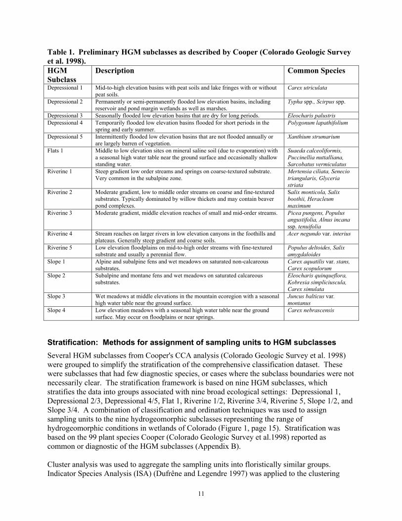
11
Table 1. Preliminary HGM subclasses as described by Cooper (Colorado Geologic Survey et al. 1998). HGM Subclass
Description Common Species
Depressional 1 Mid-to-high elevation basins with peat soils and lake fringes with or without peat soils.
Carex utriculata
Depressional 2 Permanently or semi-permanently flooded low elevation basins, including reservoir and pond margin wetlands as well as marshes.
Typha spp., Scirpus spp.
Depressional 3 Seasonally flooded low elevation basins that are dry for long periods. Eleocharis palustris Depressional 4 Temporarily flooded low elevation basins flooded for short periods in the
spring and early summer. Polygonum lapathifolium
Depressional 5 Intermittently flooded low elevation basins that are not flooded annually or are largely barren of vegetation.
Xanthium strumarium
Flats 1 Middle to low elevation sites on mineral saline soil (due to evaporation) with a seasonal high water table near the ground surface and occasionally shallow standing water.
Suaeda calceoliformis, Puccinellia nuttalliana, Sarcobatus vermiculatus
Riverine 1 Steep gradient low order streams and springs on coarse-textured substrate. Very common in the subalpine zone.
Mertensia ciliata, Senecio triangularis, Glyceria striata
Riverine 2 Moderate gradient, low to middle order streams on coarse and fine-textured substrates. Typically dominated by willow thickets and may contain beaver pond complexes.
Salix monticola, Salix boothii, Heracleum maximum
Riverine 3 Moderate gradient, middle elevation reaches of small and mid-order streams. Picea pungens, Populus angustifolia, Alnus incana ssp. tenuifolia
Riverine 4 Stream reaches on larger rivers in low elevation canyons in the foothills and plateaus. Generally steep gradient and coarse soils.
Acer negundo var. interius
Riverine 5 Low elevation floodplains on mid-to-high order streams with fine-textured substrate and usually a perennial flow.
Populus deltoides, Salix amygdaloides
Slope 1 Alpine and subalpine fens and wet meadows on saturated non-calcareous substrates.
Carex aquatilis var. stans, Carex scopulorum
Slope 2 Subalpine and montane fens and wet meadows on saturated calcareous substrates.
Eleocharis quinqueflora, Kobresia simpliciuscula, Carex simulata
Slope 3 Wet meadows at middle elevations in the mountain ecoregion with a seasonal high water table near the ground surface.
Juncus balticus var. montanus
Slope 4 Low elevation meadows with a seasonal high water table near the ground surface. May occur on floodplains or near springs.
Carex nebrascensis
Stratification: Methods for assignment of sampling units to HGM subclasses Several HGM subclasses from Cooper's CCA analysis (Colorado Geologic Survey et al. 1998) were grouped to simplify the stratification of the comprehensive classification dataset. These were subclasses that had few diagnostic species, or cases where the subclass boundaries were not necessarily clear. The stratification framework is based on nine HGM subclasses, which stratifies the data into groups associated with nine broad ecological settings: Depressional 1, Depressional 2/3, Depressional 4/5, Flat 1, Riverine 1/2, Riverine 3/4, Riverine 5, Slope 1/2, and Slope 3/4. A combination of classification and ordination techniques was used to assign sampling units to the nine hydrogeomorphic subclasses representing the range of hydrogeomorphic conditions in wetlands of Colorado (Figure 1, page 15). Stratification was based on the 99 plant species Cooper (Colorado Geologic Survey et al.1998) reported as common or diagnostic of the HGM subclasses (Appendix B). Cluster analysis was used to aggregate the sampling units into floristically similar groups. Indicator Species Analysis (ISA) (Dufrêne and Legendre 1997) was applied to the clustering
12
results to identify species indicative of the clustering hierarchy. This information was in turn compared with the 99 characteristic species identified by Cooper (Colorado Geologic Survey et al. 1998) and allocations to the nine HGM groups were made accordingly. Cluster analysis is a method of identifying groups of samples in a dataset. For this classification the groups are floristically similar assemblages of plots. The clustering method used works in an agglomerative manner, initially treating each sample unit as its own group, and proceeding to combine samples into larger and larger groups. This joining method produces a hierarchy of groups which contain smaller groups and are in turn part of larger groups. Ward's method of minimum variance joining, as implemented in PC-ORD 4 (McCune and Mefford 1999) was used to cluster the sampling units. Euclidean distance, the default distance measure for Ward's method in PC-ORD, was used for the analysis. In this algorithm, joining is based on the two cluster groups whose fusion results in the smallest increase in variance, relative to the variances within each cluster taken separately (Ludwig and Reynolds 1988). An output option of the clustering program provided a record of group membership for each sampling unit in the upper 200 levels of clustering. This information was then used to create the group membership matrix necessary for Indicator Species Analysis (ISA). Indicator Species Analysis was applied to only the first 90 levels of the clustering (see Hupalo et al. 2000 for further details). Once group membership has been determined, the next step is to characterize the differences between groups in an ecologically meaningful way, such as by species composition. In order to assign the groups produced by the cluster analysis to the correct HGM subclasses, species characteristic of those groups must be identified. Indicator Species Analysis (Dufrêne and Legendre 1997) is a technique to identify the species or species assemblage that characterize a group of sampling units. The objective of ISA is to identify species that have high fidelity to a particular group and thus are good indicators of that group. A good indicator species occurs with high relative abundance and high frequency in its own group, and at the same time does not occur in other groups. The indicator species identified by ISA were used as an aid to assigning a group of plots to an HGM group with the same characteristic species. ISA (McCune and Mefford 1999) was conducted on all clusters for each of the upper 90 levels of the cluster analysis, and mass assignments of sampling units to HGM subclasses were based on the results. Following the work of Dufrêne and Legendre (1997), species having an Indicator Value (IV) of 25 or greater and a p-value of 0.05 or less were retained. This selected species present in at least 50% of the sampling units in one subclass and with relative abundance in that subclass (average percent cover) of 50% or greater. Assignments were made by comparing (visually matching species names) the Indicator Species of a group at a given cluster level with the HGM subclass diagnostic and common species identified by CCA analysis in Cooper (Colorado Geologic Survey et al. 1998). After the assignment of groups to HGM subclasses, the subclasses were inspected for obviously misclassified plots. These types of outliers are not necessarily poor data, but they may have an extreme influence on multivariate analyses. Misclassification may result from sampling units which cross ecotones and therefore have non-homogenous vegetation. Sampling units from semiaquatic communities (e.g. dominated by Nuphar luteum and some Potamogeton and

13
Sparganium species) or regionally isolated, monocultural species (Carex vesicaria) were also outliers. Some plots were permanently removed (poor sampling units) and others were temporarily removed (unusual communities) from the data. The stand composition of each questionable plot, or group of plots, was evaluated by querying the relational database. Then a decision was made to leave the sampling unit(s), move the sampling unit(s) to a different HGM subclass, or remove the sampling unit(s) from the dataset.
Verification: Assessing the effectiveness of stratification Once groups have been identified, the next step is to determine their validity. Two questions are of interest: 1) Are the groups significantly different? and 2) if so, how are they different? In order to address the first question, the non-parametric Multi-response Permutation Procedure (MRPP) comparison test was used. This procedure gives an indication of how clumped the original groups are compared to arbitrary groups produced by reassigning the samples. To address the second question, Indicator Species Analysis was reapplied to the sampling units, now grouped by nine HGM subclasses. This was done to determine whether the new set of Indicator Species made sense from ecological and hydrogeomorphic points of view, had good separation between groups, and compared well with the characteristic species that Cooper (Colorado Geologic Survey et al. 1998) identified. MRPP tests the hypothesis that samples within a group are clumped in multivariate space. This hypothesis is evaluated by reassigning the original group memberships (permutation), and calculating the degree to which the original group is more clumped than groups of randomly assigned samples. MRPP detects concentration within a priori groups, a similar purpose to the one-way analysis of variance F test, but with fewer statistical assumptions about the data (Zimmerman et al. 1985). The test was applied to the subclasses as an overall comparison, rather than as pair-wise comparisons. The test statistic “T” is a descriptor of the within-group homogeneity of the real data compared to the amount of homogeneity expected by chance, indicating the degree of separation between the groups. MRPP was implemented in PC-ORD 4 (McCune and Mefford 1999), using rank transformed Sorensen distances. The Sorensen distance metric was chosen for MRPP because it retains more sensitivity in heterogeneous datasets and gives less weight to outliers, compared to Euclidean distance (McCune and Mefford 1999). A rank transformation was applied to help correct the loss of sensitivity of distance measures as community heterogeneity increases (McCune and Mefford 1999). Applying the test to rank transformed distances changes the null hypothesis from "average within-group distance no smaller than expected by chance" to "no difference in average within-group rank of distances" (McCune and Mefford 1999). Indicator Species Analysis was used to evaluate the degree of separation of characteristic species between the individual HGM subclasses. Group membership was according to one of nine HGM subclasses (Subclass R1/2 was later divided, resulting in a total of ten subclasses). In some respects this provides more ecological insight than conducting pair-wise comparisons with MRPP and avoids Type I error and test power issues associated with non-independent multiple comparisons. If good separation existed between the nine groups, then a species maximum Indicator Value would be expected to be statistically significant and have a considerably higher value than in the other subclasses. Secondly, subclass Indicator Species should agree with the characteristic species of Cooper (Colorado Geologic Survey et al. 1998).

14
Figure 1. Outline of stratification and verification process.
Mass assignment of sampling units to HGM subclasses based on the ISA summary table resulted in the stratification of 80% of the sampling units. A second cluster analysis and ISA applied to the upper 15 levels of the cluster resulted in assignment of an additional 5% of the sampling units (see Figure 1). The remaining 15% of unassigned sampling units were assigned based on repetitive ordination with DCA, following the example of Peet (1980). DCA revealed that the remaining sampling units were generally weedy and associated with alkaline flat and lower altitude riverine (R3, 4 and R5) subclasses. High beta diversity sometimes produced an undesirable arch effect in the ordination (Kent and Coker 1992). Because of the arch distortion, the composition of sampling units patterns was always inspected to avoid allocating dissimilar sampling units (from opposing tails of the arch). Less than 2% of the dataset remained unassigned to one of the nine subclasses following these ordinations. Unassigned sampling units, outliers, and sampling units from semi-aquatic communities were excluded from further analyses. Overall, 4,335 sampling units of the 4,527 sampling units were allocated to HGM subclasses. Separate outlier analyses (chi-square and Sorensen distances) and DCA ordination was conducted on each HGM subclass as a final quality control on the stratification process. A small number (< 50 sampling units) of reallocations were made. These were cases where sampling units greatly influenced the ordination and were usually much more than two standard deviations from the group average distance using either distance measure.

15
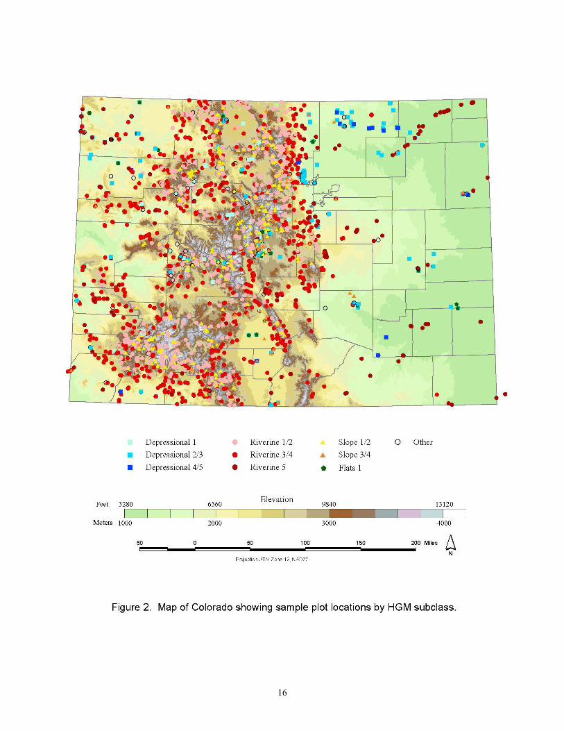
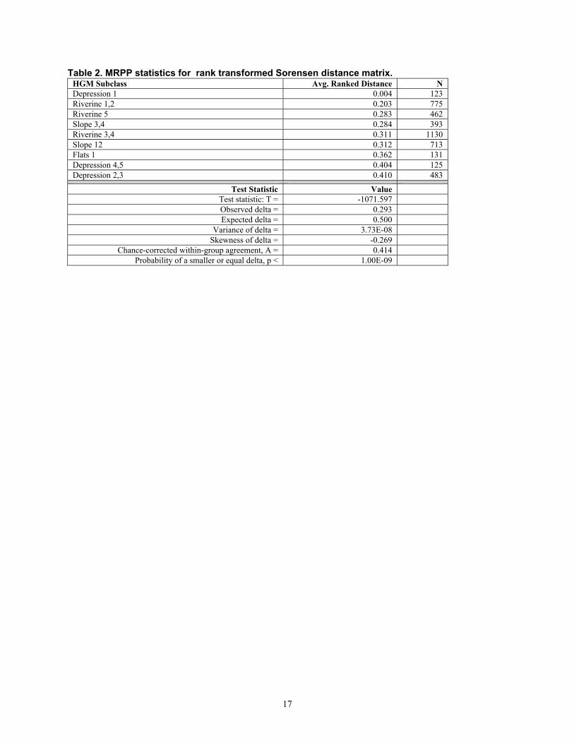
The upper section of Table 2 shows the average within-group rank distance for each HGM subclass from the MRPP analysis. This statistic is a measure of the internal heterogeneity of the nine groups of sampling units. For example, the Depressional (1) subclass is comprised of species-poor stands dominated by Carex utriculata, reflected by the very low average distance for the group. The magnitude of the average within-group rank distances is related to the group heterogeneity, not necessarily sample size. For example, Flats 1 is one of the smaller groups but exhibits one of the higher amounts of internal variability, which supports Cooper’s (Colorado Geologic Survey et al. 1998) assertion that the mineral soil flats subclass (Flats 1) should be subdivided when more data are available. In addressing the question of whether the groups produced by the cluster analysis are different, the MRPP results reported in Table 2 indicate that the stratification was effective, in that overall the average within-group ranked distances were significantly different (T = -1071.597; p<<0.001). This is not surprising, given that the groups were largely defined by cluster analysis, a procedure which maximizes variability among groups and minimizes it within groups. With such a large sample size even a slight overall difference between groups should be detectable. It is of more interest to know whether the differences are ecologically significant, that is, to know which variables are accounting for among-group differences. Table 3 lists all species from the analysis that had an Indicator Value greater than twenty percent and p-values < 0.05 in a Monte Carlo test of significance of the observed maximum IV, and the HGM subclasses to which they belong. The left section of Table 3 shows the HGM subclass and the maximum Indicator Value of each Indicator Species. The center section shows the Monte Carlo test results, based on 250 permutations with randomized data. The mean IV scores obtained from 250 calculations on randomized data provide a benchmark to compare with IV scores for the real (observed) data. The right section of the table shows the observed Indicator Values in each HGM subclass. The ISA shows there is a strong correspondence with the characteristic species that Cooper (Colorado Geologic Survey et al. 1998) delimited, and a large difference between a species maximum IV and the IV achieved in the other subclasses. The species listed in Table 3 are ecologically explainable and their Indicator Values show good separation among the nine groups. Values greater than twenty percent (rather than the twenty-five percent stratification criterion) are given to better illustrate the characteristic plant assemblages. Figure 2 shows the location of the sampling units, coded by HGM subclass affiliation, that were used in the wetland community classification.
16
17
Table 2. MRPP statistics for rank transformed Sorensen distance matrix. HGM Subclass Avg. Ranked Distance N Depression 1 0.004 123 Riverine 1,2 0.203 775 Riverine 5 0.283 462 Slope 3,4 0.284 393 Riverine 3,4 0.311 1130 Slope 12 0.312 713 Flats 1 0.362 131 Depression 4,5 0.404 125 Depression 2,3 0.410 483
Test Statistic Value Test statistic: T = -1071.597 Observed delta = 0.293 Expected delta = 0.500
Variance of delta = 3.73E-08 Skewness of delta = -0.269
Chance-corrected within-group agreement, A = 0.414 Probability of a smaller or equal delta, p < 1.00E-09

18
Table 3. Indicator Species Analysis on HGM subclass membership. Max observed Indicator Value (IV) by HGM subclass
IV stats for randomized groups 250 permutations
Number of sampling units and observed Indicator Value for each HGM Subclass
D 1 D 2,3 D 4,5 F 1 R 1,2 R 3,4 R 5 S 1,2 S 3,4Spp ID Group Max IV Mean S.Dev p-value N= 123 483 125 131 775 1130 462 713 393CARUTR D 1 88 2.5 0.57 0.004 88 0 0 0 1 0 0 1 0ELEPAL D 2,3 41 2.3 0.61 0.004 0 41 3 0 0 0 0 0 0SCHPUN D 2,3 25 1.3 0.44 0.004 0 25 0 1 0 0 1 0 0TYPLAT D 2,3 24 1 0.37 0.004 0 24 0 0 0 0 0 0 0ECHCRU D 4,5 37 1 0.46 0.004 0 0 37 0 0 0 0 0 0XANSTR D 4,5 30 1.2 0.5 0.004 0 0 30 0 0 0 1 0 0PERLAP D 4,5 29 0.9 0.48 0.004 0 0 29 0 0 0 0 0 0POLARE D 4,5 26 0.6 0.32 0.004 0 0 26 0 0 0 0 0 0DISSTR F 1 55 1 0.38 0.004 0 0 0 55 0 0 0 0 0PUCAIR F 1 26 0.6 0.36 0.004 0 0 0 26 0 0 0 0 0SALMON R 1,2 39 2.7 0.56 0.004 0 0 0 0 39 1 0 1 0MERCIL R 1,2 39 3.3 0.64 0.004 0 0 0 0 39 3 0 3 0CALCAN R 1,2 33 3.3 0.68 0.004 0 0 0 0 33 2 0 4 0CARCOR R 1,2 32 2.9 0.64 0.004 0 0 0 0 32 1 0 4 0SALDRU R 1,2 26 1.9 0.47 0.004 0 0 0 0 26 2 0 0 0PICENG R 1,2 26 2 0.47 0.004 0 0 0 0 26 1 0 1 0DISINV R 1,2 22 2.5 0.56 0.004 0 0 0 0 22 9 0 0 0SENTRI R 1,2 22 2.5 0.65 0.004 0 0 0 0 22 1 0 6 0HERSPH R 1,2 22 2.8 0.67 0.004 0 0 0 0 22 12 0 0 0ALNINC R 3,4 37 2.7 0.55 0.004 0 0 0 0 3 37 0 0 0POPANG R 3,4 30 2.1 0.57 0.004 0 0 0 0 0 30 1 0 0ROSWOO R 3,4 30 2.7 0.61 0.004 0 0 0 0 1 30 2 0 0MAISTE R 3,4 24 2.6 0.66 0.004 0 0 0 0 5 23 0 0 0SWISER R 3,4 24 1.7 0.49 0.004 0 0 0 0 0 23 0 0 0SALEXI R 5 54 2.5 0.62 0.004 0 0 0 0 0 1 54 0 0POPDEL R 5 38 1.5 0.4 0.004 0 0 0 0 0 0 38 0 0CARAQU S 12 43 3.1 0.62 0.004 5 0 0 0 3 0 0 43 0SALPLA S 12 37 2 0.52 0.004 0 0 0 0 1 0 0 36 0PSYLEP S 12 35 2 0.52 0.004 0 0 0 0 1 0 0 35 0PEDGRO S 12 25 1.9 0.53 0.004 0 0 0 0 2 0 0 25 1CLERHO S 12 25 1.5 0.52 0.004 0 0 0 0 1 0 0 25 0JUNARC S 3,4 56 3.1 0.66 0.004 0 0 0 0 0 0 1 0 56DESCES S 3,4 23 2.7 0.68 0.004 0 0 0 0 1 0 0 9 23ARGANS S 3,4 21 1.2 0.39 0.004 0 0 0 0 0 0 0 0 21From Hupalo et al. 2000. CARUTR - Carex utriculata, ELEPAL - Eleocharis palustris, SCHPUN - Schoenoplectus pungens, TYPLAT - Typha latifolia, ECHCRU - Echinochloa crus-galli, XANSTR - Xanthium strumarium, PERLAP - Polygonum lapathifolium, POLARE - Polygonum arenastrum, DISSTR - Distichlis spicata, PUCAIR - Puccinellia nuttalliana, SALMON - Salix monticola, MERCIL - Mertensia ciliata, CALCAN - Calamagrostis canadensis, CARCOR - Cardamine cordifolia, SALDRU - Salix drummondiana, PICENG - Picea engelmannii, DISINV - Lonicera involucrata, SENTRI - Senecio triangularis, HERSPH - Heracleum maximum, ALNINC - Alnus incana ssp. tenuifolia, POPANG - Populus angustifolia, ROSWOO - Rosa woodsii, MAISTE - Maianthemum stellatum, SWISER - Cornus sericea ssp. sericea, SALEXI - Salix exigua, POPDEL - Populus deltoides, CARAQU - Carex aquatilis var. stans, SALPAL - Salix planifolia, PSYLEP - Caltha leptosepala ssp. leptosepala, PEDGRO - Pedicularis groenlandica, CLERHO - Rhodiola rhodanthum, JUNARC - Juncus arcticus, DESCES - Deschampsia cespitosa ssp. cespitosa, ARGANS - Argentina anserina.
19
Tabular Analysis and identification of associations Once samples had been allocated to HGM subgroups, tabular analysis was used to identify plant associations. Techniques were based on the procedures suggested by Mueller-Dombois and Ellenberg (1974) for classifying vegetation by tabular comparison. These methods, although dating from the days before high-speed computing, have the advantage of allowing an ecologist to examine and compare large amounts of raw data in a meaningful format, and subsequently to construct a detailed mental picture of the entire range of plant associations and variation present in the data. For each HGM group, a raw data matrix was constructed from the database by importing the data in list form to PC-ORD, and saving the working matrix as a spreadsheet file. The total number of species in the matrix was restricted to 250 due to limitations of the spreadsheet program used (Microsoft Excel). For most groups, species occurring in fewer than five plots were omitted from the table. The resulting data matrix, in spreadsheet form, was used to calculate the degree of constancy for each species. Both absolute constancy (number of plots in which the species occurs) and percent constancy (number of plots in which the species occurs/total number of plots) were calculated. The matrix could then be sorted by either of these scores. Percent constancy was used to examine the data for differential species. Good differential species are generally those which occur in the mid-range of constancy (e.g. 10-60%), and are thus useful in differentiating between groups of plots. The selected range of species, together with plot identification information, was extracted to a new matrix. In this "partial table" species columns were rearranged (ordinated) to group species which have similar distribution among a series of plots together, giving a first approximation of community associations present in the HGM subgroup. The ordinated partial table was used in conjunction with expert knowledge of state and regional ecologists to assign samples to an association type. Because some existing associations may be underrepresented in this dataset, the plots for which species had been omitted in order to fit the matrix into the spreadsheet were reexamined for possible relevance as distinct associations. Discussions with state and regional experts in wetland and riparian community types helped clarify the existence and extent of data gaps. The information was synthesized into the plant association descriptions presented in this report.

20
CLASSIFICATION RESULTS Wetlands constitute only a small part of the landscape in the arid environment of Colorado. Yet they occur in a variety of forms, and their importance in maintaining natural diversity, wildlife, scenic beauty, and water quality is well-established (Cooper 1993, Sanderson and Kettler 1996, Windell et. al. 1986). Wetlands are dynamic systems. They may change over time with changing environmental conditions. Wetland plant communities may transition into wetter open water communities or into drier upland communities. Although we may easily recognize wetlands, it is more difficult to assign a precise definition to the term wetland (see page 3). In general terms, wetlands are areas where saturation with water is the dominant factor governing soil development and determining the nature of the plants and animals that live in the soil and on the soil surface (Cowardin et al. 1979). The seasonality of the water, the duration and depth of inundation, the water chemistry and source of the water supporting the wetland, and the vegetation and soil characteristics are some of the factors that influence wetland types. When conditions at a particular site change, the wetland changes as well. Under stable conditions, some wetlands may persist relatively unchanged for long periods (e.g. fens with peat soils more than 10,000 years old). In other types, natural dynamic processes such as flooding or successional processes such as in-filling of depressions, produce changes in wetlands over time. Wetlands are also vulnerable to disturbance, degradation, or destruction when used for agriculture, water or other natural resource development, residential or road construction, or recreation. Dahl (2000) estimated that 50% of the wetlands in Colorado have been lost or degraded since 1980. Cooper (Colorado Geologic Survey et al. 1998) estimated that up to 90% of some wetland types may have been lost or degraded. In Colorado, four main types of wetlands are commonly recognized: riparian lands, wet meadows, marshes, and peatlands (Jones and Cooper 1993, Colorado Geologic Survey et al. 1998). Landscape diversity, which is a result of regional and local variation in geologic substrate, geomorphology, elevation, and precipitation, creates conditions for a diversity of wetland types within these four categories. These types include seeps, springs, marshes, playas, fens, carrs, wet meadows, mineral flats, and streamside forests, woodlands, and shrublands. This classification begins the effort to assimilate results of years of research to produce a comprehensive guide describing the variety of wetlands in Colorado, documenting distribution across the state, and evaluating relative natural heritage value. We identify plant associations by physiognomic group (forest, woodland, shrubland, herbaceous) and floristic composition according to the USNVC standard (Table 4, page 26). We also describe wetland types by hydrogeomorphic class and subclass based on hydrology, position on the landscape, and sustaining processes (Table 5, page 39). Many of the plant associations listed here were originally identified in earlier work, especially by Kittel et al. (1999a) and in numerous works by Cooper. This preliminary report focuses on major wetland plant associations, but also lists a number of provisional or potentially rare types that may occur.

21
A total of 184 major plant associations were identified. These associations are based on floristic data from samples collected in thousands of vegetation stands throughout Colorado. In spite of the large sample size, sampling efforts were not necessarily uniform across all habitat types of the state, and data gaps remain. For instance, aquatic plant associations are not included due to a lack of samples. A list of associations which are not described and which need further verification is presented in Table 6 (page 49), and there are undoubtedly additional types which have yet to be identified. In additon, many of the associations described may be further subdivided in the future. Of the 184 plant associations presented here, 48 are listed as “unclassified.” This means that they are legitimate associations, based on the number of sampled stands and the opinion of the authors, but that they are not yet listed in the USNVC classification. About half of the unclassified types were identified in Kittel et al. 1999a. Of the unclassified types identified in Kittel's riparian classification (1999a), most are forest or woodland types, a few are willow and other shrub types, and one is an herbaceous association. In contrast, most of the remaining unclassified associations (those not previously identified in the USNVC classification or Kittel’s riparian classification) are herbaceous types. Salix amygdaloides is the only tree-dominated woodland type in this group. Salix amygdaloides has generally been considered part of Populus deltoides associations in Colorado. Salix amygdaloides associations are not common, but they do occur (five stands in our sample) and were probably more common in the past before exotic species and development altered their natural habitat. About one-fourth of the newly identified associations are dominated by exotic species, including Tamarix ramosissima (tamarisk or saltcedar), a common shrub or small tree in the R5 HGM subclass. Other exotic, dominant species include three forbs of drawdown zones or other disturbed areas around ponds (Xanthium strumarium (cockleburr), Polygonum lapathifolia (curly knotweed), and Polygonum arenastrum (oval-leaf knotweed), and one very common grass, Agrostis gigantea (redtop).
Wetlands by Hydrogeomorphic class and subclass In 1998, as part of a multi-disciplinary effort (Colorado Geological Survey et al.), Cooper investigated the relationship between geomorphology, wetland vegetation, and wetland functions, and produced a first approximation of hydrogeomorphic classes and subclasses for Colorado wetlands. He described four hydrogeomorphic classes in Colorado: riverine, slope, depression, and mineral soil flats. Within a geographic region, HGM wetland classes are further subdivided into subclasses. A subclass includes all those wetlands that have essentially the same characteristics and perform the same functions. Riparian areas, loosely defined as streamside vegetation communities, may include depressional, slope, or mineral flats associations as well as riverine associations. Position on the landscape and the source of the water supporting the wetland are the critical factors distinguishing the four types. Table 5 lists plant associations by hydrogeomorphic (HGM) group. We used the HGM system to stratify our original dataset, and below we present a review of our results by HGM class and subclass. The HGM classification groups wetland types that have similar characteristics and perform similar functions; it can be used to assist land managers to develop functional evaluations as well as to identify the wetlands under their jurisdiction. Class and subclass descriptions follow Cooper (Colorado Geologic Survey et al. 1998) and include information derived from the data analysis for this classification. The original stratification of the classification dataset combined several of Cooper’s original 15 HGM subclasses into
22
subclasses to simplify analysis (see Methods). During the process of identifying plant associations, we were able to separate one of the combined subclasses, R1/2 into the component R1 and R2 subclasses. Several subclasses are still combinations of Cooper’s original set. For example, D2/3 combines the Depressional 2 and Depressional 3 subclasses. In general, and partly because indicator species were used to define HGM subclasses, most plant associations occur in only one subclass. However, there are several associations that occur in two or even three subclasses.
Mineral Soil Flats Wetlands Mineral Soil Flats occur on relatively flat ground and are supported by precipitation and surface runoff. Flats Subclass 1 (F1) Cooper (1998) describes one Mineral Soil Flats subclass (F1), but suggests that this type may need to be divided when more data are available. Mineral soil flats occasionally have standing water and more frequently have a seasonally high water table. Soils are often saline due to evaporation of water containing high concentrations of dissolved solutes. Geomorphic setting includes flat sites or very shallow basins. In Colorado, mineral soil flats are especially common in South Park and the San Luis Valley, and are also found on the eastern plains, along the Front Range, in North Park, and at lower elevations on the Western Slope. Elevations of sampled stands range from 3,820 to 9,500 feet (1,160-2,900 meters). Twelve plant associations were identified in the Mineral Soil Flats subclass. All are dominated by native plant species that are tolerant of saline and alkaline soils.
Depressional Wetlands We combined Cooper’s five depressional subclasses into three groups: D1, D2/3, and D4/5. Depressional wetlands occur in shallow or deeper depressions and are supported by the water filling the depression. Depressional Subclass 1 (D1) Depressional wetlands in subclass 1 occur in mid-to-high elevation basins with peat soils and lake fringes with or without peat soils (Cooper 1998). Cooper also suggests that basin peatland and lake fringe types are functionally different and should be separated into different subclasses when sufficient data are available. CSWCC data included stands from the Front Range, South Park, the Park Range, and areas around Crested Butte and Telluride (6,880-10,400 feet, 2,097-3,170 m). We identified two seasonally flooded herbaceous wetland types in this subclass: Carex utriculata, and Carex aquatilis-Carex utriculata. The Carex utriculata type is by far the most common and widespread; the Carex aquatilis-Carex utriculata association is probably also common in the state but occurred in fewer than ten stands in our sample. Depressional Subclasses 2 and 3 (D2/3) Depressional wetlands in subclasses 2 and 3 are usually found at lower elevations and are permanently or semi-permanently flooded. The subclass includes reservoir and pond margins as well as marshes (Cooper 1998) and includes cattail, bulrush and other tall reed, sedge, grass, and rush-dominated herbaceous vegetation. We identified 16 plant associations in this subclass. All are herbaceous and able to tolerate saturated soils (seasonally, temporarily or semipermanently
23
flooded). All but one (Bidens cernua-Bidens frondosa) of these associations are dominated by native graminoid species. Depressional Subclasses 4 and 5 (D4/5) Depressional wetlands in subclasses 4 and 5 occur in low elevation basins that are temporarily or intermittently flooded. Subclass 5 wetlands may be flooded very occasionally, sometimes only once every five to ten years as in the case of playa lakes. Perennial vegetation may be poorly developed and the depression bottom may be barren. This type may include abandoned beaver ponds, small irrigation ponds and playa lakes. They occurred between 4,500 and 8,000 feet (1,370-2,440 meters), but were uncommon above 7,500 feet (2,290 meters). We identified 13 plant associations in the Depressional 4/5 subclass. All are dominated by forbs or graminoids.
Slope Wetlands We group Cooper’s four subclasses of slope wetlands into two types here, S1/2 and S3/4. Slope wetlands occur on gentle to moderate slopes and are supported by groundwater. Slope Subclasses 1 and 2 (S1/2) Slope wetlands in subclass 1 are alpine and subalpine fens and wet meadows on non-calcareous substrates. Subclass 2 wetlands are subalpine and montane fens and wet meadows on calcareous substrates. Both types may be dominated by woody or herbaceous species and may have organic or mineral soils. Wetlands in slope subclass 1 are very common and widespread in mountainous regions of the state. Slope 2 wetlands are much less common and are known mainly from the meadows and fens in South Park. Wetlands in these two subclasses occurred in our dataset between 7,900 and 13,080 feet (2,400-3,990 meters). We identified 42 plant associations in these two subclasses. Two uncommon wetland types occur in this subclass: extreme rich fens and iron fens. Extreme rich fens currently are documented from South Park in Colorado (Cooper 1996, Sanderson and March 1996). The water supporting extreme rich fens is rich in calcium, magnesium, and other minerals and plant nutrients. Probably because of these unusual conditions, extreme rich fens in South Park support at least two rare plant communities, fourteen rare plants and nine rare invertebrates (Sanderson and March 1996). Iron fens occur in the Colorado mineral belt. Waters supporting these fens have high concentrations of iron and very acidic water. Only a limited suite of plants can grow in the acid conditions of these fens. Slope Subclasses 3 and 4 (S3/4) The Slope 3 subclass includes wet meadows at middle elevations in the mountains with a seasonally high water table and dominated by herbaceous plants. Slope 4 wetlands occur at lower elevations, but also have a seasonally high water table supporting herbaceous or occasionally shrub associations. They may occur on floodplains or at springs and may be supported by irrigation. They are widespread throughout the state. We identified 18 plant associations in the Slope 3/4 subclass, occurring between 3,950 and 12,300 feet (12,00-3,750 meters), although most were below 9,500 feet (2,900 meters). Most are seasonally or temporarily flooded and dominated by graminoid species. Two are temporarily flooded shrubland types.
Riverine Wetlands Riverine wetlands occur along rivers and streams. Stream flow is the main source of water maintaining the riverine wetland vegetation. Riverine wetlands are important for flood control,
24
maintaining water quality, stabilizing stream banks, and providing habitat for fish and other wildlife (Hansen et al. 1988, Brinson et al. 1981). Riparian areas are used extensively for domestic livestock grazing, gravel mining, recreation, transportation and residential development. Riverine Subclass 1 (R1) Wetlands in subclass R1 typically occur along steep-gradient, low-order streams and springs on coarse-textured substrate. They are especially common in the subalpine zone, but also occur on the plains (Cooper 1998). Stands used for this classification came from studies on the Front Range, from subalpine sites around Telluride and Crested Butte, from the alpine tundra of the central mountains, the Gunnison, Colorado, San Miguel, and Dolores river basins. A few stands were from South Park. Elevation of stands ranged from 7,700 to 12,000 feet (2,350-3,660 meters). Thirteen R1 plant associations were identified, mostly subalpine types. The vegetation at the headwaters of streams at lower elevations have received less attention. Riverine Subclass 2 (R2) Subclass R2 wetlands occur along middle elevation, moderate gradient, low- to mid- order streams on coarse and fine-textured substrates. They may contain beaver pond complexes. Preliminary analysis of this group identified 46 plant associations including coniferous and deciduous forests, shrublands, and herbaceous types. Stands occur between 6,100 and 12,300 feet (1,860-3,750 meters) but are most common between 7,500 and 11,000 feet (2,290-3,350 meters). Riverine Subclasses 3 and 4 (R3/4) Subclass R3 wetlands occur on middle elevation reaches of small and mid-order streams. They are often dominated by tall shrubs and trees. Subclass R4 wetlands occupy lower elevation canyons in the foothills and plateaus along larger rivers or small intermittent streams. Seventy-six plant associations were identified in these two combined subclasses. These wetland sites have coarser soils and steeper gradients than subclass R5. Riverine Subclass 5 (R5) Subclass R5 wetlands typically occur on low elevation floodplains of mid- to high-order streams with fine-textured substrate and usually perennial, but occasionally intermittent, flow. In this dataset, stands in this subclass occurred mostly on the eastern plains, along the Front Range, the Animas drainage, and along the lower Yampa River on the Western Slope. Associations in this subclass are most common below 7,000 feet (2,130 meters) but may occur up to 9,800 feet (2,990 meters). Thirty-four plant associations were identified in the R5 subclass. They are dominated by shrublands, grasslands or deciduous woodlands.
Further research needed This project represents the first effort to establish a wetland classification for Colorado that includes all major wetland types found in the state. It includes both riparian and non-riparian wetlands as well as wetlands dominated by non-native plants. Colorado wetland types include riparian forests, woodlands, shrublands, and grasslands, emergent wetlands, wet meadows, fens, marshes, ephemeral pond and playa wetlands, hanging gardens, and seep and spring wetlands.

25
Because the data used in this classification were collected for a variety of projects and purposes, they do not constitute a uniform, random, or complete sample of the state’s wetland diversity. In addition, although the dataset is large, it covers only a certain range of the habitats and geographic areas of the state. Many areas have not been surveyed and new wetland associations will likely be discovered when they are. As further information becomes available, it may become clear that some associations listed here need to be combined or divided. A number of potential plant associations were identified on the basis of only one or two plots each (see Table 6 on page 49). Although these associations were uncommon in our dataset, many of them are expected to be more common across the landscape. Further investigation of these types should help clarify whether they are actually rare or merely have not yet been well documented. We would like to alert the reader to a few types of wetlands that require further research for more complete description of their composition, function, and distribution in Colorado: Playas: Shallow closed basins that are periodically or occasionally flooded. Species composition of playas varies considerably among and within stands depending on seasonal precipitation and degree of inundation. Several potential playa associations have been identified, but further inventory is needed to fully describe and classify the full suite of playa associations. Many may fall into the Pascopyrum smithii-Eleocharis spp. association described briefly for Colorado and Wyoming (NatureServe 2002). A Buchloe dactyloides-Ratibida tagetes-Ambrosia linearis association has also been described from a very limited area of southeast Colorado (Doyle et al. 2001). Hanging gardens: Communities found on cliff walls or alcoves. One such association is described in this guide, the Aquilegia micrantha-(Mimulus eastwoodiae) Hanging Garden association. Nan Lederer (1994, unpublished paper for Colorado Natural Areas Program) described grotto associations at Castlewood Canyon State Park. In addition, Welsh (1989) has described hanging gardens from Utah. Another, the Sullivantia hapemanii var. purpusii association, occurs in western Colorado (CNHP 2002). Alpine Wetlands: A number of alpine wetland associations are described in this classification, primarily from the Colorado Front Range. Other alpine areas have been less systematically inventoried. Floating and Submergent Wetlands: Sanderson and Kettler (1996) and others have described some floating and submerged aquatic wetland associations. Our sample set did not include sufficient data to completely classify these types. Finally, the HGM classes and subclasses for Colorado were identified recently and have been minimally tested, reviewed, and used by wetland scientists. Some subclass descriptions will need revision as more information becomes available. There is also a need to describe the functions performed by wetlands of the different HGM classes and subclasses. Some of the associations identified here were well documented in our data for one subclass, but also occurred in a few stands in other HGM subclasses. More work is needed to identify whether those associations actually belong in more than one subclass.

26
CO
LOR
AD
O W
ETLA
ND
PLA
NT
ASS
OC
IATI
ON
S
Tabl
e 4.
Col
orad
o W
etla
nd P
lant
Ass
ocia
tions
by
phys
iogn
omic
gro
up.
Onl
y as
soci
atio
ns w
ith a
n El
code
beg
inni
ng w
ith C
EGL
are
clas
sifie
d by
USN
VC
. El
emen
t Cod
e Sc
ient
ific
Nam
e C
omm
on N
ame
G R
ank
S R
ank
HG
M g
roup
Fore
sts
CEG
L000
255
Abie
s co
ncol
or -
(Pic
ea p
unge
ns) -
Pop
ulus
an
gust
ifolia
/ Ac
er g
labr
um F
ores
t W
hite
fir -
(Blu
e sp
ruce
) - N
arro
wle
af c
otto
nwoo
d / R
ocky
Mou
ntai
n m
aple
G
2 S2
R
3/4
CR
FEXX
XXX7
Ab
ies
lasi
ocar
pa -
Pice
a en
gelm
anni
i - P
opul
us
angu
stifo
lia /
Loni
cera
invo
lucr
ata
Fore
st
Suba
lpin
e fir
- En
gelm
ann
spru
ce -
Nar
row
leaf
co
ttonw
ood
/ Tw
inbe
rry h
oney
suck
le F
ores
t G
4 S3
R
2, R
3/4
CEG
L000
296
Abie
s la
sioc
arpa
- Pi
cea
enge
lman
nii /
Aln
us
inca
na F
ores
t Su
balp
ine
fir -
Enge
lman
n sp
ruce
/ T
hinl
eaf a
lder
Fo
rest
G
5 S5
R
2, R
3/4
CEG
L000
300
Abie
s la
sioc
arpa
- Pi
cea
enge
lman
nii /
C
alam
agro
stis
can
aden
sis
Fore
st
Suba
lpin
e fir
- En
gelm
ann
spru
ce /
Blue
join
t re
edgr
ass
Fore
st
G5
S3
R2
CR
FCAB
LA0I
Ab
ies
lasi
ocar
pa -
Pice
a en
gelm
anni
i / C
arex
aq
uatil
is F
ores
t Su
balp
ine
fir -
Enge
lman
n sp
ruce
/ W
ater
sed
ge
Fore
st
G4
S3
S1/2
, R2
CR
FFPI
EN0A
Ab
ies
lasi
ocar
pa -
Pice
a en
gelm
anni
i / E
quis
etum
ar
vens
e Fo
rest
Su
balp
ine
fir -
Enge
lman
n sp
ruce
/ Fi
eld
hors
etai
l Fo
rest
G
4 S2
R
2, R
3/4
CEG
L002
663
Abie
s la
sioc
arpa
- Pi
cea
enge
lman
nii /
Mer
tens
ia
cilia
ta F
ores
t Su
balp
ine
fir -
Enge
lman
n sp
ruce
/ Ta
ll fri
nged
bl
uebe
lls F
ores
t G
5 S5
S1
/2?,
R2,
R3/
4
CEG
L000
331
Abie
s la
sioc
arpa
- Pi
cea
enge
lman
nii /
Rib
es s
pp.
Fore
st
Suba
lpin
e fir
- En
gelm
ann
spru
ce /
Cur
rant
spp
. Fo
rest
G
5 S3
R
2, R
3/4?
CEG
L000
327
Abie
s la
sioc
arpa
- Pi
cea
enge
lman
nii /
Sal
ix
drum
mon
dian
a Fo
rest
Su
balp
ine
fir -
Enge
lman
n sp
ruce
/ D
rum
mon
d w
illow
For
est
G5
S4
R2,
R3/
4
CW
FDAC
NE2
F Ac
er n
egun
do -
Popu
lus
angu
stifo
lia /
Cel
tis
laev
igat
a va
r. re
ticul
ata
Fore
st
Boxe
lder
- N
arro
wle
af c
otto
nwoo
d / N
etle
af
hack
berry
For
est
G1Q
S1
Q
R3/
4
CEG
L000
627
Acer
neg
undo
- Po
pulu
s an
gust
ifolia
/ C
ornu
s se
ricea
For
est
Boxe
lder
- N
arro
wle
af c
otto
nwoo
d / R
ed-o
sier
do
gwoo
d Fo
rest
G
2 S2
R
3/4

27
Elem
ent C
ode
Scie
ntifi
c N
ame
Com
mon
Nam
e G
Ran
k S
Ran
k H
GM
gro
up
CEG
L000
625
Acer
neg
undo
/ C
ornu
s se
ricea
For
est
Boxe
lder
/ R
ed-o
sier
dog
woo
d Fo
rest
G
3?
S2
R3/
4
CEG
L000
628
Acer
neg
undo
/ Pr
unus
virg
inia
na F
ores
t Bo
xeld
er /
Cho
kech
erry
For
est
G3
S2
R3/
4
CEG
L002
643
Popu
lus
angu
stifo
lia S
and
Dun
e Fo
rest
N
arro
wle
af c
otto
nwoo
d Sa
nd D
une
Fore
st
G1
S1
R3/
4
CR
FAPO
BA0A
Po
pulu
s ba
lsam
ifera
For
est
Bals
am p
opla
r For
est
GU
S2
R
2, R
3/4
CEG
L000
678
Popu
lus
delto
ides
/ M
uhle
nber
gia
aspe
rifol
ia
Fore
st
Plai
ns c
otto
nwoo
d / A
lkal
i muh
ly F
ores
t G
3 S1
R
5
CEG
L000
563
Popu
lus
trem
uloi
des
/ Ace
r gla
brum
For
est
Qua
king
asp
en /
Roc
ky M
ount
ain
map
le F
ores
t G
1G2
S1S2
R
2, R
3/4
CEG
L001
150
Popu
lus
trem
uloi
des
/ Aln
us in
cana
ssp
. ten
uifo
lia
Fore
st
Qua
king
asp
en /
Thin
leaf
ald
er F
ores
t G
3 S3
R
3/4
CEG
L002
650
Popu
lus
trem
uloi
des
/ Bet
ula
occi
dent
alis
For
est
Qua
king
asp
en /
Wat
er b
irch
Fore
st
G3
S2
R3/
4
CEG
L000
582
Popu
lus
trem
uloi
des
/ Cor
nus
seric
ea F
ores
t Q
uaki
ng a
spen
/ R
ed-o
sier
dog
woo
d Fo
rest
G
4 S2
S3
R3/
4
CEG
L000
583
Po
pulu
s tre
mul
oide
s / C
oryl
us c
ornu
ta F
ores
t Q
uaki
ng a
spen
/ Be
aked
haz
elnu
t For
est
G3
S1
R3/
4
CEG
L000
618
Popu
lus
trem
uloi
des
/ Tal
l for
b Fo
rest
Q
uaki
ng a
spen
/ Ta
ll fo
rbs
Fore
st
G5
S5
R2,
R3/
4
CEG
L000
462
Pseu
dots
uga
men
zies
ii / S
ymph
oric
arpo
s or
eoph
ilus
Fore
st
Dou
glas
-fir /
Mou
ntai
n sn
owbe
rry F
ores
t G
5 S4
R
3/4
Woo
dlan
ds
CEG
L000
936
Acer
neg
undo
/ Be
tula
occ
iden
talis
Woo
dlan
d Bo
xeld
er /
Wat
er b
irch
Woo
dlan
d G
1G2
S1
R3/
4
CEG
L001
085
Cel
tis la
evig
ata
var.r
etic
ulat
a Sh
rubl
and
Net
leaf
hac
kber
ry /
Blue
bunc
h w
heat
gras
s W
oodl
and
G1G
2Q
S1S2
R
3/4

28
Elem
ent C
ode
Scie
ntifi
c N
ame
Com
mon
Nam
e G
Ran
k S
Ran
k H
GM
gro
up
CEG
L000
746
Juni
peru
s sc
opul
orum
/ C
ornu
s se
ricea
W
oodl
and
Roc
ky M
ount
ain
juni
per /
Red
-osi
er d
ogw
ood
Woo
dlan
d G
4 S2
R
3/4
CEG
L000
894
Pice
a pu
ngen
s / A
lnus
inca
na s
sp. t
enui
folia
W
oodl
and
Blue
spr
uce
/ Thi
nlea
f ald
er W
oodl
and
G3
S3
R2,
R3/
4
CEG
L002
637
Pice
a pu
ngen
s / B
etul
a oc
cide
ntal
is W
oodl
and
Blue
spr
uce
/ Wat
er b
irch
Woo
dlan
d G
2 S2
R
2
CEG
L000
388
Pice
a pu
ngen
s / C
ornu
s se
ricea
Woo
dlan
d Bl
ue s
pruc
e / R
ed-o
sier
dog
woo
d W
oodl
and
G4
S2
R2?
, R3/
4
CEG
L000
389
Pice
a pu
ngen
s / E
quis
etum
arv
ense
Woo
dlan
d Bl
ue s
pruc
e / F
ield
hor
seta
il W
oodl
and
G3?
S2
? R
3/4
CEG
L002
640
Popu
lus
angu
stifo
lia -
Juni
peru
s sc
opul
orum
W
oodl
and
Nar
row
leaf
cot
tonw
ood
- Roc
ky M
ount
ain
juni
per
Woo
dlan
d G
2G3
S3
R3/
4
CEG
L000
934
Popu
lus
angu
stifo
lia -
Pice
a pu
ngen
s / A
lnus
in
cana
Woo
dlan
d N
arro
wle
af c
otto
nwoo
d - B
lue
spru
ce /
Thin
leaf
al
der W
oodl
and
G4
S4
R2?
, R3/
4
CEG
L002
641
Popu
lus
angu
stifo
lia -
Pseu
dots
uga
men
zies
ii W
oodl
and
Nar
row
leaf
cot
tonw
ood
- Dou
glas
-fir W
oodl
and
G3
S2
R3/
4
CEG
L002
642
Popu
lus
angu
stifo
lia /
Alnu
s in
cana
ssp
. ten
uifo
lia
Woo
dlan
d N
arro
wle
af c
otto
nwoo
d / T
hinl
eaf a
lder
Woo
dlan
dG
3 S3
R
3/4
CEG
L000
648
Popu
lus
angu
stifo
lia /
Betu
la o
ccid
enta
lis
Woo
dlan
d N
arro
wle
af c
otto
nwoo
d / W
ater
birc
h W
oodl
and
G3
S2
R3/
4
CEG
L002
664
Popu
lus
angu
stifo
lia /
Cor
nus
seric
ea W
oodl
and
Nar
row
leaf
cot
tonw
ood
/ Red
-osi
er d
ogw
ood
Woo
dlan
d G
4 S3
R
3/4
CEG
L002
644
Popu
lus
angu
stifo
lia /
Cra
taeg
us ri
vula
ris
Woo
dlan
d N
arro
wle
af c
otto
nwoo
d / R
iver
haw
thor
n W
oodl
and
G2?
S2
R
3/4
CEG
L000
651
Po
pulu
s an
gust
ifolia
/ Pr
unus
virg
inia
na
Woo
dlan
d N
arro
wle
af c
otto
nwoo
d / C
hoke
cher
ry W
oodl
and
G2Q
S1
R
3/4,
R5
CEG
L000
652
Popu
lus
angu
stifo
lia /
Rhu
s tri
loba
ta W
oodl
and
Nar
row
leaf
cot
tonw
ood
/ Sku
nkbu
sh s
umac
W
oodl
and
G3
S3
R3/
4
CEG
L002
645
Popu
lus
angu
stifo
lia /
Salix
(mon
ticol
a,
drum
mon
dian
a, lu
cida
) Woo
dlan
d N
arro
wle
af c
otto
nwoo
d / M
ixed
willo
w (M
ount
ain
willo
w, D
rum
mon
d w
illow
, Shi
ning
willo
w)
Woo
dlan
d
G3
S3
R3/
4

29
Elem
ent C
ode
Scie
ntifi
c N
ame
Com
mon
Nam
e G
Ran
k S
Ran
k H
GM
gro
up
CEG
L002
646
Popu
lus
angu
stifo
lia /
Salix
dru
mm
ondi
ana
- Ace
r gl
abru
m W
oodl
and
Nar
row
leaf
cot
tonw
ood
/ Dru
mm
ond
willo
w -
Roc
ky M
ount
ain
map
le W
oodl
and
G2?
S1
R
2?, R
3/4
CEG
L000
654
Popu
lus
angu
stifo
lia /
Salix
exi
gua
Woo
dlan
d N
arro
wle
af c
otto
nwoo
d / S
andb
ar w
illow
W
oodl
and
G4
S4
R3/
4, R
5
CEG
L002
647
Po
pulu
s an
gust
ifolia
/ Sa
lix ir
rora
ta W
oodl
and
Nar
row
leaf
cot
tonw
ood
/ Blu
este
m w
illow
W
oodl
and
G2
S2
R3/
4
CEG
L000
655
Popu
lus
angu
stifo
lia /
Salix
ligu
ifolia
(=Sa
lix
erio
ceph
ala
ssp.
ligu
lifol
ia) -
Shep
herd
ia a
rgen
tea
Woo
dlan
d
Nar
row
leaf
cot
tonw
ood
/ Stra
plea
f willo
w -
Silv
er
buffa
lobe
rry W
oodl
and
G2
S2
R3/
4
CC
NH
PXXX
X3
Popu
lus
angu
stifo
lia /
Salix
luci
da s
sp. c
auda
ta
Woo
dlan
d N
arro
wle
af c
otto
nwoo
d / W
hipl
ash
willo
w
Woo
dlan
d G
1Q
S1
R3/
4
CEG
L002
648
Popu
lus
angu
stifo
lia /
Sym
phor
icar
pos
albu
s W
oodl
and
Nar
row
leaf
cot
tonw
ood
/ Com
mon
sno
wbe
rry
Woo
dlan
d G
2Q
S2Q
R
3/4
CEG
L000
659
Popu
lus
delto
ides
- (S
alix
am
ygda
loid
es) /
Sal
ix
exig
ua W
oodl
and
Plai
ns c
otto
nwoo
d -
(Pea
chle
af w
illow
) / S
andb
ar
willo
w W
oodl
and
G3G
4 S3
R
3/4,
R5
CEG
L002
017
Popu
lus
delto
ides
- (S
alix
nig
ra) /
Spa
rtina
pe
ctin
ata
- Car
ex s
pp. W
oodl
and
Plai
ns c
otto
nwoo
d - (
Blac
k w
illow
) / P
rairi
e co
rdgr
ass
Woo
dlan
d G
1G2
S1
R5
Po
pulu
s de
ltoid
es /
Brom
us in
erm
is W
oodl
and
Plai
ns c
otto
nwoo
d / S
moo
th b
rom
e W
oodl
and
NA
NA
R5
CEG
L002
649
Popu
lus
delto
ides
/ C
arex
pel
lita
(=la
nugi
nosa
) W
oodl
and
Plai
ns c
otto
nwoo
d / W
oolly
sed
ge W
oodl
and
G2
S1
R5
CEG
L000
939
Popu
lus
delto
ides
/ D
istic
hlis
spi
cata
Woo
dlan
d Pl
ains
cot
tonw
ood
/ Inl
and
saltg
rass
Woo
dlan
d G
2 S2
R
5
Po
pulu
s de
ltoid
es /
Elym
us tr
achy
caul
us
Woo
dlan
d Pl
ains
cot
tonw
ood
/ Sle
nder
whe
atgr
ass
Woo
dlan
d G
U
S2
R5
Po
pulu
s de
ltoid
es /
Fore
stie
ra p
ubes
cens
W
oodl
and
Plai
ns c
otto
nwoo
d / W
ild-p
rivet
Woo
dlan
d G
U
S2
R5
CEG
L001
454
Popu
lus
delto
ides
/ Pa
nicu
m v
irgat
um -
Schi
zach
yriu
m s
copa
rium
Woo
dlan
d Pl
ains
cot
tonw
ood
/ Sw
itchg
rass
- Li
ttle
blue
stem
W
oodl
and
G2
S2
R5
CC
NH
PXXX
19
Popu
lus
delto
ides
/ Pa
scop
yrum
sm
ithii
- Pa
nicu
m o
btus
um W
oodl
and
Cot
tonw
ood
/ Wes
tern
whe
atgr
ass
- Vin
e m
esqu
ite W
oodl
and
G2
S2
R3/
4?, R
5
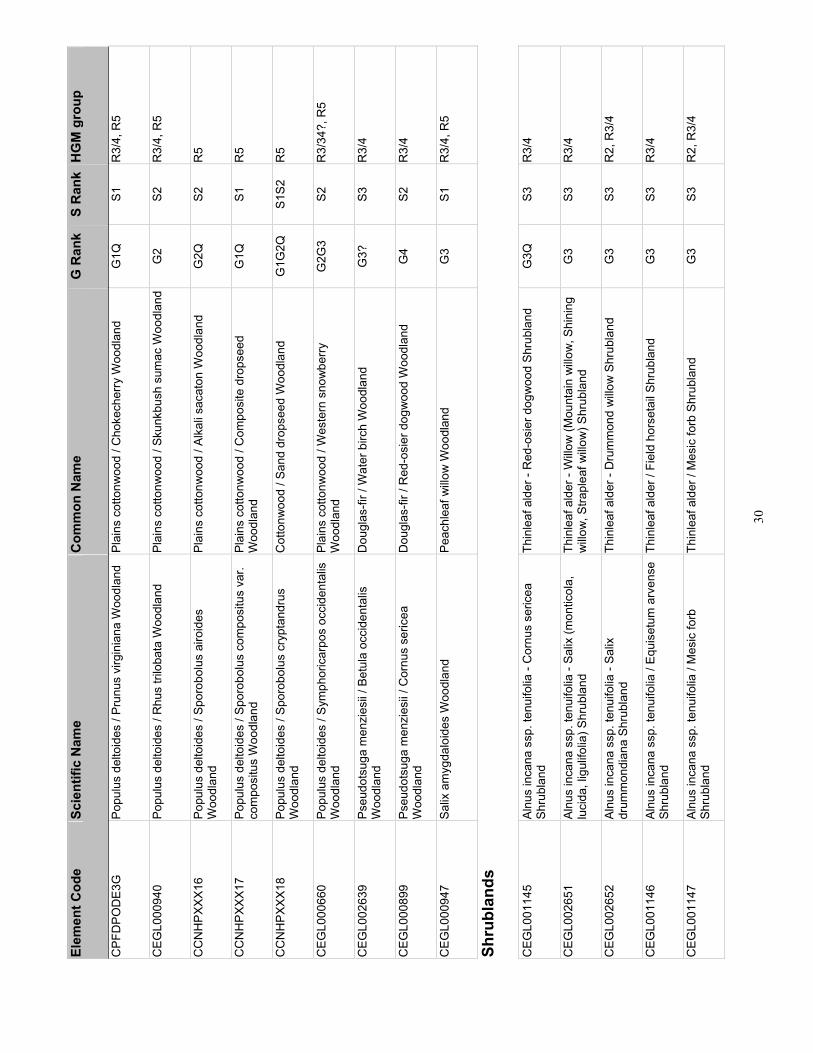
30
Elem
ent C
ode
Scie
ntifi
c N
ame
Com
mon
Nam
e G
Ran
k S
Ran
k H
GM
gro
up
CPF
DPO
DE3
G
Popu
lus
delto
ides
/ Pr
unus
virg
inia
na W
oodl
and
Plai
ns c
otto
nwoo
d / C
hoke
cher
ry W
oodl
and
G1Q
S1
R
3/4,
R5
CEG
L000
940
Popu
lus
delto
ides
/ R
hus
trilo
bata
Woo
dlan
d Pl
ains
cot
tonw
ood
/ Sku
nkbu
sh s
umac
Woo
dlan
dG
2 S2
R
3/4,
R5
CC
NH
PXXX
16
Popu
lus
delto
ides
/ Sp
orob
olus
airo
ides
W
oodl
and
Plai
ns c
otto
nwoo
d / A
lkal
i sac
aton
Woo
dlan
d G
2Q
S2
R5
CC
NH
PXXX
17
Popu
lus
delto
ides
/ Sp
orob
olus
com
posi
tus
var.
com
posi
tus
Woo
dlan
d Pl
ains
cot
tonw
ood
/ Com
posi
te d
rops
eed
Woo
dlan
d G
1Q
S1
R5
CC
NH
PXXX
18
Popu
lus
delto
ides
/ Sp
orob
olus
cry
ptan
drus
W
oodl
and
Cot
tonw
ood
/ San
d dr
opse
ed W
oodl
and
G1G
2Q
S1S2
R
5
CEG
L000
660
Popu
lus
delto
ides
/ Sy
mph
oric
arpo
s oc
cide
ntal
is
Woo
dlan
d Pl
ains
cot
tonw
ood
/ Wes
tern
sno
wbe
rry
Woo
dlan
d G
2G3
S2
R3/
34?,
R5
CEG
L002
639
Pseu
dots
uga
men
zies
ii / B
etul
a oc
cide
ntal
is
Woo
dlan
d D
ougl
as-fi
r / W
ater
birc
h W
oodl
and
G3?
S3
R
3/4
CEG
L000
899
Ps
eudo
tsug
a m
enzi
esii
/ Cor
nus
seric
ea
Woo
dlan
d D
ougl
as-fi
r / R
ed-o
sier
dog
woo
d W
oodl
and
G4
S2
R3/
4
CEG
L000
947
Salix
am
ygda
loid
es W
oodl
and
Peac
hlea
f willo
w W
oodl
and
G3
S1
R3/
4, R
5
Shru
blan
ds
CEG
L001
145
Alnu
s in
cana
ssp
. ten
uifo
lia -
Cor
nus
seric
ea
Shru
blan
d Th
inle
af a
lder
- R
ed-o
sier
dog
woo
d Sh
rubl
and
G3Q
S3
R
3/4
CEG
L002
651
Alnu
s in
cana
ssp
. ten
uifo
lia -
Salix
(mon
ticol
a,
luci
da, l
igul
ifolia
) Shr
ubla
nd
Thin
leaf
ald
er -
Willo
w (M
ount
ain
willo
w, S
hini
ng
willo
w, S
trapl
eaf w
illow
) Shr
ubla
nd
G3
S3
R3/
4
CEG
L002
652
Alnu
s in
cana
ssp
. ten
uifo
lia -
Salix
dr
umm
ondi
ana
Shru
blan
d Th
inle
af a
lder
- D
rum
mon
d w
illow
Shr
ubla
nd
G3
S3
R2,
R3/
4
CEG
L001
146
Alnu
s in
cana
ssp
. ten
uifo
lia /
Equi
setu
m a
rven
se
Shru
blan
d Th
inle
af a
lder
/ Fi
eld
hors
etai
l Shr
ubla
nd
G3
S3
R3/
4
CEG
L001
147
Alnu
s in
cana
ssp
. ten
uifo
lia /
Mes
ic fo
rb
Shru
blan
d Th
inle
af a
lder
/ M
esic
forb
Shr
ubla
nd
G3
S3
R2,
R3/
4
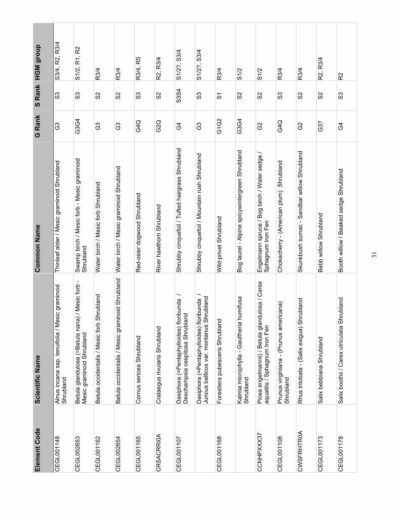
31
Elem
ent C
ode
Scie
ntifi
c N
ame
Com
mon
Nam
e G
Ran
k S
Ran
k H
GM
gro
up
CEG
L001
148
Alnu
s in
cana
ssp
. ten
uifo
lia /
Mes
ic g
ram
inoi
d Sh
rubl
and
Thin
leaf
ald
er /
Mes
ic g
ram
inoi
d Sh
rubl
and
G3
S3
S3/4
, R2,
R3/
4
CEG
L002
653
Betu
la g
land
ulos
a (=
Betu
la n
ana)
/ M
esic
forb
- M
esic
gra
min
oid
Shru
blan
d Sw
amp
birc
h / M
esic
forb
- M
esic
gra
min
oid
Shru
blan
d G
3G4
S3
S1/2
, R1,
R2
CEG
L001
162
Betu
la o
ccid
enta
lis /
Mes
ic fo
rb S
hrub
land
W
ater
birc
h / M
esic
forb
Shr
ubla
nd
G3
S2
R3/
4
CEG
L002
654
Be
tula
occ
iden
talis
/ M
esic
gra
min
oid
Shru
blan
d W
ater
birc
h / M
esic
gra
min
oid
Shru
blan
d G
3 S2
R
3/4
CEG
L001
165
Cor
nus
seric
ea S
hrub
land
R
ed-o
sier
dog
woo
d Sh
rubl
and
G4Q
S3
R
3/4,
R5
CR
SAC
RR
I0A
Cra
taeg
us ri
vula
ris S
hrub
land
R
iver
haw
thor
n Sh
rubl
and
G2Q
S2
R
2, R
3/4
CEG
L001
107
Das
ipho
ra (=
Pent
aphy
lloid
es) f
lorib
unda
/
Des
cham
psia
ces
pito
sa S
hrub
land
Sh
rubb
y ci
nque
foil
/ Tuf
ted
hairg
rass
Shr
ubla
nd
G4
S3S4
S1
/2?,
S3/
4
D
asip
hora
(=Pe
ntap
hyllo
ides
) flo
ribun
da /
Ju
ncus
bal
ticus
var
. mon
tanu
s Sh
rubl
and
Shru
bby
cinq
uefo
il / M
ount
ain
rush
Shr
ubla
nd
G3
S3
S1/2
?, S
3/4
CEG
L001
168
Fore
stie
ra p
ubes
cens
Shr
ubla
nd
Wild
-priv
et S
hrub
land
G
1G2
S1
R3/
4
Ka
lmia
mic
roph
ylla
- G
aulth
eria
hum
ifusa
Sh
rubl
and
Bog
laur
el -
Alpi
ne s
picy
win
terg
reen
Shr
ubla
nd
G3G
4 S2
S1
/2
CC
NH
PXXX
37
Pice
a en
gelm
anni
i) / B
etul
a gl
andu
losa
/ C
arex
aq
uatil
is /
Spha
gnum
Iron
Fen
En
gelm
ann
spru
ce /
Bog
birc
h / W
ater
sed
ge /
Spha
gnum
Iron
Fen
G
2 S2
S1
/2
CEG
L001
108
Prun
us v
irgin
iana
- (P
runu
s am
eric
ana)
Sh
rubl
and
Cho
kech
erry
- (A
mer
ican
plu
m)
Shru
blan
d G
4Q
S3
R3/
4
CW
SFR
HTR
0A
Rhu
s tri
loba
ta -
(Sal
ix e
xigu
a) S
hrub
land
Sk
unkb
ush
sum
ac -
Sand
bar w
illow
Shr
ubla
nd
G2
S2
R3/
4
CEG
L001
173
Salix
beb
bian
a Sh
rubl
and
Bebb
willo
w S
hrub
land
G
3?
S2
R2,
R3/
4
CEG
L001
178
Salix
boo
thii
/ Car
ex u
tricu
lata
Shr
ubla
nd
Boot
h w
illow
/ Be
aked
sed
ge S
hrub
land
G
4 S3
R
2
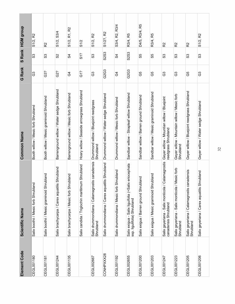
32
Elem
ent C
ode
Scie
ntifi
c N
ame
Com
mon
Nam
e G
Ran
k S
Ran
k H
GM
gro
up
CEG
L001
180
Salix
boo
thii
/ Mes
ic fo
rb S
hrub
land
Bo
oth
willo
w /
Mes
ic fo
rb S
hrub
land
G
3 S3
S1
/2, R
2
CEG
L001
181
Salix
boo
thii
/ Mes
ic g
ram
inoi
d Sh
rubl
and
Boot
h w
illow
/ M
esic
gra
min
oid
Shru
blan
d G
3?
S3
R2
CEG
L001
244
Salix
bra
chyc
arpa
/ C
arex
aqu
atilis
Shr
ubla
nd
Barre
ngro
und
willo
w /
Wat
er s
edge
Shr
ubla
nd
G2?
S2
S1
/2, S
3/4
CEG
L001
135
Salix
bra
chyc
arpa
/ M
esic
forb
Shr
ubla
nd
Barre
ngro
und
willo
w /
Mes
ic fo
rb S
hrub
land
G
4 S4
S1
/2, R
1, R
2
Sa
lix c
andi
da /
Trig
loch
in m
ariti
mum
Shr
ubla
nd
Hoa
ry w
illow
/ Se
asid
e ar
row
gras
s Sh
rubl
and
G1?
S1
? S1
/2
CEG
L002
667
Salix
dru
mm
ondi
ana
/ Cal
amag
rost
is c
anad
ensi
s Sh
rubl
and
Dru
mm
ond
willo
w /
Blue
join
t ree
dgra
ss
Shru
blan
d G
3 S3
S1
/2, R
2
CC
NH
PXXX
28
Salix
dru
mm
ondi
ana
/ Car
ex a
quat
ilis S
hrub
land
D
rum
mon
d w
illow
/ W
ater
sed
ge S
hrub
land
G
2G3
S2S3
S1
/2?,
R2
CEG
L001
192
Salix
dru
mm
ondi
ana
/ Mes
ic fo
rb S
hrub
land
D
rum
mon
d w
illow
/ M
esic
forb
Shr
ubla
nd
G4
S4
S3/4
, R2,
R3/
4
CEG
L002
655
Salix
exi
gua
- Sal
ix li
guifo
lia (=
Salix
erio
ceph
ala
ssp.
ligu
lifol
ia) S
hrub
land
Sa
ndba
r willo
w -
Stra
plea
f willo
w S
hrub
land
G
2G3
S2S3
R
3/4,
R5
CEG
L001
200
Salix
exi
gua
/ Bar
ren
grou
nd S
hrub
land
Sa
ndba
r willo
w /
Barre
n gr
ound
Shr
ubla
nd
G5
S5
D4/
5, R
3/4,
R5
CEG
L001
203
Salix
exi
gua
/ Mes
ic g
ram
inoi
d Sh
rubl
and
Sand
bar w
illow
/ M
esic
gra
min
oid
Shru
blan
d G
5 S5
R
3/4,
R5
CEG
L001
247
Salix
gey
eria
na -
Salix
mon
ticol
a / C
alam
agro
stis
ca
nade
nsis
Shr
ubla
nd
Gey
er w
illow
- M
ount
ian
willo
w /
Blue
join
t re
edgr
ass
Shru
blan
d G
3 S3
R
2
CEG
L001
223
Salix
gey
eria
na -
Salix
mon
ticol
a / M
esic
forb
Sh
rubl
and
Gey
er w
illow
- M
ount
ain
willo
w /
Mes
ic fo
rb
Shru
blan
d G
3 S3
R
2
CEG
L001
205
Salix
gey
eria
na /
Cal
amag
rost
is c
anad
ensi
s Sh
rubl
and
Gey
er w
illow
/ Bl
uejo
int r
eedg
rass
Shr
ubla
nd
G5
S3
R2
CEG
L001
206
Salix
gey
eria
na /
Car
ex a
quat
ilis S
hrub
land
G
eyer
willo
w /
Wat
er s
edge
Shr
ubla
nd
G3
S3
S1/2
, R2

33
Elem
ent C
ode
Scie
ntifi
c N
ame
Com
mon
Nam
e G
Ran
k S
Ran
k H
GM
gro
up
CEG
L001
207
Salix
gey
eria
na /
Car
ex u
tricu
lata
Shr
ubla
nd
Gey
er w
illow
/ Be
aked
sed
ge S
hrub
land
G
5 S3
R
2
CEG
L002
666
Salix
gey
eria
na /
Mes
ic fo
rb S
hrub
land
G
eyer
willo
w /
Mes
ic fo
rb S
hrub
land
G
3 S3
R
2, R
3/4
CEG
L001
218
Salix
ligu
lifol
ia (=
Salix
erio
ceph
ala
var.
ligul
ifolia
) Sh
rubl
and
Stra
plea
f willo
w S
hrub
land
G
2G3
S2S3
S1
/2, R
2, R
3/4
CR
WAS
ALU
1A
Salix
luci
da (s
sp. c
auda
ta o
r ssp
. las
iand
ra)
Shru
blan
d Sh
inin
g w
illow
Shr
ubla
nd
G3Q
S2
S3
R2,
R3/
4
CEG
L001
222
Salix
mon
ticol
a / C
alam
agro
stis
can
aden
sis
Shru
blan
d R
ocky
Mou
ntai
n w
illow
/ Bl
uejo
int r
eedg
rass
Sh
rubl
and
G3
S3
R2
CEG
L002
656
Salix
mon
ticol
a / C
arex
aqu
atilis
Shr
ubla
nd
Roc
ky M
ount
ain
willo
w /
Wat
er s
edge
Shr
ubla
nd
G3
S3
R2
CEG
L002
657
Sa
lix m
ontic
ola
/ Car
ex u
tricu
lata
Shr
ubla
nd
Mou
ntai
n w
illow
/ Be
aked
sed
ge S
hrub
land
G
3 S3
S1
/2, R
2
Sa
lix m
ontic
ola
/ Equ
iset
um a
rven
se S
hrub
land
M
ount
ain
willo
w /
Fiel
d ho
rset
ail S
hrub
land
G
2?
S2
R2
CEG
L002
658
Salix
mon
ticol
a / M
esic
For
b Sh
rubl
and
Mou
ntai
n w
illow
/ M
esic
forb
Shr
ubla
nd
G4
S3
S1/2
, R2,
R3/
4
CEG
L002
659
Salix
mon
ticol
a / M
esic
Gra
min
oid
Shru
blan
d M
ount
ain
willo
w /
Mes
ic g
ram
inoi
d Sh
rubl
and
G3
S3
S1/2
, S3/
4, R
2
CEG
L001
225
Salix
pla
nifo
lia /
Cal
amag
rost
is c
anad
ensi
s Sh
rubl
and
Plan
elea
f willo
w /
Blue
join
t ree
dgra
ss S
hrub
land
G
4 S3
S1
/2, R
1
CEG
L002
665
Salix
pla
nifo
lia /
Cal
tha
lept
osep
ala
Shru
blan
d Pl
anel
eaf w
illow
/ W
hite
mar
sh-m
arig
old
Shru
blan
d
G
4 S4
S1
/2, R
1
CEG
L001
227
Salix
pla
nifo
lia /
Car
ex a
quat
ilis S
hrub
land
Pl
anel
eaf w
illow
/ W
ater
sed
ge S
hrub
land
G
5 S4
S1
/2
Sa
lix p
lani
folia
/ C
arex
utri
cula
ta S
hrub
land
Pl
anel
eaf w
illow
/ Be
aked
sed
ge S
hrub
land
G
3G4
S2
S1/2
CC
NH
PXXX
26
Salix
pla
nifo
lia /
Mes
ic fo
rb S
hrub
land
Pl
anel
eaf w
illow
/ M
esic
forb
Shr
ubla
nd
G4
S4
S1/2
, R2

34
Elem
ent C
ode
Scie
ntifi
c N
ame
Com
mon
Nam
e G
Ran
k S
Ran
k H
GM
gro
up
Sa
lix w
olfii
/ C
alam
agro
stis
can
aden
sis
Shru
blan
d
Wol
f willo
w /
Blue
join
t ree
dgra
ss S
hrub
land
G
3 S3
S1
/2, R
1
CEG
L001
234
Salix
wol
fii /
Car
ex a
quat
ilis S
hrub
land
W
olf w
illow
/ W
ater
sed
ge S
hrub
land
G
4 S3
S1
/2, R
1
CEG
L001
237
Salix
wol
fii /
Car
ex u
tricu
lata
Shr
ubla
nd
Wol
f willo
w /
Beak
ed s
edge
Shr
ubla
nd
G4
S3
S1/2
, R1
CEG
L001
240
Salix
wol
fii /
Mes
ic fo
rb S
hrub
land
W
olf w
illow
/ M
esic
forb
Shr
ubla
nd
G3
S3
S1/2
, R1
Sa
rcob
atus
ver
mic
ulat
us /
Barre
n gr
ound
Sh
rubl
and
Blac
k gr
ease
woo
d / B
arre
n gr
ound
Shr
ubla
nd
GU
S2
F1
CEG
L001
363
Sarc
obat
us v
erm
icul
atus
/ D
istic
hlis
spi
cata
Sh
rubl
and
Blac
k gr
ease
woo
d / I
nlan
d sa
ltgra
ss S
hrub
land
G
4 S2
F1
CEG
L001
128
Shep
herd
ia a
rgen
tea
Shru
blan
d Si
lver
buf
falo
berry
Shr
ubla
nd
G3G
4 S1
R
3/4
CEG
L001
131
Sy
mph
oric
arpo
s oc
cide
ntal
is S
hrub
land
W
este
rn s
now
berry
Shr
ubla
nd
G4G
5 S3
R
5
Ta
mar
ix ra
mos
issi
ma
Shru
blan
d Sa
ltced
ar S
hrub
land
N
A N
A R
3/4,
R5
Her
bace
ous
Vege
tatio
n
Ag
rost
is g
igan
tea
Her
bace
ous
Vege
tatio
n R
edto
p H
erba
ceou
s Ve
geta
tion
NA
NA
D4/
5?, S
3/4
Al
opec
urus
aeq
ualis
Her
bace
ous
Vege
tatio
n Sh
orta
wn
foxt
ail H
erba
ceou
s Ve
geta
tion
G3G
4 S2
D
2/3,
D4/
5
CEG
L001
464
Andr
opog
on g
erar
dii -
Sor
ghas
trum
nut
ans
- (S
parti
na p
ectin
ata)
Her
bace
ous
Vege
tatio
n Bi
g bl
uest
em -
Yello
w in
dian
gras
s - P
rairi
e co
rdgr
ass
Her
bace
ous
Vege
tatio
n G
2 S1
S2
R5
CEG
L002
729
Aqui
legi
a m
icra
ntha
- (M
imul
us e
astw
oodi
ae)
Han
ging
Gar
den
Man
cos
colu
mbi
ne -
(Eas
twoo
d's
mon
keyf
low
er)
Han
ging
Gar
den
G2G
3 S2
S3
S3/4
Bi
dens
cer
nua
- Bid
ens
frond
osa
Her
bace
ous
Vege
tatio
n N
oddi
ng b
egga
rtick
- D
evil's
beg
garti
ck
Her
bace
ous
Vege
tatio
n G
3 S3
D
2/3

35
Elem
ent C
ode
Scie
ntifi
c N
ame
Com
mon
Nam
e G
Ran
k S
Ran
k H
GM
gro
up
CEG
L001
559
Cal
amag
rost
is c
anad
ensi
s W
este
rn H
erba
ceou
s Ve
geta
tion
Blue
join
t ree
dgra
ss W
este
rn H
erba
ceou
s Ve
geta
tion
G4
S4
R1,
R2
CEG
L001
954
Cal
tha
lept
osep
ala
Her
bace
ous
Vege
tatio
n W
hite
mar
sh-m
arig
old
Her
bace
ous
Vege
tatio
n G
4 S4
S1
/2
CEG
L002
662
Car
dam
ine
cord
ifolia
- M
erte
nsia
cilia
ta -
Sene
cio
trian
gula
ris H
erba
ceou
s Ve
geta
tion
Hea
rtlea
f bitt
ercr
ess
- Mou
ntai
n bl
uebe
lls -
Arro
wle
af ra
gwor
t Her
bace
ous
Vege
tatio
n G
4 S4
S1
/2, R
1, R
2
CEG
L001
803
Car
ex a
quat
ilis -
Car
ex u
tricu
lata
Her
bace
ous
Vege
tatio
n W
ater
sed
ge -
Beak
ed s
edge
Her
bace
ous
Vege
tatio
n G
4 S4
D
1, S
1/2,
S/3
/4
CEG
L001
802
Car
ex a
quat
ilis H
erba
ceou
s Ve
geta
tion
Wat
er s
edge
Her
bace
ous
Vege
tatio
n G
5 S4
S1
/2
CEG
L001
872
Car
ex c
apilla
ris -
Poly
gonu
m v
ivip
arum
H
erba
ceou
s Ve
geta
tion
Hai
r sed
ge -
Serp
ent-g
rass
Her
bace
ous
Vege
tatio
n G
2 S2
S1
/2
C
arex
em
oryi
Her
bace
ous
Vege
tatio
n Em
ory's
sed
ge H
erba
ceou
s Ve
geta
tion
G2?
S2
R
5
CEG
L001
876
Car
ex il
lota
Her
bace
ous
Vege
tatio
n Sm
all-h
ead
sedg
e H
erba
ceou
s Ve
geta
tion
GU
Q
S2
S1/2
CEG
L001
972
Car
ex m
icro
pter
a H
erba
ceou
s Ve
geta
tion
Smal
lwin
g se
dge
Her
bace
ous
Vege
tatio
n G
4 S2
? S1
/2
CEG
L001
813
Car
ex n
ebra
scen
sis
Her
bace
ous
Vege
tatio
n N
ebra
ska
sedg
e H
erba
ceou
s Ve
geta
tion
G4
S3
D2/
3, S
3/4
CEG
L001
818
Car
ex n
igric
ans
- Jun
cus
drum
mon
dii
Her
bace
ous
Vege
tatio
n Bl
ack
alpi
ne s
edge
- D
rum
mon
d ru
sh
Her
bace
ous
Vege
tatio
n G
U
S2
S1/2
CEG
L001
809
Car
ex p
ellit
a (=
lanu
gino
sa) H
erba
ceou
s Ve
geta
tion
Woo
lly s
edge
Her
bace
ous
Vege
tatio
n G
3 S3
D
2/3,
S3/
4, R
5
CEG
L002
660
Car
ex p
raeg
raci
lis H
erba
ceou
s Ve
geta
tion
Clu
ster
ed fi
eld
sedg
e H
erba
ceou
s Ve
geta
tion
G3G
4 S2
S3
/4
CEG
L001
769
Car
ex s
axat
ilis H
erba
ceou
s Ve
geta
tion
Rus
set s
edge
Her
bace
ous
Vege
tatio
n G
3 S2
S1
/2, S
3/4
CEG
L001
823
Car
ex s
copu
loru
m -
Cal
tha
lept
osep
ala
Her
bace
ous
Vege
tatio
n M
ount
ain
sedg
e - M
arsh
-mar
igol
d H
erba
ceou
s Ve
geta
tion
G4
S4
S1/2

36
Elem
ent C
ode
Scie
ntifi
c N
ame
Com
mon
Nam
e G
Ran
k S
Ran
k H
GM
gro
up
CEG
L001
825
Car
ex s
imul
ata
Her
bace
ous
Vege
tatio
n An
alog
ue s
edge
Her
bace
ous
Vege
tatio
n G
4 S3
S1
/2
CEG
L001
562
Car
ex u
tricu
lata
Her
bace
ous
Vege
tatio
n Be
aked
sed
ge H
erba
ceou
s Ve
geta
tion
G5
S5
D1,
D2/
3, S
1/2?
, S3
/4, R
2
CEG
L001
868
Car
ex v
erna
cula
Her
bace
ous
Vege
tatio
n N
ativ
e se
dge
Her
bace
ous
Vege
tatio
n G
U
S1
S1/2
CEG
L002
661
Car
ex v
esic
aria
Her
bace
ous
Vege
tatio
n Bl
iste
r sed
ge H
erba
ceou
s Ve
geta
tion
G4Q
S1
S1
/2, R
3/4
C
oryd
alis
cas
eana
ssp
. bra
ndeg
ei H
erba
ceou
s Ve
geta
tion
Bran
dege
e's
fum
ewor
t Her
bace
ous
Vege
tatio
n G
2 S2
R
1, R
2
CEG
L001
599
Des
cham
psia
cae
spito
sa H
erba
ceou
s Ve
geta
tion
Tufte
d ha
irgra
ss H
erba
ceou
s Ve
geta
tion
G4
S4
S1/2
, S3/
4
CEG
L001
770
Dis
tichl
is s
pica
ta H
erba
ceou
s Ve
geta
tion
Inla
nd s
altg
rass
Her
bace
ous
Vege
tatio
n G
5 S3
F1
Ec
hino
chlo
a cr
us-g
alli
Her
bace
ous
Vege
tatio
n Ba
rnya
rdgr
ass
Her
bace
ous
Vege
tatio
n N
A N
A D
4/5
CEG
L001
832
Eleo
char
is a
cicu
laris
Her
bace
ous
Vege
tatio
n N
eedl
e sp
iker
ush
Her
bace
ous
Vege
tatio
n G
4?
S3
D2/
3, D
4/5
CEG
L001
833
Eleo
char
is p
alus
tris
Her
bace
ous
Vege
tatio
n C
omm
on s
pike
rush
Her
bace
ous
Vege
tatio
n G
5 S4
D
2/3,
D4/
5, S
1/2
El
eoch
aris
par
vula
Her
bace
ous
Vege
tatio
n D
war
f spi
keru
sh H
erba
ceou
s Ve
geta
tion
GU
S2
D
2/3,
D4/
5
CEG
L001
836
Eleo
char
is q
uinq
ueflo
ra H
erba
ceou
s Ve
geta
tion
Few
-flow
er s
pike
rush
Her
bace
ous
Vege
tatio
n G
4 S3
S4
S1/2
CEG
L007
886
Eleo
char
is ro
stel
lata
Her
bace
ous
Vege
tatio
n Be
aked
spi
keru
sh H
erba
ceou
s Ve
geta
tion
G3
S2
S3/4
Eq
uise
tum
hye
mal
e H
erba
ceou
s Ve
geta
tion
Scou
ringr
ush
hors
etai
l Her
bace
ous
Vege
tatio
n G
3 S3
R
3/4,
R5
G
laux
mar
itim
a H
erba
ceou
s Ve
geta
tion
Sea
milk
wor
t Her
bace
ous
Vege
tatio
n G
3 S2
F1
, S3/
4
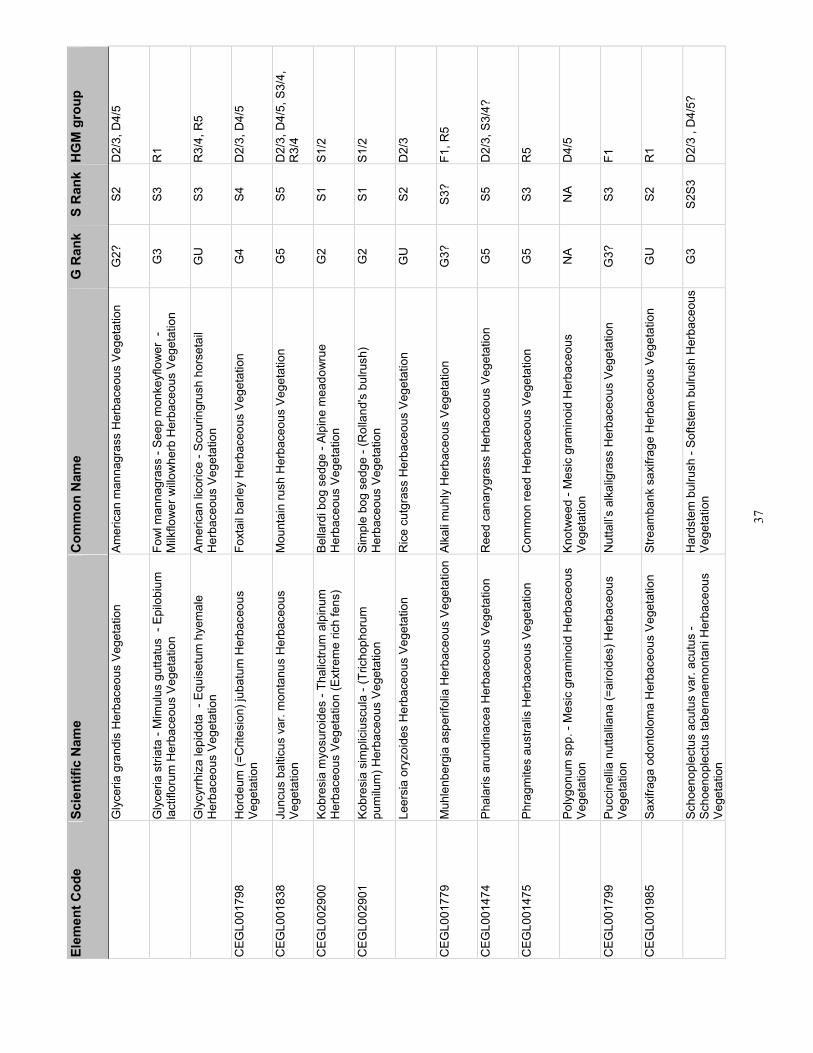
37
Elem
ent C
ode
Scie
ntifi
c N
ame
Com
mon
Nam
e G
Ran
k S
Ran
k H
GM
gro
up
G
lyce
ria g
rand
is H
erba
ceou
s Ve
geta
tion
Amer
ican
man
nagr
ass
Her
bace
ous
Vege
tatio
n G
2?
S2
D2/
3, D
4/5
G
lyce
ria s
triat
a - M
imul
us g
utta
tus
- Ep
ilobi
um
lact
iflor
um H
erba
ceou
s Ve
geta
tion
Fow
l man
nagr
ass
- See
p m
onke
yflo
wer
-
Milk
flow
er w
illow
herb
Her
bace
ous
Vege
tatio
n G
3 S3
R
1
G
lycy
rrhiz
a le
pido
ta -
Equ
iset
um h
yem
ale
Her
bace
ous
Vege
tatio
n Am
eric
an li
coric
e - S
cour
ingr
ush
hors
etai
l H
erba
ceou
s Ve
geta
tion
GU
S3
R
3/4,
R5
CEG
L001
798
Hor
deum
(=C
rites
ion)
juba
tum
Her
bace
ous
Vege
tatio
n Fo
xtai
l bar
ley
Her
bace
ous
Vege
tatio
n G
4 S4
D
2/3,
D4/
5
CEG
L001
838
Ju
ncus
bal
ticus
var
. mon
tanu
s H
erba
ceou
s Ve
geta
tion
Mou
ntai
n ru
sh H
erba
ceou
s Ve
geta
tion
G5
S5
D2/
3, D
4/5,
S3/
4,
R3/
4
CEG
L002
900
Kobr
esia
myo
suro
ides
- Th
alic
trum
alp
inum
H
erba
ceou
s Ve
geta
tion
(Ext
rem
e ric
h fe
ns)
Bella
rdi b
og s
edge
- Al
pine
mea
dow
rue
Her
bace
ous
Vege
tatio
n G
2 S1
S1
/2
CEG
L002
901
Kobr
esia
sim
plic
iusc
ula
- (Tr
icho
phor
um
pum
ilum
) Her
bace
ous
Vege
tatio
n Si
mpl
e bo
g se
dge
- (R
olla
nd's
bul
rush
) H
erba
ceou
s Ve
geta
tion
G2
S1
S1/2
Le
ersi
a or
yzoi
des
Her
bace
ous
Vege
tatio
n R
ice
cutg
rass
Her
bace
ous
Vege
tatio
n G
U
S2
D2/
3
CEG
L001
779
Muh
lenb
ergi
a as
perif
olia
Her
bace
ous
Vege
tatio
nAl
kali
muh
ly H
erba
ceou
s Ve
geta
tion
G3?
S3
? F1
, R5
CEG
L001
474
Ph
alar
is a
rund
inac
ea H
erba
ceou
s Ve
geta
tion
Ree
d ca
nary
gras
s H
erba
ceou
s Ve
geta
tion
G5
S5
D2/
3, S
3/4?
CEG
L001
475
Phra
gmite
s au
stra
lis H
erba
ceou
s Ve
geta
tion
Com
mon
reed
Her
bace
ous
Vege
tatio
n G
5 S3
R
5
Po
lygo
num
spp
. - M
esic
gra
min
oid
Her
bace
ous
Vege
tatio
n Kn
otw
eed
- Mes
ic g
ram
inoi
d H
erba
ceou
s Ve
geta
tion
NA
NA
D4/
5
CEG
L001
799
Pucc
inel
lia n
utta
lliana
(=ai
roid
es) H
erba
ceou
s Ve
geta
tion
Nut
tall’s
alk
alig
rass
Her
bace
ous
Vege
tatio
n G
3?
S3
F1
CEG
L001
985
Saxi
fraga
odo
ntol
oma
Her
bace
ous
Vege
tatio
n St
ream
bank
sax
ifrag
e H
erba
ceou
s Ve
geta
tion
GU
S2
R
1
Sc
hoen
ople
ctus
acu
tus
var.
acut
us -
Scho
enop
lect
us ta
bern
aem
onta
ni H
erba
ceou
s Ve
geta
tion
Har
dste
m b
ulru
sh -
Softs
tem
bul
rush
Her
bace
ous
Vege
tatio
n G
3 S2
S3
D2/
3 , D
4/5?
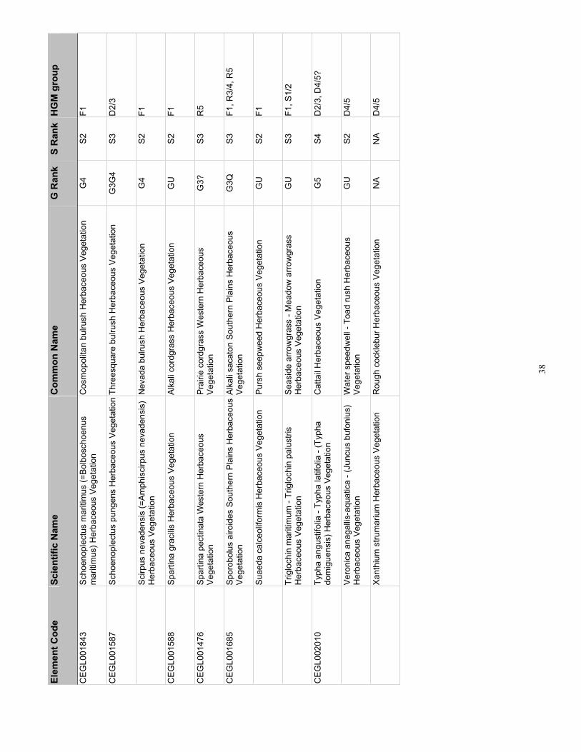
38
Elem
ent C
ode
Scie
ntifi
c N
ame
Com
mon
Nam
e G
Ran
k S
Ran
k H
GM
gro
up
CEG
L001
843
Scho
enop
lect
us m
ariti
mus
(=Bo
lbos
choe
nus
mar
itim
us) H
erba
ceou
s Ve
geta
tion
Cos
mop
olita
n bu
lrush
Her
bace
ous
Vege
tatio
n G
4 S2
F1
CEG
L001
587
Scho
enop
lect
us p
unge
ns H
erba
ceou
s Ve
geta
tion
Thre
esqu
are
bulru
sh H
erba
ceou
s Ve
geta
tion
G3G
4 S3
D
2/3
Sc
irpus
nev
aden
sis
(=Am
phis
cirp
us n
evad
ensi
s)
Her
bace
ous
Vege
tatio
n N
evad
a bu
lrush
Her
bace
ous
Vege
tatio
n G
4 S2
F1
CEG
L001
588
Spar
tina
grac
ilis H
erba
ceou
s Ve
geta
tion
Alka
li co
rdgr
ass
Her
bace
ous
Vege
tatio
n G
U
S2
F1
CEG
L001
476
Spar
tina
pect
inat
a W
este
rn H
erba
ceou
s Ve
geta
tion
Prai
rie c
ordg
rass
Wes
tern
Her
bace
ous
Vege
tatio
n G
3?
S3
R5
CEG
L001
685
Spor
obol
us a
iroid
es S
outh
ern
Plai
ns H
erba
ceou
s Ve
geta
tion
Alka
li sa
cato
n So
uthe
rn P
lain
s H
erba
ceou
s Ve
geta
tion
G3Q
S3
F1
, R3/
4, R
5
Su
aeda
cal
ceol
iform
is H
erba
ceou
s Ve
geta
tion
Purs
h se
epw
eed
Her
bace
ous
Vege
tatio
n G
U
S2
F1
Tr
iglo
chin
mar
itim
um -
Trig
loch
in p
alus
tris
Her
bace
ous
Vege
tatio
n Se
asid
e ar
row
gras
s - M
eado
w a
rrow
gras
s H
erba
ceou
s Ve
geta
tion
GU
S3
F1
, S1/
2
CEG
L002
010
Typh
a an
gust
ifolia
- Ty
pha
latif
olia
- (T
ypha
do
mig
uens
is) H
erba
ceou
s Ve
geta
tion
Cat
tail
Her
bace
ous
Vege
tatio
n G
5 S4
D
2/3,
D4/
5?
Ve
roni
ca a
naga
llis-a
quat
ica
- (Ju
ncus
buf
oniu
s)
Her
bace
ous
Vege
tatio
n W
ater
spe
edw
ell -
Toa
d ru
sh H
erba
ceou
s Ve
geta
tion
GU
S2
D
4/5
Xa
nthi
um s
trum
ariu
m H
erba
ceou
s Ve
geta
tion
Rou
gh c
ockl
ebur
Her
bace
ous
Vege
tatio
n N
A N
A D
4/5

39
Tabl
e 5.
Wet
land
Pla
nt A
ssoc
iatio
ns o
f Col
orad
o by
HG
M g
roup
O
nly
asso
ciat
ions
with
an
Elco
de b
egin
ning
with
CEG
L ar
e cl
assi
fied
by U
SNV
C.
Elem
ent C
ode
Scie
ntifi
c N
ame
Com
mon
Nam
e
Min
eral
Fla
ts 1
CEG
L001
770
Dis
tichl
is s
pica
ta H
erba
ceou
s Ve
geta
tion
Inla
nd s
altg
rass
Her
bace
ous
Vege
tatio
n
Gla
ux m
ariti
ma
Her
bace
ous
Vege
tatio
n Se
a m
ilkw
ort H
erba
ceou
s Ve
geta
tion
CEG
L001
779
Muh
lenb
ergi
a as
perif
olia
Her
bace
ous
Vege
tatio
n Al
kali
muh
ly H
erba
ceou
s Ve
geta
tion
CEG
L001
799
Pucc
inel
lia n
utta
lliana
(=ai
roid
es) H
erba
ceou
s Ve
geta
tion
Nut
tall’s
alk
alig
rass
Her
bace
ous
Vege
tatio
n
Sarc
obat
us v
erm
icul
atus
/ Ba
rren
grou
nd S
hrub
land
Bl
ack
grea
sew
ood
/ Bar
ren
grou
nd S
hrub
land
C
EGL0
0136
3 Sa
rcob
atus
ver
mic
ulat
us /
Dis
tichl
is s
pica
ta S
hrub
land
Bl
ack
grea
sew
ood
/ Inl
and
saltg
rass
Shr
ubla
nd
CEG
L001
843
Scho
enop
lect
us m
ariti
mus
(=Bo
lbos
choe
nus
mar
itim
us) H
erba
ceou
s Ve
geta
tion
Cos
mop
olita
n bu
lrush
Her
bace
ous
Vege
tatio
n
Sc
irpus
nev
aden
sis
(=Am
phis
cirp
us n
evad
ensi
s) H
erba
ceou
s Ve
geta
tion
Nev
ada
bulru
sh H
erba
ceou
s Ve
geta
tion
CEG
L001
588
Spar
tina
grac
ilis H
erba
ceou
s Ve
geta
tion
Alka
li co
rdgr
ass
Her
bace
ous
Vege
tatio
n C
EGL0
0168
5 Sp
orob
olus
airo
ides
Sou
ther
n Pl
ains
Her
bace
ous
Vege
tatio
n Al
kali
saca
ton
Sout
hern
Pla
ins
Her
bace
ous
Vege
tatio
n
Suae
da c
alce
olifo
rmis
Her
bace
ous
Vege
tatio
n Pu
rsh
seep
wee
d H
erba
ceou
s Ve
geta
tion
Tr
iglo
chin
mar
itim
um -
Trig
loch
in p
alus
tris
Her
bace
ous
Vege
tatio
n Se
asid
e ar
row
gras
s - M
eado
w a
rrow
gras
s H
erba
ceou
s Ve
geta
tion
D
epre
ssio
nal 1
CEG
L001
803
Car
ex a
quat
ilis -
Car
ex u
tricu
lata
Her
bace
ous
Vege
tatio
n W
ater
sed
ge -
Beak
ed s
edge
Her
bace
ous
Vege
tatio
n C
EGL0
0156
2 C
arex
utri
cula
ta H
erba
ceou
s Ve
geta
tion
Beak
ed s
edge
Her
bace
ous
Vege
tatio
n
Dep
ress
iona
l 2/3
Alop
ecur
us a
equa
lis H
erba
ceou
s Ve
geta
tion
Shor
taw
n fo
xtai
l Her
bace
ous
Vege
tatio
n
Bide
ns c
ernu
a - B
iden
s fro
ndos
a H
erba
ceou
s Ve
geta
tion
Nod
ding
beg
garti
ck -
Dev
il's b
egga
rtick
Her
bace
ous
Vege
tatio
n C
EGL0
0181
3 C
arex
neb
rasc
ensi
s H
erba
ceou
s Ve
geta
tion
Neb
rask
a se
dge
Her
bace
ous
Vege
tatio
n C
EGL0
0180
9 C
arex
pel
lita
(=la
nugi
nosa
) Her
bace
ous
Vege
tatio
n W
oolly
sed
ge H
erba
ceou
s Ve
geta
tion
CEG
L001
562
Car
ex u
tricu
lata
Her
bace
ous
Vege
tatio
n Be
aked
sed
ge H
erba
ceou
s Ve
geta
tion
CEG
L001
832
Eleo
char
is a
cicu
laris
Her
bace
ous
Vege
tatio
n N
eedl
e sp
iker
ush
Her
bace
ous
Vege
tatio
n

40
Elem
ent C
ode
Scie
ntifi
c N
ame
Com
mon
Nam
e C
EGL0
0183
3 El
eoch
aris
pal
ustri
s H
erba
ceou
s Ve
geta
tion
Com
mon
spi
keru
sh H
erba
ceou
s Ve
geta
tion
El
eoch
aris
par
vula
Her
bace
ous
Vege
tatio
n D
war
f spi
keru
sh H
erba
ceou
s Ve
geta
tion
G
lyce
ria g
rand
is H
erba
ceou
s Ve
geta
tion
Amer
ican
man
nagr
ass
Her
bace
ous
Vege
tatio
n C
EGL0
0179
8 H
orde
um (=
Crit
esio
n) ju
batu
m H
erba
ceou
s Ve
geta
tion
Foxt
ail b
arle
y H
erba
ceou
s Ve
geta
tion
CEG
L001
838
Ju
ncus
bal
ticus
var
. mon
tanu
s H
erba
ceou
s Ve
geta
tion
Mou
ntai
n ru
sh H
erba
ceou
s Ve
geta
tion
Le
ersi
a or
yzoi
des
Her
bace
ous
Vege
tatio
n R
ice
cutg
rass
Her
bace
ous
Vege
tatio
n C
EGL0
0147
4
Phal
aris
aru
ndin
acea
Her
bace
ous
Vege
tatio
n R
eed
cana
rygr
ass
Her
bace
ous
Vege
tatio
n
Scho
enop
lect
us a
cutu
s va
r. ac
utus
- Sc
hoen
ople
ctus
tabe
rnae
mon
tani
H
erba
ceou
s Ve
geta
tion
Har
dste
m b
ulru
sh -
Softs
tem
bul
rush
Her
bace
ous
Vege
tatio
n
CEG
L001
587
Scho
enop
lect
us p
unge
ns H
erba
ceou
s Ve
geta
tion
Thre
esqu
are
bulru
sh H
erba
ceou
s Ve
geta
tion
CEG
L002
010
Typh
a an
gust
ifolia
- Ty
pha
latif
olia
- (T
ypha
dom
igue
nsis
) Her
bace
ous
Vege
tatio
n C
atta
il H
erba
ceou
s Ve
geta
tion
D
epre
ssio
nal 4
/5
Al
opec
urus
aeq
ualis
Her
bace
ous
Vege
tatio
n Sh
orta
wn
foxt
ail H
erba
ceou
s Ve
geta
tion
Ec
hino
chlo
a cr
us-g
alli
Her
bace
ous
Vege
tatio
n Ba
rnya
rdgr
ass
Her
bace
ous
Vege
tatio
n C
EGL0
0183
2 El
eoch
aris
aci
cula
ris H
erba
ceou
s Ve
geta
tion
Nee
dle
spik
erus
h H
erba
ceou
s Ve
geta
tion
CEG
L001
833
Eleo
char
is p
alus
tris
Her
bace
ous
Vege
tatio
n C
omm
on s
pike
rush
Her
bace
ous
Vege
tatio
n
Eleo
char
is p
arvu
la H
erba
ceou
s Ve
geta
tion
Dw
arf s
pike
rush
Her
bace
ous
Vege
tatio
n
Gly
ceria
gra
ndis
Her
bace
ous
Vege
tatio
n Am
eric
an m
anna
gras
s H
erba
ceou
s Ve
geta
tion
CEG
L001
798
Hor
deum
(=C
rites
ion)
juba
tum
Her
bace
ous
Vege
tatio
n Fo
xtai
l bar
ley
Her
bace
ous
Vege
tatio
n C
EGL0
0183
8
Junc
us b
altic
us v
ar. m
onta
nus
Her
bace
ous
Vege
tatio
n M
ount
ain
rush
Her
bace
ous
Vege
tatio
n
Poly
gonu
m s
pp. -
Mes
ic g
ram
inoi
d H
erba
ceou
s Ve
geta
tion
Knot
wee
d - M
esic
gra
min
oid
Her
bace
ous
Vege
tatio
n C
EGL0
0120
0 Sa
lix e
xigu
a / B
arre
n gr
ound
Shr
ubla
nd
Sand
bar w
illow
/ Ba
rren
grou
nd S
hrub
land
C
EGL0
0201
0 Ty
pha
angu
stifo
lia -
Typh
a la
tifol
ia -
(Typ
ha d
omig
uens
is) H
erba
ceou
s Ve
geta
tion
Cat
tail
Her
bace
ous
Vege
tatio
n
Ve
roni
ca a
naga
llis-a
quat
ica
- (Ju
ncus
buf
oniu
s) H
erba
ceou
s Ve
geta
tion
Wat
er s
peed
wel
l - T
oad
rush
Her
bace
ous
Vege
tatio
n
Xa
nthi
um s
trum
ariu
m H
erba
ceou
s Ve
geta
tion
Rou
gh c
ockl
ebur
Her
bace
ous
Vege
tatio
n
Slop
e 1/
2
CR
FCAB
LA0I
Ab
ies
lasi
ocar
pa -
Pice
a en
gelm
anni
i / C
arex
aqu
atilis
For
est
Suba
lpin
e fir
- En
gelm
ann
spru
ce /
Wat
er s
edge
For
est
CEG
L002
653
Betu
la g
land
ulos
a (=
Betu
la n
ana)
/ M
esic
forb
- M
esic
gra
min
oid
Shru
blan
d Sw
amp
birc
h / M
esic
forb
- M
esic
gra
min
oid
Shru
blan
d
CEG
L001
954
Cal
tha
lept
osep
ala
Her
bace
ous
Vege
tatio
n W
hite
mar
sh-m
arig
old
Her
bace
ous
Vege
tatio
n

41
Elem
ent C
ode
Scie
ntifi
c N
ame
Com
mon
Nam
e C
EGL0
0266
2 C
arda
min
e co
rdifo
lia -
Mer
tens
ia c
iliata
- Se
neci
o tri
angu
laris
H
erba
ceou
s Ve
geta
tion
Hea
rtlea
f bitt
ercr
ess
- Mou
ntai
n bl
uebe
lls -
Arro
wle
af ra
gwor
t H
erba
ceou
s Ve
geta
tion
CEG
L001
803
Car
ex a
quat
ilis -
Car
ex u
tricu
lata
Her
bace
ous
Vege
tatio
n W
ater
sed
ge -
Beak
ed s
edge
Her
bace
ous
Vege
tatio
n C
EGL0
0180
2 C
arex
aqu
atilis
Her
bace
ous
Vege
tatio
n W
ater
sed
ge H
erba
ceou
s Ve
geta
tion
CEG
L001
872
Car
ex c
apilla
ris -
Poly
gonu
m v
ivip
arum
Her
bace
ous
Vege
tatio
n H
air s
edge
- Se
rpen
t-gra
ss H
erba
ceou
s Ve
geta
tion
CEG
L001
876
Car
ex il
lota
Her
bace
ous
Vege
tatio
n Sm
all-h
ead
sedg
e H
erba
ceou
s Ve
geta
tion
CEG
L001
972
Car
ex m
icro
pter
a H
erba
ceou
s Ve
geta
tion
Smal
lwin
g se
dge
Her
bace
ous
Vege
tatio
n C
EGL0
0181
8 C
arex
nig
rican
s - J
uncu
s dr
umm
ondi
i Her
bace
ous
Vege
tatio
n Bl
ack
alpi
ne s
edge
- D
rum
mon
d ru
sh H
erba
ceou
s Ve
geta
tion
CEG
L001
769
Car
ex s
axat
ilis H
erba
ceou
s Ve
geta
tion
Rus
set s
edge
Her
bace
ous
Vege
tatio
n C
EGL0
0182
3 C
arex
sco
pulo
rum
- C
alth
a le
ptos
epal
a H
erba
ceou
s Ve
geta
tion
Mou
ntai
n se
dge
- Mar
sh-m
arig
old
Her
bace
ous
Vege
tatio
n C
EGL0
0182
5 C
arex
sim
ulat
a H
erba
ceou
s Ve
geta
tion
Anal
ogue
sed
ge H
erba
ceou
s Ve
geta
tion
CEG
L001
868
Car
ex v
erna
cula
Her
bace
ous
Vege
tatio
n N
ativ
e se
dge
Her
bace
ous
Vege
tatio
n C
EGL0
0266
1 C
arex
ves
icar
ia H
erba
ceou
s Ve
geta
tion
Blis
ter s
edge
Her
bace
ous
Vege
tatio
n C
EGL0
0159
9 D
esch
amps
ia c
aesp
itosa
Her
bace
ous
Vege
tatio
n Tu
fted
hairg
rass
Her
bace
ous
Vege
tatio
n C
EGL0
0183
3 El
eoch
aris
pal
ustri
s H
erba
ceou
s Ve
geta
tion
Com
mon
spi
keru
sh H
erba
ceou
s Ve
geta
tion
CEG
L001
836
Eleo
char
is q
uinq
ueflo
ra H
erba
ceou
s Ve
geta
tion
Few
-flow
er s
pike
rush
Her
bace
ous
Vege
tatio
n
Kalm
ia m
icro
phyl
la -
Gau
lther
ia h
umifu
sa S
hrub
land
Bo
g la
urel
- Al
pine
spi
cyw
inte
rgre
en S
hrub
land
C
EGL0
0290
0 Ko
bres
ia m
yosu
roid
es -
Thal
ictru
m a
lpin
um H
erba
ceou
s Ve
geta
tion
(Ext
rem
e ric
h fe
ns)
Bella
rdi b
og s
edge
- Al
pine
mea
dow
rue
Her
bace
ous
Vege
tatio
n
CEG
L002
901
Kobr
esia
sim
plic
iusc
ula
- (Tr
icho
phor
um p
umilu
m) H
erba
ceou
s Ve
geta
tion
Sim
ple
bog
sedg
e - (
Rol
land
's b
ulru
sh) H
erba
ceou
s Ve
geta
tion
CC
NH
PXXX
37
Pice
a en
gelm
anni
i) / B
etul
a gl
andu
losa
/ C
arex
aqu
atilis
/ Sp
hagn
um
Iron
Fen
Enge
lman
n sp
ruce
/ Bo
g bi
rch
/ Wat
er s
edge
/ Sp
hagn
um Ir
on F
en
CEG
L001
180
Salix
boo
thii
/ Mes
ic fo
rb S
hrub
land
Bo
oth
willo
w /
Mes
ic fo
rb S
hrub
land
C
EGL0
0124
4 Sa
lix b
rach
ycar
pa /
Car
ex a
quat
ilis S
hrub
land
Ba
rreng
roun
d w
illow
/ W
ater
sed
ge S
hrub
land
C
EGL0
0113
5 Sa
lix b
rach
ycar
pa /
Mes
ic fo
rb S
hrub
land
Ba
rreng
roun
d w
illow
/ M
esic
forb
Shr
ubla
nd
Sa
lix c
andi
da /
Trig
loch
in m
ariti
mum
Shr
ubla
nd
Hoa
ry w
illow
/ Se
asid
e ar
row
gras
s Sh
rubl
and
CEG
L002
667
Salix
dru
mm
ondi
ana
/ Cal
amag
rost
is c
anad
ensi
s Sh
rubl
and
Dru
mm
ond
willo
w /
Blue
join
t ree
dgra
ss S
hrub
land
C
EGL0
0120
6 Sa
lix g
eyer
iana
/ C
arex
aqu
atilis
Shr
ubla
nd
Gey
er w
illow
/ W
ater
sed
ge S
hrub
land
C
EGL0
0121
8 Sa
lix li
gulif
olia
(=Sa
lix e
rioce
phal
a va
r. lig
ulifo
lia) S
hrub
land
St
rapl
eaf w
illow
Shr
ubla
nd
CEG
L002
657
Sa
lix m
ontic
ola
/ Car
ex u
tricu
lata
Shr
ubla
nd
Mou
ntai
n w
illow
/ Be
aked
sed
ge S
hrub
land
C
EGL0
0265
8 Sa
lix m
ontic
ola
/ Mes
ic F
orb
Shru
blan
d M
ount
ain
willo
w /
Mes
ic fo
rb S
hrub
land
C
EGL0
0265
9 Sa
lix m
ontic
ola
/ Mes
ic G
ram
inoi
d Sh
rubl
and
Mou
ntai
n w
illow
/ M
esic
gra
min
oid
Shru
blan
d C
EGL0
0122
5 Sa
lix p
lani
folia
/ C
alam
agro
stis
can
aden
sis
Shru
blan
d Pl
anel
eaf w
illow
/ Bl
uejo
int r
eedg
rass
Shr
ubla
nd
CEG
L002
665
Salix
pla
nifo
lia /
Cal
tha
lept
osep
ala
Shru
blan
d Pl
anel
eaf w
illow
/ W
hite
mar
sh-m
arig
old
Shru
blan
d
C
EGL0
0122
7 Sa
lix p
lani
folia
/ C
arex
aqu
atilis
Shr
ubla
nd
Plan
elea
f willo
w /
Wat
er s
edge
Shr
ubla
nd
Sa
lix p
lani
folia
/ C
arex
utri
cula
ta S
hrub
land
Pl
anel
eaf w
illow
/ Be
aked
sed
ge S
hrub
land
C
CN
HPX
XX26
Sa
lix p
lani
folia
/ M
esic
forb
Shr
ubla
nd
Plan
elea
f willo
w /
Mes
ic fo
rb S
hrub
land
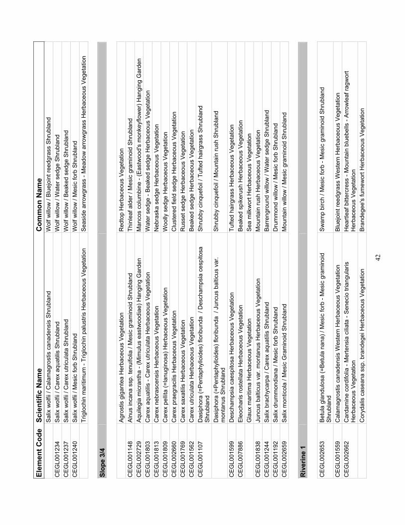
42
Elem
ent C
ode
Scie
ntifi
c N
ame
Com
mon
Nam
e
Salix
wol
fii /
Cal
amag
rost
is c
anad
ensi
s Sh
rubl
and
W
olf w
illow
/ Bl
uejo
int r
eedg
rass
Shr
ubla
nd
CEG
L001
234
Salix
wol
fii /
Car
ex a
quat
ilis S
hrub
land
W
olf w
illow
/ W
ater
sed
ge S
hrub
land
C
EGL0
0123
7 Sa
lix w
olfii
/ C
arex
utri
cula
ta S
hrub
land
W
olf w
illow
/ Be
aked
sed
ge S
hrub
land
C
EGL0
0124
0 Sa
lix w
olfii
/ M
esic
forb
Shr
ubla
nd
Wol
f willo
w /
Mes
ic fo
rb S
hrub
land
Trig
loch
in m
ariti
mum
- Tr
iglo
chin
pal
ustri
s H
erba
ceou
s Ve
geta
tion
Seas
ide
arro
wgr
ass
- Mea
dow
arro
wgr
ass
Her
bace
ous
Vege
tatio
n
Slop
e 3/
4
Ag
rost
is g
igan
tea
Her
bace
ous
Vege
tatio
n R
edto
p H
erba
ceou
s Ve
geta
tion
CEG
L001
148
Alnu
s in
cana
ssp
. ten
uifo
lia /
Mes
ic g
ram
inoi
d Sh
rubl
and
Thin
leaf
ald
er /
Mes
ic g
ram
inoi
d Sh
rubl
and
CEG
L002
729
Aqui
legi
a m
icra
ntha
- (M
imul
us e
astw
oodi
ae) H
angi
ng G
arde
n M
anco
s co
lum
bine
- (E
astw
ood'
s m
onke
yflo
wer
) Han
ging
Gar
den
CEG
L001
803
Car
ex a
quat
ilis -
Car
ex u
tricu
lata
Her
bace
ous
Vege
tatio
n W
ater
sed
ge -
Beak
ed s
edge
Her
bace
ous
Vege
tatio
n C
EGL0
0181
3 C
arex
neb
rasc
ensi
s H
erba
ceou
s Ve
geta
tion
Neb
rask
a se
dge
Her
bace
ous
Vege
tatio
n C
EGL0
0180
9 C
arex
pel
lita
(=la
nugi
nosa
) Her
bace
ous
Vege
tatio
n W
oolly
sed
ge H
erba
ceou
s Ve
geta
tion
CEG
L002
660
Car
ex p
raeg
raci
lis H
erba
ceou
s Ve
geta
tion
Clu
ster
ed fi
eld
sedg
e H
erba
ceou
s Ve
geta
tion
CEG
L001
769
Car
ex s
axat
ilis H
erba
ceou
s Ve
geta
tion
Rus
set s
edge
Her
bace
ous
Vege
tatio
n C
EGL0
0156
2 C
arex
utri
cula
ta H
erba
ceou
s Ve
geta
tion
Beak
ed s
edge
Her
bace
ous
Vege
tatio
n C
EGL0
0110
7 D
asip
hora
(=Pe
ntap
hyllo
ides
) flo
ribun
da /
Des
cham
psia
ces
pito
sa
Shru
blan
d Sh
rubb
y ci
nque
foil
/ Tuf
ted
hairg
rass
Shr
ubla
nd
D
asip
hora
(=Pe
ntap
hyllo
ides
) flo
ribun
da /
Jun
cus
balti
cus
var.
mon
tanu
s Sh
rubl
and
Shru
bby
cinq
uefo
il / M
ount
ain
rush
Shr
ubla
nd
CEG
L001
599
Des
cham
psia
cae
spito
sa H
erba
ceou
s Ve
geta
tion
Tufte
d ha
irgra
ss H
erba
ceou
s Ve
geta
tion
CEG
L007
886
Eleo
char
is ro
stel
lata
Her
bace
ous
Vege
tatio
n Be
aked
spi
keru
sh H
erba
ceou
s Ve
geta
tion
G
laux
mar
itim
a H
erba
ceou
s Ve
geta
tion
Sea
milk
wor
t Her
bace
ous
Vege
tatio
n C
EGL0
0183
8
Junc
us b
altic
us v
ar. m
onta
nus
Her
bace
ous
Vege
tatio
n M
ount
ain
rush
Her
bace
ous
Vege
tatio
n C
EGL0
0124
4 Sa
lix b
rach
ycar
pa /
Car
ex a
quat
ilis S
hrub
land
Ba
rreng
roun
d w
illow
/ W
ater
sed
ge S
hrub
land
C
EGL0
0119
2 Sa
lix d
rum
mon
dian
a / M
esic
forb
Shr
ubla
nd
Dru
mm
ond
willo
w /
Mes
ic fo
rb S
hrub
land
C
EGL0
0265
9 Sa
lix m
ontic
ola
/ Mes
ic G
ram
inoi
d Sh
rubl
and
Mou
ntai
n w
illow
/ M
esic
gra
min
oid
Shru
blan
d
Riv
erin
e 1
C
EGL0
0265
3 Be
tula
gla
ndul
osa
(=Be
tula
nan
a) /
Mes
ic fo
rb -
Mes
ic g
ram
inoi
d Sh
rubl
and
Swam
p bi
rch
/ Mes
ic fo
rb -
Mes
ic g
ram
inoi
d Sh
rubl
and
CEG
L001
559
Cal
amag
rost
is c
anad
ensi
s W
este
rn H
erba
ceou
s Ve
geta
tion
Blue
join
t ree
dgra
ss W
este
rn H
erba
ceou
s Ve
geta
tion
CEG
L002
662
Car
dam
ine
cord
ifolia
- M
erte
nsia
cilia
ta -
Sene
cio
trian
gula
ris
Her
bace
ous
Vege
tatio
n H
eartl
eaf b
itter
cres
s - M
ount
ain
blue
bells
- Ar
row
leaf
ragw
ort
Her
bace
ous
Vege
tatio
n
Cor
ydal
is c
asea
na s
sp. b
rand
egei
Her
bace
ous
Vege
tatio
n Br
ande
gee'
s fu
mew
ort H
erba
ceou
s Ve
geta
tion

43
Elem
ent C
ode
Scie
ntifi
c N
ame
Com
mon
Nam
e
Gly
ceria
stri
ata
- Mim
ulus
gut
tatu
s -
Epilo
bium
lact
iflor
um H
erba
ceou
s Ve
geta
tion
Fow
l man
nagr
ass
- See
p m
onke
yflo
wer
- M
ilkflo
wer
willo
whe
rb
Her
bace
ous
Vege
tatio
n C
EGL0
0113
5 Sa
lix b
rach
ycar
pa /
Mes
ic fo
rb S
hrub
land
Ba
rreng
roun
d w
illow
/ M
esic
forb
Shr
ubla
nd
CEG
L001
225
Salix
pla
nifo
lia /
Cal
amag
rost
is c
anad
ensi
s Sh
rubl
and
Plan
elea
f willo
w /
Blue
join
t ree
dgra
ss S
hrub
land
C
EGL0
0266
5 Sa
lix p
lani
folia
/ C
alth
a le
ptos
epal
a Sh
rubl
and
Plan
elea
f willo
w /
Whi
te m
arsh
-mar
igol
d Sh
rubl
and
Sa
lix w
olfii
/ C
alam
agro
stis
can
aden
sis
Shru
blan
d
Wol
f willo
w /
Blue
join
t ree
dgra
ss S
hrub
land
C
EGL0
0123
4 Sa
lix w
olfii
/ C
arex
aqu
atilis
Shr
ubla
nd
Wol
f willo
w /
Wat
er s
edge
Shr
ubla
nd
CEG
L001
237
Salix
wol
fii /
Car
ex u
tricu
lata
Shr
ubla
nd
Wol
f willo
w /
Beak
ed s
edge
Shr
ubla
nd
CEG
L001
240
Salix
wol
fii /
Mes
ic fo
rb S
hrub
land
W
olf w
illow
/ M
esic
forb
Shr
ubla
nd
CEG
L001
985
Saxi
fraga
odo
ntol
oma
Her
bace
ous
Vege
tatio
n St
ream
bank
sax
ifrag
e H
erba
ceou
s Ve
geta
tion
R
iver
ine
2
CR
FEXX
XXX7
Ab
ies
lasi
ocar
pa -
Pice
a en
gelm
anni
i - P
opul
us a
ngus
tifol
ia /
Loni
cera
in
volu
crat
a Fo
rest
Su
balp
ine
fir -
Enge
lman
n sp
ruce
- N
arro
wle
af c
otto
nwoo
d / T
win
berry
ho
neys
uckl
e Fo
rest
C
EGL0
0029
6 Ab
ies
lasi
ocar
pa -
Pice
a en
gelm
anni
i / A
lnus
inca
na F
ores
t Su
balp
ine
fir -
Enge
lman
n sp
ruce
/ T
hinl
eaf a
lder
For
est
CEG
L000
300
Abie
s la
sioc
arpa
- Pi
cea
enge
lman
nii /
Cal
amag
rost
is c
anad
ensi
s Fo
rest
Su
balp
ine
fir -
Enge
lman
n sp
ruce
/ Bl
uejo
int r
eedg
rass
For
est
CR
FCAB
LA0I
Ab
ies
lasi
ocar
pa -
Pice
a en
gelm
anni
i / C
arex
aqu
atilis
For
est
Suba
lpin
e fir
- En
gelm
ann
spru
ce /
Wat
er s
edge
For
est
CR
FFPI
EN0A
Ab
ies
lasi
ocar
pa -
Pice
a en
gelm
anni
i / E
quis
etum
arv
ense
For
est
Suba
lpin
e fir
- En
gelm
ann
spru
ce /
Fiel
d ho
rset
ail F
ores
t C
EGL0
0266
3 Ab
ies
lasi
ocar
pa -
Pice
a en
gelm
anni
i / M
erte
nsia
cilia
ta F
ores
t Su
balp
ine
fir -
Enge
lman
n sp
ruce
/ Ta
ll fri
nged
blu
ebel
ls F
ores
t C
EGL0
0033
1 Ab
ies
lasi
ocar
pa -
Pice
a en
gelm
anni
i / R
ibes
spp
. For
est
Suba
lpin
e fir
- En
gelm
ann
spru
ce /
Cur
rant
spp
. For
est
CEG
L000
327
Abie
s la
sioc
arpa
- Pi
cea
enge
lman
nii /
Sal
ix d
rum
mon
dian
a Fo
rest
Su
balp
ine
fir -
Enge
lman
n sp
ruce
/ D
rum
mon
d w
illow
For
est
CEG
L002
652
Alnu
s in
cana
ssp
. ten
uifo
lia -
Salix
dru
mm
ondi
ana
Shru
blan
d Th
inle
af a
lder
- D
rum
mon
d w
illow
Shr
ubla
nd
CEG
L001
147
Alnu
s in
cana
ssp
. ten
uifo
lia /
Mes
ic fo
rb S
hrub
land
Th
inle
af a
lder
/ M
esic
forb
Shr
ubla
nd
CEG
L001
148
Alnu
s in
cana
ssp
. ten
uifo
lia /
Mes
ic g
ram
inoi
d Sh
rubl
and
Thin
leaf
ald
er /
Mes
ic g
ram
inoi
d Sh
rubl
and
CEG
L002
653
Betu
la g
land
ulos
a (=
Betu
la n
ana)
/ M
esic
forb
- M
esic
gra
min
oid
Shru
blan
d Sw
amp
birc
h / M
esic
forb
- M
esic
gra
min
oid
Shru
blan
d
CEG
L001
559
Cal
amag
rost
is c
anad
ensi
s W
este
rn H
erba
ceou
s Ve
geta
tion
Blue
join
t ree
dgra
ss W
este
rn H
erba
ceou
s Ve
geta
tion
CEG
L002
662
Car
dam
ine
cord
ifolia
- M
erte
nsia
cilia
ta -
Sene
cio
trian
gula
ris
Her
bace
ous
Vege
tatio
n H
eartl
eaf b
itter
cres
s - M
ount
ain
blue
bells
- Ar
row
leaf
ragw
ort
Her
bace
ous
Vege
tatio
n C
EGL0
0156
2 C
arex
utri
cula
ta H
erba
ceou
s Ve
geta
tion
Beak
ed s
edge
Her
bace
ous
Vege
tatio
n
Cor
ydal
is c
asea
na s
sp. b
rand
egei
Her
bace
ous
Vege
tatio
n Br
ande
gee'
s fu
mew
ort H
erba
ceou
s Ve
geta
tion
CR
SAC
RR
I0A
Cra
taeg
us ri
vula
ris S
hrub
land
R
iver
haw
thor
n Sh
rubl
and
CEG
L000
894
Pice
a pu
ngen
s / A
lnus
inca
na s
sp. t
enui
folia
Woo
dlan
d Bl
ue s
pruc
e / T
hinl
eaf a
lder
Woo
dlan
d C
EGL0
0263
7 Pi
cea
pung
ens
/ Bet
ula
occi
dent
alis
Woo
dlan
d Bl
ue s
pruc
e / W
ater
birc
h W
oodl
and
CEG
L000
934
Popu
lus
angu
stifo
lia -
Pice
a pu
ngen
s / A
lnus
inca
na W
oodl
and
Nar
row
leaf
cot
tonw
ood
- Blu
e sp
ruce
/ Th
inle
af a
lder
Woo
dlan
d C
RFA
POBA
0A
Popu
lus
bals
amife
ra F
ores
t Ba
lsam
pop
lar F
ores
t

44
Elem
ent C
ode
Scie
ntifi
c N
ame
Com
mon
Nam
e C
EGL0
0056
3 Po
pulu
s tre
mul
oide
s / A
cer g
labr
um F
ores
t Q
uaki
ng a
spen
/ R
ocky
Mou
ntai
n m
aple
For
est
CEG
L000
618
Popu
lus
trem
uloi
des
/ Tal
l for
b Fo
rest
Q
uaki
ng a
spen
/ Ta
ll fo
rbs
Fore
st
CEG
L001
173
Salix
beb
bian
a Sh
rubl
and
Bebb
willo
w S
hrub
land
C
EGL0
0117
8 Sa
lix b
ooth
ii / C
arex
utri
cula
ta S
hrub
land
Bo
oth
willo
w /
Beak
ed s
edge
Shr
ubla
nd
CEG
L001
180
Salix
boo
thii
/ Mes
ic fo
rb S
hrub
land
Bo
oth
willo
w /
Mes
ic fo
rb S
hrub
land
C
EGL0
0118
1 Sa
lix b
ooth
ii / M
esic
gra
min
oid
Shru
blan
d Bo
oth
willo
w /
Mes
ic g
ram
inoi
d Sh
rubl
and
CEG
L001
135
Salix
bra
chyc
arpa
/ M
esic
forb
Shr
ubla
nd
Barre
ngro
und
willo
w /
Mes
ic fo
rb S
hrub
land
C
EGL0
0266
7 Sa
lix d
rum
mon
dian
a / C
alam
agro
stis
can
aden
sis
Shru
blan
d D
rum
mon
d w
illow
/ Bl
uejo
int r
eedg
rass
Shr
ubla
nd
CC
NH
PXXX
28
Salix
dru
mm
ondi
ana
/ Car
ex a
quat
ilis S
hrub
land
D
rum
mon
d w
illow
/ W
ater
sed
ge S
hrub
land
C
EGL0
0119
2 Sa
lix d
rum
mon
dian
a / M
esic
forb
Shr
ubla
nd
Dru
mm
ond
willo
w /
Mes
ic fo
rb S
hrub
land
C
EGL0
0124
7 Sa
lix g
eyer
iana
- Sa
lix m
ontic
ola
/ Cal
amag
rost
is c
anad
ensi
s Sh
rubl
and
Gey
er w
illow
- M
ount
ian
willo
w /
Blue
join
t ree
dgra
ss S
hrub
land
CEG
L001
223
Salix
gey
eria
na -
Salix
mon
ticol
a / M
esic
forb
Shr
ubla
nd
Gey
er w
illow
- M
ount
ain
willo
w /
Mes
ic fo
rb S
hrub
land
C
EGL0
0120
5 Sa
lix g
eyer
iana
/ C
alam
agro
stis
can
aden
sis
Shru
blan
d G
eyer
willo
w /
Blue
join
t ree
dgra
ss S
hrub
land
C
EGL0
0120
6 Sa
lix g
eyer
iana
/ C
arex
aqu
atilis
Shr
ubla
nd
Gey
er w
illow
/ W
ater
sed
ge S
hrub
land
C
EGL0
0120
7 Sa
lix g
eyer
iana
/ C
arex
utri
cula
ta S
hrub
land
G
eyer
willo
w /
Beak
ed s
edge
Shr
ubla
nd
CEG
L002
666
Salix
gey
eria
na /
Mes
ic fo
rb S
hrub
land
G
eyer
willo
w /
Mes
ic fo
rb S
hrub
land
C
EGL0
0121
8 Sa
lix li
gulif
olia
(=Sa
lix e
rioce
phal
a va
r. lig
ulifo
lia) S
hrub
land
St
rapl
eaf w
illow
Shr
ubla
nd
CR
WAS
ALU
1A
Salix
luci
da (s
sp. c
auda
ta o
r ssp
. las
iand
ra) S
hrub
land
Sh
inin
g w
illow
Shr
ubla
nd
CEG
L001
222
Salix
mon
ticol
a / C
alam
agro
stis
can
aden
sis
Shru
blan
d R
ocky
Mou
ntai
n w
illow
/ Bl
uejo
int r
eedg
rass
Shr
ubla
nd
CEG
L002
656
Salix
mon
ticol
a / C
arex
aqu
atilis
Shr
ubla
nd
Roc
ky M
ount
ain
willo
w /
Wat
er s
edge
Shr
ubla
nd
CEG
L002
657
Sa
lix m
ontic
ola
/ Car
ex u
tricu
lata
Shr
ubla
nd
Mou
ntai
n w
illow
/ Be
aked
sed
ge S
hrub
land
Salix
mon
ticol
a / E
quis
etum
arv
ense
Shr
ubla
nd
Mou
ntai
n w
illow
/ Fi
eld
hors
etai
l Shr
ubla
nd
CEG
L002
658
Salix
mon
ticol
a / M
esic
For
b Sh
rubl
and
Mou
ntai
n w
illow
/ M
esic
forb
Shr
ubla
nd
CEG
L002
659
Salix
mon
ticol
a / M
esic
Gra
min
oid
Shru
blan
d M
ount
ain
willo
w /
Mes
ic g
ram
inoi
d Sh
rubl
and
CC
NH
PXXX
26
Salix
pla
nifo
lia /
Mes
ic fo
rb S
hrub
land
Pl
anel
eaf w
illow
/ M
esic
forb
Shr
ubla
nd
R
iver
ine
3/4
C
EGL0
0025
5 Ab
ies
conc
olor
- (P
icea
pun
gens
) - P
opul
us a
ngus
tifol
ia /
Acer
gla
brum
Fo
rest
W
hite
fir -
(Blu
e sp
ruce
) - N
arro
wle
af c
otto
nwoo
d / R
ocky
Mou
ntai
n m
aple
C
RFE
XXXX
X7
Abie
s la
sioc
arpa
- Pi
cea
enge
lman
nii -
Pop
ulus
ang
ustif
olia
/ Lo
nice
ra
invo
lucr
ata
Fore
st
Suba
lpin
e fir
- En
gelm
ann
spru
ce -
Nar
row
leaf
cot
tonw
ood
/ Tw
inbe
rry
hone
ysuc
kle
Fore
st
CEG
L000
296
Abie
s la
sioc
arpa
- Pi
cea
enge
lman
nii /
Aln
us in
cana
For
est
Suba
lpin
e fir
- En
gelm
ann
spru
ce /
Thi
nlea
f ald
er F
ores
t C
RFF
PIEN
0A
Abie
s la
sioc
arpa
- Pi
cea
enge
lman
nii /
Equ
iset
um a
rven
se F
ores
t Su
balp
ine
fir -
Enge
lman
n sp
ruce
/ Fi
eld
hors
etai
l For
est
CEG
L002
663
Abie
s la
sioc
arpa
- Pi
cea
enge
lman
nii /
Mer
tens
ia c
iliata
For
est
Suba
lpin
e fir
- En
gelm
ann
spru
ce /
Tall
fring
ed b
lueb
ells
For
est
CEG
L000
327
Abie
s la
sioc
arpa
- Pi
cea
enge
lman
nii /
Sal
ix d
rum
mon
dian
a Fo
rest
Su
balp
ine
fir -
Enge
lman
n sp
ruce
/ D
rum
mon
d w
illow
For
est

45
Elem
ent C
ode
Scie
ntifi
c N
ame
Com
mon
Nam
e C
WFD
ACN
E2F
Acer
neg
undo
- Po
pulu
s an
gust
ifolia
/ C
eltis
laev
igat
a va
r. re
ticul
ata
Fore
st
Boxe
lder
- N
arro
wle
af c
otto
nwoo
d / N
etle
af h
ackb
erry
For
est
CEG
L000
627
Acer
neg
undo
- Po
pulu
s an
gust
ifolia
/ C
ornu
s se
ricea
For
est
Boxe
lder
- N
arro
wle
af c
otto
nwoo
d / R
ed-o
sier
dog
woo
d Fo
rest
C
EGL0
0093
6 Ac
er n
egun
do /
Betu
la o
ccid
enta
lis W
oodl
and
Boxe
lder
/ W
ater
birc
h W
oodl
and
CEG
L000
625
Acer
neg
undo
/ C
ornu
s se
ricea
For
est
Boxe
lder
/ R
ed-o
sier
dog
woo
d Fo
rest
C
EGL0
0062
8 Ac
er n
egun
do /
Prun
us v
irgin
iana
For
est
Boxe
lder
/ C
hoke
cher
ry F
ores
t C
EGL0
0114
5 Al
nus
inca
na s
sp. t
enui
folia
- C
ornu
s se
ricea
Shr
ubla
nd
Thin
leaf
ald
er -
Red
-osi
er d
ogw
ood
Shru
blan
d C
EGL0
0265
1 Al
nus
inca
na s
sp. t
enui
folia
- Sa
lix (m
ontic
ola,
luci
da, l
igul
ifolia
) Sh
rubl
and
Thin
leaf
ald
er -
Willo
w (M
ount
ain
willo
w, S
hini
ng w
illow
, Stra
plea
f w
illow
) Shr
ubla
nd
CEG
L002
652
Alnu
s in
cana
ssp
. ten
uifo
lia -
Salix
dru
mm
ondi
ana
Shru
blan
d Th
inle
af a
lder
- D
rum
mon
d w
illow
Shr
ubla
nd
CEG
L001
146
Alnu
s in
cana
ssp
. ten
uifo
lia /
Equi
setu
m a
rven
se S
hrub
land
Th
inle
af a
lder
/ Fi
eld
hors
etai
l Shr
ubla
nd
CEG
L001
147
Alnu
s in
cana
ssp
. ten
uifo
lia /
Mes
ic fo
rb S
hrub
land
Th
inle
af a
lder
/ M
esic
forb
Shr
ubla
nd
CEG
L001
148
Alnu
s in
cana
ssp
. ten
uifo
lia /
Mes
ic g
ram
inoi
d Sh
rubl
and
Thin
leaf
ald
er /
Mes
ic g
ram
inoi
d Sh
rubl
and
CEG
L001
162
Betu
la o
ccid
enta
lis /
Mes
ic fo
rb S
hrub
land
W
ater
birc
h / M
esic
forb
Shr
ubla
nd
CEG
L002
654
Be
tula
occ
iden
talis
/ M
esic
gra
min
oid
Shru
blan
d W
ater
birc
h / M
esic
gra
min
oid
Shru
blan
d C
EGL0
0266
1 C
arex
ves
icar
ia H
erba
ceou
s Ve
geta
tion
Blis
ter s
edge
Her
bace
ous
Vege
tatio
n C
EGL0
0108
5 C
eltis
laev
igat
a va
r.ret
icul
ata
Shru
blan
d N
etle
af h
ackb
erry
/ Bl
uebu
nch
whe
atgr
ass
Woo
dlan
d C
EGL0
0116
5 C
ornu
s se
ricea
Shr
ubla
nd
Red
-osi
er d
ogw
ood
Shru
blan
d C
RSA
CR
RI0
A C
rata
egus
rivu
laris
Shr
ubla
nd
Riv
er h
awth
orn
Shru
blan
d
Equi
setu
m h
yem
ale
Her
bace
ous
Vege
tatio
n Sc
ourin
grus
h ho
rset
ail H
erba
ceou
s Ve
geta
tion
CEG
L001
168
Fore
stie
ra p
ubes
cens
Shr
ubla
nd
Wild
-priv
et S
hrub
land
Gly
cyrrh
iza
lepi
dota
- E
quis
etum
hye
mal
e H
erba
ceou
s Ve
geta
tion
Amer
ican
lico
rice
- Sco
urin
grus
h ho
rset
ail H
erba
ceou
s Ve
geta
tion
CEG
L001
838
Ju
ncus
bal
ticus
var
. mon
tanu
s H
erba
ceou
s Ve
geta
tion
Mou
ntai
n ru
sh H
erba
ceou
s Ve
geta
tion
CEG
L000
746
Juni
peru
s sc
opul
orum
/ C
ornu
s se
ricea
Woo
dlan
d R
ocky
Mou
ntai
n ju
nipe
r / R
ed-o
sier
dog
woo
d W
oodl
and
CEG
L000
894
Pice
a pu
ngen
s / A
lnus
inca
na s
sp. t
enui
folia
Woo
dlan
d Bl
ue s
pruc
e / T
hinl
eaf a
lder
Woo
dlan
d C
EGL0
0038
8 Pi
cea
pung
ens
/ Cor
nus
seric
ea W
oodl
and
Blue
spr
uce
/ Red
-osi
er d
ogw
ood
Woo
dlan
d C
EGL0
0038
9 Pi
cea
pung
ens
/ Equ
iset
um a
rven
se W
oodl
and
Blue
spr
uce
/ Fie
ld h
orse
tail
Woo
dlan
d C
EGL0
0264
0 Po
pulu
s an
gust
ifolia
- Ju
nipe
rus
scop
ulor
um W
oodl
and
Nar
row
leaf
cot
tonw
ood
- Roc
ky M
ount
ain
juni
per W
oodl
and
CEG
L002
641
Popu
lus
angu
stifo
lia -
Pseu
dots
uga
men
zies
ii W
oodl
and
Nar
row
leaf
cot
tonw
ood
- Dou
glas
-fir W
oodl
and
CEG
L002
642
Popu
lus
angu
stifo
lia /
Alnu
s in
cana
ssp
. ten
uifo
lia W
oodl
and
Nar
row
leaf
cot
tonw
ood
/ Thi
nlea
f ald
er W
oodl
and
CEG
L000
648
Popu
lus
angu
stifo
lia /
Betu
la o
ccid
enta
lis W
oodl
and
Nar
row
leaf
cot
tonw
ood
/ Wat
er b
irch
Woo
dlan
d C
EGL0
0266
4 Po
pulu
s an
gust
ifolia
/ C
ornu
s se
ricea
Woo
dlan
d N
arro
wle
af c
otto
nwoo
d / R
ed-o
sier
dog
woo
d W
oodl
and
CEG
L002
644
Popu
lus
angu
stifo
lia /
Cra
taeg
us ri
vula
ris W
oodl
and
Nar
row
leaf
cot
tonw
ood
/ Riv
er h
awth
orn
Woo
dlan
d C
EGL0
0065
1
Popu
lus
angu
stifo
lia /
Prun
us v
irgin
iana
Woo
dlan
d N
arro
wle
af c
otto
nwoo
d / C
hoke
cher
ry W
oodl
and
CEG
L000
652
Popu
lus
angu
stifo
lia /
Rhu
s tri
loba
ta W
oodl
and
Nar
row
leaf
cot
tonw
ood
/ Sku
nkbu
sh s
umac
Woo
dlan
d C
EGL0
0264
5 Po
pulu
s an
gust
ifolia
/ Sa
lix (m
ontic
ola,
dru
mm
ondi
ana,
luci
da)
Woo
dlan
d N
arro
wle
af c
otto
nwoo
d / M
ixed
willo
w (M
ount
ain
willo
w, D
rum
mon
d w
illow
, Shi
ning
willo
w) W
oodl
and
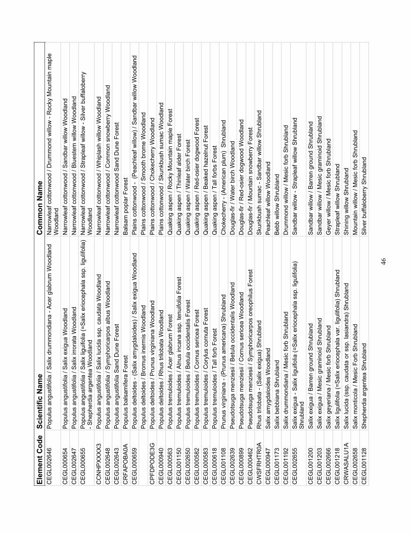
46
Elem
ent C
ode
Scie
ntifi
c N
ame
Com
mon
Nam
e C
EGL0
0264
6 Po
pulu
s an
gust
ifolia
/ Sa
lix d
rum
mon
dian
a - A
cer g
labr
um W
oodl
and
Nar
row
leaf
cot
tonw
ood
/ Dru
mm
ond
willo
w -
Roc
ky M
ount
ain
map
le
Woo
dlan
d C
EGL0
0065
4 Po
pulu
s an
gust
ifolia
/ Sa
lix e
xigu
a W
oodl
and
Nar
row
leaf
cot
tonw
ood
/ San
dbar
willo
w W
oodl
and
CEG
L002
647
Po
pulu
s an
gust
ifolia
/ Sa
lix ir
rora
ta W
oodl
and
Nar
row
leaf
cot
tonw
ood
/ Blu
este
m w
illow
Woo
dlan
d C
EGL0
0065
5 Po
pulu
s an
gust
ifolia
/ Sa
lix li
guifo
lia (=
Salix
erio
ceph
ala
ssp.
ligu
lifol
ia)
- She
pher
dia
arge
ntea
Woo
dlan
d N
arro
wle
af c
otto
nwoo
d / S
trapl
eaf w
illow
- Si
lver
buf
falo
berry
W
oodl
and
CC
NH
PXXX
X3
Popu
lus
angu
stifo
lia /
Salix
luci
da s
sp. c
auda
ta W
oodl
and
Nar
row
leaf
cot
tonw
ood
/ Whi
plas
h w
illow
Woo
dlan
d C
EGL0
0264
8 Po
pulu
s an
gust
ifolia
/ Sy
mph
oric
arpo
s al
bus
Woo
dlan
d N
arro
wle
af c
otto
nwoo
d / C
omm
on s
now
berry
Woo
dlan
d C
EGL0
0264
3 Po
pulu
s an
gust
ifolia
San
d D
une
Fore
st
Nar
row
leaf
cot
tonw
ood
Sand
Dun
e Fo
rest
C
RFA
POBA
0A
Popu
lus
bals
amife
ra F
ores
t Ba
lsam
pop
lar F
ores
t C
EGL0
0065
9 Po
pulu
s de
ltoid
es -
(Sal
ix a
myg
dalo
ides
) / S
alix
exi
gua
Woo
dlan
d Pl
ains
cot
tonw
ood
- (P
each
leaf
willo
w) /
San
dbar
willo
w W
oodl
and
Po
pulu
s de
ltoid
es /
Brom
us in
erm
is W
oodl
and
Plai
ns c
otto
nwoo
d / S
moo
th b
rom
e W
oodl
and
CPF
DPO
DE3
G
Popu
lus
delto
ides
/ Pr
unus
virg
inia
na W
oodl
and
Plai
ns c
otto
nwoo
d / C
hoke
cher
ry W
oodl
and
CEG
L000
940
Popu
lus
delto
ides
/ R
hus
trilo
bata
Woo
dlan
d Pl
ains
cot
tonw
ood
/ Sku
nkbu
sh s
umac
Woo
dlan
d C
EGL0
0056
3 Po
pulu
s tre
mul
oide
s / A
cer g
labr
um F
ores
t Q
uaki
ng a
spen
/ R
ocky
Mou
ntai
n m
aple
For
est
CEG
L001
150
Popu
lus
trem
uloi
des
/ Aln
us in
cana
ssp
. ten
uifo
lia F
ores
t Q
uaki
ng a
spen
/ Th
inle
af a
lder
For
est
CEG
L002
650
Popu
lus
trem
uloi
des
/ Bet
ula
occi
dent
alis
For
est
Qua
king
asp
en /
Wat
er b
irch
Fore
st
CEG
L000
582
Popu
lus
trem
uloi
des
/ Cor
nus
seric
ea F
ores
t Q
uaki
ng a
spen
/ R
ed-o
sier
dog
woo
d Fo
rest
C
EGL0
0058
3
Popu
lus
trem
uloi
des
/ Cor
ylus
cor
nuta
For
est
Qua
king
asp
en /
Beak
ed h
azel
nut F
ores
t C
EGL0
0061
8 Po
pulu
s tre
mul
oide
s / T
all f
orb
Fore
st
Qua
king
asp
en /
Tall
forb
s Fo
rest
C
EGL0
0110
8 Pr
unus
virg
inia
na -
(Pru
nus
amer
ican
a) S
hrub
land
C
hoke
cher
ry -
(Am
eric
an p
lum
) Sh
rubl
and
CEG
L002
639
Pseu
dots
uga
men
zies
ii / B
etul
a oc
cide
ntal
is W
oodl
and
Dou
glas
-fir /
Wat
er b
irch
Woo
dlan
d C
EGL0
0089
9
Pseu
dots
uga
men
zies
ii / C
ornu
s se
ricea
Woo
dlan
d D
ougl
as-fi
r / R
ed-o
sier
dog
woo
d W
oodl
and
CEG
L000
462
Pseu
dots
uga
men
zies
ii / S
ymph
oric
arpo
s or
eoph
ilus
Fore
st
Dou
glas
-fir /
Mou
ntai
n sn
owbe
rry F
ores
t C
WSF
RH
TR0A
R
hus
trilo
bata
- (S
alix
exi
gua)
Shr
ubla
nd
Skun
kbus
h su
mac
- Sa
ndba
r willo
w S
hrub
land
C
EGL0
0094
7 Sa
lix a
myg
dalo
ides
Woo
dlan
d Pe
achl
eaf w
illow
Woo
dlan
d C
EGL0
0117
3 Sa
lix b
ebbi
ana
Shru
blan
d Be
bb w
illow
Shr
ubla
nd
CEG
L001
192
Salix
dru
mm
ondi
ana
/ Mes
ic fo
rb S
hrub
land
D
rum
mon
d w
illow
/ M
esic
forb
Shr
ubla
nd
CEG
L002
655
Salix
exi
gua
- Sal
ix li
guifo
lia (=
Salix
erio
ceph
ala
ssp.
ligu
lifol
ia)
Shru
blan
d
Sand
bar w
illow
- St
rapl
eaf w
illow
Shr
ubla
nd
CEG
L001
200
Salix
exi
gua
/ Bar
ren
grou
nd S
hrub
land
Sa
ndba
r willo
w /
Barre
n gr
ound
Shr
ubla
nd
CEG
L001
203
Salix
exi
gua
/ Mes
ic g
ram
inoi
d Sh
rubl
and
Sand
bar w
illow
/ M
esic
gra
min
oid
Shru
blan
d C
EGL0
0266
6 Sa
lix g
eyer
iana
/ M
esic
forb
Shr
ubla
nd
Gey
er w
illow
/ M
esic
forb
Shr
ubla
nd
CEG
L001
218
Salix
ligu
lifol
ia (=
Salix
erio
ceph
ala
var.
ligul
ifolia
) Shr
ubla
nd
Stra
plea
f willo
w S
hrub
land
C
RW
ASAL
U1A
Sa
lix lu
cida
(ssp
. cau
data
or s
sp. l
asia
ndra
) Shr
ubla
nd
Shin
ing
willo
w S
hrub
land
C
EGL0
0265
8 Sa
lix m
ontic
ola
/ Mes
ic F
orb
Shru
blan
d M
ount
ain
willo
w /
Mes
ic fo
rb S
hrub
land
C
EGL0
0112
8 Sh
ephe
rdia
arg
ente
a Sh
rubl
and
Silv
er b
uffa
lobe
rry S
hrub
land
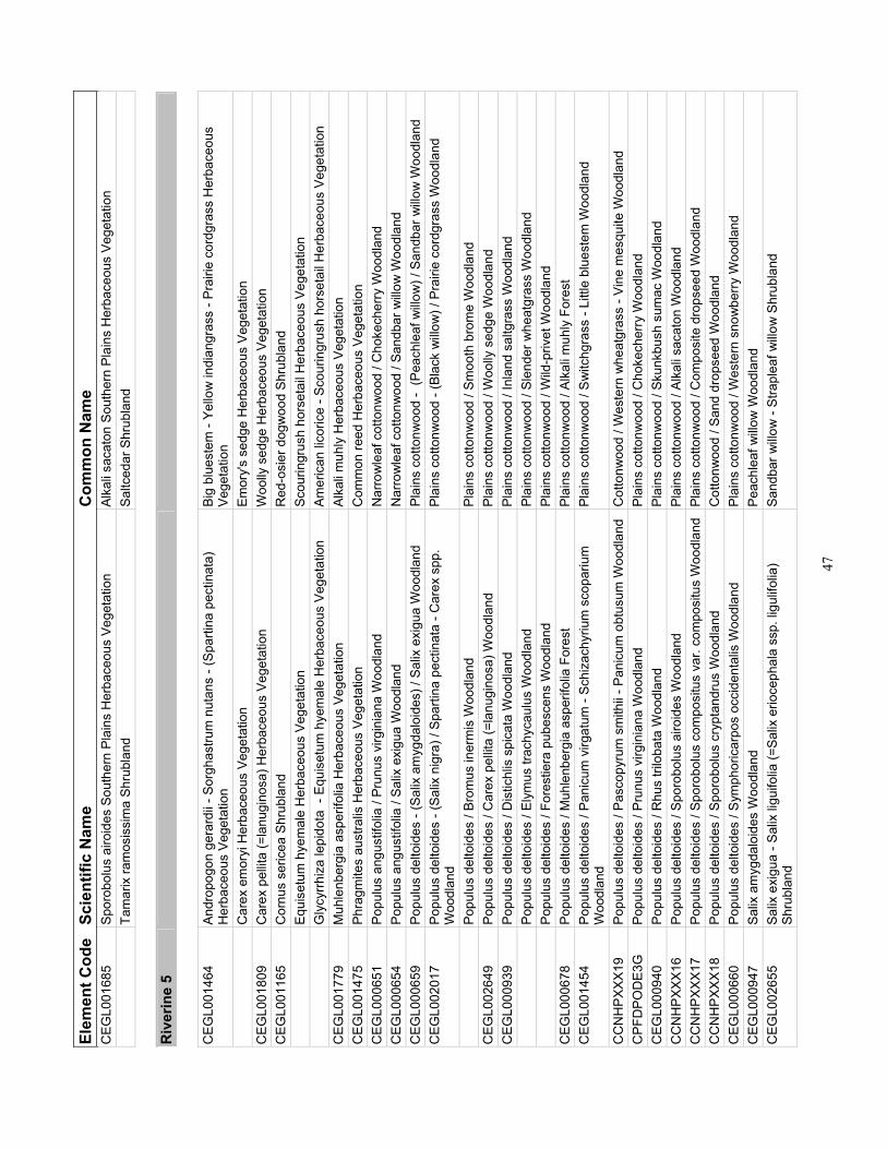
47
Elem
ent C
ode
Scie
ntifi
c N
ame
Com
mon
Nam
e C
EGL0
0168
5 Sp
orob
olus
airo
ides
Sou
ther
n Pl
ains
Her
bace
ous
Vege
tatio
n Al
kali
saca
ton
Sout
hern
Pla
ins
Her
bace
ous
Vege
tatio
n
Tam
arix
ram
osis
sim
a Sh
rubl
and
Saltc
edar
Shr
ubla
nd
R
iver
ine
5
CEG
L001
464
Andr
opog
on g
erar
dii -
Sor
ghas
trum
nut
ans
- (Sp
artin
a pe
ctin
ata)
H
erba
ceou
s Ve
geta
tion
Big
blue
stem
- Ye
llow
indi
angr
ass
- Pra
irie
cord
gras
s H
erba
ceou
s Ve
geta
tion
C
arex
em
oryi
Her
bace
ous
Vege
tatio
n Em
ory's
sed
ge H
erba
ceou
s Ve
geta
tion
CEG
L001
809
Car
ex p
ellit
a (=
lanu
gino
sa) H
erba
ceou
s Ve
geta
tion
Woo
lly s
edge
Her
bace
ous
Vege
tatio
n C
EGL0
0116
5 C
ornu
s se
ricea
Shr
ubla
nd
Red
-osi
er d
ogw
ood
Shru
blan
d
Equi
setu
m h
yem
ale
Her
bace
ous
Vege
tatio
n Sc
ourin
grus
h ho
rset
ail H
erba
ceou
s Ve
geta
tion
G
lycy
rrhiz
a le
pido
ta -
Equ
iset
um h
yem
ale
Her
bace
ous
Vege
tatio
n Am
eric
an li
coric
e - S
cour
ingr
ush
hors
etai
l Her
bace
ous
Vege
tatio
n C
EGL0
0177
9 M
uhle
nber
gia
aspe
rifol
ia H
erba
ceou
s Ve
geta
tion
Alka
li m
uhly
Her
bace
ous
Vege
tatio
n C
EGL0
0147
5 Ph
ragm
ites
aust
ralis
Her
bace
ous
Vege
tatio
n C
omm
on re
ed H
erba
ceou
s Ve
geta
tion
CEG
L000
651
Po
pulu
s an
gust
ifolia
/ Pr
unus
virg
inia
na W
oodl
and
Nar
row
leaf
cot
tonw
ood
/ Cho
kech
erry
Woo
dlan
d C
EGL0
0065
4 Po
pulu
s an
gust
ifolia
/ Sa
lix e
xigu
a W
oodl
and
Nar
row
leaf
cot
tonw
ood
/ San
dbar
willo
w W
oodl
and
CEG
L000
659
Popu
lus
delto
ides
- (S
alix
am
ygda
loid
es) /
Sal
ix e
xigu
a W
oodl
and
Plai
ns c
otto
nwoo
d -
(Pea
chle
af w
illow
) / S
andb
ar w
illow
Woo
dlan
d C
EGL0
0201
7 Po
pulu
s de
ltoid
es -
(Sal
ix n
igra
) / S
parti
na p
ectin
ata
- Car
ex s
pp.
Woo
dlan
d Pl
ains
cot
tonw
ood
- (Bl
ack
willo
w) /
Pra
irie
cord
gras
s W
oodl
and
Po
pulu
s de
ltoid
es /
Brom
us in
erm
is W
oodl
and
Plai
ns c
otto
nwoo
d / S
moo
th b
rom
e W
oodl
and
CEG
L002
649
Popu
lus
delto
ides
/ C
arex
pel
lita
(=la
nugi
nosa
) Woo
dlan
d Pl
ains
cot
tonw
ood
/ Woo
lly s
edge
Woo
dlan
d C
EGL0
0093
9 Po
pulu
s de
ltoid
es /
Dis
tichl
is s
pica
ta W
oodl
and
Plai
ns c
otto
nwoo
d / I
nlan
d sa
ltgra
ss W
oodl
and
Po
pulu
s de
ltoid
es /
Elym
us tr
achy
caul
us W
oodl
and
Plai
ns c
otto
nwoo
d / S
lend
er w
heat
gras
s W
oodl
and
Po
pulu
s de
ltoid
es /
Fore
stie
ra p
ubes
cens
Woo
dlan
d Pl
ains
cot
tonw
ood
/ Wild
-priv
et W
oodl
and
CEG
L000
678
Popu
lus
delto
ides
/ M
uhle
nber
gia
aspe
rifol
ia F
ores
t Pl
ains
cot
tonw
ood
/ Alk
ali m
uhly
For
est
CEG
L001
454
Popu
lus
delto
ides
/ Pa
nicu
m v
irgat
um -
Schi
zach
yriu
m s
copa
rium
W
oodl
and
Plai
ns c
otto
nwoo
d / S
witc
hgra
ss -
Littl
e bl
uest
em W
oodl
and
CC
NH
PXXX
19
Popu
lus
delto
ides
/ Pa
scop
yrum
sm
ithii
- Pan
icum
obt
usum
Woo
dlan
d C
otto
nwoo
d / W
este
rn w
heat
gras
s - V
ine
mes
quite
Woo
dlan
d C
PFD
POD
E3G
Po
pulu
s de
ltoid
es /
Prun
us v
irgin
iana
Woo
dlan
d Pl
ains
cot
tonw
ood
/ Cho
kech
erry
Woo
dlan
d C
EGL0
0094
0 Po
pulu
s de
ltoid
es /
Rhu
s tri
loba
ta W
oodl
and
Plai
ns c
otto
nwoo
d / S
kunk
bush
sum
ac W
oodl
and
CC
NH
PXXX
16
Popu
lus
delto
ides
/ Sp
orob
olus
airo
ides
Woo
dlan
d Pl
ains
cot
tonw
ood
/ Alk
ali s
acat
on W
oodl
and
CC
NH
PXXX
17
Popu
lus
delto
ides
/ Sp
orob
olus
com
posi
tus
var.
com
posi
tus
Woo
dlan
d Pl
ains
cot
tonw
ood
/ Com
posi
te d
rops
eed
Woo
dlan
d C
CN
HPX
XX18
Po
pulu
s de
ltoid
es /
Spor
obol
us c
rypt
andr
us W
oodl
and
Cot
tonw
ood
/ San
d dr
opse
ed W
oodl
and
CEG
L000
660
Popu
lus
delto
ides
/ Sy
mph
oric
arpo
s oc
cide
ntal
is W
oodl
and
Plai
ns c
otto
nwoo
d / W
este
rn s
now
berry
Woo
dlan
d C
EGL0
0094
7 Sa
lix a
myg
dalo
ides
Woo
dlan
d Pe
achl
eaf w
illow
Woo
dlan
d C
EGL0
0265
5 Sa
lix e
xigu
a - S
alix
ligu
ifolia
(=Sa
lix e
rioce
phal
a ss
p. li
gulif
olia
) Sh
rubl
and
Sa
ndba
r willo
w -
Stra
plea
f willo
w S
hrub
land

48
Elem
ent C
ode
Scie
ntifi
c N
ame
Com
mon
Nam
e C
EGL0
0120
0 Sa
lix e
xigu
a / B
arre
n gr
ound
Shr
ubla
nd
Sand
bar w
illow
/ Ba
rren
grou
nd S
hrub
land
C
EGL0
0120
3 Sa
lix e
xigu
a / M
esic
gra
min
oid
Shru
blan
d Sa
ndba
r willo
w /
Mes
ic g
ram
inoi
d Sh
rubl
and
CEG
L001
476
Spar
tina
pect
inat
a W
este
rn H
erba
ceou
s Ve
geta
tion
Prai
rie c
ordg
rass
Wes
tern
Her
bace
ous
Vege
tatio
n C
EGL0
0168
5 Sp
orob
olus
airo
ides
Sou
ther
n Pl
ains
Her
bace
ous
Vege
tatio
n Al
kali
saca
ton
Sout
hern
Pla
ins
Her
bace
ous
Vege
tatio
n C
EGL0
0113
1
Sym
phor
icar
pos
occi
dent
alis
Shr
ubla
nd
Wes
tern
sno
wbe
rry S
hrub
land
Tam
arix
ram
osis
sim
a Sh
rubl
and
Saltc
edar
Shr
ubla
nd
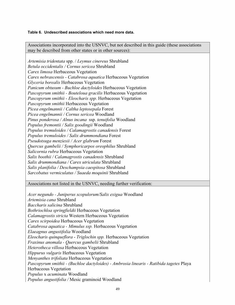
49
Table 6. Undescribed associations which need more data.
Associations incorporated into the USNVC, but not described in this guide (these associations may be described from other states or in other sources): Artemisia tridentata spp. / Leymus cinereus Shrubland Betula occidentalis / Cornus sericea Shrubland Carex limosa Herbaceous Vegetation Carex nebrascensis - Catabrosa aquatica Herbaceous Vegetation Glyceria borealis Herbaceous Vegetation Panicum obtusum - Buchloe dactyloides Herbaceous Vegetation Pascopyrum smithii - Bouteloua gracilis Herbaceous Vegetation Pascopyrum smithii - Eleocharis spp. Herbaceous Vegetation Pascopyrum smithii Herbaceous Vegetation Picea engelmannii / Caltha leptosepala Forest Picea engelmannii / Cornus sericea Woodland Pinus ponderosa / Alnus incana ssp. tenuifolia Woodland Populus fremontii / Salix goodingii Woodland Populus tremuloides / Calamagrostis canadensis Forest Populus tremuloides / Salix drummondiana Forest Pseudotsuga menziesii / Acer glabrum Forest Quercus gambelii / Symphoricarpos oreophilus Shrubland Salicornia rubra Herbaceous Vegetation Salix boothii / Calamagrostis canadensis Shrubland Salix drummondiana / Carex utriculata Shrubland Salix planifolia / Deschampsia caespitosa Shrubland Sarcobatus vermiculatus / Suaeda moquinii Shrubland Associations not listed in the USNVC, needing further verification: Acer negundo - Juniperus scopulorum/Salix exigua Woodland Artemisia cana Shrubland Baccharis salicina Shrubland Bothriochloa springfieldii Herbaceous Vegetation Calamagrostis stricta Western Herbaceous Vegetation Carex scirpoidea Herbaceous Vegetation Catabrosa aquatica - Mimulus ssp. Herbaceous Vegetation Elaeagnus angustifolia Woodland Eleocharis quinqueflora - Triglochin spp. Herbaceous Vegetation Fraxinus anomala - Quercus gambelii Shrubland Heterotheca villosa Herbaceous Vegetation Hippurus vulgaris Herbaceous Vegetation Menyanthes trifoliata Herbaceous Vegetation Pascopyrum smithii - (Buchloe dactyloides) - Ambrosia linearis - Ratibida tagetes Playa Herbaceous Vegetation Populus x acuminata Woodland Populus angustifolia / Mesic graminoid Woodland

50
Salix exigua / Eleocharis palustris Shrubland Salix exigua / Equisetum hyemale Shrubland Salix exigua / Schoenoplectus pungens Shrubland Salix fragilis Woodland Salix geyeriana - Salix monticola / Carex aquatilis Shrubland Salix geyeriana - Salix monticola / Mesic graminoid Shrubland Scirpus pallidus Herbaceous Vegetation Sparganium eurycarpum Herbaceous Vegetation Sporobolus airoides - Panicum obtusum Herbaceous Vegetation Sullivantia hapemanii var. purpusii Hanging Garden
51
LITERATURE CITED
Access 97 Relational Database Ver. SR-2. Microsoft Corporation, Seattle, WA.
Allen, R. B. and R. K. Peet. 1990. Gradient analysis of forests of the Sangre de Cristo Range, Colorado. Canadian Journal of Botany 68: 193-201.
Anderson, M., P. Bourgeron, M. T Bryer, R. Crawford, L. Engelking, D. Faber-Langendoen, K. Gallyoun, K. Goodin, D. H. Grossman, S. Landall, K. Metzler, K. D. Patterson, M. Pyne, M. Reid, L. Sneddon, and A. S. Weakley. 1998. International Classification of Ecological Communities: Terrestrial Vegetation for the United States. Volume II. Arlington, VA: The Nature Conservancy.
Baker, W.L. 1984. A preliminary classification of the natural vegetation of Colorado. Great Basin Naturalist 44(4):647-676.
Benedict, A.D. 1991. A Sierra Club Naturalist’s Guide, The Southern Rockies. Sierra Club Books. San Francisco, CA.
Binkley, D. 1986. Forest Nutrition Management. John Wiley & Sons, Inc., New York, NY.
Bourgeron, P.S. and L.D. Engelking, eds. 1994. A preliminary vegetation classification of the western United States. Western heritage Task Force, The Nature Conservancy, Boulder, CO.
Brinson, M. M. 1993. A Hydrogeomorphic Classification for Wetlands, Technical Report WRP-DE-4. U.S. Army Corps of Engineers Waterways Experimental Station, Vicksburg, MS.
Brinson, M.M., B. Swift, R. Plantico, and J. Barclay. 1981. Riparian ecosystems: their ecology and status. U.S. Fish and Wildlife Service, FWS/OBS-81/17.
Brunsfield, S.J. and F.D. Johnson. 1985. Field Guide to the Willows of East-Central Idaho. Forest, Wildlife and Range Experiment Station Bulletin No. 39. University of Idaho, Moscow, ID.
Chapin,F.S., III, L.R. Walker, C.L. Fastie, and L.C. Sharman. 1994. Mechanisms of primary
succession following deglaciation at Glacier Bay, Alaska. Ecological Monographs 64(2):149-175.
Colorado GAP Project. 1993. Colorado Land Ownership 500K (Polygon). US Department of
the Interior, Fish and Wildlife Service, National Ecology Research Center in cooperation with the Bureau of Land Management, Colorado State Office, Geosciences Team. Fort Collins, CO.
Colorado Geologic Survey, Colorado Department of Natural Resources, Colorado School of
Mines, Division of Environmental Science and Engineering, Colorado State University, Department of Earth Resources. 1998. Characterization and Functional Assessment of

52
Reference Wetlands in Colorado. Report submitted to the Colorado Department of Natural Resources and the U. S. Environmental Protection Agency, Region VIII.
Colorado Natural Heritage Program (CNHP). 1997. Colorado’s Natural Heritage: Rare and Imperiled Animals, Plants, and Natural Communities. Volume 3, No. 1. Colorado Natural Heritage Program, Fort Collins, CO.
Colorado Natural Heritage Program (CNHP). 2002. Biological and Conservation Data (BCD) System. Data from field surveys. Colorado Natural Heritage Program, Colorado State University, Fort Collins, CO.
Colorado State Archives. 2001. Colorful Colorado Geography. http://www.archives.state.co.us/arcgeog.html. Colorado State Archives. Denver, CO.
Cooper, D.J. 1986. Ecological studies of wetland vegetation Cross Creek Valley, Holy Cross Wilderness Area, Sawatch Range, Colorado. Holy Cross Wilderness Defense Fund, Technical Report #2.
Cooper, D.J. 1990. Ecological studies of wetlands in South Park, Colorado: Classification, functional analysis, rare species inventory, and the effects of removing irrigation. Unpublished report prepared for EPA Region VIII and Park County, CO.
Cooper, D.J. 1993. Wetlands of the Crested Butte region: Mapping, functional evaluation and hydrologic regime. Unpublished report for the Town of Crested Butte and EPA Region VIII.
Cooper, D.J. 1995. An analysis of wetland impacts in the Telluride Mountain Village. Unpublished Report to the U.S. Dept. of Justice.
Cooper, D. J. 1998. "Classification of Colorado's Wetlands for Use in HGM Functional Assessment: A First Approximation." in Characterization and Functional Assessment of Reference Wetlands in Colorado. Report submitted to the Colorado Department of Natural Resources and the U. S. Environmental Protection Agency, Region VIII. Colorado Geologic Survey, Colorado Department of Natural Resources, Denver, CO; Colorado School of Mines, Division of Environmental Science and Engineering, Golden, CO; Colorado State University, Department of Earth Resources, Fort Collins, CO.
Cooper, D.J. and T. Cottrell. 1989. An ecological characterization and functional evaluation of wetlands in the Cherry Creek basin: Cherry Creek reservoir upstream to Frantown. Unpublished report for EPA Region VIII and Park County, CO.
Cooper, D.J. and T. Cottrell. 1990. Classification of riparian vegetation in the northern Colorado Front Range. Unpublished report prepared for The Nature Conservancy, Boulder, CO.
Cooper, D.J. and D. Gilbert. 1990. An ecological characterization and functional evaluation of wetlands in the Telluride region of Colorado. Unpublished report for EPA Region VIII.
Cooper, D.J. and C. Severn. 1992. Wetlands of the San Luis Valley, Colorado: An ecological study and analysis of the hydrologic regime, soil chemistry, vegetation and the potential

53
effects of a water table drawdown. Unpublished report for CDOW, USFWS and Rio Grande Water Conservation District.
Cooper, S.V., P. Lesica, and D. Page-Dumroese. 1997. Plant Community classification for Alpine Vegetation on the Geaverhead National Forest, Montana. USDA Forest service General Technical Report INT-362. Intermountain Research Station, Ogden, UT.
Costanza R., R. d'Arge, R. de Groot, S. Farber, M. Grasso, B. Hannon, K. Limburg, S. Naeem, R. V. O'Neill, J. Paruelo, R. G. Raskin, P. Sutton, and M. van den Belt. 1997. The value of the world's ecosystem services and natural capital. Nature 387: 253-60.
Cowardin, L. M., V. Carter, F. C. Golet, and E. T. LaRoe. 1979. Classification of wetlands and deepwater habitats of the United States, U. S. Department of the Interior, Fish and Wildlife Services, Office of Biological Services, Washington D.C.
Cronquist, A., A.H. Holmgren, N.H. Holmgren, J.L. Reveal, and P.K. Holmgren. 1977. Intermountain Flora, Vol.6. Columbia University Press, New York, NY. 584 pp.
Dahl T.E. 2000. Status and Trends of Wetlands in the Conterminous United States 1986-1997.
U.S. Department of the Interior, Fish and Wildlife Service, Washington D.C. 82 pp. Daily, G. C., S. Alexander, P. R. Ehrlich, L. Goulder, J. Lubchenco, P. A. Matson, H. A.
Mooney, S. Postel, S. H. Schneider, D. Tilman, and G. M. Woodwell. 1997. Ecosystem services: benefits supplied to human societies by natural ecosystems. Issues in Ecology 2 Spring.
Daly, C. and G. Taylor. 1998. Colorado Average Monthly or Annual Precipitation (Raster). Water and Climate Center of the Natural Resources Conservation Service. Portland, OR.
Daubenmire, R. 1952. Forest vegetation of northern Idaho and adjacent Washington, and its bearing on concepts of vegetation classification. Ecological Monographs 22:301-330.
Dorn, R. D. 1997. Rocky Mountain Region Willow Identification Field Guide, R2-RR-97-01. Denver, CO: USDA, US Forest Service.
Doyle, G., J. Gionfriddo, D. Anderson, and D. Culver. 2001. Survey of critical wetlands and riparian areas in El Paso and Pueblo Counties, Colorado. Colorado Natural Heritage Program, Colorado State University, Ft. Collins, CO.
Dufrêne, M. and P. Legendre. 1997. Species assemblages and indicator species: The need for a flexible asymmetrical approach. Ecological Monographs 67: 3: 345-66.
Durkin, P., M. Bradley, E. Muldavin, and P. Mehlhop. 1994. A riparian/wetland vegetation community classification of New Mexico: Pecos River Basin, vol. 1. Report submitted to the New Mexico Environment Department, Surface Water Quality Bureau. New Mexico Natural Heritage Program, University of New Mexico, Albuquerque, NM.
Durkin, P., M. Bradley, S.E. Carr, E. Muldavin, and P. Mehlhop. 1995. Riparian/wetland vegetation communities of the Rio Grande: a classification and site evaluation. Report
54
submitted to the New Mexico Environment Department, Surface Water quality Bureau. New Mexico Natural Heritage Program, University of New Mexico, Albuquerque, NM.
Erhard, D. Rio Grande National Forest. Monte Vista, CO. Personal communication. Faber-Langendoen, D., ed. 1996. Midwest regional community classification. Conservation
Science Department, Midwest Region, The Nature Conservancy, Minneapolis, MN. Flahault, C. and C. Schroter. 1910. Rapport sur la nomenclature phytogeographique. Proceedings
of the Third International Botanical Congress, Brussels 1:131-164. Ganskopp, D.C. 1986. Tolerances of sagebrush, rabbitbrush, and greasewood to elevated water
tables. J. Range Manage. 39:334-337. Girard, M., D.L. Wheeler, and S.B. Mills. 1995. Classification of riparian communities on the
Bighorn National Forest. USDA Forest Service draft manuscript. Rocky Mountain Region, Lakewood, CO.
Grossman, D. H., D. Faber-Langendoen, A. S. Weakley, M. Anderson, P. Bourgeron, R. Crawford, K. Goodin, S. Landaal, K. Metzler, K. Patterson, M. Pyne, M. Reid, and L. Sneddon. 1998. International Classification of Ecological Communities: Terrestrial Vegetation of the United States. The National Vegetation Classification System: Development, Status, and Applications. Volume I. Arlington, VA: The Nature Conservancy.
Hansen, P.L., S.W. Chadde, and R.D. Pfister. 1988. Riparian Dominance Types of Montana. Montana forest and Conservation Experimental Station Miscellaneous Publication No. 49. University of Montana, Missoula, MT.
Hansen, P., R. Pfister, K. Boggs, J. Pierce, and S. Chadde. 1989. Classification and management of riparian sites in central and eastern Montana. Draft version 1. Montana Riparian Association, University of Montana, Missoula, MT.
Hansen, P.L., R.D. Pfister, K. Boggs, B.J. Cook, J. Joy, and D.L. Hinckley. 1995. Classification and Management of Montana’s Riparian and Wetland Sites. Montana Forest and Conservation Experiment Station Miscellaneous Publication No. 54. The University of Montana, Missoula, MT.
Haukos, D.A. and L.M. Smith. 1997. Common Flora of the Playa Lakes. Lubbock, TX:University of Texas Tech University Press. 196pp.
Hermann, F.J. 1970. Manual of the Carices of the Rocky Mountains and Colorado Basin. USDA Forest Service Agricultural Handbook No. 374. 398pp.
Hoagland, B.W. and Collins, S. W. 1997. Heterogeneity in shortgrass prairie vegetation: the role of playa lakes. Journal of Vegetation Science 8:277-286.
Hupalo, R., D.Culver, and G. Doyle. 2000. Comprehensive Statewide Wetlands Classification and Characterization. Colorado Natural Heritage Program, Colorado State University, Ft.
55
Collins, CO.
Johnston, B.C. 1987. Plant Associations of Region Two. 4th ed. USDA Forest Service R2-ECOL-87-02. Rocky Mountain Region, Lakewood, CO.
Jones, G. and G.M. Walford. 1995. Major riparian vegetation types of eastern Wyoming. Report submitted to the Wyoming Department of Environmental Quality, Water Quality Division. Wyoming Natural Diversity Database (The Nature Conservancy), Laramie, WY.
Jones, K. and D. Cooper. 1993. Wetlands of Colorado. Report prepared for the Colorado Division of Wildlife and the U.S. Environmental Protection Agency.
Kartesz, J. T. and R. Kartesz. 1980. A Synonymized Checklist of the Vascular Flora of the United States, Canada and Greenland. Chapel Hill, NC: University of North Carolina Press.
Kent, M. and P. Coker. 1992. Vegetation Description and Analysis: A Practical Approach. 1st ed. Boca Raton, FL: CRC Press, Inc.
Kettler, S. The Nature Conservancy, Boulder, CO. Personal communication.
Kettler, S. and A. McMullen. 1996. Routt National Forest riparian vegetation classification. Report submitted to Routt National Forest. Colorado Natural Heritage Program, Colorado State University, Ft. Collins, CO.
Kimmins, J. P. 1997. Forest Ecology: A Foundation for Sustainable Management. Second ed. Upper Saddle River, NJ: Prentice Hall.
Kittel, G.M. and N.D. Lederer. 1993. A Preliminary Classification of the Riparian Vegetation of the Yampa and San Miguel/Dolores River Basins. Report submitted to the Colorado Department of Health and the Environmental Protection Agency, Region VIII. The Nature Conservancy, Boulder, CO.
Kittel, G., R. Rondeau, N. Lederer, and D. Randolph. 1994. A classification of the riparian vegetation of the White and Colorado River Basins, Colorado. Report submitted to the Colorado Department of Natural Resources and the Environmental Protection Agency, Region VIII. Colorado Natural Heritage Program, Colorado State University, Ft. Collins, CO.
Kittel, G., R. Rondeau, and S. Kettler. 1995. A Classification of the Riparian Vegetation of the Gunnison River Basin, Colorado. Report submitted to the Colorado Department of Natural Resources and the Environmental Protection Agency, Region VIII. Colorado Natural Heritage Program, Colorado State University, Ft. Collins, CO.
Kittel, G., R.J. Rondeau, and A. McMullen. 1996. A Classification of the Riparian Vegetation of the lower South Platte and parts of the upper Arkansas River Basins, Colorado. Report submitted to the Colorado Department of Natural Resources and the Environmental Protection Agency, Region VIII. Colorado Natural Heritage Program, Colorado State University, Ft. Collins, CO

56
Kittel, G., VanWie, and M. Damm. 1997. A Classification of the riparian vegetation of the South Platte River Basin (and part of the Republican River Basin), Colorado. Report submitted to the Colorado Department of Natural Resources and the Environmental Protection Agency, Region VIII. Colorado Natural Heritage Program, Colorado State University, Ft. Collins, CO
Kittel, G. M., E. VanWie, M. Damm, R. Rondeau, S. Kettler, A. McMullen, and J. Sanderson. 1999a. A Classification of Riparian Wetland Plant Associations of Colorado: User Guide to the Classification Project. Colorado Natural Heritage Program, Colorado State University, Ft. Collins, CO.
Kittel, G. E., VanWie, M. Damm, R. Rondeau, S. Kettler, and J. Sanderson. 1999b. A classification of riparian plant associations of the Rio Grande and Closed Basin Watersheds, Colorado. A Classification of Riparian Plant Associations of the Rio Grade and Closed Basin Watersheds, Colorado . Colorado Natural Heritage Program, Colorado State University, Ft. Collins, CO.
Knight, D.H. 1994. Mountains and Plains: The Ecology of Wyoming Landscapes. Yale University Press: New Haven and London. 338pp.
Knopf, F.L. 1996. Prairie Legacies-Birds. Pages 135-148 in Prairie Conservation: Preserving North America’s Most Endangered Ecosystem (F.B. Samson and F.L. Knopf, Eds.). Island Press. Washington, D.C.
Kovalchik, B.L. 1987. Riparian Zone Associations, Deschutes, Ochoco, Fremont, and Winema National Forests. USDA Forest Service R6-ECOL-TP-279-87. Pacific Northwest Region, Bend, OR.
Kovalchik, B.L. and W. Elmore. 1992. Effects of cattle grazing systems on willow-dominated plant associations in central Oregon. In W.P. Clary, E.D. McArthur, D. Bedunah, and C.L. Wambolt, compilers. Proceedings-Symposium on Ecology and Management of Riparian Shrub Communities. USDA Forest Service General Technical Report INT-289. Intermountain Research Station, Ogden, UT.
Ludwig, J.A. and J.F. Reynolds. 1988. Statistical Ecology. New York: John Wiley and Sons.
Manitoba Agriculture - Weeds in Crop Production: abstract & images. UC Davis, IPM: abstract & images. Weed Science Society of America: website.
Manning, M.E. and W.G. Padgett. 1995. Riparian Community Type Classification for Humbolt
and Tiyabe National Forest, Nevada and Eastern California. USDA Forest Service R4-ECOL-95-01. Intermountain Region, Ogden, UT.
Max, T. A., J. Schreuder, J. W. Hazard, D. D. Oswald, J. Teply, and J. Alegria. 1996. The Pacific Northwest Region Vegetation and Inventory Monitoring System, U.S. Forest Service Research Paper PNW-RP-493. Pacific Northwest Research Station, Portland, OR.
Maybury, K. P. editor. 1999. Seeing the Forest and the Trees: Ecological classification for Conservation. Arlington, VA: The Nature Conservancy.

57
McCune, B., and M. J. Mefford. 1999. PC-ORD. Multivariate Analysis of Ecological Data, ver. 4. MjM Software Design. Gleneden Beach, OR.
Mueller-Dumbois, D. and H. Ellenberg. 1974. Aims and Methods of Vegetation Ecology. New York, NY: John Wiley & Sons.
Muldavin, E. New Mexico Natural Heritage Program. Albuquerque, New Mexico. Personal communication.
Mutel, C.F. and J.C. Emerick. 1984. From Grassland to Glacier : the Natural History of Colorado. Johnson Books, Boulder, CO.
National Research Council. 1995. Wetlands: Characteristics and Boundaries. Washington, DC: National Academy Press.
NatureServe Explorer: An online encyclopedia of life [web application]. 2002. Version 1.6 . Arlington, Virginia, USA: NatureServe. Available: http://www.natureserve.org/explorer. (Accessed: February 5, 2003).
Noss, R. F. 1990. Indicators for monitoring biodiversity: A hierarchical approach. Conservation
Biology 4: 355-64.
Padgett, W.G., A.P. Youngblood, and A.H. Winward. 1989. Riparian Community Type Classification of Utah and Southeastern Idaho. USDA Forest Service R4-ECOL-89-01. Intermountain Region, Ogden, UT.
Palmer, M.W. 1993. Putting Things in Even Better Order: The Advantages of Canonical Correspondence Analysis. Ecology 74:2215-2230.
Peet, R. K. 1980. Ordination as a tool for analyzing complex datasets. Vegetatio 42: 171-74.
Phillips, C.M. 1977. Willow carrs of the upper Laramie River Valley, Colorado. Thesis. Colorado State University, Ft. Collins, CO.
Porterfield, H. G. 1945. Survival of buffalo grass following submersion in playas. Ecology 26:98-100.
Richard, C., G. Kittel, and S. Kettler. 1996. A Classification of the Riparian Vegetation of the
San Juan National Forest. Draft 1 to be submitted to the San Juan National Forest. Colorado Natural Heritage Program, Colorado State University, Ft. Collins, CO.
Robson, S.G., and E.R. Banta. 1995. Groundwater Atlas of the United States, Segment 2 – Arizona, Colorado, New Mexico, and Utah. U.S. Geological Survey Hydrologic Investigations Atlas 730-C, 32p. Available online at http://capp.water.usgs.gov/gwa/ch-c/index.html.
Romo, J.T. and M.R. Hafferkamp. 1989. Water relations of Artemisia tridentata ssp. wyomingensis and Sarcobatus vermiculatus in the steppe of southeastern Oregon. Amer. Midl. Natur. 121:155-164.
58
Rondeau, R.J., M.B. Wunder, A. Meredith, C.A. Pague, and S. Spackman. 1997. Biological
survey of Naval Oil Shale Reserve No. 1 (NOSR-1). Report submitted to the Department of Energy. Colorado Natural Heritage Program, Colorado State University, Ft. Collins, CO.
Rosgen, D.L. 1996. Applied River Morphology. Wildland Hydrology, Pagosa Springs, CO.
Sanderson, J. and M. March. 1996. Extreme Rich Fens of South Park, Colorado: their distribution, identification, and natural heritage significance. Report submitted to Park County, the Colorado Department of Natural Resources, and the U.S. Environmental Protection Agency. Colorado Natural Heritage Program, Colorado State University, Ft. Collins, CO.
Sanderson, J. and S. Kettler. 1996. A preliminary wetland vegetation classification for a portion of Colorado's west slope, The Colorado Natural Heritage Program, Colorado State University, Fort Collins, CO.
Stubbendieck, J., S.L. Hatch and K.J. Kjar. 1982. North American Range Plants. 2nd ed. University of Nebraska Press, Lincoln, NE.
Stubbendieck, J., G.Y. Friisoe, & M.R. Bolick. 1994. Weeds of Nebraska and the Great Plains. Nebraska Department of Agriculture, Bureau of Plant Industry. Lincoln, Nebraska. 589pp. ter Braak, C. J. F. 1986. Canonical Correspondence Analysis: a new eigenvector technique for
multivariate direct gradient analysis. Ecology 67: 1167-79. The Nature Conservancy. 1996. Conservation by Design: A Framework for Mission Success.
Arlington, VA: The Nature Conservancy.
The Nature Conservancy. 1999. An Alliance Level Classification of Vegetation of the Coterminous Western United States. Submitted to the University of Idaho, Cooperative Fish and Wildlife Research Unit.
Tweto, O. 1979. Geologic Map of Colorado. U.S. Geological Survey, Denver, CO.
Unger, I.A. 1974. Halophyte communities of Park County, Colorado. Bulletin of the Torrey Botanical Club 101(3)145-152.
US Army Corps of Engineers. 1987. Wetlands Definition Manual. Technical Report Y-87-1. Environmental Laboratory, Vicksburg, MS.
USDA.- NRCS. "The PLANTS database." Web page. Available at National Plant Data Center, Baton Rouge, LA. http://plants.usda.gov/plants/index.html.
USDA Soil Conservation Service. 1984. Rountree big bluestem and Rumsey indiangrass. Program Aid Number 1350. USDA Soil Conservation Service, Washington, DC.
59
USGS. 2001. The USGS-NPS Vegetation Mapping Program. http://biology.usgs.gov/npsveg/index.html
Van Cleve, K., L.A. Viereck, and R.L. Schlentner. 1971.Accumulation of nitrogen in alder (Alnus) ecosystems near Fairbanks, Alaska. Arctic and Alpine Research 3(2):101-114.
Van der Maarel, E., I. Espejel, and P. Moreno-Casasola. 1987. Two-step vegetation analysis based on very large datasets. Vegetatio 68: 139-43.
Viereck. L.A. 1970. Forest succession and soil development adjacent to the Chena River in interior Alaska. Arctic and Alpine Research 2(1):1-26.
Von Loh, J. Engineering-Environment Management. Littleton, CO. Personal communication.
Weaver, J.E. 1965. Native Vegetation of Nebraska. Lincoln, NE:University of Nebraska Press,.
Weber, W. A. and R. C. Wittmann. 1996a. Colorado Flora: Western Slope. 2nd ed. Niwot, CO: University Press of Colorado.
Weber, W. A., and R. C. Wittmann. 1996b. Colorado Flora: Eastern Slope. 2nd ed. Niwot, CO: University Press of Colorado.
Weber, W.A, and R.C. Wittmann. 2001a. Colorado Flora: Western Slope. 3rd ed. Niwot, CO: University Press of Colorado.
Weber, W.A, and R.C. Wittmann. 2001b. Colorado Flora: Eastern Slope. 3rd ed. Niwot, CO: University Press of Colorado.
Welsh S. L. 1989. On the distribution of Utah's hanging gardens. The Great Basin Naturalist 49(1): 1-30.
Whitson, T.D. (Ed.) et al. 1996. Weeds of the West. Western Society of Weed Science in cooperation with Cooperative Extension Services, University of Wyoming. Laramie, Wyoming. 630pp. Wilson, E.O. 1988. Biodiversity. National Academy Press, Washington, D.C.
Windell, J.T., B.E. Willard, D.J. Cooper, SQ. Foster, C.F. Knud-Hansen, L.P. Rink, and G.N.Kiladis. 1986. An ecological characterization of Rocky Mountain montane and subalpine wetlands. U.S. Fish and Wildlife Serv. Biol. Rep. 86(11). 298 pp.
Youngblood, A.P., W.G. Padgett, and A.H. Winward. 1985. Riparian Community Type Classification of Eastern Idaho-Western Wyoming. USDA Forest Service R4-ECOL-85-01. Intermountain Region, Ogden, UT.
Zimmerman, G. M., H. Goetz, and P. W. Mielke Jr. 1985. Use of an improved statistical method for group comparisons to study effects of prairie fire. Ecology 66: 2: 606-11.

60
APPENDIX A – DATA SOURCES Two of the data sources below are compilations from the results of other studies. Therefore, the table lists both data sources, the original sources indented below the compiled source. Not all data of Cooper (Colorado Geologic Survey et al. 1998) was used in current analysis. For example, sampling units that did not have spatial coordinates and sampling units from Kittel's studies. Source Location Cooper 1998 (n= 2376) Cooper 1986 Cross Creek Valley Cooper 1987 E-470 Beltway - E of Denver Cooper 1988 Boulder Valley and Bonny Reservoir Cooper 1990 South Park Cooper 1993 Crested Butte area Cooper 1995 Telluride Mt. Village Cooper 1995 Yampa River canyon, Green River - Lodore Canyon and
Whirlpool Split Cooper 1996 High Creek Fen, South Park Cooper and Cottrell 1988 Rollinsville area Cooper and Cottrell 1989 Cherry Creek - SE Denver Cooper and Cottrell 1990 Northern CO Front Range Cooper and Gilbert 1990 Telluride region Cooper and Merritt 1996 Park Range, North Park Cooper and Severn 1992 San Luis Valley Komarkova 1979 Front Range alpine McKee et al. 1995 Animas and La Plata rivers Merritt 1996 Larimer County plains Merritt 1997 Green River, Allen Bottom, Yampa River, Deer Lodge Park Kittel et al. 1999a (n= 1925) Kettler and McMullen 1996 Routt National Forest Kittel and Lederer 1993 San Miguel, Dolores, and Yampa river basins Kittel et al. 1994 Colorado River basin and White River basin Kittel et al. 1995 Gunnison River basin Kittel et al. 1996 Arkansas River basin Kittel et al. 1997 South Platte River basin Kittel et al. 1999a Lower San Juan River and North Platte River basins Kittel et al. 1999b Rio Grande and Closed basins, Rio Grande National Forest Richard et al. 1996 San Juan National Forest Sanderson and Kettler 1996 (n= 1/20) Central Colorado West Slope Hupalo 1999 unpublisheda (n= 90) East slope alpine and plains a: Unpublished data collected in 1999 for this project, methods are documented below the data source listing.
61
Data Sources: Cooper, D.J. 1986. Ecological studies of wetland vegetation Cross Creek Valley, Holy Cross
Wilderness Area, Sawatch Range, Colorado. Holy Cross Wilderness Defense Fund, Technical Report #2.
Cooper, D.J. 1987. Wetlands, vegetation and soils along the proposed E-470 Beltway. Unpublished report for the E-470 Partnership.
Cooper, D.J. 1988. Advanced identification of wetlands in the City of Boulder Comprehensive Planning Area. City of Boulder and EPA Region VIII.
Cooper, D.J. 1990. Ecological studies of wetlands in South Park, Colorado: Classification, functional analysis, rare species inventory, and the effects of removing irrigation. Unpublished report prepared for EPA Region VIII and Park County, Colorado.
Cooper, D.J. 1993. Wetlands of the Crested Butte region: Mapping, functional evaluation and hydrologic regime. Unpublished report for the Town of Crested Butte and EPA Region VIII.
Cooper, D.J. 1995. An analysis of wetland impacts in the Telluride Mountain Village. Unpublished Report to the U.S. Dept. of Justice.
Cooper, D.J. 1996. Water and soil chemistry, floristics and phytosociology of the extreme rich High Creek fen, in South Park, Colorado, U.S.A. Canadian Journal of Botany 74:1801-1811.
Cooper, D. J. 1998. "Classification of Colorado's Wetlands for Use in HGM Functional Assessment: A First Approximation." Characterization and Functional Assessment of Reference Wetlands in Colorado, CO Department of Natural Resources, Colorado Geological Survey - Division of Minerals and Geology, Denver, CO 80203.
Cooper, D.J. and T. Cottrell. 1988. Wetland finding and description of wetlands State Highway 119 - Blackhawk to the Boulder County Line. Unpublished report Colorado Dept. of Transportation by Daniel, Mann, Johnson and Mendenhall, Inc.
Cooper, D.J. and T. Cottrell. 1989. An ecological characterization and functional evaluation of wetlands in the Cherry Creek basin: Cherry Creek reservoir upstream to Frantown. Unpublished report for EPA Region VIII and Park County, Colorado.
Cooper, D.J. and T. Cottrell. 1990. Classification of riparian vegetation in the northern Colorado Front Range. Unpublished report prepared for The Nature Conservancy, Boulder, Colorado.
Cooper, D.J. and D. Gilbert. 1990. An ecological characterization and functional evaluation of wetlands in the Telluride region of Colorado. Unpublished report for EPA Region VIII.
Cooper, D.J. and C. Severn. 1992. Wetlands of the San Luis Valley, Colorado: An ecological study and analysis of the hydrologic regime, soil chemistry, vegetation and the potential effects of a water table drawdown. Unpublished report for CDOW, USFWS and Rio Grande Water Conservation District.
62
Kettler, S. and A. McMullen. 1996. Routt National Forest riparian vegetation classification. Report submitted to Routt National Forest. Colorado Natural Heritage Program, Colorado State University, Ft. Collins, CO.
Kittel, G.M. and N.D. Lederer. 1993. A preliminary classification of the riparian vegetation of the Yampa and San Miguel/Dolores River Basins. Report submitted to the Colorado Department of Health and the Environmental Protection Agency, Region VIII. The Nature Conservancy’s Colorado Program, Boulder, CO.
Kittel, G., R. Rondeau, N. Lederer, and D. Randolph. 1994. A classification of the riparian vegetation of the White and Colorado River Basins, Colorado. Report submitted to the Colorado Department of Natural Resources and the Environmental Protection Agency, Region VIII. Colorado Natural Heritage Program, Colorado State University, Ft. Collins, CO.
Kittel, G., R. Rondeau, and S. Kettler. 1995. A classification of the riparian vegetation of the Gunnison River Basin, Colorado. Report submitted to the Colorado Department of Natural Resources and the Environmental Protection Agency, Region VIII. Colorado Natural Heritage Program, Colorado State University, Ft. Collins, CO.
Kittel, G., R.J. Rondeau, and A. McMullen. 1996. A classification of the riparian vegetation of the lower South Platte and parts of the upper Arkansas River Basins, Colorado. Report submitted to the Colorado Department of Natural Resources and the Environmental Protection Agency, Region VIII. Colorado Natural Heritage Program, Colorado State University, Ft. Collins, CO.
Kittel, G., E. VanWie, and M. Damm. 1997. A classification of the riparian vegetation of the South Platte River Basin (and part of the Republican River Basin), Colorado. Report submitted to the Colorado Department of Natural Resources and the Environmental Protection Agency, Region VIII. Colorado Natural Heritage Program, Colorado State University, Ft. Collins, CO.
Kittel, G. M., E. VanWie, M. Dam, R. Rondeau, S. Kettler, A. McMullen, and J. Sanderson. 1999a. A Classification of Riparian Wetland Plant Associations of Colorado: User Guide to the Classification Project, Colorado Natural Heritage Program, Colorado State University, Ft. Collins, CO.
Kittel, Gwen M., Erika VanWie, Mary Damm, Renée Rondeau, Steve Kettler, and John Sanderson. 1999b. A Classification of Riparian Plant Associations of the Rio Grande and Closed Basin Watersheds, Colorado. Prepared for: The Colorado Department of Natural Resources and the Environmental Protection Agency, Region VIII Denver, Colorado. The Colorado Natural Heritage Program, Colorado State University, Ft. Collins, CO.
Komarkova, V. 1979. Alpine vegetation of the Indian Peaks Area. J. Cramer, Vaduz, Germany.
McKee, J.P., D.E. Salas, and K. Willie. 1995. Animas - LaPlata Project wetland / riparian vegetation communities: Classification and inventory. Technical Service Center. U.S. Bureau of Reclamation. Denver, CO.

63
Merrit, D. M. 1997. Riparian vegetation and geomorphic features on regulated and unregulated rivers: Green and Yampa, NW Colorado. Unpublished thesis, Colorado State University. Fort Collins, CO.
Richard, C., G. Kittel, and S. Kettler. 1996. A classification of the riparian vegetation of the San Juan National Forest. Draft 1 to be submitted to the San Juan National Forest. Colorado Natural Heritage Program, Colorado State University, Ft. Collins, CO.
Sanderson, John and Steve Kettler 1996. A Preliminary Wetland Vegetation Classification for a portion of Colorado's West Slope, CNHP Research Report No. 13. Colorado Natural Heritage Program, Colorado State University, Ft. Collins, Colorado 80523.
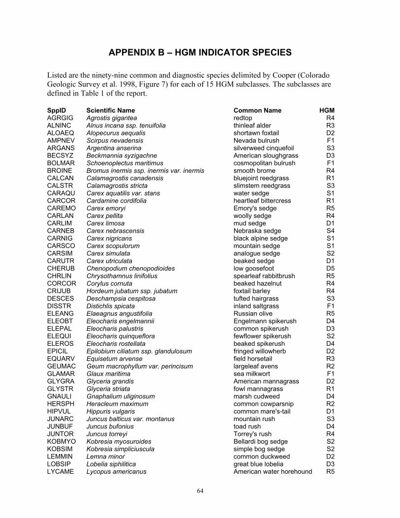
64
APPENDIX B – HGM INDICATOR SPECIES Listed are the ninety-nine common and diagnostic species delimited by Cooper (Colorado Geologic Survey et al. 1998, Figure 7) for each of 15 HGM subclasses. The subclasses are defined in Table 1 of the report. SppID Scientific Name Common Name HGMAGRGIG Agrostis gigantea redtop R4ALNINC Alnus incana ssp. tenuifolia thinleaf alder R3ALOAEQ Alopecurus aequalis shortawn foxtail D2AMPNEV Scirpus nevadensis Nevada bulrush F1ARGANS Argentina anserina silverweed cinquefoil S3BECSYZ Beckmannia syzigachne American sloughgrass D3BOLMAR Schoenoplectus maritimus cosmopolitan bulrush F1BROINE Bromus inermis ssp. inermis var. inermis smooth brome R4CALCAN Calamagrostis canadensis bluejoint reedgrass R1CALSTR Calamagrostis stricta slimstem reedgrass S3CARAQU Carex aquatilis var. stans water sedge S1CARCOR Cardamine cordifolia heartleaf bittercress R1CAREMO Carex emoryi Emory's sedge R5CARLAN Carex pellita woolly sedge R4CARLIM Carex limosa mud sedge D1CARNEB Carex nebrascensis Nebraska sedge S4CARNIG Carex nigricans black alpine sedge S1CARSCO Carex scopulorum mountain sedge S1CARSIM Carex simulata analogue sedge S2CARUTR Carex utriculata beaked sedge D1CHERUB Chenopodium chenopodioides low goosefoot D5CHRLIN Chrysothamnus linifolius spearleaf rabbitbrush R5CORCOR Corylus cornuta beaked hazelnut R4CRIJUB Hordeum jubatum ssp. jubatum foxtail barley R4DESCES Deschampsia cespitosa tufted hairgrass S3DISSTR Distichlis spicata inland saltgrass F1ELEANG Elaeagnus angustifolia Russian olive R5ELEOBT Eleocharis engelmannii Engelmann spikerush D4ELEPAL Eleocharis palustris common spikerush D3ELEQUI Eleocharis quinqueflora fewflower spikerush S2ELEROS Eleocharis rostellata beaked spikerush D4EPICIL Epilobium ciliatum ssp. glandulosum fringed willowherb D2EQUARV Equisetum arvense field horsetail R3GEUMAC Geum macrophyllum var. perincisum largeleaf avens R2GLAMAR Glaux maritima sea milkwort F1GLYGRA Glyceria grandis American mannagrass D2GLYSTR Glyceria striata fowl mannagrass R1GNAULI Gnaphalium uliginosum marsh cudweed D4HERSPH Heracleum maximum common cowparsnip R2HIPVUL Hippuris vulgaris common mare's-tail D1JUNARC Juncus balticus var. montanus mountain rush S3JUNBUF Juncus bufonius toad rush D4JUNTOR Juncus torreyi Torrey's rush R4KOBMYO Kobresia myosuroides Bellardi bog sedge S2KOBSIM Kobresia simpliciuscula simple bog sedge S2LEMMIN Lemna minor common duckweed D2LOBSIP Lobelia siphilitica great blue lobelia D3LYCAME Lycopus americanus American water horehound R5

65
SppID Scientific Name Common Name HGMMENTRI Menyanthes trifoliata buckbean D1MERCIL Mertensia ciliata tall fringed bluebells R1MIMGUT Mimulus guttatus seep monkeyflower R1NEGACE Acer negundo var. interius boxelder R4OXYFEN Oxypolis fendleri Fendler's cowbane R1PEDCRE Pedicularis crenulata meadow lousewort S3PEDGRO Pedicularis groenlandica elephanthead lousewort S1PENFLO Dasiphora floribunda shrubby cinquefoil S3PERLAP Polygonum lapathifolium curlytop knotweed D4PHAARU Phalaris arundinacea reed canarygrass D3PHRAUS Phragmites australis common reed R5PICPUN Picea pungens blue spruce R3POAPRA Poa pratensis Kentucky bluegrass R3POPANG Populus angustifolia narrowleaf cottonwood R3POPDEL Populus deltoides eastern cottonwood R5PSYLEP Caltha leptosepala ssp. leptosepala white marsh marigold S1PUCAIR Puccinellia nuttalliana Nuttall's alkaligrass F1RANREP Ranunculus flammula var. filiformis greater creeping spearwort F1RHUARO Rhus trilobata var. trilobata skunkbush sumac R5ROSWOO Rosa woodsii Woods' rose R3RUDAMP Rudbeckia laciniata var. ampla cutleaf coneflower R3SAGLAT Sagittaria latifolia broadleaf arrowhead D2SALAMY Salix amygdaloides peachleaf willow R5SALBOO Salix boothii Booth willow R2SALCAN Salix candida sageleaf willow S2SALEXI Salix exigua narrowleaf willow R5SALFRA Salix fragilis crack willow R5SALGEY Salix geyeriana Geyer willow R2SALIRR Salix irrorata dewystem willow R4SALLIG Salix ligulifolia strapleaf willow R3SALMON Salix monticola Rocky Mountain willow R2SALPLA Salix planifolia planeleaf willow S1SARVER Sarcobatus vermiculatus greasewood F1SCHLAC Schoenoplectus acutus var. acutus /
tabernaemontani hardstem bulrush / softstem bulrush
D2
SCIPAL Scirpus pallidus cloaked bulrush D2SENTRI Senecio triangularis arrowleaf ragwort S1SPAEUR Sparganium eurycarpum broadfruit bur-reed D2SPAGRA Spartina gracilis alkali cordgrass R5SPAPEC Spartina pectinata prairie cordgrass R5SPEMED Spergularia maritima media sandspurry F1SPOAIR Sporobolus airoides alkali sacaton F1SUACAL Suaeda calceoliformis Pursh seepweed F1SWISER Cornus sericea ssp. sericea red-osier dogwood R3TAMRAM Tamarix ramosissima saltcedar R5THAALP Thalictrum alpinum alpine meadow-rue S2TRIMAR Triglochin maritimum seaside arrowgrass S2TRIPAL Triglochin palustre marsh arrowgrass S2TYPANG Typha angustifolia narrowleaf cattail D2TYPLAT Typha latifolia broadleaf cattail D2VITRIP Vitis riparia riverbank grape R5XANSTR Xanthium strumarium rough cockleburr D5
66
APPENDIX C: The Natural Heritage Network Ranking System
Just as ancient artifacts and historic buildings represent our cultural heritage, a diversity of plant and animal species and their habitats represent our “natural heritage.” Colorado’s natural heritage encompasses a wide variety of ecosystems from tallgrass prairie and shortgrass high plains to alpine cirques and rugged peaks, from canyon lands and sagebrush deserts to dense subalpine spruce-fir forests and wide-open tundra. These widely diversified habitats are determined by water availability, temperature extremes, altitude, geologic history, and land use history. The species that inhabit each of these ecosystems have adapted to the specific set of conditions found there. But, because human influence today touches every part of the Colorado environment, we are responsible for understanding our impacts and carefully planning our actions to ensure our natural heritage persists for future generations. Some generalist species, like house finches, have flourished over the last century, having adapted to habitats altered by humans. However, many other species are specialized to survive in vulnerable Colorado habitats; among them are Pikes Peak spring parsley (a wildflower), the Arkansas darter (a fish), and the Pawnee montane skipper (a butterfly). These species have special requirements for survival that may be threatened by incompatible land management practices and competition from non-native species. Many of these species have become imperiled not only in Colorado, but also throughout their range of distribution, some existing in fewer than five populations in the entire world. The decline of these specialized species often indicates disruptions that could permanently alter entire ecosystems. Thus, recognition of rare and imperiled species is crucial to preserving Colorado’s diverse natural heritage. Colorado is inhabited by some 800 vertebrate species and subspecies, and tens of thousands of invertebrate species. In addition, the state has approximately 4,300 species of plants and more than 450 recognized plant communities that represent terrestrial and wetland ecosystems. It is this rich natural heritage that has provided the basis for Colorado’s diverse economy. Some components of this heritage have always been rare, while others have become imperiled with human-induced changes in the landscape. This decline in biological diversity is a global trend resulting from human population growth, land development, and subsequent habitat loss. Globally, the loss in species diversity has become so rapid and severe that Wilson (1988) has compared the phenomenon to the great natural catastrophes at the end of the Paleozoic and Mesozoic eras. The need to address this loss in biological diversity has been recognized for decades in the scientific community. However, many conservation efforts made in this country were not based upon preserving biological diversity; instead, they primarily focused on preserving game animals, striking scenery, and locally favorite open spaces. To address the absence of a methodical, scientifically based approach to preserving biological diversity, Dr. Robert Jenkins of The Nature Conservancy pioneered the Natural Heritage Methodology in the early '70s. Recognizing that rare and imperiled species are more likely to become extinct than common ones, the Natural Heritage Methodology ranks species according to their rarity or degree of imperilment. The ranking system is scientifically based upon the number of known locations of the species as well as its biology and known threats. By ranking the relative rareness or
67
imperilment of a species, the quality of its populations, and the importance of associated conservation sites, the methodology can facilitate the prioritization of conservation efforts so the most rare and imperiled species may be preserved first. As the scientific community began to realize that plant communities are as important as individual species, this methodology has also been applied to ranking and preserving rare plant communities, and the best examples of common communities. The Natural Heritage Methodology is used by Natural Heritage Programs throughout North, Central, and South America, forming an international database network. The 85 Natural Heritage Network data centers are located in each of the 50 U.S. states, five provinces of Canada, and 13 countries in South and Central America and the Caribbean. This network enables scientists to monitor the status of species from a state, national, and global perspective. Information collected by the Natural Heritage Programs can provide a means to protect species before the need for legal endangerment status arises. It can also enable conservationists and natural resource managers to make informed, objective decisions in prioritizing and focusing conservation efforts. What is Biological Diversity? Protecting biological diversity has become an important management issue for many natural resource professionals. Biological diversity at its most basic level includes the full range of species on Earth, from single-celled species such as bacteria and protists through the multicellular kingdoms of plants and animals. At finer levels of organization, biological diversity includes the genetic variation within species, both among geographically separated populations and among individuals within a single population. On a wider scale, diversity includes variations in the biological communities in which species live, the ecosystems in which communities exist, and the interactions between these levels. All levels are necessary for the continued survival of species and plant communities, and all are important for the well being of humans. It stands to reason that biological diversity should be of concern to all people. The biological diversity of an area can be described at four levels:
1. Genetic Diversity — the genetic variation within a population and among populations of a plant or animal species. The genetic makeup of a species varies between populations within its geographic range. Loss of a population results in a loss of genetic diversity for that species and a reduction of total biological diversity for the region. Once lost, this unique genetic information cannot be reclaimed.
2. Species Diversity — the total number and abundance of plant and animal species and subspecies in an area.
3. Community Diversity — the variety of plant communities within an area that represent the range of species relationships and inter-dependence. These communities may be diagnostic or even restricted to an area. It is within communities that all life dwells.
4. Landscape Diversity — the type, condition, pattern, and connectedness of natural communities. A landscape consisting of a mosaic of natural communities may contain one multifaceted ecosystem, such as a wetland ecosystem. A landscape also may contain several

68
distinct ecosystems, such as a riparian corridor meandering through shortgrass prairie. Fragmentation of landscapes, loss of connections and migratory corridors, and loss of natural communities all result in a loss of biological diversity for a region. Humans and the results of their activities are integral parts of most landscapes.
The conservation of biological diversity must include all levels of diversity: genetic, species, community, and landscape. Each level is dependent on the other levels and inextricably linked. In addition, and all too often omitted, humans are also closely linked to all levels of this hierarchy. We at the Colorado Natural Heritage Program believe that a healthy natural environment and a healthy human environment go hand in hand, and that recognition of the most imperiled species is an important step in comprehensive conservation planning. Colorado’s Natural Heritage Program To place this document in context, it is useful to understand the history and functions of the Colorado Natural Heritage Program (CNHP). CNHP is the state's primary comprehensive biological diversity data center, gathering information and field observations to help develop statewide conservation priorities. After operating in the Colorado Division of Parks and Outdoor Recreation for 14 years, the Program was relocated to the University of Colorado Museum in 1992, and to the College of Natural Resources at Colorado State University in 1994, where it has operated ever since. The multi-disciplinary team of scientists, planners, and information managers at CNHP gathers comprehensive information on the rare, threatened, and endangered species and significant plant communities of Colorado. Life history, status, and locational data are incorporated into a continually updated data system. Sources include published and unpublished literature, museum and herbaria labels, and field surveys conducted by knowledgeable naturalists, experts, agency personnel, and our own staff of botanists, ecologists, and zoologists. The Biological and Conservation Data System (BCD), developed by The Nature Conservancy, is used by all natural heritage programs to house data about imperiled species. These data include taxonomic group, global and state rarity rank, federal and state legal status, observation source, observation date, county, township, range, watershed, and other relevant facts and observations. CNHP also uses the Biological Diversity Tracking System (BIOTICS) for digitizing and mapping occurrences of rare plants, animals, and plant communities. These rare species and plant communities are referred to as elements of natural diversity or simply elements. Concentrating on site-specific data for each element enables CNHP to evaluate the significance of each location for the conservation of biological diversity in Colorado and in the nation. By using species imperilment ranks and quality ratings for each location, priorities can be established to guide conservation action. A continually updated locational database and priority-setting system such as that maintained by CNHP provides an effective, proactive land-planning tool. To assist in biological diversity conservation efforts, CNHP scientists strive to answer questions such as: • What species and ecological communities exist in the area of interest?

69
• Which are at greatest risk of extinction or are otherwise significant from a conservation perspective?
• What are their biological and ecological characteristics, and where precisely are these priority species or communities found?
• What is their condition at these locations, and what processes or activities are sustaining or threatening them?
• Where are the most important sites to protect? • Who owns or manages those places deemed most important to protect, and what is
threatening those places? • What actions are needed for the protection of those sites and the significant elements of
biological diversity they contain? • How can we measure our progress toward conservation goals? CNHP has effective working relationships with several state and federal agencies, including the Colorado Department of Natural Resources, the Colorado Division of Wildlife, the Bureau of Land Management, and the U.S. Forest Service. Numerous local governments and private entities, such as consulting firms, educators, landowners, county commissioners, and non-profit organizations, also work closely with CNHP. Use of the data by many different individuals and organizations encourages a proactive approach to conservation, thereby reducing the potential for conflict. The Natural Heritage Ranking System Key to the functioning of Natural Heritage Programs is the concept of setting priorities for information gathering and inventory. The number of possible facts and observations that can be gathered about the natural world is essentially limitless. The financial and human resources available to gather such information are not. Because biological inventories tend to be woefully underfunded, there is a premium on devising systems that are both effective in providing information that meets users’ needs and efficient in gathering that information. The cornerstone of heritage inventories is the use of a ranking system to achieve these twin objectives of effectiveness and efficiency. Ranking species and ecological communities according to their imperilment status provides guidance for where natural heritage programs should focus their information-gathering activities. For species deemed secure, only general information needs to be maintained by natural heritage programs. Fortunately, the more common and secure species constitute the majority of most groups of organisms. On the other hand, for those species that are by their nature rare or otherwise threatened, more detailed information is needed. Because of these species’ very rarity, gathering comprehensive and detailed population data on them is possible, even if difficult. Gathering similarly comprehensive information on more abundant species would pose a far greater challenge. To determine the status of species within Colorado, CNHP gathers information on plants, animals, and plant communities. Each of these elements of natural diversity is assigned a rank that indicates its relative degree of imperilment on a five-point scale (for example, 1 = extremely rare/imperiled, 5 = abundant/secure). The primary criterion for ranking elements is the number of occurrences (in other words, the number of known distinct localities or populations). This
70
factor is weighted more heavily than other factors because an element found in one place is more imperiled than something found in twenty-one places. Also of importance is the size of the geographic range, the number of individuals, trends in population and distribution, identifiable threats, and the number of already protected occurrences. Element imperilment ranks are assigned both in terms of the element's degree of imperilment within Colorado (its State or S-rank) and the element's imperilment over its entire range (its Global or G-rank). Taken together, these two ranks indicate the degree of imperilment of an element. For example, the lynx, which is thought to be secure in northern North America but is known from fewer than 5 current locations in Colorado, is ranked G5S1 (globally secure, but critically imperiled in this state). The Rocky Mountain Columbine (Aquilegia saximontana), which is known only in Colorado from about 30 locations, is ranked a G3S3 (vulnerable both in the state and globally, since it only occurs in Colorado and then in small numbers). Further, a tiger beetle that is only known from one location in the world at the Great Sand Dunes National Monument is ranked G1S1 (critically imperiled both in the state and globally, because it exists in a single location). CNHP actively collects, maps, and electronically processes specific occurrence information for animal and plant species considered from extremely imperiled to vulnerable in the state (S1 - S3). Several factors, such as rarity, evolutionary distinctiveness, and endemism (restrictiveness of habitat), contribute to the conservation priority of each species. Certain species are “watchlisted,” meaning that specific occurrence data are collected and periodically analyzed to determine whether more active tracking is warranted. A complete description of each of the Natural Heritage ranks is provided in Table 2. This single rank system works readily for all species except those that are migratory. Animals that migrate may spend only a portion of their life cycles within the state. In these cases, it is necessary to distinguish between breeding, non-breeding, and resident species. As noted in Table 2, ranks followed by a “B,” for example S1B, indicate that the rank applies only to the status of breeding occurrences. Similarly, ranks followed by an “N,” for example S4N, refer to non-breeding status, typically during migration and winter. Elements without this notation are believed to be year-round residents within the state.

71
Table C - 1. Definition of Natural Heritage Imperilment Ranks
Global imperilment ranks are based on the range-wide status of a species. State imperilment ranks are based on the status of a species in an individual state. State and Global ranks are denoted with an "S" or a "G" respectively, followed by a number or letter. These ranks should not be interpreted as legal designations. G/S1 Critically imperiled globally/state because of rarity (5 or fewer occurrences in the world/state; or
1,000 or fewer individuals), or because some factor of its biology makes it especially vulnerable to extinction.
G/S2 Imperiled globally/state because of rarity (6 to 20 occurrences, or 1,000 to 3,000 individuals), or because other factors demonstrably make it very vulnerable to extinction throughout its range.
G/S3 Vulnerable through its range or found locally in a restricted range (21 to 100 occurrences, or 3,000 to 10,000 individuals).
G/S4 Apparently secure globally/state, though it may be quite rare in parts of its range, especially at the periphery. Usually more than 100 occurrences and 10,000 individuals.
G/S5 Demonstrably secure globally/state, though it may be quite rare in parts of its range, especially at the periphery.
G/SX Presumed extinct globally, or extirpated within the state. G#? Indicates uncertainty about an assigned global rank. G/SU Unable to assign rank due to lack of available information. GQ Indicates uncertainty about taxonomic status. G/SH Historically known, but usually not verified for an extended period of time. G#T# Trinomial rank (T) is used for subspecies or varieties. These taxa are ranked on the same criteria as
G1-G5. S#B Refers to the breeding season imperilment of elements that are not permanent residents. S#N Refers to the non-breeding season imperilment of elements that are not permanent residents. Where
no consistent location can be discerned for migrants or non-breeding populations, a rank of SZN is used.
SZ Migrant whose occurrences are too irregular, transitory, and/or dispersed to be reliably identified, mapped, and protected.
SA Accidental in the state. SR Reported to occur in the state but unverified. S? Unranked. Some evidence that species may be imperiled, but awaiting formal rarity ranking. Note: Where two numbers appear in a state or global rank (for example, S2S3), the rank of the element is unclear but likely within the stated range. Legal Designations Natural Heritage imperilment ranks should not be interpreted as legal designations. Although most species protected under state or federal endangered species laws are extremely rare, not all rare species receive legal protection. Legal status is designated by either the U.S. Fish and Wildlife Service under the Endangered Species Act or by the Colorado Division of Wildlife under Colorado Statutes 33-2-105 Article 2. In addition, the U.S. Forest Service recognizes some species as “Sensitive,” as does the Bureau of Land Management. Table 3 defines the special status assigned by these agencies and provides a key to abbreviations used by CNHP. Candidate species for listing as endangered or threatened under the Endangered Species Act are indicated with a “C”. While obsolete legal status codes (Category 2 and 3) are no longer used, CNHP will continue to maintain them in its Biological and Conservation Data system for reference.

72
Table C-2. Federal and State Agency Special Designations.
Federal Status: 1. U.S. Fish and Wildlife Service (58 Federal Register 51147, 1993) and (61 Federal Register 7598, 1996)
LE Listed Endangered: defined as a species, subspecies, or variety in danger of extinction throughout all or a significant portion of its range.
E(S/A) Endangered: treated as endangered due to similarity of appearance with listed species.
LT Listed Threatened: defined as a species, subspecies, or variety likely to become endangered in the foreseeable future throughout all or a significant portion of its range.
P Proposed: taxa formally proposed for listing as Endangered or Threatened (a proposal has been published in the Federal Register, but not a final rule).
C Candidate: taxa for which substantial biological information exists on file to support proposals to list them as endangered or threatened, but no proposal has been published yet in the Federal Register.
2. U.S. Forest Service (Forest Service Manual 2670.5) (noted by the Forest Service as “S”)
FS Sensitive: those plant and animal species identified by the Regional Forester for which population viability is a concern as evidenced by:
• Significant current or predicted downward trends in population numbers or density. • Significant current or predicted downward trends in habitat capability that would reduce a
species' existing distribution. 3. Bureau of Land Management (BLM Manual 6840.06D) (noted by BLM as “S”)
BLM Sensitive: those species found on public lands, designated by a State Director, that could easily become endangered or extinct in a state. The protection provided for sensitive species is the same as that provided for C (candidate) species.
State Status: The Colorado Division of Wildlife has developed categories of imperilment for nongame species (refer to the Colorado Division of Wildlife’s Chapter 10 – Nongame Wildlife of the Wildlife Commission's regulations). The categories being used and the associated CNHP codes are provided below.
E Endangered: those species or subspecies of native wildlife whose prospects for survival or recruitment within this state are in jeopardy, as determined by the Commission.
T Threatened: those species or subspecies of native wildlife which, as determined by the Commission, are not in immediate jeopardy of extinction but are vulnerable because they exist in such small numbers, are so extremely restricted in their range, or are experiencing such low recruitment or survival that they may become extinct.
SC Special Concern: those species or subspecies of native wildlife that have been removed from the state threatened or endangered list within the last five years; are proposed for federal listing (or are a federal listing “candidate species”) and are not already state listed; have experienced, based on the best available data, a downward trend in numbers or distribution lasting at least five years that may lead to an endangered or threatened status; or are otherwise determined to be vulnerable in Colorado.

73
Element Occurrence Ranking Actual locations of elements, whether they are single organisms, populations, or plant communities, are referred to as element occurrences. The element occurrence is considered the most fundamental unit of conservation interest and is at the heart of the Natural Heritage Methodology. To prioritize element occurrences for a given species, an element occurrence rank (EO-Rank) is assigned according to the ecological quality of the occurrences whenever sufficient information is available. This ranking system is designed to indicate which occurrences are the healthiest and ecologically the most viable, thus focusing conservation efforts where they will be most successful. The EO-Rank is based on three factors:
Size – a measure of the area or abundance of the element’s occurrence, relative to other known, and/or presumed viable, examples. Takes into account factors such as area of occupancy, population abundance, population density, population fluctuation, and minimum dynamic area (which is the area needed to ensure survival or re-establishment of an element after natural disturbance).
Condition/Quality – an integrated measure of the composition, structure, and biotic interactions that characterize the occurrence. This includes factors such as reproduction, age structure, biological composition (such as the presence of exotic versus native species), structure (for example, canopy, understory, and ground cover in a forest community), and biotic interactions (such as levels of competition, predation, and disease).
Landscape Context – an integrated measure of two factors: the dominant environmental regimes and processes that establish and maintain the element, and connectivity. Dominant environmental regimes and processes include herbivory, hydrologic and water chemistry regimes (surface and groundwater), geomorphic processes, climatic regimes (temperature and precipitation), fire regimes, and many kinds of natural disturbances. Connectivity includes such factors as a species having access to habitats and resources needed for life cycle completion, fragmentation of ecological communities and systems, and the ability of the species to respond to environmental change through dispersal, migration, or re-colonization.
Each of these factors is rated on a scale of A through D, with A representing an excellent grade and D representing a poor grade. These grades are then averaged to determine an appropriate EO-Rank for the occurrence. If not enough information is available to rank an element occurrence, an EO-Rank of E is assigned. EO-Ranks and their definitions are as follows:
EO Rank Description A excellent estimated viability B good estimated viability C fair estimated viability D poor estimated viability E verified extant (viability not assessed) H historical F failed to find X extirpated