statistical analysis of the relationship between social
TRANSCRIPT

Matsumoto, M. et al.
Paper:
Statistical Analysis of the Relationship Between Social Capitaland Evacuation: The Case of the 2017 Mt. Agung Eruption
Michimasa Matsumoto∗,†, Miwa Kuri∗, Kazuya Sugiyasu∗, Yasuhito Jibiki∗,Ni Nengah Suartini∗∗, and I Made Budiana∗∗∗
∗International Research Institute of Disaster Science (IRIDeS), Tohoku University6-6-11-901-2 Aoba, Aramaki, Aoba-ku, Sendai 980-8579, Japan†Corresponding author, E-mail: [email protected]
∗∗Japanese Education Department, Faculty of Arts and Letters, Universitas Pendidikan, Bali, Indonesia∗∗∗Japanese Department Faculty of Letter, Udayana University, Bali, Indonesia
[Received May 6, 2018; accepted July 25, 2018]
This study aimed to examine actual situations andproblems involving evacuation activity during theMt. Agung eruption in the autumn and winter of 2017.It also clarified (from the viewpoints of administrativeinformation, individuals, families, local residence or-ganizations, and simple notification services) the fac-tors that promoted evacuation based on an examina-tion of data from evacuees and supporters as providedby administrative agencies, questionnaires, and sur-veys. There were two main results. The first involvedthe relationship between alert recognition and recog-nition of the call for evacuation. When people receivedthe volcanic eruption alert from real media sources,they also recognized the call for evacuation from otherpeople or parties within those sources. When peoplereceived the alert through virtual media, they also rec-ognized the call for evacuation from the same media.The information recognition path available throughreal media was narrower than that involving virtualmedia. Second, only the factor of “alert recognition”realized “group evacuation.” Factors such as “prioraction” and “recognition of eruption in 1963” were notdirectly related to “group evacuation.”
Keywords: volcano, evacuation, social capital, Banjar,Indonesia
1. Introduction
1.1. Identifying Problems
Bali, Indonesia is a world-famous sightseeing resort.Local Mt. Agung has long been considered a sacred objectof faith and is now a tourist destination. Mt. Agung is alsoknown to periodically erupt. Large eruptions occurred in1808, 1821, 1843, and 1963. Nearly 2,000 people diedas a result of the 1963 eruption. Last year, a series oferuptions occurred throughout the autumn and winter of2017. More than 140,000 people evacuated during thistime; this was almost twice the number directed by the
government.1On the other hand, Japan experienced large tsunamis in
March 2011 that caused tremendous damage on its east-ern side along the Pacific Ocean. However, not muchwas learned from this disaster; the tsunami warning forthe Fukushima offshore earthquake in November 2016brought disorder along the Japanese coastline. The areapopulation was supposed to evacuate on foot, but mostdid so using automotive assistance, thus resulting in ma-jor traffic congestion (many did not evacuate at all).
1. With reference to Matsumoto et al. [1], this research involved varioussystems related to Indonesian volcanos, including the “agency in chargeof disaster countermeasures,” “system for volcano observation,” “vol-cano disaster danger area,” and “volcanic activity level in Indonesia.”According to JICA [2, 3], the volcanic disaster risk reduction and man-agement systems managed by the Indonesian government agencies aremainly confined to those in charge of disaster countermeasures (e.g., theNational Disaster Management Agency abbreviated as “BNPB” in theIndonesian language) and observation (e.g., the Centre for Volcanologyand Disaster Hazard Mitigation (CVGHM) as abbreviated as “PVMBG”in the Indonesian language). The central, province and local (i.e., “Kabu-paten (regency in English)” and “Kota (city in English”) governmentsalter their command systems and responses depending on disaster scale.After the law was amended in 2007, the Indonesian government estab-lished the National Disaster Management Agency (BNPB) in 2008 asa permanent central organization designed to deal with disasters underthe direct control of the President. The national, province and localgovernments are currently establishing a Regional Disaster ManagementAgency (abbreviated as “BPBD” in the Indonesian language) and aredeveloping relevant systems. BNPB takes both prior and recovery ac-tions and countermeasures against all types of disasters. BNPB is autho-rized to order other ministries to take immediate action when a disasteroccurs. The emergency measures budget is also controlled by BNPB.BNPB provides advisories to other ministries in ordinary and recoverytimes. BNPB also supports evacuation, but initial actions are taken by thelocal governments. BNPB monitors needs of provincial and local gov-ernments, and provides assistance if necessary. PVMBG, which belongsto the Geological Agency in Ministry of Energy and Mineral Resources,plays the central role for observation. One of the PVMBG’s missionsis to constantly observe volcanic activities while recording data on vol-canos, landslides, earthquakes, and tsunamis in addition to conductingsurveys, research, and hazard mapping. It also provides early warningsregarding volcanic activity and landslides. According to the PVMBGWebsite, the organization classifies 127 volcanos in Indonesia accordingto the following three types based on activity status (it monitors and ob-serves 65 active Type A volcanos at its observatories):-Type A (80 volcanos): There are records of all eruptions occurring since1600.-Type B (29 volcanos): There is no reliable eruption record, but cratersemit visible steam and sulfur.-Type C (21 volcanos): There is no crater, but steam and sulfur rise.
1096 Journal of Disaster Research Vol.13 No.6, 2018
https://doi.org/10.20965/jdr.2018.p1096
© Fuji Technlogy Press Ltd.
Statistical Analysis of the Relationship Between Social Capitaland Evacuation: The Case of the 2017 Mt. Agung Eruption
The community organization called Banjar2 is impor-tant when studying the behaviors of people in Bali. Thestrong Banjar solidarity was described by Geertz [5].Banjar may have influenced the increased evacuationnumbers during the eruption in 2017. However, commu-nity organizations do not always affect evacuation. Forexample, a survey in Okuma-cho, Futaba-gun (where allcitizens evacuated the earthquake disaster area near thenuclear power plant) indicated that “the community wasabsent” (Yoshihara) [6]. In other words, the communitythat existed before the earthquake did not facilitate theevacuation or the living conditions in the evacuation sites,where forming new communities was difficult. An ac-cumulation of case studies would be useful in studyingthe different roles of community organizations in differ-ent countries or regions during different disaster types.
This study aimed to examine actual situations and evac-uation actions involving the Mt. Agung eruptions dur-ing the autumn and winter of 2017 by clarifying (fromthe viewpoints of administrative information, individuals,families, local residence organizations, and simple notifi-cation services (SNSs)) the factors that promoted evacu-ation based on data from evacuees and supporters as pro-vided by administrative agencies, questionnaires, and sur-veys. This paper is organized as follows. The next sectionsummarizes previous studies on volcanic eruption evacua-tions and examines their relationship to the present study.3
Section 2 provides an overview of the Mt. Agung erup-tions that occurred in 1963 and 2017 in addition to thereactions of local governments and community organiza-tions. Section 3 analyzes the evacuation situation using
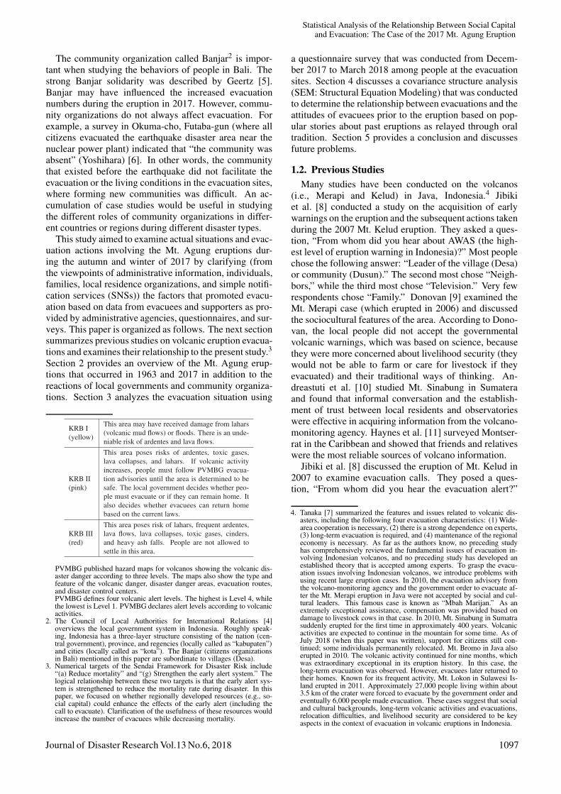
KRB I(yellow)
This area may have received damage from lahars(volcanic mud flows) or floods. There is an unde-niable risk of ardentes and lava flows.
KRB II(pink)
This area poses risks of ardentes, toxic gases,lava collapses, and lahars. If volcanic activityincreases, people must follow PVMBG evacua-tion advisories until the area is determined to besafe. The local government decides whether peo-ple must evacuate or if they can remain home. Italso decides whether evacuees can return homebased on the current laws.
KRB III(red)
This area poses risk of lahars, frequent ardentes,lava flows, lava collapses, toxic gases, cinders,and heavy ash falls. People are not allowed tosettle in this area.
PVMBG published hazard maps for volcanos showing the volcanic dis-aster danger according to three levels. The maps also show the type andfeature of the volcanic danger, disaster danger areas, evacuation routes,and disaster control centers.PVMBG defines four volcanic alert levels. The highest is Level 4, whilethe lowest is Level 1. PVMBG declares alert levels according to volcanicactivities.
2. The Council of Local Authorities for International Relations [4]overviews the local government system in Indonesia. Roughly speak-ing, Indonesia has a three-layer structure consisting of the nation (cen-tral government), province, and regencies (locally called as “kabupaten”)and cities (locally called as “kota”). The Banjar (citizens organizationsin Bali) mentioned in this paper are subordinate to villages (Desa).
3. Numerical targets of the Sendai Framework for Disaster Risk include“(a) Reduce mortality” and “(g) Strengthen the early alert system.” Thelogical relationship between these two targets is that the early alert sys-tem is strengthened to reduce the mortality rate during disaster. In thispaper, we focused on whether regionally developed resources (e.g., so-cial capital) could enhance the effects of the early alert (including thecall to evacuate). Clarification of the usefulness of these resources wouldincrease the number of evacuees while decreasing mortality.
a questionnaire survey that was conducted from Decem-ber 2017 to March 2018 among people at the evacuationsites. Section 4 discusses a covariance structure analysis(SEM: Structural Equation Modeling) that was conductedto determine the relationship between evacuations and theattitudes of evacuees prior to the eruption based on pop-ular stories about past eruptions as relayed through oraltradition. Section 5 provides a conclusion and discussesfuture problems.
1.2. Previous StudiesMany studies have been conducted on the volcanos
(i.e., Merapi and Kelud) in Java, Indonesia.4 Jibikiet al. [8] conducted a study on the acquisition of earlywarnings on the eruption and the subsequent actions takenduring the 2007 Mt. Kelud eruption. They asked a ques-tion, “From whom did you hear about AWAS (the high-est level of eruption warning in Indonesia)?” Most peoplechose the following answer: “Leader of the village (Desa)or community (Dusun).” The second most chose “Neigh-bors,” while the third most chose “Television.” Very fewrespondents chose “Family.” Donovan [9] examined theMt. Merapi case (which erupted in 2006) and discussedthe sociocultural features of the area. According to Dono-van, the local people did not accept the governmentalvolcanic warnings, which was based on science, becausethey were more concerned about livelihood security (theywould not be able to farm or care for livestock if theyevacuated) and their traditional ways of thinking. An-dreastuti et al. [10] studied Mt. Sinabung in Sumateraand found that informal conversation and the establish-ment of trust between local residents and observatorieswere effective in acquiring information from the volcano-monitoring agency. Haynes et al. [11] surveyed Montser-rat in the Caribbean and showed that friends and relativeswere the most reliable sources of volcano information.
Jibiki et al. [8] discussed the eruption of Mt. Kelud in2007 to examine evacuation calls. They posed a ques-tion, “From whom did you hear the evacuation alert?”
4. Tanaka [7] summarized the features and issues related to volcanic dis-asters, including the following four evacuation characteristics: (1) Wide-area cooperation is necessary, (2) there is a strong dependence on experts,(3) long-term evacuation is required, and (4) maintenance of the regionaleconomy is necessary. As far as the authors know, no preceding studyhas comprehensively reviewed the fundamental issues of evacuation in-volving Indonesian volcanos, and no preceding study has developed anestablished theory that is accepted among experts. To grasp the evacu-ation issues involving Indonesian volcanos, we introduce problems withusing recent large eruption cases. In 2010, the evacuation advisory fromthe volcano-monitoring agency and the government order to evacuate af-ter the Mt. Merapi eruption in Java were not accepted by social and cul-tural leaders. This famous case is known as “Mbah Marijan.” As anextremely exceptional assistance, compensation was provided based ondamage to livestock cows in that case. In 2010, Mt. Sinabung in Sumatrasuddenly erupted for the first time in approximately 400 years. Volcanicactivities are expected to continue in the mountain for some time. As ofJuly 2018 (when this paper was written), support for citizens still con-tinued; some individuals permanently relocated. Mt. Bromo in Java alsoerupted in 2010. The volcanic activity continued for nine months, whichwas extraordinary exceptional in its eruption history. In this case, thelong-term evacuation was observed. However, evacuees later returned totheir homes. Known for its frequent activity, Mt. Lokon in Sulawesi Is-land erupted in 2011. Approximately 27,000 people living within about3.5 km of the crater were forced to evacuate by the government order andeventually 6,000 people made evacuation. These cases suggest that socialand cultural backgrounds, long-term volcanic activities and evacuations,relocation difficulties, and livelihood security are considered to be keyaspects in the context of evacuation in volcanic eruptions in Indonesia.
Journal of Disaster Research Vol.13 No.6, 2018 1097

Matsumoto, M. et al.
The overwhelming majority of respondents chose the an-swer “Leader of village (Desa) or community (Dusun),”while the second most chose “Police or army.” Very fewchose “Family.” De Belizal et al. [12] also studied the2007 Kelud eruption and analyzed the factors that inhib-ited evacuation (i.e., anxiety about caring for livestockor livelihood). They found that the evacuation alert wasnot thoroughly enforced or emphasized. They identifiedthe importance of improving communication between lo-cal residents and the government. Lavigne et al. [13]discussed the relationship between evacuations and lo-cal communities. They studied four volcanos in Java andpointed out that “Cultural beliefs specific to Java” wereevacuation-inhibiting factors (p. 282); this specificallyincluded the local community structure and leadershiproles. Mei et al. [14]5 studied Mt. Merapi, which eruptedin 2010. They clarified that the ratio of the people whoheard an evacuation alerts from the village mayors washighest among other methods. The Social Network Ser-vices (e.g., Twitter and Facebook) also influenced evacu-ation behavior. Sorensen and Sorensen [15] performed aU.S. case studies and identified factors that encouragedevacuation, including “Community involvement,” “Kinrelations (number),” and “Channel: Media”(p.191).
The above studies argue organizations (e.g., villages orcommunities) that played important roles in disseminat-ing evacuation alerts or calls for evacuation. However,they lacked a viewpoint of locally-formed resources (e.g.,social capitals). A review-paper by Meyer [16] stated that195 papers were written on “Social Capital in DisasterResearch” from the year of 1998 to 2015, but that only afew of them studied the relationship between evacuationand social capital. A model taking these variables intoaccount is still under development. The present study isexpected to provide empirical findings.
2. Overview of the 1963 and 2017 Mt. AgungEruptions and Subsequent Actions Taken
2.1. Overview of the 1963 EruptionA standard hazard map was created for Indonesia after
the eruption of Mt. Agung in 1963. Problems with areaevacuation reactions were then analyzed. The significanceof the 1963 eruption remains; it is overviewed here forcomparison with the 2017 eruption.
According to Crandell et al. [17], the Netherlands be-gan making a volcano hazard map for Indonesia in 1919.After the 1963 Mt. Agung eruption, a new program wasestablished to create hazard maps for the systematic map-ping of the local volcano hazard zones (Fig. 1). This pro-gram was the first of its kind.
Zen [18] reported on the eruption and resulting dam-ages immediately after the disaster, as follows:
The Volcanological Survey of Indonesia has
5. It was not described as an “evacuation order” (an “order” is somethingissued by a local government official). It should therefore be consideredas an “alert” given by the volcano monitoring agency.
Fig. 1. Areas surveyed in this study (Cases1 and 2) accord-ing to a hazard map of Mt. Agung, Bali.
submitted its first report on the situation ofMt. Agung on March 13 demanding an immedi-ate evacuation of the people. The “closed zone”is the semicircular area within 10 km radiusfrom the top and the additional areas likely tobe hit by lahars (volcanic mud flow) are markedas “danger area.”
The official number of death casualties dur-ing the first cycle of activity as released by thelocal government of Bali is 1700 of which 1500died because of glowing avalanches mainlyfrom the paroxysmal eruption on March 17, and200 more because of the lahar which hit Suba-gan on March 21. Most of the death casual-ties fell in villages in the district of Selat on thesouthern slope. In the region of Selat only 1200people died from the pyroclastic flow (origi-nal: nuees ardentes) which hit this area severaltimes. But most of the casualties fell within theclosed and the danger zone. It is remarkablethat there are only 154 people wounded dur-ing the first cycle of activity. They suffer fromburns caused by pyroclastic flows. 772 cowsand pigs were hit by pyroclastic flows and died.Up to March 22, it is reported that 162 houseswere completely destroyed by pyroclastic flowsand lahars, 2 high school buildings, water reser-voir in Klungkung, 1 electric power plant and 1water reservoir in Karangasem and 10 bridges.
1098 Journal of Disaster Research Vol.13 No.6, 2018

Statistical Analysis of the Relationship Between Social Capitaland Evacuation: The Case of the 2017 Mt. Agung Eruption
During the second cycle of activity 120 peo-ple were overrun by pyroclastic flows and died.They were all caught either in the “closed zone”or in the “danger area.” In addition to this, nu-merous houses in the villages in the northernand southeastern slopes were destroyed by py-roclastic flows. The village of Tjulik and thetemples in Besakih were destroyed by the earth-quake of May 18.
Questions have been asked as to the cause ofthe high death casualties. It can simply be ex-plained by the reluctance of the people to movefrom the “closed zone” and from the “dangerarea.” And it is regretted that the local gov-ernment has not taken strong measures for animmediate evacuation. Around March 17, thepeople of Bali would have their religious cer-emonies centered in the main temple of Be-sakih. Thousands of people from all over theplace flocked together to attend the ceremonies.When the area of Besakih was closed, minorceremonies in smaller temples lying higher upthe slope especially in the region of Selat, stillcontinued. This is one of the causes why thesepeople were so reluctant to move out of theclosed zone. The second factor is namely thefact that Balinese people have never witnessed areal dangerous volcanic eruption. The last erup-tion of Mt. Agung happened 120 years ago. Noone remembers anymore what terrible thingshappened at that time and besides, as statedpreviously, there is no written record about theeruption in 1843. People living in the “dangerzone” around Karangasam and along the coastdid not realize that lahars could still hit them atsuch a distance. In short people in Bali did notfully realize the real danger of a volcanic erup-tion before this catastrophe.
2.2. Overview of the 2017 EruptionThe Center for Volcanology and Geological Hazard
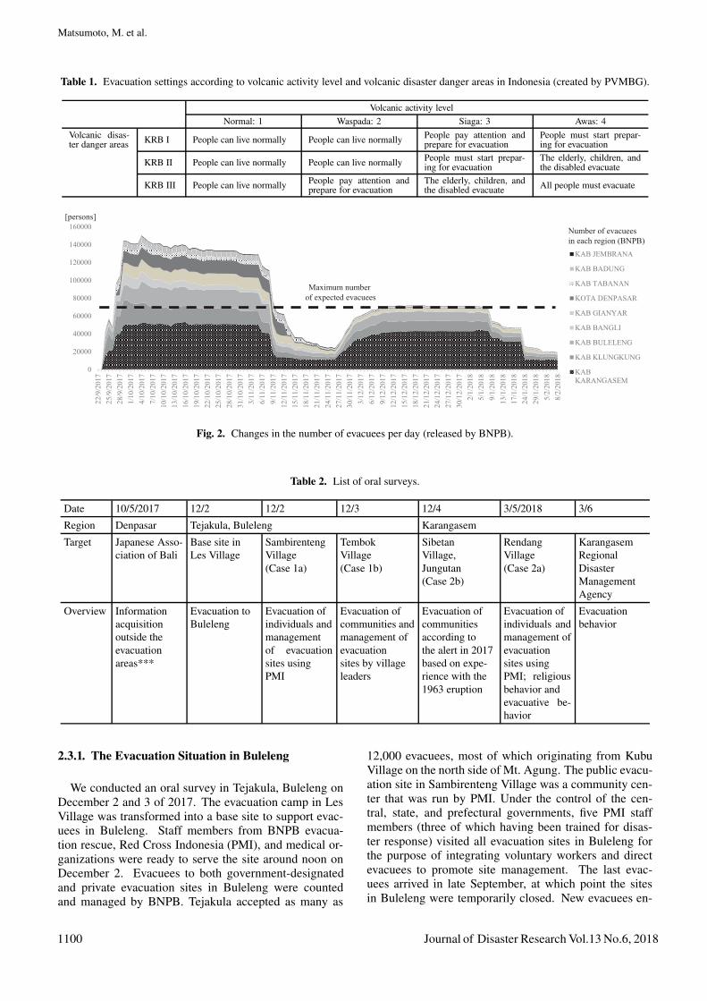
Mitigation (PVMBG: Pusat Vulkanologi dan MitigasiBencana Geologi) releases current hazard maps (Fig. 1),while the National Disaster Management Agency (BNPB:Badan Nasional Penanggulangan Bencana) makes evacu-ation decisions based on volcanic activity and associateddanger areas (Table 1).
The number of volcanic tremors around Mt. Agung hasincreased since the mid-September 2017. PVMBG thusraised the volcanic danger to Level 2 on September 14,Level 3 on September 18, and Level 4 on September 22.According to BNPB data on the number of evacuees re-leased (see the Table), many evacuated to Karangasem,Klungkung, and Buleleng. At Level 4, approximately80,000 people in a 12 km area around the volcano are re-quired to either prepare for evacuation or evacuate (detailsare currently being checked because the Level 4 evacua-tion zone may gradually change). The number of the evac-uees increased after September 22, exceeding 140,000 as
of September 29 (BNPB) (Fig. 2). The Indonesian Gov-ernment has therefore requested that people outside theareas designated for evacuation return to their homes. Thedanger was lowered to Level 3 on October 29 because ofa decline in seismic activity, but was raised to Level 4on November 26 after one small eruption on Novem-ber 21 and a number of successive eruptions beginningon November 25. On January 4, 2018, the restricted zonewas reduced to a 6 km area with Level 4 restrictions. OnFebruary 10, the area was lowered to Level 3 and the re-stricted zone was reduced to 4 km.
2.3. Peoples’ Actions During the 2017 Eruption andMemories of the 1963 Eruption
The authors conducted oral surveys on October 5 and6 and from December 2 through 5 in 2017 (Table 2).This research focused on the fact that (1) double the ex-pected number of persons evacuated as a precaution and(2) elderly persons living near the mountainside were in-fluenced to evacuate by their experiences during the 1963eruption; those who moved into their homes after the 1963eruption were also somewhat influenced to evacuate dur-ing the middle of September based on this event. How-ever, disruption occurred because the evacuation siteswere not under direct government control. This resultedin a lack of relief supplies and unfair treatment. In addi-tion, (3) information transfers among residents and familymembers using SNS (i.e., Short Message Service) had thefollowing characteristics: In early October, there was dif-ficulty in determining whether information was correct,thus resulting in confusion. However, by early December,both the evacuation site management staff and residentshad begun to check whether information had originatedfrom a public agency [19].
A BNPB report indicated that Karangasem,Klungkung, and Buleleng received many evacuees.Since the evacuation sites in Klungkung were closedin March, we did not survey evacuees in this area. Weinstead focused on evacuees that had collected informa-tion before making their evacuation decisions. We thuschose the following case examples: Case 1 in the northside6 (evacuations to areas outside the prefecture (mainlyindividual evacuations to Sambirenteng Village in Bule-leng and community evacuations to Tembok Village))and Case 2 in the south side7 (individual evacuations toRendang Village in Karangasem). Survey sheets werethen distributed to these locations and an oral surveywas conducted on March 5, 2018 among evacuees andsupporters at Karangasem Regional Disaster Manage-ment Agency and in Rendang Village, Karangasem. Forcomparison, an oral survey was conducted on October 5,2017, through the Japanese Association of Bali in Den-pasar. This survey asked respondents how they acquiredinformation from outside the evacuation areas.
6. The evacuation from Kubu Village, Karangasem to Tejakula, Buleleng.7. The evacuations from Jungutan Village on the mountainside to the moun-
tain foot and from Rendang Village on the mountainside to the mountainfoot.
Journal of Disaster Research Vol.13 No.6, 2018 1099
Matsumoto, M. et al.
Table 1. Evacuation settings according to volcanic activity level and volcanic disaster danger areas in Indonesia (created by PVMBG).
Volcanic activity levelNormal: 1 Waspada: 2 Siaga: 3 Awas: 4
Volcanic disas-ter danger areas KRB I People can live normally People can live normally People pay attention and
prepare for evacuationPeople must start prepar-ing for evacuation
KRB II People can live normally People can live normally People must start prepar-ing for evacuation
The elderly, children, andthe disabled evacuate
KRB III People can live normally People pay attention andprepare for evacuation
The elderly, children, andthe disabled evacuate All people must evacuate
���������
��������
��������
���������
���������
���������
����������
����������
� ��������
����������
����������
���������
���������
����������
���������
��������
���������
����������
���������
���������
����������
����������
����������
����������
���������
��������
���������
����������
���������
���������
����������
����������
����������
����������
�������
������
�������
��������
��������
��������
��������
������
������
�
�����
�����
����
����
������
������
������
� ����
������������
����������
�����������
�������������
�����������
����������
������������
�������������
�������������
� !"#$�%&�#'() ##*�+,�#()-�$#.+%,�/����0
�(1+! !�, !"#$�%&�#12#)3#4�#'() ##*
52#$*%,*6
Fig. 2. Changes in the number of evacuees per day (released by BNPB).
Table 2. List of oral surveys.
Date 10/5/2017 12/2 12/2 12/3 12/4 3/5/2018 3/6
Region Denpasar Tejakula, Buleleng Karangasem
Target Japanese Asso-ciation of Bali
Base site inLes Village
SambirentengVillage(Case 1a)
TembokVillage(Case 1b)
SibetanVillage,Jungutan(Case 2b)
RendangVillage(Case 2a)
KarangasemRegionalDisasterManagementAgency
Overview Informationacquisitionoutside theevacuationareas***
Evacuation toBuleleng
Evacuation ofindividuals andmanagementof evacuationsites usingPMI
Evacuation ofcommunities andmanagement ofevacuationsites by villageleaders
Evacuation ofcommunitiesaccording tothe alert in 2017based on expe-rience with the1963 eruption
Evacuation ofindividuals andmanagement ofevacuationsites usingPMI; religiousbehavior andevacuative be-havior
Evacuationbehavior
2.3.1. The Evacuation Situation in Buleleng
We conducted an oral survey in Tejakula, Buleleng onDecember 2 and 3 of 2017. The evacuation camp in LesVillage was transformed into a base site to support evac-uees in Buleleng. Staff members from BNPB evacua-tion rescue, Red Cross Indonesia (PMI), and medical or-ganizations were ready to serve the site around noon onDecember 2. Evacuees to both government-designatedand private evacuation sites in Buleleng were countedand managed by BNPB. Tejakula accepted as many as
12,000 evacuees, most of which originating from KubuVillage on the north side of Mt. Agung. The public evacu-ation site in Sambirenteng Village was a community cen-ter that was run by PMI. Under the control of the cen-tral, state, and prefectural governments, five PMI staffmembers (three of which having been trained for disas-ter response) visited all evacuation sites in Buleleng forthe purpose of integrating voluntary workers and directevacuees to promote site management. The last evac-uees arrived in late September, at which point the sitesin Buleleng were temporarily closed. New evacuees en-
1100 Journal of Disaster Research Vol.13 No.6, 2018
Statistical Analysis of the Relationship Between Social Capitaland Evacuation: The Case of the 2017 Mt. Agung Eruption
tered Buleleng in late November; many were received byan evacuation site in Tejakula, which was closer to theirhome. These evacuees wished to return home to care forlivestock during the day and only stayed at the evacua-tion site at night. In Tembok Village, people individuallyevacuated to their own places, the places of relatives, orprivate and public evacuation sites. The public evacua-tion sites accepted livestock and were managed throughstrong leadership by the village mayor. In September, ap-proximately 7,000 evacuees were accepted at 75 villagesites. According to the mayor, the village did not havesufficient warning and was thus in panic. The accurateamount of evacuees and relief goods was not obtainableand the goods could thus not be distributed equally amongevacuees who complained about their circumstances. Thecomplaints caused trouble for evacuation site manage-ment. The evacuees returned home on the day of Galun-gan (an event to host ancestor spirits). The public evac-uation sites were then temporarily closed, but reopenedafter the eruption in late November. Evacuees were ac-cepted at this time as a Banjar (local community unit)group and obliged to take turns managing the evacuationsites. Tembok Village and each Banjar agreed on the evac-uation rules. About 3,000 evacuees were accepted in thebeginning of December. Information on the agreement,fair distribution of the relief goods, and managerial distri-bution policy were actively delivered and released throughSNS.
2.3.2. The Evacuation Situation in KarangasemAn oral survey was conducted among respondents
who had experienced the eruption in Jungutan Villagein Karangasem on December 4, 1963 (Jungutan is amountainous area about 12 km south from the top ofMt. Agung). The survey was designed to obtain informa-tion about evacuations from the foot and side of the moun-tain. A survey was also conducted among three elderswho evacuated from a Banjar closer to the mountain topthan the communities on the side of Mt. Agung. These el-ders also remembered the eruption in 1963. They recalledinformation about a mud flow, explosive eruption, and es-cape from a lava flow. They were notified by the govern-ment of the necessity of the evacuation on September 19;a total of 435 people of the Banjar evacuated on Septem-ber 22 using trucks arranged by the government to carrythem to the evacuation site (community center Br. Dukuh)in Jungutan Village. These evacuees had a highly positiveopinion of the government regarding their evacuation ef-forts just prior to the dangerous situation. The governmentefficiently provided prior notification, arranged trucks forevacuation, and had furnished evacuation sites. Each Ban-jar on both the foot and side of the mountain usually con-ducted evacuation drills for volcanic eruptions accordingto a policy determined by the Banjar head. These Banjardid not therefore consider that any other drill would benecessary. No questionnaire survey was created for resi-dents of Jungutan Village because the Balinese languagewas spoken there and the Banjar had evacuated from the
side to the foot of the mountain under the direction of theBanjar head. Evacuees were not able to make individualdecisions about their evacuation.
An oral survey was also created for a PMI staff mem-ber and volunteer chief on March 5, 2018. The survey wasdesigned to gather information about the evacuation situ-ation in the Rendang Village. The area housed an evacu-ation site containing agricultural facilities (Kantor Perta-nian) in southern Rendang Village. There, PMI supportedevacuees on a 24-hour basis. Evacuees were from mul-tiple Banjars near Besakih Temple in northern RendangVillage. The site contained a maximum of approximately3,500 evacuees by September 22. At the time of our visit,there were 519 evacuees from 135 households. In theresidential area near Besakih, buildings and roads wereseverely damaged by the 2017 earthquake. This had alsooccurred during the 1963 eruption. The evacuation sitewas smoothly managed under 24-hour PMI control. Evac-uees performed commercial activities through which theyinteracted with local citizens. The PMI staff pointed outthe following background. The evacuees and evacuationsupporters shared the same understanding regarding localneeds and evacuation site management practices. That is,both groups believed that the evacuation sites were onlysupposed to provide evacuees with goods and recommen-dation letters to medical institutions. This was believedbecause medical institutions contributed to the physicalcare of evacuees while religious organizations providedmental care. This mutual understanding enabled smoothmanagement of the evacuation site. Evacuees stayed atthe site following the evacuation order subsequent to thefirst evacuation during mid-September. However, in thebeginning of November, almost all (except the elderly andsick) temporarily returned home for Galungan. The evac-uation site manager could not stop this since there wasno formal arrangement for the evacuees to return homeand there was no eruption at that time. After January, thearea designated for evacuation became smaller gradually.Early March, the regulated area was within 4 km fromthe mountain but many of the people who were from thearea 8 km from the mountain still stayed at the evacuationsites at night and returned home only during the daytimebecause the roads to the home area were destroyed andpeople could not go home by car but had to bike or walk.
2.4. The Karangasem Regional Disaster Manage-ment Agency (BPBD) and Preventative Ac-tions During the 2017 Eruption
An oral survey was conducted on March 6, 2018 atthe Karangasem Regional Disaster Management Agency.Karangasem consists of three cities, 52 counties, 75 vil-lages, and 554 Banjars. Karangasem furnished 383 evac-uation sites for approximately 2,000 evacuees. Since thisoccurred in the rainy season, outdoor evacuation was notappropriate and a community center in Banjar was usedas an evacuation site. Some people evacuated to thehomes of relatives. Evacuation organizations (e.g., PMIand the rescue organization) shared a logistics warehouse
Journal of Disaster Research Vol.13 No.6, 2018 1101
Matsumoto, M. et al.
and 20 trucks.Most people moved to the evacuation sites by them-
selves. Many used their cars and trucks to bring as manybelongings as possible. The government used eight trucksto evacuate people. They first evacuated the elderly, chil-dren, and babies. The physically disabled and sick people(including sick youths) were then evacuated. Finally, theyoung were evacuated.
Since this was the first experience in which disaster-management action was taken following the eruption ofMt. Agung, the BPBD announced village mayors theevacuation site locations,8 but did not decide which vil-lage was to evacuate to which site or the route they weremeant to take. When the danger level was lowered toLevel 3 at the end of October, a significant number of peo-ple returned home to care for livestock or retrieve items.However, the Disaster Prevention Bureau did not knowthe exact number. Children and the elderly remained atthe evacuation sites.
A volunteer organization called “Pasbaya” was alsopresent. Pasbaya consisted of evacuees organized byKarangasem and the Regional Disaster ManagementAgency. The volunteers did not receive a salary, but werecompensated with foods and goods, including walkie-talkies (including a wireless receiver and transmitter).Pasbaya established a system to spread information im-mediately. The government was thus able to acquire in-formation on evacuees and supplies every six hours. Themanagement committee consisted of 100 members, in-cluding village mayors and Banjar heads. The organiza-tion consisted of 275 formal members. The total numberreached 700. Those who did not have walkie-talkies couldcommunicate using cellular phones. Internet servicesand electric companies collaborated to manage large-scaleevacuations and adjusted relay stations to maintain excel-lent communication. In addition to the information ex-change among local communities, the volunteer organiza-tion set two volunteers at the volcano monitoring stationto receive information immediately and directly from ex-perts. This information was shared among the concernedpeople when unusual volcanic activities were detected.9
3. Evacuation from Eruption in 2017
3.1. Overview of Survey and Idea of AnalysisThis study aimed to find the factors that influenced
evacuation after the eruption and, more specifically, to un-derstand the relationships among the people, media, com-munity, past disasters, and current disaster countermea-
8. As discussed in footnote 2, the Banjar is subordinate to the village(Desa). The Banjar chief is therefore notified by the village (Desa)mayor.
9. If we combine the information we obtained from other Regional Disas-ter Management Agencies, we find the following: The Level increasedfrom 1 to 2 on September 14 and the Regional Disaster ManagementAgency in Bali sent the first report to the Regional Disaster ManagementAgencies in neighboring prefectures. When the Level increased to 3 onSeptember 19, the decision was made to accept evacuees in Karangasem,Klungkung, and Buleleng. When the Level increased to 4 on September22, the evacuation operation began.
sures. Section 2 discussed volcanic eruptions and the ac-tions taken after they occurred from viewpoints of thosewho “give directions on evacuation,” including local gov-ernments, supporting organizations, and community lead-ers. In this section, we overview the questionnaire surveyresults among people living in the three evacuation sites(i.e., Sambirenteng, Tembok, and Rendang) (Table 2). Asdescribed in Section 2, these were the locations in whichthe oral surveys were conducted. The surveys focused onresidential areas (i.e., Desa and Banjar), alert recognition,evacuation actions, problems living in evacuation sites,recognition of the 1963 eruption, and actions taken beforethe eruption. In this section, we first discuss the processinvolving alert recognition, the call for evacuation, andthe evacuation itself. Items related to “past disaster” and“prior actions taken before disaster” are also discussed inthis section. This is done to examine how “past disaster”and “prior actions taken before disaster” affect evacuationusing the SEM described in Section 4.
A questionnaire detention survey method was em-ployed among respondents. The authors explained theaim of the survey to evacuation site leaders and askedthem to distribute the questionnaire sheets to all house-holds. The same leaders collected the sheets afterwards.The survey was conducted among householders (or peo-ple in similar positions) living at Sambirenteng and Tem-bok evacuation sites December 2017 and at Rendang inMarch 2018. A total of 40 answer sheets (and attributes ofrespondents) were collected in Sambirenteng. Ages wereas follows: 20s (15.0%), 30s (30.0%), 40s (32.5%), 50s(15.0%), 60s (5.0%), and 70s or higher (2.5%). A totalof 75 sheets were collected in Tembok. Ages were as fol-lows: 20s (9.3%), 30s (32.0%), 40s (37.3%), 50s (9.3%),60s (6.7%), 70s or higher (2.7%), and unknown (2.7%).A total of 92 sheets were collected in Rendang (ages werenot asked unknown).10
3.2. Survey ResultsASSUM for Windows was used to analyze the survey
results. The difference from the total average was eval-uated using � � at a significance level of 1%, � � at asignificance level of 5%, ↑ ↓ for a significance level of10%, and ∴ ∵ for a significance level of 20%. Surveydata were totaled for each evacuation site and comparedbetween sites. The basis for fact finding was at a signifi-cance level of 1 or 5%, but was sometimes placed at 10%or 20% to determine the tendencies of each evacuationsite.
3.2.1. Evacuation from Eruption in 2017(1) Means Through which Alerts Were Recognized
How were the alerts recognized (Table 3)? In Sam-birenteng, most people answered television or radio, fol-lowed by SNS and family or relatives. Compared to the
10. Ages were unknown due to the nature of the survey. Since they werehouseholders (or persons in similar positions), ages should be around 30to 40.
1102 Journal of Disaster Research Vol.13 No.6, 2018

Statistical Analysis of the Relationship Between Social Capitaland Evacuation: The Case of the 2017 Mt. Agung Eruption
Table 3. Means of alert recognition.11
Num Fam Peo Tel Nei SNS Int Loc OthTotal 207 53.1 47.8 41.1 39.1 27.1 17.9 3.9 3.9Sambirenteng 40 �30.0 �27.5 �72.5 �15.0 �42.5 20.0 2.5 2.5Tembok 75 �84.0 46.7 �20.0 �64.0 �12.0 �1.3 9.3 1.3Rendang 92 �38.0 ↑ 57.6 44.6 ↓ 29.3 32.6 �30.4 − ∴ 6.5Num: Number of surveyed persons, Fam: Family or relatives, Peo: People of Banjar or Desa,Tel: Television or radio, Nei: Neighbors, Int: Internet, Loc: Local government, Oth: Others
Table 4. Recognition of the call for evacuation.
Num Fam Peo Nei Tel Loc Int SNS OthTotal 207 66.7 65.7 55.6 15.0 6.3 5.8 4.8 8.2Sambirenteng 40 65.0 ∵ 55.0 ∵ 45.0 �27.5 5.0 7.5 ∴ 10.0 −Tembok 75 �85.3 72.0 61.3 �2.7 �13.3 − − −Rendang 92 �52.2 65.2 55.4 19.6 �1.1 ∴ 9.8 6.5 �18.5Num: Number of surveyed persons, Fam: Family or relatives, Peo: People of Banjar or Desa,Nei: Neighbors, Tel: Television or radio, Loc: Local government, Int: Internet, Oth: Others
other evacuation sites, the number of people who chosetelevision or radio was significantly higher. However,the number of people who chose Banjar or Desa andneighbors was significantly lower. In Tembok, most peo-ple chose family or relatives, followed by neighbors andfamily or relatives. Compared to the other evacuationsites, the number of people who chose family or relativeswas significantly higher, while the number of people whochose television or radio, internet, and SNS was signif-icantly lower. In Rendang, most chose Banjar or Desa,followed by television or radio and family or relatives.Compared to the other evacuation sites, the number ofpeople who chose Banjar or Desa and internet was signif-icantly higher. As seen above, each evacuation site con-tained unique characteristics regarding the means of alertrecognition.
(2) Recognition of the Evacuation CallBy which of the above recognition methods did peo-
ple receive the call for evacuation (Table 4)? In Sam-birenteng, most people chose family or relatives, followedby Banjar or Desa and neighbors. Compared to the otherevacuation sites, the number of people who chose televi-sion or radio was significantly higher, while the numberof people who chose neighbors and Banjar or Desa wassignificantly lower. In Tembok, most people chose fam-ily or relatives, followed by Banjar or Desa and neigh-bors. Compared to the other evacuation sites, the numberof people who chose family or relatives was significantlyhigher, while the number of people who chose televisionor radio was significantly lower. In Rendang, most peoplechose “People of Banjar or Desa,” followed by “Neigh-bors” and “Family or relatives.” Compared to the otherevacuation sites, no items were chosen at significantlyhigher rates, while the number of people who chose fam-ily or relatives was significantly lower. In this relativeevaluation, people in Sambirenteng evacuated based onmedia information while people in Tembok and Rendang
11. The units shown in Tables 3–14 in this section are percentages (%).
Table 5. Reasons for evacuation.
Num Dam Fre Dir Eva Bec OthTotal 207 96.1 81.6 10.6 6.3 5.8 1.0Sam-birenteng 40 �90.0 ↓70.0 ↑20.0 − 10.0 −Tembok 75 97.3 80.0 14.7 �17.3 8.0 −Rendang 92 97.8 ∴88.0 �3.3 − ∵2.2 2.2
Num: Number of surveyed persons,Dam: Damage from volcanic eruption,Fre: Frequent earth-quakes,Dir: Direction on evacuation site by local government or Banjar,Eva: Evacuation to far family or relatives,Bec: Because others evacuate,Oth: Others.
evacuated based on information from families and com-munities.
(3) Reason for Evacuation
Here, we discuss the reasons for evacuation (Table 5).Most people at the evacuation site in Sambirenteng choseto evacuate because of damage from the volcanic erup-tion, followed by frequent earthquakes. Compared to theother evacuation sites, the number of people who choseto evacuation based on the direction of the local govern-ment or Banjar was significantly higher. In Tembok, mostpeople chose to evacuate because of damage from the vol-canic eruption, followed by frequent earthquakes. Com-pared to the other evacuation sites, the number of peoplewho chose to evacuate to family or relatives was signif-icantly higher. In Rendang, most people chose frequentearthquakes, while relatively few chose local governmentor Banjar.
(4) People Accompanied During Evacuation
Who did the evacuees accompany during the evacu-ation (Table 6)? In Sambirenteng, most people chose“Family or relatives,” followed by “Neighbors.” Com-pared to the other evacuation sites, the number of people
Journal of Disaster Research Vol.13 No.6, 2018 1103
Matsumoto, M. et al.
Table 6. People accompanied during evacuation.
Numberof
surveyedpersons
Familyor rela-
tivesNeigh-
bors
Peopleof
Banjaror Desa
Alone
Total 207 82.6 59.4 47.8 1.0Sam-birenteng 40 77.5 ∵ 47.5 ↓32.5 −Tembok 75 84.0 60.0 �32.0 −Rendang 92 83.7 64.1 �67.4 2.2
who chose neighbors and Banjar or Desa was significantlylower. In Tembok, relatively few people chose Banjar orDesa. The evacuation site in Rendang was characterizedby different tendencies compared to other sites, while thenumber of people who chose Banjar or Desa was signif-icantly higher. The survey results on accompanied per-sons indicated that many people in both Sambirenteng andTembok evacuated with family and relatives. Many peo-ple in Rendang evacuated as a community.
(5) Difficulty at the Evacuation Sites
At the evacuation site in Sambirenteng, people had dif-ficulty with lack of food and drink, lack of showers andtoilets, and lack of information from television or radio(Table 7). Compared to the other evacuation sites, thenumber of people who chose lack of food and drink, lackof showers and toilets, and lack of information from tele-vision or radio was significantly higher, while the num-ber of people who chose lack of privacy and difficulty incommunication with neighbors was significantly lower.In Tembok, people had difficulty with lack of food anddrink, lack of support between evacuees, and informationabout volcanic status. Compared to the other evacuationsites, the number of people who chose lack of supportbetween evacuees and difficulty in communication withneighbors was significantly higher, while the number ofpeople who chose lack of showers and toilets and lack ofprivacy was significantly lower. In Rendang, people haddifficulty with lack of showers and toilets and lack of wel-fare services. Compared to the other evacuation sites, thenumber of people who chose lack of welfare services andlack of privacy was significantly higher, while the numberof people who chose lack of food and drink was signif-icantly lower. As seen in this survey, the people at theevacuation site in Sambirenteng were not satisfied withthe hardware or information, but established human rela-tionships. On the other hand, the evacuation site in Tem-bok had the opposite tendency. People at the evacuationsite in Rendang were not satisfied with the hardware orprivacy, but established human relationships to a certainextent.
3.2.2. The 1963 Eruption(1) Recognition of Past Eruptions
How many people knew about the 1963 eruption (Ta-ble 8)? Between 70–90% of people at every evacuation
site answered, “I know.” This was much larger than thepercentage of people who answered, “I do not know.” Asignificant number in Tembok knew about the eruption.
(2) Means of Recognition (Based on the Number ofPersons who Recognized the Eruption)
Next, we studied the means by which people knew ofthe 1963 eruption (Table 9). In Sambirenteng, the meanswere (in decreasing order) “Television or radio,” “Fam-ily or relatives,” and “Banjar or Desa.” Compared to theother evacuation sites, the number of people who chose“Television or radio,” “Banjar or Desa,” and “SNS” wassignificantly higher. On the other hand, the number ofpeople who chose “Family or relatives” was significantlylower. In Tembok, nearly 90% chose “Family or rela-tives.” Less than 20% chose “others.” The number ofpeople who chose “Family or relatives” was significantlyhigher than at the other evacuation sites. In Rendang, thenumber was more evenly distributed. That is, “Televisionor radio,” “Internet,” and “Neighbors” were chosen by ap-proximately 30% of respondents each. Compared to theother evacuation sites, the number of people who chose“Internet” was significantly higher, while the number ofpeople who chose “Family or relatives” and “SNS” wassignificantly lower. In Sambirenteng and Rendang, peo-ple recognized the eruption through a variety of means,while in Tembok, the means of recognition was nearlylimited to family or relatives. This could be one reasonfor the high recognition rate.
(3) Depth of Recognition (Based on the Number ofPersons who Recognized the Eruption)
How much do people know about the damage from the1963 eruption (Table 10)? In Sambirenteng, 70% of re-spondents recognized “Human damage,” but the numberof people who recognized “Property damage” was signif-icantly lower when compared to respondents at the othersites. In Tembok, more than 80% of respondents recog-nized both human and property damages. Respondentsat the evacuation site in Rendang had almost the sametendency as those in Sambirenteng. In other words, hu-man damage was recognized by many people, but prop-erty damage was only well-recognized in Tembok.
(4) Recognition of Eruptions Before 1963
The recognition ratio was less than 10% at all evacua-tion site (Table 11).
3.2.3. Actions Prior to the Eruption(1) Recognition of Eruptions Before 1963
Finally, we assessed disaster response communicationprior to the eruption (Table 12). In Sambirenteng, 70%of respondents answered “Yes,” which was significantlyhigher than the response rates in other areas. In Tem-bok, 60% of respondents answered “Yes,” while nearly40% answered “No.” This was significantly higher thanthe response rates in other areas. In Rendang, about 40%
1104 Journal of Disaster Research Vol.13 No.6, 2018

Statistical Analysis of the Relationship Between Social Capitaland Evacuation: The Case of the 2017 Mt. Agung Eruption
Table 7. Reasons for evacuation.
Num Lc-fd Lc-st Lc-i Wel Lc-se Lc-itr Dif Lc-pr Bad Lc-inm OthTotal 207 40.1 37.7 37.2 30.9 28.5 23.7 17.9 14.0 9.7 9.2 1.0Sambirenteng 40 �62.5 �60.0 35.0 ∵ 20.0 �12.5 �50.0 �2.5 − ∵ 2.5 ∵ 2.5 −Tembok 75 �56.0 �14.7 41.3 �18.7 �42.7 18.7 �32.0 �4.0 13.3 − −Rendang 92 �17.4 ↑ 46.7 34.8 �45.7 23.9 ↓ 16.3 13.0 �28.3 9.8 �19.6 2.2Num: Number of surveyed persons, Lc-fd: Lack of food or drink, Lc-st: Lack of showers and toilets,Lc-i: Lack of information about volcanic status, Wel: Welfare services, Lc-se: Lack of support between evacuees,Lc-itr: Lack of information about volcanic status from television or radio, Dif: Difficulty communica-ting with neighbors,Lc-pr: Lack of privacy, Bad: Bad living conditions (in terms of space and sanitation),Lc-inm: Lack of information about volcanic status from newspapers or magazines, Oth: Others
Table 8. Recognition of the 1963 eruption.
Number ofsurveyedpersons
I know. I do notknow.
Notanswered.
Total 207 77.8 20.8 1.4Sambirenteng 40 70.0 27.5 2.5Tembok 75 ↑ 86.7 ∵ 13.3 −Rendang 92 73.9 23.9 2.2
Table 9. Means of recognizing the 1963 eruption.
Numberof
surveyedpersons
Familyor
relativesTelevisionor radio Internet Neigh-
bors
Total 161 52.2 26.1 21.7 20.5Sam-birenteng 28 ↓ 35.7 �57.1 17.9 17.9
Tembok 65 �89.2 �7.7 15.4 15.4Rendang 68 �23.5 30.9 ∴ 29.4 26.5
Numberof
surveyedpersons
Peopleof
Banjaror Desa
SNSLocal
govern-ment
Others
Total 161 9.3 9.3 3.7 1.2Sam-birenteng 28 �28.6 21.4 3.6 −Tembok 65 ↓3.1 9.2 6.2 −Rendang 68 7.4 ∵ 4.4 1.5 2.9
of respondents answered “Yes,” which was significantlylower than the response rate in other areas. These resultsindicate that the ratio of people who had interest in dis-aster response was highest in Sambirenteng, followed byTembok and Rendang.
(2) Persons with whom to Communicate About Dis-aster Response (Based on the Number of House-holds)
With whom did people communicate about disaster re-sponse (Table 13)? In Sambirenteng, most people dis-cussed this issue with “Family or relatives,” followed by“Neighbors.” Compared to the other evacuation sites,the number of people who chose “Workplace” was sig-nificantly higher, while the number of people who chose“Banjar or Desa” was significantly lower. The evacuationsite in Tembok had similar tendencies to the sire in Sam-
Table 10. Depth of recognition regarding damage from the1963 eruption.
Number ofsurveyedpersons
Humandamage
Propertydamage Others
Total 161 71.4 47.2 1.2Sambirenteng 28 67.9 �7.1 �7.1Tembok 65 ↑ 81.5 �83.1 −Rendang 68 ∵ 63.2 �29.4 −
Table 11. Recognition of eruptions before 1963.
Number ofsurveyedpersons
I know. I do notknow.
Notanswered.
Total 161 5.6 80.7 13.7Sambirenteng 28 3.6 82.1 14.3
Tembok 65 6.2 86.2 ∵ 7.7Rendang 68 5.9 75.0 ∴ 19.1
Table 12. Prior disaster response communication.
Number ofsurveyedpersons
Yes,I had.
No, I didnot have.
Notanswered.
Total 207 55.1 30.0 15.0
Sambirenteng 40 ↑ 70.0 ∵ 20.0 10.0Tembok 75 61.3 36.0 �2.7Rendang 92 �43.5 29.3 �27.2
birenteng. However, when compared to the other evacua-tion sites, the number of people who chose “Neighbors,”“Banjar or Desa,” and “Local government staffs” was sig-nificantly higher. The evacuation site in Rendang alsohad this tendency, but the number of people who chose“Neighbor” was significantly lower than at other evacu-ation sites. The above results indicate that respondentsat all evacuation sites communicated with their familiesor relatives. Moreover, the people in Tembok talked withneighbors and Banjar, while those in Sambirenteng talkedwith neighbors, and those in Rendang mostly communi-cated with family.
(3) Discussion Topics (Based on the Number of House-holds)
What did people discuss regarding disaster response(Table 14)? In Sambirenteng, more than 80% of re-
Journal of Disaster Research Vol.13 No.6, 2018 1105

Matsumoto, M. et al.
Table 13. Persons with whom to communicate about disaster response.
Number ofsurveyedpersons
Family orrelatives Neighbors People of
Banjar or DesaPolice or fire
stationLocal
governmentstaffs
Total 114 73.7 45.6 26.3 9.6 7.0Sambirenteng 28 71.4 46.4 ∵ 14.3 10.7 −Tembok 46 78.3 ∴ 56.5 �39.1 4.3 �17.4Rendang 40 70.0 ↓ 32.5 20.0 15.0 −
Number ofsurveyedpersons
School Workplace NPO Others
Total 114 2.6 1.8 − 1.8Sambirenteng 28 − �7.1 − −Tembok 46 ↑ 6.5 − − −Rendang 40 − − − 5.0
Table 14. What was discussed regarding disaster response?
Number ofsurveyedpersons
Evacuationsite
Things tobring Readiness Securing foods
and drinksHow to
evacuate Others
Total 114 57.0 51.8 17.5 13.2 10.5 2.6Sambirenteng 28 �82.1 �28.6 17.9 17.9 7.1 −Tembok 46 56.5 �82.6 23.9 ∴19.6 ↓ 2.2 −Rendang 40 �40.0 �32.5 10.0 �2.5 �22.5 ↑ 7.5
spondents talked about the “Evacuation site,” followedby “Things to bring.” Compared to the other evacuationsites, the number of people who chose “Evacuation site”was significantly higher, while the number of people whochose “Things to bring” was significantly lower. In Tem-bok, most people chose “Things to bring,” followed by“Evacuation site.” Compared to the other sites, the num-ber of people who chose “Things to bring” was signifi-cantly higher. In Rendang, most people chose “Evacu-ation site,” followed by “Things to bring” and “How toevacuate.” The choices were relatively dispersed com-pared with those at other sites. The above results indi-cate that the people at the evacuation site in Sambirentengwere interested in the evacuation site, while the people inTembok were interested in things to bring. Respondentsin Rendang talked about various matters.
In this section, we overviewed a questionnaire surveyconducted among evacuees living at the evacuation sitesin Sambirenteng, Tembok, and Rendang. Respondentswere asked about (1) evacuation from the 2017 eruption,(2) the 1963 eruption, and (3) actions taken prior to theeruption. The major results were as follows:
Sambirenteng: People recognized the alert and callfor evacuation through television and radio, andevacuated with their families and relatives.
Tembok: People recognized the alert from their fam-ilies, relatives, and neighbors. They recognizedthe call to evacuate from community memberssuch as family, relatives, and neighbors, andevacuated with their families and relatives.
Rendang: People recognized the alert from the com-munity and Internet. They recognized the call to
evacuate from their families and the community,and evacuated with the community.
By using the item “(1) evacuation from the 2017 erup-tion” from the questionnaire survey results, we conjec-tured the flow of events starting from the alert recognitionand ending with the evacuation, as follows: Alert recog-nition → call for evacuation → evacuation. In the nextsection, we discuss the relationship between the (2) 1963eruption and (3) the actions taken prior to the eruption andevacuation.
4. Past Eruptions, Alert Recognition, SocialCapital, and Group Evacuation
4.1. Past Eruptions, Alert Recognition, and the Callfor Evacuation
In the previous section, we studied the flow of eventsstarting with alert recognition and ending with the evacu-ation as well as recognition of past eruptions (e.g., 1963)and actions taken prior to the eruption at each evacuationsite. In this section, we discuss how social capitals (e.g.,recognition of past eruptions and actions taken prior to theeruption) affected the number of channels involving thecall for evacuation. Putnam [20] referred to this as “So-cial capital that promoted people’s cooperative behaviorto improve the efficiency of the society.” Many argumentsexist on the associated definitions and measurement meth-ods. We do not provide details in this regard. In this paper,we simply define social capital as “communication amongindividuals about disaster and the accumulation of knowl-
1106 Journal of Disaster Research Vol.13 No.6, 2018

Statistical Analysis of the Relationship Between Social Capitaland Evacuation: The Case of the 2017 Mt. Agung Eruption
Table 15. The relationship between alert recognition and the call for evacuation.12
Number of sur-veyed persons
Call for evacuationFamily orrelatives Neighbors People of
Banjar or DesaTelevision or
radioTotal 207 66.7 55.6 65.7 15.0
Alert recognition
Family or relatives 110 �81.8 59.1 ↑ 74.5 ↓ 9.1Neighbors 81 �87.7 �81.5 ∴ 72.8 11.1People of Banjar or Desa 99 66.7 �68.7 �79.8 17.2Television or radio 85 67.1 60.0 67.1 �25.9Internet 37 75.7 �78.4 70.3 16.2SNS 56 71.4 �69.6 62.5 16.1Local government 8 − − �100.0 12.5Others 8 �25.0 62.5 �25.0 ↑ 37.5
Number of sur-veyed persons
Call for evacuation
Internet SNS Localgovernment Others
Total 207 5.8 4.8 6.3 8.2
Alert recognition
Family or relatives 110 4.5 3.6 �0.9 10.0Neighbors 81 6.2 2.5 ∵2.5 �14.8People of Banjar or Desa 99 7.1 7.1 4.0 ↑ 13.1Television or radio 85 7.1 5.9 4.7 �15.3Internet 37 �27.0 �18.9 2.7 5.4SNS 56 �17.9 �17.9 7.1 10.7Local government 8 − − �100.0 −Others 8 12.5 12.5 − 12.5
edge (e.g., know-how) through such communication.”
4.1.1. The Relationship Between Alert Recognitionand Responses to the Call for Evacuation
People who recognized the evacuation alert from“neighbors” tended to respond to the call for evacua-tion based on information from “family or relatives” and“neighbors” (Table 15). Alert recognition from the “In-ternet” or “SNS” exhibited similar tendencies. Namely,people who recognized the alert from the “Internet” or“SNS” tended to respond to the call based on informa-tion from the “Internet” or “SNS,” respectively. The re-lationship between alert recognition and response to thecall for evacuation can be summarized as follows: “Fam-ily or relatives”→ “Family or relatives,” “Neighbors”→“Family or relatives” + “Neighbors,” “Banjar or Desa”→ “Neighbors” + “Banjar or Desa,” “Television or ra-dio” → “Television or radio,” and “Internet,” “SNS” →“Internet,” “SNS.” When people recognized the volcaniceruption alert from real media sources, they tended to rec-ognize the call for evacuation based on information fromother people or parties within the real media. When peo-ple recognized the alert from virtual media, they recog-nized the call to evacuated mostly based on informationfrom the same media. The information recognition pathfrom real media was narrower than that from virtual me-dia.
4.1.2. The Relationship Between Past Eruptions andthe Call for Evacuation
Here, we discuss the relationship between the meansof recognizing the 1963 eruption and the call for evacua-tion in 2017 (Table 16). Those who recognized the 1963
12. The units shown in Tables 15–17 in this section are percentages (%).
eruption based on information from family or relatives re-sponded to the call for evacuation based on informationfrom “Family or relatives,” “Neighbors,” and “People ofBanjar or Desa,” but did not respond at high rates to “Tele-vision or radio.” Those who recognized the 1963 erup-tion based on information from “Neighbors” or “Peopleof Banjar or Desa” showed almost the same tendency, butresponded at slightly higher rates to the call for evacu-ation based on information from the “Internet.” Thosewho recognized the 1963 eruption based on informationfrom “Television or radio” responded to the call for evac-uation based on information from “Television or radio”and the “Internet,” but responded at lower rates to infor-mation from “Neighbors” and “Banjar or Desa.” Thosewho recognized the 1963 eruption based on informationfrom the “Internet” or “SNS” responded to the call forevacuation based on information from people with whomthey had actual connections.
4.1.3. Relationship Between Prior Actions and theCall for Evacuation
Here, we discuss the relationship between persons withwhom to communicate regarding actions prior to the erup-tion and the call for evacuation. Those who talked with“Neighbors” about these matters tended to respond to thecall for evacuation based on information from “Neigh-bors” and “Family or relatives.” On the other hand, thosewho talked with “Banjar or Desa” about these matterstended to respond to the call for evacuation based on in-formation from “Family or relatives,” “Neighbors,” and“Banjar or Desa.” The relationship between prior actionsand the call for evacuation was similar to the relationshipseen in (1) (Table 17). There was also a tendency in which“people responded to the call for evacuation from some of
Journal of Disaster Research Vol.13 No.6, 2018 1107

Matsumoto, M. et al.
Table 16. Relationship between the 1963 eruption and the call for evacuation.
Number of sur-veyed persons
Call for evacuationFamily orrelatives Neighbors People of
Banjar or DesaTelevision or
radioTotal 161 66.5 58.4 65.8 13.7
Means torecognizepast eruption
Family or relatives 84 �81.0 ∴ 66.7 ∴ 72.6 �2.4Neighbors 33 63.6 63.6 ↑ 81.8 6.1People of Banjar or Desa 15 80.0 66.7 � 93.3 20.0Television or radio 42 ↓ 52.4 52.4 59.5 �38.1Internet 35 74.3 ∴ 71.4 62.9 ∵ 5.7SNS 15 80.0 66.7 53.3 13.3Local government 6 − − ↑ 100.0 16.7Others 2 100.0 50.0 50.0 −
Number of sur-veyed persons
Call for evacuation
Internet SNS Localgovernment Others
Total 161 5.6 3.7 6.8 5.0
Means torecognizepast eruption
Family or relatives 84 6.0 2.4 ∴ 10.7 ∴ 8.3Neighbors 33 ∴ 12.1 3.0 − �15.2People of Banjar or Desa 15 � 20.0 6.7 − �26.7Television or radio 42 ↑ 11.9 7.1 2.4 4.8Internet 35 �17.1 ∴ 8.6 � 17.1 −SNS 15 �33.3 �26.7 6.7 6.7Local government 6 16.7 ↑ 16.7 �83.3 ∴ 16.7Others 2 − − − �50.0
Table 17. Relationship between prior actions and the call for evacuation.
Number of sur-veyed persons
Call for evacuationFamily orrelatives Neighbors People of
Banjar or DesaTelevision or
radioTotal 114 56.1 47.4 67.5 16.7
Person tocommunicate withfor prior actions
Family or relatives 84 61.9 51.2 73.8 17.9Neighbors 52 �76.9 �75.0 71.2 19.2People of Banjar or Desa 30 �76.7 �73.3 ↑ 83.3 ∵ 6.7Local government staffs 8 ↓ 25.0 25.0 �100.0 −Police or fire station 11 ↓ 27.3 ↑ 72.7 ∵ 45.5 ↑ 36.4School 3 ∴ 100.0 ↑ 100.0 66.7 −Workplace 2 50.0 50.0 50.0 50.0NPOOthers 2 − − − �100.0
Number of sur-veyed persons
Call for evacuation
Internet SNS Localgovernment Others
Total 114 3.5 3.5 7.9 2.6
Person tocommunicate withfor prior actions
Family or relatives 84 1.2 1.2 ∵ 3.6 1.2Neighbors 52 1.9 − ∵ 1.9 1.9People of Banjar or Desa 30 ↑ 10.0 6.7 3.3 3.3Local government staffs 8 − − �75.0 −Police or fire station 11 9.1 �18.2 − −School 3 − − − −Workplace 2 �50.0 − − −NPOOthers 2 − �50.0 − �100.0
the people with whom they communicated regarding prioractions.”
4.2. The Relationship Between Past Eruptions,Prior Actions, Alert Recognition, and Evacu-ation
In this section, we discuss how the 1963 eruption andactions taken prior to the eruption (which are a kind ofsocial capital) affected evacuation behavior. For this pur-
pose, we employed a SEM method to clarify the relation-ships among past experiences, prior actions, alert recog-nition, and evacuation. The model is shown in Fig. 3. Thevariables were set as follows: For “prior action” involvingcommunication about disaster, an observable variable isthe “number of persons with whom to communicate.” Forthe “eruption in 1963,” an observable variable is whetherpeople “recognized or not” (the value of the variable is de-fined as “recognized = 1” and “not recognized = 0”). For“alert recognition,” an observable variable is “recognized
1108 Journal of Disaster Research Vol.13 No.6, 2018
Statistical Analysis of the Relationship Between Social Capitaland Evacuation: The Case of the 2017 Mt. Agung Eruption
�
�$+%$�()3+%,� !"#$�%&�2#$*%,*�7+3-�7-%!�3%�)%!! ,+)(3#
�$ 23+%,�+,��� ��#)%.,+8#4�%$�,%3
�+,4�%&�2#$*%,*�7+3-�7-%!�3%�#'() (3#
�9#$3�$#)%.,+3+%,�#)%.,+8#4�%$�,%3
Fig. 3. The relationships among past eruptions, prior ac-tions, alert recognition, and evacuation.
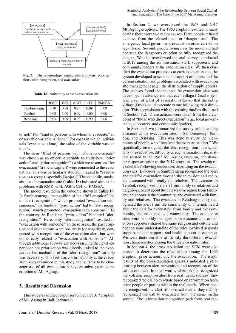
Table 18. Suitability at each evacuation site.
RMR GFI AGFI CFI RMSEASambirenteng 0.10 0.98 0.83 0.99 0.09Tembok 0.02 1.00 0.99 1.00 0.00Rendang 0.03 0.99 0.93 0.99 0.06
or not.” For “kind of persons with whom to evacuate,” anobservable variable is “kind.” For cases in which individ-uals “evacuated alone,” the value of the variable was setto −1.
The item “Kind of persons with whom to evacuate”was chosen as an objective variable to study how “prioraction” and “prior recognition” (which are resources “forevacuation” (a social capital)) were connected to the evac-uation. This was particularly studied in regard to “evacua-tion as a group (especially Banjar).” The suitability analy-sis at each evacuation site (Table 18) indicated almost noproblems with RMR, GFI, AGFI, CFI, or RMSEA.
The model resulted in the outcome shown in Table 19.In Sambirenteng, “recognition of the 1963 eruption” ledto “alert recognition,” which promoted “evacuation withsomeone.” In Tembok, “prior action” led to “alert recog-nition,” which promoted “evacuation with someone.” Tothe contrary, in Rendang, “prior action” hindered “alertrecognition.” Here, only “alert recognition” resulted in“evacuation with someone.” In these areas, the past erup-tion and prior actions were positively (or negatively) con-nected with recognition of the evacuation alert, but werenot directly related to “evacuation with someone.” Al-though additional surveys are necessary, neither past ex-perience nor prior action was directly linked to the evac-uation, but mediation of the “alert recognition” variablewas necessary. This fact was confirmed only at the evacu-ation sites examined in this study, but is likely to be char-acteristic of all evacuation behaviors subsequent to theeruption of Mt. Agung.
5. Results and Discussion
This study examined responses to the fall 2017 eruptionof Mt. Agung in Bali, Indonesia.
In Section 2, we overviewed the 1963 and 2017Mt. Agung eruptions. The 1963 eruption resulted in manydeaths; there were two major causes. First, people refusedto move from the “closed area” or “danger area.” Theemergency local government evacuation order carried nolegal force. Second, people living near the mountain hadnot seen the dangerous eruption or fully recognized thedanger. We also overviewed the oral surveys conductedin 2017 among the administration staff, supporters, andcommunity leaders at the evacuation sites. We then clar-ified the evacuation processes at each evacuation site, thesystem developed to accept and support evacuees, and thecurrent situation and problems associated with evacuationsite management (e.g., the distribution of supply goods).The authors found that no specific evacuation plan wasdeveloped in advance and that each village (Desa) mayorwas given of a list of evacuation sites so that the entirevillage (Desa) could evacuate to one following their direc-tion. This is consistent with the existing studies discussedin Section 1.2. These actions were taken from the view-point of “those who direct evacuation” (e.g., local govern-ment, supporters, and community leaders).
In Section 3, we summarized the survey results amongevacuees at the evacuation sites in Sambirenteng, Tem-bok, and Rendang. This was done to study the view-points of people who “received the evacuation alert.” Wespecifically investigated the alert recognition means, de-tails of evacuation, difficulty at each evacuation site, mat-ters related to the 1963 Mt. Agung eruption, and disas-ter responses prior to the 2017 eruption. The results re-vealed the following tendencies depending on the evacua-tion sites: Evacuees in Sambirenteng recognized the alertand call for evacuation through the television and radio,and evacuated with family and relatives. The evacuees inTembok recognized the alert from family or relatives andneighbors, heard about the call for evacuation from familyand neighbors in the community, and evacuated with fam-ily and relatives. The evacuees in Rendang mainly rec-ognized the alert from the community or Internet, heardabout the call for evacuation from family and the com-munity, and evacuated as a community. The evacuationsites were smoothly managed since evacuees and evacu-ation supporters shared the same religion and culture andhad the same understanding of the roles involved in goodssupport, mental support, and health support at each site.We were therefore able to identify the different evacua-tion characteristics among the three evacuation sites.
In Section 4, the cross tabulation and SEM were dis-cussed to determine the relationship among the 1963eruption, prior actions, and the evacuation. The majorresults of the cross-tabulation analysis indicated a rela-tionship between alert recognition and recognition of thecall to evacuate. In other words, when people recognizedthe volcanic eruption alert from real media sources, theyrecognized the call to evacuate based on information fromother people or parties within the real media. When peo-ple recognized the alert from virtual media, they mainlyrecognized the call to evacuated from the same mediasource. The information recognition path from real me-
Journal of Disaster Research Vol.13 No.6, 2018 1109
Matsumoto, M. et al.
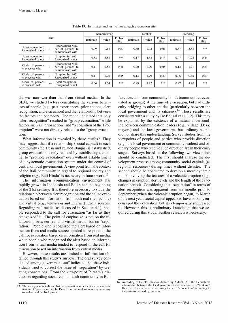
Table 19. Estimates and test values at each evacuation site.
PassSambirenteng Tembok Rendang
Estimate t-value Proba-bility Estimate t-value Proba-
bility Estimate t-value Proba-bility
[Alert recognition]Recognized or not ←
[Prior action] Num-ber of persons tocommunicate with
0.09 0.68 0.50 0.30 2.73 0.01 −0.37 −3.83 ***
[Alert recognition]Recognized or not ← [Eruption in 1963]
Recognized or not 0.53 3.88 *** 0.17 1.53 0.13 0.07 0.75 0.46
Kinds of personsto evacuate with ←
[Prior action] Num-ber of persons tocommunicate with
−0.11 −0.83 0.41 0.20 2.00 0.05 −0.12 −1.21 0.23
Kinds of personsto evacuate with ← [Eruption in 1963]
Recognized or not −0.11 −0.76 0.45 −0.13 −1.29 0.20 −0.06 −0.68 0.50
Kinds of personsto evacuate with ← [Alert recognition]
Recognized or not 0.66 4.34 *** 0.49 4.82 *** 0.47 4.90 ***
dia was narrower than that from virtual media. In theSEM, we studied factors constituting the various behav-iors of people (e.g., past experiences, prior actions, alertrecognition, and evacuation) and the relationship betweenthe factors and behaviors. The model indicated that only“alert recognition” resulted in “group evacuation,” whilefactors such as “prior action” and “recognition of the 1963eruption” were not directly related to the “group evacua-tion.”
What information is revealed by these results? Theymay suggest that, if a relationship (social capital) in eachcommunity (the Desa and related Banjar) is established,group evacuation is only realized by establishing a chan-nel to “promote evacuation” even without establishmentof a systematic evacuation system under the control ofcentral or local government. A viewpoint from the contextof the Bali community in regard to regional society andreligion (e.g., Bali Hindu) is necessary in future work.13
The information communication environment hasrapidly grown in Indonesia and Bali since the beginningof the 21st century. It is therefore necessary to study therelationship between alert recognition and the call to evac-uation based on information from both real (i.e., people)and virtual (e.g., television and internet) media sources.Regarding real media (as discussed in Section 4.1), peo-ple responded to the call for evacuation “as far as theyrecognized” it. The point of emphasize is not on the re-lationship between real and virtual media, but on “sepa-ration.” People who recognized the alert based on infor-mation from real media sources tended to respond to thecall for evacuation based on information from real media,while people who recognized the alert based on informa-tion from virtual media tended to respond to the call forevacuation based on information from virtual media.
However, these results are limited to information ob-tained through this study’s surveys. The oral survey con-ducted among government staff indicated that these indi-viduals tried to correct the issue of “separation” by cre-ating connections. From the viewpoint of Putnam’s dis-cussion regarding social capital, each community in Bali
13. The survey results indicate that the evacuation sites had the characteristicfeature of “evacuation led by Desa.” Further oral surveys are necessaryto understand the background.
functioned to form community bonds (communities evac-uated as groups) at the time of evacuation, but had diffi-culty bridging to other entities (particularly between thelocal government and its citizens).14 These results areconsistent with a study by De Belizal et al. [12]. This maybe explained by the existence of a mutual understand-ing between communication leaders (e.g., village (Desa)mayors) and the local government, but ordinary peopledid not share this understanding. Survey studies from theviewpoints of people and parties who provide direction(e.g., the local government or community leaders) and or-dinary people who receive such direction are in their earlystages. Surveys based on the following two viewpointsshould be conducted: The first should analyze the de-velopment process among community social capitals (asregional resources) during times without disaster. Thesecond should be conducted to develop a more dynamicmodel involving the features of a volcanic eruption (e.g.,changes in eruption alert levels and the length of the evac-uation period). Considering that “separation” in terms ofalert recognition was apparent from six months prior toSeptember (when the volcanic eruption began) to Marchof the next year, social capital appears to have not only en-couraged the evacuation, but also temporarily suppressedit. However, this is preliminary knowledge that we ac-quired during this study. Further research is necessary.
14. According to the classification defined by Aldrich [21], the hierarchicalrelationship between the local government and its citizens is “Linking.”Here, we discuss these events using the term “connection” according tothe patterns defined by Putnam.
1110 Journal of Disaster Research Vol.13 No.6, 2018

Statistical Analysis of the Relationship Between Social Capitaland Evacuation: The Case of the 2017 Mt. Agung Eruption
References:[1] K. Matsumoto, A. Konno, G. Yamauchi, and Y. Yanagida, “Pro-
posal for an Evacuation System during Volcano Eruptions Based ona Multidisciplinary Approach: Using Mount Merapi in Indonesia asan Example,” Inter-Graduate School Doctoral Degree Program onScience for Global Safety of Tohoku University, pp. 107-185, 2015.
[2] JICA, “Data collection survey on ASEAN regional collaborationin disaster management final report,” 2012, http://libopac.jica.go.jp/images/report/P1000008081.html [accessed July 7, 2018]
[3] JICA, “Project Development Report for Integrated Study on Mit-igation of Multimodal Disasters caused by Ejection of VolcanicProducts,” 2014 (in Japanese), http://open jicareport.jica.go.jp/pdf/12151486.pdf [accessed July 7, 2018]
[4] Council of Local Authorities for International Relations, “LocalAutonomy in Indonesia,” 2009 (in Japanese), http://www.clair.or.jp/j/forum/series/pdf/j29.pdf [accessed September 18, 2018]
[5] C. Geertz, “Negara: the Theatre State in Nineteenth-century Bali,”Princeton University Press, 1980.
[6] N. Yoshihara, “Illusion and Reality in Local Community: an anal-ysis on evacuation behavior and evacuation centers,” S. Tanaka, H.Funabashi, and T. Masamura (eds.), Great East Japan Earthquakeand Sociology: Society brings a Big Disaster, pp. 47-69, Minerva-shobo, 2013 (in Japanese).
[7] A. Tanaka, “Features and Issues in Volcanic Disasters,” H. Yoshiiand A. Tanaka (eds.), Introduction of Disaster Crisis Management,pp. 88-94, Koubundou Publishers Inc., 2008 (in Japanese).
[8] Y. Jibiki, D. Pelupessy, N. Sekiya, and A. Tanaka, “Designing Suit-able Information Dissemination Against Natural Disasters: from theCase Study of Mt. Kelud Eruption in 2007 in East Java, Indonesia,”D. Mardianto and M. Takahashi (eds.), Community Approach toDisaster, pp. 181-192, Gadjah Mada University Press, 2012.
[9] K. Donovan, “Doing social volcanology: exploring volcanic culturein Indonesia,” Area, Vol.42, No.1, pp. 117-126, 2010.
[10] S. Andreastuti, et al., “Character of community response to volcaniccrises at Sinabung and Kelud volcanoes,” J. of Volcanology andGeothermal Research, 2017, http://dx.doi.org/10.1016/j.jvolgeores.2017.01.022 [accessed May 1, 2018]
[11] K. Haynes, J. Barclay, and N. Pidgeon, “The issue of trust and its in-fluence on risk communication during a volcanic crisis,” Bull. Vol-canol., Vol.70, pp. 605-621, 2008.
[12] E. De Belizal, F. Lavigne, J. C. Gaillard, D. Grancher, I. Pratomo,and J.-C. Komorowski, “The 2007 eruption of Kelut volcano (EastJava, Indonesia): phenomenology, crisis management and social re-sponse,” Geomorphology, Vol.136, No.1, pp. 165-175, 2012.
[13] F. Lavigne, B. De Coster, N. Juvin, F. Flohic, J.-C. Gaillard, P. Tex-ier, J. Morin, and J. Sartohadi, “People’s behaviour in the face ofvolcanic hazards: perspectives from Javanese communities, Indone-sia,” J. of Volcanology and Geothermal Research, Vol.172, No.3-4,pp. 273-287, 2008.
[14] E. T. W. Mei, F. Lavigne, A. Picquout, E. De Belizal, D. Brunstein,D. Grancher, J. Sartohadi, N. Cholic, and C. Vidal, “Lessons learnedfrom the 2010 evacuations at Merapi volcano,” J. of Volcanologyand Geothermal Research, Vol.261, pp. 348-365, 2013.
[15] J. H. Sorensen and B. V. Sorensen, “Community Processes: Warn-ing and Evacuation,” H. Rodrıguez, E. L. Quarantelli, and R. R.Dynes (eds.), Handbook of Disaster Research, pp. 183-199, 2007.
[16] M. A. Meyer, “Social Capital in Disaster Research,” H. Rodrıguez,W. Donner, and J. E. Trainor (eds.), Handbook of Disaster Research,pp. 263-286, 2018.
[17] D. R. Crandell, B. Booth, K. Kusumadinata, D. Shimozuru, G. P.L. Walker, and D. Westercamp, “Source-book for volcanic-hazardszonation,” Unesco, 1984, http://unesdoc.unesco.org/images/0006/000630/063032Eo.pdf [accessed MM DD, 20YY]
[18] M. T. Zen and D. Hadikusumo, “Preliminary report on the 1963eruption of Mt. Agung in Bali (Indonesia),” Bull. Volcanol., Vol.27,No.1, pp. 269-299, 1964.
[19] M. Kuri, N. N. Suartini, I. M. Budiana, K. Sugiyasu, and M. Mat-sumoto, “Evacuation action on the 2017 warning of Agung volcano,Indonesia: preliminary report,” Tohoku J. of Natural Disaster Sci-ence, No.54, pp. 253-258, 2018.
[20] R. D. Putnam, “Making Democracy Work: Civic Traditions in Mod-ern Italy,” Princeton University Press, 1993.
[21] D. P. Aldrich, “Building Resilience: Social Capital in Post-DisasterRecovery,” University of Chicago Press, 2012.
Name:Michimasa Matsumoto
Affiliation:Associate Professor, International Research In-stitute of Disaster Science (IRIDeS), TohokuUniversity
Address:6-6-11-901-2 Aoba, Aramaki, Aoba-ku, Sendai 980-8579, JapanBrief Career:2002- Japan Consumer Marketing Research Institute2007- Fukushima National College of Technology2013- Tohoku UniversitySelected Publications:• “Survey analysis of coastal areas in Fukushima prefecture: The realsituation and changes in the devastated communities,” Ochanomizu-shobo,2015.Academic Societies & Scientific Organizations:• Japan Society for Urbanology (JSU)• Japan Association of Regional and Community Studies (JARCS)• Japan Society of Civil Engineers (JSCE)
Name:Miwa Kuri
Affiliation:Lecturer, International Research Institute of Dis-aster Science (IRIDeS), Tohoku University
Address:6-6-11-901-2 Aoba, Aramaki, Aoba-ku, Sendai 980-8579, JapanBrief Career:1999- Post-Doctoral Research Fellow, Geological Survey of Japan,National Institute of Advanced Industrial Science and Technology (AIST)2002- Post-Doctoral Research Fellow, Geology, Science, TohokuUniversity2013- Lecture, IRIDeS, Tohoku UniversitySelected Publications:• “Response of the Tourism Industry to Volcanic Hazard Information: ACase Study of the Volcanic Warning at Zao Volcano in 2015,” J. DisasterRes., Vol.13, No.3, pp. 547-558, 2018.• “Science Communication of Hazards with Scientific Uncertainty: In theCases of Volcanic Activity,” J. Disaster Res., Vol.11. No.4, pp. 707-719,2016.Academic Societies & Scientific Organizations:• Japan Geoscience Union (JpGU)• Volcanological Society of Japan (VSJ)• Japanese Society for Science and Technology Studies (STS)
Journal of Disaster Research Vol.13 No.6, 2018 1111
Matsumoto, M. et al.
Name:Kazuya Sugiyasu
Affiliation:Assistant Professor, International Research Insti-tute of Disaster Science (IRIDeS), Tohoku Uni-versity
Address:6-6-11-901-2 Aoba, Aramaki, Aoba-ku, Sendai 980-8579, JapanBrief Career:2012-2013 Researcher, The University of Tsukuba2013- Assistant Professor, Tohoku UniversitySelected Publications:• “Case Study of Tsunami Evacuating Action and Future planning after the2011 Great East Japan Earthquake, in Iwaki City, Fukushima, Japan,” 16thInt. Symp. on New Technologies for Urban Safety of Mega Cities in ASIA(USMCA-2017), 2017.• “Understanding Regional Building Characteristics in Yangon Based onDigital Building Model,” J. Disaster Res., Vol.13, No.1, pp. 125-137, 2018.Academic Societies & Scientific Organizations:• Architectural Institute of Japan (AIJ)• City Planning Institute of Japan (CPIJ)• Institute of Social Safety Science (ISSS)• Japan Association for Earthquake Engineering (JAEE)
Name:Yasuhito Jibiki
Affiliation:Assistant Professor, International Research Insti-tute of Disaster Science (IRIDeS), Tohoku Uni-versity
Address:6-6-11-901-2 Aoba, Aramaki, Aoba-ku, Sendai 980-8579, JapanBrief Career:2008 Research Fellowship for Young Scientists (DC2), Japan Society forthe Promotion of Science2010 Project Assistant Professor, Center for Integrated DisasterInformation Research, The University of Tokyo2013- Assistant Professor, Tohoku UniversitySelected Publications:• “Analyzing Why Sovereign States Adopt the Cluster Approach inHumanitarian Response,” Ph.D. Dissertation for The University of Tokyo,2013.• “Typhoon Yolanda in the Philippines: Qualitative analysis of institutionaland political factors influencing the continuum,” A. Hanatani, O. A.Gomez, and C. Kawaguchi (eds.), Crisis Management Beyond theHumanitarian-Development Nexus, 2018 (forthcoming).Academic Societies & Scientific Organizations:• Japan Association of International Relations (JAIR)• Japan Society for Disaster Information Studies (JASDIS)• Institute of Social Safety Science (ISS)
Name:Ni Nengah Suartini
Affiliation:Lecturer, Ganesha University of Education
Address:Pegok, Jalan Raya Sesetan No.196, Sesetan, Denpasar Selatan, Pedungan,Denpasar Sel., Kota Denpasar, Bali 80223, IndonesiaBrief Career:2000-2002 Event Coordinator at Bali Event Organizer2002-2005 Japanese Teacher and Interpreter at Japanese Studies, UdayanaUniversity2005- Universitas Pendidikan GaneshaSelected Publications:• The Emergence of Lifestyle Migration and the Change of Cross-culturalMarriage On Japanese Women in BaliAcademic Societies & Scientific Organizations:• Asosiasi Studi Pendidikan Bahasa Jepang Indonesia (ASPBJI)
Name:I Made Budiana
Affiliation:Lecturer, Japanese Department Faculty of Letter,Udayana University
Address:Jl. Baja Taki II A No 21, Padangsambian Kaja, Denpasar Barat, Bali,IndonesiaBrief Career:2005- Lecturer, Japanese Department Faculty of Letter, UdayanaUniversitySelected Publications:• “Three Argument Verb in Japanese And Balinese,” Thesis, PostgraduateUdayana University, 2016.Academic Societies & Scientific Organizations:• Indonesian Linguistic Society
1112 Journal of Disaster Research Vol.13 No.6, 2018
Powered by TCPDF (www.tcpdf.org)