status of coastal erosion of vietnam and … · i. status of coastal erosion in vietnam ... such as...
TRANSCRIPT

1
STATUS OF COASTAL EROSION OF VIETNAM AND PROPOSED MEASURES FOR PROTECTION
Nguyen Ngoc BinhEng.
Do Dinh Sam Prof., DSc.
Pham Huy TienAssoc. Prof., Dr.
Ngo Ngoc Cat Assoc. Prof., Dr.
The coastal zone of Vietnam:The coastal zone of Vietnam is 3,260 km
long, extending through the territories of 24 provinces and cities, which include 127 urban and rural districts, 21 towns and 6 cities (Ha Long, Vinh, Hue, Quy Nhon, Nha Trang, VungTau). Here occur a series of interactive processes between the land and the sea, between the dynamic forces of rivers and the sea, between the natural and human processes, etc. Along the cost of Vietnam in average in every 20 km there is a river mouth. The landforms of the coastal zone of Vietnam are multiform and diverse. In many areas the landforms are strongly dissected, giving the coast many beauty spots. The coastal zone of Vietnam also receives many natural calamities, causing multidirectional impacts on the nature and socio-economic conditions. In particular the coastal erosion is causing many difficulties for the life of the coastal population.
I. Status of coastal erosion in VietnamThis paper is prepared mainly based on the data of the
State level research project "Forecasting the coastal erosion and sedimentation of the coastal and river mouth areas and proposing preventive measures" led by Assoc. Prof. Dr. Pham Huy Tien (2005) and the reports on mangrove forests of Vietnam edited by Prof. DSc. Do Dinh Sam and Eng. Nguyen Ngoc Binh of the Vietnam Institute of Forestry.
The status of coastal erosion and sedimentation in our country is diverse from area to area, depending on the lithological composition of the coast and the river -marine dynamic regime.
I.1. Coastal and river mouth areas in the North region
(From Quang Ninh to Ninh Binh) Coastal erosion in the Northern region is usually associates with
sedimentation and occurs in a complicated manner depending on many natural and human factors, of which the main ones are the lithological composition of the coast and hydrographic and oceanographic dynamic regime.
The coastal erosion in Quang Ninh area occurs only locally within short coastal sections. But in the coastal zone of the Red river delta the coastal erosion occurs in relatively long coastal sections between the coastal sections with sedimentation near river mouths. Notably from Mong Cai to Hau Loc 6 coastal sections with continuous erosion from 1930 to present have been recorded: Cat Hai, Bang La, Thuy Xuan, Xuan Thuy, Hai Hau, Hau Loc, of which two areas of very serious erosion are Cat Hai and HauLoc.

2
(From Quang Ninh to Ninh Binh)
I.2. Coastal and river mouth areas in the Central region
(From Thanh Hoa to Binh Thuan)Coastal erosion has been observed in all coastal provinces
of the Central region. Here 263 erosion sites have been recorded, of which the smallest site covers 1.4 ha, the largest one covers 262.8 ha. The total area of coastal erosion in the period 1990 - 2003 is 8839 ha. Observation and records show that in the total 263 erosion sites 284 coastal sections and 10 areas have been completely eroded. In the coastal section from Thanh Hoa to KhanhHoa there is an erosion site in every 6 km.
(From Thanh Hoa to Da Nang)
(From Da Nang to Binh Thuan)

3
Table 1. Record of coastal erosion from Thanh Hoa to Binh Thuan
284Total 24Binh Thuan11Ninh Thuan20Khanh Hoa16Phu Yen40Quang Ngai14Da Nang18Quang Nam33Thua Thien Hue29Quang Tri25Quang Binh11Ha Tinh30Nghe An13Thanh Hoa
Number of coastal sections subjected to erosion Province The coastal erosion occurs at different rates. The areas with
irregular, rugged landform, with many bays and peninsulas, bedrock, river mouth areas erosion occurs with small extent, low to medium intensity.
Strong and very strong erosion occurs in convex coastal sections facing wind and wave direction, with sand being the main shore-building material. There are up to 268 erosion sections composed of sand, accounting for 93.7% of the total erosion sections.
The Central coastline from Thanh Hoa to Binh Thuan is 1765 km long, of which 392 km are being eroded (accounting for 22% of the total coast line).
The survey results show that the eroded coastal sections with length over 1000 m account for 41%.
Table 2. Number of eroded coastal section classified by dimension
4.316.520.128.530.6Percentage
2841247578187Total No of sections
2413479Binh Thuan
1101433Ninh Thuan
1612643Phu Yen
2002387Khanh Hoa
40278914Quang Ngai
1402345Da Nang city
18156138Thua Thien – Hue
3313662Quang Nam
29136811Quang Tri
25162412Quang Binh
1124221Ha Tinh
30164613Nghe An
1303370Thanh Hoa
Very large Large Average Considerable Small
> 60002000 - 60001000 - 2000200 - 1000< 200
Total number
of sections
Number of eroded coastal section classified by dimension
Province
In the Central region, erosion occurs nearly all over the coast line, in the territories of all coastal provinces, though with different intensity and rate. The areas with strongest erosion are concentrated in the coastal zone of the Thanh Hoa, Thua Thien - Hue, Quang Nam, Quang Ngai, Phu Yen.
According to the records, (Pham Huy Tien et al., 2005) so far there are 263 erosion sites, where 284 coastal sections and 10 sites have been completely eroded. Erosion occurs in most of lithological types of the coast: gravel, sand, clayey mud, sandy mud, however sandy coast accounts for 93.7% of the total length of erosion sections.
It is notable that at present erosion still continues to occur in 21 coastal sections with reinforcement structures such as dykes, revetment, piles, tree plantation.
Many coastal sections with bedrock basement which had been filled by unconsolidated sediments (such as sand, coral and shell detritus) are now being eroded.

4
Over 50% of coastal sections being eroded are over 1km long, 10.6% of coastal sections have been eroded 200 m or more inland. 43% of coastal sections are being eroded with high rate (15 - 30 m/year) of which many sections are eroded with the rate > 100 m/year.
In the 13 coastal provinces of the Central region, especially 3 provinces Thua Thien - Hue, Quang Ngai, Phu Yen the erosion and sedimentation processes occur in a complicated manner but the erosion process always predominates.
The erosion process occurs at different rates, intensity and extents in different areas, in the mean time tends to be ever increasing, especially since 1990. The erosion process mainly occurs in the coastal sections perpendicular with the wind and wave directions, composed of unconsolidated sediments, without or with technically inappropriate reinforcement structures.
I.3. Coastal and river mouth areas of the Southern region
(From Vung Tau to Ha Tien)The results of survey and assembling of reported data from the
localities together with the results of interpretation of maps and remote sensing data, show that before 1940 there was no erosion in the coastal and river mouth areas from Vung Tau to Ha Tien.
In the period 1940 - 1950, coastal erosion did occur in the river mouth areas of the Southern region, but with low rate. Since 1960 coastal erosion has been rather common almost allover the coastal zone of the provinces in the Southern plain.
Since 1995, coastal erosion in the Southern plain has been occurring in a rather complicate manner, in many areas, causing serious consequences.
(From Vung Tau to Ha Tien)
Table 3. Records of coastal and river mouth erosion of Southern provinces (Pham Huy Tien et al., 2005)
495,100300Tra VinhCau NgangMy Long15
614,800200Tra VinhCau NgangMy Long14
551,900180Tra VinhTra CuDai An13
11,780,0001000Ben TreThanh PhuThanh Hai12
1,718,000500Ben TreBa TriBao Thach11
3,865,000800Ben TreBinh DaiThua Duc10
363,000200Ben TreBinh DaiThanh Phuoc9
743,000200Ben TreBinh DaiThanh Phuoc8
175,000175Ben TreGo Cong DongVom Lang7
3,400,0001700Tien GiangGo Cong DongTan Dien6
750,000750Tien GiangGo Cong DongTan Thanh5
6,786,0001000Ho Chi Minh cityCan GioThach An4
1,151,000400Ho Chi Minh cityCan GioLy Nhon3
1,072,000400Ho Chi MinhcityCan GioLy Nhon2
748,000400Ho Chi Minh cityCan GioLong Hoa1
Area (m2)Width (m)ProvincesDistrictsCommunes No

5
Table 3. Records of coastal and river mouth erosion of Southern provinces (Pham Huy Tien et al., 2005)
124,105,700Total
60,00030Kien GiangHa TienBinh An31400,000200Kien GiangHa TienThuan An30
15,930,0001100Ca MauNgoc HienTan An2916,610,0001000Ca MauNgoc HienTam Giang2814,980,0001400Ca MauNgoc HienTam Giang278.,65,000900Ca MauDam RoiNguyen Huan266,12,000700Ca MauDam RoiTan Tien255.,40,0001100Ca MauDam RoiTan Thuan241,844,000300Bac LieuGia RaiGanh Hao233,173,000400Soc TrangVinh ChauVinh Hai222,026,000500Soc TrangLong PhuTrung b×nh213,363,000400Soc TangLong PhuTrung b×nh201,357,000400Tra VinhDuyen HaiHiep Thanh191,665,000500Tra VinhDuyen HaiDong Hai182,436,500400Tra VinhDuyen HaiLong Vinh174,230,000600Tra VinhDuyen HaiLong Hoa16
II. Intensity and rate of coastal erosion in Vietnam
II.1. Intensity of erosion
The intensity of coastal erosion depends on an assemblage endogenous, exogenous and human factors, of which the exogenous factors are of the most important role. Among the exogenous factors, the physico-chemical properties of the coastal formations are one of the decisive factors.
Based on the degree of erosion, the authors have classified the intensity and extent of coastal erosion in the Red river delta into the following stages and levels:
Table 4. Overview of the coastal erosion intensity in the Red river delta (Pham Huy Tien et al., 2005)
2.0 ha/year9.87 ha/year17.2 ha/yearErosion area
1001.870.813.538.229.6Very high (> 10km)
0025.74.961.7815.52High (5-10km)
003.50.6700Moderate (2.5-5km)
000000Low (0-2.5km)
1..819.0725.12Erosion length
Do Son – BaLat
%Km%Km%Km
1990 to present 1965 – 19901930 – 1965Erosion
intensity (km)
Area
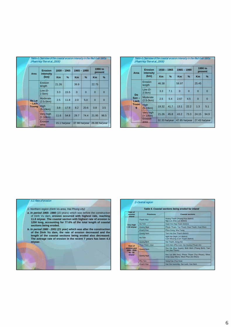
6
Table 4. Overview of the coastal erosion intensity in the Red river delta (Pham Huy Tien et al., 2005)
26.08 ha/year37.98 ha/year15.1 ha/yearErosion area
96.521.9574.429.754.811.6Very high(> 10km)
3.50.820.68.217.93.8High (5-10km)
005.02.011.82.5Moderate (2.5-5km)
000015.53.3Low (0-2.5km)
22.7539.921.26Erosion length
Ba Lat – LachTruong
%Km%Km%Km
1990 to present 1965 – 19901930 – 1965Erosion
intensity (km)
Area
Table 4. Overview of the coastal erosion intensity in the Red river delta (Pham Huy Tien et al., 2005)
27.43 ha/year47.85 ha/year32.33 ha/yearErosion area
94.924.1573.343.245.821.26Very high(> 10km)
5.11.322.213.141.719.32High (5-10km)
004.52.675.42.5Moderate (2.5-5km)
00007.13.3Low (0-2.5km)
25.4558.9746.38Erosion length
Do Son –LachTruon
g
%Km%Km%Km
1990 to present 1965 – 19901930 – 1965Erosion
intensity (km)
Area
II.2. Rate of erosion
1- Northern region (Dinh Vu area, Hai Phong city)a. In period 1965- 1980 (15 years) which was before the construction
of Dinh Vu dam, erosion occurred with highest rate, reaching 11.8 m/year. The coastal section with highest rate of erosion is1250 long, accounting for 77.6% of the total length of coastal sections being eroded.
b. In period 1980 - 2001 (21 year) which was after the construction of the Dinh Vu dam, the rate of erosion decreased and the length of the coastal sections being eroded also decreased. The average rate of erosion in the recent 7 years has been 4.3 m/year.
2- Central region
Table 5. Coastal sections being eroded far inland
Van Gio township, Dai Lanh, Van NinhKhanh Hoa
Song Cau (Tuy Hoa)Phu Yen
Duc Loi (Mo Duc), Phuoc Thuan (Tuy Phuoc), NhonChau (Quy Nhon), Nhon Phuc (An Nhon)Quang Ngai
Duy Hai (Duy Xuyen), Binh Minh (Thang Binh), Tam Tien (Nui Thanh)Quang Nam
Vinh Hien (Phu Loc), Hai Duong (Thuan An)Thua Thien - Hue
Hai Thanh, Dong HoiQuang Binh
Nghi Hai (Nghi Loc district)Cam Nhuong (Cam Xuyen district)Ha Tinh
Rate of erosion year 1999 - 2000
40 - 60 m/year
Tam Hai (Nui Thanh district)Quang Nam
Phuu Dong, Nha TrangKhanh Hoa
Phuoc Thuan, Tuy Thuan, Hoai Thanh, Hoai NhonQuang Ngai
Xuan Hoi (Ngu Xuan district)Ha Tinh
Hoang Thanh (Hoang Hoa district)Ngu Loc (Hau Loc district)Thanh Hoa
Very high > 30 m/year
Coastal sections ProvincesRate of erosion inland

7
II.2. Rate of erosion
3- Southern region Also according to the above authors, along the Southern coastline of Vietnam
there are 19 coastal sections (45,2%) with low erosion rate (< 5 m/year), 7 coastal sections (6.6%) with moderate erosion rate (5 - 15 m/year), 5 coastal sections 11.9% with high erosion rate (15 - 30 m/year) and 7 coastal sections 16.6% with very high erosion rate (> 30 m/year).
The areas with highest coastal erosion rate (> 30 m/year) are Go Cong Dong (Tien Giang province) Hiep Thach - Duyen Hai (Tra Vinhprovince) Ganh Hao, Dong Hai (Bac Lieu province), Tan Thuan, Tan Tien (Ca Mau province).
The results of observation show that, high intensity erosion occurs in areas with straight coastline and near big river mouths in the Southeast of the Southern region. The intensity of sedimentation and erosion is low in the irregular coastal sections shielded by many islands, of Ha Tien province in the West of the Southern region.
The coastal erosion in the Southern region tends to increase with time. According to the recorded data of the last ten years (1992 - 2002) the number of coastal sections being eroded increased by 10.
III. Coastal erosion in some key research areas.
III.1. Hai Hau area, Nam Dinh province
Erosion in Van Ly area has been occurring for over 50 years, extending over a length of 30 km, with average rate of 10 -15 m/year, maximum 20 - 30 m/year, taking away tens of ha every year. At present 1/4 of the coastline of the Red river delta is being eroded.
Table 6. Status of coastal erosion in Van Ly - Hai Thanh area (Pham Huy Tien et al., 2005)
21.529.016.829.5Area (ha/year)
55.410.369.812.066.713.0Very high (> 10km)
00020.54.025.62.2High (5-10km)
18.83.5004.60.953.54.6Moderate (2,5-5km)
25.84.830.25.28.21.620.91.8Low (0-2.5km)
18.617.219.58.6Total length of erosion
%Km%Km%Km%Km
1995 - 20031991 - 19951965 - 19911930 - 1965PeriodIntensity

8
III.2. Coastal erosion in Thua Thien - Hue province
The coast here extends in NW-SE direction, 120 km long, facing straightly the wind and wave direction and composed mainly of sand. The erosion process here occurs with a rather high intensity, especially in the recent period.
In the province there are 33 coastal sections being eroded with a total erosion length of 29.5 km. In average in every 4 km there is a coastal section being eroded and the total length of the coastalsections being eroded accounts for 25% of the length of the coastline. The province has 5 coastal districts, in which 15 communes are being eroded.
From 1950 to 2000 were 33 coastal sections eroded, of which during 10 years (1990 - 2000) were eroded 27 coastal sections, accounting for 81.8%. In particular in 1999, due to the impact of the historic flood in November in Thua Thien - Hue province 14 coastal sections were strongly eroded.
The erosion process occurs with highest intensity in the coastalsection of village II of Hai Duong commune, Huong Tra district, where the whole 1500 m long coastal section is being eroded. In the area of Hoa Duan river mouth, during the historic flood of November 1999 a new river mouth was formed. By April 2000 the Hoa Duan river mouth which was about 400 m wide and, about 70 m long and 20 m high had been nearly completely eroded taking 6
III.3. Coastal and river mouth erosion in Quang Ngai province
The coast of Quang Ngai province is being eroded with highest intensity in the 13 provinces of Central coastal zone. In the province there are 11 districts, in which 30 communes are being eroded.
The coast of Quang Ngai extends in NW - SE direction, composed mainly of sand. 40 coastal sections are being eroded with a total length of 60 km.
It is notable that in the recent years along the coast of Quang Ngaiprovince erosion has occurred in coastal sections which have been reinforced, in particular:
- 6 coastal sections reinforced by revetment are being eroded.- 7 coastal sections reinforced by piling are being eroded.- 5 coastal sections reinforced by protective walls are being eroded. - 11 coastal sections reinforced by tree plantation are being eroded.- 16 coastal sections related with river mouths are being eroded.The coast of Duc Loi commune (Mo Duc district) in year 1999 was
eroded 250 m inland, that of My Duc commune (Phu My district) -150 m. In Sa Huynh the erosion rate is relatively high in average 27.5 m/year, destroying roads, forests, and other infrastructures.
III.4. Coastal and river mouth erosion in Phu Yen province
The length of the coastline of Phu Yen province is about 80 km, it is at present being rather strongly eroded. The province has 4 coastal districts in which 13 communes are in serious state of erosion. The coast of Phu Yen province extends in N-S direction, perpendicular with the wind and wave direction. It iscomposed mainly of sand, in particular the coast of Chao bay is composed of cobbles and gravel. In the area of Xuan Dai, XuanTho, Song Cau township the coast is composed of clayey soil. The province has 16 coastal sections being eroded with a total length of 23.3 km, in average in every 3.5 km of the coast there is section being eroded and the total length of the coastal sections being eroded accounts for 29% of the total length of the province's coastline.
The erosion with highest average annual rate occurs in Song Cau, Song Hai townships (Song Cau district), An Ninh Dong (Tuy An district). In particular in Nhon Phuc (An Nhondistrict), according to the survey data, the erosion in 2000 was 108 m.
III.5. Coastal erosion at the Ganh Hao river mouth, Bac Lieu province
Coastal erosion at the Ganh Hao river mouth is mainly related with the NE monsoon which has a velocity of 10 - 15 m/sec (usually from October to March).

9
IV. Occurrence of erosion through various periods
In Do Son - Ba Lat section (coastal section of the Northern region) erosion occurs in a very complicated manner with different trends in three periods as follows:
- Period 1930 - 1965: erosion occurred over a length of 46.4 km, with average rate of 7 m/year.
- Period 1965 - 1990: erosion occurred over a length of 59 km, with average rate of 8.1 m/year.
- Period 1990 to present: erosion has occurred over a length of 23.7 km, with average rate of 11 m/year.
Thus, in recent years although the extent of erosion has been decreased, the intensity has been strongly increased.
Analyzing the trend of the last 70 years shows 4 basic occurrence forms of erosion:
- Continuous erosion (Hai Hau, Hau Loc).- Erosion passing to sedimentation (Bang La, Vinh Quang, Giao
Thuy).- Erosion alternating with sedimentation in small sections (Diem Dien,
Dong Chau, Dong Long).- Sedimentation passing to erosion (Thuy Xuan, Hai Thinh, Da Loc).Classifying the occurrence of coastal erosion in the Central region
Table 7. Occurrence of erosion by periods of time
284Total
1571990 - 2003
951980 - 1989
181970 - 1979
141950 - 1969
None 1930 - 1949
Number of coastal sections eroded Period
In 1999 alone erosion occurred in 50 coastal sections.
V. Relationship between erosion and the lithological composition of the coast
The record of the number of coastal sections eroded and the relationship between the erosion and the lithological composition of the coast show that up to 93.7% of the coastal sections composed of sand are eroded (see Table)
Table 8. Relationship between erosion and the lithologicalcomposition of the coast
93.70.71.40.72.11.4%
2680204020604Number of
coastal sections eroded
SandClayey loam
Clayey silt
Loam with clay
Cobbles, gravel, sand
Bedrock
Lithologicalcomposition

10
VI. Relationship between erosion and preventive measures
In the Central coastal zone, although preventive measures have been taken in many coastal sections, erosion still occurs due to many reasons. As the cause of erosion has not been clarified, although some preventive measures have been taken, such as construction of dikes and revetment, plantation of trees, piling, the efficiency of erosion control is still low.
Table 9. Relationship between erosion and preventive measures
69137335Number of
sections being eroded
Related with river mouth Piling Tree
plantation Dyke and revetment
Preventive measures
VII. Cause of coastal erosion in VietnamErosion and sedimentation are due to a combination of many factors. Erosion and sedimentation are two sides of an issue. The research of erosion and sedimentation must be based on a systematic and integrated evaluation if the factors causing erosion and sedimentation. The factors causing coastal and rivermouth erosion and sedimentation are closely related with each other and interact with each other in a unified system, which follows the law of nature and closely controlled by man, creating a kinetic balance among them (Fig.). When one or some factors change, other also change to establish a new balance. (Pham HuyTien et al., 2005).
Fig 1: Factors causing coastal and river mouth erosion and sedimentation (Pham Huy The et al., 2005)
Endogenous - Neotectonic activities and
modern movement - Geological settings, geomorphology
Exogenous - Waves and currents, coastal sediment flow - River and sea flow, sediment flow - Wind (storm, monsoon) and special weather conditions - Sea level, tide - Physico-chemical properties of coastal formations
Human activities - Hydraulic engineering, civil works- Mining, extraction of construction material - Destruction of watershed and mangrove forest
Coastal and river mouth erosion sedimentation
11
In a particular coastal section with known geological settings and lithological composition of the coast, erosion or sedimentation is due to one of three groups of causes: exogenous, endogenous and human, or a combination of 2 or 3 of those groups. For the coastal and river mouth areas of our country, the erosion and sedimentation are mainly caused by exogenous factors, which are mainly wave and tide. Besides, the lithological composition of the coastal formations is very important. For each coastal section there are different causes and mechanism of sedimentation and erosion.
a) Northern river mouth and coastal areas In the Northern river mouth and coastal areas, sedimentation
and erosion occur alternately due to uneven distribution of the sediments brought by the river. In the coastal sections far from river mouths occur erosion, while in river mouth areas occurs sedimentation with high rate as in Ba Lat, Day river mouths. After the Hoa Binh reservoir had been put into operation, the sedimentation rate in the Ba Lat river mouth was decreased and the erosion intensity in some coastal
sections of the Red river delta was increased. The causes of erosion and sedimentation in some key areas are as follows:
+ The coast of Cat Hai, Dinh Vu: the basic cause of the coastal erosion in Cat Hai, Dinh Vu is the deficit of sediments in the condition of neotectonic subsidence of the estuary and sea level rise due to the global warming. The direct cause of coastal destruction is the actions of waves and tide which are very strong during the SE monsoon.
+ The coast of Hai Hau - Nghia Hung is an open coast. The coast here is straight, extending in NE - SW direction, therefore the winds have the opportunity to develop in many directions, with high concentration of wave energy. Moreover, the large tide amplitude of the area facilitates the expansion of the surf zone, especially during high tide, when the waves have the opportunity to develop and attack the coast, causing coastal erosion. The high wave energy destroys, abrades beaches, submerged coast, dikes and revetments. The wave currents in turn transport and redistribute the materials destroyed by waves. The coastal wave currents transport the material southwards, causing erosion in Hai Hau coastal area and sedimentation in NghiaH t l
b) Central river mouth and coastal areas In the Central region the rivers are short and of high slope,
with lowest sediment content in Vietnam, the sea is open with highest wave energy. As this region suffers the most strong and severe natural calamities such as storms and floods, erosion here also occurs with highest intensity. The main and direct cause of erosion is the wind and wave (surf pressure, wave currents, etc.), in particular for three main coastal sections being eroded as follows:
+ Coastal section from Hai Duong to Hoa Duan (Thua Thien -Hue province): the erosion is due to wave, wave currents and the shifting of the Huong river mouth.
+ Coastal section of Sa Huynh district (Quang Ngai province): the erosion is mainly due to wave currents.
+ Coastal section of Song Cau district (Phu Yen province): erosion is mainly due to waves.
The historic data on typhoons and tropical cyclones landing the coastal area of Vietnam from 1884 to 1989 (about 125 years) show the following:
+ In the whole country occurred 493 typhoons. + The coastal section with greatest number of typhoon was
from Da Nang to Phu Yen, with 118 typhoons (accounting for 24%). The wind velocity in the typhoons and tropical cyclone reached 40m/s, even 56m/s.
- Besides typhoons, in average in each year there were 40-60 days with storms (strong wind).
- If counted in each 30 year period: 1901-1930: occurred 117 typhoons 1931-1960: occurred 134 typhoons 1961-1990: occurred 171 typhoons
Thus, the frequency of typhoons from the East sea hitting the main land tends to ever increase, and it is mostly notable that during the last 40 years typhoons and tropical cyclones have had the tendency to move Southwards. Typhoons and tropical cyclones cause high waves in some cases as high as 4-5 m, which together with high surge of

12
coast destruction capacity, causing serious coastal erosion. Especially, as the coast in the central region is composed mainly of sand with low coherence, erosion here is more likely to occur. (Note: during the typhoon rise of the sea level in the Central coastal area may reach over 2.0m). Of the total of 286 coastal sections in the Central region being eroded, 268 are composed of sand, accounting for 93.7 %. In the coastal zone of the central region, the erosion area covers 8,839 ha, while the sedimentation area covers only 5200.4 ha.
c) The coastal and river mouth areas of the Southern region In the Southern region, sedimentation and erosion occur
alternatively due to the simultaneous action of tidal waves and the coastal currents which transport alluvium in the littoral zone. The causes of this in some main areas are as follows:
+ In Can Gio area: (Ho Chi Minh city): Tide and waves are the main cause of coastal erosion. The Tri An dam has caused the decrease of the sediment flow through the river mouth, causing the sediment deficit and intensifying the erosion process.
+ In East Go Cong area (Tien Giang province): the coastal erosion is mainly due to the waves during the Northeast monsoon season. Besides, the system of irrigation and flood discharge canals to the Western sea also decreases the sediment supply to the area, causing sediment deficit and increasing the coastal erosion rate.
+ In Ganh Hao area (Bac Lieu): due to the long distance from the river mouth, the amount of sediment carried from the north, which is small, is pushed far away from the shore by the waves, causing loss of sediment balance. This together with human activities such as aquaculture, destruction of
VIII. The role of the mangrove forests in controlling erosion and protecting the coast
According to the report of the Department of Fisheries of HaiPhong city, the typhoon No 2 in 2005 (31 July 2005) which landed the coastal zone of the Red river delta has destroyed the system of bunds enclosing 8000ha of brackish water shrimp cultivation ponds beyond the national dike system in Hai Phong, causing the loss of 1000 tons of shrimps, 250 tons of crabs and 2000 tons of fish which would be soon harvested.
In the mean time, in Yen Hung district (Quang Ninh province), the same typhoon No 2 in 2005 caused the loss all shrimps in 4536 ha shrimp cultivation ponds free of mangrove forest beyond national dike which would be harvested after 15 days, as 29,372m long bund surrounding the shrimp cultivation ponds was destroyed. The total loss in HaiPhong and Yen Hung reached 190 billion VND.
Especially the typhoon No 7 in 2005 which landed the coast of Thanh Hoa and the coastal provinces of the Red river delta during 3 days from 26 to 28 August 2005 caused 150 km long and 5 m high national dike to collapse and broken 11km of national sea dike which cost 2000 billion VND for
VIII.1 Collapse and breakage of coastal sections without mangrove forests in Vietnam by waves

13
In the mean time, salt water invaded the fields on the land side, causing the loss of thousands of hectares of paddy and other crops together with 11,200 tons of shrimps in 21,200ha of shrimp cultivation ponds. The total loss caused by the typhoons No 7 in 2005 in the North was 233,000 billion VND (Source: news from the Vietnam Television in October 2005)
According to the report of the local authorities, in Bang La commune (Do Son township, Hai Phong city) has 4 km of national sea dike. Mangrove forests have been planted on the sea side of the dike, consisting of Sonneratiacaseolasis O.K. and Kandelia Candel (L) Duc). The dike protection mangrove forests here are already 4 years old (2001-2005). The Sonneratia caseolasis O.K. trees are 4-5m high, the Kandelia Candel (L) Duc) trees are 2m high. The sea dike protection mangrove forests is 150m wide, 4000m long. After 2 typhoons No 2 and No 7 in 2005, the national sea dike system within the commune was neither
collapsed nor collapsed. However, the sea waves following the 50 m gap between the two mangrove forest stretches used for the movement of fishing boats reaches the foot of the dike, although weakened, has made the foot of the national dike to collapse,, although not seriously. Even where the national dike is only 4m higher than the water level the dike has not collapsed thanks to the mangrove forests that prevent the waves. But as the sea level rises too high (the tide rises 2.5m together with the surge due to the typhoon of 2m), the sea water flew over the national dike to the rice field, causing the loss of the harvest.
Although according to the reports of the local authorities of the Red river delta, where there are dike protection mangrove forests, the annual cost of repairing the sea dikes is only 1,5 million VND/ km of sea dike, while where there are no dike protection mangrove forests the cost reaches as much as 5 million VND/1km of sea dike (in average) and the reconstruction of 1km of destroyed sea dike costs 100 billion VND.
Following are the results of the experimental model of planting sea dike protection mangrove forests in Tan Thanhcommune, Kien Thuy district, Hai Phong city implemented by the Forest Ecological Center of the Vietnam Institute of Forestry in 2001 - 2002. The experimental sea dike protection mangrove forest is a mixed forest, consisting of Sonneratia caseolasis O.K. with density of 1000 trees/ha, and Kandelia Candel (L) Duc) with density 8250 trees /ha (Kandelia Candel (L) Duc with spacing 1m x 1m, Sonneratiacaseolasis O.K. with spacing 3.3m x3m).
VIII.2 Effect of the mangrove forest in protecting the sea dike system and the shrimp ponds
VIII.2 Effect of the mangrove forest in protecting the sea dike system and the shrimp ponds
Layer I: Sonneratia caseolasis O.K. accounts for a high proportion.Layer II: (lower layer) consists of KandeliaCandel.The dike protection mangrove forest belt is 200m wide, on the sea side of the national sea dike.
14
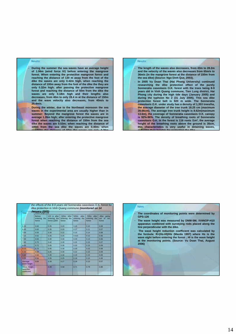
− During the summer the sea waves have an average height of 1.06m (wind force IV) before entering the mangrove forest. When entering the protective mangrove forest and reaching the distance of 130 m away from the foot of the dike the waves are only 0.42m high, when reaching the distance of 100m away from the foot of the dike the they are only 0.32m high; after passing the protective mangrove forest and reaching the distance of 50m from the dike the waves are only 0.18m high and their lengths also decreases, from 40m to only 28.4 m at the distance of 150m and the wave velocity also decreases, from 40m/s to 25.4m/s.
− During the winter, due to the Northeast monsoon the sea waves in the experimental area are usually higher than in summer: Beyond the mangrove forest the waves are in average 1.26m high; after entering the protective mangrove forest when reaching the distance of 150m from the sea dike the waves are 0.53m; when reaching the distance of 100m from the sea dike the waves are 0.40m; when reaching the distance of 50m the waves are only 0 26m
Results:
− The length of the waves also decreases, from 43m to 28.2m and the velocity of the waves also decreases from 65m/s to 36m/s (in the mangrove forest at the distance of 150m from the sea dike) (Source: Ngo Dinh Que, 2003).
− In 2005 Vu Doan Thai (Hai Phong University) continued researching the dike protection effect of the purely Sonneratia caseolasis O.K. forest with the trees being 8-9 years old in Vinh Quang commune, Tien Lung district, HaiPhong city during the high tide days (January 2005) and during the typhoon No 2 (31 July 2005). This sea dike protection forest belt is 920 m wide. The Sonneratiacaseolasis O.K. under study has a density of 1,353 trees/ha, the average diameter of the tree trunk 18.25 cm (maximum 28.66cm). The average tree trunk height is 8.62m(maximum 13.6m), the coverage of Sonneratia caseolasis O.K. canopy is 92%-96%. The density of breathing roots of Sonneratiacaseolasis O.K. in the forest is 116 roots /1m2, the average height of the breathing roots above the ground is 35cm, this characteristics is very useful in detaining waves, reducing their heights for protecting the dike
Results:
the effects of the 8-9 years old Sonneratia caseolasis O.K. forest for dike protection in Vinh Quang commune (monitored on 14 January 2005)
0.880.790.710.580.39Wave height reduction coefficient
0.070.130.180.270.390.64Average wave height
0.060.150.180.250.350.569.00
0.080.150.190.300.450.648.45
0.090.150.220.300.450.688.30
0.080.150.200.300.450.708.15
0.090.150.200.350.450.728.00
0.070.150.200.300.420.707.45
0.060.130.200.300.400.657.30
0.060.120.0150.250.350.627.15
0.080.140.150.220.300.557.00
0.070.110.170.200.350.606.45
0.080.100.150.200.350.606.30
After going out of the forest
720m after entering the forest
520m after entering the forest
320m after entering the forest
120 m after entering the forest 120m
Before entering the forest
Wave height (m)Time − The coordinates of monitoring points were determined by GPS-126
− The wave height was measured by DNW-5M; IVANOP-H10 apparatus combined with surveying rods placed along the line perpendicular with the dike.
− The wave height reduction coefficient was calculated by the formula: R=(Hs-Hl)/Hs (Mazda 1997) where Hs is the wave eight before entering the forest ; Hl is the wave height at the monitoring points. (Source: Vu Doan Thai, August 2006)
Notes

15
− The actual results have proved that for protecting the coast from erosion and sea dike system from collapse and breaking due to strong winds and typhoons we must establish mangrove forest belts beyond the beach near the coast and the dike for detaining the wave. The mangrove forests are" green walls" for protecting the coastal and river mouth areas, limiting the impacts of waves and storm winds (as a highly effective anti-erosion method with low cost)
− But for planting effectively the mangrove forest we must be based on the climatic conditions of each area, the tidal regime, the soil type, soil maturity to select the suitable type of mangrove forest to plant.
− For example: Sonneratia caseolasis O.K. forest can be planted in the river mouth areas with high flow, with high annual variation of the salinity, but the salinity of the water should not exceed 20o and with muddy soil of low maturity (2.5-1.5), etc.
− Following are the natural conditions in terms of soil h t i ti tid l i d il t it f d t i i
VIII.3. Criteria for selecting types of mangrove forest suitable for protection in each area Table 11: Natural distribution characteristics of mangrove forest types in
the coastal area of the Red river delta(Overview of mangrove forests in Vietnam 2005)
<0.61.4-0.72.5-1.5>2.5Soil maturity (n)
Salt submerged soil (with no latent aluminum sulfate)Soil class
�919-1029-2030
Number of tidal
submergence days
Submerged when the tide
is high
Submerged when the tide is moderately high
Submerged when the tide
is low
Submerged when the tide
is very low Tidal regime
Excoecariaagallocha L
KandeliaCandel
Sonneratiacaseolasis
O.K. + KandeliaCandel
Sonneratiacaseolasis
O.K., Sonneratiacaseolasis
O.K. + Aegieras
coriculatumL.Bleo
No mangrove forest
Type of mangrove
forest
Natural distribution characteristics of mangrove forests in Mekong river delta(Overview of mangrove forests in Vietnam 2005)
<0.40.6-0.40.9-0.71.4-1.02.4-1.5�2.5Soil
maturity (n)
Firm clay Compacted clay Clay Soft clay Mud Diluted
mud
Very diluted mud
Soil type
Salt submerged soil with latent aluminum sulfate Salt submerged soil Soil
class
Submerged when the
tide is high and abnormallyhigh in the
year
Submerged when the tide is
high
Submerged when the tide is
moderately high
Submerged when the tide is low
Submerged
when the tide is very
low
Tidal regime
Excoecariaagallocha L, Lumnitzua
sp.
Ceriopssp.Bruguie
ra sp.
Phizophora
apiculataBl.
Avicenniaalba Bl +
Phizophoraapiculata
Bl.
Avicennia alba Bl.
No mangro
ve forest
Type of mangr
ove forest
− The Central coastal zone of Vietnam is being eroded with highestintensity in the whole country due top the following reasons:
− The sea beach is narrow, with relatively high slope − The soil of the coast and the beaches in the Central region is
mainly composed of sand (loose sand, cohesive sand and siltysand). The sand content in the soil is up to �90%, is mainly fine (with particle size 0.25mm – 0.05mm), so it of low consolidation, easily eroded by the action of rising water level and waves.
− The coast is open, directly affected by strong wind, typhoons and tropical cyclones
− The Central coast has up to 286 coastal sections being eroded with the length of eroded coastal sections from 0.5 km to 23km, of which 286 coastal sections are composed of sand (accounting for 93.7% of the total coastal sections being eroded in the Central region)
− Along the coastal tidal flats in the Central region there are almost no natural mangrove forests. There is no possibility to plant protective mangrove forest. (There are natural mangrove forests in some localities, but they are near river mouths, or along channels in the coastal area). According to the results of research and actual production in Vietnam in the last decades (1934 – 2005)
VIII.4. Planting protective forest belts of casuarina, acacia, coconut palm in coastal sections being eroded in the Central region

16
The casuarina is a wood tree species that grow fast in the first period.
It can stand strong wind and can detain well the winds It has a wide and deep root system, which can hold well in the
soil, limiting the erosion of the sandy coast when occur sea water surge, strong wind and high waves.
The casuarina is a tree species imported from Australia, has been planted in many soil types in deltaic and coastal areas of the country. It has proved to have wide ecological range in terms of soil fertility, it can survive in moving sandy soil with very low fertility, can adapt to wide range of soil moisture, from dry sandy soil to soil submerged during a short period.
Although casuarina is not a leguminous plant but its roots have nodules due to symbiotic fungus, which can fix N from the atmosphere, thus increasing the fertility of the sandy soil.
The casuarina timber has many uses serving directly the life of the people in the coastal areas, especially as firewood.
In the last period, the Vietnam Institute of Forestry has investigated 52 varieties of casuarina and has selected some important origins suitable for each coastal area of Vietnam with different climatic and land conditions as follows:
+ Besides some important varieties of casuarina planted widely in Vietnam, recently a new variety has been imported from China, which has proved to grow fast, with straight trunk and less branches in comparison with other common varieties..
+ For the coastal area with semi-arid climate, with low annual rainfall 750mm-1100mm/year (Ninh Thuan – Binh Thuanprovinces) the casuarina of variety 6166 (from Danger Australia) has been selected, which is fairly suitable.
+ Besides casuarina forest belts we can plant acacia forest belts consisting of Acacia auriculiformis, Acacia crassicarpa) and draught resistant acacias (Acacia difficilis, Acacia tumida) (Prof. Dr. Le Dinh Kha, 1998)
+ Finally in the semi-arid tropical areas we can plant also
+ The sandy soil in the coastal areas near river mouths is mixed with alluvium, having high fertility, therefore we can plant casuarina forest belts alternated with coconut palm forest belts)
+ The density of the coastal erosion preventing casuarinaforest belts is relatively high from 5000 tree/ha to 10,000 trees/ha. Before and after the canopy closure we should preserve or plant grasses deep and wide root systems such as Frimlristylis sericeac, Sciripus gumaformis Eragrotis sp, Cymbopogon cacsins, etc., to enhance the erosion control capacity of these coastal protection forest belts.
− Implementing the National level research project "Assessment of earthquake and tsunami risks in the coastal zone of Vietnam", the scientists of the Institute of Geophysics - VAST (Nguyen DinhXuyen, Pham Van Thuc et al., 2004 - 2005) carried out a field survey at 33 points from Mong Cai to Ca Mau, which shows that the whole coastal zone of Vietnam is subjected to great impacts of waves and storms. The wave height can reach 10 m, commonly 5 m. High storm waves usually break sea dikes, sweep away houses, cause inundation and kill many people. Depending on the coastal topography, the sea water can invade 1 to 3 km inland, with depth 4 - 5m. Besides storm waves, tides, surges, in 1978 tsunami appeared in Tra Co, Mong Cai (Quang Ninh province) with wave height from 3 to 5 m. The wave was of meteorological origin.
− Besides, in 1923, 1960, 1963, 1991, tsunami has occurred in someareas of South Central and Southern regions of Vietnam due to the activities of Hon Tro volcano (in Phu Quy islands).
IX. Tsunami risk in the coastal zone of Vietnam
17
− The study of earthquakes in the subduction zone in the West of the Philippines and in the East sea show that earthquakes here are characterized by the magnitude of 5 in Richter occurring once every 3 years, 5.5 once every 7, over 6 once in 20 years, over 6.5 once every 60 years. The maximum earthquake is forecast to be ofmagnitude 7 in Richter scale.
− The earthquake frequency in the sea area of Vietnam is much lower than the East sea as a whole, only equal 1/20 thereof. It is also much lower than the recurrence frequency of earthquakes in the main land, equal only 1/2 thereof.
− Although during the earthquakes in the West of the Philippines no tsunamis have been discovered in the coastal zone Vietnam, but these zones must be considered as a source of tsunami threatening the coastal zone of Vietnam.
− According to the forecast by Pham Van Thuc, who has investigated tsunamis in Vietnam for many years, if tsunamis occurs in subduction zones in the West of the Philippines the time it takes for the waves to be transmitted to Nha Trang, Vietnam is 2 hours 12 minutes, with wave height 1.5 m, to the coast of the Red
− river delta is 5 hours 30 minutes, with wave height 2 m, to the coast of Mekong river delta is 5 hours 25 minutes, with wave height of 4 m.
− According to Nguyen Dinh Xuyen, in the East Vietnam coastal zone there are two sources of tsunami. The first is the fault zone running along the meridian 109 - 110 near the coast of Vietnam. In this zone there is a possibility to generate earthquake and volcanoes. Here earthquakes reach maximum magnitude 6.1 ± 0.3 in Richter scale, with displacement being mainly strike-slip, therefore they do not cause big tsunamis..
− Volcanic activities in the above fault zone only cause earthquakes up to magnitude 7 within a small area, without causing big tsunamis. The maximum volcanic eruption occurred in 1923 on Phu Quy island, causing earthquake of magnitude 7, however only a small tsunami was generated in the coastal zone of Vietnam.
− The second tsunami source is the subduction zone in the West of the Philippines, here earthquakes may reach magnitude 8.5 in Richter scale (according to the Philippine specialists). According to some New Zealand specialists earthquake here can reach magnitude 8.8 in Richter scale.
− According to Nguyen Ngoc Thuy (Director of the Institute of Geophysics) actually strong earthquakes of magnitude 7.4 - 8.5 in Richter scale have occurred many times in the subductionzone in the West of the Philippines, many of which have caused tsunamis, but no clear impacts on the coast of Vietnam have been seen.
− Using the tsunami simulating models being used world wide, the Vietnamese scientists Assoc. Prof. Vu Quang Ca, Institute of Meteorology and Hydrology); MSc. Pham Quang Hung, Institute of geophysics) have calculated for the case of the maximum earthquake of magnitude 9 in Richter scale. The results show that in this case tsunamis with wave height of 3 - 5 m will reach the coast of Vietnam 2 hours after the earthquake.
− Historical documents have recorded the volcanic earthquakes in Binh Thuan offshore area in 1877 and 1882 causing high waves. However, those documents do not record the impacts on the coast caused by the earthquake, and only describe that due to the earthquake the tile-roof houses were strongly vibrated.
− In the future sedimentation and erosion will continue to occur with high intensity. The erosion center tends to move Southwards. Based on the actual field data, remote sensing method, digital modeling method, the authors have forecast the trend of coastal sedimentation and erosion, with the results as follows:
X. Forecasting coastal erosion in Vietnam to the year 2010 and 2020(According to Pham Huy Tien et al., 2005)

18
− - Northern region:− + Dinh Vu island area: The erosion process will continue, with
the tendency of moving and increasing the intensity towards the NE coast, while the Western coast will tend to be dominated by sedimentation.
− + SW area of Do Son peninsula: sedimentation will continue for 5 - 10 years. Then the average coast line will be 500 - 600 m from the present one, the 0 m line in the chart will be move seaward 600 - 700 m. In 20 years the rate of sedimentation will decrease. In 50 years the average coast line will reach near theVan Huong bay.
− + Balat rivermouth area: The flood plain willcontinue to expand, the river moth willcontinue moving North, the low tidal flat on the two sides of the river mouth will be built up by sedimentation into a high tidal flat.
− + Day rivermouth area: In about 15 - 20 years, the average sea level line will reach the 1.1 m/0 m line of the present chart, and the area of the isle emerging above the average sea level will increase by 3000 ha toward the SW.
− - Central region:− In general the erosion and sedimentation trends in the Central
region do not any abrupt changes in extent, and rate. In particular erosion intensity will slightly increase.
− + The coastal section from Thuan An to Hoa Duan will still be an erosion center, it will extended further in NW and erosion will be of high intensity in the SE, the average intensity will be 12, 25, 38% higher than the present one in 2020, 2050, 2100.
− + Erosion in the Sa Huynh key area will continue expand in SW direction with intensity equivalent to the present one. After 2010 when erosion has reached a critical limit, it will stop and the coast will be in the equilibrium state, then will occur alternated erosion and sedimentation with small rate.
− + The coastal erosion in Phu Yen will continue increasing in extent and intensity in Phu Hanh, Phu Son, Phu Quang, PhuHiep, An Nhon, and Tuy Hoa town areas. In particular in the Xuan Hai key area, collapses will move SE with intensity increasing by 11.5%, 18% and 29% in 2020, 2050 and 2100 respectively.
− - Southern region: − + Coastal erosion in East Go Cong will continue increasing in
intensity to 2020, then decrease gradually.− - The research project has established a procedure for
forecasting coastal and river mouth erosion and sedimentation for some key areas.
− The Eastern coast will be intensively eroded during the NE monsoon, while the Western coast of the South will be eroded intensively during the SW monsoon and especially during the high tide period.
− The interaction between sedimentation and erosion will be different along the coast. The province with largest sedimentation area is Ca Mau, the provinces with largest coastal and rivermouth areas lost erosion are Ho Chi Minh city and Tra Vinh.
− The total area of land built up by sedimentation in the coastal and river mouth areas of the South is more than the total land area lost by erosion 14,019 versus 10,915.6 ha (with difference 3104.1 ha).
− As already known, coastal erosion is a very complicated problem. The causes of coastal erosion are diverse. To propose effective measures for preventing and controlling coastal erosion and coast protection, we are required to understand and evaluate the causes of erosion for each particular area and coastal section.
− It is necessary to combine effectively the engineering and non-engineering measures, of which the planting of mangrove forests and casuarina forests in the coastal zone is very important.
− In the case engineering measures must be used, it is necessary to base on firm scientific grounds not to cause erosion and destruction of the ecosystems of the neighboring coasts. Engineering measures first of all must be concentrated in the key areas being seriously eroded: Cat Hai (Hai Phong),Hai Hau(Nam Dinh), Hai Duong – Hoa Duan (Thua Thien – Hue), MuiNe (Binh Thuan), Go Vap (Tien Giang), Ganh Hao (Ca Mau).
XI. Proposing measures for preventing and controlling coastal erosion

19
− Coastal erosion in Vietnam is a natural hazard that occurs frequently and causes not small harms to the life of the people and the socio-economic development.
− For effective prevention of coastal erosion, it is necessary to study and exact evaluation of the mechanism and causes of erosion of each coastal section, whereby to propose measures suitable with thetechnical and economic conditions of Vietnam.
− Practical experiences have indicated that areas with mangrove forests planted according to technical specifications can very effectively detain sea waves and prevent erosion. On the other hand, the investment for planting mangrove forest is less than other measures, especiallyengineering measures.
− For the coastal sections being eroded in the Central region of Vietnam, planting of casuarina, acacia and coconut palm forests is more suitable than mangrove forests.
− According to the evaluation by scientists, the risk of tsunami occurrence in the coastal zone of Vietnam is not high.
− To prevent and mitigate the adverse impacts which may occur due to the coastal erosion in the coastal zone of Vietnam, there must be adequate investment from the Government of Vietnam together withthe international cooperation in the region for researching and construction of tsunami warning stations in the coastal zone
CONCLUSION
Radiant KalidascopeYour Subtitle Goes Here
Your Topic Goes HereYour subtopic goes here
Transitional Page

20
Your Topic Goes HereYour subtopic goes here
Elementswww.animationfactory.com