statutory planning committee
TRANSCRIPT
Please convey apologies to Christina Sanders on 6551-9053 or email [email protected]
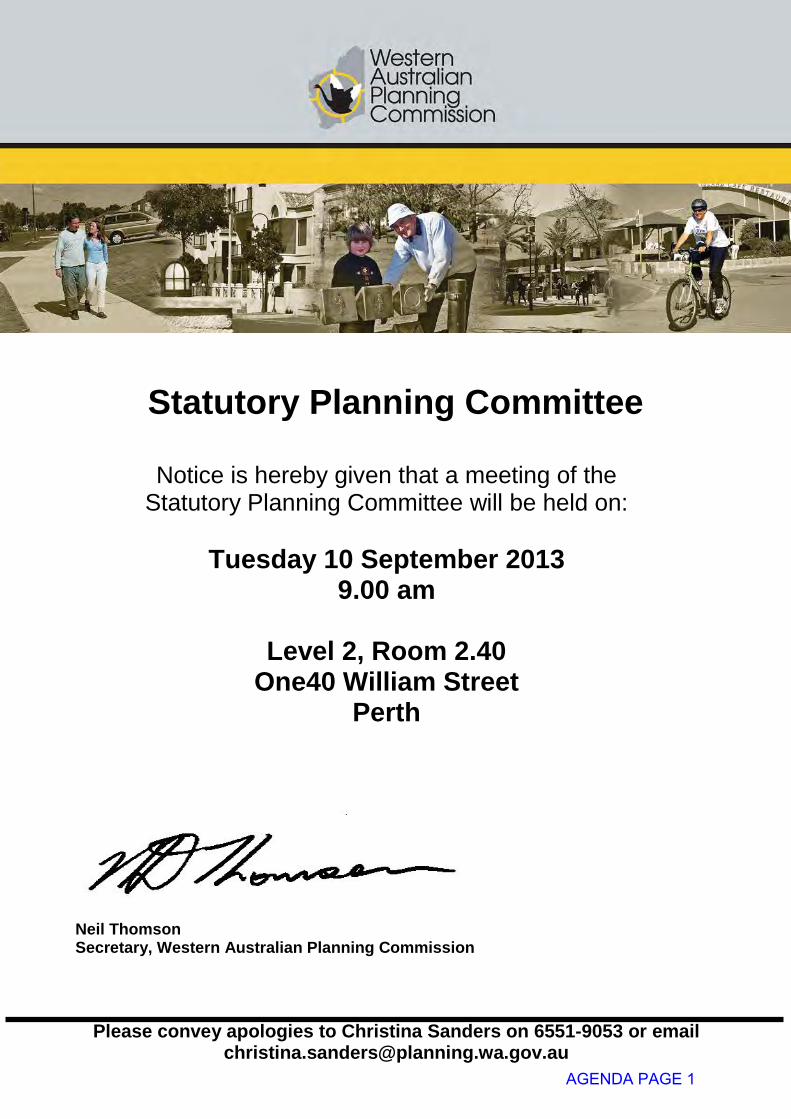
Statutory Planning Committee
Notice is hereby given that a meeting of the
Statutory Planning Committee will be held on:
Tuesday 10 September 2013 9.00 am
Level 2, Room 2.40
One40 William Street Perth
Neil Thomson Secretary, Western Australian Planning Commission
AGENDA PAGE 1
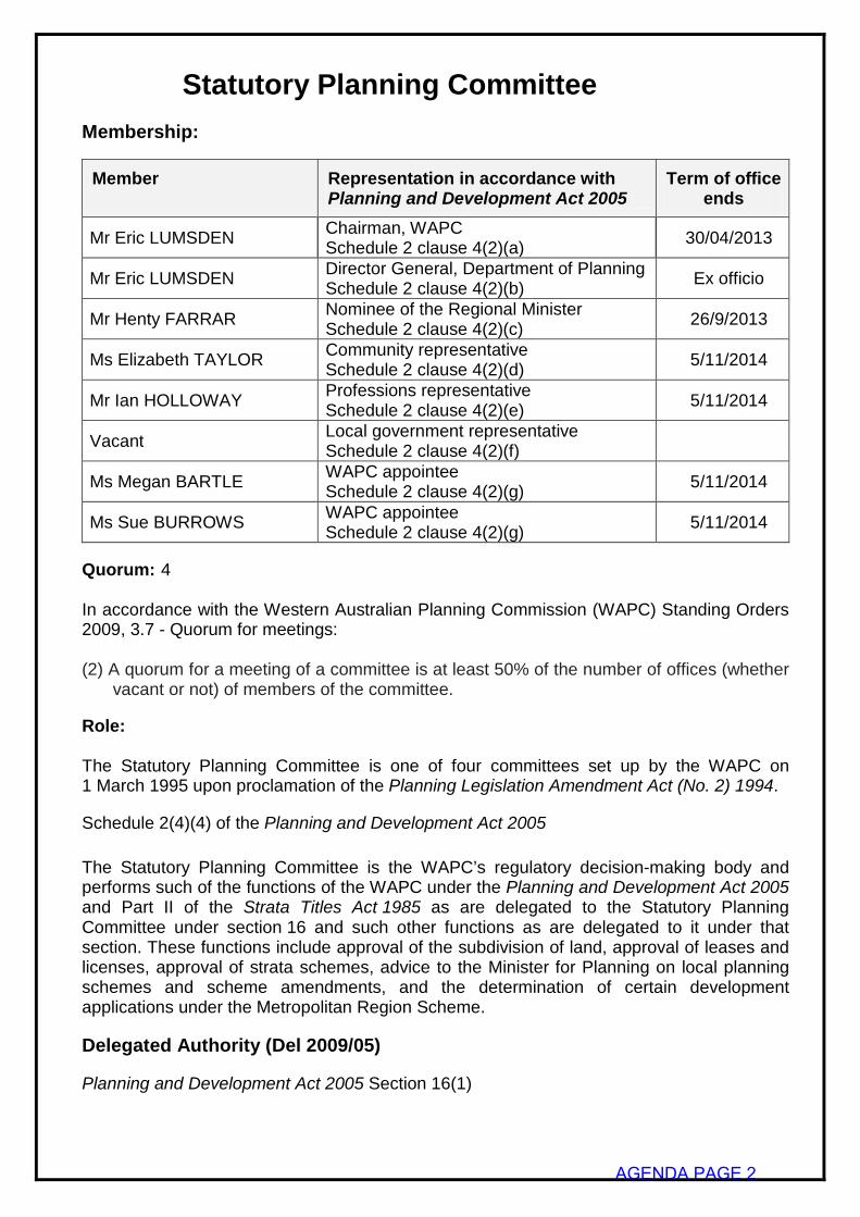
Statutory Planning Committee
Membership:
Member Representation in accordance with Planning and Development Act 2005
Term of office ends
Mr Eric LUMSDEN Chairman, WAPC Schedule 2 clause 4(2)(a) 30/04/2013
Mr Eric LUMSDEN Director General, Department of Planning Schedule 2 clause 4(2)(b) Ex officio
Mr Henty FARRAR Nominee of the Regional Minister Schedule 2 clause 4(2)(c) 26/9/2013
Ms Elizabeth TAYLOR Community representative Schedule 2 clause 4(2)(d) 5/11/2014
Mr Ian HOLLOWAY Professions representative Schedule 2 clause 4(2)(e) 5/11/2014
Vacant Local government representative Schedule 2 clause 4(2)(f)
Ms Megan BARTLE WAPC appointee Schedule 2 clause 4(2)(g) 5/11/2014
Ms Sue BURROWS WAPC appointee Schedule 2 clause 4(2)(g) 5/11/2014
Quorum: 4 In accordance with the Western Australian Planning Commission (WAPC) Standing Orders 2009, 3.7 - Quorum for meetings: (2) A quorum for a meeting of a committee is at least 50% of the number of offices (whether
vacant or not) of members of the committee. Role: The Statutory Planning Committee is one of four committees set up by the WAPC on 1 March 1995 upon proclamation of the Planning Legislation Amendment Act (No. 2) 1994.
Schedule 2(4)(4) of the Planning and Development Act 2005
The Statutory Planning Committee is the WAPC’s regulatory decision-making body and performs such of the functions of the WAPC under the Planning and Development Act 2005 and Part II of the Strata Titles Act 1985 as are delegated to the Statutory Planning Committee under section 16 and such other functions as are delegated to it under that section. These functions include approval of the subdivision of land, approval of leases and licenses, approval of strata schemes, advice to the Minister for Planning on local planning schemes and scheme amendments, and the determination of certain development applications under the Metropolitan Region Scheme.
Delegated Authority (Del 2009/05)
Planning and Development Act 2005 Section 16(1)
AGENDA PAGE 2
2.1 Power to determine applications for approval to commence and carry out development lodged with or referred to the WAPC pursuant to the provisions of a region scheme.
2.2 Power to approve detailed plans requiring the subsequent approval of the WAPC as a
condition of development approval pursuant to the provisions of a region scheme and power to confirm that conditions imposed by the WAPC on a development approval pursuant to the provisions of a region scheme have been complied with.
2.3 Power to determine whether or not proposals and the ongoing implementation of a
region scheme comply with conditions (if any) applied pursuant to sections 48F and 48J of the Environmental Protection Act 1986.
2.4 Power to determine whether or not applications to commence and carry out
development are of State or regional importance, or in the public interest, pursuant to any resolution of the WAPC made under a region scheme requiring such determination.
2.5 Power to request the Minister for Planning to approve the WAPC disregarding the
advice of the Swan River Trust in whole or in part in relation to the approval of development of land within the Riverbank or Development Control Area as defined under the Swan and Canning Rivers Management Act 2006 where the determining authority is the WAPC.
2.6 All functions of the WAPC as set out in - (i) Sections 14(a), 14(c), 34, 97, 98, 100, 104, 105, 106, 107, 109, 110, 111, 134,
135, 136, 138, 139, 140, 142, 143, 144, 145, 147, 151, 153, 154, 157, 169, 185, 214, 215, 216 of the Act;
(ii) Town Planning Regulations 1967; (iii) Regulations 21, 22, 24 and 27 of the Planning and Development Regulations
2009; (iv) Strata Titles Act 1985 or the provisions of a strata or survey-strata scheme; (v) Strata Titles General Regulations 1996; (vi) Section 52 and section 85 of the Land Administration Act 1997; (vii) Section 40 of the Liquor Control Act 1988; (viii) Perry Lakes Redevelopment Act 2005. 2.7 Power to determine requests for variations to plans of subdivision where WAPC
approval is required pursuant to the provisions of an approved local planning scheme. 2.8 Power to provide comment on and grant approval to plans known generally as outline
development plans, structure plans and similar plans, and to planning policies and similar documents or amendments thereto, requiring the approval or endorsement of the WAPC pursuant to the provisions of a local planning scheme.
2.9 Power to provide comments or advice on behalf of the WAPC to a local government or
a redevelopment authority where a provision of a local planning scheme or a redevelopment scheme requires comments from the WAPC.
2.10 Power to execute and accept the benefit of easements in gross, covenants in gross,
records on title and other instruments for dealings in land for subdivisions, strata subdivisions and developments in accordance with any applicable policy and legislation.
AGENDA PAGE 3
2.11 Power to make recommendations to the Minister for Planning in relation to requests from local governments to expend monies paid by subdividing land owners in lieu of setting aside free of cost to the Crown, areas of land for public open space, where such recommendations are in accordance with WAPC policy.
2.12 Power to determine whether or not a proposal is likely to have a significant effect on
the environment pursuant to section 38(1) of the Environmental Protection Act 1986 and to refer such proposal to the Environmental Protection Authority.
2.13 Power to waive or clear conditions affixed as conditions of approval. 2.14 Power to endorse diagrams and plans of survey and deposited plans involving the
acquisition and resumption of land created pursuant to Part 11 of the Act and the Land Administration Act 1997.
2.15 Power to advise the Minister for Planning on any appeal or matter arising therefrom
pursuant to Part 14 of the Act. 2.16 Power to defend and otherwise deal with applications for review lodged with the State
Administrative Tribunal and to appeal, defend, respond and otherwise deal with any matter that may be appealed to the Supreme Court on a question of law.
2.17 Power to defend, respond, appeal and otherwise deal with legal proceedings. 2.18 Power to prepare and approve, subject to the prior approval of the Minister for
Planning, policies relating to planning matters and/or the functions of the WAPC, save and except for State Planning Policies under Part 3 of the Act.
2.19 Power to determine matters under Regional Interim Development Orders. 2.20 Such powers and functions of the WAPC as set out in-
(i) Part 5 of the Act; (ii) Town Planning Regulations 1967 as are necessary for the preparation, promulgation and the making of recommendations in relation to the Improvement Scheme authorised by Improvement Plan No. 37 for the Browse Liquefied Natural Gas Precinct.
This meeting is not open to members of the public.
AGENDA PAGE 4
RELEVANT INFORMATION FOR MEMBERS Disclosure of interests In accordance with the Planning and Development Act 2005 and Part 6 of the Standing Orders 2009, members of Committees (and certain employees) are required to disclose the following types of interests that they have or persons closely associated to them, have:
• direct and indirect pecuniary interests (financial);
• proximity interests (location); and
• impartiality interests (relationship).
A “direct pecuniary interest” means a relevant person’s interest in a matter where it is reasonable to expect that the matter if dealt with by the board or a Committee, or an employee in a particular way, will result in a financial gain, loss, benefit or detriment for the person.
An “indirect pecuniary interest” means a relevant person’s interest in a matter where a financial relationship exists between that person and another person who requires a board or Committee decision in relation to the matter.
A “proximity interest” means a relevant person’s interest in a matter if the matter concerns -
(i) a proposed change to a planning scheme affecting land that adjoins the person’s land;
(ii) a proposed change to the zoning or use of land that adjoins the person’s land; or
(iii) a proposed development, maintenance or management of the land or of services or facilities on the land that adjoins the person’s land.
An “Impartiality interest” means an interest that could, or could reasonably be perceived to, adversely affect the impartiality of the member having the interest and includes an interest arising from kinship, friendship, partnership or membership of an association or an association with any decision making process relating to a matter for discussion before the board or a Committee.
Members disclosing any pecuniary or proximity interests for an item can not participate in discussion or the decision making procedure relating to the item and must leave the meeting room during the discussion of the item. Members disclosing an impartiality interest in an item must also leave the room during the discussion or the decision making procedure relating to the item unless the Committee, by formal resolution, allows the member to remain. The reason to allow a member to remain must be stated in the formal resolution and will be minuted.
Disclosure of representations Where a member has had verbal communication with or on behalf of a person with an interest in a matter which is before a meeting, the member is to disclose the interest.
Where a member is in receipt of relevant written material (including email) from or on behalf of a person with an interest in a matter which is before a meeting, the member is to table the material at the meeting for the information of members and relevant employees.
AGENDA PAGE 5
O R D E R O F B U S I N E S S 1. Declaration of opening
2. Apologies
3. Members on leave of absence and applications for leave of absence • Ms Sue Burrows
4. Disclosure of interests
5. Declaration of due consideration
6. Deputations and presentations
7. Announcements by the Chairperson of the board and communication from the WAPC
8. Confirmation of minutes of the meeting of 27 August 2013
9. Reports (see attached index of reports)
10. Confidential items (see attached index of reports)
11. General business
12. Items for consideration at a future meeting
Item No Report Request Report Required by
7477.11.1 The Wheatbelt – Towns of York and Toodyay
To request Committee Support to arrange a site visit with regard to water and bush fire issues and in relation to future approvals for rural living subdivisions due to lack of water resources, and a possible need for consolidation of the local towns. (to be combined with 7477.11.2) (Subsequently resolved on 28/5/13 to hold the site visit on a date when a cancelled SPC meeting would occur)
8/10/2013
AGENDA PAGE 6
7477.11.2 Avon Arc Study To request Committee Support to invite Avon Arc to advise the Committee on issues such as sustainability, identifying priority areas, royalties for regions and capability. (to be combined with 7477.11.1) (as above)
8/10/13
7477.11.3 Private Arrangements for obtaining money for public open space by agreement
To request the Department to prepare a report to the WAPC regarding these types of arrangements.
10 / 9 / 13
7482.9.1 Update of Planning Bulletin 67: Guidelines for Wind Farm Development
To request the Department to liaise with the Department of Lands and the Department of Agriculture and consult with departments and the statutory planning section to ascertain whether there are any further refinements required to the policy. To incorporate comments from SPC members and to represent the policy to a future SPC meeting.
24 / 9 / 13
13. Closure - next meeting to be held on 24 September 2013
AGENDA PAGE 7

Statutory Planning Committee
Minutes of ordinary meeting 7487 held on Tuesday, 27 August 2013
Page 1 of 34
Attendance
Members Ms Megan Bartle WAPC appointee Ms Sue Burrows WAPC appointee Ms Elizabeth Taylor Community representative (Presiding Member) Mr Neil Thomson Acting Director General, Department of Planning Officers Department of Planning Ms Natalie Cox Planning Manager, Perth and Peel Planning
(Item 10.1) Mr Rob Cull Senior Planning Officer, Perth and Peel Planning
(Items 10.3, 10.4 and 10.5) Mr Jas Lapinski Senior Planning Officer, Perth and Peel Planning
(Item 9.1) Ms Kym Petani Acting Director Metro North East, Perth and Peel
Planning Mr Mat Selby Planning Director, Perth and Peel Planning
(Item 9.7) Mr Craig Shepherd Planning Manager, Perth and Peel Planning
(Item 9.3) Mr Emille van Heyningen Planning Manager, Perth and Peel Planning (Item 10.9) Mr Alex Watson Planning Officer, Perth and Peel Planning (Item 10.9) Observers Ms Amanda Butterworth Allerding and Associates (item 6.1 – refers Item 9.1) Mr Trevor Robb Telstra Corporation (item 6.1 – refers Item 9.1) Mr Max Baumwol (item 6.2 – refers Item 9.1) Mr Tamas Fonda Onslow Park Tennis Club (Item 6.3 – refers Item 9.6) Mr Robert Cole Progress Developments (item 6.5 – refers Item 10.5) Mr Simon Munckton Dayton Property Group (item 6.5 – refers Item 10.5) Mr John Elliott City of Swan (item 6.5 – refers Item 10.4, 10.5 and 10.6)
Uncon
firmed
AGENDA PAGE 8
Statutory Planning Committee
Minutes of ordinary meeting 7487 held on Tuesday, 27 August 2013
Page 2 of 34
Presenters Mr Steve Allerding Allerding and Associates (item 6.1 – refers Item 9.1) Mr Kevin Jardine Consultant to Telstra Corporation
(item 6.1 – refers Item 9.1) Mr Phil van Leen Telstra Corporation (item 6.1 – refers Item 9.1) Mr Peter Goff MGA Town Planners (item 6.2 – refers Item 9.1) Mr James Edwards Onslow Park Tennis Club (item 6.3 – refers Item 9.6) Mr Steve Allerding Allerding and Associates (Item 6.4 – refers Item 10.2) Mr Brett Jackson Kareelya Property Group (item 6.4 – refers Item 10.2) Mr Mark Szabo Burgess Design Group (item 6.5 – refers Item 10.5) Mr Colin Cameron City of Swan (item 6.5 – refers Items 10.4, 10.5 and 10.6) Mr Philip Russell City of Swan (item 6.5 – refers Items 10.4, 10.5 and 10.6) Mayor Charlie Zannino City of Swan (item 6.5 – refers Items 10.4, 10.5 and 10.6) Committee Support Ms Christina Sanders Committee Support Officer - Department of Planning Due to the absence of the Presiding Member and in accordance with clause 3.6 of the Standing Orders 2009, a member was chosen to preside over the meeting. Ms Bartle nominated Ms Taylor. Ms Taylor accepted the nomination. Resolved Moved by Ms Bartle, seconded by Ms Burrows That Ms Taylor preside over the meeting of the Statutory Planning Committee in the absence of the Presiding Member.
The motion was put and carried. 7487.1 Declaration of Opening
The Presiding Member declared the meeting open at 9.02 am, acknowledged the traditional owners and custodians of the land on which the meeting is taking place and welcomed Members.
7487.2 Apologies
Mr Henty Farrar Nominee of the Regional Minister
Uncon
firmed
AGENDA PAGE 9
Statutory Planning Committee
Minutes of ordinary meeting 7487 held on Tuesday, 27 August 2013
Page 3 of 34
7487.3 Members on Leave of Absence and Applications for Leave of Absence
Messrs Holloway and Lumsden have previously been granted leave of absence for the SPC meeting scheduled for 27 August 2013. Ms Burrows has previously been granted leave of absence for the SPC meetings scheduled between 2 September and 14 October 2013.
7487.4 Disclosure of Interests
Member/Officer Minute No. Page No. Nature of Interest Mr Neil Thomson All items 1-45 Impartiality Resolved
Moved by Ms Taylor, seconded by Ms Bartle In accordance with clause 6.10(7) of the Standing Orders
2009, members of the Statutory Planning Committee agree that the member listed above, who has disclosed an impartiality interest, is permitted to participate in discussion and voting on the items as the interest is insignificant and is unlikely to influence Mr Thomson’s conduct in relation to the matters.
The motion was put and carried. 7487.5 Declaration of Due Consideration
No declarations were made. 7487.6 Deputations and Presentations
7487.6.1 Adoption of Proposed Amendment 3 to the East Wanneroo Cell 9 – East Landsdale Local Structure Plan No. 57 (refer Report 9.1)
Presenters Mr Steve Allerding Mr Kevin Jardine Mr Phil van Leen Messrs Allerding, Jardine and van Leen gave a powerpoint
presentation on the adoption of proposed Amendment 3 to the East Wanneroo Cell 9 – East Landsdale Local Structure Plan No. 57. A copy of the presentation has been placed on file.
Uncon
firmed
AGENDA PAGE 10
Statutory Planning Committee
Minutes of ordinary meeting 7487 held on Tuesday, 27 August 2013
Page 4 of 34
Moved to item 6.4. 7487.6.2 Adoption of Proposed Amendment 3 to the East
Wanneroo Cell 9 – East Landsdale Local Structure Plan No. 57 (refer Report 9.1)
Presenter Mr Peter Goff Mr Goff gave a powerpoint presentation on the adoption of
proposed Amendment 3 to the East Wanneroo Cell 9 – East Landsdale Local Structure Plan No. 57. He also referred to his letter of 22 August 2013 to Mr Lumsden, a copy of which had been circulated to members prior to the meeting. Copies of the letter and presentation have been placed on file.
7487.6.3 Additional Use for the Operation of a Child Care Centre
at the Onslow Park Tennis Club (Lot 312 – No. 85-99) Onslow Road, Shenton Park (refer Item 9.6)
Presenter Mr James Edwards Mr Edwards gave a powerpoint presentation on the
additional use for the operation of a Child Care Centre at the Onslow Park Tennis Club, Shenton Park and tabled a letter from the Onslow Park Tennis Club dated 15 August 2013. Copies of the letter and presentation have been placed on file.
Moved to Item 6.5. 7487.6.4 City of Busselton Local Planning Scheme Amendment
No. 162 – For Final Determination (refer Item 10.2) Presenter Mr Steve Allerding Mr Brett Jackson Messrs Allerding and Jackson gave a powerpoint
presentation in support for proposed Scheme Amendment No. 162 Broadwater Resort Rezoning.
Mr Allerding tabled handout notes to SPC members
regarding Broadwater Bungalows, Shire of Busselton Scheme Amendment 162, which had been forwarded to members prior to the meeting.
Uncon
firmed
AGENDA PAGE 11
Statutory Planning Committee
Minutes of ordinary meeting 7487 held on Tuesday, 27 August 2013
Page 5 of 34
Copies of the presentation and handout notes have been placed on file.
Moved to Item 6.2. 7487.6.5 City of Swan Local Planning Scheme Amendment No.
58 – For Final Approval (refer Item 10.5) Presenters Mr Mark Szabo Mr Robert Cole Mr Simon Munckton Messrs Szabo, Cole and Munckton gave a powerpoint
presentation on the City of Swan Local Planning Scheme Amendment No. 58 and tabled copies of the presentation for members’ interest. A copy of the presentation has been placed on file.
7487.6.6 City of Swan Local Planning Scheme Amendment No.
58 – For Final Approval (refer Items 10.4, 10.5 and 10.6) Presenters Mayor Charlie Zannino Mr Colin Cameron Mr Philip Russell Messrs Zannino, Cameron and Russell gave a powerpoint
presentation on the City of Swan Local Planning Scheme Amendment Nos. 57, 58 and 59 and referred members to a letter addressed to SPC members that had been circulated to them prior to the meeting. Copies of the letter and presentation have been placed on file.
7487.7 Announcements by the Chairperson of the Board and
communication from the WAPC
Nil. 7487.8 Confirmation of Minutes
7487.8.1 Minutes of the Statutory Planning Committee meeting held on Tuesday, 23 July 2013
Ms Burrows advised that she had previously applied for a
leave of absence at the SPC meeting of 9 July for the SPC meetings to be held between 2 September and 14 October 2013, which had not been reflected in the Minutes of 23 July 2013.
Uncon
firmed
AGENDA PAGE 12
Statutory Planning Committee
Minutes of ordinary meeting 7487 held on Tuesday, 27 August 2013
Page 6 of 34
Resolved
Moved by Ms Burrows, seconded by Ms Bartle 1. That the minutes of the meeting held on
Tuesday 23 July 2013 be amended to show a leave of absence for the Statutory Planning Committee meetings to be held between 2 September and 14 October 2013;
2. That the minutes of the Statutory Planning
Committee meeting held on Tuesday, 23 July 2013 as amended, be confirmed as a true and correct record of the proceedings.
The motion was put and carried. 7487.9 Reports
Members agreed to discuss items 9.1, 9.2, 9.6, 9.10, 9.13, 10.2, 10.4, 10.5 and 10.6. All remaining items to be endorsed en bloc.
Resolved
Moved by Ms Burrows, seconded by Mr Thomson That the Western Australian Planning
Commission resolves en bloc Items, 9.3-9.5, 9.7-9.9, 9.11-9.12, 10.1, 10.3, 10.7-10.14.
The motion was put and carried. 7487.9.1 Adoption of Proposed Amendment 3 To The East
Wanneroo Cell 9 - East Landsdale Local Structure Plan No. 57
File SPN/0124M-2 Report Number SPC/473 Agenda Part C Reporting Officer Senior Planning Officer Metropolitan
Northwest
Uncon
firmed
AGENDA PAGE 13
Statutory Planning Committee
Minutes of ordinary meeting 7487 held on Tuesday, 27 August 2013
Page 7 of 34
Resolved
Moved by Ms Taylor, seconded by Ms Burrows That the Western Australian Planning
Commission resolves to: 1. refuse to adopt proposed Amendment 3 to
East Wanneroo Cell 9 - East Landsdale Structure Plan No. 57 for the following reasons:
1.1 the proposal will increase
radiofrequency interference which will result in an adverse impact on the operations of the Perth International Telecommunications Centre;
1.2 the proposal does not provide for an
orderly and equitable distribution of residential density throughout the East Wanneroo Cell 9 - East Landsdale Local Structure Plan No. 57 area;
1.3 the proposal to allocate residential
density and control subdivision through Detailed Area Plans would fetter the role and authority of the Western Australian Planning Commission;
2. advise the City of Wanneroo of its decision
accordingly.
The motion was put and carried. 7487.9.2 Subdivision of Lot 602 Hale Road, Forrestfield to Create
Two Lots – Shire of Kalamunda File 147249 Report Number SPC/474 Agenda Part C Reporting Officer Planning Officer, Metropolitan Planning
North East, Perth and Peel Planning Officer’s Recommendation That the Western Australian Planning
Commission resolves to refuse the application
Uncon
firmed
AGENDA PAGE 14
Statutory Planning Committee
Minutes of ordinary meeting 7487 held on Tuesday, 27 August 2013
Page 8 of 34
for subdivision of Lot 602 Hale Road, Forrestfield as shown on the plan date-stamped 24 December 2012, for the following reasons: 1. The proposed subdivision is contrary to
orderly and proper planning by reason that it does not provide sufficient and appropriate vehicular access to the proposed lots.
2. Approval to the subdivision would create
an undesirable precedent for the further creation of battleaxe lots of a similar nature.
3. The proposed subdivision does not comply with Development Control Policy 1.1 - Subdivision of Land - General Principles by reason that it would create lots that are deemed not to provide suitable vehicular access to a constructed public road.
ADVICE TO APPLICANT: 1. The Western Australian Planning
Commission considers the formalisation of Woolworths Drive as a public road as necessary for the further subdivision and development of the application area. Subdivision of the land prior to this taking place would prejudice the process of creating the public road reserve. The applicant is advised to liaise with the Shire of Kalamunda with regard to this matter.
Members discussed this item and resolved to approve the
application subject to a condition of reciprocal access and an advice note to the applicant to progress dialogue with the Shire of Kalamunda for Woolworths Drive to become a dedicated road.
Resolved
Moved by Mr Thomson, seconded by Ms Bartle That the Western Australian Planning
Commission resolves to approve the application for subdivision of Lot 602 Hale Road,
Uncon
firmed
AGENDA PAGE 15

Statutory Planning Committee
Minutes of ordinary meeting 7487 held on Tuesday, 27 August 2013
Page 9 of 34
Forrestfield as shown on the plan date-stamped 24 December 2012, subject to the following conditions:
CONDITIONS
1. Engineering drawings and specifications
are to be submitted, approved, and works undertaken in accordance with the approved engineering drawings, specifications and approved plan of subdivision, for grading and/or stabilisation of the site to ensure that:
a) lots can accommodate their
intended use; and b) finished ground levels at the
boundaries of the lot(s) the subject of this approval match or otherwise coordinate with the existing and/or proposed finished ground levels of the land abutting. (Local Government)
2. The land being filled, stabilised, drained
and/or graded as required to ensure that
a) lots can accommodate their intended development; and
b) finished ground levels at the boundaries of the lot(s) the subject of this approval match or otherwise coordinate with the existing and/or proposed finished ground levels of the land abutting; and
c) stormwater is contained on-site, or
appropriately treated and connected to the local drainage system (Local Government)
3. Prior to the commencement of
subdivisional works, the landowner/ applicant is to provide a pre-works geotechnical report certifying that the land is physically capable of development or advising how the land is to be remediated and compacted to ensure it is capable of development; and
Uncon
firmed
AGENDA PAGE 16
Statutory Planning Committee
Minutes of ordinary meeting 7487 held on Tuesday, 27 August 2013
Page 10 of 34
In the event that remediation works are
required, the landowner/applicant is to provide a post geotechnical report certifying that all subdivisional works have been carried out in accordance with the pre-works geotechnical report. (Local Government).
4. The proposed access way(s) being
constructed and drained at the landowner/applicant's cost to the specifications of the local government. (Local Government)
5. Suitable arrangements being made with
the local government for the provision of vehicular crossover(s) to service the lot(s) shown on the approved plan of subdivision. (Local Government)
6. Redundant vehicle crossover(s) to be
removed and the kerbing, verge, and footpath (where relevant) reinstated with grass or landscaping to the satisfaction of the Western Australian Planning Commission and to the specifications of the local government. (Local Government)
7. The landowner/applicant entering into an
agreement with the local government to ensure reciprocal rights of access over adjoining battle-axe access ways. (Local Government)
8. Arrangements being made with the Water
Corporation so that provision of a suitable water supply service will be available to the lots shown on the approved plan of subdivision. (Water Corporation)
9. Arrangements being made with the Water
Corporation so that provision of a sewerage service will be available to the lots shown on the approved plan of subdivision. (Water Corporation)
Uncon
firmed
AGENDA PAGE 17
Statutory Planning Committee
Minutes of ordinary meeting 7487 held on Tuesday, 27 August 2013
Page 11 of 34
10. Suitable arrangements being made with the Water Corporation for the drainage of the land either directly or indirectly into a drain under the control of that body. (Water Corporation)
11. Arrangements being made to the
satisfaction of the Western Australian Planning Commission and to the specification of Western Power for the provision of an underground electricity supply to the lot(s) shown on the approved plan of subdivision. (Western Power)
12. The transfer of land as a Crown reserve
free of cost to Western Power for the provision of electricity supply infrastructure. (Western Power)
13. The provision of easements pursuant to
Section 167 of the Planning and Development Act 2005 for existing or planned power infrastructure being granted free of cost to that body. (Western Power)
ADVICE TO APPLICANT 1. In regard to Conditions 8, 9 and 10, the
landowner/applicant shall make arrangements with the Water Corporation for the provision of the necessary services. On receipt of a request from the landowner/applicant, a Land Development Agreement under Section 67 of the Water Agencies (Powers) Act 1984 will be prepared by the Water Corporation to document the specific requirements for the proposed subdivision.
2. In regard to Condition 11, Western Power
provides only one underground point of electricity supply per freehold lot.
3. The applicant is advised to liaise with the
Shire of Kalamunda with regard to the potential future ceding and vesting of the
Uncon
firmed
AGENDA PAGE 18

Statutory Planning Committee
Minutes of ordinary meeting 7487 held on Tuesday, 27 August 2013
Page 12 of 34
proposed access legs (Woolworths Drive) as a dedicated public road.
The motion was put and carried. Moved to Item 9.6. 7487.9.3 Canning Vale Sports Master Plan File 27 August 2013 Report Number SPC/475 Agenda Part DP/11/01537/1 Reporting Officer Planning Manager, Metropolitan South-
East Resolved
Moved by Ms Burrows, seconded by Mr Thomson That the Western Australian Planning
Commission resolves to: 1. note the information contained in this report
regarding the draft Canning Vale Sports Master Plan (Attachment 2);
2. approve the draft Canning Vale Sports
Master Plan Report for public consultation in accordance with the Public Consultation Strategy (Attachment 4).
The motion was put and carried. 7487.9.4 City of Greater Geraldton Residential Development
Strategy - For Final Endorsement File DP/12/01201/1 Report Number SPC/476 Agenda Part E Reporting Officer Planning Manager, Regional Planning
and Strategy Resolved
Moved by Ms Burrows, seconded by Mr Thomson That the Western Australian Planning
Commission resolves to:
Uncon
firmed
AGENDA PAGE 19

Statutory Planning Committee
Minutes of ordinary meeting 7487 held on Tuesday, 27 August 2013
Page 13 of 34
1. determine the submissions in accordance with the attached Schedule of Submissions;
2. endorse the City of Greater Geraldton
Residential Development Strategy subject to the modifications listed in the attached Schedule of Modifications (Attachment 5) being carried out, as being consistent with 12A(3) of the Town Planning Regulations 1967.
The motion was put and carried. 7487.9.5 City of Greater Geraldton Commercial Activity Centres
Strategy – For Final Approval File DP/12/01202/1 Report Number SPC/477 Agenda Part E Reporting Officer Planning Manager - Central Regions Resolved
Moved by Ms Burrows, seconded by Mr Thomson That the Western Australian Planning
Commission resolves to: 1. determine the submissions in accordance
with the schedule of submissions (attachment 4 - schedule of submissions);
2. endorse the commercial activity centres
strategy in accordance with the Town Planning Regulations 1967 (as amended) subject to the following modifications being carried out:
2.1. Modifying Section 3.3.4 - Valuable
Agricultural Land of the Background Report to read:
"Agriculture continues to be the predominant land use in the City of Greater Geraldton. The area contains two distinct agricultural regions: the south-west agricultural region (mainly freehold or broad acre agricultural land) and the rangelands (pastoral
Uncon
firmed
AGENDA PAGE 20

Statutory Planning Committee
Minutes of ordinary meeting 7487 held on Tuesday, 27 August 2013
Page 14 of 34
country). Figure 27 shows the extent of the rangelands within the City of Greater Geraldton. Rangelands are generally suitable only for grazing cattle of sheep due to lower rainfall levels. Within the City of Greater Geraldton, the south-west agricultural region is dominated by cropping, predominantly wheat, canola and lupins. There is also some livestock, mostly sheep and cattle. In the recent Geraldton-Greenough Local Rural Strategy (City of Greater Geraldton, 2008) it was noted that the region has excellent potential for diversifying agricultural activities into non-traditional alternatives, for example, aquaculture, floriculture and silviculture. When considering the suitability of land for future residential development and other commercial activities the value of the land for agricultural activities should be considered. There is the potential for more high quality agricultural land adjacent to the urban, rural residential and industrial areas of Geraldton to be used for non-agricultural land uses due to the physical proximity of other existing land uses";
2.2. Modifying Section 2.2.1 - "State Statutory Planning" of the Background Report to include: "State Planning Policy 3.5 - Historic Heritage Conservation".
The motion was put and carried. 7487.9.6 Additional Use for the Operation of a Child Care Centre
at the Onslow Park Tennis Club – Lot 312 (No. 85-99) Onslow Road, Shenton Park
File 12-50041-3 Report Number SPC/478 Agenda Part G Reporting Officer Planning Officer, Metropolitan Central
Uncon
firmed
AGENDA PAGE 21
Statutory Planning Committee
Minutes of ordinary meeting 7487 held on Tuesday, 27 August 2013
Page 15 of 34
Officer’s Recommendation
That the Western Australian Planning Commission resolves to refuse the additional child care centre use on Lot 312 (No. 85 - 99) Onslow Road, Shenton Park for the following reasons: 1. the proposed development would result in
an intensification and change to the use of the land which would compromise the designated use of the land for Parks and Recreation purposes and would be contrary to the purposes specified by the Crown Management Order over the land;
2. the site of the proposed development forms
part of a large area of land reserved for Parks and Recreation under the Metropolitan Region Scheme that requires comprehensive planning to address issues resulting from the existing uses and development on the land, including restrictions to public access, and therefore the proposed development, if approved, would prejudice any future planning for the area and the use of the reserve for Parks and Recreation purposes;
3. the proposed development would prejudice the orderly and proper planning of the locality and the preservation of the amenities of the area.
Members discussed the additional use request and agreed to approve the application. They acknowledged that the use is compatible with ongoing activities on the site.
Resolved
Moved by Ms Bartle, seconded by Mr Thomson That the Western Australian Planning
Commission resolves to approve the additional child care centre use on Lot 312 (No. 85 - 99) Onslow Road, Shenton Park as the use is compatible with ongoing activities on the site, subject to the following conditions and advice:
Uncon
firmed
AGENDA PAGE 22
Statutory Planning Committee
Minutes of ordinary meeting 7487 held on Tuesday, 27 August 2013
Page 16 of 34
CONDITIONS: 1. The child care centre use shall cease on or
before a five year period from the date of this approval.
2. The child care centre shall operate between
the hours of 9:00am and 3:00pm, Monday to Friday.
3. The child care centre shall provide care to no
more than 25 children at any one time. ADVICE:
1. If it is intended to continue the child care centre use beyond the five year period, the applicant will be required to lodge a new MRS Form 1 Application to Commence Development at least 3 months before the expiry of the five year approval period.
The motion was put and carried. Moved to Item 9.10. 7487.9.7 Application to Construct Twelve Grouped Dwellings at
No. 6 (Lot 302) Alexander Road and No. 229-233 (Lots 6, 7 & 8) Orrong Road, Rivervale
File 15-50108-1 Report Number SPC/479 Agenda Part G Reporting Officer Planning Officer - Metropolitan Planning
Central Resolved
Moved by Ms Burrows, seconded by Mr Thomson That the Western Australian Planning
Commission resolves to approve the proposed development of 12 grouped dwellings at No. 6 (Lot 302) Alexander Road and No. 229-233 (Lots 6, 7 and 8) Orrong Road, Rivervale, pursuant to Clause 30 of the Metropolitan Region Scheme, subject to the following conditions and advice notes:
Uncon
firmed
AGENDA PAGE 23
Statutory Planning Committee
Minutes of ordinary meeting 7487 held on Tuesday, 27 August 2013
Page 17 of 34
CONDITIONS: 1. The proposed vehicle access way(s) and
crossover(s) as shown on the approved plan being constructed and drained, and thereafter maintained, to the specification of the local government and to the satisfaction of the Western Australian Planning Commission.
2. The car parking area(s) on the subject land
shall be sealed, drained, paved and line marked in accordance with Australian Standard 2890.1 and thereafter maintained to the specification of the local government and to the satisfaction of the Western Australian Planning Commission. All car parking bays provided for the visitors to the development shall be clearly marked and signposted for the exclusive use of the visitors to the development.
3. Access to the site from Orrong Road shall be restricted to 'left-in' only. Appropriate 'No Exit' signage and vehicular guide signs to prevent vehicles exiting onto Orrong Road to be installed and thereafter maintained to the specification of the local government and the satisfaction of the Western Australian Planning Commission.
4. Appropriate 'Keep Clear' pavement
markings on Alexander Road to be provided to the specification of Main Roads WA and the satisfaction of the Western Australian Planning Commission.
5. Lighting being provided to access ways
and visitor parking areas to the specification of the local government and to the satisfaction of the Western Australian Planning Commission.
6. A Landscape Management Plan being prepared and approved prior to commencement of site works to the specification of the local government and the satisfaction of the Western Australian Planning Commission. Once approved, the
Uncon
firmed
AGENDA PAGE 24
Statutory Planning Committee
Minutes of ordinary meeting 7487 held on Tuesday, 27 August 2013
Page 18 of 34
Landscape Management Plan is to be implemented in its entirety.
7. Stormwater from all roofed and paved areas to be collected and contained on-site to the specification of the local government and to the satisfaction of the Western Australian Planning Commission.
8. The surface finish of the boundary walls
shall be to the satisfaction of the adjoining neighbour or, in the case of a dispute, to the satisfaction of the Western Australian Planning Commission.
9. A Waste Management Plan being
submitted to the specification of the local government and to the satisfaction of the Western Australian Planning Commission prior to the first occupation of the development.
ADVICE TO APPLICANT:
1. In respect to condition 1, the location of the proposed deceleration lane shall be guided by the City of Belmont's adopted Vehicle Access Plan.
2. In respect to condition 6, all landscaping
areas identified in the approved Landscape Management Plan shall be completed prior to the first occupation of the development and thereafter maintained by the owner(s)/occupier(s).
3. No earthworks to encroach into the Orrong
Road reserve. 4. No walls, fences or letterboxes above 0.75
metres in height are to be constructed within 1.5 metres of where walls or fences adjoin vehicular access points to the site, a driveway meets a public street or two streets intersect, unless the further approval of the Western Australian Planning Commission is obtained.
Uncon
firmed
AGENDA PAGE 25
Statutory Planning Committee
Minutes of ordinary meeting 7487 held on Tuesday, 27 August 2013
Page 19 of 34
5. Solid fences within the street setback area in excess of 1.2 metres in height are not permitted unless they comply with the Residential Design Codes.
6. Any existing crossovers not included as
part of the proposed development are to be removed and the verge reinstated to the specification of the local government and to the satisfaction of the Western Australian Planning Commission.
7. Construction work outside the period
7:00am to 7:00pm Monday to Saturday and at any time on Sundays and public holidays is not permitted unless an approved Noise Management Plan for the construction site has been issued.
ADVICE TO MAIN ROADS WA: Main Roads WA is advised that the Western Australian Planning Commission (WAPC) has assessed the application in light of the referral advice and background comments provided. The WAPC acknowledges that future planning for Orrong Road, between Barry Street and Kew Street, is underway but that this review has not yet been finalised with no estimated time for completion. In light of the current planning design concept for Orrong Road not being assessed to be a seriously entertained planning document, the WAPC has made this decision taking into account the legislative requirements of the Metropolitan Region Scheme, the City of Belmont Local Planning Scheme No.15 and the City of Belmont's adopted Vehicle Access Plan, which do not require any additional road widening beyond the existing 'Other Regional Road' reserve.
The motion was put and carried.
Uncon
firmed
AGENDA PAGE 26

Statutory Planning Committee
Minutes of ordinary meeting 7487 held on Tuesday, 27 August 2013
Page 20 of 34
7487.9.8 Shire of Exmouth South (District) Structure Plan – For Final Endorsement
File SPN/0530/1 Report Number SPC/480 Agenda Part G Reporting Officer Planning Manager, Central Regions Resolved
Moved by Ms Burrows, seconded by Mr Thomson That the Western Australian Planning
Commission resolves to: 1. determine the submissions in accordance
with the Schedule of Submissions (Attachment 5) and support inclusion of all modifications adopted by the Shire of Exmouth, as per the Council resolution of 20 June 2013;
2. endorse the Exmouth South Structure
Plan, subject to the following modifications: 2.1 amend the Structure Plan map -
include (P1) after Public drinking water protection, and better reflect boundaries of the protection area;
2.2 amend the Structure Plan section
6.6.1 - include (P1) after 'Acknowledge primacy of the Exmouth Water Reserve' and before 'for protection of public drinking water;
2.3 include reference to SPP 2.7 Public
Drinking Water Source policy within section 3.3 State Policies; and
2.4 include as last paragraph within
section 5.4.3 Mineral and Petroleum Resources the following:
"It is important for existing resource extraction sites, where there are resources that will last for a number of years, to be identified in the Structure Plan and protected from developments that would conflict with
Uncon
firmed
AGENDA PAGE 27
Statutory Planning Committee
Minutes of ordinary meeting 7487 held on Tuesday, 27 August 2013
Page 21 of 34
the extraction. Protection of construction material sites is important because all developments require supplies of cost effective, high quality resources".
The motion was put and carried. 7487.9.9 Subdivision to Create 2 Lots for Special Residential
Purpose - Lot 120 Eaglehawk Drive, Ravenswood – Shire of Murray
File 148238 Report Number SPC/481 Agenda Part G Reporting Officer Planning Manager, Perth and Peel
Planning Resolved
Moved by Ms Burrows, seconded by Mr Thomson That the Western Australian Planning
Commission resolves to approve the application for subdivision of Lot 120 Eaglehawk Drive, Ravenswood as shown on the plan date-stamped 25 June 2013. This decision is valid for three years subject to the following condition(s) and advice: CONDITIONS: 1. All buildings and effluent disposal systems
having the necessary clearance from the new boundaries as required under the relevant legislation including the Local Planning Scheme and Building Regulations of Australia. (Local Government)
2. Other than buildings, outbuildings and/or
structures shown on the approved plan for retention, all buildings, outbuildings and/or structures present on Lot 2 at the time of subdivision approval being demolished and materials removed from the lot. (Local Government)
3. Prior to commencement of subdivisional
works, a detailed plan identifying building envelope(s) on all lots on the approved
Uncon
firmed
AGENDA PAGE 28
Statutory Planning Committee
Minutes of ordinary meeting 7487 held on Tuesday, 27 August 2013
Page 22 of 34
plan of subdivision is to be prepared in consultation with the local government to ensure the appropriate siting of development, to the satisfaction of the Western Australian Planning Commission. (Local Government)
4. The landowner/applicant shall provide a
written undertaking to the satisfaction of the Western Australian Planning Commission to advise prospective purchasers of the provisions of the local government's local planning scheme that relate to the use and management of the land. (Local Government)
5. A notification, pursuant to Section 70A of
the Transfer of Land Act 1893 is to be placed on the certificate(s) of title of the proposed lot(s). Notice of this notification is to be included on the diagram or plan of survey (deposited plan). The notification is to state as follows: 'A reticulated sewerage service is not available to the lot/s.' (Local Government)
6. A notification, pursuant to Section 165 of
the Planning and Development Act 2005 is to be placed on the certificates of title of the proposed lot(s) advising of the existence of a hazard or other factor. Notice of this notification is to be included on the diagram or plan of survey (deposited plan). The notification is to state as follows: 'This lot is in close proximity to known mosquito breeding areas. The predominant mosquito species is known to carry viruses and other diseases.' (Western Australian Planning Commission)
7. Arrangements being made with the Water
Corporation so that provision of a suitable water supply service will be available to the lots shown on the approved plan of subdivision. (Water Corporation)
Uncon
firmed
AGENDA PAGE 29
Statutory Planning Committee
Minutes of ordinary meeting 7487 held on Tuesday, 27 August 2013
Page 23 of 34
8. Arrangements being made to the
satisfaction of the Western Australian Planning Commission and to the specification of Western Power for the provision of an underground electricity supply to the lot(s) shown on the approved plan of subdivision. (Western Power)
ADVICE: 1. In regard to Condition 1, the Western
Australian Planning Commission will accept building clearance requirements as specified in the relevant local planning scheme operative at the time the subdivision approval was granted by the Western Australian Planning Commission.
2. In regard to Condition 2, planning approval and/or a demolition licence may be required to be obtained from the local government prior to the commencement of demolition works.
3. In regard to Condition 7, the landowner/applicant shall make arrangements with the Water Corporation for the provision of the necessary services. On receipt of a request from the landowner/applicant, a Land Development Agreement under Section 67 of the Water Agencies (Powers) Act 1984 will be prepared by the Water Corporation to document the specific requirements for the proposed subdivision.
4. In regard to Condition 8, Western Power provides only one underground point of electricity supply per freehold lot.
The motion was put and carried.
Uncon
firmed
AGENDA PAGE 30

Statutory Planning Committee
Minutes of ordinary meeting 7487 held on Tuesday, 27 August 2013
Page 24 of 34
7487.9.10 Subdivision to Create Three Lots for Farming, Conservation and Homestead Purpose – Lot 14 Woodlands Road, Porongurup – Shire of Plantagenet
File 147938 Report Number SPC/482 Agenda Part H Reporting Officer Planning Officer, Great Southern Team Officer’s Recommendation
That the Western Australian Planning
Commission resolves to refuse the subdivision of Lot 14 Woodlands Road Porongurup for the following reasons: 1. The proposed subdivision is contrary to
Development Control Policy 3.4 Subdivision of Rural Land as the balance lot is not suitable for the continuation of an agricultural rural land use.
2. The proposed subdivision is contrary to the
objectives of State Planning Policy 2.5 as it would result in the ad hoc fragmentation of rural land, and increase potential for land use conflict.
3. The proposed subdivision is contrary to
State Planning Policy 2.5 as it creates rural living lots on land that has not been identified for closer settlement in an endorsed local planning strategy or zoned in the local planning scheme.
4. Approval to the subdivision would create an undesirable precedent for the further subdivision of other lots of a similar size in the Rural Zone in this locality causing unplanned breakdown of landholdings.
Members discussed this item and resolved to defer consideration of this item as they would like additional information in regard to the appropriateness of creating a conservation lot in this specific location given the adjoining land classification.
Uncon
firmed
AGENDA PAGE 31
Statutory Planning Committee
Minutes of ordinary meeting 7487 held on Tuesday, 27 August 2013
Page 25 of 34
Resolved
Moved by Ms Bartle, seconded by Ms Burrows The Western Australian Planning Commission
resolved:
1. to defer consideration of the Subdivision to
Create Three Lots for Farming, Conservation and Homestead Purpose – Lot 14 Woodlands Road, Porongurup – Shire of Plantagenet to the next meeting of the Statutory Planning Committee;
2. to request additional information from the
Department of Planning in regard to the appropriateness of creating a conservation lot in this specific location given the adjoining land classification.
The motion was put and carried. Moved to Item 9.13. 7487.9.11 Subdivision to Create Two Lots for Farming and
Conservation Purpose - Lot 605 South Coast Highway Kentdale – Shire of Denmark
File 148031 Report Number SPC/483 Agenda Part H Reporting Officer Planning Officer, Great Southern Team Resolved
Moved by Ms Burrows, seconded by Mr Thomson That the Western Australian Planning
Commission resolves to refuse the subdivision of Lot 605 South Coast Highway Kentdale for the following reasons: 1. The proposed subdivision is contrary to
Development Control Policy 3.4 Subdivision of Rural Land as it does not meet the exceptional circumstances where rural subdivision can be considered as the vegetation has not been identified in a strategic planning document or by the
Uncon
firmed
AGENDA PAGE 32
Statutory Planning Committee
Minutes of ordinary meeting 7487 held on Tuesday, 27 August 2013
Page 26 of 34
relevant environmental agencies for further protection.
2. The proposed subdivision is contrary to Development Control Policy 3.4 Subdivision of Rural Land as the Commissioner for Soil and Land Conservation is not an appropriate agency to administer the necessary environmental conservation covenant.
3. The proposed subdivision is contrary to
Development Control Policy 3.4 Subdivision of Rural Land as the balance lot is not suitable for the continuation of an agricultural rural land use.
4. The proposed subdivision is contrary to the
objectives of State Planning Policy 2.5 as it would result in the ad hoc fragmentation of rural land, and increase potential for land use conflict.
5. The proposed subdivision is contrary to
State Planning Policy 2.5 as it creates rural living lots on land that has not been identified for closer settlement in an endorsed local planning strategy or zoned in the local planning scheme.
6. Approval to the subdivision would create an undesirable precedent for the further subdivision of other lots of a similar size in the Rural Zone in this locality causing unplanned breakdown of landholdings.
The motion was put and carried. 7487.9.12 Subdivision to Create Two Lots for Farming and
Conservation Purpose - Lot 656 Harewood Road, Scotsdale – Shire of Denmark
File 148075 Report Number SPC/484 Agenda Part H Reporting Officer Planning Officer, Great Southern Team
Uncon
firmed
AGENDA PAGE 33
Statutory Planning Committee
Minutes of ordinary meeting 7487 held on Tuesday, 27 August 2013
Page 27 of 34
Resolved
Moved by Ms Burrows, seconded by Mr Thomson That the Western Australian Planning
Commission resolves to refuse the subdivision
of Lot 656 Harewood Road, Scotsdale for the
following reasons:
1. The proposed subdivision is contrary to
Development Control Policy 3.4 Subdivision
of Rural Land as it does not meet the
exceptional circumstances where rural
subdivision can be considered as the
vegetation has not been identified in a
strategic planning document or by the
relevant environmental agencies for further
protection.
2. The proposed subdivision is contrary to
Development Control Policy 3.4 Subdivision
of Rural Land as the Commissioner for Soil
and Land Conservation is not an appropriate
agency to administer the necessary
environmental conservation covenant.
3. The proposed subdivision is contrary to
Development Control Policy 3.4 Subdivision
of Rural Land as the balance lot is not
suitable for the continuation of an agricultural
rural land use.
4. The proposed subdivision is contrary to the
objectives of State Planning Policy 2.5 as it
would result in the ad hoc fragmentation of
rural land, and increase potential for land use
conflict.
Uncon
firmed
AGENDA PAGE 34

Statutory Planning Committee
Minutes of ordinary meeting 7487 held on Tuesday, 27 August 2013
Page 28 of 34
5. The proposed subdivision is contrary to State
Planning Policy 2.5 as it creates rural living
lots on land that has not been identified for
closer settlement in an endorsed local
planning strategy or zoned in the local
planning scheme.
6. Approval to the subdivision would create an
undesirable precedent for the further
subdivision of other lots of a similar size in
the Rural Zone in this locality causing
unplanned breakdown of landholdings.
The motion was put and carried. 7487.9.13 Subdivision to Create Two Lots for Farming and
Conservation Purpose - Lot 4194 Gardener Road Kentdale – Shire of Denmark
File 147958 Report Number SPC/485 Agenda Part H Reporting Officer Planning Officer, Great Southern Team Officer’s Recommendation
That the Western Australian Planning
Commission resolves to refuse the subdivision of Lot 4194 Gardener Road Kentdale for the following reasons; 1. The proposed subdivision is contrary to
Development Control Policy 3.4 Subdivision of Rural Land as it does not meet the exceptional circumstances where rural subdivision can be considered as the vegetation has not been identified in a strategic planning document or by the relevant environmental agencies for further protection.
2. The proposed subdivision is contrary to
Development Control Policy 3.4 Subdivision of Rural Land as the Commissioner for Soil and Land Conservation is not an appropriate agency to administer the
Uncon
firmed
AGENDA PAGE 35
Statutory Planning Committee
Minutes of ordinary meeting 7487 held on Tuesday, 27 August 2013
Page 29 of 34
necessary environmental conservation covenant.
3. The proposed subdivision is contrary to Development Control Policy 3.4 Subdivision of Rural Land as the balance lot is not suitable for the continuation of an agricultural rural land use.
4. The proposed subdivision is contrary to the
objectives of State Planning Policy 2.5 as it would result in the ad hoc fragmentation of rural land, and increase potential for land use conflict.
5. The proposed subdivision is contrary to
State Planning Policy 2.5 as it creates rural living lots on land that has not been identified for closer settlement in an endorsed local planning strategy or zoned in the local planning scheme.
6. Approval to the subdivision would create an undesirable precedent for the further subdivision of other lots of a similar size in the Rural Zone in this locality causing unplanned breakdown of landholdings.
Members discussed this item and agreed to defer this item
to the next meeting pending clarification from the Department of Planning of conservation merit.
Resolved
Moved by Ms Bartle, seconded by Mr Thomson The Western Australian Planning Commission
resolved to defer the Subdivision to Create Two Lots for Farming and Conservation Purpose - Lot 4194 Gardener Road Kentdale – Shire of Denmark to the next meeting pending clarification from the Department of Planning of conservation merit.
The motion was put and carried. Moved to Item 10.2.
Uncon
firmed
AGENDA PAGE 36
Statutory Planning Committee
Minutes of ordinary meeting 7487 held on Tuesday, 27 August 2013
Page 30 of 34
7487.10 Confidential Items
7487.10.1 City of Bayswater Amendment No.58 to Town Planning Scheme No. 24 – For Final Approval
File TPS/0957/1 Report Number SPC/486 Agenda Part B Reporting Officer Manager, Schemes, Strategies and
Amendments THIS ITEM IS CONFIDENTIAL
7487.10.2 City of Busselton Local Planning Scheme Amendment
No. 162 - For Final Determination File TPS/0599 (853/6/21P162) Report Number SPC/487 Agenda Part B Reporting Officer Planning Manager, Regional Planning
and Strategy THIS ITEM IS CONFIDENTIAL
7487.10.3 City of Stirling Local Planning Scheme Amendment No.
8 - For Final Approval File TPS/0989 Report Number SPC/488 Agenda Part B Reporting Officer Manager, Schemes Strategies and
Amendments THIS ITEM IS CONFIDENTIAL
7487.10.4 City of Swan Local Planning Scheme Amendment No.
57 - For Final Approval File TPS/0516/1 Report Number SPC/489 Agenda Part B Reporting Officer Planning Manager - Schemes,
Strategies and Amendments THIS ITEM IS CONFIDENTIAL
7487.10.5 City of Swan Local Planning Scheme Amendment No.
58 - For Final Approval File TPS/0518/1 Report Number SPC/490 Agenda Part B Reporting Officer Planning Manager, Schemes,
Strategies and Amendments
Uncon
firmed
AGENDA PAGE 37
Statutory Planning Committee
Minutes of ordinary meeting 7487 held on Tuesday, 27 August 2013
Page 31 of 34
THIS ITEM IS CONFIDENTIAL
7487.10.6 City of Swan Local Planning Scheme Amendment No.
59 - For Final Approval File TPS/0519 Report Number SPC/491 Agenda Part B Reporting Officer Planning Manager. Schemes,
Strategies and Amendments THIS ITEM IS CONFIDENTIAL
7487.10.7 City of Vincent Draft Local Planning Strategy and Local
Planning Scheme No. 2 - For Consent to Advertise File TPS/0114/1 Report Number SPC/492 Agenda Part B Reporting Officer Manager, Schemes, Strategies and
Amendments THIS ITEM IS CONFIDENTIAL
7487.10.8 Shire of Murray Local Planning Scheme Amendment
274 - For Consent to Advertise File TPS/1088 Report Number SPC/493 Agenda Part B Reporting Officer Senior Planning Officer, Perth and Peel
Planning THIS ITEM IS CONFIDENTIAL
7487.10.9 Shire of Serpentine Jarrahdale Local Planning Scheme
Amendment No. 162 - For Final Approval File TPS/0015/1 Report Number SPC/494 Agenda Part B Reporting Officer Planning Manager Schemes, Strategies
and Amendments THIS ITEM IS CONFIDENTIAL
7487.10.10 Shire of Chittering Local Planning Scheme No. 6
Amendment No. 50 - For Final Approval File TPS/1056 Report Number SPC/495 Agenda Part E Reporting Officer Manager, Wheatbelt Region
Uncon
firmed
AGENDA PAGE 38
Statutory Planning Committee
Minutes of ordinary meeting 7487 held on Tuesday, 27 August 2013
Page 32 of 34
THIS ITEM IS CONFIDENTIAL
7487.10.11 Shire of Coolgardie Local Planning Scheme No. 5 –
Resolution to Prepare a Scheme File TPS/1171/1 Report Number SPC/496 Agenda Part E Reporting Officer Senior Planning Officer, Central
Regions THIS ITEM IS CONFIDENTIAL
7487.10.12 Shire of Exmouth Town Planning Scheme No.3
Amendment 27 - For Final Approval File TPS/0955/1 Report Number SPC/497 Agenda Part E Reporting Officer Planning Manager, Central Regions THIS ITEM IS CONFIDENTIAL
7487.10.13 Shire of Shark Bay Local Planning Strategy – For Final
Approval File DP/12/00260/1 Report Number SPC/498 Agenda Part E Reporting Officer Senior Planning Officer, Central
Regions THIS ITEM IS CONFIDENTIAL
7487.10.14 Section 31 (State Administrative Tribunal Act 2004)
Reconsideration of Refusal for Proposed Subdivision – Lot 10 West Parade, South Guildford, City of Swan
File 146983 Report Number SPC/499 Agenda Part G Reporting Officer Planning Manager, Metropolitan
Planning North East: THIS ITEM IS CONFIDENTIAL
7487.11 General Business
Nil.
Uncon
firmed
AGENDA PAGE 39

Statutory Planning Committee
Minutes of ordinary meeting 7487 held on Tuesday, 27 August 2013
Page 33 of 34
7487.12 Items for Consideration at a Future Meeting
Item No Report Request Report Required by
7477.11.1 The Wheatbelt – Towns of York and Toodyay
To request Committee Support to arrange a site visit with regard to water and bush fire issues and in relation to future approvals for rural living subdivisions due to lack of water resources, and a possible need for consolidation of the local towns. (to be combined with 7477.11.2). (Subsequently resolved on 28/5/13 to hold the site visit on a date when a cancelled SPC meeting would occur.
8/10/13
7477.11.2 Avon Arc Study To request Committee Support to
invite Avon Arc to advise the Committee on issues such as sustainability, identifying priority areas, royalties for regions and capability. (to be combined with 7477.11.1 - as above)
8/10/13
7477.11.3 Private
Arrangements for obtaining money for public open space by agreement
To request the Department to prepare a report to the WAPC regarding these types of arrangements.
10/09/13
7482.9.1 Update of
Planning Bulletin 67: Guidelines for Wind Farm Development
To request the Department to liaise with the Department of Lands and the Department of Agriculture and consult with departments and the statutory planning section to ascertain whether there are any further refinements required to the policy. To incorporate comments from SPC members and to represent the policy to a future SPC meeting.
TBA
7487.13 Closure
The next ordinary meeting is scheduled for 9 am on 10 September 2013.
Uncon
firmed
AGENDA PAGE 40

Statutory Planning Committee
Minutes of ordinary meeting 7487 held on Tuesday, 27 August 2013
Page 34 of 34
There being no further business before the Committee, the Presiding Member thanked members for their attendance and declared the meeting closed at 11.45 am. PRESIDING MEMBER_________________________________________________ DATE _________________________________________________________
Uncon
firmed
AGENDA PAGE 41

INDEX OF REPORTS
Item Description
9 REPORTS
C SUBDIVISIONAL / AMALGAMATIONS
9.1 ENDORSEMENT OF OUTLINE DEVELOPMENT PLAN LOT 6
BORTOLO DRIVE, GREENFIELDS
9.2 RECONSIDERATION OF MODIFICATIONS REQUIRED TO
THE CITY OF SWAN LOCAL STRUCTURE PLAN NO. 11
G DEVELOPMENTS / SUBDIVISIONAL / SURVEY STRATA
9.3 APPROVAL FOR REFURBISHMENT AND UPGRADE OF
COMMUNITY CENTRE - HAMPTON ROAD, PINJARRA
10 CONFIDENTIAL REPORTS
B LOCAL OR REGIONAL PLANNING SCHEMES / AMENDMENTS
10.1 SHIRE OF ESPERANCE - LOCAL PLANNING SCHEME
AMENDMENT NO. 12 - FOR FINAL APPROVAL
10.2 CITY OF MANDURAH - RESOLUTION TO PREPARE A LOCAL
PLANNING SCHEME
10.3 SHIRE OF MURRAY - LOCAL PLANNING SCHEME
AMENDMENT 275 - FOR CONSENT TO ADVERTISE
10.4 TOWN OF PORT HEDLAND - LOCAL PLANNING SCHEME
AMENDMENT NO. 62 - FOR FINAL APPROVAL
AGENDA PAGE 42

E MINOR LOCAL OR REGIONAL PLANNING SCHEMES / LOCAL
PLANNING SCHEME AMENDMENTS
10.5 SHIRE OF NORTHAMPTON HORROCKS BEACH LOCAL
PLANNING STRATEGY – CONSENT TO ADVERTISE
10.6 SHIRE OF MINGENEW: DRAFT MINGENEW TOWNSITE
STRATEGY - FOR CONSENT TO ADVERTISE
10.7 SHIRE OF THREE SPRINGS DRAFT TOWNSITE STRATEGY
- FOR CONSENT TO ADVERTISE
10.8 SHIRE OF BROOME - LOCAL PLANNING SCHEME NO. 4
AMENDMENT NO. 62
AGENDA PAGE 43
ITEM NO: 9.1 ENDORSEMENT OF OUTLINE DEVELOPMENT PLAN LOT 6 BORTOLO DRIVE, GREENFIELDS WAPC OR COMMITTEE: Statutory Planning Committee REPORTING AGENCY: Department of Planning REPORTING OFFICER: Senior Planning Officer AUTHORISING OFFICER: Planning Manager AGENDA PART: Not Applicable FILE NO: SPN/0514 DATE: 28 August 2013 ATTACHMENTS: 1.
2. 3. 4. 5. 6.
Location Plan Aerial Photograph Gordon Road Structure Plan Advertised Outline Development Plan Adopted Outline Development Plan Schedule of Modifications
REGION SCHEME ZONING: Other Regional Roads, Regional Open Space and Urban LOCAL GOVERNMENT: City of Mandurah LOCAL SCHEME ZONING: Other Regional Roads, Regional Open Space and
Urban Development LGA RECOMMENDATION(S): Approval REGION DESCRIPTOR: Peel RECEIPT DATE: 9 July 2013 PROCESS DAYS: APPLICATION TYPE: Outline Development Plan CADASTRAL REFERENCE: Lot 6 Bortolo Drive RECOMMENDATION: That the Western Australian Planning Commission resolves to: 1. endorse the outline development plan for Lot 6 Bortolo Drive
Greenfields, subject to the outline development plan being modified in accordance with the attached schedule of modifications; and
2. advise the City of Mandurah of its decision. SUMMARY: In January 2013, the Council adopted an Outline Development Plan (ODP) for Lot 6 Bortolo Drive (the site), for advertising purposes. During the advertising period, 42 submissions were received. The submissions have been considered by the Council, which has adopted the ODP and requested the Western Australian Planning Commission (WAPC) endorse the ODP.
AGENDA PAGE 44

The ODP is being presented to the Committee as the recommendation does not agree with the Council's determination of submissions. More specifically, the Council down-coded a proposed R20 site to R10 in response to objections received, whereas the recommendation in this report seeks to reinstate the R20 coding. Background: In September 1999, the Council adopted an ODP for the site for advertising purposes. During the advertising period, 130 submissions were received. The submissions were presented to the Council in July 2000 for its consideration, however, the Council resolved not to finalise the draft ODP until issues raised by the Environmental Protection Authority and the Water Corporation had been resolved. In October 2000, the proposed ODP was again considered by the Council, which resolved not to support the proposed ODP, as: (a) it proposed non-residential land uses which would have conflicted with existing
low-density residential development; and (b) the concerns raised by the Environmental Protection Authority and the Water
Corporation had not been satisfactorily addressed. In December 2000, the landowner asked the (then) Minister for Planning and Infrastructure to review the Council's decision. The appeal was dismissed, however, the appeal process led to the development of the Gordon Road Planning Precinct Structure Plan. In March 2003, the Peel Region Scheme (PRS), which included the site in the Urban zone and the Other Regional Roads reservation, was promulgated. In June 2006, the WAPC endorsed the Gordon Road Planning Precinct Structure Plan (GRPPSP), which addresses various environmental issues and the potential for land use conflict (Attachment 3). In relation to the site, the structure plan: (a) shows a significant portion of the site as a Regional Open Space reserve; (b) identifies areas of public open space, restricted service commercial
development and future residential development; and (c) plans for the extension of Bortolo Drive through the site to Gordon Road and
the extension of Dubarda Link through the site to Bortolo Drive. In April 2006, the WAPC initiated Amendment 013/57 to the PRS, to give effect to some of the recommendations of the GRPPSP. The amendment transferred approximately 7.8 hectares of the site to the Regional Open Space reservation. The amendment was finalised in March 2009. In January 2012, the Council adopted a revised ODP for the site, for advertising purposes (Attachment 4). During the advertising period, 42 submissions were received. The submissions were considered by the Council in May 2013, with the Council adopting the ODP, subject to modifications (Attachment 5).
AGENDA PAGE 45
LEGISLATION / STRATEGIC PLAN / POLICY: Legislation City of Mandurah Town Planning Scheme No. 3 Part: IV Specific Zone Requirements Section: 4.9 Urban Development Zone Clause: 4.9.2 Permitted Uses and Development Standards Legislation City of Mandurah Town Planning Scheme No. 3 Part: VII Use and Development of Land Section: 7.11 Outline Development Plans Clause: 7.11.
3 Adoption Procedure
Strategic Plan Strategic Goal: Planning Outcomes: Planned Local Communities developing a sense of place Strategies: Encourage innovation in the design of our communities Policy Number and / or Name: State Planning Policy 4.1: State Industrial Buffer Policy
Gordon Road Planning Precinct Structure Plan DETAILS: The site is 12.93 hectares in area, and is located south of Gordon Road, east of the greyhounds race track (Attachment 1). It is vegetated and has not been developed, except for a track connecting Bortolo Drive and Palomino Place, which abuts the northern boundary of the site (Attachment 2). In respect of the PRS and the City of Mandurah Town Planning Scheme No. 3 (TPS No. 3): (a) approximately 300 square metres of the site is reserved for Other Regional Roads; (b) approximately 7.8 hectares of the site for is reserved for Regional Open Space; and (c) approximately 5.7 hectares of the site is zoned Urban (in the PRS) and Urban
Development (in TPS No. 3). The PRS also contains Special Control Area No. 2: Wastewater Treatment Plant Odour Buffers (SCA No. 2), which affects approximately 9.67 hectares of the site. The proposed ODP (Attachment 3): (a) depicts the reservations established in the PRS; (b) identifies land required for local road links; and (c) identifies land for public open space, specific types of service-commercial
development and low density residential development.
AGENDA PAGE 46
GOVERNMENT AND CORPORATE IMPLICATIONS: The WAPC will be required to assess and determine any future subdivision applications. CONSULTATION: The ODP was advertised from 21 February 2013 to 22 March 2013, as required by TPS No. 3. During the advertising process 42 submissions were received. Five of these submissions were received from State government agencies/service providers and 37 were received from the public. The issues most commonly raised in the submissions include: (a) potential noise pollution caused by traffic and future development; (b) speeding vehicles on suburban roads; (c) the proposed lots being smaller than existing residential lots located east and
south of the site; (d) impacts on vegetation and wildlife; (e) the potential impact of the proposed service commercial area on existing
residential development; (f) the perception that the ODP would encourage further subdivision of existing
residential areas, leading to a loss of the area's semi-rural character; (g) a preference for a cul-de-sac to be provided at the northern end of Bortolo
Drive, instead of a 'T' junction intersection with Gordon Road; (h) a request that the area identified as Regional Open Space be relocated such
that it abuts existing residential development; and (i) a request that memorials be placed on certificates of title advising of potential
odour impacts associated with the Gordon Road wastewater treatment plant, instead of identifying an odour buffer and limiting potential land-uses within the odour buffer.
In order to address these issues, the Council required the following modifications be made to the proposed ODP: (a) the proposed R20 area was changed to R10, and a requirement for a detailed
area plan to be prepared was imposed; (b) a notation was added, requiring the preparation of a traffic management plan
to address the interface between service commercial traffic and proposed residential development;
(c) the legend, as it related to the masonry wall, was modified to read "Minimum 2m high masonry wall along boundary, minimum 5m setback to building";
(d) a notation was added, to advise that a condition of subdivision approval would require the proponent construct a round-a-bout at the intersection of Dubarda Link and Bortolo Drive; and
(e) a notation was added, requiring future service commercial development be consistent with a detailed area plan which specifies development setbacks,
AGENDA PAGE 47
maximum development heights and graduated development height to reduce the impact of building bulk on neighbouring residential properties.
The modifications made to the proposed ODP in response to the submissions received are not considered significant enough to warrant the ODP being readvertised and are unlikely to result in material changes to future development outcomes. OFFICER’S COMMENTS: Gordon Road Planning Precinct Structure Plan (WAPC, 2006) The residential, service commercial (restricted) and regional open space areas identified on the ODP are consistent with the endorsed GRPPSP. In addition, the 1500 m2 lot sizes identified for the eastern residential precinct are also consistent with the GRPPSP. Residential areas The reduced R-coding of the western low density residential area (which changed from R20 to R10) is not supported as: (a) developing the western precinct to an R10 density, as opposed to R20, would
result in lots approximately 38 metres (street frontage) by 30 metres (deep), whereas an R20 density coding would allow for regularly shaped lots approximately 19 metres (street frontage) by 30 metres (deep) which are typical of an R20 area;
(b) the creation of six lots at an R20 coding, instead of three lots at an R10 coding, makes better use of urban zoned land; and
(c) the western precinct does not abut any privately-owned residential land and is unlikely to have any adverse amenity impacts on existing residential properties.
On this basis the ODP should be modified to re-instate the R20 area in the western
precinct. Service Commercial area The land uses identified on the ODP for the service commercial area are appropriate given the site's proximity to the Gordon Road Wastewater Treatment Plant. It is noted that the ODP does not stipulate a minimum lot size for any future service commercial lots. This is considered to be acceptable as: (a) TPS No. 3 does not stipulate a minimum lot size within the Service
Commercial zone; and (b) it is unlikely that small lot sizes would be proposed in the service commercial
area given the types of service commercial land uses identified by the ODP.
AGENDA PAGE 48
Traffic Management The City of Mandurah added a notation to the ODP, requiring a traffic management plan be prepared to address the interface between traffic associated with the service commercial and residential areas. It is considered that this notation should be removed as: (a) the proponent already commissioned a transport assessment, which
considered the means of controlling traffic flow through the proposed intersections and recommended a round-a-bout be constructed at the intersection of Bortolo Drive and Dubarda Link and traffic signals be installed at the intersection of Bortolo Drive and Gordon Road;
(b) the City of Mandurah has not raised any objection to the intersection treatments recommended by the transport assessment; and
(c) the general design of the Gordon Road/Bortolo Drive intersection has already been determined.
Developer Contributions WAPC State Planning Policy No. 3.6: Development Contributions for Infrastructure: (a) requires a development contribution plan (DCP) be prepared where a local
government seeks contributions for non-standard items of infrastructure; (b) identifies standard types of infrastructure for which the council may require a
contribution, including the "upgrading, construction and widening of existing roads and laneways to accommodate additional traffic generated by a development"; and
(c) is implemented primarily through local planning strategies, structure plans and local planning schemes and the day-to-day consideration of zoning, subdivision, and development proposals.
As contributions towards roads are specifically identified as standard infrastructure contributions, there is no requirement for a DCP in this instance. It is therefore appropriate that the ODP includes notations relating to contributions towards road and intersection construction. In this respect, the ODP includes a notation requiring the proponent pay a 9.1 per cent contribution to the signalisation of the intersection between Lakes Road and Bortolo Drive. However, the notation makes no reference to who will be responsible for undertaking the civil works associated with the intersection. The notation should be modified to refer to the intersection of Gordon Road and Bortolo Drive (there is no intersection between Lakes Road and Bortolo Drive) and clearly state who will be responsible for undertaking civil works for the intersection. In addition, the Council has added a notation to the ODP requiring the construction of a round-a-bout at the intersection of Dubarda Link and Bortolo Drive. However, the extent of the proposed service commercial and residential development is limited and will not generate enough traffic to require the round-a-bout be constructed. Rather, it is the potential, future expansion of tertiary education facilities south of the site which will increase traffic volumes and cause the need for the round-a-bout to be constructed. On this basis the notation should be modified to require any future plan
AGENDA PAGE 49
of subdivision have regard for the proposed round-a-bout, without requiring its construction. Other Considerations The ODP indicates that a noise wall should be constructed between the proposed service commercial lots and existing residential lots. However, the location of the noise wall is not clearly marked on the ODP and there is no indication as to when the noise wall will need to be constructed. Minor modifications are recommended in order to address these matters. The proposed ODP does not accurately reflect the Other Regional Roads and Regional Open Space reservations. In this respect, land within the Other Regional Roads reservation is shown as being within the Regional Open Space reservation. The proposed ODP should be modified to accurately reflect the regional reservations. The proposed ODP requires a fauna relocation plan be submitted to the City of Mandurah prior to subdivision or site works being undertaken. However, it is considered that this notation should be deleted for the following reasons: (a) the site is located in close proximity to existing developments; (b) a large part of the site (more than 50 per cent) is reserved for Regional Open
Space and will not be developed; (c) although an environmental assessment of the site found 24 trees which may,
potentially, provide habitat for black cockatoos, most of these trees would be retained, no black cockatoos were observed on or in the vicinity of the site and no black cockatoo nests were found;
(d) no threatened or priority ecological communities were found on the site (e) there is no statutory, strategic or policy basis for requiring a fauna relocation
plan be prepared an implemented; and (f) the ODP and any subsequent subdivision approval which may be granted do
not abrogate the proponent's responsibilities under the Wildlife Conservation Act 1950.
Conclusion The proposed ODP should be endorsed, subject to modifications (Attachment 6), as: (a) the site can be provided with standard services; (b) the site is contiguous with existing urban development; (c) the areas to be developed are not environmentally constrained; (d) it is generally consistent with the zones and reservation in the Peel Region
Scheme; and (e) it is consistent with the Gordon Road Planning Precinct Structure Plan.
AGENDA PAGE 50
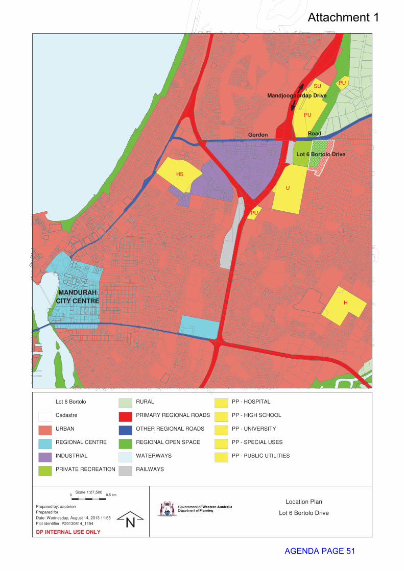
MANDURAH
CITY CENTRE
Lot 6 Bortolo Drive
Gordon Road
Mandjoogoordap Drive
Lot 6 Bortolo
Cadastre
URBAN
REGIONAL CENTRE
INDUSTRIAL
PRIVATE RECREATION
RURAL
PRIMARY REGIONAL ROADS
OTHER REGIONAL ROADS
REGIONAL OPEN SPACE
WATERWAYS
RAILWAYS
PP - HOSPITAL
PP - HIGH SCHOOL
PP - UNIVERSITY
PP - SPECIAL USES
PP - PUBLIC UTILITIES
0 0.5 km
Prepared by: aaobrien
Prepared for:
Date: Wednesday, August 14, 2013 11:55
Plot identifier: P20130814_1154
Scale 1:27,500
DP INTERNAL USE ONLY
Location Plan
Lot 6 Bortolo Drive
Attachment 1
AGENDA PAGE 51
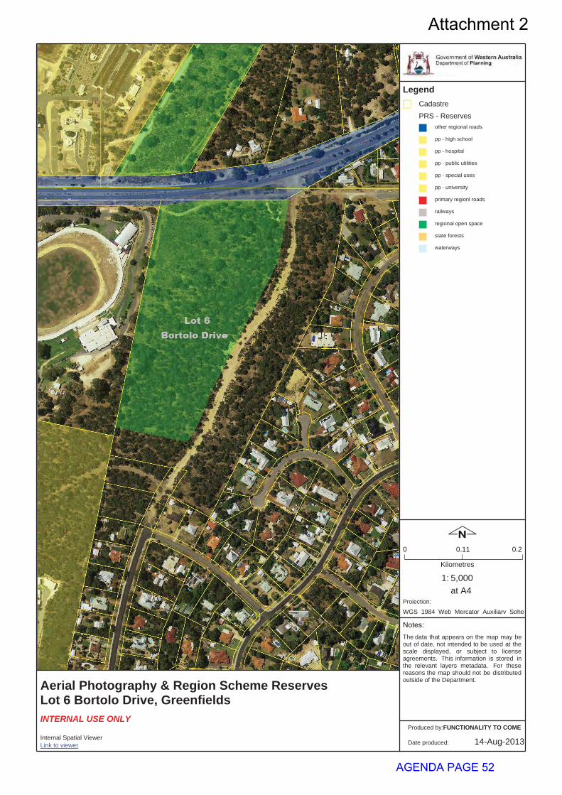
Aerial Photography & Region Scheme ReservesLot 6 Bortolo Drive, Greenfields
5,000
Legend
1:Kilometres
0 0.20.11
at A4
Notes:
14-Aug-2013
The data that appears on the map may beout of date, not intended to be used at thescale displayed, or subject to licenseagreements. This information is stored inthe relevant layers metadata. For thesereasons the map should not be distributedoutside of the Department.
INTERNAL USE ONLY
Projection:
WGS 1984 Web Mercator Auxiliary Sphe
Date produced:
FUNCTIONALITY TO COME
Link to viewer
Produced by:
Internal Spatial Viewer
CadastrePRS - Reserves
other regional roads
pp - high school
pp - hospital
pp - public utilities
pp - special uses
pp - university
primary regionl roads
railways
regional open space
state forests
waterways
Attachment 2
AGENDA PAGE 52
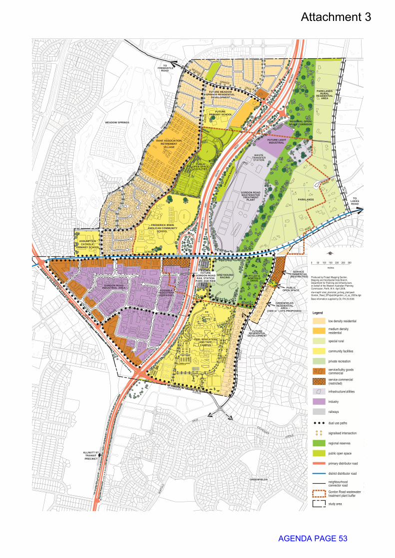
service commercial(restricted)
service/bulky goodscommercial
0 50
metres
100 150 200 250 300
study area
Legend
special rural
industry
railways
public open space
dual use paths
community facilities
signalised intersection
MEADOW SPRINGS
TOFREMANTLE
ROAD
regional reserves
PRECINCTTRANSIT
ALLNUTT ST
N
district distributor road
primary distributor road
infrastructure/utilities
GREYHOUNDRACING
DRIVEBORTOLO
private recreation
WASTEWASTETRANSFERTRANSFERSTATIONSTATION
medium densityresidential
low density residential
PT LOT 6
neighbourhoodconnector road
Gordon Road wastewatertreatment plant buffer
Produced by Project Mapping Section,Mapping and GeoSpatial Data Branch,Department for Planning and Infrastructure,on behalf of the Western Australian PlanningCommission, Perth, W A April 2006.
Base information supplied by DLI PA 23-2003
ntw-map9\ \strat_plan\strat_pol\reg_plan\peel\Gordon_Road_SP\dpub04\gordon_rd_sp_2020a.dgn
GORDON ROADWASTEWATER
PLANTTREATMENT
INDUSTRIALFUTURE LIGHT
QUA
RRY
POSSIBLEPEDESTRIAN
OVERPASSES
GORDON ROADINDUSTRIAL AREA
ROAD
WAY
ROAD
FREMANTLE
CATHOLICPRIMARY SCHOOL
ASSUMPTION
FREDERICK IRWINANGLICAN COMMUNITY
SCHOOL
RAAF ASSOCIATION
VILLAGE
NORT
HERN
MUL
GA
DR
IVE
MARRI CT
PARKLANDS
GREENFIELDS
DRIV
E
PARKLANDSRURAL
RESIDENTIALAREA
FUTURE MEADOWSPRINGS RESIDENTIAL
DEVELOPMENT
RETIREMENT
FUTURERESIDENTIAL
PUBLICOPEN SPACE
SERVICECOMMERCIAL
GREENFIELDSRESIDENTIAL
AREA
DEVELOPMENT
MAN
DURA
H
SOUT
H
WEST
PARADE
PORTRUSH
AVEN
UE
OAKM
ONT
ROUSE
EXCHEQUERAVENUE
BOR
TOLO
(RESTRICTED)
PEEL EDUCATIONAND TAFECAMPUS
METROPOLIT
AN
RAIL
WAY
AND
BYPA
SS
PRIMARY SCHOOLFUTURE
BORT
OLO
DRIVE
EXCHEQUER
AVENUE
ROAD
MEADOW
SPRINGS
GORDON
LAND
SCAP
EBU
FFER
(RO
AD "A
")
FUTUREGORDON ROADRAIL STATION
PARK AND RIDE
2
PUBLIC
FACILITIESOPEN SPACE
(1500 m LOTS PROPOSED)
TOLAKESROAD
DRIVE
SPACE CORRIDORREGIONAL OPEN
Attachment 3
AGENDA PAGE 53
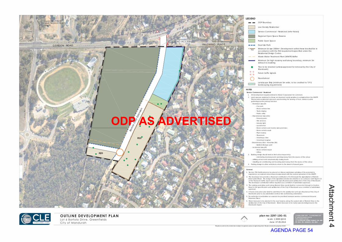
GORDON ROAD PALOMINO PLACE
BORT
OLO
D
RIVE
Borto
lo D
rive
Exte
nsio
n
R20
R10
NO ACCESS
Gordon Road WasteWater Treatment Plant(WWTP)
plan no: 2297-13G-01scale: 1:3000 @ A3
date: 07.05.2013This plan is current at the revised date & subject to approval, survey & engineering detail. This plan remains the property of CLE ©
LEGEND
Service Commercial - Restricted1. All development requires referral to Water Corporation for comment.2. Land uses are restricted to those not deemed overly sensitive to emissions from the WWTP.
This excludes residential uses and uses involving the serving of food, drinks or publicgatherings as the primary function.- Permitted Uses (P):
- Car park- Motor vehicle hire- Trade display- Public utility
- Discretionary Uses (AA):- Funeral parlor- Hire services- Industry light- Laundromat- Motor vehicle and marine sales premises- Motor vehicle wash- Plant nursery- Showroom- Veterinary clinic- Veterinary hospital
- Discretionary Uses - Advertise (SA)- Builders Storage yard
- Incidental Uses (IP):- Motor vehicle repair- Office
3. Building design should seek to limit odour impacts by:- orientating doorways and openings away from the source of the odour
- utilising air lock and automatically closing doors- installing air conditioning and locating plant away from the source of the odour
4. Parking design to allow vehicles to return to the street in forward gear.
T:(+618) 9382 1233 F:(+618) 9382 1127E: [email protected]
ODP Boundary
Low Density Residential
Service Commercial - Restricted (refer Notes)
Regional Open Space Reserve
Public Open Space
Dual Use Path
Minimum lot size 1500m². Development within these lots shall be inaccordance with the R10 requirements specified under theResidential Design Codes.
Waste Water Treatment Plant (WWTP) Buffer
Minimum 2m high masonry wall along boundary, minimum 3msetback to building
Tree to be retained (unless approved for removal by the City ofMandurah)
Future traffic signals
Roundabout
General1. Section 70A Notifications to be placed on titles at subdivision advising of the potential to
experience occasional odour impacts associated with the normal operation of the WWTP.
2. The developer is to provide a financial contribution of 9.1% toward the signalisation of BortoloDrive/Lakes Road. The design of the signalised intersection shall be in accordance with Figure C2of the Transcore traffic report and to the specifications and satisfaction of the City of Mandurah.The developer contribution will be required as a condition of subdivision approval.
3. The existing pedestrian path along Bortolo Drive (west) shall be connected through to GordonRoad to the specification and satisfaction of the City of Mandurah as a condition of subdivisionapproval.
4. A fauna relocation plan shall be submitted to the satisfaction and specifications of the City ofMandurah prior to any subdivision works or site works being undertaken.
5. No vehicular or pedestrian access is to be provided between service commercial lots andPalomino Place.
6. Street trees are to be planted in the road reserve along the eastern side of Bortolo Drive to thesatisfaction of the City of Mandurah. Street trees are to be native species indigenous to theMandurah region.
R10
NOTES
Landscape Strip (minimum 5m wide, to be credited to T.P.S.landscaping requirement)
Attachm
ent 4
ODP AS ADVERTISED
AGENDA PAGE 54

GORDON ROAD PALOMINO PLACE
BORT
OLO
D
RIVE
Borto
lo D
rive
Exte
nsio
n
R10
R10
NO ACCESS
Gordon Road WasteWater Treatment Plant(WWTP)
plan no: 2297-13H-01scale: 1:3000 @ A3
date: 25.06.2013This plan is current at the revised date & subject to approval, survey & engineering detail. This plan remains the property of CLE ©
LEGEND
Service Commercial - Restricted1. All development requires referral to Water Corporation for comment.2. Land uses are restricted to those not deemed overly sensitive to emissions from the WWTP. This excludes
residential uses and uses involving the serving of food, drinks or public gatherings as the primary function.- Permitted Uses (P):
- Car park- Motor vehicle hire- Trade display- Public utility
- Discretionary Uses (AA):- Funeral parlor- Hire services- Industry light- Laundromat- Motor vehicle and marine sales premises- Motor vehicle wash- Plant nursery- Showroom- Veterinary clinic- Veterinary hospital
- Discretionary Uses - Advertise (SA)- Builders Storage yard
- Incidental Uses (IP):- Motor vehicle repair- Office
3. Development be subject to an approved Detailed Area Plan which specifies development setbacks,maximum development heights and graduated development height to reduce future impact of buildingbulk on adjacent residential lots.
4. Building design should seek to limit odour impacts by:- orientating doorways and openings away from the source of the odour- utilising air lock and automatically closing doors- installing air conditioning and locating plant away from the source of the odour
5. Parking design to allow vehicles to return to the street in forward gear.6. A traffic management plan is to be prepared to address the interface between service commercial traffic
and proposed residential development.
T:(+618) 9382 1233 F:(+618) 9382 1127E: [email protected]
ODP Boundary
Low Density Residential. Development within these lots shall be inaccordance with the R10 requirements specified under the ResidentialDesign Codes, which may be varied by an approved Detailed Area Plan.
Service Commercial - Restricted (refer Notes)
Regional Open Space Reserve
Public Open Space
Dual Use Path
Minimum lot size 1500m²
Waste Water Treatment Plant (WWTP) Buffer
Minimum 2m high masonry wall along boundary, minimum 5msetback to building
Tree to be retained (unless approved for removal by the City ofMandurah)
Future traffic signals
Roundabout
General1. Section 70A Notifications to be placed on titles at subdivision advising of the potential to experience occasional
odour impacts associated with the normal operation of the WWTP.
2. The developer is to provide a financial contribution of 9.1% toward the signalisation of Bortolo Drive/Lakes Road.�The design of the signalised intersection shall be in accordance with Figure C2 of the Transcore traffic reportand to the specifications and satisfaction of the City of Mandurah.� The developer contribution will be requiredas a condition of subdivision approval.
3. The construction of a roundabout at the intersection of Durbarda Link and Bortoli Drive extension will berequired as a condition of subdivision approval.
4. The existing pedestrian path along Bortolo Drive (west) shall be connected through to Gordon Road to thespecification and satisfaction of the City of Mandurah as a condition of subdivision approval.
5. A fauna relocation plan shall be submitted to the satisfaction and specifications of the City of Mandurah priorto any subdivision works or site works being undertaken.
6. No vehicular or pedestrian access is to be provided between service commercial lots and Palomino Place.
7. Street trees are to be planted in the road reserve along the eastern side of Bortolo Drive to the satisfaction ofthe City of Mandurah. �Street trees are to be native species indigenous to the Mandurah region.
NOTES
Landscape Strip (minimum 5m wide, to be credited to T.P.S.landscaping requirement)
COUNCIL APPROVEDDATE ___ / ____ / ______
APPROVED / ENDORSED BY WAPC ON ___ / ____ / ______
TOWN PLANNING SCHEME NO 3
FILE REF: _________
ODP146
20130528
Attachm
ent 5
ODP AS ADOPTED BY THE COUNCIL
AGENDA PAGE 55
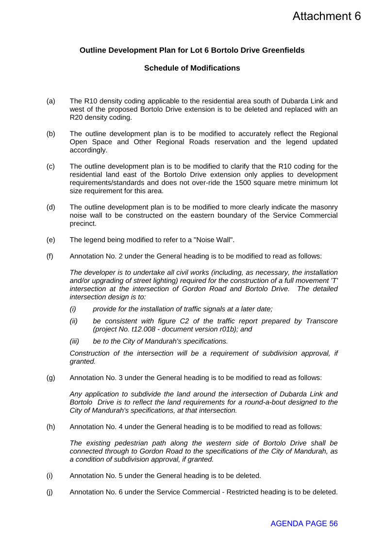
Outline Development Plan for Lot 6 Bortolo Drive Greenfields
Schedule of Modifications
(a) The R10 density coding applicable to the residential area south of Dubarda Link and
west of the proposed Bortolo Drive extension is to be deleted and replaced with an R20 density coding.
(b) The outline development plan is to be modified to accurately reflect the Regional
Open Space and Other Regional Roads reservation and the legend updated accordingly.
(c) The outline development plan is to be modified to clarify that the R10 coding for the
residential land east of the Bortolo Drive extension only applies to development requirements/standards and does not over-ride the 1500 square metre minimum lot size requirement for this area.
(d) The outline development plan is to be modified to more clearly indicate the masonry
noise wall to be constructed on the eastern boundary of the Service Commercial precinct.
(e) The legend being modified to refer to a "Noise Wall". (f) Annotation No. 2 under the General heading is to be modified to read as follows:
The developer is to undertake all civil works (including, as necessary, the installation and/or upgrading of street lighting) required for the construction of a full movement 'T' intersection at the intersection of Gordon Road and Bortolo Drive. The detailed intersection design is to:
(i) provide for the installation of traffic signals at a later date;
(ii) be consistent with figure C2 of the traffic report prepared by Transcore (project No. t12.008 - document version r01b); and
(iii) be to the City of Mandurah's specifications.
Construction of the intersection will be a requirement of subdivision approval, if granted.
(g) Annotation No. 3 under the General heading is to be modified to read as follows:
Any application to subdivide the land around the intersection of Dubarda Link and Bortolo Drive is to reflect the land requirements for a round-a-bout designed to the City of Mandurah's specifications, at that intersection.
(h) Annotation No. 4 under the General heading is to be modified to read as follows: The existing pedestrian path along the western side of Bortolo Drive shall be
connected through to Gordon Road to the specifications of the City of Mandurah, as a condition of subdivision approval, if granted.
(i) Annotation No. 5 under the General heading is to be deleted. (j) Annotation No. 6 under the Service Commercial - Restricted heading is to be deleted.
Attachment 6
AGENDA PAGE 56

(k) A new annotation is to be inserted under the Service Commercial - Restricted heading, to read as follows: A two metre high masonry wall is to be constructed on the boundary between the Service Commercial area and existing residential development, for noise mitigation purposes (as shown on the ODP). The wall is to be constructed when the Service Commercial precinct is:
(i) subdivided to create multiple service commercial lots; or
(ii) developed, as a single lot, for service commercial purposes. (l) A new annotation is to be inserted under the General heading, to read as follows:
The developer shall pay, to the City of Mandurah, 9.1% of the cost of installing traffic signals at the intersection of Bortolo Drive and Gordon Road, such cost to be calculated at the time of subdivision. Payment of the contribution towards installing traffic signals will be a requirement of subdivision approval, if granted.
(m) The annotations being re-numbered as necessary.
AGENDA PAGE 57
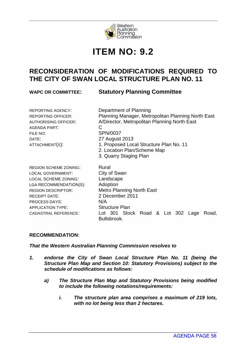
ITEM NO: 9.2 RECONSIDERATION OF MODIFICATIONS REQUIRED TO THE CITY OF SWAN LOCAL STRUCTURE PLAN NO. 11 WAPC OR COMMITTEE: Statutory Planning Committee
REPORTING AGENCY: Department of Planning REPORTING OFFICER: Planning Manager, Metropolitan Planning North East AUTHORISING OFFICER: A/Director, Metropolitan Planning North East AGENDA PART: C FILE NO: SPN/0037 DATE: 27 August 2013 ATTACHMENT(S): 1. Proposed Local Structure Plan No. 11
2. Location Plan/Scheme Map 3. Quarry Staging Plan
REGION SCHEME ZONING: Rural LOCAL GOVERNMENT: City of Swan LOCAL SCHEME ZONING: Landscape LGA RECOMMENDATION(S): Adoption REGION DESCRIPTOR: Metro Planning North East RECEIPT DATE: 2 December 2011 PROCESS DAYS: N/A APPLICATION TYPE: Structure Plan CADASTRAL REFERENCE: Lot 301 Stock Road & Lot 302 Lage Road,
Bullsbrook.
RECOMMENDATION:
That the Western Australian Planning Commission resolves to 1. endorse the City of Swan Local Structure Plan No. 11 (being the
Structure Plan Map and Section 10: Statutory Provisions) subject to the schedule of modifications as follows:
a) The Structure Plan Map and Statutory Provisions being modified
to include the following notations/requirements:
i. The structure plan area comprises a maximum of 219 lots, with no lot being less than 2 hectares.
AGENDA PAGE 58
ii. No further subdivision seeking to create lots less than 2ha
will be supported unless a reticulated water supply is provided and a sub-regional structure plan and local rural strategy prepared and endorsed by the WAPC for the locality, providing for further subdivision.
b) The existing Stock Road reserve being retained as a connection to
Great Northern Highway and identified as a potential future road connection to the west. The WAPC is prepared to support the reduction of the existing reservation width to 25 metres and deviation within the structure plan area to reflect the proposed lot layout/road network.
c) Further details being provided regarding the
implementation/enforcement of the higher construction standards in accordance with AS 3959 Construction of buildings in bushfire-prone areas and details of an effective statutory mechanism ensuring the higher construction standards. This information will be required to be provided prior to the consideration of any related subdivision application.
d) The statutory provisions (section 10.3) being modified to clearly
identify the requirement for dwellings to be constructed in accordance with AS 3959 Construction of buildings in bushfire-prone areas.
e) The statutory provisions, structure plan map and staging plan
being modified to identify that subdivision of proposed Lots 1-8 will not be supported until such time as the future connection to the north is provided to ensure the provision of two vehicular access routes which connect to the public road network. The subdivision of these lots without this connection is not supported by the WAPC as it would result in the creation of a cul-de-sac road in excess of 1 kilometre in length inconsistent with the requirements of Planning for Bush Fire Protection (Edition 2).
f) The proposed buffer to the Midland Brick Clay Quarry being
increased to 1000m where future blasting has been identified as being required. The WAPC will not support subdivision within this area until such time as the Department of Mines and Petroleum advises the WAPC that blasting operations have ceased and are no longer required to extract the clay resource;
g) The structure plan map and statutory provisions being modified to clearly identify the buffer areas relating to the Midland Brick Clay Quarry and the restriction on subdivision/development until such time as the corresponding stage of the quarry has been closed and the resource on the site exhausted;
AGENDA PAGE 59
2. note the structure plan text and technical appendices as supporting
documents to guide the assessment of subdivision and development applications;
3. note the surplus Stock Road reserve land must be formally closed prior
to being amalgamated into adjoining lots.
SUMMARY:
At its meeting of 28 February 2012, the Western Australian Planning Commission (WAPC) Statutory Planning Committee (SPC) resolved to endorse Local Structure Plan No. 11 (LSP 11) relating to Lots 301 Stock Road and 302 Lage Road, Bullsbrook, subject to a number of modifications (Attachment 1 - Proposed Local Structure Plan No.11). The proponent, the Rowe Group, has requested the WAPC reconsider this decision in relation to the requirement for a 1000m buffer to the Midland Brick Bullsbrook clay quarry and has requested a reduced buffer of 500m.
BACKGROUND:
LSP 11 proposes the subdivision of Lot 301 Stock Road and Lot 302 Lage Road, Bullsbrook into 219 rural-residential lots ranging between 2 hectares to 15.4 hectares in area. On 28 February 2012, the WAPC resolved to endorse LSP 11, subject to a number of modifications including, inter alia: "f) The proposed buffer to the Midland Brick Clay Quarry being increased to
1000m where future blasting has been identified as being required. The WAPC will not support subdivision within this area until such time as either:
i. the Department of Mines and Petroleum advises the WAPC that blasting operations have ceased and are no longer required to extract the clay resource; or
ii. the Department of Mines and Petroleum advises the WAPC that based on a
technical analysis the potential impacts of fly rock associated with blasting from the future quarry operations can be contained within a lesser area (no less than 500m).
Where blasting is not required, or the Department of Mines and Petroleum advises that blasting operations are no longer required, a 500m buffer will be supported.
g) The structure plan map and statutory provisions being modified to clearly
identify the buffer areas relating to the Midland Brick Quarry and the restriction on subdivision/development until such time as the corresponding stage of the quarry has been closed and the resource on site exhausted."
Modifications f) and g) were required in recognition of the need to protect the highly valued clay resource being extracted from Midland Brick's Bullsbrook clay quarry
AGENDA PAGE 60
from the sensitive land use proposed by LSP 11, and to ensure the proposed sensitive land use (rural residential development) was not adversely impacted from the effects of blasting arising from the extractive industry. The decision also recognises the role of the Department of Mines and Petroleum (DMP) as the government authority most qualified to provide advice on fly-rock matters. On 22 May 2013 the City of Swan forwarded a development application for the continuation and expansion of extraction operations for the Midland Brick Bullsbrook clay quarry at Lots 13, 56 and 1010 Stock Road, Great Northern Highway and Lage Road Bullsbrook. The application is seeking approval for 20 years and seeks approval for blasting. Midland Brick have also lodged a Project Management Plan with the DMP for its approval in accordance with the requirements of the Mines Safety and Inspection Act 1994, which is yet to be determined.
LEGISLATION / STRATEGIC PLAN / POLICY:
Legislation Planning and Development Act (2005) Section: Part 10. Section 135 (Approval of WAPC required for
subdivision) Strategic Plan Strategic Goal: Planning Outcomes: Effective Delivery of Integrated Plans Strategies: Develop integrated infrastructure and land use plans for
the State Build infrastructure capacity and regulation Implement State and Regional planning priorities
Policy Number and / or Name: SPP 2.4 Basic Raw Materials
SPP 2.5 Agricultural and Rural Land Use Planning EPA Guidance Statement No. 3
DETAILS:
Structure Plan The key elements of LSP 11 are as follows:
• Total area of 695.9ha; • 219 lots ranging in size from 2ha to 15.4ha with an average lot size of 2.7ha; • Provision of a 4032m2 site for a future district Fire and Emergency Services
Authority (FESA) fire station; • Road connection to Great Northern Highway via the realignment of Lage Road
and two proposed connections to existing local roads to the east (Clarkson Road and Stock Road). Two road connections are proposed to the north, subject to future structure planning and development occurring;
• Use of building envelopes to contain development and vegetation clearing and separation from creek/drainage lines; and
AGENDA PAGE 61

• Provision of servicing and fire fighting infrastructure (reticulated water not provided), 6 metre wide strategic fire breaks and the requirement for construction in accordance with AS 3959 Construction of buildings in bushfire-prone areas (AS 3959). (Attachment 1)
The subject land is located approximately 2 km south-east of the existing Bullsbrook town site, east of Great Northern Highway, north of the Walyunga National Park and west of the Shady Hills rural residential subdivision. (Attachment 2 - Location Plan/Scheme Map) The site is currently used for rural purposes, including grazing and rural living, and is predominantly cleared, with little remnant vegetation. Surrounding land uses include rural residential to the east, rural and urban to the north and west, and resource extraction (being the Midland Brick clay quarry) and environmental protection uses to the south and south-west. Summary of Applicant's Contentions The proponent has requested the WAPC reconsider its position with respect to the 1000m buffer to the Midland Brick Bullsbrook clay quarry and support a reduced buffer of 500m. The applicant's justification for imposition of a reduced buffer of 500m summarised as follows:
• Midland Brick does not currently have approval to blast at the quarry; • Midland Brick would need to obtain a new approval to blast which would
require compliance with relevant environmental and mine safety criteria to existing constraints (i.e. - private property, public land and dwellings);
• There are existing dwellings 165m, 202m, 292m, 405m, 463m and 480m from the quarry;
• The Mine Safety Act and Regulations require an operator to contain fly rock on site and protect the public from any danger associated with blasting;
• Any approval issued to Midland Brick would require an on-site containment of fly rock; and
• Fly rock experts have determined Midland Brick can contain fly rock within 200m from the blast through appropriate controls that will enable a safe and efficient blast and improved access to the clay resource.
GOVERNMENT AND CORPORATE IMPLICATIONS: Any approval to reduce the buffer could restrict the ability to extract clay resources from the site in the longer term. The clay resource is considered a significant source of semi-plastic clay for brick manufacture and is limited in extent. Any requirement to find alternative sources could have adverse impacts to the supply/cost of bricks in the Perth metropolitan area. CONSULTATION: As part of the original advertising of LSP 11, the (then) Department of Environment and Conservation provided advice in relation to the need for a buffer of at least 500m. However, it was noted that this advice was on the basis of noise and dust only
AGENDA PAGE 62

and did not consider future blasting on the site or resultant safety issues in relation to fly rock associated with blasting. DMP objected to the original structure plan on the basis that the current clay extraction area (Midland Brick Bullsbrook clay quarry) had in excess of 20 years reserve of clay and shale remaining. Future extraction will require blasting as a result of secondary dolerite intrusions. As a result, a 1000m building exclusion zone from the resource extraction area was required. Further advice has been sought from DMP on a number of occasions in this regard, both in response to the technical information submitted by the proponent and the blasting Project Management Plan submitted by the quarry operator. DMP has formally advised that a reduction in the buffer zone is not recommended until blasting operations have ceased at the quarry. This is discussed further in the officer comments below. Officers of the Department were present at a meeting between DMP and the quarry operator in relation to the Project Management Plan (blasting) currently being assessed by DMP. DMP is continuing to undertake this assessment and further information has been provided by the quarry operator as a result of this, which is discussed within the officer comments below. OFFICER’S COMMENTS: Clay Quarry Operations The Midland Brick Bullsbrook clay quarry has been in operation for approximately 40 years, with in excess of 20 - 30 years of reserve resource remaining. Quarrying activities are currently contained within the northern portion of Lot 13 and a small portion of the adjoining Lot 1010 Lage Road, with future stages proposed to progressively move to the south into Lot 56 Stock Road (Attachment 3 - Quarry Staging Plan). Due to the presence of secondary dolerite intrusions, blasting will be required to continue to extract clay and shale for brick manufacturing in the future. The lots comprising the quarry are identified within State Planning Policy 2.4 - Basic Raw Materials (SPP 2.4) as priority resource locations, which are defined as "locations of regionally significant resources which should be recognised for future basic raw material extraction and not be constrained by incompatible uses or development." SPP 2.4 states that, before determining applications for sensitive land use (including rural-residential) within 1000m of a basic raw materials extraction area, the WAPC must consider the significance of the resource in terms of whether it is a key extraction area, a priority resource area or extraction area and the likely effects arising from the extractive industry, including blasting. SPP 2.4 provides a presumption against the introduction of sensitive land uses which could be adversely affected by existing or future extractive industries unless appropriate measures can be taken to ameliorate the adverse impacts. Further to this, the Environmental Protection Authority (EPA) Guidance Statement No. 3 - Separation Distances between Industrial and Sensitive Land Uses (Guidance Statement 3) specifies a generic buffer distance of 1000 metres in relation to extractive industries involving
AGENDA PAGE 63

hard rock blasting as a result of noise, dust and risk associated with the blasting and identifies DMP as the responsible authority in respect of blasting. SPP 2.4 also supports the concept of sequential land use, providing that in order to facilitate the exploitation of basic raw materials whilst supporting future long term development for urban and other purposes, sequential land use planning should be a requirement whereby extraction and rehabilitation can take place on a programmed basis in advance of longer term use and development. DMP has previously advised that the Bullsbrook (semi-plastic schist) clay resource is based upon the northernmost outcrop of a weathered and sheared schist that is a significant source of semi-plastic clay for brick manufacture and is limited in its extent. There is uncertainty as to whether it continues beyond the current Midland Brick landholdings. The quarry site is highly valued as a source of red burning clay schist with excellent drying characteristics that is used for the production of bricks. The resource is important for the manufacturing of bricks as it has special properties of low fusion temperature and strength, and it blends with clay to produce red bricks. Midland Brick has advised that the schist is one of six that is used in each brick it produces and estimates that the deposit at the quarry will contribute towards the production of approximately six billion bricks over the next 30 years. The amount of resource remaining within the quarry and its close proximity to production facilities are therefore extremely important in the supply and cost of bricks within the Perth metropolitan area, flowing onto housing affordability. DMP has previously advised that any requirement to find alternative sources could have adverse impacts to the supply/cost of bricks in the Perth metropolitan area. Requirement for Blasting Midland Brick has confirmed that blasting will be required to access clay resources in the future due, to the presence of dolerite intrusions that were discovered in recent drilling exercises, which cannot be overcome through 'doze and rip' quarrying methods previously used on site. Midland Brick has summarised the expected blasting operations at the quarry as follows:
• 20 blasting events in the first 10 years (10,000 tonnes blasted in one to two events per year);
• 80 blasts in the next 20 years (20,000 tonnes blasted in four events per year, dependent upon the weathering profile of the deposit); and
• 180 additional blasts over a period of 20 years, from year 10 onwards, to allow for the cutback of the eastern wall of the deposit (1,700,000 tonnes blasted in 8-9 events per annum).
The above operations will result in approximately 280 blast events throughout the life of the quarry, increasing in frequency over time as the resource becomes more difficult to access and cutback actions are required. Midland Brick and DMP have previously expressed concern regarding the potential for rural-residential subdivision in the vicinity of the clay quarry to reduce protective
AGENDA PAGE 64
setbacks and in doing so, prejudice the ongoing extraction of important raw materials. This position is supported by State Planning Policy 2.5 - Agricultural and Rural Land Use Planning (SPP 2.5), which states that the location of rural-residential and rural smallholdings should avoid any unacceptable impacts on, or sterilisation of, natural primary resources including prospective areas for mineralisation and basic raw materials. Management of Fly-Rock and Buffer Requirements The Mines Safety and Inspection Act 1994, Mines Safety and Inspections Regulations 1995 and the Dangerous Goods Safety Act 2004 include requirements for blasting operations on mine sites within Western Australia which are the responsibility of the DMP. The aforementioned legislation does not prescribe any buffer distances between mine sites and sensitive land uses, instead the responsibility for minimising the risk of injury to members of the public and damage to property is placed upon the operators of mine sites. Mining operators must therefore determine the likely risks their operations pose, based on site specific risk assessment, and implement appropriate measures to manage and/or mitigate that risk. There are currently four dwellings located within 500m of the quarry and Midland Brick's blasting operations will therefore need to take into account any risk to these properties when designing and undertaking its blast events. In this regard, Midland Brick has provided a copy of a draft report prepared by their blasting consultant, advising that the throw of rock, being the expected movement of rock in blasting operations, will be minimal and when fly-rock, being the propulsion of rock beyond the blast site, does occur, it should be contained within 100m of the blast site. The caveat provided with this advice, however, is that there is sufficient energy, in the right circumstances, to throw a single rock significantly further. The draft report references a number of research studies in relation to fly-rock, with one study concluding that from a 76mm hole (as proposed), a 208mm sized rock could by thrown 541m, while another concluded that fly rock could travel between 426m to 737m depending on the particle shape. The draft report provided by Midland Brick concludes that a minimum clearance zone of 541 metres to 737m is appropriate to allow for variations in particle shape. The draft report provided by Midland brick estimates the probability of a fly-rock event occurring at the quarry to be less than 1 in 1000, with at least one event likely to occur within the life of the quarry, based on research on the subject, experience in designing, supervising and executing blasting operations and an appreciation of the geological conditions at the quarry. The DMP has advised that while Midland Brick have committed to implementing best practice engineering practices to manage risk (electronic detonators and blasting mats), there is an unavoidable reliance on administrative controls, with associated possibility of human error. In this regard, discussions with DMP have confirmed that regular reports of fly-rock events are received where rocks have been ejected distances considerably greater than nominated buffer areas. As the variable nature of the rock mass at the quarry
AGENDA PAGE 65

will create a degree of unpredictability in blast response, the DMP does not disagree with the statements made by Midland Brick's consultant in relation to fly-rock probability at quarry. While the proponent's proposal to reduce the buffer from the quarry to 500m will not alter the probability of a fly-rock event occurring, it will significantly increase the probability of fly-rock causing injury to the public or damage to property, should a fly-rock event occur. Discussions with DMP officers indicated that where the potential for fly-rock at distances of greater than 500m was identified, the 1000m buffer identified by Guidance Statement 3 should be maintained to provide for an appropriate level of protection in relation to risk. DMP recommends a prudent approach and the application of a high factor of safety particularly because the consequence from a fly rock event could be extremely serious. Buffer Distance Options The Department has considered three potential options with regard to buffer distances in making its recommendation to the SPC, being 500m, 750m and 1000m. A 500m buffer would preclude the creation of 33 lots until such time as quarrying operations have ceased. However, as discussed earlier it is possible that rock could be thrown up to 737m and there is a high likelihood of such an event occurring during the life of the quarry. A 500m buffer is therefore not considered to adequately address the risk posed by fly-rock and is not supported by the Department for this reason. A 750m buffer would preclude the subdivision of 65 properties until blasting operations have ceased, at which time the buffer would be reduced to 500m to deal with noise and dust issues only. Similarly, as the information before the Department indicates that fly-rock could be thrown up to 737m, a 750m buffer leaves a negligible (13m) margin of safety should the science informing the fly-rock study differ to what eventually occurs on-site during blasting operations. The 1000m buffer previously imposed by the WAPC and identified under the EPA's Guidance Statement 3 would preclude the subdivision of 100 properties until quarrying operations have ceased. While this represents almost half of the 219 lots proposed to be subdivided within LSP 11, it minimises the risks associated with a fly-rock event. EPA Guidance Statement No.2 - Guidance for Risk Assessment and Management: Off-Site Individual Risk From Hazardous Industrial Plant (Guidance Statement 2) sets the acceptable societal risk for residential areas (which would include the proposed rural residential development) at 1 in 1,000,000 per year. The technical analysis estimates the probability of a fly-rock event occurring within the lifetime of the quarry is less than 1 in 1,000 which poses a significantly higher level of risk than deemed acceptable by the EPA. The precautionary principle establishes that where an action or policy has a suspected risk of causing harm to the public or to the environment, the lack of full
AGENDA PAGE 66

scientific certainty should not be used as a reason for not incorporating measures that prevent the harm from occurring provided that such measures are proportionate to the threat. The State Administrative Tribunal (SAT) has endorsed the precautionary principle as part of the Western Australian planning jurisprudence (Wattleup Road Development Company Pty. Ltd v Western Australian Planning Commission [2011] WASAT 160). In making its decision the SAT determined that the precautionary principle warranted refusal of the proposed subdivision until adequate air quality monitoring at the site, demonstrating acceptable health impacts, was undertaken. The SAT further determined that this represented a response that was proportionate to the threat, appropriate and cost-effective. The use of explosives is an intrinsically hazardous process and it cannot be guaranteed that fly rock will be contained within a reduced buffer distance. Increasing the number of dwellings within 500m to 1000m of the future blasting will increase the risk of persons or property being struck by fly-rock resulting from the proposed blasting operations. CONCLUSION The operator of the Midland Brick Bullsbrook clay quarry is required, under Western Australian mining legislation, to implement measures that minimise the risk of fly-rock occurring during blasting operations. In this regard, Midland Brick expects that fly-rock generated at the quarry should be contained within 100m of the blast area but may, under certain circumstances, be thrown up to 737m. The DMP supports a prudent approach and application of a high level of safety with regard to buffer distances, given the serious consequences that can result from a fly-rock incident. The Department shares this view and recommends that the WAPC adopt a precautionary approach in regard to the buffer distance imposed upon LSP 11. A 1000m buffer, taking into consideration the high likelihood of a flyrock event occurring over the life of the extractive operations, is proportionate to the serious risk fly-rock poses to persons and property. A reduction in the buffer distance will introduce an unacceptable level of risk which cannot be supported. On this basis, and to ensure the long term supply of the significant clay resource, it is recommended that the buffer requirement of 1000m be maintained.
AGENDA PAGE 67

JUi -da ,-:3fcK .'^sia ^3 ^3
ATTACHMENT 1
10T RANGE 20001 TO 154065TOFAL LOTS 219TOTAL AHEA 60967MAVERAGE SIZE 27039
F"...™ ' ^ Fguroii GREG ROWE | & associates... fTfW»0I IS'frwipfopoie wrf-ii focus to OU ACHItViMSNT
y-xpixtib/ET'n***>' lot301 rtotJ;roidSlot302btenwd(km ' ' * *kutoLrvik t I
tU^lXltyNthewUSmi NanMn^^v V/iilunAura^*, {£01**\ Ny.VAV{rex-n>.V4fAiJ l«J*lll»i2l IJJIt**«IOmi l>l»HWH . riU/SOUTrtWliT . MDV/tST . PUAM
Mih<l^c<Mjtcmer4»ccrtrm
AGENDA PAGE 68
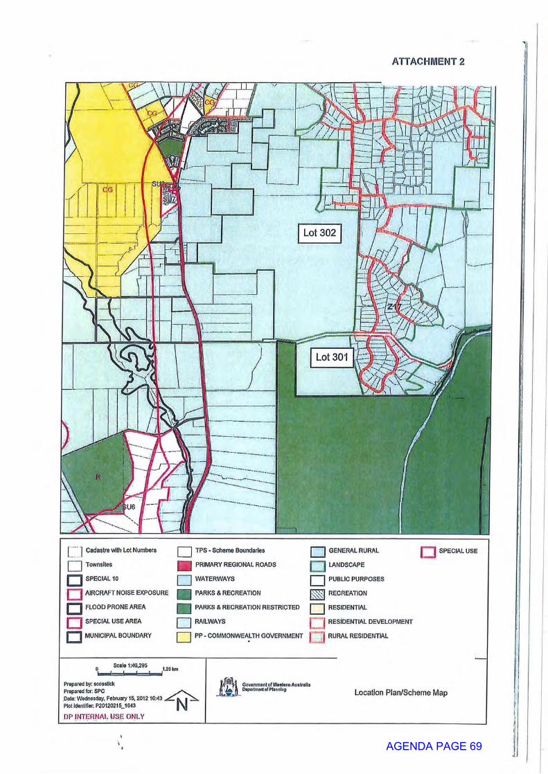
ATTACHMENT 2
Lot 302
Lot 301
"j Cadastre with Lot Numbers
Townsites
j|~~| SPECIAL 10
AIRCRAFT NOISE EXPOSURE
D FLOOD PRONE AREA
SPECIAL USE AREA
MUNICIPAL BOUNDARY
TPS - Scheme Boundaries
PRIMARY REGIONAL ROADS
WATERWAYS
PARKS & RECREATION
PARKS & RECREATION RESTRICTED
RAILWAYS
PP - COMMONWEALTH GOVERNMENT
GENERAL RURAL
LANDSCAPE
PUBLIC PURPOSES
RECREATION
nSPECIAL USE
I -v.!
RESIDENTIAL
RESIDENTIAL DEVELOPMENT
RURAL RESIDENTIAL
Scale 1:46,295
Prepared by: scosslickPrepared for; SPCDate: Wednesday, February 15, 2012 ISMS „Plot Idenllfier: P20120215J643
DP INTERNAL USE ONLY
GovammentofWoslom AustraliaI*. A DepoitmontorPIonnlno Location Plan/Scheme Map
AGENDA PAGE 69

ATTACHMENT 3
AGENDA PAGE 70
ITEM NO: 9.3 APPROVAL FOR REFURBISHMENT AND UPGRADE OF COMMUNITY CENTRE - HAMPTON ROAD, PINJARRA WAPC OR COMMITTEE: Statutory Planning Committee REPORTING AGENCY: Department of Planning REPORTING OFFICER: Planning Manager, Peel Planning, Perth and Peel
Planning AUTHORISING OFFICER: Director, Peel Planning, Perth and Peel Planning AGENDA PART: G FILE NO: 616-134-1 DATE: 28 August 2013 ATTACHMENT(S): 1. Location Plan
2. Proposed Site Plan 3. Proposed Elevations
REGION SCHEME ZONING: Regional Open Space (Reservation) LOCAL GOVERNMENT: Shire of Murray LOCAL SCHEME ZONING: Regional Open Space (PRS Reservation) LGA RECOMMENDATION(S): Not Supported REGION DESCRIPTOR: MAND RECEIPT DATE: 14 May 2013 PROCESS DAYS: 66 APPLICATION TYPE: Development CADASTRAL REFERENCE: Lots 299, 309 and 354 Hampton Road, Pinjarra
RECOMMENDATION:
That the Western Australian Planning Committee resolves to approve the application for approval to commence development in accordance with the plans submitted thereto, subject to the following condition and advice notes: CONDITIONS: 1. Suitable arrangements are to be made with the Shire of Murray for the
provision of vehicular crossovers to service the development.
2. Uniform fencing is to be constructed along the western boundary of Lot 299 Hampton Road Pinjarra to control access to the regionally significant vegetation located on Lot 354 Hampton Road Pinjarra to the satisfaction of the Western Australian Planning Commission.
AGENDA PAGE 71
SUMMARY: • The application seeks approval to refurbish an existing community centre,
construct change rooms, a shed and shade structures and to carry out other site improvements on Lots 299, 309 and 354 Hampton Road, Pinjarra.
• Planning approval under the Peel Region Scheme is required as the subject site is reserved Region Open Space under the Scheme.
• Planning approval is also required under the Shire of Murray Town Planning Scheme No. 4.
• The application has been referred to the Statutory Planning Committee for determination as Delegation 2012/01 does not give Department of Planning officers the authority to approve an application if the determination significantly varies with the advice of the local government. In this respect, the Shire of Murray has advised that it does not support the application.
• It is recommended that the application be conditionally approved as it is considered to be consistent with the relevant provisions of the Peel Region Scheme and Development Control Policy 5.3: Use of Land Reserved For Parks and Recreation and Regional Open Space.
LEGISLATION / STRATEGIC PLAN / POLICY:
Legislation Subdivision / Development Approval / Reconsiderations - Part 10 of the Planning and Development Act 2005.
Section: Section 162 - No development except with approval. Strategic Plan Strategic Goal: Strategic Goal 2: Planning Outcomes: Effective Delivery of Integrated Plans Strategies: Implement State and Regional Planning priorities Policy Number and / or Name: Development Control Policy 5.3: Use of Land Reserved
Parks and Recreation and Regional Open Space
INTRODUCTION:
The application seeks approval to refurbish an existing community centre, construct change rooms, a shed and shade structures and to carry out other improvements on Lots 299, 309 and 354 (Reserves 25503 and 32876) Hampton Road, Pinjarra (Attachment 1 - Location Plan).
The subject site is within the Regional Open Space (ROS) reservation under the Peel Region Scheme (PRS) and this reservation has effect under the Shire of Murray Town Planning Scheme No.4 (TPS4).
The proposed works (Attachment 2 - Proposed Site Plan, Attachment 3 - Proposed Elevations) on this site include:
AGENDA PAGE 72

• refurbishment of the existing community centre, including the construction of new toilets and improvements to the entry of the community centre;
• construction of an outdoor stage at the western end of the existing community centre;
• construction of changes rooms (shown as a youth sports building on the plans);
• construction of a shed adjacent to the existing basketball court;
• construction of a shade structure over the basketball court;
• construction of a car parking area; and
• other site improvements including the construction of a bin enclosure and footpaths.
An application for planning approval has also been submitted to the Shire of Murray pursuant to the requirements of the TPS4, as planning approval is required under both the PRS and TPS4 for development on land reserved under the PRS.
CONSULTATION:
The Shire of Murray has advised that it does not support the application and provided a large number of reasons for not supporting this application. The Shire of Murray's key reasons for not supporting the application are:
• full details of the existing and proposed uses of the site have not been provided;
• the proposed means of access for vehicles and pedestrians have not been clearly indicated;
• a detailed noise management plan is required for the outdoor stage component of the development proposal;
• a Bush Fire Attack Level Assessment, prepared in accordance with the WAPC's Bushfire Protection Guidelines, needs to be conducted by a suitably qualified person;
• a social impact assessment needs to be conducted. This assessment needs to identify potential social issues, mitigation and management strategies;
• the existing and proposed ground levels over the whole of the land, subject to the application, need to be provided;
• the location of existing site vegetation and vegetation that is proposed to be removed is not indicated on the plans; and
• the site plan does not indicate any proposals for the landscaping of the site. The Shire of Murray advertised the application for public comment for a period of 21 days. At the close of the advertising period, 41 submissions including a petition containing 26 signatures were received. Eight of the submissions and the petition supported the proposal, whilst the remaining 32 submissions objected to or raised concerns with the proposal.
AGENDA PAGE 73
The objections raised concerns about an increase in antisocial behaviour and crime, noise impacts, increased pedestrian and vehicle traffic, properties being devalued and the operating hours of the centre. Concerns relating to antisocial behaviour, crime and devaluation of properties are not relevant planning considerations and cannot be considered in the assessment of this application. Concerns relating to amenity impacts associated with the development and use of the site are relevant planning issues and are discussed in the 'Potential amenity impacts' section of this report. The submissions will be considered by the Shire of Murray in its assessment of the application lodged pursuant to the requirements of TPS4. In this respect, the application was presented to the Council on the 29 August 2013, where it was recommended that the Council refuse the application. The application was referred to the Water Corporation and Western Power for comment. These agencies raised no objections to the application and did not request any conditions be imposed.
COMMENTS:
Peel Region Scheme An application for planning approval is required as the site of the community centre is located with the ROS reservation in the Scheme. Clause 19 of the PRS identifies the types of development which are permitted on reserved land and do not require WAPC approval. The proposed development of the site is not a type of development specified in clause 19 of the PRS and therefore requires planning approval pursuant to clause 18 of the PRS. Clause 34 of the PRS states that the Commission in considering an application for planning approval is to have regard for a range of matters including the aims and provisions of the PRS. In this respect clause 10 of the PRS states that the purpose of the ROS reservation is "to protect the natural environment, provide recreational and cultural opportunities, safeguard important landscapes and sites of cultural or historical significance and provide for public access". The proposed development is considered to be consistent with the purpose of the ROS reservation in the PRS as it will provide recreation and cultural opportunities through the various activities that will be held on site. DC 5.3: Use of Land Reserved for Parks and Recreation and Regional Open Space Development Control Policy 5.3: Use of Land Reserved for Parks and Recreation and Regional Open Space (DC5.3) provides guidance on the types of development which may be permitted on ROS land. In respect of ROS, DC5.3 states that:
• the use and development of land shall be consistent with furthering the enhancement of the reserved land facilitating its use for recreational or conservation purposes (Clause 3.1);
AGENDA PAGE 74
• the uses and development of land for purposes inconsistent with the purpose of the reserve will not be supported (Clause 3.2);
• the use and development of land which would result in long-term restrictions to public access will not be supported (Clause 3.4); and
• the land may be used for passive recreation, active sporting pursuits and cultural and/or community activities (Clause 3.5).
The proposed development is consistent with the requirements of DC5.3 as:
• as the upgrade of the existing community hall and basketball courts will enhance the use of the reserve for recreational purposes;
• the proposal is consistent with the purpose of the ROS reserve in the PRS; and
• the site will be used for a range of activities including active sporting pursuits (basketball, walking group and fitness classes) and community activities (nutrition and cooking classes, health sessions, community garden and small scale presentations and performances).
It is, however, noted that the proposal is not entirely consistent with the requirements of clause 3.4 of DC5.3, as the site plans indicate that a 2.1 metre high black palisade fence will be constructed around the community hall and basketball courts. This fence will restrict access to part of the site, but it should be noted that this will only restrict access to a small part of the reserved land. The majority of the ROS land will continue to be publicly accessible, consistent with the requirements of clause 3.4 of DC5.3. For the reasons discussed above, the proposed development is considered to be generally consistent with the objectives and policy requirements of DC5.3. Potential amenity impacts Clause 1.3 of DC5.3 states that it would be appropriate to permit community groups to locate on land reserved ROS where the applicant can demonstrate that the nature and scale of the proposal is compatible with the use and zoning of surrounding land. The Shire of Murray has raised concern about the proposed developments adversely impacting on the amenity of nearby residential properties, particularly given that it is proposed to construct an outdoor stage. In this respect, the development proposal is unlikely to have an adverse impact on the amenity of nearby residences for the following reasons: (a) Hours of operation
The proponent has provided details of activities that are proposed to be held on site, which indicate that the community centre is intended to be used only during the day between 10.00am and 6.00pm. This is a time when most people are likely to be at work or doing other activities and are less likely to be adversely impact upon by activities at the community centre site.
AGENDA PAGE 75
(b) Number of people using the site
The proponent has advised that it is estimated that no more than 50 people would be using the site at any one time and that on most occasions there would be no more than between 12 and 23 people will on the site at any one time. As a result, it is unlikely that the activities at the site would generate significant noise levels or traffic volumes that may adversely impact on the amenity of nearby residences.
(c) Impact of noise from proposed outdoor stage
The proposed outdoor stage is located about 70 metres from the nearest residential property and is facing the opposite direction from the closest residential properties. Furthermore, the stage is intended to be an intimate setting and it is not planned for any sound amplification to be used. For these reasons it is not anticipated that the use of this stage would create noise levels that would adversely impact on the amenity of the nearest residences. If the local government decides to refuse the application and there was an application for review to the State Administrative Tribunal, there is the opportunity to impose conditions on the use of the facilities.
(d) Amenity impacts associated with other outdoor activities
The other main outdoor activity occurring on site is basketball, but this is not expected to significantly impact on nearby residences as the basketball courts are located about 90 metres from the nearest residence. Furthermore, any noise created by the players and spectators of a basketball game is likely to be an classed as an exempt noise under the Environmental Protection (Noise) Regulations 1997 and are not subject to the requirements of these regulations. Most other activities, except for the community garden, would be held inside the community hall and would be unlikely to adversely impact of the amenity of nearby residential properties.
(e) Impact on traffic movements along Hampton Road
Currently, there are about 110 residential properties that would use Hampton Road as their main access. Based on an average of 8 vehicle movements per day for each residential property, it is estimated that Hampton Road would carry about 890 vehicles per day. The use of the community centre is estimated to create a maximum of 100 additional vehicle movements per day. This is based on two traffic movements (one in and one out) for each of the maximum number of 50 people visiting the site per day. However, on most days the use of the community centre is likely to create about 50 additional vehicle movements per day. The additional vehicle movements associated with the use of the community centre are likely to increase the vehicle movements along Hampton Road by about eleven per cent. This level of traffic is not considered to be a significant increase in traffic levels and is unlikely to significantly impact on the use of the road or the amenity of the adjacent residential properties.
AGENDA PAGE 76
Environmental considerations Most of Lot 354 and part of Lot 309 are identified as potentially containing regionally significant vegetation in Environmental Protection Bulletin No.12: Swan Bioplan - Peel Regionally Significant Areas. In this respect, the Shire of Murray has highlighted the need to control access to the regionally significant vegetation located on Lot 354. To ensure that regionally significant vegetation is adequately protected, it is recommended that a condition of approval be imposed which requires the construction of a fence along the western boundary of Lot 299 to control access to this vegetation located on Lot 354.
CONCLUSION:
The application is consistent with the provisions of the PRS and DC5.3. On this basis, it is recommended that the application be approved subject to conditions. Restrictions on operating hours, occupancy numbers and sound amplification are not specified in the recommendations, as these matters could be addressed by local government conditions if approved under the local planning scheme.
AGENDA PAGE 77
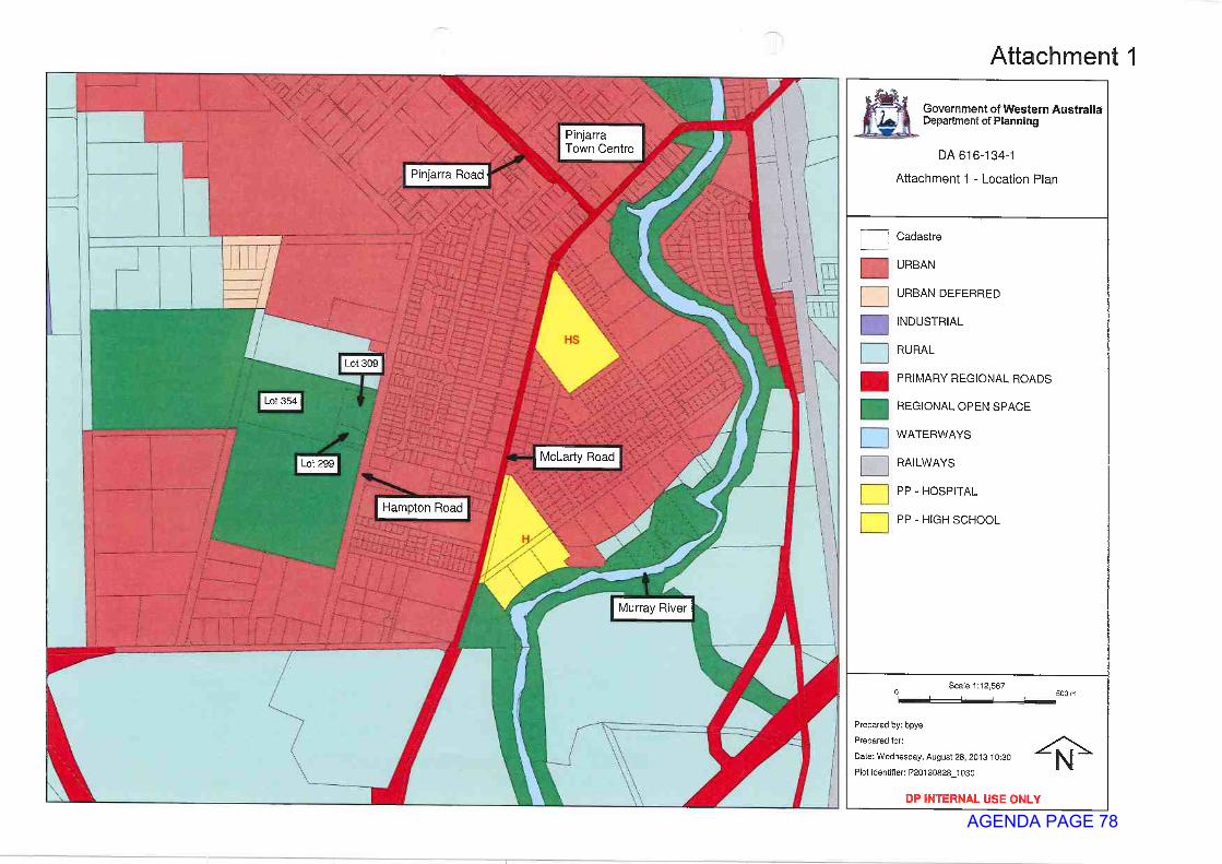
AGENDA PAGE 78

AGENDA PAGE 79
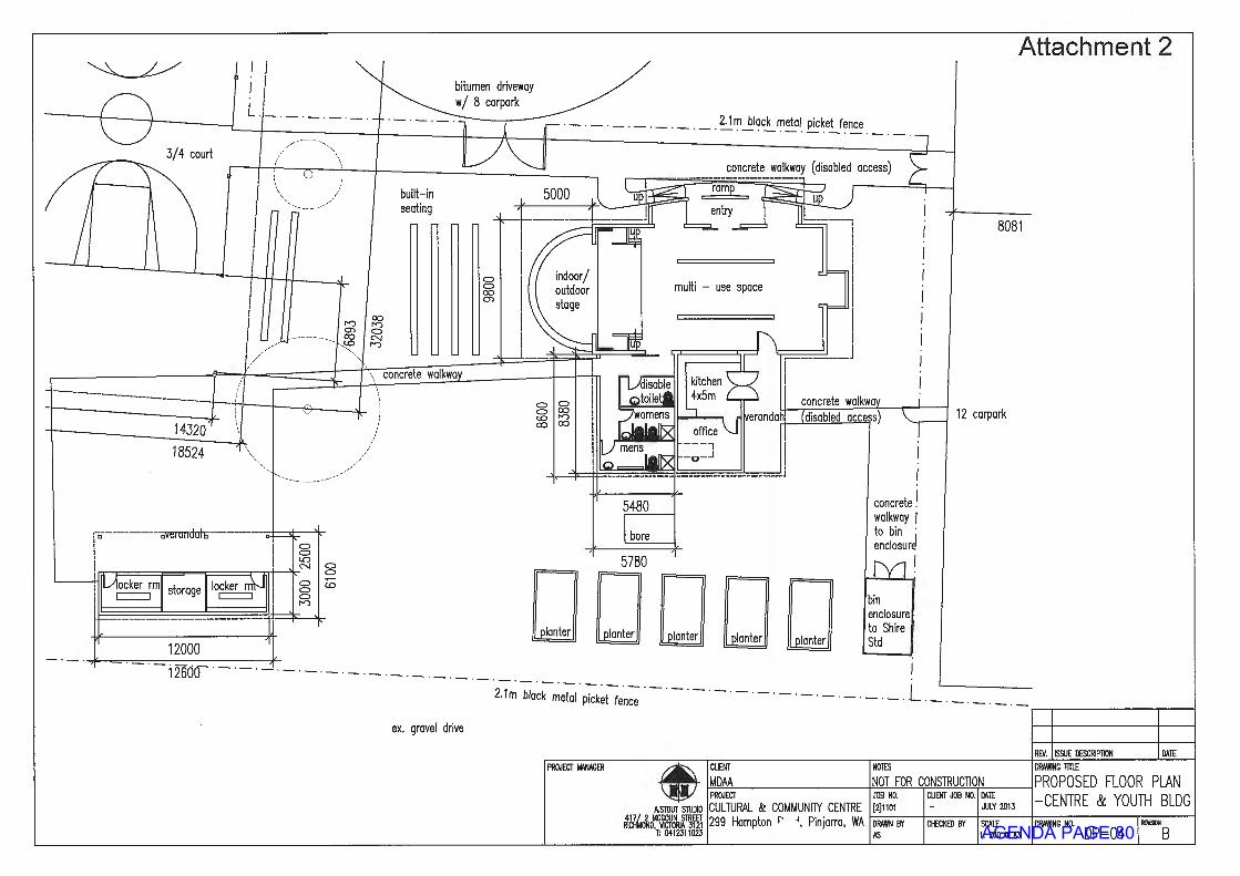
AGENDA PAGE 80
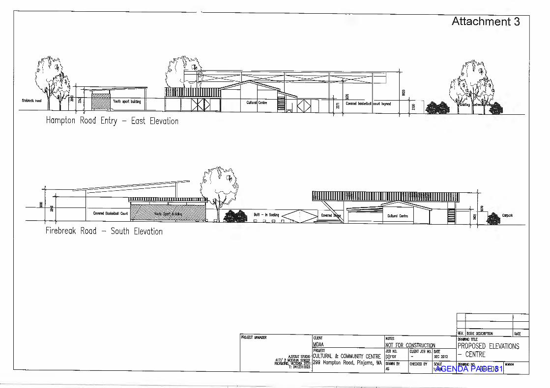
AGENDA PAGE 81