stearns county land use zoning ordinance review committee
TRANSCRIPT

Stearns County Land Use & Zoning
Ordinance Review Committee
Meeting #2: Monday, November 30, 2020
6:00pm
Webex: http://stearnscountymn.iqm2.com/Citizens/Default.aspx
Agenda
1. Welcome and call to order
2. Shoreland alterations, part 2. Topics include topographic alterations, sand
blankets and retaining walls. Review proposed ordinance amendments.
3. Next Meeting: Monday, December 21st, 3:30pm. Topic: Solar Farm
Permitting Options and Recreational Vehicles in shoreland.
If you are unable to attend, please contact Angie Berg:
[email protected] or 320‐656‐3613
We are not adopting a zoning ordinance; we are implementing the comprehensive plan.
Packet Page 1

STEARNS COUNTY SHORELAND ORDINANCE REVISIONS Implementing the Comprehensive Plan
Meeting 2
November 30, 2020
OUTLINE
1. Shoreland Excavator Licensing
2. Rock Riprap
3. Retaining Walls
4. Topographic Alterations
5. Sand Blankets
6. Impervious Surfaces
7. *Water Access on Steep Slopes – Stairways, Lifts, and Landings *
8. Vegetation Alterations
9. Score Your Shore Site Assessment
10. Violations/Work Without Permits/Fee Schedule, Permit Costs
Session 1 Takeaways
• Prioritize sensitive areas including bluffs, steep slopes, and the shore impact zone. • Recognize the differences between shoreland classifications for water bodies and ensure
flexible, appropriate language for each unique classification. • Requirements need to be concise and clear to facilitate education of stakeholders –
property owners, contractors, realtors, etc. • Consider additional penalties and incentives to ensure compliance.
Packet Page 2

SHORELAND EXCAVATOR LICENSING
Thoughts & Discussion from Meeting 1
• Licensed contractors should not be able to pursue new shoreland projects with outstanding violations on past projects.
• Contractors exceeding permitted limits on non-permitted projects. • Increased penalties for contractors who perform work that would not have been
authorized by a permit. • Elevating consequences over a 5-year period for contractors with violations. • Consider incentives.
New Proposed Section 4.20 D. (2)
Licensed contractors who complete defective work in violation of this Ordinance or who perform work without a minor shoreland permit shall be required to meet with the Department and identify a plan to correct the noncompliance and/or obtain a Minor Shoreland Alteration permit. The contractor may not complete or be granted additional permits for shoreland work until all previous projects satisfy permit conditions and Ordinance requirements.
_________________________________________________________________
Reasoning Incorrectly performing the work, other than needing to correct it, carries few consequences for contractors. The process to coerce corrective action may take many months and hours of staff time. Preventing additional work from being completed will provide incentive for contractors to do the project correctly the first time. This measure may be more restrictive than simply paying a fee (some contractors would prefer a fee). Fees could be considered in addition.
This measure ensures compliance and reduces time invested in correspondence (written and verbal) with the contractor. Contractors who perform the work correctly will not experience delays.
Packet Page 3

SHORELAND EXCAVATOR LICENSING
4.20 Licensing
A. License Required. No person, firm or corporation shall engage in the business of excavating, landscaping, grading or hauling fill within shoreland areas of Stearns County without first having a license from the County, paying the license fee established by Board resolution and furnishing a bond as hereinafter provided.
B. Bond Requirement. Before a license is granted, the applicant shall furnish a bond, approved by the Board, in the sum of $10,000.00, duly executed by the applicant, as principal and by a corporation authorized to issue such bond in the State of Minnesota, as surety. Such bond shall provide that all work done or performed by said principal shall fully conform to, and comply with, the requirements of this Ordinance.
C. License Application. Application for license shall be made annually on a form provided by the County, and such license shall expire on December 31st following issuance.
D. License Revocation. A license issued under the provisions of Section 4.20 of this Ordinance may be revoked or renewal refused by the Board for cause. Any work performed by a licensee in violation of the provisions of this Ordinance or the refusal of the licensee to correct defective work performed by such licensee shall be cause for revocation of, or refusal to, renew a license. Prior to the revocation or refusal to renew a license issued under the provisions of Section 4.20 of this Ordinance, a hearing shall be given the licensee before the Board. Notice of the time, place and purpose of such hearings shall be given the licensee in writing.
(1) Failure to obtain permit. Shoreland alterations made by a contractor licensed under Section 4.20 of this Ordinance without having obtained a major shoreland alteration permit shall result in the loss of said license. Restoration costs shall be paid for using the bond or financial security posted with the license. Revocation of license shall not prevent contractor from seeking a new license.
(2) Noncompliance. Licensed contractors who complete defective work in violation of this Ordinance or who perform work without a minor shoreland permit shall be required to meet with the Department and identify a plan to correct the noncompliance and/or obtain a minor shoreland alteration permit. The contractor may not complete or be granted additional permits for shoreland work until all previous projects satisfy permit conditions and Ordinance requirements.
Packet Page 4

ROCK RIPRAP Current Stearns County Standards - 10.2.14
(3) Bioengineered solutions, such as the use of natural vegetation, slope stabilization using mulch, biomat, or similar bioengineered means, shall be the preferred method of preventing or mitigating the risk of erosion. Rock riprap shall only be allowed when bioengineered solutions are demonstrated to be unfeasible. Riprap used for ornamental purposes or for terracing natural slopes shall meet the retaining wall standards set forth in Section 10.2.14 I of this Ordinance; or successor Ordinance. For purposes of this Section, rock riprap shall mean coarse stones randomly and loosely placed along the shoreline. Rock riprap is permitted as a minor shoreland alteration permit provided the following standards are met:
a. The finished slope does not exceed 3 feet horizontal to 1 foot vertical. b. The landward extent of the riprap is within ten (10) feet of the OHWL. c. The height of the riprap above the OHWL does not exceed three (3) feet.
Thoughts & Discussion from Meeting 1
1. Consideration of shoreland classification (NE/RD/GD) and water body size. 2. Property owners want the “look” of riprap and feel that it is either the “best” option or
the “only” option to control erosion. 3. Erosion potential is often self-induced through shoreline alterations, disturbance,
mowing, or vegetation removal. 4. Many, but not all, contractors are unfamiliar with bioengineering and vegetation
techniques for erosion control at the water’s edge and will prioritize rock for customers.
Amendment Options – Rock Riprap
1. Rock riprap placement shall only be allowed where deemed appropriate by the Department or SWCD to prevent active erosion. Riprap is not allowed for aesthetic reasons. If riprap is not authorized, bioengineered solutions such as the use of natural vegetation, slope stabilization, or other bioengineered means shall be the method used to prevent erosion. Bioengineered solutions do not require a permit from the Department unless required due to topographic alteration activity.
2. Rock riprap shall only be allowed where an active erosion problem exists. Bioengineered solutions shall be the preferred method to control erosion. Riprap is not allowed for aesthetic reasons. Installation of riprap requires the establishment of a native vegetation buffer at least 10 feet landward of the riprap for the entire length of riprap placement. Buffer plans must be approved by the Department or the SWCD. (Dimensional requirements to remain the same unless stated otherwise in permit conditions due to shoreland classification, water body size, etc.)
3. Existing language.
More Restrictive
↓
Status Quo
Packet Page 5

LGU Higher Standards - Riprap
Beltrami County Riprap is only allowed where erosion problems exist (not for aesthetic reasons). Installation of riprap also requires establishing a 10 ft. native vegetation buffer parallel to the shoreline for the entire length of the riprap, except for an approved shoreland alteration (recreation) area. Buffer plans must be approved by the SWCD. Ordinance Citation: Section 1104.3. F.
Morrison County If a native vegetative buffer of at least 10ft does not exist on the property, an application for riprap must include a plan to establish a native vegetative buffer of at least 10ft as measured from the top of the rip rap and extending the length of the property excluding recreational use areas. These plans shall be approved by Morrison County Land Services and shall be implemented immediately. Ordinance Citation: Section 710.45 D.
Benton County a. Rip-rap should only be used in areas experiencing active erosion. b. Rip-rap for aesthetic purposes is prohibited. c. The area to be rip-rapped shall be limited to 25 percent of the shoreline length. d. There shall be a minimum 10 foot native vegetation buffer the entire length of the rip-rapped area. Ordinance Citation: Section 7.14.5 (G)(2)(e)
Beltrami County Riprap is only allowed where erosion problems exist (not for aesthetic reasons). Installation of riprap also requires establishing a 10 ft. native vegetation buffer parallel to the shoreline for the entire length of the riprap, except for an approved shoreland alteration (recreation) area. Buffer plans must be approved by the SWCD. Ordinance Citation: Section 1104.3. F.
Aitkin County Riprap requires a permit and is only allowed in areas with established erosion problems that cannot be corrected through bioengineering measures. Installation of riprap requires a vegetative buffer to a depth determined by the county for the entire width of the lot, except for access areas. Riprap/walls for ornamental or terracing purposes are prohibited in the BIZ/SIZ. Ordinance Citation: Section 5.32 D. (6)
Cass County 1. Rip-rap will only be allowed in situations where active erosion problems exist. 2. Any permit for rip-rap must contain a plan to establish a vegetative buffer with the
depth to be determined by ESD for the entire width of the lot, except for lake or river access areas. Plans for such buffers shall be approved by ESD.
3. Natural rock rip-rap shall only be used for the correction of an established erosion problem that cannot be controlled through the use of suitable vegetation, slope stabilization using natural mulch, biomat or similar bioengineering means. Slope stabilization methods must be approved by ESD.
4. Rip-rap and retaining walls used for ornamental purposes or for terracing natural slopes are prohibited within SIZ 1, SIZ 2 and the bluff impact zone.
Other Local LGU Standards - Riprap Kandiyohi County No specific riprap requirements.
Packet Page 6

ROCK RIPRAP
(3) Bioengineered solutions, such as the use of natural vegetation, slope stabilization using mulch, biomat, or similar bioengineered means, shall be the preferred method of preventing or mitigating the risk of erosion. Rock riprap shall only be allowed when bioengineered solutions are demonstrated to be unfeasible. Riprap used for ornamental purposes or for terracing natural slopes shall meet the retaining wall standards set forth in Section 10.2.14 I of this Ordinance; or successor Ordinance. For purposes of this Section, rock riprap shall mean coarse stones randomly and loosely placed along the shoreline. Rock riprap is permitted as a minor shoreland alteration permit provided the following standards are met:
(a) The finished slope does not exceed three (3) feet horizontal to one (1) foot vertical. (b) The landward extent of the riprap is within ten (10) feet of the OHWL. (c) The height of the riprap above the OHWL does not exceed three (3) feet.
_________________________________________________________________________________ Option 1.
(3) Rock riprap placement shall only be allowed where deemed appropriate by the Department or SWCD to prevent active erosion. Riprap is not allowed for aesthetic reasons. If riprap is not authorized, bioengineered solutions such as the use of natural vegetation, slope stabilization, or other bioengineered means shall be the method used to prevent erosion. This activity does not require a permit from the Department unless required due to topographic alteration activity. When deemed appropriate by the Department or SWCD, rock riprap is permitted as a minor shoreland alteration permit provided the following standards are met unless otherwise noted in permit conditions:
(a) The finished slope does not exceed three (3) feet horizontal to one (1) foot vertical. (b) The landward extent of the riprap is within ten (10) feet of the OHWL. (c) The height of the riprap above the OHWL does not exceed three (3) feet.
_________________________________________________________________________________ Option 2.
(3) Rock riprap shall only be allowed where an active erosion problem exists. Bioengineered solutions shall be the preferred method to control erosion. Riprap is not allowed for aesthetic reasons. Installation of riprap requires the establishment of a native vegetation buffer at least 10 feet landward of the riprap for the entire length of riprap placement. Buffer plans must be approved by the Department or the SWCD. When authorized, rock riprap is permitted as a minor shoreland alteration permit provided the following standards are met unless otherwise noted in permit conditions:
(a) The finished slope does not exceed three (3) feet horizontal to one (1) foot vertical. (b) The landward extent of the riprap is within ten (10) feet of the OHWL. (c) The height of the riprap above the OHWL does not exceed three (3) feet.
Packet Page 7

RETAINING WALLS Thoughts & Discussion from Meeting 1
1. Implement more restrictive standards on walls in SIZ and bluff/BIZ than walls further from the water body.
2. Standards based on slopes/site conditions. 3. Elimination of wall below grade in height calculation. 4. Make requirements clear.
Amendment Options – Retaining Walls
1. Retaining walls shall be prohibited within the shore impact zone (SIZ) and bluff impact zone (BIZ). Retaining walls outside of the SIZ or BIZ may be allowed as either a minor or major shoreland alteration according to the following standards: (existing criteria)
2. Retaining walls proposed in the SIZ, BIZ, or steep slopes may only be authorized when the following apply:
a. The wall is not used for ornamental purposes or to alter the topography. b. No wall(s) shall exceed four feet in height without a plan signed by a Minnesota
licensed professional engineer.
3. Existing language.
More
Restrictive
↓
Status Quo
Packet Page 8

LGU Higher Standards
Aitkin County …retaining walls used for ornamental purposes or for terracing natural slopes are prohibited within the shore impact zone and bluff impact zones, unless allowed in Section 5.32,D. [by the Department]. Cass County Rip-rap and retaining walls used for ornamental purposes or for terracing natural slopes are prohibited within Shore Impact Zone 1, Shore Impact Zone 2, and the bluff impact zone. Crow Wing County A. A retaining wall may be installed with a shoreland alteration permit in shore impact zones 1 or 2 provided the following standards are met:
1. The Department determines that there is no other alternative to control erosion. 2. No tier of the retaining wall shall exceed four feet in height without a plan signed by a Minnesota licensed professional engineer. 3. Construction complies with all provisions of Articles 11 and 41 of this ordinance.
B. A retaining wall may be installed without a permit behind the structure setback provided that:
1. It does not significantly alter the character of the property or does not create runoff or erosion problems. 2. Construction complies with all provisions of Articles 11 and 41 of this Ordinance.
Douglas County (c.) Retaining walls - may be allowed where there is a demonstrated need, the design is consistent with the existing uses in the area, and is not an aesthetic intrusion upon the land. The height of new retaining walls should not exceed three (3) feet in height, some existing walls are higher than three (3) feet and these may be reconstructed with a shoreland alteration permit. If greater heights are needed for new retaining walls they may be granted with a conditional use permit.
Other LGU Standards
Kandiyohi County
3. Retaining walls may be allowed where there is a demonstrated need, the design is consistent with the existing uses in the area, and the wall doesn’t impair the natural character of the shoreline. However, within steep slopes, bluff and/or shore impact zones, retaining wall construction shall only be allowed where erosion problems preclude the use of vegetation.
4. The repair and reconstruction of existing walls may be allowed by permit subject to review by the Zoning Administrator.
Packet Page 9

RETAINING WALLS I. Retaining Walls. The construction of retaining walls are subject to the requirements in
Section 10.2.14B and D of this Ordinance and shall only be authorized by either a minor or major shoreland alteration permit as listed below. Wall height as it pertains to this Section is measured from the bottom of the retaining material to the top of the cap as measured from the highest point of the wall and shall include the height of all components constituting the wall. Cumulative height means the combined height of any wall or series of walls require to retain a single slope.
Retaining walls shall be prohibited within the shore impact zone (SIZ) and bluff impact zone (BIZ). Retaining walls outside of the SIZ or BIZ may be allowed as either a minor or major shoreland alteration according to the following standards:
Or
Retaining walls proposed in the SIZ, BIZ, or steep slopes may only be authorized by a major shoreland alteration permit when the following apply:
a. The wall is not used for ornamental purposes or to alter the topography. b. No wall(s) shall exceed four feet in height without a plan signed by a Minnesota
licensed professional engineer.
(1) Minor Shoreland Alteration Permit. A Minor Shoreland Alteration Permit can authorize retaining walls meeting any of the following conditions:
(a) Retaining walls four (4) feet in cumulative height or less when a documented erosion problem exists; or
(b) Retaining walls that are not visible from the shore by virtue of topography or vegetation during leaf-on, daylight conditions; or
(c) Replacement retaining walls pursuant to Section 5.1.2C(6) of this Ordinance; or (d) Retaining walls four (4) feet in cumulative height or less used for ornamental
purposes or for terracing natural slopes where a documented erosion problem does not exist is limited to one area not to exceed 25% of the lot width as measured at the Ordinary High Water Level. Maximum width shall not exceed 75 feet.
(e) Retaining walls that are located outside of the setback area for the applicable lake or river class.
(2) Major Shoreland Alteration Permit. A Major Shoreland Alteration Permit can authorize retaining walls meeting any of the following conditions:
(a) Retaining walls more than four (4) feet in cumulative height when a documented erosion problem exists.
(b) Replacement retaining walls greater than four (4) feet in cumulative height not pursuant to Section 5.1.2C(6) of this Ordinance.
(c) Retaining walls more than four (4) feet in cumulative height used for ornamental purposes or for terracing natural slopes where a documented erosion problem does not exist when the request exceeds more than one area, more than 25% of the lot width as measured from the Ordinary High Water Level or more than 75 feet in total width.
Packet Page 10

TOPOGRAPHIC ALTERATIONS
Current Stearns County Standards
Less than 10 cubic yards of fill/excavation/grading does not require permit (regardless of location).
Less than 50 cubic yards of fill/excavation/grading does not require permit if: not in SIZ, BIZ, or steep slope.
B. Minor Shoreland Alteration Permits. A minor shoreland alteration permit may authorize the following activities.
1. Topographic alterations of a smaller scale in which the total amount of fill being deposited, removed or graded on site is less than one hundred (100) cubic yards.
Greater than 100 cubic yards requires Conditional Use Permit.
Amendment Options – Topographic Alterations
1. Fill placement is prohibited in the SIZ or BIZ unless authorized by the Department as part of a DNR, SWCD, NRCS or Watershed District project. Fill placement greater than 10 cubic yards on steep slopes (slopes greater than 12%) within the building setback for the applicable shoreland classification is prohibited. (other existing requirements remain)
2. A permit shall be required for any topographic alteration in the SIZ, BIZ, or on steep slopes (slopes greater than 12%). If no vegetation buffer exists between the project area and the water body, one must be established as part of the project. If an existing vegetation buffer adjacent to the water body will be eliminated or disturbed by the project, restoration of the buffer, with dimensions determined by the Department, shall be a condition of permit approval.
3. Less than [10/5 cubic yards] [270/135 square feet] of disturbance does not require a permit.
4. Existing requirements.
More Restrictive
↓
Status Quo
Packet Page 11

TOPOGRAPHIC ALTERATIONS
Other LGU Standards
Morrison County No alteration of the natural shoreline is allowed. Alteration of more than ten cubic yards of material in the shore and bluff impact zone and on steep slopes requires a variance. Ordinance Citation: Section 714.3.b. Kandiyohi County The movement of more than five (5) cubic yards of material on steep slopes or within shore and/or bluff impact zones unless the Zoning Administrator determines there is a potential for erosion necessitating a Condition Use Permit. This shall only be allowed one (1) time per tax parcel. Crow Wing County No permit required for 10 cubic yards or less if not located in Shore Impact Zone 1. Cass County A. The movement of up to fifty (50) cubic yards of earthen material within the structure setback and/or up to two-hundred (200) cubic yards behind the structure setback requires a shoreland alteration permit.
B. The movement of more than fifty (50) cubic yards of earthen material within the structure setback and/or more than two-hundred (200) cubic yards behind the structure setback requires a conditional use permit and may include conditions as determined by ESD.
And specific standards
2. When mechanized equipment is used for earthmoving in SIZ-1, an erosion control plan shall be approved by ESD prior to construction and the measures prescribed in the plan shall be implemented to which ESD may require conditions and financial assurance as determined appropriate.
3. The maximum width of a shoreland alteration area through SIZ- 1 shall be twenty (20) feet wide at the OHWL.
Packet Page 12

SAND BLANKETS Current Stearns County Standards
(b) The sand blanket may be up to twelve (12) inches in depth, up to thirty (30) feet in width along the shoreline or one-half (1/2) the lot width, whichever is less; and may not extend more than ten (10) feet landward of the ordinary high water level.
(c) An earthen berm shall be constructed on the landward side of the sand blanket to divert surface water runoff around the sand area. The berm shall be planted with vegetation such as grass to aid in the assimilation of surface water runoff.
(2) Sand blanket placement without excavation: (a) Only clean, washed sand, free of organic or toxic materials shall be used. (b) The sand blanket may be up to twelve (12) inches in depth, up to fifty (50) feet in
width along the shoreline or one-half (1/2) the lot width, whichever is less; and may not extend more than ten (10) feet landward of the ordinary high water level.
Amendment Options – Sand Blankets
1. Sand blankets are limited to [25] feet in length or 25% of the lot width, whichever is less.
2. Existing requirements.
Other LGU Standards
Benton County Blanket is limited to 25 percent of the length of the shoreline or 25 feet, whichever is less. Ordinance Citation 7.14(G)(2)(f)(i)b. Kandiyohi County [A shoreland alteration permit shall be required for] The establishment of a sand beach area to a maximum size of one hundred fifty (150) square feet. Ordinance Citation 12-1-9 5. Todd County Installation of a beach sand blanket may be permitted, with a shoreland alteration permit, provided that: They are constructed in accordance with Minnesota Department of Natural Resources (DNR) standards, except that they shall not exceed 25 feet along the shoreline or 25 percent of the width of the lot, whichever is less.
More Restrictive
↓
Status Quo
Packet Page 13

IMPERVIOUS SURFACES Stearns County does not limit impervious surfaces beyond the statewide minimum 25% lot coverage requirement in the Shoreland Overlay District. If the patio/impervious surface area is within 12” of existing grade, a permit is not required. A permit is also not required for walkways or stairs to the lake (meeting 4ft wide, 32 sq. ft. landing max size requirements).
Meeting 1 Thoughts/Discussion
• Proximity to water body should require standards/setbacks. • Runoff should not be directed toward adjacent properties or the water body.
Amendment Options – Impervious Surfaces
1. Impervious surfaces are prohibited in the SIZ and BIZ excluding water oriented accessory structures and stairways, lifts, or landings constructed in accordance with this Ordinance. and/or
2. Each property shall be allowed one (1) area of impervious cover in the SIZ not to exceed 150 square feet in size excluding stairways, lifts, or landings in accordance with this Ordinance.
3. In addition to a WOAS, each riparian lot may be allowed an area of impervious surface up to 50 square feet in size. Addition of impervious surface in the SIZ requires a minor shoreland alteration permit. A buffer of native vegetation at least 30/20 feet wide shall exist between the impervious surface and the water body. Water runoff from the impervious surface shall not be directed toward an adjacent property or the water body.
4. Status quo (no impervious requirements other than 12” from grade)
More Restrictive
↓
Status Quo
Packet Page 14

LGU Higher Standards
Crow Wing County No impervious surfaces shall be allowed within the shore impact zone, except stairways, lifts or landings. Portions of boat launching ramps greater than 10 feet landward from the OWHL shall be constructed of pervious material.
Ordinance Citation: Section 33.12 D
Cass County Patios and platforms are allowed within the structure setback with a shoreland alteration permit with specific standards limiting size and establishing setbacks from the OWHL. Ordinance Citation: Section 1126.7
Douglas County No pervious or porous pavement systems shall be allowed in a bluff impact zone or shore impact zone unless specifically approved otherwise by the Land and Resource Director when restoration to natural vegetation would not be practical or advised by a qualified engineer. These areas shall be maintained or restored to natural vegetative buffer whenever feasible. Ordinance Citation: Section V.L.4.(2.)(d.)iii.c.
Kandiyohi County No permit shall be required for a deck, patio, concrete slab, asphalt driveway, or the like, with an average height of less than twelve (12) inches above grade, provided the structure is located outside of the shore impact zone. Only water orientated accessory structures are permitted within the shore or bluff impact zone.
Ordinance Citation 2-6-1 1.
Packet Page 15

STEEP SLOPE ACCESS – STAIRWAYS, LIFTS, & LANDINGS
Existing Standards
(3) Stairways, Lifts and Landings. Stairways, lifts and landings are the preferred alternative to major topographic alterations for achieving access up and down bluffs and steep slopes to shore areas. Stairways, lifts and landings shall meet the following design requirements: (a) Stairways and lifts shall not exceed four (4) feet in width on residential lots. Stairways and
lifts shall not exceed six (6) feet in width for commercial properties, public open- space recreational properties and residential open space or conservation design developments in shoreland;
(b) Landings for stairways and lifts on residential lots shall not exceed thirty two (32) square feet in area. Landings for stairways and lifts shall not exceed forty eight (48) square feet for commercial properties, public open-space recreational properties and residential open space or conservation design developments in shoreland;
(c) Canopies or roofs are not allowed on stairways, lifts or landings; (d) Stairways, lifts and landings may be either constructed above the ground on posts or
pilings, or placed into the ground, provided they are designed and built in a manner that ensures control of soil erosion;
(e) Stairways, lifts and landings shall be located in the most visually inconspicuous portions of the lot, as viewed from the surface of the public water assuming summer, leaf-on conditions, whenever practical; and
(f) Facilities such as ramps, lifts or mobility paths for physically handicapped persons are also allowed for achieving access to shore areas, provided that the dimensional and performance standards of subitems (a) to (e) are complied with, in addition to the requirements of Minnesota Rules, chapter 1341; or successor rule.
Amendment Options – Water Access
1. A permit is required for constructing impervious surfaces to achieve access to shore
areas. On slopes exceeding 18%, topographic alterations shall be prohibited for achieving lake access and stairways, lifts, and landings constructed above ground shall be used.
2. On slopes exceeding 18%, topographic alterations shall be prohibited for achieving lake access and stairways, lifts, and landings constructed above ground shall be used.
3. Status Quo. No permit is required for water access as long as it meets existing criteria and does not disturb more than 10 cubic yards of material.
More Restrictive
↓
Status Quo
Packet Page 16

VEGETATION ALTERATIONS Vegetative Alterations Current Standards A. Vegetation alteration necessary for the construction of structures, sewage treatment systems and the construction of
roads and parking areas regulated by Section 10.2.16 of this Ordinance are exempt from the vegetation alteration standards in Section 10.2.13 of this Ordinance, provided that a plan for the activities has been submitted to and approved by the Department.
B. Except for agricultural and forest management uses as regulated in Sections 10.2.19 and 10.2.20 of this Ordinance, respectively, removal or alteration of vegetation may only be allowed, subject to the following standards: (1) Intensive vegetation clearing within the shore and bluff impact zones and on steep slopes is not allowed, except
as described in this Section. Intensive vegetation clearing for forest land conversion to another use outside of the shore and bluff impact zones and on steep slopes may be allowed as a conditional use if an erosion control and sedimentation plan is developed and approved by the Soil and Water Conservation District.
(2) Planned Unit, open space and conservation design developments are subject to the standards of Sections 7.6 and 10.2.22 A.(2) of this Ordinance.
(3) Vegetative alterations may be allowed on riparian lots, in shore or bluff impact zones or on steep slopes in accordance with the following standards: (a) Prior to vegetative removal regulated by this Section or prior to establishing a view corridor on a riparian
lot, the property owner shall contact the Department to arrange for a site visit and complete an application for vegetative alteration; and
(b) The Department may require that the property owner clearly mark any proposed view corridor and/or any vegetation to be removed from a riparian lot. Additionally, the Department may require the property owner to supply information on slope, soil type, property line locations, location of easements and any other information that may be needed in order for the Department to act on a request; and
(c) In considering a request for vegetative alterations, including the establishment of a view corridor, the Department may take into account the predevelopment vegetation, natural openings, surrounding vegetation patterns and density, previous vegetative alterations, slope, soil type, the locations and extent of adjacent view corridors, the adjacent body of water and other information it deems necessary and pertinent to the request; and
(d) The total cumulative view corridor shall not exceed fifty (50) feet or one-half (1/2) the lot width, whichever is less; and
(e) The view corridor shall extend from the most lakeward side of the principle residence and continue to the ordinary high water level of a public water body; and
(f) The total cumulative tree/shrub removal within any view corridor shall not exceed twenty five (25) percent of the trees greater than five (5) inches in diameter four and one-half (4.5) feet above the ground (diameter breast height or DBH) and twenty five (25) percent of the trees/shrubs less than five (5) inches DBH; and
(g) From the ordinary high water level, extending through the shore impact zone and extending to the building setback, exclusive of the view corridor, no vegetative alterations are allowed, however planting of trees, shrubs and other vegetation is encouraged; and
(h) From the building setback and extending to the landward end of the lot, up to twenty five (25) percent of the trees greater than five (5) inches DBH and up to twenty five (25) percent of the trees/shrubs less than five (5) inches DBH may be removed in accordance with a plan submitted to and approved by the department; and
(i) Except Boxelder and Chinese Elm, the removal of exotic species such as European Buckthorn or Purple Loosestrife or noxious species such as Poison Ivy or Prickly Ash is permitted; and
(j) The screening of structures, vehicles or other facilities as viewed from the water, assuming summer, leaf-on conditions, shall not be substantially reduced; and
(k) The existing shading of water surfaces along the shoreline shall be preserved during summer, leaf-on periods of the year.
C. The removal of exotic species such as European Buckthorn or Purple Loosestrife or noxious species such as Poison Ivy or Prickly Ash shall not be considered to constitute an alteration of the vegetation.
D. Naturally dead or diseased trees may be removed regardless of their location on the property. E. Application of fertilizer and pesticides in shoreland must be done in such a way as to minimize runoff into the shore
impact zone or public water. The use of phosphorous containing fertilizer is prohibited within the shore impact zone. F. Burning of yard waste is prohibited within the shore and bluff impact zones or on steep slopes. G. Planting of trees, shrubs, establishing vegetated buffers and maintaining vegetated shorelines is encouraged on all
riparian lots within Stearns County as a method to minimize and mitigate the impacts of stormwater runoff, erosion and nutrient enrichment on the County’s water resources.
Packet Page 17
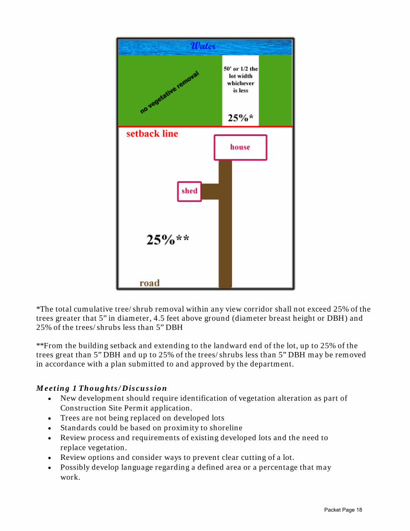
*The total cumulative tree/shrub removal within any view corridor shall not exceed 25% of the trees greater that 5” in diameter, 4.5 feet above ground (diameter breast height or DBH) and 25% of the trees/shrubs less than 5” DBH **From the building setback and extending to the landward end of the lot, up to 25% of the trees great than 5” DBH and up to 25% of the trees/shrubs less than 5” DBH may be removed in accordance with a plan submitted to and approved by the department.
Meeting 1 Thoughts/Discussion • New development should require identification of vegetation alteration as part of
Construction Site Permit application. • Trees are not being replaced on developed lots • Standards could be based on proximity to shoreline • Review process and requirements of existing developed lots and the need to
replace vegetation. • Review options and consider ways to prevent clear cutting of a lot. • Possibly develop language regarding a defined area or a percentage that may
work.
Packet Page 18

LGU Higher Standards
Beltrami County In the shore impact zone, a path no wider than 15 feet may be cleared to the OHWL and shall be stabilized to control erosion within 24 hours of vegetation removal. In addition to the path to the lake, an area at least 10 feet from the OHWL and not to exceed 200 square feet may be cleared. Section 1122.1.C.4. Outside of the shore impact zone but within the required setback, the removal of 25% (as measured by aerial coverage) of trees, in a random pattern, and 75% (as measured by aerial coverage) of shrubs may be permitted. Ordinance Citation: Section 1122.1.C.5. Removal or alteration of vegetation within the OHWL setback requires a shoreland alteration permit. Ordinance Citation: Section 1122.1 Cass County In Shore Impact Zone – 1, clearing width shall not exceed 20 (twenty) feet of the width of the lot at the OWHL and all cutting shall be done by hand and topsoil is not disturbed. Ordinance Citation: Section 1128.2. In Shore Impact Zone – 2, up to 25% of threes may be removed in a random pattern and up to 30% of shrubs. Ordinance Citation: Section 1128.3. Hubbard County Only one shoreline recreation use area (area within the shore impact zone for residential and resort developments) shall be allowed on each residential lot and it shall not exceed the following dimensions: Natural Environment: 10’ x 15’ Recreational Development: 20’ x 15’ General Development: 30’ x 15’
Other LGU Standards
Kandiyohi County
a. Within the shoreland and/or bluff impact zone, the removal of vegetation shall be limited to prevent erosion into public waters, and to preserve the natural character of the shoreland. Removal shall be restricted within a strip paralleling the lakeshore and extending inland a specified distance from the normal high water mark. The specified distance is established according to lake classification:
(1) Natural Environment Lakes: Seventy-five (75) feet from the ordinary high water level.
(2) Recreational Development Lake: Fifty (50) feet from the ordinary high water level.
(3) General Development Lakes: Fifty (50) feet from the ordinary high water level.
b. To allow a viewing corridor to the water from the principal dwelling, twenty-five (25) percent of the lot width, or a maximum of fifty (50) feet, whichever is less, may have up to twenty (20) percent of the trees trimmed or selectively cut. In the remaining footage, trimming and selective cutting shall maintain sufficient cover to screen cars, dwellings, and other structures from view from the water assuming summer leaf on conditions
Packet Page 19

Amendment Options – Vegetative Alterations
1. 100% removal of trees and shrubs in a 25ft corridor between the building setback for the applicable shoreland classification and the water body can be authorized by a Vegetative Alteration Permit. The corridor shall serve as the access and view corridor. Vegetation outside of the 25ft corridor shall not be disturbed or removed. Areas considered a bluff or steep slope shall only be allowed 25% removal within a 25ft corridor. Lake access paths in bluffs or steep slopes may be completed in accordance with Section XXXX of this Ordinance.
2. Existing requirements.
Change
↓
Status Quo
Option 1
Packet Page 20

SCORE YOUR SHORE SITE EVALUATION
Thoughts & Discussion from Meeting 1
1. Evaluation can be used to maintain and improve habitat on riparian properties. 2. Objective tool to evaluate the site. 3. Potential penalty to new property owners if alterations were completed in the past? 4. Completion during pre-application site visit by both the property owner/contractor and
ESD facilitates education and understanding of lot conditions. 5. Examples of previous Major SAPs to be included at next meeting for comparison.
Amendment Options – Site Evaluation/Site Requirements
1. During the pre-application site visit, a Score Your Shore assessment shall be completed
by the Department and the property owner and/or licensed shoreland contractor. Properties with site conditions below the following thresholds shall not be allowed additional alterations until improved: Upland Zone Score: 19 Shoreline Zone Score: 17
Sites failing to meet this threshold shall include mitigation as part of the application or seek a variance to be allowed the alteration permit.
Packet Page 21

VIOLATIONS AND WORK WITHOUT PERMITS
Amendment Options – Unpermitted Work
1. When unpermitted work is completed on a riparian lot, an SSTS compliance inspection shall be required regardless of whether the site is restored to the original condition or if a shoreland alteration permit is obtained.
SHORELAND ALTERATION PERMIT FEES
Minor Shoreland Alteration Permit: $400
ATF Minor Shoreland Alterations
Resolved after 1 Notice: $530 ($400 + $130 fee)
Resolved after 2nd notice: $640 ($400 + $240)
Resolved after 3rd notice: $760 ($400 + $360) ______________________________________________
Major Shoreland Alteration Permit Application: $550
ATF Major Shoreland Permit Application
Resolved after 1 notice: $1,075 ($550 + $525 fee)
Resolved after 2nd notice: $1,230 ($550 + $680)
Resolved after 3rd notice: $1,385 ($550 + $835) ______________________________________________
Unlicensed Contractor with No Permit: $1,000 + permit fee
Amendment Options – Permit Fees
1. Sand Blankets o Permit fee $100/$200 if sand blanket only
2. Minor SAP Application o $200 if only 1 category of alteration (riprap, topographic alteration, retaining
wall, etc.) o $400 maximum if more than 1 category
3. ATF Fees o Increase by $ amount o % cost of project
Packet Page 22