stirling council: stirling local development plan · stirling.gov.uk phone 0845 277 7000 text 07717...
TRANSCRIPT
stirling.gov.uk phone 0845 277 7000 text 07717 990 001 minicom 01786 464599
Stirling Council:Stirling Local Development Plan
September 2014


3Stirling Council Local Development Plan
Stirling Local Development Plan
Foreword
“Stirling’s Local Development Plan is a key strategic document, setting out avision that will shape the future of the Stirling area for the next 20 years. The Planprovides a positive approach to appropriate development and supports sustainableeconomic growth and sustainable development, while recognising the importanceof ‘placemaking’ and safeguarding the area’s important environmental andhistoric assets.
The policies and proposals contained in the Local Development Plan togetherwith supporting Supplementary Guidance, provides an up-to-date developmentplanning framework that will help to ensure that changes are managed in thebest possible way. The Plan will encourage and control the future use and developmentof land to assist in addressing the wider economic, environmental and socialchallenges that we all face.
The Local Development Plan indicates the land allocated to meet the futuredevelopment needs of the Stirling area, providing additional housing, business and retail space, thereby promoting Stirling as ‘Open for Business’. The Plan seeks todevelop more sustainable communities, by placing the emphasis on consolidation of existing settlements, where there is an established network of centres and supporting infrastructure.
New development impacts on all of us and the Local Development Plan is theresult of extensive consultation and engagement with local communities, businesses,community planning partners and a variety of key stakeholders, and follows onfrom the earlier publication and comments on the Main Issues Report andProposed Plan.”
Johanna Boyd Stewart Carruth, Leader of Chief Executive of Stirling Council. Stirling Council.
Fo
rE
wo
rD

4

5Stirling Council Local Development Plan
Stirling Local Development Plan
Contents
1. Introduction................................................................................... 7
2. Consultation on the Local Development Plan............................... 8
3. The Approach to the Vision, Spatial Strategy and Policies........... 9
4. Local Development Plan Vision................................................... 12
5. Spatial Strategy........................................................................... 15
6. Setting the Land requirement for Housing, Business & retail... 20
7. The overarching Policy, Primary Policies and Policies................ 29 A. Placemaking and implementing the Spatial Strategy (1-3).............. 30 B. Climate change adaptation and mitigation (4-6).............................. 50 C. Conservation of historic and natural heritage (7-9)......................... 58 D. Managing and utilising local resources (10-15)............................... 70
8. List of Policies and related Supplementary Guidance................ 80
9. Glossary of Terms........................................................................ 83
Appendix A: Schedule of Land owned by the Local Authority............. 94 Appendix B: Schedule of Sites (Housing, Employment, retail)........... 98
10. Settlement Statements and Proposals Maps............................. 106
Co
nT
En
TS
6
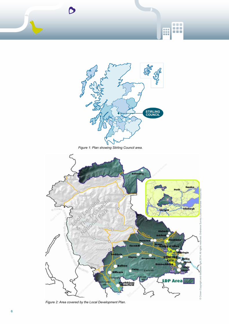
Figure 2: Area covered by the Local Development Plan.
Figure 1: Plan showing Stirling Council area.
© C
row
n C
opyr
ight
and
dat
abas
e rig
ht 2
014.
All
right
s re
serv
ed. o
rdna
nce
Surv
ey L
icen
ce n
umbe
r 100
0207
80
STIRLINGCOUNCIL
7Stirling Council Local Development Plan
Stirling Local Development Plan
1. Introduction
1.1 Development plans guide the future use of land and the appearance of cities, towns and rural areas. They indicate where development, including regeneration, should happen and where it should not. In the Stirling area, the development plan comprises the Stirling Local Development Plan supported by Supplementary Guidance.
1.2 The Local Development Plan (LDP) covers the whole of the Stirling LDP area (see figure 2). It contains a Vision looking ahead 20 years to 2034 and there is a statutory requirement to keep
development plans up to date to ensure that they reflect and respond to emerging pressures and issues. This new Plan and supporting Supplementary Guidance replaces the Stirling Council Local Plan (1999), Local Plan Alteration 1A (2007), Alteration 2 (2006), the Clackmannanshire and Stirling Structure Plan (2002) (as it relates to the Stirling LDP area), and all accompanying Supplementary Planning Guidance.
1.3 The Plan is supported by an Action Programme which sets out the actions necessary to implement the strategy and policies of the Plan.
1. I
nT
ro
Du
CT
Ion
8
2. Consultation on the Local Development Plan
2.1 The preparation of the Local Development Plan involved a great deal of research and analysis. It was subject to Strategic Environmental Assessment (SEA), Habitat regulations Appraisal (HrA), and an Equalities Impact Assessment. The Plan has been subject to extensive consultation and engagement with local communities, key agencies and local businesses etc, at various stages of production. unresolved representations to the Proposed Plan were also examined by the Directorate for Planning and Environmental Appeals between July 2013 and March 2014.
2.2 Details of all the consultation undertaken on the Local Development Plan is set out within the Participation Statement, contained within the latest Development Plan Scheme. http://www.stirling.gov.uk/__documents/temporary-uploads/economy,-planning-_and_-regulation/dev- plan-scheme/dps-for-web-9-9-2013.pdf
2.3 Accessing the Local Development Plan: The Plan and its supporting documents are available to view online at: www.stirling.gov.uk/localdevplan. The full text of the Plan and the detailed mapping relevant to the Policies and Supplementary Guidance are available to view as interactive ‘online versions’ at:- http://ldponline.stirling.gov.uk/oldp-web//docSelectAction.do?docId=163 2.4 The Planning and Policy team is responsible for preparing, monitoring and reviewing the Local Development Plan and Supplementary Guidance. The team can be contacted at:-
Economy Planning and Regulation Stirling Council Municipal Buildings 8-10 Corn Exchange Road Stirling FK8 2HU Tel: 01786 233685 Email: [email protected]
2. H
ow
Yo
u C
An
Co
MM
En
T o
n T
HE
Pr
oP
oS
ED
PLA
n
9Stirling Council Local Development Plan
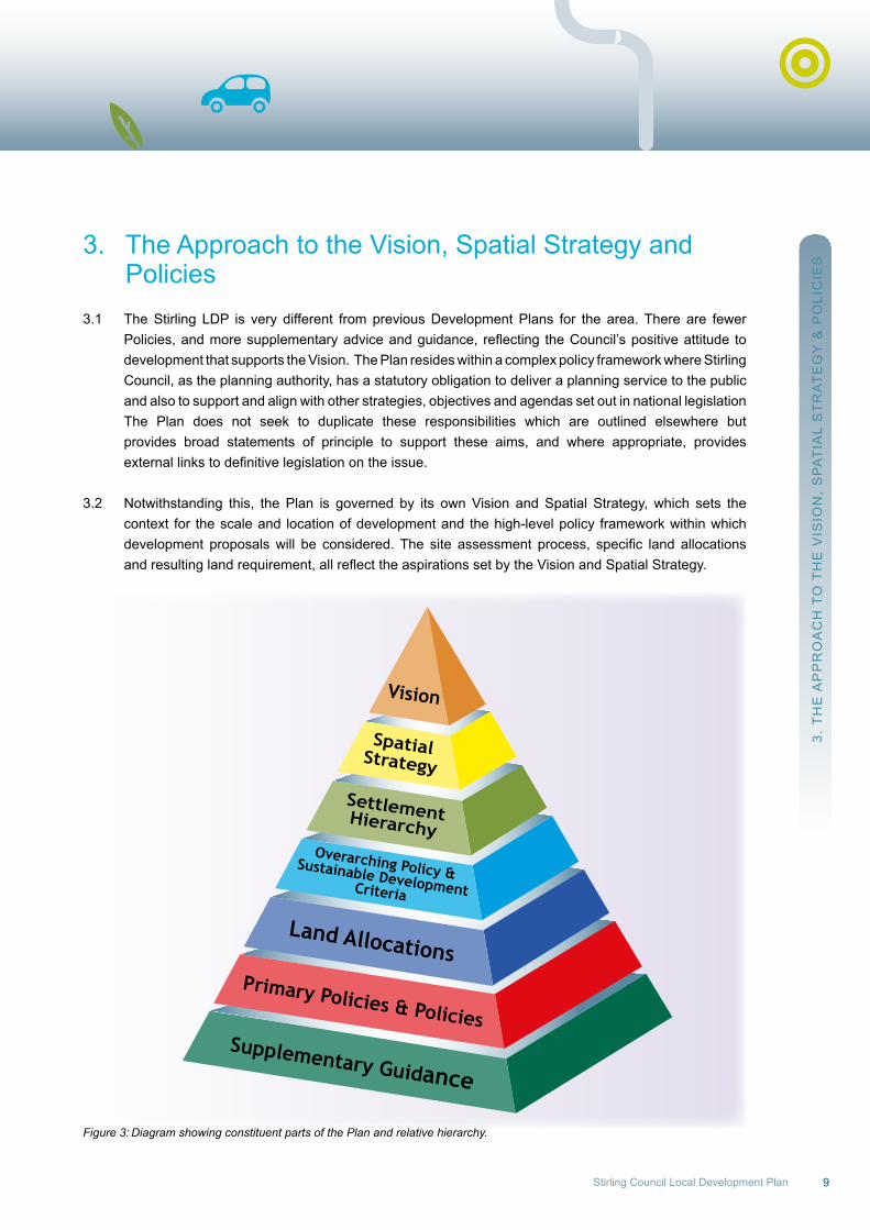
3. The Approach to the Vision, Spatial Strategy and Policies3.1 The Stirling LDP is very different from previous Development Plans for the area. There are fewer Policies,andmoresupplementaryadviceandguidance, reflecting theCouncil’spositiveattitude to development that supports the Vision. The Plan resides within a complex policy framework where Stirling Council, as the planning authority, has a statutory obligation to deliver a planning service to the public and also to support and align with other strategies, objectives and agendas set out in national legislation The Plan does not seek to duplicate these responsibilities which are outlined elsewhere but provides broad statements of principle to support these aims, and where appropriate, provides externallinkstodefinitivelegislationontheissue.
3.2 notwithstanding this, the Plan is governed by its own Vision and Spatial Strategy, which sets the context for the scale and location of development and the high-level policy framework within which development proposalswill be considered.The site assessment process, specific land allocations andresultinglandrequirement,allreflecttheaspirationssetbytheVisionandSpatialStrategy.
Figure 3: Diagram showing constituent parts of the Plan and relative hierarchy.
3. T
HE
AP
Pr
oA
CH
To
TH
E V
ISIo
n,
SP
AT
IAL
ST
rA
TE
GY
& P
oLI
CIE
S
Primary Policies & Policies
Overarching Policy &Sustainable DevelopmentCriteria
Land Allocations
SettlementHierarchy
SpatialStrategy
Vision
Supplementary Guidance
10
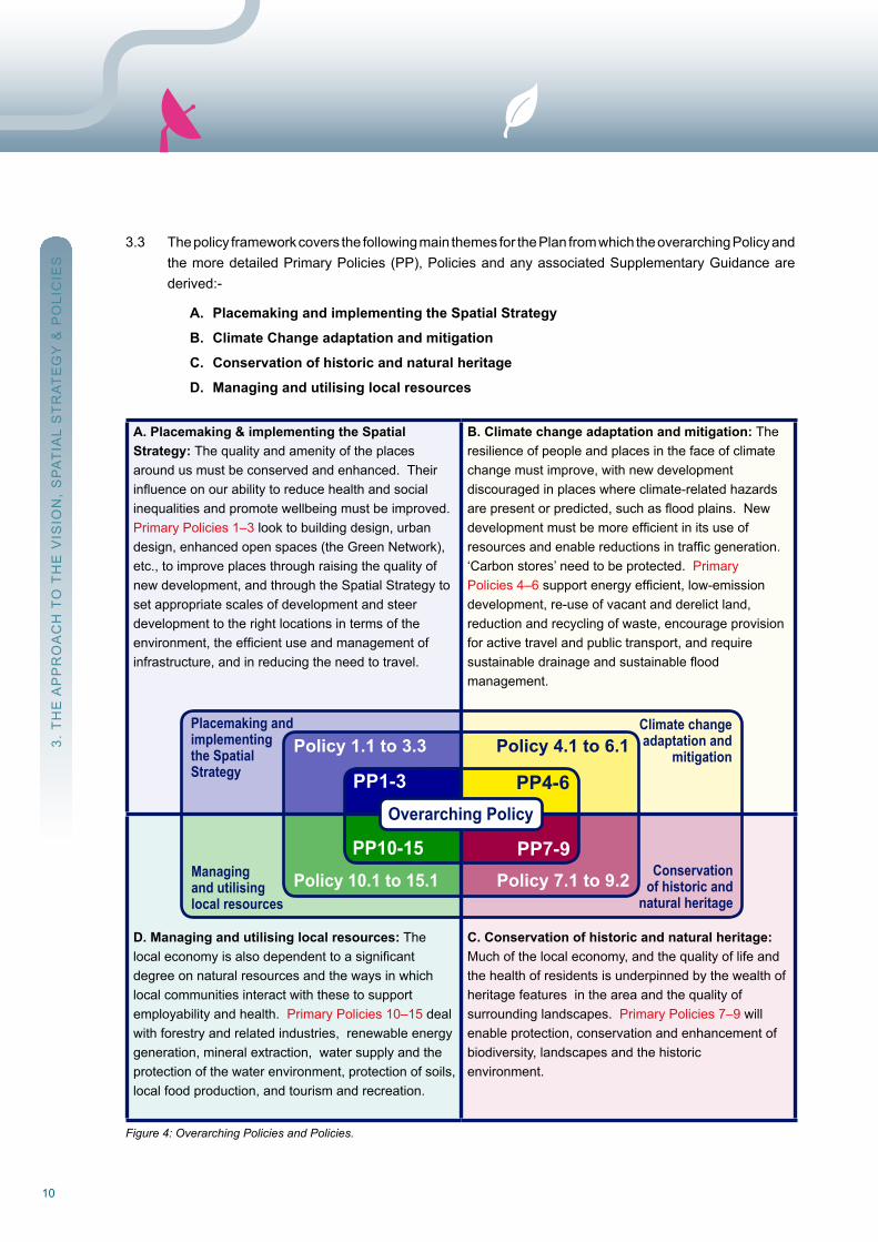
3.3 The policy framework covers the following main themes for the Plan from which the overarching Policy and the more detailed Primary Policies (PP), Policies and any associated Supplementary Guidance are derived:-
A. Placemaking and implementing the Spatial Strategy
B. Climate Change adaptation and mitigation
C. Conservation of historic and natural heritage
D. Managing and utilising local resources
A. Placemaking & implementing the SpatialStrategy: The quality and amenity of the places around us must be conserved and enhanced. Theirinfluenceonourabilitytoreducehealthandsocialinequalities and promote wellbeing must be improved. Primary Policies 1–3 look to building design, urban design, enhanced open spaces (the Green network), etc., to improve places through raising the quality of new development, and through the Spatial Strategy to set appropriate scales of development and steerdevelopment to the right locations in terms of theenvironment,theefficientuseandmanagementofinfrastructure, and in reducing the need to travel.
B. Climate change adaptation and mitigation: The resilience of people and places in the face of climate change must improve, with new developmentdiscouraged in places where climate-related hazards arepresentorpredicted,suchasfloodplains.Newdevelopmentmustbemoreefficientinitsuseofresourcesandenablereductionsintrafficgeneration.‘Carbon stores’ need to be protected. PrimaryPolicies 4–6supportenergyefficient,low-emissiondevelopment, re-use of vacant and derelict land, reduction and recycling of waste, encourage provision for active travel and public transport, and requiresustainabledrainageandsustainablefloodmanagement.
D. Managing and utilising local resources: Thelocaleconomyisalsodependenttoasignificantdegree on natural resources and the ways in whichlocal communities interact with these to supportemployability and health. Primary Policies 10–15 deal with forestry and related industries, renewable energy generation, mineral extraction, water supply and the protection of the water environment, protection of soils, local food production, and tourism and recreation.
C. Conservation of historic and natural heritage: Much of the local economy, and the quality of life and the health of residents is underpinned by the wealth of heritage features in the area and the quality ofsurrounding landscapes. Primary Policies 7–9 willenable protection, conservation and enhancement ofbiodiversity, landscapes and the historicenvironment.
Figure 4: Overarching Policies and Policies.
3. T
HE
AP
Pr
oA
CH
To
TH
E V
ISIo
n,
SP
AT
IAL
ST
rA
TE
GY
& P
oLI
CIE
S
Managingand utilisinglocal resources
Placemaking andimplementingthe SpatialStrategy
Climate changeadaptation and
mitigation
Conservationof historic and
natural heritage
Policy 1.1 to 3.3 Policy 4.1 to 6.1
Policy 10.1 to 15.1 Policy 7.1 to 9.2
PP1-3
PP10-15 PP7-9
PP4-6Overarching Policy
11Stirling Council Local Development Plan
How to use this Local Development Plan
3.4 Development proposals are assessed against the Development Plan (and other material considerations). Therefore, notwithstanding this underlying policy structure, the LDP must be considered and used as an
integrated planning tool. The Council is as much concerned with maintaining and building on the character and quality of Stirling and the other places in the area as it is with meeting the Council’s aspirations for new
housing and business space. Design and placemaking are emphasised, and the vision of a Green network, also contributing to biodiversity conservation, active travel networks and climate change mitigationandadaptation,isembraced.Individualtopic-specificpoliciesandlandallocationsdonot set out the whole picture for the various types of development. The overarching Policy and the Spatial Strategy are intended to be as much part of the consideration leading to development decisions as the detailed Policies and Supplementary Guidance. The fact that a particular policy or proposaldoesnotmention,say,floodavoidance,historicenvironmentorwastemanagement,doesnot
mean that such issues are irrelevant; all aspects need to be fully considered. Schedules of the housing, employment and retail sites allocated within the Plan are contained within Appendix B and also shown within the Settlement Statements at Chapter 10.
DefinitionsoftermsusedthroughoutthePlanarecontainedwithintheGlossaryofTerms(Chapter9).
3. T
HE
AP
Pr
oA
CH
To
TH
E V
ISIo
n,
SP
AT
IAL
ST
rA
TE
GY
& P
oLI
CIE
S
12
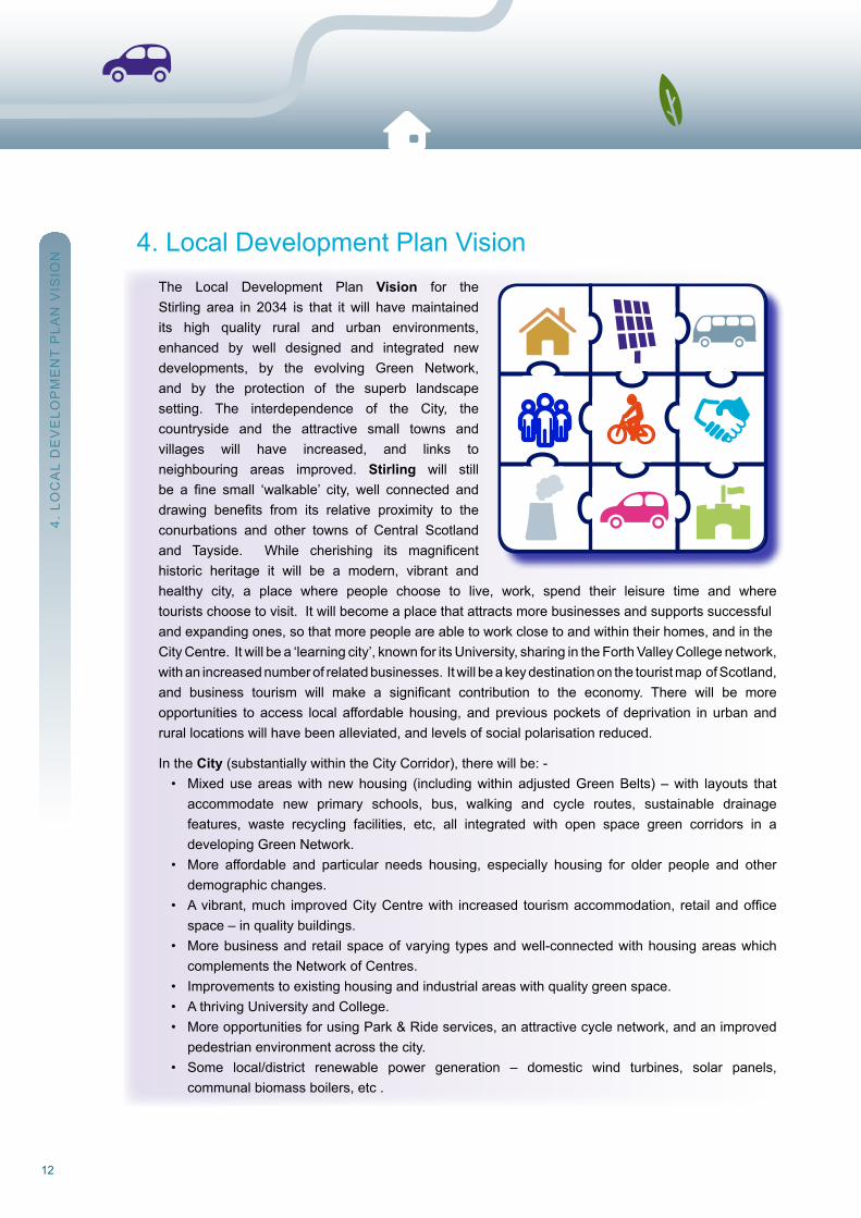
4. Local Development Plan Vision The Local Development Plan Vision for the Stirling area in 2034 is that it will have maintained its high quality rural and urban environments, enhanced by well designed and integrated new developments, by the evolving Green network, and by the protection of the superb landscape setting. The interdependence of the City, the countryside and the attractive small towns and villages will have increased, and links to neighbouring areas improved. Stirling will still be a fine small ‘walkable’ city, well connected and drawing benefits from its relative proximity to the conurbations and other towns of Central Scotland and Tayside. While cherishing its magnificent historic heritage it will be a modern, vibrant and healthy city, a place where people choose to live, work, spend their leisure time and where tourists choose to visit. It will become a place that attracts more businesses and supports successful and expanding ones, so that more people are able to work close to and within their homes, and in the City Centre. It will be a ‘learning city’, known for its university, sharing in the Forth Valley College network, with an increased number of related businesses. It will be a key destination on the tourist map of Scotland, and business tourism will make a significant contribution to the economy. There will be more opportunities to access local affordable housing, and previous pockets of deprivation in urban and rural locations will have been alleviated, and levels of social polarisation reduced.
In the City (substantially within the City Corridor), there will be: - • Mixeduseareaswith newhousing (includingwithin adjustedGreenBelts) –with layouts that accommodate new primary schools, bus, walking and cycle routes, sustainable drainage features, waste recycling facilities, etc, all integrated with open space green corridors in a developing Green network. • More affordable and particular needs housing, especially housing for older people and other demographic changes. • Avibrant,much improvedCityCentrewith increased tourismaccommodation, retailandoffice space – in quality buildings. • Morebusinessandretailspaceofvarying typesandwell-connectedwithhousingareaswhich complements the network of Centres. • Improvementstoexistinghousingandindustrialareaswithqualitygreenspace. • AthrivingUniversityandCollege. • MoreopportunitiesforusingPark&Rideservices,anattractivecyclenetwork,andanimproved pedestrian environment across the city. • Some local/district renewable power generation – domestic wind turbines, solar panels, communal biomass boilers, etc .
4. L
oC
AL
DE
VE
LoP
ME
nT
PLA
n V
ISIo
n

13Stirling Council Local Development Plan
4. L
oC
AL
DE
VE
LoP
ME
nT
PLA
n V
ISIo
n
• Local/districtwastemanagementandrecyclingsites. • Localfoodproduction–moreallotments,communityorchardsandotherlocalfoodproduction enterprises. • Green Network enhancements enabling the river corridor1 to contribute much more to the quality more to the quality of life in the City.
All new and recent development will be compatible with the low-carbon and zero waste life-styles prevailing, and are able to cope with any changed climate regime.
At Durieshill – • Thenewvillagewillbewellestablished,withsubstantiallevelsofnewhousingofvarioustenures, and commensurate secondary and primary educational and community facilities, transport infrastructure and employment opportunities, all within a planned landscape fitting into the wider Green network.
In the villages and smaller towns there will be:- • Small to medium sized infill peripheral housing developments – including provisions for more affordable housing, and housing for older people. • In a few locations, close to the City, more substantial new housing, new or expanded primary schools and regenerated village centres. • More local business premises and tourism related development including retail. • Some local renewable power generation - wind turbines, communal biomass boilers, etc • Local waste management and recycling sites. • Morerecreationalactivityandfacilities. • Community orchards and other local food production enterprises. • Transportinfrastructurethatimprovesandencouragesamodalshiftfrommotorvehiclestoother means, such as walking, cycling and public transport, via an improved, comprehensive and safe network.
1. All references to ‘green’ networks and corridors include the ‘blue’ network of watercourses and riparian areas; but note that references to the‘rivercorridor’throughStirlingarenotlimitedtothefloodplainandmayincludeneighbouringareas,includingdevelopmentsites.
14
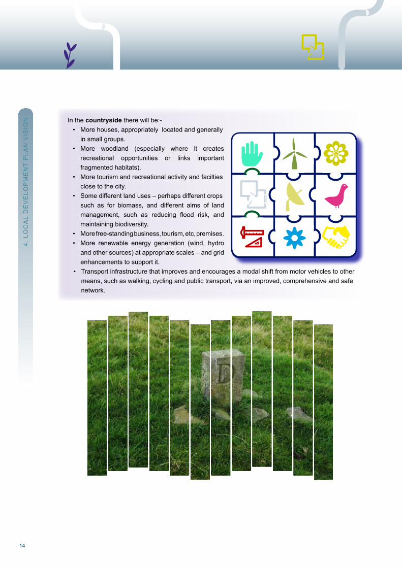
In the countryside there will be:- • Morehouses,appropriatelylocatedandgenerally in small groups. • More woodland (especially where it creates recreational opportunities or links important fragmented habitats). • Moretourismandrecreationalactivityandfacilties close to the city. • Some different land uses – perhaps different crops such as for biomass, and different aims of land management, such as reducing flood risk, and maintaining biodiversity. • Morefree-standingbusiness,tourism,etc,premises. • More renewable energy generation (wind, hydro and other sources) at appropriate scales – and grid enhancements to support it. • Transportinfrastructurethatimprovesandencouragesamodalshiftfrommotorvehiclestoother means, such as walking, cycling and public transport, via an improved, comprehensive and safe network.
4. L
oC
AL
DE
VE
LoP
ME
nT
PLA
n V
ISIo
n
15Stirling Council Local Development Plan
5. S
PA
TIA
L S
Tr
AT
EG
Y
5. Spatial Strategy
The Spatial Strategy contains the Plan Proposals i.e. what the Council considers to be the appropriate typesandscales(andphasing)ofsignificantdevelopment inthevarioussettlementsandtheruralareas.Itfocusesonthespecificmainproposalsfortheperioduptoyear10fromadoptionofthePlanand also provides a broad indication of the scale and location of growth up to year 20. The Policies andSupplementaryGuidance indicatehowtheCouncilwishesthosedevelopments tobe implemented,andequally,how itwillassessanddeterminedevelopmentproposals thatarenotspecificallydealtwith in the Strategy, including the great majority of planning applications for relatively smallscale and householder developments. The Spatial Strategy also includes an onshore wind energySpatial Framework. Policy 12.1 sets out a list of criteria the planning authority will consider indetermining applications for wind farm developments. New Supplementary Guidance will be prepared and adopted within one year of the adoption of this Local Development Plan that will comprise Stirling Council’s spatial framework for onshore wind. The adopted spatial framework will then be incorporated intotheLocalDevelopmentPlanatthefirstreview.
5.1 The Spatial Strategy table (Table 1), the Key Diagrams, Settlement Hierarchy and Settlement Statements (Chapter 10) set the context for how the area will develop over the next 20 years (for
major developments such as business, retail and housing). Physically, the options are limited.The new settlement at Durieshill, planned since 2004, is still a commitment but slow progress
towards implementation does not encourage similar large-scale projects. The consolidation and expansion of existing settlements, though likely to raise local concerns, is aligned with sustainable
development principles and offers opportunities for enhancement and regeneration of these areas.
5.2 The Council supports sustainable economic growth Achieving economic growth means change, and some change requires development; this Plan seeks to address the spatial implications of economic, social and environmental change, in particular, opportunities for development. These spatial implications are further discussed in the Vision and Spatial Strategy Background report. The Plan helps manage this change by choosing the most appropriate scale, mix and location of new development and through a range of different policy responses.
16
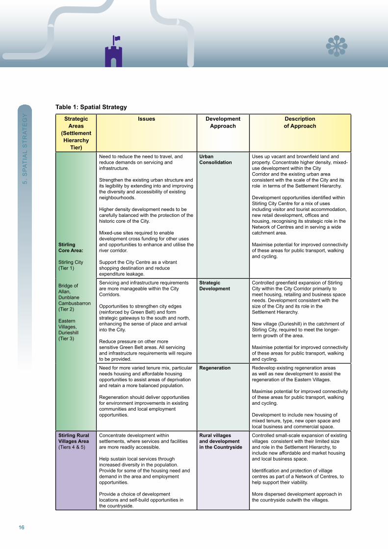
Table 1: Spatial Strategy
StrategicAreas
(SettlementHierarchy
Tier)
Issues DevelopmentApproach
Descriptionof Approach
StirlingCore Area:
Stirling City(Tier 1)
Bridge ofAllan,DunblaneCambusbarron (Tier 2)
EasternVillages,Durieshill(Tier 3)
need to reduce the need to travel, and reduce demands on servicing andinfrastructure.
Strengthen the existing urban structure and its legibility by extending into and improving the diversity and accessibility of existing neighbourhoods.
Higher density development needs to be carefully balanced with the protection of the historic core of the City.
Mixed-use sites required to enabledevelopment cross funding for other uses and opportunities to enhance and utilise the river corridor.
Support the City Centre as a vibrantshopping destination and reduceexpenditure leakage.
UrbanConsolidation
Usesupvacantandbrownfieldlandandproperty. Concentrate higher density, mixed-use development within the CityCorridor and the existing urban areaconsistent with the scale of the City and its role in terms of the Settlement Hierarchy.
DevelopmentopportunitiesidentifiedwithinStirling City Centre for a mix of usesincluding visitor and tourist accommodation, newretaildevelopment,officesandhousing, recognising its strategic role in the network of Centres and in serving a wide catchment area.
Maximise potential for improved connectivity of these areas for public transport, walking and cycling.
Servicing and infrastructure requirements are more manageable within the CityCorridors.
opportunities to strengthen city edges(reinforced by Green Belt) and formstrategic gateways to the south and north, enhancing the sense of place and arrival into the City.
reduce pressure on other moresensitive Green Belt areas. All servicing and infrastructure requirements will require to be provided.
StrategicDevelopment
ControlledgreenfieldexpansionofStirlingCity within the City Corridor primarily to meet housing, retailing and business space needs. Development consistent with the size of the City and its role in theSettlement Hierarchy.
new village (Durieshill) in the catchment of Stirling City, required to meet the longer-term growth of the area.
Maximise potential for improved connectivity of these areas for public transport, walking and cycling.
need for more varied tenure mix, particular needs housing and affordable housing opportunities to assist areas of deprivation and retain a more balanced population.
regeneration should deliver opportunities for environment improvements in existing communities and local employmentopportunities.
regeneration should deliver
Regeneration redevelop existing regeneration areas as well as new development to assist the regeneration of the Eastern Villages.
Maximise potential for improved connectivity of these areas for public transport, walking and cycling.
Development to include new housing of mixed tenure, type, new open space and local business and commercial space.
Stirling RuralVillages Area(Tiers 4 & 5)
Concentrate development withinsettlements, where services and facilities are more readily accessible.
Help sustain local services throughincreased diversity in the population. Provide for some of the housing need and demand in the area and employmentopportunities.
Provide a choice of developmentlocations and self-build opportunities inthe countryside.
Rural villagesand developmentin the Countryside
Controlled small-scale expansion of existing villages consistent with their limited size and role in the Settlement Hierarchy, to include new affordable and market housing and local business space.
Identificationandprotectionofvillagecentres as part of a network of Centres, tohelp support their viability.
More dispersed development approach inthe countryside outwith the villages.
5. S
PA
TIA
L S
Tr
AT
EG
Y
17Stirling Council Local Development Plan
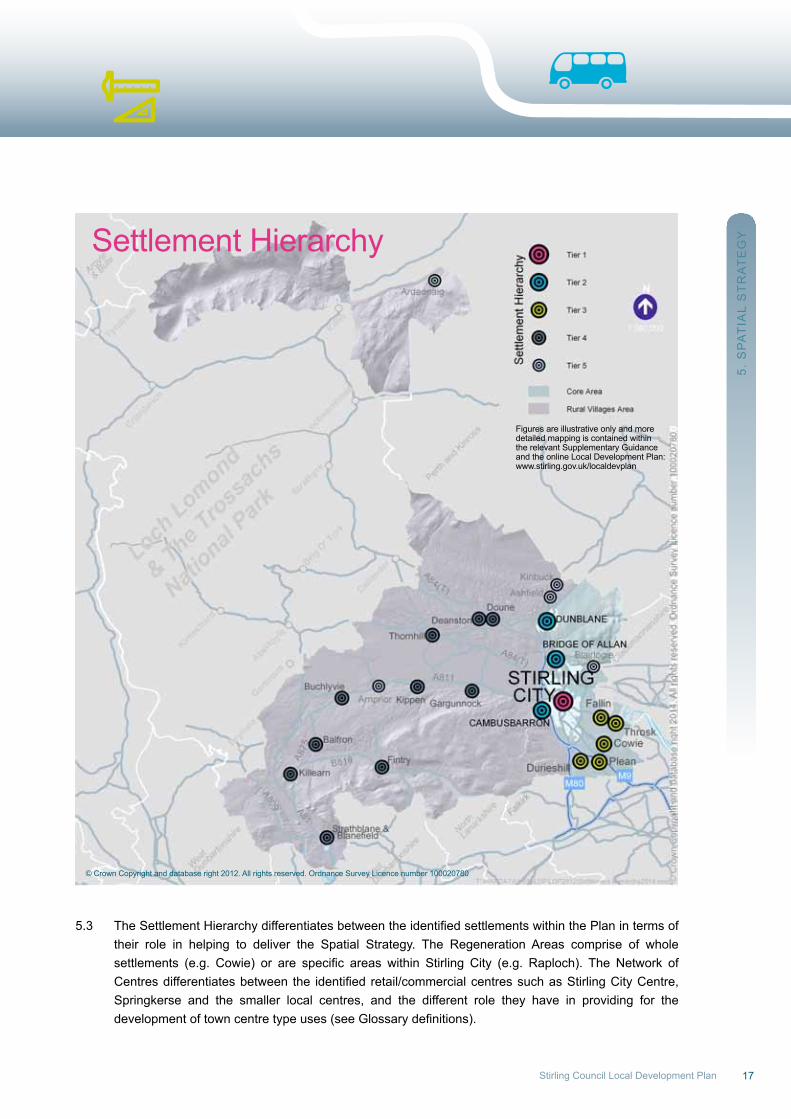
5.3 TheSettlementHierarchydifferentiatesbetweentheidentifiedsettlementswithinthePlanintermsof their role in helping to deliver the Spatial Strategy. The regeneration Areas comprise of whole settlements (e.g. Cowie) or are specific areas within Stirling City (e.g. Raploch). The Network of Centresdifferentiatesbetween the identifiedretail/commercialcentressuchasStirlingCityCentre, Springkerse and the smaller local centres, and the different role they have in providing for the developmentoftowncentretypeuses(seeGlossarydefinitions).
5. S
PA
TIA
L S
Tr
AT
EG
YSettlement Hierarchy
© Crown Copyright and database right 2012. All rights reserved. ordnance Survey Licence number 100020780
Figures are illustrative only and moredetailed mapping is contained withinthe relevant Supplementary Guidanceand the online Local Development Plan:www.stirling.gov.uk/localdevplan
1818
5. S
PA
TIA
L S
Tr
AT
EG
Y
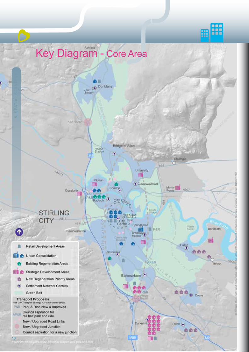
Key Diagram - Core Area
19Stirling Council Local Development Plan 19
5. S
PA
TIA
L S
Tr
AT
EG
Y
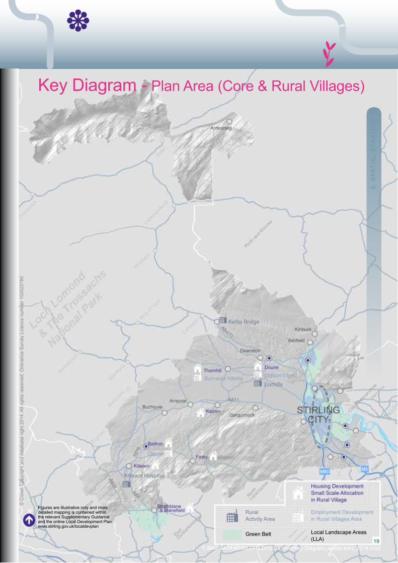
Key Diagram - Plan Area (Core & rural Villages)
Figures are illustrative only and moredetailed mapping is contained withinthe relevant Supplementary Guidanceand the online Local Development Plan:www.stirling.gov.uk/localdevplan

20
6. S
ET
TIn
G T
HE
LA
nD
rE
Qu
IrE
ME
nT
Fo
r H
ou
SIn
G,
Bu
SIn
ES
S &
rE
TAIL
6. Setting the Land requirement for Housing, Business and retail6.1 The LDP Main Issues report (MIr) was published in May 2010 and sets out the agreed approach of the
Council and its community planning partners in planning for future growth in the Stirling area. The Vision and Spatial Strategy options highlight the City Visioning process and identify placemaking as being at the heart of the strategy for determining the levels of growth and future development requirements
for the Stirling area. The MIr argues that rather than use an arbitrary target for population growth, proper placemaking requires growth that is sustainable, and which protects the character and
environmental quality of the Stirling area2.
6.2 The Plan’s Vision and Spatial Strategy continue to support the MIr placemaking approach and assess the need for development alongside the need to tackle some of the spatial implications of economic, social and environmental change. This is further documented in the Vision and Spatial Strategy Background report3. The Council’s Vision is to deliver quality developments, recognise placemaking, and protect the intrinsic character and identity of the City of Stirling, its settlements and its landscape. Therefore, rather than start with a development target and then aim to find suitable locations to accommodate that level of growth, the strategy starts with the spatial issues and then determines how to tackle these through appropriate land use and development. This approach has directly influenced the housing andemployment land requirement and retail floorspace requirement in the Plan.
Housing Land requirement
6.3 The provision of land for housing and the timely release of that land to enable the building of homes is a key component of the Plan. The broader objective of the Plan in relation to housing is the creation of
sustainable mixed communities, including the provision of quality dwellings in the right places. It is vital that these considerations underpin the whole process of planning for housing, even at the earliest stages of
setting the land requirement.
6.4 Scottish Planning Policy (SPP) requires the Council to plan for ‘generous amounts’ of new housing land tomeet identified housing requirements across all tenures, including affordable housing, and
related policy objectives. The scale, nature and distribution of the housing requirement for the area and the housing supply target4 is based on the outcome of the Stirling Housing need and Demand Assessment5 taking account of the following:
• Theestimatedimpactsofhousingmarketinterventions. • Reviewingactualhousingsupplyinrecentyears. • Considering issues that will impact upon future supply e.g. current and forecast economic circumstances. • Settingsupplytargetswhicharerealisticandwillhelptomeetidentifiedneeds.
2.MainIssuesReportChapter3‘VisionandKeyObjectives’fortheLocalDevelopmentPlan:http://www.stirling.gov.uk/__documents/planning/future-development/local-development-plan/mir.pdf3.StirlingLDPVisionandSpatialStrategyBackgroundReportSeptember2012:http://www.stirling.gov.uk/services/housing/planning-and- building-standards/local-and-statutory-development-plans/local-development-plan4.LocalHousingStrategyChapter1:http://www.stirling.gov.uk/services/housing/local-housing-strategy5.HousingNeedandDemandAssessment:http://www.stirling.gov.uk/__documents/temporary-uploads/housing-_and_-customer-service/local-housing-strategy/stirlings-hnda-19july2011v2.pdf
21Stirling Council Local Development Plan
6.5 wider strategic economic, social and environmental policy objectives have also been taken into account when determining the scale and distribution of the housing requirement and the housing supply target for the area. These include: • Ensuring a good range and choice of locations for new development to meet local housing pressures. • Deliveringnewhousing,particularlyaffordable,andtheefficientuseofexistingaccommodation. • Ensuringthemixandrangeofhousetypesprovidedmeetsthechangingpopulationdemographics and improves diversity. • Ensuringthescaleofnewhousingdevelopmentisappropriatetoexistingcommunities,supports placemaking and is supported by the necessary infrastructure. • Reducingthelevelsofsocialpolarisationandinequality.
6.6 InsettingthehousinglandrequirementforthePlan,theCouncil’sapproachhasbeendirectlyinfluenced by the above factors, and the need to identify and allocate suitable sites which have a high likelihood of coming forward within the timeframe considered by the Plan and which are consistent with the Plan’s Vision, Spatial Strategy and Settlement Hierarchy. The Housing Land requirement Background report further details the approach to setting the housing land requirement6.
6.7 Tables 3 and 4 set out the housing land requirement within the Plan. The Plan allocates a range of sites that are effective, or capable of becoming effective to meet this requirement up to year 10 beyond the predicted year of plan adoption (i.e. 2014/2024). ongoing monitoring through the Housing Land Audit and if necessary earlier release of sites from later phases and periods, will ensure there is a 5 year effective supply at all times, consistent with Scottish Planning Policy.
6.8 The housing land requirement for Period 1 (2010/24) is made up of the following:
• Completionsandexistinghousingsupply. • Smallsitesallowance. • AdditionalPlanallocations.
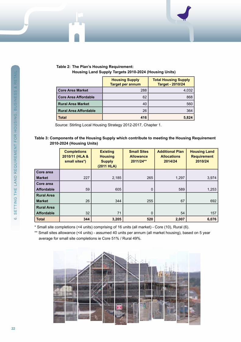
6.9 Table 4 details the housing land requirement for the Plan by Strategic Area (Core Area and rural Villages Area), for Period 1. All the sites which make up the land requirement are given in the Schedule in Appendix B. In comparing the land requirement with the Housing Supply Target (Table 2), the overall land requirement (at 6,076 units) will help to promote a wider range and choice of sites and help offset any potential delays in implementing particular housing developments.
6.StirlingLocalDevelopmentPlanHousingLandRequirementBackgroundReport-June2014:http://www.stirling.gov.uk/services/ housing/planning-and-building-standards/local-and-statutory-development-plans/local-development-plan
6. S
ET
TIn
G T
HE
LA
nD
rE
Qu
IrE
ME
nT
Fo
r H
ou
SIn
G,
Bu
SIn
ES
S &
rE
TAIL
22
Table 2: The Plan’s Housing Requirement: Housing Land Supply Targets 2010-2024 (Housing Units)
Housing SupplyTarget per annum
Total Housing SupplyTarget - 2010/24
Core Area Market 288 4,032
Core Area Affordable 62 868
Rural Area Market 40 560
Rural Area Affordable 26 364
Total 416 5,824
Source: Stirling Local Housing Strategy 2012-2017, Chapter 1.
Table 3: Components of the Housing Supply which contribute to meeting the Housing Requirement 2010-2024 (Housing Units)
Completions2010/11 (HLA &
small sites*)
ExistingHousingSupply
(2011 HLA)
Small SitesAllowance2011/24**
Additional PlanAllocations
2014/24
Housing LandRequirement
2010/24
Core areaMarket 227 2,185 265 1,297 3,974Core areaAffordable 59 605 0 589 1,253Rural AreaMarket 26 344 255 67 692
Rural AreaAffordable 32 71 0 54 157Total 344 3,205 520 2,007 6,076
* Small site completions (<4 units) comprising of 16 units (all market) - Core (10), rural (6).** Small sites allowance (<4 units) - assumed 40 units per annum (all market housing), based on 5 year average for small site completions ie Core 51% / rural 49%.
6. S
ET
TIn
G T
HE
LA
nD
rE
Qu
IrE
ME
nT
Fo
r H
ou
SIn
G,
Bu
SIn
ES
S &
rE
TAIL
23Stirling Council Local Development Plan
Table 4: Housing Land Requirement (Housing Units) by Strategic Area, Period 1: 2010-2024.
ExistingSupply &
Completions2010/24
Additional Plan Allocations
2014/24
Total land supply effective or capable ofbecoming effective: Period 1
HLA 2011& Small Sites
Phase 12010/19
Phase 2 2019/24
Total Period 1 2010/24
Stirl
ing
Cor
e
UrbanConsolidation 1,376 677 1,636 417 2,053Regeneration 584 809 1,011 382 1,393Core in the Countryside 22 0 22 0 22
StrategicDevelopment 1,100 400 600 900 1,500Sub-total 3,082 1,886 3,269 1,699 4,968
Stirl
ing
Rur
al
Rural VillagesArea 467 121 494 94 588Sub-Total 467 121 494 94 588Sub-Totals 3,549 2,007 3,763 1,793 5,556Small SitesAllowance 320 200 520Total 4,083 1,993 6,076
6.10 In Period 2, beyond 2024, it is expected that the need and demand for housing land in the Stirling area will remain strong. Consistent with the long term Spatial Strategy set out in the Plan, the focus for growth in this period is likely to be to the south of Stirling City in the continuing strategic development areas of South Stirling Gateway (H055) and Durieshill (H057) (see Table 5).
6.11 Transport and education improvements brought about in part by these developments will enable other existing and new developments to come forward in Stirling City and the Eastern Villages. A strategy of ‘urban consolidation’ will continue and key brownfield sites continue to be built out including the former Stirling Royal Infirmary, the Ministry of Defence site and Viewforth. Beyond these sites,thesupplyofbrownfieldlandislikelytodiminishinthelongerterm,althoughtheregeneration areas of Cornton, Cultenhove and raploch will continue to provide for a variety of housing needs.
6.12 The growth of the Eastern Villages is set to continue into Period 2, with their associated regeneration benefitshelping to improve thesocio-economicandenvironmentalaspectsof these formermining communities. other locations may contribute, providing key infrastructure constraints can be overcome, and subject to a future review of the Plan.
6. S
ET
TIn
G T
HE
LA
nD
rE
Qu
IrE
ME
nT
Fo
r H
ou
SIn
G,
Bu
SIn
ES
S &
rE
TAIL
24
6.13 within the rural Villages Area, the Spatial Strategy limits most new development to small-scale expansion of existing villages. In the period after 2024, villages such as Kippen may start to play a greater role in the provision of new housing providing infrastructure constraints can be overcome and subject to a future review of the Plan. Affordable housing need will continue to grow within the rural Villages Area, and more innovative opportunities for delivering new housing development in this area will need to be considered in a future review of the LHS and LDP.
Table 5: Scale of Future Housing Land Supply (Housing Units) by Strategic Area, Period 2: 2024-2034
Existing Supply 2024/34
(2011 HLA)
Additional HousingLand Supply
2024/34
Scale of FutureHousing Land
Supply 2024/34
Stirl
ing
Cor
e
Urban Consolidation 0 200 200
Regeneration 985 545 1,530
Strategic Development 1,400 400 1,800
Stirl
ing
Rur
al
Rural Villages &Housing in theCountryside 0 30 30
Total 2,385 1,175 3,560
Employment Land requirement
6.14 new business space has a large role to play in the future shape of Stirling, as the availability of a good range of employment opportunities adds to the attractiveness of the area as a place to live and work. The Stirling Economic Strategy7 (2009-2013) indicates that the objective is to increase the range and number of jobs available locally, particularly high value jobs, to reduce the need to travel outside the area and to take full advantage of its location and assets. This aspiration is set within the context of the Vision, which aims to ensure that the high quality rural and urban environments are maintained while allowing for growth of appropriate scale in appropriate locations.
6.15 In order to measure the possible levels of employment growth and resultant land required, an employment land requirement was calculated. This is based on the rate of jobs growth per annum to meet the Council’s aspirations for economic growth, translated into a business space requirement, and then a land requirement. The assessment is set out in the Stirling Business Space Strategy 20108 (BSS) and the resulting land requirement is highlighted in Table 6.
7.http://www.stirling.gov.uk/__documents/temporary-uploads/economy,-planning-_and_-regulation/9072-community-planning-2009.pdf8.http://www.stirling.gov.uk/__documents/economic-development/business-intelligence/economy,-planning-_and_-regulation/economic- support/strategies-and-studies/business-space-strategy-and-appraisal.pdf
6. S
ET
TIn
G T
HE
LA
nD
rE
Qu
IrE
ME
nT
Fo
r H
ou
SIn
G,
Bu
SIn
ES
S &
rE
TAIL
25Stirling Council Local Development Plan
Table 6: Employment Land Requirement (hectares) Period 1: 2010-2024
Business Space Strategy Target: 2010/2024 86.8 ha
minus anticipated completions from existing supply until 2024 61.7 ha
Additional Employment Land Requirement 25.1 ha
6.16 It is recognised and accepted however that the BSS, written in 2010, may have been over-optimistic in its projection of growth and need for employment land due to the unforeseen economic circumstances. notwithstanding this, the Plan has provision for a good range and choice of employment land, which willbemonitoredannuallythroughtheEmploymentLandAudit.Again,thelandrequirementreflects the need to identify and allocate suitable sites which have a high likelihood of coming forward within the timeframe considered by the Plan. If necessary, earlier release of sites can come forward from later phases or periods to maintain this supply.
6.17 The Spatial Strategy for employment land focuses on providing a range and choice of sites in generally sustainablelocations(seeTable7).Thestrategyreliesonasignificantamountoftheexistingemployment land supply becoming effective during the timeframe of the Plan, while additional allocations are put forward to ensure a range and choice can be maintained. Stirling City, and the strategic development sites around the City, will play the greatest role in meeting future business needs.
6.18 within the rural area, in response to the rural Stirling Business Space Study 2011 and to support the economic viability of rural communities, the Plan allocates a number of small sites for employment purposesandprovidesaflexiblepolicyapproachtoensureeconomicdevelopmentinthecountryside can be supported where appropriate.
6.19 A full discussion on the employment land aspects of the Plan is provided in the Background report ‘Employment Land requirement Background report9 and all the sites which make up the land requirement are given in the Schedule in Appendix B.
9.StirlingLocalDevelopmentPlanEmploymentLandRequirementBackgroundReportSeptember2012:http://www.stirling.gov.uk/__ documents/temporary-uploads/economy,-planning-_and_-regulation/draft-proposed-ldp/background-reports/emp-land-requirement.pdf
6. S
ET
TIn
G T
HE
LA
nD
rE
Qu
IrE
ME
nT
Fo
r H
ou
SIn
G,
Bu
SIn
ES
S &
rE
TAIL
26
Table 7: Employment Land Requirement (hectares) Period 1: 2010-2024
ExistingSupply2010/24
AdditionalEmployment Land
AllocationsPeriod 1: 2014/24
Total Land Supply effective orcapable of becoming
effective: Period 1
Phase 1: 2010/19 Phase 2: 2019/24
Stirl
ing
Cor
e
UrbanConsolidation 13.5 0 13.5 0Regeneration 2.5 0.8 3.3 0
StrategicDevelopment 35.3 15.6 23.85 28.3
Stirl
ing
Rur
al RuralVillages 10.4 3.6 8.2 5.8
Total 61.7 ha 20.0 ha 48.85 ha 34.05 ha
6.20 Forthelongerterm,thescaleandlocationofemploymentlandidentifiedforPeriod2ofthePlan,after 2024, is likely to take place in the main strategic allocations around the City through the continuing development of Broadleys, Millhall, South Stirling Gateway, Stirling university Innovation Park and Craigforth. A future supply of 84ha will be maintained at Bandeath.
Table 8: Scale of Future Employment Land Supply (hectares) by Strategic Area, Period 2: 2024-2034
Scale of FutureLand Supply
2024/34
Stirl
ing
Cor
e
Urban Consolidation 0
Regeneration 0
Strategic Development 111.4
Stirl
ing
Rur
al
Rural Villages &Housing in theCountryside 5.0
Total 116.4 ha
6. S
ET
TIn
G T
HE
LA
nD
rE
Qu
IrE
ME
nT
Fo
r H
ou
SIn
G,
Bu
SIn
ES
S &
rE
TAIL

27Stirling Council Local Development Plan
retail Floorspace requirements
6.21 recent Council studies in 200910, 201011 and 201112 intothecapacityforfurtherretailfloorspacein the Stirling area have identified, in both qualitative and quantitative terms, the need for further retailfloorspaceinparticularlocations.
6.22 Consistentwith the hierarchy ofNetwork ofCentres identifiedwithin thePlan (seePolicy 2.6 and SG09), land is allocated for retail purposes (see Tables 9 and 10) to meet the future demand for modern retail space. All the sites allocated for such purposes are identified in the Schedule in Appendix B.
6.23 Stirling City Centre has the main role in meeting the current and future personal and convenience retailing needs for the Stirling area, as well as tourism, leisure and other services, and will continue to beprotected.SitesatStationRoad(R02andR03)andSpittalStreet(R04)areidentifiedwithinthe City Centre for personal retailing. The boundary of the City Centre has been expanded to allow for future expansion for a range of purposes.Siteswithin theCityCentre are identified atBurghmuir (r05), STEP/Vico (r06), and rainbow Slides (r01) to meet future retail space and other city centre uses space needs. Supported by the City Centre Development Framework (SG08B), this will help manage the demand for such uses and resist the pressure for out of centre retail developments that could threaten the vitality and viability of the City Centre.
6.24 Outwith theCityCentre, existing town and local centres are defined and protected as part of the Network of Centres, and the potential for additional retail capacity is identified. The Commercial Centre of Springkerse includes allocations of land for household bulky goods retailing, as part of mixed use developments proposed for this area at Springkerse (r11), Crookbridge (r12) and Millhall,East (R13).NewSuperstore(convenience)development is identified for theCityCentreat STEP/Vico site (r06), Burghmuir (r05), at the former MFI site, St ninians (r07), Durieshill (r10) and Barbush, Dunblane (r08). Further superstore (c.4000 sq.m net convenience) is anticipated at Bannockburn within the South Stirling Gateway (r09), the aim of which is to improve such provision in the southern area of Stirling and reduce expenditure leakage to other areas.
6.25 Forthelongerterm,theretailrequirementsfortheStirlingareaaremoredifficulttopredictduetothe future economic uncertainties of the retail market. It is likely however, that the existing supply and additional allocations will continue to build out over the longer term. The supply of retail floorspacewillbemonitored throughtheannualRetailMonitoringReportandadditionalallocations brought forward, if required, in a future review of the Plan.
10. http://www.stirling.gov.uk/__documents/planning/future-development/retail-development/stirling-retail-capacity-study-update.pdf11.http://www.stirling.gov.uk/__documents/planning/future-development/retail-development/convenience-retail-study-final-report-sept10.pdf12.http://www.stirling.gov.uk/__documents/planning/future-development/local-development-plan/supporting-reports-ldp/background-report- dunblane-retail-req-2.pdf
6. S
ET
TIn
G T
HE
LA
nD
rE
Qu
IrE
ME
nT
Fo
r H
ou
SIn
G,
Bu
SIn
ES
S &
rE
TAIL
28
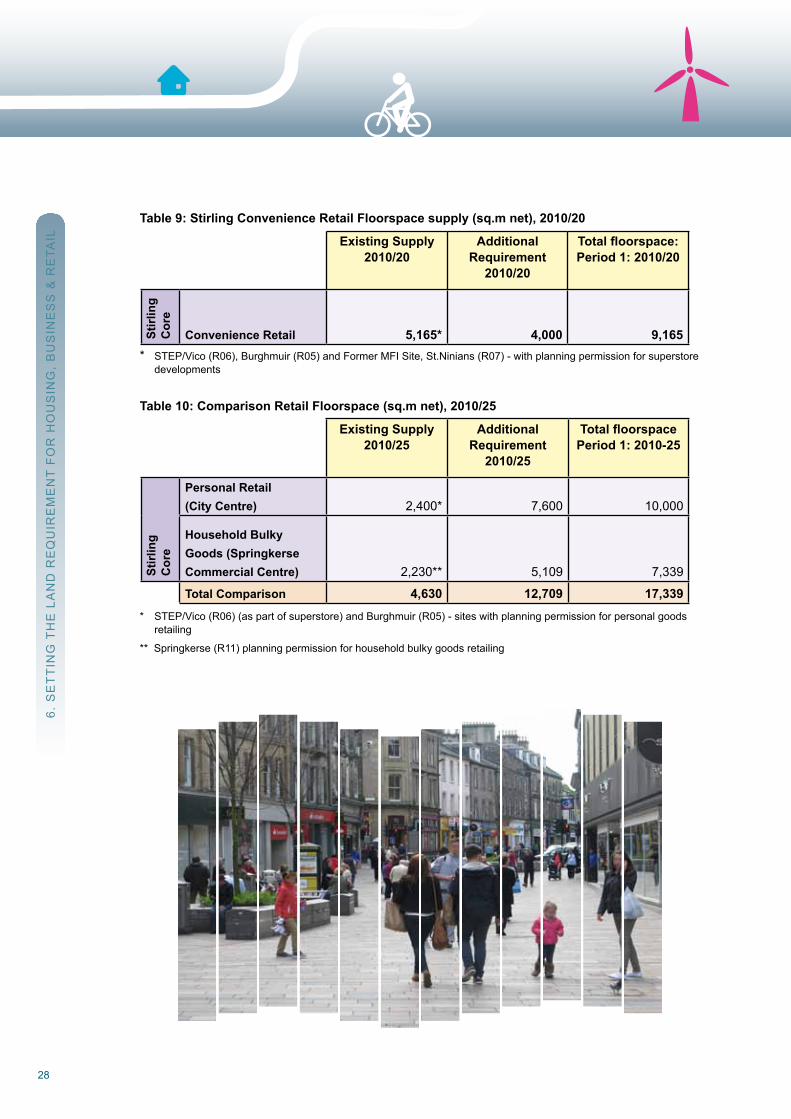
Table 9: Stirling Convenience Retail Floorspace supply (sq.m net), 2010/20
Existing Supply 2010/20
AdditionalRequirement
2010/20
Total floorspace: Period 1: 2010/20
Stirl
ing
Cor
e
Convenience Retail 5,165* 4,000 9,165 * STEP/Vico (r06), Burghmuir (r05) and Former MFI Site, St.ninians (r07) - with planning permission for superstore developments
Table 10: Comparison Retail Floorspace (sq.m net), 2010/25
Existing Supply 2010/25
AdditionalRequirement
2010/25
Total floorspace Period 1: 2010-25
Stirl
ing
Cor
e
Personal Retail(City Centre) 2,400* 7,600 10,000
Household BulkyGoods (SpringkerseCommercial Centre) 2,230** 5,109 7,339
Total Comparison 4,630 12,709 17,339 * STEP/Vico (r06) (as part of superstore) and Burghmuir (r05) - sites with planning permission for personal goods retailing
** Springkerse (r11) planning permission for household bulky goods retailing
6. S
ET
TIn
G T
HE
LA
nD
rE
Qu
IrE
ME
nT
Fo
r H
ou
SIn
G,
Bu
SIn
ES
S &
rE
TAIL
29Stirling Council Local Development Plan
7. T
HE
oV
Er
Ar
CH
InG
Po
LIC
Y, P
rIM
Ar
Y P
oLI
CIE
S &
Po
LIC
IES
7. The overarching Policy, Primary Policies and PoliciesThe Overarching Policy and Sustainable Development Criteria are the principal link between nationalpolicy aims and the LDP objectives and policies. They are intended to be used both as a guide to the highlevel aspirations of the Council for developers and, along with the more detailed policies, in assessingproposals and reaching planning decisions.
The range of topics covered by Primary Policies has been determined by considering those issues ofparticular local concern. Primary Policies are backed up with more detailed Policies. Many Primary Policiesand Policies are further supported by Supplementary Guidance (SG).
overarching PolicyThis Plan supports good quality development, in the right place, that meets the community’s needs (social, economic and environmental), in order to contribute positively to the creation of vibrant, mixed and healthycommunities. All developments, land use changes and other proposals, plus related frameworks,masterplans, planning briefs, strategies, etc, will require to demonstrate the following: -
(a) Compatibility with the Spatial Strategy and conformity with the relevant Sustainable Development Criteria. (b) A design-led approach, including high standards of design, reinforcement of a sense of place, integration with neighbouring areas and the wider community. (c) Appropriate measures for mitigation of and adaptation to climate change. (d) Appropriate measures for the safeguarding, conservation and enhancement of the historic and natural environment. (e) Safeguarding and appropriate management and utilisation of natural resources. (f) Adherence to the principles of the national Planning Framework proposal for a Central Scotland Green network, with relevant contributions to local and national Green network objectives.
[national Central Scotland Green network principles are that the network should be: grounded in nature; at scale; regenerative; life-enhancing; connected; functional and resilient; locally distinctive and respectful of the past; harnessing the potential of development; beyond carbon neutral; and adding value. Local green network objectives are set out in SG02.]
Sustainable Development Criteria (these are derived from Scottish Planning Policy)
1. Improve the overall quality of the built environment. 2. Contribute to reduction in greenhouse gas emissions, in line with or better than national targets,andencourageenergyandheatefficiency,andtheuseoflowandzerocarbonpower generation. 3. reduce the need to travel and encourage active travel and other more sustainable travel and transport opportunities. 4. Support Zero waste objectives, and minimise the life-cycle resource requirements. 5. Avoidareasatriskoffloodinganderosion. 6. Protect and enhance the historic and cultural environments, and the natural environment (including biodiversity and landscape). 7. Minimise adverse impacts on water, air and soil quality. 8. Support healthy and safer lifestyles, by improving access to amenities, promoting access to open space and other recreation opportunities and by addressing environmental problems. 9. Involve re-use and/or regeneration of previously used land and property, including derelict and contaminated land, and the re-cycling of construction materials. 10. Makeefficientuseofexistingandnewinfrastructure.
30
A. Placemaking and Implementing the Spatial Strategy(Primary Policies 1-3 & Policies 1.1-3.3)
This Plan prioritises the importance of design, urban design and placemaking in order to ensure that the developments envisaged for the coming decades will maintain and improve the character and assets of the area. while not losing sight of the housing and other land requirements, the concept of placemaking through better design is prioritised.
This Plan recognises that the quality and amenity of the places around us must be conserved and enhanced, as these are key to influencing our ability to reduce social inequalities and lead healthier lives, and beeconomically attractive and competitive. Therefore, policies included within this section seek to improveplaces through raising the quality of new development, setting appropriate scales of development andsteering proposed development to the right locations in terms of our social and economic aims, theenvironment,andefficientuseandmanagementofinfrastructure.
As a result, consolidating the built up areas is the priority, as is the regeneration of existingcommunities,followedbystrategicgreenfieldexpansion,whichbuildsonexistinginfrastructurewhilstlimitingadverse environmental impacts. Small-scale development in the countryside is generally supported whereenvironmentalcriteriacanbesatisfied,andtheGreenBeltscontinuetoprotectthecharacter,identityandset-ting of settlements. The concept of a Green network is promoted, ensuring that important open spaces and green corridors are protected and provided in new development and that all development contributes to the enhancement of the Green network.
Primary Policy 1: PlacemakingIn order to achieve the Council’s Placemaking objectives, development of all scales must: -
(a) Be designed and sited, not only with reference to their own specifications and requirements, but also in relation to the character and amenity of the place, urban or rural, where they are located. (b) Be of quality, having regard to any relevant design guidance, landscape character guidance, Conservation Area Character Assessments and Settlement Statements. (c) Be located so as to reduce the need to encroach onto greenfield sites and to maximise sustainability benefits. Developments should utilise vacant and under-used land and buildings within settlements at higher densities where appropriate. (d) Safeguard and enhance built and natural heritage, contribute to the implementation of the Council’s open Space Strategy and Green network objectives, and respect the Green Belts.
7. T
HE
oV
Er
Ar
CH
InG
Po
LIC
Y, P
rIM
Ar
Y P
oLI
CIE
S &
Po
LIC
IES
A. PLACEMAKInG AnD IMPLEMEnTInG THE SPATIAL STrATEGY
31Stirling Council Local Development Plan
Policy 1.1: Site Planning
All new development, including alterations and extensions to existing buildings, are required to contribute, in a positive manner, to quality of the surrounding built and natural environment. All proposals are therefore expected to meet the following criteria (where relevant): -
(a) The siting, layout and density of new development should; contribute towards or create a coherent structure of streets, spaces and buildings; respect, complement and connect with its surroundings; be safely accessed; and create a sense of identity within the development. (b) All new development should consider and respect site topography, and any surrounding important landmarks (built or natural), views or skylines. (c) The design should be appropriate to both any building to which it relates, and the wider surroundings in terms of appearance, position, height, scale, massing, and should use materials,finishesandcolourswhichcomplementthoseprevalent. (d) In urban settings in particular, buildings should be positioned so as to respect an existing building line, or establish one where none exists. Thereafter, access, uses and orientation of principal elevations should reinforce the street or areas of open space. (e) All buildings, streets and open spaces should be considered and designed in a manner so as to create safe, accessible, inclusive places for people, which are easily navigable, particularly on foot, bicycle and public transport. Any core path, established rights of way, and other important access routes should be protected and retained. (f) It should be demonstrated that buildings and spaces have been designed with future adaptability in mind wherever possible and appropriate. (g) Existing buildings, structures and natural features that contribute to local townscape and biodiversity should be retained and sensitively integrated into proposals.
All new development should comply with SG01 which supports this policy by providing detailedguidance on all aspects of site planning and design.
Policy 1.2: Design Process
In order to ensure that the aims of Placemaking and quality site planning are met: -
(a) Preparation of Development Frameworks and/or Masterplans will be required for areas or sites requiring a comprehensive approach to the provision, design, and location of uses, open space and infrastructure. Thereafter, detailed proposals coming forward for all or part of the site will be expected to demonstrate cognisance and compliance with the relevant Development Framework/Masterplan. (b) Planning Briefs will be prepared by the Council for sites where merited by the size, sensitivity, and/or complexity of the site and proposals. Thereafter, detailed proposals coming forward for all or part of the site will be expected to comply with the relevant Planning Brief. (c) Design Statements and Design and Access Statements* will be required in support of Planning Applications in all instances as set out in SG01.
[Preparation of all documents, and their content, should comply with the relevant guidance contained within SG01.] [*These are statutory requirements in some cases. They deal with access to buildings, e.g. disabled access, and are in addition to any Transport Assessments or Transport Statements, for which see SG14].
7. T
HE
oV
Er
Ar
CH
InG
Po
LIC
Y, P
rIM
Ar
Y P
oLI
CIE
S &
Po
LIC
IES
A. PLACEMAKInG AnD IMPLEMEnTInG THE SPATIAL STrATEGY
32
A. PLACEMAKInG AnD IMPLEMEnTInG THE SPATIAL STrATEGY
Policy 1.3: Green network and open Space
All development proposals will be assessed in terms of their impact on, and potential to contribute to, nationalGreen network principles and local Green network and open Space Strategy objectives in terms of thefollowing:-
(a) The safeguarding of existing, and the provision of new elements contributing to the Green network, will be considered in the context of the above objectives, biodiversity conservation, the river Basin Management Plans, the Flood risk Management Plan, the Playing Field Strategy (once adopted), the Core Path Plan and any relevant Conservation Area Character Appraisal. (b) Proposals adjacent to, encroaching upon, or in the vicinity of, existing open spaces and green corridors, should maintain or enhance functionality and connectivity (active travel routes, habitat networks, etc). Such proposals resulting in a net reduction of open space, including loss of connectivity or accessibility, should ensure that the remaining elements of the Green network are enhanced and that alternative routes are provided or enabled. (c) There will be a presumption against the loss of open space unless its loss, or replacement with alternative provision, has been found to be acceptable in accordance with the above considerations. In instances where it is agreed by the Council open space can be lost, adequate compensatory measures will be required. (d) new development should, where necessary, incorporate accessible multifunctional open space of the appropriate quantity and quality to meet the needs arising from the nature of the development itself. In some instances it may be more appropriate to remedy local deficiencies (both in terms of quality and quantity) that have been identified in the Open Space Strategy, and which would be exacerbated by additional development. (e) Financial contributions may be sought for the purposes of providing open space and wider contributions to the Green network, consistent with SG02, Policy 3.3 and SG16. Means to ensure the long term maintenance of new and existing open space created in association with development will also secured.
[SG02 supports this policy by providing further detail of Green network objectives, open spacerequirements, etc. For the avoidance of doubt, Green network includes ‘blue’ infrastructure such as riversand watercourses. national Central Scotland Green network principles are that the network should be:grounded in nature; at scale; regenerative; life enhancing; connected; functional and resilient; locallydistinctive and respectful of the past; harnessing the potential of development; beyond carbon neutral;and adding value].
7. T
HE
oV
Er
Ar
CH
InG
Po
LIC
Y, P
rIM
Ar
Y P
oLI
CIE
S &
Po
LIC
IES
33Stirling Council Local Development Plan
Policy 1.4: Playing Fields
Theredevelopmentofplayingfieldsandsportspitcheswillonlybeacceptablewhere:
(a) theproposeddevelopmentisancillarytotheprincipaluseofthesiteasaplayingfield, (b) theproposeddevelopmentinvolvesaminorpartoftheplayingfieldwhichwouldnotaffectitsuse and potential for sport and training, (c) Theplaying field thatwouldbe lost,wouldbe replacedbyanewplaying fieldof comparableor greaterbenefitforsportandinalocationthatisconvenientforitsusers,orbytheupgradingofan existing playing field to provide a better quality facility either within the same site or at another location that is convenient for its users and which maintains or improves the overall playing capacity in the area, or (d) an adopted playing field strategy demonstrates that there is a clear excess of sports pitches to meet current and anticipated future demand in the area, and that the site could be developed without detriment to the overall quality of provision.
A. PLACEMAKInG AnD IMPLEMEnTInG THE SPATIAL STrATEGY
7. T
HE
oV
Er
Ar
CH
InG
Po
LIC
Y, P
rIM
Ar
Y P
oLI
CIE
S &
Po
LIC
IES
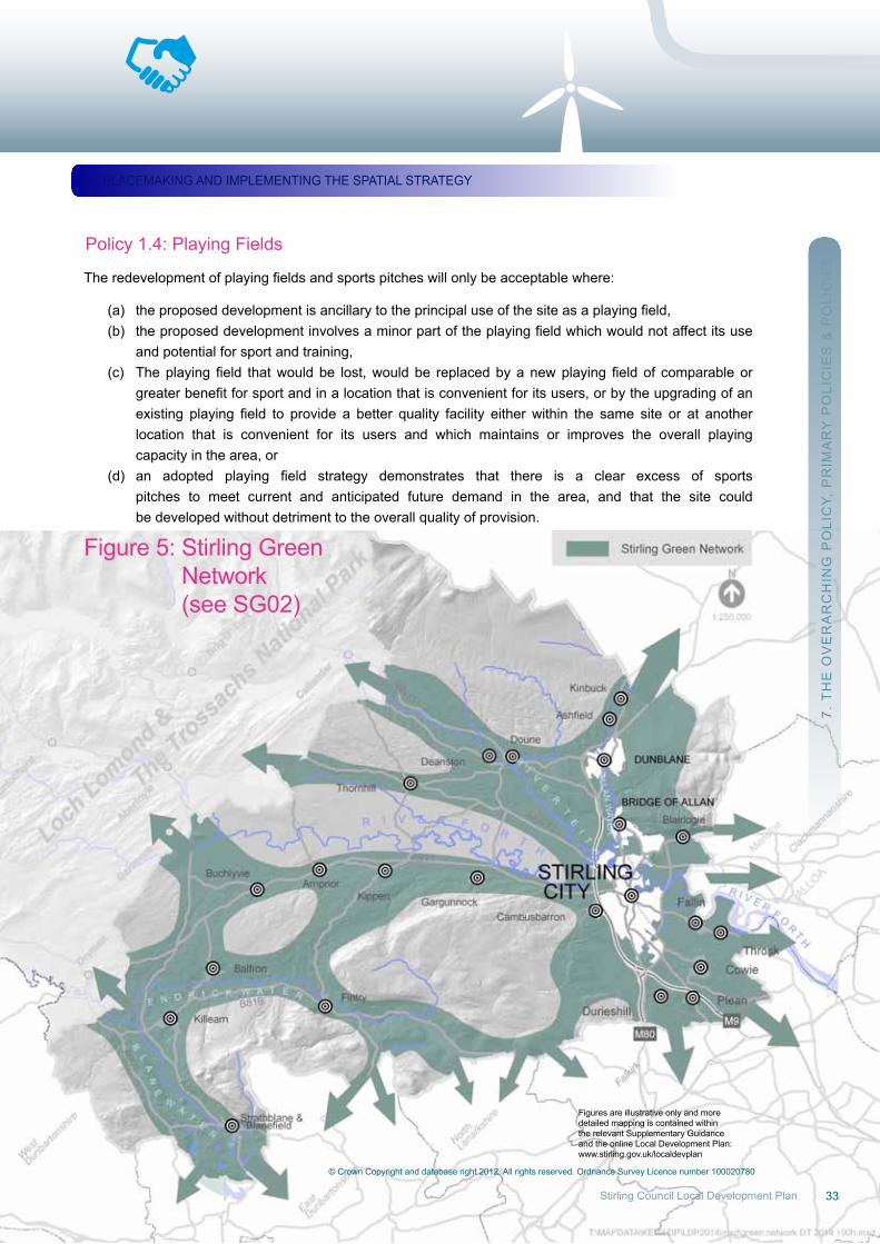
Figure 5: Stirling Green network (see SG02)
© Crown Copyright and database right 2012. All rights reserved. ordnance Survey Licence number 100020780
Figures are illustrative only and moredetailed mapping is contained withinthe relevant Supplementary Guidanceand the online Local Development Plan:www.stirling.gov.uk/localdevplan
33Stirling Council Local Development Plan
34
7. T
HE
oV
Er
Ar
CH
InG
Po
LIC
Y, P
rIM
Ar
Y P
oLI
CIE
S &
Po
LIC
IES
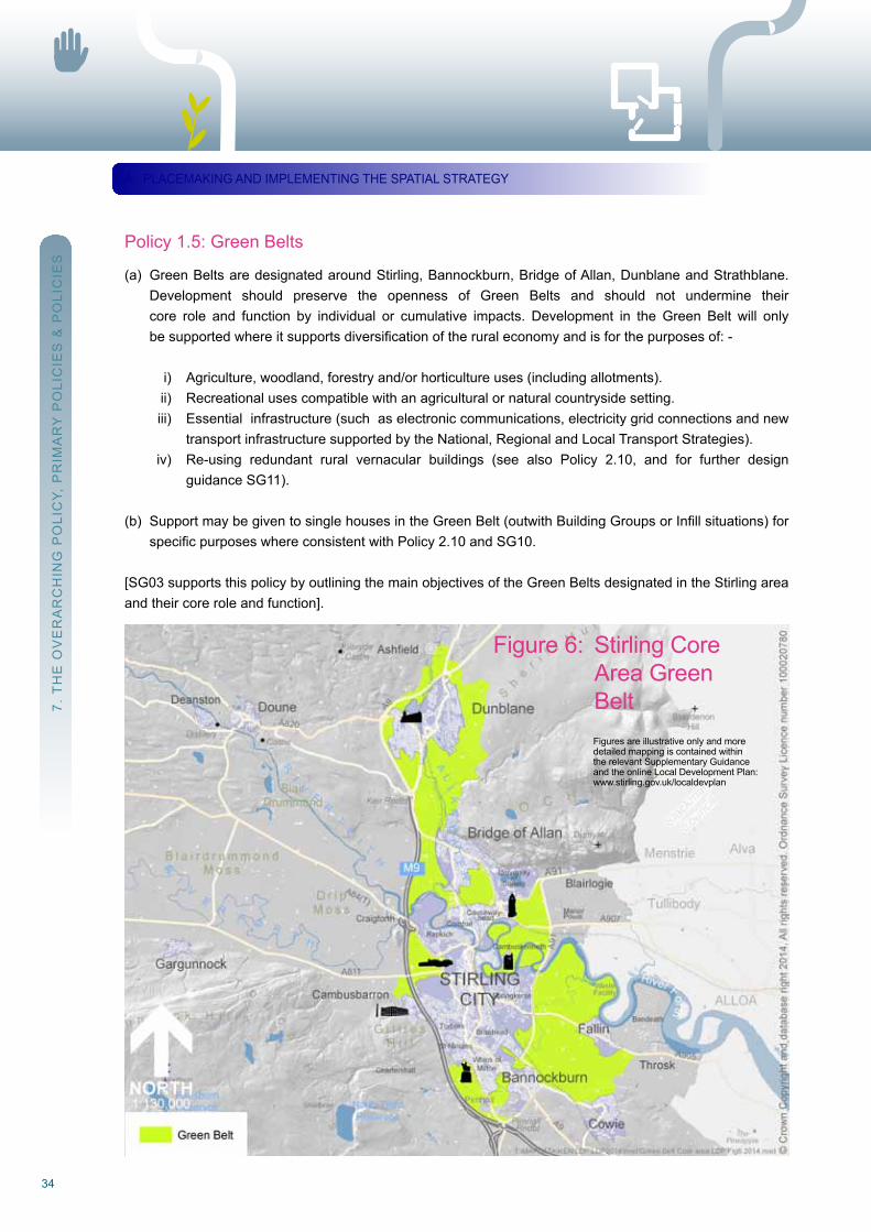
Policy 1.5: Green Belts
(a) Green Belts are designated around Stirling, Bannockburn, Bridge of Allan, Dunblane and Strathblane. Development should preserve the openness of Green Belts and should not undermine their core role and function by individual or cumulative impacts. Development in the Green Belt will only besupportedwhereitsupportsdiversificationoftheruraleconomyandisforthepurposesof:-
i) Agriculture, woodland, forestry and/or horticulture uses (including allotments). ii) recreational uses compatible with an agricultural or natural countryside setting. iii) Essential infrastructure (such as electronic communications, electricity grid connections and new transport infrastructure supported by the national, regional and Local Transport Strategies). iv) re-using redundant rural vernacular buildings (see also Policy 2.10, and for further design guidance SG11).
(b) SupportmaybegiventosinglehousesintheGreenBelt(outwithBuildingGroupsorInfillsituations)for specificpurposeswhereconsistentwithPolicy2.10andSG10.
[SG03 supports this policy by outlining the main objectives of the Green Belts designated in the Stirling area and their core role and function].
A. PLACEMAKInG AnD IMPLEMEnTInG THE SPATIAL STrATEGY
Figure 6: Stirling Core Area Green Belt
Figures are illustrative only and moredetailed mapping is contained withinthe relevant Supplementary Guidanceand the online Local Development Plan:www.stirling.gov.uk/localdevplan
35Stirling Council Local Development Plan
Primary Policy 2: Supporting the Vision and Spatial Strategy
Development proposals considered consistent with the Plan’s Vision and Spatial Strategy will be supported as follows: -
(a) The priority for the Development Plan is to support and enable the major developments of the Spatial Strategy. Sufficient land is allocated in locations to provide a range and choice of sites and uses. Should existing sites and allocations prove ineffective, this will be addressed in the first instance through consideration of advancing alternate developments from Plan Phase 2 or Period 2. (b) outwith allocated sites, the Core Area will be the preferred location for new build development on sites located close to, and easily accessible by, major public transport routes. In the rural Villages Area and areas of Countryside, development will be more constrained by accessibility, infrastructure, landscape and biodiversity considerations. However new employment development, and other developments that will provide significant economic and social support to the rural area will be encouraged in appropriate circumstances.
[SG08 and the production of associated Development Frameworks, Masterplans and Planning Briefs forspecific sites, supports this policy by endorsing particular development proposals as part of the SpatialStrategy].
Policy 2.1: Housing Land requirement
(a) new housing development will be supported in principle, where land is allocated for housing purposes in the Plan (see Appendix B). The housing land requirement allows for a generous supply. At all times, a 5-year supply of land for housing that is effective or can be shown through the Action Programme to be capable of becoming effective, will be maintained.
(b) The housing land supply will be monitored annually through the Housing Land Audit and reviewed biennially as the Action Programme is updated. Developments will require to accord with the proposed phasing detailed in the Settlement Statements and LDP Action Programme unless the site requires to come forward to maintain an effective supply in accordance with Primary Policy 2.
Policy 2.2: Planning for Mixed Communities and Affordable Housing
(a) All new residential development schemes should provide a range of housing of different types and sizes, and where required, different tenures and affordability. The different kinds of housing should be well integrated through the entire development scheme, ensuring that the siting and layout and architectural quality and design, is appropriate to the site and surrounding area.
(b) For larger development schemes (20 units or more) any market housing proposed should aim to meet the needs of smaller households, older people and lower income households consistent with local housing needs.
7. T
HE
oV
Er
Ar
CH
InG
Po
LIC
Y, P
rIM
Ar
Y P
oLI
CIE
S &
Po
LIC
IES
A. PLACEMAKInG AnD IMPLEMEnTInG THE SPATIAL STrATEGY
36
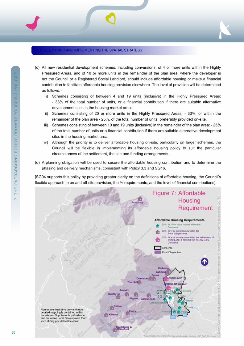
(c) All new residential development schemes, including conversions, of 4 or more units within the Highly Pressured Areas, and of 10 or more units in the remainder of the plan area, where the developer is nottheCounciloraRegisteredSocialLandlord,shouldincludeaffordablehousingormakeafinancial contribution to facilitate affordable housing provision elsewhere. The level of provision will be determined as follows: - i) Schemes consisting of between 4 and 19 units (inclusive) in the Highly Pressured Areas: - 33% of the total number of units, or a financial contribution if there are suitable alternative development sites in the housing market area. ii) Schemes consisting of 20 or more units in the Highly Pressured Areas: - 33%, or within the remainder of the plan area - 25%, of the total number of units, preferably provided on-site. iii) Schemes consisting of between 10 and 19 units (inclusive) in the remainder of the plan area: - 25% ofthetotalnumberofunitsorafinancialcontributioniftherearesuitablealternativedevelopment sites in the housing market area. iv) Although the priority is to deliver affordable housing on-site, particularly on larger schemes, the Council will be flexible in implementing its affordable housing policy to suit the particular circumstances of the settlement, the site and funding arrangements.
(d) A planning obligation will be used to secure the affordable housing contribution and to determine the phasing and delivery mechanisms, consistent with Policy 3.3 and SG16.
[SG04supportsthispolicybyprovidinggreaterclarityonthedefinitionsofaffordablehousing,theCouncil’sflexibleapproachtoonandoff-siteprovision,the%requirements,andtheleveloffinancialcontributions].
7. T
HE
oV
Er
Ar
CH
InG
Po
LIC
Y, P
rIM
Ar
Y P
oLI
CIE
S &
Po
LIC
IES
A. PLACEMAKInG AnD IMPLEMEnTInG THE SPATIAL STrATEGY
Figure 7: Affordable Housing requirement
Figures are illustrative only and moredetailed mapping is contained withinthe relevant Supplementary Guidanceand the online Local Development Plan:www.stirling.gov.uk/localdevplan
37Stirling Council Local Development Plan
Policy 2.3: Particular needs Housing and Accommodation
(a) All new residential developments should consider and provide for particular housing needs where evidenced through local area analysis on housing needs.
(b) It is preferable that all new housing be built to ‘varying needs’ or ‘lifetime homes’ standards to support independent living, be accessible to as wide a range of people as possible, and allow the potential for future adaptation.
(c) Development providing particular needs accommodation should be located within residential areas where residents have a realistic choice of access to local services and facilities. outwith these areas, accommodationwillonlybesupportedwheretheneedforsuchaccommodationinthelocalityisjustified, a good accessible residential environment can be secured, and other appropriate locations are not available.
(d) There will be a presumption against the further provision of private nursing or residential care home accommodation unless it supports the Council’s strategy for ‘reshaping older People’s Care’ which moves away from institutional care to more flexible home based care in suitable housing. In determining applications for such accommodation, consultation will be undertaken with the Council’s Head of Social Services and nHS Forth Valley.
(e) The formation of Houses in Multiple occupation (HMos), including new-build and changes of use (but excluding purpose-built student accommodation), will be controlled in order to protect residential amenity. Proposals will be supported where: - i) It can be demonstrated that suitable in-curtilage waste and recycling storage space will be provided; ii) Parking or road safety problems will not be created or exacerbated; iii) Appropriate maintenance arrangements are in place for any external spaces / garden ground associated with the HMo; and iv) The locational criteria set out in SG05 can be met.
(f) There is a private permanent site for Showpeople at riverside, Stirling. Any improvements to this established facility that requires planning permission will generally be supported. There is no evidence from the HnDA to suggest that additional provision is required in the near future, however should any proposals come forward, they will be determined in accordance with other appropriate policies in the Plan.
[Part(e)shouldbereadinconjunctionwithSG05,whichdefinestheformationofHMOsinhousesandinflatsfor the purposes of this policy].
7. T
HE
oV
Er
Ar
CH
InG
Po
LIC
Y, P
rIM
Ar
Y P
oLI
CIE
S &
Po
LIC
IES
A. PLACEMAKInG AnD IMPLEMEnTInG THE SPATIAL STrATEGY
38
Policy 2.4: Safeguarding Employment Land and Property
(a) All employment land and property, (particularly those sites allocated in the Plan at Appendix B), for Class 4 business, Class 5 general industry, Class 6 storage and distribution, and/or waste management purposes, will be safeguarded for employment generating uses.
(b) For allocated sites and sites within the Employment Safeguarding Areas shown on the Proposals Maps, other uses will only be supported where one or more of the following circumstances apply: - i) The site is no longer required to maintain an effective supply of employment land set out within the Spatial Strategy - see also part (d). ii) The use is ancillary to, or complements, the overall employment use (e.g. small scale renewable energy developments). iii) The use is consistent with Policy 2.8 dealing with sites suitable for a mix of uses, and is to be delivered in conjunction with an employment use, thereby enabling the majority of the site to be developed for employment purposes.
(c) For unallocated sites, other uses will only be supported where it has been proven that the site has been unsuccessfully marketed for employment purposes for a period of 12 months or more.
(d) The Schedule at Appendix B lists the existing land supply and new land allocations that make up the overall supply of employment land. These will be monitored through the annual Employment Land Audit, which will also monitor windfalls, and will be used to determine if an effective land supply is being maintained and if a change of use is appropriate.
Policy 2.5: Employment Development
(a) In order to provide a good choice and mix of employment land and support vibrant and prosperous communities, development for business, general industry, storage or distribution and/or waste management facilities will be supported where it meets one or more of the following criteria: - i) It is located within an allocated employment site or an area safeguarded for such uses, and is compatible with the Key Site requirements. ii) It demonstrates considerable economic benefits to the Stirling economy, is located within the Core Area, and cannot be located on an allocated site / safeguarded employment area.
(b) Partial change of use to enable working from home will be supported in appropriate circumstances, but will be restricted to activities that will not impact on residential amenity either alone or through cumulative impact.
7. T
HE
oV
Er
Ar
CH
InG
Po
LIC
Y, P
rIM
Ar
Y P
oLI
CIE
S &
Po
LIC
IES
A. PLACEMAKInG AnD IMPLEMEnTInG THE SPATIAL STrATEGY
39Stirling Council Local Development Plan
7. T
HE
oV
Er
Ar
CH
InG
Po
LIC
Y, P
rIM
Ar
Y P
oLI
CIE
S &
Po
LIC
IES
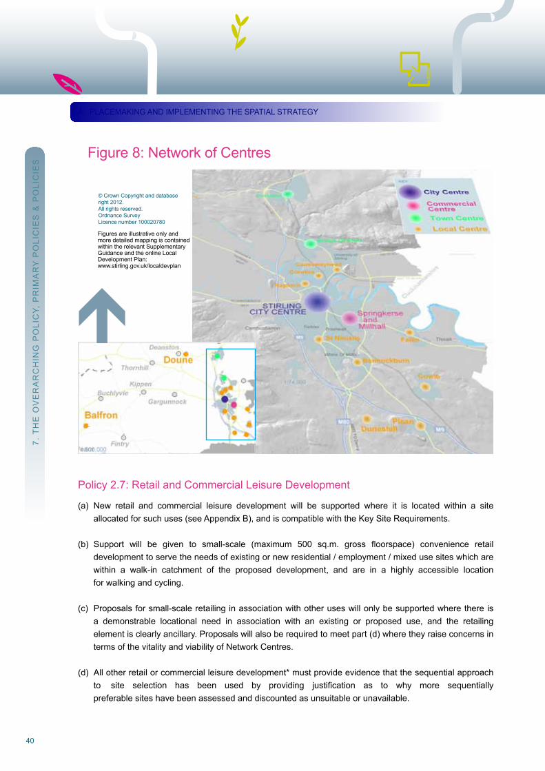
Policy 2.6: The network of Centres
(a) ProposalsforallnewretailandcommercialleisuredevelopmentwithintheidentifiedNetworkofCentres will be assessed against Policy 2.7 retail and Commercial Leisure Development.
(b) In addition, within all network Centres: - i) There will be support for Class 1 retail uses (where consistent with the role and function of the centre. ii) Class 3 uses (restaurants, cafes, snack bars etc.), public houses, and hot-food takeaways will be supported only where they will not be to the detriment of occupiers of adjacent properties by virtue of noise, disturbance, or odour, and there will be a presumption against siting public houses and hot-food takeaways adjacent to or on the ground floor of residential properties. iii) Changesofusetoresidentialusewillnotgenerallybesupportedonthegroundfloorofbuildings. iv) All developments must have an active frontage at street level, and be designed to include measures that will enhance the character and appearance of the Centre. (The advice contained in SG22 should be referred to when replacing or carrying out works to shopfronts).
(c) within Stirling City Centre: - i) All developments should comply with the City Centre Development Framework (SG08B), where applicable. ii) within the Prime retail Area, changes of use at street level away from Class 1 retail use will be resisted, except where a vacant unit has been unsuccessfully marketed for this use for more than 12 months to the satisfaction of the Council. iii) outwith the Prime retail Area, in order to ensure a diversity of uses, changes of use that provide economic and social activity during both day and evening will be supported. iv) no proposal for a public car park (including stand-alone car parks, and those that are associated withnewdevelopment)willbesupported,unlessitcanbeshowntomeetanidentifiedshortfallin car parking provision. This will also apply to proposals in edge of City Centre locations.
(d) within Bridge of Allan, Dunblane and all Local Centres, there will be a presumption against the loss of all uses (particularly Class 1 retail), which contribute to their vitality and viability, or which serve an importantcommunityand/oremploymentfunction(e.g.SubPostOfficesorpharmacies).
[SG09supportsthispolicyindefiningtheboundaries,settingouttheroleandfunction,andthehierarchythatexists between the network of Centres].
A. PLACEMAKInG AnD IMPLEMEnTInG THE SPATIAL STrATEGY
40
Policy 2.7: retail and Commercial Leisure Development
(a) new retail and commercial leisure development will be supported where it is located within a site allocated for such uses (see Appendix B), and is compatible with the Key Site requirements.
(b) Support will be given to small-scale (maximum 500 sq.m. gross floorspace) convenience retail development to serve the needs of existing or new residential / employment / mixed use sites which are within a walk-in catchment of the proposed development, and are in a highly accessible location for walking and cycling.
(c) Proposals for small-scale retailing in association with other uses will only be supported where there is a demonstrable locational need in association with an existing or proposed use, and the retailing element is clearly ancillary. Proposals will also be required to meet part (d) where they raise concerns in terms of the vitality and viability of network Centres.
(d) All other retail or commercial leisure development* must provide evidence that the sequential approach to site selection has been used by providing justification as to why more sequentially preferable sites have been assessed and discounted as unsuitable or unavailable.
7. T
HE
oV
Er
Ar
CH
InG
Po
LIC
Y, P
rIM
Ar
Y P
oLI
CIE
S &
Po
LIC
IES
A. PLACEMAKInG AnD IMPLEMEnTInG THE SPATIAL STrATEGYa
© Crown Copyright and databaseright 2012.All rights reserved.ordnance SurveyLicence number 100020780
Figure 8: network of Centres
Figures are illustrative only andmore detailed mapping is containedwithin the relevant SupplementaryGuidance and the online LocalDevelopment Plan:www.stirling.gov.uk/localdevplan
41Stirling Council Local Development Plan
Inaddition,allofthefollowingcriteriaitoiiimustbesatisfiedwhereproposalsarelocatedeither:- Within a Network Centre (excluding the City Centre) where the proposal is inconsistent with the role andfunctionoftheCentreasspecifiedinSG09and/orofascalethatcouldadverselyimpactuponthevitalityand viability of a Centre; or
On sites outwith Network Centres that are not allocated for retail or commercial leisure uses or areinconsistent with the site allocation and its Key Site requirements.
i) Demonstrate that there will be no unacceptable individual or cumulative impact on the vitality and viability of any Centre within the network. A retail Impact Analysis (rIA) must accompany proposals formore than 2,500sq.m. gross floorspace. For smaller developments, the requirement for an rIA will be at the Council’s discretion. ii) Demonstrate that the development will help to meet proven qualitative and quantitative deficienciesinexistingprovision. iii) Demonstrate that the development will be of a scale, character, and design, commensurate both with the size of the catchment to be served, and if applicable, with the Centre(s) closest to where it is located.
(e) Planning Permissions covered by any part of this policy may be subject to conditions and / or planning obligationsgoverningtheoverallamountandconfigurationoffloorspace,andtherangeofgoodstobe sold.
[*Includesexpansionorchangeofuseofanexistingpropertywhichsignificantlyaltersitsscale,form,role,orfunction,e.g.layoutreconfiguration,ortheadditionofmezzaninefloors].
Policy 2.8: Sites Suitable for a Mix of uses
(a) Development incorporating a mix of uses will be expected and supported in the following instances: - i) OnallocatedsiteswhereamixofuseshasbeenidentifiedinKeySiteRequirements; ii) OnsiteswithinthedefinedNetworkofCentres; iii) on sites located close to, and easily accessed by, major public transport routes and nodes within the Core Area, and which are considered to support the Spatial Strategy; iv) on sites where it can be demonstrated that provision of a mix of uses is required to deliver/ enabledevelopmentoftheprimaryuseonthesite(wherespecificallyreferredtointheKeySite requirements).
(b) Mixed use proposals will be expected to demonstrate compliance with both the following criteria: - i) The mix and proportion of uses proposed is appropriate for the location, site and wider community. ii) The layout, distribution of uses, density of development and resultant built form is appropriate for the site and its environs (see SG01).
7. T
HE
oV
Er
Ar
CH
InG
Po
LIC
Y, P
rIM
Ar
Y P
oLI
CIE
S &
Po
LIC
IES
A. PLACEMAKInG AnD IMPLEMEnTInG THE SPATIAL STrATEGY
42
Policy 2.9: Economic Development in the Countryside
(a) In order to support a healthy and vibrant rural economy, developments supporting rural economic activity in the Countryside* will be encouraged to locate: - i) In and around the rural Activity Areas; ii) Close to villages, where there is a greater possibility for a realistic choice of access; or iii) where redundant or under-utilised buildings can be used, and particularly where traditional rural buildings can be restored and re-used, including as part of a mixed-used development (see also Policy 2.8 and SG11).
(b) Businessesbasedonrecreationalactivitiesthathaveasite-specificneedforaCountrysidelocationwill be encouraged.
(c) Smaller-scale developments that are compatible with neighbouring residential properties may be permittedinBuildingGroupsandInfillsituations(asdefinedinPolicy2.10andSG10)oraspartofFarm Steading developments (see SG11).
[SG10 and SG11 support this policy by providing locational and siting guidance for economic development in the countryside].
[*CountrysideisdefinedbytheCountrysidePolicyBoundaryshownontheProposalsMaps].
Policy 2.10: Housing in the Countryside
(a) new houses (including those for holiday let outwith managed chalet developments), of a scale, layout and design suitable for their intended location, will be supported in the Countryside* where one or more of the following circumstances apply: - i) when they are within or closely and cohesively visually related to existing Building Groups and Clusters. ii) WheretheywilloccupyInfillsitesrelativetoexistingrowsofhouses. iii) Outwithexistinggroupsor Infillsituationswhen theproposal is foraSinglehouseataspecific typeofsiteorforaspecificpurpose. iv) when the replacement or renovation of a single house is proposed. v) when the proposal is for the Conversion, redevelopment or replacement of a Farm Steading or other range or cluster of non-Domestic Buildings. vi) Whentheproposalwillresultinthebeneficialre-useofaBrownfieldSite.
(b) DevelopmentopportunitieswithindesignatedGreenBeltswillbesignificantlyconstrained(seePolicy1.5 and SG10).
[SG10supportsthispolicybyprovidingdetailsofthedefinitionoftermsused,requirementsrelativetoListedBuildings, affordable housing, Green Belts, etc, and includes guidance on siting and design, landscaping, energyefficiencyetc.SG36setsout theproceduresallowing for the identificationand formationofSmallSettlements within the Countryside and policy interpretation therein].
[SG11supportsthispolicybyprovidingspecificdesignguidanceinrelationtothereuseofredundantruralbuildings].
[*CountrysideisdefinedbytheCountrysidePolicyBoundaryshownonProposalsMaps].
7. T
HE
oV
Er
Ar
CH
InG
Po
LIC
Y, P
rIM
Ar
Y P
oLI
CIE
S &
Po
LIC
IES
A. PLACEMAKInG AnD IMPLEMEnTInG THE SPATIAL STrATEGY
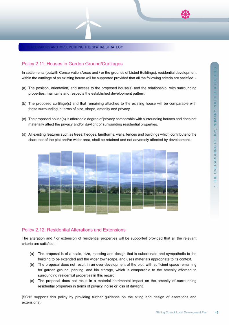
43Stirling Council Local Development Plan
Policy 2.11: Houses in Garden Ground/Curtilages
In settlements (outwith Conservation Areas and / or the grounds of Listed Buildings), residential development withinthecurtilageofanexistinghousewillbesupportedprovidedthatallthefollowingcriteriaaresatisfied:-
(a) The position, orientation, and access to the proposed house(s) and the relationship with surrounding properties, maintains and respects the established development pattern.
(b) The proposed curtilage(s) and that remaining attached to the existing house will be comparable with those surrounding in terms of size, shape, amenity and privacy.
(c) The proposed house(s) is afforded a degree of privacy comparable with surrounding houses and does not materially affect the privacy and/or daylight of surrounding residential properties.
(d) All existing features such as trees, hedges, landforms, walls, fences and buildings which contribute to the character of the plot and/or wider area, shall be retained and not adversely affected by development.
Policy 2.12: residential Alterations and Extensions
The alteration and / or extension of residential properties will be supported provided that all the relevant criteriaaresatisfied:-
(a) The proposal is of a scale, size, massing and design that is subordinate and sympathetic to the building to be extended and the wider townscape, and uses materials appropriate to its context. (b) Theproposaldoesnotresultinanover-developmentoftheplot,withsufficientspaceremaining for garden ground, parking, and bin storage, which is comparable to the amenity afforded to surrounding residential properties in this regard. (c) The proposal does not result in a material detrimental impact on the amenity of surrounding residential properties in terms of privacy, noise or loss of daylight.
[SG12 supports this policy by providing further guidance on the siting and design of alterations andextensions].
7. T
HE
oV
Er
Ar
CH
InG
Po
LIC
Y, P
rIM
Ar
Y P
oLI
CIE
S &
Po
LIC
IES
A. PLACEMAKInG AnD IMPLEMEnTInG THE SPATIAL STrATEGY

44
Policy 2.13: residential Caravans
(a) The provision of residential caravan(s) as an alternative to permanent housing on a temporary basis will be supported where one or more of the following circumstances applies: -
i) To provide residential accommodation where on-site presence is necessary for the proper management of a rural business. ii) where a house is being renovated or constructed on a self-build basis or where the future occupiers have no alternative accommodation during this period. iii) To house construction workers for an approved development during the construction period.
In all instances, arrangements for the reinstatement / after-use of the site must be agreed prior to installation of the caravan(s).
(b) The Council runs a permanent site for Gypsies/Travellers at Bridgend, Stirling, which is considered appropriate to meet their ongoing needs. Any improvements to this established facility that requires planning permission will generally be supported.
(c) outwith the above location, additional permanent sites for Gypsies/Travellers will be supported where consistent with other policies in the Plan and where all the following criteria can be met: - (i) It will not adversely affect the built and / or landscape character of the area. (ii) It provides an appropriate residential setting for such development. (iii) Access to local services and education facilities can be provided. (iv) Essential infrastructure such as water, sewage disposal, refuse collection and other services can be provided. (v) Suitable parking and access arrangements to the local road network can be provided. (vi) It can be demonstrated that the site will be properly managed and adequately secured.
7. T
HE
oV
Er
Ar
CH
InG
Po
LIC
Y, P
rIM
Ar
Y P
oLI
CIE
S &
Po
LIC
IES
A. PLACEMAKInG AnD IMPLEMEnTInG THE SPATIAL STrATEGY
45Stirling Council Local Development Plan
Policy 2.14: Advertisements
Proposals for the display of advertisements will be supported where they do not detract from the visualamenity of the locale or adversely affect public safety. Proposals should meet all of the following relevant criteria: -
(a) The cumulative effect of a number of advertisements on a building or within a locality does not result in advertisement clutter.
(b) The effect of any illumination used on advertisements is not detrimental to the appearance of a locality. The Planning Authority will discourage illuminated box signs because of their general bulk and appearance.
(c) Advertisementsshouldbesitedsoasnottocausedriverdistraction,especiallyatlocationsofhightraffic flowsorconflicts,orwheretheymaybeconfusedwithtrafficlightsortrafficsigns.
(d) Advertisementsshouldbesitedsoasnottoobstructorimpedepedestrianflow.
(e) Advertisements and signage on a Listed Building, within the curtilage of a Listed Building or within a Conservation Area, should preserve or enhance the character and appearance of the building and / or the Area (consistent with Policies 7.2 and 7.3).
(f) Advanced directional signs, particularly in the countryside, will not be permitted unless in relation to the temporary advertisement of events and construction, or those considered to be desirable on public safety grounds. Advertisement hoardings (i.e. structures providing space for commercial advertising) are unacceptable in the countryside.
[SG13 supports this policy by providing further guidance on the siting and design of advertisements].
Policy 2.15: Mobile Hot Food outlets
(a) Proposals for mobile hot food outlets* will only be supported in the following instances: - (i) Wheretheoutletisrequiredforatemporaryperiodinassociationwithaspecificevent;or (ii) where the outlet is located within an area where similar facilities are unavailable within reasonable travelling distance.
(b) In the above instances: - (i) Proposals must not adversely impact upon amenity, or the landscape quality, or character of the area. (ii) road and public safety must not be compromised. (iii) Adequate off-road parking must be provided, in a location that is separate from the outlet. (iv) on-site waste collection facilities must be provided.
[* An Article 4 Direction removing permitted development rights for open-air retail markets (including single stalls and caravans used for the sale of goods), applies in the Plan area].
7. T
HE
oV
Er
Ar
CH
InG
Po
LIC
Y, P
rIM
Ar
Y P
oLI
CIE
S &
Po
LIC
IES
A. PLACEMAKInG AnD IMPLEMEnTInG THE SPATIAL STrATEGY
46
Primary Policy 3: Provision of Infrastructure
(a) Should no further infrastructure be provided, there will be significant infrastructure deficiencies as a result of the scale and location of development within the Plan. Management and enhancement of existing infrastructure, and reducing the demands for new infrastructure will be the preferred approach in supporting the implementation of the Spatial Strategy.
(b) Land necessary for the provision of identified and anticipated infrastructure (ie. for enhancements to the transport network as identified in National, Regional and Local Transport Strategies, new or expanded schools, new and improved healthcare facilities and recycling bring sites), will be safeguarded where appropriate as shown in the Settlement Statements.
(c) Shared use of facilities in the provision of educational, social, recreational, health and wider community infrastructure will be supported. The loss of services through changes of use/demolition, where they serve an important community and/or employment function (e.g. post offices, pharmacies), will also be resisted.
(d) Continuing enhancement of electronic communications infrastructure will be encouraged in accordance with the principles set out in SPP (2010).
(e) where appropriate, transport infrastructure corridors, sustainable drainage elements, open space and Green Corridor provision etc., should be integrated with the Green network (see Policy 1.3 and SG02).
[Infrastructure provision and enhancement is likely to require input from developers. Policy 3.3 and SG16supportthispolicybydefiningthescopeof,andmechanismsforsecuringDeveloperContributions].
Policy 3.1: Addressing the Travel Demands of new Development
(a) In order to create accessible developments in sustainable locations, new development should be located where safely and conveniently accessible by walking, cycling and public transport as well as by motor vehicles.
(b) Development should aim to reduce its travel demands, and to ensure that residual demands are met in a manner which ensures a safe and realistic choice of access by walking, cycling, public transport and motor vehicles.
[SG14 supports the above policy by providing guidance on how developments will be expected to assess and demonstrate there is a safe and realistic choice of access. Accordingly, SG14 includes advice on transport statements, transport assessments, travel plans, improving walking, cycling and public transport access and parking standards. SG14, Policy 3.3 and SG16 also set out when developer contributions will be required to either ensure a safe and realistic choice of access and / or enable infrastructure improvements necessary as a consequence of the cumulative impact of developments].
7. T
HE
oV
Er
Ar
CH
InG
Po
LIC
Y, P
rIM
Ar
Y P
oLI
CIE
S &
Po
LIC
IES
A. PLACEMAKInG AnD IMPLEMEnTInG THE SPATIAL STrATEGY

47Stirling Council Local Development Plan
Policy 3.2: Site Drainage
(a) Foul Drainage (i) A connection to the public sewer will be required for all development within or close to urban areas (i.e. all settlements of greater than 2000 population equivalent) and other sewered areas. where there is limited capacity at the waste water Treatment works the authority recommends early contact with Scottish water. A private drainage system would only be considered in the sewered area as a temporary measure where there is no capacity in the existing sewer system. Private drainage provision will be unlikely, however in such cases the private system should be built to relevant Scottish water standards to allow adoption once connection to the public sewerage system is available. (ii) In other settlements (population equivalents less than 2000) where there is no, or a limited collection system a private system may be permitted where it does not have a detrimental effect on the natural environment, surrounding uses or local amenity. A discharge to land (i.e. a full soakaway or raised mound soakaway) compatible with the Scottish Building Standards Agency Technical Handbooks should be explored prior to considering a discharge to surface waters.
(b) Surface Water Drainage (i) Surface water from new development shall be treated by a Sustainable Drainage System (SuDS) before it is discharged into the water environment, in accordance with the CIrIA C697 document ‘The Suds Manual’ and, where the scheme is to be adopted by Scottish water, the Sewers for Scotland Manual Second Edition. (ii) All proposed developments that include roads should be designed in accordance with the SuDS forRoadsManual(2010),publishedbytheSocietyofChiefOfficersofTransportationinScotland. (iii) Taking account of the location, scale and type of development, planning applications may require to be submitted with a drainage strategy in accordance with Scottish Government Planning Advice note 61 – Planning and Sustainable urban Drainage Systems (paras. 23 and 24).
[SG34 supports this policy by providing more detailed information and guidance on the role of the planning system in protecting the water environment from deterioration, and as a means to implement improvement measuresbyinfluencingthelocationanddesignofnewdevelopment].
7. T
HE
oV
Er
Ar
CH
InG
Po
LIC
Y, P
rIM
Ar
Y P
oLI
CIE
S &
Po
LIC
IES
A. PLACEMAKInG AnD IMPLEMEnTInG THE SPATIAL STrATEGY
48
Policy 3.3: Developer Contributions
(a) Developer contributions will be sought in situations where a development (or combination of developments) creates a need for new, extended or improved public infrastructure, facilities or services. The need to seek contributions towards additional infrastructure will be determined through considering existing capacity and also cumulative development pressures arising from other proposals in the Local Development Plan.
(b) Contributions will be sought for both critical and necessary infrastructure (as outlined with SG16) and where secured through a Planning obligation (a Section 75 Agreement or other legal agreement as necessary), be consistent with Circular 3/2012.
(c) The provision of on-site affordable housing is a priority for the Council and developer contributions will be used primarily to deliver affordable housing on-site unless an appropriate off-site opportunity is considered by the Council to be more suitable in accordance with Policy 2.2 and SG04.
(d) Developerswillberequiredtomakeafairandreasonablecontribution(financialor ‘inkind’),whichis necessary and proportionate to the scale and nature of the development, relative to: -
(i) Ensuring that there is a safe and realistic choice of access including addressing the impact on transport networks in the immediate vicinty of the development. In addition in the City Transport Area, there will also be a requirement for developments (above thresholds set out in SG14) to contribute to infrastructure necessary as a consequence of the cumulative impact of developments. In remote rural locations not served by a fixed route bus service, contributions may be sought towards the DrT service. (ii) Theprovisionofprimaryandsecondaryeducation facilities toensuresufficient school capacity is in place to accommodate the development, which for the Education Core Area will be considered on a cumulative basis as a consequence of the impact of developments in this area. SG15 sets out the methodology used to measure the impact and the solutions for each geographical area. (iii) The improvement of existing and/or the provision of new community facilities resulting from development proposed in the Regeneration Areas. Specific site requirements are identified in the Key Site requirements set out in the relevant Settlement Statements. (iv) The provision of new or improvements to existing open Space and Green Corridors which contributes to the protection and enhancement of the Green network. Contributions to off-site provision will only be sought where on-site provision is not appropriate. SG02 sets out the rationale and methodology for seeking developer contributions in particular circumstances. (v) The cost of meeting new or expanded local health service infrastructure resulting from new development in the identified ‘pressured locations’ as set out in SG06. Specific requirements areidentifiedintheKeySiteRequirementssetoutintherelevantSettlementStatements. (vi) As a result of new development, the provision of new or expanded on and off-site facilities for the provision, storage, collection and recycling of household waste, including Household recycling Centres as set out in SG19.
7. T
HE
oV
Er
Ar
CH
InG
Po
LIC
Y, P
rIM
Ar
Y P
oLI
CIE
S &
Po
LIC
IES
A. PLACEMAKInG AnD IMPLEMEnTInG THE SPATIAL STrATEGY

49Stirling Council Local Development Plan
(e) The Council will work with the agencies responsible for the provision and management of infrastructure, and the developer industry, via an Infrastructure working Group to consider cumulative impacts and establish an equitable system of securing developer contributions. In this way, the contributions for each site set out in the Key Site requirements can be kept under review and the LDP Action Programme updated accordingly.
[SG16 supports this policy by setting out further guidance on the scope of and mechanisms for Developer Contributionsandthelegal,administrativeandfinancialarrangements].
7. T
HE
oV
Er
Ar
CH
InG
Po
LIC
Y, P
rIM
Ar
Y P
oLI
CIE
S &
Po
LIC
IES
Figure 9: City Transport Area
© Crown Copyright and database right 2012. All rights reserved.ordnance Survey Licence number 100020780
A. PLACEMAKInG AnD IMPLEMEnTInG THE SPATIAL STrATEGY
Figures are illustrative only and moredetailed mapping is contained withinthe relevant Supplementary Guidanceand the online Local Development Plan:www.stirling.gov.uk/localdevplan
50
B. Climate Change Adaptation and Mitigation(Primary Policies 4-6 & Policies 4.1-6.1)The resilience of places must improve in order to adapt to the ever-increasing challenges of a changing climate, with new development strongly discouraged in places where climate-related hazards are alreadypresent or predicted, such as flood plains. New development needs to be more efficient in its use ofresourcesandenabletrafficreduction.Carbonstoresalsoneedtobeprotectedandenhanced.
Mitigation of climate change involves reducing greenhouse gas emissions by changing the way we build and use buildings to reduce use of resources, energy and heat and by carrying out as many activities as possible in ways that reduce resource use, waste and travel. This is strongly linked to placemaking. In addition to the design and construction of new development, adapting to the changes in climate projected to take place inScotlandover the lifetimeofexistingdevelopments includes retro-fittingappropriateadaptations to thecurrentbuildingstockandinfrastructureaswellasavoidingandmanagingflooding.
Thepoliciesfoundwithinthissectionof thePlanthereforeseektosupportenergy-efficient, low-emission,climate-adapted development and encourage use of vacant and derelict land, reduction and recycling of waste, provision for active travel and public transport, and require sustainable drainage and floodmanagement.
Primary Policy 4: Greenhouse Gas reduction
(a) In order to contribute to the aims of greenhouse gas reduction, all new development should: - (i) Be in sustainable locations (with reference to the proposed main use or mix of uses, and existing or proposed infrastructure capacity). (ii) optimise accessibility to active travel opportunities and public transport. (iii) Employ sustainable constructionmaterials andmethods, andprovide energy andheat efficient accommodation with design and layout of buildings optimising passive environmental gains (solar, shelter, water use etc). (iv) where practical, meet energy and heat requirements by on-site renewable generation and/or by linking to local area networks.
(b) Proposals to establish local energy and/or heat distribution networks will be supported subject to the location and design of the base plant and all external components of the system being to the satisfaction of the Planning Authority.
(c) Alterations to existing buildings to achieve better energy performance will be supported subject to satisfying Primary Policy 7 and Policies 7.5 and 7.7 where they relate to Listed Buildings or Conservation Areas.
7. T
HE
oV
Er
Ar
CH
InG
Po
LIC
Y, P
rIM
Ar
Y P
oLI
CIE
S &
Po
LIC
IES
B. CLIMATE CHAnGE ADAPTIon & MITIGATIon
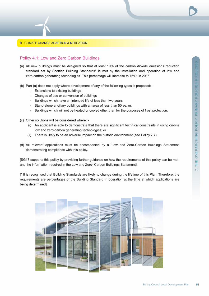
51Stirling Council Local Development Plan
Policy 4.1: Low and Zero Carbon Buildings
(a) All new buildings must be designed so that at least 10% of the carbon dioxide emissions reduction standard set by Scottish Building Standards* is met by the installation and operation of low and zero-carbon generating technologies. This percentage will increase to 15%* in 2016.
(b) Part (a) does not apply where development of any of the following types is proposed: - - Extensions to existing buildings - Changes of use or conversion of buildings - Buildings which have an intended life of less than two years - Stand-alone ancillary buildings with an area of less than 50 sq. m; - Buildings which will not be heated or cooled other than for the purposes of frost protection.
(c) other solutions will be considered where: - (i) Anapplicantisabletodemonstratethattherearesignificanttechnicalconstraintsinusingon-site low and zero-carbon generating technologies; or (ii) There is likely to be an adverse impact on the historic environment (see Policy 7.7).
(d) All relevant applications must be accompanied by a ‘Low and Zero-Carbon Buildings Statement’ demonstrating compliance with this policy.
[SG17 supports this policy by providing further guidance on how the requirements of this policy can be met, and the information required in the Low and Zero- Carbon Buildings Statement].
[* It is recognised that Building Standards are likely to change during the lifetime of this Plan. Therefore, the requirements are percentages of the Building Standard in operation at the time at which applications arebeing determined].
7. T
HE
oV
Er
Ar
CH
InG
Po
LIC
Y, P
rIM
Ar
Y P
oLI
CIE
S &
Po
LIC
IES
B. CLIMATE CHAnGE ADAPTIon & MITIGATIon
52
Policy 4.2: Protection of Carbon-rich Soils
(a) The categorisation of carbon-rich soils is detailed in SnH information note 318, along with limited information on extent and distribution of carbon-rich soils. Forthcoming guidance from SnH will provide more detailed spatial data regarding location of carbon-rich soils. If the mapped data highlights that carbon-rich soils may be present at the development site a detailed soil investigation would be required to identify the exact location of the carbon-rich soils on site in order that appropriate mitigation measures are incorporated into the development.
For the purposes of this policy peat accumulations are deemed to fall within Category 6 of the soil map units, and high carbon content soils are deemed to fall within Category 3 (organo-mineral no peat), Category 4 (organo-mineral with some peat) and Category 5 (organo-mineral with peat).
(b) The role of carbon-rich soils in storing carbon will be maintained by: - (i) Protecting from development or land use change peat accumulations or high carbon content soils not already designated for habitat conservation reasons (i.e. natura sites, SSSIs, Local nature Conservation Sites and Geological Conservation review Sites); (ii) Supporting proposals which include re-wetting and / or other restoration measures which provide ademonstrablecarbonand/orbiodiversitybenefit.
(c) Exceptions to the presumption against development may be permitted for renewable energy generating developments in areas of peat accumulations or areas of high carbon soils, where it can be demonstrated that the balance of advantage in terms of climate change mitigation lies with the energy generation proposal, as determined by the Scottish Government’s ‘Calculating carbon savings from wind farms on Scottish peat lands – A new Approach (June 2010)’, or equivalent evidence.
(d) ApeatmanagementplanmustbesubmittedforsitesidentifiedbySNHdocumentsorforsitesoutwith these areas where peat or carbon rich soils are found on site. The peat management plan must demonstrate that appropriate mitigation measures are in place to minimise impact on peat, including avoidance of development on areas of deep peat. Details of the requirements for a peat management plan are included in the ‘Developments on peatland: Guidance on the assessment of peat volumes, reuse of excavated peat and the minimisation of waste’ guidance.
[DefinitionsandlinkstotheabovereferenceddocumentsarecontainedwithintheGlossary].
7. T
HE
oV
Er
Ar
CH
InG
Po
LIC
Y, P
rIM
Ar
Y P
oLI
CIE
S &
Po
LIC
IES
B. CLIMATE CHAnGE ADAPTIon & MITIGATIon
53Stirling Council Local Development Plan
Primary Policy 5: Flood risk Management
a) DevelopmentproposalsonareasshowntobeatriskoffloodingonSEPAFloodMaps(2014)(fluvial, coastal and surface water), should be avoided. The functional flood plain will be safeguarded from development in order to maintain its water conveyance and storage capacity. (note: SPP (Feb 2010) states that for planning purposes the functional flood plain will generally have a greater than 0.5% (1:200)probabilityoffloodinginanyyear).
b) DevelopmentproposalsonareasshowntobeatriskoffloodingontheIndicativeRiverandCoastalFlood Map (Scotland), or adjacent to a small watercourse (which has not been assessed on the Indicative river and Coastal Flood Map (Scotland) i.e. with a catchment area less than 3km²), or in an areaknowntobeatriskoffloodingfromanysource:- i) Shall be informed by a Flood risk Assessment (FrA) assessing the risk from all sources of flooding.TheFRAshallbecarriedoutincompliancewithSEPA’sTechnicalFloodRiskGuidance for Stakeholders; ii) will be assessed against advice and the risk Framework in Scottish Planning Policy (Feb 2010) relating to Flooding and Drainage (paras. 38 and 196 to 211); and iii) Shall not result in a use that ismore vulnerable to flooding or has a larger footprint than any previous development on the site.
c) Surface water from new development shall be treated by a Sustainable Drainage System (SuDS) before it is discharged into the water environment, in accordance with the CIrIA C697 document ‘The Suds Manual’ and, where the scheme is to be adopted by Scottish water, the Sewers for Scotland Manual Second Edition.
d) Alldevelopmentswillbeassessedfortheirpotentialtocontributetothereductionofoverallfloodrisk. Developmentslikelytoresultinanadverseeffectuponsustainablefloodmanagementorotherwisenot in conformity with the objectives of relevant Flood risk Management Plans (due to be adopted in 2016), will not be permitted.
e) Aprecautionaryapproachwillbetakenincontrollingdevelopmentinareaspotentiallysubjecttoflooding from small watercourses with no obvious flood plain or from surcharging drainage systems, and in locations prone to landslips and other forms of erosion, which may be exacerbated by changing rainfall patterns.
f) In exceptional circumstances, as set out in SPP (Feb 2010), where development is considered acceptable in an area at risk of flooding, water resilient materials, construction methods, including appropriatefinishedfloorlevels,shouldbeutilised.
g) Developmentoutwiththefunctionalfloodplainisnotnecessarily,notatrisktoflooding.Aprecautionary approach is therefore advisable and water resilient materials, construction methods, including appropriatefinishedfloorlevels,shouldbeutilisedasandwhendeterminedbyanFRA.
h) Developers of sites outwith functional flood plainswill be encouraged to provide,where appropriate, featurescontributingtosustainablefloodmanagement.
[SG18supportsthispolicybysummarisingthelegislation,policyandguidancerelatingtoplanningandfloodrisk management].
7. T
HE
oV
Er
Ar
CH
InG
Po
LIC
Y, P
rIM
Ar
Y P
oLI
CIE
S &
Po
LIC
IES
B. CLIMATE CHAnGE ADAPTIon & MITIGATIon

54
7. T
HE
oV
Er
Ar
CH
InG
Po
LIC
Y, P
rIM
Ar
Y P
oLI
CIE
S &
Po
LIC
IES
B. CLIMATE CHAnGE ADAPTIon & MITIGATIon
Figure 10: Flood risk Area (1 in 200 year)
Figures are illustrative only and moredetailed mapping is contained withinthe relevant Supplementary Guidanceand the online Local Development Plan:www.stirling.gov.uk/localdevplan
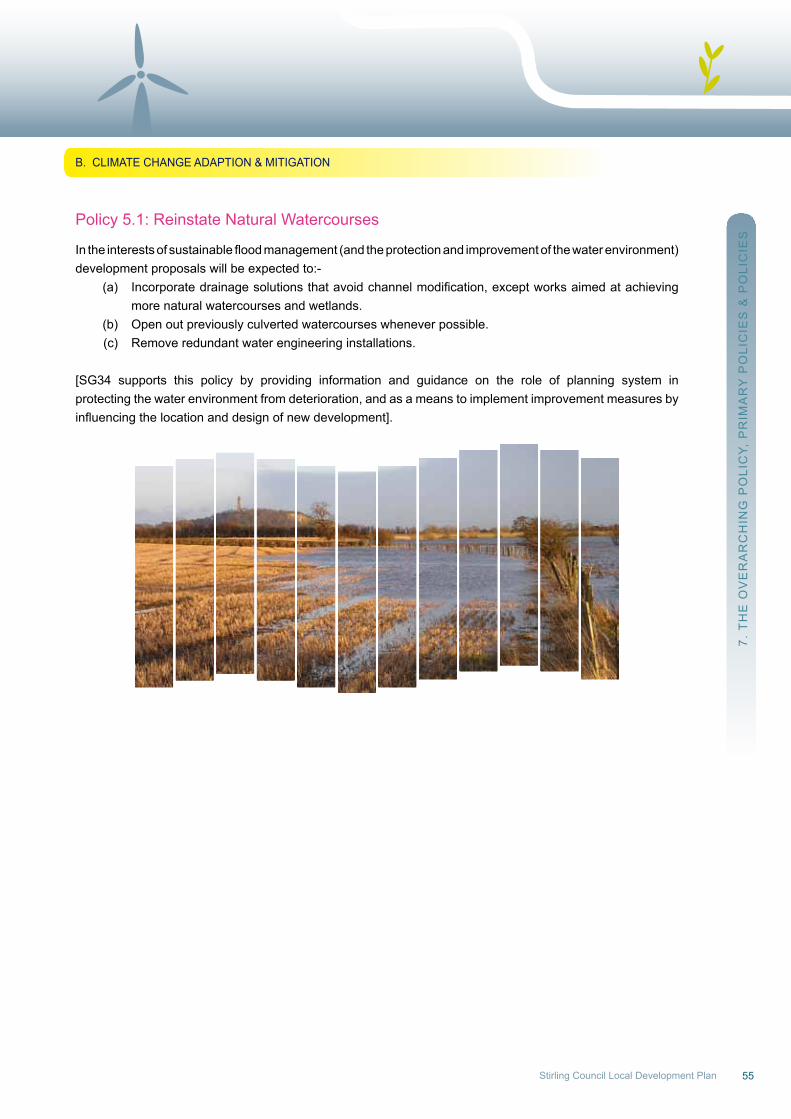
55Stirling Council Local Development Plan
Policy 5.1: reinstate natural watercourses
Intheinterestsofsustainablefloodmanagement(andtheprotectionandimprovementofthewaterenvironment)development proposals will be expected to:- (a) Incorporatedrainagesolutionsthatavoidchannelmodification,exceptworksaimedatachieving more natural watercourses and wetlands. (b) open out previously culverted watercourses whenever possible. (c) remove redundant water engineering installations.
[SG34 supports this policy by providing information and guidance on the role of planning system inprotecting the water environment from deterioration, and as a means to implement improvement measures byinfluencingthelocationanddesignofnewdevelopment].
7. T
HE
oV
Er
Ar
CH
InG
Po
LIC
Y, P
rIM
Ar
Y P
oLI
CIE
S &
Po
LIC
IES
B. CLIMATE CHAnGE ADAPTIon & MITIGATIon
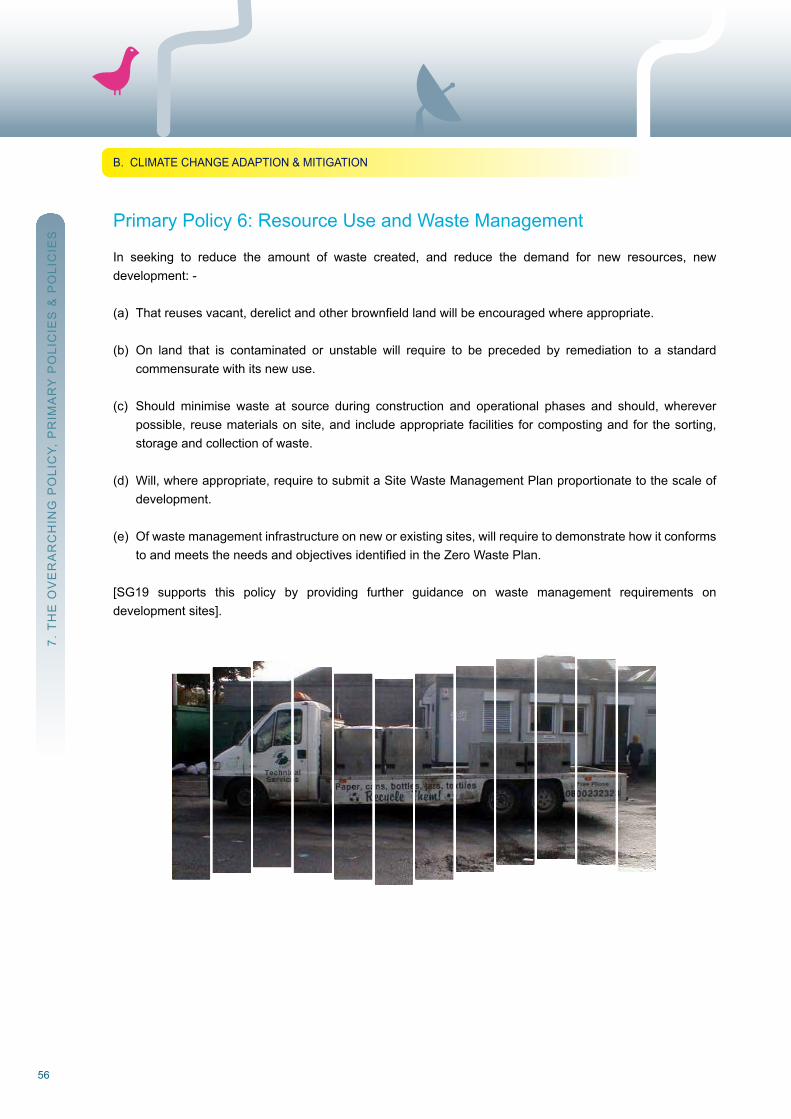
56
Primary Policy 6: resource use and waste Management
In seeking to reduce the amount of waste created, and reduce the demand for new resources, newdevelopment: -
(a) Thatreusesvacant,derelictandotherbrownfieldlandwillbeencouragedwhereappropriate.
(b) on land that is contaminated or unstable will require to be preceded by remediation to a standard commensurate with its new use.
(c) Should minimise waste at source during construction and operational phases and should, wherever possible, reuse materials on site, and include appropriate facilities for composting and for the sorting, storage and collection of waste.
(d) will, where appropriate, require to submit a Site waste Management Plan proportionate to the scale of development.
(e) of waste management infrastructure on new or existing sites, will require to demonstrate how it conforms toandmeetstheneedsandobjectivesidentifiedintheZeroWastePlan.
[SG19 supports this policy by providing further guidance on waste management requirements ondevelopment sites].
7. T
HE
oV
Er
Ar
CH
InG
Po
LIC
Y, P
rIM
Ar
Y P
oLI
CIE
S &
Po
LIC
IES
B. CLIMATE CHAnGE ADAPTIon & MITIGATIon
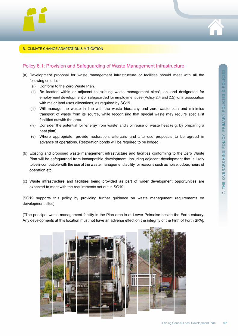
57Stirling Council Local Development Plan
Policy 6.1: Provision and Safeguarding of waste Management Infrastructure
(a) Development proposal for waste management infrastructure or facilities should meet with all the following criteria: - (i) Conform to the Zero waste Plan. (ii) Be located within or adjacent to existing waste management sites*, on land designated for employment development or safeguarded for employment use (Policy 2.4 and 2.5), or in association with major land uses allocations, as required by SG19. (iii) will manage the waste in line with the waste hierarchy and zero waste plan and minimise transport of waste from its source, while recognising that special waste may require specialist facilities outwith the area. (iv) Consider the potential for ‘energy from waste’ and / or reuse of waste heat (e.g. by preparing a heat plan). (v) where appropriate, provide restoration, aftercare and after-use proposals to be agreed in advance of operations. restoration bonds will be required to be lodged.
(b) Existing and proposed waste management infrastructure and facilities conforming to the Zero waste Plan will be safeguarded from incompatible development, including adjacent development that is likely to be incompatible with the use of the waste management facility for reasons such as noise, odour, hours of operation etc.
(c) waste infrastructure and facilities being provided as part of wider development opportunities are expected to meet with the requirements set out in SG19.
[SG19 supports this policy by providing further guidance on waste management requirements ondevelopment sites].
[*The principal waste management facility in the Plan area is at Lower Polmaise beside the Forth estuary.Any developments at this location must not have an adverse effect on the integrity of the Firth of Forth SPA].
7. T
HE
oV
Er
Ar
CH
InG
Po
LIC
Y, P
rIM
Ar
Y P
oLI
CIE
S &
Po
LIC
IES
B. CLIMATE CHAnGE ADAPTATIon & MITIGATIon
58
C. Conservation of Historic and natural Heritage(Primary Policies 7-9 & Policies 7.1-9.2)
Geography, geology and history are so intrinsic to the character of the Stirling area that they effectivelydefine it, and are key elements in placemaking. Stirling’s unique geographical position in Scotland hasmarked it as a gateway to the north and has endowed the City with a wealth of built heritage and natural assets. Therefore, policies under this section seek to enable protection, conservation and enhancement ofbiodiversity, landscapes and the historic environment.
Muchofthehistoricenvironmentisgivenstatutoryprotectionthroughspecificdesignations.Therearearound1500 Listed Buildings (85 Category A, over 700 Category B, the remainder Category C), 28 Conservation Areas, 12 nationally important Gardens and Design Landscapes, and 148 Scheduled Monuments in the Plan area. The over 4000 entries in the Stirling Sites and Monuments record include a wide range of undesignated features,structuresandsites,andtheHistoricScotlandBattlefieldInventorydesignateshistoricbattlefieldsites at Bannockburn, Sheriffmuir, Stirling Bridge and Sauchieburn.
Along with the extensive historic landscapes that also carry elements of the past, the historic environment adds richness and context to homes, places of work and other activities. no part of Stirling City is more than a15minutewalkfromanassetofnationalorinternationalsignificance.
Adapting the historic environment to modern circumstances is a complex issue, and the policies in thissection of the Plan (and their associated supplementary guidance) seek to address the most frequentlyarising situations. Conservation Area Character Appraisals have also been prepared, providing a moreinformed basis to judge the impact of development proposals in these areas, and identify opportunities for improvedmanagement.TheCityCentreDevelopmentFramework (SG08B)highlights the significant rolethe Castle plays in Stirling’s identity.
In addition to the above heritage features which are themselves of great heritage importance, so too is thelandscape setting. Stirling is fortunate in the quality of its landscape resource, with around 60% of thearea designated as Special Landscape Areas. This Plan is therefore strong on landscape conservationand seeks to encourage new landscape elements in development proposals, and remediation ofneglected features important to landscape character.
About 7% of the Plan area is designated for its nature conservation interest, and of this area, over half has international importance. Protection is extended to the Firth of Forth Special Protection Area (SPA), (also a rAMSAr site), Special Areas of Conservation (SACs), Flanders Moss national nature reserve (nnr),LocalNatureReserves(LNR)andSitesofSpecialScientificInterest(SSSIs)whicharewhollyorpartlywithinthe area.
Beyondthis,biodiversityinterestextendsmuchmorewidely.TheLocalBiodiversityActionPlanhasidentifiedwhere species and habitats of national and local conservation concern occur in the area. while the legislative basis of wildlife conservation measures applied through the planning process is a matter for other strategies, the Council has a duty to further the conservation of biodiversity.
7. T
HE
oV
Er
Ar
CH
InG
Po
LIC
Y, P
rIM
Ar
Y P
oLI
CIE
S &
Po
LIC
IES
C. ConSErVATIon oF HISTorIC & nATurAL HErITAGE
59Stirling Council Local Development Plan
Primary Policy 7: Historic Environment
The historic environment contributes in a unique way to the character of the Stirling area. It is important in forming the identity of places and providing a cultural, educational, social, and economic resource. Thehistoric environment and, where appropriate, the settings of its component features, will therefore besafeguarded, preserved and enhanced. Developments and other proposals that would have a negativeimpact on these assets will not normally be supported. The historic environment will be managed, and relevant development proposals assessed, in line with statutory requirements, government policy, and the following: -
(a) The Historic Landscape Assessment reports, the Inventory of Gardens and Designed Landscapes andtheInventoryofBattlefieldsites. (b) Historic Scotland’s Managing Change and Inform documents (as an interim measure, pending productionwherenecessaryofmoredetailedSupplementaryGuidancespecifictothecontextofthe Stirling Plan area). (c) Conservation Area Character Appraisals. (d) Current local Planning guidance on the historic environment. (e) The Council’s Sites & Monuments record. (f) The potential for sites or structures to harbour undiscovered heritage assets including archaeology.
All the Supplementary Guidance referred to under Policies 7.1 to 7.8 will be relevant for proposalsconsidered under Primary Policy 7.
Policy 7.1: Archaeology & Historic Building recording (designated & undesignated buildings/sites)
(a) There will be a presumption against development that impacts physically upon either a Scheduled Monument, a nationally important monument or significantly detracts from the setting of such monuments.
(b) where there is the possibility that archaeological remains may exist within a development site, but their extentandsignificanceisunclear, theprospectivedevelopershouldarrangeforanevaluationpriorto the determination of any planning application in order to establish the importance of the site, its sensitivity to development and the most appropriate means for preserving or recording surviving archaeological features.
(c) Approval of any proposal directly affecting historic environment features will be conditional upon satisfactory provision being made by the developer for the appropriate level of archaeological and / or standing building investigation and recording, assessment, analysis, publication and archiving.
[SG21 supports this policy by providing further guidance on the appropriate levels of building recordingrequired, with varying degrees of impact on historic buildings of differing status, and the broader national policy context].
[SG23 supports this policy by providing further guidance on the variety, nature and scope ofarchaeological remains in the Stirling area, as well as the potential types of required archaeological mitigation and the broader national policy context].
7. T
HE
oV
Er
Ar
CH
InG
Po
LIC
Y, P
rIM
Ar
Y P
oLI
CIE
S &
Po
LIC
IES
C. ConSErVATIon oF HISTorIC & nATurAL HErITAGE

60
7. T
HE
oV
Er
Ar
CH
InG
Po
LIC
Y, P
rIM
Ar
Y P
oLI
CIE
S &
Po
LIC
IES
C. ConSErVATIon oF HISTorIC & nATurAL HErITAGE
Policy 7.2: Development within and outwith Conservation Areas
(a) Development within a Conservation Area and development outwith, that will impact on the conservation area, shall preserve or enhance its character, appearance and setting. All new development should respect the architectural and visual qualities of the area, have regard to the character of the area as identifiedintherelevantConservationAreaCharacterAppraisal,andshould:- (i) relate well to the density and pattern of existing development; the design, massing, scale and materials used in surrounding buildings; means of access and boundary and landscape treatments such as walls, railings, trees and hedges. [See Policy 7.4 for the treatment of boundaries / hardstandings in Conservation Areas and Listed Buildings]. (ii) retain existing natural and built features which contribute to the character of the Conservation Area and / or its setting.
(b) Given the importance of assessing design matters, applications for Planning Permission in Principle will not normally be considered appropriate for development proposals in Conservation Areas.
(c) where an existing building, Listed or not, contributes positively to the character of the Conservation Area, proposals involving demolition will be considered in terms of Part (a)(ii) and Policy 7.3. Proposals for demolition will only be considered if accompanied by a detailed planning application for a replacement development that enhances or preserves the character of the Conservation Area. If allowed, demolition should not commence until evidence is given of contracts let for the approved redevelopment.
[Character Appraisals of the character and qualities of the Conservation Areas have been produced andinform specific Key Site Requirements, Development Frameworks, Masterplans, and Planning Briefs.Specificopportunitiesforaction,enhancementandmanagementstrategieswithinConservationAreaswillbetaken forward in the development of the Settlement Statements/Strategies, see Action Programme].
© Crown Copyright and database right 2012. All rights reserved. ordnance Survey Licence number 100020780
Figure 11: Designated Conservation Areas
Ashfield*Balfron (2no)BlairlogieBuchlyvieCambusbarronCarbeth (2no)Deanston*DouneDunblane*FintryGargunnockKillearnKippen (2no)Thornhill
- STIRLING -
BannockburnBridgehaugh*Bridge of AllanBruce StreetCambuskenneth*Drip Bridge
King’s ParkParkPlace/Randolphfield(*partof)randolph roadStirling Town & royal Park (*part of)St.ninians*Torbrex*
* Article 4 Directions which apply to the Conservation Area
Figures are illustrative only and moredetailed mapping is contained withinthe relevant Supplementary Guidanceand the online Local Development Plan:www.stirling.gov.uk/localdevplan
61Stirling Council Local Development Plan
Policy 7.3: Development affecting Listed Buildings
(a) The layout, design, materials, scale, siting and use of any development must preserve the character of the Listed Building and its setting. where this is not proposed, development will be refused. There is a presumption against demolition or other works that adversely affect the special interest of a building or it’s setting.
(b) Listed Buildings should not be demolished unless it can be clearly demonstrated that any of the following apply: - (i) The building is no longer of special interest. (ii) The building is beyond repair. (iii) Thedemolitionofthebuildingisessentialtodeliveringsignificantbenefitstoeconomicgrowthor the wider community. (iv) Therepairofthebuildingisnoteconomicallyviableandithasbeenmarketedatapricereflecting its location and condition to potential restoring purchasers for a reasonable period.
(c) Understanding the architectural and historic significance of a building or structure is an important pre-requisite to making informed decisions about its development. In some cases the preparation of a ConservationPlaninsupportofadevelopmentproposalwillberequired.Ininstanceswheresignificant alteration or demolition of a building is approved, measures will be required to ensure adequate recording of the building (see Policy 7.1 and SG21).
Policy 7.4: Development in Gardens/Curtilages within Conservation Areas and around Listed Buildings
In the interests of preserving or enhancing the historic, architectural and landscape qualities ofConservation Areas and Listed Buildings and their settings, new development will not generally be supported within the gardens and grounds of existing buildings or if served by rear access lanes. Support may be given to developments which propose: -
(a) The sympathetic conversion, adaptation or extension of existing properties or ancillary buildings of character where the development will preserve the character and appearance of the original building, its setting and the surrounding area;
(b) The erection of small scale ancillary buildings directly associated with the use of the main building and sited and designed to respect the special architectural and visual qualities of the Conservation Area and / or setting and character of the Listed Building; and
(c) The retention of existing boundaries and landscape treatments that contribute to the character of the area / building and proposed new boundaries and landscape treatments of a design, location and material appropriate to the character and appearance of the Conservation Area and setting of the Listed Building.
[SG25 supports this policy by providing further guidance on the treatment of external areas, boundaries,parking areas, etc.].
7. T
HE
oV
Er
Ar
CH
InG
Po
LIC
Y, P
rIM
Ar
Y P
oLI
CIE
S &
Po
LIC
IES
C. ConSErVATIon oF HISTorIC & nATurAL HErITAGE
62
Policy 7.5: new/replacement windows – Listed Buildings and Conservation Areas
There will be a presumption in favour of the retention (with traditional repair/sympathetic refurbishment ifrequired) of original windows or other windows of historic significance. Replacement of, or alteration to,existing windows will be considered as follows: -
(a) Where original windows or other windows of historic significance are proven to be beyond repair, replacement matching them in every respect including materials, dimensions, profiles, opening methodandfinishwillbeacceptable.Reuseofhistoricglassandotherfeaturesmayberequired.
(b) Whereoriginalwindows,orotherwindowsofhistoricsignificance,nolongerexist,supportwillbegiven to proposals which reinstate a historically correct window type, including design, material and opening method.
(c) Double-glazing may be acceptable where part (a) or (b) of this policy applies or where it can be incorporated within the existing joinery, and, only where there will be no loss of historic glass and no adverse impact on the character or appearance of the Listed Building or Conservation Area.
(d) Secondary glazing is supported where it can be internally installed without detriment to the external appearance of the building or internal features of interest.
[SG37 supports this policy by providing further guidance on the treatment of existing windows and doors and on proposals for alterations to or replacement of windows and doors and any associated openings].
Policy 7.6: new/replacement Shopfronts within Listed Buildings and Conservation Areas
In relation to new or altered shopfronts, proposals will be supported which: -
(a) respect the architectural and historic character of the building(s) to which they relate and are sympathetic to their townscape context.
(b) Support the retention and restoration of traditional or historic shopfronts where these survive or where evidence of their former appearance can be produced in support of restoration.
(c) Do not apply standardised ‘house’ styles or standardised shopfront designs in situations where their use would be detrimental to the character or architectural integrity of the building concerned or the character of the Conservation Area.
(d) remove shopfronts and introduce an alternative frontage treatment at street level, only where clear historic evidence supports this as the original appearance, and where the existing shopfront treatment is of no architectural or historic interest.
[SG22 supports this policy by providing further design guidance on proposals for new or altered shopfronts in the above situations].
7. T
HE
oV
Er
Ar
CH
InG
Po
LIC
Y, P
rIM
Ar
Y P
oLI
CIE
S &
Po
LIC
IES
C. ConSErVATIon oF HISTorIC & nATurAL HErITAGE
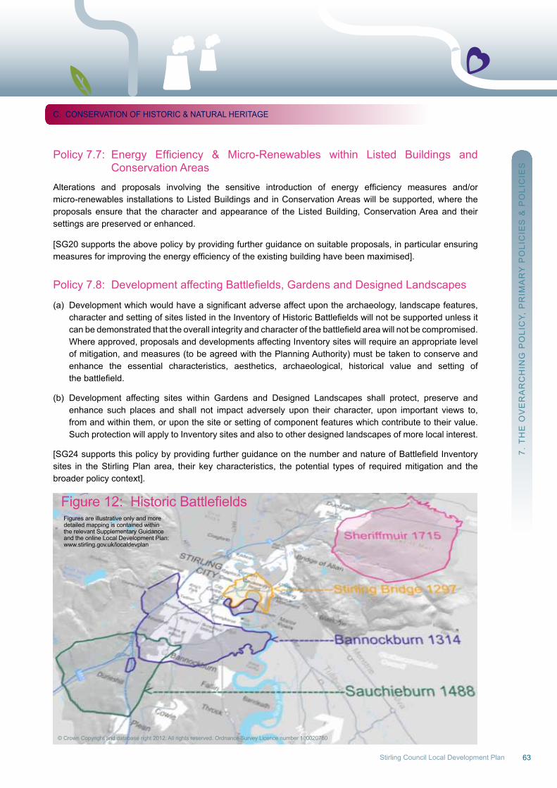
63Stirling Council Local Development Plan
Policy7.7: Energy Efficiency & Micro-Renewables within Listed Buildings and Conservation Areas
Alterations and proposals involving the sensitive introduction of energy efficiency measures and/ormicro-renewables installations to Listed Buildings and in Conservation Areas will be supported, where theproposals ensure that the character and appearance of the Listed Building, Conservation Area and theirsettings are preserved or enhanced.
[SG20 supports the above policy by providing further guidance on suitable proposals, in particular ensuring measuresforimprovingtheenergyefficiencyoftheexistingbuildinghavebeenmaximised].
Policy7.8: DevelopmentaffectingBattlefields,GardensandDesignedLandscapes
(a) Developmentwhichwouldhaveasignificantadverseaffectuponthearchaeology,landscapefeatures, characterandsettingofsiteslistedintheInventoryofHistoricBattlefieldswillnotbesupportedunlessit canbedemonstratedthattheoverallintegrityandcharacterofthebattlefieldareawillnotbecompromised. where approved, proposals and developments affecting Inventory sites will require an appropriate level of mitigation, and measures (to be agreed with the Planning Authority) must be taken to conserve and enhance the essential characteristics, aesthetics, archaeological, historical value and setting of thebattlefield.
(b) Development affecting sites within Gardens and Designed Landscapes shall protect, preserve and enhance such places and shall not impact adversely upon their character, upon important views to, from and within them, or upon the site or setting of component features which contribute to their value. Such protection will apply to Inventory sites and also to other designed landscapes of more local interest.
[SG24supportsthispolicybyprovidingfurtherguidanceonthenumberandnatureofBattlefieldInventorysites in the Stirling Plan area, their key characteristics, the potential types of required mitigation and the broader policy context].
7. T
HE
oV
Er
Ar
CH
InG
Po
LIC
Y, P
rIM
Ar
Y P
oLI
CIE
S &
Po
LIC
IES
C. ConSErVATIon oF HISTorIC & nATurAL HErITAGE
Figure12: HistoricBattlefields
© Crown Copyright and database right 2012. All rights reserved. ordnance Survey Licence number 100020780
Figures are illustrative only and moredetailed mapping is contained withinthe relevant Supplementary Guidanceand the online Local Development Plan:www.stirling.gov.uk/localdevplan
64
Primary Policy 8: Conservation and Enhancement of Biodiversity
(a) The protection, conservation and enhancement of wildlife, its habitats and other natural features in international and national designated sites will be supported in line with statutory requirements. International designations comprise of natura sites, i.e. Special Protection Areas (SPAs) and Special Areas of Conservation (SACs); and national sites comprise of Sites of Special Scientific Interest (SSSIs) and the Flanders Moss national nature reserve (nnr).
(b) Development proposals brought forward in relation to any policy, proposal or strategy in this Plan, that arelikelytohaveasignificanteffectonaNaturasite,willnotbeinaccordancewiththePlan,unlessitcan be ascertained that, by means of appropriate assessment, that the integrity of the site will not be adversely affected.
(c) Development proposals that adversely affect the integrity of SSSIs or the qualities for which it has been designated will not be in accordance with the plan unless it can be demonstrated that those effectsareclearlyoutweighedbysocial,environmentaloreconomicbenefitsofnationalimportance.
(d) where proposals may affect protected species, developers must carry out species surveys and produce mitigations plans where required. Development that may result in activities that would normally require a species licence will not be permitted unless the applicant can demonstrate (with reference to any relevant “purposes” and “tests”) that such a licence will be likely to be granted. SG26 provides more detail on the species to which this policy applies.
(e) The Planning Authority will: - (i) Consider the potential of all development proposals to contribute positively to biodiversity conservation and enhancement, and will seek mitigation for any adverse impacts. (ii) Identify and protect Local nature Conservation Sites and Geological Conservation review Sites (see Policies 8.2 and 8.3). (iii) In the context of the Green network and Integrated Habitat network, seek to identify, protect and enhance habitat networks and create linking features.
(f) Areas not covered by statutory or local designations will have an appropriate level of protection if they are deemed to be important for their contributions to local biodiversity or form an important link within the Integrated Habitat network.
[SG26 supports this policy and provides general information on designated sites, links to the relevantlegislation and statutory requirements and guidance in relation to biodiversity and checklists for habitat and protected species surveys].
7. T
HE
oV
Er
Ar
CH
InG
Po
LIC
Y, P
rIM
Ar
Y P
oLI
CIE
S &
Po
LIC
IES
C. ConSErVATIon oF HISTorIC & nATurAL HErITAGE
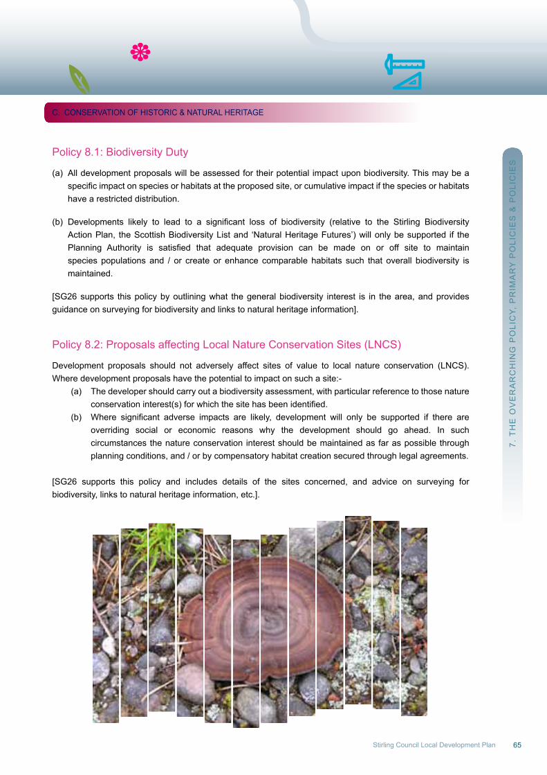
65Stirling Council Local Development Plan
Policy 8.1: Biodiversity Duty
(a) All development proposals will be assessed for their potential impact upon biodiversity. This may be a specificimpactonspeciesorhabitatsattheproposedsite,orcumulativeimpactifthespeciesorhabitats have a restricted distribution.
(b) Developments likely to lead to a significant loss of biodiversity (relative to the Stirling Biodiversity Action Plan, the Scottish Biodiversity List and ‘natural Heritage Futures’) will only be supported if the Planning Authority is satisfied that adequate provision can be made on or off site to maintain species populations and / or create or enhance comparable habitats such that overall biodiversity is maintained.
[SG26 supports this policy by outlining what the general biodiversity interest is in the area, and providesguidance on surveying for biodiversity and links to natural heritage information].
Policy 8.2: Proposals affecting Local nature Conservation Sites (LnCS)
Development proposals should not adversely affect sites of value to local nature conservation (LnCS).where development proposals have the potential to impact on such a site:- (a) The developer should carry out a biodiversity assessment, with particular reference to those nature conservationinterest(s)forwhichthesitehasbeenidentified. (b) Where significant adverse impacts are likely, development will only be supported if there are overriding social or economic reasons why the development should go ahead. In such circumstances the nature conservation interest should be maintained as far as possible through planning conditions, and / or by compensatory habitat creation secured through legal agreements.
[SG26 supports this policy and includes details of the sites concerned, and advice on surveying forbiodiversity, links to natural heritage information, etc.].
7. T
HE
oV
Er
Ar
CH
InG
Po
LIC
Y, P
rIM
Ar
Y P
oLI
CIE
S &
Po
LIC
IES
C. ConSErVATIon oF HISTorIC & nATurAL HErITAGE
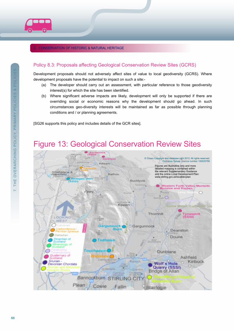
66
Policy 8.3: Proposals affecting Geological Conservation review Sites (GCrS)
Development proposals should not adversely affect sites of value to local geodiversity (GCrS). wheredevelopment proposals have the potential to impact on such a site:- (a) The developer should carry out an assessment, with particular reference to those geodiversity interest(s)forwhichthesitehasbeenidentified. (b) Where significant adverse impacts are likely, development will only be supported if there are overriding social or economic reasons why the development should go ahead. In such circumstances geo-diversity interests will be maintained as far as possible through planning conditions and / or planning agreements.
[SG26 supports this policy and includes details of the GCr sites].
7. T
HE
oV
Er
Ar
CH
InG
Po
LIC
Y, P
rIM
Ar
Y P
oLI
CIE
S &
Po
LIC
IES
C. ConSErVATIon oF HISTorIC & nATurAL HErITAGE
© Crown Copyright and database right 2012. All rights reserved.ordnance Survey Licence number 100020780
Figure 13: Geological Conservation review Sites
Figures are illustrative only and moredetailed mapping is contained withinthe relevant Supplementary Guidanceand the online Local Development Plan:www.stirling.gov.uk/localdevplan
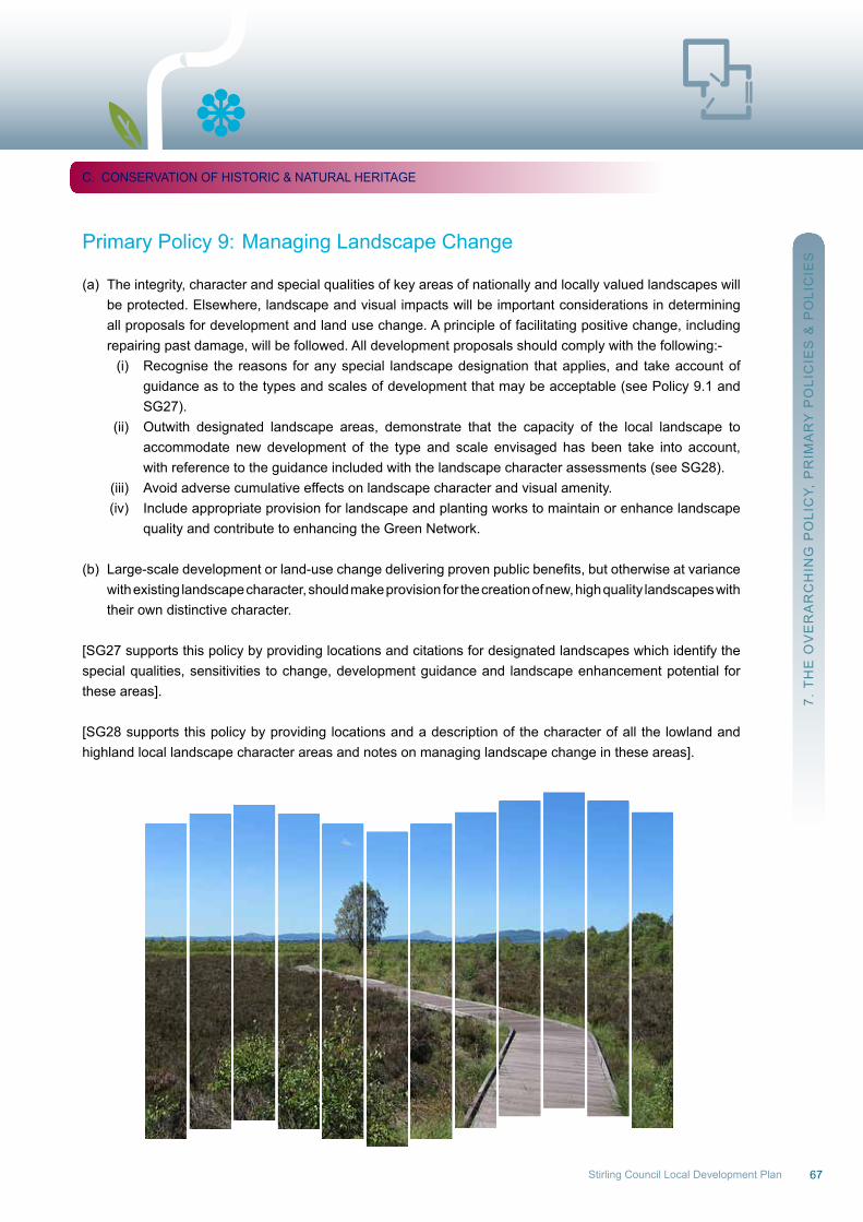
67Stirling Council Local Development Plan
Primary Policy 9: Managing Landscape Change
(a) The integrity, character and special qualities of key areas of nationally and locally valued landscapes will be protected. Elsewhere, landscape and visual impacts will be important considerations in determining all proposals for development and land use change. A principle of facilitating positive change, including repairing past damage, will be followed. All development proposals should comply with the following:- (i) recognise the reasons for any special landscape designation that applies, and take account of guidance as to the types and scales of development that may be acceptable (see Policy 9.1 and SG27). (ii) outwith designated landscape areas, demonstrate that the capacity of the local landscape to accommodate new development of the type and scale envisaged has been take into account, with reference to the guidance included with the landscape character assessments (see SG28). (iii) Avoid adverse cumulative effects on landscape character and visual amenity. (iv) Include appropriate provision for landscape and planting works to maintain or enhance landscape quality and contribute to enhancing the Green network.
(b) Large-scaledevelopmentorland-usechangedeliveringprovenpublicbenefits,butotherwiseatvariance with existing landscape character, should make provision for the creation of new, high quality landscapes with their own distinctive character.
[SG27 supports this policy by providing locations and citations for designated landscapes which identify the special qualities, sensitivities to change, development guidance and landscape enhancement potential for these areas].
[SG28 supports this policy by providing locations and a description of the character of all the lowland and highland local landscape character areas and notes on managing landscape change in these areas].
7. T
HE
oV
Er
Ar
CH
InG
Po
LIC
Y, P
rIM
Ar
Y P
oLI
CIE
S &
Po
LIC
IES
C. ConSErVATIon oF HISTorIC & nATurAL HErITAGE
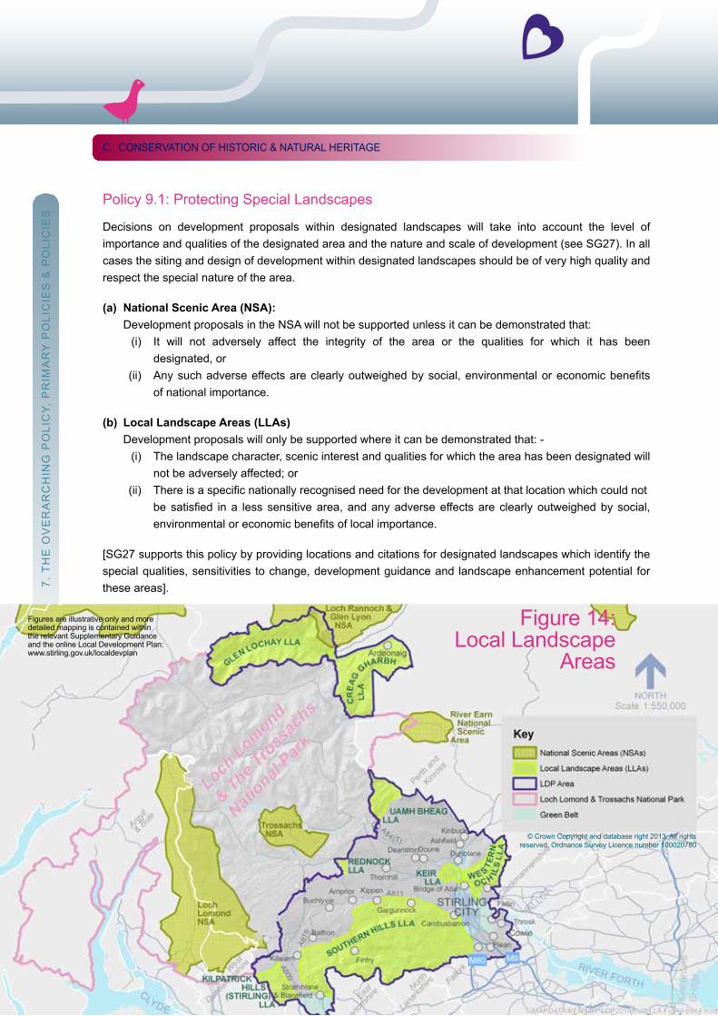
68
Policy 9.1: Protecting Special Landscapes
Decisions on development proposals within designated landscapes will take into account the level ofimportance and qualities of the designated area and the nature and scale of development (see SG27). In all cases the siting and design of development within designated landscapes should be of very high quality and respect the special nature of the area.
(a) National Scenic Area (NSA): Development proposals in the nSA will not be supported unless it can be demonstrated that: (i) It will not adversely affect the integrity of the area or the qualities for which it has been designated, or (ii) Anysuchadverseeffectsareclearlyoutweighedbysocial,environmentaloreconomicbenefits of national importance.
(b) Local Landscape Areas (LLAs) Development proposals will only be supported where it can be demonstrated that: - (i) The landscape character, scenic interest and qualities for which the area has been designated will not be adversely affected; or (ii) Thereisaspecificnationallyrecognisedneedforthedevelopmentatthatlocationwhichcouldnot besatisfied ina less sensitivearea,andanyadverseeffectsare clearlyoutweighedbysocial, environmentaloreconomicbenefitsoflocalimportance.
[SG27 supports this policy by providing locations and citations for designated landscapes which identify the special qualities, sensitivities to change, development guidance and landscape enhancement potential for these areas].
C. ConSErVATIon oF HISTorIC & nATurAL HErITAGE
68
7. T
HE
oV
Er
Ar
CH
InG
Po
LIC
Y, P
rIM
Ar
Y P
oLI
CIE
S &
Po
LIC
IES
© Crown Copyright and database right 2013. All rights reserved. ordnance Survey Licence number 100020780
Figure 14: Local Landscape
Areas
Figures are illustrative only and moredetailed mapping is contained withinthe relevant Supplementary Guidanceand the online Local Development Plan:www.stirling.gov.uk/localdevplan
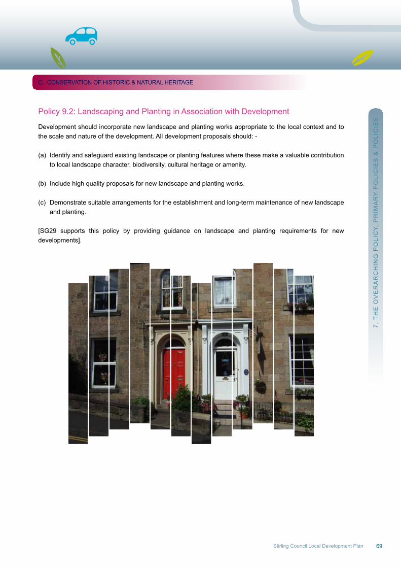
69Stirling Council Local Development Plan
Policy 9.2: Landscaping and Planting in Association with Development
Development should incorporate new landscape and planting works appropriate to the local context and to the scale and nature of the development. All development proposals should: -
(a) Identify and safeguard existing landscape or planting features where these make a valuable contribution to local landscape character, biodiversity, cultural heritage or amenity.
(b) Include high quality proposals for new landscape and planting works.
(c) Demonstrate suitable arrangements for the establishment and long-term maintenance of new landscape and planting.
[SG29 supports this policy by providing guidance on landscape and planting requirements for newdevelopments].
7. T
HE
oV
Er
Ar
CH
InG
Po
LIC
Y, P
rIM
Ar
Y P
oLI
CIE
S &
Po
LIC
IES
C. ConSErVATIon oF HISTorIC & nATurAL HErITAGE
70
D. Managing and utilising Local resources(Primary Policies 10-15 & Policies 10.1-15.1)
Thelocaleconomyisdependenttoasignificantdegreeonnaturalresourcesandthereforethepoliciesinthis section deal with forestry and related industries, renewable energy generation, mineral extraction, water supply and the protection of the water environment, protection of soils, local food production, and tourism and recreation.
The natural environment of the Plan area is hugely important for the resources it contains (soils, minerals, water), for the prime movers (wind, water again), and for its aesthetic, tourism and cultural qualities, as well as the landscapes and employment opportunities that these create.
Sand, gravel and hard rock quarries have a part to play in the economy, and future supplies to wider markets will have an impact on requirements in the coming decades. new technology has allowed the exploration into unconventional Gas in the area and policy is needed to deal with emerging coal-bed methane extraction. The Plan area has the potential to contribute to energy generation through most of the renewable and low-carbon technologies currently being developed, and the relevant policies encourage all forms of renewable low-carbon generation and heat production within environmental capacities.
Tourism makes a significant contribution to the economy of the Plan area: some 440,000 tourists visitStirling Castle annually, and the proximity of Stirling to the Loch Lomond and Trossachs national Park, is aconsiderable asset. However there is a need to raise awareness of the Plan area’s overall tourism offer,increase the duration of the average tourist’s stay in the area, and improve the business / conferencetourism accommodation offering in the City. Such improvements are encouraged through policy, along with other appropriate accommodation and visitor facilities.
7. T
HE
oV
Er
Ar
CH
InG
Po
LIC
Y, P
rIM
Ar
Y P
oLI
CIE
S &
Po
LIC
IES
D. MAnAGInG & uTILISInG LoCAL rESourCES
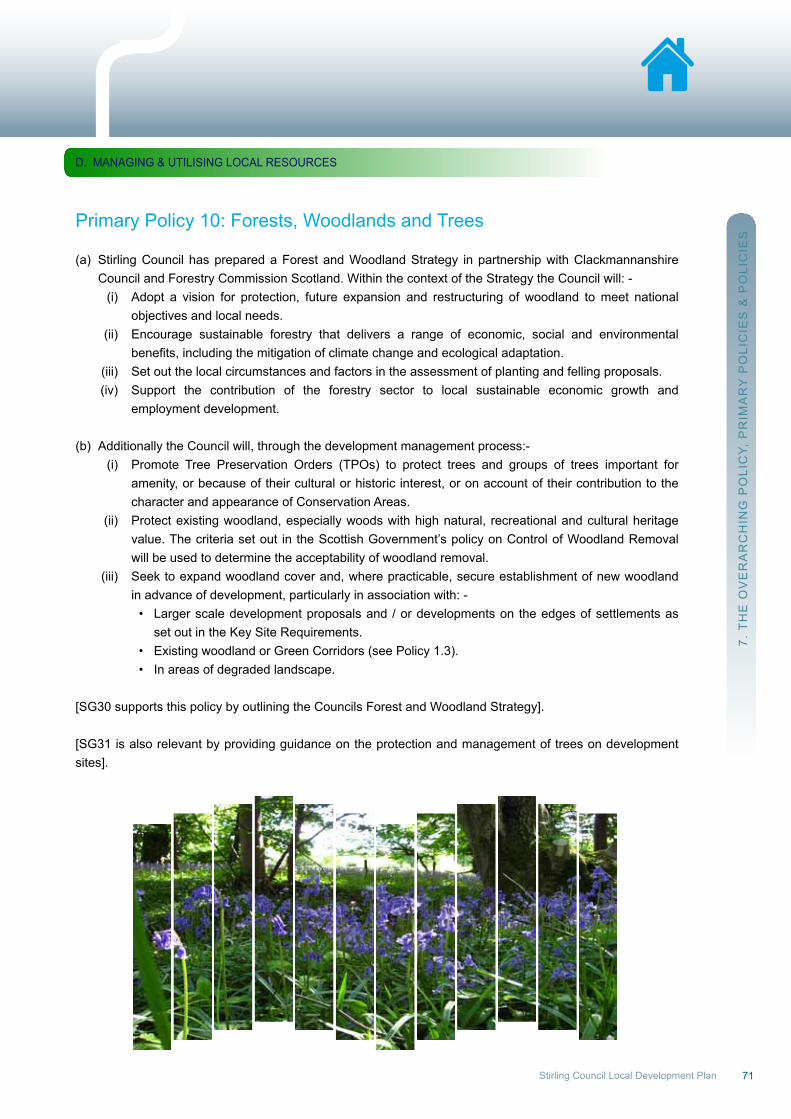
71Stirling Council Local Development Plan
Primary Policy 10: Forests, woodlands and Trees
(a) Stirling Council has prepared a Forest and woodland Strategy in partnership with Clackmannanshire Council and Forestry Commission Scotland. within the context of the Strategy the Council will: - (i) Adopt a vision for protection, future expansion and restructuring of woodland to meet national objectives and local needs. (ii) Encourage sustainable forestry that delivers a range of economic, social and environmental benefits,includingthemitigationofclimatechangeandecologicaladaptation. (iii) Set out the local circumstances and factors in the assessment of planting and felling proposals. (iv) Support the contribution of the forestry sector to local sustainable economic growth and employment development.
(b) Additionally the Council will, through the development management process:- (i) Promote Tree Preservation orders (TPos) to protect trees and groups of trees important for amenity, or because of their cultural or historic interest, or on account of their contribution to the character and appearance of Conservation Areas. (ii) Protect existing woodland, especially woods with high natural, recreational and cultural heritage value. The criteria set out in the Scottish Government’s policy on Control of woodland removal will be used to determine the acceptability of woodland removal. (iii) Seek to expand woodland cover and, where practicable, secure establishment of new woodland in advance of development, particularly in association with: - • Largerscaledevelopmentproposalsand /ordevelopmentson theedgesofsettlementsas set out in the Key Site requirements. • ExistingwoodlandorGreenCorridors(seePolicy1.3). • Inareasofdegradedlandscape.
[SG30 supports this policy by outlining the Councils Forest and woodland Strategy].
[SG31 is also relevant by providing guidance on the protection and management of trees on development sites].
7. T
HE
oV
Er
Ar
CH
InG
Po
LIC
Y, P
rIM
Ar
Y P
oLI
CIE
S &
Po
LIC
IES
D. MAnAGInG & uTILISInG LoCAL rESourCES
72
Policy 10.1: Development Impact on Trees and Hedgerows
(a) Development proposals should provide protection from adverse impacts resulting from development to important individual trees, groups of trees or hedgerows that contribute to local amenity or have nature conservation or historic interest.
(b) During the construction phase ensure the protection and management of retained trees on development sites in accordance with BS 5837:2012 Trees in relation to design, demolition and construction (April 2012).
(c) Allproposalsonsiteswithexistingtreesorothersignificantvegetationfeatureswithinorclosetothesite boundaries should: - (i) Include an appropriate tree survey and demonstrate how the findings of the tree survey and assessment have informed the development proposals. (ii) Identify trees proposed for removal and retention, with details of how protection will be afforded. (iii) Bring forward tree planting proposals to compensate for any removal and / or workable mitigation measures where development would impair connectivity between important woodland habitats. (iv) Demonstrate suitable arrangements for the long-term management of retained trees and any compensatory planting (on or off-site as approprate according to the nature and scale of the development). Developers should notify owners of any affected trees. (v) Ensure the long-term retention of existing and proposed trees by positioning buildings an appropriate distance from them, taking into account the ultimate height of the trees.
[SG31 supports this policy by providing guidance on the protection and management of trees on development sites]
[SG32 supports this policy by providing guidance on the legal circumstances surrounding trees].
7. T
HE
oV
Er
Ar
CH
InG
Po
LIC
Y, P
rIM
Ar
Y P
oLI
CIE
S &
Po
LIC
IES
D. MAnAGInG & uTILISInG LoCAL rESourCES
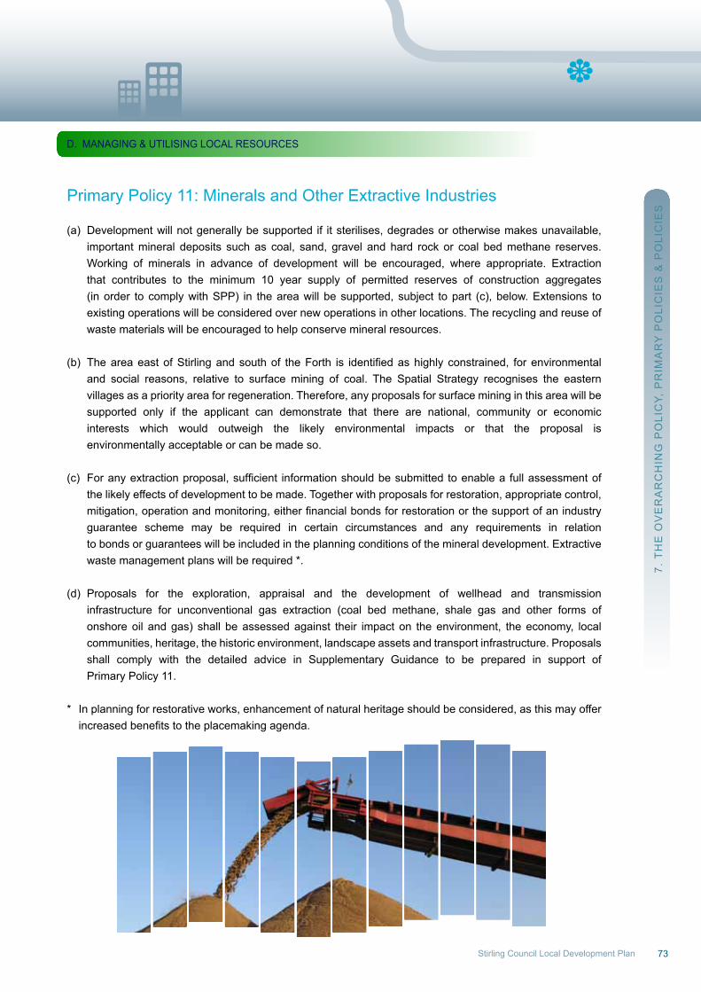
73Stirling Council Local Development Plan
Primary Policy 11: Minerals and other Extractive Industries
(a) Development will not generally be supported if it sterilises, degrades or otherwise makes unavailable, important mineral deposits such as coal, sand, gravel and hard rock or coal bed methane reserves. working of minerals in advance of development will be encouraged, where appropriate. Extraction that contributes to the minimum 10 year supply of permitted reserves of construction aggregates (in order to comply with SPP) in the area will be supported, subject to part (c), below. Extensions to existing operations will be considered over new operations in other locations. The recycling and reuse of waste materials will be encouraged to help conserve mineral resources.
(b) TheareaeastofStirlingandsouthof theForth is identifiedashighlyconstrained, forenvironmental and social reasons, relative to surface mining of coal. The Spatial Strategy recognises the eastern villages as a priority area for regeneration. Therefore, any proposals for surface mining in this area will be supported only if the applicant can demonstrate that there are national, community or economic interests which would outweigh the likely environmental impacts or that the proposal is environmentally acceptable or can be made so.
(c) Foranyextractionproposal,sufficient informationshouldbesubmittedtoenablea fullassessmentof the likely effects of development to be made. Together with proposals for restoration, appropriate control, mitigation,operationandmonitoring,eitherfinancialbondsforrestorationorthesupportofanindustry guarantee scheme may be required in certain circumstances and any requirements in relation to bonds or guarantees will be included in the planning conditions of the mineral development. Extractive waste management plans will be required *. (d) Proposals for the exploration, appraisal and the development of wellhead and transmission infrastructure for unconventional gas extraction (coal bed methane, shale gas and other forms of onshore oil and gas) shall be assessed against their impact on the environment, the economy, local communities, heritage, the historic environment, landscape assets and transport infrastructure. Proposals shall comply with the detailed advice in Supplementary Guidance to be prepared in support of Primary Policy 11.
* In planning for restorative works, enhancement of natural heritage should be considered, as this may offer increasedbenefitstotheplacemakingagenda.
7. T
HE
oV
Er
Ar
CH
InG
Po
LIC
Y, P
rIM
Ar
Y P
oLI
CIE
S &
Po
LIC
IES
D. MAnAGInG & uTILISInG LoCAL rESourCES
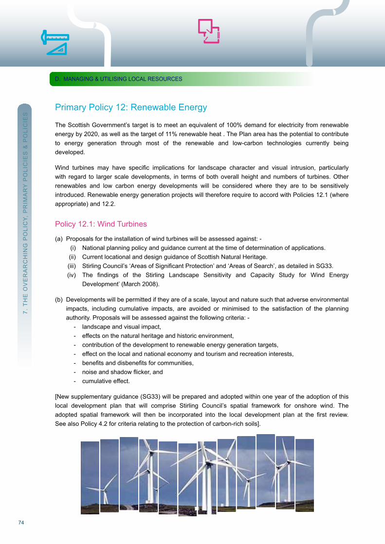
74
Primary Policy 12: renewable Energy
The Scottish Government’s target is to meet an equivalent of 100% demand for electricity from renewable energy by 2020, as well as the target of 11% renewable heat . The Plan area has the potential to contributeto energy generation through most of the renewable and low-carbon technologies currently beingdeveloped.
Wind turbines may have specific implications for landscape character and visual intrusion, particularlywith regard to larger scale developments, in terms of both overall height and numbers of turbines. otherrenewables and low carbon energy developments will be considered where they are to be sensitivelyintroduced. renewable energy generation projects will therefore require to accord with Policies 12.1 (where appropriate) and 12.2.
Policy 12.1: wind Turbines
(a) Proposals for the installation of wind turbines will be assessed against: - (i) national planning policy and guidance current at the time of determination of applications. (ii) Current locational and design guidance of Scottish natural Heritage. (iii) StirlingCouncil’s‘AreasofSignificantProtection’and‘AreasofSearch’,asdetailedinSG33. (iv) The findings of the Stirling Landscape Sensitivity and Capacity Study for Wind Energy Development’ (March 2008).
(b) Developments will be permitted if they are of a scale, layout and nature such that adverse environmental impacts, including cumulative impacts, are avoided or minimised to the satisfaction of the planning authority. Proposals will be assessed against the following criteria: - - landscape and visual impact, - effects on the natural heritage and historic environment, - contribution of the development to renewable energy generation targets, - effect on the local and national economy and tourism and recreation interests, - benefitsanddisbenefitsforcommunities, - noiseandshadowflicker,and - cumulative effect.
[new supplementary guidance (SG33) will be prepared and adopted within one year of the adoption of thislocal development plan that will comprise Stirling Council’s spatial framework for onshore wind. Theadopted spatial framework will then be incorporated into the local development plan at the first review.See also Policy 4.2 for criteria relating to the protection of carbon-rich soils].
7. T
HE
oV
Er
Ar
CH
InG
Po
LIC
Y, P
rIM
Ar
Y P
oLI
CIE
S &
Po
LIC
IES
D. MAnAGInG & uTILISInG LoCAL rESourCES
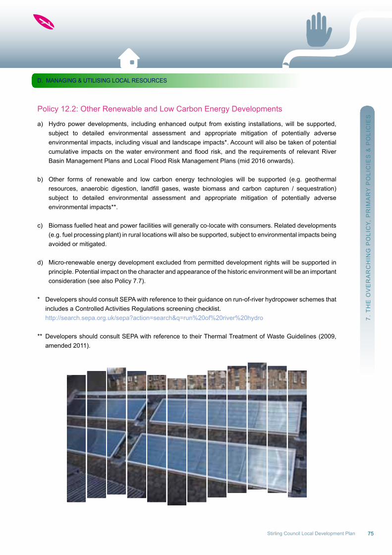
75Stirling Council Local Development Plan
Policy 12.2: other renewable and Low Carbon Energy Developments
a) Hydro power developments, including enhanced output from existing installations, will be supported, subject to detailed environmental assessment and appropriate mitigation of potentially adverse environmental impacts, including visual and landscape impacts*. Account will also be taken of potential cumulative impacts on thewater environment and flood risk, and the requirements of relevantRiver Basin Management Plans and Local Flood risk Management Plans (mid 2016 onwards).
b) other forms of renewable and low carbon energy technologies will be supported (e.g. geothermal resources, anaerobic digestion, landfill gases, waste biomass and carbon capturen / sequestration) subject to detailed environmental assessment and appropriate mitigation of potentially adverse environmental impacts**.
c) Biomass fuelled heat and power facilities will generally co-locate with consumers. related developments (e.g. fuel processing plant) in rural locations will also be supported, subject to environmental impacts being avoided or mitigated.
d) Micro-renewable energy development excluded from permitted development rights will be supported in principle. Potential impact on the character and appearance of the historic environment will be an important consideration (see also Policy 7.7).
* Developers should consult SEPA with reference to their guidance on run-of-river hydropower schemes that includes a Controlled Activities regulations screening checklist. http://search.sepa.org.uk/sepa?action=search&q=run%20of%20river%20hydro
** Developers should consult SEPA with reference to their Thermal Treatment of waste Guidelines (2009, amended 2011).
7. T
HE
oV
Er
Ar
CH
InG
Po
LIC
Y, P
rIM
Ar
Y P
oLI
CIE
S &
Po
LIC
IES
D. MAnAGInG & uTILISInG LoCAL rESourCES
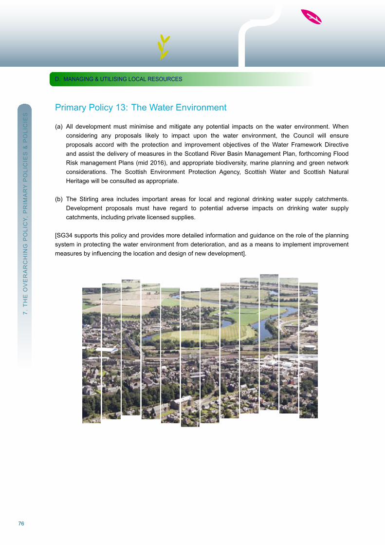
76
Primary Policy 13: The water Environment
(a) All development must minimise and mitigate any potential impacts on the water environment. when considering any proposals likely to impact upon the water environment, the Council will ensure proposals accord with the protection and improvement objectives of the water Framework Directive and assist the delivery of measures in the Scotland river Basin Management Plan, forthcoming Flood risk management Plans (mid 2016), and appropriate biodiversity, marine planning and green network considerations. The Scottish Environment Protection Agency, Scottish water and Scottish natural Heritage will be consulted as appropriate.
(b) The Stirling area includes important areas for local and regional drinking water supply catchments. Development proposals must have regard to potential adverse impacts on drinking water supply catchments, including private licensed supplies.
[SG34 supports this policy and provides more detailed information and guidance on the role of the planning system in protecting the water environment from deterioration, and as a means to implement improvement measuresbyinfluencingthelocationanddesignofnewdevelopment].
7. T
HE
oV
Er
Ar
CH
InG
Po
LIC
Y, P
rIM
Ar
Y P
oLI
CIE
S &
Po
LIC
IES
D. MAnAGInG & uTILISInG LoCAL rESourCES
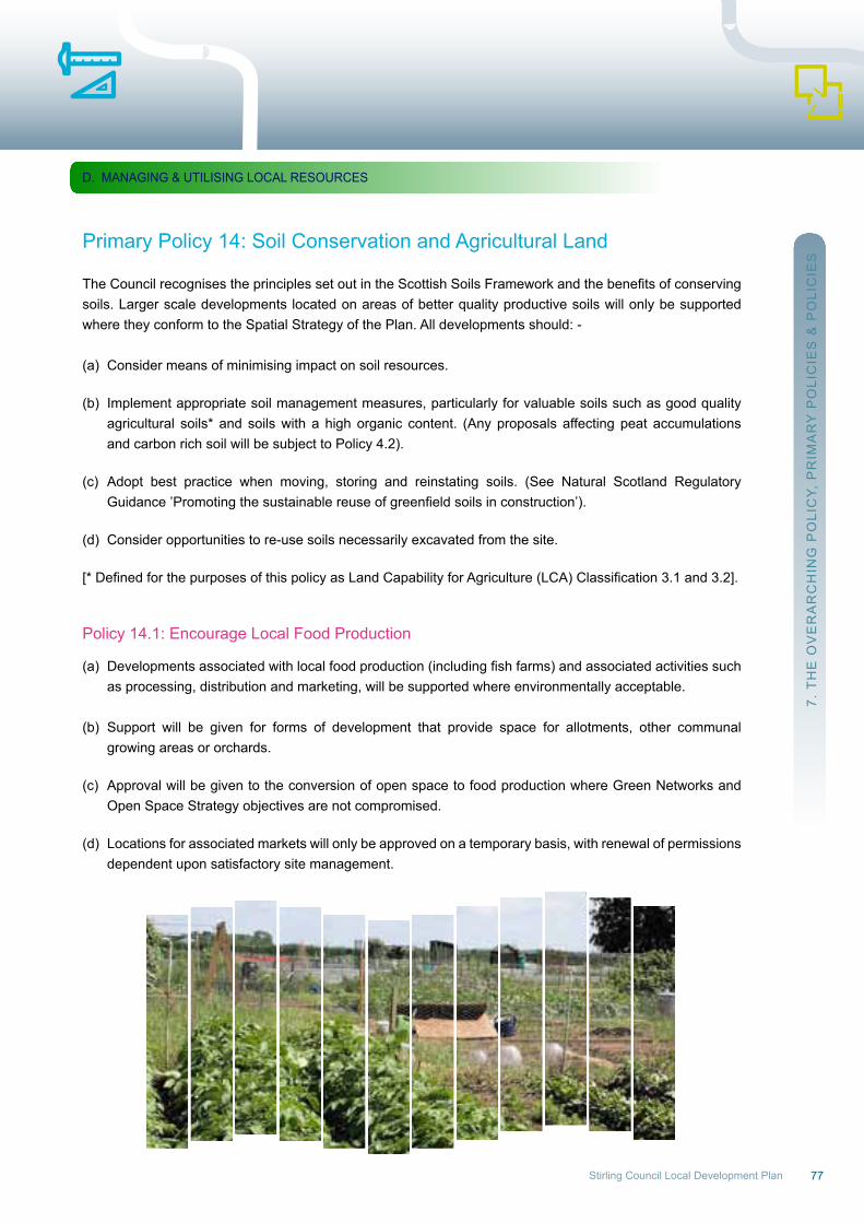
77Stirling Council Local Development Plan
Primary Policy 14: Soil Conservation and Agricultural Land
TheCouncilrecognisestheprinciplessetoutintheScottishSoilsFrameworkandthebenefitsofconservingsoils. Larger scale developments located on areas of better quality productive soils will only be supported where they conform to the Spatial Strategy of the Plan. All developments should: -
(a) Consider means of minimising impact on soil resources.
(b) Implement appropriate soil management measures, particularly for valuable soils such as good quality agricultural soils* and soils with a high organic content. (Any proposals affecting peat accumulations and carbon rich soil will be subject to Policy 4.2). (c) Adopt best practice when moving, storing and reinstating soils. (See natural Scotland regulatory Guidance’Promotingthesustainablereuseofgreenfieldsoilsinconstruction’).
(d) Consider opportunities to re-use soils necessarily excavated from the site.
[*DefinedforthepurposesofthispolicyasLandCapabilityforAgriculture(LCA)Classification3.1and3.2].
Policy 14.1: Encourage Local Food Production
(a) Developmentsassociatedwithlocalfoodproduction(includingfishfarms)andassociatedactivitiessuch as processing, distribution and marketing, will be supported where environmentally acceptable. (b) Support will be given for forms of development that provide space for allotments, other communal growing areas or orchards.
(c) Approval will be given to the conversion of open space to food production where Green networks and open Space Strategy objectives are not compromised.
(d) Locations for associated markets will only be approved on a temporary basis, with renewal of permissions dependent upon satisfactory site management.
7. T
HE
oV
Er
Ar
CH
InG
Po
LIC
Y, P
rIM
Ar
Y P
oLI
CIE
S &
Po
LIC
IES
D. MAnAGInG & uTILISInG LoCAL rESourCES
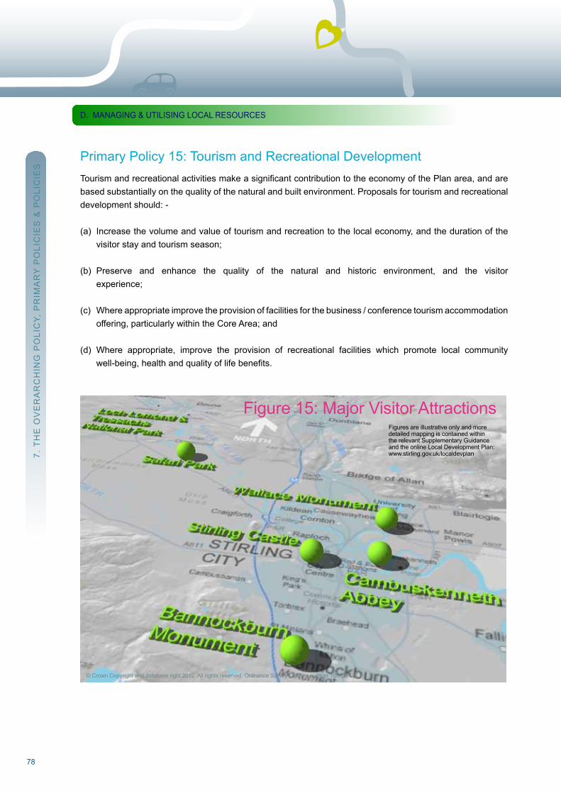
78
Primary Policy 15: Tourism and recreational Development TourismandrecreationalactivitiesmakeasignificantcontributiontotheeconomyofthePlanarea,andarebased substantially on the quality of the natural and built environment. Proposals for tourism and recreational development should: -
(a) Increase the volume and value of tourism and recreation to the local economy, and the duration of the visitor stay and tourism season;
(b) Preserve and enhance the quality of the natural and historic environment, and the visitor experience;
(c) where appropriate improve the provision of facilities for the business / conference tourism accommodation offering, particularly within the Core Area; and
(d) where appropriate, improve the provision of recreational facilities which promote local community well-being,healthandqualityoflifebenefits.
7. T
HE
oV
Er
Ar
CH
InG
Po
LIC
Y, P
rIM
Ar
Y P
oLI
CIE
S &
Po
LIC
IES
D. MAnAGInG & uTILISInG LoCAL rESourCES
© Crown Copyright and database right 2012. All rights reserved. ordnance Survey Licence number 100020780
Figure 15: Major Visitor AttractionsFigures are illustrative only and moredetailed mapping is contained withinthe relevant Supplementary Guidanceand the online Local Development Plan:www.stirling.gov.uk/localdevplan
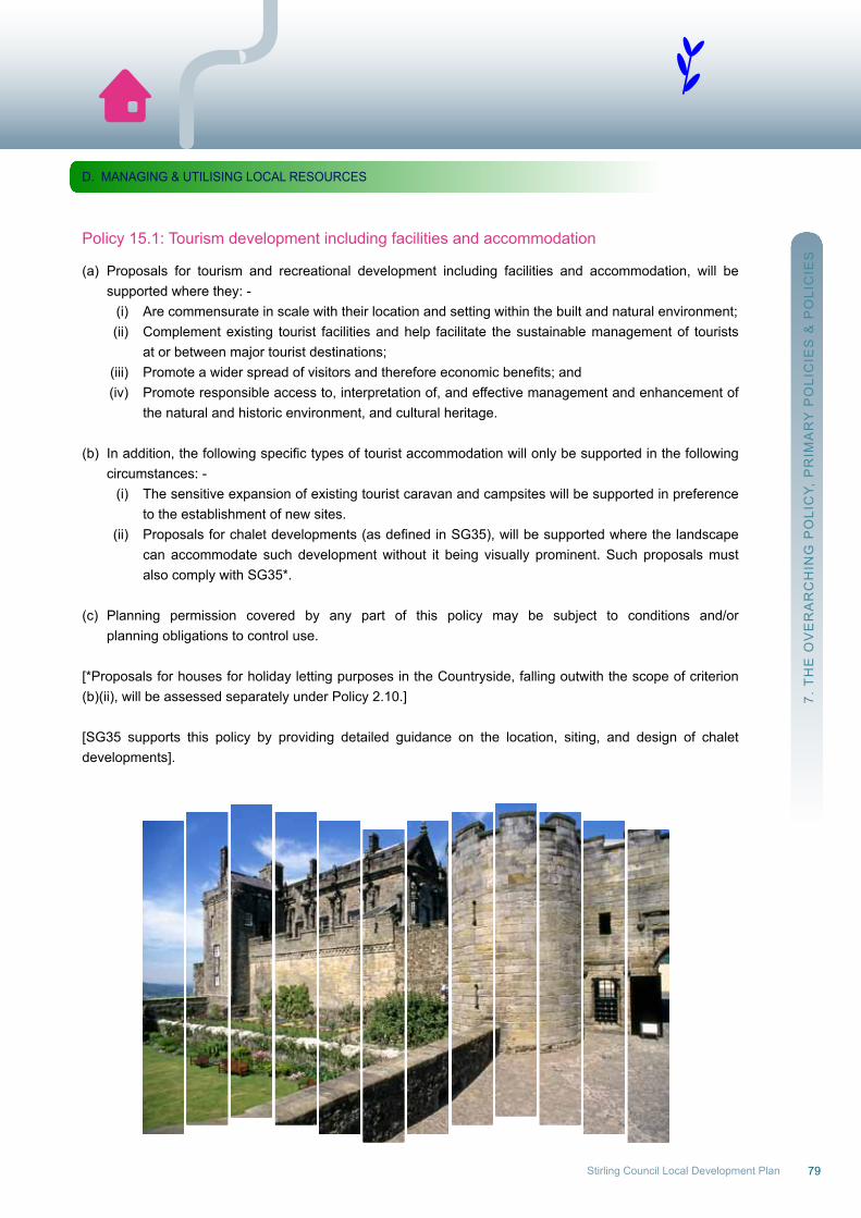
79Stirling Council Local Development Plan
Policy 15.1: Tourism development including facilities and accommodation
(a) Proposals for tourism and recreational development including facilities and accommodation, will be supported where they: - (i) Are commensurate in scale with their location and setting within the built and natural environment; (ii) Complement existing tourist facilities and help facilitate the sustainable management of tourists at or between major tourist destinations; (iii) Promoteawiderspreadofvisitorsandthereforeeconomicbenefits;and (iv) Promote responsible access to, interpretation of, and effective management and enhancement of the natural and historic environment, and cultural heritage.
(b) Inaddition,thefollowingspecifictypesoftouristaccommodationwillonlybesupportedinthefollowing circumstances: - (i) The sensitive expansion of existing tourist caravan and campsites will be supported in preference to the establishment of new sites. (ii) Proposalsforchaletdevelopments(asdefinedinSG35),willbesupportedwherethelandscape can accommodate such development without it being visually prominent. Such proposals must also comply with SG35*.
(c) Planning permission covered by any part of this policy may be subject to conditions and/or planning obligations to control use.
[*Proposals for houses for holiday letting purposes in the Countryside, falling outwith the scope of criterion(b)(ii), will be assessed separately under Policy 2.10.]
[SG35 supports this policy by providing detailed guidance on the location, siting, and design of chaletdevelopments].
7. T
HE
oV
Er
Ar
CH
InG
Po
LIC
Y, P
rIM
Ar
Y P
oLI
CIE
S &
Po
LIC
IES
D. MAnAGInG & uTILISInG LoCAL rESourCES
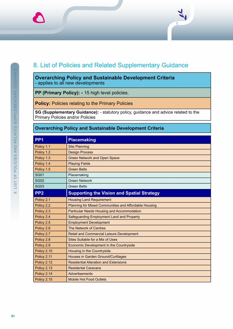
80
8. List of Policies and related Supplementary Guidance
Overarching Policy and Sustainable Development Criteria- applies to all new developments
PP (Primary Policy): - 15 high level policies.
Policy: Policies relating to the Primary Policies
SG (Supplementary Guidance): - statutory policy, guidance and advice related to thePrimary Policies and/or Policies
Overarching Policy and Sustainable Development Criteria
PP1 PlacemakingPolicy 1.1 Site PlanningPolicy 1.2 Design ProcessPolicy 1.3 Green network and open SpacePolicy 1.4 Playing FieldsPolicy 1.5 Green BeltsSG01 PlacemakingSG02 Green networkSG03 Green Belts
PP2 Supporting the Vision and Spatial StrategyPolicy 2.1 Housing Land requirementPolicy 2.2 Planning for Mixed Communities and Affordable HousingPolicy 2.3 Particular needs Housing and AccommodationPolicy 2.4 Safeguarding Employment Land and PropertyPolicy 2.5 Employment DevelopmentPolicy 2.6 The network of CentresPolicy 2.7 retail and Commercial Leisure DevelopmentPolicy 2.8 Sites Suitable for a Mix of usesPolicy 2.9 Economic Development in the CountrysidePolicy 2.10 Housing in the CountrysidePolicy 2.11 Houses in Garden Ground/CurtilagesPolicy 2.12 residential Alteration and ExtensionsPolicy 2.13 residental CaravansPolicy 2.14 AdvertisementsPolicy 2.15 Mobile Hot Food outlets
8. L
IST
oF
Po
LIC
IES
An
D r
ELA
TE
D S
uP
PLE
ME
nTA
rY
Gu
IDA
nC
E

81Stirling Council Local Development Plan
PP2 Supporting the Vision and Spatial Strategy (cont)SG04 Affordable HousingSG05 Houses in Multiple occupationSG08 All Development Frameworks, Masterplans and Planning Briefs Non-statutory
SupplementaryGuidance
SG08A Stirling’s Major Growth Area - DurieshillSG08B City Centre Development FrameworkSG09 network of CentresSG10 Housing in the Countryside, including Design GuideSG11 new uses for redundant rural BuildingsSG12 residential Alterations and ExtensionsSG13 AdvertisementsSG36 Small Settlements
PP3 Provision of InfrastructurePolicy 3.1 Addressing the Travel Demands of new DevelopmentPolicy 3.2 Site DrainagePolicy 3.3 Developer ContributionsSG06 Health Care FacilitiesSG14 Ensuring a Choice of Access for new DevelopmentsSG15 Education ProvisionSG16 Developer Contributions
PP4 Greenhouse Gas ReductionPolicy 4.1 Low and Zero Carbon DevelopmentPolicy 4.2 Protection of Carbon-rich SoilsSG17 Low and Zero Carbon Buildings
PP5 Flood Risk ManagementPolicy 5.1 reinstate natural watercoursesSG18 Planning and Flood risk Management
PP6 Resource Use and Waste ManagementPolicy 6.1 Provision and Safeguarding of waste Management InfrastructureSG19 waste Management requirements for Development Sites
PP7 Historic EnvironmentPolicy 7.1 Archaeology and Historic Building recording
Policy 7.2 Development within Conservation Areas
Policy 7.3 Development affecting Listed Buildings
Policy 7.4 Development in Gardens/Curtilages within Conservation Areas and around Listed Buildings
Policy 7.5 new/replacement windows - Conservation Areas and Listed BuildingsPolicy 7.6 new/replacement shopfronts within Listed Buildings and Conservation AreasPolicy 7.7 EnergyEfficiencyandMicro-renewableswithinListedBuildingsandConservationAreas
Policy 7.8 DevelopmentaffectingBattlefields,GardensandDesignedLandscapes
8. L
IST
oF
Po
LIC
IES
An
D r
ELA
TE
D S
uP
PLE
ME
nTA
rY
Gu
IDA
nC
E
82
PP7 Historic Environment (cont)SG07 Conservation Area Character Appraisals/StatementsSG20 HistoricEnvironment:EnergyEfficiencyandMicro-RenewablesSG21 Historic Building recordingSG22 ShopfrontsSG23 Introduction to Archaeology in StirlingSG24 AnIntroductiontoBattlefieldsandPlanninginStirlingSG25 Boundaries and Hardstandings (Conservation Areas and Listed Buildings)SG37 Historic Environment: windows and Doors
PP8 Conservation and Enhancement of BiodiversityPolicy 8.1 Biodiversity DutyPolicy 8.2 Proposals affecting Local nature Conservation Sites (LnCS)Policy 8.3 Proposals affecting Geological Conservation review (GCr) sitesSG26 Biodiversity Conservation
PP9 Managing Landscape ChangePolicy 9.1 Protecting Special Landscapes (nSA, LLAs)Policy 9.2 Landscape and Planting in Association with DevelopmentSG27 Protecting Special LandscapesSG28 Landscape Character AssessmentsSG29 Landscape and Planting requirements in new Developments
PP10 Forests, Woodland and TreesPolicy 10.1 Development Impact on Trees and HedgerowsSG30 Forest and woodland StrategySG31 Trees and new DevelopmentSG32 Trees and the Law
PP11 Minerals and Other Extractive ActivitiesPP12 Renewable EnergyPolicy 12.1 wind TurbinesPolicy 12.2 other renewable and Low Energy DevelopmentsSG33 wind Farms and wind Turbines (to be prepared)
PP13 The Water EnvironmentSG34 The water Environment
PP14 Soil Conservation and Agricultural LandPolicy 14.1 Encourage Local Food Production
PP15 Tourism and Recreational DevelopmentPolicy 15.1 Tourism Development including Facilities and Accommodation
SG35 Chalet Developments
8. L
IST
oF
Po
LIC
IES
An
D r
ELA
TE
D S
uP
PLE
ME
nTA
rY
Gu
IDA
nC
E
83Stirling Council Local Development Plan
9. Glossary of TermsAction Programme: Sets out how the Planning Authority proposes to implement the Local Development Plan including a list of actions required to deliver each of the plan’s policies and proposals, the name/department/organisation that is to carry out the action, and the timescale for carrying out each action.
Active Travel: Travel by physically active, non-motorised modes, such as walking and cycling.
Affordable Housing: Housing of a reasonable quality that is affordable to people on modest incomes. In some places the market provides some or all of the affordable housing needed, while in other places it will benecessarytomakehousingavailableatacostbelowmarketvaluetomeetanidentifiedneed.AffordablehousingisfurtherdefinedinSG04.
Ancient and Semi-Natural Woodland: Refersspecificallytolandthatiscurrentlywoodedandcomprisingofnativetreespecies,andhasbeencontinuallywooded,atleastsince1750(asidentifiedbyScottishNaturalHeritage), and is home to rare and threatened species, more than any other uK habitat. Includes some more recent plantation woodland that occupies ancient woodland sites and perpetuates continuous tree cover.
Appropriate Assessment: See Habitat regulations Appraisal.
Archaeology: refers to physical structures and objects surviving from the past 10,000 years of history and prehistory. Such remains are easily damaged or destroyed and represent an irreplaceable source ofinformation about the past not available from any other source. They include everything from Stirling Castle and Cambuskenneth Abbey, to the remains of millennia old hunting camps that only survive as scatters of artefacts in the topsoil.
Article 4 Direction: Article 4 of the Town and Country Planning (General Permitted Development) (Scotland)order 1992 gives the Scottish Government and planning authorities the power to remove permitteddevelopment rights by issuing a direction.
Battlefields (Inventory Site): A battlefield area demarcated by Historic Scotland and included in theirInventoryofHistoricBattlefieldsinScotland.WhileinclusionintheInventorydoesnotcarryanynewstatutoryrestrictions, it is a material consideration in the planning process.http://www.historic-scotland.gov.uk/index/heritage/battlefields.htm
Best Practicable Environmental Option: This emphasises the protection and conservation of theenvironment across land, air and water. The procedure establishes for a given set of objectives, the optionthatprovidesthemostbenefitsortheleastdamagetotheenvironment,asawhole,atacceptablecost,inthelong term as well as in the short term.
Bring Site: Locations throughout the Stirling Council area where you can take household materials to be recycled.
Business Space Strategy (BSS): Stirling Council strategy (2010) providing an analysis of demand, supplyand take-up of business space, which also sets out the requirements for the provision of land for futurebusiness space development.
9. G
LoS
SA
rY
oF
TE
rM
S

84
Calculating Carbon Savings from Wind Farms on Scottish Peat Lands: A new Approach (June 2010) – Scottish Government publication.http://www.scotland.gov.uk/Publications/2008/06/25114657/0
Central Scotland Green Network (CSGN): National-scale project identified by Scottish GovernmentthroughNationalPlanningFramework2definedas‘Astrategicnetworkofwoodlandandotherhabitats,ac-tive travel routes, greenspace links, watercourses and waterways, providing an enhanced setting for develop-ment and other land uses and improved opportunities for outdoor recreation and cultural activity’. See Green Corridors and Green network.
City Transport Strategy (CTS): ThefirstofthreedeliverystrategiescoveringStirlingCitythatformpartofthe Local Transport Strategy.
Commercial Leisure Development: Developments that attract large numbers of people including multiplex cinemas, bingo halls, nightclubs, tenpin bowling, casinos, and commercial sports facilities, including health andfitnesscentres.
Comparison Retail: ShoppingnotclassifiedasConvenience retail. The purchaser will compare items on the basis of price and quality before a purchase is made. Comparison retail items are not purchased on a regular basis, unlike convenience retail items. Comparison retail can be further categorised as Personalretail and Household (bulky goods) retail.
Conservation Area: An area designated under the Town and Country Planning (Scotland) Act 1997 as being of special architectural and/or historic interest.
Control of Woodland Removal: Scottish Government policy approved in June 2008 which seeks to protect the existing forest resource in Scotland, and supports woodland removal (deforestation) only where it would achievesignificantandclearlydefinedadditionalpublicbenefits.http://www.forestry.gov.uk/pdf/fcfc125.pdf/$FILE/fcfc125.pdf
Convenience Retail: ShoppingnotclassifiedasComparison retail. The sale of food, drink, newspapers, magazines and confectionary and other everyday items that are purchased on a regular basis.
Countryside Policy Boundary (CPB): The boundaries within which Policy 2.10 on Housing in theCountrysideandPolicy2.9EconomicDevelopmentintheCountrysideapplies.(Alsoeffectivelydefinethetowns and villages).
Cultural Heritage: Also referred to as Historic Environment e.g. Conservation Areas, Listed Buildings, ScheduledMonuments,ArchaeologicalSites,BattlefieldInventorySitesandHistoricGardensandDesignedLandscapes.
Demand Responsive Transport (DRT): A service provided in the more remote rural areas that areinadequately served by commercial public transport services. DrT is a public transport service which differs fromconventionaltransportinthatisdoesnotrunonfixedroutesortimetables.ThecostofprovidingtheDRTservice is directly related to the number of trips generated in the area (see SG14).
9. G
LoS
SA
rY
oF
TE
rM
S
85Stirling Council Local Development Plan
Design and Access Statement: required to be submitted with certain planning applications (e.g. fornational or major developments, or within conservation areas), outlining the design principles guiding theapplication, and how design issues impacting on disabled people have been addressed.
Developer Contribution: Financial (or in kind) contribution towards infrastructure required as a result of development.
Development Framework: required for development areas or sites requiring a comprehensive approach to the provision, design and location of uses, open space and infrastructure.
Development Scheme: May consist of one planning application or a series of planning applications which aresufficientlyconnectedbytime,location,designorotherrelevantcharacteristicsforthePlanningAuthorityto treat the applications as one development scheme.
Economic Strategy: Strategy dealing with the economic growth of the Stirling Council area prepared by Stirling Community Planning Partnership covering the period 2009-2013.
Edge of Centre: A location that is outwith but within easy walking distance of and well connected to a network centre, and is also outwith the Countryside Policy Boundary area. In determining whether a site is Edge of Centre, account will be taken of local circumstances including local topography, barriers such as major roads, car parks, railway lines, or watercourses which cannot be easily and safely crossed, the attractiveness and perceived safety of the route to the network centre and the strength of attraction and size of the centre:physicalproximityaloneisnotsufficientforasitetobeconsideredEdgeofCentre.
Effective Housing Land Supply: That part of the established housing land supply which is free or expected to be free of development constraints in the period under consideration, and will therefore be available for the construction of housing.
Employment Land Audit: AnnualreportproducedbyStirlingCouncil(fromJune2012)whichidentifiesandmonitors the employment land in the area that makes up the employment land supply.
Employment Land Supply: All land and buildings used or designated for purposes under Classes 4(Business), 5 (General Industry) and 6 (Storage and Distribution) of the 1997 Town and Country Planning (UseClasses)(Scotland)Order,consideredtobeappropriateormarketableasperthedefinitionsetoutinSPP and by the Planning Authority in consultation with the Economic Development Service.
Environmental Impact Assessment (EIA): Procedure governed by the Environmental Impact Assessment(Scotland) regulations 2011, whereby the likely environmental effects of certain types and scales ofdevelopment,anddevelopmentsinsensitivelocations,areexaminedinsufficientdetailbeforethegrantofplanning permission.
Established Housing Land Supply: The total housing land supply - including both unconstrained andconstrained sites. This will include the effective housing land supply, plus the remaining capacity for sitesunder construction, sites with planning consent, sites in adopted local development plans and whereappropriate other buildings and land with agreed potential for housing development.
9. G
LoS
SA
rY
oF
TE
rM
S
86
European Sites: nature conservation sites designated by Ministers under the European Habitats or Birds Directives as Special Areas for Conservation (SACs) or Special Protection Areas (SPAs). Developmentaffecting such sites is subject to special controls and may be called in by Scottish Ministers.
Five-year Housing Land Supply: Scottish Government requirement to maintain a 5 year effective landsupply at all times.
Flood Risk Management Plan: A requirement of the Flood risk Management (Scotland) Act 2009. A new rangeofplanstobepreparedbySEPA,LocalAuthoritiesandothersinpartnership,tofostersustainablefloodmanagementinareasidentifiedbySEPAasbeingpotentiallyvulnerabletoflooding.SeeSG18.
Forest and Woodland Strategy: A long-term vision which considers the development of the whole range of woodland types within the area building on the existing Indicative Forest Strategy.
Garden and Designed Landscape: Anareaofsignificantparklandandwoodland,generallycentreduponacastleormansionhouse,whichhasbeenlaidoutforartisticeffectandidentifiedinthe“ScottishInventoryofGardens and Designed Landscapes”. May also include non inventory sites of more local interest. http://www.historic-scotland.gov.uk/index/heritage/gardens.htm
Green Belt: Designated to direct development to suitable locations, particularly towns and cities with adistinct character and identity that could be harmed by unplanned growth. Green Belts can encirclesettlements but can also take other forms including buffers, corridors, coastal strips or wedges.
Green Corridors: In the City area, existing open spaces and green spaces and the links between them that havebeen identifiedashaving characteristics valuable to the realisationof theGreenNetwork. Includesdevelopment sites located in situations where development or management could create characteristicsvaluable to the realisation of the Green network. Includes land in private ownership and some land that is not ‘green’ in the sense of being vegetated. Their principal characteristic is or will be connectivity.
Green Network: Stirling Council’s interpretation of the Central Scotland Green network insofar as it falls geographically within the Stirling Local Development Plan area. See Central Scotland Green network.
Habitat Regulations Appraisal (HRA): A staged procedure to determine whether or not a plan or project is likelytohaveasignificanteffectonaEuropeansite.An‘appropriateassessment’isrequiredwhereaplanorprojectislikelytohaveasignificanteffectonaEuropeansiteeitheraloneorincombinationwithotherplansor projects.
Highly Pressured Areas (Housing): Priority locations for the development of affordable housing where a 33% affordable housing contribution will be required. The highly pressured areas are the Stirling ruralVillages Area (Local Housing Strategy sub-area), Dunblane & Bridge of Allan.
House(s) in Multiple Occupation: For the purposes of Policy 2.3, an HMo is a house were more than 5 residentslivetogetherasunrelatedindividuals,oraflatwhere3ormoreresidentslivetogetherasunrelatedindividuals. Further detail is provided in SG05.
9. G
LoS
SA
rY
oF
TE
rM
S
87Stirling Council Local Development Plan
Household (Bulky Goods) Retail: A category of Comparison retail and is the sale of items such asfurniture and furnishings,white goods, large non-portable electrical appliances, floor andwall coverings,bedding, lighting, automotive and bicycle parts and accessories, garden and outdoor life equipment, tools,DIYequipmentandbuildingmaterials,fittedunitsandassociatedappliances,heatinggoods,officefurnishings and equipment including stationery supplies, pets and pet supplies. Differs from Personal retail.
Household Waste Recycling Centre: Location where a wide variety of household recyclables (including garden waste) can be taken directly to be recycled as well as excess waste and bulky household items,including fridges and freezers and furniture.
Housing Demand: The quantity and type/quality of housing which households wish to buy or rent and are able to afford.
Housing Land Audit (HLA): The established means for monitoring housing land supply, which takes the formofanannualreport.Ithastwokeyfunctions:todemonstratetheavailabilityofsufficienteffectivelandtomeettherequirementforacontinuousfive-yearsupply;andtoprovideasnapshotoftheamountoflandavailable for the construction of housing at any particular time.
Housing Land Requirement: The amount of land (referred to as housing units) required to be allocated for housingtomeettheidentifiedhousingrequirement.
Housing Market Area: A geographical area which is relatively self-contained in terms of housing demand, i.e. a large percentage of people moving house or settling in the area will have sought a dwelling only in that area.
Housing Need and Demand Assessment (HNDA): A detailed assessment that provides the evidence base fordefininghousingsupply targets in theLocalHousingStrategyandallocating land forhousing indevelopment plans.
Housing Need: refers to households lacking their own housing or living in housing which is inadequate or unsuitable, who are unlikely to be able to meet their needs in the housing market without some assistance.
Housing Supply Target: Identified by the Local Housing Strategy in response to the outcomes of theHousing need and Demand Assessment.
Infrastructure: utility services (including roads, sewers, and supplies of gas, water and electricity) or social/community services (including schools, community halls and health centres) which are needed to allow a development to take place.
Integrated Habitat Network (IHN): Aspecificproject(bytheForestryCommissionundertheaegisofCSGN)which examines the functional connectivity of existing habitat patches and helps indicate where efforts might best be focused to enhance habitat networks.
Land Capability for Agriculture: MacaulayLandUseResearchInstituteclassificationsystemusedtoranklandonthebasisofitspotentialproductivityandcroppingflexibility.http://www.macaulay.ac.uk/explorescotland/lca.html
9. G
LoS
SA
rY
oF
TE
rM
S
88
Lifetime Homes Standard: A set of design criteria that provide a model for building accessible andadaptable homes which allow for an inclusive design approach to general housing.
Listed Building: Buildings designated by Historic Scotland which are of special interest, architecturally or historicallyandsatisfysetcriteriausedtodistinguishthissignificancefromthePlanning(ListedBuildingsandConservation Areas) (Scotland) Act 1997.
Local Centres: SpatiallydefinedcentresatthelowesttieroftheNetworkofCentreshierarchy,whichprovidea focus for town centre uses (see network of Centres and SG09).
Local Development: one of the 3 categories of development (others being national and Major) used for DevelopmentManagementpurposesanddefinedinThePlanningetc.(Scotland)Act2006andtheTownandCountry Planning (Hierarchy of Developments) (Scotland) regulations 2009.
Local Development Plan (LDP): A plan in which is set out, for land in the part of the district to which it relates;a spatial strategy, being a detailed statement of the planning authority’s policies and proposals as to the development and use of the land; such other matters as may be prescribed; and any other matter which the planning authority consider it appropriate to include. All planning authorities must prepare one or more local development plans for their area.
Local Housing Strategy (LHS): Provides the strategic direction to tackle housing need and demand and to inform the future investment in housing and related services across the local authority area.
Local Landscape Area (LLA): Stirling Council’s local landscape designations (previously called Areasof Great Landscape Value) whose purpose is to safeguard and enhance the character and quality oflandscapes, promote understanding and awareness of the distinctive character and special qualities of local landscapes, and safeguard and promote important settings for outdoor recreation and tourism locally.
Local Nature Reserve: A nature reserve established by the local authority.
Local Transport Strategy (LTS): An umbrella document encompassing the City Transport Strategy, thenational Park Transport Strategy and the Smaller Towns and Villages Transport Strategy. It lays down a policy framework for sustainable transportation, and the individual supporting strategies outline how projects, plans and services will be used on the ground to turn policy into action.
Low and Zero Carbon Buildings Statement:A statement required to be submitted with all relevant planning applications in order to comply withPolicy 4.1. Details of the information required to be included in the statement can be found in SG17.
Major Development: one of the 3 categories of development (others being national and Local) used for DevelopmentManagementpurposesanddefinedinThePlanningetc.(Scotland)Act2006andtheTownandCountry Planning (Hierarchy of Developments) (Scotland) regulations 2009.
Masterplan: A document, usually comprising a schematic plan, 3-dimensional images, and text, whichillustrates and explains how it is intended to develop a site.
9. G
LoS
SA
rY
oF
TE
rM
S
89Stirling Council Local Development Plan
National Developments: one of the 3 categories of development (others being Local and Major) used for DevelopmentManagementpurposesanddefined inThePlanningetc. (Scotland)Act2006and theTownand Country Planning (Hierarchy of Developments) (Scotland) regulations 2009. national Developments areidentifiedintheNationalPlanningFrameworkandaretheScottishGovernment’spriorityprojectsforthedevelopment of Scotland.
National Planning Framework 2 (NPF2): A strategy for Scotland’s development to 2030, setting outstrategic development priorities to support the Scottish Government’s central purpose – sustainableeconomic growth. Planning authorities are required to take the Framework into account when preparingdevelopment plans and it is a material consideration in the determination of planning applications.
National Scenic Area (NSA): IdentifiedbythetermsofTheTownandCountryPlanning(NationalScenicAreas) (Scotland) Designation Directions 2010 as an area “of outstanding scenic value in a national context.”
Natural Heritage Futures: SnH reports (2009) for the Eastern Lowlands, west Central Belt, and LochLomond, The Trossachs and Breadalbane relative to the Plan area, which offer long term visions for the area in terms of landscape and wildlife.http://www.snh.gov.uk/about-snh/what-we-do/nhf/nhf-downloads/
Neighbour Notification (Development Plans): Planning authorities are required to notify those with an interest in neighbouring land when relevant new proposals are to be introduced into the Development Plan. Notificationwillapplytolandthatisconterminousorwithin20metresoftheproposeddevelopmentsite.
Network of Centres: Spatially defined centres locatedwithin the city, towns, and villages, eachwith anidentifiedroleandfunctionthatwillbeusedasthebasisfordecisionmakingonsitesthatareproposedforretail or commercial leisure development within the centres. A hierarchy exists between the centres. Further information is provided in SG09.
Open Space Audit: An audit of the extent, type, quality, accessibility and connectivity of open spaces which provides information that will enable development of an open Space Strategy and inform related strategies and plans.
Open Space Strategy: Provides the evidence base and sets out how a local authority will invest in andmanage the open space in its area. Applies to all the open space – not just that owned or managed by the authority – and cover parks, open space, town squares, streets, play space and housing land. The Council’s open Space Strategy is published separately from the Local Development Plan.
Open Space: The term ‘open space’ covers greenspace consisting of any vegetated land or structure,water, path or geological feature within and on the edges of settlements, and civic space consisting of squares, market places and other paved or hard landscaped areas with a civic function (Planning Advice note 65 – Planning and open Space).
Out of Centre: A location which is outwith and separate from a network centre. Differs from an Edge ofCentre location.
9. G
LoS
SA
rY
oF
TE
rM
S

90
Particular Needs Housing: Housing which is designed or adapted to meet the needs of particular groups within the population, including older people and those with a disability.
Personal Retail: A category of Comparison retail and is the sale of items such as clothes, footwear,cosmetics, jewellery, books and magazines, small portable electrical items including MP3 players, DVDs, computergames,mobiletelephonesandkitchenappliances,smallitemsofstationeryandgifts,toys,flowers,optical products. Differs from Household (bulky goods) Retail.
Planning Advice Note (PAN): Documents produced by the Scottish Government providing advice on good practice and other relevant planning information.
Planning Brief: A guide to developing a site produced by the Council, where merited by the size, sensitivity, and/or complexity of the site and/or the particular development proposal.
Planning Obligation: Section 75 of the Town and Country Planning (Scotland) Act 1997 (as amended by the 2006 Act) provides that a person may either by agreement with the Planning Authority or unilaterally enter into a planning obligation restricting or regulating the use of land in the district of the Planning Authority, either permanently or during such a period as may be prescribed by the agreement or obligation.
Pressured Area Status (Housing): Pressured Area Status removes the right to buy in particular circumstances (approved by Scottish Government). It covers the whole Stirling rural Sub-Area and in the Stirling Core Area at Cambusbarron, Dunblane, Bridge of Allan, Causewayhead, Stirling town centre,Broomridge, St ninians, riverside and Braehead, Bannockburn, whins of Milton, Hillpark and Firs.
Pressured Areas (NHS Forth Valley): Areas containing existing Health Care Facilities considered to be at pressure in terms of capacity as a result of new development in the area.
Prime Retail Area: TheareaasdefinedontheProposalsMapsforStirling. It is themain focus for retailactivity within the City Centre and the Plan area as a whole, and where the loss of Class 1 retail uses will be resisted in accordance with Policy 2.6. See Network of Centres.
Promoting the Sustainable Reuse of Greenfield Soils in Construction: natural Scotland (March 2010) guidance prepared with (SEPA) the Civil Engineering Contractors Association (Scotland) (CECA) and the EnvironmentIndustriesCommission(EIC)topromotethesustainablereuseofgreenfieldsoils.http://www.sepa.org.uk/planning/idoc.ashx?docid=f2099206-fe50-448e-8eb4-4d90289fade4&version=-1
Public Car Park: A privately or publicly owned off-street car park for public use, whether stand alone orassociated with development providing parking for the general public, not just the users of a development.
RAMSAR: The Convention on wetlands of International Importance, especially as waterfowl Habitat.
Regeneration Areas (Existing and New): Areas identifiedasapriority fornewdevelopment toaid theirsocial, economic and environmental regeneration. Areas comprise of raploch, Cornton, Cultenhove, Fallin, Throsk,CowieandPlean.WithineachRegenerationAreaisadefinedlocalcentre(seeLocalCentres).
9. G
LoS
SA
rY
oF
TE
rM
S
91Stirling Council Local Development Plan
Regional Transport Strategy (TACTRAN): The Tayside and Central Scotland Transport Partnership(TACTrAn) was established on 1 December 2005 as one of seven statutory regional TransportPartnerships across Scotland. It sets out a vision for improving the region’s transport infrastructure, services and other facilities over the period to 2023.
Registered Social Landlord (RSL): Independent housing organisations registered with The ScottishHousing regulator, under the Housing (Scotland) Act 2001. Includes Housing Associations.
Reshaping Older Peoples Care: A model of care developed by Stirling Council whereby older people (aged 65andover)willbenefitthroughimprovementsintheavailabilityandqualityofcareofferedtothemenablingpeople to stay at home longer.
Retail Impact Analysis (RIA): An assessment of the likely individual or cumulative impact of a proposed development on the vitality and viability of network Centres.
River Basin Management Plans (RBMP): A requirement of the water Environment and water Services (Scotland) Act 2003. A new range of plans, at national and regional (major river basin) scale, prepared by SEPA and partner organisations and concerned with the protection and enhancement of the waterenvironment. See SG34.
Rural Activity Area (RAA): Location within the countryside (outwith towns and villages) considered suitablefor employment-related developments appropriate to a rural area combined with other appropriate uses wherespecified.
Scheduled Monument: A nationally important archaeological monument protected by the AncientMonuments and Archaeological Areas Act 1979. It is a criminal offence to alter or physically impact on a Scheduled Monument without prior Scheduled Monument Consent.
Scottish Biodiversity List: A list of animals, plants and habitats that Scottish Ministers consider to be of principal importance for biodiversity conservation in Scotland.http://www.snh.gov.uk/protecting-scotlands-nature/biodiversity-scotland/scottish-biodiversity-list/
Scottish Environment Protection Agency (SEPA): Scotland’s environmental regulator.
Scottish Natural Heritage (SNH) Information Note 318: Identificationofcarbon-richsoilmappingunits,which can be found at;http://www.snh.gov.uk/planning-and-development/advice-for-planners-and-developers/soils-rocks-and-min-erals/soils-and-development or; http://www.snh.gov.uk/docs/A602512.pdf
Scottish Planning Policy (SPP): Scottish Government statement of national planning policy, publishedin 2010.
Scottish Soils Framework: Scottish Government (2009) document that promotes the sustainablemanagement and protection of soils consistent with the economic, social and environmental needs ofScotland.http://www.scotland.gov.uk/resource/Doc/273170/0081576.pdf
9. G
LoS
SA
rY
oF
TE
rM
S
92
Section 75 Agreement: A legal agreement under Section 75 of the Town and Country Planning (Scotland) Act 1997 used to overcome obstacles to the grant of planning permission. The Town and Country Planning (Scotland) Act 2006 has now replaced the term ‘planning agreements’ with the term ‘Planning obligations’.
Secured by Design: Police initiative to encourage the building industry to adopt crime prevention measures in the design of new development. This is to assist in reducing the opportunity for crime and the fear of crime, creating a safer and more secure environment.
Sequential Approach: The sequential approach requires that locations for all retail and commercial leisure developments be considered in the following order: - City Centre, Town and Local Centres - Edge of Centre - Commercial Centre - out of Centre locations that are, or can be made, easily accessible by a choice of transport modes.
Settlement Hierarchy: Sets out the different role of settlements (hierarchy) within the Plan area in terms of their potential to contribute to a sustainable development spatial strategy.
Single Outcome Agreement (SOA): An agreement between the Scottish Government and each ofScotland’s 32 local authorities, setting out strategic priority issues based on the Government’s 15 “nationaloutcomes”. Stirling Community Planning Partners have agreed their vision for the Stirling area and thestrategic priorities that need to be addressed to achieve this vision which are expressed as outcomes to be delivered by the partners, both individually and jointly.
Site of Special Scientific Interest (SSSI): AsiteidentifiedbyScottishNaturalHeritage(SNH)asrequiringspecialprotectionbecauseofitsflora,fauna,geologicalorphysiographicalfeaturesundertheWildlifeandCountryside Acts. SnH must be consulted by a planning authority where a planning application may affect an SSSI.
Special Areas of Conservation (SAC): Protected sites under the EC Habitats Directive.
Special Protection Areas (SPA): Protected sites under the EC Birds Directive.
Stirling Biodiversity Action Plan: update of the ‘Local Biodiversity Action Plan’ prepared by the Council in partnership with conservation organisations, including habitat and species action plans for national habitats and species of conservation concern occurring in the area, and for local habitats and species.
Strategic Environmental Assessment (SEA): The requirement, deriving from the EnvironmentalAssessment (Scotland) Act 2005, to undertake and publish environmental assessments of plans, programmes or strategies at a strategic level.
Strategic Transport Projects Review (STPR): Sets the Scottish Government’s 29 transport investment priorities for the next 20 years.
Structure Planting: Significanttreeplantingcarriedoutaheadoforinassociationwithnewdevelopmentinorder to create a landscape framework. usually associated with new free-standing developments or urban expansions where trees will help to form a new visual edge to a settlement and/or help the development to blend with the local landscape character.
9. G
LoS
SA
rY
oF
TE
rM
S
93Stirling Council Local Development Plan
Supermarket: Aconvenience retailstoresellingmainly food,withgrossfloorspace (forconvenienceandancillary comparison goods combined) of between 500 and 2,500 square metres inclusive.
Superstore: A convenience retail store sellingmainly food, with gross floorspace (for convenience andancillary comparison goods combined) of more than 2,500 square metres.
Supplementary Guidance (SG): Statutory planning guidance to accompany the development planincorporating guidance and/or design advice to support a particular policy or proposal.
Sustainable Drainage Systems (SuDS): A method of water management on development sites designed to mimicnaturalsystems,bycreatingalternativestorapidrun-off.Infiltrationdrains,ponds,etcattenuatefloodflows,allowforpollutantstosettleout,andalsoprovideopportunitiesforhabitatcreation.Moresustainablethan the traditional practice of routing run-off through a pipe to treatment works or a watercourse.
Transport Assessment (TA): Aformofappraisalandforecastingofthevariousimpactsofthevehiculartrafficikely to be generated by a new development, with proposals to mitigate these effects, and to encouragewalking, cycling and the use of public transport as alternatives.
Tree Preservation Order (TPO): An order promoted by the local authority preventing the felling, lopping,toppingetcofspecifiedtreesorareasofwoodlandwithoutspecificconsent.TheorderismadeunderSection160 of the Town and Country Planning (Scotland) Act 1997.
Use Classes Order: The Statutory Instrument termed The Town and Country Planning (use Classes)(Scotland) order 1997 which sets out various classes of use for the purpose of clarifying when a change of use requires planning permission.
Varying Needs Standard: Goodpracticeon thedesignofhousing toachieveflexibilityandsuitability forpeople of all abilities mainly used by registered Social Landlords.
Vitality and Viability: Vitality is a measure of how lively and busy a network Centre is. Viability is a measureof the capacity of a network Centre to attract ongoing investment for maintenance, improvement, andadaptation to changing needs. Together, vitality and viability give an indication of the health of a networkCentre.Examplesof vitalityandviability indicators include:pedestrianflow (footfall), prime rental values,space in use for different town centre functions and how it has changed, retailer representation and intentions (national multiples and independents), commercial yield, vacancy rates particularly at street level in prime retail areas, physical structure of the centre including opportunities and constraints, and its accessibility,periodic surveys of consumers, and crime levels.
Windfall Sites: non-allocated sites that come forward for development and contribute to the land supply.
Zero Waste Plan: Scottish Government’s vision for a zero waste society. This vision describes a Scotland whereallwasteisseenasaresource.Wasteisminimised;valuableresourcesarenotdisposedofinlandfills,and most waste is sorted, leaving only limited amounts to be treated.
9. G
LoS
SA
rY
oF
TE
rM
S
94
APPEnDIX A
Schedule of Land owned by the Local Authority
The following table outlines land in the ownership of the planning authority (however small), as requiredby Section 15(3) of the Planning etc. (Scotland) Act 2006, which is affected by policies and proposalsfor development in the Stirling Local Development Plan.
Description of land owned by planning authority (a)
Reference to policies, proposals or views contained in local development plan which
relate to the occurrence of development of the land (b)
Ref Land description City/Town Grid X Grid y LDP Policy
Section Ref Site
B42 Buchanan Street/ Dunmore Street Balfron 254752 688596 Policy 2.5 Employment B42
H083 Depot Site Balfron 254573 688960 Policy 2.1 Housing H083
B43 Balfron Depot Balfron 254573 688960 Policy 2.5 Employment B43
H084 Endrick Gardens north [C] Balfron 254429 688710 Policy 2.1 Housing H084
H088 KH Parsons workshop Balfron 254787 688644 Policy 2.1 Housing H088
H089 Former garage Balfron 254840 688989 Policy 2.1 Housing H089
H090 64 Buchanan Street Balfron 254701 688761 Policy 2.1 Housing H090
B24 Manor Farm Business Extension Blairlogie 283060 695312 Policy 2.5 Employment B24
H004 13 union Street Bridge of Allan 279097 697447 Policy 2.1 Housing H004
H005 4 Inverallan road Bridge of Allan 278784 697550 Policy 2.1 Housing H005
H010 The Coppice Bridge of Allan 279155 696314 Policy 2.1 Housing H010
B02 Cowie Main Street west of units 1 - 3 Cowie 283596 689172 Policy 2.5 Employment B02
H074 Berryhills South/north Cowie 283297 689214 Policy 2.1 Housing H074
B01 Berryhills Main Street Cowie Cowie 283297 689214 Policy 2.5 Employment B01
H076 ochil View Cowie 284263 689260 Policy 2.1 Housing H076
H125 32 Main Street Cowie 283696 689224 Policy 2.1 Housing H125
H093 Leny road South A Deanston 271151 701748 Policy 2.1 Housing H093
H094 Leny road South B Deanston 271056 701643 Policy 2.1 Housing H094
H096 Moray Street Doune 272723 701795 Policy 2.1 Housing H096
H015 Dunblane High School Dunblane 277215 700806 Policy 2.1 Housing H015
H020 Bogside Dunblane 278540 701615 Policy 2.1 Housing H020
H057 Durieshill Durieshill 281558 687246 Policy 2.1 Housing H057
B09 Durieshill Durieshill 281558 687246 Policy 2.5 Employment B09
r10 Durieshill Durieshill 281558 687246 Policy 2.7 retail r10
AP
PE
nD
IX A
95Stirling Council Local Development Plan
Description of land owned by planning authority (a)
Reference to policies, proposals or views contained in local development plan which
relate to the occurrence of development of the land (b)
Ref Land description City/Town Grid X Grid y LDP Policy
Section Ref Site
B03 Fallin Polmaise Park (former depot) Fallin 283925 691461 Policy 2.5 Employment B03
H078 BMX site Fallin 283565 691535 Policy 2.1 Housing H078
H098 Menzies Terrace Fintry 261672 687140 Policy 2.1 Housing H098
B44 Keltie Bridge Keltie Bridge 265032 706770 Policy 2.5 Employment B44
H100 Crosshead road Killearn 252276 685761 Policy 2.1 Housing H100
H105 Former nursery Kippen 264963 694481 Policy 2.1 Housing H105
H069 East Plean Plean 283757 686939 Policy 2.1 Housing H069
H070 Balfour Crescent Plean 283546 687199 Policy 2.1 Housing H070
H071 Coal Merchants Yard Plean 283434 687524 Policy 2.1 Housing H071
H072 Touchill Farm Plean 283270 687077 Policy 2.1 Housing H072
H073 Main Street 1 Plean 283625 686675 Policy 2.1 Housing H073
B04 Backo'Hill Stirling 279036 694596 Policy 2.5 Employment B04
B11 Millhall, East Stirling 281338 692218 Policy 2.5 Employment B11
B12 Broadleys B Expansion Stirling 281147 692385 Policy 2.5 Employment B12
r13 Milhall East Stirling 281338 692218 Policy 2.7 retail r13
r13 Broadleys B Expansion Stirling 281147 692385 Policy 2.5 retail r13
B13 Broadleys Extension Area Stirling 280917 692081 Policy 2.5 Employment B13
B26 Crookbridge Stirling 281378 692504 Policy 2.5 Employment B26
r12 Crookbridge Stirling 281378 692504 Policy 2.7 retail r12
B27 Forthside Stirling 279966 693492 Policy 2.5 Employment B27
B34 Springkerse roundabout, Springkerse Stirling 281402 693302 Policy 2.5 Employment B34
B35 Munro road A,Springkerse Stirling 281218 693127 Policy 2.5 Employment B35
B37 11 Borrowmeadow road, Springkerse Stirling 281025 693308 Policy 2.5 Employment B37
B38 South west Springkerse roundabout Stirling 281201 693229 Policy 2.5 Employment B38
B40 15 Borrowmeadow road, Springkerse Stirling 281084 693270 Policy 2.5 Employment B40
B54 Tradstocks Stirling 277217 695731 Policy 2.5 Employment B54
H001 Former womens Aid refuge Stirling 280655 690515 Policy 2.1 Housing H001
H002 Firs Crescent Stirling 280896 690716 Policy 2.1 Housing H002
H003 Quakerfield/DowniePlace Stirling 281150 690293 Policy 2.1 Housing H003
H023 Braehead 1 (Broom road) Stirling 280481 692059 Policy 2.1 Housing H023
AP
PE
nD
IX A
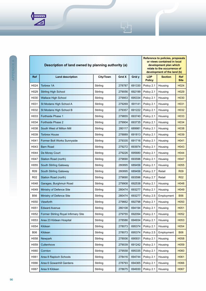
96
Description of land owned by planning authority (a)
Reference to policies, proposals or views contained in local development plan which
relate to the occurrence of development of the land (b)
Ref Land description City/Town Grid X Grid y LDP Policy
Section Ref Site
H024 Torbrex 1A Stirling 278787 691330 Policy 2.1 Housing H024
H029 Stirling High School Stirling 279056 692199 Policy 2.1 Housing H029
H030 wallace High School Stirling 279953 695334 Policy 2.1 Housing H030
H031 St Modans High School A Stirling 279269 691141 Policy 2.1 Housing H031
H032 St Modans High School B Stirling 279357 691222 Policy 2.1 Housing H032
H033 Forthside Phase 1 Stirling 279855 693740 Policy 2.1 Housing H033
H034 Forthside Phase 2 Stirling 279904 693735 Policy 2.1 Housing H034
H038 South west of Milton Mill Stirling 280117 689981 Policy 2.1 Housing H038
H039 Torbrex House Stirling 278889 691813 Policy 2.1 Housing H039
H041 Former Bolt works Sunnyside Stirling 279335 691716 Policy 2.1 Housing H041
H043 Barn road Stirling 279272 693974 Policy 2.1 Housing H043
H044 De Moray Court Stirling 279226 695680 Policy 2.1 Housing H044
H047 Station road (north) Stirling 279690 693596 Policy 2.1 Housing H047
H055 South Stirling Gateway Stirling 280895 689456 Policy 2.1 Housing H055
r09 South Stirling Gateway Stirling 280895 689456 Policy 2.7 retail r09
r02 Station road (north) Stirling 279690 693596 Policy 2.7 retail r02
H048 Garages, Burghmuir road Stirling 279908 692538 Policy 2.1 Housing H048
H049 Ministry of Defence Site Stirling 280474 693277 Policy 2.1 Housing H049
B56 Ministry of Defence Site Stirling 280474 693277 Policy 2.5 Employment B56
H050 Viewforth Stirling 279662 692798 Policy 2.1 Housing H050
H051 Edward Avenue Stirling 280108 694194 Policy 2.1 Housing H051
H052 FormerStirlingRoyalInfirmarySite Stirling 279755 692094 Policy 2.1 Housing H052
H053 Area 23 Kildean Hospital Stirling 278586 694934 Policy 2.1 Housing H053
H054 Kildean Stirling 278073 695374 Policy 2.1 Housing H054
B06 Kildean Stirling 278073 695374 Policy 2.5 Employment B06
H058 newpark Stirling 278936 690931 Policy 2.1 Housing H058
H059 Cultenhove Stirling 279039 691242 Policy 2.1 Housing H059
H060 Cornton Stirling 279558 695335 Policy 2.1 Housing H060
H061 Area 8 raploch Schools Stirling 278416 694744 Policy 2.1 Housing H061
H066 Area 6 Gowanhill Gardens Stirling 278793 694365 Policy 2.1 Housing H066
H067 Area 9 Kildean Stirling 278675 694930 Policy 2.1 Housing H067
AP
PE
nD
IX A
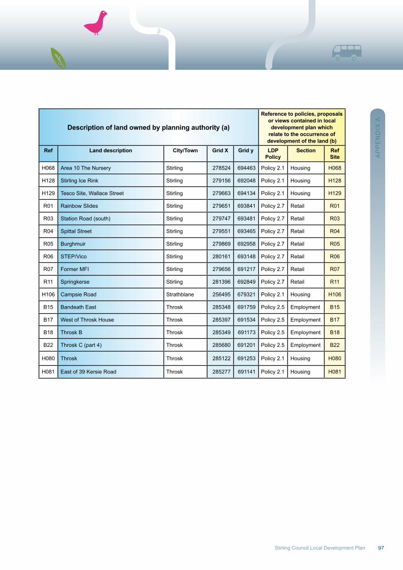
97Stirling Council Local Development Plan
Description of land owned by planning authority (a)
Reference to policies, proposals or views contained in local development plan which
relate to the occurrence of development of the land (b)
Ref Land description City/Town Grid X Grid y LDP Policy
Section Ref Site
H068 Area 10 The nursery Stirling 278524 694463 Policy 2.1 Housing H068
H128 Stirling Ice rink Stirling 279156 692048 Policy 2.1 Housing H128
H129 Tesco Site, wallace Street Stirling 279663 694134 Policy 2.1 Housing H129
r01 rainbow Slides Stirling 279651 693841 Policy 2.7 retail r01
r03 Station road (south) Stirling 279747 693481 Policy 2.7 retail r03
r04 Spittal Street Stirling 279551 693465 Policy 2.7 retail r04
r05 Burghmuir Stirling 279869 692958 Policy 2.7 retail r05
r06 STEP/Vico Stirling 280161 693148 Policy 2.7 retail r06
r07 Former MFI Stirling 279656 691217 Policy 2.7 retail r07
r11 Springkerse Stirling 281396 692849 Policy 2.7 retail r11
H106 Campsie road Strathblane 256495 679321 Policy 2.1 Housing H106
B15 Bandeath East Throsk 285348 691759 Policy 2.5 Employment B15
B17 west of Throsk House Throsk 285397 691534 Policy 2.5 Employment B17
B18 Throsk B Throsk 285349 691173 Policy 2.5 Employment B18
B22 Throsk C (part 4) Throsk 285680 691201 Policy 2.5 Employment B22
H080 Throsk Throsk 285122 691253 Policy 2.1 Housing H080
H081 East of 39 Kersie road Throsk 285277 691141 Policy 2.1 Housing H081A
PP
En
DIX
A
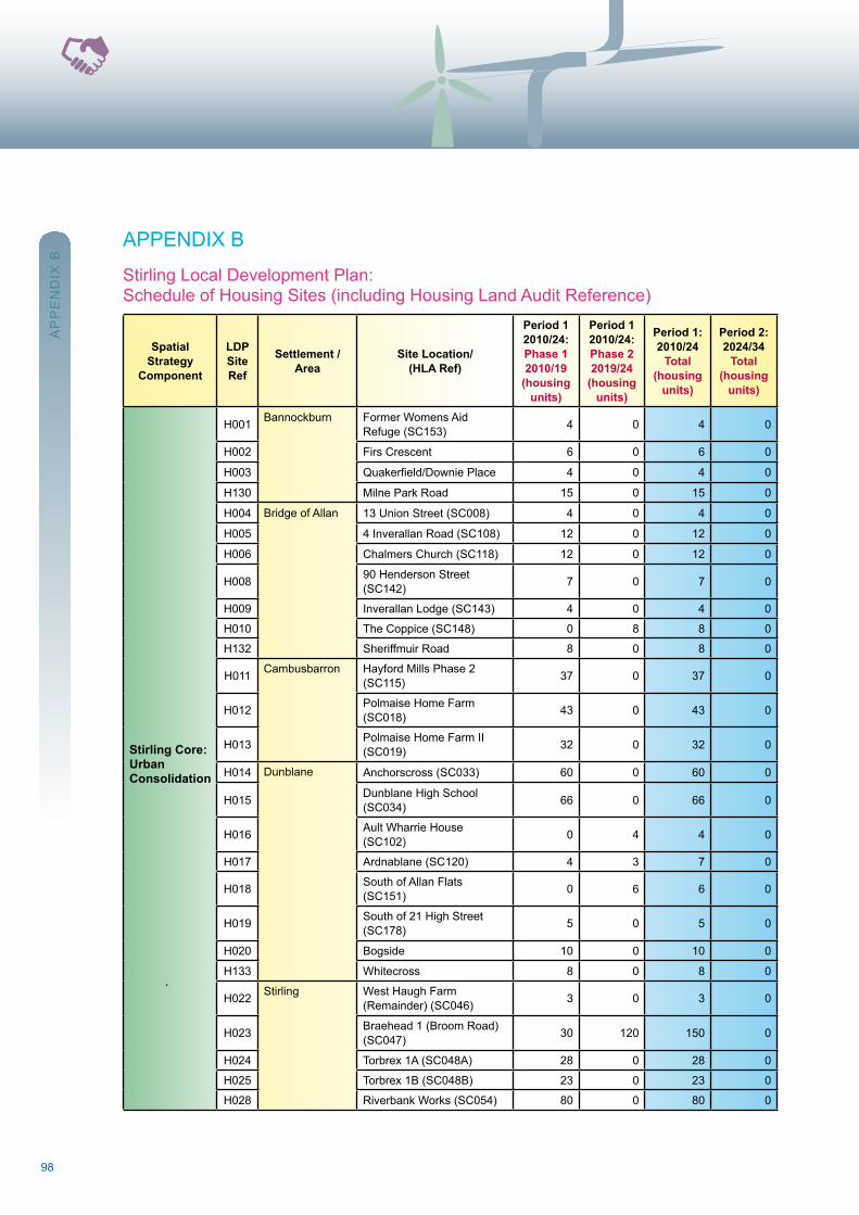
98
APPEnDIX B
Stirling Local Development Plan:Schedule of Housing Sites (including Housing Land Audit reference)
SpatialStrategy
Component
LDPSite Ref
Settlement / Area
Site Location/(HLA Ref)
Period 12010/24:Phase 12010/19
(housingunits)
Period 12010/24:Phase 22019/24
(housingunits)
Period 1:2010/24
Total(housing
units)
Period 2:2024/34
Total(housing
units)
Stirling Core: UrbanConsolidation
H001 Bannockburn Former womens Aidrefuge (SC153) 4 0 4 0
H002 Firs Crescent 6 0 6 0
H003 Quakerfield/DowniePlace 4 0 4 0
H130 Milne Park road 15 0 15 0
H004 Bridge of Allan 13 union Street (SC008) 4 0 4 0
H005 4 Inverallan road (SC108) 12 0 12 0
H006 Chalmers Church (SC118) 12 0 12 0
H008 90 Henderson Street (SC142) 7 0 7 0
H009 Inverallan Lodge (SC143) 4 0 4 0
H010 The Coppice (SC148) 0 8 8 0
H132 Sheriffmuir road 8 0 8 0
H011 Cambusbarron Hayford Mills Phase 2 (SC115) 37 0 37 0
H012 Polmaise Home Farm (SC018) 43 0 43 0
H013 Polmaise Home Farm II (SC019) 32 0 32 0
H014 Dunblane Anchorscross (SC033) 60 0 60 0
H015 Dunblane High School (SC034) 66 0 66 0
H016 Ault wharrie House (SC102) 0 4 4 0
H017 Ardnablane (SC120) 4 3 7 0
H018 South of Allan Flats (SC151) 0 6 6 0
H019 South of 21 High Street (SC178) 5 0 5 0
H020 Bogside 10 0 10 0
H133 whitecross 8 0 8 0
H022 Stirling west Haugh Farm (remainder) (SC046) 3 0 3 0
H023 Braehead 1 (Broom road) (SC047) 30 120 150 0
H024 Torbrex 1A (SC048A) 28 0 28 0
H025 Torbrex 1B (SC048B) 23 0 23 0
H028 riverbank works (SC054) 80 0 80 0
AP
PE
nD
IX B
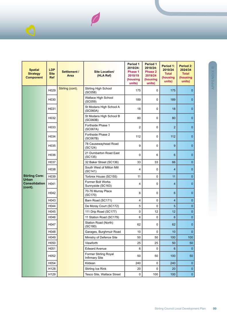
99Stirling Council Local Development Plan
SpatialStrategy
Component
LDPSite Ref
Settlement / Area
Site Location/(HLA Ref)
Period 12010/24:Phase 12010/19
(housingunits)
Period 12010/24:Phase 22019/24
(housingunits)
Period 1:2010/24
Total(housing
units)
Period 2:2024/34
Total(housing
units)
Stirling Core: UrbanConsolidation(cont).
H029 Stirling (cont). Stirling High School (SC058) 175 0 175 0
H030 wallace High School (SC059) 189 0 189 0
H031 St Modans High School A (SC060A) 18 0 18 0
H032 St Modans High School B (SC060B) 80 0 80 0
H033 Forthside Phase 1 (SC067A) 2 0 2 0
H034 Forthside Phase 2 (SC067B) 112 0 112 0
H035 78 Causewayhead road (SC124) 9 0 9 0
H036 21 Dumbarton road East (SC135) 0 6 6 0
H037 32 Baker Street (SC136) 33 33 66 0
H038 South west of Milton Mill (SC141) 4 0 4 0
H039 Torbrex House (SC155) 11 0 11 0
H041 Former Bolt worksSunnyside (SC163) 4 0 4 0
H042 70-76 Murray Place (SC170) 6 0 6 0
H043 Barn road (SC171) 4 0 4 0
H044 De Moray Court (SC172) 5 0 5 0
H045 111 Drip road (SC177) 0 12 12 0
H046 11 Station road (SC179) 6 0 6 0
H047 Station road (north) (SC180) 62 0 62 0
H048 Garages, Burghmuir road 10 0 10 0
H049 Ministry of Defence Site 50 50 100 100
H050 Viewforth 25 25 50 50
H051 Edward Avenue 6 0 6 0
H052 Former Stirling royalInfirmarySite 50 50 100 50
H054 Kildean 240 0 240 0
H128 Stirling Ice rink 20 0 20 0
H129 Tesco Site, wallace Street 0 100 100 0
AP
PE
nD
IX B
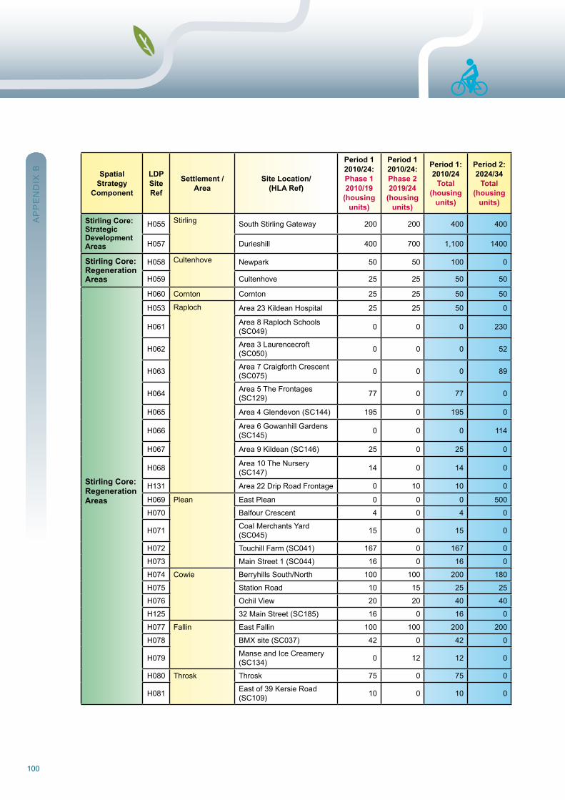
100
SpatialStrategy
Component
LDPSite Ref
Settlement / Area
Site Location/(HLA Ref)
Period 12010/24:Phase 12010/19
(housingunits)
Period 12010/24:Phase 22019/24
(housingunits)
Period 1:2010/24
Total(housing
units)
Period 2:2024/34
Total(housing
units)
Stirling Core: Strategic Development Areas
H055 Stirling South Stirling Gateway 200 200 400 400
H057 Durieshill 400 700 1,100 1400
Stirling Core: RegenerationAreas
H058 Cultenhove newpark 50 50 100 0
H059 Cultenhove 25 25 50 50
Stirling Core:RegenerationAreas
H060 Cornton Cornton 25 25 50 50
H053 raploch Area 23 Kildean Hospital 25 25 50 0
H061 Area 8 raploch Schools (SC049) 0 0 0 230
H062 Area 3 Laurencecroft (SC050) 0 0 0 52
H063 Area 7 Craigforth Crescent (SC075) 0 0 0 89
H064 Area 5 The Frontages (SC129) 77 0 77 0
H065 Area 4 Glendevon (SC144) 195 0 195 0
H066 Area 6 Gowanhill Gardens (SC145) 0 0 0 114
H067 Area 9 Kildean (SC146) 25 0 25 0
H068 Area 10 The nursery (SC147) 14 0 14 0
H131 Area 22 Drip road Frontage 0 10 10 0
H069 Plean East Plean 0 0 0 500
H070 Balfour Crescent 4 0 4 0
H071 Coal Merchants Yard (SC045) 15 0 15 0
H072 Touchill Farm (SC041) 167 0 167 0
H073 Main Street 1 (SC044) 16 0 16 0
H074 Cowie Berryhills South/north 100 100 200 180
H075 Station road 10 15 25 25
H076 ochil View 20 20 40 40
H125 32 Main Street (SC185) 16 0 16 0
H077 Fallin East Fallin 100 100 200 200
H078 BMX site (SC037) 42 0 42 0
H079 Manse and Ice Creamery (SC134) 0 12 12 0
H080 Throsk Throsk 75 0 75 0
H081 East of 39 Kersie road (SC109) 10 0 10 0
AP
PE
nD
IX B
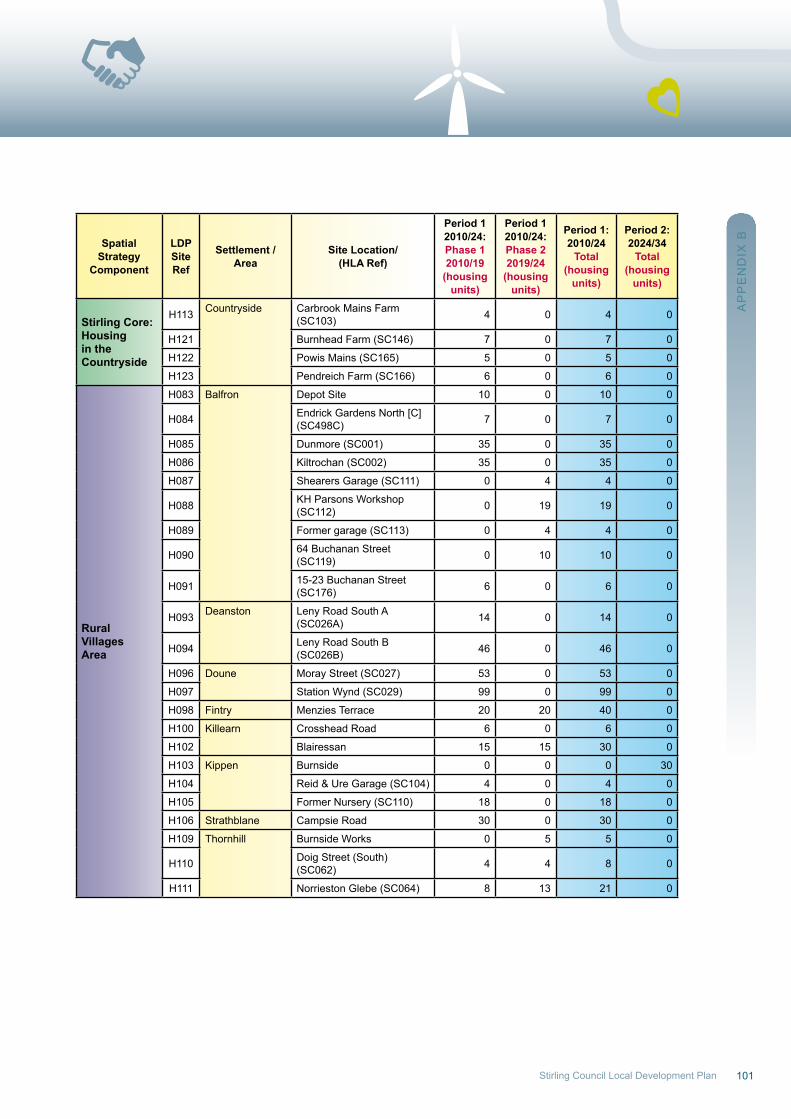
101Stirling Council Local Development Plan
SpatialStrategy
Component
LDPSite Ref
Settlement / Area
Site Location/(HLA Ref)
Period 12010/24:Phase 12010/19
(housingunits)
Period 12010/24:Phase 22019/24
(housingunits)
Period 1:2010/24
Total(housing
units)
Period 2:2024/34
Total(housing
units)
Stirling Core:Housingin theCountryside
H113 Countryside Carbrook Mains Farm (SC103) 4 0 4 0
H121 Burnhead Farm (SC146) 7 0 7 0
H122 Powis Mains (SC165) 5 0 5 0
H123 Pendreich Farm (SC166) 6 0 6 0
RuralVillagesArea
H083 Balfron Depot Site 10 0 10 0
H084 Endrick Gardens north [C] (SC498C) 7 0 7 0
H085 Dunmore (SC001) 35 0 35 0
H086 Kiltrochan (SC002) 35 0 35 0
H087 Shearers Garage (SC111) 0 4 4 0
H088 KH Parsons workshop (SC112) 0 19 19 0
H089 Former garage (SC113) 0 4 4 0
H090 64 Buchanan Street (SC119) 0 10 10 0
H091 15-23 Buchanan Street (SC176) 6 0 6 0
H093 Deanston Leny road South A (SC026A) 14 0 14 0
H094 Leny road South B (SC026B) 46 0 46 0
H096 Doune Moray Street (SC027) 53 0 53 0
H097 Station wynd (SC029) 99 0 99 0
H098 Fintry Menzies Terrace 20 20 40 0
H100 Killearn Crosshead road 6 0 6 0
H102 Blairessan 15 15 30 0
H103 Kippen Burnside 0 0 0 30
H104 reid & ure Garage (SC104) 4 0 4 0
H105 Former nursery (SC110) 18 0 18 0
H106 Strathblane Campsie road 30 0 30 0
H109 Thornhill Burnside works 0 5 5 0
H110 Doig Street (South) (SC062) 4 4 8 0
H111 norrieston Glebe (SC064) 8 13 21 0
AP
PE
nD
IX B
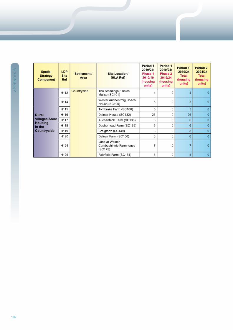
102
SpatialStrategy
Component
LDPSite Ref
Settlement / Area
Site Location/(HLA Ref)
Period 12010/24:Phase 12010/19
(housingunits)
Period 12010/24:Phase 22019/24
(housingunits)
Period 1:2010/24
Total(housing
units)
Period 2:2024/34
Total(housing
units)
RuralVillages Area: Housingin theCountryside
H112 Countryside The Steadings Finnich Malise (SC101) 4 0 4 0
H114 wester Auchentroig Coach House (SC105) 5 0 5 0
H115 Tombrake Farm (SC106) 5 0 5 0
H116 Dalnair House (SC132) 26 0 26 0
H117 Auchenteck Farm (SC138) 6 0 6 0
H118 Dasherhead Farm (SC139) 6 0 6 0
H119 Craigforth (SC149) 8 0 8 0
H120 Dalnair Farm (SC150) 6 0 6 0
H124Land at westerCambushinnie Farmhouse (SC175)
7 0 7 0
H126 FaitrfieldFarm(SC184) 5 0 5 0
AP
PE
nD
IX B
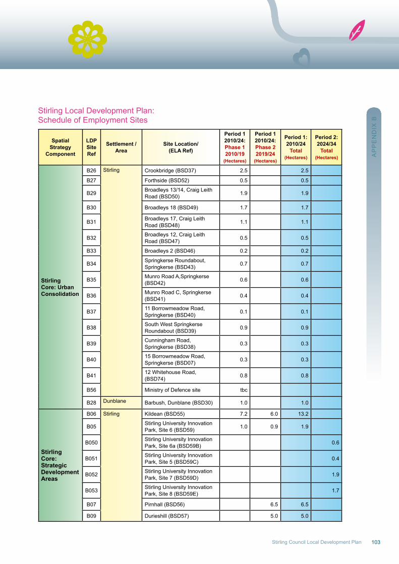
103Stirling Council Local Development Plan
Stirling Local Development Plan:Schedule of Employment Sites
SpatialStrategy
Component
LDPSite Ref
Settlement / Area
Site Location/(ELA Ref)
Period 12010/24:Phase 12010/19
(Hectares)
Period 12010/24:Phase 22019/24
(Hectares)
Period 1:2010/24
Total(Hectares)
Period 2:2024/34
Total(Hectares)
StirlingCore: UrbanConsolidation
B26 Stirling Crookbridge (BSD37) 2.5 2.5
B27 Forthside (BSD52) 0.5 0.5
B29 Broadleys 13/14, Craig Leith road (BSD50) 1.9 1.9
B30 Broadleys 18 (BSD49) 1.7 1.7
B31 Broadleys 17, Craig Leith road (BSD48) 1.1 1.1
B32 Broadleys 12, Craig Leith road (BSD47) 0.5 0.5
B33 Broadleys 2 (BSD46) 0.2 0.2
B34 Springkerse roundabout, Springkerse (BSD43) 0.7 0.7
B35 Munro road A,Springkerse(BSD42) 0.6 0.6
B36 Munro road C, Springkerse(BSD41) 0.4 0.4
B37 11 Borrowmeadow road, Springkerse (BSD40) 0.1 0.1
B38 South west Springkerse roundabout (BSD39) 0.9 0.9
B39 Cunningham road,Springkerse (BSD38) 0.3 0.3
B40 15 Borrowmeadow road, Springkerse (BSD07) 0.3 0.3
B41 12 whitehouse road, (BSD74) 0.8 0.8
B56 Ministry of Defence site tbc
B28 Dunblane Barbush, Dunblane (BSD30) 1.0 1.0
StirlingCore:StrategicDevelopmentAreas
B06 Stirling Kildean (BSD55) 7.2 6.0 13.2
B05 Stirling university Innovation Park, Site 6 (BSD59) 1.0 0.9 1.9
B050 Stirling university Innovation Park, Site 6a (BSD59B) 0.6
B051 Stirling university Innovation Park, Site 5 (BSD59C) 0.4
B052 Stirling university Innovation Park, Site 7 (BSD59D) 1.9
B053 Stirling university Innovation Park, Site 8 (BSD59E) 1.7
B07 Pirnhall (BSD56) 6.5 6.5
B09 Durieshill (BSD57) 5.0 5.0
AP
PE
nD
IX B

104
SpatialStrategy
Component
LDPSite Ref
Settlement / Area
Site Location/(ELA Ref)
Period 12010/24:Phase 12010/19
(Hectares)
Period 12010/24:Phase 22019/24
(Hectares)
Period 1:2010/24
Total(Hectares)
Period 2:2024/34
Total(Hectares)
StirlingCore:StrategicDevelopmentAreas(cont)
B10Stirling(cont)
Bannockburn, (Stirling South Gateway) (BSD62) 2.0 1.9 3.9 4.0
B11 Millhall, East (BSD63) 1.25 1.25 2.5 2.5
B12 Broadleys B Expansion (BSD45) 1.0 1.0
B13 Broadleys Extension Area(BSD44) 2.5 2.5 5.0 5.0
B15 Fallin / Throsk Bandeath East (BSD60A) 7.3
B16 East of Block 6, BandeathIndustrial Estate (BSD60B) 1.0
B17 west of Throsk House (BSD60C) 1.8
B19 BandeathInfill(BSD60F) 0.9
B18 Throsk B (BSD60E) 0.3
B20 Bandeath north (BSD02) 43.0
B21 Bandeath west (BSD01) 41.0
B22 Throsk C (part 4) (BSD13) 3.2 3.2
B23 Throsk C (part1) (BSD11) 0.7 0.7
B24 Blairlogie Manor Farm BusinessExtension (BSD72) 5.0 4.2 9.2
StirlingCore:RegenerationAreas
B01 Cowie Berryhills Main Street Cowie(BSD29) 0.8 0.8
B02 Cowie Main Street west of units 1 - 3 (BSD14) 0.7 0.7
B03 Fallin Fallin Polmaise Park (former depot) (BSD15) 0.8 0.8
B04 raploch Back o'Hill (BSD53) 1.0 1.0
RuralVillagesArea
B42 Balfron Buchanan Street/ Dunmore Street (BSD71) 0.3 0.3
B43 Balfron Depot (BSD28) 0.5 0.5
B44 Keltie Bridge Keltie Bridge (BSD21) 0.9 0.9
B45 Doune /Deanston
Station wynd Doune (BSD26) 0.5 0.5
B46 Lochills (BSD25) 0.6 0.6
B47 Killearn Killearn Hospital (BSD31) 1.5 1.5 1.0
B49 Thornhill Burnside works (BSD73) 0.3 0.3
B48Countryside Stirling Agricultural Centre
north of Hill of Drip Farm, Stirling (BSD10)
2.4 2.4
B14 Craigforth (BSD54) 4.0 4.0 4.0
B54 Tradstocks (BSD69) 3.0 3.0
AP
PE
nD
IX B

105Stirling Council Local Development Plan
Stirling Local Development Plan:Schedule of retail Sites
Strategy Area LDP Ref
Settlement / Area Site Location Retail Goods Type Retail floorspace
(square metres)
Stirling Core:UrbanConsolidation
r01 City Centre rainbow Slides Personal Goods Tobeconfirmed
r02 City Centre Station road (north) Personal Goods Tobeconfirmed
r03 City Centre Station road (south) Personal Goods Tobeconfirmed
r04 City Centre Spittal Street Personal Goods Tobeconfirmed
r05 City Centre BurghmuirConvenienceSuperstore, Personal Goods
1,848 (netconvenience),1,359 (net personal)
r06 City Centre STEP/Vico ConvenienceSuperstore 9,400 (gross)
r07 St.ninans Former MFI ConvenienceSuperstore 4,650 (gross)
r08 Dunblane Barbush ConvenienceSuperstore 3,900 (gross)
Stirling Core:StrategicDevelopmentAreas
r09 Bannockburn South StirlingGateway
ConvenienceSuperstore 4,000 (net)
r10 Durieshill Durieshill ConvenienceSupermarket 2,500 (gross)
r11SpringkerseCommercialCentre
Springkerse Household bulky goods 2,230 (net)
r12SpringkerseCommercialCentre
Crookbridge Household bulky goods Tobeconfirmed
r13SpringkerseCommercialCentre
Millhall East / Broadleys BExpansion Household bulky goods Tobeconfirmed
AP
PE
nD
IX B