stone county subdivision regulations
TRANSCRIPT
Stone County Subdivision Regulations Amendments current through June 10 2014
STONE COUNTY SUBDIVISION REGULATIONS
TABLE OF CONTENTS
Page
ARTICLE 1 - GENERAL PROVISIONS ...................................................................................1
Jurisdiction .........................................................................................................................1
Purpose and Intent .............................................................................................................1
Applicability .......................................................................................................................1
Exemptions .........................................................................................................................1
When Subdivision Regulations Apply ..............................................................................2
ARTICLE 2 - ADMINISTRATION.............................................................................................3
Duties of the Planning and Zoning Director....................................................................3
Duties of the Planning and Zoning Commission .............................................................3
Duties of the Governing Body ...........................................................................................3
Approvals Necessary for Acceptance of Subdivision Plats ............................................4
Responsibilities of the Recorder of Deeds ........................................................................4
ARTICLE 3 - DEFINITIONS.......................................................................................................5
Definitions ...........................................................................................................................5
ARTICLE 4 - MINIMUM DESIGN STANDARDS ...................................................................9
Water and Sewer ...............................................................................................................9
Blocks ................................................................................................................................10
Streets and Alleys .............................................................................................................10
Lots ....................................................................................................................................14
Easements .........................................................................................................................15
Subdivision Design ...........................................................................................................15
ARTICLE 5 - LOT SPLITS ........................................................................................................18
General ..............................................................................................................................18
Application Procedure .....................................................................................................18
Approval Guidelines ........................................................................................................18
Filing Fee...........................................................................................................................19
Stone County Subdivision Regulations Amendments current through June 10 2014
TABLE OF CONTENTS (continued)
Page
ARTICLE 6 - SUBMISSION OF PLATS .................................................................................19
Pre-Application ................................................................................................................19
Preliminary Plats .............................................................................................................19
Final Plat ...........................................................................................................................21
ARTICLE 7 - IMPROVEMENTS .............................................................................................27
Required Improvements ..................................................................................................27
Exceptions for Existing Improvements ..........................................................................29
ARTICLE 8 - IMPROVEMENT PROCEDURES ...................................................................31
General ..............................................................................................................................31
Building Permits...............................................................................................................31
Occupancy Permits ........................................................................................................ 32
Plans and Specifications ..................................................................................................32
Construction of Improvements .......................................................................................33
Inspection ..........................................................................................................................33
Inspection Procedures .....................................................................................................33
Final Inspection ................................................................................................................33
Acceptance of Improvements ..........................................................................................34
ARTICLE 9 - VARIANCES AND WAIVERS .........................................................................35
Variances ..........................................................................................................................35
Waivers .............................................................................................................................35
ARTICLE 10 - ADMINISTRATION.........................................................................................37
Permit ................................................................................................................................37
Recorded Plats ..................................................................................................................37
Consideration of Subdivision Regulation Amendments ...............................................37
ARTICLE 11 - SEVERABILITY ...............................................................................................39
Severability and Savings Clause .....................................................................................39
ARTICLE 12 - PENALTY ..........................................................................................................41
Penalty ...............................................................................................................................41
Stone County Subdivision Regulations Amendments current through June 10 2014
Subdivision Regulations, Page 1
ARTICLE 1, GENERAL PROVISIONS
1. Jurisdiction: These regulations shall apply to all land located in the unincorporated area
of Stone County, Missouri. All plans, plats or replats of land laid out in building lots,
hereafter made for each subdivision or each part thereof lying within the jurisdiction of
the Stone County Planning and Zoning Board shall be prepared, presented and recorded
as herein described.
2. Purpose and Intent: The purpose and intent of these regulations is to provide for the
harmonious development of the unincorporated areas of the County; to provide for the
proper location and width of streets, building lines, open spaces, safety and recreation
areas, utilities, drainage; for the avoidance of congestion of population through
requirements of minimum lot width, depth and area and the compatibility of design; to
require and fix the extent to which and the manner in which streets shall be graded and
improved, and water, sewer, drainage, and other utility mains and piping or connections
or other physical improvements shall be installed; and to provide for and secure, to the
governing body, the actual construction of such physical improvements.
3. Applicability: The owner or owners of any land located within the jurisdiction of these
regulations subdividing said land into two or more lots and blocks or tracts or parcels, for
the purpose of laying out any subdivisions, suburban lots, building lots, tracts or parcels
or any owner of any land establishing any street, alley, park or other property intended
for public use or for the use of purchasers or owners of lots, tracts or parcels of land
fronting thereon or adjacent thereto, shall cause a plat to be made in accordance with
these regulations, unless exempted under Section 4 of this Article.
4. Exemptions: These regulations shall not apply in the following instances:
A. The division of any parcel or tract of land when the smallest parcel created is 20
acres or greater in area.
B. A change in the boundary between adjoining land which does not create an
additional or substandard lot.
C. Land used for public street or railroad right-of-way, a drainage easement or other
public utilities subject to local, state or federal regulations, where no new street or
easement of access is involved.
D. Whenever any lot, parcel, or tract of land located within the area governed by
these regulations has been subdivided, resubdivided or replatted prior to adoption
of these regulations. However, any further resubdivision of lots, parcels or tracts
must be done in accordance with these regulations. The regulations allow one
split of each lot, parcel or tract into not more than two parcels under lot split
provisions of Article 5, without preparation of a subdivision plat.
E. Any transfer by operation of law.

Stone County Subdivision Regulations Amendments current through June 10 2014
Subdivision Regulations, Page 2
5. When Subdivision Regulations Apply: The division of any parcel of land or tract into
more than two tracts, two or more of which are smaller than 20 acres, shall be made
under the platting provisions of Article 6, "Submission of Plats". The division of any
parcel of land or tract smaller that 20 acres into two tracts may be made under the
provisions of Article 5, "Lot Splits". All plats and lot splits shall comply with the
provisions of these regulations.
Stone County Subdivision Regulations Amendments current through June 10 2014
Subdivision Regulations, Page 3
ARTICLE 2, ADMINISTRATION
1. Duties of the Planning and Zoning Administrator:
A. Maintain permanent and current records with respect to these regulations
including amendments thereto. Keep minutes and agendas of all meetings and
hearings.
B. File copies of all preliminary and final plats, together with applications and filing
fees, in the Office of the Planning and Zoning Administrator.
C. Transmit preliminary and final plats to the Planning and Zoning Board, and
Planning and Zoning Board recommendations regarding acceptance of
dedications to the governing body for its action.
D. Notify the Office of the Recorder of Deeds of final plat approval.
E. Transmit plat applications to the County Engineer and, after consideration of the
County Engineer’s opinion, shall notify the subdivider as to whether or not the
application is consistent with the requirements of the Subdivision Regulations
and/or design standards and, if not, of the specific manner in which such drawings
do not so conform or comply. The subdivider may then correct any defective
drawings and resubmit the correct drawings.
F. Circulate documents and communications to, from, or among applicants, the
County Engineer, the Planning and Zoning Board, the Board of Adjustment,
and/or the governing body.
2. Duties of the Planning and Zoning Board:
A. Review and approve, approve conditionally, or disapprove preliminary plats
within 30 days after submission.
B. Review and approve, approve conditionally, or disapprove final plats and transmit
final plats together with appropriate recommendations to the governing body for
its acceptance of the plat and dedications of easement and rights-of-way within 30
days after submission.
C. Accept bond for the County Commission providing for and securing to the
County the actual construction of improvements in the subdivision.
D. Make other determinations and decisions as may be required of the Planning and
Zoning Board from time to time by these regulations, and by the applicable
sections of the Missouri Statutes.
Stone County Subdivision Regulations Amendments current through June 10 2014
Subdivision Regulations, Page 4
3. Duties of the Governing Body:
A. Accept or reject final plats and the dedications of easements and rights-of-way in
final plats.
B. Take other actions as required from time to time including the consideration of
amendments to these regulations.
C. Approve or reject financial guarantees from subdividers in lieu of immediate
completion or installation of improvements required by the regulations.
4. Approvals Necessary for Acceptance of Subdivision Plats:
All plans, plats, or replats of land laid out in building lots, and the streets, alleys or other
portions of the same intended to be dedicated for public use, or for the use of purchasers
or owners of the lots fronting thereon or adjacent thereto shall be submitted to the Stone
County Planning and Zoning Board for their consideration.
The Planning and Zoning Board shall determine if the plat conforms to the provisions of
these regulations and shall recommend to approve or disapprove a preliminary plat within
30 days after submission of the preliminary plat to the secretary. The governing body
shall act on the preliminary plat and accept or refuse the dedication of land for public
purpose on final plats within 30 days after the first meeting of the governing body
following the date of the submission of the plat to the governing body.
The division of any parcel of land or tract into more than two tracts, two or more of
which are smaller than 20 acres, shall be made under the platting provisions of Article 6,
"Submission of Plats". The division of any parcel of land or tract smaller that 20 acres
into two tracts may be made under the provisions of Article 5, "Lot Splits". All plats and
lot splits shall comply with the provisions of these regulations.
5. Responsibilities of the Recorder of Deeds:
The Recorder of Deeds shall not record any plat until such plat is approved by the
Planning and Zoning Board and accepted by the governing body and is signed by the
governing body of Stone County, Missouri. See Article 6, "Submission of Plats", for a
detailed list of submittals needed for platting land and for all procedural requirements.
Pursuant to RSMO 137.185, no tract or parcel of less than one-sixteenth of a section shall
be conveyed by metes and bounds without a survey, a certified and sealed copy of which
shall be recorded in the office of the Recorder of Deeds on Stone County prior to the
conveyance of the tract or parcel.
Stone County Subdivision Regulations Amendments current through June 10 2014
Subdivision Regulations, Page 5
6. Duties of the County Engineer:
A. Review of Plat Applications: The County Engineer shall review all plat
applications in order to advise as to whether the application conforms to the
regulations and/or design standards. The County Engineer shall forward to the
Planning and Zoning Director a notice stating his/her opinion and, in the event
that it is the engineer’s opinion that the application does not so conform or
comply, the County Engineer shall notify the Planning and Zoning Director of the
specific manner in which such drawings do not so conform or comply.
ARTICLE 3, DEFINITIONS
1. Definitions: Definitions for the interpretation of these rules and regulations are as
follows:
Agricultural Uses: The use of a tract of land of not less than 20 acres for the
growing of crops, pasturage or nursery, including the structures necessary for
carrying out farming operations and the dwellings of those owning or operating
the premises, a member of the family thereof, or persons employed thereon, and
the family thereof, but such use shall not include feedlots.
Alley: A dedicated public right-of-way, other than a street, which provides only a
secondary means of access to abutting property, the right-of-way of which is
twenty (20) feet or less in width.
Block: A piece or parcel of land entirely surrounded by public highways, streets,
streams, railroad rights-of-way or parks, etc., or a combination thereof.
County Engineer: The person responsible to perform the duties of the County
Engineer including any and all special engineers as appointed by the governing
body. If the position of County Engineer is vacant, the governing body shall
appoint an engineer to perform the County Engineer’s functions under these
Subdivision Regulations.
Cul-de-sac: A vehicular turnaround which is located at the closed end of a dead-
end street or alley.
Department of Natural Resources, Missouri (MDNR): The Missouri Department
of Natural Resources.
Design: The location of streets, alignment of streets, grades and widths of streets,
alignment of easements, grades and widths of easements, alignment and rights-of-
way for drainage and sanitary sewers, and the designation of minimum lot area,
width and length.
Stone County Subdivision Regulations Amendments current through June 10 2014
Subdivision Regulations, Page 6
Easement: A permanent or temporary grant of right by a landowner to the public,
a corporation or other persons, of the use of a portion of a lot or tract of land for
specified purposes where title to said portion of the lot or tract of land remains
with the landowner.
Final Plat: A plan or map prepared in accordance with the provisions of this
regulation and those of any other applicable local regulation, which plat is
prepared to be placed on record in the office of the Recorder of Deeds of Stone
County.
Governing Body: The County Commission of Stone County, Missouri.
Green Space: an area of land or water or combination thereof, as defined by the
developer, set aside, dedicated, designated, or reserved for the public or private
use, planned for maintenance of the natural environment; or for passive or active
recreational use by all residents of a platted subdivision, or by the general public,
including nature trails, picnic areas, and walking paths; and active recreation, such
as swimming pools, tennis courts, and shuffleboard courts; and not including
areas utilized for streets, alleys, or private roads, off-street parking or loadings
areas. Open space shall be contiguous.
Improvements: Street work, utilities, sidewalks, drainage structures and other
physical modifications which are to be installed or constructed by the subdivider
for the benefit of the lot owners and for the proper development of the county, as
a condition precedent to the approval and acceptance of the final plat.
Land Use Plan: The Comprehensive Plan of Stone County, Missouri, as
amended.
Lot: A portion of land in a subdivision or other parcel of land under single
ownership, intended as a unit for transfer of ownership or for development, and,
when more than one parcel, contiguous.
Open Space: An area of land or water or combination thereof, as defined by the
developer, set aside, dedicated, designated, or reserved for the public or private
use, planned for maintenance of the natural environment; or for passive or active
recreational use by all residents of a platted subdivision, or by the general public,
including nature trails, picnic areas, and walking paths, and active recreation, such
as swimming pools, tennis courts, and shuffleboard courts; and not including
areas utilized for streets, alleys, or private roads, off-street parking or loading
areas. Open space in private ownership shall be contiguous and visible from a
street right-of-way.
Pedestrian Way: A right-of-way dedicated to public use, which cuts across a
block to facilitate pedestrian access to adjacent streets and properties.
Stone County Subdivision Regulations Amendments current through June 10 2014
Subdivision Regulations, Page 7
Planning and Zoning Administrator: The individual appointed by the governing
body to administer these regulations. Also known as Planning and Zoning
Director.
Planning and Zoning Board: Shall mean the Stone County Planning and Zoning
Board. Also known as the Planning and Zoning Commission.
Preliminary Plat: A map made for the purpose of showing the design of a
proposed subdivision and the existing conditions in and around it; this map need
not be based on accurate or detailed final survey of the property.
Secretary: Secretary of the Planning and Zoning Board.
Significant/Specimen Tree or Stand: Any tree or grouping of trees that is
considered to be of high value due to its size, species, form, historical
significance, or other professional criteria.
Setback: The required minimum horizontal distance between the building line
and the related front, side, or rear property line as provided in the Stone County
Planning and Zoning Regulations.
Street: A right-of-way, which provides vehicular and pedestrian access to
adjacent properties, whether dedicated to the public, or private.
Street, Public: A right-of-way, dedicated to the public and accepted by the
County, which provides vehicular and pedestrian access to adjacent properties.
Subdivider: A person, firm, corporation, partnership, or association who causes
land to be divided into a subdivision for itself or for others.
Subdivision: The division of a tract of land into two or more lots or parcels for
the purpose of transfer of ownership or building development, or, if a new street is
involved, any division of a parcel of land; except that, the division of land shall
not be considered to be a subdivision when the smallest parcel created is more
than twenty (20) acres in area. The term "subdivision" includes "resubdivision",
and the term "resubdivision", as used herein, shall include any further subdivision
of a lot or parcel of land previously subdivided, for sale, use, or other purposes,
which varies from the latest, approved plat of the same.
Stone County Subdivision Regulations Amendments current through June 10 2014
Subdivision Regulations, Page 8
ARTICLE 4, MINIMUM DESIGN STANDARDS
1. Water and Sewer:
A. The area of the lots shall be determined by the standards in the zoning regulations
and the availability of public sanitary sewer and a public water supply. Prior to
the submission of a preliminary plat, the subdivider shall obtain a determination
from the County Engineer as to whether adequate public sewer and water supply
are available, as provided in Article 7.
B. If the proposed subdivision is serviced by a public water supply and a public
sanitary sewer system, the minimum lot area requirements shall be subject to
those set forth herein in the Zoning Regulations.
C. If the proposed subdivision is serviced with a public water supply, but not with a
public sewer system, or is serviced with a public sewer system, but not a public
water supply, the preliminary plat shall be prepared on the basis of minimum 2.5
acre lots; provided, however, additional lot area may be required if the area has or
is suspected of having a high water table or if soil conditions prove to be
unsuitable based on standards of the Stone County Health Department.
D. If the proposed subdivision is serviced with a public water supply, but not with a
public sewer system, lots less than 2.5 acres in area may be approved if the area is
suitable for on-site septic systems at a density greater than one on-site system per
2.5 acres, upon a satisfactory soils test provided by the subdivider, and as
determined and approved by the Stone County Health Department.
E. If the proposed subdivision is not served with either a public water supply or a
public sewer system, the subdivider shall submit a preliminary plat on the basis of
minimum 3.5 acre lots; provided, however, that additional lot area may be
required if the area has or is suspected of having a high water table or if soil
conditions prove to be unsuitable based on standards of the Stone County
Department of Health; provided, further, that less lot area may be required if the
area is suitable for on-site septic systems at a density greater than one on-site
system per 3.5 acres on the same lot as a private well, but not smaller than on a
2.5 acre lot, as determined by the Stone County Health Department.
F. All water and sewer systems shall be approved by the Planning & Zoning
Commission upon recommendation by the County Engineer as provided in Article
8.
2. Blocks:
A. Length: Intersecting streets (which determine block length) shall be provided at
such intervals as to serve cross traffic adequately and to meet existing streets in
the neighborhood. In residential districts, where no existing plats are recorded,
Stone County Subdivision Regulations Amendments current through June 10 2014
Subdivision Regulations, Page 9
the blocks shall not exceed 1,320 feet in length, except that a greater length may
be permitted where topography or other conditions justify a departure from this
maximum. In blocks longer than 800 feet, pedestrian ways and/or easements
through the block may be required near the center of the block. Such pedestrian
ways or easements shall have a minimum width of ten feet.
B. Width: In residential developments, the block width shall normally be sufficient
to allow two tiers of lots of appropriate depth. In certain instances, however, a
different arrangement may be required in order to provide better circulation or to
protect a major circulation route. Blocks intended for business or industrial use
shall be of such width and depth as may be considered most suitable for the
prospective use.
3. Streets and Alleys:
A. Relationship to Adjoining Street Systems: The arrangement of streets in new
subdivisions shall make provisions for the continuation of the principal existing
streets in adjoining additions (or their proper projection where adjoining property
is not subdivided) insofar as they may be necessary for public requirements. The
width of such street rights-of-way in new subdivisions shall be not less than the
minimum street widths established herein. Alleys, when required, and street
arrangement must cause no hardship to owners of adjoining property when they
plat their land and seek to provide for convenient access to it. Whenever there
exists a dedicated or platted half street or alley adjacent to the tract to be
subdivided, the other one half of the street or alley shall be platted and dedicated
as a public way.
B. Street Names: Streets that are obviously in alignment with other already existing
and named streets shall bear the names of the existing streets. Street names
should not be similar to already platted street names. Streets and house numbers
shall be numbered in accordance with the adopted house numbering policy of
Stone County.
C. Arterial Streets: Arterial streets through subdivisions shall conform to the major
street plan of the Land Use Plan as adopted by the Planning and Zoning Board
and the governing body.
D. Local Streets: Local streets should be designed so as to discourage through or
non-local traffic.
E. Cul-de-sacs: An adequate turnaround of not less than a 100-foot diameter right-
of-way shall be provided at the closed end of a dead-end local street longer than
one lot in length. Such local street segment should not exceed 600 feet in length
from the centerline of an intersection of a cross street to the center of the cul-de-
sac, but may be longer, based on the density of platted lots, as approved by the
Planning and Zoning Board upon the recommendations of the County Engineer.
Stone County Subdivision Regulations Amendments current through June 10 2014
Subdivision Regulations, Page 10
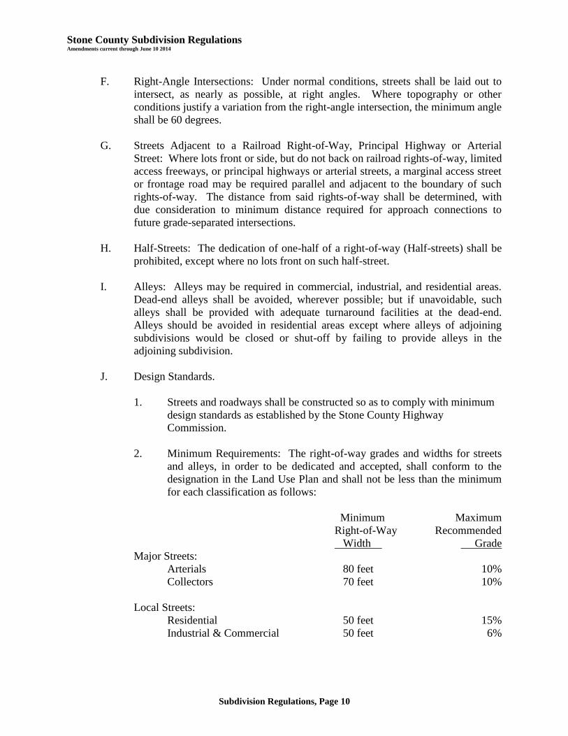
F. Right-Angle Intersections: Under normal conditions, streets shall be laid out to
intersect, as nearly as possible, at right angles. Where topography or other
conditions justify a variation from the right-angle intersection, the minimum angle
shall be 60 degrees.
G. Streets Adjacent to a Railroad Right-of-Way, Principal Highway or Arterial
Street: Where lots front or side, but do not back on railroad rights-of-way, limited
access freeways, or principal highways or arterial streets, a marginal access street
or frontage road may be required parallel and adjacent to the boundary of such
rights-of-way. The distance from said rights-of-way shall be determined, with
due consideration to minimum distance required for approach connections to
future grade-separated intersections.
H. Half-Streets: The dedication of one-half of a right-of-way (Half-streets) shall be
prohibited, except where no lots front on such half-street.
I. Alleys: Alleys may be required in commercial, industrial, and residential areas.
Dead-end alleys shall be avoided, wherever possible; but if unavoidable, such
alleys shall be provided with adequate turnaround facilities at the dead-end.
Alleys should be avoided in residential areas except where alleys of adjoining
subdivisions would be closed or shut-off by failing to provide alleys in the
adjoining subdivision.
J. Design Standards.
1. Streets and roadways shall be constructed so as to comply with minimum
design standards as established by the Stone County Highway
Commission.
2. Minimum Requirements: The right-of-way grades and widths for streets
and alleys, in order to be dedicated and accepted, shall conform to the
designation in the Land Use Plan and shall not be less than the minimum
for each classification as follows:
Minimum Maximum
Right-of-Way Recommended
Width Grade
Major Streets:
Arterials 80 feet 10%
Collectors 70 feet 10%
Local Streets:
Residential 50 feet 15%
Industrial & Commercial 50 feet 6%
Stone County Subdivision Regulations Amendments current through June 10 2014
Subdivision Regulations, Page 11
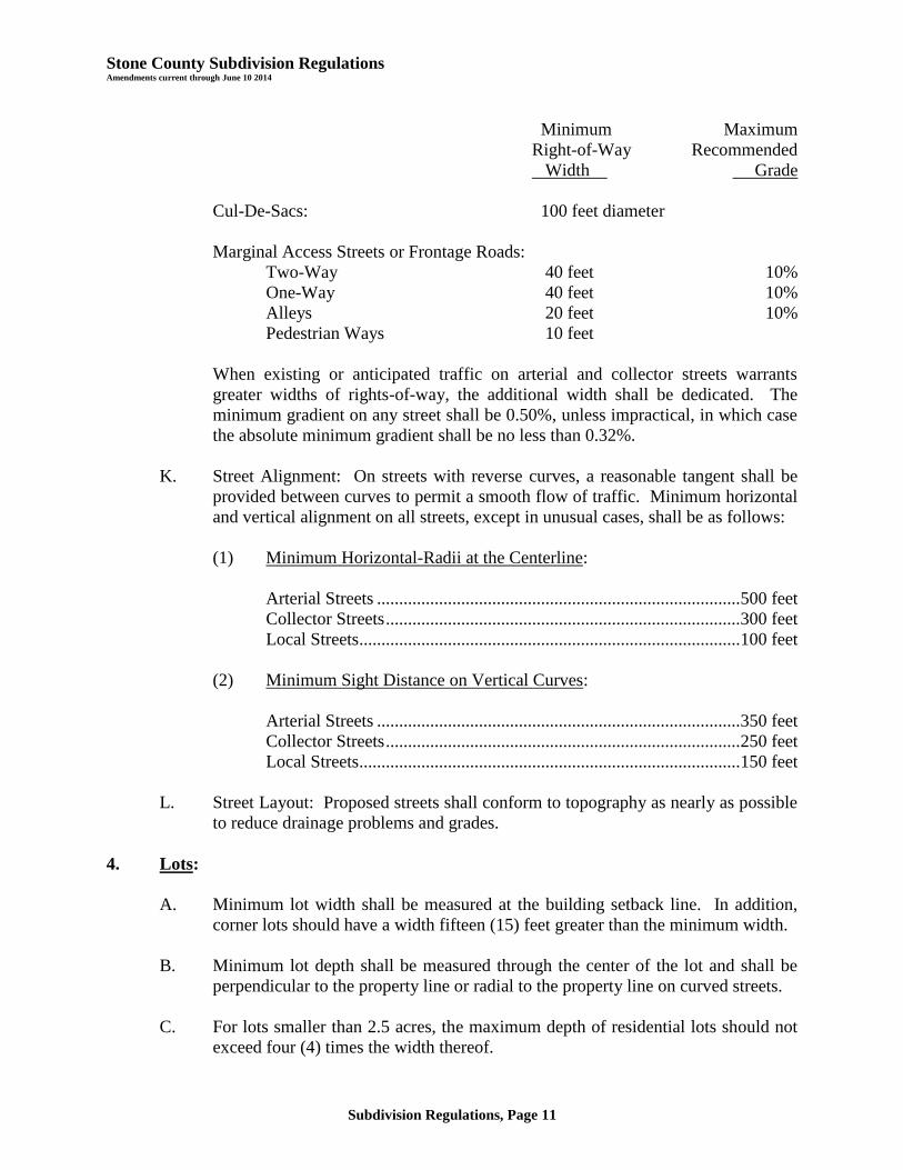
Minimum Maximum
Right-of-Way Recommended
Width Grade
Cul-De-Sacs: 100 feet diameter
Marginal Access Streets or Frontage Roads:
Two-Way 40 feet 10%
One-Way 40 feet 10%
Alleys 20 feet 10%
Pedestrian Ways 10 feet
When existing or anticipated traffic on arterial and collector streets warrants
greater widths of rights-of-way, the additional width shall be dedicated. The
minimum gradient on any street shall be 0.50%, unless impractical, in which case
the absolute minimum gradient shall be no less than 0.32%.
K. Street Alignment: On streets with reverse curves, a reasonable tangent shall be
provided between curves to permit a smooth flow of traffic. Minimum horizontal
and vertical alignment on all streets, except in unusual cases, shall be as follows:
(1) Minimum Horizontal-Radii at the Centerline:
Arterial Streets .................................................................................. 500 feet
Collector Streets ................................................................................ 300 feet
Local Streets...................................................................................... 100 feet
(2) Minimum Sight Distance on Vertical Curves:
Arterial Streets .................................................................................. 350 feet
Collector Streets ................................................................................ 250 feet
Local Streets...................................................................................... 150 feet
L. Street Layout: Proposed streets shall conform to topography as nearly as possible
to reduce drainage problems and grades.
4. Lots:
A. Minimum lot width shall be measured at the building setback line. In addition,
corner lots should have a width fifteen (15) feet greater than the minimum width.
B. Minimum lot depth shall be measured through the center of the lot and shall be
perpendicular to the property line or radial to the property line on curved streets.
C. For lots smaller than 2.5 acres, the maximum depth of residential lots should not
exceed four (4) times the width thereof.
Stone County Subdivision Regulations Amendments current through June 10 2014
Subdivision Regulations, Page 12
D. Minimum lot area shall be subject to the Zoning Regulations of the district in
which the subdivision is located and the minimum design standards of this
regulation. The more restrictive of the regulations shall govern.
E. All side lot lines shall bear between 60 and 90 degrees from the street right-of-
way line on a straight street or from the tangent of a curved street.
F. Front building or setback lines shall be shown on the final plat for all lots in the
subdivision and shall not be less than the setbacks required by the Zoning
Regulations or any other regulations adopted by the governing body; the most
restrictive setback requirement shall govern.
G. Double frontage lots shall be avoided unless, in the opinion of the Planning and
Zoning Board, a variation to this rule will give better street alignment and lot
arrangement.
H. Every lot shall abut on a street other than an alley.
I. The subdivision or resubdivision of a tract or lot shall not be permitted where said
subdivision or resubdivision places an existing permanent structure in violation of
the requirements of the Zoning Regulations or the minimum design standards of
these regulations.
J. Where possible, residential lots should not face on arterial streets. The number of
lots facing on collector streets shall be kept to a minimum in each subdivision.
The street pattern shall be designed so that the side lines of lots abut collector
streets wherever land shapes and topography permit.
5. Easements:
A. Utility Easements: Where alleys are not provided, permanent easements of not
less than ten (10) feet in width shall be provided on each side of all rear lot lines,
and on side lot lines, where necessary, for utility poles, wires, conduits,
underground conductors, storm and sanitary sewers, gas, water and heat mains,
and other public utilities. These easements shall provide for a continuous right-
of-way. Where the utility company or agency has the need for a wider easement
than required above for a specific location, this easement shall be shown on the
plat. Permanent easements shall not be obstructed by structures, retaining walls
or trees. A property owner may install fences and landscape the easement with
grass and shrubs at their own risk.
A twelve (12) foot temporary construction easement shall be provided on each
side of all lot lines for initial construction of water, sewer and other utility lines.
B. Drainage Easements: If a subdivision is traversed by a water course,
drainageway or channel, then a storm water easement shall be provided. Such
Stone County Subdivision Regulations Amendments current through June 10 2014
Subdivision Regulations, Page 13
easement or right-of-way shall conform substantially to the lines of such water
course and shall be of such width or construction, or both, as may be necessary to
provide adequate storm water drainage and for access for maintenance thereof.
Parallel streets may be required in connection therewith. The subdivider may be
required to have an engineer's study prepared for the Planning and Zoning Board
as to the required width of such easement for each major water course or
drainageway involved. Such study shall be based on a 100-year storm.
6. Subdivision Design:
A. Access Control: In the interest of public safety and for the preservation of the
traffic-carrying capacity of the streets system, the Planning and Zoning Board
shall have the right to restrict and regulate points of access to all property from
the public street system. Such restrictions shall be indicated on the final plat.
B. Subdivision Design: The design of the subdivision shall provide for efficient
traffic flow, proper mixing of land uses, and a logical link between surrounding,
existing development, and the proposed layout. The Land Use Plan should be
used as a guide in determining if the design of the proposed subdivision is proper.
The Planning and Zoning Board shall have the authority to deny a plat or request
redesign, if, in its opinion, the layout is not suitable for the site, or if the
development of the subdivision would be premature.
C. Storm Water Runoff Plan: The subdivider may be required to have an engi-
neer's study prepared on the amount of increased storm water runoff which will be
created by proposed development and a plan of how this runoff will be
accommodated. The County may require design modification of the proposed
storm water system to reduce increased runoff.
D. Natural Resource Preservation: To the maximum extent practicable,
development shall be located to preserve the natural features of the site, to avoid
areas of environmental sensitivity, and to minimize negative impacts and
alteration of natural features. Significant trees or stands of trees shall be
preserved as undeveloped open space, to the extent consistent with reasonable
utilization of land, and in accordance with applicable state or local regulations.
Environmental Feature Areas as identified in the Land Use Plan including
sites on the Natural Features Inventory map, the 100 year floodplain,
drainage areas, and significant water resources such as lakes, creeks and
rivers.

Stone County Subdivision Regulations Amendments current through June 10 2014
Subdivision Regulations, Page 14
E. Design Techniques: The 1995 edition of the Stone County Subdivision
Regulations contained illustrations of examples which may be used as guides in
the review of the subdivision applications. Those illustrations are retained.
F. A minimum of fifteen percent (15%) open space/green space, as defined, shall be
required in all subdivision plats submitted.
Stone County Subdivision Regulations Amendments current through June 10 2014
Subdivision Regulations, Page 15
ARTICLE 5, LOT SPLITS
1. General: The intent of this section is to provide for the issuance of building permits for
lots divided into not more than two tracts without having to replat said lot, provided that
the resulting lots shall not again be divided without replatting. The Planning and Zoning
Administrator may approve or disapprove lot splits in accordance with the following
regulations.
2. Application Procedure: Requests for lot split approval shall be made by the owner of
the land to the Planning and Zoning Administrator. Four (4) copies of a scale drawing
and legal description of the lots involved and the location of any structure(s) thereon
together with the precise nature, location and dimensions of the proposed lot split shall
accompany the application.
3. Approval Guidelines: Approval or disapproval of lot splits shall be made by the
Planning and Zoning Administrator, based on the following guidelines:
A. No lot split shall be approved if:
(1) A new street or alley is needed or proposed.
(2) A vacation of streets, alleys, setback lines, access control or easements is
required or proposed.
(3) Such action will result in significant increases in service requirements
(e.g., utilities, schools, traffic control, streets, etc.); or will interfere with
maintaining existing service levels (e.g., additional curb cuts, repaving,
etc.).
(4) There is less street right-of-way than required by these regulations or the
Land Use Plan unless such dedication can be made by separate instrument.
(5) All easement requirements have not been satisfied.
(6) Such split will result in a tract without direct access to a street.
(7) A substandard-sized lot or parcel will be created.
(8) The lot has been previously split in accordance with these regulations.
B. The Planning and Zoning Administrator may make such additional
recommendations as deemed necessary to carry out the intent and purpose of
existing land development regulations and governing body policy. Requirements
may include, but not be limited to, installation of public facilities, dedication of
rights-of-way and easements, and submission of covenants for the protection of
other landowners in the original subdivision.

Stone County Subdivision Regulations Amendments current through June 10 2014
Subdivision Regulations, Page 16
C. The Planning and Zoning Administrator shall, in writing, either approve, with or
without conditions, or disapprove, the lot split within five (5) working days of
application.
4. Filing Fee: The filing fee for lot splits shall be established by the governing body.
Stone County Subdivision Regulations Amendments current through June 10 2014
Subdivision Regulations, Page 17
ARTICLE 6, SUBMISSION OF PLATS
1. Pre-Application: Prior to the filing of the preliminary plat, the subdivider shall contact
the Planning and Zoning Administrator to determine:
A. Procedure for filing plats.
B. Availability of sewer and water.
C. Comprehensive Plan requirements for improvements such as major streets, land
use, parks, schools and public open spaces.
D. Zoning requirements for the property in question and adjacent properties.
E. Special setback requirements for arterial, collector and local streets.
2. Preliminary Plats: After reaching the preliminary conclusions regarding the
requirements for the proposed subdivision, the subdivider may submit a preliminary plat
together with any supplementary information necessary to the Planning and Zoning
Administrator.
A. Submission of a Preliminary Plat:
(1) Filing Fee: A filing fee established by the governing body shall
accompany the filing of each preliminary plat. The preliminary plat shall
not be accepted for filing until the filing fee has been paid by the
subdivider.
(2) Number of Copies: This subdivider shall submit ten (10) copies of the
preliminary plat and of a vicinity map (if not on the preliminary plat)
showing the location of the proposed subdivision; and one copy reduced to
11" x 17". These plats shall be filed with the Planning and Zoning
Administrator at least fourteen (14) days prior to a regular meeting of the
Planning and Zoning Board at which the preliminary plat is to be
considered.
(3) The subdivider shall submit a certificate proving ownership of the entire
tract to be platted.
(4) The subdivider shall submit proof that the proposed plat has been
reviewed by all affected utility companies or agencies along with any
comments from these companies or agencies.
(5) A preliminary grading and drainage plan, including location and size of all
storm drainage improvements, existing and proposed land elevations and
contours, and necessary widths of all open drainageways shall be
Stone County Subdivision Regulations Amendments current through June 10 2014
Subdivision Regulations, Page 18
submitted to the County Engineer. These plans are not intended to be
detailed suitable for construction.
(6) Preliminary plats shall contain:
a. The proposed name of the subdivision. (The name shall not
duplicate or too closely resemble the name or names of an existing
subdivision.)
b. The location of the boundary lines of the subdivision and reference
to the section or quarter section lines.
c. The names and addresses of the developer, owner, and the engineer
or land surveyor who prepared the plat.
d. Scale of the plat, 1" = 100' or larger.
e. Date of preparation and north point.
f. Existing conditions:
o Location, width and name of platted streets or other public
ways, railroads and utility rights-of-way, parks and other
public open spaces and permanent buildings within or
adjacent to the proposed subdivision.
o All existing sewers, water mains, gas mains, culverts, or
other underground installations, within or adjacent to the
proposed subdivision, with pipe size and manholes, grades
and location.
o Names of adjacent subdivisions together with arrangement
of streets and lots, and owners of adjacent parcels of
unsubdivided land.
o Topography (unless specifically waived) with contour
intervals of not more than two feet, referred to U.S.G.S.
datum; where the ground is too flat for contours, spot
elevations shall be provided.
o Location of water courses, bridges, wooded areas, lakes,
ravines and such other features as may be pertinent to the
subdivision.
o Current zoning classification.

Stone County Subdivision Regulations Amendments current through June 10 2014
Subdivision Regulations, Page 19
o Significant stands of trees and unique or specimen trees.
o Environmental Feature Areas as identified in the Land Use
Plan including sites on the Natural Features Inventory map,
the 100 year floodplain, drainage areas, and significant
water resources such as lakes, creeks and rivers.
g. The general arrangements of lots and their approximate size.
h. Location and width of proposed streets, alleys, and pedestrian
ways and easements to accommodate drainage.
i. The general plan of sewage disposal, water supply and drainage.
j. Location and size of proposed parks, playgrounds, churches,
school sites or other special uses of land to be considered for
reservation or dedication for public use.
k. General layout of adjacent property within two hundred (200) feet
to show how streets and other public facilities in the proposed
subdivision relate to the adjacent property.
l. Approximate gradient of streets.
B. Preliminary Plat Action: The Planning and Zoning Board shall approve,
conditionally approve, or disapprove the preliminary plat within 30 days of
submission of the plat. Action by the Planning and Zoning Board shall be con-
veyed to the subdivider in writing. In case the plat is disapproved by the Planning
and Zoning Board, the subdivider shall be notified of the reason for such action
and what requirements shall be recommended to meet approval. The approval of
the preliminary plat does not constitute an acceptance of the subdivision, but is
deemed to be an authorization to proceed with the preparation of the final plat.
C. Applicants may be offered the option of waiving the 30-day provision of §64.830
(Approval of plats).
D. If a meeting of the Planning and Zoning Board is not scheduled within 30 days of
the filing of a plat application, and if the County Engineer has reported upon the
plat application as provided in Article 2, Section 2 of these Subdivision
Regulations, the Planning and Zoning Administrator shall transmit to the
governing body the Plat Application and attachments, and the County Engineer’s
report. The governing body may consider the Plat Application and attachments,
and the County Engineer’s report, and decide whether to approve, conditionally
approve, or disapprove the preliminary plat.
Stone County Subdivision Regulations Amendments current through June 10 2014
Subdivision Regulations, Page 20
E. Effective Date: The approval of the preliminary plat shall be effective for two
(2) years.
3. Final Plat:
A. Submission:
(1) After approval of the preliminary plat, the subdivider may submit a final
plat; except that the Planning and Zoning Administrator may accept
simultaneous subdivision of the preliminary and final plats.
(2) The original (on mylar, tracing cloth or similar material) and the number
of prints required by the Planning and Zoning Board shall be submitted to
the Planning and Zoning Administrator at least fourteen (14) days prior to
the Planning and Zoning Board public meeting at which the plat will be
considered.
(3) The names and signatures of the owner or owners of the property, duly
acknowledged and notarized, shall appear on the original copies
submitted.
(4) The final plat, prepared for recording purposes, shall be drawn at a scale
of at least 1"=100'. The size of the sheet on which such final plat is
prepared shall be 36 inches by 22 inches. Where the proposed plat is of
unusual size, the final plat shall be submitted on two or more sheets of the
same dimensions. If two or more sheets are required, an index map of the
same dimensions shall be filed showing the entire development at a
smaller scale. The dimensions indicated are standard for all final plats and
must be complied with. Title, description and other written data shall be
located either right or left.
(5) The final plat shall be reviewed for accuracy by the County Engineer prior
to submission to the governing body.
B. Information: The final plat shall show and contain the following information:
(1) Name of subdivision (not to duplicate or too closely resemble the name of
any existing subdivision).
(2) Location of section, township, range, county and state, including the
descriptive boundaries of the subdivision based on an accurate traverse,
giving angular and linear dimensions which must be mathematically
correct. The allowable error of closing on any portion of the plat shall be
one foot in five thousand (5,000).
Stone County Subdivision Regulations Amendments current through June 10 2014
Subdivision Regulations, Page 21
(3) The location of existing monuments or bench marks shall be shown and
described on the final plat. Location of such monument shall be shown in
reference to existing official monuments or the nearest established street
lines, including the true angles and distances to such reference points or
monuments.
(4) The location of lots; streets and highway rights-of-way; parks and other
features; with accurate dimensions in feet and decimals of feet with the
length of radii and of arcs along with the intersection angle (delta) on all
curves, and all other information necessary to reproduce the plat on the
ground. Dimensions shall be shown from all angle points of curve on lot
lines.
(5) Lots shall be numbered clearly. Blocks shall be numbered or lettered
clearly in the center of the block.
(6) The exact locations, widths and names of all streets and alleys to be
dedicated.
(7) Boundary lines and description of the boundary lines of any area other
than streets and alleys which are to be dedicated or reserved for public use.
(8) Building setback lines on the front and side streets with dimensions.
(9) Name, signature and seal of the registered land surveyor preparing the
plat.
(10) Scale of the plat (scale to be shown graphically and in feet per plat scale
inch), date of preparation and north point, including basis for north.
(11) Statement dedicating all easements, streets, alleys, and all other public
areas not previously dedicated.
(12) The following certificates, which may be combined where appropriate:
a. A certificate signed and acknowledged by all parties having any
record, title, or interest in the land subdivided, and consented to the
preparation and recording of said subdivision map.
b. A certificate signed and acknowledged as above, dedicating or
reserving all parcels of land shown on the final plat and intended
for any public or private use, including open space and easements;
and those parcels which are intended for the exclusive use of the
lot owners of the subdivision, their licensees, visitors, tenants, and
servants.
Stone County Subdivision Regulations Amendments current through June 10 2014
Subdivision Regulations, Page 22
c. The acknowledgement of a notary in the following form:
State of , County of , SS.
Be it remembered that on _____________, 20__, before me, a
notary public in and for said County and State, came ,
to me personally known to be the same person who executed the
foregoing instrument of writing and duly acknowledged the
execution of same. In testimony whereof, I have hereunto set may
hand and affixed my notarial seal the day and year above written.
(SEAL)
Notary Public
d. The certificate of the Planning and Zoning Board in the following
form:
This plat of addition has been submitted
to and approved by the Stone County Planning and Zoning Board
on , 20__.
Chair
Secretary
e. A blank space for noting entry on the transfer record in the
following form:
Entered on transfer record on , 20 .
Deputy Recorder of Deeds
C. Supplemental Information to be Submitted with Final Plat: The following
additional data shall be submitted with the final plat:
(1) A title report by an abstract or a title insurance company, or an attorney's
opinion of title, showing the name of the owner of the land and all other
persons who have an interest in, or an encumbrance on, the plat. The
consent of all such persons shall be shown on the plat.
Stone County Subdivision Regulations Amendments current through June 10 2014
Subdivision Regulations, Page 23
(2) A certificate showing that all taxes and special assessments due and
payable have been paid in full; or if such taxes have been protested as
provided by law, monies or other sufficient escrows guaranteeing such
payment of taxes in the event the protest is not upheld, may be placed on
the deposit with such officials or governing bodies to meet this
requirement.
(3) A copy of any deed restrictions applicable to the subdivision.
(4) A computer disk of the final plat that is compatible with the Stone County
computer system.
D. Final Plat Action:
(1) Within 30 days after the submission of a final plat, the Planning and
Zoning Board shall approve, conditionally approve, or disapprove the final
plat. After approval by the Planning and Zoning Board, the governing
body shall either accept or reject the dedication of land for public purposes
within 30 days after the first meeting of the governing body after the plat
was approved. The action of the Planning and Zoning Board and the
governing body shall be conveyed to the subdivider in writing within ten
(10) days of the meeting of the governing body at which the plat was
considered. If the final plat is disapproved, the subdivider shall be notified
of the reasons for such disapproval.
(2) If a final plat is amended or rejected by the Planning and Zoning Board, or
if the council or board of trustees of any municipality files with the
Planning and Zoning Board a certified copy of a resolution of such council
or board protesting against the action of the Planning and Zoning Board
any final plat of land lying within one and one-half miles of the city limits
of such municipality, such approval shall be deemed overruled, and such
plat may then be approved only by a unanimous vote of the county
commission, and the reasons for the approval or failure to approve such
plat shall be recorded in the record of the county commission and certified
to the Planning and Zoning Board.
Stone County Subdivision Regulations Amendments current through June 10 2014
Subdivision Regulations, Page 24
ARTICLE 7, IMPROVEMENTS
1. Required Improvements: The subdivider shall install, or provide for the installation of,
the following improvements in conformance with the County Engineer's standards and
specifications.:
A. Streets:
(1) Streets in subdivisions comprised of lots smaller than 15,000 square feet
shall be hard-surfaced with asphalt or concrete.
(2) Streets in subdivisions comprised of lots larger than 15,000 square feet
shall be hard-surfaced with chip and seal or asphalt or concrete; except
that, streets in subdivisions comprised of lots larger than 5 acres may be
improved with gravel.
(3) Streets in subdivisions with hard-surfaced roads shall have access via an
improved, hard-surfaced street to a public highway, road or street.
(4) Private Street Development Procedures: Residential subdivisions
developed with private streets on rights-of-way not dedicated to the
public, shall meet the following requirements:
a. The proposed development shall have access via an improved,
hard-surfaced street to a public highway, road or street.
b. No street intended to be private is planned to be extended to serve
property outside that development;
c. The subdivider demonstrates to the reasonable satisfaction of the
County that the private roads will be properly maintained,
including creation of a homeowners' association with bylaws
requiring establishment of a street maintenance and reconstruction
fund, which fund may be used for the cost of legal proceedings in
case of encforcment, and annual accounting reports of which must
be submitted to the Planning and Zoning Administrator;
d. The final plat of the development proposing private streets
includes a clear statement that such streets are private and that the
purchaser of the lot shall be furnished a disclosure statement
outlining maintenance responsibilities for the streets; and
e. The private streets are developed to County standards
recommended by the County Engineer for design and improvement
of private streets.
Stone County Subdivision Regulations Amendments current through June 10 2014
Subdivision Regulations, Page 25
B. Water: Where a public water supply is proposed to serve a subdivision, said
water lines shall be installed in proper easements or within the limits of the street
and alley right-of-way. The system shall be of equal or better quality and size
than the minimum standards of the County and shall meet all State DNR
standards. Where private water supplies are proposed, adequate provision shall
be made for easements to allow installation of a public system should the property
ever be annexed or required to develop a public supply. Private water systems
shall meet all requirements of the State DNR.
C. Sewer: A public or district sanitary sewer shall be used in all subdivisions
wherever available, based upon a finding by the County Engineer. The sewer
shall be designed and constructed to provide service to each lot within the
subdivision.
Upon determination of the County Engineer that the public or district sewer
system is not practicably available to the development, the subdivider may submit
plans for consideration for disposal of sewage into a central, private system, or
individual on-site system. The sewer system shall meet all State DNR standards.
In subdivisions where individual private wastewater systems are proposed,
adequate provision shall be made for easements to allow the installation of a
public system should the property ever be annexed or required to develop a public
system.
D. Storm Drainage: The subdivider shall install culverts, storm drainage, rip-rap
slopes, stabilized ditches and other storm drainage improvements, including on-
site detention. All improvements shall comply with the minimum standards of the
governing body and such plans shall be examined and approved by the County
Engineer.
E. Street Signs: The developer shall install street signs at all intersections within a
subdivision as prescribed by the County Commission.
F. Trees: Street trees should be planted in accordance with landscape design
standards and the Zoning Regulations. Except for clearing necessary to provide
utilities and access to the site, no clearing of significant or specimen trees shall be
permitted within 25 feet of a dedicated public right-of-way; however such
vegetative buffer shall include no more than 20% of a lot or tract.
G. Permanent Monuments: Permanent monuments shall be placed at all lot and
block corners, angle points, point of curve in streets, and at intermediate points as
required prior to the final acceptance of the plat by the County. Said permanent
monuments shall be 1/2-inch minimum iron bars or pipe, eighteen (18) inches
long, shall be set with top of monument flush with existing ground line, and shall
include an identification cap on the bar.

Stone County Subdivision Regulations Amendments current through June 10 2014
Subdivision Regulations, Page 26
H. Street Lights: The County shall require the installation of street lights at street
intersections and other locations as it determines necessary. The developer shall
be responsible for all costs of providing street lighting equipment.
I. Designation and Maintenance of Parks, Open Spaces, Common Improvements,
Greenspaces, Roads, Streets, Alleys or Rights-of-way:
(1) The County will not accept in subdivision plats, dedications to the public,
or dedications to public use, of parks, open spaces, common
improvements, greenspaces, roads, streets, alleys or rights-of-way.
(2) No plat will be approved if the plat purports to dedicate to public use:
parks, open spaces, greenspaces, roads, streets, alleys or rights-of-way.
(3) All plans, plats, or replats of land laid out in building lots, and the streets,
alleys or other portions of the same intended to be dedicated for public
use, or for the use of purchasers or owners of the lots fronting thereon or
adjacent thereto shall be submitted to the Stone County Planning &
Zoning Commission for its consideration.
(4) Subdivisions, developments, and/or neighborhoods shall be platted and
developed with private streets on rights-of-way not dedicated to the
public. The private streets must be developed to County standards for
design and improvement, and be approved by the County Engineer.
(5) The subdivider of a subdivision, development, and/or neighborhood must
demonstrate to the reasonable satisfaction of the Planning & Zoning
Commission, and to the County Commission, that the parks, open spaces,
greenspaces, roads, streets, alleys or rights-of-way in the subdivision will
be properly maintained by creation of a homeowners’ or property owners’
association with covenants and bylaws requiring establishment of a street
maintenance and reconstruction fund, which fund may also be used for the
cost of legal proceedings in case of enforcement.
(6) The final plat must include a clear statement that the parks, open spaces,
greenspaces, roads, streets, alleys or rights-of-way are private and that the
purchasers of the lots shall be responsible to maintain the parks, open
spaces, greenspaces, roads, streets, alleys or rights-of-way.
(7) The subdivider of a subdivision, development, and/or neighborhood must
comply with Stone County Zoning Regulations, Article 24, Common Open
Space and Common Improvement Regulations.
Stone County Subdivision Regulations Amendments current through June 10 2014
Subdivision Regulations, Page 27
2. Exceptions for Existing Improvements:
A. Where the proposed subdivision is a resubdivision or concerns an area presently
having any or all required improvements as previously set out, and where such
improvements meet the requirements of this Article and are in good condition as
determined by the governing body upon its consideration of the opinion of the
County Engineer, no further provision need be made by the subdivider to
duplicate such improvements. However, where such existing improvements do
not meet said requirements as determined by the governing body upon its
consideration of the opinion of the County Engineer, the subdivider shall provide
for the repair, correction, or replacement of such improvements so that all final
improvements will then meet said requirements as determined by the governing
body upon its consideration of the opinion of the County Engineer.
B. Where the proposed subdivision is a resubdivision or concerns an area presently
abutting or continuing any existing public street of less than the minimum
required right-of-way width or roadway width, land shall be dedicated so as to
provide a minimum street right-of-way width established by these regulations
and/or by the policy of the governing body, and the subdivider of such proposed
subdivision shall provide an additional roadway pavement meeting the minimum
standards set by these regulations and the governing body. The governing body
shall determine what adjustment to make where the aforesaid widening merges
with existing streets which are of smaller width at the boundary of such proposed
subdivision. The governing body may reduce the minimum roadway system in
the proposed subdivision if the extension of such roadway is already improved at
each end of such roadway in the subdivision and the roadway in the proposed
subdivision is two (2) blocks or less in length.
Stone County Subdivision Regulations Amendments current through June 10 2014
Subdivision Regulations, Page 28
ARTICLE 8, IMPROVEMENT PROCEDURES
1. Land Disturbance, When.
A. If the land to be disturbed is greater than 20 acres. After the approval of the
preliminary plat, but before the recording of the final plat, the Subdivider may do
the grading and any drainage work that is required, all according to plans
approved by the County Engineer, provided the Subdivider has provided and
received approval of a Reclamation Bond as required by Section 3 of this Article.
B. If the land to be disturbed is 20 acres or less. After the approval of the
preliminary plat, but before the recording of the final plat, the Subdivider may do
the grading and any drainage work that is required, all according to plans
approved by the County Engineer.
2. Construction of Physical Improvements.
A. Option 1 - Actual Construction of All Physical Improvements Required. Before
the filing of the final plat with the Recorder of Deeds, all physical improvements
(sewer system if applicable, water system if applicable, street paving, storm
drainage, and utility lines) must be installed in accordance with this Article; and
plans and installation approved by the appropriate utility company ; and all
grading work completed.
B. Option 2 - Subdivision Development Bond. In lieu of the actual construction of
all physical improvements (sewer system if applicable, water system if applicable,
street paving, storm drainage, and utility lines) before the filing of the final plat,
the Planning and Zoning Commission may accept a bond or letter of credit in the
amount that will guarantee the construction of the required improvements within a
period of time to be specified and approved by the Planning and Zoning
Commission. Such surety shall be properly executed and delivered to the
Planning and Zoning Director before any grading or construction begins.
3. Reclamation Bond Required for Land Disturbances Greater Than 20 Acres.
A bond secured by cash, commercial surety or letter of credit in the amount that
will guarantee the reclamation of an area that is being significantly altered for
Subdivision, commercial or industrial uses, to provide for restoration to its natural
or pre-development state. Such surety shall be executed in the form required by
this Article and accepted by the Planning and Zoning Director before any grading
or construction begins. The amount of said bond shall be no less than one
hundred twenty-five percent (125%) of the estimated excavation and grading
costs as determined by the Planning and Zoning Commission after hearing the
recommendation of the County Engineer. The bond must provide for restoration
of the land to its natural or pre-development state.
Stone County Subdivision Regulations Amendments current through June 10 2014
Subdivision Regulations, Page 29
4. Requirements for Sureties on Subdivision Development Bonds and Reclamation
Bonds.
A. All bonds shall be in form acceptable to the Planning and Zoning Director and be
executed by surety companies that are
1. Licensed to write bonds of such character and amount by the Missouri
Department of Insurance, and
2. Named in the current list of Companies Holding Certificates of Authority
as Acceptable Sureties on Federal Bonds and as Acceptable Reinsurance
Companies as published in Circular 570 (amended) by the Audit Staff
Bureau of Accounts, U.S. Treasury Department.
B. The bond must show the amount and contain an impression of the surety’s
corporate seal.
C. A completed Power of Attorney form must accompany the bond, indicating the
name of the Attorney-in-Fact who completed the bond, that the bond is acceptable
for financial responsibility, and that the surety company will cover the amount of
the bond; and the signatures of both the Principal and Attorney-in-Fact must be
notarized on the bond.
D. A certified copy of the agent’s authority to act must accompany all bonds signed
by an agent. If the surety furnished on any bond is declared bankrupt or becomes
insolvent or its right to do business is terminated in Missouri, or it ceases to meet
the requirements of this paragraph, the Subdivider shall within five days substitute
another bond and surety, both of which must be acceptable to the Planning and
Zoning Director and meet the requirements of this paragraph.
5. Building Permits.
A. No building permit or occupancy permit shall be issued for a lot or tract within a
Subdivision unless:
(1) The physical improvements (sewer system if applicable, water system if
applicable, street paving, storm drainage, and utility lines) have been
installed, approved by the County Engineer; or
(2) The Subdivider has provided, and the Planning and Zoning Director has
accepted, a Subdivision Development Bond.
B. No building permit shall be issued for lot or tract within a Subdivision unless the
Subdivider has provided, and the Planning and Zoning Director has accepted, a
Reclamation Bond, if a Reclamation Bond is required by Section 3 of this Article.
Stone County Subdivision Regulations Amendments current through June 10 2014
Subdivision Regulations, Page 30
6. Plans and Specifications.
Upon the approval of the preliminary plat, the Subdivider shall have prepared by a
licensed professional engineer, engineering drawings for proposed required
improvements containing the data and information specified below:
A. Content of Engineering Drawings. Engineering drawings for required
improvements shall contain the following data and information:
(1) Plans, profiles, details, specifications and cost estimates for roadway and
sidewalk construction, including plans and profiles for each street with a
typical cross section of the roadway. The profiles of grade lines shall be
shown to a scale of 1" = 20' horizontal, and 1" = 5' vertical. This
information shall be shown on standard plan and profile sheets unless
otherwise required.
(2) Plans, profiles, details, specifications and cost estimates of proposed storm
drainage improvements.
(3) Plans, profiles, details, specifications and cost estimates of proposed water
distribution systems and proposed water supply facilities and hydrants, if
any.
(4) Plans, profiles, details, specifications and cost estimates of sewerage
systems and of any required sewage treatment facilities.
(5) Grading plans for all lots and other sites in the Subdivision.
(6) When unusual site conditions exist, the Planning and Zoning Director may
require such additional plans, specifications and drawings as may be
necessary for an adequate review of the improvements to be installed.
(7) All plans shall be based on U.S.G.S. datum for vertical control.
B. Review of Plans. The County Engineer shall review within 30 days all
engineering drawings in order to advise as to whether or not such drawings are
consistent with the approved preliminary plat and comply with their design
standards. The County Engineer shall forward to the Planning and Zoning
Director a notice stating his/her opinion and, in the event that it is the engineer's
opinion that the drawings do not so conform or comply, the County Engineer shall
notify the Planning and Zoning Director of the specific manner in which such
drawings do not so conform or comply. After consideration of the County
Engineer's opinion, the Planning and Zoning Director shall notify the Subdivider
as to whether or not the drawings are consistent with the approved preliminary
plat and comply with their design standards and, if not, of the specific manner in
Stone County Subdivision Regulations Amendments current through June 10 2014
Subdivision Regulations, Page 31
which such drawings do not so conform or comply. The Subdivider may then
correct any defective drawings and resubmit the correct drawings.
C. Approval by Planning and Zoning Commission. The Planning and Zoning
Commission shall approve a final plat only after its determination that the
plat conforms to the requirements of these regulations and after
consideration of the County Engineer's opinion that the drawings are
consistent with the approved preliminary plat and with the adopted County
design standards.
7. Construction of Improvements.
No land shall be disturbed, nor any grading or drainage work done, nor improvements
constructed, nor any work preliminary thereto be done, until:
A. All requirements specified in the Stone County Zoning Regulations and
the Stone County Subdivision Regulations shall have been complied with.
B. The engineering drawings for the subdivision shall have been approved by
the Planning and Zoning Commission.
C.
(1) a final plat has been approved, or
(2) a Subdivision Development Bond and a Reclamation Bond (if
required by Section 3 of this Article) have been accepted by the
Planning and Zoning Director.
8. Inspection.
A. All improvements constructed or erected shall be subject to inspection at any time
by the County Engineer and/or the Planning and Zoning Director.
B. The Subdivider shall give at least forty-eight (48) hours written notification to the
Planning and Zoning Director before the performance of any of the following
work:
(1) All phases of roadway construction.
(2) All phases of construction including, but not limited to, water lines,
sanitary sewer lines, storm sewer, underground wiring, and other required
improvements.

Stone County Subdivision Regulations Amendments current through June 10 2014
Subdivision Regulations, Page 32
9. Inspection Procedures.
After notice is received according to Section 8.B of this Article, the Planning and Zoning
Director shall arrange for an on-site inspection by the County Engineer to determine that
the work complies with the approved engineering plans and specifications; except that,
inspection may be by a licensed engineer employed by the owner or developer upon
approval by the County Engineer. After such inspection has been made, the inspecting
engineer shall notify the Planning and Zoning Director of his or her opinion thereof. If
the Planning and Zoning Director shall determine, after consideration of the opinion of
the County Engineer, that such work does not comply with the approved engineering
plans and specifications, the Planning and Zoning Director shall so notify the Subdivider,
and may require the Subdivider to terminate all further work until necessary steps are
taken to correct any defect, deficiency, or deviation to the satisfaction of the Planning and
Zoning Director. Upon the correction of such defect, deficiency, or deviation, the
Subdivider shall again notify Planning and Zoning Director as provided for in Section 8
of this Article.
10. Final Inspection.
A. Upon completion of all improvements within the area covered by the final plat,
the Subdivider shall notify the Planning and Zoning Director who shall arrange
for a final inspection by the County Engineer of all improvements installed. If the
inspection is made by the County Engineer, after such inspection has been made,
the County Engineer shall notify the Planning and Zoning Director of his or her
opinion thereof. If the Planning and Zoning Commission shall determine, after
consideration of the opinion of the County Engineer, that there are defects,
deficiencies, or deviations in any such improvements as installed, or there are any
deviations in such improvements as installed from the approved engineering plans
and specifications, the Planning and Zoning Director shall so notify the
Subdivider in writing, and the Subdivider shall, at its sole expense, correct such
defects, deficiencies or deviations. Once these have been corrected, the
Subdivider shall notify Planning and Zoning Director that the improvements are
ready for reinspection.
B. The cost of one final inspection visit and review by the County Engineer is
included in the subdivision fee. The County Engineer’s costs and expenses for
further inspections and reinspections shall be paid by the Subdivider.
11. County Will Not Accept Improvements.
The County will not accept ownership of, operation of, or responsibility for any
improvements, including common areas, green space, sewer systems, water systems,
wells, well lots, water storage tanks, streets, storm drainage systems, and/or utility lines.
Stone County Subdivision Regulations Amendments current through June 10 2014
Subdivision Regulations, Page 33
ARTICLE 9, VARIANCES AND WAIVERS
1. Variances: Whenever the Planning and Zoning Board deems full conformance to
provisions of these regulations is impractical or impossible due to the size, shape,
topographic location or condition, or such usage of land included in a subdivision plat
being presented for approval, the Planning and Zoning Board may authorize variances of
these regulations. In authorizing such variances or exceptions, the Planning and Zoning
Board shall find the following:
A. That there are special circumstances or conditions affecting the property.
B. That the variances or exceptions are necessary for the reasonable and acceptable
development of the property in question.
C. That the granting of the variances or exceptions will not be detrimental to the
public welfare or injurious to other property in the vicinity in which the property
is situated.
2. Waivers: Any waiver of the required improvements shall be only by the Planning and
Zoning Board on a showing that such improvements are technically not feasible.
Stone County Subdivision Regulations Amendments current through June 10 2014
Subdivision Regulations, Page 34
ARTICLE 10, ADMINISTRATION
1. Permits: No building permit shall be issued for any structure that is located upon a lot in
a subdivision filed after the date of the adoption of these rules that has not been
subdivided in accordance with these Subdivision Regulations and recorded by the
subdivider with the County Recorder of Deeds. No such plat or replat or dedication or
deed of a street or public way shall be filed, as provided by law, until such plat or replat
or dedication or deed shall have endorsed upon it the fact that it has been submitted and
approved by the Planning and Zoning Board.
2. Recorded Plats: The subdivider shall submit the required number of copies of the
recorded plat, and shall be submitted to the Planning and Zoning Administrator for
distribution to various public and quasi-public departments, offices or agencies.
3. Consideration of Subdivision Regulation Amendments: Before adopting or amending
any subdivision regulations, the Planning and Zoning Board shall call and hold a hearing
on such regulations or amendments thereto; and shall act as provided for amending the
zoning regulations. The governing body shall act on the recommendations of the
Planning and Zoning Board by the same procedure as for zoning amendments.
Stone County Subdivision Regulations Amendments current through June 10 2014
Subdivision Regulations, Page 35
ARTICLE 11, SEVERABILITY
1. Severability and Savings Clause:
A. Each section and each subdivision of a section of these Subdivision Regulations
are hereby declared to be independent of every other section or subdivision of a
section so far as inducement for the passage of these Subdivision Regulations are
concerned and invalidity of any section or subdivision of a section of these
Subdivision Regulations shall not invalidate any other section or subdivision of a
section thereof.
B. These Subdivision Regulations shall in no manner affect pending actions either
civil or criminal founded on or growing out of any ordinance or part of any
ordinance hereby repealed, and these Subdivision Regulations shall in no manner
affect rights or causes of action either civil or criminal not in suit that may have
already accrued or grown out of any ordinance or part of any ordinance hereby
repealed.

Stone County Subdivision Regulations Amendments current through June 10 2014
Subdivision Regulations, Page 36
ARTICLE 12, PENALTY
Any person violating the provisions of these Subdivision Regulations is guilty of a
misdemeanor and, upon conviction thereof, shall be subject to a fine of one hundred
dollars ($100.00), plus costs, and shall stand committed to jail until such fine and costs be
paid or otherwise discharged according to law. Each day such violation is committed or
permitted to continue shall constitute a separate offense and shall be punishable as a
separate offense.
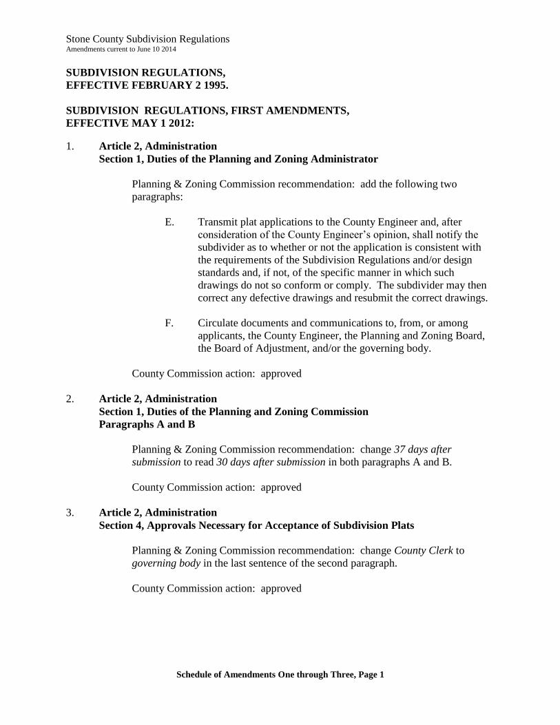
Stone County Subdivision Regulations Amendments current to June 10 2014
Schedule of Amendments One through Three, Page 1
SUBDIVISION REGULATIONS,
EFFECTIVE FEBRUARY 2 1995.
SUBDIVISION REGULATIONS, FIRST AMENDMENTS,
EFFECTIVE MAY 1 2012:
1. Article 2, Administration
Section 1, Duties of the Planning and Zoning Administrator
Planning & Zoning Commission recommendation: add the following two
paragraphs:
E. Transmit plat applications to the County Engineer and, after
consideration of the County Engineer’s opinion, shall notify the
subdivider as to whether or not the application is consistent with
the requirements of the Subdivision Regulations and/or design
standards and, if not, of the specific manner in which such
drawings do not so conform or comply. The subdivider may then
correct any defective drawings and resubmit the correct drawings.
F. Circulate documents and communications to, from, or among
applicants, the County Engineer, the Planning and Zoning Board,
the Board of Adjustment, and/or the governing body.
County Commission action: approved
2. Article 2, Administration
Section 1, Duties of the Planning and Zoning Commission
Paragraphs A and B
Planning & Zoning Commission recommendation: change 37 days after
submission to read 30 days after submission in both paragraphs A and B.
County Commission action: approved
3. Article 2, Administration
Section 4, Approvals Necessary for Acceptance of Subdivision Plats
Planning & Zoning Commission recommendation: change County Clerk to
governing body in the last sentence of the second paragraph.
County Commission action: approved
Stone County Subdivision Regulations Amendments current to June 10 2014
Schedule of Amendments One through Three, Page 2
4. Article 2, Administration
Section 6, Duties of the County Engineer
Paragraph A
Planning & Zoning Commission recommendation: add Section – 6, Duties of the
County Engineer, Paragraph A to read as follows:
A. Review of Plat Applications: The County Engineer shall review
all plat applications in order to advise as to whether the application
conforms to the regulations and/or design standards. The County
Engineer shall forward to the Planning and Zoning Director a
notice stating his/her opinion and, in the event that it is the
engineer’s opinion that the application does not so conform or
comply, the County Engineer shall notify the Planning and Zoning
Director of the specific manner in which such drawings do not so
conform or comply.
County Commission action: approved
5. Article 3, Definitions
Section 1 – Definitions
Planning & Zoning Commission recommendation: add the following to the
definition of “County Engineer”:
If the position of County Engineer is vacant, the governing body shall
appoint an engineer to perform the County Engineer’s functions under
these Subdivision Regulations.
County Commission action: approved
6. Article 3, Definitions
Section 1 – Definitions
Planning & Zoning Commission recommendation: add the following to the
definition of Planning and Zoning Administrator:
Also known as Planning and Zoning Director
County Commission action: approved

Stone County Subdivision Regulations Amendments current to June 10 2014
Schedule of Amendments One through Three, Page 3
7. Article 3, Definitions
Section 1, Definitions
Planning & Zoning Commission recommendation: add the following to the
definition of Planning and Zoning Board:
Also known as Planning and Zoning Commission
County Commission action: approved
8. Article 4, Minimum Design Standards
Section 1, Water and Sewer
Paragraph F
Planning & Zoning Commission recommendation: replace governing body with
Planning and Zoning Commission.
County Commission action: approved
9. Article 6, Submission of Plats
Section 2, Preliminary Plats
Paragraphs C and D
Planning & Zoning Commission recommendation: add the following as Section 2,
Paragraphs C and D:
C. Applicants may be offered the option of waiving the 30-day
provision of §64.830 (Approval of plats).
D. If a meeting of the Planning and Zoning Board is not scheduled
within 30 days of the filing of a plat application, and if the County
Engineer has reported upon the plat application as provided in
Article 2, Section 2 of these Subdivision Regulations, the Planning
and Zoning Administrator shall transmit to the governing body the
Plat Application and attachments, and the County Engineer’s
report. The governing body may consider the Plat Application and
attachments, and the County Engineer’s report, and decide whether
to approve, conditionally approve, or disapprove the preliminary
plat.
The current Paragraph C will become Paragraph E.
County Commission action: approved
Stone County Subdivision Regulations Amendments current to June 10 2014
Schedule of Amendments One through Three, Page 4
10. Article 7, Improvements
Section 1, Required Improvements
Paragraph I
Subparagraphs 1 through 7
Planning & Zoning Commission recommendation: add Paragraph I,
Subparagraphs 1 through 7 to read as follows:
I. Designation and Maintenance of Parks, Open Spaces, Common
Improvements, Greenspaces, Roads, Streets, Alleys or Rights-of-
way:
(1) The County will not accept in subdivision plats, dedications
to the public, or dedications to public use, of parks, open
spaces, common improvements, greenspaces, roads, streets,
alleys or rights-of-way.
(2) No plat will be approved if the plat purports to dedicate to
public use: parks, open spaces, greenspaces, roads, streets,
alleys or rights-of-way.
(3) All plans, plats, or replats of land laid out in building lots,
and the streets, alleys or other portions of the same
intended to be dedicated for public use, or for the use of
purchasers or owners of the lots fronting thereon or
adjacent thereto shall be submitted to the Stone County
Planning & Zoning Commission for its consideration.
(4) Subdivisions, developments, and/or neighborhoods shall be
platted and developed with private streets on rights-of-way
not dedicated to the public. The private streets must be
developed to County standards for design and
improvement, and be approved by the County Engineer.
(5) The subdivider of a subdivision, development, and/or
neighborhood must demonstrate to the reasonable
satisfaction of the Planning & Zoning Commission, and to
the County Commission, that the parks, open spaces,
greenspaces, roads, streets, alleys or rights-of-way in the
subdivision will be properly maintained by creation of a
homeowners’ or property owners’ association with
covenants and bylaws requiring establishment of a street
maintenance and reconstruction fund, which fund may also
be used for the cost of legal proceedings in case of
enforcement.
Stone County Subdivision Regulations Amendments current to June 10 2014
Schedule of Amendments One through Three, Page 5
(6) The final plat must include a clear statement that the parks,
open spaces, greenspaces, roads, streets, alleys or rights-of-
way are private and that the purchasers of the lots shall be
responsible to maintain the parks, open spaces,
greenspaces, roads, streets, alleys or rights-of-way.
(7) The subdivider of a subdivision, development, and/or
neighborhood must comply with Stone County Zoning
Regulations, Article 24, Common Open Space and
Common Improvement Regulations.
County Commission action: approved
11. Article 8 – Improvement Procedures
Planning & Zoning Commission recommendation: replace the entire old Article 8
with the rewritten Article 8:
ARTICLE 8, Improvement Procedures
Section 1, Land Disturbance, When.
A. If the land to be disturbed is greater than 20 acres. After
the approval of the preliminary plat, but before the
recording of the final plat, the Subdivider may do the
grading and any drainage work that is required, all
according to plans approved by the County Engineer,
provided the Subdivider has provided and received
approval of a Reclamation Bond as required by Section 3 of
this Article.
B. If the land to be disturbed is 20 acres or less. After the
approval of the preliminary plat, but before the recording of
the final plat, the Subdivider may do the grading and any
drainage work that is required, all according to plans
approved by the County Engineer.
Section 2, Construction of Physical Improvements.
A. Option 1 - Actual Construction of All Physical
Improvements Required. Before the filing of the final plat
with the Recorder of Deeds, all physical improvements
(sewer system if applicable, water system if applicable,
street paving, storm drainage, and utility lines) must be
installed in accordance with this Article; and plans and
installation approved by the appropriate utility company ;
and all grading work completed.
Stone County Subdivision Regulations Amendments current to June 10 2014
Schedule of Amendments One through Three, Page 6
B. Option 2 - Subdivision Development Bond. In lieu of the
actual construction of all physical improvements (sewer
system if applicable, water system if applicable, street
paving, storm drainage, and utility lines) before the filing
of the final plat, the Planning and Zoning Commission may
accept a bond or letter of credit in the amount that will
guarantee the construction of the required improvements
within a period of time to be specified and approved by the
Planning and Zoning Commission. Such surety shall be
properly executed and delivered to the Planning and Zoning
Director before any grading or construction begins.
Section 3, Reclamation Bond Required for Land Disturbances
Greater Than 20 Acres.
A bond secured by cash, commercial surety or letter of credit in the
amount that will guarantee the reclamation of an area that is being
significantly altered for Subdivision, commercial or industrial uses,
to provide for restoration to its natural or pre-development state.
Such surety shall be executed in the form required by this Article
and accepted by the Planning and Zoning Director before any
grading or construction begins. The amount of said bond shall be
no less than one hundred twenty-five percent (125%) of the
estimated excavation and grading costs as determined by the
Planning and Zoning Commission after hearing the
recommendation of the County Engineer. The bond must provide
for restoration of the land to its natural or pre-development state.
Section 4, Requirements for Sureties on Subdivision Development
Bonds and Reclamation Bonds.
A. All bonds shall be in form acceptable to the Planning and
Zoning Director and be executed by surety companies that
are
1. Licensed to write bonds of such character and
amount by the Missouri Department of Insurance,
and
2. Named in the current list of Companies Holding
Certificates of Authority as Acceptable Sureties on
Federal Bonds and as Acceptable Reinsurance
Companies as published in Circular 570 (amended)
by the Audit Staff Bureau of Accounts, U.S.
Treasury Department.
Stone County Subdivision Regulations Amendments current to June 10 2014
Schedule of Amendments One through Three, Page 7
B. The bond must show the amount and contain an impression
of the surety’s corporate seal.
C. A completed Power of Attorney form must accompany the
bond, indicating the name of the Attorney-in-Fact who
completed the bond, that the bond is acceptable for
financial responsibility, and that the surety company will
cover the amount of the bond; and the signatures of both
the Principal and Attorney-in-Fact must be notarized on the
bond.
D. A certified copy of the agent’s authority to act must
accompany all bonds signed by an agent. If the surety
furnished on any bond is declared bankrupt or becomes
insolvent or its right to do business is terminated in
Missouri, or it ceases to meet the requirements of this
paragraph, the Subdivider shall within five days substitute
another bond and surety, both of which must be acceptable
to the Planning and Zoning Director and meet the
requirements of this paragraph.
Section 5, Building Permits.
A. No building permit or occupancy permit shall be issued for
a lot or tract within a Subdivision unless:
(1) The physical improvements (sewer system if
applicable, water system if applicable, street paving,
storm drainage, and utility lines) have been
installed, approved by the County Engineer; or
(2) The Subdivider has provided, and the Planning and
Zoning Director has accepted, a Subdivision
Development Bond.
B. No building permit shall be issued for lot or tract within a
Subdivision unless the Subdivider has provided, and the
Planning and Zoning Director has accepted, a Reclamation
Bond, if a Reclamation Bond is required by Section 3 of
this Article.
Section 6, Plans and Specifications.
Upon the approval of the preliminary plat, the Subdivider shall
have prepared by a licensed professional engineer, engineering

Stone County Subdivision Regulations Amendments current to June 10 2014
Schedule of Amendments One through Three, Page 8
drawings for proposed required improvements containing the data
and information specified below:
A. Content of Engineering Drawings. Engineering drawings
for required improvements shall contain the following data
and information:
(1) Plans, profiles, details, specifications and cost
estimates for roadway and sidewalk construction,
including plans and profiles for each street with a
typical cross section of the roadway. The profiles
of grade lines shall be shown to a scale of 1" = 20'
horizontal, and 1" = 5' vertical. This information
shall be shown on standard plan and profile sheets
unless otherwise required.
(2) Plans, profiles, details, specifications and cost
estimates of proposed storm drainage
improvements.
(3) Plans, profiles, details, specifications and cost
estimates of proposed water distribution systems
and proposed water supply facilities and hydrants, if
any.
(4) Plans, profiles, details, specifications and cost
estimates of sewerage systems and of any required
sewage treatment facilities.
(5) Grading plans for all lots and other sites in the
Subdivision.
(6) When unusual site conditions exist, the Planning
and Zoning Director may require such additional
plans, specifications and drawings as may be
necessary for an adequate review of the
improvements to be installed.
(7) All plans shall be based on U.S.G.S. datum for
vertical control.
B. Review of Plans. The County Engineer shall review within
30 days all engineering drawings in order to advise as to
whether or not such drawings are consistent with the
approved preliminary plat and comply with their design
standards. The County Engineer shall forward to the
Stone County Subdivision Regulations Amendments current to June 10 2014
Schedule of Amendments One through Three, Page 9
Planning and Zoning Director a notice stating his/her
opinion and, in the event that it is the engineer's opinion
that the drawings do not so conform or comply, the County
Engineer shall notify the Planning and Zoning Director of
the specific manner in which such drawings do not so
conform or comply. After consideration of the County
Engineer's opinion, the Planning and Zoning Director shall
notify the Subdivider as to whether or not the drawings are
consistent with the approved preliminary plat and comply
with their design standards and, if not, of the specific
manner in which such drawings do not so conform or
comply. The Subdivider may then correct any defective
drawings and resubmit the correct drawings.
C. Approval by Planning and Zoning Commission. The
Planning and Zoning Commission shall approve a final plat
only after its determination that the plat conforms to the
requirements of these regulations and after consideration of
the County Engineer's opinion that the drawings are
consistent with the approved preliminary plat and with the
adopted County design standards.
Section 7, Construction of Improvements.
No land shall be disturbed, nor any grading or drainage work done,
nor improvements constructed, nor any work preliminary thereto
be done, until:
A. All requirements specified in the Stone County Zoning
Regulations and the Stone County Subdivision Regulations
shall have been complied with.
B. The engineering drawings for the subdivision shall have
been approved by the Planning and Zoning Commission.
C.
(1) a final plat has been approved, or
(2) a Subdivision Development Bond and a
Reclamation Bond (if required by Section 3 of this
Article) have been accepted by the Planning and
Zoning Director.
Stone County Subdivision Regulations Amendments current to June 10 2014
Schedule of Amendments One through Three, Page 10
Section 8, Inspection.
A. All improvements constructed or erected shall be subject to
inspection at any time by the County Engineer and/or the
Planning and Zoning Director.
B. The Subdivider shall give at least forty-eight (48) hours
written notification to the Planning and Zoning Director
before the performance of any of the following work:
(1) All phases of roadway construction.
(2) All phases of construction including, but not limited
to, water lines, sanitary sewer lines, storm sewer,
underground wiring, and other required
improvements.
Section 9, Inspection Procedures.
After notice is received according to Section 8.B of this Article,
the Planning and Zoning Director shall arrange for an on-site
inspection by the County Engineer to determine that the work
complies with the approved engineering plans and specifications;
except that, inspection may be by a licensed engineer employed by
the owner or developer upon approval by the County Engineer.
After such inspection has been made, the inspecting engineer shall
notify the Planning and Zoning Director of his or her opinion
thereof. If the Planning and Zoning Director shall determine, after
consideration of the opinion of the County Engineer, that such
work does not comply with the approved engineering plans and
specifications, the Planning and Zoning Director shall so notify the
Subdivider, and may require the Subdivider to terminate all further
work until necessary steps are taken to correct any defect,
deficiency, or deviation to the satisfaction of the Planning and
Zoning Director. Upon the correction of such defect, deficiency,
or deviation, the Subdivider shall again notify Planning and Zoning
Director as provided for in Section 8 of this Article.
Section 10, Final Inspection.
A. Upon completion of all improvements within the area
covered by the final plat, the Subdivider shall notify the
Planning and Zoning Director who shall arrange for a final
inspection by the County Engineer of all improvements
installed. If the inspection is made by the County Engineer,
after such inspection has been made, the County Engineer
Stone County Subdivision Regulations Amendments current to June 10 2014
Schedule of Amendments One through Three, Page 11
shall notify the Planning and Zoning Director of his or her
opinion thereof. If the Planning and Zoning Commission
shall determine, after consideration of the opinion of the
County Engineer, that there are defects, deficiencies, or
deviations in any such improvements as installed, or there
are any deviations in such improvements as installed from
the approved engineering plans and specifications, the
Planning and Zoning Director shall so notify the Subdivider
in writing, and the Subdivider shall, at its sole expense,
correct such defects, deficiencies or deviations. Once these
have been corrected, the Subdivider shall notify Planning
and Zoning Director that the improvements are ready for
reinspection.
B. The cost of one final inspection visit and review by the
County Engineer is included in the subdivision fee. The
County Engineer’s costs and expenses for further
inspections and reinspections shall be paid by the
Subdivider.
Section 11, County Will Not Accept Improvements.
The County will not accept ownership of, operation of, or
responsibility for any improvements, including common areas,
green space, sewer systems, water systems, wells, well lots, water
storage tanks, streets, storm drainage systems, and/or utility lines.
County Commission action: approved
12. Article 13, Effective Date.
Planning & Zoning recommendation: remove the entire Article 13 as suggested
by County Counselor William McCullah.
County Commission action: approved
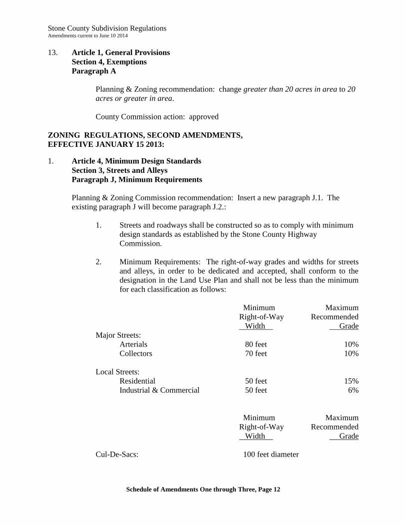
Stone County Subdivision Regulations Amendments current to June 10 2014
Schedule of Amendments One through Three, Page 12
13. Article 1, General Provisions
Section 4, Exemptions
Paragraph A
Planning & Zoning recommendation: change greater than 20 acres in area to 20
acres or greater in area.
County Commission action: approved
ZONING REGULATIONS, SECOND AMENDMENTS,
EFFECTIVE JANUARY 15 2013:
1. Article 4, Minimum Design Standards
Section 3, Streets and Alleys
Paragraph J, Minimum Requirements
Planning & Zoning Commission recommendation: Insert a new paragraph J.1. The
existing paragraph J will become paragraph J.2.:
1. Streets and roadways shall be constructed so as to comply with minimum
design standards as established by the Stone County Highway
Commission.
2. Minimum Requirements: The right-of-way grades and widths for streets
and alleys, in order to be dedicated and accepted, shall conform to the
designation in the Land Use Plan and shall not be less than the minimum
for each classification as follows:
Minimum Maximum
Right-of-Way Recommended
Width Grade
Major Streets:
Arterials 80 feet 10%
Collectors 70 feet 10%
Local Streets:
Residential 50 feet 15%
Industrial & Commercial 50 feet 6%
Minimum Maximum
Right-of-Way Recommended
Width Grade
Cul-De-Sacs: 100 feet diameter
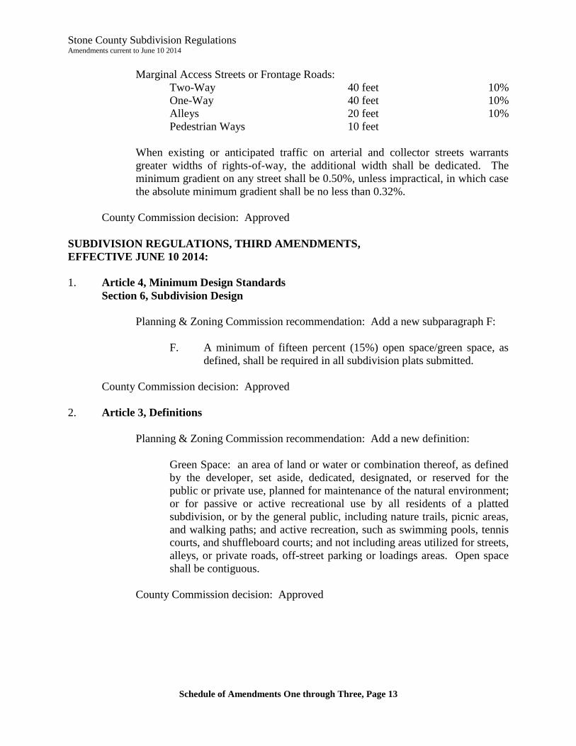
Stone County Subdivision Regulations Amendments current to June 10 2014
Schedule of Amendments One through Three, Page 13
Marginal Access Streets or Frontage Roads:
Two-Way 40 feet 10%
One-Way 40 feet 10%
Alleys 20 feet 10%
Pedestrian Ways 10 feet
When existing or anticipated traffic on arterial and collector streets warrants
greater widths of rights-of-way, the additional width shall be dedicated. The
minimum gradient on any street shall be 0.50%, unless impractical, in which case
the absolute minimum gradient shall be no less than 0.32%.
County Commission decision: Approved
SUBDIVISION REGULATIONS, THIRD AMENDMENTS,
EFFECTIVE JUNE 10 2014:
1. Article 4, Minimum Design Standards
Section 6, Subdivision Design
Planning & Zoning Commission recommendation: Add a new subparagraph F:
F. A minimum of fifteen percent (15%) open space/green space, as
defined, shall be required in all subdivision plats submitted.
County Commission decision: Approved
2. Article 3, Definitions
Planning & Zoning Commission recommendation: Add a new definition:
Green Space: an area of land or water or combination thereof, as defined
by the developer, set aside, dedicated, designated, or reserved for the
public or private use, planned for maintenance of the natural environment;
or for passive or active recreational use by all residents of a platted
subdivision, or by the general public, including nature trails, picnic areas,
and walking paths; and active recreation, such as swimming pools, tennis
courts, and shuffleboard courts; and not including areas utilized for streets,
alleys, or private roads, off-street parking or loadings areas. Open space
shall be contiguous.
County Commission decision: Approved