strategic development committee 28 march 2019
TRANSCRIPT

STRATEGIC DEVELOPMENT COMMITTEE 28 March 2019
Report of the Corporate Director of Place Classification: Unrestricted
Application for Planning Permission
click here for case file
Reference PA/16/00417
Site The Highway Business Park and The Highway Trading Centre, Heckford Street, London E1W 3HR
Ward Shadwell
Proposal Demolition of the existing structures and the construction of a new mixed-use development consisting of buildings ranging from 3 to 11 storeys in height and comprising: ‒ 5,620 sq. m GIA of office floorspace (Use Class B1a) ‒ 3,398 sq. m of industrial floorspace (Use Class B1c and B8) ‒ 699 sq. m of plant over basement, ground, first and second floor
level including a publicly accessible ground floor café; ‒ 264 residential units (Use Class C3) including on-site affordable
housing from ground to tenth floor level; ‒ basement servicing areas; ‒ landscaped open space; and ‒ new pedestrian and service routes linking Schoolhouse Lane and
Cranford Street and Cranford Street and the Highway.
Summary Recommendation
Grant planning permission with conditions and planning obligations
Applicant Workspace 12 Ltd. and Canada Life Investments Ltd
Architect Squire and Partners
Case Officer Graham Harrington & Piotr Lanoszka
Key dates - Application registered as valid on 19/02/2016 - Significant amendments received on 31/07/2018 - Public consultation finished on 31/08/2018 - Affordable housing offer revised on 25/02/2019
EXECUTIVE SUMMARY
The development represents a good example of co-locating housing and industrial space. It would deliver 35% affordable housing at a tenure split of 59.1% affordable rented (London Affordable Rent and Tower Hamlets Living Rent) to 40.9% intermediate (Shared Ownership/Intermediate Rent) while re-providing a substantial proportion of existing light industrial floorspace and delivering a significant overall uplift in employment floorspace within this Local Industrial Location.
Heights, massing and design have been substantially revised since submission and would now appropriately respond to local context, safeguarding the character and appearance of nearby heritage assets. There would be some harm (but less than substantial) to the setting

and heritage value of the listed Free Trade Wharf building when viewed from the northern Thames path and the setting and heritage value of the Wapping Wall Conservation Area. However, officers consider that the proposals would be of high architectural quality and that public benefits that would result from the scheme (including improved permeability across the site, a net increase in employment and affordable housing) would outweigh this limited harm.
The buildings would deliver high quality residential accommodation with sufficient play space and communal amenity.
The impacts on the amenity of neighbouring occupiers would be acceptable for an urban location.
The proposals would be car free and would not result in undue stress on local transport infrastructure.
Figure 1 – Site Plan Legend:
site boundary: red line
consultation boundary: dashed line
listed buildings: blue
conservation areas: shaded area

1. SITE AND SURROUNDINGS
1.1 The application site measures approximately one hectare and is located on the northern side of The Highway, within a short walking distance of the Limehouse Neighbourhood Centre. It contains small and medium sized industrial units arranged in two parcels, together with associated hardstanding and car parking. The Highway Trading Centre (to the west of Heckford Street) comprises 5 larger units and includes retail warehousing (Screwfix and lighting suppliers) with publicly accessible car parking. The Highway Business Park (to the east) contains mainly smaller industrial/showroom units. The site currently supports 4,623sqm of light industry/warehousing and 304sqm of retail warehouse.
1.2 The site is within a designated Local Industrial Location and the southern part is within an Archaeological Priority Area.
1.3 The ground level within the site slopes gently from north to south. The one and two-storey industrial buildings on site are of no heritage value and the site is not located within a conservation area.
1.4 The site benefits from very good public transport accessibility (a PTAL rating of 5) due to its location close to the DLR, National Rail and Overground train stations at Limehouse (approximately 500m to the north-east) and Shadwell (approximately 900m to the west) and the five bus routes running along Commercial Road and The Highway. Those roads form part of the Transport for London Strategic Road Network. Cycle Superhighway CS3 runs along Cable Street which bounds the site to the north. The southernmost part of the site is within the safeguarding zone of the Rotherhithe Tunnel and the site envelops one of the tunnel‟s ventilation shafts.
1.5 The surrounding area is of an inner-city mixed-use character with a variety of building heights and architectural styles.
‒ To the west, across Schoolhouse Lane, are: The Shadwell Centre (a former Victorian school, now an Idea Store Learning Centre), 6-8 storey new built residential blocks and a multi-use games court.
‒ To the north, across Cable Street, are: a post war 4 storey public housing estate and a former public hose converted into residential use.
‒ To the east, across Cranford Street, are: the mixed commercial use 4 storey Cable Street Studios and 2 storey residential Cranford Cottages, which lie within the York Square Conservation Area, as well as the 8 storey Holiday Inn Express hotel.
‒ To the south, across The Highway, are: the 4 storey Grade II* listed warehouse buildings at Free Trade Wharf (currently in residential use and part of the Wapping Wall Conservation Area), as well as more recent residential developments of between 8 and 11 storeys.
2. PROPOSAL
2.1 The proposed development and the evolution of the design are described in detail within the applicant‟s Design and Access Statement (and its addendums). In brief, the applicant seeks to redevelop the site to provide new homes and business floorspace while re-providing light industrial floorspace within new state of the art premises.
2.2 The proposed development has been laid out in two parts, joined by a new east-west street linking Schoolhouse Lane and Cranford Street, as illustrated on the below drawing. However, the applicant intends to build out the development as a single phased scheme, albeit sequenced over about 36 months.
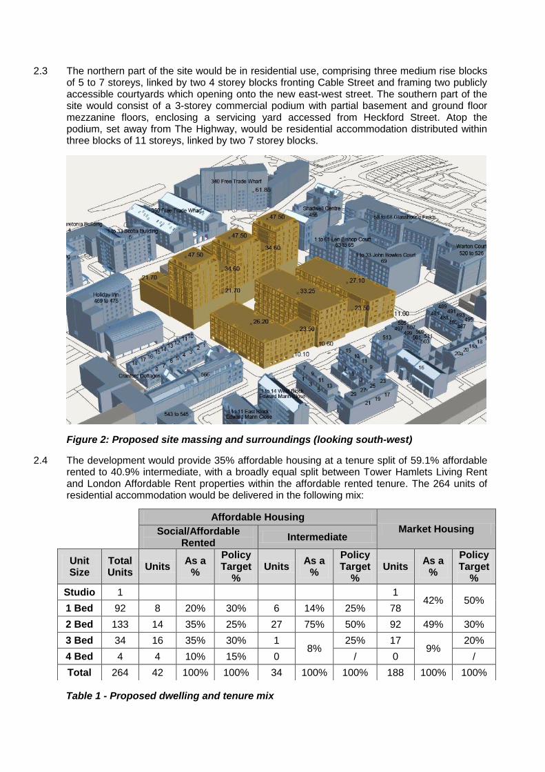
2.3 The northern part of the site would be in residential use, comprising three medium rise blocks of 5 to 7 storeys, linked by two 4 storey blocks fronting Cable Street and framing two publicly accessible courtyards which opening onto the new east-west street. The southern part of the site would consist of a 3-storey commercial podium with partial basement and ground floor mezzanine floors, enclosing a servicing yard accessed from Heckford Street. Atop the podium, set away from The Highway, would be residential accommodation distributed within three blocks of 11 storeys, linked by two 7 storey blocks.
Figure 2: Proposed site massing and surroundings (looking south-west)
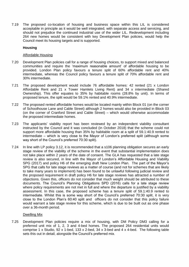
2.4 The development would provide 35% affordable housing at a tenure split of 59.1% affordable rented to 40.9% intermediate, with a broadly equal split between Tower Hamlets Living Rent and London Affordable Rent properties within the affordable rented tenure. The 264 units of residential accommodation would be delivered in the following mix:
Table 1 - Proposed dwelling and tenure mix
Affordable Housing
Market Housing Social/Affordable Rented
Intermediate
Unit Size
Total Units
Units As a
%
Policy Target
% Units
As a %
Policy Target
% Units
As a %
Policy Target
%
Studio 1 1 42% 50%
1 Bed 92 8 20% 30% 6 14% 25% 78
2 Bed 133 14 35% 25% 27 75% 50% 92 49% 30%
3 Bed 34 16 35% 30% 1 8%
25% 17 9%
20%
4 Bed 4 4 10% 15% 0 / 0 /
Total 264 42 100% 100% 34 100% 100% 188 100% 100%

2.5 The development would re-provide 3,398sqm of light industrial/warehousing floorspace (out of the existing 4,623sqm of light industrial/warehousing space), while delivering a new SME office-based business hub of 5,620sqm, significantly increasing the employment density of the site. The office unit sizes would range from 31 to 193sqm (NIA). The business hub would also include shared facilities, including a ground floor café/bar/break out space, meeting rooms shower/changing facilities in the basement. The below table illustrates the existing and proposed mix of commercial floorspace.
Existing Uses Floorspace (approximate sqm – GIA excluding plant)
Overall Business and retail warehousing 4,927
B1(c) and B8 (Light industry and warehousing)
B8 (retail warehousing
4,623 304
Proposed Uses
Residential (C3) 25,550 (approx. 74%)
Overall Business 9,018 (approx. 26%
B1(a) Offices
B1 (c) and B8 (Light industry and warehousing)
5,620 3,398
Table 2 – Existing and proposed uses
2.6 The scheme would be „car free‟, except for 4 x on-site blue badge holder parking spaces. A total of 509 long-stay cycle parking spaces would be provided. The light industrial/warehousing accommodation would benefit from a partially covered yard.
2.7 The architecture of the scheme would be contemporary in character, with rich detailing and a material palette centred on the use of robust materials such as brick and metal panels, as illustrated in the applicants‟ Design and Access Statement and re-produced below. Further selected plans and images of the proposed development are set out in Appendix 2.
Figure 3: Bay study of proposed light industrial and business units.

Figure 4: Bay studies of proposed residential units (low rise - left, tower - right)
Figure 5: CGI verified view of the scheme from The Highway (looking north, up Schoolhouse Lane)

3. RELEVANT PLANNING HISTORY
3.1 The Highway Trading Estate (west of Heckford Street) was granted permission in January 1981 (PA/80/00937). The Highway Business Park (east of Heckford Street) was granted permission in July 1986 (PA/86/00937). There are no planning permissions of note on the application site. Individual units on both estates have been subject to various changes of use/alterations/signage. In May 2015, the Council issued an Environmental Impact Assessment (EIA) Screening Opinion (PA/15/01232) confirming that EIA was not required for the redevelopment of the site (5,050sqm of B1 floorspace and approx. 300 residential units).
3.2 As part of its response to Thames Water‟s Thames Tideway Tunnel (TTT), the Council resisted the use of part of King Edward Memorial Park (KEMP) foreshore for the construction of the North East Storm Relief (NESR) sewer and a vertical drop shaft to the main tunnel. Instead, it made the case for the „Heckford Option‟. This involved two worksites: a small one in KEMP to intercept the NESR sewer, connected by a transfer tunnel to a larger work site on the application site where the vertical shaft would have been constructed. In the end, the Council failed to convince the Government of the merits of this alternative. The TTT Development Consent Order 2015 grants consent for the larger KEMP foreshore option and the works are currently under way.
4. PUBLICITY AND ENGAGEMENT
4.1 The applicants carried out public consultation prior to submission of the application in February 2016. The applicants also held a pubic exhibition in early July 2018 on proposed revisions to the scheme, which were submitted in August 2018 (details set out in the applicant‟s Community Involvement Update).
4.2 Following the receipt of the application, the Council notified nearby owners/occupiers by post and by site notices. A press advert was also published in a local newspaper.
4.3 The first round of public consultation took place in March 2016, with further consultation in relation to revisions to the original scheme taking place in April 2017.
4.4 A total of 26 representations were received, from residents living in Fatham Court (Cable Street), Free Trade Wharf Atlantic Wharf/Campania Building, John Bowles Court (Schoolyard Lane) and Len Bishop Court (Schoolyard Lane). Objections have also been received from the Free Trade Wharf Residents Association and Management Company).
4.5 The following issues have been raised in objection:
‒ Inadequate prior consultation
‒ Lack of discussion about Thames Tideway Tunnel/cumulative impact with this and other developments
‒ Additional traffic/increase in noise & pollution
‒ Excessive height/ out of character/overdevelopment/ excessive density
‒ Loss of view
‒ Loss of privacy/overlooking
‒ Loss of daylight/sunlight and overshadowing
‒ Adverse impact on listed building (Free Trade Wharf)
‒ Loss of jobs
‒ Proposed café should be on the Cable Street frontage
‒ Unsatisfactory play areas/lack of open space for local people

‒ Inadequate affordable housing
‒ Adverse impact on local services
‒ Noise and disturbance during construction
4.6 The Holiday Inn has written to provide qualified support for the proposal (subject to appropriate controls of demolition and construction, TV reception surveys and improved lighting when built).
4.7 Neighbouring owner/occupiers were consulted again on a significantly revised scheme that was received in August 2018. A total of 8 representations were received, raising the following objections:
‒ Inadequate prior consultation
‒ Lack of car parking/increased pressure on local streets
‒ Lack of open space for local people
‒ Excessive height/out of character/overdevelopment/ excessive density
‒ Loss of view
‒ Loss of daylight/sunlight and overshadowing (applicant‟s assessment not accurate, applicant‟s model should be made available)
‒ Proposed café should be on the Cable Street frontage
‒ Loss of jobs
‒ Inadequate affordable housing
‒ Adverse impact on local services
4.8 Three letters of support have been received, raising the following issues:
‒ Replacement of poor-quality buildings with strong development that addresses surrounding streets
‒ Will improve site and dissuade current drug dealing
‒ Introduction of small businesses and café
‒ Improved connectivity.
5. CONSULTATION RESPONSES
5.1 Internal and external consultees were originally consulted in March 2016, further consultations in relation to revisions to the scheme took place in April 2017 and August 2018.
Georgian Group
5.2 In principle, the Georgian Group does not object to the development. In its existing form, the site does not make a positive contribution to the setting of Free Trade Wharf and presents an imposing, inactive prospect from The Highway. The Group would encourage strong activation of the south side of the development site and welcomes the proposed opening-up of the interior of the site through the creation of a new, east-west route.
5.3 The Group notes that the Townscape and Visual Impact Assessment accompanying the application failed to assess views from the south side of the river. Such views show the visual impact of the proposed development on Free Trade Wharf, with the tallest 16-storey element of the proposals being sited directly behind the listed building in axial views. It is therefore suggested that it may be preferable to reverse the arrangement of the taller elements of the proposal, to situate the 10-storey tower on the western boundary of the site, and the tallest element on the eastern boundary, reducing the visual impact on the listed building.
5.4 (The above comment was provided in response to the original proposals. The Georgian Group provided no response to the latest round of consultation)
Greater London Authority
Principle of development
5.5 The proposals would significantly enhance the extent of employment floorspace on the site with an increase from 4,927sqm. to 9,018sqm. and, whilst not meeting the threshold for industrial re-provision within the draft London Plan, the proposals would provide an appropriate mix of employment and residential uses in this location.
Affordable housing
5.6 The development would deliver 35% affordable housing by habitable room, which is subject to robust interrogation by GLA officers to ensure that the maximum level of affordable housing is provided. Early and late stage reviews should be secured.
Urban and inclusive design
5.7 The residential quality is generally high and the layout, height and massing responds well to the existing and emerging context. A Management Plan should be secured by condition.
Historic environment
5.8 The proposals would result in some less than substantial harm to Free Trade Wharf and the adjacent conservation areas. However, the public benefits would outweigh this harm.
Climate change
5.9 The proposed heating strategy should be reviewed – CHP not appropriate. Carbon dioxide savings for both the domestic and non-domestic elements fall short of the policy targets and as such the applicant should explore the scope for additional measures to achieve further carbon reductions, including the maximisation of on-site PV installation. The surface water drainage strategy needs improving and additional attenuation storage needed. Further reductions in water consumption for the proposed development are also required.
Transport
5.10 Further long-stay and short-stay cycle parking should be provided. 8 Blue Badge car parking spaces should be provided from the outset. Full residential and commercial travel plans, final construction logistics plan and delivery and servicing plans should be secured.
Historic England – Archaeology
5.11 Requests a planning condition requiring works to be undertaken in accordance with a Stage 1 Written Scheme of Investigation and that any parts of the site where heritage assets of archaeological interest have been identified at Stage 1 are subject to a Stage 2 assessment.
London City Airport
5.12 No safeguarding objection to the proposed development.
London Fire & Emergency Planning Authority
5.13 Pump appliance access and water supplies for the fire service were not specifically addressed in the supplied documentation, however they do appear adequate. In other respects, this proposal should conform to the requirements of part B5 of Approved Document B.

Metropolitan Police – Crime Prevention
5.14 Concern that the Design & Access Statement makes no reference to crime prevention. Requests planning conditions to require Secured by Design accreditation.
NATS
5.15 No safeguarding objection to the proposed development.
Natural England
5.16 The scheme as amended is unlikely to have significant effects on the natural environment.
Thames Water
5.17 No objection subject to: (i) Condition requiring approval and implementation of water network upgrades/housing infrastructure phasing plan and prior to occupation; (2) Condition – approval of works within 5m of water main; (3) informatives about proximity to a number of underground assets and prior approval of discharge of surface water into public sewer.
Transport for London
5.18 A number of comments on car and cycle parking, based on the application as originally submitted. TfL has no objection to the proposed servicing arrangements however the applicant should clarify whether the safeguarding of the Rotherhithe tunnel vent shaft has been agreed with TfL. Construction Logistics Plan should be secured by condition. Travel Plan details are acceptable. Content that the development will not have a material impact on the transport network.
LBTH Environmental Health
Noise & Vibration
5.19 No objection subject to conditions requiring: Noise survey prior to installation of mechanical plant/ventilation/flues and imposition of appropriate standards and approval of a Construction Environmental Management Pan.
Air Quality
5.20 The Air Quality Assessment shows that the NO2 Annual Objective would be exceeded or neared at several receptors. Mitigation needs to be provided at all units predicted to exceed or nearly exceed the annual NO2 objective to make the development suitable for residential use.
5.21 The Air Quality Assessment shows that the Air Quality Neutral requirements are not met – mitigation needed to reduce emissions to meet these requirements.
5.22 All boilers and CHP must meet the GLA‟s NOx emissions standards.
Contaminated Land
5.23 No objection, subject to standard conditions.
LBTH Transportation & Highways
5.24 No objection subject to the imposition of conditions requiring approval of a Construction Environmental Management Plan, scheme of highway works, Delivery and Service Plan, Car Park Management Plan and Travel Plans

Other consultees
5.25 The following were consulted but did not comment:
‒ Ancient Monuments Society
‒ Council for British Archaeology
‒ Environment Agency
‒ Historic England (above ground assets)
‒ Society for the Protection of Ancient Buildings
‒ Twentieth Century Society
6. RELEVANT PLANNING POLICIES AND DOCUMENTS
6.1 Legislation requires that decisions on planning applications must be taken in accordance with the Development Plan unless there are material considerations that indicate otherwise.
6.2 In this case the Development Plan comprises:
‒ The London Plan 2016 (LP)
‒ Tower Hamlets Core Strategy 2010 (SP)
‒ Tower Hamlets Managing Development Document 2013 (DM)
6.3 The key development plan policies relevant to the proposal are:
Land Use - LP4.1, LP4.2, LP4.4, LP4.7, SP01, SP06, DM1, DM17
(local industrial locations, offices, retail and restaurant uses)
Housing - LP3.3 -3.13, SP02, DM3, DM4
(affordable housing, unit mix, density, play space, housing quality)
Design - LP7.1-7.8, LP7.18, SP09, SP10, SP12, DM10, DM23, DM24, DM26, DM27
(layout, massing, building heights, materials, public realm, heritage)
Amenity - LP7.6, LP7.15, SP03, SP10, DM25
(privacy, outlook, daylight and sunlight, construction impacts)
Transport - LP6.1, LP6.3, LP6.9, LP6.10, LP6.13, LP6.14, SP05, SP09, DM14, DM20, DM21, DM22
(sustainable transport, highway safety, car and cycle parking, waste, servicing)
Environment
- LP3.2, LP5.1 - 5.15, LP5.21, LP7.14, LP7.19, LP7.21, SP03, SP04, SP11, DM9, DM11, DM13, DM29, DM30
(biodiversity, energy efficiency, air quality, drainage, contaminated land)
6.4 Other policy and guidance documents relevant to the proposal are:
‒ National Planning Policy Framework (2019)
‒ National Planning Practice Guidance (updated 2019)
‒ LP Housing SPG (updated 2017)
‒ LP Affordable Housing and Viability SPG (2017)

‒ LP Land for Industry and Transport SPG (2012)
‒ LP Draft New London Plan (2018)
‒ LBTH Employment Land Review (2016)
‒ LBTH Planning Obligations SPD (2016)
‒ LBTH Draft Local Plan (2019)
7. PLANNING ASSESSMENT
7.1 The key issues raised by the proposed development are:
i. Land Use
ii. Housing
iii. Design & Heritage
iv. Neighbour Amenity
v. Transport
vi. Environment
vii. Infrastructure
viii. Local Finance Considerations
ix. Equalities and Human Rights
Land Use
Redevelopment in a Local Industrial Location
7.2 The site forms part of the designated Highway Local Industrial Location (LIL), which extends between The Highway and Cable Street (Schoolhouse Lane to Butcher Row). Policy SP06 supports the provision of a range of and mix of employment uses and Policy DM17 makes clear that the redevelopment of sites with industrial B Use Class floorspace in LILs, to include residential uses, will only be supported if the existing industrial B Use Class floor space is re-provided on site and where it:
a. provides separate access and servicing for commercial uses and residential uses; b. ensures the provision of residential uses does not jeopardise the function and viability
of the industrial B Use Class on the site and within the wider LIL; c. provides high quality flexible working space which is usable; and d. provides a range of flexible units including units less than 250sqm and less than
100sqm to meet the needs of Small and Medium Enterprise (SMEs).
B1(c) Light industrial and B8 warehousing space
7.3 The proposed light industrial/warehousing space amounts to 3,398sqm and would comprise 11 units in Block 07, ranging in size from 71sqm to 652sqm (NIA), providing a wide range of unit types to suit light industrial/warehousing demand and match the mix currently seen on the existing site. The units would be at ground floor and part mezzanine levels, serviced from the service yard accessed from The Highway. The double-height element of each unit would have a floor to ceiling height of approx. 5.4m. The western part of the service yard would be covered by a 6m high roof (to mitigate noise and provide additional covered storage space).
B1(a) office space
7.4 The proposed office space amounts to 5,620sqm and would comprise 58 units ranging in size from 31sqm to 193sqm (NIA). There would be two units on the ground floor of Block 07 fronting on to the proposed new section of Cranford Street. There would then be 28 office

units of varying sizes on both the first and second floors of Block 07 (above the light industrial/warehousing units and associated shared services). Each floor would include two meeting rooms, break out space and tea points. The office units would have a floor to ceiling height of approx. 2.7m. The range of proposed office studio sizes has been tailored to closely match demand witnessed for similar unit sizes at successful Workspace developments in other parts of Tower Hamlets including at Bow Enterprise Park, the Pill Box in Bethnal Green and Poplar Business Park.
Shared Services
7.5 The proposed ground floor café/bar and break out area would be serviced by a commercial kitchen, with two small meetings rooms adjacent. It would provide a central hub to the building where businesses could meet. It would be open to both the office and industrial businesses as well as the general public. A combined light industrial/warehousing/office refuse storage area would be located adjacent to Schoolhouse Yard. A dedicated basement area would provide easy and direct access for employees to changing/shower facilities and cycle storage areas.
Business model
7.6 Joint applicant, Workspace, has confirmed that it intends to manage the proposed business space. As an organisation, Workspace, offers flexible lease terms that support businesses as they grow and do not require significant deposits and/or guarantors that can be challenging and restrictive to young companies. Workspace has confirmed that the proposed office and light industrial/warehousing units would be available on its standard two-year lease, subject to a rolling 6-month tenant only break option and that new customers would have a three-month trial period, after which, they may break their lease if their circumstances have changed, offering additional flexibility.
7.7 Workspace has also confirmed that it intends to quote rents as inclusive of service charge to allow customers to budget and benchmark easily, pre-install data and telephony and allow individuals/small businesses that do not want to commit to a lease to rent desks, meeting rooms etc. and attend events. Whilst it is not certain that Workspace would manage the business space and it would be inappropriate to secure any of the operational matters raised above through the S106 agreement, it is likely to be in the interest of any future operator to manage the proposed space in a similar way to ensure that they attract a sufficient number of SME businesses.
Assessment of the proposals against policies SP06 and DM17
7.8 The proposed business element of the scheme would result in a net loss of 1,529sqm of potential industrial/warehousing space – although it should be noted that 304sqm of the existing space is occupied by quasi retail space (Screwfix and a wholesale lighting business). In addition, it would result in a net gain of 4,091sqm of overall business space and employment (as discussed below) when the proposed office space is taken in to account, representing an 83% increase in business space. In this context, officers consider that the net loss of industrial space would be acceptable.
7.9 Separate access and servicing arrangements for housing and business uses would be provided.
7.10 The proposed housing should not jeopardise industrial uses in the eastern part of the Highway LIL. The likely impacts on business studios in Thames House (Cable Street Studios) on the east side of Cranford Street would be acceptable and the proposals should not prejudice the continued operation of the Cemex concrete batching plant on the corner with Butcher Row (as the Holiday Inn provides a buffer).

7.11 The proposed workspace would be high-quality and flexible.
7.12 The proposed light industrial/warehousing and office space would be suitable for SMEs and includes a large number of small office units under 100sqm.
7.13 A recommended condition would remove permitted development rights to change from B1/B8 to residential use, thereby ensuring that the Council would retain the ability to determine planning applications for any such proposed changes of use.
Employment
7.14 The existing site comprises approx. 4,927sqm (industrial/warehousing/retail) and has the potential to employ approx. 135 Full Time Equivalent (FTE) employees, based on the HCA Employment Density Guide (3rd Edition, 2015). Based on the HCA Guide, the proposed light industrial/warehousing and office floorspace would have the potential to employ between approx. 517 and 540 FTE employees. This would represent an increase of between 382 and 405 FTE jobs. In accordance with the Council‟s Planning Obligations SPD, it is recommended that a financial contribution of £181,976 is secured towards the training and development of unemployed residents in the borough, to help them take up the job opportunities.
Affordable workspace
7.15 The Council‟s emerging Local Plan policy D.EMP2 calls for at least 10% of new employment space within major commercial and mixed-use schemes to be provided as „affordable workspace‟ (let at below market rates). The Council has used this emerging policy to secure affordable workspace on some recent schemes. However, in this case, officers are satisfied that the financial viability of the proposed scheme does not allow for affordable workspace to be secured in addition to providing the proposed 35% affordable housing. Furthermore, the Workspace‟s proposed business model would ensure a range of flexible business space for SMEs at various rent levels.
Displacement of existing businesses
7.16 The majority of the existing units on the site are occupied on a short-term let basis with many of the existing tenants paying rents that the applicants do not consider to be commensurate with the local market rate. This is a direct result of the owners seeking to keep the existing Trading Estate and Business Park occupied, prevent them from becoming derelict and unsightly and to avoid substantial void service charges and empty rates, which the owners would otherwise be liable for. The proposed comprehensive development would require tenants to identify alternative premises that would cater for their needs. The applicants are willing to minimise disruption for industrial/warehousing tenants on the Business Park (who have longer-term leases than the Trading Estate) through the following measures:
‒ Minimum 6 month notice of the termination of the lease and the need to leave the site;
‒ First right of refusal (1 month prior to marketing) to return to a new unit within the scheme; and
‒ In-house advice from the applicants (or their agents) about identifying alternative properties and locations to move to on a temporary or permanent basis
7.17 Officers recommend that the above commitments are secured by way of a s106 planning obligation.
Housing
7.18 Development Plan policies set minimum housing targets for Tower Hamlets and seek to ensure that the amount of housing is optimised on all sites where it is appropriate.
7.19 The proposed co-location of housing and business space within this LIL is considered acceptable in principle as it would be well integrated, with separate access and servicing, and should not prejudice the continued industrial use of the wider LIL. Redevelopment including 264 new homes would be consistent with key Development Plan policies, would help the Council meet its housing targets and is supported.
Housing
Affordable Housing
7.20 Development Plan policies call for a range of housing choices, to support mixed and balanced communities and require the „maximum reasonable amount‟ of affordable housing to be provided. London Plan policy favours a tenure split of 60% affordable rent and 40% intermediate, whereas the Council policy favours a tenure split of 70% affordable rent and 30% intermediate.
7.21 The proposed development would include 76 affordable homes: 42 rented (21 x London Affordable Rent and 21 x Tower Hamlets Living Rent) and 34 x intermediate (Shared Ownership). This offer equates to 35% by habitable rooms (28.8% by unit). In terms of proposed tenure, the split would be 59.1% rented and 40.9% intermediate.
7.22 The proposed rented affordable homes would be located mainly within Block 01 (on the corner of Schoolhouse Lane and Cable Street) although 2 homes would also be provided in Block 03 (on the corner of Cranford Street and Cable Street) – which would otherwise accommodate the proposed intermediate homes.
7.23 The applicants‟ viability report has been reviewed by an independent viability consultant instructed by the Council and it was concluded (in October 2018) that the scheme could not support more affordable housing than 35% by habitable room at a split of 59.1:40.9 rented to intermediate – which is very close to the Mayor of London‟s preferred split (although some way short of the Council‟s preferred 70:30 split).
7.24 In line with LP policy 3.12, it is recommended that a s106 planning obligation secures an early stage review of the viability of the scheme in the event that substantial implementation does not take place within 2 years of the date of consent. The GLA has requested that a late stage review is also secured, in line with the Mayor of London‟s Affordable Housing and Viability SPG (2017) and policy H6 of the emerging draft New London Plan. The part of the Mayor‟s SPG that calls for late stage reviews as a matter of course (and not for schemes that are likely to take many years to implement) has been found to be unlawful following judicial review and the proposed requirement in draft policy H6 for late stage reviews has attracted a number of objections. Given this, officers do not consider that much weight should be attributed to these documents. The Council‟s Planning Obligations SPD (2016) calls for a late stage review where policy requirements are not met in full and where the departure is justified by a viability assessment. In this case, the proposed scheme has a tenure split of 59.1:40.9 rented to intermediate. Whilst this is some way short of the Council‟s preferred 70:30 split, it is very close to the London Plan‟s 60:40 split and officers do not consider that this policy failure would warrant a late stage review for this scheme, which is due to be built out as one phase over a 36-month period.
Dwelling Mix
7.25 Development Plan policies require a mix of housing, with DM Policy DM3 calling for a preferred unit mix of 1, 2, 3 and 4-bed homes. The proposed 264 residential units would comprise 1 x Studio, 92 x 1-bed, 133 x 2-bed, 34 x 3-bed and 4 x 4-bed. The following table sets this out in detail, alongside the Council‟s preferred mix.

Table 3 - Proposed dwelling and tenure mix
7.26 The above demonstrates a fairly good match with the Council‟s preferred dwelling mix for rented affordable housing (with 45% of homes being for families). The proposed intermediate and market housing mix is considered acceptable although it is 2-bed heavy.
Accessible Housing
7.27 Development Plan policies require 90% of new housing to meet Building Regulations 2010 (2015 version) requirement M4(2) „accessible and adaptable dwellings,‟ and 10% to meet requirement M4(3) „wheelchair user dwellings‟ i.e. designed to be wheelchair accessible or easily adaptable.
7.28 All proposed homes would meet the „accessible and adaptable dwellings‟ standard and the following 28 homes (10.6%) of homes would meet the „wheelchair user dwellings‟ standard.
Tenure 1-bed 2-bed 3-bed
4-bed Total
Market Sector
- 16 -
16
Intermediate
- 7 -
7
Rented Affordable - 3 -
2 5
Total - 26 - 2
28
Table 4: Proposed wheelchair accessible homes
7.29 The proposed wheelchair accessible homes would be located on lower floors (Levels 2 to 6) of buildings and, in accordance with the Mayor of London‟s Housing SPG, be served by two lifts.
7.30 It is recommended that a planning obligation secures the approval of 1:50 details and fit-out of the proposed rented affordable „wheelchair user dwellings‟
Affordable Housing Market Housing Social/Affordable
Rented Intermediate
Unit Size
Total Units
Units As a
%
Policy Target
% Units
As a %
Policy Target
% Units
As a %
Policy Target
%
Studio 1 1 42% 50%
1 Bed 92 8 20% 30% 6 14% 25% 78
2 Bed 133 14 35% 25% 27 75% 50% 92 49% 30%
3 Bed 34 16 35% 30% 1 8%
25% 17 9%
20%
4 Bed 4 4 10% 15% 0 / 0 /
Total 264 42 100% 100% 34 100% 100% 188 100% 100%

Quality of Residential Accommodation
7.31 Development Plan policies require new dwellings to be of a high standard. This includes requirements to meet minimum floorspace and private amenity space standards, provide appropriate noise insulation, air quality, privacy & outlook, daylight/sunlight and wind/microclimate.
Housing Standards and Guidance
7.32 All of the proposed homes would meet the relevant floorspace/amenity standards, would have a reasonable layout and meet the recommended minimum floor to ceiling height of 2.5. Lift/stair cores would serve between 3 and 8 dwellings (which is the recommended maximum). At 76 (29%), the proposals include a relatively high number of single-aspect dwellings, particularly in Blocks 01, 02 and 03. However, none would be wholly north-facing (with small east and west facing windows included in some dwellings) and none in Blocks 04, 05, or 06 would face the noisy/polluted Highway. Given this and other design constraints, the number of single aspect homes is considered acceptable.
Noise & Vibration
7.33 The proposals would introduce additional homes in to an already noisy area, although the proposed homes in Blocks 04, 05 and 06 are set back between approximately 25 and 30m from the Rotherhithe Tunnel vent shaft and back edge of The Highway‟s footway and located at third floor and above. Business B1 accommodation (light industry and offices) is, by definition, compatible with housing and should not cause unacceptable noise for future residents. Given the proposed size and configuration of units and the inclusion of a partly roofed service yard any B8 warehousing use would also be compatible.
7.34 The applicant‟s Noise Assessment finds that acceptable internal noise levels are achievable. Nevertheless, it is recommended that conditions reserve details of glazing/ventilation for subsequent approval and manage noise from mechanical plant.
Air Quality
7.35 The proposals would introduce additional homes in to an area of poor air quality, although as noted above, the proposed homes in Blocks 04, 05 and 06 are set back from Rotherhithe Tunnel ventilation shaft and The Highway and located at third floor and above. The applicant‟s Air Quality Assessment identifies 11 proposed flats (located on the lower residential floors of Blocks 01, 04, 05, and 06) which would need additional mitigation – in the form of the installation of filtration in combination with mechanical ventilation or the provision of cleaner air ducted from the shielded side of the proposed development. It is recommended that such details are reserved by condition.
Privacy & Outlook
7.36 Some proposed dwellings in Blocks 01, 02 and 03 would face each other across the proposed courtyards and be approx. 16m apart. This is below the indicative 18m minimum suggested by supporting text to policy DM25, but standards must be applied flexibly and the overall level of amenity for future residents would be high. Some proposed dwellings would face each other across the proposed new east-west street and be approx. 13m apart. However, such a distance is not uncommon across streets in Tower Hamlets and is considered acceptable. All of the proposed homes would have an acceptable outlook.
Daylight, Sunlight & Overshadowing
7.37 The application is supported by a Daylight and Sunlight Report. This report has been reviewed on behalf of the Council by BRE consultants.

7.38 The applicants‟ Report sets out the findings of an assessment of daylight of the proposed homes, using Average Daylight Factor (ADF) and Daylight Distribution (DD). This finds that 595 of the 736 rooms tested (81%) fully comply with guidance in relation to ADF and 537 rooms (73%) fully comply with guidance in relation to DD. BRE conclude that the generally good proposed daylight provision for Blocks 04,05 and 06 would be contrasted with areas of very poor provision in Blocks 01, 02 and 03. For these Blocks, BRE identify some non-daylit kitchen/dining areas and 21 x poorly lit associated living areas, together with 30 combined living/kitchen/dining areas and 30 bedrooms that would be below recommended standards due to the proposed layout and design of balcony areas. The provision of private amenity space is required by Development Plan policies and makes a positive contribution to the overall quality of homes. Given this and the overall quality of the proposed homes, including meeting or exceeding floorspace and floor to ceiling standards, the proposed daylight amenity is considered acceptable.
7.39 The applicants‟ Report also sets out findings of an assessment of sunlight of windows facing south, using Annual Probable Sunlight Hours (APSH). This shows that of the 386 rooms tested, 144 (37%) comply with the BRE guidelines. BRE conclude that sunlight provision for Blocks 04, 05 and 06 would be average, but again contrast this with for Blocks 01, 02 and 03 which would be very poor. Outside of the top two floors of Block 2, only 10 living rooms would meet the annual and winter recommendations. The proposed north-south alignment of Blocks 01, 02 and 03, which is otherwise a good response to surrounding character and grain, produces an inherent restriction in sunlight amenity. Officers consider that the proposed inset balconies would partially mitigate this by allowing residents to access sunlight when sitting/standing in these areas.
7.40 The applicant‟s Daylight and Sunlight Report finds that only 12% of the proposed western residential courtyard and none of the proposed eastern courtyard would receive 2 hours of sunlight on 21 March (as opposed to the 50% called for in the BRE Guidelines). BRE conclude that this would be very poor. However, officers consider that, subject to considering details of hard and soft landscaping and play provision, the overall quality of these proposed spaces would be high and the limited sunlight at this time of year would be acceptable. Furthermore, nearly 100% of both spaces would receive at least 2 hours of sunlight on 21 June.
Wind/Microclimate
7.41 The applicants‟ Pedestrian Level Wind Microclimate Assessment identifies the proposed residential entrance to Block 01 as being likely to be one condition windier than the desired conditions and in response, the applicants have relocated it further east (away from the corner). Microclimate conditions in all of the other areas would be appropriate for the intended use of those areas.
Communal Amenity Space & Play Space
7.42 Policy DM4 requires communal amenity space (at a minimum of 50sqm for the first 10 dwellings and 1sqm for every additional unit). This generates a need for 304sqm. The proposed development includes communal space in the two residential courtyards which amounts to 656sqm. Although this includes space up to the windows of ground floor homes in some cases, and as such exaggerates the amount of useable communal space, the proposed space is more than sufficient and it would be high quality. The proposal also includes an open space next to The Highway (Approx. 414sqm excluding play space).
7.43 Development Plan policies require provision of children‟s play space (10sqm per child). The GLA‟s child yield calculator estimates that the development would generate 80 children (34 x children under 5, 27 x children aged 5-11 and 19 x children aged 12+) requiring 800sqm of child play space.

7.44 The proposed scheme incorporates play space for younger children (up to 11) within the proposed residential courtyards for Blocks 01, 02 and 03 and play space for older children next to The Highway.
7.45 Younger children living in Blocks 04, 05 and 06 would need to use play space within the proposed residential courtyards for Blocks 01, 02 and 03. This is not ideal, but the shared-surface nature and low-traffic environment of the proposed east-west street help make this acceptable. It is recommended that details of communal/play space are reserved by condition to allow consideration of details of a buffer zone between communal space and ground floor windows and the allocation and details of play space.
Density
7.46 Policies LP3.4 and SP02 require development to „optimise’ housing output taking account of public transport accessibility, local context and character and design principles and for proposals which compromise this policy to be resisted. The London Plan provides a ‘Sustainable residential quality density matrix’ for differing locations based on character and PTAL. The site has an Urban character and has a PTAL of 5. For such sites, the matrix provides an indicative density of 200-700 habitable rooms per hectare (hrph) (45 to 260 units per hectare).
7.47 The Mayor of London‟s „Housing‟ SPG advises that density should be calculated based on net site area (the red line boundary) and that in mixed-use buildings, the proposed non-residential floorspace should be taken in to account by reducing the net site area proportionately. Approximately 75% of the proposed development would be residential space and so density has been calculated on 75% of the net site area. This results in a figure of 962hrph or 330uph.
7.48 Whilst the proposed density is above the indicative figures in the London Plan matrix, Policy 3.4 makes clear that this should not be applied mechanistically and that the indicative density ranges should be considered a starting point and not an absolute rule when determining the optimum housing potential. Schemes which exceed the ranges in the matrix must be of a high design quality and tested against a range of considerations (local context and character, public transport connectivity, design quality, contribution to place making, potential to define own setting, residential mix, design/management of facilities and location).
7.49 Officers consider that the proposals would be acceptable when considered against these considerations, as demonstrated above and below, and that they would not represent an overdevelopment of the site. The Mayor of London notes that on-going management and maintenance are particularly important for high-density housing and (in accordance with draft London Policy D6) has requested that a residential Management Plan be secured by condition. Officers agree and such a condition is recommended.
Design & Heritage
7.50 Development Plan policies call for high-quality designed schemes that reflect local context and character and provide attractive, safe and accessible places that safeguard and where possible enhance the setting of heritage assets.
Layout
7.51 The proposed layout takes account of discussions with officers and has been revised during the course of the application. The proposed scheme is centred around a new east-west street linking Schoolyard Lane and Cranford Street, creating northern and southern zones. There would also be a new publicly accessible pedestrian/cycle route on the eastern part of the site, linking Cranford Street with The Highway. These would greatly improve the permeability of the area, and it is recommended that public access is secured by a s106 obligation.

7.52 The southern zone would comprise an „n‟ shaped building. The lower three floors (Block 07) would accommodate the proposed industrial/warehousing and office space, framing a service yard for the industrial/warehouse space accessed from The Highway. The upper residential floors (Blocks 04, 05 and 06) would be set back between 25 and 30m from The Highway, pulling back the proposed housing from the noise and pollution of this main road. The proposed office space and housing would be accessed and serviced from the proposed east-west street.
7.53 The northern zone would comprise an „m‟ shaped residential building, framing two residential courtyards. All of the proposed housing would be serviced by the proposed east-west street, but officers have sought to maximise the inclusion of ground floor entrances for homes from the surrounding streets (Schoolyard Lane, Cable Street and Cranford Street) to ensure an outward looking development that interacts with its surroundings.
7.54 Overall, the proposed layout successfully integrates employment and housing uses and ensures a good relationship with surrounding streets and improves the permeability of the area by the introduction of publicly accessible east-west and north-south routes.
Townscape, Massing and Heights
7.55 Policy DM26 makes clear that the height and scale of buildings should be proportionate to their location within the town centre hierarchy (with this site located „Outside of Town Centres‟). Policy DM26 also requires development to achieve a high architectural quality which contributes positively to the skyline, not adversely affecting heritage assets or strategic views, presenting a human scale at street level including not creating unsuitable microclimate conditions.
7.56 The proposed massing and heights also take account of discussions with officers and has been revised during the course of the application – reducing maximum heights from the originally proposed 16-storeys to the currently proposed 11-storeys.
7.57 Building heights in the southern zone are limited by the existence of the Rotherhithe Tunnel and its „exclusion zone‟. Here, 3-storey arms of the „n‟ shaped building would step up to Blocks 04,05 and 06, which would alternate between 11-7-11-7-11 storeys. The „m‟ shaped building in the northern zone would alternate between 5-7-5 storey elements (Block 01, 02 and 03), with 4-storey linking elements along the Cable Street frontage.
7.58 Officers consider that the proposed massing and height generally responds well to its immediate context – which includes the 10-storey Holiday Inn to the east and the 9-storey Atlantic Wharf and part 5 to 12-storey Free Trade Wharf residential buildings to the south. The taller elements of the proposed buildings would be higher than neighbouring buildings, with the most distinct difference probably being between the proposed 5-storey Block 3 and proposed 11-storey Block 6 and the existing 2-storey Cranford Cottages on Cranford Street.
7.59 The applicant‟s Heritage, Townscape and Visual Impact Assessment (HTVIA) includes an assessment of 10 local and 6 more distant views and Accurate Visual Representations (AVRs) of some of these views are set out in Appendix 2. The likely impact on designated and non-designated heritage assets is discussed below. However, from a townscape point of view, officers consider that where the proposed buildings are visible from nearby streets and public places, they would enhance the existing varied/fragmented context. Furthermore, officers do not consider that the proposals would be unduly prominent in its wider context, when seen more remotely.
Appearance & Materials
7.60 The proposed buildings in the two zones would have different architectural treatments. Buildings in the southern zone (Blocks 04 to 07) would be more robust in nature, with the
three-storey industrial/warehousing brick elements incorporating large metal panels, to help distinguish them from the residential buildings that rise above. The residential elevations would be in three bands of 4, 4 and 3-storeys (with windows in the northern and southern elevations offset to introduce playfulness), with inset balconies, aluminium screens and window reveals. The top 11th storeys would comprise inset „light weight‟ elements, in aluminium and glass.
7.61 Buildings in the northern zone would be more domestic in character. The buildings would again have inset balconies, aluminium window screens and window reveals, but with the use of a creamy brick and timber for the proposed inset „light weight‟ top-storey elements.
7.62 Officers consider that, subject to securing details of materials and architectural detailing by condition, the proposed buildings represent high quality architecture.
Landscaping & Public Realm
7.63 The proposed east-west street would be a paved, shared surface space. Bollards at both ends of the street would manage vehicular access and it would incorporate 4 x accessible car parking spaces, a loading bay and short-stay cycle parking spaces. There would be 11 x ornamental trees, together with stepped planters and timber seating on the northern side, to make the most of sun from the south.
7.64 The proposed two residential courtyards would be accessible from the proposed east-west street, with resin bound gravel ramped paths mediating the height difference, to ensure an accessible environment for all. The spaces would incorporate communal amenity and play space, with the intention of incorporating naturalistic play elements, such as boulders and logs to create an imaginative play environment. There would be timber decked paths, meadow grass areas, seating and ornamental trees and a planted buffer zone to safeguard the privacy and amenity of people living in ground floor homes. Shallow planters would also be incorporated on the Schoolyard Lane, Cable Street and Cranford Street elevations of Blocks 01,02 and 03 to provide a threshold space between the proposed homes and the pavement.
7.65 The proposed north-south pedestrian/cycle route on the eastern part of the site would open out in to a semi-public open space next to The Highway – including tree planting, timber benches and a play space for older children.
7.66 The proposals would also include non-accessible green roof areas on top of the 4-storey link buildings along Cable Street (Blocks 01, 02, 03) and the 7-storey elements on Blocks 04, 05 and 06. These are discussed in more detail when considering biodiversity below.
7.67 Officers have some concern at the attractiveness of the proposed open space/older children play space next to The Highway, given the noisy and polluted nature of the main road. Nevertheless, subject to conditions requiring details of proposed hard and soft landscaping and play equipment, officers are satisfied that the proposed public realm and landscaping of the scheme would be high quality.
Safety & Security
7.68 The proposed design would ensure a positive relationship with existing and proposed streets and the proposed pedestrian/cycle route, with front doors where possible and natural surveillance from windows and balconies on all floors. Subject to adequate lighting of the proposed new east-west street and the north-south pedestrian/cycle route, the proposed public realm and open space areas have been designed with personal safety in mind and all would be overlooked by surrounding buildings (with the proposed semi-public space being in full view of The Highway). The Metropolitan Police Design Advisor has requested that Secured by Design accreditation be achieved and it is recommended that this is secured by condition.

Built Heritage
7.69 Development Plan policies call for development affecting heritage assets and their settings to conserve their significance, by being sympathetic to their form, scale, materials and architectural detail.
7.70 The York Square Conservation Area sits immediately to the east of the site and extends to the east and north-east. The Albert Gardens Conservation Area is further away to the north-west and the Wapping Wall Conservation Area is close by to the south. There are a number of statutory listed buildings nearby. The most significant of these is the Free Trade Wharf building immediately to the south. Other statutory listed buildings are more distant (to the north of the DLR viaduct and some distance away to the east and west and/or are low-lying passageways and steps). There are also the locally listed structures at Ratcliffe Orchard Walls to the east of the Holiday Inn hotel. These are highlighted in Figure 6 below.
Figure 6: Nearby Heritage Assets
7.71 The applicant‟s Heritage, Townscape and Visual Impact Assessment (HTVIA) sets out a comprehensive assessment of the impact of the proposals on these heritage assets. The paragraphs below discuss those assets that officers consider would be most affected by the proposals.

The Royal Foundation of St Katherine (Grade II*).
7.72 Located off Butcher Row, approx. 150m to the east. View 13 from Butcher Row immediately to the north of the church (see below) demonstrates that the proposed development would not be prominent from this position. The majority of the proposed development would also be obscured from view for someone walking through the area along Butcher Row. The applicant‟s HTVIA finds that the proposals would have a negligible effect on the setting of the listed building and officers agree.
Figure 7 - View 13: The proposed development from the Royal Foundation of St Katherine on Butcher Row.
Troxy (Grade II)
7.73 The Troxy is located on Commercial Street, approx. 100m to the north of the site, on the other side of the DLR viaduct. Inter-visibility between this listed building and the proposed development would be limited to views along Pitsea Place. The primary heritage significance of the Troxy is its Art Deco interior, although it also has an interesting Art Deco façade on to Commercial Road. The applicant‟s HTVIA finds that the proposals would have a negligible effect on the setting of the listed building and officers agree.
Free Trade Wharf (Grade II)
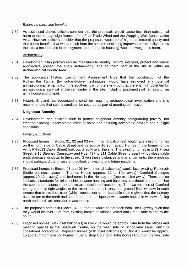
7.74 Free Trade Wharf is located immediately south of the site, on the other side of The Highway. The demolition of the existing low-quality industrial units on the site and replacement with high-quality three-storey industrial element (Block 07) up to the Highway would reinforce the street edge and be beneficial to the setting of this building. The proposed taller elements (Blocks 04, 05 and 06) would be visible from this listed building, rising up beyond the proposed industrial/warehousing units. View 14 (below) demonstrates that the western most proposed 11-storey building would broadly align with the symmetrical composition formed by Free Trade Wharf‟s two buildings and courtyard when viewed from the northern Thames path. The wide nature of The Highway provides significant visual separation between the listed building, meaning that views of the listed building from along this busy road should not be significantly affected. View 15 shows the proposed development in a longer distance from the south side of the River (see below).
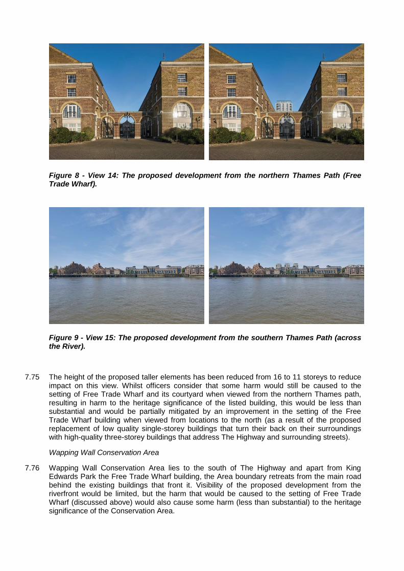
Figure 8 - View 14: The proposed development from the northern Thames Path (Free Trade Wharf).
Figure 9 - View 15: The proposed development from the southern Thames Path (across the River).
7.75 The height of the proposed taller elements has been reduced from 16 to 11 storeys to reduce impact on this view. Whilst officers consider that some harm would still be caused to the setting of Free Trade Wharf and its courtyard when viewed from the northern Thames path, resulting in harm to the heritage significance of the listed building, this would be less than substantial and would be partially mitigated by an improvement in the setting of the Free Trade Wharf building when viewed from locations to the north (as a result of the proposed replacement of low quality single-storey buildings that turn their back on their surroundings with high-quality three-storey buildings that address The Highway and surrounding streets).
Wapping Wall Conservation Area
7.76 Wapping Wall Conservation Area lies to the south of The Highway and apart from King Edwards Park the Free Trade Wharf building, the Area boundary retreats from the main road behind the existing buildings that front it. Visibility of the proposed development from the riverfront would be limited, but the harm that would be caused to the setting of Free Trade Wharf (discussed above) would also cause some harm (less than substantial) to the heritage significance of the Conservation Area.

York Square Conservation Area
7.77 The eastern boundary of the site abuts the south-west section of the Conservation Area. This area was an extension of the original conservation area to protect the setting of historic buildings along Butcher Row and contains the attractive non-listed Thames House on Cable Street and cottages on Cranford Street. View 13 above demonstrates how the proposed development would be seen from Butcher Row. Views 3 and 5 below demonstrate how the proposals would be seen in views along Cable Street and Cranford Street.
Figure 10 - View 3: West along Cable Street
Figure 11 - View 5: West along Cranford Street (Rear of Holiday In on left)
7.78 Whilst the proposals would result in an increase in scale of buildings in the area adjoining the Conservation Area, the proposals would replace unattractive inactive frontage along Cranford Street (which is sometimes the subject of fly tipping) with attractive homes that have entrances from the street and would reinstate a historic route between Cranford Street Schoolyard Lane. The applicant‟s HTVIA finds that, overall, the proposals would lead to an enhancement to the character and appearance of the Conservation Area and officers agree.
Other heritage assets
7.79 Albert Gardens Conservation Area (including the Grade II listed Nos. 1-39 Albert Gardens) sits to the north of the site, on the other side of the DLR viaduct and given the separation and distance, no harm is identified. Officers have considered the likely impacts on the setting of all other nearby heritage assets and no harm has been identified.
Balancing harm and benefits
7.80 As discussed above, officers consider that the proposals would cause less than substantial harm to the heritage significance of the Free Trade Wharf and the Wapping Wall Conservation Area. However, officers consider that the proposals would be of high architectural quality and that public benefits that would result from the scheme (including improved permeability across the site, a net increase in employment and affordable housing) would outweigh this harm.
Archaeology
7.81 Development Plan policies require measures to identify, record, interpret, protect and where appropriate present the site‟s archaeology. The southern part of the site is within an Archaeological Priority Area.
7.82 The applicant‟s Historic Environment Assessment finds that the construction of the Rotherhithe Tunnel (by cut-and-cover techniques) would have removed any potential archaeological remains from the southern part of the site – but that there is high potential for archaeological survival in the remainder of the site, including post-medieval remains of an alms house and chapel.
7.83 Historic England has requested a condition requiring archaeological investigation and it is recommended that such a condition be secured as part of granting permission.
Neighbour Amenity
7.84 Development Plan policies seek to protect neighbour amenity safeguarding privacy, not creating allowing unacceptable levels of noise and ensuring acceptable daylight and sunlight conditions.
Privacy & Outlook
7.85 Proposed homes in Blocks 01, 02 and 03 (with internal balconies) would face existing homes on the north side of Cable Street and be approx.16-20m apart. Homes in the former King‟s Arms PH (513 Cable Street) look out directly over the site. The existing homes in 1-13 Pitsea Street, 3-15 Stepney Causeway and Nos. 497 to 511 Cable Street present windowless gable ends/staircase windows to the street. Given these distances and arrangements, the proposals should safeguard the privacy and outlook of existing and future residents.
7.86 Proposed homes in Blocks 03 and 06 (with internal balconies) would face existing Reservoir Studio business space in Thames House (approx. 12 to 14m away), Cranford Cottages (approx.10-12m away) and bedrooms in the Holiday Inn (approx. 18m away). There are no indicative standards for relationship between housing and business units/hotel bedrooms – but the separation distances set above are considered reasonable. The two terraces of Cranford cottages are at right angles to the street and there is only one ground floor window in each terrace that fronts the street (which appear not to be habitable rooms given that the primary aspects are to the north and south) and more oblique views towards habitable windows facing north and south are considered acceptable.
7.87 The proposed homes in Blocks 04, 05 and 06 would be set back from The Highway such that they would be over 50m from existing homes in Atlantic Wharf and Free Trade Wharf to the south.
7.88 Proposed homes (with inset balconies) in Block 04 would be approx. 14m from the offices and meeting spaces in the Shadwell Centre, on the west side of Schoolyard Lane, which is considered acceptable. Proposed homes (with inset balconies) in Block01 would be approx. 15 and 16m from existing homes in Len Bishop Court and John Bowles Court on the west side
of Schoolyard Lane. Such separation distances are common across streets in London and should safeguard the privacy of existing and proposed residents.
7.89 A number of local people have objected to the loss of their private view, which is not a material planning consideration.
Daylight, Sunlight & Overshadowing
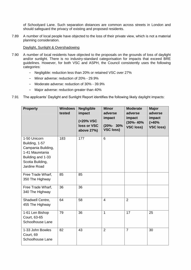
7.90 A number of local residents have objected to the proposals on the grounds of loss of daylight and/or sunlight. There is no industry-standard categorisation for impacts that exceed BRE guidelines. However, for both VSC and ASPH, the Council consistently uses the following categories:
‒ Negligible: reduction less than 20% or retained VSC over 27%
‒ Minor adverse: reduction of 20% - 29.9%
‒ Moderate adverse: reduction of 30% - 39.9%
‒ Major adverse: reduction greater than 40%
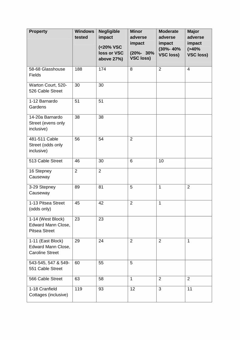
7.91 The applicants‟ Daylight and Sunlight Report identifies the following likely daylight impacts:
Property Windows
tested
Negligible
impact
(<20% VSC
loss or VSC
above 27%)
Minor
adverse
impact
(20%- 30% VSC loss)
Moderate
adverse
impact
(30%- 40%
VSC loss)
Major
adverse
impact
(>40%
VSC loss)
1-50 Unicorn
Building, 1-57
Campania Building,
1-41 Mauretania
Building and 1-33
Scotia Building,
Jardine Road
183 177 6
Free Trade Wharf,
350 The Highway
85 85
Free Trade Wharf,
340 The Highway
36 36
Shadwell Centre,
455 The Highway
64 58 4 2
1-61 Len Bishop
Court, 63-65
Schoolhouse Lane
79 36 1 17 25
1-33 John Bowles
Court, 69
Schoolhouse Lane
82 43 2 7 30
Property Windows
tested
Negligible
impact
(<20% VSC
loss or VSC
above 27%)
Minor
adverse
impact
(20%- 30% VSC loss)
Moderate
adverse
impact
(30%- 40%
VSC loss)
Major
adverse
impact
(>40%
VSC loss)
58-68 Glasshouse
Fields
188 174 8 2 4
Warton Court, 520-
526 Cable Street
30 30
1-12 Barnardo
Gardens
51 51
14-20a Barnardo
Street (evens only
inclusive)
38 38
481-511 Cable
Street (odds only
inclusive)
56 54 2
513 Cable Street 46 30 6 10
16 Stepney
Causeway
2 2
3-29 Stepney
Causeway
89 81 5 1 2
1-13 Pitsea Street
(odds only)
45 42 2 1
1-14 (West Block)
Edward Mann Close,
Pitsea Street
23 23
1-11 (East Block)
Edward Mann Close,
Caroline Street
29 24 2 2 1
543-545, 547 & 549-
551 Cable Street
60 55 5
566 Cable Street 63 58 1 2 2
1-18 Cranfield
Cottages (inclusive)
119 93 12 3 11

Property Windows
tested
Negligible
impact
(<20% VSC
loss or VSC
above 27%)
Minor
adverse
impact
(20%- 30% VSC loss)
Moderate
adverse
impact
(30%- 40%
VSC loss)
Major
adverse
impact
(>40%
VSC loss)
Holiday Inn, 469-475
The Highway
71 68 1 2
Total 1,439 1,258 57 49 75
Table 5: Summary of the applicants’ Daylight & Sunlight Report
7.92 As noted above, the applicants‟ Daylight and Sunlight Report has been reviewed on behalf of the Council by BRE consultants. BRE reviewed the scope, methodology, text and conclusions of the applicants‟ report – but were not asked to validate the calculations included in the assessment. BRE‟s review finds that the applicants‟ assessment has generally been carried out appropriately. However, it notes that the applicants‟ have not correctly applied BRE guidelines when reporting on a hypothetical “mirror-image” building as the values with the hypothetical mirror-image in place should be used as the alternative target values, not an alternative existing baseline. The result is that the applicants‟ assessment underestimates impact on existing properties at Len Bishop Court and John Bowles Court when comparing to an equivalent building on the other side of Schoolhouse Lane. BRE‟s review also notes that the applicants‟ assessment overestimates the likely loss of sunlight impact on some windows and, unhelpfully, does not provide additional daylight/sunlight results without existing overhangs in place.
7.93 It should be noted that BRE agree that all 85 windows tested at Free Trade Wharf would meet guidelines for daylight and all the 29 windows tested for sunlight would meet guidelines for sunlight.
7.94 Daylight. The table below set out BRE‟s advice for windows that the applicants‟ report assesses as likely to experience a greater than Negligible daylight impact.
Property Daylight
Impact Further detail
Unicorn, Campania, Mauretania & Scotia Buildings
Minor Six windows below guidelines either under balconies (four windows likely to comply without them in place) or marginally below target (two windows).
Shadwell Centre (educational use)
Minor Five windows below guidelines on ground floor. At least some rooms may be lit by windows on other facades. An additional window would be very marginally below the guidelines on the first floor.
Nos. 58-68 Glasshouse Fields
Minor Fourteen windows below VSC guidelines but are to balcony areas; likely to meet guidelines if calculations repeated without them. Six rooms below Daylight Distribution. Two to balcony areas. Four others meet VSC guidelines and are deep rooms or currently obstructed by other buildings.

Property Daylight Impact
Further detail
Nos. 483 & 485 Cable Street
Minor One window at each property below the VSC guidelines. These are below overhangs and would be expected to comply if they were removed from the calculations.
Nos. 7, 15, 17,19, & 21 Stepney Causeway
Minor – Moderate
Two windows each at Nos. 17, 19 and 21 plus one window at No. 7 would be below VSC guidelines. These are below overhangs and would be expected to comply without them in place. A further window at No. 25 would be marginally below guidelines and is a secondary window.
1,3 & 7 Pitsea Street
Minor One window at each property below VSC guidelines. They are either below overhangs or a secondary window.
Edward Mann Close Minor Five windows below the guidelines are under balcony areas and would be expected to comply without them in place.
Nos. 543-551 Cable Street (Reservoir Studios)
Minor Five windows below guidelines are to balcony areas. Would be expected to comply without them in place.
Nos. 11 & 13 Cranford Cottages
Minor Two main windows on the front façade below vertical sky component guidelines.
No. 2 Cranford Cottages
Minor One rear window below the guidelines by a small margin.
Holiday Inn (Nos. 469-475 The Highway).
Minor
Three windows would be under VSC guidelines. Two of these are for the same large restaurant area that would also be below Daylight Distribution guidelines. Only an issue if the restaurant area has a specific requirement or expectation for daylight.
No. 513 Cable Street (Fathom Court)
Moderate Impact to south facing façade on ground and first floor where all 16 windows would be below VSC guidelines. Daylight Distribution would be met however.
No. 1 Cranford Cottages
Moderate All main windows below VSC guidelines.
No. 10 Cranford Cottages
Moderate Four main windows below VSC guidelines.
No. 566 Cable Street (west façade) (artist studios)
Moderate
Five windows below VSC guidelines; two rooms below Daylight Distribution. Loss of daylight to commercial properties may be considered less important, however, these artist‟s studios could have a daylight expectation or requirement. Clarification of adjacent windows not included in assessment suggested.

Property Daylight Impact
Further detail
Len Bishop Court and John Bowles Court
Major 82 Windows below vertical sky component guidelines (43 at Len Bishop Court and 39 at John Bowles Court), including all windows on the ground to first floors. 43 rooms below daylight distribution (20 to Len Bishop Court and 23 to John Bowles Court). Results are significantly below the guidelines in some cases. Part of the impact is due to the existing windows being close to the boundary. 57 windows and 17 rooms would have values below the alternative target of an equivalent building on the opposite site of Schoolhouse Lane. The proposed development would impact a significant number of windows more than if an equivalent building was in place on the other side of Schoolhouse Lane.
Table 6: Likely daylight Impacts
7.95 Sunlight. The table below set out BRE‟s advice for windows that the applicants‟ report assesses as likely to experience a greater than Negligible sunlight impact.
Property Sunlight
Impact Further detail
497 Cable Street Minor One window, understood to light a living area, below winter APSH guideline, but meets annual standard.
No. 513 Cable Street (Fathom Court)
Minor Minor impact to winter sunlight on south facade. Although meeting the guideline, provision is reduced by a significant amount.
Nos. 1 & 3 Pitsea Street
Minor Four windows each at Nos. 1 and 3, plus one at No. 5 on the ground floor below winter guidelines by a small margin, but meet annual. It is understood some of these light living areas.
Holiday Inn (Nos. 469-475 The Highway).
Minor
Two windows would be below APSH guidelines. Only an issue if the restaurant has a specific requirement or expectation for sunlight.
Nos. 13 & 17 Cranford Cottages
Minor Winter sunlight below guidelines to front window (more likely to light living room), but APSH would be met.
No. 566 Cable Street (west façade)
Major Only a major impact if these artist studios have a specific requirement for sunlight.
Table 7: Likely sunlight impacts
7.96 Overshadowing. The applicants‟ report sets out the findings of an assessment of overshadowing of 48 nearby amenity spaces. All of these spaces would meet BRE guidelines for 50% of the area to receive at least 2 hours of sunlight on 21 March. The table below set out BRE‟s advice for the two spaces that do not meet the guidelines.

Amenity space Over-
shadowing Impact
Further detail
Shared yard at Cranford Cottages
Minor The area receiving two or more hours of sunlight on 21 March would reduce from 7% to 1%.
Basketball court on corner of Schoolhouse Lane and Cable Street
Moderate Area able to receive at least two hours of sunlight on 21st March with the proposed development in place is reduced to 0.46 times that before, compared to a guideline of 0.8.
Table 8: Likely overshadowing impacts
7.97 Conclusion. The Mayor of London‟s Housing SPG makes clear that standards should be applied flexibly, providing that proposals still achieve satisfactory levels of residential amenity and avoid unacceptable harm. The proposals would have negative impacts on daylight and sunlight enjoyed by the occupiers of a number of nearby homes and users of two amenity spaces, when assessed against the BRE guidelines. However, officers consider that these impacts would be acceptable when weighed against the benefits that the scheme would deliver and that residents and users would be left with an acceptable level of daylight and sunlight and that their overall level residential amenity would be acceptable.
Noise & Vibration
7.98 The application is supported by a Noise Assessment. Office and light industrial uses are, by definition, compatible with housing and should not cause unacceptable noise for existing or future residents and, given the size and configuration of the proposed units, any warehousing use is not expected to cause unacceptable noise. Furthermore, the proposal is expected to result in a reduction in traffic movements and associated noise. Subject to a recommended condition, noise from mechanical plant should be managed to acceptable levels and the proposals should not worsen the noise environment for existing residents.
Construction Impacts
7.99 Demolition and construction activities are likely to cause some additional noise and disturbance, additional traffic generation and dust. In accordance with relevant Development Plan policies, a number of conditions are recommended to minimise these impacts. These would control working hours and require the approval and implementation of Construction Environmental Management Plan and a Construction Logistics Plan.
Transport
7.100 Development Plan policies promote sustainable modes of travel and limit car parking to essential user needs. They also seek to secure safe and appropriate servicing.
Vehicular, pedestrian and cycle access
7.101 Vehicular access for the proposed light industrial/warehousing units would be via a two-way access from The Highway (in the same location to the existing Heckford Street access). This would serve the partially covered service yard.
7.102 Vehicular access for servicing the proposed office units and housing would be from the proposed new east-west private street that would run through the site between Schoolhouse Lane and Cranford Street. This street would be a shared surface with lockable bollards at both
ends to prevent it becoming a general route. Vehicles are expected to enter from Schoolyard Lane and exit via Cranford Street. It would include a servicing bay, four Blue Badge car parking spaces and short-term cycle parking spaces. These works would result in the loss of two car parking spaces on Cranford Street and Schoolhouse Lane (four in total).
7.103 Pedestrian and cycle access would be from existing surrounding streets, the proposed new east-west street and the proposed new north-south route on the east side of the site, which would link Cranford Street with The Highway.
Deliveries & Servicing
7.104 Following comments by officers, a previously proposed service bay on Schoolhouse Lane has been removed from the proposals. Servicing and refuse collection would be undertaken within the site from the courtyard/service bay accessed from The Highway and servicing bay on the proposed new east-west street. The applicant‟s Transport Assessment estimates that there would be approximately 54 to 57 deliveries a day associated with the proposed development (business and residential elements). The application is supported by a draft Delivery and Servicing Plan to help ensure effective management of servicing arrangements (including the employment of a caretaker to manage servicing of the site). It is recommended that the approval of a final Delivery and Servicing Plan is secured by condition.
Car Parking
7.105 The site and surrounding area (excluding The Highway) form part of Controlled Parking Zone C4, which is in operation Monday to Friday between 08.30 and 17.30. The applicant‟s Transport Assessment reports on a parking beat survey in early 2016 that finds that parking utilisation in the surrounding area is low. Of the total kerb space available overnight, 16% of all available spaces were occupied, with over 520 observed spaces. Utilisation of permit holder only, resident bays and shared use bays overnight is between 47-50%, with around 104 observed spaces.
7.106 The proposals include 4 Blue Badge Car Parking Spaces on the northern side of the proposed new east-west street. The intention is to prioritise allocation of these spaces to the proposed 4 wheelchair accessible affordable rented properties. The proposed provision is below that required by Development Plan policies and the Mayor of London‟s Housing SPG (which calls for one space for each of the proposed 24 wheelchair accessible homes). However, officers consider that this proposed level of provision is acceptable, subject to a s106 planning obligation securing a Car Park Management Plan to (i) manage the allocation of the proposed spaces and (ii) identify a mechanism for providing additional on-site and/or on-street accessible car parking spaces should demand require. A separate s106 obligation is also recommended to prevent residents (apart from Blue Badge holders) from obtaining parking permits for the surrounding CPZ s
7.107 Given the small number of proposed spaces, there is the opportunity to provide all of the proposed four car parking spaces with Electric Vehicle Charging Points (EVCPs). The applicant agrees and it is recommended that this is secured by condition.
7.108 There would be no off-street car parking for the proposed light industrial/warehousing and office units, although the courtyard serving the light industrial units provides room for vans to park up and unload/load.
7.109 There is an existing Zipcar Car Club space on Heckford Street. The applicant has been in discussion with Zipcar and is willing to contribute towards a Car Club membership for each household and commercial tenant. This would comprise a welcome pack and three year‟s free membership for each household, 1 year‟s free business account for each business and £30 Driving Credit per membership. It is recommended that details of the proposed car club space
(which would need to be on one of the surrounding public highways) and membership is secured by a s106 obligation.
Cycle Parking and Facilities
7.110 The proposals include a total of 423 long-stay residential cycle parking spaces, in four basement areas, accessed via cycle lifts from the stair/lift lobby areas for Blocks 01 to 06. A total of 7 short-stay residential cycle parking spaces (including space for adapted cycles) would be provided within the proposed new east-west street.
7.111 The proposals also include a total of 86 long-stay cycle parking spaces for the proposed light industrial/warehousing and office units in a basement area accessed via a cycle lift in the residential lobby area of Blocks 04. Shower and changing facilities are also proposed in the basement, next to the cycle parking area. Short-stay cycle parking spaces would be provided within the proposed new east-west street.
7.112 The proposed levels of cycle parking meet the required London Plan standards and the provision of shower/changing facilities for employees of the proposed light industrial/office space is welcome. The Mayor of London has requested that an additional 12 long-stay and 1 short stay (residential) and 13 additional long-stay (commercial) cycle parking spaces are secured, to reflect higher standards in emerging policy. Officers agree and recommend that these are secured by condition.
Trip generation
7.113 The applicant‟s Transport Assessment identifies a likely significant reduction in the number of vehicular trips to the site associated with the development, with 1,1,47 less two-way vehicle trips during a day. The reduction in vehicular trips would be particularly beneficial during peak periods.
7.114 There is expected to be increases in the use of buses, DLR and rail services as follows:
‒ Buses: approx. 70 additional two-way trips during the AM peak and 59 additional two-way trips in the PM peak;
‒ DLR: approx. 149 additional two-way trips during the AM peak and 122 two-way trips in the PM peak; and
‒ Rail: approx. 40 additional two-way trips during the AM peak and 35 additional two-way trips in the PM peak.
7.115 Given the numerous bus, DLR and rail services in the vicinity of the site, the Transport Assessment concludes that the impact of additional trips on the public transport network would be minimal. Officers agree and TfL has not objected to the proposals.
7.116 The proposed east-west street between Schoolhouse Lane and Cranford Street and proposed north-south route between Cranford Street and The Highway would improve permeability through the site for pedestrians and cyclists. This and the good levels of cycle parking and (for the industrial/office units) shower and changing facilities should adequately cater for the expected increase in walking and cycling trips.
Travel Planning
7.117 The application is supported by framework Residential and Workspace Travel Plans, setting out proposed measures to encourage sustainable travel. It is recommended that the approval and implementation of final Travel Plans is secured vi a s106 obligation.
Rotherhithe Tunnel

7.118 The Rotherhithe Tunnel lies under the south eastern sliver of the site and there is a TfL imposed Exclusion Zone that extends further in to the site – as far as the ventilation shaft that serves the tunnel. The applicant‟s Transport Assessment (Appendix K) includes a technical note and concludes that the proposed development safeguards the Rotherhithe Tunnel and ventilation shaft in the following ways:
‒ Minimising the net change in load on the tunnel within the tunnel control zone
‒ Installing no foundations within the 3.5m exclusion zone
‒ Sleeving all piled foundations within the 45-degree zone of influence so as not to load the tunnel.
‒ Setting the line of the new basement well away from the tunnel zone of influence
7.119 In addition, the proposed courtyard accessed from The Highway would include two operational parking bays for TfL to maintain the vent shaft. It is recommended that details of a „build over‟ agreement and servicing arrangements for the Rotherhithe Tunnel are secured by planning conditions.
Environment
Environmental Impact Assessment
7.120 In May 2015, the Council issued an Environmental Impact Assessment (EIA) Screening Opinion confirming that EIA was not required for the redevelopment of the site for a similar amount of employment floorspace and housing. The Council‟s EIA Officer has confirmed that the proposed development as amended does not constitute EIA development. A number of separate reports assessing relevant aspects of the environmental effects of the development against relevant policies have been submitted as required by the Council‟s local validation requirements.
Energy & Environmental Sustainability
7.121 The application is supported by an Energy Statement. This sets out how the proposed development addresses policy requirements to reduce the site‟s contribution to climate change by minimising the emissions of CO2. The strategy is based on:
‒ Being Lean: good levels of thermal insulation, the use of mechanical ventilation that includes heat recovery (thus reducing heating demand), the use of high efficiency gas boilers, the use of low energy lighting and other measures. Savings from energy demand reduction would amount to 56.4 tonnes of CO2 per annum (a 12.1% saving over the Building Regulations 2010 (2013 version));
‒ Being Clean: the provision of a site-wide heating network (serving housing and light industrial/office units) served from a single energy centre in the basement of Block 04 – to facilitate a possible future connection to a wider district heating network. A gas-fired CHP engine (104kWe/142kWth) is proposed. Savings from being clean would amount to 132.9 tonnes of CO2 per annum (a 28.5% saving); and
‒ Being Green: the provision of PVs (150sqm array) on the roofs of the southernmost buildings (Blocks 04, 05 and 06). Savings from being green would amount to 10.8 tonnes of CO2 per annum (a 2.3% saving).
7.122 The above strategy is in accordance with relevant Development Plan policies and guidance. Together, the measures would achieve a 43% improvement over the Building Regulations 2010 (2013 version) standards. Policy DM29 requires a 45% reduction. It is therefore recommended that, in accordance with policy and supporting guidance, a s106 obligation secures a financial contribution of £17,280 towards carbon offsetting projects in the borough. However, the Mayor of London considers that a CHP-led strategy is no longer appropriate in

the light of revised and emerging policies/guidance and has asked the applicants to identify a new energy strategy. In the light of this, officers recommend that an energy strategy that ensures CO2 emission savings of at least 43% and, where appropriate, requires the heat and hot water system to be constructed to enable future connection to a district heating network, be secured by condition. be approved. It is also recommended that a condition reserves the details of any PV array.
7.123 The applicant‟s Sustainability Statement sets out a number of commitments that respond to Development Plan policies to encourage environmentally sustainable development. These include use of locally sourced materials, re-use of structures as high-grade aggregate, use of responsibly sourced timber, incorporation of recycling facilities (see Waste below) minimisation of water use and installation of water meters/leak detection and implementation of a Site Waste Management Plan. The Statement also includes a BREEAM pre-assessment for the proposed non-residential floorspace, which gives an indicative total score of 71.77% („Excellent‟). It is recommended that the submission of a final certificate to demonstrate that the „Excellent‟ level is achieved is secured by condition.
Air Quality
7.124 Development Plan policies require major developments to be accompanied by assessments which demonstrate that the proposed use(s) are acceptable and show how development would prevent or reduce air pollution.
7.125 The expected reduction in traffic generation and the applicant‟s agreement to provide Electric Vehicle Charging Points (EVCPs) is expected to reduce exposure to NO2, PM10 and PM2.5 particulates. The long-term predicted environmental concentrations of NO2 from the proposed energy centre are predicted to be below the Air Quality Objective at all sensitive receptors. Nevertheless, it is recommended that a condition requires all boilers and CHP to meet the GLA‟s NOx emissions standards, as set out in the relevant London Plan SPG.
7.126 The applicant‟s Air Quality Assessment demonstrates that the proposed development would generate building and transport NOx emissions and transport PM10 emissions below the emission benchmark and no further mitigation is required – with the proposals meeting London Plan policy requirements to be at least air quality neutral.
7.127 Demolition and construction activities can cause dust and poor air quality. It is recommended that a Construction Environmental Management Plan is secured by way of a planning condition.
Wind/Microclimate
7.128 The application is supported by a Pedestrian Level Wind Microclimate Assessment. This finds that the site is generally suitable for its existing use, although one location (a bus stop on The Highway) exceeds the relevant criteria. Following wind tunnel testing, the Assessment predicts similar wind conditions to the existing scenario. The proposals should not, therefore, have an adverse impact on the wind/microclimate environment of the surrounding area.
Waste
7.129 Development Plan policies require adequate refuse and recycling storage and management and the re-use of demolition and construction materials.
7.130 All commercial waste and recycling is to be stored within a storage area on the ground floor of Block 04, with direct access from the north-west corner of the proposed service yard (accessed from Heckford Street). The store has been sized appropriately, taking account of Council guidance.
7.131 Stores for residential refuse, recycling and compostable waste are proposed on the ground floor of each block, accessed via either Schoolhouse Lane, the proposed new east-west route or Cranford Street, depending on their location. The stores have been sized appropriately, taking account of Council guidance. The proposed stores are located to be easily accessible and residents will not need to walk further than 30m from their front door when carrying refuse/recycling/waste. A small internal store is proposed at the northern end of Block 01 to ensure that the 30m carry standard is met – with on-site management moving material to the bigger external store nearer the proposed east-west route on collection day. Officers consider these arrangements to be acceptable.
7.132 The applicant‟s Sustainability Statement gives a commitment that prior to commencement of works a Site Waste Management Plan (SWMP) shall be prepared to minimise waste and maximise re-use/recycling of materials from the existing buildings/hardstanding. It is recommended that this is secured by condition.
Biodiversity
7.133 Development Plan policies seek to safeguard and where possible enhance biodiversity value.
7.134 The application is supported by an Extended Phase 1 Habitat Survey. This demonstrates that, whilst there is some vegetation on the site, it is currently of low biodiversity value. Whilst such vegetation could support nesting birds, the protection of such birds is governed by non-planning legislation.
7.135 The proposed residential courtyards would provide formal soft landscaping. It is also proposed to plant trees along the proposed new east-west street and trees and shrubs along the proposed new north-south pedestrian route and semi-public open space next to The Highway. All these spaces provide opportunities to include native species and nectar-rich flowers. It is recommended that the details of soft landscaping are reserved by condition to secure planting that is attractive and supports biodiversity.
7.136 Areas of green roofs are proposed for the lower roof area linking Blocks 01, 02 and 03 and Blocks 04, 05 and 06. This amounts to an area of approx. 310sm. This is welcome and a condition reserving details of biodiverse roofs is recommended. The Habitat Survey refers to opportunities for the inclusion of bird and bat boxes. Bat boxes and boxes for swift and house sparrows would contribute to Local Biodiversity Action Plan targets and would be welcome. It is recommended that details of numbers, type and locations of these are reserved by condition
7.137 Subject to the conditions listed above, the proposals would meet Development Plan requirements to provide a net benefit for biodiversity and are acceptable.
Flood Risk & Drainage
7.138 Development Plan policies seek to manage flood risk and encourage the use of Sustainable Urban Drainage.
7.139 The site is within Flood Risk Zone 1 and is not in a Critical Drainage Area. The applicant‟s Flood Risk Assessment (FRA) finds a low risk of flooding in relation to tidal, fluvial, artificial drainage, overland and infrastructure failure. Groundwater flooding is identified as a potential medium risk due to the inclusion of relatively small basement areas.
7.140 The FRA recommends that groundwater levels are to be monitored to inform basement design, that surface water run-off is restricted to 3 x Greenfield Run-Off rate for up to 1in 100-year return period, that Sustainable Urban Drainage (SuDs) is incorporated to accommodate surface water up to and including the 1 in 100-year event + 40% climate change and that new sewerage systems are provided.
7.141 The applicants Drainage Strategy demonstrates how the FRA recommendations would be achieved. This includes the following SuDS features: landscape planters for rainwater pipes for Blocks 01,02 and 03 to discharge into; filter drains beneath paving in the proposed two residential courtyards; permeable paving and attenuation tanks (approx. 673 cubic metres) along the proposed new east-west street and in the proposed Heckford Street service yard. The scheme is expected to connect with the existing foul combined sewer that runs south from Heckford Street. The Mayor of London has queried the proposed SuDS measures and it is recommended that approval of a surface water drainage strategy and resultant water run-off rates are secured by condition.
7.142 Thames Water has raised no objections, subject to the inclusion of appropriate conditions and informatives. These are generally secured by the recommended conditions and informatives. However, officers do not consider it necessary to include a condition requiring approval and implementation of water network upgrades/housing infrastructure phasing plan (which is a commercial matter between the applicants and Thames Water).
Land Contamination
7.143 Subject to standard conditions, the proposals are acceptable from a land contamination perspective and that any contamination that is identified can be satisfactorily dealt with.
Infrastructure Impact
7.144 It is estimated that the proposed development would be liable for Tower Hamlets Community Infrastructure Levy (CIL) payments of approximately £2,824,800 (inclusive of social housing relief and exclusive of indexation) and Mayor of London CIL of approximately £1,100,672 (inclusive of social housing relief and exclusive of indexation).
7.145 Alongside CIL, Development Plan policies seek financial contributions to be secured by way of planning obligations to offset the likely impacts of the proposed development on local services and infrastructure.
7.146 The applicant has agreed to meet all of the financial contributions that are sought by the Council‟s Planning Obligations SPD, as follows:
‒ £141,068 towards construction phase employment skills training
‒ £181,976 towards end-user phase employment skills training
‒ £17,280 toward carbon emission off-setting
Local Finance Considerations
7.147 Assuming that the Council delivers its annual housing target of 3,931 units, the Council would be liable for a New Homes Bonus payment of approximately £24m over 4 years. Due to the introduction of a new threshold approach by the Government it is not possible to provide an exact amount of New Homes Bonus the proposed development would deliver; officers estimate that the proposal could deliver up to £1,867,645 over 4 years.
Human Rights & Equalities
7.148 The proposal does not raise any unique human rights or equalities implications. The balance between individual rights and the wider public interest has been carefully considered and officers consider it to be acceptable.
7.149 The proposed provision of new business space, homes and (subject to approval of details) public realm, communal open space and play space would meet inclusive design standards and 28 homes (over 10%) would be „wheelchair accessible‟. These standards would benefit future employees and residents, including disabled people, elderly people and parents/carers

with children. The proposed affordable housing, construction and end-user stage apprenticeships and employment initiatives would be of particular benefit to groups that are socially/economically disadvantaged.
7.150 The proposed development would not result in adverse impacts upon equality or social cohesion.
8. RECOMMENDATION
8.1 That subject to any direction by the Mayor of London, conditional planning permission is GRANTED subject to the prior completion of a legal agreement to secure the following planning obligations:
8.2 Financial obligations
a. £141,068 towards construction phase employment skills training
b. £181,976 towards end-user phase employment skills training
c. £17,280 toward carbon emission off-setting
d. £5,500 monitoring fee
Total financial contributions: £345,824.
8.3 Non-financial obligations:
a. Affordable housing (35% by habitable room)
‒ 21 units (121 habitable rooms) at London Affordable Rent
‒ 21 units (121 habitable rooms) at Tower Hamlets Living Rent
‒ 34 units (105 habitable rooms) as Shared Ownership
‒ Early Stage Review
‒ Details and implementation of London Affordable Rent/Tower Hamlets Living Rent „wheelchair accessible‟ dwellings (to M4 (3)(2)(b) standard)
b. Access to employment
‒ 20% local procurement
‒ 20% local labour in construction
‒ 17 construction phase apprenticeships
‒ 2 x end-user phase apprenticeships
c. Re-location assistance (existing businesses on the Highway Business Park), including 6-months minimum notice, first right of refusal to return and assistance in identifying alternative properties.
d. Transport matters:
‒ Car Free development (residential)
‒ Approval and implementation of Car Park Management Plan (including spaces on east-west street and service yard and mechanism for increasing on-site and on-street provision of accessible car parking spaces)
‒ Car Club (details of 1 x space, plus three years free membership for households. One-year free membership for commercial occupiers and £30 Driving Credit per membership).
‒ Residential and Workspace Travel Plans

‒ S278 Agreement (works to Schoolyard Land, Cranford Street and The Highway and potential additional accessible car park spaces).
e. Public access to the proposed east-west street, north-south pedestrian/cycle route, residential courtyards and open space next to The Highway
f. Compliance with Considerate Constructors Scheme
8.4 That the Corporate Director of Place is delegated the power to negotiate the legal agreement. If within three months of the resolution the legal agreement has not been completed, the Corporate Director for Place is delegated power to refuse planning permission.
8.5 That the Corporate Director of Place is delegated the power to impose conditions and informatives to address the following matters:
8.6 Planning Conditions
Compliance
1. 3 years deadline for commencement of development.
2. Development in accordance with approved plans.
3. Removal of permitted development rights:
a. No changes of use of B1/B8 to residential;
b. No fences or other means of enclosure to be erected; and
c. No painting of brickwork or masonry.
4. Restrictions on demolition and construction activities:
a. All works in accordance with Tower Hamlets Code of Construction Practice;
b. Standard hours of construction and demolition;
c. Air quality standards for construction machinery;
d. Ground-borne vibration limits; and
e. Noise pollution limits.
5. Mechanical plant noise standard (subject to post completion verification).
6. Noise insulation standards for new residential units (subject to post completion verification).
7. Air quality standards for boilers and any CHP units.
8. Inclusive access standards for new residential units.
9. Energy efficiency and sustainability measures (subject to post completion verification):
a. BREEAM „Excellent‟ certificate for Business B1/B8 space; and
b. Water consumption standards.
10. Delivery and retention of waste storage facilities.
11. Delivery and retention of on-site Blue Badge parking spaces and electric vehicle charging points.
Pre-commencement
The inclusion of the following pre-commencement conditions has been agreed in principle with the applicants, subject to detailed wording
12. Construction Environmental Management Plan and Construction Logistics Plan (in consultation with TfL):

a. Site manager‟s contact details and complain procedure;
b. Dust and dirt control measures
c. Measures to maintain the site in tidy condition, disposal of waste
d. Recycling/disposition of waste from demolition and excavation
e. Safe ingress and egress for construction vehicles;
f. Numbers and timings of vehicle movements and access routes;
g. Parking of vehicles for site operatives and visitors;
h. Travel Plan for construction workers;
i. Location and size of site offices, welfare and toilet facilities;
j. Erection and maintenance of security hoardings;
k. Measures to ensure that pedestrian and cycle access past the site is safe and not unduly obstructed; and
l. Measures to minimise risks to pedestrians and cyclists, including but not restricted to accreditation of the Fleet Operator Recognition Scheme (FORS) and use of banksmen for supervision of vehicular ingress and egress.
13. Rotherhithe Tunnel „Build Over‟ Scheme and Piling Method Statement (in consultation with TfL and Thames Water).
14. Archaeology Written Scheme of Investigation (in consultation with Historic England).
15. Land Contamination Remediation Scheme (subject to post completion verification).
16. Approval of an energy strategy which ensures CO2 emission savings of at least 43% and, where appropriate, requires the heat and hot water system to be constructed to enable future connection to a district heating network.
17. Approval of surface water drainage strategy and resultant water run-off rate.
18. Approval of long-stay and short-stay residential and commercial cycle parking and associated facilities.
Pre-superstructure works
19. Details of external facing materials and architectural detailing.
20. Details of hard and soft landscaping of all public realm and open spaces including play equipment, street furniture and lighting.
21. Details of mechanical ventilation and air intake points for new dwellings.
22. Details of biodiversity improvement measures, including biodiverse roofs, bird and bat boxes.
23. Details of Secured by Design measures.
24. Details of kitchen extract systems for commercial uses.
25. Details of any roof level PV array (roof plan and elevation).
26. Approval of residential management plan.
8.7 Informatives
1. Permission subject to legal agreement.
2. Development is CIL liable.
3. Thames Water – proximity to assets.

APPENDIX 1
Drawings General Arrangement Masterplan C645_P_B1_001 Rev D Basement Plan C645_P_00_001 Rev G Ground Floor Plan C645_P_01_001 Rev C First Floor Plan C645_P_02_001 Rev D Second Floor Plan C645_P_03_001 Rev D Third Floor Plan C645_P_04_001 Rev E Fourth Floor Plan C645_P_05_001 Rev D Fifth Floor Plan C645_P_06_001 Sixth Floor Plan C645_P_07-09_001 Seventh-Ninth Floor Plan C645_P_10_001 Rev B Tenth Floor Plan C645_P_MG_001 Mezzanine Plan C645_P_RF_001 Rev E Roof Plan Detailed Plans: Zone 1 C645_Z1_P_B1_001 Rev D Basement C645_Z1_P_00_001 Rev E Ground Floor Plan C645_Z1_P_01_001 Rev D First Floor Plan C645_Z1_P_02_001 Rev E Second Floor Plan C645_Z1_P_03_001 Rev F Third Floor Plan C645_Z1_P_04_001 Rev F Fourth Floor Plan C645_Z1_P_05_001 Rev D Fifth Floor Plan C645_Z1_P_06_001 Rev C Sixth Floor Plan C645_Z1_P_RF_001 Rev D Roof Plan Detailed Plans: Zone 2 C645_Z2_P_B1_001 Basement C645_Z2_P_00_001 Rev F Ground Floor Plan C645_Z2_P_01_001 Rev B First Floor Plan C645_Z2_P_02_001 Rev B Second Floor Plan C645_Z2_P_03_001 Rev B Third Floor Plan C645_Z2_P_04_001 Rev B Fourth Floor Plan C645_Z2_P_05-06_001 Fifth-Sixth Floor Plan C645_Z2_P_07-09_001 Seventh-Ninth Floor Plan C645_Z2_P_10_001 Rev A Tenth Floor Plan C645_Z2_P_RF_001 Rev C Roof Plan C645_Z2_P_MG_001 Rev A Mezzanine Floor Plan General Arrangement Masterplan Elevations C645_01_E_N_001 Rev C Elevation 01 (North) C645_02_E_E_001 Rev C Elevation 02 (East) C645_03_E_S_001 Rev B Elevation 03 (South) C645_04_E_W_001 Rev D Elevation 04 (West) C645_09_E_S_001 Rev C Elevation 09 (South) C645_10_E_N_001 Rev C Elevation 10 (North) Elevations C645_01_E_N_002 Rev C Elevation 01 (North) C645_02_E_E_002 Rev C Elevation 02 (East) C645_03_E_S_002 Rev B Elevation 03 (South) C645_04_E_W_002 Rev D Elevation 04 (West)

C645_05_E_E_002 Rev C Elevation 05 (East) C645_06_E_W_002 Rev C Elevation 06 (West) C645_07_E_E_002 Rev C Elevation 07 (East) C645_08_E_W_002 Rev C Elevation 08 (West) C645_09_E_S_002 Rev C Elevation 09 (South) C645_10_E_N_002 Rev D Elevation 10 (North) C645_11_E_S_002 Rev B Elevation 11 (South) Sections C645_S_AA_001 Rev B Section AA C645_S_BB_001 Rev C Section BB C645_S_CC_001 Rev B Section CC C645_S_DD_001 Rev B Section DD Affordable Flat Types D811_P_T1_B1_B3_001 Rev B 1 Bed, Blocks 01/03 D811_P_T2_B1_B3_001 Rev B 2 Bed, Blocks 01/03 D811_P_T3_B1_001 Rev B 3 Bed Duplex, Block 01 D811_P_T4_B1_001 Rev B 4 Bed, Block 01 Private Flat Types D811_P_T5_B4_B5_B6_001 Rev B Studio, Blocks 04/05/06 D811_P_T6_B2_001 Rev B 1 Bed, Block 02 D811_P_T7_B4_B5_B6_001 Rev B 2 Bed, Blocks 04/05/06 D811_P_T9_B4_B5_B6_001 Rev B 3 Bed, Blocks 04/05/06 Wheelchair Accessible Flat Types D811_P_T10_B1_B3_001 Rev D 2 Bed, Blocks 01/03 D811_P_T11_B4_B5_B6_001 Rev B 2 Bed, Blocks 04/05/06 Landscape Drawings THL-ASU-00-XX-DP-L-L100 Rev 00 General Arrangement Plan THL-ASU-00-XX-DR-L-L300 Rev 00 Hard Materials Plan THL-ASU-00-XX-DR-L-L900 Rev 00 Tree & Planting Plan Submission documents
‒ Air Quality Assessment (WYG) ‒ CIL Liability Form ‒ Commercial Market and Workspace Study (GVA) ‒ Daylight and Sunlight Assessment (GL Hearn) ‒ Delivery and Servicing Plan (TTP Consulting) ‒ Design & Access Statement (Squire & Partners) ‒ Drainage Strategy (Cundall) ‒ Energy Statement (Cundall) ‒ Extended Phase 1 Habitat Survey (DF Clark Bionomique Ltd) ‒ Flood Risk Assessment (Cundall) ‒ Geoenvironmental and Geotechnical Assessment (Cundall) ‒ Heritage, Townscape and Visual Impact Assessment (Montagu Evans) ‒ Historic Environment Assessment (MOLA) ‒ Noise Assessment (Cundall) ‒ Planning Application Form ‒ Planning Statement (Rolfe Judd Planning) ‒ Residential Travel Plan (TTP Consulting)

‒ Statement of Community Involvement (Thorncliffe) ‒ Sustainability Assessment (Cundall) ‒ Transport Assessment (TTP Consulting) ‒ Viability Report (confidential) (GVA) ‒ Wind Microclimate Assessment (RWDI Anemos) ‒ Workspace Travel Plan (TTP Consulting)
Post Submission documents (latest documents only)
‒ Air Quality Assessment (Replacement) (WYG) ‒ CIL Liability Form (Updated) (August 2018) ‒ Daylight and Sunlight Assessment (Replacement) (GL Hearn) (July 2018) ‒ Delivery and Servicing Plan (Replacement) (Caneparo Associates) (July 2018) ‒ Design & Access Statement (Addendum) (Squire & Partners) (July 2018) ‒ Drainage Strategy (Replacement) (Cundall) (July 2018) ‒ Energy Statement (Replacement) (Cundall) (July 2018) ‒ Flood Risk Assessment (Replacement) (Cundall) (July 2018) ‒ Heritage, Townscape and Visual Impact Assessment (Replacement) (Montagu Evans)
(August 2018) ‒ Historic Environment Assessment (Replacement) (MOLA) (July 2018) ‒ Landscape Design Statement (Alexandra Steed URBAN) (July 2018) ‒ Noise Assessment (Replacement) (Cundall) (July 2018) ‒ Planning Application Form (Replacement) (August 2018) ‒ Planning Statement (Addendum) (Rolfe Judd Planning) (August 2018) ‒ Residential Travel Plan (Replacement) (Caneparo Associates) (July 2018) ‒ Statement of Community Involvement (Addendum) (Your Shout) (July 2018) ‒ Sustainability Assessment (Replacement) (Cundall) (July 2018) ‒ Transport Assessment (Addendum) (Caneparo Associates) (July 2018) ‒ Viability Report (Replacement) (confidential) (GVA) (July 2018) ‒ Wind Microclimate Assessment (RWDI) (August 2018) Workspace Travel Plan
(Replacement) (Caneparo Associates) (July 2018

APPENDIX 2
Selection of plans and images
Figure 1 – Proposed ground floor plan

Figure 2 – Proposed ground floor plan of the northern part of the site.
Figure 3 – Typical proposed residential floor plan within the northern part of the site.

Figure 4 – Proposed ground floor plan of the southern part of the site.
Figure 5 – Proposed 2nd floor plan of the southern part of the site.

Figure 6 – Proposed north elevation.
Figure 7 – Proposed south elevation.

Figure 8 – Proposed east elevation (part).
Figure 9 – Proposed west elevation (part)

Figure 10 – View 1 Cable Street (Northwest of Site) Existing
Figure 11 – View 1 Cable Street (Northwest of Site) Proposed

Figure 12 – View 5 Cranford Street Existing
Figure 13 – View 5 Cranford Street Proposed
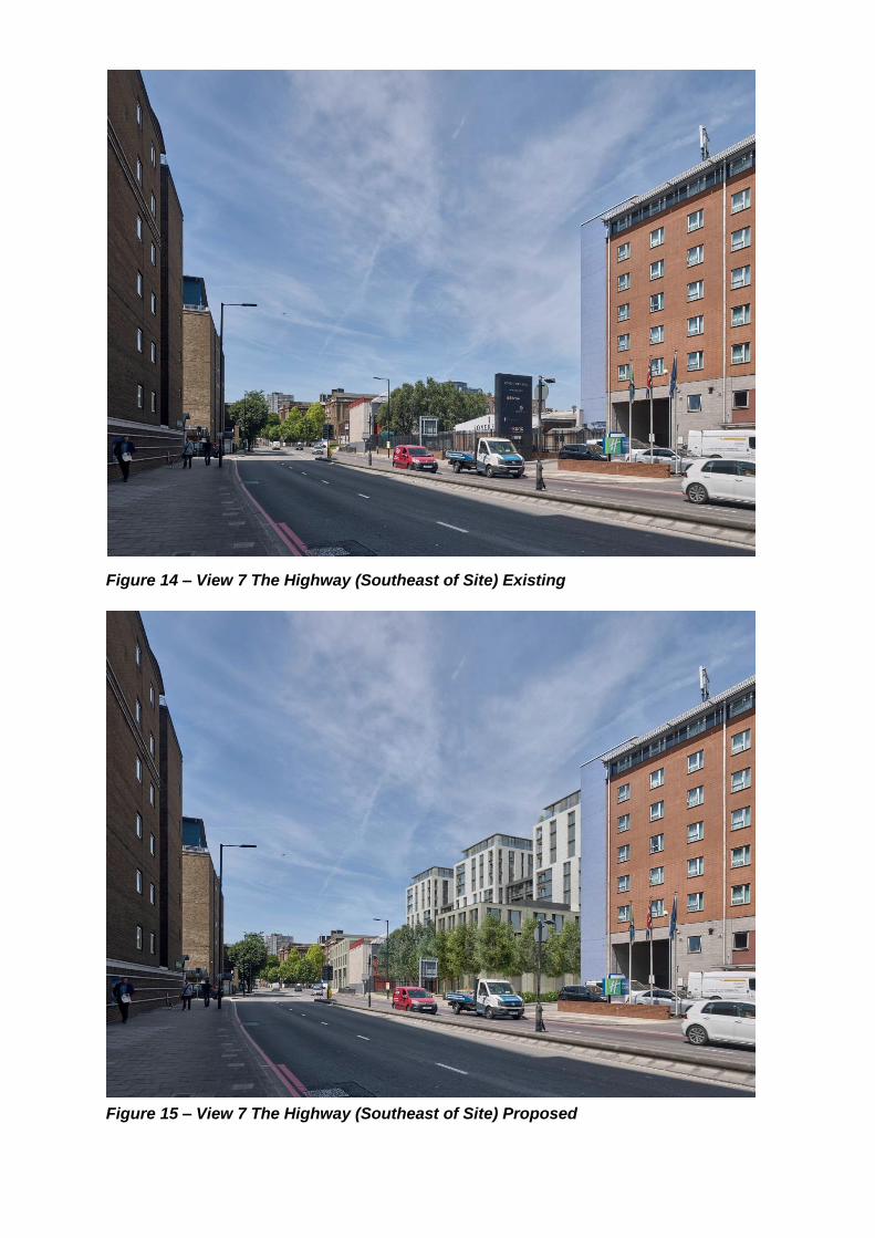
Figure 14 – View 7 The Highway (Southeast of Site) Existing
Figure 15 – View 7 The Highway (Southeast of Site) Proposed

Figure 16 – View 7 The Highway (Southwest of Site) Existing
Figure 17 – View 7 The Highway (Southwest of Site) Proposed

Figure 18 – View 11 Thames Path (South) Existing
Figure 19 – View 11 Thames Path (South) Proposed

Figure 20 – View 14 Thames Path (2) Existing
Figure 21 – View 14 Thames Path (2) Proposed