strategic redevelopment initiative pilot project · 2015-11-02 · strategic redevelopment...
TRANSCRIPT
STRATEGIC REDEVELOPMENT INITIATIVE PILOT PROJECT
Stratford, Connecticut
ABSTRACT: This report and redevelopment plan is the result of a Strategic Redevelopment Initiative (SRI) pilot project completed in Stratford, Connecticut. The SRI was carried out by the Town of Stratford with funding supplied by the US Environmental Protection Agency. The plan makes recommendations for re-use and redevelopment of property being made available through the site remediation process. It describes 23 properties in Stratford, provides the results of a survey of property owners, and presents redevelopment concepts for 10 of the properties.
TABLE OF CONTENTS I. BACKGROUND....................................................................................................................... 1
II. CHARACTERISTICS OF THE STUDY AREA................................................................. 4 A. EXISTING LAND USE....................................................................................................... 4 B. SOIL TYPES ........................................................................................................................ 4 C. WETLANDS ........................................................................................................................ 4 D. FLOODPLAIN..................................................................................................................... 4
E. SOIL CONTAMINATION ................................................................................................... 9
III. SURVEY OF PROPERTY OWNERS .............................................................................. 13 A. PARCEL SETTING........................................................................................................... 13 B. LAND USE CONSIDERATIONS..................................................................................... 13 C. LEGAL ISSUES................................................................................................................. 17 D. PUBLIC INITIATIVE ....................................................................................................... 17 E. COMMUNITY INPUT....................................................................................................... 17 F. LOCAL STAKEHOLDERS............................................................................................... 17 G. ENVIRONMENTAL CONCERNS................................................................................... 18
IV. SITE SELECTION.............................................................................................................. 18 A. SELECTION CRITERIA................................................................................................... 19 B. SELECTION RESULTS .................................................................................................... 19
V. REMEDIATION APPROACHES....................................................................................... 23
VI. REDEVELOPMENT CONCEPTS .................................................................................... 24 A. HOTEL/ MARINA COMPLEX AND MITIGATION WETLAND................................. 26 B. SUPPORT OF EXISTING BUSINESSES ALONG FERRY BOULEVARD.................. 28 C. RESIDENTIAL/COMMERCIAL PLANNED UNIT DEVELOPMENT (PUD).............. 29 D. COMMERCIAL OFFICE PARK ...................................................................................... 31 E. RECREATIONAL COMPLEX.......................................................................................... 32
VI. FUNDING SOURCES ........................................................................................................ 34
VII. LIABILITY AND INSURANCE...................................................................................... 36
VIII. NEXT STEPS IN THE REDEVELOPMENT PROCESS ........................................... 39 A. FEDERAL PERMITS......................................................................................................... 39 B. STATE PERMITS............................................................................................................... 40 C. LOCAL PERMITS.............................................................................................................. 41 APPENDICES A. SURVEY INSTRUMENT B. ZONING OFFICER’S REVIEW
LIST OF FIGURES
Figure 1: The project area is located along Ferry Creek on the west bank of the Housatonic River in Stratford, CT …………………………………………………………………………..1 Figure 2: Twenty-three properties in Stratford were considered for redevelopment...................... 2 Figure 3: Existing land use in study area. ....................................................................................... 5 Figure 4: Soils in the study area...................................................................................................... 6 Figure 5: Wetlands in the study area............................................................................................... 7 Figure 6: Floodplains in subject area. ............................................................................................. 8 Figure 7: Sampling and testing results (central). .......................................................................... 10 Figure 8: Sampling and testing results (north).............................................................................. 11 Figure 9: Sampling and testing results (south). ............................................................................ 12 Figure 10: Properties studied and their selection status................................................................ 22 Figure 11: Overview of potential redevelopment of project area. ................................................ 25 Figure 12: Walkways along the Housatonic River could be developed to form parts of the
proposed Housatonic Greenway.......................................................................................... 25 Figure 13: After remediation, property near the mouth of Ferry Creek could be developed for a
small hotel and marina......................................................................................................... 27 Figure 14: Artist's conception of redevelopment at Lockwood Avenue. .................................... 27 Figure 15: Most owners of businesses along Ferry Boulevard wish to continue to operate.. ...... 28 Figure 16: Artist's conception of redevelopment along Ferry Boulevard.................................... 27 Figure 17 : A mixed use planned unit development (PUD) could be designed for 600 East
Broadway............................................................................................................................. 30 Figure 18: A mixed use planned unit development (PUD) could mix residential and commercial
uses, providing a transition between residential property to the west and commercial property to the east. ............................................................................................................. 30
Figure 19: The former Contract Plating property has high visibility and is convenient to the highway. This property could be redeveloped as a commercial office park. ..................... 31
Figure 20: Artist's conception of redevelopment along at Contract Plating ................................ 32 Figure 21: Artist's conception of adaptive reuse of existing building at Contract Plating. ......... 32 Figure 23: After remediation the former Raymark Ball Field could be redeveloped as part of a
recreational complex............................................................................................................ 33 Figure 23: The former Raymark Ball Field could be returned to recreational use and adjoining
property could be used to create a sports/athletic complex. ................................................ 33
LIST OF TABLES Table 1: Town of Stratford Redevelopment Initiative Subject Property Owners List. .................. 3 Table 2: List of property owners and summary of survey responses. .......................................... 15 Table 3: Application of Decision Criteria to Sites Considered.................................................... 20
Redevelopment Initiative Pilot Program Stratford, CT
1
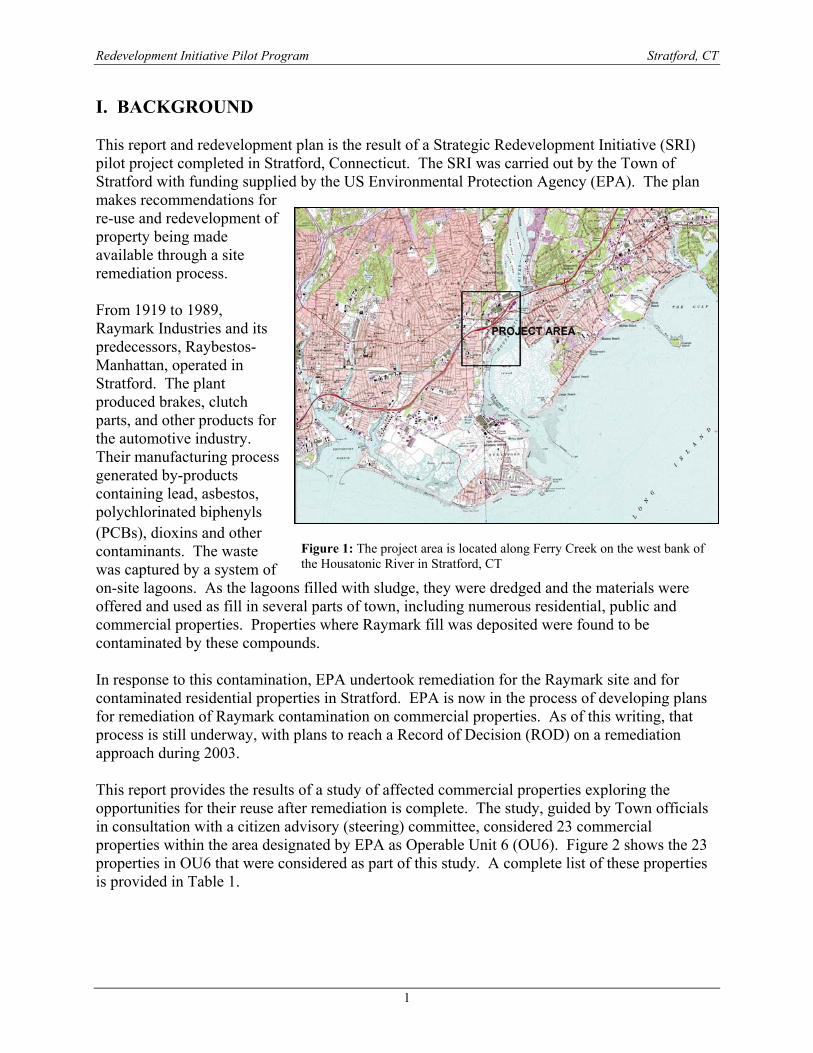
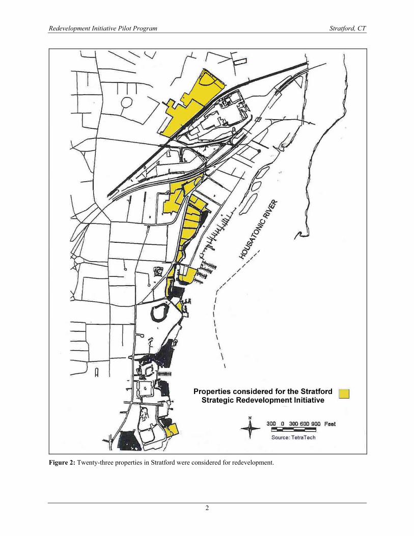
I. BACKGROUND This report and redevelopment plan is the result of a Strategic Redevelopment Initiative (SRI) pilot project completed in Stratford, Connecticut. The SRI was carried out by the Town of Stratford with funding supplied by the US Environmental Protection Agency (EPA). The plan makes recommendations for re-use and redevelopment of property being made available through a site remediation process. From 1919 to 1989, Raymark Industries and its predecessors, Raybestos-Manhattan, operated in Stratford. The plant produced brakes, clutch parts, and other products for the automotive industry. Their manufacturing process generated by-products containing lead, asbestos, polychlorinated biphenyls (PCBs), dioxins and other contaminants. The waste was captured by a system of on-site lagoons. As the lagoons filled with sludge, they were dredged and the materials were offered and used as fill in several parts of town, including numerous residential, public and commercial properties. Properties where Raymark fill was deposited were found to be contaminated by these compounds. In response to this contamination, EPA undertook remediation for the Raymark site and for contaminated residential properties in Stratford. EPA is now in the process of developing plans for remediation of Raymark contamination on commercial properties. As of this writing, that process is still underway, with plans to reach a Record of Decision (ROD) on a remediation approach during 2003. This report provides the results of a study of affected commercial properties exploring the opportunities for their reuse after remediation is complete. The study, guided by Town officials in consultation with a citizen advisory (steering) committee, considered 23 commercial properties within the area designated by EPA as Operable Unit 6 (OU6). Figure 2 shows the 23 properties in OU6 that were considered as part of this study. A complete list of these properties is provided in Table 1.
Figure 1: The project area is located along Ferry Creek on the west bank of the Housatonic River in Stratford, CT
Redevelopment Initiative Pilot Program Stratford, CT
2
Figure 2: Twenty-three properties in Stratford were considered for redevelopment.
Redevelopment Initiative Pilot Program Stratford, CT
3
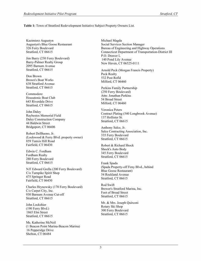
Table 1: Town of Stratford Redevelopment Initiative Subject Property Owners List.
Kazimierz Augustyn Augustyn's Blue Goose Restaurant 326 Ferry Boulevard Stratford, CT 06615
Edwin C. Fordham Fordham Realty 280 Ferry Boulevard Stratford, CT 06615
Rod Swift Brewer's Stratford Marina, Inc. Foot of Broad Street Stratford, CT 06615
Veronica Peters Contract Plating (540 Longbrook Avenue) 137 Hollister St. Stratford, CT 06615
John Daley Raybestos Memorial Field Daley Construction Company 44 Baldwin Street Bridgeport, CT 06606
Jim Barry (230 Ferry Boulevard) Barry-Palmer Realty Group 2095 Barnum Avenue Stratford, CT 06615
John Lockshier (190 Ferry Blvd.) 1865 Elm Street Stratford, CT 06615
Perkins Family Partnership (250 Ferry Boulevard) Attn: Jonathan Perkins 54 Broad Street Milford, CT 06460
Commodore Housatonic Boat Club 643 Riverdale Drive Stratford, CT 06615
Don Brown Brown's Boat Works 638 Stratford Avenue Stratford, CT 06615
Mr. & Mrs. Joseph Quirconi Rotary Ski Shop 300 Ferry Boulevard Stratford, CT 06615
Robert DelBuono, Jr. (Lockwood & Ferry Blvd. property owner) 859 Tunxis Hill Road Fairfield, CT 06430 Robert & Richard Shock
Shock's Auto Body 345 Ferry Boulevard Stratford, CT 06615
Anthony Salce, Jr. Salce Contracting Association, Inc. 335 Ferry Boulevard Stratford, CT 06615
Frank Spada (Spada Property-off Feny Blvd., behind Blue Goose Restaurant) 54 Rockland Avenue Stratford, CT 06615
N/F Edward Grella (200 Ferry Boulevard) C/o Turnpike Spirit Shop 475 Springer Road Fairfield, CT 06430
Charles Hrynewsky (170 Ferry Boulevard) C/o Carpet City, Inc. 930 Barnum Avenue Cut-off Stratford, CT 06615
Ms. Katherine McNeil (1 Beacon Point Marina-Beacon Marina) 16 Pepperidge Drive Shelton, CT 06484
Michael Magda Social Services Section Manager Bureau of Engineering and Highway Operations Connecticut Department of Transportation-District III P.O. Drawer L 140 Pond Lily Avenue New Haven, CT 06525-0111
Arnold Peck (Morgan Francis Property) Peck Realty 532 Post Rofld Milford, CT 06460
Redevelopment Initiative Pilot Program Stratford, CT
4
II. CHARACTERISTICS OF THE STUDY AREA The study area consists predominantly of low-lying land along the west bank of the Housatonic River. Properties along Ferry Boulevard and Ferry Creek form the core of the study area although parcels as far south as the Housatonic Boat Club and as far north as the former Raymark ball field were considered. A. EXISTING LAND USE Land use in the study area is shown in Figure 3. The study area is predominantly occupied by commercial land uses such as an ice cream shop, liquor store, automobile dealer, boat dealers, small retail shops, automobile body shops and restaurants. Some vacant land is included, particularly the Morgan Francis property at Ferry and Lockwood near the mouth of Ferry Creek. Other open space is part of public rights-of-way and the banks of Ferry Creek. The ball field at the north end of the study area is unused, but still classified as recreational property. Just south of the ball field is Contract Plating, currently vacant, but classified as industrial property based on its former use. B. SOIL TYPES Soils in the project area are shown in Figure 4. Much of the area is classified as Udorthents, indicating the impact of development. Udorthents are soils that have been disturbed, graded or filled for development purposes. Other prominent soils in the study area are organic soils associated with wetlands and upland soils in the area north of the railroad tracks. C. WETLANDS Wetlands in the study area are shown in Figure 5. Wetland soils are concentrated along the shores of Ferry Creek. These soils reportedly include peat deposits and organic material, which make them unsuitable for building purposes. Most of the wetlands in the project area are tidally influenced, but dense growth of Phragmites indicates brackish conditions caused by fresh water inflow via Ferry Creek. D. FLOODPLAIN Figure 6 shows the limits of the 100 and 500-year floodplain in the study area. Much of the study area is within floodplain. The 100-year flood plain is the area within which there is a 1% chance of flooding in any given year. There is a 0.2% chance of flooding in any given year within the 500-year floodplain.

Redevelopment Initiative Pilot Program Stratford, CT
5
Figure 3: Existing land use in study area.

Redevelopment Initiative Pilot Program Stratford, CT
6
Figure 4: Soils in the study area.

Redevelopment Initiative Pilot Program Stratford, CT
7
Figure 5: Wetlands in the study area.

Redevelopment Initiative Pilot Program Stratford, CT
8
Figure 6: Floodplains in subject area.
Redevelopment Initiative Pilot Program Stratford, CT
9
E. SOIL CONTAMINATION Raymark waste is generally identified with concentrations of asbestos, polychlorinated biphenyls (PCB) [specifically Arochlor 1268], lead above 1,000 ppm, and copper above 260 ppm. All of the properties in this redevelopment pilot project are known or suspected to contain Raymark Waste. All are listed as properties within Operating Unit 6 (OU6) of the Raymark superfund site. The exact extent of contamination on each of the subject properties is not known. Some sampling and testing of soils has been undertaken for the remediation project. Figures 7, 8, and 9 show the locations from which samples have been taken. One or all of the Raymark constituents have been found on all 23 properties included in the redevelopment initiative. All samples tested contain at least one of the contaminants normally associated with Raymark waste. Sample density varies between properties. Most of the samples taken from properties along Ferry Boulevard were surface soils from around the perimeter of the property. Those properties are mostly paved. Asbestos was found on all 23 of the properties. Lead was found on all the properties, though not necessarily above the concentration of concern (1000 ppm). PCBs were found in several locations, particularly on the northeast corner of 230 Ferry Boulevard and southeast corner of 250 Ferry Boulevard in fill areas adjacent to the creek. Further site specific testing will be necessary to establish the limits of contamination on the properties and design property specific remediation.

Redevelopment Initiative Pilot Program Stratford, CT
10
Figure 7: Sampling and testing results (central).

Redevelopment Initiative Pilot Program Stratford, CT
11
Figure 8: Sampling and testing results (north).

Redevelopment Initiative Pilot Program Stratford, CT
12
Figure 9: Sampling and testing results (south).
Redevelopment Initiative Pilot Program Stratford, CT
13
III. SURVEY OF PROPERTY OWNERS The study included the preparation of a survey instrument designed to solicit information on the extent of contamination on each site and to gauge the level of interest on the part of the site owner in participating in redevelopment planning. The survey instrument was reviewed and approved by the steering committee and then was administered, by personal interview, to the owners of the 23 properties (Tables 2 and 3). A copy of the survey is attached as Appendix A to this report. Fourteen (14) of the owners/operators of these 23 properties responded to requests for interviews. During the interviews the site owners or operators were asked to complete the survey by responding to questions pertaining to parcel setting, land use considerations, legal issues, public initiative, community input, local stakeholders, and environmental concerns. When respondents did not know the answer to a particular question, they were instructed to answer, “don’t know” or to leave the question blank. The owner of Brewer’s Boat Works was approached on multiple occasions, each time indicating that he did not want to participate in the survey or activities. Some of the parcels did not have any structures on them and so the surveys were not relevant to these properties. The remaining 13 owner/operators all cooperated with this study. A. PARCEL SETTING The surveyed area was primarily commercial with a few industrial uses. The current uses included a retail sports store, used car and boat dealerships, storage and office spaces, food services, a marina, an auto body shop, and a metal finishing factory. The land ranged in size from less than one acre to more than 10 acres. Improvements on these properties began as far back as 85 years ago at 540 Longbrook Avenue, and the most recent improvement was made just 7 years ago at 630 Broad Street. These improvements generally consisted of adding additions to pre-existing buildings, paving areas of blacktop, making renovations, constructing additional buildings, and the building of a dock on a piece of waterfront property. The known previous uses included restaurants, auto body shops and auto dealerships, and a machine shop. The majority of respondents (69.2%) said they received their utilities (water, gas, electric, sewer) from Ferry Boulevard. One owner receives utilities from Broad Street and another from Longbrook Avenue. Property taxes ranged from less than five thousand dollars ($5,000) for an auto body repair shop located at 345 Ferry Boulevard on a lot less than one acre, to one hundred ten thousand dollars ($110,000) for a parcel just over 10 acres owned by Contract Plating Company, Inc. of 540 Longbrook Avenue. The average amount paid in taxes was around thirty-three thousand dollars ($33,000). When asked if taxes were current, all but two respondents answered “yes.” Reasons cited for the two delinquencies were that the property had no value, and because of environmental stigma. B. LAND USE CONSIDERATIONS Existing zoning in the area is a mixture of light commercial and industrial zones. All owners involved with the survey answered “yes” to whether or not they were in conformance with their property’s zoning classification. Approximately half of respondents (53.8%) answered they had not developed a master plan for the area. About 15.4% of people said that they had developed a
Redevelopment Initiative Pilot Program Stratford, CT
14
master plan and 30.8% did not answer this question at all. A few owners indicated they had no idea whether any institutional controls were in place. About half (53.8%) said they had not experienced any institutional controls and another 23.0% indicated that “yes,” institutional controls were in place. This included Mr. Peck, who said that a semi-engineered cap had been installed on his property, and Fordham Realty, which had the most institutional controls in place. These included the installation of an oil/water separator system, a geotextile membrane, the importation of fill, a raised elevation on the building, covering the parcel with asphalt and placed riprap on the banks of Ferry Creek to prevent erosion. Mr. DelBuono, owner of a vacant property near the outlet of Ferry Creek, suspected that Environmental Land Use Restrictions (ELURs) might have been implemented on his property restricting remedial activity. Mr. DelBuono was also the only respondent to mention any knowledge of historical or cultural resources in the area. He referred to the sister cites of Ontario and Avon, which historically meant good marketing leverage. The land trends in the area were mostly commercial development and redevelopment with light industrial, retail and service trends as well. The answers to the questions on flood plains ranged from there were no floodplains, to the possibility of some floodplains to, yes, there are definitely floodplains. Mr. Joseph Quiriconi, owner of the Rotary Ski Shop said that his land was mostly wetlands before fill was added. Mr. Quiriconi was also the only respondent who indicated that he knew of restrictions on his land. He could not do any planting, digging, or moving of dirt. The rest of the respondents had no restrictions or weren’t aware of any. None of the respondents thought there were any State Groundwater Protection issues associated with their properties.
Redevelopment Initiative Pilot Program Stratford, CT
15
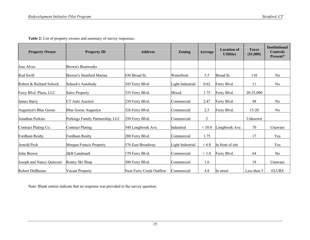
Table 2: List of property owners and summary of survey responses.
Note: Blank entries indicate that no response was provided to the survey question.
Property Owner Property ID Address Zoning Acreage Location of Utilities
Taxes ($1,000)
Institutional Controls Present?
Jose Alves Brown's Boatworks
Rod Swift Brewer's Stratford Marina 630 Broad St. Waterfront 5.5 Broad St. 110 No
Robert & Richard Schock Schock's Autobody 345 Ferry Blvd. Light Industrial 0.62 Ferry Blvd. 11 No
Ferry Blvd. Plaza, LLC Salce Property 335 Ferry Blvd. Mixed 1.75 Ferry Blvd. 20-25,000
James Barry CT Auto Auction 230 Ferry Blvd. Commercial 2.47 Ferry Blvd. 48 No
Augustyn's Blue Goose Blue Goose Augustyn 326 Ferry Blvd. Commercial 2.5 Ferry Blvd. 15-20 No
Jonathan Perkins Perkings Family Partnership, LLC 250 Ferry Blvd. Commercial 2 Unknown
Contract Plating Co. Contract Plating 540 Longbrook Ave. Industrial < 10.0 Longbrook Ave. 70 Unaware
Fordham Realty Fordham Realty 280 Ferry Blvd. Commercial 1.75 17 Yes
Arnold Peck Morgan Francis Property 576 East Broadway Light Industrial < 6.0 In front of site Yes
John Brown J&B Landmark 170 Ferry Blvd. Commercial > 1.0 Ferry Blvd. 64 No
Joseph and Nancy Quirconi Rotary Ski Shop 300 Ferry Blvd. Commercial 1.6 18 Unaware
Robert DelBuono Vacant Property Near Ferry Creek Outflow Commercial 4.8 In street Less then 5 ELURS
Redevelopment Initiative Pilot Program Stratford, CT
16
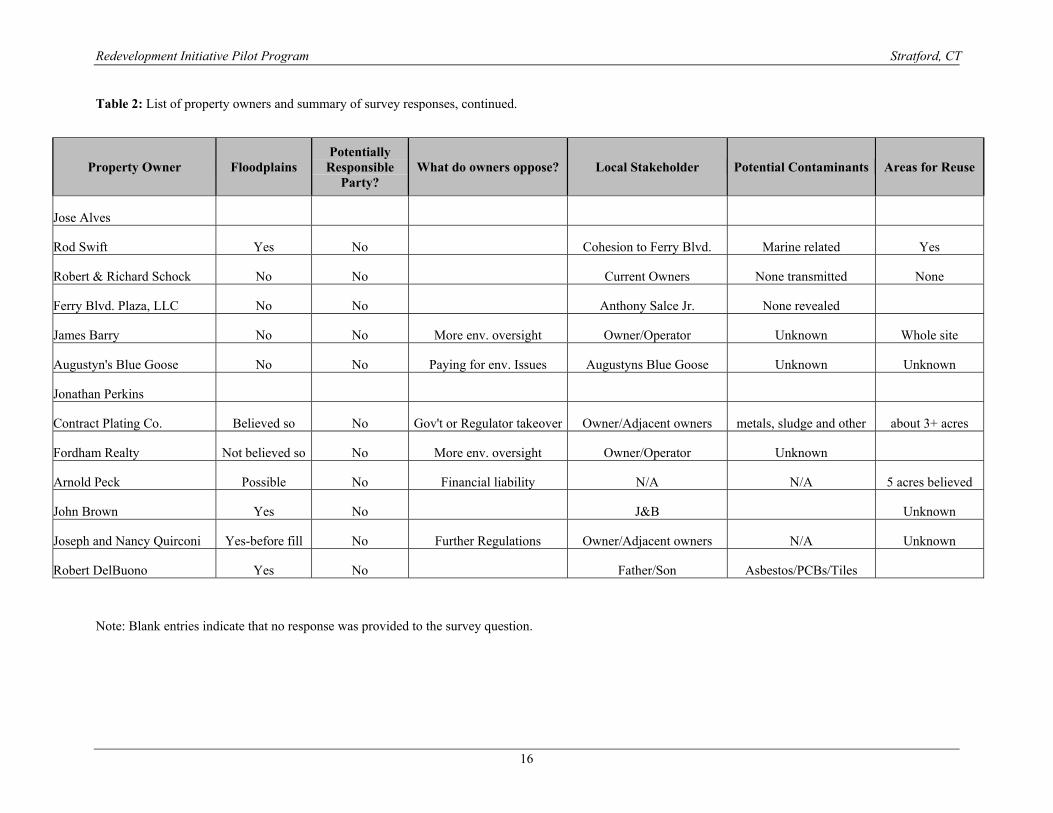
Table 2: List of property owners and summary of survey responses, continued.
Note: Blank entries indicate that no response was provided to the survey question.
Property Owner Floodplains Potentially
Responsible Party?
What do owners oppose? Local Stakeholder Potential Contaminants Areas for Reuse
Jose Alves
Rod Swift Yes No Cohesion to Ferry Blvd. Marine related Yes
Robert & Richard Schock No No Current Owners None transmitted None
Ferry Blvd. Plaza, LLC No No Anthony Salce Jr. None revealed
James Barry No No More env. oversight Owner/Operator Unknown Whole site
Augustyn's Blue Goose No No Paying for env. Issues Augustyns Blue Goose Unknown Unknown
Jonathan Perkins
Contract Plating Co. Believed so No Gov't or Regulator takeover Owner/Adjacent owners metals, sludge and other about 3+ acres
Fordham Realty Not believed so No More env. oversight Owner/Operator Unknown
Arnold Peck Possible No Financial liability N/A N/A 5 acres believed
John Brown Yes No J&B Unknown
Joseph and Nancy Quirconi Yes-before fill No Further Regulations Owner/Adjacent owners N/A Unknown
Robert DelBuono Yes No Father/Son Asbestos/PCBs/Tiles
Redevelopment Initiative Pilot Program Stratford, CT
17
C. LEGAL ISSUES None of the property owners had ever been identified as a Potentially Responsible Party and all wished to see clarification of their liability limits. The number of people (46.3%) who had previously attempted to settle their legal liability regarding their property was equal to the number of people who had not attempted to settle their liability. One out of 13 respondents did not answer this question. Nearly all the respondents would be willing to discuss a settlement of their legal liability for contamination in and around their property. D. PUBLIC INITIATIVE More than three-quarters of respondents (76.9%) answered “no” or “don’t know” to all questions pertaining to public initiative. 23.1% did not respond to any questions pertaining to public initiatives. One potential municipal/public use suggested was to use the property to support the Shakespeare Theater. E. COMMUNITY INPUT All respondents had very similar answers to questions concerning community input. Most people were aware of the Superfund Redevelopment Initiative (SRI) and the Raymark Advisory Committee (RAC). Only five of the thirteen respondents knew of the SRI, RAC, or both in relation to their property. Most of the respondent’s expectations of their community were similar. They wanted to see fairness, viability, and the education of their fellow citizens. They also expected to see the area return to normal, and one respondent (Contract Plating) wished to have information readily discussed with the general population. The responses were similar when owners were asked what they would like to see happen in their community. This included the ability to conduct “normal” unobstructed business, seeing the area prosper, having property returned to viable conditions and general community enhancement. There was also strong agreement by respondents as to what they oppose. Nearly all opposed more environmental oversight and restrictions, financial liability, and some added that they would oppose paying for environmental issues. F. LOCAL STAKEHOLDERS Eight of the thirteen respondents identified the local stakeholder as the owner/operator of the property, and the majority of respondents included the local community and surrounding properties as stakeholders as well. 76.9% of respondents were unaware of any financing or insurance products available for their property, but many said they would like to receive more information pertaining to this. Three of the thirteen respondents had banker/ lenders on their properties and one of the three did not support redevelopment. The majority of respondents did not have brokers, only one in the group did. About half (49%) of the surveyed people had lawyers and less than one-quarter (21%) of the people had ever consulted an environmental engineer. Three of the properties were for sale or had been up for sale at one time and one sale was pending verification of environmental conditions. No contracts were pending nor was the sale/lease based on any alternative uses.
Redevelopment Initiative Pilot Program Stratford, CT
18
G. ENVIRONMENTAL CONCERNS The majority of people involved in this survey had not had any environmental assessments prepared other than that done by EPA. There were four people, however, that did have environmental assessments prepared prior to the one done by EPA. In response to the question about potential contaminants and their locations 61.5% of people had no response, said it was not applicable, unknown, or there were none. Contract Plating indicated the possibility of residual metals, sludge and constituents in the deeper soil zones of their property and Mr. DelBuono said his property contained asbestos, PCB’s and Tiles. Brewer’s Stratford Marina of 630 Broad Street said there was marine related environmental contamination on their property, but did not specify the type of contaminant. They also indicated that they had addressed the environmental concerns on the property. Schock’s Autobody, located at 345 Ferry Boulevard, believes that an underground storage tank (UST) exists but has never used it and believes that it has been rendered inoperable. Mr. Jonathan Perkins of the Perkins Family Partnership, LLC, located at 250 Ferry Boulevard, says there was a leaking UST his property, but it was taken care of approximately 11 years ago with the Connecticut Department of Environmental Protection (DEP) oversight. Properties considered clean and available for reuse by their owners included 3 or more acres at 540 Longbrook Avenue, three sites in their entirety including 230 Ferry Boulevard, 630 Broad Street, and 576 East Broadway, and eight respondents did not know what amount of their land was considered available for reuse. One site, 345 Ferry Boulevard, was considered completely unusable by it’s owner. All but one respondent provided no response or answered “don’t know” about groundwater use classification/determination. The one person who did respond said groundwater on the property was contaminated as part of OU-7. One respondent, Contract Plating of 540 Longbrook Avenue, believed their site to be regulated by the Resource Conservation and Recovery Act (RCRA) and also under Superfund, while all others were believed to be regulated under the Superfund or they were unaware of any other regulation on their property. Except for the USTs mentioned above, no owners were aware of any contamination to their property other than the Raymark contamination. EPA had placed six monitoring wells and took samples at 300 Ferry Boulevard, installed soil borings at 335 Ferry Boulevard, and oversaw sight cleanup at 280 Ferry Boulevard. The state performed an Emergency Spill Closure at Contract Plating and the Connecticut Department of Transportation (DOT) performed construction easements on Mr. DelBuono’s property. Only one respondent anticipated any future controls over their property. They thought ELURs would be a probable future institutional control. However, most respondents were amenable to the possible future use of ELURs IV. SITE SELECTION The scope of work for the SRI called for preparation of redevelopment plans for up to eight sites. Therefore it was necessary to establish criteria by which a smaller subset of the 23 properties could be selected for further study.
Redevelopment Initiative Pilot Program Stratford, CT
19
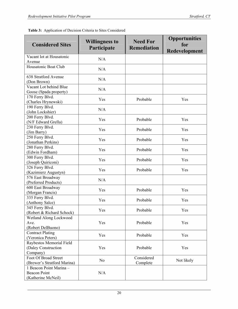
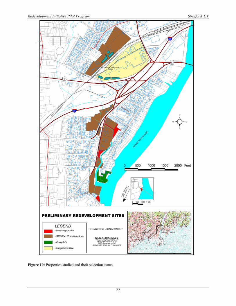
A. SELECTION CRITERIA Site selection criteria were applied to choose which of the 23 possible sites should receive consideration in the pilot. The following three criteria were used: Willingness to Participate – Redevelopment will require property owners who are cooperative and eager to participate. Therefore properties with owners who were unresponsive, or who refused to respond to the survey, were not selected. Need for remediation – The concept of the SRI pilot project was to demonstrate redevelopment and reuse alternatives for properties within the Superfund regulatory framework. Therefore properties which do not need remediation, or which have completed remediation already, were not selected. Opportunities for redevelopment and/or reuse – Properties which are not developable, or which do not lend themselves to reuse, were not selected. B. SELECTION RESULTS Table 3 shows the application of the selection criteria to the properties considered in the SRI. Figure 10 shows the properties studied and indicates their selection status. 1. Sites not selected for SRI Consideration Applying the three criteria above to the 23 sites originally selected, twelve sites were found to be unsuitable for the SRI:
• 2 property owners were inappropriate for the SRI because they had no development or reuse potential.
- One is entirely occupied by a surface drainage swale. - One is DOT property in the I-95 Right-of-way.
• 6 property owners were non-responsive and therefore their sites were not selected - John Lockshier – 90 Ferry Boulevard - Housatonic Boat Club - Katherine McNeil - Edward Grella – Turnpike Spirit Shop - Charles Hrynewsky – 170 Ferry Boulevard - Frank Spada – Vacant property Behind Blue Goose Restaurant
• 1 property owner, Brown’s Boat Works, responded but declined to participate in the SRI • 1 property owner, Brewers Stratford Marina, had already completed remediation under
the supervision of the DEP. Since remediation and reuse of the site is complete, the site was not included in the SRI (although they did complete the survey).
• 2 properties had very limited development opportunity - Shock’s Auto Body, where lot coverage with asphalt or buildings was 100% - Ferry Boulevard Plaza, a fully occupied commercial complex adjacent to I-95
Redevelopment Initiative Pilot Program Stratford, CT
20
Table 3: Application of Decision Criteria to Sites Considered
Considered Sites Willingness to Participate
Need For Remediation
Opportunities for
Redevelopment Vacant lot at Housatonic Avenue N/A
Housatonic Boat Club N/A
638 Stratford Avenue (Don Brown) N/A
Vacant Lot behind Blue Goose (Spada property) N/A
170 Ferry Blvd. (Charles Hrynewski) Yes Probable Yes
190 Ferry Blvd. (John Lockshier) N/A
200 Ferry Blvd. (N/F Edward Grella) Yes Probable Yes
230 Ferry Blvd. (Jim Barry) Yes Probable Yes
250 Ferry Blvd. (Jonathan Perkins) Yes Probable Yes
280 Ferry Blvd. (Edwin Fordham) Yes Probable Yes
300 Ferry Blvd. (Joseph Quiriconi) Yes Probable Yes
326 Ferry Blvd. (Kazimierz Augustyn) Yes Probable Yes
576 East Broadway (Preferred Products) N/A
600 East Broadway (Morgan Francis) Yes Probable Yes
335 Ferry Blvd. (Anthony Salce) Yes Probable Yes
345 Ferry Blvd. (Robert & Richard Schock) Yes Probable Yes
Wetland Along Lockwood Ave. (Robert DelBuono)
Yes Probable Yes
Contract Plating (Veronica Peters) Yes Probable Yes
Raybestos Memorial Field (Daley Construction Company)
Yes Probable Yes
Foot Of Broad Street (Brewer’s Stratford Marina) No Considered
Complete Not likely
1 Beacon Point Marina – Beacon Point (Katherine McNeil)
N/A
Redevelopment Initiative Pilot Program Stratford, CT
21
2. Sites selected for SRI Consideration Elimination of these twelve sites left ten properties for further consideration in the SRI. Although this exceeded the 8 sites authorized, the decision was made to carry all 10 sites into the planning process. This decision was made due to similarities between several of the sites which enabled them to be combined and considered together for redevelopment. Therefore sites considered for redevelopment include:
• 2 Vacant Properties - The Peck Property at 600 East Broadway – This property, locally known as the
Morgan Francis property, is zoned light industrial but presently undeveloped. - The DelBuono Property at Ferry Boulevard and Lockwood Ave. – this property is
zoned commercial but undeveloped. • 2 Underutilized Properties
- The Peters property at 540 Longbrook Avenue. This property, formerly occupied by Contract Plating is now idle industrial space.
- The Daley property at Frog Pond Lane. This property is known as Raybestos Memorial Field and was formerly used for softball games.
• 6 Active Commercial Properties - The Quirconi property at 300 Ferry Boulevard – This property is occupied by a
small strip mall housing the Rotary Ski Shop and several other retail store fronts. - Augustyn’s Blue Goose Restaurant – 326 Ferry Boulevard - Fordham Realty at 280 Ferry Boulevard – The Fordham property is now, or was
formerly used for retail boat sales. - Perkins Family Partnership, LLC property at 250 Ferry Boulevard. This property
has also been used for retail boat sales. - Barry-Palmer Realty Property at 230 Ferry Boulevard presently occupied by
Connecticut Auto Auction Auto sales. - Hrynewsky property at 170 Ferry Boulevard occupied by J.B. Landmark, and
Lighthouse Ice Cream / Coffee Shop.
Redevelopment Initiative Pilot Program Stratford, CT
22
STRATFORD, CONNECTICUT
TEAM MEMBERS:MAGUIRE GROUP INCHRP Associates, INC
RAFFERTY SPECIALTY FINANCE
PROJECT AREA
MILFORD
BRIDGEPORT
LEGEND- Non-responsive
- SRI Plan Considerations
- Complete
- Origination Site
PRELIMINARY REDEVELOPMENT SITES
FE
RR
Y B
OU
L EVA
RD
EA
ST B
RO
AD
WAY
STRATFORD AVE
HOUSATONIC
RIV
ER
LONGBROOK AVE
CLI
NTO
N AV
E
EAST M
A IN S
T RO
UTE 110
HO
USATO
NIC
AVE
WILLOW AVE
BROAD ST
FERRY CREEK
HISTORICAL INDUSTRIALPONDS
°
°
(/1
.-,95
(/1
.-,95
S
N
EW
0 500 1000 1500 2000 Feet
¶App r
ox. 0
.6 m
iles
S
of 6
3 8 S
trat fo
rd A
ve.
0 500 1000 Feet
Figure 10: Properties studied and their selection status.
Redevelopment Initiative Pilot Program Stratford, CT
23
V. REMEDIATION APPROACHES This SRI is focused on the redevelopment of the properties after remediation is complete. Its purpose is not to select or dictate remediation approaches. However, since the opportunities for redevelopment are closely related to the remediation approach, the common approaches to remediation are summarized herein. It should be noted that there is no effective treatment available to render soils that are contaminated with asbestos non-hazardous. Therefore treatment is not an option for Raymark waste that includes asbestos. This leaves two types of options available for remediation; encapsulation and removal. Encapsulation – Encapsulation is the process by which contaminants on a site are rendered immobile and/or protected to prevent public contact and associated risks. This method is also commonly referred to as “capping”. Common methods of encapsulation include:
Earthen cap – This typically requires cover with four feet of low permeability soil followed by loaming and seeding over the surface to prevent erosion. Its advantage is that it is one of the easiest approaches to remediation. Its disadvantage lies in the resulting dramatic change in site elevation that disrupts the relationship between buildings and the surface of the site.
Engineered cap – In this approach, engineered materials such as a geotextile membrane are used to replace part of the earth in the cap. The geotextile is then covered over with about two feet of soil followed by loaming and seeding. This approach is often the least expensive approach to remediation and overcomes some, but not all, of the problem of increased site elevation relative to site buildings. Asphalt may be used in place of loam and seed when remediated areas are to be used as parking lots. Building cap – In this approach, contaminants on a site are consolidated under the floor slab of a commercial or industrial structure. The floor slab may also sometimes be underlain by geotextiles depending on the type of containment. The advantage of this type of containment is that it can easily be accommodated as part of building construction. The disadvantage is that it is not applicable to sites where building construction is not proposed. ELUR – Environmental Land Use Restrictions (ELURs) are normally used in association with containment structures. ELURs are recorded with the property deed to place restrictions on disturbance of the containment area and require maintenance and monitoring of the containment structures on the property. Effective encapsulation requires long term maintenance and periodic inspection to ensure the integrity of the cap.
Removal – Removal is the process by which contaminated materials are excavated from the property and transported elsewhere. There are three basic approaches to removal, on-site, local and long distance. On-site removal involves transporting waste material from one part of a property to
another, usually from an open area to another nearby area where containment can be
Redevelopment Initiative Pilot Program Stratford, CT
24
provided as described above. This approach is also sometimes referred to as consolidation. The advantage of this approach is that the transport can often be accomplished by excavation equipment with no need for trucking on public streets. The disadvantage is that it is only applicable in association with the construction of containment.
Local removal involves transport to an adjacent or nearby site for containment. This
approach may require some trucking, but allows multiple properties to take advantage of containment facilities under construction on one property and thereby realize economies of scale in construction. Its disadvantage is that it typically requires some transport over local roads.
Long distance removal involves loading material into transport trucks and shipping it to
secure disposal facilities in another location. The advantage of this approach is that it completely removes the target materials from the property. The disadvantage is that it requires extensive transport over public streets, there are few approved disposal facilities available, and the transport can be very expensive.
The ultimate selection of a remediation approach for the properties in the study area will be made by the EPA, in consultation with the Town, the property owners, and the Raymark Advisory Committee (RAC). VI. REDEVELOPMENT CONCEPTS Figure 11 provides an overview of potential redevelopment within the project area. Redevelopment concepts were developed based on discussions with property owners, interested citizens and Town officials. The following uses might be considered for the project area:
• Recreational Facilities • Commercial Office Park • Commercial Planned Unit Development (PUD) • Public Parkland • Streetscape Improvements • Continuation Of Existing Viable Businesses • Constructed Wetlands • Hotel/Marina Complex
The text on the following pages provides descriptions and illustrations of each of these types of redevelopment and indicates how specific redevelopment concepts can be applied to groups of properties in the project area. These plans and illustrations are provided to show concepts for each property. They do not represent designs for any development and should not be constructed to dictate the types of development that must occur within the project area. Instead, they provide examples of how the area might be redeveloped after remediation is complete.

Redevelopment Initiative Pilot Program Stratford, CT
25
Figure 11: Overview of potential redevelopment of project area.
Redevelopment Initiative Pilot Program Stratford, CT
26
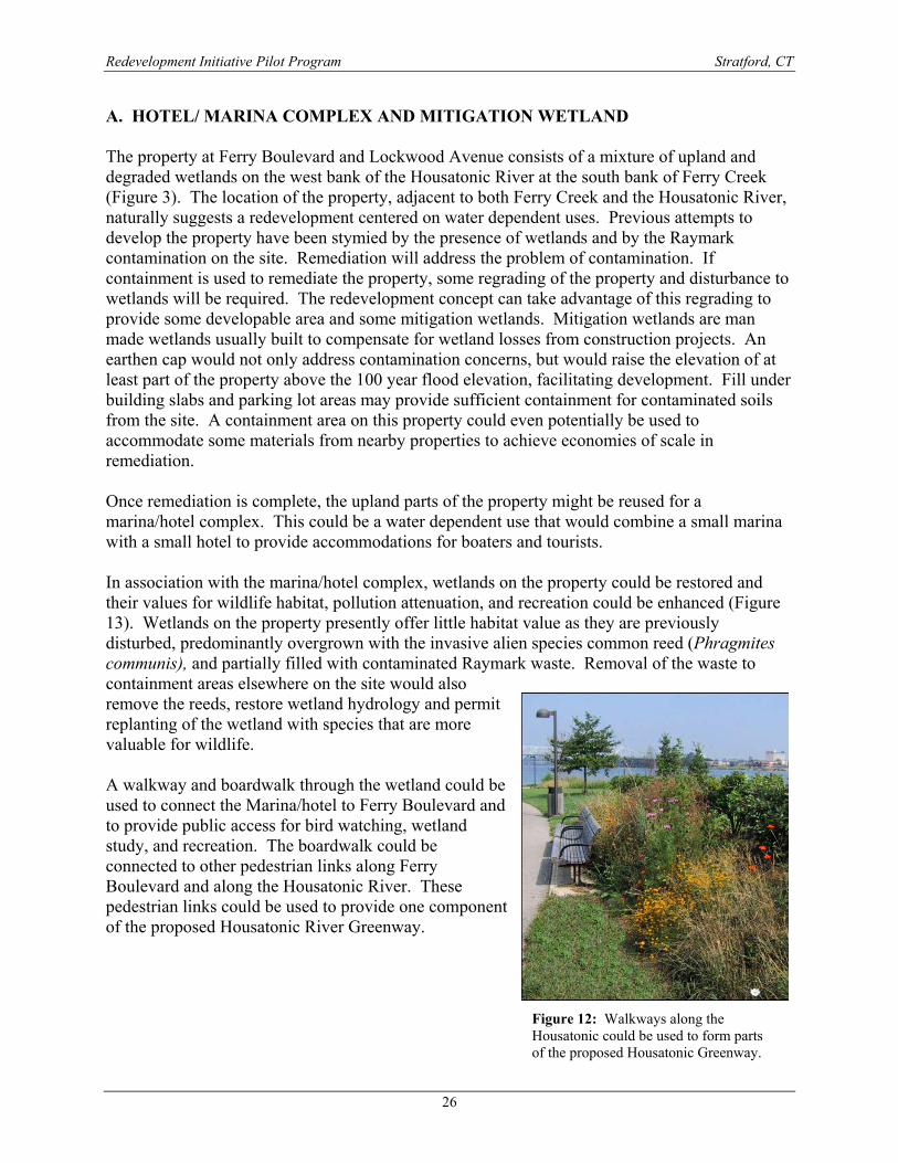
A. HOTEL/ MARINA COMPLEX AND MITIGATION WETLAND The property at Ferry Boulevard and Lockwood Avenue consists of a mixture of upland and degraded wetlands on the west bank of the Housatonic River at the south bank of Ferry Creek (Figure 3). The location of the property, adjacent to both Ferry Creek and the Housatonic River, naturally suggests a redevelopment centered on water dependent uses. Previous attempts to develop the property have been stymied by the presence of wetlands and by the Raymark contamination on the site. Remediation will address the problem of contamination. If containment is used to remediate the property, some regrading of the property and disturbance to wetlands will be required. The redevelopment concept can take advantage of this regrading to provide some developable area and some mitigation wetlands. Mitigation wetlands are man made wetlands usually built to compensate for wetland losses from construction projects. An earthen cap would not only address contamination concerns, but would raise the elevation of at least part of the property above the 100 year flood elevation, facilitating development. Fill under building slabs and parking lot areas may provide sufficient containment for contaminated soils from the site. A containment area on this property could even potentially be used to accommodate some materials from nearby properties to achieve economies of scale in remediation. Once remediation is complete, the upland parts of the property might be reused for a marina/hotel complex. This could be a water dependent use that would combine a small marina with a small hotel to provide accommodations for boaters and tourists. In association with the marina/hotel complex, wetlands on the property could be restored and their values for wildlife habitat, pollution attenuation, and recreation could be enhanced (Figure 13). Wetlands on the property presently offer little habitat value as they are previously disturbed, predominantly overgrown with the invasive alien species common reed (Phragmites communis), and partially filled with contaminated Raymark waste. Removal of the waste to containment areas elsewhere on the site would also remove the reeds, restore wetland hydrology and permit replanting of the wetland with species that are more valuable for wildlife. A walkway and boardwalk through the wetland could be used to connect the Marina/hotel to Ferry Boulevard and to provide public access for bird watching, wetland study, and recreation. The boardwalk could be connected to other pedestrian links along Ferry Boulevard and along the Housatonic River. These pedestrian links could be used to provide one component of the proposed Housatonic River Greenway.
Figure 12: Walkways along the Housatonic could be used to form parts of the proposed Housatonic Greenway.
Redevelopment Initiative Pilot Program Stratford, CT
27
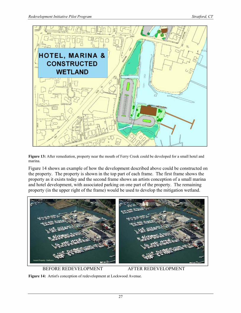
Figure 13: After remediation, property near the mouth of Ferry Creek could be developed for a small hotel and marina. Figure 14 shows an example of how the development described above could be constructed on the property. The property is shown in the top part of each frame. The first frame shows the property as it exists today and the second frame shows an artists conception of a small marina and hotel development, with associated parking on one part of the property. The remaining property (in the upper right of the frame) would be used to develop the mitigation wetland.
BEFORE REDEVELOPMENT AFTER REDEVELOPMENT Figure 14: Artist's conception of redevelopment at Lockwood Avenue.
Vacant Property - DelBuono
Redevelopment Initiative Pilot Program Stratford, CT
28
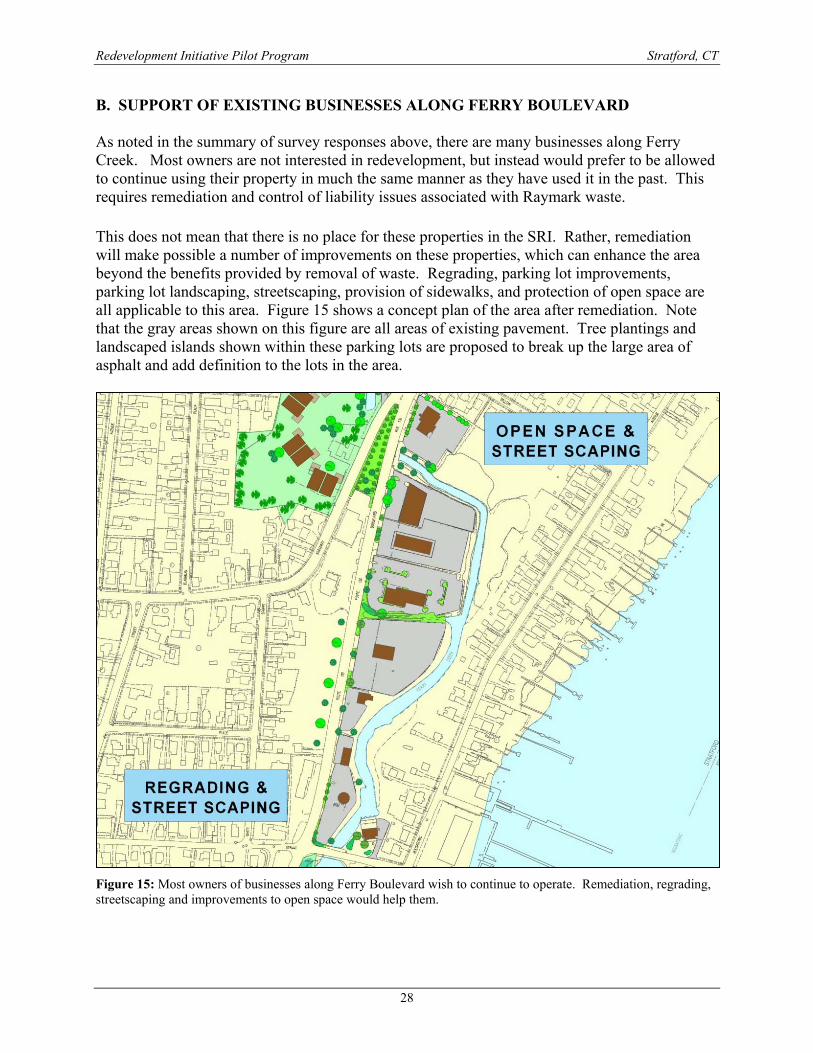
B. SUPPORT OF EXISTING BUSINESSES ALONG FERRY BOULEVARD As noted in the summary of survey responses above, there are many businesses along Ferry Creek. Most owners are not interested in redevelopment, but instead would prefer to be allowed to continue using their property in much the same manner as they have used it in the past. This requires remediation and control of liability issues associated with Raymark waste. This does not mean that there is no place for these properties in the SRI. Rather, remediation will make possible a number of improvements on these properties, which can enhance the area beyond the benefits provided by removal of waste. Regrading, parking lot improvements, parking lot landscaping, streetscaping, provision of sidewalks, and protection of open space are all applicable to this area. Figure 15 shows a concept plan of the area after remediation. Note that the gray areas shown on this figure are all areas of existing pavement. Tree plantings and landscaped islands shown within these parking lots are proposed to break up the large area of asphalt and add definition to the lots in the area.
Figure 15: Most owners of businesses along Ferry Boulevard wish to continue to operate. Remediation, regrading, streetscaping and improvements to open space would help them.
Redevelopment Initiative Pilot Program Stratford, CT
29
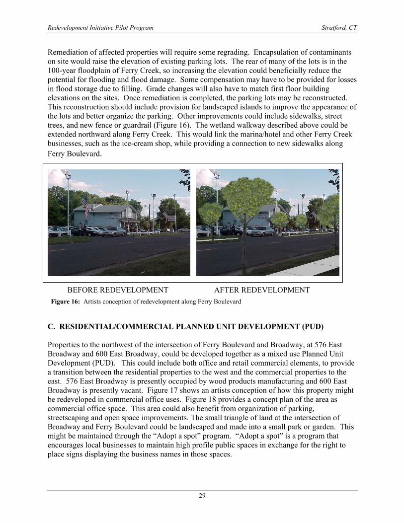
Remediation of affected properties will require some regrading. Encapsulation of contaminants on site would raise the elevation of existing parking lots. The rear of many of the lots is in the 100-year floodplain of Ferry Creek, so increasing the elevation could beneficially reduce the potential for flooding and flood damage. Some compensation may have to be provided for losses in flood storage due to filling. Grade changes will also have to match first floor building elevations on the sites. Once remediation is completed, the parking lots may be reconstructed. This reconstruction should include provision for landscaped islands to improve the appearance of the lots and better organize the parking. Other improvements could include sidewalks, street trees, and new fence or guardrail (Figure 16). The wetland walkway described above could be extended northward along Ferry Creek. This would link the marina/hotel and other Ferry Creek businesses, such as the ice-cream shop, while providing a connection to new sidewalks along Ferry Boulevard.
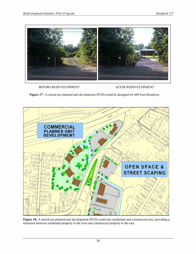
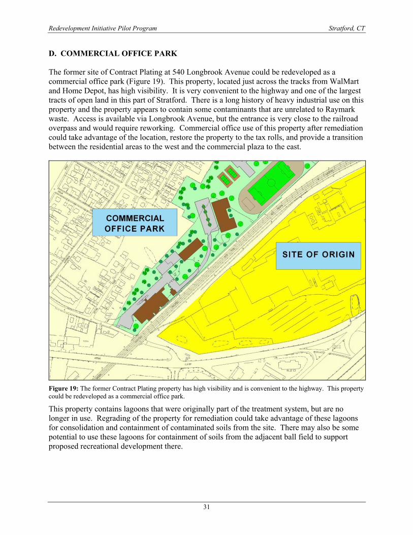
BEFORE REDEVELOPMENT AFTER REDEVELOPMENT C. RESIDENTIAL/COMMERCIAL PLANNED UNIT DEVELOPMENT (PUD) Properties to the northwest of the intersection of Ferry Boulevard and Broadway, at 576 East Broadway and 600 East Broadway, could be developed together as a mixed use Planned Unit Development (PUD). This could include both office and retail commercial elements, to provide a transition between the residential properties to the west and the commercial properties to the east. 576 East Broadway is presently occupied by wood products manufacturing and 600 East Broadway is presently vacant. Figure 17 shows an artists conception of how this property might be redeveloped in commercial office uses. Figure 18 provides a concept plan of the area as commercial office space. This area could also benefit from organization of parking, streetscaping and open space improvements. The small triangle of land at the intersection of Broadway and Ferry Boulevard could be landscaped and made into a small park or garden. This might be maintained through the “Adopt a spot” program. “Adopt a spot” is a program that encourages local businesses to maintain high profile public spaces in exchange for the right to place signs displaying the business names in those spaces.
Figure 16: Artists conception of redevelopment along Ferry Boulevard
Redevelopment Initiative Pilot Program Stratford, CT
30
BEFORE REDEVELOPMENT AFTER REDEVELOPMENT
Figure 17 : A mixed use planned unit development (PUD) could be designed for 600 East Broadway.
Figure 18: A mixed use planned unit development (PUD) could mix residential and commercial uses, providing a transition between residential property to the west and commercial property to the east.
Redevelopment Initiative Pilot Program Stratford, CT
31
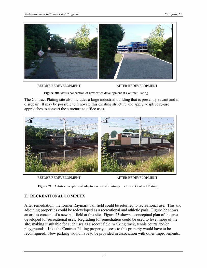
D. COMMERCIAL OFFICE PARK The former site of Contract Plating at 540 Longbrook Avenue could be redeveloped as a commercial office park (Figure 19). This property, located just across the tracks from WalMart and Home Depot, has high visibility. It is very convenient to the highway and one of the largest tracts of open land in this part of Stratford. There is a long history of heavy industrial use on this property and the property appears to contain some contaminants that are unrelated to Raymark waste. Access is available via Longbrook Avenue, but the entrance is very close to the railroad overpass and would require reworking. Commercial office use of this property after remediation could take advantage of the location, restore the property to the tax rolls, and provide a transition between the residential areas to the west and the commercial plaza to the east.
Figure 19: The former Contract Plating property has high visibility and is convenient to the highway. This property could be redeveloped as a commercial office park.
This property contains lagoons that were originally part of the treatment system, but are no longer in use. Regrading of the property for remediation could take advantage of these lagoons for consolidation and containment of contaminated soils from the site. There may also be some potential to use these lagoons for containment of soils from the adjacent ball field to support proposed recreational development there.
Redevelopment Initiative Pilot Program Stratford, CT
32
BEFORE REDEVELOPMENT AFTER REDEVELOPMENT The Contract Plating site also includes a large industrial building that is presently vacant and in disrepair. It may be possible to renovate this existing structure and apply adaptive re-use approaches to convert the structure to office uses.
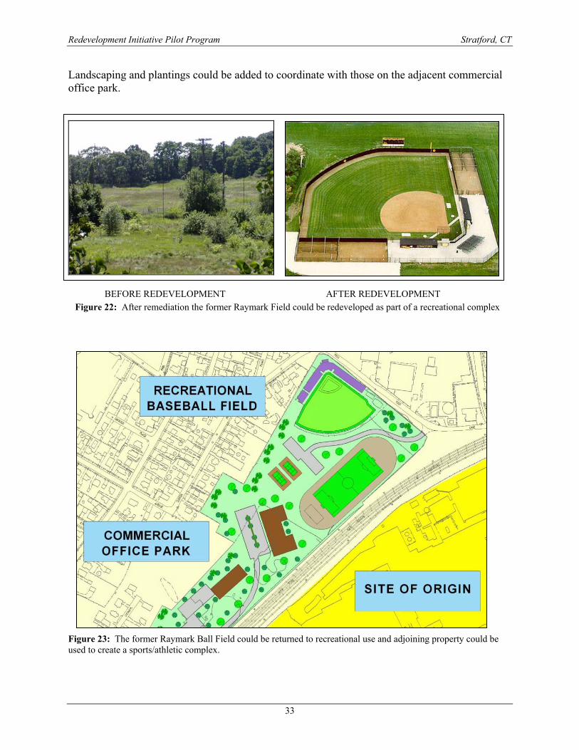
BEFORE REDEVELOPMENT AFTER REDEVELOPMENT E. RECREATIONAL COMPLEX After remediation, the former Raymark ball field could be returned to recreational use. This and adjoining properties could be redeveloped as a recreational and athletic park. Figure 22 shows an artists concept of a new ball field at this site. Figure 23 shows a conceptual plan of the area developed for recreational uses. Regrading for remediation could be used to level more of the site, making it suitable for such uses as a soccer field, walking track, tennis courts and/or playgrounds. Like the Contract Plating property, access to this property would have to be reconfigured. New parking would have to be provided in association with other improvements.
Figure 20: Artists conception of new office development at Contract Plating
Figure 21: Artists conception of adaptive reuse of existing structure at Contract Plating
Redevelopment Initiative Pilot Program Stratford, CT
33
Landscaping and plantings could be added to coordinate with those on the adjacent commercial office park.
BEFORE REDEVELOPMENT AFTER REDEVELOPMENT
Figure 23: The former Raymark Ball Field could be returned to recreational use and adjoining property could be used to create a sports/athletic complex.
Figure 22: After remediation the former Raymark Field could be redeveloped as part of a recreational complex
Redevelopment Initiative Pilot Program Stratford, CT
34
VI. FUNDING SOURCES Redevelopment will require public and private investment. Some of the potential funding sources include the following:
a) EPA Superfund – Funding provided to EPA under the Comprehensive Environmental Response Compensation and Liabilities Act (CERCLA) and the Superfund Amendments and Reauthorization Act (SARA) are the most likely source of funds for remediation.
b) Brownfields – Alternatively, funds for remediation and related site improvements
may come from Connecticut State Brownfields monies. Brownfield funding does not apply to properties under Superfund control. To stimulate development, the Connecticut Department of Economic and Community Development (DECD) offers flexible funding programs designed to provide gap financing. Without economic support, developers would turn to greenfields – farmlands and suburban tracts –– where risk is known and not consider the broader potential benefits of brownfields. DECD has already established the following important brownfields redevelopment tools:
o Industrial Site Investment Tax Credit Program - encourages private investment in environmentally contaminated properties by providing investors with a dollar for dollar corporate tax credit of up 100% of their investment, up to a maximum of $100,000,000. An eligible Industrial Site Investment Project is defined as an investment made in real property, or in improvements to real property, located within Connecticut that has been subject to environmental contamination.
o Urban Site Investment Tax Credit Program – very similar to the Industrial Site Investment Tax Credit Program, this program also offers investors a dollar for dollar corporate tax credit of up 100% of their investment up to a maximum of $100,000,000. An eligible Urban Site Investment Project is defined as an investment that will add significant new economic activity, increase employment in a new facility and generate significant additional tax revenues to the municipality and the state.
o Special Contaminated Property Remediation and Insurance Fund (SCPRIF) – provides low-interest loans for the investigation of environmental conditions associated with a site.
o Urban Sites Remedial Action Program - facilitates the transfer, reuse and redevelopment of potentially polluted commercial and industrial real property by providing funds for preparation of the planning and implementation of the site remediation. These funds are intended as "seed capital" to expedite the project.
The Department of Economic and Community Development, the state’s economic and community development agency, in partnership with the Connecticut Department of Environmental Protection, is the state’s lead agency in Brownfields remediation
Redevelopment Initiative Pilot Program Stratford, CT
35
and redevelopment. Comprehensive information about brownfields and other DECD programs is available on their website www.decd.org or by contacting Chet Camarata, P.E., the executive director of DECD’s Infrastructure and Real Estate Division, at (860) 270-8140.
b) Private investments – Private funding provided by developers and property owners
has the potential to be used for many components of the redevelopment process. Private money will continue to be the source of funding to keep Ferry Boulevard businesses operating. Private funding will also likely be used in cases where ownership of property is to be transferred (essential to qualify for Brownfields funding) and to match federal, state and local funds that require private matching. Finally, attracting private developers to make investments in the project area will be essential to development of the Planned Unit Development and office park components of the plan. Private funds may also be used to maintain streetscaping and landscaping elements of the plan through “Adopt a Spot” type programs.
c) State Economic Development Funds – In addition to Brownfields funds, DECD
works with the Connecticut Development Authority to provide financing and incentives to developers proposing investments to provide tax base, jobs and redevelopment in Connecticut. These range from tax exemptions, to tax increment financing, funding for utilities, training, loans and loan guarantees.
d) Federal Economic Development Funds – The Economic Development Administration
(EDA) is another source of potential funding. EDA, part of the U.S. Department of Commerce, was authorized under the Public Works and Economic Development Act of 1965. EDA’s main goal is to provide grant money to economically distressed areas for public works projects so they may:
a. improve the opportunities for the successful establishment or expansion of industrial or commercial facilities; b. assist in the creation of additional long-term employment opportunities; and c. benefit the area’s low-income families and long-term unemployed.
e) US Department of Housing and Urban Development Programs – HUD offers grants, loans, contracts, and other business opportunities to a wide variety of agencies, organizations, and companies in the furtherance of meeting housing program goals. HUD funds may be particularly applicable to any redevelopment elements that include new housing, affordable housing, or subsidized housing. HUD funding is available through competitive grants, formula grants, and loans. HUD administers the Community Development Block Grant (CDBG) program, which provides funds to combat blight and contribute to community development efforts.
f) Historic Preservation Funds – These funds can be used for renovation and
preservation of historic sites and structures and for investigation of the potential for the presence of historical and archaeological resources within the study area.
Redevelopment Initiative Pilot Program Stratford, CT
36
g) Transportation Funds – Connecticut DOT can participate in funding for roadway reconstruction, street-scaping, pedestrian walkways and related transportation enhancements. Transportation improvements can be timed to coordinate with remediation and redevelopment efforts.
h) Recreation Funds – A variety of public and private funding sources are available for
playgrounds, exercise facilities, and soccer fields. For example, the US Soccer Foundation in Washington, DC has a grant program to encourage communities to construct soccer facilities.
i) Local matching funds – Most government programs that make grants to communities
require that the communities provide a matching share of funding for the program. Community funds and in-kind contributions can thereby be used to leverage grant funding and enhance other public and private initiatives.
j) Special appropriations – Stratford can undertake a lobbying effort at both the state
and federal levels directed toward getting special appropriations from the legislature. This Strategic Redevelopment Initiative is unusual because it contains so many properties and Stratford may be able capitalize on this fact to generate targeted appropriations directed specifically to implementation of this plan.
k) Conservation and restoration funds – Because the implementation of this plan will
include wetland and wildlife habitat restoration elements, funding may be available under federal and state programs for restoration of wildlife habitat, purchase of open space, creation of urban parks and programs, coastal conservation, and land and water conservation.
VII. LIABILITY AND INSURANCE In order for redevelopment to occur, it is essential that liability issues be addressed. Liability for contamination can interfere with the title to properties, limit funding opportunities and frighten away prospective investors. Today, the insurance marketplace can address most environmental liability exposures, whether they be known or un-known. Specialized forms of coverage are available for remediation sites and participants in Brownfield transactions. Available coverages include:
1. Pollution Legal Liability Coverage- This protects the insured against suits brought for damages for bodily injury or property damage caused by the spread of contamination from the insured’s site onto a neighboring property. The pathway for the migration can be through the air, the groundwater or the soil. The increasing activism among many concerned citizen groups has led to hundreds of class action law suits alleging bodily injury and related health problems, to which pollution legal liability insurance responds.
2. Remediation Legal Liability- This coverage protects the insured for the cost of
remediating any additional contamination that is discovered on site. Remediation Legal Liability provides additional security to the insured for any unknown, pre-existing
Redevelopment Initiative Pilot Program Stratford, CT
37
contamination at the time the site was acquired. The discovery of any additional contamination would require remediation to a “use based standard”. The UBS reflects the regulatory agencies’ realization that a site should only be remediated based on its anticipated use, for example, the standards for remediation is more stringent for residential use than for industrial or commercial use.
3. Remediation Stop Loss Coverage - One of the newest and most critical coverages offered
by insurers is the Stop Loss. This allows the project owner to cap the remediation costs for a project. With many projects, cost overruns are incurred due to the discovery of higher than anticipated concentrations of contamination or a wider spread of contamination. In any development, a proforma to arrange financing and determine the feasibility of a project is necessary. The ability to cap the cost of remediation can provide the developer a greater certainty of his break-even point, and can enhance the ability to negotiate favorable credit terms since the potential for loss due to contamination overruns is mitigated by the policy.
4. Owner Controlled Environmental Insurance Program – This program is a wrap policy
designed to provide owners or prime contractors with combined coverage for Commercial General Liability, operations and professional services, contractors pollution occurrence, errors and omissions liability insurance, non-owned disposal site coverage, owners spill coverage, and supplemental environmental automobile insurance.
5. Secured Creditor Impaired Property Policy – This policy pays the outstanding loan
balance when a default occurs and an environmental condition exists (monetary and environmental triggers). This policy has been utilized at all levels of transaction complexity, and protects the Lender from having to enter the chain of ownership on an environmentally impaired property when a borrower defaults.
The process of remediation and “brownfield” property redevelopment will often require different insurance products over the course of redevelopment. For instance:
1. During site selection the redeveloper may benefit from professional liability coverage. The same can be said of a municipality during the point when a property is decided upon for taking for taxes or site assemblage.
2. During the remediation process third party liability coverage and stop loss protection would be desired.
3. During new construction or rehabilitation where costs are more certain, a comprehensive owner / operator liability insurance coverage would be appropriate, including the professional liability coverage.
4. During ongoing operations, uncertainties can be mitigated with long-term regulatory reopener coverage that can be available as a result of prior cost cap insurance.
5. If a developer is refinancing a project, benefits exist with long term and guaranteed renewable owner operator and reopener insurance coverage.
Environmental Insurance can be used as a valuable tool by a municipality to promote the redevelopment of impaired sites. Local efforts could range from increasing the awareness of
Redevelopment Initiative Pilot Program Stratford, CT
38
availability of insurance products through the utilization of funds for economic development to cover some or all of a redeveloper’s environmental insurance costs. DECD has (since 1993) been utilizing a tailored cleanup cap cost coverage program that permits the DECD to enter into firm fixed price contracts with private developers protecting itself from cost overruns and allowing a more expedient ability to deliver a remediated site. Municipalities can use pooled insurance to stimulate increased urban redevelopment of smaller Brownfield sites. In an instance, where a municipality has title to a number of smaller sites, via tax foreclosures, the municipality can create pools of property to gain the economic benefits of risk sharing, and purchase insurance for the pools to benefit the redeveloper and their lenders. In this example, protection may be provided free of charge as a full subsidy to all registered parcels and redevelopment projects. The purchasing organization may absorb the underwriting costs, paying fees for the creation of the policy, but charge the individual property owners or redevelopers the coverage fees for the levels of insurance they demand, thus offering a partial subsidy, or the owners or redevelopers may be charged the full amount of the coverage in which case they benefit only from the cost benefits received by the creation of the pools themselves. Pooling of sites needs to answer the following questions:
1. What type of pool of sites can be created? (Number of parcels, characteristics of ownership, intended use, location, etc.)
2. How much can the pool generated by a city reduce the costs of different insurance coverages for individual parcels by spreading risk and reducing the need for site specific underwriting?
3. Can pooling reduce the cost of needed coverage to levels that make coverage economically efficient from a private investment perspective?
4. What is the relative value of publicly financed insurance coverage to would be developers and their lenders, compared to other more direct financial subsidies?
These answers must come from all stakeholders: the public and non-profit environmental and development decision makers, developers, lenders and others involved in private investment.
In the US, there are over 400 municipal joint insurance pools for property and casualty insurance. The New Jersey Environmental Joint Insurance Fund is the only one that brings Environmental Insurance into the mix. Common perceptions about Environmental Insurance are that it is:
• Too expensive • Does not pay claims • Is not flexible • Is a waste of money

Redevelopment Initiative Pilot Program Stratford, CT
39
The redeveloper’s perception is that “If you have enough information to quantify the risks, your uncertainty is so low that the additional insurance is not needed, and only an economic decision needs to be made.” VIII. NEXT STEPS IN THE REDEVELOPMENT PROCESS This report provides the results of the Redevelopment Initiative planning process. Final plans for redevelopment cannot be prepared until the final decisions on remediation are made. The concepts shown above have been reviewed with the Stratford SRI Advisory Committee. The SRI Committee has adopted this plan and is providing it to Town, State and Federal Officials for consideration in the remediation process. Once remediation decisions have been made, the plan can proceed to design and implementation. A number of permits and approvals will be required for implementation of the redevelopment concepts presented in this document. Required permits may include any or all of the following: A. FEDERAL PERMITS US Army Corps of Engineers Section 10 - The Rivers and Harbors Acts of 1890 (superseded) and 1899 (33 U.S.C. 401, et seq.) establishes permit requirements to prevent unauthorized obstruction or alteration of any navigable water of the United States. The most frequently exercised authority is contained in Section 10 (33 U.S.C. 403) which covers construction, excavation, or deposition of materials in, over, or under such waters, or any work which would affect the course, location, condition, or capacity of those waters. The authority is granted to the Secretary of the Army. Other permit authorities in the Act are Section 9 for dams and dikes, Section 13 for refuse disposal, and Section 14 for temporary occupation of work built by the United States. Various pieces of legislation have modified these authorities, but not removed them. US Army Corps of Engineers Section 404 - In 1972, amendments to the Federal Water Pollution Control Act added what is commonly called Section 404 authority (33 U.S.C. 1344) to the program. The Secretary of the Army, acting through the Chief of Engineers, is authorized to issue permits, after notice and opportunity for public hearings, for the discharge of dredged or fill material into waters of the United States at specified disposal sites. Selection of such sites must be in accordance with guidelines developed by the Environmental Protection Agency (EPA) in conjunction with the Secretary of the Army; these guidelines are known as the 404(b)(1) Guidelines. The discharge of all other pollutants into waters of the U. S. is regulated under Section 402 of the Act which supersedes the Section 13 permitting authority mentioned above. The Federal Water Pollution Control Act was further amended in 1977 and given the common name of "Clean Water Act" and was again amended in 1987 to modify criminal and civil penalty provisions and to add an administrative penalty provision. Federal Emergency Management Agency – National Flood Insurance Program - National Flood Insurance Act and Disaster Protection Act Certification requires that banks not make, extend or review any loan secured by improved real estate located in an area having flood
Redevelopment Initiative Pilot Program Stratford, CT
40
hazards, and in which flood insurance is available, unless the building securing the loan is covered by flood insurance. This usually requires architectural or engineering review and certification of building plans to the lender. US Environmental Protection Agency - Stormwater Notices of Intent and/or NPDES Permits are required for stormwater discharges associated with certain industrial activities. Industrial activity was recently redefined to include “construction activity including clearing, grading, and excavation activities except operations that result in the disturbance of less than five acres of total land area which are not part of a larger common plan of development or sale. The project owner and operator is required to file a Notice of Intent and pollution abatement plan with the Environmental Protection Agency. B. STATE PERMITS Depending on the level of State involvement in redevelopment, any or all of the following state permits may be required: Connecticut Environmental Policy Act (DEP-FS-009) The purpose of the Connecticut Environmental Policy Act, often referred to as "CEPA", is to identify and evaluate the impacts of proposed State actions which could have the potential to significantly affect the environment. This evaluation enables the State agency responsible for reviewing the information to judge the appropriateness of proceeding with the action in light of its environmental impacts. For each State action covered by CEPA, the sponsoring agency must conduct a detailed environmental assessment. If the agency finds that the action would not have a significant environmental impact, it issues a Finding of No Significant Impact (FONSI) explaining that finding. Otherwise, the agency issues an Environmental Impact Evaluation (EIE) discussing environmental, social and economic impacts and less damaging alternatives to the proposed action.
Coastal Permits (DEP-OLISP-FS-100) This permit program, administered by the Office of Long Island Sound Programs (OLISP), regulates a variety of activities in tidal wetlands and in tidal, coastal or navigable waters of the state through two different permit programs: Structures, Dredging and Fill; and Tidal Wetlands. When making a decision on a permit application under this program, OLISP must consider factors such as: the potential effect on the area's natural resources, including, but not limited to, plant and animal species; the prevention or alleviation of shore erosion and coastal flooding; the use and development of all adjoining lands; the improvement of coastal and inland navigation for all vessels; the interests of the state in such areas as pollution control, water quality, recreational use of public water, and management of coastal resources; and the rights and interests of all persons concerned with the proposed activity. 401 Water Quality Certification (DEP-IWRD-FS-103) The 401 Water Quality Certification program, administered by the Bureau of Water Management's Inland Water Resources Division and the Office of Long Island Sound Programs, regulates any applicant for a federal license or permit who seeks to conduct an activity which may result in any discharge into the navigable waters, including all wetlands, watercourses, and natural and man-made ponds. Such persons must obtain certification from DEP that the discharge is consistent with the federal Clean Water Act and the Connecticut Water Quality Standards. Any conditions contained in a water quality
Redevelopment Initiative Pilot Program Stratford, CT
41
certification become conditions of the federal permit or license. In making a decision on a request for 401 Water Quality Certification, DEP must consider the effects of proposed discharges on ground and surface water quality and existing and designated uses of waters of the state. Flood Management Certification DEP-IWRD-FS-102 This program, administered by the Bureau of Water Management's Inland Water Resources Division, requires Department approval of a certification, or an exemption from such approval, for all State actions in or affecting floodplains or natural or man-made storm drainage facilities. In making a decision to approve or reject a state agency's flood management certification, the Department must consider whether the proposed activity: is consistent with state standards and criteria for preventing flood hazards to human life, health or property and with the provisions of the National Flood Insurance Program (NFIP) and municipal floodplain regulations; does not adversely affect fish populations or fish passage; and does not promote intensive use and development of flood prone areas.
Inland Wetlands and Watercourses DEP-IWRD-FS-104 This program, administered by the Bureau of Water Management's Inland Water Resources Division, regulates activities undertaken by state agencies in or affecting inland wetlands or watercourses. In making a decision on an inland wetlands and watercourses permit application, DEP must consider, among other things, the impact of proposed activities on the environment including wildlife and fisheries habitats, flooding and flood hazards, and whether there are alternatives to the proposed action that will cause less environmental impact. C. LOCAL PERMITS Planning and Zoning: Zoning compliance certification, site plan review, coastal review, and erosion and sedimentation controls Building Inspector Demolition Permits, Building Permits, Certificates of Occupancy, Sign Permits and Plumbing, Heating, Electrical, Air Conditioning and Water Heater Permits Inland Wetlands and Watercourses Agency Inland Wetlands and Watercourses Permit Public Works Department Sewer System Connection Permit Water System Connection As noted above, the illustrations provided in this document provide general concepts only. These are not intended to represent specific design plans for any of the redevelopment concepts. Application for most of the permits above will require detailed engineering and the preparation and submission of design plans meeting the standards of the reviewing regulatory bodies.