stratford-on-avon district council strategic housing land ... housing land... · february 2008...
TRANSCRIPT

February 2008
Stratford-on-AvonDistrict Council
Strategic Housing LandAvailability Assessment
Final Report
Baker Associates Stratford on Avon SHLAA Final Report
February 2008
1
CONTENTS
1. Introduction....................................................................................................3
2. Study methodology ........................................................................................7
3. Market assessment......................................................................................21
4. Sites with Planning Permission for housing .................................................28
5. Site Specific Sources...................................................................................30
6. Review of assessment.................................................................................32
7. Housing potential of windfall ........................................................................34
8. Broad locations ............................................................................................41
9. Summary .....................................................................................................69
Figure 1 Housing schemes currently, or soon to be, on the market………..22
Figure 2 Housing market summary………………………………………….....27
Figure 3 Distribution of housing identified housing sites……………………..31
Figure 4 Housing potential from site specific opportunities……………….....32
Figure 5 Small site completions 1987 – 2007…………………………………35
Figure 6 Large site completions 1987 – 2007………………………………...36
Figure 7 Large site completions 1987 – 2007 (exc. very large sites)………37
Figure 8 Housing completions and average rates 1987 – 2007…………….38
Figure 9 Housing potential from all sources…………………………………..39
Baker Associates Stratford on Avon SHLAA Final Report
February 2008
2
APPENDICES
Appendix 1 Sites with planning permission
Appendix 2 Typical site layouts and densities
Appendix 3 Table of rejected sites within Stratford-upon-Avon and the Main
Rural Centres
Appendix 4 Site yield summary table
Appendix 5 Opportunity site analysis forms and location plans
Appendix 6 Settlement Maps
Appendix 7 Landscape study
Appendix 8 Accessibility analysis
Appendix 9 Table of promoted sites adjacent to SuA & MRC
Appendix 10 Table of promoted sites in LCVs & Countryside
Appendix 11 Maps of all promoted sites
Appendix 12 Past completion rates for dwellings on Previously Developed Land

Baker Associates Stratford on Avon SHLAA Final Report
February 2008
3
1. Introduction
1.1. Commission
1.1.1. Baker Associates, in conjunction with Enderby Associates, were appointed in May 2007 to undertake a Strategic Housing Land Availability Assessment (SHLAA) for the administrative area of Stratford on Avon.
1.1.2. Stratford-on-Avon District falls within the South Housing Market Area of the West Midlands Regions. While the South Housing Market Area Partnership published a Strategic Housing Market Assessment in April 2007, as yet it has not sought to undertake a SHLAA for the sub-region. With no immediate prospect of a sub-regional SHLAA, and in view of the pressing need to provide evidence to inform the LDF, the District Council decided to commission a district-level SHLAA. In this case the creation and use of an ad hoc partnership group for the purposes of this SHLAA would have been detrimental to the required timetable.
1.1.3. An inception meeting was held on 14 May at which time the methodology for the study was set out and agreed. Work commenced on the study immediately following the inception meeting including correspondence with key stakeholders regarding the methodology.
1.1.4. This was followed by a widespread “call for sites” to identify all opportunities within the district. In these ways stakeholders were involved in the early stages of the process, provided with the opportunity to inform the methodology and also identify the widest range of potential sites.
1.1.5. Sites identified from all sources, including those from the previous Urban Capacity Study and those promoted by landowners/agents were visited and assessed.
1.1.6. However, in July 2007, 2 months after the commencement of the study, new guidance relating to such studies was issued by Communities and Local Government (CLG). The Strategic Housing Land Availability Assessment Practice Guidance (the practice guidance) set out further clarification of the process that councils should follow in undertaking a SHLAA.
1.1.7. It is intended to be “practical” (Para 1) and essentially contains a step by step guide to undertaking an assessment. It is made clear that the methodology set out in the document is intended as a blueprint for assessments to follow and that “When followed, a local planning authority should not need to justify the methodology used in preparing its assessment, including at independent examination” (Para 15).
1.1.8. Therefore, following the issue of the practice guidance a review was undertaken to ensure compliance between the methodology as set out and the approach advocated in the guide. This indicated that the agreed methodology was robust and that the process of undertaking the study complied with the stages set out in the practice guidance. Where the approach did differ was in

Baker Associates Stratford on Avon SHLAA Final Report
February 2008
4
the terminology used to describe sites and as a result the reporting proformas were re-drafted.
1.1.9. It is therefore considered that the study as conducted complies fully with the requirements of PPS3 and follows the process as set out in the practice guidance.
1.1.10. Shortly before the completion of the study PAS issued a guidance note on “strategic housing land availability assessment and development plan document preparation” (January 2008). This provides advice in the preparation of SHLAA and the methodology was further considered in the light of the advice. The methodology continues to be considered robust in the light of the emerging guidance.
1.2. Document status
1.2.1. The SHLAA has developed from the previous Urban Capacity and Urban Potential studies undertaken since PPG3 and Tapping the Potential were produced. However, the methodology has changed over time to increasingly provide evidence on a site specific basis.
1.2.2. The SHLAA now provides a key element of the evidence base for the Local Development Framework (LDF) and is intended to be used by the Council in preparing further documents, notably the Core Strategy.
1.2.3. The study has been prepared in conjunction with officers of the Council, as well as with other key stakeholders such as local property agents, developers and social landlords. However, it remains a consultant’s report which is intended to provide evidence and has been produced based on the best available information available at the time of writing and using professional judgement of those involved.
1.2.4. The practice guidance is however very clear. “The Assessment is an important evidence source to inform plan making but does not in itself determine whether a site should be allocated for housing development” (para 8)
1.2.5. Therefore, this document must be considered as part of the wider evidence base for the LDF but cannot be construed as committing the Council to allocate any particular parcel of land for a particular use, nor approve any application for development.
1.3. Document format
1.3.1. This document presents not only the findings of the study carried out by Baker Associates on behalf of the Council but also the methodology used to arrive at these findings and therefore its compliance with the practice guidance
1.3.2. Section 2 describes the methodology which was followed in preparing this study. It is based on the original methodology agreed with the Council at the Inception Meeting but has been adapted to reflect the requirements of the practice guidance.

Baker Associates Stratford on Avon SHLAA Final Report
February 2008
5
1.3.3. Section 3 sets out a review of the housing market in Stratford on Avon which has been prepared in consultation with developers and agents in the study area. The market appraisal provides an important element of the SHLAA as it is drawn from consultations with a range of local agents and developers and has been used to provide the basis for understanding the local market.
1.3.4. Section 4 provides the first of the findings of the study, which is the stock of sites with planning permission at the base date, which is 1 April 2007. Details of all of these sites are included in Appendix 1.
1.3.5. Section 5 includes a summary of the assessment of site specific opportunities for housing across the study area. The summary findings are based on an assessment of identified sites arising from all sources and based on the independent assessment of all sites through the study. This includes a consideration of potential yield from each site, which is based in part on typical site layouts (Illustrated in Appendix 2).
1.3.6. Sites which have been assessed but are judged not currently developable are listed in Appendix 3, including a reason as to their rejection. A summary of all of the sites which are considered to provide potential housing land within the study period are included in Appendix 4 and the detailed assessment of each of those sites included in Appendix 5.
1.3.7. Section 6 draws all of the previous information together to provide a review of the situation and indicate the level of housing land which is likely to be available within the plan period, in line with Stage 8 of the practice guidance.
1.3.8. The Review of the Assessment indicates that, against the emerging RSS requirements, there is a shortfall of housing land likely to come forward over the period to 2026. As a result it has been necessary to consider the final two stages of the practice guidance, Stages 9 and 10.
1.3.9. Section 7 considers the opportunity for the provision of windfall sites to come forward. This analysis is based on past trends shown in Appendix 12 as well as present and emerging policy and an understanding of the local market.
1.3.10. Section 8 sets out an assessment of the potential broad locations for development. This analysis includes consideration of greenfield opportunities adjacent to Stratford upon Avon and the Main Rural Centres. This assessment has been based on a review of the urban fringe through identification of clear cut designations, illustrated in Appendix 6, consideration of landscape compartments, the findings of which are included in Appendix 7 and the assessment of the relative accessibility of sites, judged in Appendix 8.
1.3.11. A summary table is presented as Appendix 9 indicating the conclusion reached on all of the land promoted to this study which lies adjacent to Stratford-upon-Avon and the 8 Main Rural Centres.
1.3.12. In order to provide a complete audit trail relating to all sites considered by this study a list of sites promoted to this study located in the countryside or a Local Centre Village is provided in Appendix 10. All of these sites have been passed

Baker Associates Stratford on Avon SHLAA Final Report
February 2008
6
to the officers of the Council for assessment in line with the agreed methodology if this should be deemed appropriate
1.3.13. Appendix 11 provides maps indicating all 9 settlements which were the subject of this study and indicating the location and extent of all sites promoted in or adjacent to the settlements. These maps indicate the reference number adopted for each site and each is coloured in order to identify if it has been rejected as a potential housing site (Appendix 3) is considered as a site specific opportunity (Appendix 4 & 5) or lies on the edge of a settlement and is therefore potentially within a broad location for development (Appendix 9).
1.3.14. Finally Section 9 provides a summary of the findings throughout the document.
Baker Associates Stratford on Avon SHLAA Final Report
February 2008
7
2. Study methodology
2.1. Introduction
2.1.1. A proposed study methodology was included in the Proposal prepared by Baker Associates for Stratford on Avon District Council in response to a specification issued in March 2007.
2.1.2. The methodology was based on the Draft Guidance on Housing Land Availability Assessments (December 2005) along with best practice emerging from undertaking numerous housing studies across the country.
2.1.3. The methodology was agreed with the Council at the Inception Meeting on 14th
May 2007. Following the meeting key stakeholders including Warwickshire County Council, Regional Assembly and Home Builders Federation were each sent copies of the methodology for comment.
2.1.4. No substantive responses were received which required significant amendment to the methodology and therefore the project was initiated on the basis of the submitted methodology.
2.1.5. In July 2007, 2 months after the commencement of the study, CLG issued new guidance on how to conduct a SHLAA. The new guidance is intended to be “practical” (Para 1) and essentially contains a step by step guide to undertaking an assessment.
2.1.6. The new guidance makes it clear that the methodology set out in the document is intended as a blueprint for assessments to follow and that “When followed, a local planning authority should not need to justify the methodology used in preparing its assessment, including at independent examination” (Para 15).
2.1.7. Therefore, following the introduction of the practice guidance a review of the adopted methodology was undertaken and discussed with the officers of the Council. The methodology was considered to closely follow the practice guidance and it was agreed that the study could continue as originally envisaged. However, the methodology was redrafted in order to reflect the stages of the practice guidance.
2.1.8. The methodology set out below therefore describes the various stages of the process undertaken in conducting this study, the early stages of which were completed prior to the issue of the practice guidance but which followed the advice closely as the methodology had already anticipated the CLG approach.

Baker Associates Stratford on Avon SHLAA Final Report
February 2008
8
2.2. Methodology in brief
2.2.1. The project commenced with an Inception Meeting. Immediately following this, letters were sent to key stakeholders setting out the proposed methodology. In parallel with this key documents were reviewed and sites from published sources identified.
2.2.2. In May letters were sent to landowners, developers and agents seeking the identification of sites which might be suitable for housing development. This is referred to as the “call for sites”. Respondents were asked to identify sites which might come forward for housing within Stratford-upon-Avon, the eight Main Rural Centres (MRC) and the twenty one Local Centre Villages (LCV) identified in the Adopted local Plan.
2.2.3. Respondents were given three weeks to reply and in July a series of site visits were undertaken.
2.2.4. Following assessment of sites an initial long list of potential housing sites was discussed with the officers of the Council. This resulted in some sites being rejected from consideration and other sites being identified as having potential.
2.2.5. Following further assessment of sites and inclusion of sites with planning permission an initial review was undertaken which indicated a shortfall of potential sites against the requirements of the Draft RSS. At this point it was agreed that further work regarding greenfield sites and windfall should be undertaken.
2.2.6. As part of the analysis of greenfield locations a landscape study was undertaken, as well as an assessment of the range of facilities available in each settlement.
2.2.7. A final document was produced in January 2008 bringing together all the elements of the study. This was subject of a presentation to Members and Officers prior to issue of the final version of the document.
2.2.8. The following sections reflect the stages set out in the CLG Practice Guidance and set out in more detail the stages followed in completing the study.
2.3. Stage 1: Planning the Assessment
2.3.1. The initial stage related primarily to the project planning required by the planning authority when scoping the study and considering the appointment of consultants.
2.3.2. The majority of the work in this initial phase was undertaken prior to the appointment of consultants and is formalised through the Council’s own project plan set out in the Specification released in March 2007.
2.3.3. A more detailed work programme and project milestones for undertaking the work was prepared by Baker Associates for the inception meeting and

Baker Associates Stratford on Avon SHLAA Final Report
February 2008
9
remained the project programme for the study throughout the process (though it was amended to reflect the practice guidance)
2.3.4. In this initial stage of project planning it was also necessary to set all of the study parameters relating to the physical and time extents to be considered.
TIME PERIODS
2.3.5. The study is specific about the time period to which it relates, and this will be the RSS and LDF period horizon to 2026.
2.3.6. A base date for the study is not referred to in the practice guidance. However a date is required to act as a baseline against which to assess information. In this instance the base date is 1st April 2007. This date is particularly important when considering the distinction between sites with planning permission and those where an application is submitted but not determined.
2.3.7. In this study any site where planning consent has been issued before 1 April 2007 is counted as a site with planning permission. Also, in line with normal practice within the Council, any site where there is a committee resolution to approve an application is also counted as a site with planning permission (Section 4).
2.3.8. It is necessary, in the context of national policy and the practice guidance, to provide an assessment of potential housing land in a series of time bands. The new Guidance indicates that this should relate to “the first five years of a plan” “years 6 – 10” and “ideally years 11 – 15” (para 5).
2.3.9. The yield from the SHLAA is therefore set in a series of time bands which reflect these requirements and are; 2007-2012 (5 years from base date), 2012-2017 (years 6 – 10 from base date) and 2017-2026 (years 11 – 19 from base date).
STUDY EXTENT
2.3.10. The study has been commissioned by Stratford-on-Avon Council as a study of the district in order to provide evidence to inform the emerging LDF. It is not, therefore, focused on the whole of the South Housing Market Area as the timescale for the production of various Local Development Documents is not in parallel. Therefore, delay would result from trying to provide a co-ordinated study and this was not considered appropriate.
2.3.11. Within the district the prime concern of planning policy is to develop sustainable communities. In general these locations will be focused on existing settlements and the location for the majority of housing development should be focused on larger settlements where a range of services can be accessed.
2.3.12. However, the practice guidance states that the study should “aim to identify as many sites with housing potential in and around as many settlements as possible in the study area” (Para 7).

Baker Associates Stratford on Avon SHLAA Final Report
February 2008
10
2.3.13. It is clear that the new Guidance seeks to identify the maximum number of possible locations for housing and that looking simply within settlement boundaries of the main urban areas is not sufficient scope.
2.3.14. In the context of Stratford on Avon District the main settlement is Stratford upon Avon. The Adopted Local Plan also identifies 8 Main Rural Centres which it was agreed should be the main focus for the identification of sites and therefore it was agreed that these should be the subject of survey.
2.3.15. Within the district there are, however, numerous smaller settlements and the local plan identifies 21 Local Centre Villages where the provision of affordable housing to meet local needs is supported. Therefore there may be instances where sites may come forward in these locations.
2.3.16. However, assessment of all settlements in detail has a significant resource implication and therefore it was agreed that any sites coming forward in these locations would be assessed by the officers of the Council, not by the consultant team. Therefore, where sites in these settlements have been promoted to this study they have been passed to the Council for consideration (A list of all such sites is included in Appendix 10).
2.3.17. All sites which have been submitted from whatever source have been assessed against the relevant criteria. However, no detailed survey of areas outside of the main settlements has been undertaken.
SPECIFIC SITE SIZE THRESHOLD
2.3.18. The practice guidance is not explicit as to whether there should be any threshold for the scale of sites to be identified. Implicitly the guidance suggests that all sites with housing potential should be identified. However, if this study were to attempt to identify all sites, including individual housing plots, living over the shop units and/or sub-division of smaller buildings, it would not only be an onerous and extremely time consuming task but also a potentially endless one.
2.3.19. Para 25 of the new Guidance indicates that for site survey a “minimum size of site” may be chosen. This should reflect the local circumstances of the area and its housing market but also reflect the resources available to the study.
2.3.20. It has never been part of the methodology adopted in any of the Urban Capacity or Housing Potential Studies undertaken by Baker Associates to consider opportunity sites down to individual plots.
2.3.21. Therefore, in order to provide robust evidence base, within a budget, it is appropriate to consider only larger sites in detail, as specific opportunities. Therefore a potential site yield is used as the criteria to judge whether a site is a specific opportunity, not site size.
2.3.22. A site specific threshold of 10 or more units is considered to be an appropriate scale of site to be able to identify and assess using an appropriate level of resources and therefore this level has been adopted for this study.

Baker Associates Stratford on Avon SHLAA Final Report
February 2008
11
CONSULTATION WITH STAKEHOLDERS
2.3.23. A key part of the practice guidance and the adopted methodology is consultation with key stakeholders. This initially starts with consultation with HBF, Regional Assembly and others regarding the methodology to be followed. This provides the opportunity at an early stage to influence the way in which the study is progressed.
2.3.24. Land owners, developers, architects and agents are contacted at an early stage in the process in order to identify the maximum number of opportunities for housing sites. This ensures that relevant parties are aware of the study and are able to provide input, not just in the form of sites but also their assessment of constraints, yields and viability.
2.3.25. Through the process of considering sites a number of agents and developers are contacted and the local market for housing discussed. This provides further understanding of the likely viability of sites and involvement from stakeholders.
2.3.26. Following production of the final report, it is anticipated that the findings will be available widely and subject to further comment from all relevant parties. This will provide further information for consideration of the LDF documents.
2.4. Stage 2 Determining which sources of sites will be included in the Assessment
2.4.1. The maximum range of sources for sites should be considered in order to provide the most robust assessment of likely availability. This falls into two groups of potential housing sources; those sites within the planning process already and those which are not.
2.4.2. Sites within the planning process include the following groups:
SITES WITH UNIMPLEMENTED PLANNING PERMISSIONS FOR HOUSING AND THOSE WHICH ARE UNDER CONSTRUCTION
2.4.3. All the information held by the Council regarding planning applications has been included within this study. In line with adopted county procedures, sites where there is a resolution to approve an application are included in the figures, which are discussed in more detail in Section 4.
REFUSED APPLICATIONS
2.4.4. Sites where previous applications have been refused are not necessarily considered, as those sites are generally not currently developable. However, discussions with the relevant officers of the Council sought to identify where there may be sites which have previously been refused for site specific reasons, such as design or massing, but where the principle of housing development may be accepted.

Baker Associates Stratford on Avon SHLAA Final Report
February 2008
12
2.4.5. These sites also often come forward through the call for sites as developers are included as consultees to that process. Where such sites have been identified they have been identified with all other site specific opportunities.
LAND ALLOCATED (OR WITH PERMISSION) FOR EMPLOYMENT OR OTHER LAND USES WHICH ARE NO LONGER REQUIRED FOR THOSE USES
2.4.6. All sites which are allocated for development other than housing were considered as part of the SHLAA. However, where there is no evidence that the allocated use is not likely to be implemented sites were not included in the study.
2.4.7. Equally, it is not reasonable to review every single consent given by the council for uses other than housing. Where sites with consent for other uses were identified either by the Council, or by landowners/agents as being subject of consideration for housing use, these sites were included in the study.
EXISTING HOUSING ALLOCATIONS AND SITE DEVELOPMENT BRIEFS
2.4.8. All housing allocations were considered as part of the desktop review discussed below. Many of the sites allocated in the Adopted Local Plan have already been completed and therefore do not represent an opportunity for future housing provision.
2.4.9. Where sites are not subject of extant consents for development they were reviewed and included as opportunity sites in this study where appropriate.
2.4.10. Development briefs, prepared by the Council or others, were also identified through the process of information gathering. Notably the Stratford-upon-Avon Urban Design Framework provided a source of sites for consideration. Sites not currently in the planning process may include a further range of sites and maximum number of opportunities for the provision of housing was investigated as part of the SHLAA. The new Guidance provides examples of potential sources. These are indicative but not necessarily exhaustive list.
VACANT AND DERELICT LAND AND BUILDINGS
2.4.11. Buildings which are not in efficient and/or economic use have always been identified as part of housing studies such as UCS. Several such sites were identified by landowners or developers during the course of this project. Additionally, some sites were identified by survey teams during site visits.
SURPLUS PUBLIC SECTOR LAND
2.4.12. Consultation with key public land owner groups was undertaken through a “call for sites” and the Council identified a number of potential sites for inclusion in the study. Each was considered and assessed on its merits against the three main tests.
Baker Associates Stratford on Avon SHLAA Final Report
February 2008
13
LAND IN NON-RESIDENTIAL USES
2.4.13. The whole range of land is considered through site surveys and many sites which are identified through the call for sites are currently in non residential uses.
LAND IN EXISTING HOUSING AREAS
2.4.14. All land within residential areas will potentially be suitable for housing development and opportunities are identified through site survey and from the call for sites. Garage courts, open spaces and areas where there are large gardens providing infill opportunities were all considered as part of the study.
2.4.15. However, many of the spaces within existing residential areas are valued for the space that they provide and add to the character of the environment. Not all opportunities are therefore suitable. Therefore, sites, such as informal open spaces, have been considered but some have been rejected through the assessment process.
SITES IN RURAL SETTLEMENTS AND RURAL EXCEPTIONS SITES
2.4.16. Housing development outside of the main urban centres is generally considered to be less sustainable as it is more difficult to provide for a range of opportunities by a mix of transport modes. However, in some instances there may be limited opportunities for small scale development in villages outside of the main settlements.
2.4.17. Rural opportunities should, on the whole, be small scale and therefore tend to fall below the site size threshold of 10 dwellings adopted for this study. Therefore, no explicit site search has been undertaken outside of the main settlements. However, where such sites have come forward from any other source they will be considered in the manner deemed appropriate by the District Council.
URBAN EXTENSIONS AND FREE STANDING SETTLEMENTS
2.4.18. It is not the role of the SHLAA to identify the need for major urban developments in any form. That is properly the role of the development planning process. However, where the relevant development plan identifies the need and broad location for such development, the SHLAA should consider the capacity of such areas.
2.4.19. In the case of Stratford on Avon, the Draft RSS does not identify the requirement for an urban extension to meet the needs of the district (Though there may be requirements in the north west of the district for land to accommodate growth of Redditch).
2.4.20. As a result, a review of all areas on the edge of the urban area has been constrained to the identification of developments on the edge of settlements, the findings presented in Section 8.

Baker Associates Stratford on Avon SHLAA Final Report
February 2008
14
SCOPE OF THE ASSESSMENT
2.4.21. The new Guidance clearly states that areas should be excluded from the assessment in only exceptional cases which must be justified. It is our approach that no areas be explicitly excluded from consideration and any site can come forward from the call for sites or from survey. However, the focus for sites should be the main settlements and the areas adjacent to them, otherwise extensive resources will be used to consider and then reject numerous sites as they fail the test for suitability.
2.4.22. No areas within or adjacent to the main settlements are excluded from the study, potential sites within all areas have been considered and a nil housing potential has not been applied to any area. Even locations where constraint policies exist, such as Green Belt, have been considered and identified sites surveyed.
2.4.23. However, sites must meet the three tests as set out in PPS3 of Suitable, Available and Achievable. If sites which come forward are unlikely to gain consent within the context of the adopted and emerging development plans, then they cannot realistically be included as an opportunity site as they are neither suitable for development nor achievable and to include such sites would artificially inflate available housing land.
2.4.24. Sites which are located on the edge of the settlements, may not be acceptable for development within the current development plan context. However, in the longer term, if settlement boundaries or green belt boundaries are altered, they may be suitable for development. These areas are generally considered within the assessment of Broad Locations later in the study.
2.5. Stage 3 Desktop Review of existing information
2.5.1. Following an agreement regarding the range of potential sources, all published material was reviewed and assessed. This included the 2002 Urban Capacity Study, Housing Development Sites Schedule and the Annual Monitoring Report.
2.5.2. The maximum range of sites was sought and all sites identified in the previous UCS were included.
2.5.3. Information held by estate agents and property agents was accessed through the call for sites by inviting these people to identify sites for housing development. They also formed a central part of the market assessment, providing local insight to the market.
2.5.4. Ordnance Survey Mapping is a key element to any SHLAA and provides the base for all assessment and presentation. The Council provided a GIS base for the study area and all identified sites, from what-ever source, were mapped and linked to an Access Database.
2.5.5. All sites identified by this study, including the appropriate study reference number, are indicated on maps in Appendix 11. The only sites which are not
Baker Associates Stratford on Avon SHLAA Final Report
February 2008
15
shown are those which are located within the Local Centre Villages or countryside. These are listed in Appendix 10.
2.6. Stage 4 Determining which sites and areas will be surveyed
2.6.1. All sites which came forward from desktop studies were included in the site search. However, in order to ensure that the maximum number of potential sites was identified, a widespread “call for sites” was undertaken.
2.6.2. The relevant stakeholders were identified from the local authorities own databases of known developers, agents and land owners. Letters were sent to all parties seeking sites to be put forward for the study and therefore ensure that “A comprehensive first assessment” (practice guidance para 9) has been undertaken.
2.6.3. All sites within Stratford-Upon-Avon and the 8 MRCs which were identified from which-ever source have been assessed during the course of the study.
2.6.4. The practice guidance suggests focusing of survey work on certain areas; notably those where recent planning applications indicate may be a hotspot for development and the relevant town and district centres where transport nodes may be focused and where major redevelopment is proposed.
2.6.5. Survey work was focused within the central area of Stratford-upon-Avon and the 8 MRCs. However, it is not feasible or viable to identify every building or site within these areas capable of potentially accommodating 10 or more dwellings and then confirm that they are suitable and available for development. It would be an onerous task to seek to identify each and every land owner and identify whether they might be available for housing, as the majority will not be as they are in perfectly viable existing uses.
2.6.6. Therefore, for such areas a robust call for sites is required to encourage land owners and developers to identify the sites for development and provide information regarding suitability and yield. In this way the most efficient use of resources is made in order to arrive at a reasonable outcome.
2.7. Stage 5 Carrying out the survey
2.7.1. Site surveys were undertaken by a small number of individuals from the consultant team, ensuring a consistent approach to recording information and assessing sites.
2.7.2. All sites identified from what-ever source were visited and details recorded regarding the characteristics of the site and its surroundings. These findings are recorded in an Access database which is used as the basis for reporting. For sites which are considered to provide an opportunity for housing within the study period, summaries of the site findings are presented in Appendix 5.
2.7.3. Any sites that are currently in an alternative use, with no evidence or obvious prospect of being available for housing and those where constraints mean that

Baker Associates Stratford on Avon SHLAA Final Report
February 2008
16
they will not be suitable for housing development have been rejected and are presented in Appendix 3 of this report.
2.8. Stage 6: Estimating the housing potential of each site
2.8.1. For each site which is considered to provide an opportunity for housing, a yield has been calculated based on the characteristics of the particular site.
2.8.2. For some sites proposals will be sufficiently advanced that a yield will already be indicated from either a masterplan or from a planning application. However, for many sites a yield has been calculated through assessment of the sites.
2.8.3. The starting point for assessing yield was the generation of indicative yields through the use of density multipliers. This provides an indication of the likely levels of housing provision depending on assumed density levels.
2.8.4. However, every site is different and therefore the density multiplier is only an initial indication. Indicative layouts of typical sites have been prepared and are included as Appendix 2. These layouts illustrate potential approaches based on the setting and characteristics of sites and are used as a basis for considering appropriate layouts and therefore yields. These provide a layer of analysis which has then been confirmed through the consideration of particular schemes for specific sites.
2.8.5. No design proposals for any site have been undertaken as part of this study. However, in considering some sites the study team have undertaken simple capacity exercises in order to arrive at reasonable levels of yield for any particular site.
2.9. Stage 7 Assessing when and whether sites are likely to be developed
2.9.1. The practice guidance seeks to consider all sites in one of three categories;
deliverable – available now and with a reasonable prospect of development within 5 years. These sites are considered to have housing potential and are identified in this study as being provided within the period 2007 - 2012
developable – sites suitable for housing and having a reasonable prospect of being delivered within the period of the plan. These sites are included within this study and identified to come forward in a timeframe after 2012.
not currently developable – these are the identified sites which, for what-ever reason, cannot currently come forward for housing. These are included within the rejected sites list (Appendix 3).
STAGE 7A: ASSESSING SUITABILITY FOR HOUSING
2.9.2. The site proformas in Appendix 5 specifically consider the suitability of sites and indicate why each of those sites is considered suitable for housing development.

Baker Associates Stratford on Avon SHLAA Final Report
February 2008
17
2.9.3. Factors which make a site suitable for housing are considered throughout the assessment process. Review of relevant policy constraints and planning history indicates the potential restrictions to development and may identify physical problems or impacts on issues such as landscape character.
2.9.4. During site visits the potential physical limitations of sites and the conditions experienced by potential occupiers were judged.
2.9.5. Issues of infrastructure provision, contamination and flood risk are all assessed through review of available data and discussions with stakeholders.
STAGE 7B: ASSESSING AVAILABILITY FOR HOUSING
2.9.6. Many sites which are considered during the assessment are promoted by land owners or developers either through planning applications or informal approaches to the Council. Further sites are promoted through the LDF process or as a response to the Call for sites.
2.9.7. In each of these cases the land owner and/or developer are identifiable and their intentions are often made clear. Where this is not the case efforts were made to identify landowners through Council records. However, this it is not always successful and within the constraints of this study it has not always been possible to identify and/or contact land owners. In these instances a view has been taken as to the likelihood that development will come forward based on knowledge of the site.
STAGE 7C: ACCESSING ACHIEVABILITY FOR HOUSING
2.9.8. The new guidance is clear that achievability relates to the economic viability of a site and this has been determined through a consideration of the market, as well as the particular circumstances of each site.
2.9.9. A market assessment forms a key part of the methodology of this study and discussions have been held with developers and agents regarding the local market conditions in the area for different types of housing.
2.9.10. Favoured house types for different types of site, as well as land values for competing land uses (not just residential), sales rates, selling prices, efficiency of residential land use, and the market for differing types of housing, in different areas are considered.
2.9.11. This information enables us to predict, with as much certainty as possible, the type of housing, and therefore the likely yield, for each site, as well as the likely viability of marginal locations.
2.9.12. This process is an essential part of assessing the deliverability of each site opportunity, and the time band for likely development.
2.9.13. Residual valuation of each and every site is not reasonable given the extent of the study and resources available. Rather the market assessment is used as a

Baker Associates Stratford on Avon SHLAA Final Report
February 2008
18
basis for considering the viability of sites in line with Para 41 of the practice guidance.
STAGE 7D: OVERCOMING CONSTRAINTS
2.9.14. In certain locations and on certain sites the potential for development will be limited by a range of constraints. In some instances these constraints may be overcome through either shifts in policy or by the creation or improvement of infrastructure.
2.9.15. In all instances the likelihood of changes occurring has been considered in order to assess whether a site is developable or not currently developable as the difference in the distinction will be the likelihood that development will proceed.
2.9.16. For all sites and locations, constraints to development have been identified during the assessment process and if the constraints are considered to represent a barrier to development the sites have been rejected. Where constraints are considered to be able to be overcome sites are included in Appendix 5 as an opportunity.
2.10. Stage 8: Review of the Assessment
2.10.1. Following site visits and review of site data, all information was collated and reported to the Council. This indicated that insufficient land is available to meet requirements set out in the emerging RSS.
2.10.2. As a result it was agreed that stages 9 and 10 of the Practice Guidance should be undertaken.
2.11. Stage 9: Identifying and assessing the housing potential of broad locations (where necessary)
2.11.1. The new guidance identifies potential sources for broad locations;
within settlements – it is proposed that development within settlements, in specific locations, might be encouraged and this could be a particular town centre where surveys weren’t able to identify specific sites. It is however unclear how this would be different from including a windfall allowance for a particular small area. Therefore in this instance it is not proposed to identify any of the town centres as a broad location for development. Though this may be an option for the council to consider at a later stage.
adjoining settlements – the guidance identifies the opportunity to provide for “small extensions to settlements” which may provide a sustainable form of development. No guide is provided as to the scale which may constitute a small extension and this will in many cases depend on the context of the settlement. However, it is clear that a small extension is one which adjoins a settlement and is not of sufficient scale to be a Major urban extension which is identified in an RSS ie. it is not regionally strategic.
Baker Associates Stratford on Avon SHLAA Final Report
February 2008
19
outside settlements – major urban extensions and free standing settlements may be identified through the development plan process at a strategic level. This has not happened for Stratford-on-Avon and therefore such areas have not been considered as part of this study.
2.11.2. Based on the range of options identified in the practice guidance, only a review of potential locations for extensions adjoining the nine identified settlements has been carried out. All locations on the edge of the built up areas have been considered as part of the SHLAA and their capacity to accept change has been considered.
2.11.3. The practice guidance suggests that criteria should be developed to assess the suitability of locations. Such criteria was developed based on the landscape characteristics of the urban fringe areas and the accessibility of those areas to transport routes and nodes as well as existing social infrastructure such as schools, shops and employment.
2.11.4. It is not for the SHLAA to identify the preferred location for Broad Locations for extensions to settlements. However, the assessment provides evidence as to the likely or preferred directions for growth, based on the available information and the relative merits of all areas
STAGE 10 DETERMINING THE HOUSING POTENTIAL OF WINDFALL (WHEREJUSTIFIED)
2.11.5. The expectation is that housing should come forward on identified sites or in the broad locations identified previously. However, information is not perfect and it is always likely that sites will come forward which have not previously been identified.
2.11.6. The adopted methodology does not seek to identify small sites (less than 10 dwellings) and this therefore provides for under counting in the assessment.
2.11.7. Within the first 5 years of the plan, sites with planning permission at the outset will provide the bulk of windfall provision and therefore there is not considered to be a significant shortfall of sites identified from this source in the first 5 years.
2.11.8. However, after 5 years the existing stock of permissions will be exhausted either through completions or because consents have lapsed. Therefore there is justification for considering a windfall allowance for small sites within the existing settlements for the period after the first 5 years.
2.11.9. For small sites previous records of windfall have been assessed and compared with existing stock of buildings and planning policies.
2.11.10. In the same way it is not possible to identify specific large sites in the later plan period, after the first 10 years, as it is too difficult to predict with any certainty which sites will come forward this far into the future.
2.11.11. Therefore assessment of long term provision has been made for large sites based on current information including past rates of completion on previously

Baker Associates Stratford on Avon SHLAA Final Report
February 2008
20
developed sites, site specific opportunities identified through this study and assessment of urban character and planning policy.
2.12. Summary
2.12.1. The previous section indicates the 10 Stages followed in completing the Stratford on Avon SHLAA, reflecting advice in the Practice Guidance.
2.12.2. The following sections present the findings of the various stages of the study and provide more information regarding the methodology for each particular phase.
Baker Associates Stratford on Avon SHLAA Final Report
February 2008
21
3. Market assessment
3.1. Introduction
3.1.1. The local housing market has a considerable effect upon the type of housing to be expected on each individual site opportunity, and therefore upon the dwelling yields. It is therefore vital to understand the working of the market. The SHLAA is attempting to predict what type of dwelling units is likely to be built on each identified site, so it is critical to know developers’ intentions, which are based upon what types of dwellings sell well on which type of site.
3.1.2. Therefore, the assessment of opportunities has been assisted by consultations undertaken during the work with people familiar with the areas and knowledgeable about the operation of the local markets, such as local agents and house builders, to assist in building up knowledge of the factors affecting the likelihood of development.
3.1.3. In addition, this assessment has tried to take account of a variety of ‘deliverability’ factors, particularly in the first five year period, when sites should be demonstrably suitable, available and achievable. These factors include access, ownership, adjacent land uses and economic viability in the light of local market considerations, though exhaustive investigations have not been possible in every instance.
3.1.4. Accordingly, interviews with local surveyors, agents and house builders were undertaken, to inform the study with local knowledge of market conditions in different areas of the area for different types of housing. For individual sites, discussions were also held with landowners, where possible.
3.1.5. Whilst it would be preferable to use metric measurements for land values and sale prices, the house building industry generally still works in imperial, and rather than confuse the situation with a mixture of both, or use metric for the sake of convention, we have opted here to use imperial measurements.
3.1.6. The local agents and developers who participated in our discussions were:
Barratts
Persimmon
Taylor Wimpey
McCarthy & Stone
Bovis
Banner
Linden
Charles Church
Humberts
Knight Frank
DTZ
Sheppherds
Stratford-on-Avon District Housing Section
Baker Associates Stratford on Avon SHLAA Final Report
February 2008
22
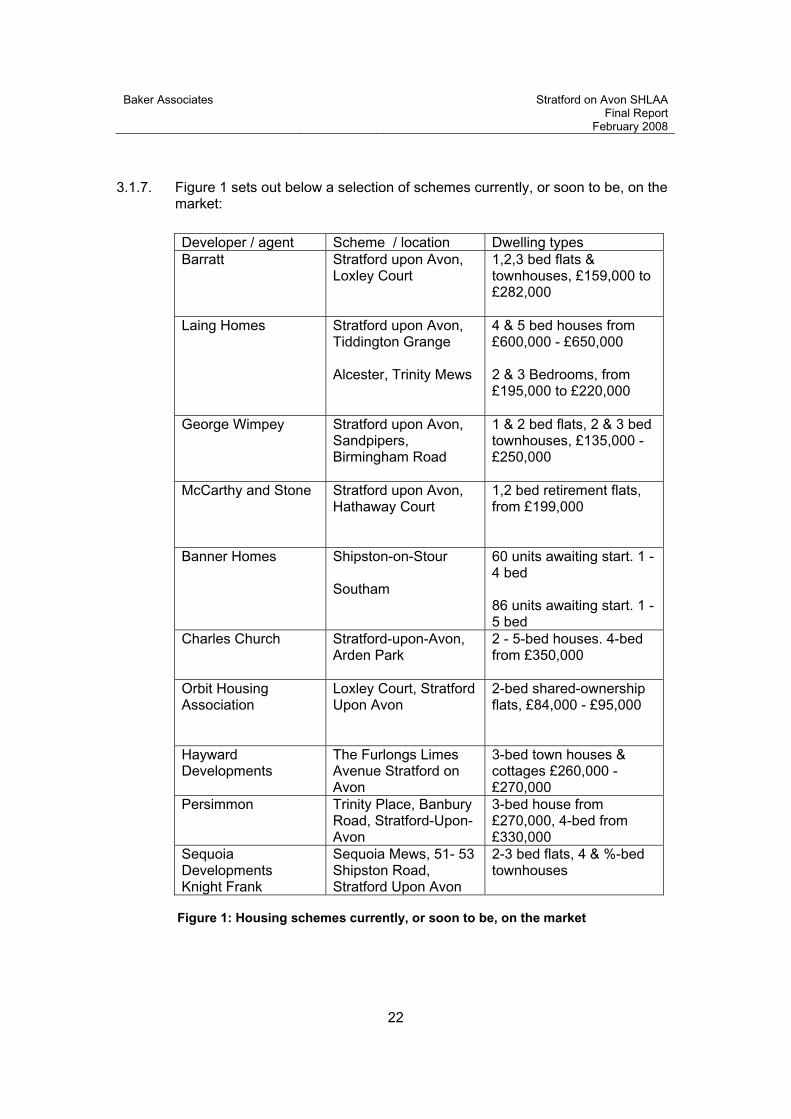
3.1.7. Figure 1 sets out below a selection of schemes currently, or soon to be, on the market:
Developer / agent Scheme / location Dwelling types Barratt Stratford upon Avon,
Loxley Court 1,2,3 bed flats & townhouses, £159,000 to £282,000
Laing Homes Stratford upon Avon, Tiddington Grange
Alcester, Trinity Mews
4 & 5 bed houses from £600,000 - £650,000
2 & 3 Bedrooms, from £195,000 to £220,000
George Wimpey Stratford upon Avon, Sandpipers, Birmingham Road
1 & 2 bed flats, 2 & 3 bed townhouses, £135,000 - £250,000
McCarthy and Stone Stratford upon Avon, Hathaway Court
1,2 bed retirement flats, from £199,000
Banner Homes Shipston-on-Stour
Southam
60 units awaiting start. 1 - 4 bed
86 units awaiting start. 1 - 5 bed
Charles Church Stratford-upon-Avon,Arden Park
2 - 5-bed houses. 4-bed from £350,000
Orbit Housing Association
Loxley Court, Stratford Upon Avon
2-bed shared-ownership flats, £84,000 - £95,000
HaywardDevelopments
The Furlongs Limes Avenue Stratford on Avon
3-bed town houses & cottages £260,000 - £270,000
Persimmon Trinity Place, Banbury Road, Stratford-Upon-Avon
3-bed house from £270,000, 4-bed from £330,000
SequoiaDevelopments Knight Frank
Sequoia Mews, 51- 53 Shipston Road, Stratford Upon Avon
2-3 bed flats, 4 & %-bed townhouses
Figure 1: Housing schemes currently, or soon to be, on the market

Baker Associates Stratford on Avon SHLAA Final Report
February 2008
23
3.2. Findings
3.2.1. Stratford-on-Avon District is relatively prosperous area, with a good local employment base, centred mainly on Stratford-upon-Avon. The district has very attractive countryside and villages, with good access onto the motorway system, particularly the M.40 linking to south-east England and Birmingham, with the M.5 and M.6 motorways reasonably accessible.
3.2.2. The district contains a number of smaller towns and villages, all set in attractive countryside, all of which are sought by potential purchasers because of high accessibility to job markets combined with opportunities for a good lifestyle. There is a very strong commuter market following job opportunities in Birmingham city centre, greater Birmingham, and more locally, to Warwick/Leamington.
3.2.3. Most developers are wary of schemes that are comprised of large numbers of flats, since the market has become over-supplied in recent years. With these caveats, agents, private housing developers and housing associations confirm a continuing strong local market for new sites for both open market and affordable housing.
AFFORDABLE HOUSING
3.2.4. In 2005 Stratford-on-Avon District Council and Warwick District Council commissioned Outside Research and Development Ltd (ORD). to undertake a Joint Housing Assessment for South Warwickshire covering the two districts. The Assessment was completed in October 2006.
3.2.5. This research shows that there is a continuing shortfall of affordable housing in the District with first time buyers and others experiencing real difficulty entering the local housing market. Local people are being priced out of their own communities and replaced by better off commuters and people retiring to the countryside. In rural areas of the District, in particular, this has led to increased risk of closure of local schools, shops and other local facilities.
3.2.6. The ORD assessment shows that in Stratford-on-Avon District an additional 954 affordable homes are required annually to meet identified housing needs. This equates to an additional 4,770 affordable homes over the next 5 years. The assessment also highlights that 91% of single earner households in the District and 83% of dual earner households in the District cannot afford to purchase an average entry level (least expensive) property in the District of £167,335.
3.2.7. Research undertaken in 2004 for the Regional Housing Strategy showed that 83% of new households in Stratford-on-Avon District could not afford to enter the ‘for sale’ housing market. Average house prices (excluding detached houses) in the District mean that these new households require mortgages of up to 9.4 times their average income.
Baker Associates Stratford on Avon SHLAA Final Report
February 2008
24
3.2.8. Low household incomes, coupled with high house prices in this District, mean that shared ownership is too expensive for many households. The Regional Housing Strategy picks up on this point and suggests that most of the affordable housing in this District and Warwick District should be for rent.
3.2.9. The Stratford-on-Avon District Economic Regeneration Performance Report 2005 (Warwickshire County Council) states that houses in Stratford-on-Avon District are significantly less affordable to local workers than elsewhere in Warwickshire. The average house in Stratford-on-Avon costs almost 10 times the median annual earnings for someone working full time in the District.
3.2.10. There are in excess of 3,000 households on the Council’s Housing Waiting List. On average approximately 400 of these households will be offered accommodation in any one year. More than 100 households in the District are accepted as homeless and in need of permanent housing each year.
3.2.11. The view of local Housing Associations and the Council’s Housing Services Manager is that there is a high unmet requirement for both affordable housing for purchase, shared ownership, and social housing for rent, which is exacerbated by continuing sales under the Right to Buy scheme. This often has the effect of negating the contribution made through S.106 agreements.
3.2.12. As regards open market housing supply and demand, the ORD survey showed that there is sufficient housing to cater for demand from existing Stratford-on-Avon District households, although within this overall supply there is a shortfall of 2-bed owner occupied housing.
3.2.13. When in-migration is taken into account, there is an overall shortfall of market housing; there is a significant shortfall in 2-bed owner occupied housing and to a much lesser extent 3-bed owner occupied housing and 2- bed private rented housing.
PRIVATE HOUSING MARKET TRENDS
3.2.14. Land values for open market housing, as found across middle and southern England, have increased significantly over the last 10 years, and currently range from around £1.3 million up to as much as £2 million per net developable acre of open market housing, depending on the precise location and suitability to a particular market. The higher values are produced on sites in the most attractive parts of the district, for instance in Stratford-on-Avon, Henley-in-Arden, and Shipston-on-Stour. Lower land values are found in the eastern parts of the district for instance in Kineton and Southam.
3.2.15. The market peaked in 2004, then again in the summer of 2007. The reason for market flattening after 2004 was because of the five successive interest rate rises of 0.25% each, raising base rates from 3.5% in August 2003 to 4.75% in August 2004. This was the Bank of England’s (BoE) response to the possibility of a damaging ‘boom-bust’ in house prices, so increased interest rates were seen as the mechanism to take the heat out of the market, without flattening it.
Baker Associates Stratford on Avon SHLAA Final Report
February 2008
25
3.2.16. For similar reasons, the BoE again introduced five quarter point rises between late 2006 - July 2007 peaking at 5.75%, the highest rate for six years. In response to the significant downturn in the market resulting from these increases and from Northern Rock’s difficulties, the BoE reduced the rate to 5.5% on 6 December 2007.
3.2.17. Despite these rate rise increases and the market difficulties, residential land values have not decreased, demonstrating high and continuing demand for (and lack of supply of) development sites with planning consent. It is unlikely that land values will fall in 2008, but almost certainly will not increase.
3.2.18. There is continuing good demand for sites for family housing with a garden, with a small proportion of flats. The demand for large schemes of 100% flats has virtually disappeared, with the national developers avoiding them altogether. Agents report that there has been a reduction of about 30% in sales enquiries since September 2007, with actually achieved sales prices down by about 10%.
3.2.19. There are four general but distinct markets in the district sought by developers:
The first is for sites for traditional 2-3 storey 2 - 4 bed terraced, semis and detached houses with gardens, which are in very high demand but which until recently have been discouraged by government guidance. These house types produce a relatively low floorspace per acre (compared to flatted and 3-storey townhouse schemes), and so frequently do not generate a sufficiently high land value to enable developers to purchase.
The second type of market is for town houses and flats in 2.5 - 3 storey developments. Since the year 2000, PPG3 has encouraged this, where developers are making more efficient use of land, usually at much higher than the minimum density of 30 dwellings per hectare (dph), more often closer to, and frequently significantly in excess of, 50 dph.
The third type of market is for sheltered housing for the elderly, which achieves very high densities and land values because of both small unit area and lower parking requirements.
The fourth is for affordable housing, both for shared ownership, and for rent.
3.2.20. Whilst the UK housing market has been adversely affected since September 2007 by bad debts in the USA mortgage market that has spread to the UK, particularly evident in the problems of Northern Rock, the underlying housing market is still strong. Short-term demand has fallen which is putting pressure on price, but medium and long-term demand is still strong. This is underpinned by government policy to deliver a much increased level of housing to meet a national shortage, whilst land with permission for an immediate start is in short supply.
3.2.21. The housing land market in the area continues to be reasonably strong for most house types in all locations, whilst housebuilders and private vendors are adjusting prices to align with demand.

Baker Associates Stratford on Avon SHLAA Final Report
February 2008
26
COVERAGE, OR SALEABLE FLOORSPACE
3.2.22. In order to value the land for open market housing by the residual method, assumptions need to be made about the likely saleable floorspace. As discussed above these assumptions have been predicated upon the need to maximise floorspace within the context of the local market and local site characteristics.
3.2.23. ‘Coverage’, which measures the efficiency of residential land use, varies according to individual type of scheme. This is not simply a matter of density, but the amount of saleable floorspace that is accommodated in a unit area, and which governs the sales turnover, and hence the land value, of a housing scheme.
3.2.24. For example, a development of 16 units/acre (40 dph) could be a mix of 2 and 3-bed 2-storey units at 600-800 sq. ft each, giving an overall coverage of only 11,200 sq. ft. per acre (sfa). However, the vast majority of housing schemes are now relatively high density ranging from around 15,000 to 18,000 sfa for predominantly 2 - 2.5 storey development, and up to 18,000 - 21,000 sfa for 2.5 - 3 storey scheme.
3.2.25. An efficient scheme of 16 units /acre (40 dph) could therefore produce 17,000 sq. ft. with dwellings averaging 1062sq. ft / unit. Coverage has a major effect on sales turnover, and in turn, land value, which is a consequence of the relationship between sales turnover and development costs, profit, and overhead.
3.2.26. Total turnover, and hence, land value, is dramatically increased by greater coverage. It must also be understood that the overall scheme and its density must be designed to accord with the character of the surrounding area.
3.2.27. In terms of achievable sales prices, the open market for houses varies from around £230 up to £280 per sq. ft in the more attractive areas. There are significant variations taking account of individual circumstances and precise location, with the highest prices achieved in the west of the district, and lower house prices in the east.
3.2.28. Accordingly, land values vary across the district. Values are also affected by the size of the site, reflecting return on capital employed across a period of time, the cost of financing a purchase compared with the time taken to receive all site sales value. Sales rates obviously have a major effect on the overall financing, and most projects will seek to achieve around 35 - 50 sales per year in order to justify the land economics upon which the land purchase is based.
3.2.29. Sales rates are not only governed by the capacity of the market, but also, particularly in flat schemes, by achievable construction programmes. Value is also obviously affected by development costs, physical as well as costs derived from planning and other legal agreements.
3.2.30. However, in broad terms, ‘clean’ land values in the area range from about £I.3 million to £2 million per net developable acre of open market housing, (£3.2m -

Baker Associates Stratford on Avon SHLAA Final Report
February 2008
27
£5m per hectare) with the upper figure being achieved on good quality sites in Stratford-on-Avon and Henley-in-Arden.
3.2.31. A summary of the market in terms of achievable land values, sales price per sq. ft, sales rates, coverage and house types is shown in Figure 2:
Figure 2: Housing market summary
3.2.32. It is considered that, due to the very high land values in the area, which have not fallen since the market peaked in the summer of 2004, it is unlikely that any competing uses or abnormal development costs would adversely affect the economic viability for housing of any of the identified sites.
3.2.33. Accordingly, most abnormal development costs should be able to be absorbed without falling below the value for alternative uses, such as general employment and warehousing land, (as opposed to office and retail); employment land (B1/B8) is worth about £200,000 per acre across the district. Housing land is worth at least £1 million more per developable acre than employment land, which enables most instances of abnormal development costs to be allowed for, including affordable housing, still producing a higher land value.
3.2.34. Those familiar with the housing market over the long term appreciate that any analysis is a view at a particular time. The market will undoubtedly vary over the period considered by this study, which should be reviewed at regular intervals.
Land value / net dev acre
Saleprice/sq ft
Sales rates per
year
Coveragesq ft / acre
Target house types by market
£1.3 million - £2 million
£230 - £280
35 - 45 16,000- 18,000
Strong market for traditional 2, & 3 bed
properties with gardens, as well as 3 & 4-bed
detached dwellings in the right location. Weaker
market for flats particularly on large schemes.

Baker Associates Stratford on Avon SHLAA Final Report
February 2008
28
4. Sites with Planning Permission for housing
4.1. Introduction
4.1.1. A major change from the previous system of UCS is the inclusion of sites with existing consent for housing development. The inclusion of this material is intended to provide a comprehensive view of the likely housing coming forward within the District and Figure 4 of the practice guidance illustrates the possible sources arising from sites within the planning process.
4.1.2. The list includes allocated employment land and housing allocations. These are clearly sources of potential housing, however it is considered that assessment of each of these is required on a site specific basis and therefore they are included within the assessment of sites set out in Section 5 and Appendix 3/4.
4.1.3. Sites with planning permission for housing provide a separate source of provision as they are the most deliverable, having overcome already any barriers to development from the planning system.
4.1.4. Therefore the sites with permission for housing are set out in a separate table in Appendix 1. The analysis of sites is split between large and small sites (more or less than 10 units) in order to reflect the information coming forward from site specific sources in later sections.
4.1.5. Information has been provided by the Council based on the annual returns at 1 April 2007 and in line with accepted methodology, includes sites where there is a resolution to grant consent from the appropriate planning committee.
4.1.6. Sites with planning permission on both brown and green field locations have been included, as have sites within any settlement in the district. This differs from the approach regarding site specific opportunities as the planning permissions have already been given and therefore form part of the available land.
4.1.7. Planning policy is likely to increasingly focus development on locations within the main settlements and that is why the study concentrates on these locations to identify future opportunities.
4.1.8. Each planning consent will be limited by condition requiring commencement within 3 years or maybe for older consents 5 years. The market for such sites remains strong in the district and it is therefore considered that the majority will come forward during the next 5 years.
4.2. Large sites
4.2.1. The table in Appendix 1 shows that a total of 799 dwellings may come forward from large sites currently with planning permission in the period until 2026.

Baker Associates Stratford on Avon SHLAA Final Report
February 2008
29
4.3. Small sites
4.3.1. Figures for small sites (less than 10 dwellings) with planning permission have also been provided and included in Appendix 1.
4.3.2. A total figure of 425 dwellings is generated from this analysis.
4.4. Summary
4.4.1. Analysis indicates that a total of 1224 dwellings have planning permission for development as at 1 April 2007.
4.4.2. The SHLAA Practice Guidance makes no reference to the requirement to discount any of these figures to reflect any non completion figure and it is not intended to do so for the purposes of this study.
4.4.3. The figures provide a clear indication of the level of housing which might come forward and there is considered to be no material reason why the full number cannot be achieved.
4.4.4. There may be some instances when sites do not come forward for unforeseen circumstances. However, it will be equally the case that, because of the absence of 100% knowledge of the future, other sites do come forward in the short term which otherwise have not been identified which will make up for any loss.
4.4.5. Given the absence of any windfall allowance in the first 5 years, it is considered wholly appropriate to adopt this approach as any sites coming forward within the short term will not be counted elsewhere.
4.4.6. It will, however, be for the council to continually monitor the provision of housing land and completions in order to confirm that the figures are being achieved.

Baker Associates Stratford on Avon SHLAA Final Report
February 2008
30
5. Site Specific Sources
5.1. Introduction
5.1.1. The identification of a range of sites from various sources is discussed in earlier sections. From this wide range of sources over 450 sites were identified. Each was mapped on the GIS base and linked to an Access Database which stored information about the site and assessment of its potential for housing.
5.1.2. All of these sites are illustrated in Appendix 11 and were visited and assessed by the consultant team. They were discussed at meetings with the relevant officers of the Council. Based on these assessments and an understanding of previous planning history where appropriate, the consultant team identified a total of 26 sites which are considered to provide opportunities for housing within the current policy framework.
5.1.3. The list of these sites is included as Appendix 4 and each is considered in detail in Appendix 5 and shown in red in Appendix 11. For each site, consideration of its particular characteristics, assessment of the local market and owner expectations all combined to provide a likely yield for the site and, in line with the practice guidance, was indicated in one of three time periods.
5.1.4. A large number of sites were considered not presently developable and these are included in the list of rejected sites in Appendix 3 and illustrated blue in Appendix 11.
5.1.5. A number of sites identified through the study, mainly from promotion by land owners or developers, were outside of the built up area boundaries, in the countryside. In these instances it is considered that these areas are not currently developable. However, sites on the edge of the identified settlements may be acceptable given changes to policy as a result of shifts in the LDF to meet RSS requirements. As a result these sites were not considered rejected but were assessed as part of the consideration of Broad Locations, set out in Section 8 and are shown green in Appendix 11.
5.2. Findings
5.2.1. The analysis of sites indicated in a total of 26 sites being identified across the study area potentially providing a total of 1072 dwellings in the period to 2026. The majority of these are considered likely to be developed in the period before 2017, within the first 10 years.
5.2.2. Of these total dwellings 90% of the dwellings are identified to come forward on brownfield sites, the remainder on Greenfield sites.
GEOGRAPHIC DISTRIBUTION
5.2.3. Figure 3 illustrates the distribution of sites across the 9 identified settlements. It also incorporates the number of dwellings coming forward from sites with planning permission in the various settlements.

Baker Associates Stratford on Avon SHLAA Final Report
February 2008
31
Appendix 1 Appendix 1 Appendix 4 Source
Dwellings from Large
sites with PP
Dwellings from Small
sites with PP
Dwellings from
Identified sites
Total dwellings
% total identified
hsing
Alcester 55 11 20 86 3.7%
Bidford-on-Avon 154 12 30 196 8.5%
Henley-in-Arden 36 17 40 93 4.1%
Kineton 0 18 110 128 5.6%
Shipston on Stour 0 19 60 79 3.4%
Southam 87 17 15 119 5.2%
Stratford-upon-Avon 397 31 727 1155 50.3%
Studley 20 29 60 109 4.7%
Wellesbourne 0 5 10 15 0.7%
Others 50 266 0 316 13.8%
Total identified dwellings 799 425 1072 2296 100.0%
Figure 3: Distribution of housing on identified sites
5.2.4. The table demonstrates the dominance of Stratford-upon-Avon and the lack of sites likely to come forward in some settlements, notably Wellesbourne.
5.3. Summary
5.3.1. Following the methodology set out in Section 2, sites identified from the variety of sources have been visited and have been assessed. Appendix 3 identifies all those sites which were identified but not considered to represent an opportunity for housing development, i.e. not currently developable.
5.3.2. Appendix 4 Site Yield Summary lists the large sites likely to come forward for housing. Details of those sites and assessment of the dwelling yield for each are set out in Appendix 5.
5.3.3. The total number of dwellings that could be accommodated on the identified opportunity sites is estimated as 1072.
Baker Associates Stratford on Avon SHLAA Final Report
February 2008
32
6. Review of assessment
6.1. Introduction
6.1.1. The SHLAA Practice Guidance requires that figures for the anticipated level of housing provision in the period to 2026 are presented in order to be compared with the requirements set by the Regional Spatial Strategy.
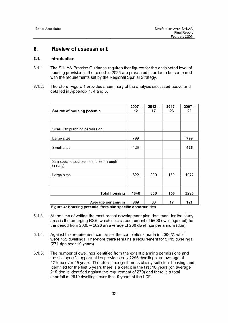
6.1.2. Therefore, Figure 4 provides a summary of the analysis discussed above and detailed in Appendix 1, 4 and 5.
Source of housing potential 2007 -
122012 –
172017 -
262007 –
26
Sites with planning permission
Large sites 799 799
Small sites 425 425
Site specific sources (identified through survey)
Large sites 622 300 150 1072
Total housing 1846 300 150 2296
Average per annum 369 60 17 121 Figure 4: Housing potential from site specific opportunities
6.1.3. At the time of writing the most recent development plan document for the study area is the emerging RSS, which sets a requirement of 5600 dwellings (net) for the period from 2006 – 2026 an average of 280 dwellings per annum (dpa)
6.1.4. Against this requirement can be set the completions made in 2006/7, which were 455 dwellings. Therefore there remains a requirement for 5145 dwellings (271 dpa over 19 years)
6.1.5. The number of dwellings identified from the extant planning permissions and the site specific opportunities provides only 2296 dwellings, an average of 121dpa over 19 years. Therefore, though there is clearly sufficient housing land identified for the first 5 years there is a deficit in the first 10 years (on average 215 dpa is identified against the requirement of 270) and there is a total shortfall of 2849 dwellings over the 19 years of the LDF.

Baker Associates Stratford on Avon SHLAA Final Report
February 2008
33
6.1.6. This shortfall should be met from other sources and the practice guidance indicates that there are two parallel processes which may be undertaken in order to identify housing land supply in order to meet any deficit. These are;
Windfall
Broad Locations
6.1.7. Each of these sources is discussed in the following sections.

Baker Associates Stratford on Avon SHLAA Final Report
February 2008
34
7. Housing potential of windfall
7.1. Introduction
7.1.1. The SHLAA Practice Guidance indicates that there may be local circumstances where a windfall allowance may be justified and this may be included where the housing land available falls below the required level.
7.1.2. Windfall provision within the Stratford on Avon area has traditionally provided a significant percentage of the housing supply, much of previous development coming forward from the redevelopment of existing sites and buildings previously in non residential uses.
7.1.3. Importantly the study has not specifically attempted to identify small sites (those yielding less than 10 dwellings) as to attempt to do so would mean seeking sites of a scale down to individual housing plots, living over the shop units and/or sub-division of smaller buildings. It was agreed at the outset of the study (see Section 2) that this would not only be an onerous and extremely time consuming task but also a potentially endless one which could not be achieved within the project budget.
7.1.4. Therefore it is considered appropriate to include within the figures for future housing provision a figure for windfall provision to come forward on small sites within the urban area on previously developed land.
7.1.5. It is considered that many of the small sites coming forward in the next 5 years will already be identified in the sites with planning permission (section 4). Therefore, to provide a further windfall figure in this first 5 years would result in double counting.
7.1.6. However, in the period after 2012 the stock of sites with existing consent will be depleted and therefore the provision of an allowance for small sites coming forward after this point in time is wholly appropriate.
7.1.7. In parallel with this, the study has sought to identify specific large sites which will come forward for housing development. Given the constraints of this study with regard to time, resources and imperfect information for the future, the assessment of likely yield from identifiable sites is considered robust within the short term but beyond the next 10 years the identification of individual sites is not necessarily robust.
7.1.8. Therefore an allowance for housing provision on large sites for the period beyond 2017 is also considered to be required in order to provide a realistic indication of possible yield.
7.1.9. In order to arrive at an appropriate estimate of future yield on both small and large sites consideration of previous completion figures and emerging policy direction has been made, along with the characteristics of the settlements in question.

Baker Associates Stratford on Avon SHLAA Final Report
February 2008
35
7.1.10. The analysis below is based on figures provided by the Council regarding housing completions from 1987/88 to 2006/7. The figures have been used to generate tables in Appendix 12 and graphs, reproduced below.
7.1.11. The past completion rates are used as a basis to consider future provision of housing on previously developed land. The figures for completion rates used in the analysis below exclude greenfield sites which may have come forward in the past and any dwellings coming forward on allocated sites.
7.1.12. The assessment of sites likely to come forward in the future draws upon the past completion rates but also considers the likely opportunities which may remain for future housing provision within the urban area and also likely planning policies, which will increasingly support redevelopment in appropriate locations.
7.2. Findings
7.2.1. The graphs below illustrate the fluctuation in returns of housing provision across the district and show housing completions as net figures.
SMALL SITES
7.2.2. Figure 5 illustrates the completions of dwellings on brownfield sites across the district over the period from 1987.
7.2.3. It draws on figures provided by the Council and reproduced in Appendix 12. It shows, in blue, the delivery of housing on sites in Stratford-upon-Avon and the 8 MRCs, which has fluctuated over time but in recent years grown steadily.
Figure 5: Small site completions 1987 - 2007
-20
0
20
40
60
80
100
120
140
160
180
1987/88
1988/89
1989/90
1990/91
1991/92
1992/93
1993/94
1994/95
1995/96
1996/97
1997/98
1998/99
1999/2000
2000/01
2001/02
2002/03
2003/04
2004/05
2005/06
2006/07
SUA/MRC LCV Cty

Baker Associates Stratford on Avon SHLAA Final Report
February 2008
36
7.2.4. The red bar indicates completions within the LCVs, which is generally falling over time, whilst the level of completion in the countryside has reduced to zero. However, it should be noted that the figures on which the graph is based do not include replacement dwellings, barn conversions and agricultural dwellings, which mean that figures may underestimate the past supply to a degree.
7.2.5. The average delivery of housing on small sites is calculated in Appendix 12 and illustrated in Figure 8, below.
LARGE SITES
7.2.6. Figure 6 provides a similar graph which has been prepared for large sites (10 or more dwellings).
Figure 6: Large site completions 1987 - 2007
-100
-50
0
50
100
150
200
250
300
350
1987/88
1988/89
1989/90
1990/91
1991/92
1992/93
1993/94
1994/95
1995/96
1996/97
1997/98
1998/99
1999/2000
2000/01
2001/02
2002/03
2003/04
2004/05
2005/06
2006/07
SUA/MRC LCV Cty
7.2.7. The graph draws on information shown in Appendix 12 and illustrates the delivery of housing on previously developed sites across the district, excluding local plan allocations.
7.2.8. The figures are presented as net completions, hence in 2002/3 there is a major negative figure in the LCVs reflecting the demolition of a number of dwellings on Bastyan Avenue, Lower Quinton. This was part of a major redevelopment of the area, resulting in significant positive provision in the LCV category in the following years.
7.2.9. The presence of this sort of very large or “super” site has raised questions in the assessment of past completion rate figures and their appropriateness for the future.

Baker Associates Stratford on Avon SHLAA Final Report
February 2008
37
7.2.10. There have been a small number of very large sites come forward in recent years which are considered to be A-typical of the past completion rates.
7.2.11. The sites include Tilemans Lane and Station Road, Shipston as well as the Paddock Lane and High School sites in Stratford. It is considered that the delivery of these sites may not be replicated in future years and therefore a graph indicating the net completions excluding these “super” sites has been prepared and is included in Figure 7.
Figure 7: Large site completions 1987 - 2007 (exc very large sites)
0
50
100
150
200
250
300
350
1987/88
1988/89
1989/90
1990/91
1991/92
1992/93
1993/94
1994/95
1995/96
1996/97
1997/98
1998/99
1999/2000
2000/01
2001/02
2002/03
2003/04
2004/05
2005/06
2006/07
SUA/MRC LCV Cty
7.2.12. The revised graph shows a very different picture of completions with the figures in the last 4 years falling to below 100 units per annum.
SUMMARY FINDINGS
7.2.13. Figure 8 illustrates the number of completions and their average delivery over the 20 years of the records.
7.2.14. The figures reflect the images from Figures 5 and 6, where the average returns over the past 5 years have risen in the MRC and declined in the LCVs and particularly the countryside.
7.2.15. Over the period the returns from small sites has been relatively stable overall as falling returns from sites in the LCVs and countryside have been off set by increases from sites in the MRCs.
7.2.16. Therefore, it is considered appropriate to include a future windfall figure of 80 dwellings per annum for small sites.

Baker Associates Stratford on Avon SHLAA Final Report
February 2008
38
Total1987 - 2007
Average completion rate per annum
SuA/MRC Past 20 yrs Last 5 yrs Large sites 2327 116 155
Small sites 1042 52 66
LCV
Large sites 305 15 17
Small sites 465 23 17
Countryside
Large sites 143 7 0
Small sites 418 21 3
Total 4700 235 258
Large sites 2,775 139 172 Small sites 1,925 96 86
Figure 8: Housing completions and average rates 1987 - 2007
7.2.17. The numbers in Figure 8 include the returns from the “super” sites, which do artificially inflate the average returns from large sites, particularly over the past 5 years. If these larger sites were excluded form the analysis the total return over 20 years would be reduced to 2,288 dwellings, an average of 114 per annum over 20 years and 93 over the last 5.
7.2.18. Part of the recent decline in completions may be due to the recent moratorium which has inhibited new sites coming forward, but may also indicate that opportunities for brownfield housing development are falling as the capacity is used up.
7.2.19. There is nothing to say that in future other “super” sites may not become unexpectedly available and deliver large numbers of dwellings as windfalls. However, it is considered inappropriate to depend on these in any assessment of future likely delivery.
7.2.20. Therefore, it is considered appropriate to restrict the anticipated long term return from large brownfield sites to 100 dwellings per annum, which reflects the long term average return of housing from sites between 10 and 100 dwellings and anticipates an increase in delivery from this source when the moratorium is lifted.

Baker Associates Stratford on Avon SHLAA Final Report
February 2008
39
7.3. Summary
7.3.1. If the figures for windfall are accepted and included in the table previously set out in Section 6, the total provision of housing land would be as in Figure 9.
Source of housing potential 2007 -
122012 -
172017 –
262007 -
26
Sites with planning permission
Large sites (Section 4) 799 799
Small sites (Section 4) 425 425
Site specific sources
Large sites (Section 5) 622 300 150 1072
Non site specific sources
Large sites (Section 7) 900 900
Small sites (Section 7) 400 720 1120
Total housing 1846 700 1770 4316
Average per annum 369 140 197 227 Figure 9: Housing potential from all sources
7.3.2. Figure 9 indicates that, even when an allowance for windfall provision is included in the future, the RSS requirement of 5,145 dwellings is not achieved and a deficit of approximately 800 dwellings remains, even assuming that the currently proposed RSS requirement for the district is not subject to change through the remaining stages of the RSS revision process.
7.3.3. This therefore prompts further consideration of the possible provision of housing land.
7.3.4. Also the characteristics of the housing coming forward are important. PPS3 indicates the importance of providing a mix of housing (para 20) in order to maintain and create sustainable communities.

Baker Associates Stratford on Avon SHLAA Final Report
February 2008
40
7.3.5. Recent provision of housing within Stratford on Avon has been dominated by the provision of flats and apartments either in the conversion of existing buildings or in new buildings. This has been as a consequence of the drive to increase densities and reuse previously developed sites but has resulted in a market which is currently saturated.
7.3.6. In order to provide family housing, it is acknowledged that release of greenfield land may be necessary and would also provide opportunities to provide for a range of community and leisure facilities, ecological enhancement, as well as affordable housing.
7.3.7. Therefore, consideration of greenfield release has been undertaken in line with the requirements of the Practice Guidance (Stage 9).
Baker Associates Stratford on Avon SHLAA Final Report
February 2008
41
8. Broad locations
8.1. Introduction
8.1.1. The Practice Guidance requires that, where there is a shortfall of available housing sites compared with requirements, a SHLAA should identify broad locations for development.
8.1.2. Para 46 of the guidance indicates that these locations will be where housing is “considered feasible and will be encouraged”. The analysis undertaken as part of this study has assessed a range of opportunities for housing and has considered their suitability for housing in principle. The result of this is the identification of a stock of land considered suitable for housing development.
8.1.3. However, this study cannot replace the appropriate process of plan making, which is the LDF. If this study, without appropriate public consultation and consideration of options, were to identify preferred locations for development, this would negate the LDF process and raise significant issues for the role of plan making.
8.1.4. Therefore the following analysis seeks to identify opportunities for future housing provision as evidence for the LDF. This evidence will then be rightly considered through the appropriate plan making process in order to identify appropriate locations for development.
8.1.5. Key to this process will be the spatial strategy for the dispersal of the housing requirement across the District. That strategy is currently being considered as part of the LDF Core Strategy and is currently not agreed. It may be that the Strategy finally concludes that the most sustainable form of development will be for housing to be provided in a small number, or one, settlement.
8.1.6. Alternatively, a dispersion of housing to a number of settlements may be considered most appropriate. If this were to happen, it is considered that the settlements which are most likely to attract that housing would be the 9 previously considered during this study, which include Stratford, as the main settlement within the District and the 8 Main Rural centres (MRCs) identified in the Local Plan Review.
8.1.7. Finally, a new settlement may be identified as the preferred option, however the RSS does not currently identify such a strategy and therefore this is not considered as a part of this study.
8.1.8. The Practice Guidance (para 46) indicates that Broad Locations may be identified within, adjoining or outside of settlements.
8.1.9. Broad locations within settlements may be “a particular town centre where site surveys weren’t able to identify specific sites” (para 47). However, for this study the scale of urban areas is such that it is considered that specific opportunities have been identified where possible in all of the nine settlements and therefore

Baker Associates Stratford on Avon SHLAA Final Report
February 2008
42
it is not proposed to consider further the identification of Broad Locations within settlements.
8.1.10. Similarly, Broad Locations outside of settlements should be “signalled by the RSS” (para 46 bullet two). None such are specifically identified for Stratford-on-Avon District, though there may be some requirement for Redditch. However, this is subject of other studies. Therefore, generally no Broad Locations outside of settlements have been considered.
8.1.11. This study has concentrated on the identification of Broad Locations for housing adjoining the 9 settlements, which the Practice Guidance refers to as “small extensions to settlements”.
8.1.12. There is no definition of how large a “small extension” might be other than to differentiate it from a “major urban extension”. Therefore, it is likely that “small extensions” may in fact include significant developments of hundreds of dwellings. The description of a broad location as a “small extension” may be a misnomer in the context of the settlement to which it relates. Therefore this study refers to broad locations adjacent to settlements as “extensions to settlements” rather than “small extensions”.
8.1.13. The methodology adopted in identifying the areas of search and the Broad Locations is set out in the section below, followed by the findings relating to each of the settlements considered.
8.2. Methodology
8.2.1. This study seeks to identify locations which may be suitable for development in the future to meet housing requirements. In order to achieve this, a process has been followed in order to select the most suitable locations for development.
IDENTIFICATION OF SETTLEMENTS
8.2.2. The first step was to identify the settlements to be considered, which was agreed to include Stratford-upon-Avon and the eight MRCs as these are the most appropriate settlements to accommodate development given their range of services.
8.2.3. All 9 settlements were assessed, however, it may be that the LDF Core Strategy considers some of these settlements should not be the focus for development. However, at this stage it remains the case that these 9 settlements are considered equally likely to receive future housing allocations.
DESIGNATIONS
8.2.4. Constraints relating to each of the settlements were considered. This follows advice in the Practice Guidance that the scope of any assessment should not be “narrowed down by existing policies designed to constrain development” but that “clear cut designations such as SSSI” (para 21) may be excluded from the areas of search.

Baker Associates Stratford on Avon SHLAA Final Report
February 2008
43
8.2.5. The initial analysis considered the presence and extent of designations particularly focusing on the edge of the urban area for each settlement.
8.2.6. A review of all designations identified in the local plan indicated that a certain number of them were considered to be “clear –cut” as they related to resources which were generally irreplaceable without significant cost, if at all.
8.2.7. These are generally wildlife, nature conservation and/or geological designations such as SSSI, Local Nature Reserve and Ancient Woodland.
8.2.8. In addition, designations which seek to protect historic capital such as Scheduled Ancient Monuments were included in the initial analysis.
8.2.9. Finally, flood zones 2 and 3 were added to the list as they indicate areas where there may be great sensitivity to development.
8.2.10. All of these designations were mapped and this is reproduced in Appendix 6.
8.2.11. The mapping does not include any constraint policies such as Green Belt, Area of Restraint or Special Landscape Area as it is considered that each of these is specifically excluded from such a study by the Practice Guidance as these are essentially policies specifically targeted at restricting development. They are not generally applied to land with intrinsic value but are applied in order to protect land for the sake of preserving openness only.
8.2.12. Therefore such designations are not considered a constraint in order that the study can consider the widest possible range of locations.
8.2.13. The remaining stages of the study therefore excluded only those areas which are subject to clear cut designations, which for many settlements related only to flood zones which do dominate the edge of several urban areas and which, particularly given the experiences of 2007, are unlikely to be acceptable for development.
LANDSCAPE STUDY
8.2.14. A key consideration for identifying locations for future urban extensions is the characteristics of the landscape and its sensitivity to change.
8.2.15. A review of urban fringe areas was undertaken and the methodology and findings are presented in Appendix 7.
8.2.16. The study drew upon previously published material, notably the Stratford Town’s Urban Edge Study, but undertook a simple assessment of all urban fringe locations for the 9 identified settlements.
8.2.17. The basis of the assessment was the identification of separate landscape compartments based on the physical features on the ground. Areas away from the urban edge were not assessed as development in these locations would not be considered sustainable and the RSS provides no support for any free standing settlement.

Baker Associates Stratford on Avon SHLAA Final Report
February 2008
44
8.2.18. Each of the compartments was assessed and its sensitivity to change considered. For each area the capacity of the landscape to absorb development has been assessed.
8.2.19. The summary of findings for each landscape compartment is included in Appendix 7 but acknowledges that further work is required to consider any locations which may be promoted for future development.
ACCESSIBILITY
8.2.20. The second element in assessing the suitability of locations for development relates to the range of services located within settlements accessible by a range of modes of transport, notably walking and cycles but also by public transport where possible.
8.2.21. Facilities within each settlement have been identified through survey and discussions with Council Officers. These have been mapped on the appropriate settlement maps in Appendix 6.
8.2.22. The number of facilities in each settlement is discussed in the relevant sections below and the distances from each facility is mapped in Appendix 8. This mapping illustrates the straight line distances from each facility, which allows an assessment of relative accessibility to facilities to be made for all locations on the edge of the settlement.
PROVISION
8.2.23. Broad Locations for development are discussed for each settlement and described without identifying specific boundaries on a map base. An indication of the Broad Location is shown on each of the maps in Appendix 6 but this is illustrative only and is intended to allow for flexibility of approach for the Local Planning Authority.
8.2.24. However, in order to provide useful material for the LDF, an assessment of possible development area and from this a potential yield for housing has been calculated.
8.2.25. The potential yield for housing coming forward from each location has been calculated by applying a simple multiplier for each area. The level of return for housing will depend on the extent of developable area within each location, excluding areas of landscape, infrastructure as well as other uses which may be required.
8.2.26. Generally, the larger the location, the lower the level of housing per gross hectare. Also, the majority of locations being considered are in rural settings where high density living may not be appropriate or attractive. Therefore yields are generally identified at a relatively low density per gross area, accepting that within the wider location there may be some areas of higher density living.
8.2.27. For each location an assumption has been made based on the scale of the identified land, its characteristics and the likely demands of the market. These
Baker Associates Stratford on Avon SHLAA Final Report
February 2008
45
figures, and the total potential provision which results, can only be considered an estimate and will be subject to further analysis.
8.2.28. The figures provided assume generally that the whole of the broad location may come forward for development. In many instances it is possible and/or likely that smaller parcels of land may be developed within the Broad Location and that not all of the area will come forward. However, it may well be that the LDF will not allocate any part of the broad location for development in a specific settlement, or will only require part of the broad location to be developed during the period up to 2026.
8.2.29. Many sites on the edges of settlements were promoted by land owners and developers as part of this study. All of these sites were mapped and given unique reference numbers. The extent of each promoted area is illustrated on settlement maps in Appendix 11 and summarised in a table in Appendix 9.
8.2.30. The following sections identify the findings of the assessment of broad locations on the edge of existing settlements.
8.3. Alcester
8.3.1. Located on the western side of the district, the town has a population of approximately 7,500, making it the second largest settlement in the District.
CLEAR CUT DESIGNATIONS
8.3.2. Figure 6.1 illustrates the clear cut designations which are considered to restrict development in and around the settlement.
8.3.3. The principal constraints are the flood plains of two rivers, the Alne which joins the Arrow south of the town. The Arrow runs through the centre of the town, its floodplain providing public open space within the settlement. Whilst the Alne is located south of the town, inhibiting its development southwards.
8.3.4. The other main constraint to development around the town is the Scheduled Ancient Monument to the north, at Beauchamp Court, part of which is also in the flood plain.
ACCESSIBILITY
8.3.5. The settlement is located between the A46 and the A435 mid way between Evesham to the south, Redditch to the north and Stratford-upon-Avon to the west.
8.3.6. On a daily basis buses run hourly through the settlement from Stratford to Evesham (route 26/26a) and Evesham to Redditch (Route 246/7). In addition there are other routes operated during evenings and weekends.
8.3.7. The settlement serves as a local service centre and provides a range of facilities as well as employment opportunities. There are three primary schools, two secondary schools as well as a community centre and library.

Baker Associates Stratford on Avon SHLAA Final Report
February 2008
46
8.3.8. The location of community facilities is shown in Figure 6.1 (Appendix 6). They are generally grouped to the south of the settlement, though the main employment area is at the north of the town.
8.3.9. The mapping included in Appendix 8 illustrates the distance from each of the identified facilities and indicates that, due to the scale of the settlement, most of the urban fringe areas are located in relatively close proximity to all of the services such that it is considered feasible for residents of new homes on the edge of the settlement to at least cycle to most facilities.
LANDSCAPE
8.3.10. The urban fringe around the town, which is not subject of the clear cut designations, has been considered and findings set out in Section 7.
8.3.11. The area around the town has been assessed and divided into three particular compartments, West, North & East. Each is defined by features on the ground and the boundaries of each are illustrated on Figure 6.1.
8.3.12. The analysis and findings of the landscape study are included in Appendix 7 and demonstrate that there may be two areas, one to the west, the other to the east, which may provide opportunities for development whilst minimising landscape impact.
SUMMARY OF FINDINGS
8.3.13. Alcester provides a range of local services and employment opportunities. It is constrained by floodplain to the south and no areas for development have been considered in this area.
8.3.14. Land to the north of the settlement is divorced from the main urban area by the existing employment area and adjacent Scheduled Ancient Monument, which prohibit the connection of any new residential areas with the existing settlement. In addition the area north of the employment estate would be prominent in the landscape.
8.3.15. This leaves two distinct areas where there may be opportunities for housing.
AL01 LAND WITHIN THE A435
8.3.16. Land to the west of the town is contained within the A435, and may provide a sustainable location given the relative proximity to facilities within the urban area. The land in the south of the area is part of the flood plain and therefore not considered suitable for development. However, the majority of the area within the western bypass could form a Broad Location for development.
8.3.17. The land has previously been allocated for development. However, it has not been developed and is currently unallocated.
8.3.18. All of the land north of the Allimore Lane, which crosses the site, has been promoted for development to this study and is recorded as two references;
Baker Associates Stratford on Avon SHLAA Final Report
February 2008
47
ALC703 and ALC704. The former of these is promoted by the land owner of approximately half of the land, the second relates to the whole area and is promoted by a developer having an interest in the whole site.
8.3.19. A parcel of land south of Allimore Lane (ALC702) has also been promoted by the land owners.
8.3.20. It is therefore concluded that the majority of the land is available for development.
8.3.21. The land is generally open countryside and there are not considered to be any constraints which would result in the site not being viable for housing development.
8.3.22. It is therefore considered that an area of approximately 30ha may be considered suitable, available and achievable for housing in principle. If this location were to come forward for a mix of uses, predominately housing, a total of circa 750 dwellings may be accommodated, assuming an average density of 25 dwellings per gross hectare. This density reflects the scale of the location and the likely requirements for a mix of uses to be provided as well as the necessary infrastructure and landscaping.
AL 02 LAND TO THE EAST OF KINWARTON FARM ROAD
8.3.23. The road currently forms the edge of the settlement. However, the landscape is constrained to the east by a hill and associated ridge. Land contained within this landscape is excluded from the Green Belt and could provide an area of approximately 5.5ha for development.
8.3.24. The land has been promoted for development to this study by the land owner and a potential developer (ALC701) and is therefore considered available for development. In addition there are no known constraints which would result in the area not being viable for housing development.
8.3.25. Development in this location for a mix of housing and other uses may provide approximately 165 dwellings, assuming an average density of 30 dwellings per gross hectare. This assumes that structural landscaping will be required in order to create a long term edge for the settlement.
POSSIBLE PROVISION
8.3.26. This assessment provides an indication of the level of housing which may come forward from broad locations for development on land adjacent to Alcester.
8.3.27. It indicates that two broad locations may be available if it is considered that the settlement should be the location for future housing growth. However, the analysis does not suggest that the settlement should be considered the focus for future provision, nor does it indicate that the areas should necessarily be developed in their entirety or that there is any preference between the two locations.

Baker Associates Stratford on Avon SHLAA Final Report
February 2008
48
8.4. Bidford-on-Avon
8.4.1. The village has a population of approximately 4,500 but has been the scene of continuing development pressure as consents are completed within the village. Also there is a current application, included in Section 4, for a further 140 dwellings at Friday Furlong (Local Plan Allocation BID.E) to the north of the settlement.
CLEAR CUT DESIGNATIONS
8.4.2. Figure 6.2 illustrates the clear cut designations which are considered to restrict development in and around the settlement. This is principally the flood plain of the River Avon which dominates the southern side of the village
8.4.3. No land south of the village, within Flood Plain 2 and 3, have been considered as potential broad locations.
ACCESSIBILITY
8.4.4. The settlement is located close to the A46, north of Evesham. It is understood that there is a strong commuting pattern between the village and Stratford-upon-Avon due to the house price differential between the two settlements.
8.4.5. On a daily basis buses run hourly through the settlement from Stratford to Evesham (route 28 & 29) and Evesham to Redditch (Route 246/7). In addition there are other routes operated during evenings and weekends.
8.4.6. The settlement serves as a local service centre but provides only a limited range of services, including a single primary school but no secondary provision.
8.4.7. There is a small industrial estate at the north of the settlement and the remainder of services are focused around the historic core, to the south.
8.4.8. The location of community facilities is shown in Figure 6.2 (Appendix 6).
8.4.9. The mapping included in Appendix 8 illustrates the distance from each of the identified facilities and indicates that, due to the scale of the settlement, most of the urban fringe areas are located in relatively close proximity to all of the services, such that it is considered feasible for residents of new homes on the edge of the settlement to at least cycle to most facilities.
LANDSCAPE
8.4.10. The urban fringe to the north, east and west of the village has been considered and findings set out in Section 7.
8.4.11. The landscape study demonstrates that there may be three broad locations for suitable development, one on each of the available sides of the settlement.

Baker Associates Stratford on Avon SHLAA Final Report
February 2008
49
SUMMARY OF FINDINGS
8.4.12. Bidford on Avon is a relatively small settlement which has grown steadily through new development but has a relatively low level of services.
8.4.13. However, the consideration of designations, accessibility and landscape indicates that there may be three broad locations for further growth around the village.
BD01 LAND BETWEEN VICTORIA ROAD AND MARRIAGE HILL
8.4.14. An area to the west of the village is not protected by any designation constraining development and is enclosed by the rising ground of Marriage Hill. An area of approximately 9ha could be developed without undue impact on the wider landscape, in a location relatively well located to existing community facilities.
8.4.15. Land in this area has been promoted for development by the land owners (BID701) and it is understood that part of the area is owned by the Parish Council and is allocated for Public Open Space.
8.4.16. The land does not have direct access to the highway network and as such at least one dwelling will need to be demolished in order to provide highway access. The local market is strong enough such that the loss of a dwelling to achieve access would not impact on the viability of the site unduly and therefore the location remains viable and this has been identified as an opportunity by the land owner promoting the site. Therefore it is considered that development may be viable and the land available.
8.4.17. Development in this broad location may be expected to provide for open space and potentially a mix of other uses. Therefore approximately 110 dwellings may come forward on 5.5ha of land at an average gross density of 20 dwellings per ha. This reflects the village setting and the need to provide public open space and also strategic landscaping on the settlement edge.
BD02 LAND BETWEEN VICTORIA ROAD AND WATERLOO ROAD
8.4.18. The area is bounded on three sides by development and on the fourth by Small Brook, where structural landscaping could provide an improved edge of the settlement when viewed from the north.
8.4.19. The majority of this land has been promoted as part of this study (BID702 & BID705) and therefore it is considered to be available for development, which may be suitable in principle.
8.4.20. This broad location includes approximately 25 ha of land, which may provide for 625 dwellings. This assumes an average density of 25 dwellings per gross hectare reflecting the likely requirement for a mix of uses to be provided as well as infrastructure and landscaping.
BD 03 LAND WEST OF GRAFTON LANE

Baker Associates Stratford on Avon SHLAA Final Report
February 2008
50
8.4.21. The final broad location lies to the east of the urban area, enclosed on three sides by existing development. The land is not subject to any designation constraining development and could be acceptable in principle subject to suitable structural landscaping.
8.4.22. Land in the area has not been promoted as part of this study and therefore the availability of the area may not be certain.
8.4.23. However, if development in this location for a mix of housing and other uses were to come forward it may provide approximately 225 dwellings on approximately 9ha at an average density of 25 dwellings per hectare.
POSSIBLE PROVISION
8.4.24. This assessment provides an indication of the level of housing which may come forward from broad locations for development on land adjacent to Bidford on Avon.
8.4.25. It indicates that three broad locations may be available if it is considered that the settlement should be the location for future housing growth. However, the analysis does not suggest that the settlement should be considered the focus for future provision, nor does it indicate any preference between the three locations.
8.5. Henley-in-Arden
8.5.1. The most northerly of the settlements, Henley lies equidistant between Redditch and Warwick and has a population of approximately 2,800.
CLEAR CUT DESIGNATIONS
8.5.2. Figure 6.3 illustrates the clear cut designations which are considered to restrict development in and around the settlement.
8.5.3. The principle constraint is the floodplain which bisects the town and, in combination with the Scheduled Ancient Monument, severely restricts development to the north east of the town.
8.5.4. The other boundaries of the settlement are relatively unconstrained by clear cut designations. However, the built up area is coterminous with the Green Belt boundary and the Special Landscape Area. Also, significant parts of the urban fringe are also designated as Conservation Area. Therefore, though there are no clear cut designations impacting the boundary of the settlement, there are significant policy constraints which would need to be overcome if development were to be promoted.
ACCESSIBILITY
8.5.5. Henley in Arden is located on the A3400 which links to the M40 and M42 to the north and Stratford-upon-Avon to the south.

Baker Associates Stratford on Avon SHLAA Final Report
February 2008
51
8.5.6. Bus services through the town do run daily, the X20 service running 7 days a week providing an hourly service linking Stratford-upon-Avon and Birmingham.
8.5.7. The town also has a railway station, with hourly services to Stratford-upon-Avon 15 minutes to the south and Birmingham approximately 40 minutes to the north.
8.5.8. The town has a small shopping centre and no identified employment area. It does have a range of local facilities including two primary schools, a secondary school and medical centres.
8.5.9. The mapping included in Appendix 8 illustrates the distance from each of the identified facilities and indicates that, due to the scale of the settlement, most of the urban fringe areas are located in relatively close proximity to all of the services such that it is considered feasible for residents of new homes on the edge of the settlement to at least cycle to most facilities.
LANDSCAPE
8.5.10. The urban fringe around the town, which is not subject of the clear cut designations, has been considered and findings set out in Section 7.
8.5.11. The area around the town has been assessed and divided into four particular compartments. Each is defined by features on the ground and is illustrated on Figure 6.3.
8.5.12. The analysis and findings of the landscape study are included in Appendix 7 and demonstrate that there are no areas around the town where new development could be located without significant impact on the wider landscape.
SUMMARY OF FINDINGS
8.5.13. Henley in Arden is a relatively small settlement set within a sensitive landscape which contains the town within natural boundaries. The settlement has a small range of facilities which are strongly influenced by the proximity to Redditch.
8.5.14. The town is located on a bus route and has a train station providing reasonable links with Birmingham and Stratford. Therefore there may be opportunities for building on these links in order to promote sustainable transport choices.
8.5.15. However, it is considered that development outside of the existing settlement boundaries would have a significant impact either on clear cut designations or on the wider landscape.
8.5.16. Therefore, it is considered that there is little opportunity for further development of the settlement.

Baker Associates Stratford on Avon SHLAA Final Report
February 2008
52
POSSIBLE PROVISION
8.5.17. This assessment suggests that there is no scope for broad locations for development to be identified on land adjacent to Henley in Arden without impact.
8.5.18. However, the core strategy may identify the town as a focus for future growth, which may provide justification for development.
8.6. Kineton
8.6.1. The settlement lies in the eastern part of the district, in an essentially rural setting. It acts as a local service centre for the rural hinterland, with a population of approximately 2,200 it is the smallest of the nine settlements considered as part of this study .
CLEAR CUT DESIGNATIONS
8.6.2. Figure 6.4 illustrates the clear cut designations which are considered to restrict development in and around the settlement.
8.6.3. The principal constraint is the floodplain which lies south of the village and provides a clear barrier to growth and coalescence of the town with Little Kineton. In conjunction with this, the Battle of Edgehill Historic Battlefield provides a clear constraint to development south of the settlement.
ACCESSIBILITY
8.6.4. Kineton lies on the B4086 linking Stratford and Banbury. Bus services through the village do run daily, providing a service each hour and a half to Stratford and Banbury. Services travel via other intervening villages.
8.6.5. The village has a small shopping centre and a small employment area. It does have a range of local facilities including a primary school and a secondary school.
8.6.6. The mapping included in Appendix 8 illustrates the distance from each of the identified facilities and indicates that, due to the scale of the settlement, most of the urban fringe areas are located in relatively close proximity to all of the services such that it is considered feasible for residents of new homes on the edge of the settlement to at least cycle to most facilities.
LANDSCAPE
8.6.7. The urban fringe around the village, which is not subject of the clear cut designations, has been considered and findings set out in Appendix 7.
8.6.8. The area around the village has been assessed and divided into three compartments. Each is defined by features on the ground and is illustrated on Figure 6.4.
Baker Associates Stratford on Avon SHLAA Final Report
February 2008
53
8.6.9. The assessment indicates that there is no capacity for housing development in two compartments but within the third, eastern, compartment there may be opportunities.
SUMMARY OF FINDINGS
8.6.10. Kineton is a relatively small settlement within a rural location. It acts as a local service centre and has a small range of services. It is strongly constrained for development to the south due to flood zones and also historic features.
8.6.11. The landscape to the west and the north of the town is sensitive to change and development would have a significant impact. However, the landscape to the east is generally of a poorer quality and therefore less constrained.
KN01 LAND EAST OF SOUTHAM ROAD
8.6.12. A parcel of land east of the main road, wrapping around the existing recreation ground, provides an opportunity to improve the urban edge of the settlement without undue impact on the landscape.
8.6.13. Part of the land has been promoted to this study by the land owner (KIN702) and therefore is considered available for development. The characteristics of the area indicate that there are no abnormal constraints to development which might render proposals unviable.
8.6.14. The area is within a reasonable walking distance of main facilities and an area of 9 ha could be developed for a total of 225 houses if the site were to come forward for housing at an average density of 25 dwellings per ha. .
KN02 LAND NORTH OF BANBURY ROAD
8.6.15. The second parcel of land lies to the east of the High School, contained within a low ridgeline. The area is approximately 6.5 ha directly accessed from Banbury Road.
8.6.16. The land has been promoted, along with more significant parcels of land to the north and west, by the land owner and a developer (KIN704). The parcels of land adjacent to Banbury Road are therefore considered available for development.
8.6.17. The Broad Location is made up of fields which are generally level and unconstrained by physical features. If developed the area could accommodate a total of 165 dwellings at an average density of 25 dwellings per hectare.
POSSIBLE PROVISION
8.6.18. This assessment suggests that there is some scope for broad locations for development to be identified on land adjacent to Kineton in a sustainable manner. In both instances, land within the vicinity has been promoted to this study by the relevant land owners and is therefore considered available for development.

Baker Associates Stratford on Avon SHLAA Final Report
February 2008
54
8.6.19. The analysis indicates that two broad locations may be available if it is considered that the settlement should be the location for future housing growth. However, the analysis does not suggest that the settlement should be the focus for future provision, nor does it indicate any preference between the locations. In each instance parcels of land within the broad locations identified may come forward for development as smaller extensions to the settlement than the total areas suggested.
8.7. Shipston on Stour
8.7.1. Shipston is the most southerly of the settlements considered, with a population of approximately 4,250.
CLEAR CUT DESIGNATIONS
8.7.2. Figure 6.5 illustrates the clear cut designations which are considered to restrict development in and around the settlement.
8.7.3. The principle constraint is the floodplain of the River Stour which lies to the east and south of the town. This coincides, on the eastern side of the town, with an Area of Restraint identified in the Adopted Local Plan and, in part, a Conservation Area.
ACCESSIBILITY
8.7.4. The town sits on the A3400 linking Stratford to the north with the A44 and ultimately Oxford to the south.
8.7.5. The town is linked to local villages by a number of bus services, many of which operate on only one day a week. The only daily services are the 23/23A and the 50 which provide an hourly service to Stratford during the day but does not run early enough to provide for workers.
8.7.6. The town has a small shopping centre and an employment estate on the northern periphery of the settlement. It does have a range of local facilities including a primary school and a secondary school.
8.7.7. The mapping included in Appendix 8 illustrates the distance from each of the identified facilities and indicates that, due to the scale of the settlement, most of the urban fringe areas are located in relatively close proximity to all of the services such that it is considered feasible for residents of new homes on the edge of the settlement to at least cycle to most facilities.
8.7.8. However, it is noticeable that the majority of services are located in the northern part of the settlement.
LANDSCAPE
8.7.9. The urban fringe around the town, which is not subject of the clear cut designations, has been considered and findings set out in Appendix 7.

Baker Associates Stratford on Avon SHLAA Final Report
February 2008
55
8.7.10. The area around the town has been assessed and divided into three compartments. Each is defined by features on the ground and is illustrated on Figure 6.5.
8.7.11. The assessment indicates that there may be Broad Locations for development available to the north and the west of the town.
SUMMARY OF FINDINGS
8.7.12. Shipston is clearly constrained to the east by the River Stour, which flooded significantly in 2007.
8.7.13. Opportunities for development on land to the south of the town are very limited, not least by the shape of the built up area which results in a very short southern boundary, but also because of the characteristics of the landscape in this area.
8.7.14. There are therefore two remaining directions for growth.
SP01 LAND WEST OF THE SETTLEMENT
8.7.15. The western quadrant is contained by the ridge running through Waddon Hill. This provides a valuable backdrop to the town but there remain opportunities for small areas of development along this boundary, as long as the development is not allowed to impact on the rising ground.
8.7.16. Two parcels of land have been promoted by developers within this area (SHP708 and SHP709) and are therefore considered to be available. However, there appears to be no physical constraints to development of any land on this boundary which would preclude development in principle and therefore there may be more suitable locations within this Broad Location which could come forward.
8.7.17. Development on this boundary would, generally be distant from the main services and facilities provided by the settlement and achieving access to the parcels of land may also provide a constraint to development given the existing road network and lack of routes. However, it would be feasible to provide access at points along the boundary and therefore parcels of land may come forward.
8.7.18. A total area of 28ha to the west of the settlement might come forward for development, providing a total of approximately 560 dwellings assuming an average yield of 20 dwellings per gross hectare.
8.7.19. However, it is anticipated that only small parcels of land might come forward on land within this larger area and therefore the delivery of dwellings is likely to be far below this total level.

Baker Associates Stratford on Avon SHLAA Final Report
February 2008
56
SP02 LAND NORTH OF THE SETTLEMENT
8.7.20. Land north of the existing built up area provides the best opportunities for development without significant landscape impact, indeed it may provide opportunities to heal the existing harsh urban edge.
8.7.21. Land in this area may also be best related to existing facilities and the main employment area.
8.7.22. Highway access may be difficult to achieve but opportunities to access the area may exist from Stratford Road and Darlingscote Road.
8.7.23. A total area of 40ha to the north of the settlement might come forward for development, providing a total of 800 dwellings assuming an average density of 20 dwellings per gross ha. This reflects the anticipated requirements for infrastructure and structural landscaping as well as a range of uses, not just residential development.
8.7.24. Within this area Parcels of land have been promoted by land owners (SHP701, SHP706 and SHP707) which indicates that much of the land within this area might be available. However, the level of land promoted is significantly greater than that which might relate to the urban edge of the settlement and not all of the large promoted site (SHP706) would be considered suitable as an extension to the settlement.
8.7.25. As with SP01, the extent of development within this Broad Location may be significantly above that required to meet LDF Core Strategy requirements and smaller parcels of land within the Broad Location may come forward independently as required.
POSSIBLE PROVISION
8.7.26. This assessment suggests that there is some scope for broad locations for development to be identified on land adjacent to Shipston in a sustainable manner. In both instances, land within the vicinity has been promoted to this study by the relevant land owners and is therefore considered available for development.
8.7.27. The analysis indicates that two broad locations may be available if it is considered that the settlement should be the location for future housing growth. However, the analysis does not suggest that the settlement should be the focus for future provision, nor does it indicate any preference between the locations or imply that all land within that Broad Location might come forward.

Baker Associates Stratford on Avon SHLAA Final Report
February 2008
57
8.8. Southam
8.8.1. Southam is located in the north east of the district and is the only one of the 9 settlements located north of the M40. It has a population of approximately 6,650.
CLEAR CUT DESIGNATIONS
8.8.2. Figure 6.6 illustrates the clear cut designations which are considered to restrict development in and around the settlement.
8.8.3. The principle constraint is the floodplain which bisects the town and forms the basis of a Public Open Space on the town’s western edge.
ACCESSIBILITY
8.8.4. The town sits at the cross-roads of the A432 north south (Banbury to Coventry) and the A425 (Leamington Spa – Daventry). It is linked through a number of bus routes with other small settlements in the area but also lies on the route linking Rugby with Leamington – providing an hourly service for much of the day in both directions.
8.8.5. The town has a shopping centre and a significant and growing employment estate on the southern periphery of the settlement. It also has a good range of local facilities including 3 primary schools and a secondary school.
8.8.6. The mapping included in Appendix 8 illustrates the distance from each of the identified facilities and indicates that, due to the scale of the settlement, most of the urban fringe areas are located in relatively close proximity to all of the services such that it is considered feasible for residents of new homes on the edge of the settlement to at least cycle to most facilities. However, it is noticeable that all education facilities are located in the north of the town, whilst the main employers are in the south.
LANDSCAPE
8.8.7. The urban fringe around the town has been considered and findings set out in Appendix 7.
8.8.8. Four landscape compartments have been identified and assessed. Each is defined by features on the ground and is illustrated on Figure 6.6.
8.8.9. The assessment indicates that the best opportunity for development may lie to the south of the settlement. However, this would require the relocation of existing recreational facilities. Smaller opportunities lie to the north of the existing school playing fields on the northern side of the settlement.

Baker Associates Stratford on Avon SHLAA Final Report
February 2008
58
SUMMARY OF FINDINGS
8.8.10. Southam has seen significant growth from its historic core, which continues at present with the development of new employment areas. Strong constraints to development on the western side have lead to east-wards growth creating an “artificial” form of development.
8.8.11. The provision of a bypass to the east of the built area provides a clear landscape boundary and one which would inhibit connectivity back into the settlement for any further development to the east.
8.8.12. Therefore, the opportunities for development lie to the south and north of the settlement.
SM01 LAND SOUTH OF SOUTHAM
8.8.13. Land between the B4451 and A423, south of the A425, provides the best opportunity for development given the relative value of the landscape in other locations around the town and also the strong barrier to development created by the bypass.
8.8.14. An area of approximately 22ha lies in a variety of recreational uses which may be relocated to other locations around the settlement.
8.8.15. If further analysis indicated an over-riding need for development in the town, the location may yield up to a total of 440 dwellings, assuming an average yield of 20 dwellings per gross hectare over the whole area.
8.8.16. The majority of this area has been promoted to the study by a developer (SOM709) which illustrates that it would be available for development. However, it is not necessarily the case that all of the Broad Location may come forward and therefore other land, which is not promoted, may provide a more sustainable alternative.
SM02 LAND NORTH OF SOUTHAM
8.8.17. A small area north of the settlement may be considered suitable for development, being contained within the landscape and providing an opportunity to create a more appropriate edge to the open countryside.
8.8.18. An area of approximately 4.5 ha may be considered suitable for development, providing possibly 135 dwellings assuming an average density of 30 dwellings per gross hectare.
8.8.19. Some of this area has been promoted as part of a wider area (SOM708)
POSSIBLE PROVISION
8.8.20. This assessment suggests that there is some scope for a Broad Location for development north and south of the settlement. The largest opportunities ar to
Baker Associates Stratford on Avon SHLAA Final Report
February 2008
59
the south, which would require the relocation and/or reprovision of sports pitches which may reduce the ability of the location to provide for development.
8.9. Stratford-upon-Avon
8.9.1. Stratford is the main town in the district and with a population of approximately 23,000 by far the largest. It has also been the focus of significant development which continues.
CLEAR CUT DESIGNATIONS
8.9.2. Figure 6.7 illustrates the clear cut designations which are considered to restrict development in and around the settlement.
8.9.3. The principal constraint is the floodplain of the River Avon which divides the town and provides the basis for recreational space.
8.9.4. In addition, land to the north of the town is designated as a Local Nature Reserve, whilst to the south land is subject to a Sc106 agreement providing Community Woodland and Meadowland.
8.9.5. Land to the north of the settlement is also designated as Green Belt, whilst to the north and west a Special Landscape Area is in place. Land south of the town is designated as an Area of Restraint.
8.9.6. None of these latter designations are considered to constitute a clear cut designation as they are generally designed to constrain development. Therefore these areas have been subject of consideration, whilst the flood plains and the wildlife area have not.
ACCESSIBILITY
8.9.7. The town is located at the junction of the A46, which link the M5 to the south west with the M40 to the north east, the A4300 linking Oxford to Birmingham and the A422 to Banbury.
8.9.8. The town is the focus for bus services to many of the surrounding villages and to the main settlements in the sub region, including Redditch, Birmingham, Banbury and Leamington Spa.
8.9.9. The town also has a number of local services serving various parts of the town, and linking the town centre with the Park and Ride site, located off the A3400 to the north of the town, which provides a service to the town centre every 10 minutes.
8.9.10. The town also has a railway station, providing a direct service to London Marylebone (which takes approximately 2 hours) via Warwick, Leamington Spa and Banbury. It also has services to Birmingham, which takes approximately 55 minutes.

Baker Associates Stratford on Avon SHLAA Final Report
February 2008
60
8.9.11. The town provides the main shopping and employment opportunities for the district, which are illustrated on Figure 6.7. Retailing is not only provided in the town centre, but also on an out of centre retail park and in small district centres.
8.9.12. The town also has 10 primary schools, 3 secondary schools and a sixth form college, which has recently been extended.
8.9.13. The mapping included in Appendix 8 illustrates the distance from each of the identified facilities. It illustrates the general dispersal of facilities across the town and the concentration of employment and medical facilities within the centre.
LANDSCAPE
8.9.14. The urban fringe around the town has been considered and findings set out in Appendix 7. These build upon previous work undertaken to inform the Local Plan Review and considers the sensitivity of compartments of land around the settlement to change and development.
8.9.15. It identifies a number of Broad Locations where development might come forward without significant negative impact on the landscape.
SUMMARY OF FINDINGS
8.9.16. The settlement is the largest in the district and provides the greatest concentration and range of services and facilities. It also has links by alternative modes both within the settlement (buses) and with other settlements (via bus and train). It therefore represents the potentially most sustainable location for development.
8.9.17. The assessment of urban fringe locations indicates that there are a number of locations where extensions to the existing urban area can be accommodated and which could link into the existing urban form.
SA01 LAND ADJACENT A3400
8.9.18. A parcel of land north of the town is identified in the landscape assessment as being more contained than other areas and therefore development would have a consequentially lesser impact. The parcel is easily accessed from the A3400, which is a bus route and is well located with regard to access to the town centre and also retail opportunities at the out of centre retail park.
8.9.19. The Broad Location is approximately 13 ha, of which the majority have been promoted for development by landowners and developers (STR736, STR728 and STR738) and is therefore considered available if required for development.
8.9.20. The redevelopment of the whole Broad Location may provide a total of 325 dwellings, assuming an average density of 25 dwellings per gross hectare. However, smaller parcels of land may come forward within the larger area.
SA02 LAND OFF MAIDENHEAD ROAD

Baker Associates Stratford on Avon SHLAA Final Report
February 2008
61
8.9.21. A small parcel of land is located at the end of Maidenhead Road and Avenue Road which is self contained and accessible, however, is not well related to existing services except the local primary school.
8.9.22. The land is part of a wider land holding promoted by the owner to this study (STR712) The identified Broad Location could provide a small extension (3.5 ha) to the existing urban area, providing a site of approximately 90 dwellings at an assumed density of 25 dwellings per gross area.
SA03 LAND EAST OF TIDDINGTON
8.9.23. The small settlement is not part of Stratford itself but the eastern edge forms the extent of the built up area and therefore has been subject of assessment. Tidddington provides some local services, including a primary school, and may be considered to be a sustainable location for development when considered in the context of the wider district in the production of the Core Strategy.
8.9.24. A small area of approximately 6 ha is identified in the landscape assessment and could potentially form an extension to the settlement. The land is part of a wider site promoted by the land owners (TIDD704), the majority of the area promoted is not considered appropriate for development but the small area on the edge of the settlement could provide a total of 150 dwellings at an assumed density of 25 dwellings per gross hectare.
SA04 LAND BEHIND BANBURY ROAD
8.9.25. An area of land behind the previously allocated site on Banbury Road is identified in the landscape study as potentially providing an opportunity for development in the future. This land would be contained within the landscape and is not subject of any designations. However, access to the area from Banbury Road may not be feasible, in which case the area is unlikely to come.
8.9.26. The land is promoted by developers (STR716) who indicate that access is possible and therefore an area of up to 7 ha may be appropriate as an extension to the settlement. If the whole of this area were to come forward approximately 175 dwellings may be provided.
SA05 LAND OFF KIPLING ROAD
8.9.27. A parcel of land equalling 3.5 ha was allocated in the Adopted Local Plan as a Strategic Reserve site, Policy SUA.Y, for release not before March 2011.
8.9.28. The site is contained within the landscape and provides an opportunity to provide a small extension to the built area, though it is not well related to local services.
8.9.29. The land is promoted by agents and is therefore considered available if required for development.
8.9.30. If the area were to come forward a total of 90 dwellings might be anticipated assuming a density of 25 dwellings per gross hectare.
Baker Associates Stratford on Avon SHLAA Final Report
February 2008
62
SA06 LAND WEST OF SHOTTERY
8.9.31. The Local Plan Review identifies a significant area to the west of the town as an area of Strategic Reserve (Policy SUA.W). The designation indicates that the area should not come forward before 2011 and therefore has been considered as a broad location rather than as an allocation for the purposes of this study.
8.9.32. The review of the landscape impact in this area indicates that the broad location of the allocated land reflects the landscape character in this area and the identification of two distinct parcels of development land (SA06a and SA06b), divided by an area of open space, appears valid.
8.9.33. The landscape assessment undertaken for this study indicates that the northern parcel identified in the Local Plan Review may extend outside of what might be considered the natural limits to development. However, generally support is given to this as a broad location for future development.
8.9.34. It is considered that two areas of development totalling approximately 38 ha may be available and land in these Broad Locations has been promoted by developers (STR719, STR739, STR722 and STR726).
8.9.35. If all land within the broad locations was to be further promoted for development a total of up to 950 dwellings may be achieved as part of a mixed use development.
SA07 LAND OFF BISHOPTON LANE
8.9.36. Land between the A46 and Bishopton Lane is not designated as Green Belt, nor SLA and therefore, when reviewing the Local Plan map, appears to provide a significant opportunity for development.
8.9.37. However, the south western end of the area rises up to The Ridegway making it exposed to views. The north eastern end of the area may be subject to flooding as it is low lying. It is also subject to an allocation as Public Open Space.
8.9.38. Therefore the extent of area potentially available for development is likely to be relatively small and may be approximately 10 ha within the larger area, which is promoted for development (STR714).
8.9.39. If the area considered developable were to come forward a possible 250 dwellings may be delivered, assuming an average density of 25 dwellings per gross hectare.
SA08 EGG PACKING STATION
8.9.40. The final area is a previously developed site which is allocated in the Adopted Plan review as a Reserve Site. The land is previously developed and provides a sequentially preferable location for development in principle.

Baker Associates Stratford on Avon SHLAA Final Report
February 2008
63
8.9.41. The site is approximately 3 ha which may result in 105 dwellings coming forward, assuming an average density of 35 dwellings per gross hectare.
8.9.42. The land is promoted for development to this study (STR737) and is therefore considered available if required to meet identified need.
POSSIBLE PROVISION
8.9.43. The assessment indicates that there are a number of areas around Stratford-upon-Avon which may potentially provide suitable Broad Locations for development of varying scales depending on the level of need identified through the LDF process.
8.9.44. It is not intended that this analysis differentiate between the merits of any of the identified sites, the intention is simply to identify the areas where development may be acceptable in principle in order to meet sustainable development targets.
8.9.45. The LDF will determine whether land within any of these Broad Locations needs to be developed during the period to 2026.
8.10. Studley
8.10.1. The village is triangular in shape, being enclosed between the A448 and A435. It has a population of approximately 6,500 and is located in close proximity to the southern boundary of Redditch and as such has a role subservient to the larger urban area.
CLEAR CUT DESIGNATIONS
8.10.2. Figure 6.8 illustrates the clear cut designations which are considered to restrict development in and around the settlement.
8.10.3. The principal constraint is the floodplain which lies to the east of the town.
8.10.4. The whole area is designated as Green Belt, the boundary being drawn tightly around the existing urban area. The Special Landscape Area is concurrent with this designation. However, neither is considered a “clear cut” designation for the purposes of this study (in line with advice in the CLG Practice Guidance). Therefore, neither are considered when assessing the merits of Broad Locations around the settlement, but will need to be addressed at a later stage if allocation of land is further considered.
ACCESSIBILITY
8.10.5. The town is located just south of Redditch and as a result benefits from services connecting Redditch to Evesham (246/247) and to Stratford (Route 26 & 27), as well as local services (route 67) serving the southern part of the main settlement.

Baker Associates Stratford on Avon SHLAA Final Report
February 2008
64
8.10.6. The village has a small shopping centre and employment estate on the northern periphery of the settlement. It also has a good range of local facilities including 2 primary schools and a secondary school.
8.10.7. The mapping included in Appendix 8 illustrates the distance from each of the identified facilities and indicates that, due to the scale of the settlement, most of the urban fringe areas are located in relatively close proximity to all of the services such that it is considered feasible for residents of new homes on the edge of the settlement to at least cycle to most facilities. However, it is noticeable that most services are located at the northern part of the settlement, which is also relatively accessible to services in the southern part of Redditch.
LANDSCAPE
8.10.8. The urban fringe around the village has been considered and findings set out in Appendix 7.
8.10.9. Three landscape compartments have been identified and assessed. Each is defined by features on the ground and is illustrated on Figure 6.8.
8.10.10. The assessment indicates that the best opportunity for development may lie to the south west of the settlement.
SUMMARY OF FINDINGS
8.10.11. The settlement is significantly influenced by its relationship with Redditch and the opportunities presented in the larger settlement mean that development close to Redditch would be the most sustainable location. However, the land between the two settlements is designated as Green Belt and a Special Landscape Area. This analysis however consistently excludes these designations from consideration. Therefore it is considered that there are two potential Broad Locations for development.
SD01 LAND SOUTH OF GREEN LANE
8.10.12. Green Lane forms the boundary between Stratford-on-Avon District and Redditch.
8.10.13. An area of approximately 70 ha is located within the Stratford on Avon administrative boundary, north of the settlement of Studley and either side of Redditch Road. The land is generally pasture but also includes a golf driving range.
8.10.14. The land is designated Green Belt and the area forms a strategic gap between the two settlements which is fundamental to maintaining separation. However, it also represents a sustainable location for development being in close proximity to employment, health and retail facilities as well as public transport routes.
8.10.15. The area is very sensitive to development and is unlikely to be acceptable for development within the current policy context. However, it is clear that

Baker Associates Stratford on Avon SHLAA Final Report
February 2008
65
government policy is seeking to reconsider all elements of policy and that the need for development to meet growth expectations is increasingly seen as providing the exceptional circumstances to redraw green belt boundaries.
8.10.16. The area between the two settlements may provide a sustainable location for development in a sustainable manner and therefore it is considered that, in the context of this study, a broad location for development accommodating a significant development might be promoted in the future.
8.10.17. If this were the case it is considered that this location could provide opportunities for a significant mixed use development providing possibly 1000 dwellings as part of a large scale development along with a range of other uses.
SD02 LAND SOUTH WEST OF A448
8.10.18. The landscape study identifies a parcel of land of approximately 8.5 ha at the southern end of the settlement which, if developed for housing could provide for approximately 210 dwellings.
8.10.19. However, dwellings in this location would be distant from the services and facilities within the settlement and Redditch beyond. The land could therefore provide some provision of housing in the future but it is considered that appropriate social facilities should be provided as part of any allocation.
POSSIBLE PROVISION
8.10.20. This assessment suggests that there is scope for a Broad Location for development north and south of the settlement. However, the first is in a potentially sustainable location in the gap between Redditch and Studley where a significant policy shift would be required to allow for development.
8.10.21. The second location is distant from the main services of the town and also from Redditch beyond.
8.10.22. The analysis indicates that two broad locations may be available if it is considered that the settlement should be the location for future housing growth. However, the analysis does not suggest that the settlement should be the focus for future provision, nor does it indicate any preference between the locations or imply that all land within that Broad Location might come forward.
8.11. Wellesbourne
8.11.1. The settlement (population of approximately 5,700) is located east of Stratford-upon-Avon and is the MRC most closely related with the main settlement in the district.
CLEAR CUT DESIGNATIONS
8.11.2. Figure 6.9 illustrates the clear cut designations which are considered to restrict development in and around the settlement.

Baker Associates Stratford on Avon SHLAA Final Report
February 2008
66
8.11.3. The principal constraints are the floodplains which lie to the north and through the centre of the village (River Dene).
ACCESSIBILITY
8.11.4. The village lies on the A429 which runs north to south, the B4086 Stratford Road is the most direct route to Stratford-upon-Avon.
8.11.5. Buses run from Leamington Spa to Stratford (Route 15) each hour taking 20 minutes to reach Stratford. Alternatively there are links to other villages provided by a range of service which run on various days.
8.11.6. The village has a small shopping centre and large employment estate on the southern periphery of the settlement (in conjunction with the operational airfield). It also has a small range of local facilities including a primary school.
8.11.7. The mapping included in Appendix 8 illustrates the distance from each of the identified facilities and indicates that, due to the scale of the settlement, most of the urban fringe areas are located in relatively close proximity to all of the services such that it is considered feasible for residents of new homes on the edge of the settlement to at least cycle to most facilities. However, it is noticeable that most services are located at the northern part of the settlement, though the main employers are located at the south.
LANDSCAPE
8.11.8. The urban fringe around the village has been considered and findings set out in Appendix 7.
8.11.9. Five landscape compartments have been identified and assessed. Each is defined by features on the ground and is illustrated on Figure 6.9.
8.11.10. The assessment indicates that the best opportunities for development may lie to the south and south east of the settlement.
SUMMARY OF FINDINGS
8.11.11. Wellesbourne is located relatively close to the main settlement in the district, Stratford. Therefore, despite having a significant population within the village, there are relatively few local services.
8.11.12. Opportunities for future development are restricted by the floodplain through and to the north of the settlement and by the presence of the airfield to the southwest.
8.11.13. Opportunities for development to the north west are constrained by the existing landscape form and therefore opportunities for development are focused to the east and south of the settlement.

Baker Associates Stratford on Avon SHLAA Final Report
February 2008
67
WL01 LAND SOUTH OF B4086
8.11.14. A relatively small parcel of land, approx 3.5 ha, may provide opportunities for development on land adjacent to but not within the flood plain.
8.11.15. The land has been promoted by the land owner (WEL706) and is therefore considered available for development.
8.11.16. Assuming an average density of 35 dwellings per gross hectare a total of 125 dwelling may be provided. However, the land is adjacent to the flood plain and further analysis of potential flooding issues will be required to support any further proposals.
WL02 LAND EITHER SIDE WALTON ROAD
8.11.17. Land, identified by the landscape study, could come forward for development without significant impact on the wider landscape in a location which is well related to the centre of the settlement.
8.11.18. A total area of 8 ha is enclosed within the landscape setting, part of which is previously developed and has been promoted by the land owner (WEL709). If the whole Broad Location were to be allocated for development a total of up to 200 dwellings could be provided (assuming an average yield of 25 dwellings per gross hectare). However, smaller parcels of land could come forward within this wider location.
WL03 LAND SOUTH OF LOXLEY ROAD
8.11.19. The final area is identified south of the existing built up area and is approximately 3.5 ha. Land in this area has not been promoted to this study and therefore the land may not necessarily be available.
8.11.20. If the land was to come forward it could potentially provide up to 125 dwellings, assuming a density of 35 dwellings per hectare, reflecting the relatively small size of the area and the likelihood that development will come forward as housing only.
POSSIBLE PROVISION
8.11.21. The assessment suggests that there is some scope for extensions to the settlement to come forward in Broad Locations on the southern and eastern sides. However, this does not presuppose that any or all of the areas will be required to meet housing requirements as part of the LDF Core Strategy.
Baker Associates Stratford on Avon SHLAA Final Report
February 2008
68
8.12. Summary
8.12.1. The analysis above considers the range of opportunities for Broad Locations to come forward as extensions to sustainable settlements within the District.
8.12.2. The analysis is based on a Landscape Study undertaken for this report which is included as Appendix 7 and the relationship of locations to services and transport routes and nodes, illustrated in Appendix 6 and 8.
8.12.3. The assessment seeks to identify sites which might be considered suitable for development in principle and which are adjacent to the existing built up areas. It is proposed that this will be utilised as evidence to inform the LDF Core Strategy, providing a palette of potential areas which can be selected to reflect the requirements set through the RSS and the LDF Core Strategy.
8.12.4. This study has not sought to consider the relative merits of settlements, this is rightly the role of the Core Strategy. Instead each of the Main Rural Centres, as well as Stratford, is assessed on the same basis.
8.12.5. For each settlement, all broad locations which are considered may provide a suitable opportunity for housing, are identified and assessed.
8.12.6. It is considered that each of the areas identified could, in whole or in part, be considered suitable for development as sustainable extensions to the existing urban areas. However, it is not intended that all will be pursued. Rather, it will be for the LDF to identify which, if any, settlements and locations are to be further investigated and allocated for development.
8.12.7. In considering the range of options available through the Core Strategy process, it may be apparent that an alternative solution such as a single major urban extension or new settlement may provide benefits through economies of scale which have not been assessed in this study. If this were the case the analysis above indicates that there would be significant negative impacts from such a strategy. However, it may be possible to mitigate against these and/or the costs may be outweighed by the benefits which result.
8.12.8. These issues are rightly an area for discussion through the LDF Core Strategy.

Baker Associates Stratford on Avon SHLAA Final Report
February 2008
69
9. Summary
9.1.1. This document follows the process for undertaking a SHLAA, set out in the CLG Practice Guidance, in order to identify as many sites with housing potential in and around the settlements of Stratford on Avon. It has sought to do this in an inclusive manner, consulting with land owners, developers and local agents, as well as with officers of the Council.
9.1.2. It has considered all sites coming forward from previous studies along with sites promoted from a widespread call for sites. Additional sites have been identified through survey such that this study provides as comprehensive a review as is possible within the budget available.
9.1.3. The SHLAA is intended as part of the evidence base for the LDF and the inclusion of any site within this study does not provide support to any particular scheme. Sites are considered based on available information and those identified as having potential are considered to be acceptable as housing sites in principle.
9.1.4. The total number of dwellings which are considered can come forward on identified sites is 2296, as set out in Section 5 and made up of sites with planning permission and specific sites identified from various sources.
9.1.5. The total level of housing potential on identified sites is below the level which the Draft RSS requires to be provided and therefore other sources of housing land is required to be investigated.
9.1.6. The study has not sought to identify specific sites which may provide 10 or less dwellings. This is due to the difficulties of identifying sites of that size and the resulting resource implications. Therefore, it is considered wholly appropriate to include within the study figures for small sites which will come forward as windfall in the period from 2012. (It is assumed that within the first five years these sites will come forward from the stock of sites with planning permission included in Section 4).
9.1.7. The identification of even large sites is not considered robust in the period post 2017. It is anticipated that sites will continue to come forward. However, it is not possible to identify, with any certainty, these sites at present. Therefore, it is proposed that a windfall figure be provided for previously developed sites for the period post 2017.
9.1.8. The windfall analysis generates figures for future completion rates which include only previously developed land, excluding greenfield potential. These windfall allowances are not on identifiable sites at present. However, the monitoring of the SHLAA over time will identify additional sites which currently are included in the windfall figures, reducing the overall reliance on this source.
9.1.9. When figures for potential pdl windfall are included, (see Section 6), the total housing provision still remains below the level required by the emerging RSS.

Baker Associates Stratford on Avon SHLAA Final Report
February 2008
70
9.1.10. In parallel with the windfall analysis, broad locations for development have been considered through this study. These do not include any major urban extension or freestanding settlement but consider the range of opportunities for extensions to existing settlements.
9.1.11. The scope of this study is limited to Stratford-upon-Avon and the 8 Main Rural Centres, as these are considered to be the most appropriate locations for future development.
9.1.12. All 9 settlements are considered equally, however, the LDF Core Strategy may seek to focus future development in one or more settlements, and therefore not all settlements may be required to provide future housing.
9.1.13. The identification of broad locations excludes areas which are subject of “clear cut designations” such as flood plain and draws upon a landscape study and assessment of relative accessibility of sites.
9.1.14. It attempts to provide a long list of sites which may be considered suitable for development in principle in order to ensure that sufficient land is available for development to meet the strategic requirements for the District to be determined by the RSS Phase Two Revision.
9.1.15. The analysis identifies locations for a number of dwellings well in excess of the RSS requirements and therefore not all locations will be required to come forward and in many cases only part of the identified Broad Location may be developed.
9.1.16. This assessment does not attempt to identify a preferred location for development as insufficient examination of the various options has been possible through this study and it is rightly for the LDF Core Strategy to identify the appropriate strategy for the development of the area as a whole.
9.1.17. It will be for the Core Strategy to balance the relative merits of the options and identify which mix best provides for the needs of the area. However, it may be that the Core Strategy identifies alternative solutions to meet the requirements, such as a single large urban extension, which have not been considered through this study due to the impact that such might have but which could be mitigated in certain circumstances.
9.1.18. A key element of this study will be its updating “at least annually” (practice guidance para 17) and it is through this monitoring that the Council should identify how specific sites progress towards development, what other sites come into the system and how progress is being made towards achieving the requirements of the RSS.
9.1.19. This study should provide the basis for future monitoring and enable the council to manage the future release of land as necessary.