stratford-on-avon district landscape sensitivity assessment background method and... ·...
TRANSCRIPT
STRATFORD-ON-AVON DISTRICT
LANDSCAPE SENSITIVITY ASSESSMENT
Final Report
for
Stratford-on-Avon District Council
July 2011
Email: [email protected] Web: www.whiteconsultants.co.uk
Tel: 029 2043 7841
In association with
Steven Warnock
Executive Summary Landscape Sensitivity Study for Stratford-on-Avon District
White Consultants Final/July 2011
EXECUTIVE SUMMARY White Consultants were appointed in April 2011 to undertake landscape sensitivity assessment for the main settlements in Stratford-on-Avon District.
The brief states that the study is to ‘assist the District Council to determine the most appropriate locations for development to be identified in the Local Development Framework, whether in the form of strategic sites allocated within the Core Strategy, or as other sites to be allocated in the Site Allocations Development Plan Document’.
The focus for the landscape sensitivity assessment is on land identified for assessment in the SHLAA1 study July 2009 which largely comprises land on the edge of the larger settlements of the district. However, the areas of study are defined by the character of the landscape and urban edge, not on individual land parcels.
A county landscape character assessment using land description units [LDUs] has been undertaken by Warwickshire County Council and acts as context. The broad scale LDU sensitivity assessment has been completed around the relevant settlements as part of this study. The methodology used in the assessment is based on national guidance originally published by the former Countryside Agency in 2004. This guidance remains current although it is under review by Natural England.
Sensitivity is taken to mean the sensitivity of the landscape to a particular type of change or development. It is defined in terms of the interactions between the landscape itself, the way it is perceived and the nature of the development, in this case housing or commercial uses.
The areas around each settlement have been divided into land cover parcels (LCPs)/zones primarily based on character. Desk study information on each LCP/zone has been collated including historic landscape character and features, ecological features, landscape and relevant planning designations and constraints. A site assessment has then been made taking into account visual receptors (people who would be aware of changes to the land use) and then each zone has been assessed using a standard checklist. Each site report includes an overall analysis and grading of landscape sensitivity to housing and commercial development.
Overall, the study has found that there is some capacity for development adjacent to the study settlements when assessed from the perspective of landscape sensitivity, although most zones [around 75% for housing and 91% for commercial development] are considered areas of constraint with high or high/medium sensitivity. These areas have tended to be those of intrinsically higher value, those in open countryside not closely associated with a settlement, those acting as settings to Conservation Areas or listed buildings, those located in valley corridors, in floodplains or on steep or prominent slopes, or those forming gaps within or between settlements. There is also a need to protect in particular the valley bottoms and maintain green fingers of open space penetrating into settlements.
The sensitivity of zones to commercial development is higher than to housing development because of its larger scale and height, its potential impact on sloping ground where terracing may be needed and its potential effect on adjacent residential areas.
1 Stratford-upon-Avon District Council Strategic Housing Land Availability Assessment Review 2009

Executive Summary Landscape Sensitivity Study for Stratford-on-Avon District
White Consultants Final/July 2011
The brief requires ‘a full review of the Areas of Restraint that were defined in the Local Plan Review. This review should examine whether the designation is still justified in principle in current circumstances and, if so, whether the current Areas of Restraint are still fit for purpose and whether they need deletion, amendment or the addition of other areas in relation to the main settlements.’
Whilst Areas of Restraint [AORs] do not have explicit approval from national guidance it is considered that there is a case to be made to protect landscapes around and within settlements which enhance the character of settlements and help direct the expansion of those settlements.
The existing AORS mainly relate to river corridors through or adjacent to settlements. These are considered worthy of protection as they contribute strongly to settlement character. The existing AORs are generally considered to be justifiable with some minor adjustments and additions to help guide development form. Areas put forward for exclusion relate to some draft recommendations in the landscape sensitivity assessment.
An additional AOR is proposed at Kineton, which though essentially rural in character, merits the same approach as other settlements in protecting the River Dene valley between it and Little Kineton.

Final Report Landscape Sensitivity Study for Stratford-on-Avon District
White Consultants A1 Final/July 2011
CONTENTS
PART A
1. Introduction .................................................................................................. 3
2. Method for assessing sensitivity .......................................................................... 4
3. Summary of sensitivity findings and conclusions....................................................... 9
4. Areas of Restraint review ................................................................................ 13
Tables
Box 1 Summary of method 4
Table 1 Landscape sensitivity summary 10
Figures after 18
Figure 1 Summary of Landscape sensitivity to Housing Development
Figure 2 Summary of Landscape sensitivity to Commercial Development
PART B
Introduction
Land cover parcel/zone sensitivity assessments and mapping by settlement:
Alcester, Bidford-on-Avon, Henley-in-Arden, Kineton, Shipston-on-Stour, Southam, Stratford-upon-Avon, Studley, Wellesbourne.
PART C
Areas of Restraint assessments and mapping by settlement:
Alcester, Bidford-on-Avon, Kineton, Shipston-on-Stour, Southam, Stratford-upon-Avon, Wellesbourne.
PART D
Appendix 1
Glossary of Terms

Final Report Landscape Sensitivity Study for Stratford-on-Avon District
White Consultants A2 Final/July 2011
PART A
BACKGROUND, METHOD AND SUMMARIES

Final Report Landscape Sensitivity Study for Stratford-on-Avon District
White Consultants A3 Final/July 2011
1. Introduction
1.1. White Consultants were appointed in April 2011 to undertake landscape sensitivity assessment for the main settlements in Stratford-on-Avon District. The project offers an important opportunity to protect the most sensitive landscapes while identifying where development may be acceptable around settlements.
1.2. The brief states that the study is to ‘assist the District Council to determine the most appropriate locations for development to be identified in the Local Development Framework, whether in the form of strategic sites allocated within the Core Strategy, or as other sites to be allocated in the Site Allocations Development Plan Document’.
1.3. In addition the brief requires ‘a full review of the Areas of Restraint that were defined in the Local Plan Review. This review should examine whether the designation is still justified in principle in current circumstances and, if so, whether the current Areas of Restraint are still fit for purpose and whether they need deletion, amendment or the addition of other areas in relation to the main settlements.’
1.4. The focus for the landscape sensitivity assessment is on land identified for assessment in the SHLAA1 study July 2009. However, the areas of study are defined by the character of the landscape and urban edge, not on individual land parcels.
1.5. A county landscape character assessment has been undertaken by Warwickshire County Council and analysis of sensitivity has been made for most areas using a method based on three aspects of inherent sensitivity-ecological, cultural and visibility.
1.6. A Stage 1 draft report has been undertaken to complete assessment of the sensitivity of land description units (LDUs) around settlements using the same method as for the other LDUs. These act as the context for the study. Within these broadly defined areas land cover parcels (LCPs)/zones for assessment have been defined. Information on each LCP/zone has been set out in a summary matrix using a range of information sources. The LDU sensitivity assessment method and findings are not repeated in this report. In respect of LCPs this Stage 2 report develops and supersedes previous information.
1.7. The report is divided into three parts. In Part A we discuss the method [2.0] and briefly set out a summary of sensitivity findings [3.0]. We then discuss the Areas of Restraint in policy terms with a summary of conclusions [4.0]. The sensitivity and capacity assessments for each identified LCP/zone are set out in Part B in alphabetical settlement order. Finally, in Part C, the Areas of Restraint are reviewed on a settlement by settlement basis.
1 Stratford-upon-Avon District Council Strategic Housing Land Availability Assessment Review 2009
Final Report Landscape Sensitivity Study for Stratford-on-Avon District
White Consultants A4 Final/July 2011
2. Method for assessing sensitivity
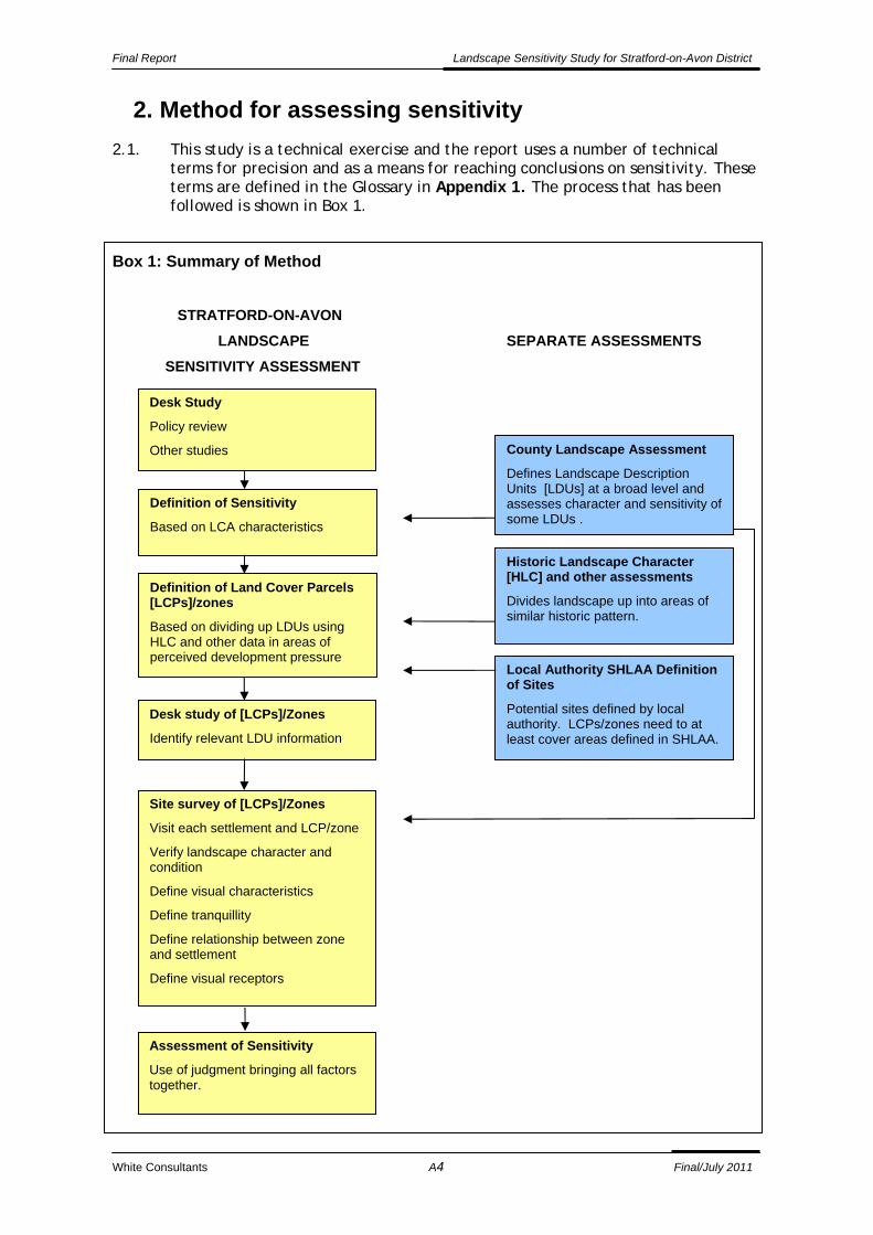
2.1. This study is a technical exercise and the report uses a number of technical terms for precision and as a means for reaching conclusions on sensitivity. These terms are defined in the Glossary in Appendix 1. The process that has been followed is shown in Box 1.
Box 1: Summary of Method
STRATFORD-ON-AVON
LANDSCAPE SEPARATE ASSESSMENTS
SENSITIVITY ASSESSMENT
Historic Landscape Character [HLC] and other assessments
Divides landscape up into areas of similar historic pattern.
County Landscape Assessment
Defines Landscape Description Units [LDUs] at a broad level and assesses character and sensitivity of some LDUs .
Definition of Land Cover Parcels [LCPs]/zones
Based on dividing up LDUs using HLC and other data in areas of perceived development pressure
Desk Study
Policy review
Other studies
Definition of Sensitivity
Based on LCA characteristics
Local Authority SHLAA Definition of Sites
Potential sites defined by local authority. LCPs/zones need to at least cover areas defined in SHLAA.
Desk study of [LCPs]/Zones
Identify relevant LDU information
Site survey of [LCPs]/Zones
Visit each settlement and LCP/zone
Verify landscape character and condition
Define visual characteristics
Define tranquillity
Define relationship between zone and settlement
Define visual receptors
Assessment of Sensitivity
Use of judgment bringing all factors together.
Final Report Landscape Sensitivity Study for Stratford-on-Avon District
White Consultants A5 Final/July 2011
Definition of Sensitivity
2.2. We have taken into consideration Countryside Agency ‘Topic Paper 6: Techniques and Criteria for Judging Capacity and Sensitivity [2004]’. We are aware that it is being reviewed during the course of this report but no revised version has yet been issued. In consultation with Natural England we have therefore worked within the framework of the existing guidance and used our experience in this topic to define our understanding and use of sensitivity.
2.3. Sensitivity is taken to mean the sensitivity of the landscape to a particular type of change or development. It is defined in terms of the interactions between the landscape itself, the way it is perceived and the nature of the development.
2.4. On the one hand, landscape sensitivity combines the sensitivity of the landscape resource [including its historical and ecological features and elements] and visual sensitivity [such as views and visibility]. For the purposes of this study it also includes values that contribute to the landscape. These are taken to include designations and constraints such as Scheduled Ancient Monuments, Conservation Areas, listed buildings, registered historic parks and gardens, ancient woodland, registered battlefields, Sites of Special Scientific Interest, local wildlife sites and nature reserves. Green Belt and Areas of Restraint are not considered as indications of value although the qualities that some LCP/zones within these areas may have in separating settlements or areas of development can contribute towards a judgement on sensitivity.
2.5. On the other hand, the nature of the two types of development under consideration is taken into account in terms of scale, height, potential design and layout and their effect on tranquillity. No judgement is made on the different amounts of change that may be acceptable in an LCP/zone although parts of zones which may be more or less appropriate for development may be discussed.
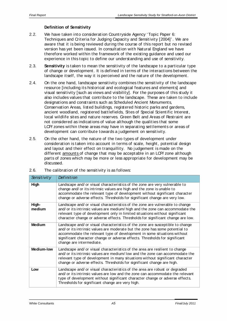
2.6. The calibration of the sensitivity is as follows:
Sensitivity Definition
High Landscape and/or visual characteristics of the zone are very vulnerable to change and/or its intrinsic values are high and the zone is unable to accommodate the relevant type of development without significant character change or adverse effects. Thresholds for significant change are very low.
High-medium
Landscape and/or visual characteristics of the zone are vulnerable to change and/or its intrinsic values are medium/high and the zone can accommodate the relevant type of development only in limited situations without significant character change or adverse effects. Thresholds for significant change are low.
Medium Landscape and/or visual characteristics of the zone are susceptible to change and/or its intrinsic values are moderate but the zone has some potential to accommodate the relevant type of development in some situations without significant character change or adverse effects. Thresholds for significant change are intermediate.
Medium-low Landscape and/or visual characteristics of the area are resilient to change and/or its intrinsic values are medium/low and the zone can accommodate the relevant type of development in many situations without significant character change or adverse effects. Thresholds for significant change are high.
Low Landscape and/or visual characteristics of the area are robust or degraded and/or its intrinsic values are low and the zone can accommodate the relevant type of development without significant character change or adverse effects. Thresholds for significant change are very high.
Final Report Landscape Sensitivity Study for Stratford-on-Avon District
White Consultants A6 Final/July 2011
Assessed development types
2.7. Housing is taken to be low rise housing around 8m high at medium-low densities ranging from small through to larger estate developments of a size that might be expected to be allocated in a local development plan. The use class is C3.
2.8. Commercial development is taken to mean medium scale business, commercial or hotel development or specialised housing accommodation on a larger block format. The depth of office buildings would typically be expected to be around 15-20m and industrial/ warehouse uses a maximum of around 35m. Heights may exceed 8m with office blocks upto 3 storeys high and industrial units upto 12m to ridge. The offices or commercial premises will be considered as of a similar grain and character to that which has been developed in the Stratford Enterprise Park around Timothy’s Bridge Road [excluding the former AMEC tower block] or the southern fringes of Southam including associated storage and car parking but excluding the large units. The use classes included are B1, B2, B8 and C1.
2.9. The sensitivity to small scale employment built form where the floor plan and height is similar to housing and with low key environmental impact such as noise, dust etc and limited signage/storage etc within the B1 use class could, in some cases, be considered in the same way as housing capacity at the local planning authority’s discretion. An example may be small scale craft units or offices. It will be a matter of judgement depending on the character and location of the proposals and the site.
2.10. Key tasks are now explained in more detail.
Deriving land cover parcels
2.11. Land Cover Parcels (LCPs) have been defined for the areas around settlements covering at least the area covered by parcels assessed in the SHLAA study. However, they are derived on landscape criteria- landcover and landform. In some cases the LCPs can be limited in size, fairly closely following the SHLAA extents but in other cases they can extend some distance from the settlement edge. This can lead to an apparently uneven area covered such as around Stratford-upon-Avon.
2.12. LCPs can be defined as discrete areas of land bounded by roads, railways, water courses and parish boundaries, where similar patterns of land use, field pattern and tree cover are evident. They are derived through the sub-division of LDUs, based primarily on differences in land cover and historic pattern, with reference to:
Historic land Characterisation (HLC)
Farm census information,
Parish boundaries
1:10,000 OS base maps
This ensures that more detailed patterns of land ownership, field pattern and landscape development are defined.
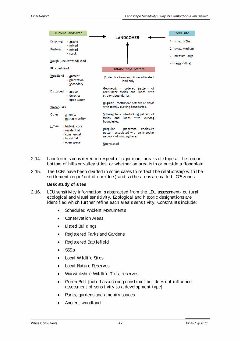
2.13. The land cover analysis identifies features within the landscape, such as parklands and larger woodlands, smaller urban areas and patches of disturbed/other non -agricultural land. The historic analysis identifies parish units and areas of farmland with different sizes/patterns of fields. Where they can still be identified on the map base, the analysis also defines former historic features, such as relic deer parks. The criteria used for defining LCPs landcover are summarized in the figure below.
Final Report Landscape Sensitivity Study for Stratford-on-Avon District
White Consultants A7 Final/July 2011
2.14. Landform is considered in respect of significant breaks of slope at the top or bottom of hills or valley sides, or whether an area is in or outside a floodplain.
2.15. The LCPs have been divided in some cases to reflect the relationship with the settlement (eg in/out of corridors) and so the areas are called LCP/zones.
Desk study of sites
2.16. LDU sensitivity information is abstracted from the LDU assessment- cultural, ecological and visual sensitivity. Ecological and historic designations are identified which further refine each area’s sensitivity. Constraints include:
Scheduled Ancient Monuments
Conservation Areas
Listed Buildings
Registered Parks and Gardens
Registered Battlefield
SSSIs
Local Wildlife Sites
Local Nature Reserves
Warwickshire Wildlife Trust reserves
Green Belt [noted as a strong constraint but does not influence assessment of sensitivity to a development type]
Parks, gardens and amenity spaces
Ancient woodland

Final Report Landscape Sensitivity Study for Stratford-on-Avon District
White Consultants A8 Final/July 2011
TPOs
2.17. Public rights of way in the District are only available in raster form so could not be used in the constraints mapping although taken into account during the assessment.
Site Survey of LCPs/zones
2.18. Relevant factors are recorded including:
Verification of character and condition of LCP/zone
Function of area
Presence of water
Visual characteristics
Tranquillity
Functional and visual relationship of the site with its surroundings and the settlement.
Description of settlement edge- is it a positive or negative edge to the settlement?
Definition of sensitive receptors within and outside the area.
Potential for improvement of the settlement edge and for overall mitigation.
2.19. These are further explained in Part B.
Overall sensitivity assessment
2.20. Bringing all the information together, an overall analysis of each LCP/zone’s sensitivity is made. Judgments are not based on a mathematical adding up of factors, positive or negative. Some factors will be more important than others in different sites. For instance, the function of an area in separating settlements may be considered very important and make it sensitive to development even if it is of limited inherent landscape value. A justification is given as to why it is considered that an area has a particular sensitivity.
Final Report Landscape Sensitivity Study for Stratford-on-Avon District
White Consultants A9 Final/July 2011
3. Summary of sensitivity findings and conclusions
3.1. Overall, the study has found that there is capacity for housing and employment around Stratford-upon-Avon and in some of the other settlements.
3.2. Areas of higher sensitivity have tended to be those of intrinsically higher value, those in open countryside not closely associated with a settlement, acting as setting to Conservation Areas or listed buildings, in valley corridors, in floodplains, on steep or prominent slopes or those forming gaps within or between settlements. There is a need to protect in particular the landscapes of the valley bottoms and maintain green fingers of open space penetrating into settlements to maintain the quality of life for residents. This is also considered in the review of Areas of Restraint. Some zones assessed form an important visual setting to parts of a settlement and act as recreational and wildlife corridors and reservoirs.
3.3. Some settlement edges, usually consisting of housing estates, present an unattractive boundary with the countryside. In these cases, and combined with where the landscape itself has lower intrinsic sensitivity, the opportunity is taken to note the potential for development. This is with the proviso that the development itself will present a positive edge with significant planting in order to integrate and enhance the landscape. This is best achieved by a design or development brief including landscape, nature conservation and urban design/settlement edge objectives.
3.4. Generally the sensitivity of zones to commercial development is higher than to housing development. This is because of its larger scale and height, its potential impact on sloping ground where terracing may be needed and its potential effect on adjacent residential areas. There are cases where housing development is less appropriate, mainly due to the relationship with the existing settlement form.
3.5. The landscape sensitivities of each LCP/zone to each development type are summarised in Table 1 and are shown in the summary figures.
3.6. In summary for housing development, there is medium/low landscape sensitivity in five zones in Alcester, Bidford-on-Avon [2], Stratford-upon-Avon and Studley. There is medium landscape sensitivity in 30 zones in Alcester [4], Bidford-on-Avon [6], Henley-in-Arden [1], Kineton [1], Shipston-on-Stour [2], Southam [3], Stratford-upon-Avon [8], Studley [3] and Wellesbourne [3]. Some of these zones should only be considered for development in the longer term due to their current prominence, where other sites around the settlement are more appropriate and where advance planting is suggested if needed. Most zones [around 75%] are generally considered areas of constraint with high or high/medium sensitivity.
3.7. In summary for commercial development, there is medium/low landscape sensitivity in two zones in Bidford-on-Avon and Studley. There is medium landscape sensitivity in ten zones in Alcester [3], Bidford-on-Avon [2], Southam [1], Stratford-upon-Avon [2] and Wellesbourne [2]. Some of these zones should only be considered for development in the longer term due to their current prominence, where other sites around the settlement are more appropriate and where advance planting is suggested if needed. Most zones [around 91%] are generally considered areas of constraint with high or high/medium sensitivity.
3.8. It is recommended that these findings are taken into consideration in the preparation of the Local Development Framework and allocation of sites for housing and employment development.

Final Report Landscape Sensitivity Study for Stratford-on-Avon District
White Consultants A10 Final/July 2011
Table 1 Landscape Sensitivity summary
Settlement Ref Housing development sensitivity Commercial development sensitivity
Alcester A01 medium medium
Alcester A02 high high
Alcester A03 medium medium
Alcester A04 high/medium high
Alcester A05 high high
Alcester A06 high high
Alcester A07 high high
Alcester A08 high/medium high
Alcester A09 high high
Alcester A10 high high
Alcester A11 high/medium high
Alcester A12 high/medium high
Alcester A13 medium/low medium
Alcester A14 medium high
Alcester A15 medium high
Bidford-on-Avon B01 medium high/medium
Bidford-on-Avon B02 high/medium high/medium
Bidford-on-Avon B03 medium high/medium
Bidford-on-Avon B04 medium/low medium
Bidford-on-Avon B05 high/medium high/medium
Bidford-on-Avon B06 high/medium high/medium
Bidford-on-Avon B07 medium/low medium/low
Bidford-on-Avon B08 medium high/medium
Bidford-on-Avon B09 high/medium high
Bidford-on-Avon B10 medium high
Bidford-on-Avon B11 high high
Bidford-on-Avon B12 high high
Bidford-on-Avon B13 high high
Bidford-on-Avon B14 medium high/medium
Bidford-on-Avon B15 medium medium
Henley-in-Arden H01 high high
Henley-in-Arden H02 high/medium high
Henley-in-Arden H03 high high
Henley-in-Arden H04 high/medium high
Henley-in-Arden H05 high/medium high
Henley-in-Arden H06 high/medium high
Henley-in-Arden H07 high/medium high/medium
Henley-in-Arden H08 high/medium high/medium
Henley-in-Arden H09 medium high/medium
Henley-in-Arden H10 high/medium high
Henley-in-Arden H11 high/medium high
Henley-in-Arden H12 high/medium high
Kineton K01 high/medium high/medium
Kineton K02 high/medium high/medium
Kineton K03 high/medium high
Kineton K04 high/medium high
Kineton K05 medium high
Kineton K06 high/medium high
Kineton K07 high high
Kineton K08 high/medium high
Kineton K09 high/medium high

Final Report Landscape Sensitivity Study for Stratford-on-Avon District
White Consultants A11 Final/July 2011
Settlement Ref Housing development sensitivity Commercial development sensitivity
Kineton K10 high/medium high
Kineton K11 high high
Shipston-on-Stour Sh01 high high
Shipston-on-Stour Sh02 high high
Shipston-on-Stour Sh03 high/medium high
Shipston-on-Stour Sh04 high high
Shipston-on-Stour Sh05 high high
Shipston-on-Stour Sh06 high/medium high
Shipston-on-Stour Sh07 medium high
Shipston-on-Stour Sh08 high high
Shipston-on-Stour Sh09 medium high/medium
Shipston-on-Stour Sh10 high/medium high/medium
Shipston-on-Stour Sh11 high high
Shipston-on-Stour Sh12 high/medium high/medium
Shipston-on-Stour Sh13 high/medium high
Shipston-on-Stour Sh14 high/medium high
Shipston-on-Stour Sh15 high high
Shipston-on-Stour Sh16 high/medium high
Southam So01 high/medium high
Southam So02 medium high/medium
Southam So03 medium medium
Southam So04 high/medium high/medium
Southam So05 high/medium high
Southam So06 high/medium high
Southam So07 high high
Southam So08 medium high
Southam So09 high high
Southam So10 high/medium high
Southam So11 high/medium high
Southam So12 high high
Southam So13 high/medium high
Stratford-upon-Avon St01 medium medium
Stratford-upon-Avon St02 high/medium high
Stratford-upon-Avon St03 high high
Stratford-upon-Avon St04 high/medium high
Stratford-upon-Avon St05 high high
Stratford-upon-Avon St06 high/medium high
Stratford-upon-Avon St07 high high
Stratford-upon-Avon St08 high/medium high
Stratford-upon-Avon St09 high/medium high
Stratford-upon-Avon St10 medium high/medium
Stratford-upon-Avon St11 medium high/medium
Stratford-upon-Avon St12 medium high/medium
Stratford-upon-Avon St13 high/medium high/medium
Stratford-upon-Avon St14 medium high/medium
Stratford-upon-Avon St15 high/medium high/medium
Stratford-upon-Avon St16 high high
Stratford-upon-Avon St17 high high
Stratford-upon-Avon St18 high high
Stratford-upon-Avon St19 high high
Stratford-upon-Avon St20 high high
Stratford-upon-Avon St21 high/medium high

Final Report Landscape Sensitivity Study for Stratford-on-Avon District
White Consultants A12 Final/July 2011
Settlement Ref Housing development sensitivity Commercial development sensitivity
Stratford-upon-Avon St22 high high
Stratford-upon-Avon St23 high/medium high
Stratford-upon-Avon St24 high high
Stratford-upon-Avon St25 medium high/medium
Stratford-upon-Avon St26 high/medium high
Stratford-upon-Avon St27 high/medium high
Stratford-upon-Avon St28 medium/low high/medium
Stratford-upon-Avon St29 medium medium
Stratford-upon-Avon St30 high high
Studley Su01 medium/low medium/low
Studley Su02 medium high/medium
Studley Su03 high/medium high/medium
Studley Su04 high/medium high/medium
Studley Su05 medium high
Studley Su06 medium high/medium
Studley Su07 high high
Studley Su08 high high/medium
Studley Su09 high high
Studley Su10 high high
Studley Su11 high high
Studley Su12 high/medium high
Studley Su13 high/medium high
Studley Su14 high/medium high
Studley Su15 high high
Wellesbourne W01 high/medium high/medium
Wellesbourne W02 high/medium high
Wellesbourne W03 medium high
Wellesbourne W04 high/medium high
Wellesbourne W05 high high
Wellesbourne W06 high/medium high
Wellesbourne W07 medium high/medium
Wellesbourne W08 high/medium high
Wellesbourne W09 high/medium medium
Wellesbourne W10 high/medium high
Wellesbourne W11 high/medium medium
Wellesbourne W12 high high
Wellesbourne W13 high/medium high
Wellesbourne W14 high high

Final Report Landscape Sensitivity Study for Stratford-on-Avon District
White Consultants A13 Final/July 2011
4. Areas of Restraint review
4.1. The brief required consideration of the current Areas of Restraint:
‘Included in the Study will be a full review of the Areas of Restraint that were defined in the Local Plan Review. This review should examine whether the designation is still justified in principle in current circumstances and, if so, whether the current Areas of Restraint are still fit for purpose and whether they need deletion, amendment or the addition of other areas in relation to the main settlements.’ [5.7]
4.2. It is understood that the Areas of Restraint [AORs] derived originally from a Warwickshire County Council structure plan policy. It is therefore an appropriate time for a review of their relevance and extent.
4.3. The AORs occur in some of the main settlements in the district where the Green Belt designation does not apply.
4.4. The method adopted is to review the policy and its purpose and then consider the current national policy framework and other relevant guidance and information. Based on this, a case for Areas of Restraint is considered and criteria are developed for amending or creating new Areas of Restraint.
SAVED LOCAL POLICIES
4.5. The main current local level policies are saved from the adopted Stratford-on-Avon District Local Plan Review 1996-2011 (LPR). This document was in conformity with the version of the West Midland Regional Spatial Strategy [WMRSS] approved by the Secretary of State in June 2004.
4.6. The key policy is Policy EF.3 Areas of Restraint [AOR] and reads:
‘In the Areas of Restraint, as defined on the Proposals Map, development will only be permitted where:
a] it would be ancillary to agriculture or existing authorised uses;
b] it would not harm or threaten the generally open nature of the area, taking into account any possible cumulative effect; or
c] exceptional circumstances can be demonstrated.’
4.7. The justification states that overriding intention of the AORs is to ‘protect their inherently open character because of the valuable contribution they make to the character of the settlement. This may take the form of significant areas of open space within the urban area or a physical feature which is important in establishing its setting.’
4.8. Small-scale ancillary development or development of an agricultural recreational nature are not precluded.
CURRENT NATIONAL POLICY CONTEXT
PPS 1 Delivering Sustainable Development
4.9. PPS1 provides the overarching planning policies. In its objectives it states that:
‘Planning should facilitate and promote sustainable and inclusive patterns of urban and rural development by:
making suitable land available for development in line with economic, social and environmental objectives to improve people's quality of life;
contributing to sustainable economic development;

Final Report Landscape Sensitivity Study for Stratford-on-Avon District
White Consultants A14 Final/July 2011
protecting and enhancing the natural and historic environment, the quality and character of the countryside, and existing communities;
……….’ [1]
PPG2 Green Belts
4.10. This policy only addresses Green Belts. The intentions of the policy are expressed thus:
‘The fundamental aim of Green Belt policy is to prevent urban sprawl by keeping land permanently open; the most important attribute of Green Belts is their openness. Green Belts can shape patterns of urban development at sub-regional and regional scale, and help to ensure that development occurs in locations allocated in development plans.’ [1.4]
4.11. Green Belts are intended to be permanent. They are different from locally derived policies such as green wedges or areas of restraint which are intended to last the lifetime of a local plan.
4.12. The West Midlands Green Belt applies to much of the north western part of Stratford District under Policy PR.2. Its intention is to separate the West Midlands conurbation from smaller settlements. It includes areas around the settlements of Alcester, Henley-in-Arden and Studley and abuts the northern edges of Stratford-upon-Avon. However, it does not apply to open spaces within settlements such as the river valley corridor in Alcester which is currently an Area of Restraint.
PPS7 Sustainable Development in Rural Areas [2004]
4.13. PPS7 addresses areas adjacent as well as away from urban areas and more rural settlements. Key objectives referred to in promoting more sustainable patterns of development include focussing most development in, or next to, existing towns and villages but preventing urban sprawl and discouraging the development of ‘greenfield’ land. In addition, objectives include promoting a range of uses to maximise the potential benefits of the countryside fringing urban areas and including appropriate leisure opportunities.
4.14. Key principles include:
‘New building development in the open countryside away from existing settlements, or outside areas allocated for development in development plans, should be strictly controlled; the Government's overall aim is to protect the countryside for the sake of its intrinsic character and beauty, the diversity of its landscapes, heritage and wildlife, the wealth of its natural resources and so it may be enjoyed by all.’
4.15. Local landscape designations based on inherent value are discouraged, with criteria based policies and landscape character assessment considered as adequate tools for providing sufficient protection. If designations are retained then a formal and robust assessment is needed to justify them [24,25].
4.16. The countryside around urban areas is addressed as follows:
‘While the policies in PPG2 continue to apply in green belts, local planning authorities should ensure that planning policies in LDDs address the particular land use issues and opportunities to be found in the countryside around all urban areas, recognising its importance to those who live or work there, and also in providing the nearest and most accessible countryside to urban residents. Planning authorities should aim to secure environmental improvements and maximise a range of beneficial uses of this land, whilst reducing potential conflicts between neighbouring land uses. This should

Final Report Landscape Sensitivity Study for Stratford-on-Avon District
White Consultants A15 Final/July 2011
include improvement of public access (eg through support for country parks and community forests) and facilitating the provision of appropriate sport and recreation facilities.’ [26]
4.17. Whilst ‘areas of restraint’ or the more commonly used term ‘green wedges’ are not referred to specifically, the above paragraph is considered to apply in this case.
West Midlands Regional Spatial Strategy 2008
4.18. The government has stated that regional planning policies are no longer to apply although there is some doubt as to when this takes legal force. It is, however, of interest to note that the WMRSS Policy QWE4: Greenery, Urban Greenspace and Public Spaces states that ‘development plan policies should create and enhance urban greenspace networks by ensuring adequate protection is given to key features such as parks, footpaths and cycleways, river valleys, canals and open spaces.’
4.19. A green infrastructure strategy may address some of these issues but it would not give precise boundary protection to well defined areas and so may not have the same weight in planning terms.
European Landscape Convention [ELC]
4.20. The ELC was created by the Council of Europe and promotes landscape protection, management and planning. It became binding on the UK in March 2007. It acknowledges ‘that the landscape is an important part of the quality of life for people everywhere: in urban areas and in the countryside, in degraded areas as well as in areas of high quality, in areas recognised as being of outstanding beauty as well as everyday areas....’[preamble]. It now has to be taken into account in planning policy in the England.
Warwickshire Landscape Character assessment
4.21. The Warwickshire landscape character assessment assesses areas at a large scale with broad brush boundaries and makes recommendations that enhance the landscape as a whole. While acting as an important context it does not address small areas around and particularly within settlements.
The Stratford-on-Avon District Design Guide
4.22. The design guide sets out useful principles for development with case studies such as Kineton. Whilst these principles could be applied to all settlements, it does not provide a strong direction on the pattern of development in individual settlements including Kineton.
Landscape sensitivity study
4.23. The study identifies the sensitivity of land cover parcels/zones around the settlement to both housing and employment using a series of criteria. This study is useful for identifying opportunities for development but also areas of constraint.
Discussion
4.24. Though there is no overt reference in PPS7 to areas of restraint or green wedges the guidance recognises the importance of countryside around urban areas and its use by local people. PPS1 also encourages sustainable patterns of urban development which enhance people's quality of life and protecting the natural and historic environment.

Final Report Landscape Sensitivity Study for Stratford-on-Avon District
White Consultants A16 Final/July 2011
4.25. There is no support in PPS7 for local landscape designations although if local planning authorities [LPAs] wish to pursue them then formal and robust assessment is needed to justify them.
4.26. Areas of Restraint are not considered to be local landscape designations like special landscape areas. They apply to relatively small areas within or adjacent to settlements and their purpose is to enhance the character, and guide the shape, of the settlement as well as having intrinsic qualities in themselves.
4.27. The landscape sensitivity study is helpful in identifying areas where there is most constraint in landscape terms. Potentially this study could be used to supersede the Areas of Restraint. The problem is that the LPA would need to adopt the full study which may prove difficult. Instead, it is considered that this could be used as a background study to inform any revisions to Areas of Restraint.
4.28. Whilst PPS7 protects open countryside it is debatable whether this is always sufficient to protect small areas of sensitive land such as river valley corridors on the fringes of settlement which may be under particular development pressure.
4.29. Whilst AORs do not have explicit approval from national guidance it is considered that there is a case to be made to protect landscapes around and within settlements which enhance the character of settlements and help direct the expansion of those settlements. There is likely to be support from local residents for retention of AORs in their locality.
4.30. The core purpose of the AORs should still be to protect their inherently open character because of the valuable contribution they make to the character of the settlement as per the previous policy. However, they may also be used to separate settlements and, in line with national policy, they should also be supported by proactive policies for enhancement of landscape character and visual amenity and beneficial use where possible including promoting access, nature conservation and food production.
4.31. Green Belts are a more powerful tool in planning with different terms of reference to Areas of Restraint but they similarly seek to restrict development and maintain openness. Therefore, where there is Green Belt there is no merit or purpose in also applying an Area of Restraint.
Method for assessing and defining Areas of Restraint
4.32. The key criteria used for defining AORs singly or collectively are:
Is there a green corridor running adjacent, through or into a settlement which contributes to its character?
Has the settlement got a positive character adjacent to green space that merits particular protection in terms of setting?
Is the green corridor generally open and free of dense development?
Does the green space separate the settlement from an adjacent settlement helping to maintain separate identities?
Is the green space of landscape or visual merit?
Are there key views to landmarks or the settlement core across the green space?
Are there cultural heritage assets which would benefit from an open green setting?

Final Report Landscape Sensitivity Study for Stratford-on-Avon District
White Consultants A17 Final/July 2011
Are there nature conservation assets which would benefit from the linkage of a green corridor?
Are there publicly accessible green spaces and/or PROWS through the area linking the countryside to the centre of the settlement?
Are there any other uses such as allotments or floodplain which require open space and would benefit adjacent areas and/or be of benefit to the community?
4.33. Each settlement is assessed in Part 3 of the report.
Conclusions
4.34. The existing AORS mainly relate to river corridors through or adjacent to settlements. These are considered worthy of protection as they contribute strongly to settlement character. The existing AORs are generally considered to be justifiable with some minor adjustments and additions to help guide development form. Areas put forward for exclusion relate to some draft recommendations in the landscape sensitivity assessment.
4.35. An additional AOR is proposed at Kineton, which though essentially rural in character, merits the same approach as other settlements in protecting the River Dene valley between it and Little Kineton.

Final Report Landscape Sensitivity Study for Stratford-on-Avon District
White Consultants A18 Final/July 2011
FIGURES

Stratford-upon-Avon
Studley
Henley-in-Arden
Southam
Shipston-on-Stour
Kineton
Wellesbourne
Bidford-on-Avon
Alcester

Stratford-upon-Avon
Studley
Henley-in-Arden
Southam
Shipston-on-Stour
Kineton
Wellesbourne
Bidford-on-Avon
Alcester