stratigraphy and petrology of in 54 and · stratigraphy and petrology of mississippian, ......
TRANSCRIPT
STRATIGRAPHY AND PETROLOGY OF
MISSISSIPPIAN, PENNSYLVANIAN, AND PERMIAN ROCKS
IN THE MAGDALENA AREA, SOCORRO COUNTY, NEW MEXICO
Open-File Report 54
New Mexico Bureau of Mines and Mineral Resources
by
William Terry Siemers
December 1973
TABLEOFCONTENTS
INTRODUCTION
Area of Study Purpose of Study Method of Study Location and Accessibility
ACKNOWLEDGMENTS
PALEOTECTONIC SETTING
MISSISSIPPIAN PERIOD i
Prekious Work Regional Stratigraphy
Northern New Mexico south- Central New Mexico Southwestern New Mexico
Local Stratigraphy Tip Top Mountain North Baldy North Fork Canyon Stratigraphic Summary
Caloso Formation Kelly Limestone
* , Petrography
PENNSYLVANIAN PERIOD
Previous Work . Regional Stratigraphy
Northern New Mexico Central New Mexico I
1 Southwestern New Mexico Local Stratigraphy
Tip Top Mountain
c. /' Sandia Formation Madera Limestone
Sandia Formation Madera Limestone
North Fork Canyon
North Baldy Summary of Pennsylvanian Sections
5
6
11
11 11 13 13 14 16 16 2 0 23 26 27 27 2 8
34
3 4 . 38 38 39 41 42 48 49 '
52 53 55 56 62
51
~~ ~
11 ..
Petrography Sandia Formation Madera Limestone
ROCKS O F QUESTIONED AGE
Bursum Farmation Ab0 Formation Yeso Formation Glorieta Sandstone San Andres Formation Comparison of Olney Ranch and Tres Montosas 'sections
c with Permian and Pennsylvanian Formations
Thickness Sedimentary Structures Lithology
ENVIRONMENTS O F DEPOSITION
Caloso Formation Kelly Limestone Sandia Formation
Quartzite Shale Limes tone
Madera Limestone
SUMMARY AND CONCLUSIONS
REFERENCES
APPENDICES
Appendix I: Stratigraphic Columns Appendix II: Sedimentary Petrology Appendix 111: Classification Systems
c
63 63 67
7 2
73 73 7 5 76 76 76 .
76 77 78
94
94 95 96 . 96 . 97 97 97
98
100
108
109 118 127
iii
LIST OF FIGURES
Figure
1. Index map of New Mexico
2. Pennsylvanian paleogeographic map of New Mexico
3. Isopach and facies map of Mississippian strata '
4. Correlation of Mississippian section in New Mexico
5. View along the crest of the Magdalena Range.
6. The change from lower Caloso to upper Caloso a t Tip Top ' Mountain
7. Crinoidal Kelly Limestone near Tip Top
8. Kelly Limestone at North Baldy
9. Contact between altered and unaltered Kelly Limestone
10. Photomicrograph of lower Caloso Formation, Tip Top . _
Mountain
11. Photomicrograph of upper Caloso Formation, Tip Top Mountain
12. Photomicrograph of Kelly Limestone, Tip Top Mountain
13. Nomenclature of Pennsylvanian units
14. Micrite pods in a laminated Sandia mudstone . .
15. Black chert nodules in Madera beds, North Fork Canyon
16. Pennsylvanian section at North Baldy
17. Coarse-grained Sandia quartzite a t North BaIdy
18. Black, fissile Sandia shale at North Baldy
19. Photomicrograph of a Sandia Quartzite, Tip Top Mountain'
20. Photomicrograph of a Sandia limestone, Tip Top Mountain
Page
3
7
8
12
19 .
21
22
24.
25
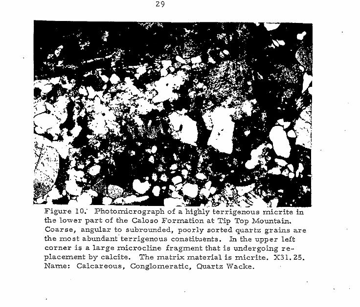
29
30
31
35
54
57
58
6 0
6 1
65
66
21.
22.
23.
(. 24.
25.
26.
27.
28.
1v I
Photomicrograph of a Madera quartzite, North Fork Canyon
Photomicrograph of a Madera limestone, Tip Top Mountain
Summary of nomenclature for Permian units
Photomicrograph of an Ab0 quartzite, Olney Ranch
,Photomicrograph of the Glorieta Sandstone, Olney R
Glorieta-San Andres contact, Olney Ranch
6 8
7 0
74
81
.anch . 83
86
Photomicrograph of the San Andres Limestone, Olney .87 Ranch
Limestone pebble and boulder conglomerate, Ab0 Formation, 91 Tres Montosas

P12 tte
LIST OF PLATES
1. Locations of measured sections
<
*
Page
in pocket
V
LIST OF TABLES
Table
1. Fauna of the Caloso Formation, Magdalena Mountains
2. Fauna of the Kelly Formation, Magdalena Mountains
3 . Summary of Mississippian Sections
4. Invertebrate fossils in the Pennsylvanian
5. Comparison of Sandia and Ab0 quartzites
6 . ' Comparison of Sandia quartzite and Glorieta Sandstone
7. Comparison of Madera Limestone aad San Andres . !
Formation
Page
17
18
33
45
80 .
85
89
. .
v11
Areally restr
ABSTRACT
,icted beds of the Mississippian and Pennsylvanian
periods occur in the Magdalena. Mountains of west-central New Mexico.
In surrounding areas, some sections previously considered Pennsylvanian
in age a r e now believed to be of Permian age. The conglomerates and
sandstones of the Caloso Formation are a typical transgressive sequence.
The gray, crinoidal wackestones and packstones of the Kelly Formation . .
represent subtidal deposition on a shallow marine shelf. Dark, carbona- -
ceous shales, coarse-grained quartzites, and thin, gray fossiliferous,
micritic limestones found in the Sandia Formation represent deposition
on a shoreline complex. The Sandia nomenclature of Loughlin and
Koschmann (1942) is difficult and impractical to use and its further use
is not supported. The homogenous, micritic limestones of the Madera
Limestone a r e thought to have accumulated.on a shallow, marine, carbonate
!
, .
shelf characterized by local,, deeper, more restricted areas. Mississippian
and Pennsylvanian rocks in the Magdalena Mountains provide an example of
ancient marine shelf sedimentation similar to modeIs presented by various
authors representing sedimentation on modern marine shelves.
INTRODUCTION
Area of Study
The area of investigation embraces the west-central portion of
Socorro County, New Mexico and centers in the 'Magdalena Mountains
where Mississippian and Pennsylvanian rocks a r e well exposed. The. '
type section of the Magdalena Group is located in the northern Magdalena
Mountains. At the type section, the Pennsylvanian sequence is about 1,200
feet thick. Loughlin and Koschmann (1.942) divided the Magdalena Group
into the Sandia Formation below and the Madera Limestone above.
The underlyiag Mississippian strata are about 125 feet thick. ,
Armstrong (1958) divided the Mississippian in the Magdalena Mountains
into an underlying Caloso Formation and a n overlying Kelly Limestone. .
. .
Purpose of Study
The primary objectives of the present study are:
1; definition of practical stratigraphic &its for mapping
2. observation of facies changes within units . .
3. description of the petrologic character of the units
4. interpretation of the environments of deposition of the kits
in the Mississippian and Pennsylvanian Systems.
2
Method of Study
Five outcrop areas were chosen for sampling and section
measurement by the brunton and tape method. Locations of the sections
a re shown on plate 1. They are:
1. North Fork Canyon, Magdalena Mountains
2 . North Baldy, Magdalena Mountains
3. Tip Top Mountain, Magdalena Mountains
9. Olney Ranch, Magdalena Mountains
5. Tres Montosas, Gallinas Mountains ;
Samples from the five sections (Appendix I) and from a drill hole
..
south of Tres Montosas were analyzed petrographically wZth some supple-
mentary x-ray diffraction analyses. Data accumulated from thin section
analysis may be found in Appendix 11. All classification systems used in
this study are located in Appendix III.
Location and Accessibility
The Magdalena Mountains l ie about 20 miles west of Socorro and.
70 miles south of Albuquerque in west-central Socorro County, New Mexico.
Tres Montosas is located about 15 miles west of the Magdalena Range (fig. 1).
Magdalena, New Mexico, a village of about 650 people, is the
principle settlement of the region. Magdalena is located 26 miles west of
Socorro on State Highway 60. From Magdalena, the sections-in the
Magdalena Mountains are reached by mining and Forest Service roads
that provide access up the rugged slopes and along the crest of the range
..
..
..
..
t
. ... . ..
. ..
.. ..
. .. ..
I
..
a'.
.. E
4
- for 4-wheel-drive vehicles. The Tres Montosas section is reached by
traveling 5 miles west of Magdalena along Highway 60, then north.
5
ACKNOWLEDGMENTS
The writer's appreciation is extended to committee members
Dr. Charles Chapin, chairman, Dr. Frank Kottlowski, Dr. John
MacMillan, and Dr. Charles Walker for their help and-supervision.
Thanks are also extended to the New Mexico Bureau of Mines and
Mineral Resources and especially to Director Don Baker, Jr. fox
financial. support of this study. Comment and criticism from Roy
Foster,;. Robert Kelley, Dr. Cristina L o c h a n Balk, and Robert
Blakestad aided in the preparation of the manuscript. .Field assistance
by Mike Boling, James Bruning, Paul Olsen and Don Simon is gratefully
acknowledged.
. .
. .
Sever:
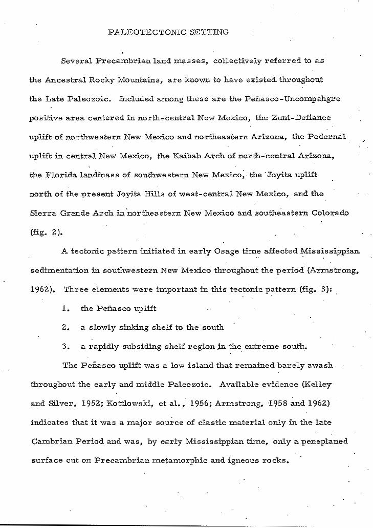
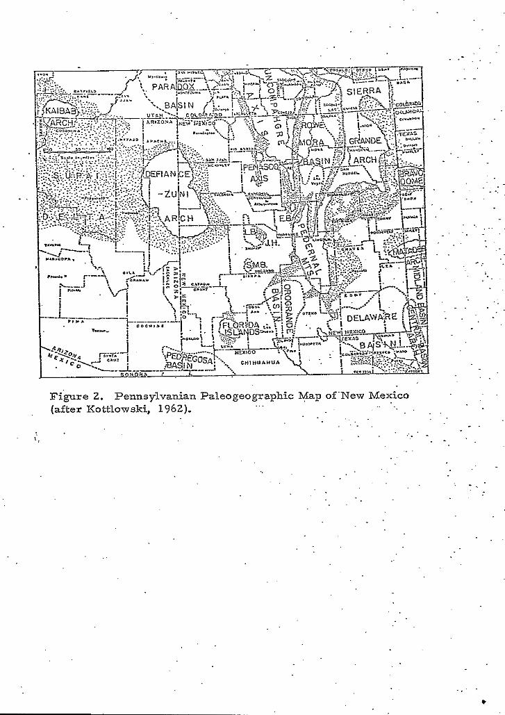
PALEOTECTONIC SETTING
~1 Precambrian land masses, collec :tively referred to as
the Ancestral Rocky Mountains, a r e known to have existed throughout
the Late Paleozoic. Included among these are the Peiiasco-Uncompahgre
positive area centered in north-central New Mexico, the Zuni-Defiance
uplift of northwestern New Mexico and northeastern Arizona, the Pedernal . -
uplift in central New Mexico, the Kaibab Arch of north-central Arizona,
the Florida landinass of southwestern New Mexico;. the .Joyita uplift
north of the present Joyita Hills of west-central New Mexico, and the
Sierra Grande Arch innortheastern New Mexico and southe'astern Colorado
(fig. 2). - ..
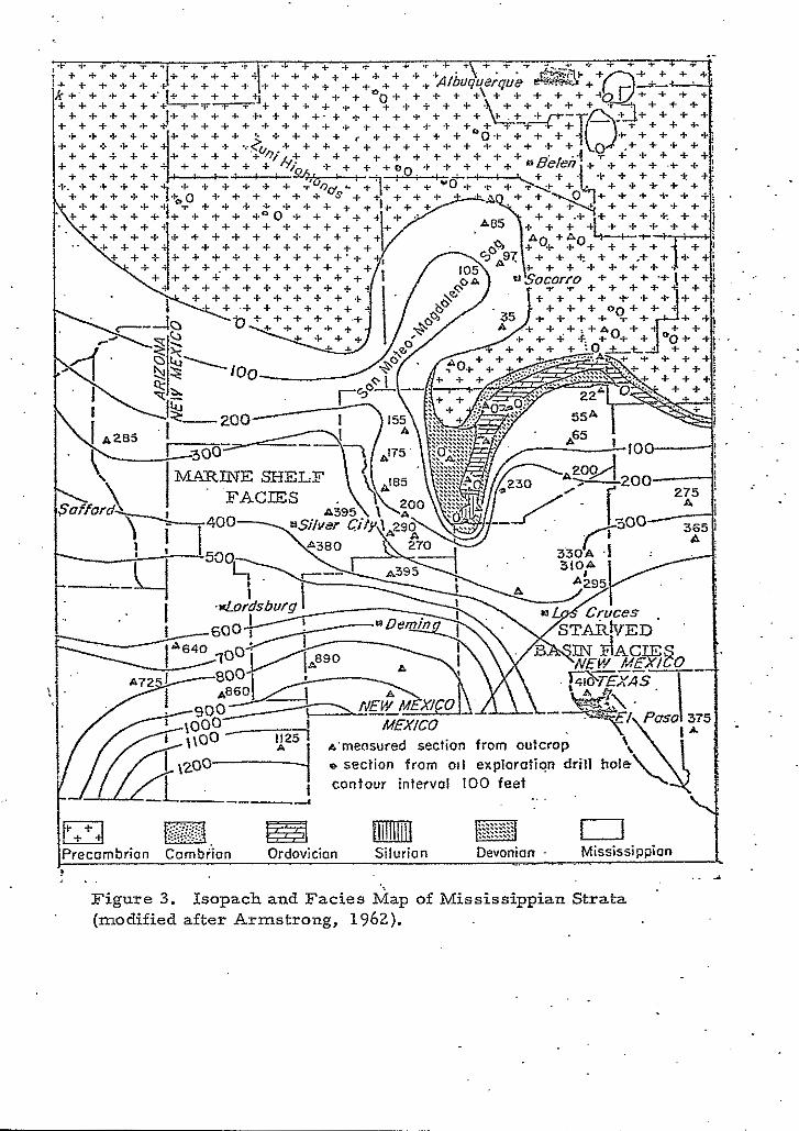
A tectonic pattern initiated in early Osage time affected Mississippian
sedimentation in southwestern New Mexico throughout the period (Armstrong,
1962). Three elements were important in this tect0ni.c pattern (fig. 3):
1. the Peiiasco uplift . .
2. a slowly sinking shelf to the south
3. a rapidly subsiding shelf region .in the extreme south.
The Peiiasco uplift was a low island that remained barely awash
throughout the early and middle Paleozoic. Available evidence (Kelley
and Silver, 1952; Kottlowski, et al., 1956; Armstrong, ,1958 and 1962)
indicates that it was a major source of clastic material only in the late
Cambrian Period and was, by early Mississippian time, only a peneplaned
surface cut on Precambrian metamorphic and igneous rocks. '
- 0
( '
.. .
e ,
' C
m
7
. . . .
Figure 2. Pennsylvanian Paleogeographic Map of'New Mexico (after Kottlowski, 1962). ...
' f
. .
..
. .
. .
. .
"
. . . . - .. . .
. .
. . . ~. . . - . . .
- . . .~
. .
. .
. -
. - . .
. _ c
8
r+'$ n, EZ3 mrnrn a Precambrion Cambrian Ordovician Silurion Devonian . Mississippian _.
. . .. 3 Figure 3. Isopach and Facies Map of Mississippian Strata (modified after Armstrong, 1962).
Y
South of the Pefiasco uplift, a shallow shelf area developed and
subsided at a slow rate until the end of Meramec time. Subsidence of
the gently sloping shelf was more rapid in the southern part of the state,
In south-central New Mexico and the Trans-Pecos region of Texas, - . .
Armstrong (1962) noted the development of a starved basin facies with an
open marina shelf carbonate facies to the west in southwestern New M e ~ c o
and southeastern Arizona. ,
The maximum inundation began in Kinderhookian time and was i
affected by an eastward transgression from the .Cordilleran miogeosyn-
cline through the Paradox Basin, around the north flank of the Zuni-
Defiance uplift, and into portions of the present San Juan Basin. *mi& - .
f rom the south, another transgression passed between the Pedernal
highlands and the Zuni-Defiance uplift. By late .Osage time, the seas
covered north-central New Mexico, reduced the Zuni-Defiance uplift to
a mere island and completely covered the weakly developed Transcontinental
.Arch (Armstrong, 1967).
Following a period of uplift a t the end of the Missis.sipp+.n, all of
the Paleozoic positive areas became contributors of debris to Pennsylvanian
sediments in New Mexico. The Joyita highlands and the Floridahighlands
never gained more than local importance and the Zuni-Defiance landmass
was periodically awash beneath the shallow Pennsylvanian seas. Par ts of
the Pedernal uplift became important contributors of debris while the Kaibab
uplift was important only as a local source for the Supai Delta in north-
western Arizona (Kottlowskz, 1960).
X0
A number of areas that tended to remain more negative than the
surrounding shelf areas also played important roles in Pennsylvanian
sedimentation. Among these basins were the Estancia, Lucero,. and San
Mateo' basins of central New Mexico, the Orogr'ande basin of south-central
( . New Mexico, the Delaware basin in the southeast corner of the state, and
the Pedregosa basin of extreme southwestern New Mexico and southeastern
Arizona.
11
MSSISSIPPLAN PERIOD
, Previous Work
In the Magdalena Mountains, I-Ierrick (1904) named a Mississippian
section consisting of crystalline light-colored limestone with an interbedded
dense, dolomitic lime, the Graphic-Kelly Limestone. The name was
derived from two major mines in the district. Three years later, Gordon
(1907) revised the nomenclature and called the same section the Kelly
Limestone after nearby Kelly, New Mexico. 1
Loughlin and Koschmann (1942), while studying the geology and
o r e deposits of the Magdalena mining district, collected a small number
of fossils near the base and near the top of the'Mississippian section. A
study of these by G. H. Gi r ty suggested they were of different geologic
age. Additional work in the area, along with observations in the Lemitar
and Ladron Mountains, led Armstrong (1958) to divide the Mississippian
sectio'n into a lower Caloso Formation &d an upper Kelly Formation.
Armstrong (1955) had previously named the Caloso Formation for L&e
basal part of the Mississippian section in the Ladron Mountains.
Regional Stratigraphy
In New Mexico, Mississippian rocks represent a period of time
extending from Late Kinderhook through Middle Chester (fig. 4); however,
Late Mississippian and Early Pennsylvanian erosion extensively removed
Mississippian sediments from large portions of the state making recon-
struction of the different Mississippain facies difficult.
. .
, w
: Formation Solam I>.
L
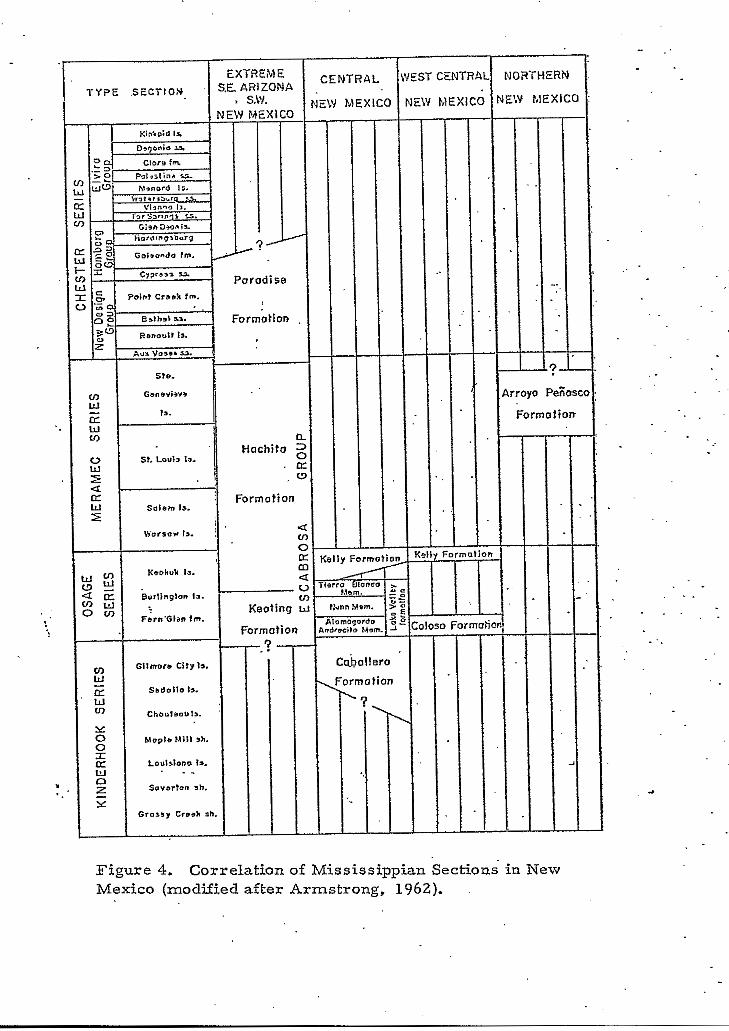
Figure 4. Correlation of Mississippian Sections- in New Mexico (modified after Armstrong, 1962).
* i
*' ,
c
0
13
-
disconformably overlie various Devonian formations.
The Caballero Formation varies from a feather-edge to 60 feet in
thickness and is a gray, mottled, nodular, shaly limestone with inter-
bedded thin, calcareous shales. Locally, a thin, fissile, black, basal ' .
shale is present. The overlying Osage rocks in south-central New Mexico
a r e divided into the Lake Valley Formation, representing Early and Middle
Osage (Fern Glen and Burlington) times, and the Kelly Formation
representing Late Osage (Keokuk) time.
-NORTHERN NEW MEXICO. The thin Upper Meramec limestones
of the Arroyo Pefiasco Formation are the only known Mississippian rocks
in kiorthern New Mexico and, along with the upper part of the Hachita
Formation in the southwestern part O E New Mexico, represent the only
rocks of known Meramec age within the state.. Armstrong (1967), in
discussing the Arroyo Peiiasco Formation, described a 2- to 60-foot-
thick basal unit consisting of quartz conglomerate, sandstone, and thin
shale. He divided the overlying carbonates into three incomplete cycles.
In ascending order these are: 1) . a lower dolomite; 2 ) a medial wacke-
stone to lime mudstone; and 3 ) a wackestone to oolitic packstone overlain
by lime mudstone or intertidal dolomite.
I . .
. .
SOUTH-CENTRAL NEW MEXICO. The extent and faunal assemblages
of the earliest Mississippian rocks in the central part of the state are not
clearly known. These rocks, first named the Caballero Formation by
Laudon and Bowsher (1941), a re indicated by a large invertebrate fauna
,to be Late Kinderhookian (Chouteau to Gilmore City) in age. The rocks . .
14
Laudon and Bowsher (1949) recognized 'six members in the Lake
Valley Formation. In ascending order they are: 1) 35 feet of gray,
fossiliferous limestones of the Andrecito Member; 2) 30 to 50 feet of
massive, cherty, poorly fossiliferous, cliff-forming, black limestones
of the Alamogordo Member; 3 ) 1 to 100 feet of.soft, blue-gray m a r k and
nodular, crinoidal limestone of the Nunn Member; 4) 1 0 to 125 feet of
medium-bedded, cherty, gray to brown, crinoidat coquinas o f the Tierra
Blanca Member; 5) 25 to 230 feet of soft, thin-bedded, gray, calcareous
siltstones and shales of the Arcente Member; and 6 ) 175 feet of mdium-
bedded to massive, gray to black, cherty, crinoidal coquinas of the Dona
Ana Member. The Kelly Formation, of Keokuk age consists of as much
as 125 feet of somewhat-.massive, gray to tan, cherty, crinoidal limestone
(Laudon and Bowsher, 1949).
SOUTHWESTERN NEW MEXICO. Armstrong (1962), while working
in Cochise County, Arizona and in Luna, Hidalgo, and Grant Counties of
Southwestern New Mexico, named the Mississippian . . rocks the Escabrosa
Group. The Escabrosa Group has a minimum thicknes.s of 650 feet in the
Peloncillo Mountains and a maximum thickness of I, 000 f ee t in the Big
. .- Hatchet Mountains of New Mexico. Armstrong also divided the Escabrosa
Group into a lower 350- to 590-foot-thick Keating Formation and an upper
250- to 350-foot-thick Hachita Formation. (
The oldest Mississippian rocks found in southwestern New Mexico
* a r e the Early Osage (Burlington) limestones of the Keating Formation. .
Armstrong (1962) divided the Keating Formation into a lower member A
15
and an upper member B. The lower part of member A consists of about
50 feet of well-sorted; crinoidal limestone. Above this is 20 to 50 feet
of massive, dark-gray, nodular limestone wi th ' an abundant and varied
fauna of corals, brachiopods, endothyrids, blastoids, bryozoans, crinoids,
and occasional trilobites and gastropods. Member B consists of dark-
gray, thin-bedded, lithographic, pelletoidal limestones that grade into
crinoidal calcarenites with a sparse brachiopod, coral, and bryozoan
fauna.
. ! . , 'The overlying Hachita Formation ranges in age from. Late Osage
(Keokuk) to Late Meramec (St. Genevieve). The lower part of the
Hachita Formation is primarily light-gray massive, crinoidal limeston6
with irregularly occuring chert nodules. Above this pure crinoidal
limestone, the proportion of brachiopods, bryozoans, and endothyrid
foraminifera becomes greater.
The Paradise Formation is present above the Hachita Formation.
The 250- to 300-foot-thick Paradise Formation is comprised of thin,.
interbedded limestones, shales and fine sandstones. The Paradise
Formation is Late Meramec (St. Genevieve) to Middle Chester (Homberg)
in age and is the only formation known to be of this age in New Mexico.
Present evidence demonstrates continuous deposition from Osage
through Meramec time and if there is a hiatus present it is completely
masked in the field (Armstrong, 1962). The'regressive Chester sequence,
however, reflects a distinct departure from the widespread environment
of stability that prevailed through most of the Mississippian. The structural
l b
and sedimentation patterns that were to dominate the Pennsylvanian
Period mere clearly defined by this time (Kottlowski, 1960).
Local Stratigraphy
Armstrong (1955), working in west-central New Mexico divided
the Mississippian into a lower Caloso Formation and an upper Kelly
Formation. He defined the 0 to 30 foot, pre-Keokuk, Caloso F o r k t i o n
as a sequence of basal sands, arlcoses, and shales overlain by a. fine-
grained, cherty, algal, massive, gray limestone. The Caloso fauna
included brachiopods, corals, gastropods,. and several pelecypod
!.
genera (table 1).
The overlying Kelly Formation is comprised of crinoidal,
medium-crystalline, gray limestone with white to light-gray chert;
The brachiopod, endothyrid, and blastoid fauna (table 2) suggests a
Keokuk age for the Kelly Formation.
In the Magdalena Mountains, the oldest Paleozoic rocks are
Mississippian strata that rest on a truncated Precambrian surface.
In the northern part of the range, the Mississippian System is well.
exposed as a winding, undulating band along the narrow, knife-edged
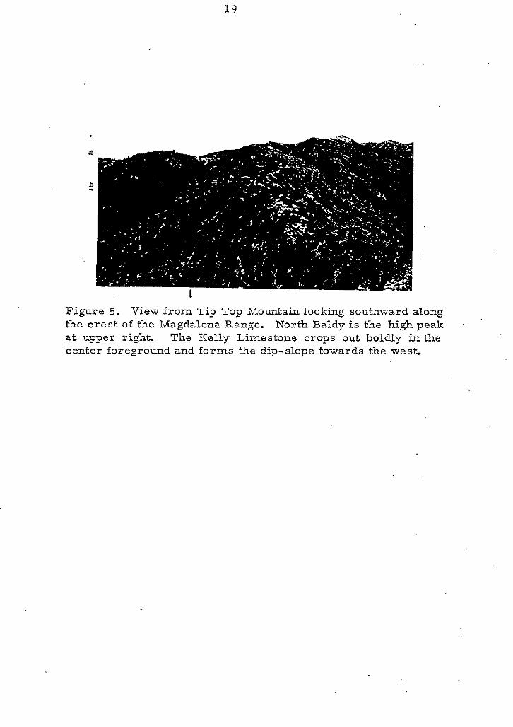
crest of the range (fig. 5). Of the five sections m asured, Mississippian
rocks were exposed at three: Tip Top Mountain, North Baldy, and
North Fork Canyon.
TIP TOP'MOUNTAIN. At Tip Top Mountain, the basal 3 feet of
the Caloso Formation. is a greenish-black limestone with poorly sorted,
17
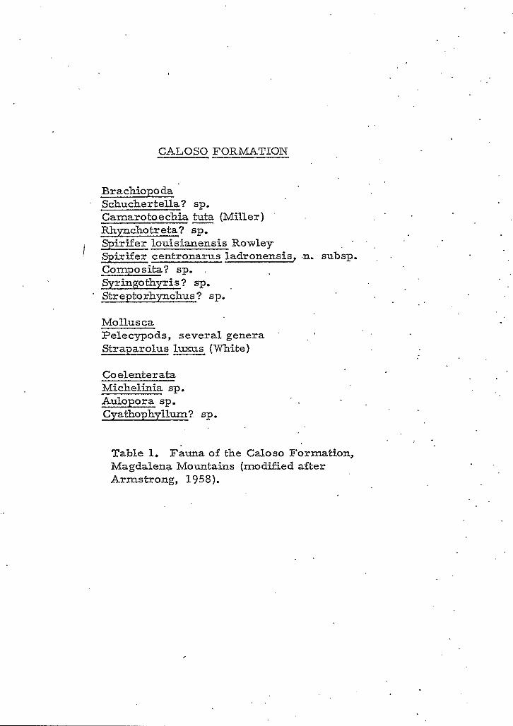
c CALOSO FORMATION
e.,
Brachiopoda Schuchertella? sp. Camarotoechia tuta (Miller) Rhynchotreta? sp. Spirifer louisianensis Rowley
-
Spirifer centronarus ladronensis,
Coelenterata Michelinia sp. Aulopora sp. Cyathophyllum? sp.
Table 1. Fauna of the Caloso Formation, Magdalena Mountains (modified after Armstrong, 1958).
. .
.n. subsp. Composita? sp.
Streptorhynchus? sp. S S ? sp.
Mollusca Pelecypods, several genera '
Straparolus (White)
1s
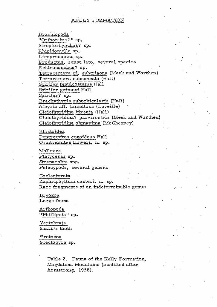
KELLY FORMATION
Brachiopoda "Orthotetes? sp. Streptorhynchus? sp. Rhipidomella sp. Linoproductus sp. Productus, sensu lato, several species Echinoconchus? sp. '
Tetracamera cf. subtrioon? (Meek and Worthen) Tetracamera subcuneata (Hall) Spirifer tenuicostatus Hall Spirifer grimesi. Hall Spirifer? sp. BrachythyIis suborbicularis (Hall) Athyris - aff. lamellosa (Leveille) Cleiothyridina hirsuta (Hall) '
Cleiothyridina? parvirostris (Meek and Worthen) Cleiothyridina obmaxima'(McChesney)
Blastoidea Pentremites coraideus Hall Orbitremites floweri, n. sp.
Mollusca Platyceras sp. Straparolus spp. Pelecypods, several genera
Coelenterata x . . Zaphriphyllum casteri, n. sp. Rare fragments of an indeterminable genus
Bryozoa Large fauna
Arthopoda llPhillipsial' sp.
Vertebrata Shark's tooth
Protozoa Plectogyra sp.
Table 2. Fauna of the Kelly Formation, Magdalena Mountains (modified after Armstrong, 1958).
..
' .
. .
. .
. .
. .
19
Figure 5. View from Tip Top Mountain looking southward along the crest of the Magdalena Range. North Baldy is the high peak . a t uoper right. The Kelly Limestone crops out boldly in the center foreground and forms the dip-slope towards the west.
angular to round, coarse-grained sand- to pebble-size fragments of
Precambrian quartz, microcline' quartz, granite, and greenschist.
It is in this lower arkosic limestone bed that Armstrong (1955) has
identified the following brachiopodsi Spirifer Louisapesis Rowley,
Camarotoechia - tuta (Miller), Schuchertella ? sp., Conposita ? sp.,
and a possible Spirifer. centronatus ladronesis, n. subsp. Above
this basal bed is about 12 feet of sandy limestone with granules and
pebbles of angular to well-rounded poorly-sorted Precambrian quartz
and quartzite. The absence of feldspar and large Precambrian fragments .
probably indicates deeper water and a farther removed source are%
Overlying this bed is about 15 feet of medium-gray limestone containing
medium- to very coarse-grained sand, limestone clasts and quartzite . .
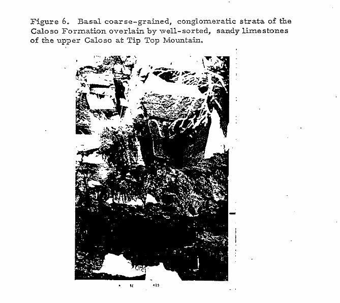
fragments (fig. 6). Total thickness of the Caloso Formation at Tip Top
Mountain is about 30 feet.
. .
. .
Upper beds of the Mississippian section include 95 feet of light-
gray,. medium-bedded,' crinoidal limestone of the Kelly Formation (fig. 7).
White, nodular chert increases in size until, in the thinner bedded upper
strata, lenticular..masses attain thicknesses of 6 inches and lengths of
4 feet. Fenestellid bryozoans are quite numerous near the top of the
section. Echinoderms, brachiopods and horn corals are also present.
NORTH BALDY MOUNTAIN. On Nor& Baldy Mountain, about
a mile and a half south-southeast of the Tip Top section, the basal 7 feet
of Mississippian is intensly silicified. Within the silicified matrix a r e
grains of moderately sorted, subangular, medium-grained quartzose
2 1
Figure 6. Basal coarse-grained, conglomeratic strata of the Caloso Formation overlain by well-sorted, sandy limestones of the up2er Caloso a t Tip Top Mountain.
2 2
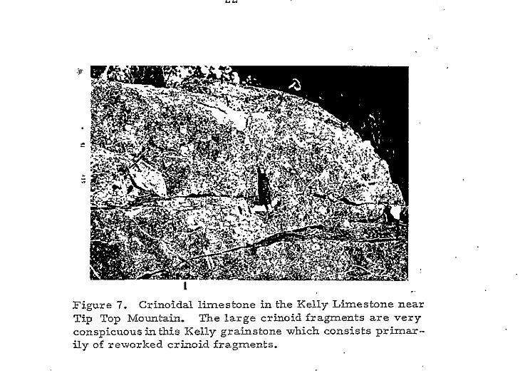
Figure 7. Crinoidal limestone in the Kelly Limestone near Tip Top Mountain. The large crinoid fragments are very conspicuous inthis Kelly grainstone which consists primar- ily of reworked crizoid fragments.
2 3
sand. Here the Caloso is very light-gray in color and weathers a
moderate yellowish-bGown to black.
Above the basal, silicified, terrigenous Caloso Formation i s
81 feet of poorly-cemented, medium- to thick-bedded, crinoidal Kelly
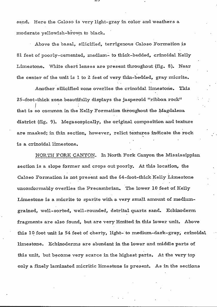
Limestone. m i t e chert lenses are present throughout (fig. 8). Near
the center of the unit is 1 to 2 feet of very thin-bedded, gray micrite.
Another silicified zone overlies the crinoidal limestone. This . .
25-foot-thick zone.beautifully displays the jasperoid "ribbon rock"
that is so common in the Kelly Formation throughout the Magdalena
district (fig. 9). Megascopically, the original composition and texture
are masked: in thin section, however, reIict textures indicate the rock
is a crinoidal limestone.
i
.
NORTH FORK CANYON. In North Fork Canyon the Mississippian
section is a slope former and crops out poorly. At this location, the
Caloso Formation is not pres'ent and the 64-foot-thick Kelly Limestone
unconformably overlies the Precambrian, The lower 1 0 feet of Kelly
Limestone is a micrite to sparite with a very small amount of medium-
grained, well-sorted, well-rounded, detrital quartz sand. Echinoderm
fragments are also found, but. are very limited in this lower unit. Above
t h i s l? foot unit is 54 feet of cherty, light-' to med1u.m-dark-gray; crinoidal
limestone. Echinoderms are abundant in the lower and middle parts of
this unit, but became very scarce in the highest parts. At the very top
only a finely laminated micritic limestone is present. As in the sections
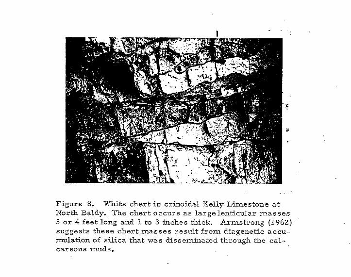
Figure 8. White chert in crinoidal Kelly Limestone at North Baldy. The chert occurs as largelenticular masses 3 o r 4 feet long and 1 to 3 inches thick. Armstrong (1962) suggests these chert masses result from diagenetl ~c accu- mulation of silica that was disseminated through the cal- careorrs muds.
2 5
Figure 9. Sharp contact between unaltered limestone and in- tensely silicjfied limestone within the Kelly Formation. From Tip Top Mountain southward, the Kelly Formation has been extensively siliciEied and often these "ribbon-like" structures a re produced with remarkably sharp contacts with relatively unaltered limestone. Silicification is most persistant in the . upper beds, but may also be present in the lower beds. Drusy quartz, sometimes accompanied by barite, fluorite, and. ga- lena, line the voids between bands of dense jasperoid.
. .
26
I ) at Tip Top Mountain and North Baldy, white nodular and lenticular
chert is abundant in t2i.e middle and upper parts of the se'ction.
STRATIGRAPHIC SUMMARY. The Mississippian System in
c the Magdalena Mountains ranges in thickness from 64 feet in the North.
Fork Canyon area to about 125 feet in the northern part of the range.
The system can generally be divided into a 7- to 30-foot lower clastic
. .
unit and a n upper 54- to 95-foot crinoidal limestone. . .
The basal terrigenous unit consists of about 5 feet of .poorly
sorted, angular to round, coarse-grained sand to pebble-size fragments
of Precambrian detritus in a carbonate matrix. Overlying the terrigenous
base is a s much as 25 feet of massive, medium-gray limestone wi th
abundant rounded to angular, medium- to coarse-grained, quartz sand
and sporadic Precambrian lithic fragments. Sparsely scattered through-
out the unit a r e brachiopods, corals, bryozoans, and echinoderms.
e
The present study is in agreement with other studies of the
Mississippian by Armstrong (1955 and 1958) and the contirked use of
the Caloso and Kelly nomenclature is suggested. The Calo'so is limited
to the lower 0 to 30 feet of pebbly, sandy arkosic limestones which
contain pre-Keokuk fossils. The Kelly Formation is identified as the
0 to 95 feet of crinoidal limestone of Keokuk age that rests disconform-
ably on the Caloso Formation and unconformably underlies the Sandia
Formation of Pennsylvanian age. I suggest, however, that due to the
thinness and limited exposure of the Caloso Formation, that the Caloso
c.
27
and Kelly formations should be mapped as Caloso-Kelly Formation
undifferentiated unless mapping on a very large scale.
Petrography
The objectives of petrographic study were the description of
the petrologic character of the units and an assessment, in terms of
mineralogy and textur.e, of probable environments in which the units
were deposited. Thin section study was supplemented by x-ray dif-
fraction analysis. !
.CALOSO FORMATION.' The Caloso Formation is dominated, .
by carbonates that contain a high percentage of detrital debris. Quartz
is the most abundant terrigenous constituent, with microcline, chert,
and heavy minerals comprising less than 50 percent of the total
detritus. In the Caloso, the detrital content ranges from 2 to 80 per-
cent and averages about 35 percent. Although the fossil content is very
limited, occasional echinoderm fragments are present. The orthochem
content: ranges from 40 to 98 percent and averages about 70 percent, It.
occurs as microspar that is considered to be recrystallized micrite.
Detrital grains usually fall in the medium-grained sand range, but
commonly vary as much as 2.1 Wentworth grades toward the coarser
sizes or 2.8 Wentworth grades toward the finer sizes. The grains,
are poorly to moderately sorted, subrowded in shape, and have a
sphericity coefficient of about .6. Diagenetic'textures occurring
witkin the limestones are predominantly neomorphic. Included a r e
I 28
* porphyroid and coalessive aggrading neomorphism and degrading neo- . .
morphism. NeomorpXc grain shapes are fibrous to equant and grain
sizes range from 1 to 5. Feldspars, quartz grains, and chert fragments
display varying degrees of replacement by calcite. Most thin sections
c exhibit small fractures that are filled with sparry caLcite or, l ess
commonly, silica.
Almost all of the Caloso limestones are quartz micritesf however,
they range from quartz micrite through quartz, feldspar, eckinoderm.
pelmicrite depending on'the varying quantity of these additional con--
stituents. ' Using Dunhams classification (1962) most of the rocks are
wackestones, o r packstones. Figures 10, 11 and 12 are representative
of lithologies characteristic of the Caloso Formation. e . KELLY LIMESTONE. The Kelly Limestone is composed
primarily of crinoidal limestone. The terrigenous content ranges from 0
to 25 percent and averages about 3 . 7 percent. This small percentage is
usually comprised of reworked terrigenous spar or rounded grains of
fine-grained, terrigenous, quartz sand. The organic allochem content
averages about 36 percent, but may range from 0 to 95 percent. The
most abundant fossils are echinoderms. Le~sser numbers, of brachiopods,
bryozoans, corals, and ostracods are present, The taxonomic groups
are restricted, for the most part to the echinoderms near %e base of
the formation but become increasingly diversified upward in the section.
The fossil debris is generally broken and well-,sorted. Calcite is the
predominant orthochemical mineral. The orthochemical content averages
c
-r)
\
29
30
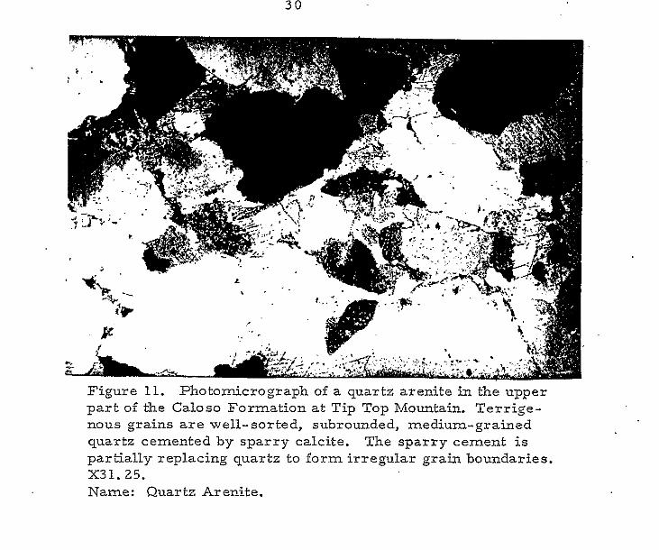
Figure 11. Photomicrograph of a quartz arenite in the upper part of the Caloso Formation at Tip Top Mountain. Terrige- nous grains a r e well-sorted, subrounded, medium-grained quartz cemented by sparry calcite. The sparry cement is partially replacing quartz to form irregular grain boundaries. X31.25. Name: Quartz AreEite.
31
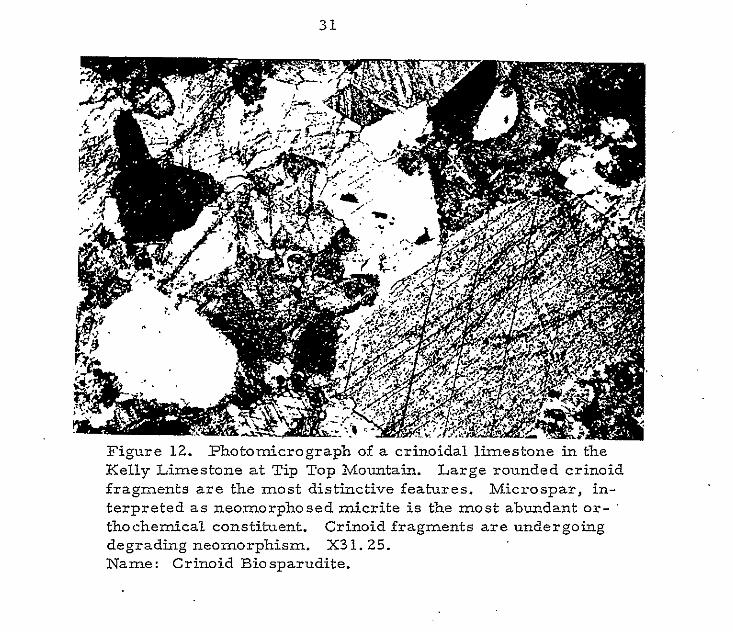
Figure 12. Photomicrograph of a crinoidal limestone in the Kelly Limestone at Tip Top Mountain. Large rounded crinoid fragments are the most distinctive features. Microspar, in- terpreted as neomorphosed micrite is the most abundant or- ' thochemical constituent. Crinoid fragments are undergobg degrading neomorphism. X31.25. Name: Crinoid Biosparudite.
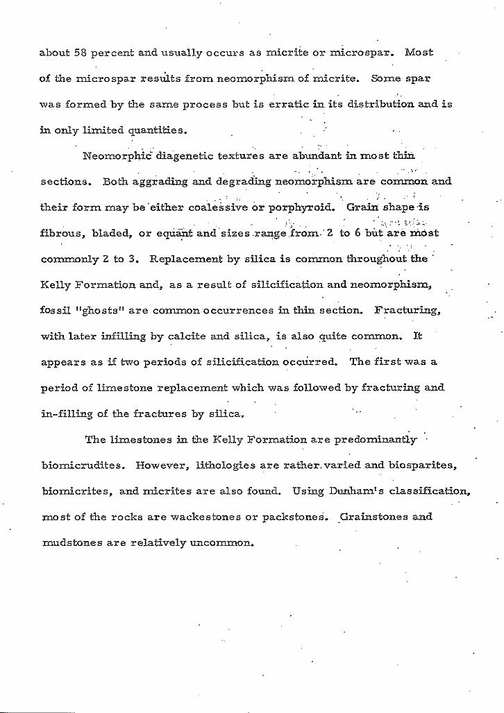
about 58 percent and usually occurs as micrite or microspar. Most
of the microspar resuits from neomorphism of micrite. Some spar
was formed by the same process but is erratic in its distribution and is ..
in only limited quantities. . .
Neomorphic'diagenetic textures a r e abundant in most thin
sections. Both aggrading and degrading neomoxphism are common and
their form may be'either coalessive or'porphyroid. Graia shape,is
fibrous, bladed, or equst and'sizes.range,from.'Z to 6 but 'are &ost ,.. . . -"I ;.,,i,:.
commonly 2 to 3. Replacement by silica is co-on throughout the
Kelly Formation and, a s a result of silicification and neomorphism,
fossil "ghosts" a r e common occurrences in thin section. Fracturing,
with later infilling by calcite and silica, is also quite common. It
appears as if two periods of silicification occurred. The first w a s a
period of limestone replacement which w a s followed by fracturing and
in-filling of the fractures by silica.
.. . . ,
~, . . . . ~
. , ., I
. . . :. s. . . . ,
, . . . I . . . > . .
. . .. . . . . .
..
The limestones in the Kelly Formation a r e predominantly '.
biomicrudites. However, lithologies are ratbermvaried and biosparites,
biomicrites, and micrites are also found. Using Dunham's classification,
most of the rocks a r e wackestones or packstones. Grainstones and
mudstones are relatively uncommon.
n
I .
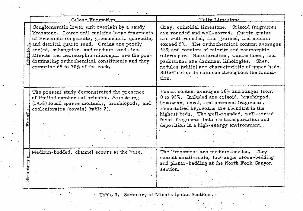
. Caloso Formation Conglomeratic lower, unit overlain by a sandy limestone. Lower unit contains large fragments of Precambrain granite, greenschist,. quartzite, and detrital quartz sand. Grains are poorly sorted, subangular, and medium sand size. Micrite and neomorphic microspar are the pre- dominating orthochemical constituents and they comprise 65 to 70% of the rock.
The pre.sent study demonstrated the presence of limited numbers of crinoids. Armstrong (1958) founa sparse mollusks, brachiopods,' and coelenterates (corals) (table 2).
. . . .
Medium-bedded, channel scours a t the base,
KAl~l&l2w&QnLimestonP
Gray, crinoidal limestone. Crinoid fragmcnts are rounded and well-sorted. Quartz grains are well-rounded, fine-grained, and seldom exceed 5%. ' The orthochemical content averages 58% and consists of micrite and neomorphic microspar. Biomicrudites, wackestones, and packstones are dominant lithologies. Chert nodules (white) are characteristic of upper beds. Silicification i s common throughout the forma- tion.
Fossil content averages 36% and ranges from 0 to 95%. Included are crinoid, brachiopod, bryozoan, coral, and ostracod fragments. Fenestelled bryozoans are abundant in the highest be'ds., The well-rounded, well-sorted fossil fragments indicate transportation and deposition in- a high-energy environment. .
The limestones 'are medium-bedded. They exhibit small-scale, low-angle cross-bedding and planar-bedding at the'NoNorth Fork Canyon section.
. . . . . . . , . . .
1 1
I. Table 3. Summary of Mississippian Sections. ' . . . . . . , .
I
PENNSYLVANJAN PERIOD
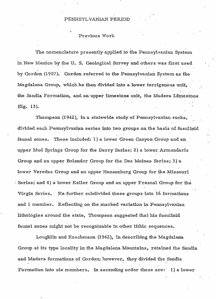
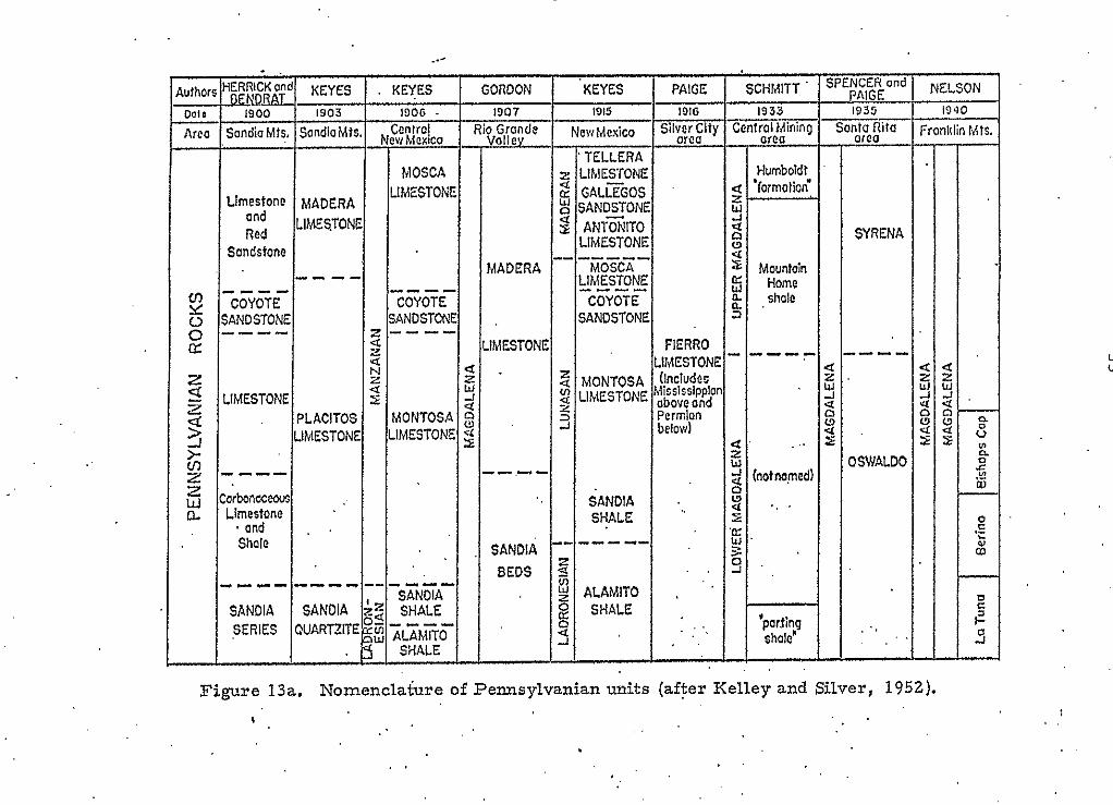
Previous Work
The nomenclature presently applied to the Pennsylvanian System
in New Mexico by the U. S. Geological Survey and others was first used
by Gordon (1907). Gordon referred to the Pennsylvanian System as the
Magdalena Group, which he then divided into a lower terrigenous unit,
the Sandia Formation, and an upper limestone unit, the Madera L h e s i o n e
.(fig. 13).
. .
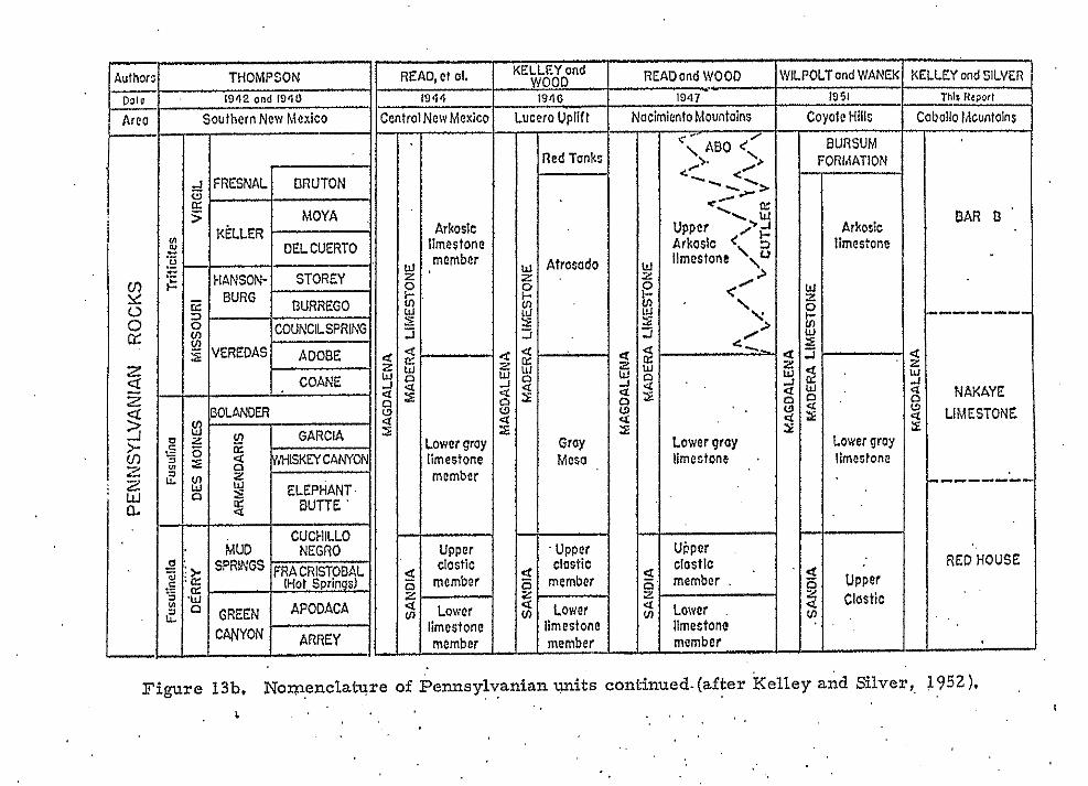
Thompson (1942), in a statewide study of Pennsylvanian rocks,
divided each Pennsylvanian series into two groups on the basis of fusulinid
faunal zones. These included: 1) a lower Green Canyon Group and an
e upper Mud Springs Group for the Derry Series: 2) a lower Armendaris
Group and an upper Bolander Group for the Des Moines Series; 3 ) a
lower Veredas Group and an upper Hansonburg Group for the Missouri
'. Series; and 4 ) a lower Keller Group and an upper Fresnal Group for the
Virgin Series. He further subdivided these groups into 16 formations
and 1 member. Reflecting on the marked variation in Pennsylvanian
lithologies around the state, Thompson suggested that his fusulinid
faunal zones might not be recognizable in other lithic sequences.
Loughlin and Koschmann (1942), in describing the Magdalena
Group at its type locality in the Magdalena Mountains, retained the Sandia
and Madera formations of Gordon; however, they divided the Sandia
Formation into six members. In ascending order these are: ' 1) a lower *'
35
..
A
THOMPSON READ,et 01.
1842 on4 1810
SoulhernNew Mexico
KELLEY ond
I I I CUCHlLLO
led Tonkc
4trosado
Gray Mcso
1-
uppcr clastic
member
Lower imestone member -.-
Thlr l l t w l
NacimicnloMountoins Covotc Hills Cabolio IAcunlains
mcmbcr .
Lowcr limestone momber
Figure 13b. Nomenclature of Pennsylvanian . . wits continued.(after Kelley and Silver, 1952).
quartzite member; 2 ) a lower limestone member; 3) a midd1.e quartzite
member; 4) a shale member; 5) an upper limestone member; and 6 ) an
upper quartzite member. Within the Madera Limestone, they described
a lower bluish-black, thin-bedded limestone, and an upper more massive,
bluish-gray limestone, but the two were not separated for mapping
purposes . (
. . Kottlowski (1960) summarized Pennsylvanian sections throughout
37
-
Pennsylvanian in Socorro County ranges from less than 250 feet, as
the Pedernal Uplift i s approached on the'east, to more than 2,500 feet
in the Lucero and San Mateo basins in the north-central and south- ( ..
central parts of the county. In most of Socorro County, the PennsyIvanian
is 1, 000 to 2,500 feet thiclc and consists of shallow marine, continental '
e shelf deposits of limestone and terrigenous rocks. Kottlowski points
out that on this shallow shelf region were areas of Iow relief that were
southwestern New Mexico and southeastern Arizona. In Kottlowski's
summary, he discussed iithofacies, "thicknesses, and depositional 1 1
environments within the Pennsylvanian System. Kottlowski noted that .
northwestern Socorro County was dominated by a shale-lime facies.
0 , The southwestern part of Socorro County was found to be predominantly
a lime-shale facies and the southeastern part of Socorro County varied
from a lime-shale to a shale-lime facies. , In the northeastern part of
Socorro County, the detrital debris w a s slightly coarser grained and a
sand-lime to lime-sand lithofacies was more dominant.
Kottlowski's isopach maps indicate that the thickness o f the
periodically emergent. These, along with the Lucero and San Mateo
basins, were the primary features affecting the shallow mariize shelf
environment in which Pennsylvanian sediments were deposited.
The present literature review is restricted to Socorro County
c and the Magdalena area. For an excellent review of Pennsylvanian
literatxire..s%ith a more regional p.erspective, the interested reader may
refer to Kottlowski (1960, p. 15-24).
Regional Stratigraphy.
The Pennsylvanian System in New Mexico is a complex sequence. '
of marine and continental strata derived from several Pennsylvanian
highlands with a rather irregular geographic distribution. Read and . .
a Wood (1947) used lithologic features to divide the Pennsylvanian in central
New Mexico into a lower Sandia Formation and, anupper Madera Limestone.
The Sandia Formation is a complex basal suite of transgressive shales, .
siltstones, sandstones, and limestones. The overlying Madera Limestone
constitutes the limestones and arkosic limestones of a period of maximum
transgression prior to regression. A brief summary of the lithologic '
character of the Pennsylvanian throughout New Mexico follows. A more
detailed discussion is given in an excellent review of the Pennsylvanian
by Kottlowski (1960). (.
NORTHERN NEW 'MEXICO. To become acquainted with the
Pennsylvanian of the northern part of the state, the areas of the Zuni,
a Jemez, Nacimiento, San P.edro, and Sangre de Cristo mounta&s were
. .
37
reviewed. In northern New Mexico, the Sandia Formation is considered
to be Early Pennsylvanian (Morrowan) in age (Read and Wood, 1947).
The thickness of the. formation ranges from 0 feet along the Zuni Arch .
to more than 2,000 feet in the Sangre de Cristo Mountains. Lithologically,'
the Sandia Formation is mostly coarse-grained conglomeratic sandstones,
siltstones, carbonaceous shales, and thin limestones, with lenses of
impure coal not uncommon to the lower beds. . ' . . . .
The Madera is composed of two lithologically distinct units
I i (Baltz and Bachman, 1956). A lower gray Iimestone consists of thjn-
to thiclc-bedded, crystalline and granular, fossiliferous limestone inter-
bedded with black shale, siltstone, and thin sandstone.. Limestone
becomes more dominant to the south. Thickness ranges from 0 feet
along the Zuni Arch to more than 3,000 feet in the Sangre de Cristo
Mountains. The upper part of the Madera is an arkosic limestone with
beds of gray and olive siltstone and shale, thin purple and red shale,
coarse-grained, conglomeratic, arkosic sandstone, and gray, fossiliferous
limestone. This arkosic limestone represents a transition from
dominantly marine conditions, indicated by the lower gray limestone,
to the nonmarine environment of the overlying Sangre de Cristo Formation.
Age of the Madera Limestone is Atokan to Missourian.
CENTRAL NEW MEXICO. Areas examined and reviewed in this
par t of the state include the Estancia Basin, Sandia Mountains, Manzano
Mountains, Lucero Mesa, Los Pinos Mountains, Joyita Hills, -Ladron
Mountains, Socorro-Lemitar Mountains, Sierra Oscura, and the San
ot Mateo Mountains, In central New Mexico the Sandia.Formation varies
in thickness from 100,to more than 600 feet. It contains a'diverse .
assemblage of rock types ranging from limestone, chert; and quartz-
pebble conglomerates to pebbly, arkosic sandstones, siltstones, and . .
( ' , shales through thin nodular, and ledgy limestones. Sand-shalellirne
ratios vary from 1.3 to 1.8 with sand-shale ratios of. 54 to -98
(Kottlowski, 1960). Coarser grained lithologies are slightly more . .
abundant in the northern part of the area. Also included in some sections
a r e dark shales, sands, and coals of continentalorigin. Faunal
assemblages contain brachiopods, corals, echinoderms, gastropods, ' .
foraminifera, and plant remains. Although the lithologic boundaries
are time transgressive, Atokan age is suggested for most of the Sandia.
a The Madera Limestone, over most of central New Mexico, is.
from 80 to more than 2, 000 feet thick and is divisible in to several local
members. On the Lucero uplift, Kelley and Wood (1946) divided the
Madera into the lower Gray Mesa, medial Atrasado, and upper Red
Tanks members. In the mountain ranges east of the Rio Grade , a
lower gray limestone member and an upper arkosic limestone member
have been m-apped (Wilpolt and others, 1946). Thompson (1942) used
a six-fold division of the Madera in this part of the state that was based
on faunal assemblages of Atokan, Desmoinesian, Missourian, and
Virgilian ages.
(.
Common to most Madera Limestone sections is a lower, ledgy, e massive to thin-bedded, medium- to dark-gray limestone with subordinate
. .. ..
41
1+ amounts of gray and green shale, siltstone, sandstone, and conglomerate.
Above this is frequently observed a medium- to light-gray limestone .
with a low chert content and a much higher proportion of gray, black, .
and red shales; green, brown and gray sandstones; and arkosic sand-
(.. stones. A n upper unit of reddish and buff sandstone, siltstone, shale,
s d limestone pebble conglomerates, interbedded with thin-bedded, gray
limestones, gray shales, and arkosic sandstones is locally present.
Some geologists correlate these strata with the Bursum Formation
(early Wolfcampian), but this third unit is probably equivalent to the
Bruton Formation (late Virgilian) to the south (Kottlowski, 1960)-
i
SOUTHWESTERN NEW MEXICO. The Pennsylvanian of,
southwestern New Mexico is Morrowan to Virgilian in age and is generally
1 ,000 to 2,000 feet in thickness. In some local areas, the thickness of
Pennsylvanian strata may approach 3, 000 feet (Kottlowski, 1960).
Throughout most of the southern part of the area, the section is dominated
! by limestone, while to the north, sand and shale become importanti .
In southwestern New Mexico, different names have been assigned
to units within Pennsylvanian sections in the various mountain ranges. . I n
southwesternmost New Mexico, Quaide (1953) and'Gillerman (1950) put
the Pennsylvanian sediments into the Naco Group containing a lower
Horquilla Formation and an upper. Earp Formation, Both of these names
are related to nomenclature presented by Gilluly and others (1954) for
Pennsylvanian strata in southeastern Arizona. In the Sacramento Mountains,
Pray (1961) divided the Pennsylvanian into a lower Gobbler Formation, a
(
*
42
a medial Be'eman Formation, and an upper Holder Formation. Kottlowski
and others (1956) refeired to the Virgil Series in the San Andres Mountains
as the Panther Seep Formation. Slightly to the west, in the Sierra
Caballos, Kelley and Silver (1952) defined the RedHouse, Nakaye, and
( Bar B formations.
The Pennsylvanian in southwestern New Mexico is generally a
lime-shale lithofacies. A limestone lithofacies predominates in the
extreme southwest and a sand-lime lithofacies is found in the vicinity
of areas that were topographically high durjrig Pennsylvanian time. The i
basal Morrowan and Atokan deposits are usually sandy and shaly except
in the south. Desmoinesian strata are dominantly marine limestones
and the upper Pennsylvanian (Missourian and Virgilian) beds range from
massive marine limestones with interbedded redbeds to clastic continental
deposits.
Local Stratigraphy
The type section for the Magdalena Group is in the Magdalena
Mountains. It is here, in the northern part of the range, that Loughlin
and Koschmann (1942) named the lower part of the Pennsylvanian section
. .
(. . the Sandia Formation and the upper part of the section the Madera Limestone.
Loughlin and Koschmann further subdivided the Sandia Formation into
six members with a total thickness of about 600 feet. The six members
are: 1) lower quartzite member; 2) lower limestone member; 3) middle 10

43
quartzite member; 4) shale member: 5) upper limestone member;
6) upper quartzite.member.
Lower quartzite member: The lower quartzite member is
about 90 feet thick. It consists of brown, gray, and greenish-gray ' .
quartzite with subordinate interbedded shale and limestone. The quart-
zite beds are fine- to coarse-grained, sometimes conglomeratic,
sands cemented by calcareous and siliceous material.
Lower limestone member:. The thickness of the lower limestone.
is approximately 65 feet. This member consists of fossiliferous, medium-
grained, bluish-gray, argillaceous limestone wi th interbedded shales and
quartzites. Thin, fossiliferous, shaly beds constitute a large portion of
the lower part of the unit.
Middle quartzite member: The middle quartzite is defined as
the 18 feet ( m a x i m u m ) of quartzite that separates the lower limestone
from the .overlying shale member. It consists of lenticular, medium-
grained, brown to gray quartzite.
Shale member: The 300-foot-thick shale member constitutes
more than one half of the Sandia Formation. It is a black, locally
carbonaceous, fossiliferous shale with interbedded'quartzite and lime-
stone.
Upper limestone member: The thickness of the upper limestone
is as much as 300 feet. This member consists of lenticular, bluish-
gray, medium-gray limestone characterized by spherical, concentric
algal growths that a re as much as 2 inches in diameter.
44
Upper quartzite member: The lenticular upper quartzite member
has a maximum thickness of about 65 feet. The member is composed
of gray quartzite beds with interbedded.limestone and shale.
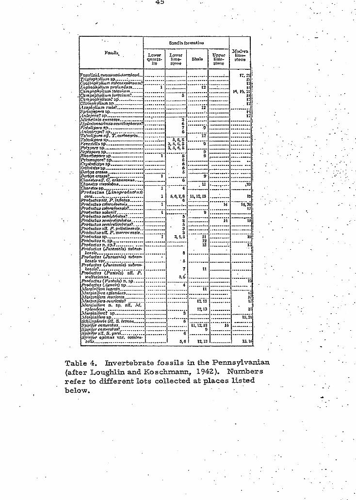
Fossils collected from the Sandia Formation by Loughlin and
Koschmann and identified by G. H. G i r t y are listed in Table 4. Stein . .
and Ringland (1913) report the following plant fossils were identified
by David White: Neuropteris aldrich (Lesquereux); ferns. represented
indeterminable species of rachises; Lepidophyllum lucidum (Lesquereux);
Sigillara spl; and Cordaites sp. Faunal evidence suggests the Sandia is
of Morrowan and Atokan (Pottsville) age.
i
Loughlin and Koschmann (1942) identified an upper member and
a lower member within the 600-foot-thick Madera Limestone. The
lower 300 feet consisted of bluish-black, thin-bedded limestone with
interbedded, bluish-gray, fossiliferous shale, and gray, medium-
grained quartzite. The general character of these beds is similar to '
' that of the Sandia Formation. However, Loughlin and Koschmann state
that, since limestone beds a r e dominant and a r e continuous upward with
greater thickness of limestone, these beds should be assigned to the
Madera Limestone: furthermore, they believe the upper quartzite of the
Sandia is a convenient and practical horizon for placing a boundary
between the gradational Sandia Formation and Madera Limestone. The
present study, though not in agreement with the six-member concept of
Loughlin and Koschmann, is in agreement with their general definition
of the formational boundary. The writer suggests the boundary be
' 45 . .
F ~ , I ? . ~ i r l , e r o ~ l u ~ ~ l ~ ~ i ~ ~ l . . ............................................... Trip l~'Ll! lnmsP ...... : 17.22: L. ..................................... r.ophnphdll.mnr~r,,nlinrn
........................................ C ; i a l . ~ ~ h l l l u r n ~ D c u ~ ~ p ; l ~ u t ~ n r ? 15 ' ti j ..... 1 ___i ...... 12 .."i .....
j IS. 13.~1 ............................................... cnmmphd!w*?ornu;am ! IS
. Campo=~Ulrmlur?triam: ................ .................... Camp, hyl:nm?sp i .____: 5 IS I ..... ........................................ 1:
.lz~ph;illmn mldt ................................. .................... S w w w r n r P ......................................................... rlaloporc?rp 1."".
12 i 12 i
.lIirhrlinincrr)mloc ............... I ...... ............................... t i i
Fidnlipnrnrp.-.-.. Z l ; i d r r l o n r r i n n a n ~ o n l . ~ ~ ~ h ~ , ~ ~ ~ ? 6 ............................... 3
..................... 7 .................... 7h)*llpom(ra.T. rulhnnnnn 1E ! :l"i3<4r,F.,?sp
.s t
6 ___: ~ ~ ~ ~ l i p n r n r l . ....................... ;". 5.6,s .............................. ). v m , t d l a s p ............................ 3.S.li.S ................... Pd,rMmsP .................... 3.S.8.8 ....... ............... .'L;yopntasp.. _._-
0 _!
i Rhnfiwmsp. . - . ............ I s ................. D "!
Ri,mnlmm?rp. ......................... ......................... cP;i.*ndu!msn. 6 ".! 6 ._:
D __._ ........................ ..............................
Dchyacrmea 5 ..LA ___..I OGhn(d6vs %.-... 6 j
D&m c a w ? C;lO"&%DTC. orX.7n.l"" ar.....
1 . ._ . .-. -. chO"d*>r.=dh"." II :
6 L 0 I
Chorvimnsp .................... 1 . 4 .......... :.... .......... Produc:ur (Linoprodnb#eb
il9 I
~rYlr,rlrrraI?.P.in ~ ~ t l u r . . . .............. 6 1.. ......................... .! Prnlnaur rdmcdmrir ........ 1 .................... 14 l & U % r,dtrctul>tolnn;t Pl.d.duscdoMdm~Jir..
1 l i : ............. ........... 9 .....................
P,oladnl~*smi~lrilhd ................... 5 ........................ __"__! P , ~ l ~ l ~ ~ ~ c m i r d i ~ l b d n n P , ~ 1 u ( t y . , ~ ~ ~ i r ~ ~ i o ~ ( l , , ~ ? ............... 5 ....... ,.. .................... R o B ~ d ~ 3 a R . P.gnll~finm,i%. ........... 3 ............................ ": P~cxl~~cItoaI?. P.morro*ranair.. .......... 3 .............................. I P,dVrlus SI," ................ I 83.S .......... pIN:adu3".Lp
I1 12
I9 : Rodudu,n.sp.P ............. ._ .................. 13 ........ 1. 1.7; P,lu$nr (Jureaniv) ndnw . I ' . ;
C l i d , l i , , m r " l i ........................................................ ...................................................
.......... ........................... .......................... ........................ ....................
............................... ........ .......................... .........................
............................. .................. ........ .............................. .......... .................... .............................. .........
cor0 .... *.. ......... > ....... : 19 ........... 11.12,13 i R 7 . 8 1
............................................. ................ s .".. ~ .". 1.1 I
.................................... ....................
. . . .
. . . . .
c
Illlrirznltr .................. 3
.'lc"nir) SD ~ u r t n ~ n.rp ..... [::::::::::I .......... .... . . ....................
......... _I_.__ ...... I 1213 I .......... f ......................... .............................. ........................................................ 1 5.6 ' 1 Ilirginilrrc? sp . l lw ia i /werp 19.21 Srhi;aphnrin all. S.lRnn n...... Spiribrmnmrmfua ................................. l1.1El3 Spiriler mmrmtc*?
1,s ._.__ . , Spirilrr *:I. 5'. gnrri
0 ."" _"__ .__ . ...................... 6 .............................. Sp:ri!<? goimar mr. mridrw
tU1i.J.. .......................... 1215. ." "".. 15.1'
.......... ..................... 3
6
................................ S$,i!<, 0.g9'mn.. vir. WCI",,,. I tu1i.J.. ............... .I.___ ...... 1 5.6 I 1215 I_.__ ...... I
15.14
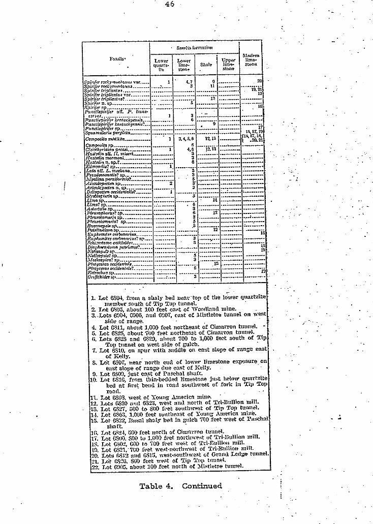
Lble 4. Invertebrate fossils in the Pennsylvanian fter Loughlin and Koschmann, 1942). Numbers :fer to different lots collected at places listed . :low. . .
...
.-
. . ..
.
- . *
47
* placed at the top of the quartz'ite below which shale is dominant and above
which limestone predominates. In subsequent pages, the logic of this
suggestion will be evident.
The upper member of the Madera Limestone w a s found by
(. . .
Loughlin and Koschmann.(1942) to be about 300 feet thick. It is con-
sistantly a fine- to coarse-grained,. homogeneous, bluish-gray lime- . .
stone throughout the Magdalena district. Black, nodular chert is abundant
within this unit. Interbedded with the limestone a r e shaly limestones,
conglomeratic limestones, thin gray shales, and gray to (. brown quartzites.
In the southern part of the district the highest beds are m ttled and
shaly and a r e stained brownish-red by iron oxides from the overlying Ab0
Sandstone of Permain age.
Loughlin and Koschmann state that the 'true thickness of the Madera . .
Limestone cannot be determined due to erosion and faulting;. they estimate
it to be about 600 feet, but note thicknesses may approach 1;OOO feet.
' Kottlowski (1960) suggests the Madera Limestone in the Magdalena, a rea
had an original thickness of at least 1,000 feet and perhaps 1,200 to
1,500 feet.
Fossils collected by Loughlin and Koschmann and idenaied by
G. H. Girty are listed in Table 4. G i r t y regards these as post-Atokai
(post-Pottsville) in age. Mr. J. W. Skinner indicated to Loughlin and
Koschmann that fusulinids he had identified from the upper Madera were
(.
suggestive of Upper Virgilian (Wabaunsee) time.
48
Overlying the Madera Limestone within the district is about
175 feet of red, shaly; laminated, fine-grained, sandstones and silt-
stones named the Ab0 Formation. The Ab0 is of P e r m i n a g e and
unconformably overlies the Madera Formation. The Ab0 is overlain
by Tertiary volcanic rocks south of Highway 60 but is in fault contact
wi th other Permian units north of the highway.. In the Granite
Mountain-Ohey Ranch area, a thick section of strata, previously called
Pennsylvanian by Loughlin and Koschrnann (1942), is believed by the
writer,' and other workers in the district, to be the Abo, Yeso (? ), . '
Glorieta, and San Andres Formations of Permian age. Sandstones and
siltstones in Hardscarbble Valley, previously mapped as Sandia shale
by Laughlin and Koschmann (1942), a r e now believed to be the Ab0
Formation of Permain age (R.. B. Blakestad, oral communication, 1973).
These Permian sections are overlain by Tertiary volcanic rocks.
i . .
TIP TOP MOUNTAIN. Although the top of the section has been
' removed by faulting, there is more than 1,200 feet of Pennsylvanian
section exposed a t Tip Top Mountain. The Sandia Formation and the
overlying Madera Limestone each account for about one half the total
thickness. The Sandia Formation crops out on the eastern side of Tip
Top Mountain and comprises most of this eastern slope.
The Sandia-Madera contact is on the eastern slope just beneath
the top of Tip Top Mountain, thus the cap and western dip slope a r e '
comprised of Madera Limestone. Near the base of the western dip
slope, Madera Limestones are interrupted by Oligocene faulting that
has uplifted Sandia quartzites and siltstones.
Sandia Formation. ' . On the eastern slope of Tip Top Mountain,
the Sandia Formation unconformably overlies Kelly Limestone of
Mississippian age and dips to the west at 40 to 45O and strikes N. 10" W. .
The Sandia Formation is about 587 feet thick and consists of shale,.
quartzite, and limestone. Shale crops out poorly due to covering by . '
talus and an immature soil. Quartzites and limestones, however, are .
usually well-exposed cliff-formers.
0
. .
Wackes aid shales constitute about 453 feet or 79 percent of the
total Sandia thickness. They range in color from olive gray to black
and a r e usually grayish black. The granular material of the wackes
is poor- to well-sorted, silt" to sand-size, quartz and ~ c a . In places,
they become slightly calcareous. Most beds a re homogeneous, but some
low-angle cross lamination is present. In some parts o f the section the
shales become quite fissile. Within the wacke and shale beds, thin
fossiliferous micritic limestone lenses, less than 1 foot thick, are
occasionally found. Within these limestone lenses, echinoderms and
brachiopods are the most abundant faunal representatives with mollusks,
corals, and bryozoans as minor and infrequent constituents. These small
limestone lenses exhibit thin lamination, Although most contacts with
other lithologies are covered, the few that were observed indicate that
both upper and lower contacts may be abrupt or gradational.
3 U
I Quartzites i n the Sandia Formation have a total thickness of
about 7 3 feet. This accounts for about 13 percent of the formations
I total thickness. The thickness of individual quar,tzite units ranges
< from 3 feet to .more than 20 feet. Colors among these quartzite units
vary from olive- to brownish-light-gray; weathered surfaces'have a
more reddish-brown appearance. The granular material usualLy
consists of rounded, moderately sorted, medium-. to coarse-grained
quartz sand. Chert and feldspar contents are consistantly very low
and very sporadic through the entire Sandia section. Locally, the
quartzites become quite calcareous. Quartzite units are typicdry
i
internally homogeneous; however, examples of small- to medium-scale, . -
Iow-angle planar cross-bedding were observed. Talus and soil cover
did not permit observation of upper and lower contacts with other lith- a ologies.
The cumulative thickness of limestone within the Sandia
' Formation on Tip Top Mountain is 44 feet, or is about 8 percent of
the total thickness. Individual limestone units range from 1 foot to
almost 3 0 feet in thickness. The fossiliferous, micritic limestones vary
from medium-light gray to blackish-gray in color.. The faunal assemblage '.
is mostly echinoderms and brachiopods accompanied by limited numbers
of bryozoans, mollusks, forams, and horn corals. The fossil content
of the more fossiliferous beds may approach 75 percent. A small per-
c
centage of fine, detrital, quartz sand is aLso characteristic of some
limestone beds. The limestone units a r e thin- to medium-bedded and
internally exhibit thin planar lamination. A s with other lithologies,
upper and lower conta'cts may be either abrupt or gradational.
Madera Limestone. The contact between the Madera . .
Limestone and the underlying Sandia Formation is gradational and
may be observed on the eastern slope of Tip Top Mountain about 100
feet below the sunnmit. The arbitrary boundary is placed at the top .
of a quartzite beneath which wacke and shale a r e the dominant-lithologies .
and above which limestone is dominant. i At Tip Top Mountain, the faulted rertinant of Madera Limestone
is about 793 feet thick. The uniform sequence of limestones form a
long dip slope that is faulted against beds of the' Sandia Formation near
the base of the slope. The thickness of Madera beds cut out by the ' .
faulting is not known but is believed to be at least several hundred feet
on the basis of Madera thicknesses encountered in drill holes elsewhere
in the district. Of the total thickness present, 79 percent (630 feet) is
limestone and 2 0 percent (157 feet) quartzite and shale.. .
. .
The limestones. range from light-gray to black in color, but . .
a r e usually dark gray or grayish-black. They are micrites with a
limited but diverse faunal assemblage. Fossils found in the Madera
Limestone include brachiopods; mollusks, echinoderms, corals,
foraminifera, and bryozoans; however, none a r e found in large numbers.
The fossil content rarely exceeds 15 percent. SmalI percentages of
silt-size quartz grains are also found in some limestone beds. About
300 feet above the basal contact, black nodular chert becomes very
section along the south side of the canyon. ' Pennsylvanian strata uncon-
formably overlie the Kelly Limestone of Mississippian age, dip to the ' .
west at 35 to 40 degrees, and strike N 10 W. The Sandia section is 0
c predominantly shale and quartz wacke that is expressed largely as covered
section. Interbedded quartzites and limestones within the Sandia
Formation form ledges. Upon entering the Madera section, the slope
angle increases suddenlv from 20 to about 30 and the limestones crop 0 0
-. e- - out boldly. The Pennsylvanian section ends abruptly along the ridge crest
abundant. These black chert nodules, along with the large horn corals,
a re probably the most diagnostic features of the Madera Limestone.
Bedding within the Madera section is variable.and ranges from thin-
bedded to very-thick-bedded. The only sedimentary structures observed
( in the Madera Limestone were thin cross-laminations and planar
laminations. Contacts between limestones and other lithologies are
usually abrupt. . .
Madera quartzites are somewhat similar to quartzites found in !
the Sandia Formation. At Tip Top Mountain, they a r e usually only a
foot or two thick and consist predominantly of rounded, poorly sorted,
coarse-grained quartz grains in a calcareous matrix; some beds contain
e pebbles of pegmatitic, milky quartz. Feldspar, mica, and cherk are
sparse to absent. The quartzites are typically homogeneous, but some
small- to medium-scale, low-angle, planar cross beds occur. . - . . - : . _ . . . ... . .
NORTH FORK CANYON. The North Fork Canyon section is
located 1.2 miles west of the Water Canyon-North Fork Canyon inter-
53
where it is ju-utaposed against down-dropped Tertiary volcanic rocks.
White rhyolite dikes have been injected along the faulted contact. ' ,
Sandia Formation. The Sandia Formation in North Fork Canyon
is about 554 feet thick. Thin-bedded wackes and shale, comprising
a s much as .75 percent (418 feet) of the section, are the most important.
rock types. , Interbedded sandstone and limestone account respectively.
for only 17 percent (94 feet) and 8 percent (43 feet) of section.. . .
The wackes and shales are usually olive-gray to olive-black in I \
color and sometimes weather a rather light-reddish.-brown. Terrigenous.
material consists of well-sorted quartz grains and mica; the matrix
material is noncalcareous. The wackes a r e thinly bedded and often
display internal planar laminations while the shales are usually crudely
fissile. Small limestone pods (fig. 14) are also present within the shaly
units and plant fossils were found along shale partings.
The more resistant quartzite beds crop out as small cliffs on
the soil and talus covered slope. They range in thickness from 1' foot
to more than 20 feet and are usually medium-gray to olive-gray in color.
The quartzites are moderately sorted, coarse-grained, quartz arenites
with calcareous cements. Many quartzites contain angular, white
quartz pebbles as much as a half inch in diameter. The quartzites a t
North Fork Canyon are usually very-thick-bedded. Contacts are usually
covered, but when observed they are abrupt and appear to be erosional.
Limestones in the North Fork Canyon section are dark-gray to
black micrites that containan abundant brachiopod and echinoderm fauna.
54
. " . .
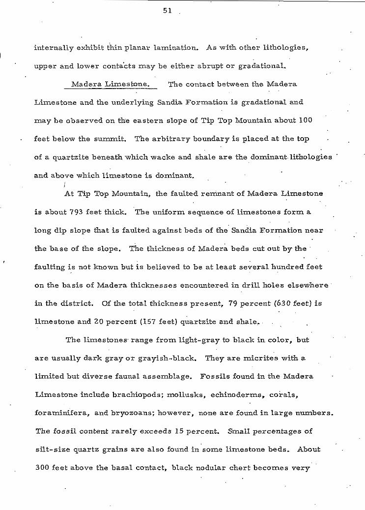
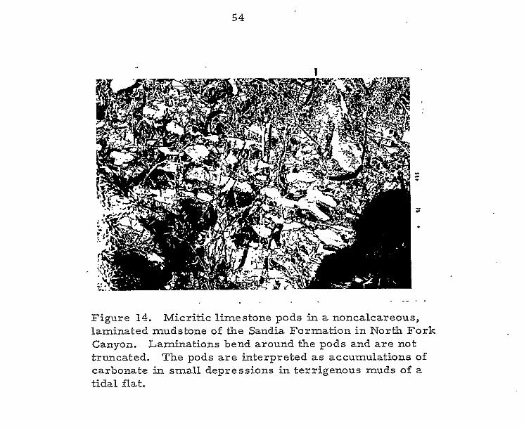
Figure 14. Micritic limestone pods in a noncalcareous, laminated mudstone of the Sandia Formation in North Fork Canyon. Laminations bend around the pods and are not truncated. The pods are interpreted as accumulations of carbonate in small depressions in terrigenous muds of a tidal flat.
5 5
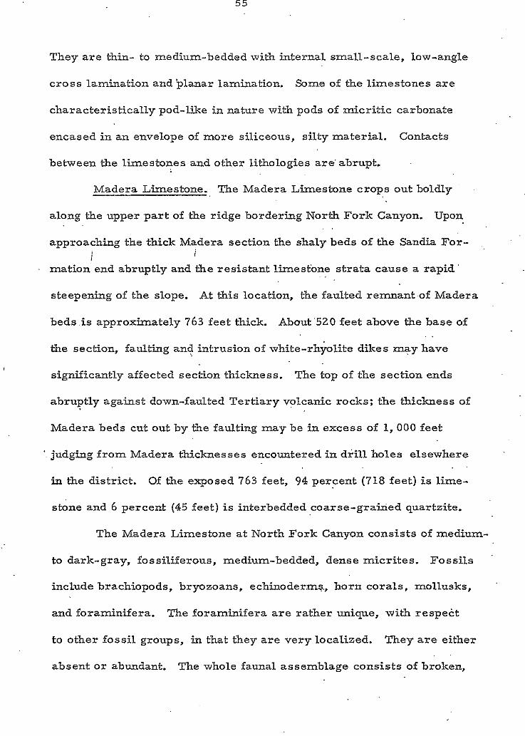
They are thin- to medium-bedded with internal small-scale, low-angle
cross lamination and planar lamination. Some of the limestones are
characteristically pod-like in nature with pods of micritic carbonate
encased in an envelope of more siliceous, silty material. Conhcts
between the limestones and other lithologies are' abrupt.
Madera Limestone. The Madera Limestone crops out boldly . .
along the upper par t of the ridge bordering North Fork Canyon. Upon
approaching the thick Madera section the shaly beds of the Sandia For-
mation end abruptly and the resistant limesfone strata cause a rapid
steepening of the slope. At this location, the faulted remnant.of Madera
beds .is approximately 763 feet thick. About'520 feet above the base of
the section, faulting and intrusion of white-rhyolite dikes may have
significantly affected section thickness. The top of the section ends
abruptly against down-faulted Tertiary volcanic rocks; the thickness of
Madera beds cut out by the faulting may be in excess of 1 ,000 feet
judging from Madera thicknesses encountered in drill holes elsewhere
in the district. Of the exposed 763 feet, 94 percent (718 feet) is lime-
stone and 6 percent (45 feet) is interbedded coarse-grained quartzite.
. . . .
i i
. .
. .
. .
The Madera Limestone a t North Fork Canyon consists of medium-
to dark-gray, fossiliferous, medium-bedded, dense micrites. Fossils
include brachiopods, bryozoans, echinoderms., horn corals, mollusks,
and foraminifera. The foraminifera are rather unique, with respect
to other fossil groups, in that they are very localized. They are either
absent or abundant. The whole faunal assemblage consists of broken, . .
I 30
transported fragments. In places, the limestone beds become slightly
sandy and in other beds the pod-like textire is well-developed. Black,
nodular chert is again present through most of the formation (fig. 15)- .
The rnicsites exhibit planar-lamination and occasional small-scale,
c . low-angle cross-lamination,
The thicknessof all the interbedded quartzites within the Madera
section is only 45 feet. Individual units range in thickness from 2 feet
to more than 20 feet and a r e usually light-olive-brown. The homogeneous
quartzites are very-thick-bedded, coarse-grained, moderately sorted,
micaceous, quartz arenites. Many of the units contain milky-white,
pegmatitic quartz pebbles that a r e a s much a s .75 inches in diameter.
The cementing material of these quartzites may be either silica o r
calcite. Contacts with underlying limestone beds a r e abrupt and.appear
erosional.
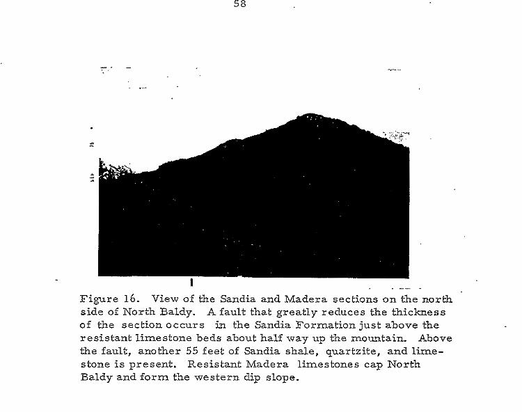
NORTH BALDY. Pennsylvanian strata at North Baldy strike
N 25O W and dip to the southwest a t about 40°. Faulting within the
Sandia Formation and the Maiera Limestone has greatly reduced the
section, leaving only 326 feet of Sandia and 35 feet of Madera Limestone
(fig. 16). The lithologies at North Baldy a r e not unlike those found a t
Tip Top Mountain and North Fork Canyon. The Sandia Formation consists
primarily of shale, expressed largely as covered section, and interbedded
quartzite and.limestone that form small cliffs and ledges on the otherwise
e:
covered slope. Shales account for 250 feet of section, while limestone
T , accounts for 24 feet and quartzite 52 feet.
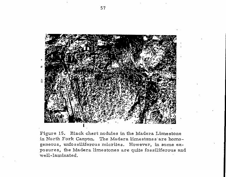
Figure 15. Black chert nodules in the Madera Limestone in North Fork Canyon. The Madera limestones'are homo- geneous, unf'ossiliferous micrites. However, in some ex- posures, the Madera limestones a re quite fossiliferous and well-laminated.
58
Figure 16. View of the Sandia and Madera sections on the north side of North Baldy. A fault that greatly reduces the thickness of the section occurs in the Sandia Formation j u s t above the resistant limestone beds about half way up the mountain. Above the fault, another 55 feet of Sandia shale, quartzite, and lime- stone is present. Resistant Madera limestones cap North Baldy and form the western dip slope.
. ". .
5 9
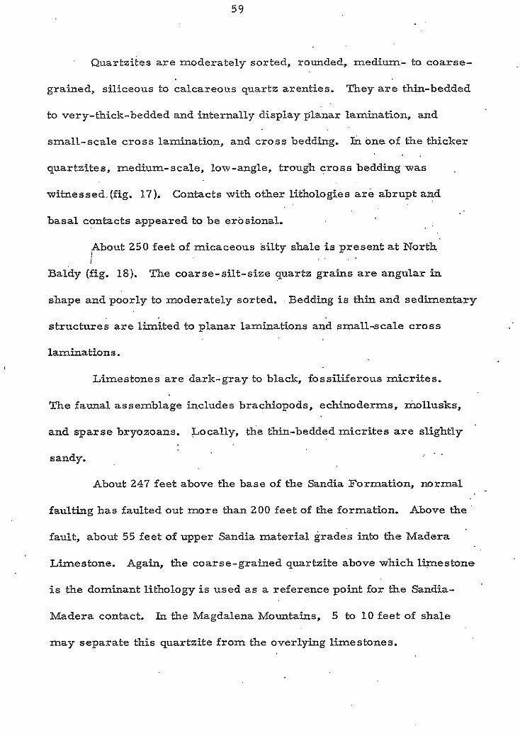
8 Quartzites are moderately sorted, rounded, medium- to coarse-
grained, siliceous to calcareous quartz arenties. They a r e thin-bedded
to very-thick-bedded and internally display planar lamination, and
smalL-scale cross lamination, and cross bedding. In one of the thicker c quartzites, medium-scale, low-angle, trough cross bedding was . .
witnessed.(fig. 17). Contacts with other lithologies are abrupt and
basal contacts appeared to be erosional.
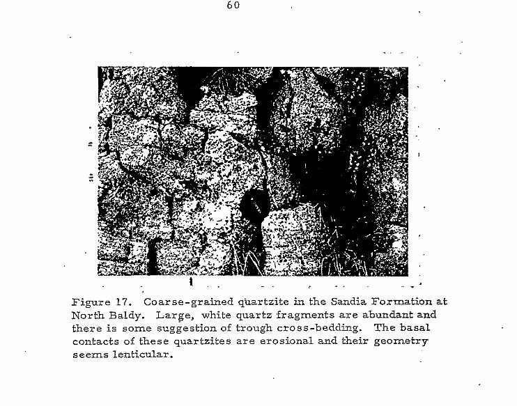
About 250 feet of micaceous silty shale is present at North I 1
Baldy (fig. 18). The coarse-silt-size quartz grains are angular in
shape and poorly to moderately sorted. , Bedding is thin and sedimentary
structures are limited to planar laminations and small-scale cross
laminations.
Limestones are dark-gray to black, fossiliferous micrites.
The faunal assemblage includes brachiopods, echinoder.ms, mollusks,
and sparse bryozoans. Locally, the thin-bedded micrites are slightly
sandy. . . _
About 247 feet above the base of the Sandia Formation, normal
faulting has faulted out more than 200 feet of the formation. Above the
fault, about 55 feet of upper Sandia material grades into the Madera '
Limestone. Again, the coarse-grained quartzite above which lwestone
is the dominant lithology i s used as a reference point for the Sandia-
Madera contact. In the Magdalena Mountains, 5 to 10 feet of shale
(I
* may separate this quartzite from the overlying limestones.
6 0
_ . . . - Figure 17. Coarse-grained quartzite in the Sandia Formation at North Baldy. Large, white quartz fragments are abundant and there is some suggestion of trough cross-bedding. The basal contacts of these quartzites are erosional and their geometry seems lenticular.
61
at and the
.. The 35 feet of Madera Limestone consists of .dark-gray to black
micrite that weathers.a lighter gray. The limestones are medium-bedded
to very-thick-bedded and display a faunal assemblage containing abundant
brachiopods, horn corals, mollusks, echinoderms, and fusulinids.
(. Sumrnary of Pennsylvanian Sections. ' In the Magdalena Mountains,
the Sandia Formation unconforrnably overlies the Kelly Limestone of
Mississippian age and is from 550 to 600 feet thick. It consists of more
than 75 percent shale and wacke with subordinate amounts of interbedded,
medium- to coarse-grained, quartzite and dark-gray to black, fossiliferous.
micritic limestone. Brachiopods, echinoderms, mollusks, bryozoans,
and horn corals are included in the faunal assemblage. Bedding is thin-
bedded to very-thick-bedded. The limestones'exhibit planar lamination
and small-scale cross lamination while quartzites are cross bedded on 0 a small to medium scale. Contacts are usually abrupt. The six members
of Loughlin and Krisclunann (1942) were found obscure and impractical to
'. use in the field. The writer suggests that the use of these'subdivisions
be discontinued and that the Sandia Formation in the Magdalena Mountains
be described as a shale unit with interbedded quartzite and limestone.
The Sandia Formation grades into the overlying Madera Limestone
(. that is about 750 to 800 feet thick in exposed sections but more than
2, 000 feet thick in some drill cores. It is predominantly dark-gray to
black, medium-bedded to very-thick-bedded, fossiliferous, rnicritic
limestone. Subordinate amounts of coarse-grained, poorly to moderately
sorted, calcareous quartzite and interbedded shales and wackes a r e *
present. Fossils include brachiopods, horn corals, echinoderms, . .
mollusks, bryozoans,. and foraminifera, with large horn corals and '
large, black chert nodules being the most distinctive features of the
formation. Internally, the medium- to very-thick-bedded limestones
locally display thin planar laminations.
Petrography
SANDIA FORMATION: The Sandia section is dominated by
I terrigenous rocks. Most of the shales were-found to be borderline
wackes. Sand- and silt-size grains comprise about 35 percent of these
silty shales: quartz with subordinate mica are the dominant minerals.
The matrix material consists of, silica, calcite, and'clay and camprises
about 65 percent of most shales; matrix minerals are usually found to
be replacing detrital quartz grains. I believe that the detrital quartz
content may have been much higher than is presently indicated. These
rocks are. classified as micaceous quartz shales or wackes. The average
grain size is coarse silt, but sizes may be as much as 1.5 Wentworth
grades larger or 2.1 Wentworth grades smaller.. Grains a r e angular
to subangular and have a sphericity coefficient of about 58. Sorting is
poor to moderate with a tendency toward poor sorting. Structures
witnessed in thin section are limited to small fractures filled with
secondary calcite or silica. Occasionally, the long axes of mica or
quartz grains are aligned parallel to each other and parallel to fissility.
64
* Quartz is the predominant mineral in Sandia arenites (fig. 19). .
Polycrystalline quartz i s abundant in some thin sections and mica and ..
feldspar are usually absent. Granular material constitutes about 75 to
80 percent of most thin sections. Mica, quartz, clay and fine autsligenic
chert constitute fhe primary matrix constituents. Cement occurs
primarily as siliceous overgrowths in optical continuity with the detrital .
quartz grains. Calcite cement is abundant in some arenites where it .
occurs as pore filling by single calcite crystals or as large ."poikilitic"
. .
patches that enclose several quartz grains. It is not uncommon to find
quartz grains highly embayed by matrix or cementing material. .
Most of the grains are very coarse sands but may.occur as much
as 1 Wentworth grade toward larger sizes or 3 Wentworth grades toward
smaller sizes. Pressure solution and siliceous overgrowths cause a
degree of uncertainty when describing textures; however, grains appear
to be moderately to well-sorted, rounded to subrounded, and to have a
. .
sphericity coefficient of about .6. Almost all of the Sandia quarizites
are quartz arenites.
The terrigenous content of Sandia limestones (fig. 20) may be as
high a s 3 0 percent, but rarely exceeds 5 percent. Quartz is the most
abundant terrigenous constituent. The grains usually fall in the coarse
silt to fine sand range, are angular, and have a sphericity coefficient
of about 0.5. Sorting is variable. The fossil content of Sandia lime-
stones is about 32 percent, but may be as high as 75 percent. The faunal
assemblage contains a large number of.taxonomic groups including
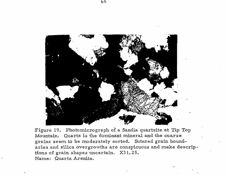
6 5
Figure 19. Photomicrograph of a Sandia quartzite a t Tip Top Mountain. Quartz is the dominant mineral and the coarse graiqs seem to be moderately sorted. Sutured grain bound- ar ies and silica overgrowths are conspicuous and make descrip- tions of grain shapes uncertain. X31.25. Name: Quartz Arenite.
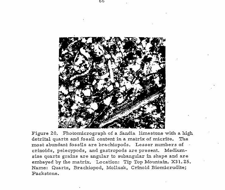
Figure 20. Photomicrograph of a Sandia limestone with a high detrital quartz and fossil content in a matrix of micrite. The most abundant fossils are brachiopods. Lesser numbers of crinoids, pelecypods, and gastropods are present. Medium- size quartz grains are angular to subangular in shape and are embayed by the matrix. 'Location: Tip Top Mountain. X31.25. Name: Quartz, Brachiopod, Mollusk, Crinoid Biomicrudite; Packstone.
c
echinoderms, brachiopods, bryozoans, mollusks, forams, and sponges.
The fos s i l material is broken and rounded suggesting transportation
prior to deposition. Matrix material, comprising more than 60 percent
of most thin sections, occurs as micrite or microspar. Pseudospar
i s present, but is not common. Both microspar and pseudospar are
interpreted as recrystallized micrite. . .
In the Sandia Formation, the most common diagenetic textures
(See Appendix I I I ) a r e the result of various trpes.of neomorphism.
Most aggrading neomorphism was found to be coalesdive. Degrading
neomorphism is also quite common. The neomorphic grain shapes are .
fibrous to equant and range from 1 to 3 in size. .Small fractures filled
with secondary sparry calcite occur in thin section.
i
All of the limestones studied in thin section are classified as
biomicrites. Using Dunham's (1962) classification scheme, the biomicrites
range from mudstone to packstone.
MADERA LIMESTONE. Quartzite accounts for about 6 percent
of the Madera Limestone. A typical arenite in the Madera Limestone
(fig. 21) consists of about 80 percent granular material and about 20
percent matrix and cement. Quartz and polycrystalline quartz are the
primary terrigenous components. Feldspar and mica are not common:
although, mica is more abundant in wackes. Carbonate is the major
orthochemical component; in arenites it occurs as a sparry cement.
T h e grain size of arenites is predominantly coarse sand.
Deviation may be as much a s 1.5 Wentworth grades toward coarser
6 8
Figure 21. Photomicrograph of a Madera quartzite from North Fork Canyon composed of coarse, poorly sorted quartz sand grains cemented by sparry calcite. X31.25. Name: Quartz Arenite.
6 9
. .
sizes or 3.5 Wenhvorth grades toward finer sizes. Grains are round
to subround and have 'a sphericity coefficient of about .6.. Sortihg is variable
and ranges from poor- to well-sorted. The quartz arenites of the Madera
Limestone typically contain .more matrix than do those of the Sandia
arenites.
Micritic limestones (fig. 22) dominate Madera Ethology. Allochems
constitute less than 20 percent of the limestone and terrigenous .material
is seldom present in thin section; however, detrital quartz sometimes
constitutes as much as 10 percent of the rock. Allochemical constituents
include intraclasts, lithoclasts, and pellets. The fossil content of the .
micrites averages about 8 percent. The faunal assemblage includes
brachiopods, echinoderms, mollusks, fusuli&ds, horn corals, bryozoans,
. .
I I ,
and ostracods. As in Sandia limestones, the fragmented fossils indicate
transportation to the depositional site.
Calcite is the dominant orthochem. The orthochern content
: is ordinarily greater than 80 percent and occurs as micrite, microspar,
or l ess commonly pseudospar. Both pseudospar and microspar are
interpreted a s neomorphosed micrite.
Neomorphism dominates diagenetic textures. Degrading
neomorphism is most common, but both prophyroid and coalescive
aggrading neomorphism occur. Neomorphic grain shapes a r e fibrous,
bladed, and equant and grain sizes range from 2 to 6 . Small fractures
in some limestones are filled with secondary calcite spar.
7 0
Figure 22. Photomicrograph of a micrite in the Madera Limestone at Tip. Top Mountain. Fossils are limited to a few brachiopod fragments o r spines. The light patches are coarser calcite formed by porphyroid, aggrading neomorphism. X31.25. Name: Fossiliferous micrite; mudstone.
i
71
* The number of fossil groups represented is large, but the fossil
content is consistantly small. Since the fossil content is less than 10
percent, the limestones are classified as fossiliferous micrites, Using
Dunham's (1962) terminology, most are classified as mudstones.
Occasionally, the granular content becomes high enough to apply the
names biomicrite and wackestone.
(
72
ROCKS OF QUESTIONED AGE
The present study leads the writer to question earlier workers
who feel the sections at Olney Ranch (Granite Mountain) and Tres Montosas
a re of Pennsylvanian age. Loughlin and Koschmann (1942) mapped a
Paleozoic section north of Highway 60 and east of Granite Mountain in
which they interpreted the sequence to be: Precambrian argillite,
Kelly Limestone, Sandia Formation, and Madera Limestone. They-were
puzzled, however, by the anomalous thickness of the Sandia' which was
estimated to be about 2,300 feet. Kottlowski (1960) described a 50 to
100 foot section located about two miles east of Tres Montosas which
consists of limestone-pebble and boulder conglomerate interbedded with
fine-grained quartzites. Although Kottlowski did not name the rocks, . .
he thought they were similar to parts of the Pennsylvanian System in .
. .
the Magdalena Mountains.
The pronounced similarity of the quartzites in the.Tres Montosas '
and Olney Ranch indicate that they belong to the same stratigraphic unit.
However; comparison of these sections with the Mississippian and
Pennsylvanian in the Magdalena Mountains indicates that they are not of
Pennsylvanian age. Moreover, comparisons of these rocks with Permian
sections elsewhere in Socorro County suggest that the rocks in question
a re of Permian age. Before discussing the evidence supporting this
conclusion, a brief review of the Permian units in Central New Mexico
is needed for purposes of comparison.
73
Rocks of Permian age a r e well exposed in Socorro County.
Abo, Yeso, Glorieta, and San Andres formations (fig. 23). A brief
description of each follows:
c BURSUM FORMATION. The type Bursum (Lloyd, 1949) in and
near the Oscura Mountains, consists 'of lower interbedded dark-purplish-
red and grayish-green shale, pinkish-gray arkose, and gray io greenish-
gray limestones capped by a thick, massive, light-gray, biostromal
. .
limestone (Wilpolt and Wanek, 1951; Kottlowski, 1952). This massive
limestone is overlain in some places by limestone pebble-conglomerate .
' and elsewhere by algal calcarenite with lenses of pebble conglomerate.
In Rhodes Canyon and northward, the Bursum Formation contains lenses
of grayish, red. to purple shale and sandstone and near the top o f the
formation sporadic limestone boulder-conglomerates (Kottlowski and
others, 1956). Regionally, thicknesses of the Bursum Formation a r e
'. variable and range from 5 0 to as much a s 400 feet.
AB0 FORTYL4TION. The Ab0 Formation.(Needham and Bates, . .
1943) consists of fine-grained, brownish-red, calcareous sandstone,
siltstone, and shale. At its type section in Ab0 Canyon, the Ab0 consists
of about 60 percent shale and about 40 percent sandstone, arkose, and
conglomerate (Needham and Bates, 1943). This ratio holds approximately
true for most eGosures in central New Mexico. Locally, limestone
pebble-conglomerates occur in the basal parts of the Ab0 Formation
(Loughlin and Koschmann, 1942; Kottlowski and others, 1956; Jaworski,
. .
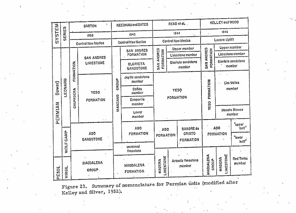
i
7 5
1973). The majority of the clastic units a r e laminated or cross-
laminated and may exhibit ripple marks, mudcracks, and burrowing.
T h e Abo Formation may be as much as 1,100 feet thick, but in the
Magdalena Mountains only thin remnants, as much as 175 feet thick,
are preserved beneath the late-Eocene erosion surface on which the
mid-Tertiary volcanic rocks were deposited.
YES0 FORMATION. Four members are recognized in the
Yeso Formation (Needham and Bates, 1943). '.h ascending order, the '
four members are: 1) Meseta Blanca Sandstone (Lower member),
2) Torres Member (Evaporite member), 3 ) Ca&as Gypsum, and 4)
Joyita Sandstone (Needham and Bates, 1943). The total thickness of
the Yeso Formation may be more than 1,600 feet and limestones in the
middle part have yielded a large faunal assemblage indicating a
Leonardian age (Kottlowski and others, 1956). The Meseta Blaixa
Sandstone is characterized by pink or orange sandstone which in the San
Andres Mountains is about 350 feet thick. The overlying Torres
Member is about 900 feet thick and consists of interbedded friable
sandstone; calcareous, sandy siltstone; arenaceous to argillaceous
limestone; and gypsum. The C a k s Gypsum member is about 200
feet thick and is composed chiefly of mottled, light- to medium-gray
gypsum with interbedded, reddish-brown and friable sandstone. Silty
limestones occur near the- base. The Joyita Sandstone is less than
100 feet thick and consists of soft, cross-bedded, reddish-brown,
calcareous sandstone.
. .
76
GLORLETA SANDSTONE. The Glorieta Sandstone (Needham
and Bates, 1943) a t tahs its maximum thickness in northern New Mexico
where it is less than 300 feet thick. The Glorieta consists of light-gray,
medium-grained, cross-bedded sandstone. In the San Andres LMountains, c the Glorieta is comprised of yellowish-brown sandstones, with interbedded
limestones, that grade down into the reddish sandstones of the Yeso
Formation. The quartzitic character of the Glorieta makes it highly
resistant to erosion.
SAN ANDRES FORMATION. The San Andres Formation (Needham
and Bates, 1943) is as much a s 1,000 feet thick. . The limestones of the.
San Andres are gray to dark-gray, medium-bedded to very-thick-bedded,
e fetid, petroliferous, fossiliferous, and dolomitic. Many limestones
throughout the formation contain laminae of calcareous siltstone'and
scattered quartz grains. Locally, Glorieta-like sandstones are found
near the base. In the Joyita Hills the Glorieta and San Andres are
separated by 3 inches of pink shale (Needham and Bates, 1943).. The.
San Andres Formation is overlain by the pale reddish-brown siltstone,
claystone, and mudstone of the Dock- (Chide) Formation of. Triassic
age, or by the Bernal or Artesia red beds of Permian age.
Comparison of Ohey Ranch and Tres Montosas Sections
with Permian and Pennsylvanian Formations
a Thickness. Major problems with thickness a r e encountered
with the so-called Sandia Formation at Olney Ranch. The Sandia
77
e Formalion in the Magdalena Range is from.550 to 600 feet thick but
the Sandia section at Olney Ranch, as mapped by Loughlin and Koschmam
(1942), is 2,300 to 2,400 feet thick. If correct,. this would r~equire
that the thickness of the section be increased approximately 1,750
feet in a little more than 3 mile S . Facies changes, along wi th pene-
contemporaneous faulting, might possibly explain the abrupt thickening
of the unit. However, these factors should be reflected in the lithologies
8
c
and structures of the sedimentary rocks. To evaluate the possibility.
of primary thickening by facies changes, the rocks of the Olney Ranch
and Tres Montosas sections are compared in'the following paragraphs
with rocks of unquestioned Sandia affinity in the Magdalena Mountains.
I
Sedimentary Structures. In the main part of the Magdalena
Range Sandia quartzites are typically homogeneous, but some small-
to medium-scale, low-angle, trough cross beds occur. At the Olney
Ranch and Tres Montosas sections, internal sedimentary structures
in the quartzites are conspicuous and are typically thin lamination and
small scale cross-lamination. The laminations are present throughout
this unit. Blakestad (personal communication, 1973) has observed the
same thin laminations and cross-laminations in a fine-grained quartzite
section along the east side of Stendel Ridge, about two miles to the south.
Loughlin and.Koschmann (1942) mapped these outcrops as Sandia shale.
It is important to note that the sedimentary structures found in the
quartzites.of these three localities are quite,unlike those of the thin
Sandia quartzites of the main part of the Magdalena Range.
c
a

Lithology. Lithologically, the sections a t Olney Ranch and * Tres Montosas are not similar to the Pennsylvanian sections in the .
Magdalena Mountains. In the main part of the Magdalena Range, the
Pennsylvanian System consisted of the Sandia .Formation (predominantly
( shale with subordinate interbedded, thin coarse-grained, poorly to . .
moderately sorted, angular to subangular quartzite and fossiliferous
micrite) and the overlying Madera Limestone (predominantly fossiliferous,
micritic Limestones with thin, interbedded, coarse-grained, poorly to
moderately sorted, angular to subangular quartzites and silty shales). '
! . .
The Paleozoic section at Olney-Ranch is underlain by Precambrian
argillite. Above the argillite is about 1, 300,feet of faulted and hydro-
thermally altered limestone that strikes ,N 33' E and dips about 60° to
the northwest. Replacement of limestone by silica has destroyed original
textures; however, in some samples replacement is incomplete and it
appears that the limestone w a s originally a dark-gray, fossiliferous
micrite. Fossil identification is almost impossible, but echinoderm
fragments are identifiable in some fresher samples as is a small
percentage of detrital quartz. Loughlin and Koschmam (1942) map
these beds as Kelly Limestone and lower Sandia Limestone but they
more closely resemble the uniform fossiliferous micrites of the Madera
Limestone and are interpreted herein as a down-faulted block of Madera.
e
c Above this limestone unit is 689 feet of section that Loughlin and
Koschmann (1942) mapped a s Sandia shale. The beds crop out poorly,
7 9
-
but the present study shows that these beds a r e predominantly fine-.
grained, laminated quartzite with subordinate shale and limestone.
The quartzites are not similar in bedding characteristics, -internal
structures, grain size, lithology or color to those found in the Sandia
Formation of the Magdalena Range (table 5). In the following descriptions,
the characteristics of-the Sandia Formation in the Magdalena Mountains
a re given in parentheses. The granular content of the Olney Ranch
quartzites (fig. 24). averages about 80 percent (Sandia - 75 to 80%)
and consists of coarse-silt to fine-sand-size, (San&a - very-coarse-
sand), well-sorted (Sandia - poor-to well-sorted), subround to round
(Sandia - subround to round) quartz and subordinate feldspar (Sandia - quartz). Grain sizes'vary as much a s 1.5 Wentworth grades toward
smaller or larger sizes (Sandia - 1 to larger, 3 to smaller) and grain
sphericity is about .6 (Sandia - 6). In the cementing material, calcite
is subordinate to silica. Color ranges from light reddish-brown through
light-gray and green. The weathered surface is always a reddish brown
(Sandia - gray). Due to poor exposure and significant alteration, shale
and limestone characteristics are uncertain. The quartzites are classified
as quartz arenites or subarkoses.
l
. .
A comparison of these quartzites with thoseof the Ab0 Formation
of Permian age show strong similarities in everything but color. The
Olney Ranch section is within a zone of strong propylitic alteration
(Chapin, oral communication, 1973) and I interpret the quartzites to be
Abo beds bleached of their normal reddish coloration by hydrothermal
i /" n e ,....". ..
Sandia Quartzites (Macrdalena Mountains) Granular Matkrial: 75%. Quartz is dominant,
d ' mica, feldspar, and chert subordinate. High o degree of pressure solution and quartz over-
growth. o Matrix & Cement: 25%. Predominantly silica, 2 subordinate calcite and clay. .
u- 0 Color: Olive-gray to gray. Weather gray.
.* u1
__I
Name: Quartz Arenites.
Grain Size: Very coarse sand. . Sorting: Poor- to well-sorted. Roundness: Uncertain, subround to round. Sphericity: Uncertain, 0. 6
al
+.a
8 1 a' R Thickness: The Sandia Fm. in the Magdalena Mts. * 2
i. Bedding: Very-thick-bedded, homogeneous, $ i s 550 to 600 feet thick.
* angle trough cross-bedding and planar cross- but with some small- to medium-scale, low-
. .
Lr Sedimentary Structures: Generally homogeneous,
*,4 bedding, Erosional lower contacts. -0 5 al E3
A b o R o l n c v n n r h ! Granular Material: 80%. Quartz and sub- ordinate feldspar. Matrix & Cement: Calcite is subordinate to silica and clay. Color: Light-reddish-brown, light-grays, and greens. Weather.red. Name: Quartz Arenite.
- Grain Size: Coarse-silt to fine sand. Sorting: Well-sorted. Roundness: Round to subround. Sphericity: 0.6
Thickness : Loughlin and KO schmann (1 942 ) estimate tlie thickness of the Sandia Formation to be about 2,300 feet. Bedding: . Thin-bedded,' thick sequence. Sedimentary Structures: Abundant; thin lamination and. cro s s-lamination. ,
I .
I . . .
Table 5 , ' Comparison of Sandia and Ab0 quartzites. ' . .
1. . . I I

81
Figure 24. Photomicrograph of an Ab0 quartzite at Olney Ranch. The fine-grained sands are subrounded, well- sorted quartz. Contrast this texture with that of the Sandia quartzite shown in figure 22. Some sutured grain boundar- ies and quartz overgrowths are also present in the Ab0 quartzites. X31.25. Name: Quartz Arenite.
82
fluids. L. P. Entwistle of the American Smelting and ReEning Company
reached LAe same conclusion for similar beds along the east side of
Stendel Ridge and at deptli in the Waldo mine (Chapin, oral communication,
1973). The overlying latitic conglomerates of the Spears Formation have
been affected in a similar manner. When fresh, ,the Spears conglomerates
are reddish brown but in the Granite Mountain area they have been
pervasively altered to a greenish gray. If the red pigmentation were
restored to Lfne quartzites in question, they would be unmistakably Abo. I . i .
Overlying the fine-grained quartzites i s a valley.-forming unit
that is about 523 feet thick. A few thin limestones crop out through the .
alluvium that covers most of the 523 feet. These limited exposures
occur as dark-gray, unfossiliferous, dolomitic micrites that may
locally become sandy. Loughlin and Koschmann (1942) mapped this
par t of the section as the upper limestone of the Sandia Formation. E
the underlying quartzites are Abo, then this unit may be a faulted,
incomplete section o f the Yeso Formation, also of Permian age. '
. .
Along the western slope of the valley, Loughlin and Koschmann
(1942) mapped 135 feet of quartzite and interbedded limestone as upper
Sandia quartzite. The limestones are subordinate and similar to tho'se
found in the valley below. The quartzites (fig. 25) a re Iight- to medium-
gray in color. The medium quartz sand grains in these very-well-sorted
quartz arenites are well-rounded and have a sphericity coefficient of
about 0 . 7 to 0.8. . Cementing material i s dominated by calcite and usually
comprises 1 0 to 20 percent of the rock. Sedimentary structures were
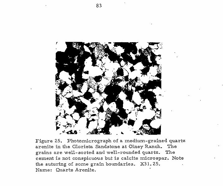
83
Fi,mre 25. Photomicrograph of a medium-grained quartz arenite in the Glorieta Sandstone at Olney Ranch. The grains are well-sorted and well-rounded quartz. The cement is not conspicuous but is calcite microspar. Note the suturing of some grain boundaries. X31.25. Kame: Quartz Arenite.
84
not conspicuous, but some small- to medium-scale, low-angle cross-
bedding occurs in the quartzite (table 6).
A comparison of these quartzites with those of the Glorieta
Sandstone on Lucero Me~sa showed striking similarities. Both a re Light-
gray, -well-sorted, medium-grained, well-rounded, thick-bedded quartz
arenites. The quartzites at Olney Ranch are more highly indurated, but
this is probably a consequence of hydrothermal alteration. The lithology
and stratigraphic position of these quartzites, above the Ab0 and Yeso
formations and below a massive dolomitk limestone interpreted below '
!
as the San Andres Limestone, makes a Glorieta assignment reasonable.
Overlying the Glorieta is 658 feet of dolomitic limestone that ..
caps the ridge and forms the westward-facing dip slope east of the Olney
ranch house (fig. 26). Loughlin and Koschmann (1942) mapped this par t
of the section as Madera Limestone. These limestones (fig. 27) are
relatively unfossiliferous with less than 5 percent fossil fragments; the
only group represented is the crinoids. The remaining 95 percent of
the rock is comprised of micrite and neomorphic microspar. The
predominate diagenetic textures are fibrous to equant neomorphism and
degrading neomorphism. Neomorphic calcite sizes range f rom 2.0 to
4.0. The limestones are medium-bedded to very-thick-bedded, and
characteristically produce a rough? hackly weathered surface, and yield
a strong fetid odor when freshly broken. The upper contact is a'fault
contact with overlying Tertiary volcanics.
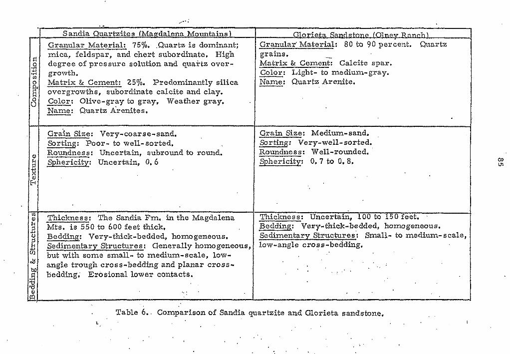
.. +... . Sandia Quartzites (Mauclalena Mountains)
Granular M a t e a 75% .Quartz is dominant; mica, feldspar, and chert subordinate. High degree of prcssure solution and quartz over- growth. Matrix & Cement: 25%. Predominantly silica overgrowths, subordinate calcite and clay.
- Name: Quartz Arenites. - Colcr: Olive-gray to gray, Weather gray.
Grain Size: Very-coarse-sand. Sorting: Poor- to well-sorted. Roundness: Uncertain, subround to round. Sphericity Uncertain, 0.6
Thickness: T h e Sandia Fm. in the Magdalena Mts. i s 550 to 600 feet thick, Bedding: Very-thick-bedded, homogeneous. Sedimentary Structures: Generally homogeneous, but with some small- to medium-scale, low- angle trough cross-bedding and planar cross- bedding; Erosional lower contacts.
.. : '
SZorietn Sandstone 1 0 1 r q i & m & ) Granular' Material: 80 to 90 percent. Quartz grains. Matrix & Cement-; Calcite spar. Color: Light- to medium-gray. Name: Quartz Arenite.
Grain Size: Medium-sand. Sorting: Very-well-sorted. Roundness: Well-rounded. Sphericity: 0.7 to 0.8.
Thickness: Uncertain, 100 to 150 feet. Bedding: Very-thick-bedded, homogeneous. Sedimentary Structures: Small- to medium-scale, low-angle cross-bedding,
. . .
Table 6.. Comparison of Sandia quartzite and Glorieta sandstone. . .
t , . . I
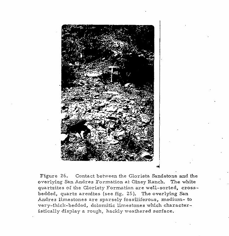
Figure 26. Contact between the Glorietz Sandstone and the overlying San Andres Formation at Olney Ranch. The white quartzites of the Gloriety Formation are well-sorted, cross- bedded, quartz arenites (see fig. 25). The overlying San Andres limestones are sparsely fossiliferous, medium- to very-thick-bedded, dolomitic limestones which character- istically display a rough, hackly weathered surface.
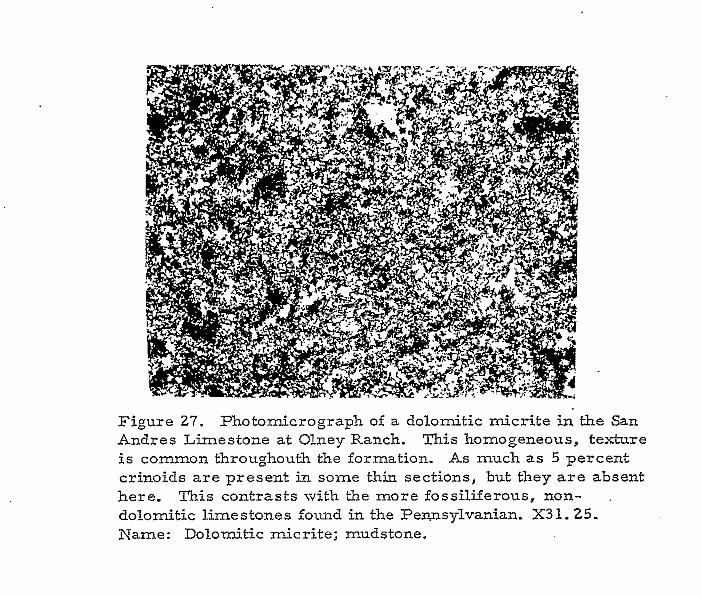
Figure 27. Photomicrograph of a dolomitic micrite in the San Andres Limestone at Olney Ranch. This homogeneous, texture is common throughouth the formation. A s much as 5 percent crinoids are present in some thin sections, but they a r e absent here. This contrasts with the more fossiliferous, non- ,
dolomitic limestones found in the Pennsylvanian. X31.25. Name: Dolomitic micrite; mudstone.
88
* A comparison of these limestones with the San Andres Limestone
revealed many similarities. Both are sparsely fossiliferous, very-thick-
bedded, black dolomitic limestones with rough, hackly weathered surfaces.
c The San Andres Formation on Lucero Mesa is predominantly gypsum but
the thin, interbedded limestones a r e similar to those in question and a
transition from evaporites to dolomitic limestone is . . a co-on facies '
change within the San Andres Formation; The Madera limestones in the
Magdalena Mountains a r e not dolomitic, are relatively fossiliferaus wi th
a wide range of faunal types, are lighter in coior, are.not fetid, and do .
not develop such a hackly fracture upon weathering (table 7). Considering
the lithologic similarities to the San Andres and their stratigraphic position :
above beds reasonably interpreted a s Ab0 and Glorieta, the assignment 1
of the upper limestone unit of the Olney Ranch section to the San'Andres
Limestone seems a likely correlation.
e
Kottlowski (1960) briefly discussed a 50- to 100-foot section of
'' poorly exposed Paleozoic rocks near Tres Montosas. He found no fossils
indicating Pennsylvanian age; however, he did note that the beds were
similar to parts of the Pennsylvanian in the Magdalena Mountains.
The rocks at the Tres Montosas section are very poorly exposed
and it was not possible to accurately measure the section; however, a rough
measurement indicates the section may be as much as 150 feet thick. The
lower half of the section consists of limestone and quartzite boulder and
pebble conglomerates interbedded with calcareo.Lzs quartzites. The
conglomerates contain poorly sorted, angular to rounded, sand- tb *
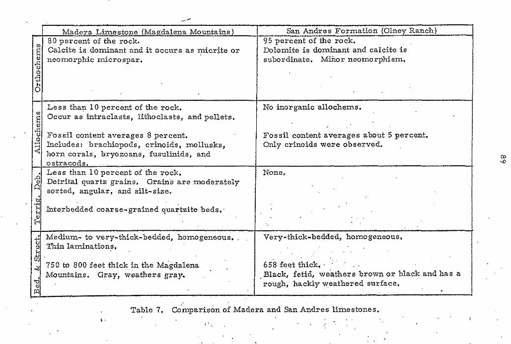
. .. /7
Madera Limestone (Magdalena Mountains) San Andres Formation (Olney Ranch) 80 percent of the rock. 95 percent of the rock.
E" subordinate. M&or neomorphism, neomorphic microspar. 0 Dolomite is dominant and caIcite is Calcite is dominant and it occurs as micrtte or
% 5 8 0
~~
Less than 1 0 percent of the rock. No inorganic allochems.
2 2
Occur as intraclasts, lithoclasts, and pellets.
3 u Fossil content averages 8 percent. Includes: brachiopods, crinoids, mollusks, horn corals, bryozoans, fusulinids, and
0 Fossil content averages about 5 percent. Only crinoids were observed.
cn ostracods.
None, Less than 1 0 percent of the rock. \D
d a,
sorted, angular, and silt-size. ' Detrital quartz grains. Grain's are moderately
0 1 r l
Interbedded coarse-grained quartzite beds, s . . . .
I
i; ~ h i n lamination?. Y Medium- to very-thick-bedded, homogeneous, , .
k & . 750 to 800 feet thick in the Magdalena Mountains. Gray, weathers gray. a;
Very-thick-bedded, homogeneous, t . 658 feet thick. ' ' . .
.Black, fetid, weathers brown or black and has a rough, hackly weathered surface, I
Table 7, Co'mparison of Madcra and San Andres limestones. 1. . . . .:
I
boulder-size clasts of dark-gray, micritic limestone and reddish-brown,
medium-grained quartzite (internally planar and cross laminated) in a
calcareous matrix (fig. 28). The interbedded calcareous quartzites are
moderately sorted, subrounded, fine- to medium-grained, olive-gray,
and weather a pale reddish brown. (
The pebble and boulder conglomerates are not present in the
upper part of the section and only quartzite beds are observed. The
calcareous quartzites are moderately sorted, subangular to subrounded,
medium grained, olive gray, and weather a light reddish brown.
Sedimentary structures in the quartzites are dominantly thin planar
laminations and small scale, low angle cross-laminations: The character- .
' istics of these quartzites are similar to those in the thick quartzite section
at Olney Ranch. Contacts with other pre-Teritary units are not exposed
because alluvium and blow-sand completely cover lower contacts. The
upper contact is a depositional contact with the overlying Tertiary volcanics
of the Spears Formation, Similarities with Ab0 quartzites, at Olney Ranch,
and the presence of limestone conglomerates 'elsewhere in the Ab0 make
a correlation of this section with the Abo Formation reasonable.
. .
If the reader compares the sections at Olney Ranch and Tres
( Montosas with the Permian stratigraphic sequence, many similarities
may be noted. The lithologies are more 'like the Permian than the
Pennsylvanian. The sedimentary structures found in the Olney Ranch
and Tres Montosas beds are more similar to those found in Permian
rocks than to those in Pennsylvanian rocks. In the light of these similarities
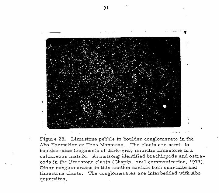
9 1
. , ~ ~
Figure 28. Limestone pebble to boulder conglomerate in the Ab0 Formation at Tres Montosas. The clasts are sand- to boulder-size fragments of dark-gray micritic limestone in a calcareous matrix. Armstrong identified brachiopods and ostra- cods in the limestone clasts (Chapin, oral communication, 1973). Other conglomerates in this section contain both quartzite and limestone clasts. The conglo.merates a r e interbedded with Ab0 quartzite s f
92
with the Permian System, and the previously discussed conflicts wi th
rocks of known. Pennsylvanian age; the following revisions in stratigraphic
nomenclature are suggested:
1.
2.
3.
4.
5.
The units mapped by Loughlin and Koschmann (1942) at Olney
Ranch as Kelly Limestone and lower Sandia Limestone a r e part
of the Madera Limestone of Pennsylvanian age. The Mississippian
and Lower Pennsylvanian have been faulted out.
The unit mapped by Loughlin and Koschmann (1942) at Olney .
Ranch and Stendel Ridge as Sandia shale is par t of the Ab0
Formation of Permian age.
The unit at Obey Ranch which was mapped by Loughlin and
Koschmann (1942) as the upper limestone member of the Sandia
Formation is of uncertain Permian age, but is probably Yeso '
Formation.
The upper quartzite member of the Sandia Formation, as mapped
by Loughlin and Koschmann (1942) at Olney Ranch, is the Glorieta
Sandstone of Permian age.
The limestone at Obey Ranch which was previously mapped a s
Madera Limestone (Loughlin and Koschmann, 1942) is the San
Andre s Formation.
Recognition and proper correlation of these units has solved many of
the problems encountered with earlier interpretations. This model
eliminates the abrupt thickening of the Sandia Formation, it adequately
explains the discrepencies in grain sizes and sedimentary structures of 8
93
* the quartzites, and it explains the dolomite and sparsely fossiliferous
character of the upper, limestone unit. In short, a degree of order is
achieved in a heretofore problematic area.
94
ENVlRONMENTS O F DEPOSITION
This chapter integrates the rock characteristics presented in
preceeding chapters and aiscusses a modern environment of deposition
in which sediments with similar characteristics occur. A correlation
with large-scale modern environments, rather than small-scale modern
equivalents, i s attempted because of limitations on &e data imposed by
poorly exposed sections and limited lateral control. -
daloso Formation: The lower Caloso (table 3), a calcareous, arkosic
sandstone with quartzite, granite and greenschist fragments, reflects .
terrigenous debris derived from the beveled Precambrian rocks over
which the Mississippian sea transgressed. The angularity, poor sorting,
and large size of the Precambrian debris suggest negligible distances of
transportation prior to deposition. This lower 15-foot part of the Caloso
is probably comprised of debris that w a s lying on the eroded Precambrian
surface and then reworked by transgressing seas. This material ,was.
presumably supplemented by debris of similar composition that w a s shed
from nearby, low-lying highlands. Although no modern analogs a r e
known, Krumbein and Sloss (1963, p. 563) discuss similar deposits
under the heading "basal arkose association.
The lower Caloso is overlain by well-sorted sandy limestones.
These probably reflect continued transgression that resulted in sedimen-
tation in deeper, quieter water with a more distant source area. The
sources still provided detrital quartz, but deeper, quieter water prevented
95
tlre incorporation of coarser material into fhese upper Caloso beds.
The paucity of fossils~and fossil fragments and significant accumulations
of carbonate mud suggest that Caloso beds were probably deposited
in somewhat restricted portions of a shallow, marine shelf. Summaries
of modern shelves have been given by Curray (1960 and 1965), Belderson
and Stride (1966), Emery (1966), Swift (1970), Stride (1963), and Uchupi
(1968). . .
Kelly Limestone: A hiatus exists between the Caloso .and Kelly i
formations ,that represents at a minimum, all of middle Osage (Burlington)
time. Deposition in late Osage (Keokuk) time, characterized by an
abundant and varied fauna (table 2), took place in an environment conducive
to organic growth. The origin of crinoidal wackestones, packstones, and
occasional grainstones (table 3 ) , however, is not easily explained. In areas
of modern carbonate accumulation, crinoids a re uncommon or absent
(Bathurst, 1971), A s a result, little is known concerning their habitat.
The model proposed here for deposition of Kelly beds is similar to, and
in agreement with, the regional model proposed and discussed by Armstrong
(1962 and 1963). The crinoidal limestones of the Kelly Formation probably
accumulated on a broad, shallow, marine.shelf. The abundant crinoid
gardens that must have been present probably indicate well-circulated
waters and probableaccess toopen seas. The crinoidal gardens were a
ready source of the bioclastic sands that paleocurrents reworked-and
spread across the shelf floor. Chert in the Kelly Formation shows
evidence of a replacement origin (partial silicificationof fossils and
, .
96
relict textures in the matrix). Armstrong (1962) suggests the silica
was originally d i s s e d a t e d throughout the unconsolidated calcareous
muds and sands and was then concentrated into nodules during diagenesis.
Sandia Formation: During latest Mississippian and early
Pennsylvanian time the Magdalena area was subjected to erosion. ' Pr io r
to Pennsylvanian transgression, the Peliasco dome, so prominant through
most of Mississippian time, along with the smaller Joyita uplift, became
the most important contributors of detritus to shallow Pennsylvanian
seas (Kottlowski, 1960). , The characteristics of Sandia rocks, presented
on page 59, are similar to those of sediments accumulating ?.&a modern
shoreline complex. Selley (197O)'reviews modern shoreline environments
and offers an excellent bibliography concerning shoreline sedimentation
Very-coarse sands and gravels often are observed in channel deposits.
Cross-bedding formed by megaripples is common in channel deposits
and lenticular bedding and wavy lamination a r e common in finer lithologies.
Small-scale erosional features are very cornmon. Carbonates are
fossiliferous and micritic in nature. They exhibit thin lamination or
cross-lamination. The rock types of the Sandia Formation are interpreted
to represent various subenvironments associated with a shoreline complex,
Quartzite: The properties of Sandia quartzites (table 5) are similar
1 . .
to channel sands. These properties include: 1) texture--very-coarse-sand
s ize , poorly to well-sorted, rounded shape; 2) structures--small- to
large-scale planar and trough crossbedding; 3) erosional basal contacts,
and 4) geometry--1ensoid (uncertain in Magdalena Mountains due to
limited exposures but some suggestion of lateral thinning). Wackes
L
97
probably represent overbank equivalents of the channel facies and were
deposited in nearby interchannel areas.
Shale: The properties of Sandia shales (page 59) indicate
deposition out of suspension in a low energy environment such a s a
marsh, swamp, deltaic platform, or tidal flat. 'They are characterized
by plant growth and a dearth of marine fossils: Sedimentary structures
are restricted to wavy, lenticular lamination and cross lamination. The
deposit? consist of silty muds with small amounts of sand and a r e usually
carbonaceous. .
Limestone: The characteristics of Sandia limestones suggest the
rocks originated in a nearshore marine or lower tidal flat type of
environment. This conclusion is supported by: I ) the presence of marine
fossils, 2) abundant micrite, 3) fine laminations, and 4) their association
with shale and quartzite. Similar limestones in modern nearshore and
tidal flat environments are described by Shinn, Lloyd, and Ginsburg (1969),
riling, Wells, and Taylor (1965), and Bathurst (1971). They are also
observed in the ancient record by Laporte (1967) and Mater (1967).
Madera Limestone: Madera limestones are the result of a.long
period of subtidal deposition on a shallow marine shelf. Uniform accumula-
tions.of micrite with relatively sparse fossil debris interrupted by
occasional beds of quartzite indicate periods of higher energy periodically
occurred. Thin lamination indicates tha't some horizons accumulated in a n
environment with sufficient circulation to winnow micrite. Occasional high-
energy regimes produced coarse-grained quartzite beds, nodular limestone
beds, and the comminution of skeletal debris.
98
SUMMARY AND CONCLUSIONS
This paper has discussed the Mississippian and Pennsylvanian
strata of the Magdalena area in terms of:
< 1. Regional Stratigraphy
2. Local Stratigraphy
3. Petrology and Petrography
4. Depositional Environments.
,Evidence was cited to support the following conclusions:
1. The Mississippian System in the Magdalena a rea is 64 to 125
feet thick. The basal Caloso Formation is about 30 feet thick and is
comprised of a lower terrigenous unit containing poorly-sorted, coarse- *, grained sand to pebble-size fragments of Precambrian detritus and an
upper unit of sandy limestone. The overlying Kelly Formation is as much
as 95 feet thick and is predominantly a crinoidal limestone. The Caloso
beds were deposited as early Mississippian seas transgressed over a
surface of low relief carved on Precambrian rocks. Limestones of the
Kelly Formation accumulated on a broad, shallow, well-circulated marine
shelf containing abundant crinoid gardens.
2. Exposed sections of Pennsylvanian rocks in the Magdale&
(. Mountains a r e 1,300 to 1,400 feet thick. The Sandia Formation is 550
to 600 feet thick and consists predominantly of shale wi th subordinate amounts
a of interbedded coarse quartzite and fossiliferous, micritic limestone. The
Sandia beds were deposited as facies of a shoreline complex. The Madera
Y 7
-
Limestone is 750 to 800 feet thick in exposed sections but as much as
1 ,200 feet of the upper Madera has been faulted out. Homogeneous
Madera micrites were probably deposited in local depressions on a
shallow marine shelf in which circulation and organic activity was
inhibited.
* (
3. The six members in the Sandia Formation, as described by
Loughhlin &d Koschmann (1942), are lenticular, local units impractical
to use in regional mapping o r stratigraphic studies. It is-.suggested that
their use be discontinued and the Sandia Formation be described as a
shale unit with thin, interbedded quartzites and limestones.
4. It is suggested that the sections a t Olney Ranch and Tres Montosas
e 'are of Permian age rather than Pennsylvanian age as previously thought. .-
Permian units at Olney Ranch are, in ascending order, the Abo, Yeso (7 ),
Glorieta, and San Andres formations. Permain strata at Tres Montosas
are restricted to about 100 to 150 feet at the Ab0 Formation.
In conclusion, Mississippian and Pennsylvanian sedimentary rocks .
in central New Mexico provide an example of ancient shallow marine
shelf environments. Relationships between numerous and diverse sub-
environments in the Pennsylvanian rocks are poorly understood a t present.
Continued study of facies distrubutions and an analysis of paleotransport
directions are needed before a detailed understanding of the Pennsylvanian
wil l be achieved.
REFERENCES * Armstrong, A. K., 1955, Preliminary observations on the Mississippian
system of northern New Mexico: New Mexico Institute of Mining
and Technology, State Bureau of Mines and Mineral Resources,
Circ. 39, 42 p.
(
"" , 1958, The Mississippian of west-central New Mexico: New Mexico . .
Institute of Mining and Technology, State Bureau of Mines and
;Mineral Resources, Mem. 5, 32 p., 6 pl.
----, 1962, Stratigraphy and paleontology of the Mississippian System
in southwestern New Mexico and adjacent southeastern Arizona:
New Mexico lnstitute of Mining and Technology, State Bureauof
Mines and Mineral Resources, Mem. 8, 99 p.
----, 1963, Biostratigraphy and paleoecology of the Mississippian
System, west-central New Mexico, &New Mexico Geological
Society Guidebook, 14th Field Conf., Socorro Region: p. 112-122.
----, 1967, Biostratigraphy and carbonate facies of the Arroyo Penasco
Formation, north-central New Mexico: New Mexico Institute of
Mining and Technology, State Bureau of Mines and Mineral .
Resources, Mem. 20, 79 p.
( . Baltz, E. H., Jr., and Bachman, G. O., 1956, Notes on the geology of
the southeastern Sangre de Cristo Mountains, New Mexico: New
Mexico Geological Society Guidebook, 7th Field Cod., Southeastern
Sangre de Cristo Mountains, New Mexico: p- 96-108. - *
101
* Bathurst, R. G., 1971, Carbonate sediments and their diagenesis,
Developments in Sedimentology 12: New Yorlc, Elsevier Publishing
Co., 620 p.
Belderson, R. H., and Stride, A. H., 1966, Tidal current fashioning of c a basal bed: Marine Geology, v. 4, p. 237-257.
Blakestad, R. B., in print, The revised geology of the Kelly Mining
District, Socorro County, New Mexico: University of Colorado,
unpub. M. S. f ies i s . !
Curray, J. R., 1960, Sediments and history of Holocene transgression,
continental shelf, northwest Gulf of Mexico, & Shepard, F. P.,
ed., Recent sediments northwest Gulf of Mexico: Tulsa, Am.
0 Assoc. Petroleum Geologists, p. 221-266.
"" , 1964, Late Quaternary history, continental shelves.of the United
States, - in Wright, H. E., Jr., Frey, David G., eds. The
Quaternary of the United States, Princeton, Princeton University
Press , p. 723-735. _ ,
Dott, R. H., Jr., 1964, Wacke, graywacke and matrix--what approach
to immature sandstone classification? : Jour. Sedimentary
Petrology, v. 34, p. 624-632. . . . .
< Dunham, R. J., 1962, Classification of carbonate rocks according to
depositional texture, &Ham, W. E., ed., Classification of
carbonate rocks: Am. Assoc. Petroleum Geologists Mem. 1,
p. 108-121.
Emery, K. O., 1966, Atlantic continental shelf and slope of the United
States: U. S. 'Geological Survey Prof. Paper 529-A, 23 p.
Folk, R. L., 1959, Practical petrographic classification o f limestones:
Am. Assoc. Petroleum Geologists Bull., v. 43, p. 1-38.
-I" , 1965, Some aspects of recrystallization in ancient limestones:
Soc. Econ. Paleontologists and Mineralogists Spec, Pub. 13,
p. 14-45. . . .
----, 1968, Petrology of sedimentary rocks: . . Austin,, Texas,. Hemphills,
170 p.
Gillerman, E., 1958, Geology of the central Peloncillo .Mountains, - Hidalgo County, New Mexico, and Cochise County, Arizona:
New Mextco Institate of Mining and Technology, State Bureau
of Mines and Mineral Resources, Bull. 57, 152 p.
..
Gilluly, J., Cooper, J. R., and Williams, J. S., 1954, Late Paleozoic
stratigraphy of central Cochise County, Arizona: U. S. Geological
Survey Prof. Paper 266, 49 p.
Gordon, C. H., 1907, Notes on the Pennsylvanian formations in the
Rio Grande Valley, New Mexico: Jour. Geol., v. 15, p. 805-816,
"" , 1907, Mississippian formations in the Rio Grande Valley, Nev
Mexico: Am. Jour. Sci., 4th ser., v. 24, p. 58-64.
Herrick, C. L., 1904, Laws of formation of New Mexico mountain
ranges: Am. Geologist, v. 33, p. 301-312..
----, and Bendrat, T. A., 1900, Identification of an Ohio coal measures
horizon in New Mexico: Am. Geologist, v. 25, p. 234-242.
103
llling, L. V., Wells, A. J., and Taylor, J. C. M., 1965,
Penecontemporary dolomite in the Persian Gulf, - in Pray,
L. C., and Murray, R. C., eds., Dolomitization and limestone
diagenesis: a spposiwm: Soc. Econ. Paleontologists and
Mineralogists, Spec. Publ., No. 13, p. 89-111. .
Ingram, R. L., 1954, Terminology for the thickness of stra'tification
and parting units in sedimentary rocks: Geological Soc. Am.
BULL, v. 65, ,p. 937-938, i
Keyes, C. R., 1915, Conspectus of the geologic formations of New
Mexico: 12 p., Des Moines.
Kottlowskl, F. E., 1952, Geology and ore deposits of a par t of Hansonburg
mining district, Socorro County, New Mexico: New Mexico
Institute of Mining and Technology, State Bureau of Mines and
Mineral Resources, Circ. 23, 9 p.
----, 1960, Summary of Pennsylvanian sections in southwestern New
Mexico and southeastern Arizona: New Mexico Institute of
Mining and Technology, State Bureau of Mines and Mineral
Resources, Bull. 66, 187 p.
----, 1962, Pennsylvanianrocks of southwestern New Mexico and
southeastern Arizona, - in Branson, C. C., ed., Pennsylvanian
System in the United States, Tulsa, Am. Assoc. Petroleum
Geologists, p. 331-371.
"" , 1963, Paleozoic and Mesozoic strata of southwestern and south-
central New Mexico: New Mexico Institute of Mining and Technology,
State Bureau of Mines and Mineral Resources, Bull. 79, 100 p. . _
"" , Flower, R. H., Thompson, M. L., and Foster, R. W., 1956,
Stratigraphic studies of the San Andres Mountains, New Mexico:
New Mexico Institute of Mining and Technology, State Bureau of
Mines and Mineral Resources, Mem. 1, ,132 p. .. . . . .. . . . ~ ..._ ." . . . . - .... .
----, and Stewart, W. J., 1970, Part I: The Wolfcampian Joyita uplift
in central New Mexico: New Mexico Institute of M i n i n g and Technology,
State Bureau of Mines and Mineral Resources, Memoir 23, p. 1-31. . .
Krumbein, W. C. ~ and SLoss, L. L., 1963, Stratigraphy and sedimentation, I '2nd ed. : San Francisco, W, H., Freeman and Co., 660 p.
Laporte, L. F. 1967, Carbonate deposition near mean sea-level and
resultant facies mosaic: Maxiiius Formation (Lower Devonian)
of New York State: Am. Assoc. Petroleum Geologists, Bull.,
V. 51, p. 73-101.
Laudon, L. R., and Bowsher, A. L., 1941, Mississippian formations of
Sacramento Mountains, New Mexico: Am. Assoc. 'Petroleum
Geologists Bull., v. 25, p. 2107-2160.
"_I , 1949, Mississippian formations of southwestern New Mexico:
Geological Soc. Am. Bull., v. 60, p. 1-87.
Lloyd, E. R., 1949, Pre-San Andres stratigraphy and oil psoducing
zones in southeastern New Mexico: New Mexico School of Mines,
State Bureau of Mines and Mineral Resources, Bull. 29,. 79 p. (.
Loughlin, G. F., and Koschmann, A. H., 1942, Geology and ore deposits
of the Magdalena mining district, New Mexico: U. S. Geological
Survey, Prof. Paper 200, 168 p.
1 u3
Mater, A., 1967, Tidal flat deposits in the Ordovician of.western
Maryland: Jour. Sedimentary Petrology, vi 37, ,p. 601-609.
e Paige, S., 1916, Description of the Silver City quadrangle: U. S.
Geological Survey Geol. Atlas, Silver City folio, New Mexico,.
No. 199, I 9 p.
Pettijohn, F. J., Potter, P. E., and Siever, R., 1972, Sand and
sandstone: New York, Springer-Verlag, 618 p.
Powers, M. C. 1953, A new roundness scale for sedimentary particles:
Jour. Sed. Pet., V. 23, p. 117-119.
Pray, L. C., 1961, Geology of the Sacramento Mountains Escarpment,
Otero County, New Mexico: New Mexico Institute of Mining and
Technology, State Bureau of Mines and Mineral Resources;
Bull. 35, 144 p.
<
&aide, W. L., 1953, Geology of the central Peioncillo Mountains,
Hidalgo County, New Mexico: University of California, unpub.
M. S. Thesis, 87 p.
106
Read, C. B.', Wilpolt, R. €I., Andrews, D. A., Summerson,. C. H.,
and Wood, G. '€I., Jr., 1944, Geologic map and stratigraphic
sections of Permian and Pennsylvanian rocks of parts of S a n
Miguel, Santa Fe, Sandoval, Bernalillo, Torrance, and
Valencia Counties, north-central New Mexico: U. S. Geological
Survey Oil and Gas hv. Prelim. Map 21.
(
Read, C. B., and Wood, G. H., 1947, Distribution and correlation of
Pennsylvanian rocks in Late Paleozoic sedimentary basins of
northern New Mexico: Jour. Geol., 'v. 55, p. 220-236.
Reineck, H. E., 1972, Tidal flats a - in Rigby, J. K,, and Hamblin, W. K.,.
eds., Recognition of ancient sedimentary environments: Soc, . .
0 Econ. Paleontologist and Mineralogists Special Publ. 16, p. 146-159.
Schmitt, Harrison, 1933, The central mining district, New Mexico: Am. . .
Inst. Min. Met. Eng. Contr., No. 39, 22 p.
Selley, R. C., 1970, Ancient sedimentary environments: Ithica, N. Y.,
Cornel1 Univ. Press, 237 p.
&inn, E. A., Lloyd, R. M., and Ginsburg, R; N., 1969, Anatomy of
a modern carbonate tidal flat, Andros Island, Bahamas: Jour.
Sedimentary Petrology, v. 39, p. 1202-1228.
c Spencer, A. C., and Paige, S., 1935, Geology of the Santa Rita mining
area, New Mexico: U. S. Geological Survey Bull., c. 859, 78 p:
Stein, P., and Ringland, S., 1913, Geology and ore deposits of Kelly,
a New Mexico: New Mexico School of Mines, unpub. Thesis.
Stride, A. H., 1963, Current-swept sea floors near the southern half
107
of Great Britain: Geological Soc. Lopdon Quart. Jour., v. 119,
p. 175-199. '
Swift, D. J., 1970, Quaternary shelves and the return to grade: ,.
Marine Geology, v. 8, p. 5-30.
Thompson, M. L., 1942, Pennsylvanian System in.New Mexico: New
Mexico School of Mines, State Bureau of Mines and Mineral
Resources, Bull. 17, 92 p. . .
- - - - ? 1948, Protozoa; Studies of American fusulinids: University of i Kansas Paleont. Contr., No. 4, art.' I,' 184.p.
Uchupi, E., 1968, Atlantic continental shelf and slope of the United
. States--physiography: U. S. Geological Survey Prof. 'Paper
529-C, 30 p.
Wilpolt, R. H. MacAlpin, A. J., Bates, R. L,, and Vorbes, G.,
1946, Geologic map and stratigraphic sections o f Paleozoic
rocks of Joyita Hills, Los Pinos Mountains, and norther?
Chupadera Mesa, Valencia, Torrance,' and.Socorro Counties,
New Mexko: U. S. Geological Survey Oil and Gas Inv. Prel im
Map 61.
----, and Wanek, A. A., 1951, Geology of the region from Socorro and
San Antonio east to Chupadera Mesa, Socorro County, New Mexico:
U. S. Geological Survey Oil and Gas Inv. Prelim. Map OM-121.
108
APPENDICES
. . . .
APPENDIX I
STRATIGRAPHIC COLUMNS
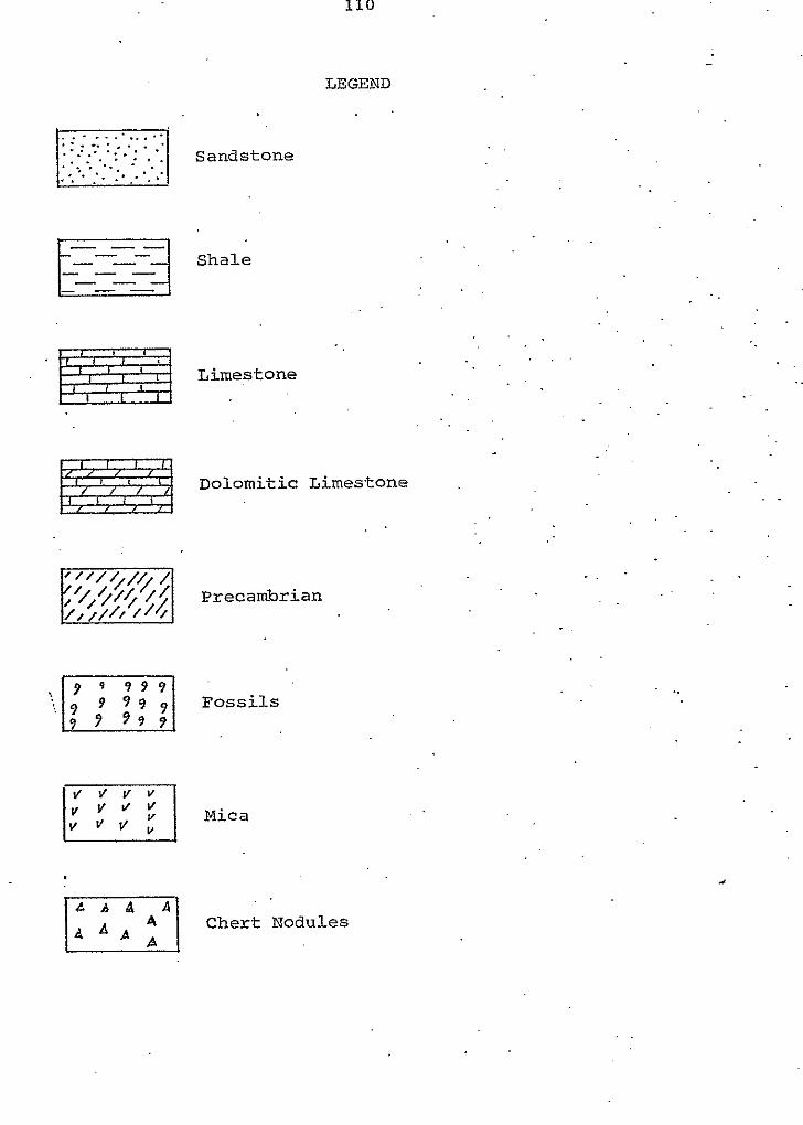
c
-:,
‘ 9 9 9 9 9
110
LEGEND
Sandstone
Shale
Limestone
Dolomitic Limestone
Precambrian
Foss i l s
Chert Nodules
Mica
..
..
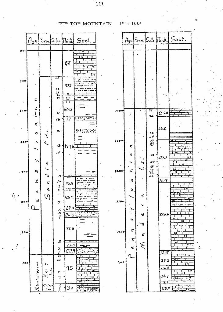
111
. 50.
.. .. .. I
30
._
TIP TOP MOUNTAm 1" = 100'
3-
1 I
"- "-
1
. : . . .
.- -
_-
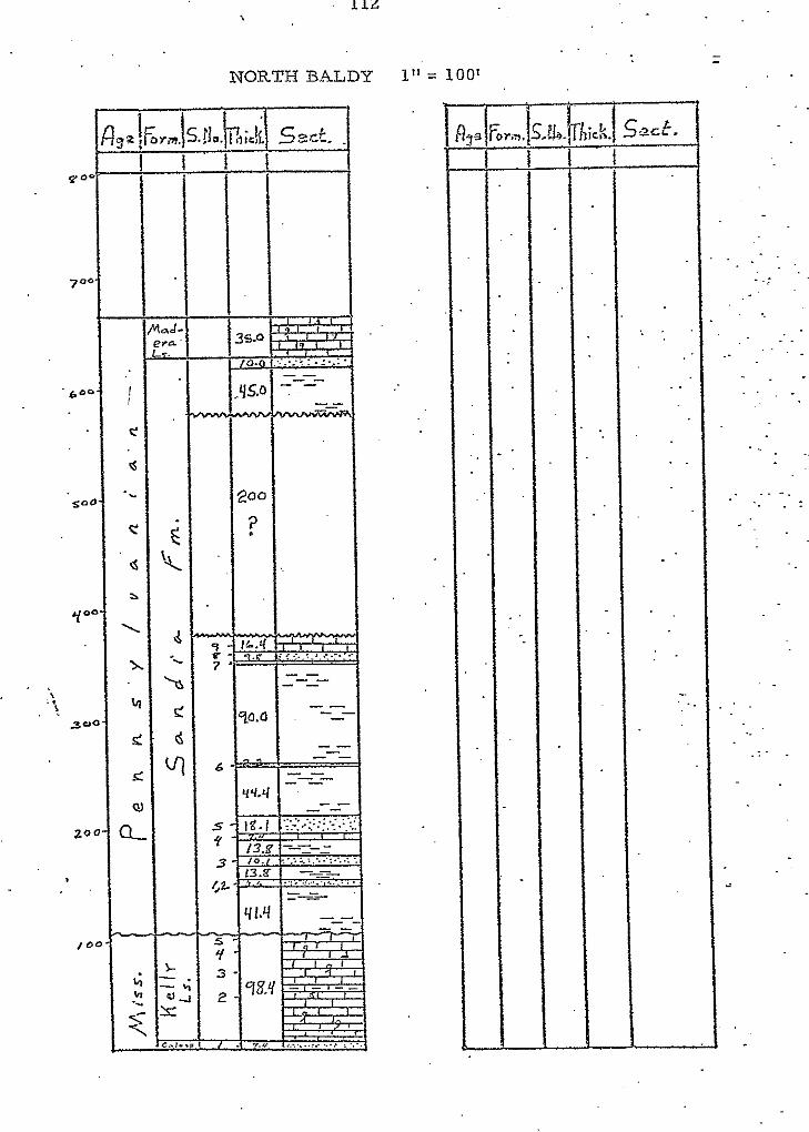
112
NORTH BALDY 1" = 100'
70
' 6"
Y'
'. . !.
3'
2'
I
- II..
*rs
so 7
6
. .
. .
- . .:
. . . .
e o
7 0
6 C
s c
Y'
... 3<
c
113
NORTH FORK CANYON 1" = 100'
114
OLNEY RANCH 1" = 100'
.. .. ..
. - . . "
. .
115
OLNEY RANCH (continued)
E F
C
-
-
........... I ............... :
. . . . . . . . . ............
//O.O
. .
. . .
. .
. . -
_ -
116 .
OLNEY RANCH (continued) . '
..
. .
. .. . . . .
. .
. . . .
.. . . . . .
. .
. .
..
TRES MONTOSAS 1" = 10' ..
I S -
118
I .. APPENDIX II
SEDIMENTARY PETROLOGY
. ...
I
4 n
C1 ay - - % Terr igenous Grains: 90
Quartz I Feldspar
70
Other : Other : -
% Allochems: P e l l e t s
- Oolites
I - -
". ~
F N N - " ~~~ ~ ~ ~
I n t r a c l a s t s L i t h o c l a s t s Composites
Brachiopods - ~
Bryozoans I A l q a e Cora l s
Foraminifera Mollusks '
I-__-..-" -. Sponges c
Ostracods I
_"""""" ~ ~~~ ~
I
% F o s s i l s : - . ? 9.5 7s
Echinoderms A I A """- ~ ~ ~~~ .~ -
. . . .
~ ~~~~ "
I I I . . . . , .
1 I
A
I . . 1
!
I-
o\ N
Composites
? A C a F. Brachiopods
I I % Fossils: - """ 5". /s 10 5 1s 5 5
Bryozoans I ! (Z c R R R A l q a e Corals Echinoderms Foraminifera
"- & R ? R Moilusks ~ R R ?
sponges
- R R c I R R I R
"~
-
I ""
ostracods I I R . . . I
I
a , APPENDIX LII
CLASSIFICATION SYSTEMS
127
r
I
..
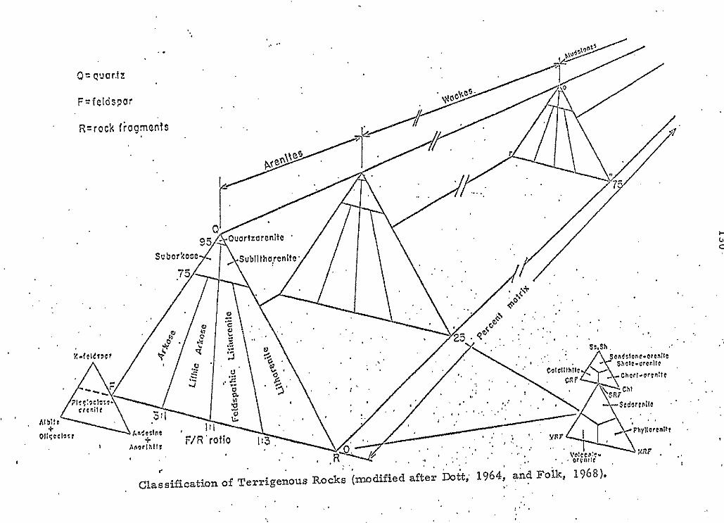
a n
131
- u.s.s:3n- Millimc:ers Phi (c}} tz;d sieve n o h
Wentworlh size class : units
. . . . .
Use wire 40?6 squars
. . . . - 12
256 . . . 255---.." S 102-1 - 10 Boulder
2. w 64 64 - 6 Cobble I > 2 16 - 4 . Pebble i - - v 5 4 4"2 .
6 3.36 " 1.75
8 . ~ 2.35 "
. . . . 7 ' .
. . . . 283 . .- 1.5 , Granule
i ., I .
. . . - 1.25 . .
. 1 2 . 1 ' . '
- . . . . . . , . - :. . .. . . . _ . . . . . 1.6s . ' ~ -. 0.75 _. . . . _ . .
I ' . . . 14, .. 'lai ' : . " - 0.5 . , Vcjwarxstnd 16 . . ,' 1.19 ' ,
. . - 0.25 0.84 : ' ' . 0.25 0.71 ' ' 0.5 . Coarsesand
. .
.. 1 . ' ;;., ,
1.00 . , 1 . 0.0
. 2 s .
. .
30 0.59 . . . . 0.75 .. . ,35
' 0.50 1p 1 a c 4 0 . 0.42 , ' 125 .I . .
II '. 50 :: 45 0.35 : ' 1.5
'. 0.30 ' 1.75 Medium And . . . I
.60 . .
0.25 114 20 2.15 ' 25 Finesand
. . . 70 0.210 80 . 0.177
. .IW 0.G9 2.75
140 0.105 3.25
200 ' . 0.074 233 '
3.75
270 . . ' 0.053
120 0.13 1;s 3.0
QOaS . 3.5 Vcryfinesand '
0.063 1/16 4.0
. 170: . . -
. .. . .
. . ' .. 4.25 '
. .. . . .. .. 3&5 , .
4 0.044
' . 0.037 - - v) 0.031 1/32 5.0
0.0156 1/64 6.0 -....."cdiumsilt-
0.0039 11256 8.0 .-Vcwfinesilt- us2 0.0978 11128
__ Di321:e 7.0 - Fine silt
.or hydro- .
.. 0.0010 ' 9.0 o.ooo9s . . 10.0 Clay 0.000?9 11.0 , meter c
z . o.wo31 . 120 '
. ..
0.0Mi2 13.0 0.00036 14.0
Terminology and class intervals for grade scaIesr
t . h
Classification of cross bedding (after McKee and Weir, 1953),
I
I 0.5 0.7 0.9
.- .-0.3 cm. Thinly laminated ' . -x~ in.
0.3-1.0 , 5 0 - 3 5
Thinly bedded 1-4 . 3-10 Very thinly bedded 3 6 1 1-3 Thickly Iaminnted
- -~ ~ ""
10-so 30-100
_' hlediumly bedded , 5 1 2
.x 1oQ- 3- 1-3 ft. Thickly bedded . '
VCKy thkkiy b d d d - . - .. - ". P.
'Clas'sification of bedding (after Ingram, 1954).
~ -
...
1 ' .' Ang; , Subang; Subrnd. ' Rnd. Well Rnd.. ~.
.. . . < , . . ., .. .* . . . . .
;..L __.._.: R.PU_NDNESS .. ""- . . Classification of sphericity and roundness, , (after Krumbein and Sloss, 1963).
L . . . . . .
1. , . . . . ,
)-.
w N
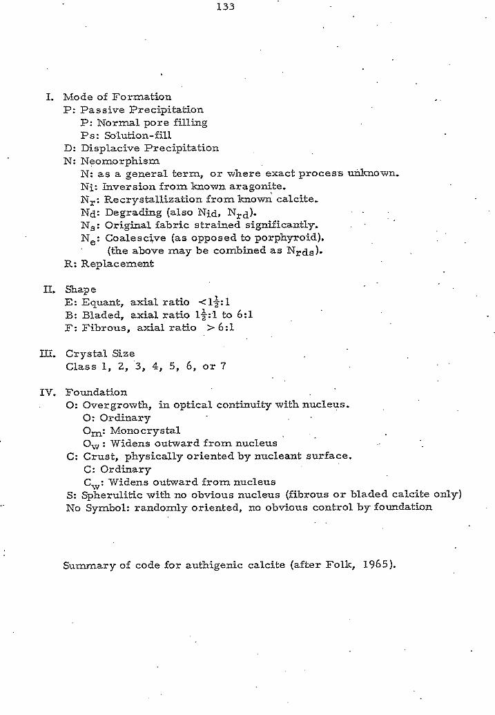
133
I. Mode of Formation P: Passive Precipitation
P: Normal pore f i l l ing Ps: Slution-fill
D: Displacive Precipitation N: Neomorphism
N: as a general term, or where exact proces's unknown. Ni: Inversion from known aragonite. N,: Recrystallization from known calcite. Nd: Degrading (also Nid, Nrd). Ns: Original fabric strained significantly. Ne: Coalescive (as opposed to porphyroid).
(the above may be combined a s N,ds).
. .
R: Replacement
11. Shape E: Equant, axial ratio <1$1 B: Bladed, axial ratio l&l to 6:l F: Fibrous, axial ratio > 6:l
III. Crystal Size Class 1, 2, '3, 4, 5 , 6, o r 7
IV. Foundation 0: Overgrowth, in optical continuity with nucleus.
0: Ordinary Om: Monocrystal 0, : Widens outward from nucleus
C: Ordinary C",: Widens outward from nucleus
C: Crust, physically oriented by nucleant surface.
S: Spherulitic with no obvious nucleus (fibrous o r bladed calcite only) No Symbol: randomly oriented, no obvious control by foundation
,"
Summary of code for authigenic calcite (after Folk, 1965).
3'
3t
31
34
33
32'
6'