streets for cycling 2012 review
TRANSCRIPT
7/27/2019 Streets for Cycling 2012 Review
http://slidepdf.com/reader/full/streets-for-cycling-2012-review 1/84
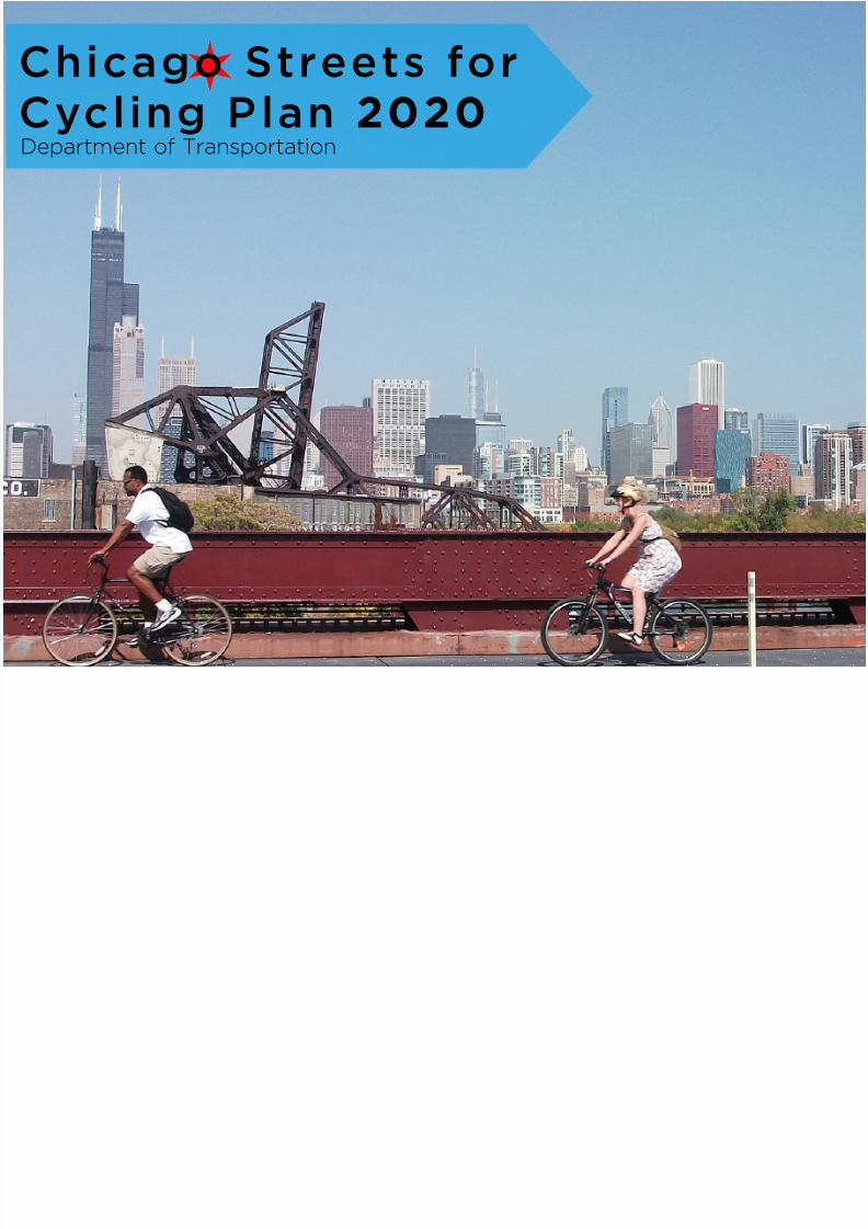
Chicago Streets forCycling Plan 2020Department of Transportation

7/27/2019 Streets for Cycling 2012 Review
http://slidepdf.com/reader/full/streets-for-cycling-2012-review 2/84
2
7/27/2019 Streets for Cycling 2012 Review
http://slidepdf.com/reader/full/streets-for-cycling-2012-review 3/84
Table of ConTenTs
Division Street
Dearborn Street
Introduction from the Mayor and Commissioner 5
Bicycling in Chicago NOW 10
What We Heard 16
2020 Network 22
Making it Happen 46
Appendix 58
3

7/27/2019 Streets for Cycling 2012 Review
http://slidepdf.com/reader/full/streets-for-cycling-2012-review 4/84
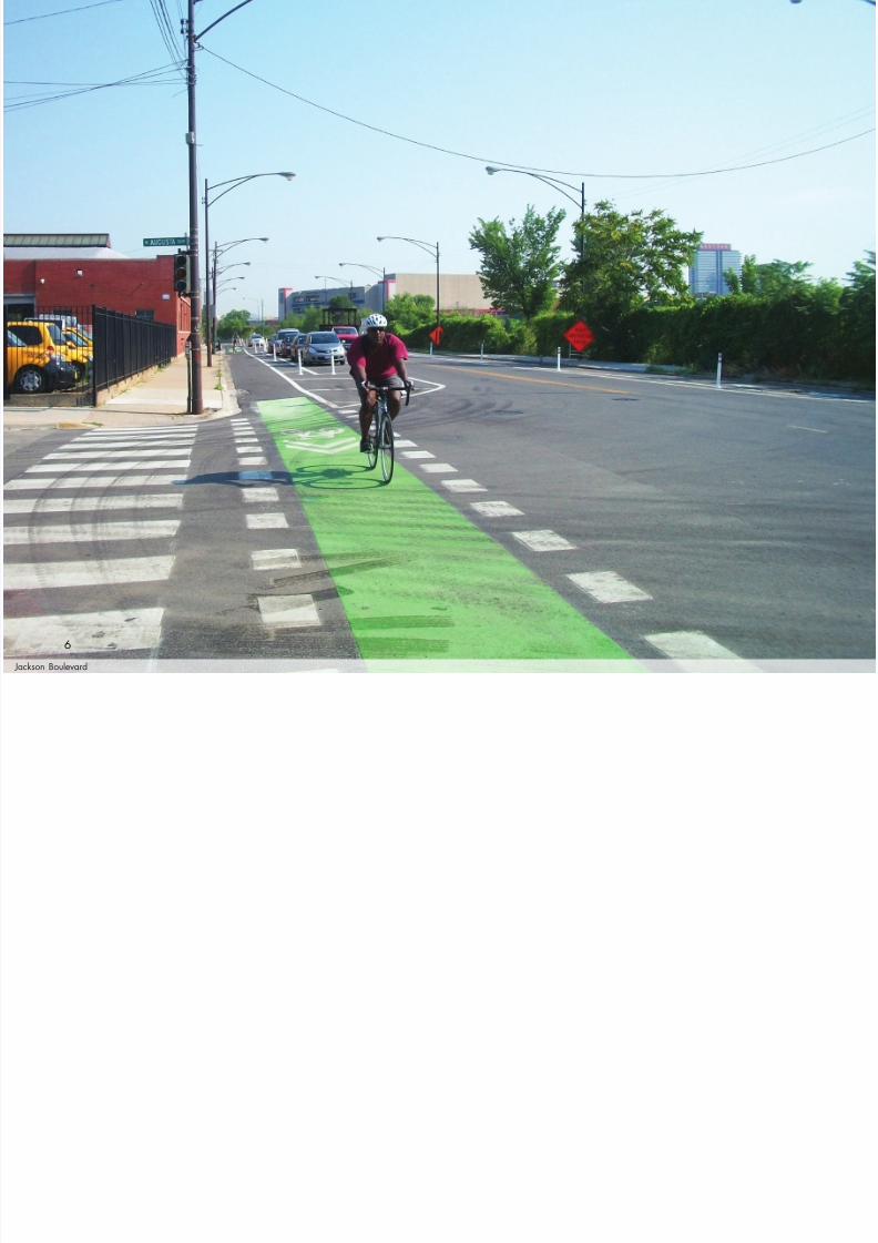
Jackson Boulevard
4

7/27/2019 Streets for Cycling 2012 Review
http://slidepdf.com/reader/full/streets-for-cycling-2012-review 5/84
Dear Fellow Chicagoans,
121 N. LaSalle Street • Chicago, Illinois 60602www.cityofchicago.org• @chicagosmayor
OFFICE OF THE MAYOR
CiTy of ChiCago
Rahm EmanuelMayor
Bicycling is an integral part of Chicago’s transportation system. Every day, thousands of people bike on our streets, whether
it is to ride to work, to the store, or for recreation. As we grow as a city, it is imperative that our streets include safe bicycle
infrastructure that encourages all residents - young, old and in between – to ride their bike. Bicycling is a reliable, fast,
affordable, healthy, and fun form of transportation. Developing this infrastructure will improve the quality of life for all
Chicagoans and will catalyze economic growth in the neighborhoods throughout our City.
My vision is to make Chicago the most bike-friendly city in the United States. The Streets for Cycling Plan 2020 helps bring
this vision to reality by identifying a 645-mile network of on-street bikeways that will encourage all Chicagoans to ridetheir bikes. Over the next few years, we will build more protected bike lanes than any other city in the country, redesign
intersections to ensure they are safer for bicyclists, and improve hundreds of miles of residential streets for bicyclists,
pedestrians, and the people that live on them.
Best of all, these improvements do not just benefit bicyclists. They also benefit pedestrians, transit users, and motorists by
making our streets safer. They will be safer because pedestrians and motorists will have a better knowledge of where and
when to expect to see bicyclists.
I look forward to riding along with the Department of Transportation and the citizens of Chicago as we implement this plan
and transform into the most bike-friendly city in the country.
Sincerely,
5
7/27/2019 Streets for Cycling 2012 Review
http://slidepdf.com/reader/full/streets-for-cycling-2012-review 6/84
Jackson Boulevard
6
7/27/2019 Streets for Cycling 2012 Review
http://slidepdf.com/reader/full/streets-for-cycling-2012-review 7/84
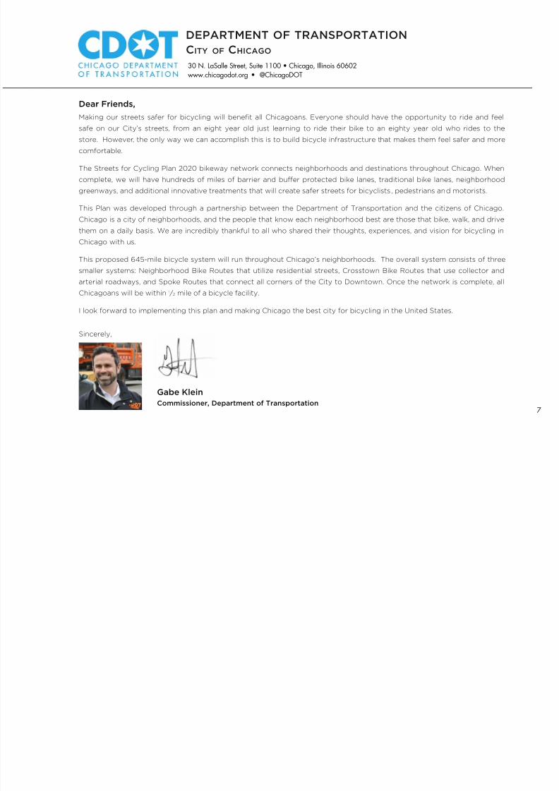
Dear Friends,
30 N. LaSalle Street, Suite 1100 • Chicago, Illinois 60602www.chicagodot.org • @ChicagoDOT
DEPARTMENT OF TRANSPORTATION
CiTy of ChiCago
Gabe KleinCommissioner, Department of Transportation
Making our streets safer for bicycling will benefit all Chicagoans. Everyone should have the opportunity to ride and feel
safe on our City’s streets, from an eight year old just learning to ride their bike to an eighty year old who rides to the
store. However, the only way we can accomplish this is to build bicycle infrastructure that makes them feel safer and more
comfortable.
The Streets for Cycling Plan 2020 bikeway network connects neighborhoods and destinations throughout Chicago. When
complete, we will have hundreds of miles of barrier and buffer protected bike lanes, traditional bike lanes, neighborhood
greenways, and additional innovative treatments that will create safer streets for bicyclists, pedestrians and motorists.
This Plan was developed through a partnership between the Department of Transportation and the citizens of Chicago.
Chicago is a city of neighborhoods, and the people that know each neighborhood best are those that bike, walk, and drive
them on a daily basis. We are incredibly thankful to all who shared their thoughts, experiences, and vision for bicycling in
Chicago with us.
This proposed 645-mile bicycle system will run throughout Chicago’s neighborhoods. The overall system consists of three
smaller systems: Neighborhood Bike Routes that utilize residential streets, Crosstown Bike Routes that use collector and
arterial roadways, and Spoke Routes that connect all corners of the City to Downtown. Once the network is complete, all
Chicagoans will be within 1 ⁄ 2 mile of a bicycle facility.
I look forward to implementing this plan and making Chicago the best city for bicycling in the United States.
Sincerely,
7

7/27/2019 Streets for Cycling 2012 Review
http://slidepdf.com/reader/full/streets-for-cycling-2012-review 8/84
Clark Street
Bicycling will play a critical role in Chicago’s economic future. Itwill help current and future residents traverse the City and attract
new employers. Making bicycling safer and more convenient willincrease bicycling activity which will have positive impacts on thequality of life for the people of Chicago, including:
• Improved physical health
• Reduced transportation costs
• Increased economic development
Chicago’s Streets for Cycling Plan 2020 sets forth a bold blueprint
to implement Mayor Rahm Emanuel’s vision of a world-class bikenetwork in Chicago: the best big city for bicycling in the UnitedStates. The Plan identifies a 645-mile bike network of innovativebikeways that will allow all Chicagoans, from eight years old toeighty and beyond, to feel safe and comfortable bicycling on citystreets.
The Plan’s network was developed using three guiding principles:
• Provide a bicycle accommodation within 1 ⁄2 mile of every
Chicago resident
• Provide a greater number of bikeways where more people live
• Increase the amount of infrastructure where ridership is high,while establishing a strong backbone of infrastructure whereridership is currently lower, but has the potential to grow
A robust public outreach process was conducted, includingcitywide public meetings and community advisory groups. Therecommended network builds on Chicago’s existing on-street
bikeways, which are discussed in the next section.
i n t r o d u c t i o n “The Streets for Cycling
Plan 2020 establishes the
framework for Chicago to
be the most bike friendly
city in the US and will create economic opportunity in
our neighborhoods and
throughout the city”
Mayor Rahm Emanuel
8

7/27/2019 Streets for Cycling 2012 Review
http://slidepdf.com/reader/full/streets-for-cycling-2012-review 9/8455th Street
9

7/27/2019 Streets for Cycling 2012 Review
http://slidepdf.com/reader/full/streets-for-cycling-2012-review 10/84
Dearborn Street
The City’s current bicycle accommodations include over 200 milesof on-street bikeways, 36 miles of trails, and more bike parking (over
12,000 racks) than any other city in the United States. The City has
also completed a number of successful education, encouragement,
and enforcement programs for bicyclists. Bike share will launch in
2013 with 3,000 bikes and 300 bike stations and grow to 4,000
bikes and 400 stations shortly thereafter. These investments, along
with social, economic and environmental factors, have led to a
tremendous increase in bicycling throughout Chicago over the past
decade.
Chicago has also long been recognized as one of the top cities for
bicycling in the United States. In 2001, Bicycling Magazine named
Chicago the Best Big City for Bicycling in the U.S. and in 2012,
again recognized Chicago as the 5th most bicycle-friendly city of
all cities with more than 95,000 residents. Mayor Rahm Emanuel
has committed to creating streets that are safe and comfortable
for bicyclists of all ages and abilities and making Chicago the most
bicycle-friendly city in the country.
This ongoing commitment has led to the percentage of bicycle
commuters in the City of Chicago more than doubling between
2000 and 2010, from 0.5% to 1.3%. While this percentage is higher
than New York (0.8%) or Los Angeles (0.9%), it is less than other
cities such as San Francisco (3.5%) and Portland (6.0%). A crucial
element to increasing bicycling in Chicago, both among commuters
and others, is to provide facilities that make more people feel safe
riding on the street.
bicycling inchicago NOW
10

7/27/2019 Streets for Cycling 2012 Review
http://slidepdf.com/reader/full/streets-for-cycling-2012-review 11/84
1 9 6 0
1 9 7 0
1963Lakefront Trail ofcially designatedas a bike path
2006Bike 2015 Plan released
1991Mayor’s Bicycle AdvisoryCouncil created
2012Chicago is ranked as the fth best
United States city for bicyclingamong cities over 95,000 people
2001Chicago ranked as the bestcity for bicycling among citiesover 1 million people
1971First on-street bike lane in Chicago
1992Bike 2000 Plan released
2004McDonald’s Cycle Center opens
2011First barrier protected bikelane installed on Kinzie Street
1 9 9 0
2 0 0 0
2 0 1 0
11
7/27/2019 Streets for Cycling 2012 Review
http://slidepdf.com/reader/full/streets-for-cycling-2012-review 12/84
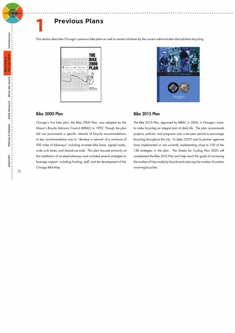
Bike 2000 Plan
Chicago’s rst bike plan, the Bike 2000 Plan, was adopted by theMayor’s Bicycle Advisory Council (MBAC) in 1992. Though the plan
did not recommend a specic network of bicycle accommodations,
its key recommendation was to “develop a network of a minimum of
300 miles of bikeways” including on-street bike lanes, signed routes,
wide curb lanes, and shared-use trails. This plan focused primarily on
the installation of on-street bikeways and included several strategies to
leverage support, including funding, staff, and the development of the
Chicago Bike Map.
This section describes Chicago’s previous bike plans as well as recent initiatives by the current administration that address bicycling.
Bike 2015 Plan
The Bike 2015 Plan, approved by MBAC in 2006, is Chicago’s visionto make bicycling an integral part of daily life. The plan recommends
projects, policies, and programs over a ten-year period to encourage
bicycling throughout the city. To date, CDOT and its partner agencies
have implemented or are currently implementing close to 100 of the
150 strategies in the plan. The Streets for Cycling Plan 2020 will
complement the Bike 2015 Plan and help reach the goals of increasing
the number of trips made by bicycle and reducing the number of crashes
involving bicyclists.
Previous Plans1
A p
p e n d i x
W h a t W e H e
a r d
2 0 2 0 N e t w o r k
M a k i n g I t H a p p e n
I n t r o d
u c t i o n
B i c y c l i n g i n
C h i c a g o N O W
12

7/27/2019 Streets for Cycling 2012 Review
http://slidepdf.com/reader/full/streets-for-cycling-2012-review 13/84
Mayor Emanuel’s Chicago 2011 Transition Plan
The Chicago 2011 Transition Plan includes 55 initiatives to promote growthand increase safety throughout Chicago. These initiatives include “creating
a world-class bike network and increasing cycling” by installing 100 miles
of protected bike lanes by 2015 and other innovative bike accommodations
that encourage all Chicagoans to ride a bike, to “improve street safety using
engineering solutions that will reduce street fatalities and injuries signicantly”,
and implement a “large scale bike share program”.
Chicago Forward
In May 2012, CDOT released its two-year action plan, Chicago Forward.It established the goal of making Chicago the best big city in America for
bicycling and walking and also incorporated the action items of installing 100
miles of protected bike lanes by 2015, installing an additional 10 miles of bike
lanes each year, installing 10 miles of neighborhood greenways by 2015, and
launching bike share.
13

7/27/2019 Streets for Cycling 2012 Review
http://slidepdf.com/reader/full/streets-for-cycling-2012-review 14/84
The Bike 2000 Plan and Bike 2015 Plan have been instrumental
in developing Chicago’s existing network of on-street bicycle
accommodations.
These accommodations have helped increase bicycle ridership across
the city. Bicyclists are seen on Chicago’s streets year round and for a
variety of trip purposes.
With this increased activity, bicycle crashes have also been on the rise.
A comprehensive crash analysis is currently underway to look at where,
when, and how crashes are occurring, who is involved, and how the
crashes can be prevented. The ndings of this report will be used to
design better facilities.
Existing BicyclingConditions2
Bicycling has increased in
Chicago over the last five years at a rate higher than almost
every major city in the United
States. Fortunately, the rate
of crashes has increased at a
much lower rate than ridership
during this same time period.
A p
p e n d i x
W h a t W e H e a r d
2 0 2 0 N e t w o r k
M a k i n g I t H a p p e n
I n t r o d
u c t i o n
B i c y c l i n g i n
C h i c a g o N O W
14

7/27/2019 Streets for Cycling 2012 Review
http://slidepdf.com/reader/full/streets-for-cycling-2012-review 15/84
CHICAGO’s BIKE LANESA QUICK HISTORY
Chicago’s rst on-street bike routes were created by Mayor Richard J. Daley with rush hour bike lanes on both Clark Street and Dearborn Street. But it wasn’t until the mid-1990’s thatChicago got serious about its bike infrastructure. Over the last twenty years, the City has installed over 170 miles of standard bike lanes and marked shared lanes.
In 2011, Chicago installed its rst barrier protected bike lane with a 1/2 mile stretch on Kinze Street. Since that rst installation, CDOT has progressed at an unprecenedented pace to
meet Mayor Emanuel’s initiative of 100 miles of protected bike lanes by May 2015. By the end of 2012, over 13 miles of barrier protected bike lanes and 18 miles of buf fer protected
bike lanes are scheduled to be installed on Chicago’s streets.
NOTE: One mile of bike lane refers toone mile of centerline lane
Bike Lanes: 133 Miles
Barrier Protected BikeLanes: 12 Miles In 2011, CDOT initiated the
installation of barrier andbuffer protected bike lanes inChicago. By 2015 Chicagowill have installed over
of on-street bikeways have been installed onChicago’s streeets over the past twenty years.
of these bike lanes.
100
MILES
200+
Marked SharedLanes: 40 Miles
Buffer Protected BikeLanes: 18 Miles
BIKEWAYS INSTALLED IN C HICAGO
PROTECTED BIKE LANES
MILES 15
7/27/2019 Streets for Cycling 2012 Review
http://slidepdf.com/reader/full/streets-for-cycling-2012-review 16/84
Copernicus Center
Gary Comer Youth Center
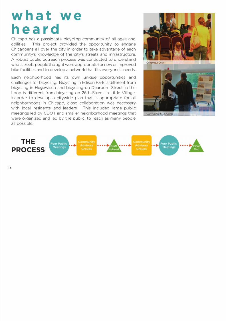
Chicago has a passionate bicycling community of all ages andabilities. This project provided the opportunity to engage
Chicagoans all over the city in order to take advantage of each
community’s knowledge of the city’s streets and infrastructure.
A robust public outreach process was conducted to understand
what streets people thought were appropriate for new or improved
bike facilities and to develop a network that fits everyone’s needs.
Each neighborhood has its own unique opportunities and
challenges for bicycling. Bicycling in Edison Park is different from
bicycling in Hegewisch and bicycling on Dearborn Street in the
Loop is different from bicycling on 26th Street in Little Village.
In order to develop a citywide plan that is appropriate for all
neighborhoods in Chicago, close collaboration was necessary
with local residents and leaders. This included large public
meetings led by CDOT and smaller neighborhood meetings that
were organized and led by the public, to reach as many peopleas possible.
w h a t weh e a r d
16

7/27/2019 Streets for Cycling 2012 Review
http://slidepdf.com/reader/full/streets-for-cycling-2012-review 17/84Sulzer Regional Library
17

7/27/2019 Streets for Cycling 2012 Review
http://slidepdf.com/reader/full/streets-for-cycling-2012-review 18/84
Discussing the Southwest side Viewing videos
Eight public meetings were held to discuss bicycling on Chicago’s streets today,
streets that could have improved facilities, and to get input on the ndings of the
Plan.
Downtown Open House
The outreach process kicked of f in December 2011 with 160 people at a citywide
open house in a pop-up storefront in the Loop hosted by the Chicago Loop
Alliance.
The project team identied nine sections of the city, using barriers such asinterstates, waterways, railways, and arterial roadways as the section borders.
Large maps of each section were posted, allowing participants to draw or
write in destinations, barriers, proposed bicycle routes and other information
and suggestions. The maps also served as a catalyst for discussions between
participants and the project team about the draft Plan and bicycling in Chicago.
The open house included educational videos on protected bike lanes, information
on upcoming CDOT bikeways projects and the Active Transportation Alliance’s
Neighborhood Bikeway Campaign.
Public Meetings1
A p
p e n d i x
W h a t W e H e a r d
2 0 2 0 N e t w o r k
M a k i n g I t H a p p e n
I n t r o d
u c t i o n
B i c y c l i n g i n
C h i c a g o N O W
18

7/27/2019 Streets for Cycling 2012 Review
http://slidepdf.com/reader/full/streets-for-cycling-2012-review 19/84
Woodson Regional Library Douglas Park
Neighborhood Meetings – Existing Conditions
Public meetings were held in early 2012 at the Gareld Park Conservatory,
Woodson Regional Library, and Sulzer Regional Library to formally introduce the
project and obtain input on existing conditions. Each meeting consisted of a
presentation about the project, questions and answers, and mapping activities.The maps focused on the specic area of the city where the meeting was held.
The open house and the initial public meetings provided valuable information on
bicycling in Chicago, including:
• Destinations: The purpose of developing a bike network is to get people
where they want to go (park, school, work, transit, shopping, etc). Participants
made it clear that the network should establish facilities that connect to as
many destinations as possible. Destinations large and small were identied,
from major parks and the Lakefront Trail to corner stores that sell fresh fruit.
• Barriers: Much of the infrastructure that helped build Chicago – access to
water, rail, arterial roadways, interstates – acts as a barrier for bicyclists.
Many viaducts, bridges, and intersections were not designed with bicyclists in
mind, and are difcult to traverse. These trouble spots were identied in the
public outreach process.
• Chicago’s Streets: Participants talked about streets they currently use, and
streets they would like to bike on if they felt comfortable or safe doing so.
Neighborhood Meetings – Revealing the Network
After the draft network was developed, four public meetings were held in the
spring of 2012 at the Copernicus Center, Gary Comer Youth Center, Douglas
Park, and the Inland Steel Building to receive comments on the draft network.
Participants provided additional suggestions and the network was revised, where
appropriate, based on these comments.
19

7/27/2019 Streets for Cycling 2012 Review
http://slidepdf.com/reader/full/streets-for-cycling-2012-review 20/84
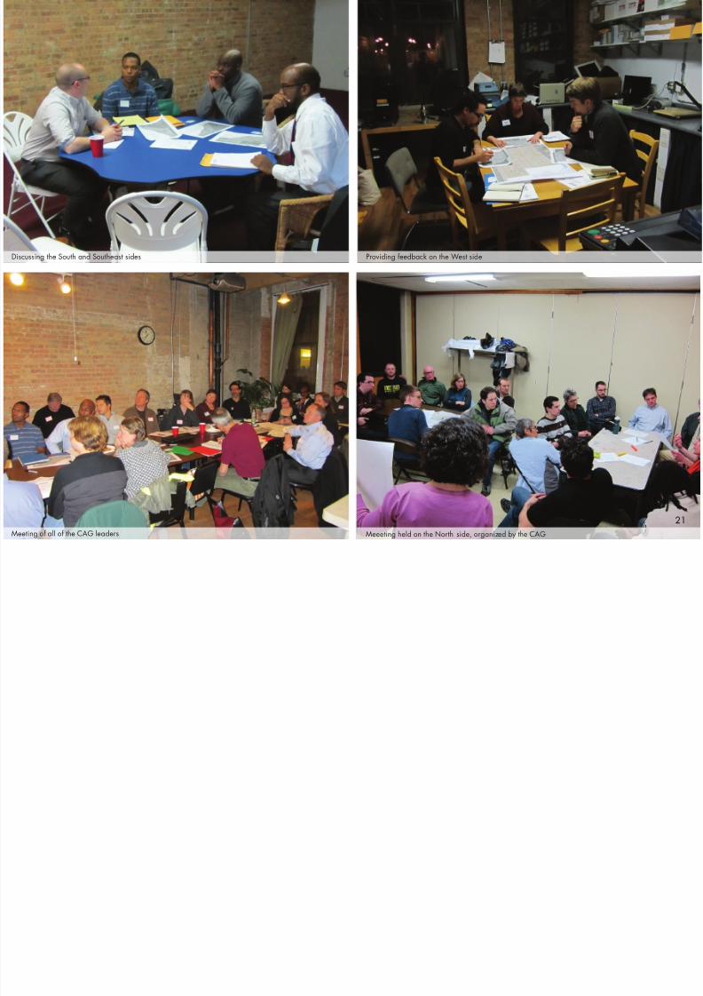
Community AdvisoryGroups2
Identifying a comprehensive bicycle network in a city the size of
Chicago requires more information than could be gained at a few large
neighborhood meetings alone. In an effort to gather as much input as
possible, and to tap into the local knowledge held by Chicagoans who
have been bicycling for years, nine Community Advisory Groups (CAGs)
were formed in separate sections of the city. Each CAG consisted of two
or three volunteer leaders who organized monthly meetings to obtain
input on each phase of the project.
The CAGS were asked to identify the best streets for future on-street
bikeways in their section of the city. For six months, the CAGs met at
local coffee shops, restaurants, and residences to discuss destinations,
barriers, and streets that should be included in the plan.
This process was a tremendous success. Over 200 people attended
and participated in at least one CAG meeting. The CAGs attracted
people who wanted greater involvement in the planning process than
simply attending a public meeting as well as people who could not or
did not want to attend the larger neighborhood meetings. The success
of the CAGs was directly due to the leaders of each group and the
considerable amount of time and effort that they volunteered to. The
input from the CAGs ensured that the Plan would reect the desires of the
local communities throughout the City.
A p
p e n d i x
W h a t W e H e a r d
2 0 2 0 N e t w o r k
M a k i n g I t H a p p e n
I n t r o d
u c t i o n
B i c y c l i n g i n
C h i c a g o N O W
2020
7/27/2019 Streets for Cycling 2012 Review
http://slidepdf.com/reader/full/streets-for-cycling-2012-review 21/84Meeeting held on the North side, organized by the CAGMeeting of all of the CAG leaders
Discussing the South and Southeast sides Providing feedback on the West side
21
7/27/2019 Streets for Cycling 2012 Review
http://slidepdf.com/reader/full/streets-for-cycling-2012-review 22/84
2020 networkChicago’s current network of bikeways has encouraged thousands of residents to bike,whether it is to work, to the park, or to the store. However, this network of bike lanes andmarked shared lanes only appeals to a small segment of the population that feels safe ridingnext to moving motor vehicle traffic. To encourage greater ridership, bikeways that make
people feel safer and more comfortable are necessary.
Chicago’s current bike network does not provide enough protection and perceived safetyto encourage “interested, but concerned” people to ride on street, whether it’s for work,shopping, or fun (see following page).
The purpose of the Streets for Cycling Plan 2020 network is to develop a comprehensivenetwork of bikeways that attracts riders of all ages, from 8 to 80, and abilities. It was developedusing three key principles:
1. Provide a bicycle accommodation within 1 ⁄2 mile of every Chicagoan. The network
should achieve the Bike 2015 Plan’s goal of having a bicycle accommodation within 1 ⁄2mile of every Chicagoan. These accommodations should connect to the destinationsidentified in the public input phase of the planning process.
2. Provide a greater number of bikeways where more people live. Ridership is thekey criterion for evaluating the success of bicycle infrastructure. The need to provideaccommodations on a citywide basis was balanced with an analysis of residential andemployment density.
3. Increase the amount of infrastructure where ridership is high, while establishing a
strong backbone of infrastructure where ridership is currently lower. Building a citywidenetwork means providing accommodations and connections in all neighborhoods, fromRogers Park to Altgeld Gardens. The network identifies new bicycle infrastructure for allneighborhoods. The Streets for Cycling Plan 2020 network meets the needs of an eightyear old just learning to ride a bike, an eighty year old that rides to the park, the commuterwho rides 10 miles to the Loop every day for work, and everyone in between.
This is accomplished through the designation of three route types that together build theStreets for Cycling Plan 2020 network. These three sets of routes – Neighborhood Routes,Crosstown Routes, and Spoke Routes–total 645 miles in length. A description of each routetype, as well as the hierarchy of bike accommodations to be considered for each individual
route, follows.
ROUTE CLASSIFICATIONS
Neighborhood Bike Routes
Crosstown Bike Routes
Spoke Routes
NETWORK MAPS
Overall
Section 1: Far Southwest
Section 2: Far South
Section 3: Southwest
Section 4: South
Section 5: Near Southwest
Section 6: Near South
Section 7: West
Section 8: Central
Section 9: Northwest
Section 10: North
22

7/27/2019 Streets for Cycling 2012 Review
http://slidepdf.com/reader/full/streets-for-cycling-2012-review 23/84
TYPES OF BICYCLISTS
The City of Portland, Oregon conducted a study of its population to better understand why people ride or don’t ride their bicycle. The number one reasonpeople do not ride their bike is because they don’t feel safe sharing the road with motorists. The results of the survey led to the conclusion that there arefour distinct types of people who ride bikes in Portland.
Interested but Concerned 60%
The majority of the population is interestedin riding their bike, whether for work, fun,or errands, but are concerned about thesafety of riding in trafc. This includesfamily, children, and seniors. Building saferfacilities will encourage this portion of the
population to ride their bike.
Enthused and Confident 6%
The enthused and condent population feelssafe riding their bike on most of Chicago’sstreets, but particularly those with somesort of bike accomodation, whether it isbike lanes or marked shared lanes. Manyexisting bicycle commuters t within thissegment.
The strong and fearless individual issomeone who will ride their bike regardlessof the roadway conditions. This segmentof the population is who many peoplepicture as the “typical” bicyclist. Less than1 percent of the population likely ts intothis category.
Strong and Fearless <1%
No Way No How 33%
There is also a portion of the populationthat has no desire to ride their bike on-street, regardless of the types of facilitiesprovided. This represents about a third of the population.
23

7/27/2019 Streets for Cycling 2012 Review
http://slidepdf.com/reader/full/streets-for-cycling-2012-review 24/84
A p p e n d i x
W h a t W e H e a r d
2 0 2 0 N e t w o r k
M a k i n g I t H a p p e n
I n t r o d
u c t i o n
B i c y c l i n g i n
C h i c a g o N O W
57th Street
Hamlin Avenue
1 Neighborhood BikeRoutes
Chicago has thousands of miles of residential streets. Most of thesestreets have low trafc volumes and speeds; therefore, these streets areideal for encouraging more active uses.
Neighborhood Bike Routes are quiet, mostly residential streets thatconnect to local destinations, such as neighborhood retail, parks,schools, and transit. Most of these streets are already “low stress” bikeroutes. The amount of new infrastructure required may vary route to routewith some requiring few changes and others requiring considerablymore. The characteristics of Neighborhood Bike Routes include:
• Low vehicular trafc speeds and volumes
• Minimal bus routes
• Residential/neighborhood retail land uses
• Intersection treatments at major crossings to assist bicyclists acrossthe street
Neighborhood Bike Routes will require a great deal of sensitivity andoutreach during the design process to ensure contextually appropriatesolutions for each neighborhood. Specic bike accommodations will bedetermined through the design and implementation stages of the plan,
and the feasibility of the following improvements will be considered, inorder of priority:
• Neighborhood greenways (preferred treatment)
• Barrier protected bike lanes
• Buffer protected bike lanes
• Bike lanes or marked shared lanes
• Signed bike routes
24

7/27/2019 Streets for Cycling 2012 Review
http://slidepdf.com/reader/full/streets-for-cycling-2012-review 25/84
NEIGHBORHOOD BIKE ROUTES:BEST PRACTICES
The goal of Neighborhood Bike Routes is to create slow, safe streets thatwill in turn be low stress bikeways. Neighborhood Bike Routes will bedesigned in close collaboration with the neighbors who live on thesestreets. Each Neighborhood Bike Route will require a unique design,and what is appropriate in one neighborhood may not work in another.
There are several ways in which neighborhood streets can be improvedfor bicycling:
The City of Montreal installsbarrier protected bike lanes onsome residential streets. Thesecan be one-way or two-waybarrier protected bike lanes.There is typically no separationbetween the bike lane and theparking lane.
New York City installs standardbike lanes on one-way residentialstreets throughout Brooklyn.
While many of these streets wereprobably adequate for bicyclingalready, the bike lane providesdedicated space for bicyclistsand may reduce trafc speeds.As of 2012, there are only tworesidential streets in Chicagowith bike lanes striped on them.
Portland has focused on making residential streets safer forbicyclists and pedestrians by building a network of neighborhoodgreenways (sometimes referred to as bicycle boulevards).Neighborhood greenways prioritize bicyclist and pedestrian safetyby utilizing a variety of trafc calming treatments to discourage cutthrough motor vehicle trafc and to reduce motor vehicle speeds.By 2015, over 80% of Portland residents will live within 1/2 mile of a neighborhood greenway
MONTREAL BARRIER PROTECTED BIKE LANES
PORTLANDNEIGHBORHOOD GREENWAYS BROOKLYN BIKE LANES
25

7/27/2019 Streets for Cycling 2012 Review
http://slidepdf.com/reader/full/streets-for-cycling-2012-review 26/84
A p p e n d i x
W h a t W e H e a r d
2 0 2 0 N e t w o r k
M a k i n g I t H a p p e n
I n t r o d
u c t i o n
B i c y c l i n g i n
C h i c a g o N O W
55th Street
Crosstown Bike Route Rendering
Crosstown BikeRoutes
Chicago’s 1,000 miles of collector and ar terial streets serve as connections
for motorists, transit users, and bicyclists. They have higher trafc volumes
than neighborhood streets, and typically have trafc signals at major
intersections. The routes allow more direct connections to destinations
and will help facilitate longer trips for bicyclists.
Crosstown Bike Routes are long, continuous routes that get bicyclists
across Chicago. These routes are located on collector and arterial streets
and connect neighborhoods, major destinations, and Neighborhood Bike
Routes. The majority of Chicago’s protected bike lanes will be located on
Crosstown Bike Routes.
Crosstown Bike Routes typically have the following characteristics:
• Lead to major destinations
• Travel through a range of land uses
• Higher vehicular trafc speeds and volumes
• Bus routes
Specic bike accommodations will be determined through the design and
implementation stages of the plan, and the feasibility of the following
improvements will be considered, in order of priority:
• Barrier protected bike lanes (preferred treatment)
• Two-way barrier protected bike lanes
• Buffer protected bike lanes
• Bike lanes or marked shared lanes
2
26

7/27/2019 Streets for Cycling 2012 Review
http://slidepdf.com/reader/full/streets-for-cycling-2012-review 27/84
CROSSTOWN BIKE ROUTES:Case Study: Elston AvenueElston Avenue is identified as a Crosstown Bike Route for its entire length (approximately9.5 miles) in the Streets for Cycling Plan 2020. Elston is a popular commuter route for
bicyclists riding to the Loop and there are standard bike lanes on its entire length.
The southernmost segment of Elston, between Milwaukee Avenue and North Avenue,
consists of industrial land uses with truck traffic comprising 21% of all traffic during peak
periods. Motorist speeds are also high, with 60% of motorists traveling faster than the
posted speed and 5% traveling faster than 40mph.
To separate bicyclists from the high truck traffic and the fast moving motor vehicle traffic,
and to reduce vehicle speeds to create a safer roadway for all users, CDOT upgradedthe existing bike lanes between Milwaukee Avenue and North Avenue to barrier and
buffer protected bike lanes in the spring of 2012. Parking was consolidated to one side
of the street in areas where it was lightly used to provide room for barrier protected
bike lanes. This required direct outreach and negotiation with the adjacent businesses
and the industrial council representing the businesses. At locations with residential and
commercial land uses, on-street parking could not be removed so buffer protected bike
lanes were installed.
After installation of the enhanced bikeways bicycle ridership increased by 49% in themorning peak period and 62.5% in the afternoon. The project also resulted in slower and
safer motorist speeds. The location of several bollards was modified after installation
to ease turning movements for trucks and worked directly with business owners to find
solutions for parking and loading.
The design and implementation of future Crosstown Bike Routes will follow a similar
process. The highest bicycle accommodation possible will be built dependent on existing
motor vehicle traffic, parking situations and land uses adjacent to each route. Crosstown
Bike Routes will be a combination of barrier protected bike lanes, buffer protected bikelanes, standard bike lanes, and marked shared lanes. AFTER
BEFORE
27
7/27/2019 Streets for Cycling 2012 Review
http://slidepdf.com/reader/full/streets-for-cycling-2012-review 28/84
A p p e n d i x
W h a t W e H
e a r d
2 0 2 0 N e t w o r k
M a k i n g I t H a p p e n
I n t r o d u c t i o n
B i c y c l i n g i n
C h i c a g o N O W
Spoke Route Rendering
Lake Street
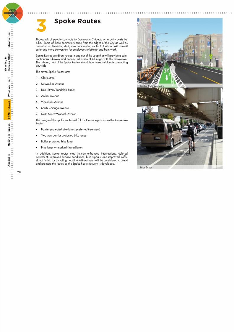
3 Spoke Routes
Thousands of people commute to Downtown Chicago on a daily basis by
bike. Some of these commuters come from the edges of the City as well asthe suburbs. Providing designated commuting routes to the Loop will make itsafer and more convenient for employees to bike to and from work.
Spoke Routes are direct routes in and out of the Loop that will provide a safe,continuous bikeway and connect all areas of Chicago with the downtown.The primary goal of the Spoke Route network is to increase bicycle commutingcitywide.
The seven Spoke Routes are:
1. Clark Street
2. Milwaukee Avenue
3. Lake Street/Randolph Street
4. Archer Avenue
5. Vincennes Avenue
6. South Chicago Avenue
7. State Street/Wabash Avenue
The design of the Spoke Routes will follow the same process as the Crosstown
Routes:• Barrier protected bike lanes (preferred treatment)
• Two-way barrier protected bike lanes
• Buffer protected bike lanes
• Bike lanes or marked shared lanes
In addition, spoke routes may include enhanced intersections, coloredpavement, improved surface conditions, bike signals, and improved trafcsignal timing for bicycling. Additional treatments will be considered to brand
and promote the routes as the Spoke Route network is developed.
28

7/27/2019 Streets for Cycling 2012 Review
http://slidepdf.com/reader/full/streets-for-cycling-2012-review 29/84
SPOKE ROUTES: BEST PRACTICES
Spoke Routes provide continuous on-street bike accommodations between the Loop and
the city limits. Two European cities have implemented similar routes to accommodate
longer commutes and increase bicycling.
Copenhagen recently installed
its rst bicycle superhighway,
the rst of 26 routes that arescheduled to be built. The
bicycle superhighways connect
to Copenhagen’s suburbs and
are intended for longer rides.
Features include air pump
stations, trafc signals timed so
bicyclists travelling a specic
speed do not have to stop,
digital user counters, smooth
surfaces, and other innovative
features to encourage longer
rides.
The Barclays Cycle Superhighways are routes that connect the
outer portions of London with central London. Four Barclays
Cycle Superhighways are completed to date and another eight
will be completed by 2015. These routes are designated by
their blue color and the bike lane treatments vary from location
to location. Bicycling has increased by approximately 70% on
these routes.
COPENHAGENBICYCLE SUPERHIGHWAY
LONDONBARCLAYS CYCLE SUPERHIGHWAYS
29

7/27/2019 Streets for Cycling 2012 Review
http://slidepdf.com/reader/full/streets-for-cycling-2012-review 30/84
A p p e n d i x
W h a t W e H
e a r d
2 0 2 0 N e t w o r k
M a k i n g I t H a p p e n
I n t r o d u c t i o n
B i c y c l i n g i n
C h i c a g o N O W
A p p e n d i x
W h a t W e H
e a r d
2 0 2 0 N e t w o r k
M a k i n g I t H a p p e n
I n t r o d u c t i o n
B i c y c l i n g i n
C h i c a g o N O W
South Chicago Avenue
The Streets for Cycling Plan 2020 network is an ambitious proposal for bicycling
in Chicago. It consists of 645 miles of bikeways, including 310 miles of
Neighborhood Bike Routes, 275 miles of Crosstown Bike Routes, and 60 miles of
Spoke Routes.
Several streets already popular for bicycling are included in the network and
additional improvements to these streets and their intersections will make them
safer for everyone. Although a few streets identied are not considered safe
and comfortable for most bicyclists currently, they are necessary for a complete
citywide network and will require considerable modications in order to provide
safe bicycle accommodations. Funding, local support, and willingness toconsiderably change the character of many of these roadways will be required to
implement all of the projects in the Plan.
The following pages display the Streets for Cycling Plan 2020 network. This
network was developed in conjunction with the Community Advisory Groups,
participants at the public meetings, individual aldermen, the Chicago Transit
Authority and the Illinois Department of Transportation.
This is a dynamic plan; adjustments are likely between now and 2020. There will
be opportunities to add bike accommodations to streets not currently included inthe proposed network and land use or trafc changes may make some streets
better for bicycling than they are at present. Changes to the network will also
occur throughout the design and outreach process, such as modifying a route to
avoid a certain intersection.
Network Maps
30

7/27/2019 Streets for Cycling 2012 Review
http://slidepdf.com/reader/full/streets-for-cycling-2012-review 31/84
31

7/27/2019 Streets for Cycling 2012 Review
http://slidepdf.com/reader/full/streets-for-cycling-2012-review 32/84
A p p e n d i x
W h a t W e H
e a r d
2 0 2 0 N e t w o r k
M a k i n g I t H a p p e n
I n t r o d u c t i o n
B i c y c l i n g i n
C h i c a g o N O W
Far Southwest1
32

7/27/2019 Streets for Cycling 2012 Review
http://slidepdf.com/reader/full/streets-for-cycling-2012-review 33/84
Far South2
33

7/27/2019 Streets for Cycling 2012 Review
http://slidepdf.com/reader/full/streets-for-cycling-2012-review 34/84
A p p e n d i x
W h a t W e H
e a r d
2 0 2 0 N e t w o r k
M a k i n g I t H a p p e n
I n t r o d u c t i o n
B i c y c l i n g i n
C h i c a g o N O W
Southwest3
34
S

7/27/2019 Streets for Cycling 2012 Review
http://slidepdf.com/reader/full/streets-for-cycling-2012-review 35/84
South4
35

7/27/2019 Streets for Cycling 2012 Review
http://slidepdf.com/reader/full/streets-for-cycling-2012-review 36/84
A
p p e n d i x
W h a t W e H
e a r d
2 0 2 0 N e t w o r k
M a k i n g I t H a p p e n
I n t r o d u c t i o n
B i c y c l i n g i n
C h i c a g o N O W
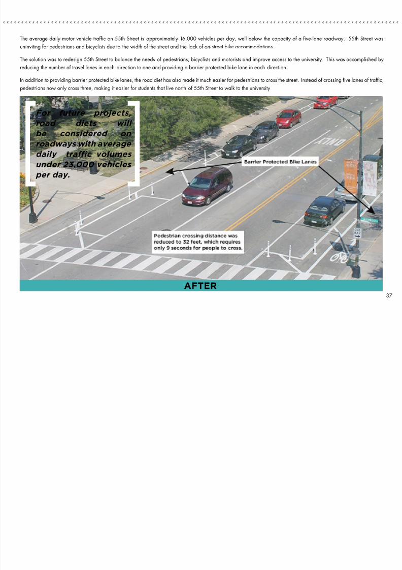
Case Study: 55th StreetBarrier protected bike lanes were installed on 55th Street in the Hyde Park neighborhood, between Cottage Grove Avenue and Dorchester Avenue,
in July 2012. This was accomplished by placing 55th Street on a “ROAD DIET” and using the additional space for the barrier protected bike lanes.
A road diet is a trafc engineering technique that reduces the amount of space for motor vehicles, either through eliminating lanes or shrinking the
width of lanes, and reallocating that space for other uses.
55th Street is the northern boundary of the University of Chicago’s campus. Prior to the project, this stretch of 55th Street was a ve-lane roadway,
with two travel lanes in each direction and a center left-turn lane at some intersections. To the east and west, it is a two-lane roadway.
BEFORE36
7/27/2019 Streets for Cycling 2012 Review
http://slidepdf.com/reader/full/streets-for-cycling-2012-review 37/84
The average daily motor vehicle trafc on 55th Street is approximately 16,000 vehicles per day, well below the capacity of a ve- lane roadway. 55th Street was
uninviting for pedestrians and bicyclists due to the width of the street and the lack of on-street bike accommodations.
The solution was to redesign 55th Street to balance the needs of pedestrians, bicyclists and motorists and improve access to the university. This was accomplished by
reducing the number of travel lanes in each direction to one and providing a barrier protected bike lane in each direction.
In addition to providing barrier protected bike lanes, the road diet has also made it much easier for pedestrians to cross the street. Instead of crossing ve lanes of trafc,
pedestrians now only cross three, making it easier for students that live north of 55th Street to walk to the university
For future projects,
road diets will
be considered on
roadways with average daily traffic volumes
under 23,000 vehicles
per day.
AFTER37

7/27/2019 Streets for Cycling 2012 Review
http://slidepdf.com/reader/full/streets-for-cycling-2012-review 38/84
A
p p e n d i x
W h a t W e H
e a r d
2 0 2 0 N e t w o r k
M a k i n g I t H a p p e n
I n t r o d u c t i o n
B i c y c l i n g i n
C h i c a g o N O W
Near Southwest5
38

7/27/2019 Streets for Cycling 2012 Review
http://slidepdf.com/reader/full/streets-for-cycling-2012-review 39/84
Near South6
39
7/27/2019 Streets for Cycling 2012 Review
http://slidepdf.com/reader/full/streets-for-cycling-2012-review 40/84
A
p p e n d i x
W h a t W e H
e a r d
2 0 2 0 N e t w o r k
M a k i n g I t H a p p e n
I n t r o d u c t i o n
B i c y c l i n g i n
C h i c a g o N O W
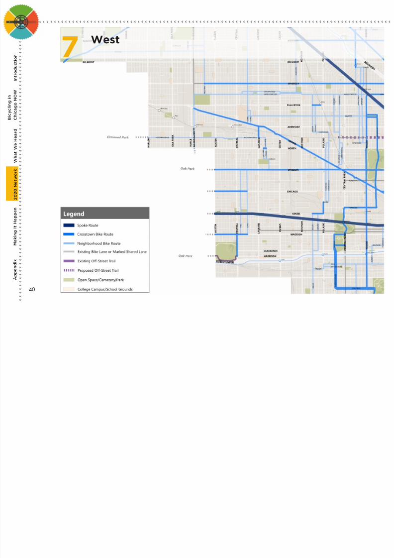
West7
40

7/27/2019 Streets for Cycling 2012 Review
http://slidepdf.com/reader/full/streets-for-cycling-2012-review 41/84
Central
Loop Inset
8
41
7/27/2019 Streets for Cycling 2012 Review
http://slidepdf.com/reader/full/streets-for-cycling-2012-review 42/84
A
p p e n d i x
W h a t W e H
e a r d
2 0 2 0 N e t w o r k
M a k i n g I t H a p p e n
I n t r o
d u c t i o n
B i c y c l i n g i n
C h i c a g o N O W
A
p p e n d i x
W h a t W e H
e a r d
2 0 2 0 N e t w o r k
M a k i n g I t H a p p e n
I n t r o
d u c t i o n
B i c y c l i n g i n
C h i c a g o N O W
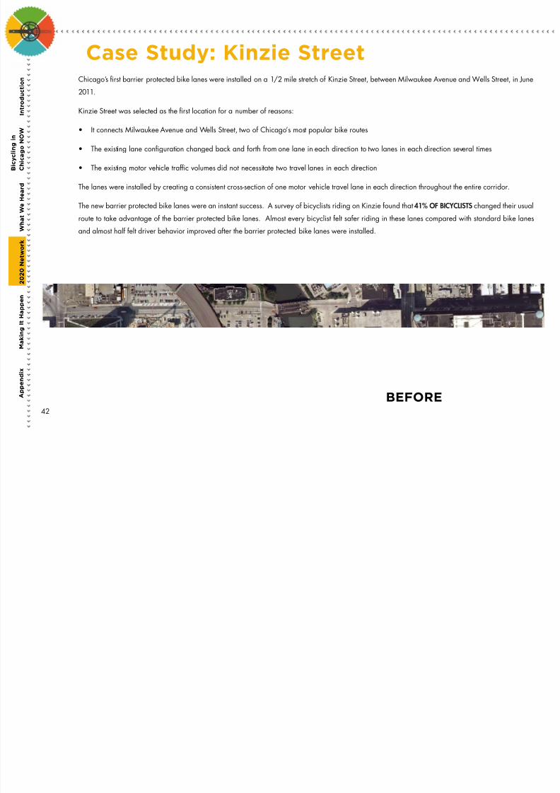
Case Study: Kinzie StreetChicago’s rst barrier protected bike lanes were installed on a 1/2 mile stretch of Kinzie Street, between Milwaukee Avenue and Wells Street, in June
2011.
Kinzie Street was selected as the rst location for a number of reasons:
• It connects Milwaukee Avenue and Wells Street, two of Chicago’s most popular bike routes
• The existing lane conguration changed back and forth from one lane in each direction to two lanes in each direction several times
• The existing motor vehicle trafc volumes did not necessitate two travel lanes in each direction
The lanes were installed by creating a consistent cross-section of one motor vehicle travel lane in each direction throughout the entire corridor.
The new barrier protected bike lanes were an instant success. A survey of bicyclists riding on Kinzie found that 41% OF BICYCLISTS changed their usual
route to take advantage of the barrier protected bike lanes. Almost every bicyclist felt safer riding in these lanes compared with standard bike lanes
and almost half felt driver behavior improved after the barrier protected bike lanes were installed.
BEFORE42
7/27/2019 Streets for Cycling 2012 Review
http://slidepdf.com/reader/full/streets-for-cycling-2012-review 43/84
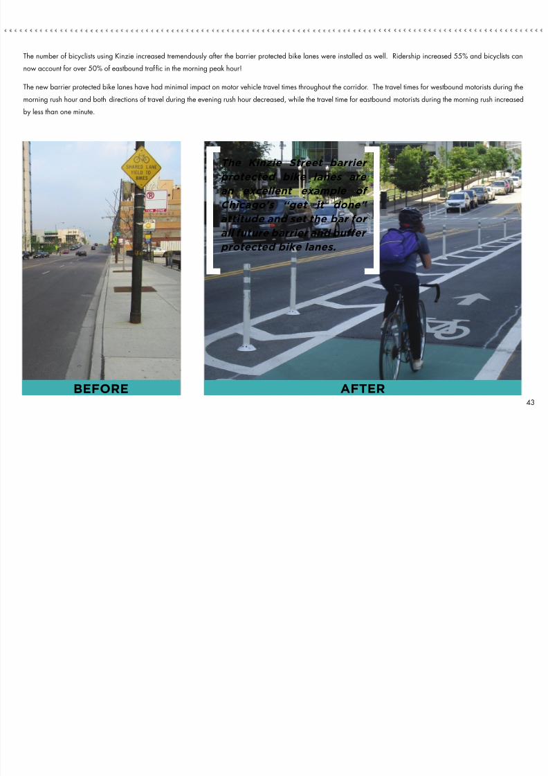
The number of bicyclists using Kinzie increased tremendously after the barrier protected bike lanes were installed as well. Ridership increased 55% and bicyclists can
now account for over 50% of eastbound trafc in the morning peak hour!
The new barrier protected bike lanes have had minimal impact on motor vehicle travel times throughout the corridor. The travel times for westbound motorists during the
morning rush hour and both directions of travel during the evening rush hour decreased, while the travel time for eastbound motorists during the morning rush increasedby less than one minute.
The Kinzie Street barrier
protected bike lanes are
an excellent example of Chicago’s “get it done”
attitude and set the bar for
all future barrier and buffer
protected bike lanes.
AFTERBEFORE43
7/27/2019 Streets for Cycling 2012 Review
http://slidepdf.com/reader/full/streets-for-cycling-2012-review 44/84
A
p p e n d i x
W h a t W e H
e a r d
2 0 2 0 N e t w o r k
M a k i n g I t H a p p e n
I n t r o
d u c t i o n
B i c y c l i n g i n
C h i c a g o N O W
Northwest9
44
7/27/2019 Streets for Cycling 2012 Review
http://slidepdf.com/reader/full/streets-for-cycling-2012-review 45/84
North10
45
7/27/2019 Streets for Cycling 2012 Review
http://slidepdf.com/reader/full/streets-for-cycling-2012-review 46/84
m a k i n g i t h a p p e n :i m p l e m e n t a t i o nThe Streets for Cycling Plan 2020 will transform hundreds of miles of Chicago streets sothat Chicago’s youngest and oldest residents will feel safe bicycling on them. Taking thisplan through implementation will require funding from many sources, as well as continuousdesign, outreach, and construction through 2020.
It will also require political leadership, community support and coordination with otheragencies as future projects will require sensitive changes to Chicago’s built environment,including travel lane removals, metered on-street parking removal or establishing bikewayson state or county jurisdiction roadways. The following milestones lay the framework forChicago to establish the most ambitious on-street bikeway network in the United States.
By 2015:
• 100 miles of protected bike lanes
• 10 miles of neighborhood greenways
• 20 miles of bike lanes on Neighborhood Bike Routes
• Continuous bikeways on three Spoke Routes
By 2020:
• Continuous bikeways on all Spoke Routes
• An additional 50 miles of protected bike lanes
• An additional 30 miles of neighborhood greenways
• An additional 40 miles of bike lanes on Neighborhood Bike Routes
• Mark and/or sign all Neighborhood Bike Routes
These milestones propose over 500 hundred miles of new on-street bikeways over thenext eight years. This is a dynamic plan, and not all of the routes identified in the networkwill be constructed by 2020. Routes will be refined, projects will be deemed unfeasiblefor various reasons, new opportunities will arise, and some bikeways will need additionalimprovements.
TABLE OF CONTENTS
1. Phasing
2. Funding
3. Maintenance
46

7/27/2019 Streets for Cycling 2012 Review
http://slidepdf.com/reader/full/streets-for-cycling-2012-review 47/84
55th Street
47

7/27/2019 Streets for Cycling 2012 Review
http://slidepdf.com/reader/full/streets-for-cycling-2012-review 48/84
Roscoe Street
Implementation of the network will occur in three stages:
PHASE ONE will run through 2015 and primarily consist of building
100 miles of protected bike lanes as well as the rst 10 miles
of neighborhood greenways. The list of Phase One projects is
described on the following pages.
PHASE TWO will largely implement the remainder of the network
through 2020. This will include an additional 50 miles of protected
bike lanes and a stronger focus on the Neighborhood Bike Routes,
including 30 miles of neighborhood greenways and 40 miles of
bike lanes. Additionally, improvements to make intersections safer
and to improve bicycle accommodations at existing barriers such as
viaducts and bridges will be completed.
PHASE THREE will ll remaining gaps in the network and expand the
number of bikeways in many neighborhoods that do not currently
experience much bicycling activity. The Plan will be updated in
2018 to assess the impact of all of the new bicycling facilities and
make recommendations for Phase Three of implementation.
The projects listed on the following pages are subject to change
and may require approvals from agencies outside of CDOT.
Phasing1
A
p p e n d i x
W h a t W e H
e a r d
2 0 2 0 N e t w o r k
M a k i n g I t H a p p e n
I n t r o
d u c t i o n
B i c y c l i n g i n
C h i c a g o N O W
48

7/27/2019 Streets for Cycling 2012 Review
http://slidepdf.com/reader/full/streets-for-cycling-2012-review 49/84
May 2011 - May 2012 Completed Projects
Jackson Boulevard
18th Street
Route Street From To
Spoke Routes Wabash 18th Roosevelt
18th Canal State
Jackson Western Ogden
Kinzie Milwaukee WellsCrosstown BikeRoutes
49

7/27/2019 Streets for Cycling 2012 Review
http://slidepdf.com/reader/full/streets-for-cycling-2012-review 50/84
Route Street From To
Clark Oak North
Clark Diversey Addison
Dearborn Polk Kinzie
Desplaines Randolph Kinzie
Lake Central Park Damen
Milwaukee Kinzie Elston
South Chicago Baltimore 79th
Wabash Roosevelt Harrison
Vincennes 103rd 84th
31st Wells LSD
55th Cottage Grove Lake Park
Broadway Montrose Foster
Campbell/Roscoe Belmont DamenClybourn Division Belmont
Damen 63rd 51st
Desplaines Roosevelt Randolph
Division California Western
Elston Milwaukee North
Franklin Madison Wacker
Franklin Sacramento Central Park
Halsted 75th 69th
Halsted Garfield 39th
Halsted 26th Harrison
Halsted Division North
Halsted Diversey Wellington
Jackson Central Park Independence
Jackson Ogden Halsted
King Drive 51st 26th
Kinzie Wells Dearborn
Wabash Cermak 18th
Wells Van Buren North
West SideBoulevards
Douglas Park Garfield Park
NeighborhoodBike Routes
Berteau Lincoln Clark
Spoke Routes
Crosstown BikeRoutes
May 2012 - May 2013Completed and Planned Projects
A
p p e n d i x
W h a t W e H
e a r d
2 0 2 0 N e t w o r k
M a k i n g I t H a p p e n
I n t r o
d u c t i o n
B i c y c l i n g i n
C h i c a g o N O W
50
7/27/2019 Streets for Cycling 2012 Review
http://slidepdf.com/reader/full/streets-for-cycling-2012-review 51/84
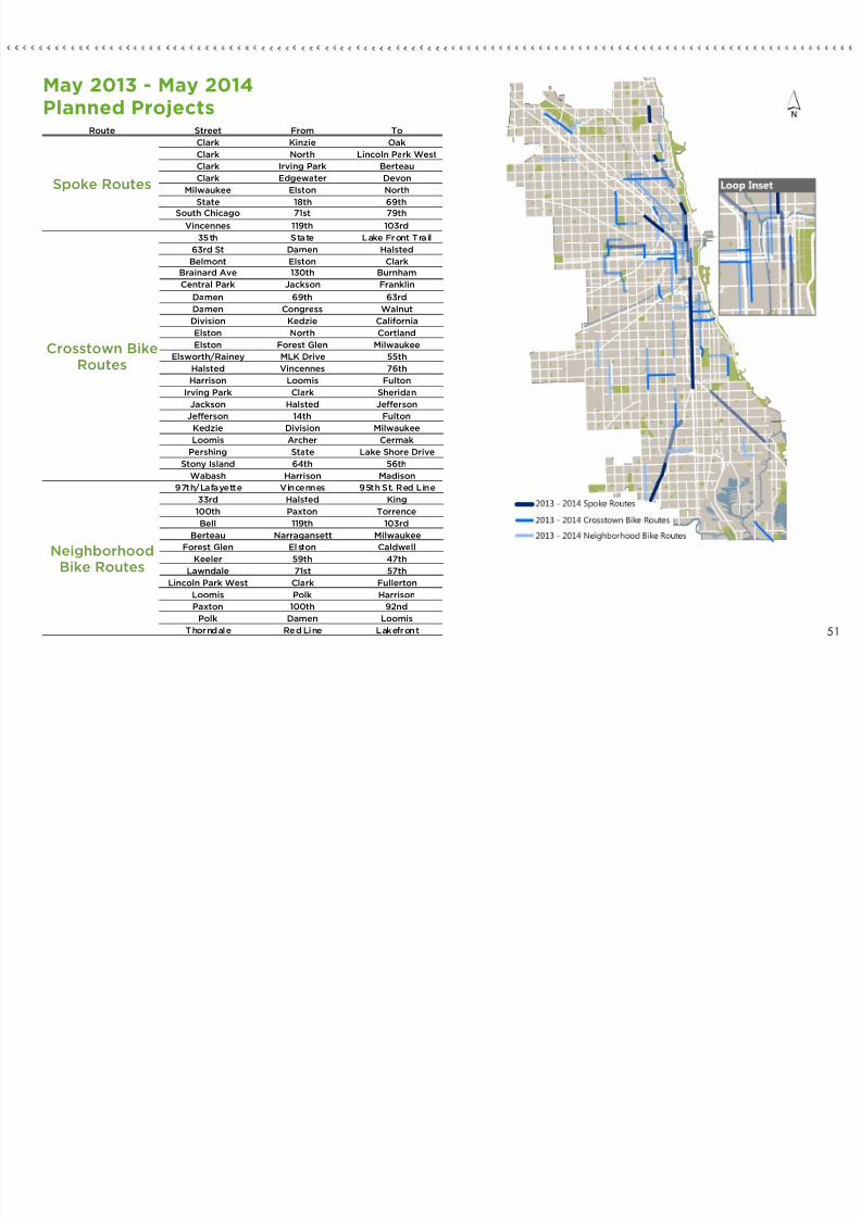
May 2013 - May 2014Planned Projects
Route Street From To
Clark Kinzie Oak
Clark North Lincoln Park West
Clark Irving Park Berteau
Clark Edgewater Devon
Milwaukee Elston North
State 18th 69th
South Chicago 71st 79th
Vincennes 119th 103rd
35th State Lake Front Trail
63rd St Damen Halsted
Belmont Elston Clark
Brainard Ave 130th Burnham
Central Park Jackson Franklin
Damen 69th 63rd
Damen Congress WalnutDivision Kedzie California
Elston North Cortland
Elston Forest Glen Milwaukee
Elsworth/Rainey MLK Drive 55th
Halsted Vincennes 76th
Harrison Loomis Fulton
Irving Park Clark Sheridan
Jackson Halsted Jefferson
Jefferson 14th Fulton
Kedzie Division Milwaukee
Loomis Archer Cermak
Pershing State Lake Shore Drive
Stony Island 64th 56th
Wabash Harrison Madison
97th/Lafayette Vincennes 95th St. Red Line
33rd Halsted King
100th Paxton Torrence
Bell 119th 103rd
Berteau Narragansett Milwaukee
Forest Glen Elston Caldwell
Keeler 59th 47th
Lawndale 71st 57th
Lincoln Park West Clark Fullerton
Loomis Polk Harrison
Paxton 100th 92ndPolk Damen Loomis
Thorndale Red Line Lakefront
NeighborhoodBike Routes
Spoke Routes
Crosstown BikeRoutes
51

7/27/2019 Streets for Cycling 2012 Review
http://slidepdf.com/reader/full/streets-for-cycling-2012-review 52/84
May 2014 - 2015 Planned Projects
A
p p e n d i x
W h a t W e H e a r d
2 0 2 0 N e t w o r k
M a k i n g I t H a p p e n
I n t r o
d u c t i o n
B i c y c l i n g i n
C h i c a g o N O W
52
Route Street From To
Clark Lincoln Park West Belden
Clark Peterson Devon
Randolph Desplaines Lake Shore Drive
Milwaukee North Logan
Vincennes 84th 69th
71st Pulaski California
76th Kostner Pulaski
Adams Desplaines Michigan
Archer Loomis State
Cermak City Limits California
Cottage Grove 93rd 115th
Diversey Long Kostner
Diversey Logan Damen
Division Milwaukee Lake Shore Drive
Elston Belmont LawrenceGrand Kedzie Damen
Harrison Fulton Michigan
Kedzie Pershing 28th
Kedzie Lake Division
Logan Kedzie Diversey
Monroe Desplaines Lake Shore Drive
Pershing Kedzie State
Pulaski 76th 71st
Stony Island South Chicago Marquette
Washington Damen Michigan
92nd/93rd/94th Cottage Grove South Chicago
Belden/Dickens Clybourn Clark
Long Diversey Lawrence
Loomis Cermak Polk
Sawyer 30th Cermak
Spoke Routes
Crosstown BikeRoutes
NeighborhoodBike Routes

7/27/2019 Streets for Cycling 2012 Review
http://slidepdf.com/reader/full/streets-for-cycling-2012-review 53/84
Armitage Avenue
Funding, engineering, and constructing the Streets for Cycling Plan 2020 network
will require collaboration between CDOT and its partners. Presently, there arethree methods to implement projects, as described below.
Federal Funds: The majority of the implementation through the year 2015 will be
funded through a $32 million grant that was provided through the Congestion
Mitigation and Air Quality (CMAQ) Improvement Program, matched by $8 million
in local funds. This will fund the construction of the Phase 1 projects.
Arterial Resurfacing Projects: CDOT’s Arterial Resurfacing (AR) program, funded
in part by the Illinois Department of Transportation, typically resurfaces arterial
streets on an annual basis. As a number of the projects identied in this plan are
on arterial streets, CDOT will coordinate the installation of all types of bikeways
with the AR program.
CDOT’s Bike Program should be involved in the selection and design process for
streets included in the AR program to expedite the implementation of the Plan and
ensure bikeways are included in projects on streets identied in the Plan.
Aldermanic Menu Funding: The Aldermanic Menu Program allocates funding to
each of Chicago’s 50 aldermen on an annual basis (currently $1.32 million per
year). Individual aldermen determine how to spend this money. Aldermen will
continue to be encouraged to assist with the funding of the routes identied in
this Plan.
There is also the opportunity to incorporate bicycle improvements into other
transportation projects. Compared to the overall cost of most transportation
projects, adding bicycle accommodations is very affordable. All projects being
designed in the public way should be reviewed to ensure recommendations from
this Plan are incorporated in the overall project.
Funding2
53
7/27/2019 Streets for Cycling 2012 Review
http://slidepdf.com/reader/full/streets-for-cycling-2012-review 54/84
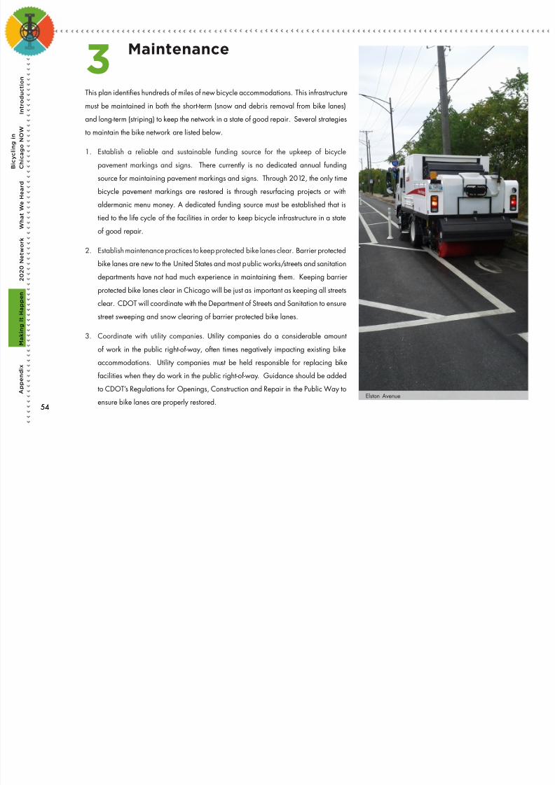
Elston Avenue
This plan identies hundreds of miles of new bicycle accommodations. This infrastructure
must be maintained in both the short-term (snow and debris removal from bike lanes)
and long-term (striping) to keep the network in a state of good repair. Several strategies
to maintain the bike network are listed below.
1. Establish a reliable and sustainable funding source for the upkeep of bicycle
pavement markings and signs. There currently is no dedicated annual funding
source for maintaining pavement markings and signs. Through 2012, the only time
bicycle pavement markings are restored is through resurfacing projects or with
aldermanic menu money. A dedicated funding source must be established that is
tied to the life cycle of the facilities in order to keep bicycle infrastructure in a state
of good repair.
2. Establish maintenance practices to keep protected bike lanes clear. Barrier protected
bike lanes are new to the United States and most public works/streets and sanitation
departments have not had much experience in maintaining them. Keeping barrier
protected bike lanes clear in Chicago will be just as important as keeping all streets
clear. CDOT will coordinate with the Department of Streets and Sanitation to ensure
street sweeping and snow clearing of barrier protected bike lanes.
3. Coordinate with utility companies. Utility companies do a considerable amount
of work in the public right-of-way, often times negatively impacting existing bike
accommodations. Utility companies must be held responsible for replacing bike
facilities when they do work in the public right-of-way. Guidance should be added
to CDOT’s Regulations for Openings, Construction and Repair in the Public Way toensure bike lanes are properly restored.
Maintenance3
A
p p e n d i x
W h a t W e H e a r d
2 0 2 0 N e t w o r k
M a k i n g I t H a p p e n
I n t r o
d u c t i o n
B i c y c l i n g i n
C h i c a g o N O W
5454

7/27/2019 Streets for Cycling 2012 Review
http://slidepdf.com/reader/full/streets-for-cycling-2012-review 55/84
Lake Street
55

7/27/2019 Streets for Cycling 2012 Review
http://slidepdf.com/reader/full/streets-for-cycling-2012-review 56/84
aCknowledgemenTs
Rahm Emanuel, Mayor
Gabe Klein, CDOT Commissioner
CDOT Project Manager
Mike Amsden, TY Lin International
CDOT Senior Staff
Scott Kubly
Luann Hamilton
Ben Gomberg
Consultant Team
Sam Schwartz EnginEEring
Mark de la Vergne
Morgan Whitcomb
Stacey Meekins
Dan Miodonski
JacobS EnginEEring
John Wirtz
mEtro StratEgiES
Laura Wilkison
Karyn Romano
activE tranSportation alliancE
Lee Crandell
John Lankford
alta planning
Craig Williams
Gin Kilgore
Joe Gilpin
mullEr & mullEr, ltd.
Mark Vrba
Kaitlin Streyle
56

7/27/2019 Streets for Cycling 2012 Review
http://slidepdf.com/reader/full/streets-for-cycling-2012-review 57/84
Community Advisory Groups
Central Area: Bob Aiken and Greg Borzo
Far South Side: Anne Alt and Peter TaylorNorth Side: Margo O’Hara and Michelle Stenzel
Northwest Side: Rick Hunter and Alice O’Laughlin
Mid-Southwest Side: Raul Gonzalez and Jen James
South Side: Jason Duba, John Hobson, and Howard Zar
Southeast Side: Derrick James, Frank Madeka, and Oboi Reed
Southwest Side: Demond Drummer and Phil Sipka
West Side: Steven Lane and Johanna Thompson
Contributors
Chris Wuellner
Malihe Samadi
Yadollah Montazery
David Gleason, TY Lin International
Nathan Roseberry, TY Lin International
Bradley Topol, TY Lin International
Dave Smith, TY Lin International
Timothy Garibay, Apex Consulting Engineers, LLC
Ryan Schmitt, Apex Consulting Engineers, LLC
PhoTo CrediTs
All photos are courtesy of the City of Chicago and Sam Schwartz
Engineering, except for the following:
flickr.com users
» Page 25, Portland Neighborhood Greenways, BikePortland.org » Page 25, Montreal Barrier Protected Bike Lanes, MBest324 » Page 25, Brooklyn Bike Lanes, Complete Streets » Page 29, Copenhagen Bicycle Superhighways, SirPecanGum » Page 29, London Barclays Cycle Superhighways, Transport for London
private collections
» Pages 9, 26, 37, and 47: University of Chicago
fronT CoVer
18th Street Barrier Protected Bike Lane
rear CoVer
Jackson Boulevard Barrier Protected Bike Lane
57
Bicycle Facil it ies
7/27/2019 Streets for Cycling 2012 Review
http://slidepdf.com/reader/full/streets-for-cycling-2012-review 58/84
Bicycle Facil it iesGuideStreets for Cycling Plan 2020

7/27/2019 Streets for Cycling 2012 Review
http://slidepdf.com/reader/full/streets-for-cycling-2012-review 59/84
i t d t i

7/27/2019 Streets for Cycling 2012 Review
http://slidepdf.com/reader/full/streets-for-cycling-2012-review 60/84
Elston Avenue
Most Chicagoans have experienced standard bike lanes andmarked shared lanes on city streets since the early 1990’s, butthe bike accommodations included in the Streets for Cycling Plan
2020 are new to the City. It is important that bicyclists, pedestriansand motorists understand how to use the new accommodationsto ensure our streets are safe for all users.
The Streets for Cycling Bicycle Facilities Guide is intended toeducate all Chicagoans on these new bike accommodations. Adescription of each treatment is provided, as well as the benefitsit provides to all roadway users. Instructions are provided forbicyclists and motorists to help both better understand how to
operate safely on the roadway.The Streets for Cycling Bicycle Facilities Guide is not a technicaldesign guide. A number of technical resources will be used todesign these accommodations including the North AmericanCity Transportation Officials Urban Bikeway Design Guide, theupcoming Chicago Department of Transportation Bicycle ProgramDesign Guidelines, the Illinois Department of TransportationBureau of Design & Environment Manual, the Manual on UniformTraffic Control Devices, and the American Association of State
Highway and Transportation Officials Green Book.
Residents, community groups, and leaders will all be able to usethis guide to envision safer streets in their neighborhoods.
i n t r o d u c t i o n “The Streets for Cycling
Plan 2020 establishes the
framework for Chicago to
be the most bike-friendly
city in the US and will create
economic opportunity in
our neighborhoods and
throughout the city”
Mayor Rahm Emanuel
iii
t a b l e o f

7/27/2019 Streets for Cycling 2012 Review
http://slidepdf.com/reader/full/streets-for-cycling-2012-review 61/84
Roscoe Street
t a b l e o fc o n t e n t s1. One-Way Barrier Protected Bike Lanes
2. Two-Way Barrier Protected Bike Lanes
3. Buffer Protected Bike Lanes
4. Neighborhood Greenways
5. Barrier Protected Bike Lanes and
Driveways/Alleys
6. Bicycle Signals
7. Mixing Zones
8. Two-Stage Turn Boxes
9. Intersection Crossing Markings
10. Bike Boxes
iv

7/27/2019 Streets for Cycling 2012 Review
http://slidepdf.com/reader/full/streets-for-cycling-2012-review 62/84
Mixing Zones
Bicycle Signals
One-Way BarrierProtected Bike
Lanes
Buffer Protected
Bike Lanes
Intersection
Crossing Markings
Protected Bike Lanes
and Driveways
Two-Stage
Turn Boxes
Two-Way Barrier
Protected Bike Lanes
Neighborhood
Greenways
Bike Boxes
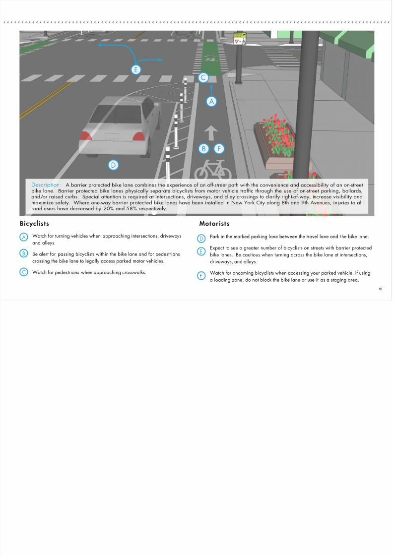
One-Way BarrierProtected Bike Lanes1
Benefi ts :
1. Provide dedicated space for bicyclists in order to increase comfort and
safety.
2. Prevent over-taking crashes.
3. Reduce the risk of dooring crashes and eliminate the risk of a doored
bicyclist being run over by a passing motor vehicle.
4. Prevent double-parking in the bike lane, unlike a standard bike lane.
5. Encourage bicyclists of all ages and abilities to ride.
What MOTORISTS should know:
Streets with barrier protected bike lanes will experience high levels of
bicycling. Take extra care when turning right or left through the bicycle lane
at intersections. Bicyclists may be traveling at high speed; check and double
check before turning through a bicycle lane.
What BICYCLISTS should know:The barrier protected bike lane provides physical separation from motor
vehicles; however, bicyclists should remain alert in potential vehicle conlict
areas and stay vigilant as pedestrians can step out into the bike lane,
particularly when accessing parked vehicles adjacent to the bike lane.
Bicyclists should obey all trafc control devices.
When BARRIER PROTECTED BIKE LANES
can be instal led:
Barrier protected bike lanes are the preferred bicycle
accommodation and will be considered on all streets.
The minimum roadway width for installing barrier
protected bike lanes on roadways with one travel
lane and one parking lane in each direction is 52’.
However, this width present several operational and
maintenance challenges and should only be installed
for short segments at critical locations. The following
should be considered before installing barrier protected
bike lanes on 52’ roadways:
• Bus trafc: Barrier protected bike lanes should
not be installed on 52’ roadways with bus routes.
• Truck trafc: If there is heavy truck trafc on the
roadway, barrier protected bike lanes should not be
installed.
• Maintenance: Special maintenance equipment is
required to clear debris and snow from barrier protected
bike lanes on 52’ roadways.
The preferred minimum roadway width for
barrier protected bike lanes is 58’. The wider bike lane
and buffer space creates a safer and more comfortable
experience for all users and allows for easy maintenance.
v
7/27/2019 Streets for Cycling 2012 Review
http://slidepdf.com/reader/full/streets-for-cycling-2012-review 63/84
Watch for turning vehicles when approaching intersections, driveways
and alleys.
Be alert for passing bicyclists within the bike lane and for pedestrians
crossing the bike lane to legally access parked motor vehicles.
Watch for pedestrians when approaching crosswalks.
Park in the marked parking lane between the travel lane and the bike lane.
Expect to see a greater number of bicyclists on streets with barrier protected
bike lanes. Be cautious when turning across the bike lane at intersections,
driveways, and alleys.
Watch for oncoming bicyclists when accessing your parked vehicle. If using
a loading zone, do not block the bike lane or use it as a staging area.
A
B
C
D
E
F
Bicyclists Motorists
A
B F
D
CE
Description: A barrier protected bike lane combines the experience of an off-street path with the convenience and accessibility of an on-streetbike lane. Barrier protected bike lanes physically separate bicyclists from motor vehicle trafc through the use of on-street parking, bollards,and/or raised curbs. Special attention is required at intersections, driveways, and alley crossings to clarify right-of-way, increase visibility andmaximize safety. Where one-way barrier protected bike lanes have been installed in New York City along 8th and 9th Avenues, injuries to all
road users have decreased by 20% and 58% respectively.
vi

7/27/2019 Streets for Cycling 2012 Review
http://slidepdf.com/reader/full/streets-for-cycling-2012-review 64/84
Mixing Zones
Bicycle Signals
One-Way Barrier
Protected Bike Lanes
Buffer Protected
Bike Lanes
Intersection
Crossing Markings
Protected Bike Lanes
and Driveways
Two-Stage
Turn Boxes
Two-Way Barrier
Protected BikeLanes
Neighborhood
Greenways
Bike Boxes
Washington D.C.
Two-Way BarrierProtected Bike Lanes2
Benefi ts :
1. Provide dedicated space for bicyclists in order to increase perceivedcomfort and safety.
2. Prevent over-taking crashes.
3. Reduce the risk of dooring crashes and eliminate the risk of a dooredbicyclist being run over by a passing motor vehicle.
4. Bollards or other barriers prevent motorists from double parking in thebike lane.
5. Encourage bicyclists of all ages and abilities to ride.
6. On one-way streets, reduce out of direction travel in areas with limitedaccess by providing contra-ow movement.
What MOTORISTS should know:
Streets with two-way barrier protected bike lanes typically experience
high levels of bicycling. Take extra care when turning through the bicycle
crossing at driveways or intersections as bicyclists may be traveling from both
directions. Bicyclists have priority over turning vehicles.
What BICYCLISTS should know:
Bicyclists enjoy the physical separation that barrier protected bike lanes
provide from motor vehicles; however, bicyclists should remain alert in
potential conict areas. Watch for pedestrians who may step into the bike
lane, especially if on-street vehicle parking is present. Make sure that turning
motorists see you before continuing through an intersection. Bicyclists should
obey all trafc control devices.
When TWO-WAY BARRIER PROTECTED
BIKE LANES should be instal led:
Two-way barriered protected bike lanes are typically
installed on one-way streets. The minimum width of the
bike lane is 8’. Bike signals should be provided at every
signalized intersection where two-way barrier protected
bike lanes are present.
Dearborn Street
vii

7/27/2019 Streets for Cycling 2012 Review
http://slidepdf.com/reader/full/streets-for-cycling-2012-review 65/84
Watch for turning vehicles when approaching intersections, driveways, and
alleys.
Be alert for passing bicyclists within the bike lane and for pedestrians
crossing the bike lane to legally access parked motor vehicles.
The bike lane may weave as it approaches intersections to make bicyclists
more visible to motorists.
Park in the marked parking lane between the t ravel lane and the bike lane.
Expect to see a greater number of bicyclists on streets with protected bike lanes.
Bicyclists will be traveling in both directions in two-way protected bike lanes.
Take extra caution and look both ways before turning across the bike lane at
intersections, driveways and alleys, especially when the barrier rote cted bike
lane is protected by on-street parking. Through bicyclists have the right-of-way at
uncontrolled intersections, driveways and alleys.
A
B
C
D
E
Bicyclists Motorists
A
B
C
E
D
Description: A barrier protected bike lane combines the experience of an off-street path with the convenience and accessibility of an on-street bike lane. Protectedbike lanes physically separate bicyclists from motor vehicle trafc through the use of on-street parking, bollards and/or raised curbs. Special attention is required atintersections, driveways, and alley crossings to clarify right- of-way, increase visibility and maximize safety. Two-way barrier protected bike lanes allow bicyclists to travelin both directions on one side of the street and are most common on one -way streets. Two-way barrier protected bike lanes increase intersection complexity and mayrequire dedicated bicycle signal heads to operate safely.
viii

7/27/2019 Streets for Cycling 2012 Review
http://slidepdf.com/reader/full/streets-for-cycling-2012-review 66/84
Mixing Zones
Bicycle Signals
One-Way Barrier
Protected Bike Lanes
Buffer ProtectedBike Lanes
Intersection
Crossing Markings
Protected Bike Lanes
and Driveways
Two-Stage
Turn Boxes
Two-Way Barrier
Protected Bike Lanes
Neighborhood
Greenways
Bike Boxes
Jackson Boulevard
Benefi ts :
1. Improve the perception of safety by providing extra separation space for
bicyclists and help all roadway users share the road.
2. Encourage cyclists to ride outside of the door zone when used next to a
parking lane. The door zone is the space where the door of a parked
vehicle can open unexpectedly into the path of a bicyclist.
3. Reduce the risk of over-taking and dooring crashes.
What MOTORISTS should know:Use caution when turning across the buffer protected bike lane to reach or
leave the parking lane.
What BICYCLISTS should know:
Ride in the center of the buffer protected lane. If a travel lane side buffer is
present, it can be used to pass slower bicyclists in the bike lane. Announce
your presence to the slower bicyclis t and check over your shoulder for
approaching vehicular trafc. Never pass on the right of a slower bicyclist(unless the buffer protected bike lane is on the lef t side of a one-way street).
Buffer ProtectedBike Lanes3 When BUFFER PROTECTED BIKE LANES
can be instal led:
Buffer protected bike lanes can be installed on streets
that are at least 48’ wide. This allows for a 2’
buffer between the parking lane and the bike lane to
encourage cyclists to ride outside of the door zone of
parked cars. The preferred minimum roadway
width for buffer protected bike lanes is 50’. This allows
for a 2’ buffer between the parking lane and the bike
lane to encourage cyclists to ride outside of the door
zone of parked cars and a 2’ buffer between the motor
vehicle travel lane and the bike lane to provide greater
separation between cyclists and motorists. They are analternative to barrier protected bike lanes on streets that
have a lot of driveways, alleys, and cross streets.
ix

7/27/2019 Streets for Cycling 2012 Review
http://slidepdf.com/reader/full/streets-for-cycling-2012-review 67/84
The buffer on the parking side encourages bicyclists to ride out of the
door zone.
The buffer on the travel lane side provides greater separation between
bicyclists and adjacent trafc.
Be alert for bicyclists when pulling into and out of on-street parking spaces.
Pass bicyclists at a safe distance, at least 3 feet per the Illinois Vehicle Code,
even if a bicyclist is riding in the buf fer space.
Do not use the buffer protected bike lane for loading or parking.
A
B
C
D
E
Motoris tsBicyclists
A
E
B
C
D
Description: A buffer protected bike lane provides marked buffer space on one or both sides of the bike lane to provide greater separation betweenbicyclists and passing motorists and/or on-street parking. Where available roadway space does not allow buffers on both sides, the buffer is typicallyinstalled on the parking side where parking turnover is high and trafc speeds low, and on the travel lane side where parking turnover is low and
trafc speeds high.
x

7/27/2019 Streets for Cycling 2012 Review
http://slidepdf.com/reader/full/streets-for-cycling-2012-review 68/84
NeighborhoodGreenways4
Benefi ts :
1. Provide comfortable and attractive places to bicycle, walk, skate, and runfor users of all ages and experience levels.
2. Improve bicyclist safety by controlling motor vehicle speeds and volumes.
3. Provide key routes and improve connec tivity.
4. Improve bicyclist comfort by providing a low-stress route to destinationsthat would otherwise be inaccessible to many bicyclists.
5. Benet neighborhoods and residents by reducing motor vehicle speeds
and volumes while providing an attrac tive amenity.
What MOTORISTS should know:
Neighborhood greenways are optimized for bicycle and pedestrian travel.Because they employ motor vehicle t rafc calming and/or diversion methods,they should be limited to local trafc and are not ideal routes for long-distanceor direct travel. When operating a vehicle on a neighborhood greenway,motorists should be aware tha t bicyclists will be more prevalent.
What BICYCLISTS should know:Neighborhood greenways are streets optimized for bicycle and pedestriantravel, and provide excellent connectivity and safe routes to key destinations.Though these routes give priority to bicyclists, always watch for motorists and
other bicyclists. Bicyclists should obey all trafc control devices.
What RESIDENTS should know:
Neighborhood greenways calm and reduce non-local vehicular trafc,enabling the street to be more community oriented. Local access to homes
along the neighborhood greenways is preserved.
When NEIGHBORHOOD GREENWAYS
can be instal led:
Neighborhood greenways can be installed on any
residential street. They are most appropriate on streets
high volumes of cut through trafc.
Seattle
Berteau Avenue
Mixing Zones
Bicycle Signals
One-Way Barrier
Protected Bike Lanes
Buffer Protected
Bike Lanes
Intersection
Crossing Markings
Protected Bike Lanes
and Driveways
Two-Stage
Turn Boxes
Two-Way Barrier
Protected Bike Lanes
Neighborhood
Greenways
Bike Boxes
xi

7/27/2019 Streets for Cycling 2012 Review
http://slidepdf.com/reader/full/streets-for-cycling-2012-review 69/84
B
A
Continue through the intersection cautiously, watching for motorists and
obeying trafc signs or signals.Watch for bicyclists entering the intersection.A B
Bicyclists
Description: Crossing uncontrolled intersections with high motor vehicle speeds and volumes can be intimidating and dangerous for bicyclists and
pedestrians. At major streets, these crossings can be facilitated with treatments that improve visibility, allow bicyclists and pedestrians to cross one
direction of travel at a time, and encourage motorists to stop or yield. The quality of treatments at major street crossings can signicantly affect a
bicyclist’s or pedestrian’s choice to use a neighborhood greenway, as opposed to another road that provides a crossing treatment.
Motoris ts
Neighborhood GreenwaysMajor Intersections
xii
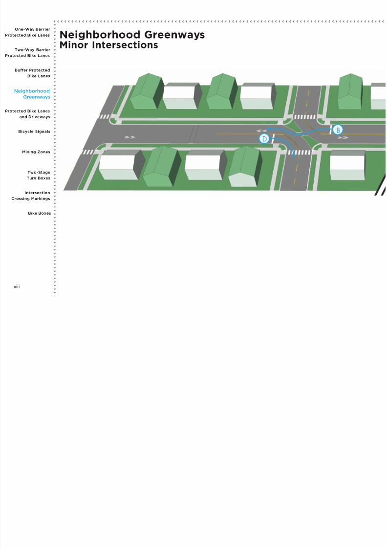
7/27/2019 Streets for Cycling 2012 Review
http://slidepdf.com/reader/full/streets-for-cycling-2012-review 70/84
D
B
Neighborhood GreenwaysMinor Intersections
Mixing Zones
Bicycle Signals
One-Way Barrier
Protected Bike Lanes
Buffer Protected
Bike Lanes
Intersection
Crossing Markings
Protected Bike Lanes
and Driveways
Two-Stage
Turn Boxes
Two-Way Barrier
Protected Bike Lanes
Neighborhood
Greenways
Bike Boxes
xiii

7/27/2019 Streets for Cycling 2012 Review
http://slidepdf.com/reader/full/streets-for-cycling-2012-review 71/84
Continue through the intersection cautiously.
Continue through the intersection by using the bicycle cut- through in
the middle of the diverter.
Reduce speed to continue through the intersection or to make a turn.
Watch for bicyclists.
Stop and watch for bicyclists before proceeding.
A
B
C
D
Motoris tsBicyclists
C
A
xiv
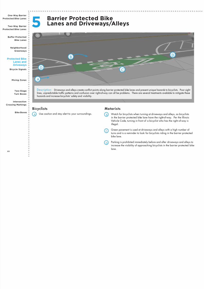
7/27/2019 Streets for Cycling 2012 Review
http://slidepdf.com/reader/full/streets-for-cycling-2012-review 72/84
Use caution and stay alert to your surroundings. Watch for bicyclists when turning at driveways and alleys, as bicyclistsin the barrier protected bike lane have the right-of-way. Per the IllinoisVehicle Code, turning in front of a bicyclist who has the right-of-way isillegal.
Green pavement is used at driveways and alleys with a high number of turns and is a reminder to look for bicyclists riding in the barrier protectedbike lane.
Parking is prohibited immediately before and after driveways and alleys to
increase the visibility of approaching bicyclists in the barrier protected bikelane.
A B
C
D
Motoris tsBicyclists
A
CD
DB
Description: Driveways and alleys create conict points along barrier protected bike lanes and present unique hazards to bicyclists. Poor sightlines, unpredictable trafc patterns and confusion over right-of-way can all be problems. There are several treatments available to mitigate thesehazards and increase bicyclists’ safety and visibility.
Barrier Protected BikeLanes and Driveways/Alleys5
Mixing Zones
Bicycle Signals
One-Way Barrier
Protected Bike Lanes
Buffer Protected
Bike Lanes
Intersection
Crossing Markings
Protected BikeLanes and
Driveways
Two-Stage
Turn Boxes
Two-Way Barrier
Protected Bike Lanes
Neighborhood
Greenways
Bike Boxes
xv
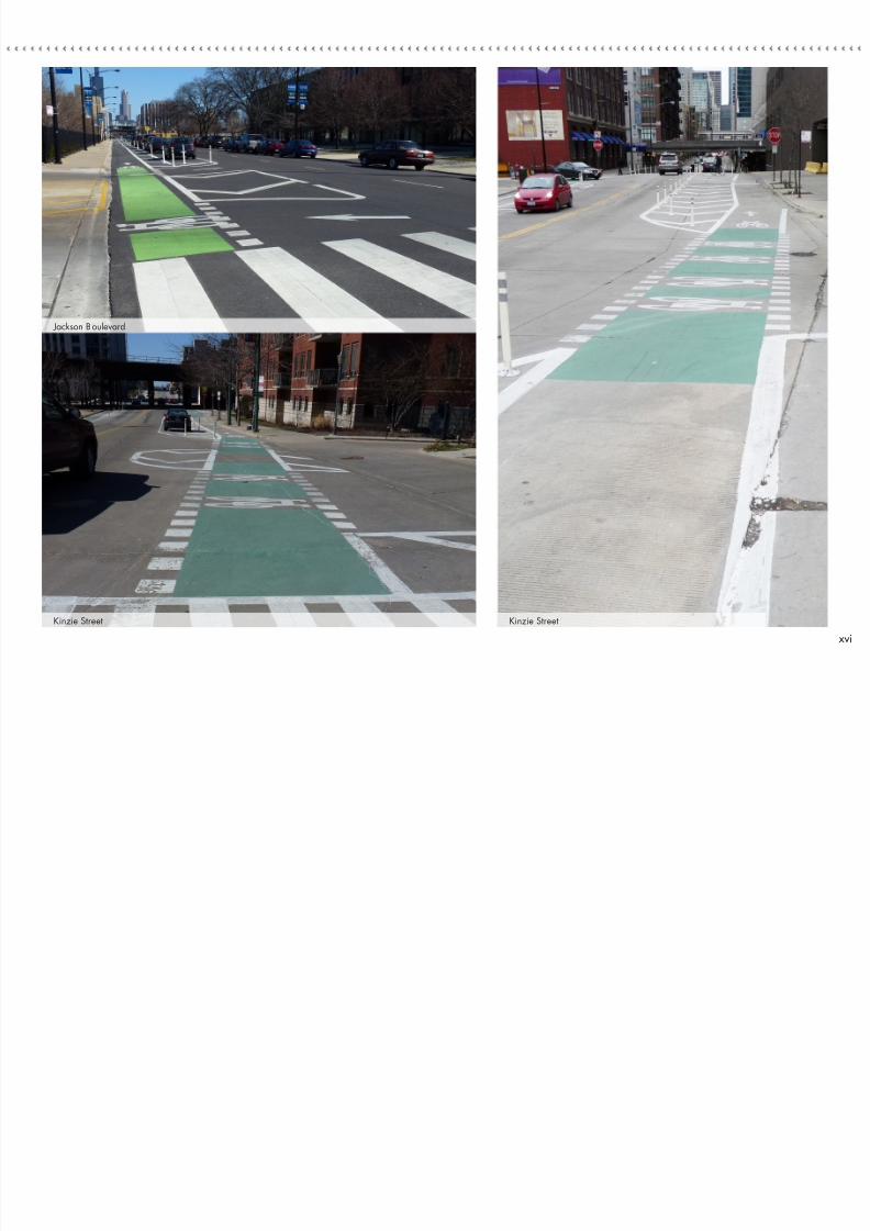
7/27/2019 Streets for Cycling 2012 Review
http://slidepdf.com/reader/full/streets-for-cycling-2012-review 73/84
Jackson Boulevard
Kinzie Street Kinzie Street
xvi
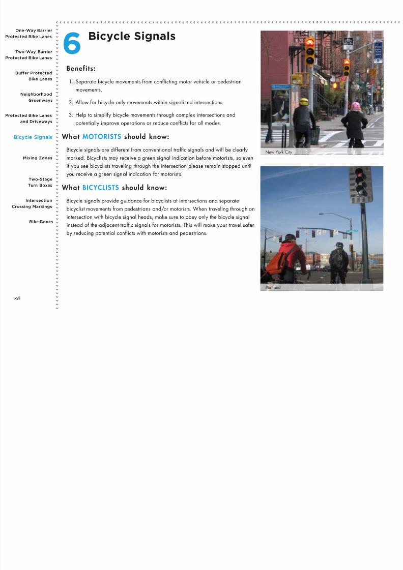
7/27/2019 Streets for Cycling 2012 Review
http://slidepdf.com/reader/full/streets-for-cycling-2012-review 74/84
Bicycle Signals6Benefi ts :
1. Separate bicycle movements from conicting motor vehicle or pedestrian
movements.
2. Allow for bicycle-only movements within signalized intersections.
3. Help to simplify bicycle movements through complex intersections and
potentially improve operations or reduce conicts for all modes.
What MOTORISTS should know:
Bicycle signals are different from conventional trafc signals and will be clearly
marked. Bicyclists may receive a green signal indication before motorists, so even
if you see bicyclists traveling through the intersection please remain stopped until
you receive a green signal indication for motorist s.
What BICYCLISTS should know:
Bicycle signals provide guidance for bicyclists at intersections and separate
bicyclist movements from pedestrians and/or motorists. When traveling through an
intersection with bicycle signal heads, make sure to obey only the bicycle signalinstead of the adjacent trafc signals for motorists. This will make your travel safer
by reducing potential conicts with motorists and pedestrians.
New York City
Portland
Mixing Zones
Bicycle Signals
One-Way Barrier
Protected Bike Lanes
Buffer Protected
Bike Lanes
Intersection
Crossing Markings
Protected Bike Lanes
and Driveways
Two-Stage
Turn Boxes
Two-Way Barrier
Protected Bike Lanes
Neighborhood
Greenways
Bike Boxes
xvii

7/27/2019 Streets for Cycling 2012 Review
http://slidepdf.com/reader/full/streets-for-cycling-2012-review 75/84
When traveling through an intersection with bicycle signals, only obey
the bicycle signal. The bicycle signal will either have bicycles on the
face of the signal, or an accompanying sign identifying it as a bicycle
signal.
When traveling through an intersection with bicycle signals, only obey the
conventional signal.A B
Motoris tsBicyclists
B
A
Description: A bicycle signal is a trafc control device used in combination with a motor vehicle trafc signal to separate bicycle and motor vehicle
movements. Their use ensures that turning motorists and through moving bicyclists can safely and comfortably travel through an intersection.
xviii

7/27/2019 Streets for Cycling 2012 Review
http://slidepdf.com/reader/full/streets-for-cycling-2012-review 76/84
Mixing Zones7Benefi ts :
1. Preserve positive guidance for bicyclists in a situation where the bicycle lane
might otherwise be dropped prior to an intersection.
2. Maintain bicyclist comfort in the absence of a dedicated signal phase.
3. Reduce motor vehicle speed prior to turning and prioritize bicycle movement.
4. Angle motor vehicles prior to merging so that bicyclists are more visible.
What MOTORISTS should know:
A mixing zone is a wide shared bicycle/turn lane. Bicyclists have priority and
may use the lane to continue straight through the intersection or to make a turn
onto a cross street. When entering the turn lane, obey the yield markings and
give priority to bicyclists approaching the intersection in the bike lane before
proceeding.
What BICYCLISTS should know:
Bicyclists have priority in the mixing zone, but remember that it is a shared
lane. Watch for motorists and obey trafc signals. When continuing through the
intersection, make sure to stay within the marked lines. If turning left, use the two-
stage turn box if one is available. Bicyclists should obey all trafc control devices.
Desplaines Street
Mixing Zones
Bicycle Signals
One-Way Barrier
Protected Bike Lanes
Buffer Protected
Bike Lanes
Intersection
Crossing Markings
Protected Bike Lanes
and Driveways
Two-Stage
Turn Boxes
Two-Way Barrier
Protected Bike Lanes
Neighborhood
Greenways
Bike Boxes
xix

7/27/2019 Streets for Cycling 2012 Review
http://slidepdf.com/reader/full/streets-for-cycling-2012-review 77/84
Bicyclists have the right-of-way in a mixing zone, but remember this is a
shared lane. Be aware of merging motorists and obey trafc signals.
Follow the intersection markings when continuing straight t hrough the
intersection.
Slow your speed and yield to approaching bicyclists when entering the
mixing zone. The row of triangle markings is a yield bar, indicating that
through bicyclists have the right-of-way.
Bicyclists may occupy the f ull lane and may continue straight through the
intersection or make a turn onto the cross street.
A
B
C
D
Motoris tsBicyclists
C
D
B
A
Description: A mixing zone is an intersection treatment used when a barrier protected bike lane approaches an intersection. They merge turning
motor vehicle trafc and bicycle trafc into a shared lane to increase visibility and help both users negotiate the intersection.
xx
O W B i

7/27/2019 Streets for Cycling 2012 Review
http://slidepdf.com/reader/full/streets-for-cycling-2012-review 78/84
Portland
Two-Stage TurnBoxes8
Benefi ts :
1. Improve bicyclist comfort when making left or right turns across lanes of
trafc.
2. Provide a formal waiting space for bicyclists making a two-stage turn.
3. Reduce turning conicts between bicyclists and motor vehicles.
4. Prevent conicts arising from bicyclists waiting to turn in a bike lane or
crosswalk.
What MOTORISTS should know:
Two-stage turn boxes are designated areas where bicyclists can wait to make a
turn rather than merging through multiple vehicle lanes. Please keep a distance
from bicyclists stopped in these boxes at intersections. When approaching an
intersection that has turn boxes, make sure to read trafc signs as you may not be
able to make right turns on red.
What BICYCLISTS should know:
Use the two-stage turn box to comfortably make left turns (or right turns from
left side bike lanes). Proceed through the intersection on a green light and
into the marked turn box. Turn your bicycle in the direction of and follow the
arrow pointing in the direction you want to travel. Wait here for a green signal
indication before proceeding straight through the intersection. Bicyclists should
obey all trafc control devices.
Jackson Boulevard
Mixing Zones
Bicycle Signals
One-Way Barrier
Protected Bike Lanes
Buffer Protected
Bike Lanes
Intersection
Crossing Markings
Protected Bike Lanes
and Driveways
Two-StageTurn Boxes
Two-Way Barrier
Protected Bike Lanes
Neighborhood
Greenways
Bike Boxes
xxi
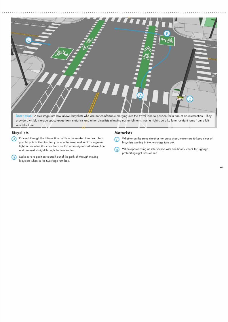
7/27/2019 Streets for Cycling 2012 Review
http://slidepdf.com/reader/full/streets-for-cycling-2012-review 79/84
Proceed through the intersection and into the marked turn box. Turn
your bicycle in the direction you want to travel and wait for a green
light, or for when it is clear to cross if at a non-signalized intersection,
and proceed straight through the intersection.
Make sure to position yourself out of the path of through moving
bicyclists when in the two-stage turn box.
Whether on the same street or the cross street, make sure to keep clear of
bicyclists waiting in the two-stage turn box.
When approaching an intersection with turn boxes, check for signage
prohibiting right turns on red.
A
B
C
D
Motoris tsBicyclists
C
D
B
A
Description: A two-stage turn box allows bicyclists who are not comfortable merging into the travel lane to position for a turn at an intersection. They
provide a visible storage space away from motorists and other bicyclists allowing easier left turns from a right side bike lane, or right turns from a left
side bike lane.
xxii
One Way Barrier

7/27/2019 Streets for Cycling 2012 Review
http://slidepdf.com/reader/full/streets-for-cycling-2012-review 80/84
IntersectionCrossing Markings9
Benefi ts :
1. Raise awareness for both bicyclists and motorists of conict areas.
2. Remind motorists that through bicyclists at uncontrolled intersections have
priority over turning vehicles or vehicles entering the roadway (from
driveways, alleys or cross streets).
3. Guide bicyclists through the intersection in a straight and direct path, reducing
the likelihood of bicyclists veering too far from the bike lane.
4. Reduce bicyclist stress by delineating the bicycle zone.
5. Promote shared use by bicyclists and motorists of the corridor.
What MOTORISTS should know:
Intersection crossing markings increase the visibility and predictability of bicyclists.
If driving parallel to a marked bike lane, be careful to keep a safe distance
between you and the lane markings. Bicyclists have priority over turning vehicles;
be aware of their presence. If approaching an intersection perpendicular to a
marked bike lane, make sure to look for bicyclists before proceeding through the
intersection or turning.
What BICYCLISTS should know:
When traveling through an intersection, stay inside the marked area. This will
guide you to the bike lane on the other side of the intersection and improve
motorists’ and pedestrians’ awareness of your presence. Watch for pedestrians
and turning motorists in conict areas. Bicyclists should obey all trafc control
devices.
Kinzie Street
Mixing Zones
Bicycle Signals
One-Way Barrier
Protected Bike Lanes
Buffer Protected
Bike Lanes
IntersectionCrossingMarkings
Protected Bike Lanes
and Driveways
Two-Stage
Turn Boxes
Two-Way Barrier
Protected Bike Lanes
Neighborhood
Greenways
Bike Boxes
xxiii

7/27/2019 Streets for Cycling 2012 Review
http://slidepdf.com/reader/full/streets-for-cycling-2012-review 81/84
Stay within the markings when traveling through the intersection. The
markings lead to the bike lane on the other side of the intersection and
increase bicyclist visibility and predictability.
Although intersection crossing markings make bicycling safer and more
predictable, always watch for pedestrians, other bicyclists, and motorists
when riding through intersections.
Do not encroach on the markings when traveling through an intersection and
give bicyclists at least 3 feet of clear space when passing.
When turning across the markings, look for bicyclists before proceeding, and
yield the righ t-of-way to bicyclists traveling straight through the intersection.
A
B
C
D
A
B
D
C
Description: Intersection crossing markings guide bicyclists on a safe, direct, and visible path through intersections or across driveways and alleys. The markings helpincrease the visibility and predictability of bicyclists by extending the bicycle lane through the intersection. The City of Chicago uses a variety of intersection crossingmarkings, including shared lane markings, dashed bike lanes, and green colored pavement.
Motoris tsBicyclists
xxiv
One-Way Barrier

7/27/2019 Streets for Cycling 2012 Review
http://slidepdf.com/reader/full/streets-for-cycling-2012-review 82/84
Bike Boxes10Benefi ts :
1. Increase bicyclist visibility when they are waiting at an intersection.
2. Reduce the instances of crashes, when motorists turn in front of through
moving bicyclists.
3. Provide queuing space for bicyclists at red lights, allowing them to clear the
intersection quickly and safely.
4. Can help position bicyclists to make a turn, especially at a red light.
5. Improve pedestrian safety and visibility by requiring motorists to stop furtherback from the crosswalk and prevent motorists from turning on red.
What MOTORISTS should know:
Stop behind the stop bar when the trafc signal is yellow or red. Do not stop in
the bike box. Turns on red are prohibited at intersections with bike boxes. Allow
bicyclists to clear the intersection rst when the light turns green. If you are
turning, signal and watch for bicyclists to the right, especially within the marked
bike lane within the intersection.
What BICYCLISTS should know:
Enter the bike box from the receiving bike lane during a red light. Proceed
as normal when the light turns green and be aware of turning vehicles. If you
approach the signal on a green light, simply proceed through the intersection as
normal, do not swerve in front of through vehicles. Be aware of turning vehicles.
Bicyclists should obey all trafc control devices.
When BIKE BOXES can be instal led:
Bike boxes can be installed at signalized intersections,
particularly intersections with a high number of crashes
or when a high number of bicyclists queue at a red light.
Elston Avenue
Mixing Zones
Bicycle Signals
One-Way Barrier
Protected Bike Lanes
Buffer Protected
Bike Lanes
Intersection
Crossing Markings
Protected Bike Lanes
and Driveways
Two-Stage
Turn Boxes
Two-Way Barrier
Protected Bike Lanes
Neighborhood
Greenways
Bike Boxes
xxv

7/27/2019 Streets for Cycling 2012 Review
http://slidepdf.com/reader/full/streets-for-cycling-2012-review 83/84
Enter the bike box from the approaching bike lane on a red light. If the
light is green, continue through the intersection in the bike lane.
Position yourself here during a red light. Use hand signals to indicate a
turn. If continuing straight, enter the intersection crossing markings when
the light turns green to enter the receiving bike lane.
When stopped in the bike box, be sure to keep the crosswalk clear to
ensure pedestrians can safely cross the street.
Stop behind the stop bar and bike box when the light is red, do not stop in
the bike box. Turns on red are prohibited at intersections with bike boxes.
When the light turns green, allow bicyclists in the bike box to clear the
intersection. If turning, signal and watch for bicyclists approaching from
behind in the bike lane.
A
A
B
C
D
E
B
C
D
E
Bicyclists Motorists
Description: A bike box is a treatment used at signalized intersections that reduces bicycle/motor vehicle crashes, especially crashes between motorists turning right
and bicyclists riding straight through an intersection.
xxvi

7/27/2019 Streets for Cycling 2012 Review
http://slidepdf.com/reader/full/streets-for-cycling-2012-review 84/84