strong-motion data from the pasadena, … · geological survey open-file report 89-203...
TRANSCRIPT

Geological Survey Open-File Report 89-203
STRONG-MOTION DATA FROM THE
PASADENA, CALIFORNIA, EARTHQUAKE
OF DECEMBER 3, 1988
By A.V.Acosta and D.A.Johnson
U. S. Geological Survey
15000 Aviation Blvd, MS 6113
Los Angeles, California 90261
May 1989

CONTENTS
Page
Introduction 1
Acknowledgement 2
Reference 2
ILLUSTRATIONS
Figure 1. Strong-motion station map 3
Figure 2. Accelerograms recorded at:
Los Angeles, 4407 Jasper Street 10
Garvey Reservoir 11
Los Angeles, 1111 Sunset Blvd. 12-14
Whittier Narrows Dam 15,16
Los Angeles, 1100 Wilshire Blvd. 17-21
Los Angeles, Griffith Park Observatory 22
Los Angeles, 1526 N. Edgemont St. 23
Los Angeles Bulk Mail Facility 24
Los Angeles, 2005 N. Highland Blvd. 25
Whittier, 7215 Bright Ave. 26-28
Norwalk, 12400 Imperial Highway 29-31
Norwalk, 12440 Imperial Highway 32-38
Los Angeles, 2055 Avenue of the Stars 39
Los Angeles, Wadsworth VA Hospital 40
Sepulveda Dam 41,42
Sepulveda Canyon 43
Weymouth Filter Plant 44,45
\\

ILLUSTRATIONS
Figure 2. Brea Dam 46,47 (con't)
Sepulveda VA Hospital 48
Jensen Filter Plant 49-51
Long Beach VA Hospital 52-54
San Antonio Dam 55-57
TABLE
TABLE 1. Strong-motion data and peak accelerations 4
C. 1
m
STRONG-MOTION DATA FROM THE PASADENA, CALIFORNIA, EARTHQUAKE
OF DECEMBER 3, 1988
INTRODUCTION
A magnitude (ML) 5.0 earthquake occurred beneath Pasadena, Cali
fornia, at 1138 G.m.t. December 3, 1988. The California Institute
of Technology (CIT) located the epicenter in the downtown area near
Pasadena City Hall. There were no significant aftershocks.
Although the epicenter of this earthquake is only about 12 kilo
meters from the epicenter of the M=5.9 Whittier Narrows earthquake
of October 1, 1987, there is apparently no direct relationship
between the two events. Lucile Jones of the U. S. Geological Sur
vey describes the faulting mechanism of the Pasadena earthquake as
strike-slip as distiguished from the dip-slip (thrust) mechanism
of the Whittier Narrows earthquake. Strong-motion data from the
Whittier Narrows earthquake have been presented in Etheredge and
Porcella (1987).
No major damage was reported from the Pasadena earthquake which was
felt over a six-county area of southern California. Minor damage to
utilities was reported in Pasadena; storefront windows were broken
and merchandise was damaged in South Pasadena (Los Angeles Times,
Dec. 4, 1988).
The earthquake triggered 45 accelerographs at 22 stations in the
National Strong-Motion Instrumentation Network (NSMIN) at epicentral
distances of from 8 to 42 kilometers (fig. 1). These accelerographs
are located at eight U.S. Geological Survey ground sites, four Army
Corps of Engineers dams, four facilities of the Metropolitan Water

District of Southern California, three Veterans Administration hos
pitals, and eight other buildings (table 1). Two of the buildings
have extensive instrumentation: 21 channels at the 32-story JCG
building at 1100 Wilshire Boulevard, Los Angeles; and 27 channels
at the 7-story Bechtel building at 12440 Imperial Highway, Norwalk.
Peak horizontal ground accelerations were largest (0.12g) at two
Los Angeles stations: 4407 Jasper Street (8 kilometers from the
epicenter) and 1111 Sunset Boulevard (13 kilometers from the epi
center). A vertical acceleration of 0.19g was recorded at the
roof of the seven-story 1111 Sunset Boulevard building. Accel
erations of 0.06-O.llg were recorded at the thirteenth floor of
1100 Wilshire Boulevard, Los Angeles (15 kilometers from the
epicenter). Copies of all NSMIN accelerograms are presented
in figure 2.
ACKNOWLEDGEMENT
The acceleration data presented in this report were recorded by
instrumentation owned by the Army Corps of Engineers, Metropolitan
Water District of Southern California, Veterans Administration,
JCG Finance Corporation of America, Bechtel Power Corporation, and
private owners. The U. S. Geological Survey appreciates the assis
tance of all who have allowed the use of their facilities for the
operation of strong-motion instrumentation.
REFERENCE
Etheredge, E., and Porcella, R., 1987, Strong-motion data from the
October 1, 1987 Whittier Narrows earthquake, U. S. Geological Survey
Open File Report 87-616.

MLOUCTVU 0 * It l« JO 24 MLOMCTOtS
Figure 1. Map showing National Strong-Motion Instrumentation Network stations triggered during the Pasadena earthquake. See table 1 for identification of map numbers.

Table 1. Strong-motion data and peak accelerations from the Pasadena, California, earthquake of December 3, 1988 (1138 G.m.t.)
Station owners are Army Corps of Engineers (ACOE); Bechtel Power Corporation (BECH); JCG Finance Corp. of America (JCG); Metropolitan Water District of Southern California (MWD); U. S. Geological Survey (USGS); the Veterans Administration (VA); and owners of buildings required to have accelerographs by ordinance (Code). Stations are listed in order of increasing epicentral distance. Epicentral dis tance is measured from station to epicenter at latitude 34.149°N and longitude 118.135°W. Direction of acceleration is for an upward trace deflection on the accelerogram; vertical component directions are all listed as "up."
Station IdentificationAcceleration
USGSNumbe r(mapnumber
5244(1)
Name( owne r )
)
Los Angeles,4407 Jasper StreetGround (USGS)
Coordinates(lat. °N,long. °W)
34.081, 118.188
EpicentralDistance
(km)
8
Direction(degrees)
130up040
Maximum(g)
0.110.060.12
709 Garvey Reservoir 34.048 10 060 0.10 (2) Abutment (MWD) 118.111 up <0.05
330 0.06872 Los Angeles, 34.067 13 (3) 1111 Sunset Blvd. 118.248
(MWD)Basement 348 0.08
up <0.05 258 0.12
4th floor 348 0.08up <0.05258 0.09.
Roof (8th) 348 <0.05up 0.19
258 <0.05
289 Whittier Narrows Dam (4) (ACOE)
Upstream 34.031 14 152 0.07118.054 up <0.05
062 0.06
Crest 34.020 15 033 0.07118.053 up <0.05
303 0.06

Table 1. Strong-motion data and peak accelerations from the Pasadena, California, earthquake of December 3, 1988 (continued)
usesNumber (map number)
5233(5)
141(6)
742(7)
5129(8)
5259(9)
Station Identification
Name Coordinates Epicentral (owner) (lat. °N, Distance
long. °W) (km)
Los Angeles, 1100 34.052 15Wilshire Blvd. 118.263( JCG/USGS )Basement 3, SE
Basement 3 , NE
Basement 4, NW
Structure Array:Ch. 1 12th floor, northCh. 2 12th floor, northCh. 3 12th floor, southCh. 4 13th floor, northCh. 5 13th floor, northCh. 6 13th floor, southCh. 7 32nd floor, northCh. 8 32nd floor, northCh. 9 32nd floor, southCh. 10 1st floor, northCh. 11 1st floor, northCh. 12 1st floor, south
Los Angeles, 34.118 15Griffith Park 118.299Observatory(USGS)
Los Angeles, 1526 34.098 15N. Edgemont Street, 118.2948th level (Code)
Los Angeles Bulk 33.996 16Mail Facility, 118.162Ground (USGS)
Los Angeles, 2005 34.106 19N. Highland Blvd., 118.3368th level (Code)
Acceleration
Direction (degrees)
298up208
298up208
298up
208
298208208298208208298208208298208208
360up270
090up360
010up280
360up270
Maximum(g)
0.08<0.050.07
0.09<0.050.05
0.08<0.050.06
<0.050.060.070.060.110.07
<0.050.09
<0.050.060.09.0.07
<0.05.<0.050.08
0.090.080.10
0.09<0.050.10
<0.05<0.05<0.05

Table 1. Strong-motion data and peak accelerations from the Pasadena, California, earthquake of December 3, 1988 (continued)
Station Identification
USGS Name Coordinates Epicentral Number (owner) (lat. °N, Distance (map long. °W) (km) number)
804 (10)
634 (11)
5239 (12)
Whittier, 7215 Bright Ave. (Code) Basement
5th floor
10th floor
Norwalk, 12400 Imperial Highway (USGS/BECH) 4th floor
North ground site
South ground site
Norwalk, 12440 Imperial Highway (USGS/BECH)
North ground site
South ground site
Basement
33.977 20 118.036
33.916 26 118.067
33.917 26 118.067
33.915 26 118.067
33.917 26 118.065
33.915 26 118.066
33.917 26 118.066
Acceleration
Direction (degrees)
180 up
090
180 up
090
180 up
090
090 up 360
090up 360
090 up 360
090 up 360
090 up 360
090 up 360
Maximum(g)
0.08 <0.05 0.06
0.10 <0.05 0.06
0.06 0.06 0.08
<0.05 <0.05 <0.05
<0.05 <0.05 <0.05
CO. 05 <0.05 <0.05.
<0.05 <0.05 <0.05
<0.05 <0.05 <0.05
<0.05 <0.05 <0.05
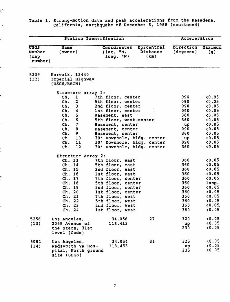
Table 1. strong-motion data and peak accelerations from the Pasadena, California, earthquake of December 3, 1988 (continued)
Station Identification
USGS Name Number (owner) (map numbe r )
Coordinates (lat. °N, long. °W)
Epicentral Distance
(km)
Acceleration
Direction Maximum (degrees) (g)
5239 Norwalk, 12440 (12) Imperial Highway
5256 (13)
5082 (14)
(USGS/BECH)
StructureCh. 1Ch. 2Ch. 3Ch. 4Ch. 5Ch. 6Ch. 7Ch. 8Ch. 9Ch. 10Ch. 11Ch. 12
StructureCh. 13Ch. 14Ch. 15Ch. 16Ch. 17Ch. 18Ch. 19Ch. 20Ch. 21Ch. 22Ch. 23Ch. 24
>s Angeles)55 Avenue
array 1:7th floor, center5th floor, center2nd floor, center1st floor, centerBasement, east5th floor, west-centerBasement, centerBasement, centerBasement, center30' Downhole, bldg.30' Downhole, bldg.30' Downhole, bldg.
Array 2:7th floor, east5th floor, east2nd floor, east1st floor, east7th floor, center5th floor, center2nd floor, center1st floor, center7th floor, west5th floor, west2nd floor, west1st floor, west
34.056of 118.413
centercentercenter
27
090 090 090 090 360 360up
090 360up 090 360
the Stars, 31st level (Code)
Los Angeles, 34.054 Wadsworth VA Hos- 118.453 pital, North ground site (USGS)
31 325up235
<0.05 <0.05 <0.05 <0.05 <0.05 <0.05 <0.05 <0.05 <0.05 <0.05 <0.05 <0.05
360360360360360360360360360360360360
320up230
<0.05<0.05<0.05<0.05<0.05Inop.<0.05<0.05<0.05<0.05<0.05.<0.05
<0.05<0.05<0.05
<0.05 <0.05 <0.05

Table 1. Strong-motion data and peak accelerations from the Pasadena, California, earthquake of December 3, 1988 (continued)
Station Identification
usesNumber (map
Name Coordinates Epicentral (owner) (lat. °N, Distance
long. °W) (km)
Acceleration
Direction (degrees)
Maximum(g)
numbe r )
949(15)
757(16)
5164(17)
951(18)
637(19)
655(20)
Sepulveda Dam(ACOE)Crest
Downstream
Sepulveda Canyon,Spillway roof (MWD)
Weymouth Filter Plant(MWD)Tank top
Ground level
Brea Dam(ACOE)Crest
Left abutment
Sepulveda VAHospital, Ground(VA)
Jensen Filter Plant(MWD)
AdministrationBldg. Basement
34.168118.470
34.167118.469
34.097118.478
34.115117.779
34.114117.778
33.890117.925
33.889117.924
34.249118.475
34.312118.496
31
31
32
33
33
34
34
34
38
054up324
054up324
166up076
017up287
017up287
130up040
130up040
360up270
022up292
<0.05<0.05<0.05
<0.05<0.05<0.05
<0.05<0.050.08
<0.05<0.05<0.05
<0.05<0.05<0.05
0.06<0.050.05
<0.05<0.05<0.05
0.07<0.05<0.05
<0.05<0.05<0.05

Table 1. Strong-motion data and peak accelerations from the Pasadena, California, earthquake of December 3, 1988 (continued)
Station Identification
USGS Name Coordinates Epicentral Number (owner) (lat. °N, Distance (map long. °W) (km) numbe r )
655 (20)
5106 (21)
287(22)
Jensen Filter Plant (MWD)
Generator Bldg. , Ground
ReservoirRoof
Long Beach VA Hospital (VA)Basement
6th floor
llth floor
San Antonio Dam(ACOE)Crest
Right Abutment
Downstream
34.313 38 118.498
34.309 38118.499
33.778 40 118.118
34.157 42117.676
34.158 42 117.682
34.156 42117.675
Acceleration
Direction (degrees)
022 up 292
022up
292
360up
270
360up 270
360up270
090up 360
090 up 360
090up 360
Maximum(g)
<0.05 <0.05 <0.05
<0.05<0.05 <0.05
<0.05<0.05 <0.05
<0.05<0.05 <0.05
<0.05<0.05 <0.05
0.060.05 0.10.
<0.05 <0.05 <0.05
<0.05<0.05 <0.05

U.S. STRONG-MOTION NETWORK
Station No.5244
34.081*N,
118.188*W
Loa Angeles, 4407 Jasper St.
Ground
SMA
I 1418
(USGS)
EARTHQUAKE OF
3 December 1988
1138 Q.m.t.
Epicentral diatanca
DIRECTION
L 130
V
Up
T 040
CONSTANTS
Sens
. a
1.7
8
cm
/9F
raq.
a 2
5.8
H
ED
amp
. a
0.6
crit
Sen
a.
a 1.7
6
cm
/9F
req.
a 26.0
H
ED
amp
. «
0.6
crit
Sena
Freq
- 1 .7
9a
26.2 HE
8 km
Damp. »
0.6
crit
Film speed
1 cm/aec
MAX. ACCELERATION
0.119
0 .06g
0.129
Fig
ure
2
. C
opie
s o
f N
SMIN
ac
cele
rog
ram
s
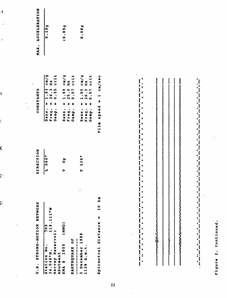
U.S. STRONG-MOTION NETWORK
Station No.70l
34,048°N,
118 .111°W
Qarvey Reservoir
Abutment
SMA
I 1055
(HWD)
EARTHQUAKE OP
3 December 1988
1138 G.ra.t.
Epicentral distance «
10 km
DIRECTION
L 060°
V
Up
T 330°
CONSTANTS
Sens. «
1.84 cm/g
Preq. «
26.3
IIz
Damp. «
0.55 crit
Sens. «
1.90 cm/g
Preq. «
25.0 Hz
Damp. n
0.57 crit
Sens.
«= 1.90 cm/g
Preq. «
26.3 Hz
Damp.
* 0.57 crit
Pilm speed »
1 cm/sec
MAX. ACCELERATION
0 .10g
<0 .
05g
0 . 06g
Pigure 2. Continued.

U.S. STRONG-MOTION NETWORK
DIRECTION
CONSTANTS
MAX. ACCELERATION
Station No.
872
34.067«N,
118.248«W
Los Angeles,. 1111 Sunset Blvd
Basement
SNA
I 1074
(MWD)
EARTHQUAKE OP
3 December 1988
1138 Q.m.t.
Epicentral distance a
13 kn
L 348«
V
Up
T 258°
Sens .
Preq.
Damp .
Sens .
Freq .
Damp .
Sens .
Freq .
Damp .
1.95 cm/g
24.3 HK
0.61 crlt
1.87 cm/g
25.6 He
0.59 crit
1.90 cm/g
25.6 HK
0.61 crit
0 .08g
<0 .
05g
0.12g
Film speed «
1 cm/sec
Figure 2.
Continued.

CO
U.S. STRONG-MOTION NETWORK
Station No.T72
34.067*N,
118.248°W
Los Ang«l«a,'1111 Sunset Blvd
4th floor
SNA
I 1075
(NWD)
EARTHQUAKE OP
3 D«c«ab«r 1988
1138 Q.a.t.
Bplc«ntral dlatanc*
DIRECTION
L 348°
V
Up
T 258°
CONSTANTS
Sana .
Praq .
Damp .
Sana .
Fraq .
Damp .
Sana .
Praq .
Damp .
1.80
25.6
0.59
1 .99
25.6
0.57
1 .8
0 25.6
0.57
cm/g
HB
crlt
cm/g
HB
crlt
cm/g
HB
crit
MAX. ACCELERATION
0.08g
<0 .05g
0 .09g
13 km
Film ap««d »
1 cn/a«c
Figure 2. Continued.

U.S. STRONG-MOTION NETWORK
DIRECTION
CONSTANTS
MAX. ACCELERATION
Station No.
872
34.067'N,
118.248°W
Los Angelas,' 1111 Sunset Blvd.
Roof (8)
SNA
I 1076
(NWD)
EARTHQUAKE OP
3 December 1988
1138 Q.n.t.
Epicentral distance «
13 km
L 348°
V
Up
T 258°
Sans .
Freq.
Damp.
Sens .
Freq.
Damp.
Sens .
Freq.
Damp.
1.90 cn/g
25.0 He
0.59 crit
1.86 cn/g
25.6 He
0.59 ccit
1.83 ca/g
25.6 He
0.57 crit
<0 .
05g
0.19g
<0 .
05g
Film speed «
1 cm/sec
^A^A
^yyy
lA^
Figure 2.
Continued.

U.S. STRONG-MOTION NETWORK
DIRECTION
CONSTANTS
MAX. ACCELERATION
Station No.
2 34.031«N,
118.054°W
Whittier Narrows Daa
Upstream (baB«yard)
SNA
I 376
(ACOE)
EARTHQUAKE OP
3 D«c«mb«r 1988
1138 Q.m.t.
Epic«ntral distance
L 152
V
Up
T 062°
Sana .
Fr«q .
Damp .
S«ns .
Fr«q .
Damp.
S«ns .
Fr«q.
Damp .
1.94 cm/g
25.6 HE
0.59 crit
2.00 cm/g
25.6 HE
0.61 crit
2.00 cm/g
25.0 Hz
0.59 crit
0.07g
<0.05g
0.06g
14 km
Film sp««d m
l cm/s«c
Figure 2.
Continued.
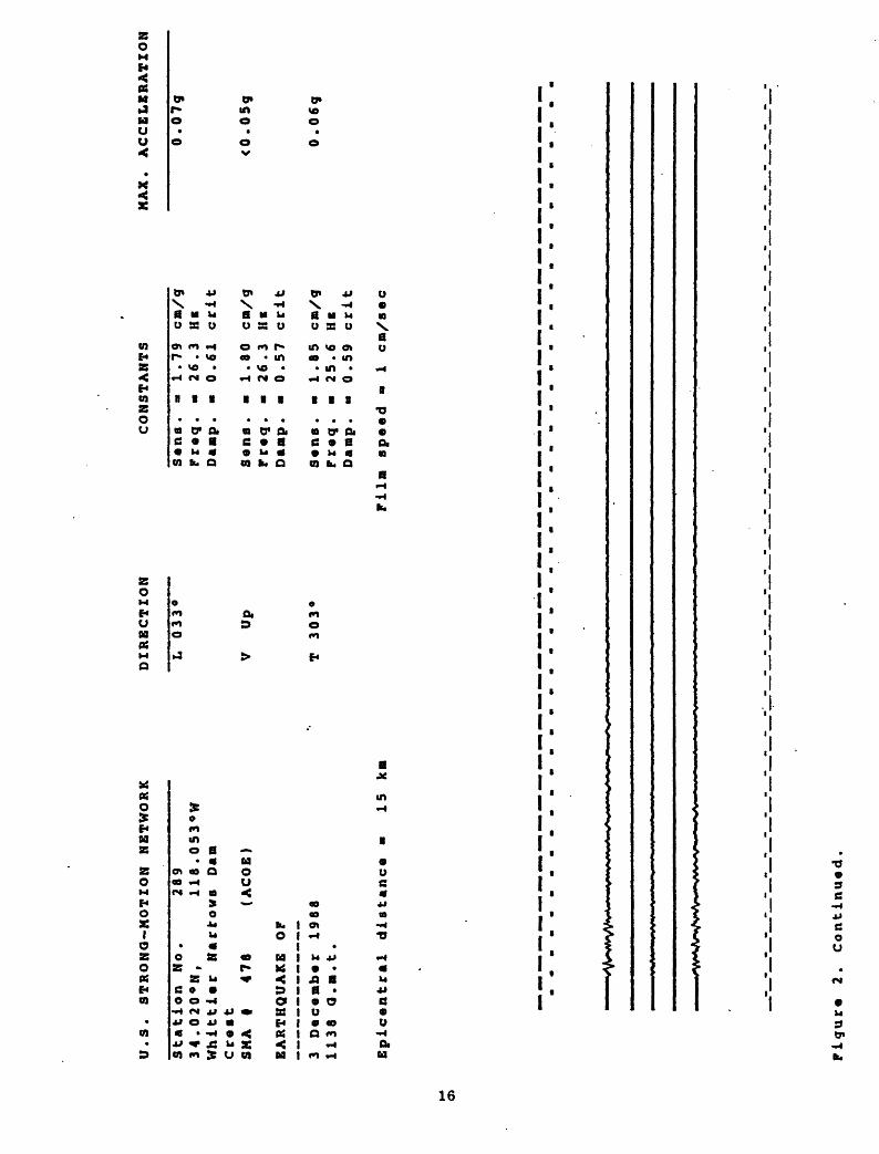
U.S. STRONQ-MOTION NETWORK
Station No.2?9
34.020°N,
118.053°W
Whittier Narrows Dan
Crest
SMA
f 476
(ACOE)
EARTHQUAKE OP
3 December 1988
1138 Q.».t.
Epicentral distance »
15 km
DIRECTION
L 033°
V
Up
T 303°
CONSTANTS
Sena.
* 1.79 cm/g
Preq.
« 26.3 HE
Damp.
« 0.61 crit
Sens. »
1.80 cm/g
Preq.
« 26.3 HE
Damp. »
0.57 crit
Sens .
«
1.85 cm/g
Preq.
« 25.6 HE
Daap.
* 0.59 crit
Pilm speed
« 1 cm/sec
MAX. ACCELCRATZON
0.07g
<0.05g
0.06g
Figure 2.
Continued.

U.S. STRONG-MOTION NETWORK
DIRECTION
CONSTANTS
MAX. ACCELERATION
Station No.
5233
34.052«N,
118.263°W
Los Angeles ,
' 1100 Wilshire Blvd
Basement
3 SB
SMA
I 6065
(JCQ/USQS)
EARTHQUAKE OP
3 December 1988
1138:33.1 a.m.t.
(WWVB trigger time)
Epicentral distance -
15 km
L 298
V
Up
T 208°
Sens .
«
1.90 cm/g
Freq.
Damp.
Sens
Preq
Damp
Sens
Preq
Damp
25.3 HE
0.6
crit
1.94 cm/g
25.8 HE
0.6
crit
1.98 cm/g
26.2 HE
0.6
crit
O.OBg
<0 .05g
0 .07g
Pilm speed
1 cm/sec
Pigure
2. Continued.

00
U.S. STRONG-MOTION NETWORK
Station No.5233
34.052°N
r 118.263°W
Los Angeles,' 1100 Wilshire Blvd
Basement
3 NE
SNA
| 6064
(JCO/USGS)
EARTHQUAKE OF
3 December 1988
1138:32.9 G.m.t.
(WWVB trigger time)
Epicentral distance «
15 km
DIRECTION
L 298°
V
Up
T 208°
CONSTANTS
Sens .
Freq .
Damp .
Sens .
Freq .
Damp .
a « " «
1.90
25.7
0.6
1.90
25.8
0.6
cm/g
HEcrit
cm/g
H* crit
Sens. -
1.90 cm/g
Freq. -
25.6 HE
Danp.
0.6
crit
Film speed »
1 cm/sec
MAX. ACCELERATION
0.09g
<0.05g
O.OSg
#»w*>
Figure 2.
Continued.

U.S. STRONG-MOTION NETWORK
Station No.5233
34.052°N,
118.263«W
LOB Angelas, 1100 Wilahir* Blvd
Bas«m«nt
4 NW
SNA
I 6063
(JCG/USQS)
EARTHQUAKE OF
3 D«c«mb«r 1968
1136 :32 .8
a.m.t.
(WWVB trigger tim«)
Epic«ntral distance «
15 km
DIRECTION
L 298°
V
Up
T 208°
CONSTANTS
S«ns. »
1.88 cm/g
Pr«q
Damp
S«ns
Fr»q
Damp
S«ns
Fr»q
Damp
25.9 He
0.6
crit
2.00 cm/g
25.4 He
0 .6
crit
1.89 cm/g
25.2 HE
0.6
crit
Film sp««d »
1 cm/a«c
MAX. ACCELERATION
0.08g
<0 .
05g
0.069
Figur* 2. Continued.

U.S. STRONG-MOTION NETWORK
CM.
DIRECTION
LOCATION
SENSITIVITY
MAX. ACCELERATION
Station No.
5233
34.052«N,
118.263°W
LOB Angeles
1100 Wilshire Blvd.
Structure Array
CRA
1. 270
(JCQS/USQS)
EARTHQUAKE OF
3 December 1988
0 1138 :32.8 a.m.t.
(WWVB trigger time)
1 2 3 4 5 6 7 8 9
10 11 12
298°
208°
208°
298°
208°
208°
298°
208°
208°
298°
208°
208°
12th
1 1 1 1 1 3
2th
2th
3th
3th
3th
2nd
32nd
32nd
1st
1 1
Bt
Bt
floor
floor
floor
floor
floor
floor
floor
floor
floor
floor .
floor ,
floor ,
, north
, north
, south
, north
, north
, south
, north
, north
, south
north
north
south
1 1 1 1 1 1 1 1 1 1 1 1
.73
.70
.66
.83
.80
.78
.78
.74
.78
.77
.74
.78
<0
0 0 0 0 0
<0
0
<0
0 0 0
.OSg
.06g
.07g
.06g
.lig
,07g
.05g
.09g
.OSg
.06g
.09g
.07g
Epicentral distance »
15 km
Film sp««d »
1 cm/sec
[See accelerogram on next page]
Figure 2. Continued

LOB
A
ngele
e
1100 W
ilehir
e
Blv
d.
Str
uctu
re
Arr
ay
CR
A f
270
(JC
GS
/US
GS
)
298'
-2D
8V
208'
298°
.
208'
208'
298°
.
208°
1029
8°
11 12
208°
208°
/ vxv
Pig
ur*
2
. C
on
tin
ued
.
to
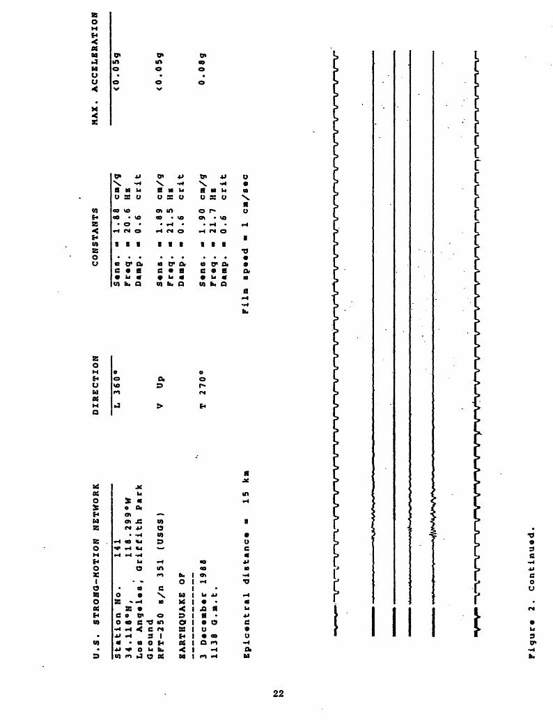
U.S. STRONG-MOTION NETWORK
Station No.ITl
34.118«N,
118.299°W
Los Angelas] Griffith Park
Ground
RFT-250 B/n 351 (USGS)
EARTHQUAKE OP
3 D«c«Bb«r 1988
1138 G.n.t.
Epicentral distance
DIRECTION
L 360°
V
Up
T 270*
CONSTANTS
15 kn
Sana. a
1.88 cn/g
Fr«q. «
20.6 He
Danp.
0.6
crit
Sans.
1.89 cn/g
Fr«q.
21.5 He
Danp.
0.6
crit
S«na. »
1.90 cn/g
Fraq.
21.7 He
Danp.
0.6
crit
Film sp««d *
1 en/sac
MAX. ACCELERATION
<0.05g
<0.05g
0.08?
Figure 2.
Continued.

U.S. STRONG-MOTION NETWORK
Station No.742
34.098°N,
118.294«W
Los Angeles, 1526 N. Edgeaont St
Roof (8)
SNA
I 923
(Coda)
EARTHQUAKE OF
3 December 1968
1138 Q.m.t
Epicentral distance »
15 kn
DIRECTION
L 090°
V
Up
T 360«
CONSTANTS
Sens. a
1.91 ca/g
Freq. a 24.7 Hz
Daap. a 0.6
crit
Sens, a
1.82 ca/g
Freq. a 25.8 Hz
Danp. a 0.6
crit
Sens .
a
1.80 ca/g
Freq. a 25.5 Hz
Danp. a
0 4 6
crit
Film speed a
1 en/sec
MAX. ACCELERATION
0.09g
O.OSg
O.lOg
to CO
Figure 2. Continued.

to
*>.
U.S. STRONG-MOTION NETWORK
Station No.5129
33.996°N,
118.162«W
LOB Angelas .Bulk Hail Facility
Ground
SNA
I 1295
(USQS)
EARTHQUAKE OP
3 Dacenber 1988
1138 Q.m.t.
Epicantral distance a
16 km
DIRECTION
L 010«
V
Up
T 280°
CONSTANTS
Sana .
«
1.80 cn/g
Praq
Da up
25.6 Hz
« 0.6
cri t
Sans .
B
1.86 cn/g
Praq. o
25.6 HE
Danp .
a 0.6
cri t
Sana. =
1.88 cn/g
Praq. =
26.3 Hz
Danp .
B 0.6
crit
Piln speed B
1 cm/sec
MAX. ACCELERATION
0.09g
<0 .
05g
O.lOg
Figura 2.
Continued

n
U.S. STRONG-NOTION NETWORK
Station No.5259
34.106°N,
118.336«W
Los Angeles/
2005 N. Highland Blvd.
Roof
(8 )
SNA
I 2691
(Code)
EARTHQUAKE OP
3 December 1989
1138 Q.«.t.
Epicentral distance
« 19 km
DIRECTION
L 360°
V
Up
T 270°
CONSTANTS
Sens. »
1.69 cn/g
Preq. « 26.4 He
Damp. »
0.6
crit
Sens.
1.79 cn/g
Preq. o
25.7 HE
Damp. »
0.6
crit
Sens. »
1.77 cm/g
Freq. B 26.4 HE
Damp.
« 0.6
crit
Film speed =
1 en/sec
MAX. ACCELERATION
<0.0
5g
<0.0
5g
<0.0
5g
to en
Figure 2.
Continued.

U.S. STRONG-MOTION NETWORK
DIRECTION
CONSTANTS
HAX. ACCELERATION
Station No.
8033.977°N,
118.036°W
Whittl«r, 72i5 Bright Av« .
SHA
I 1069
(Cod«)
EARTHQUAKE OF
3 D«c«»b«r 1988
1138 Q.a.t.
Epicvntral diatanc*
L 180°
V
Up
T 090°
S«ns .
a
1.78 cn/g
Fr«q.
= 25.9 Hz
Danp.
0.6
crlt
- 1.89 cn/g
- 25.1 Hz
« 0.6
crlt
- 1.90 cn/g
- 25.1 He
« 0.6
crlt
Fr«q
Danp
S«ns
Fr«q
Danp
0.08g
<0 .
05g
0 .06g
20
kiFlln ap««d *
1 cn/a«c
to
o>
Figur«
2. Continued.

U.S. STRONG-MOTION NETWORK
Station No.sol
33.977°N,
118.036°W
Whittiar, 7215 Bright Ava .
5th floor
SMA
I 1070
(Coda)
EARTHQUAKE OF
3 Dacambar 1986
1138 Q.m.t.
Epicantral diatanca a
20 km
DIRECTION
L 180°
V
Up
T 090°
CONSTANTS
Sans. a
1.92 cn/g
Fr»q. a
25.4 He
Damp. a
0.6
crit
Sans. «
1.91 cn/g
Praq. a
25.4 He
Damp. a
0.6
crit
Sana. a
1.80 cn/g
Praq. »
25.6 He
Damp. a
0.6
crit
Piln apaad a
1 en/sac
MAX. ACCELERATION
O.lOg
<0 .05g
0 . 06g
to
Figura 2.
Continuad.
U.S. STRONG-MOTION NETWORK
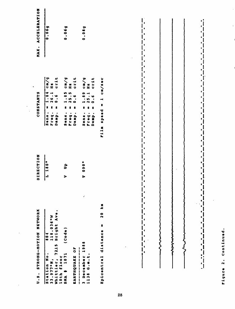
Station No.804
33.977°N,
118.036°W
Whittier,
72.15
Bright Av«.
10th floor
SHA
I 1071
(Cod«)
EARTHQUAKE OF
3 D«c«nb«r 1988
1138 Q.a.t.
Epicentral distance
DIRECTION
L 180°
V
Up
T 090«
CONSTANTS
20 kn
Sana. 1.84 cn/g
Fr«q. - 26.1 HE
Danp.
0.6
crit
S«ns.
1.85 cn/g
Fr«q. - 25.5 HE
Danp. 0.6
crit
S«na. 1.89 cn/g
Praq. - 25.1 HE
Danp. 0.6
crit
Filn ap««d
1 cn/a«c
MAX. ACCELERATION
0.06g
0 . 06g
0 . 08g
to oo
Figur* 2. Continued

to to
U.S. STRONG-NOTION NETWORK
Station No.634
33.916«N,
118.067°W
Norwalk, 12400 Imperial Highway
4th floor
SNA
I 425
(USQS/BECH)
EARTHQUAKE OF
3 D«c«ab«r 1988
1138 Q.m.t.
Epicantral distance
26 ka
DIRECTION
L 090°
V
Up
T 360°
CONSTANTS
Sana .
Frwq .
Damp .
Sens
Freq
Damp
1.72 cm/g
26.3 HE
0.57 crit
Sens.
1.99 cm/g
Freq. «
24.3 HE
Damp. m
0.55 crit
1.67 cm/g
26.3 HE
0.57 crit
MAX. ACCELERATION
<0 .
OSg
<0.05g
<0 .OSg
Film speed
1 cm/sec
Figure 2. Continued.
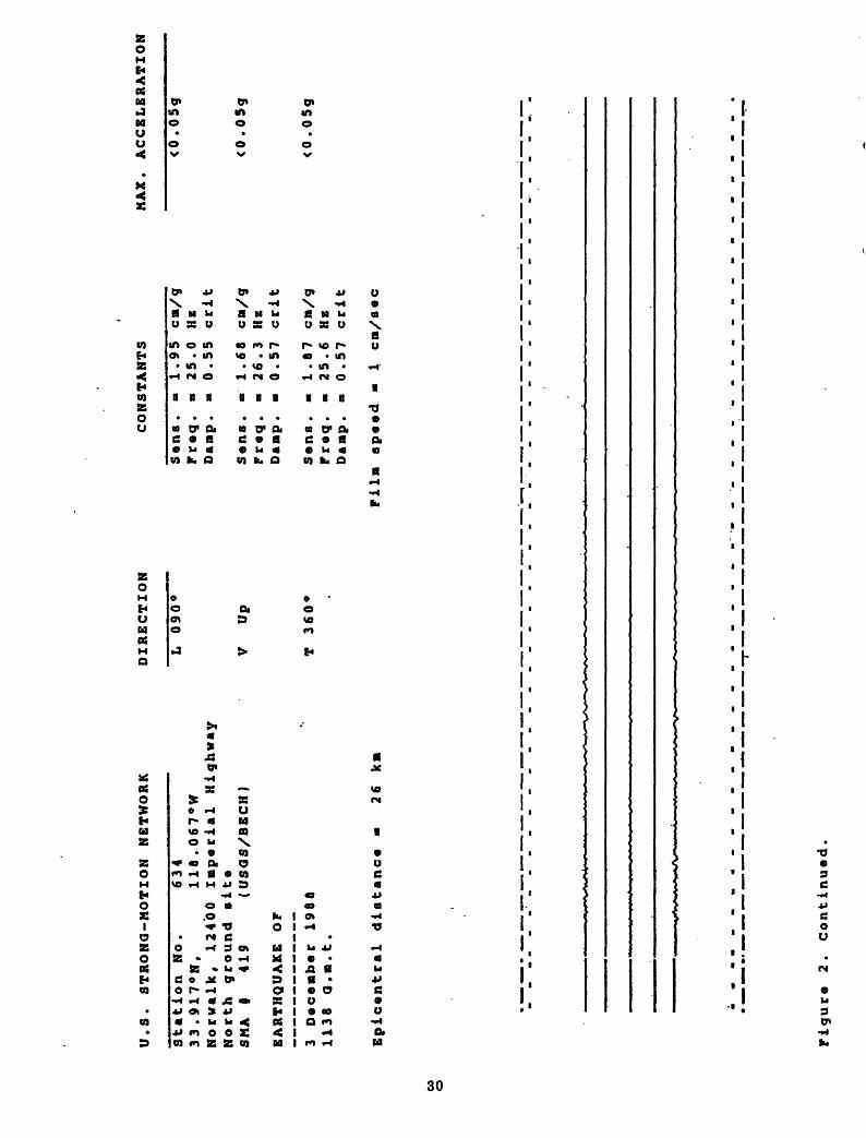
U.S. STRONG-MOTION NETWORK
Station No.631
33.917°W,
118.067»W
Norwalk, 12400 Imperial Highway
North ground »it«
SMA
I 419
(USGS/BECH)
EARTHQUAKE OP
3 Dec«mb«r 1988
1138 O.m.t.
Epicentral distance
26 k»
DIRECTION
L 090°
V
Up
T 360°
CONSTANTS
Sana, a
1.95 cn/g
Tr«q. a
25.0 HE
Danp. a
0.55 crit
S«na.
1.68 cn/g
Freq. a
26.3 Hz
Danp. »
0.57 crit
S«ns.
1.87 cn/g
Freq. a
25.6 HE
Danp. a
0.57 crit
Filn speed
1 en/sec
MAX. ACCELERATION
<0.05g
<0.05g
<0.05g
CO o
rigur* 2.
Continued.
frJ
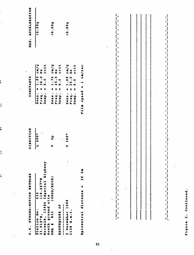
U.S. STRONG-NOTION NETWORK
Sta
tio
n
No.
6~
3l3
3.9
15°N
, 1
18
.06
7°W
Norvalk, 124QO Imperial Highway
South ground site
SNA
I 823
(USQS/BECH)
EARTHQUAKE OP
3 Decenber 1988
1138 G.n.t.
Epicentral distance
26 kn
DIRECTION
L 090°
V
Up
T 360«
CONSTANTS
Damp
1.83 cn/g
Sana .
Freq. -
26.0 He
0 .6
crit
S«ns .
Freq .
Damp .
Sana .
Fraq .
Danp .
» » a a a «
1 .76
25.9
0 .6
1.88
25 .9
0.6
cn/g
HE crit
cn/g
HE crit
NAX. ACCELERATION
<0 .
05g
<0 .05g
<0.05g
Piln spaad a
1 cm/sac
CO
Figura 2.
Continued
U.S. STRONQ-MOTION NETWORK
DIRECTION
CONSTANTS
MAX. ACCELERATION
Station No.
5239
33.917«N,
118.065°W
Norwalk, 124*40 Imperial Highway
North ground ait*
SNA
| 824
(USQS/BECH)
EARTHQUAKE OF
3 D»c«ab«r 1988
1138 :37.4 Q.n.t.
(Corrected TCQ trigger tine)
L 090°
V
Up
T 360
Sens .
Fr tq.
Daap.
S«ns .
Fr«q.
Damp.
S«ns .
Fr«q .
Damp.
1.80 cm/g
26.1 Hz
0.59 crit
1.82 cn/g
25.4 Hz
0.61 crit
1.80 ca/g
26.0 HE
0.59 crit
<0.05g
<0 .
05g
<0.05g
Epicttntral distance
26 km
Film sp*«d a
i ca/s«c
CO to
Figur* 2.
Continued.

U.S. STRONG-MOTION NETWORK
Station No.5239
33.915°N,
116.066°W
Norvalk, 12440 Imperial Highway
South ground site
SNA
I 922
(USGS/BECH)
EARTHQUAKE OP
3 December 1988
1138:37.4 G.n.t.
(Corrected TCG trigger time)
Epicentral distance »
26 km
DIRECTION
L 090°
V
Up
T 360°
CONSTANTS
Sens .
Preq .
Damp .
Sens .
Preq.
Damp.
1.85 cm/g
25.3 He
0 .55 crit
1.83 cm/g
26.4 He
0 . 55 crit
Sens. »
1.93 cm/g
Preq. »
25.4 HE
Damp. »
0.53 crit
Pilm speed »
1 cm/sec
MAX. ACCELERATION
<0.05g
<0 .05g
<0.05g
CO
CO
Figure 2.
Continued.

U.S. STRONa-NOTION NETWORK
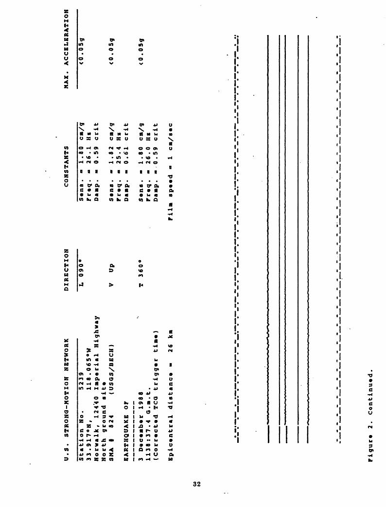
Station No.5239
33.917°N,
118.066°W
Norwalk, 12440 Imperial Highway
Bas«m«nt
SNA
I 2218
(USQS/BECH)
EARTHQUAKE OP
3 O«c«mb«r 1988
1138 :37.4 O.ra.t.
(Corrected TCQ trigger tin*)
Epictntral distance *
26 kn
DIRECTION
L 090°
V
Up
T 360°
CONSTANTS
S«ns .
Fr«q .
Danp .
S«ns .
Fr«q .
Danp .
8 8 a « a a
1 .76
26.3
0.63
1 .88
25.8
0.62
cm/g
Hzcrit
c»/g
HEcrit
Sens. «
1.71 ca/g
Freq. «
26.4 Hx
Danp. - 0.60 crit
Fil» speed
1 en/sec
NAX. ACCELERATION
<0 .05g
<0.05g
<0 .
05g
CO
Pigur* 2.
Continued.

U.S. STRONG-MOTION NETWORK
CH.
DIRECTION
LOCATION
SENSITIVITY
MAX. ACCELERATION
CO en
Station No .
5239
33.917«N,
118.066°W
Norwalk
12440 Imperial Highway
Structure Array
1
CRA
I 127
(USQS/BECH)
EARTHQUAKE OP
3 December 1988
1138:37.3 Q.m.t.
(WWVB trigger tine)
1 2 3 4 5 6 7 8 9
10
090°
090°
090°
090°
360°
360°
up
090°
360°
up
7th floor
5th floor
2nd floor
1st floo r
Basement ,
5th floor
Basement ,
Basement ,
Basement ,
Downhole
, center
, center
, center
, cent* r
east
, west-ctr
center
cente r
cente r
(30' )
,
1 1 1 1 1 1 1 1 1 1
.75
.83
.80
.72
.94
.77
.92
.88
.93
.85
<0 <0 <0 <0 <0 <0 <0
<0 <0
<0
.05g
.05g
.05g
.05g
.05g
.05g
.05g
.05g
.05g
.05g
bldg .
center
11
090°
Downhole
(30' )
,1.91
<0.05g
bldg .
cente r
12
360°
Downhole
(30' )
,1.90
<0.05g
Epicentral distance *
26 km
bldg. cente r
Film speed »
1 cm/sec
(See accelerogram on next page)
Figure 2.
Continued.

Norw
alk
*
12440
Imp
eri
al
Hig
hw
ay
Str
uctu
re
Arr
ay
1
CR
A
#
12
7
(US
GS
/BE
CH
)
090'
090°
CO
5-3
601
090'
360°
10-2
L
12
360°
Fig
ure
2.
Co
nti
nu
ed

U.S. STRONG-MOTION NETWORK
CH.
DIRECTION
LOCATION
SENSITIVITY
MAX. ACCELERATION
CO
Station No.
5239
33.917'N,
118.066'W
Norwalk
12440 Imperial Highway
Structure Array
2
CRA
I 128
(USQS/BECH)
EARTHQUAKE OF
3 December 1988
1138t37.3 a.m.t.
(WWVB trigger time)
13 14 15 16 17
18 19 20 21 22 23 24
360°
360°
360°
360*
360*
360«
360°
360°
360°
360°
360°
360°
7th
5th
2nd
1st
7th
5th
2nd
1st
7th
5th
2nd
1st
f loo r ,
f loo
floo
r ,
r ,
floor ,
floor ,
floo
floo
floo
floo
floo
floo
floo
r ,
r, r ,
r ,
r ,
r ,
r,
east
east
east
east
cente r
center
center
cente r
west
west
west
west
1 1 1 1 1 1 1 1 1 1 1 1
.9 .8
5 7
.98
.87
.88
.9 .9 .8 .8 . 8
.9 .8
2 1 5 6 4 1 5
<0 <0 <0 <0 <0
.OSg
.OSg
.OSg
.OSg
.OSg
Inop.
<0 <0 <0 <0 <0 <0
.OSg
.OSg
.OSg
.OSg
.OSg
.OSg
Epic«ntral distance
26 kn
Film speed "
1 cm/sec
(See acc«l«rogram on n«xt page]
Figure 2.
Continued.

Norw
alk
12440
Imp
eri
al
Hig
hway
Str
uctu
re A
rray
2
CR
A
#
128
(USG
S/B
EC
H)
13
-J6
01
!4
360°
15-3
60
1
16-2
60:
CO
00
17-
360
°
19
360°
'
360°
23
36°"
'
Fig
ure
2
. C
onti
nued

U.S. STRONG-MOTION NETWORK
Station No.5256
34.056°N,
118.413°W
Loa Angelas;
2055 Avenue of the Stars
Roof (31)
SNA
I 5775
(Coda)
EARTHQUAKE OP
3 December 1988
1138 Q.a.t.
Epicentral distance
DIRECTION
L 320°
V
Up
T 230°
CONSTANTS
Sens .
Freq .
Damp .
Sens .
Freq .
Damp .
Sens .
Freq .
Daap .
a a a a a a a a a
1.66
27.0
0.6
1.89
25.8
0.6
1.78
26.0
0.6
cn/g
He crit
cra/
gHzcrit
cra/
gHz crit
MAX. ACCELERATION
<0.05g
<0.05g
<0.05g
27 ka
Fila speed »
1 cm/sec
CO
CO
Figure
2. Continued.

U.S. STRONQ-HOTZON NETWORK
Station No.5082
34.054°N,
lia.453°W
Los Ang«l«B,' Wadsworth VA Hospital
Ground sit« north
SNA
I 4960
(USQS)
EARTHQUAKE OP
3 D«c«mb«r 1988
1138 :38 .7
a.m.t.
(VfW
VB trigger time)
Epicentral distance
DZRECTZON
L 325«
Up
T 235«
CONSTANTS
s«ns .
Pr«q.
Damp.
1.86 cm/g
26.0 He
0.6
crlt
31 km
S«ns. »
1.98 cm/g
Pr«q. a
25.5 He
Damp. a
0.6
crit
S«ns. a
1.70 cm/g
Pr«q. a
27.0 He
Damp. a
0.6
crit
Pilm sp««d «
1 cm/s«c
MAX. ACCELERATION
<0.05g
<0.05g
<0.05g
Pigur* 2.
Continued

U.S. STRONG-MOTION NETWORK
Station No.949
34.168*N,
118.470°W
Sapulvada DAM
Crest
SKA
I 5703
(ACOE)
EARTHQUAKE OP
3 Dacambar 1988
1136 O.m.t.
Epicantral distanca »
31 km
DIRECTION
L 054°
V
Up
T 324°
CONSTANTS
Sans.
*» 1.90 cm/g
Fraq. «
25.8 HE
Damp. a
0.6
crit
Sans .
Fraq .
Damp .
Sans .
Praq .
Daap .
a
a
1 .99
25.1
0 .6
1.88
25. 4
0. 6
cm/g
Hz
crit
cm/g
Hz
crit
MAX. ACCELERATION
<0.05g
<0 .05g
<0 .
OSg
Film spaad
1 cm/sac
Figura 2.
Continuad.

U.S. STRONG-MOTION NETWORK
Station No.9*49
34.167°N,
118.469«W
S«pulv«da Dan
Downstr«an
SMA
| 5702
(ACOE)
EARTHQUAKE OF
3 D«c«nb«r 1988
1138 Q.n.t.
Epic«ntral diatanc*
DIRECTION
L 054
V
Up
T 324
CONSTANTS
31 km
S«na. »
1.70 cn/g
Pc«q. » 26.6 HE
Danp. » 0.6
crit
Sana. -
1.85 cn/g
Fr«q. - 25.6 HE
Damp. » 0.6
crit
S«na. -
1.84 cn/g
Fcaq. * 26.0 HE
Danp. « 0.6
ccit
Piln sp««d
1 cn/a«c
MAX. ACCELERATION
<0.05g
<0.05g
<0.05g
to
Figur* 2. Continued.

U.S. STRONG-MOTION NETWORK
Station No.757
34.097«N,
118.478«W
Sepulveda Canyon
Spillway roof
SMA
I 1054
(NWD)
EARTHQUAKE OP
3 December 1988
1138 Q.n.t.
Epicentral distance «
32 km
DIRECTION
L 166°
V
Up
T 076°
CONSTANTS
Sens .
Freq .
Damp .
Sens .
Freq .
Damp *
Sens .
Freq .
Damp.
a a
a a
1.84
26.3
0.59
1 .93
25.6
0.59
1.92
25.0
0 .59
cm/g
HE
crit
cm/g
Hz
crit
cm/g
HE
crit
MAX. ACCELERATION
<0.05g
<0.05g
0.08g
Film speed a
1 cm/aec
CO
Figure 2.
Continued.

U.S. STRONG-NOTION NETWORK
Station No.5164
34.115 N,
117.779°W
W«ynouth Filter Plant
Tank top
SNA
t 1052
(MWD)
EARTHQUAKE OP
3 D«c«nb«r 1988
1138 G.n.t.
Epicentral distance
DIRECTION
L 017°
V
Up
T 287
CONSTANTS
33 ka
S«ns. »
1.86 cm/g
Fr«q. m 25.5 He
Danp. »
0.6
crit
S«ns. a
1.85 cm/g
Fr«q. m 25.9 He
Danp. a
0.6
crit
S«na. m
1.77 ca/g
Pr«q. a
25.8 HE
Danp.
0.6
crit
Filn ep««d
1 cn/s«c
NAX. ACCELERATION
<0.05g
<0.05g
<0 .
05g
Figur* 2. Continued.

U.S. STRONG-MOTION NETWORK
Station No.5164
34.114 N,
117.778-W
Weymouth Filter Plant
Ground level
SNA
1053
(HWO)
EARTHQUAKE OP
3 December 1908
1138 Q.B.t.
Epicentral distance
« 33 km
DIRECTION
L 017°
V
Up
T 287«
CONSTANTS
Sens. -
2.00 cm/g
Preq. -
24.9 Hz
Damp. «
0 . 6
crit
Sens. -
1.83 ca/g
Preq. «
25.9 HE
Damp. «
0.6
crit
Sens. *
1.88 cm/g
Preq. «
26.3 HE
Damp. «
0.6
crit
Film speed -
1 cm/sec
MAX. ACCELERATION
<0 .05g
<0 *05g
<0.05g
01
Figure 2. Continued.
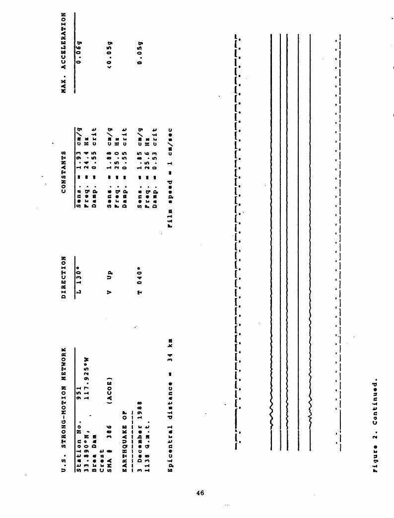
U.S. STRONG-MOTION NETWORK
Station No.
33.890°N,
Brea Dan
Crest
SMA
386
EARTHQUAKE OF
951
117.925°W
(ACOE)
3 December 1988
1138 Q.n.t.
Epicentral distance
34 kn
DIRECTION
L 130°
V
Up
T 040°
CONSTANTS
Sens .
Freq .
Danp .
Sens .
Freq .
Danp .
Sens .
Freq .
Danp .
- 1.93
-24.4
- 0.55
1.88
25.0
- 0 .55
- 1.85
25.6
-0.53
cn/g
HE
crit
cu/g
Hz
crit
cn/g
Hz
crit
MAX. ACCELERATION
0.06g
<0 .05g
0.0 5g
Filn speed «
1 en/sec
Oi
Figure 2. Continued.

U.S. STRONG-MOTION NETWORK
Station No.9TI
33.889«N,
117.924°W
Braa Dan
Laft abutment
SNA
I 365
(ACOE)
EARTHQUAKE OF
3 December 1988
1138 a.m.t.
Epicantral distanca
« 34 km
DIRECTION
L 130°
V
Up
T 040°
CONSTANTS
Sans .
«»
1.90 cm/g
Praq. «
25.9 He
Damp.
* 0.6
crit
Sans.
« 2.02 ca/g
Praq. «
24.8 Ha
Da op .
» 0.6
crit
Sans .
«
1.95 cm/g
Fraq.
« 25.2 He
Damp. -
0.6
crit
Film speed
1 cm/sac
MAX. ACCELERATION
<0.05g
<0.05g
<0.05g
Figura 2. Continued.

00
U.S. STRONG-MOTION NETWORK
Station No.637
34.249°N,
118.475°W
Sepulveda VA Hospital
Ground
SMA
| 751
(VA)
EARTHQUAKE OF
3 December 1980
1138 G.m.t.
Epicentral distance
34 km
DIRECTION
L 360°
V
Up
T 270°
CONSTANTS
Sens .
Preq.
Damp.
Sens .
Freq .
Damp.
1.84 cm/g
26.3 He
0 .55
ccit
1.81 cm/g
25.6 He
0.55 ccit
Sens. «
1.00 cm/g
Freq. «
25.0 He
Damp. «
0.55 crit
Film speed -
1 cm/sec
MAX. ACCELERATION
0.07g
<0.05g
<0 .05g
Figure 2.
Continued.

to
U.S. STRONG-MOTION NETWORK
Station No.655
34.312°N,
118.496°W
Jensen Filter Plant
Administration Bldg., basement
SNA
I 259
(MWD)
EARTHQUAKE OP
3 December 1988
1138 a.m.t.
Epicentral distance «
38 km
DIRECTION
L 022°
V
Up
T 292°
CONSTANTS
Sens .
Preq .
Damp .
Sens .
Preq .
Damp .
Sens .
Preq .
Damp.
1.78 cm/g
26.3 Hz
0.57 crit
1.74 cm/g
27.0 Hz
0 .55 crit
1.63 cm/g
27.7 Hz
0.50 crit
MAX. ACCELERATION
<0 .
05g
<0.05g
<0.05g
Pilm speed »
1 cm/sec
Pigure
2. Continued.

U.S. STRONG-MOTION NETWORK
Station No.655
34.313«N,
118.498«W
Janaan Filter Plant
Qanarator building, ground
RFT-350 8/n 1002 (MWD)
EARTHQUAKE OF
3 Dacanbar 1988
1138 Q.n.t.
Epicantral distance »
38 kn
DIRECTION
L 022°
V
Up
T 292«
CONSTANTS
Sans .
Fraq .
Danp .
1.85 cn/g
20.0 HE
0.60 crit
Sana. -
1.85 cn/g
Fraq. -
20.8 HE
Danp. -
0.55 crit
Sans. -
1.76 cn/g
Fraq. »
20.8 Hz
Danp. »
0.55 crit
Filn speed »
1 en/sac
MAX. ACCELERATION
<0.05g
<0.05g
<0.05g
Oi o
Figura
2. Continuad

U.S. STRONG-MOTION NETWORK
Station No.655
34.309°N,
118.499'W
Jensen Filter Plant
Res*rvoir roof
RFT-350 s/n 1003 (MWD)
EARTHQUAKE OP
3 December 1988
1136 Q.n.t.
Epicentral distance
DIRECTION
L 022°
V
Up
T 292
CONSTANTS
38 km
Sens. « 1.75 cm/g
Preq. a 20.4 HE
Damp. a 0.57 crit
Sens. a 1.72 cm/g
Preq. »
21.7 HE
Damp.
» 0.57 crit
Sens. «
1.74 cm/g
Preq. »
20.4 HB
Damp. »
0.57 crit
Pilm speed =
1 cm/sec
MAX. ACCELERATION
<0.05g
<0 .05g
<0.05g
Figure
2. Continued

Ol to
U.S. STRONG-MOTION NETWORK
Station No.5106
33.77B°N,
118.118«W
Long Baach vX Hospital
Basanant
SMA
I 845
(VA)
EARTHQUAKE OF
3 Dacaabar 1988
1138 Q.B.t.
Epicantral distance
DIRECTION
L 360°
V
Up
T 270*
CONSTANTS
40 kn
Sana. »
1.83 cn/g
Fraq. *
25.6 Hz
Oanp. «
0.55 celt
Sans. » 1.95 cn/g
Fraq. »
26.3 HE
Danp. «
0.57 celt
Sans. »
2.00 cn/g
Fraq. » 25.0 Hz
Danp. »
0.59 crlt
Filn spaed
1 en/sac
MAX. ACCELERATION
<0.05g
<0 .05g
<0.05g
Figura
2. Continued.

U.S. STRONG-MOTION NETWORK
DIRECTION
CONSTANTS
MAX. ACCELERATION
Station No.
5106
33.778°N,
118.118
Long Beach VA Hospital
6th floor
SNA
I 809
(VA)
EARTHQUAKE OP
3 DeceBber 1988
1138 Q.n.t.
Epicantral diatance »
40 km
L 360°
V
Up
T 270°
Sens .
Preq .
Damp.
Sens .
Freq .
Danp.
Sens .
Freq .
Danp.
1.78 cra/g
26.3 He
0.57 crit
1.95 cn/g
25.6 He
0.57 crit
1.85 cn/g
25.6 Hz
0.59 crit
<0 .05g
<0.05g
<0.05g
Piln ap«ed «
1 cn/aac
01 CO
Figure 2.
Continued.

U.S. STRONG-MOTION NETWORK
Station No.5106
33.778«N,
118.118°W
Long Beach VA Hospital
llth floor
SMA
I 749
(VA)
EARTHQUAKE OF
3 Deceaber 1988
1138 Q.m.t.
Epicentral distance «
40 km
DIRECTION
L 360°
V
Up
T 270°
CONSTANTS
Sans. m
1.88 cn/g
Freq. »
25.6 HE
Damp. «
0.50 crit
Sens.
« 1.81 cn/g
Freq. »
26.3 HE
Danp. »
0.53 crit
Sens. »
1.77 cn/g
Praq. »
27.0 HE
Danp. »
0.50 crit
Piln speed »
1 en/sec
MAX. ACCELERATION
<0 .05g
<0 .
05g
<0 .05g
Ol
Figura 2.
Continuad.

U.S. STRONG-MOTION NETWORK
Station No.2?7
34.157°N,
117.676°W
San Antonio bam
Crest
SNA
I 476
(ACOE)
EARTHQUAKE OP
3 Decomber 1988
1138 Q.m.t.
Epicontral distance
« 42
km
DIRECTION
L 090°
V
Up
T 360°
CONSTANTS
Sons. «
1.80 cra/g
Freq.
« 25.6 HE
Damp. *
0.6
c rit
Sens. «
1.80 cra/g
Freq. a
25.5 HE
Damp. «
0.6
c rit
Sons.
« 1.85 cm/g
Freq. «
25.3 HE
Damp. «
0.6
c cit
Film spaed
« 1
cm/sec
MAX. ACCELERATION
0,0
6g
0.0
5?
O.l
Og
en
en
Figuro 2.
Continued.

U.S. STRONG-MOTION NETWORK
Station No.281
34.158«N,
117.682°W
San Antonio Dam
Right abutment
SNA
I 477
(ACOE)
EARTHQUAKE OP
3 December 1988
1138 G.m.t.
Epicentral distance
DIRECTION
L 090°
V
Up
T 360°
CONSTANTS
42 km
Sens. »
1.87 cm/g
Freq. a 25.6 Hz
Damp. «
0.6
crit
Sana. «
1.75 cm/g
Freq. m 26.1 He
Damp. «
0.6
crit
S«nfi. «
1.85 cm/g
Fr«q. »
25.7 He
Damp. «
0.6
crit
Pila speed «
1 cm/aec
MAX. ACCELERATION
<0
. 0
5g
<0.0
5g
<0 .
05
g
en Oi
Figure 2. Continued.

U.S. STRONG-MOTION NETWORK
DIRECTION
L 090°
CONSTANTS
MAX. ACCELERATION
Sens. a
1.90 cm/g
Freq. »
25.4 HE
Damp
0.6
crit
Station No.
287
34.156°N,
117.675°W
San Antonio Dam
Downstream
SNA
I 475
(ACOE)
V
Up
Sens, a
1.80 cm/g
Preq. a
26.0 He
EARTHQUAKE OF
Damp, a
0.6
crit
3 December 1988
T 360°
Sens, a
1.77 cm/g
1138 Q.m.t.
Preq. a
25.5 He
Damp. a
0.6
crit
Epicentral distance a
42 km
Film speed a
1 cm/sec
01
<0 .
05g
<0 .05g
<0 .05g
Figure 2.
Continued.