structure & detailed syllabus nep-2020 & cbcs
TRANSCRIPT

Structure & Detailed Syllabus NEP-2020 & CBCS
B.A. / B.Sc. Geography Degree (Basic/Honours)
in the Universities and Colleges of Karnataka
Effective from 2021 - 2022

1
COMPOSITION OF CURRICULUM DRAFT COMMITTEE FOR B.A. /B.Sc. GEOGRAPHY PROGRAM
1Dr. Ashok Hanjagi
Professor, Bangalore University, BengaluruChairperson Signature
2Dr. B. Chandrashekara
Professor. University of Mysore, MysuruMember
3Dr. A. A. Mulimani
Professor, Karnatak University, DharawadMember
4Dr S. M. Hurkadli
Professor, Rani Channamma University, BelagaviMember
5
Dr. Ramu
Professor, Center for Geoinformatics Technology, University of Mysore, Mysuru
Member
6
Dr. L. T. Nayak
Associate Professor, Karnatak Science College, Dharawad
Member
7Dr. M. R. Hugar
Associate Professor, GFGC, Khaza Colony, VijayapuraMember
8Dr Rajashekaran D
Associate Professor, Govt. Arts College, BengaluruMember
9Dr. Gangadhar Sheeli
Associate Progessor. KLE Lingaraj College, BelagaviMember
10
Dr. K Prasanna Kumar
Special Officer, Karnataka State Higher Education Council
Member Convener

2
FOREWORD
New Education Policy (NEP) 2020 seeks to transform the Higher Education System in India by introducing the exit and entry options to the students. Selecting courses of choice will improve the education quality of the students. A creative combination of disciplines like Core, Open Elective, Vocational and Elective courses with multi-disciplinary nature is one key recommendation of NEP 2020.
The multiple exit and entry options in the Higher Education System would remove rigid boundaries and create new possibilities for students to choose and learn the courses of their choice anywhere in India can pave the way for improving student progress. A formal system of credit recognition, credit accumulation, credit transfers and credit redemption is a praiseworthy recommendation in the education system.
I am delighted to present “curriculum structure and syllabus of B.A./B.Sc Four-Years Degree Honours Program in Geography with multiple exit and entry with skills and jobs opportunities in every point of exit”. I hope that the curriculum structure and syllabus will pave the way for overall development of the students. I ensure that student community will procure the benefits at large.
Date: 16th September 2021
Place: Bengaluru
Prof. Ashok HanjagiChairman
Geography & Geoinformatics, Syllabus Framing Committee,
Karnataka

3
ACKNOWLEDGEMENT
The B.A./B.Sc. Geography Four-Years Degree Honours program with multiple exit and entry options offered in higher education institutions have been prepared with the help of Expert Committee Members formed by Karnataka State Higher Education Council, Bengaluru.
My special thanks to Prof. B. Thimme Gowda, Hon’ble Vice Chairman, Karnataka State Higher Education Council, Bengaluru for his continuous direction and guidance to prepare the program.
I would like to extend my special thanks to my committee members Prof. B. Chandrashekar, University of Mysore, Mysuru; Prof. A.A. Mulimani, Karnatak University, Dharwad; Prof. S.M. Hurakadli, Rani Channamma University, Belagavi; Prof. Ramu, Centre for Geoinformatics Technology, UoM, Mysuru; Dr. L.T. Nayak, Karnatak Science College, Dharwad; Dr. M.R. Hugar, Govt. First Grade College, Vijayapura; Dr. Rajashekaran D., Govt. Arts College, Bengaluru; Dr. Gangadhar Sheeli, KLE’s Lingaraj College, Belagavi and Dr. K. Prasanna Kumar, Special Officer (Member Convener), Karnataka State Higher Education Council for their valuable inputs for the curriculum design and content development for B.A./B.Sc. Honours Degree Program in Geography.
I express my sincere thanks to all the BOS Chairmen and Members of various Universities in Karnataka state for their help in designing the syllabus.
I would like to acknowledge and appreciate the efforts made by Mr. Sushant Sawant for preparing the tabular formats and typewriting the whole document.
Date: 16th September 2021
Place: Bengaluru
Prof. Ashok Hanjagi
ChairmanGeography & Geoinformatics, Syllabus Framing Committee,
Karnataka

4
National Educational Policy 2020
The approval of the National Education Policy (NEP) by the Ministry of Human Resource Development, GovernmentofIndiahasbeenwelldeliberatedasdiscussedsince2015.Theadventofindustry4.0scenario has rendered our current system of education outdated. Hence, the NEP is designed to contemplate the current skill requirements. The Indian education system with its earlier policies on education has greatly led to creation of fragmented system of education. However, bringing the whole system under one large umbrella is one of the best recommendations. The current NEP has attempted to rectify the same by removing stand-alone institutions, affiliated institutions, proposed formation and up-gradation of institutions to offer multidisciplinary education. Multidisciplinary education system with flexibility for undergraduate students is a key highlight of the NEP. It focuses on promoting and building vocational and skill enhancement courses, right from the entry level, which can ease the burden on the employment opportunities and supply of proficient/talented workforce.
Vision of NEP-2020
• An education system that contributes to an equitable and vibrant knowledge society, by providing high-quality education to all.
• Develops a deep sense of respect towards the fundamental rights, duties and Constitutional values, bonding with one’s country, and a conscious awareness of one’s role and responsibilities in a changing world.
• Instills skills, values, and dispositions that support responsible commitment to human rights, sustainable development and living, and global well-being, thereby reflecting a truly global citizen.
This National Education Policy 2020 aims to address the many growing developmental aspirations of our country. This Policy proposes the revision and revamping of all aspects of the education structure, including its regulation and governance, to create a new system that is aligned with the aspirations & goals of 21st century education, including Sustainable Development Goal-4, while building upon India’s traditions and value systems.
NEP aims to have an education system, which is interdisciplinary in nature by 2030 with equitable access to the highest-quality education for all learners regardless of their social or economic background and seeks to “ensure inclusive and equitable quality education and promote lifelong learning opportunities for all within the time-frame.

5
Syllabus & Regulations Governing the Choice-Based Credit System (CBCS) for the Four-Years (Eight Semesters) Bachelor of Arts / Bachelor of Science (B.A./B.Sc.)
Geography Program
Eligibility for Admision:
Candidates who have passed any PUC Science, Commerce, Arts examinations in Karnataka State or any other States in India with equal qualifications are eligible for admission to the course, provided they have secured 50% marks (45% for SC / ST / Category-I Candidates).
Scheme and Duration of the Course:
B.A./B.Sc. Geography Program consists of 8 semesters in four academic years.
Discipline Specific Core (DSC) Courses:
First, second, third and fourth semesters will have one DSC course each. Every DSC course has 6 credits and a practical component (4 credits for theory and 2 credits for practical).
Fifth and sixth semesters will have two Discipline Specific Core (DSC) courses each. Every DSC course has 5 credits and has practical component (3 credits for theory and 2 credits for practical).
Seventh and eighth semesters will have three Discipline Specific Core (DSC) courses each. In seventh semester, two DSC courses have 5 credits each (3 credits for theory and 2 credits for practical) and one course has 3 credits with no practical component. Whereas in eighth semester, one DSC course has 5 credits and a practical component (3 credits for theory and 2 credits for practical). Remaining two DSC courses have 3 credits each with no practical component. Totally, the program has 14 DSC courses.
Open Elective (OE) Courses:
First, second, third and fourth semesters will have one OE course each. Every OE course has 3 credits and with no practical component. OE courses are for other disciplines and the candidate has to choose one OE from the pool in each semester. The OE courses enhance the geographical knowledge and help students in preparation for the competitive examinations. There are totally 4 OE courses in the program.
Candidates entering into the fifth semester from the social science background like, political science, economics, history, sociology etc. can opt for 4 credits DSC as major / minor (without practical) in the semester of fifth and sixth. Further, the students coming from arts and science background with practical can opt course with 3+2 credits DSC as major / minor.

6
Vocational Courses:
Fifth and Sixth semester will have two vocational courses each for 3 credits. The candidate has to choose one vocational course from the pool. There is 2 credits internship course which have to be selected by the candidate. These courses can enable students to obtain the required technical knowledge along with artistic or practical skills.
Discipline Specific Elective (DSE) Courses:
Seventh and eighth semesters will have DSE courses. All the DSE courses have 3 credits and with no practical component.
The seventh semester will have research methodology for 3 credits and the eighth semester will either be a research project or Internship for 6 credits. If candidate is not interested to opt for the Research Methodology in the seventh semester the candidate can opt one more DSE course from the given pool.
However, the candidates willing to pursue a PhD program in future can select a Research Project in the eighth semester. The candidate should have opted for the Research Methodology course in the seventh semester itself. If candidate is not interested to opt for the Research project in the eighth semester, the candidate can opt two more DSE courses from the given pool. The DSE courses enhance the geographical knowledge and help students in preparation for the competitive examinations.
There shall be University examination at the end of each semester. The course pattern and the scheme of examinations are as follows:
Duration of the Course:
The duration of the B.A./B.Sc. Geography Program shall extend over 8 semesters (three academic years) of 16 weeks or more, each with a maximum of 90 actual working days of instruction in each semester.
Course pattern:
In the faculty of Science, the number of credits per semester may vary from 20 to 25, an average of 23 credits per semester and a total of around 186 credits for the program. The credits shall be based on the number of instructional hours per week, generally 1 credit per hour of instruction in theory and 1 credit for 2 hours of practical or project work or internship per week. The courses offered in a programme may be the Discipline Specific Core (DSC), Discipline Specific Elective (DSE), Open Elective (OE) and Vocational courses.
Medium of instruction:
The medium of instruction shall be Kannada / English.
Attendance:
The course shall be treated as an independent unit for the purpose of attendance. A student shall attend a minimum of 75% of the total instruction hours in a course including assignments and

7
seminars in each semester. There shall be no provision for condonation of shortage of attendance and a student who fails to secure 75% attendance in a course shall be required to repeat that semester.
Internal Assessment:
Marks for internal assessment shall be awarded on the basis of Attendance, Test, Case Studies and Assignments / Seminars and other co-curricular activities. The internal assessment marks shall be notified on the department / college notice board for the information of the students and it shall be communicated to the Registrar (Evaluation) within 10 days before the commencement of the University examinations, and the Registrar (Evaluation) shall have access to the records of such internal assessment evaluations.
Board of Examiners (BOE):
Board of examiners constituted by the University shall consist of a Chairman, internal and external members out of which at least one shall be from the Department / College offering the course and at least two external members from other universities. The board shall scrutinize the question papers and shall forward for the approval of university.
Results:
A candidate should obtain a minimum of 40% marks in each of the papers in the University examination and 50% marks including internal assessment marks. A candidate should obtain a minimum of 50% marks in all Semesters). The candidates who have passed in all the semester examinations are eligible for the B.A./B.Sc. Degree Honours in Geography. If candidate choose second DSC from social science stream like Sociology, Political Science, History, Economics, etc can be awarded as B.A. Degree Honours in Geography. If candidate choose second DSC from science stream like Physics, Chemistry, Botany, Geology, Environmental Science etc can be awarded as B.Sc. Degree Honours in Geography.
Carry Over:
A candidate who fails in a lower semester examination may go to the higher semester, however, the result of the candidates who have passed the VIII semester examination but not passed the lower semester examinations shall be declared as NCL (not completed lower semester examinations). Such candidates shall be eligible for the degree only after completion of all the lower semester examinations.
Question Paper Pattern:
The Theory exam will be conducting for 70 Marks and it consists of 3 Parts namely Short, Medium and Long answer questions.
Part – A Each question carries 4 marks and student has to answer 4 questions.
Part – B Each question carries 8 marks and student has to answer 3 questions.
Part – C Each question carries 15 marks and student has to answer 2 questions.

8
Model Curriculum
Name of the Degree Program: B.A. / B.Sc. (Basic / Honours) Degree in Geography
Discipline Core: Geography
Total Credits for the Program: 186
Starting year of implementation: 2021-2022
Program Outcomes:
By the end of the program the students will be able to:
(Refer to literature on outcome based education (OBE) for details on Program Outcomes)
PO1: Relating to Knowledge
By the end of the program the students will be able to:
1.1 give explanation of relevant terms and concept of geography including definitions.
1.2 Give better explanation about relevant principles, theories and models in geography.
1.3 Show clear knowledge relating to man and environmental process and factors.
PO2: Understanding and application
By the end of the program the students will be able to:
2.1 Identify the importance of spatial scale and time scale.
2.2 Know the complex and interactive nature of physical and human environments.
2.3 Identify the importance of the resemblances and variance between places, environments and people.
2.4 Comprehend how processes bring changes in systems, distributions and environments.
PO3: Students Skills
By the end of the program the students will be able to:
3.1 Interpret a variety of types of geographical data and sources and recognise their limitations.
3.2 Communicate geographical evidence, ideas and arguments.
3.3 Use geographical data to identify trends and patterns.
3.4 Use diagrams and sketch maps to demonstrate geographical aspects.
3.5 Demonstrate skill of analysis and synthesis of geographical information

9
PO4: Students Evaluation
By the end of the program the students will be able to:
4.1 Critically evaluate geographical principles, theories and models
4.2 Assess the effects of geographical processes and change on physical and human environments.
4.3 Assess how the viewpoints of different groups of people, potential conflicts of interest and other factors interact in the management of physical and human environments.
4.4 Evaluate the relative success of failure of initiatives.
Syllabus Aims:The aims of the syllabus describe the B.A. / B.Sc program in geography at 5th, 6th, 7th & 8th Level. These aims outline the educational context in which syllabus content should be viewed. Many of these aims may be delivered by the use of suitable case-studies, through application of geographi-cal skills and through practical field visits.
The BA./B.Sc Geography syllabus aims to enable students to:
• Know the significance of scale in studying geography
• Know the processes functioning at various scales within physical and human environments
• Improve a sense of space, place and location
• Develop consciousness of the relevance of geography to understanding and solving contem-porary environmental problems
• Realisation of the main fundamentals of physical geography and human geography and the interconnectedness between them
• Explain the causes and effects of change over space and time on physical and human environments
• Develop an gratefulness of the nature, value, limitations and importance of different approach-es to analyse and explanation in geography
• Increase the knowledge of, and ability to use and apply, appropriate skills and techniques in-cluding fieldwork
• Improve a logical approach in order to present a structured, coherent and evidence-based argument
• Develop a concern for accuracy and objectivity in extracting, recording, processing, present-ing, analysing and interpreting geographical data.
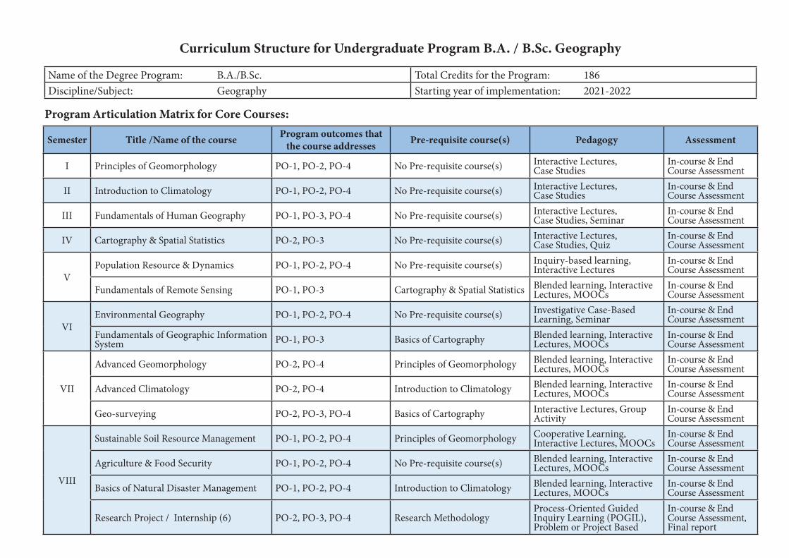
Curriculum Structure for Undergraduate Program B.A. / B.Sc. Geography
Name of the Degree Program: B.A./B.Sc. Total Credits for the Program: 186Discipline/Subject: Geography Starting year of implementation: 2021-2022
Program Articulation Matrix for Core Courses:
Semester Title /Name of the course Program outcomes that the course addresses Pre-requisite course(s) Pedagogy Assessment
I Principles of Geomorphology PO-1, PO-2, PO-4 No Pre-requisite course(s) Interactive Lectures, Case Studies
In-course & End Course Assessment
II Introduction to Climatology PO-1, PO-2, PO-4 No Pre-requisite course(s) Interactive Lectures, Case Studies
In-course & End Course Assessment
III Fundamentals of Human Geography PO-1, PO-3, PO-4 No Pre-requisite course(s) Interactive Lectures, Case Studies, Seminar
In-course & End Course Assessment
IV Cartography & Spatial Statistics PO-2, PO-3 No Pre-requisite course(s) Interactive Lectures, Case Studies, Quiz
In-course & End Course Assessment
VPopulation Resource & Dynamics PO-1, PO-2, PO-4 No Pre-requisite course(s) Inquiry-based learning,
Interactive LecturesIn-course & End Course Assessment
Fundamentals of Remote Sensing PO-1, PO-3 Cartography & Spatial Statistics Blended learning, Interactive Lectures, MOOCs
In-course & End Course Assessment
VIEnvironmental Geography PO-1, PO-2, PO-4 No Pre-requisite course(s) Investigative Case-Based
Learning, SeminarIn-course & End Course Assessment
Fundamentals of Geographic Information System PO-1, PO-3 Basics of Cartography Blended learning, Interactive
Lectures, MOOCsIn-course & End Course Assessment
VII
Advanced Geomorphology PO-2, PO-4 Principles of Geomorphology Blended learning, Interactive Lectures, MOOCs
In-course & End Course Assessment
Advanced Climatology PO-2, PO-4 Introduction to Climatology Blended learning, Interactive Lectures, MOOCs
In-course & End Course Assessment
Geo-surveying PO-2, PO-3, PO-4 Basics of Cartography Interactive Lectures, Group Activity
In-course & End Course Assessment
VIII
Sustainable Soil Resource Management PO-1, PO-2, PO-4 Principles of Geomorphology Cooperative Learning, Interactive Lectures, MOOCs
In-course & End Course Assessment
Agriculture & Food Security PO-1, PO-2, PO-4 No Pre-requisite course(s) Blended learning, Interactive Lectures, MOOCs
In-course & End Course Assessment
Basics of Natural Disaster Management PO-1, PO-2, PO-4 Introduction to Climatology Blended learning, Interactive Lectures, MOOCs
In-course & End Course Assessment
Research Project / Internship (6) PO-2, PO-3, PO-4 Research MethodologyProcess-Oriented Guided Inquiry Learning (POGIL), Problem or Project Based
In-course & End Course Assessment, Final report

Program Articulation Matrix for Open Elective (OE)
Semester Title of the course PO that the course addresses Pre-requisite course(s) Pedagogy Assessment
I
Earth System Dynamics PO-1, PO-2 No Pre-requisite course(s) Interactive lectures, Blended learning
In-course & End Course Assessment
Introduction to Natural Resources PO-1, PO-2 No Pre-requisite course(s) Interactive lectures, Blended learning
In-course & End Course Assessment
Introduction Physical Geography PO-1, PO-2, PO-3 No Pre-requisite course(s) Interactive lectures, Blended learning
In-course & End Course Assessment
Fundamentals of Remote Sensing PO-1, PO-2, PO-3 No Pre-requisite course(s) Interactive lectures, Blended learning
In-course & End Course Assessment
II
Human of Geography PO-1, PO-2 No Pre-requisite course(s) Inquiry-based learning, Interactive Lectures
In-course & End Course Assessment
Fundamentals of Natural Disasters PO-1, PO-2 No Pre-requisite course(s) Interactive lectures, Blended learning
In-course & End Course Assessment
Climate Change: Vulnerability & Adaptation PO-1, PO-2, PO-4 No Pre-requisite course(s) Blended learning, Case-Based Learning
In-course & End Course Assessment
Basics of Geographic Information Systems PO-1, PO-2, PO-3 Fundamentals of Remote Sensing
Interactive lectures, Blended learning
In-course & End Course Assessment
III
Geography of India PO-1, PO-2 No Pre-requisite course(s) Interactive lectures, Blended learning
In-course & End Course Assessment
Geography of Tourism PO-1, PO-2 No Pre-requisite course(s) Interactive lectures, Blended learning
In-course & End Course Assessment
Disaster Risk Reduction PO-1, PO-2 No Pre-requisite course(s) Interactive lectures, Blended learning
In-course & End Course Assessment
Application of GIS & Remote Sensing PO-1, PO-2, PO-4 Fundamentals of Remote Sensing, Basics of GIS
Interactive lectures, Blended learning
In-course & End Course Assessment
IV
Geography of Karnataka PO-1, PO-2 No Pre-requisite course(s) Interactive lectures, Blended learning
In-course & End Course Assessment
Biogeography PO-1, PO-2 No Pre-requisite course(s) Interactive lectures, Blended learning
In-course & End Course Assessment
Population & Settlement Geography PO-1, PO-2 No Pre-requisite course(s) Interactive lectures, Blended learning
In-course & End Course Assessment
Regional Planning & Development PO-1, PO-2, PO-4 No Pre-requisite course(s) Interactive lectures, Blended learning
In-course & End Course Assessment

Program Articulation Matrix for Vocational Courses:
Semester Title of the course PO that the course addresses Pre-requisite course(s) Pedagogy Assessment
VBasics Map Making PO-1, PO-3 No Pre-requisite course(s) Interactive lectures,
Blended learningIn-course & End Courses assessment
Mobile Asset Mapping PO-1, PO-3 No Pre-requisite course(s) Interactive lectures, Blended learning
In-course & End Courses assessment
VIOpen Source GIS PO-1, PO-3 No Pre-requisite course(s) Interactive lectures,
Blended learningIn-course & End Courses assessment
Landscaping & Layout Mapping PO-1, PO-3 No Pre-requisite course(s) Interactive lectures, Blended learning
In-course & End Courses assessment
Program Articulation Matrix for Discipline Specific Elective (DSE) :
Semester Title Of the course PO that the course addresses Pre-requisite course(s) Pedagogy Assessment
VII
Physical Geography PO-1 No Pre-requisite course(s) Interactive Lectures, case studies In-course & End Courses Assessment
Development of Geographical Thought PO-1 No Pre-requisite course(s) Interactive Lectures, case studies In-course & End
Courses Assessment
Trade & Transport Geography PO-1 No Pre-requisite course(s) Interactive Lectures, case studies In-course & End Courses Assessment
Settlement Geography PO-1 No Pre-requisite course(s) Interactive Lectures, case studies In-course & End Courses Assessment
Introduction to Oceanography PO-1 Introduction to Climatology Inquiry-based learning, Interactive Lectures, case studies
In-course & End Courses Assessment
Regional Geography of India PO-2, PO-4Principles of Geomorphology Introduction to Climatology Fundamentals of Human Geography
Blended learning, Investigative Case-Based Learning, Seminar
In-course & End Courses Assessment
Tourism Geography PO-1 Fundamentals of Human Geography Blended learning, Investigative Case-Based Learning, Seminar
In-course & End Courses Assessment
Climate Change: Vulnerability & Adaptation PO-1, PO-2, PO-4 Introduction to Climatolog Problem or project based learn-
ing, concept mapIn-course & End Courses Assessment

VIII
Bio-geography PO-1 No Pre-requisite course(s) Blended learning, Interactive Lectures, MOOCs
In-course & End Courses assessment
Geography of Health & Wellbeing PO-1, PO-2, PO-4 No Pre-requisite course(s) Blended learning, Interactive Lectures, MOOCs
In-course & End Courses assessment
Regional Geography of Karnataka PO-2, PO-4Principles of Geomorphology Introduction to ClimatologyFundamentals of Human Geography
Blended learning, Investigative Case-Based Learning, Seminar
In-course & End Courses assessment
Economic Geography PO-1, PO-2, PO-4 Fundamentals of Human GeographyCooperative Learning, Group Activity, Interactive Lectures, MOOCs
In-course & End Courses assessment
Regional Planning and Development PO-1, PO-2, PO-4 Fundamentals of Human Geography Inquiry-based learning, Interactive Lectures, case studies
In-course & End Courses assessment
Geopolitics & Defence Strategies PO-1, PO-2, PO-4 Pre-requisite course(s)Cooperative Learning, Group Activity, Interactive Lectures, MOOCs
In-course & End Courses assessment
Alternative Energy Sources PO-1, PO-2, PO-4 Environmental Geography Blended learning, Interactive Lectures, MOOCs
In-course & End Courses assessment
Natural Resource Management PO-1, PO-2, PO-4 Environmental Geography Inquiry-based learning, Interactive Lectures, case studies
In-course & End Courses assessment
Urban Geography PO-1, PO-2 Fundamentals of Human Geography Blended learning, Interactive Lectures, MOOCs
In-course & End Courses assessment
Economic Geography PO-1, PO-2, PO-4 Fundamentals of Human Geography Blended learning, Interactive Lectures, MOOCs
In-course & End Courses assessment
Disaster Risk Reduction PO-2, PO-4 Environmental Geography Blended learning, Interactive Lectures, MOOCs
In-course & End Courses assessment
Sustainable Rural Development PO-1, PO-2, PO-4 Regional Planning and Development Blended learning, Interactive Lectures, MOOCs
In-course & End Courses assessment
Continue...

B.A. / B.Sc. (Basic / Honours) Degree in Geography Contents of Courses in the Program
Course Type
Semester Discipline Specific Core (DSC) Open Elective (OE) /(3) Vocational Courses (3)
Discipline Specific Elective (DSE) (4)
Research/Other Courses
I
Principles of Geomorphology Earth System Dynamics /Introduction to Natural Resources /Introduction Physical Geography /Fundamentals of Remote Sensing
Nil Nil
II
Introduction to Climatology Human of Geography / Fundamentals of Natural Disasters / Climate Change: Vulnerability & Adaptation / Basics of Geographic Information Systems
Nil Nil
III
Fundamentals of Human Geography Geography of India /Geography of Tourism /Disaster Risk Reduction /Application of GIS & Remote Sensing
Nil Nil
IV
Cartography & Spatial Statistics Geography of Karnataka /Biogeography /Population & Settlement Geography /Regional Planning & Development
Nil Nil
V Population Resource & Dynamics/Fundamentals of Remote Sensing Nil
Basics Map Making /Mobile Asset Mapping
Nil Internship
VIEnvironmental GeographyFundamentals of Geographic Information System
NilOpen Source GIS /Landscaping & Layout Mapping
Nil

VII
Advanced GeomorphologyAdvanced ClimatologyGeo-surveying
Nil Nil
Physical Geography /Development of Geographical Thought /Trade & Transport Geography /Settlement Geography
Introduction to Oceanography /Regional Geography of India /Tourism Geography /Climate Change: Vulnerability & Adaptation
Research Methodology
VIII
Sustainable Soil Resource ManagementAgriculture & Food SecurityBasics of Natural Disaster Management
Nil Nil
Bio-geography /Geography of Health & Wellbeing /Regional Geography of Karnataka /Economic Geography
Regional Planning and Development /Geopolitics & Defence Strategies /Alternative Energy Sources /Natural Resource Management
Urban Geography /Economic Geography / Disaster Risk Reduction / Sustainable Rural Development
Research Project / Internship

Coursewise Credit and marks distribution for the B.A. / B.Sc. (Basic / Hons) Geography in Universities and Colleges in Karnataka
Semester Course Type
Course NameCredits Marks
Theory Practical Tutorial Total Theory Practical Tutorial Total
I
DSC Principles of Geomorphology 4 2 - 6 100 50 - 150
OEEarth System Dynamics / Introduction to Natural Resources / Introduction to Physical Geography / Fundamentals of Remote Sensing
3 - - 3 100 - - 100
II
DSC Introduction to Climatology 4 2 - 6 100 50 - 150
OEHuman Geography / Fundamentals of Natural Disasters / Climate Change: Vulnerability & Adaptation / Basics of Geographic Information Systems
3 - - 3 100 - - 100
III
DSC Fundamentals of Human Geography 4 2 6 100 50 - 150
OEGeography of India / Geography of Tourism / Disaster Risk Reduction / Application of GIS & Remote Sensing
3 - - 3 100 - - 100
IV
DSC Cartography & Spatial Statistics 4 2 6 100 50 - 150
OEGeography of Karnataka / Biogeography / Population & Settlement Geography / Regional Planning & Development
3 - - 3 100 - - 100
V
DSC Population Resource & Dynamics 4 1 - 5 70 30 100DSC Fundamentals of Remote Sensing 3 2 - 5 70 30 - 100
VocVocational – 1Basics of Map aking/ Mobile Asset Mapping
3 - - 3 100 - - 100
Internship 2 - - 2 50 - - 50
VI
DSC Environmental Geography 4 1 - 5 70 30 - 100DSC Fundamentals of Geographic Information System 3 2 - 5 70 30 - 100
Voc Vocational – 2 Open Source GIS / Landscaping & Layout Mapping 3 - - 3 100 - - 100
DSC: Discipline Specific Core, DSE: Discipline Specific Elective, OE: Open Elective, L+T+P: Lecture+Totorial+Practical
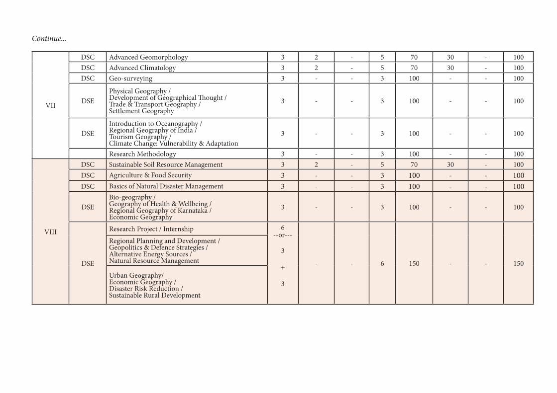
VII
DSC Advanced Geomorphology 3 2 - 5 70 30 - 100DSC Advanced Climatology 3 2 - 5 70 30 - 100DSC Geo-surveying 3 - - 3 100 - - 100
DSEPhysical Geography / Development of Geographical Thought / Trade & Transport Geography / Settlement Geography
3 - - 3 100 - - 100
DSE Introduction to Oceanography / Regional Geography of India / Tourism Geography / Climate Change: Vulnerability & Adaptation
3 - - 3 100 - - 100
Research Methodology 3 - - 3 100 - - 100
VIII
DSC Sustainable Soil Resource Management 3 2 - 5 70 30 - 100DSC Agriculture & Food Security 3 - - 3 100 - - 100DSC Basics of Natural Disaster Management 3 - - 3 100 - - 100
DSEBio-geography / Geography of Health & Wellbeing / Regional Geography of Karnataka / Economic Geography
3 - - 3 100 - - 100
DSE
Research Project / Internship 6 --or---
3
+
3
- - 6 150 - - 150
Regional Planning and Development / Geopolitics & Defence Strategies / Alternative Energy Sources / Natural Resource Management
Urban Geography/ Economic Geography / Disaster Risk Reduction / Sustainable Rural Development
Continue...

Sem Discipline Specific Core (DSC) (Credits) (L+T+P)
Discipline Specific Elective (DSE) /
Open Elective (OE) (Credits) (L+T+P)
Ability Enhancement Compulsory Courses (AECC),
Languages (L+T+P)
Skill Enhancement Course (SEC)Total CreditsSkill-based
(Credits) (L+T+P)
Value-based (Credits) (L+T+P)
IDSC-A1 Principles of Geomorphology (4+2)DSC-B1 (4+2)
OE-1.1 Earth System Dynamics /OE-1.2 Introduction to Natural Resources /OE-1.3 Introduction to Physical Geography /OE-1.4 Fundamentals of Remote Sensing (3)
L1-1 (3), L2-1 (3)(3+1+0 each)
NilSEC-1: Digital Fluency (2) (1+0+2)
Physical Education for Fitness (1) (0+0+2)
Health & Wellness (1) (0+0+2)
25
II
DSC-A2 Introduction to Climatology (4+2)DSC-B2 (4+2)
OE-2.1 Introduction to Human Geography /OE-2.2 Fundamentals of Natural Disasters /OE-2.3 Climate Change: Vulnerability & Adaptation /OE-2.4 Basics of Geographic Information Systems (3)
L2-1 (3), L2-1 (3)(3+1+0 each)
Environmental Studies (2)
Nil Physical Education - Yoga (1) (0+0+2)
NCC/NSS/R&R (S&G)/ Cultural (1) (0+0+2)
25
Exit option with Certificate (50 Credits)
III
DSC-A 3 fundamentals of Human Geography (4+2)DSC-B3 (4+2)
OE-3.1 Geography of India /OE-3.2 Geography of Tourism /OE-3.3 Disaster Risk Reduction /OE-3.4 Application of GIS & Remote Sensing (3)
L1-3 (3), L2-3 (3)(3+1+0 each)
Nil
SEC-2: Artificial Intelligence (2) (1+0+2)
Physical Education - Sports Skills (1) (0+0+2)
NCC/NSS/R&R (S&G)/ Cultural (1) (0+0+2)
25
IV
DSC-A4 Cartography & Spatial Statistics (4+2)DSC-B4 (4+2)
OE-4.1 Geography of Karnataka /OE-4.2 Biogeography /OE-4.3 Population & Settlement Geography /OE-4.4 Regional Planning & Development (3)
L1-4 (3), L2-4 (3)(3+1+0 each)
Constitution of India (2)
Nil
Physical Education – Games (1) (0+0+2)
NCC/NSS/R&R (S&G)/ Cultural (1) (0+0+2)
25
Exit option with Diploma (100 Credits)Choose any one Discipline as Major, the other as the Minor
V
DSC-A5 Population Resource & Dynamics (4+1)* DSC-A6 Fundamentals of Remote Sensing (3+2)DSC-B5 (3+2)
Vocational – 1 (3)Voc 1.1 Basics of Map Making /Voc 1.2 Mobile Asset Mapping Nil Nil
SEC-3: Such as Cyber Security (2) (1+0+2)
Physical Education – Games (1) (0+0+2)
NCC/NSS/R&R (S&G)/ Cultural (1) (0+0+2)
22
VI
DSC-A7 Environmental Geography (4+1)*DSC-A8 Fundamentals of Geographic Information Systems (3+2)DSC-B6 (3+2)
Vocational – 2 (3)Voc 2.1 Open Source GIS /Voc 2.2 Landscaping & Layout Mapping
Internship (2)
Nil Nil
SEC-4: Professional Cmmunication (2)
Physical Education – Games (1) (0+0+2)
NCC/NSS/R&R (S&G)/ Cultural (1) (0+0+2)
24
Exit option with Bachelor of Arts, B.A. / Bachelor of Science, B.Sc Basic Degree (144 Credits)
Program Structure for the B.A./B.Sc. Geography (Basic / Honours) Degree in Universities and Colleges of Karnataka

VII
DSC-A9 Advanced Geomorphology (3+2)DSC-A10 Advanced Climatology (3+2)DSC-A11 Geo-surveying (3)
DSE-A1.1 Physical Geography /DSE-A1.2 Development of Geographical Thought /DSE-A1.3. Trade & Transport Geography /DSE-A1.4 Settlement Geography (3)(Student can select one from above and another from below pools for 3 credits each)DSE-A2.1 Introduction to Oceanography /DSE-A2.2 Regional Geography of India /DSE-A2.3 Tourism Geography /DSE-A2.4 Climate Change: Vulnerability & Adaptation (3)
Research Methodology (3)
Nil Nil Nil Nil Nil 22
VIII
DSC-A12 Sustainable Soil Resource Management (3+2)DSC-A13 Agriculture & Food Security (3)DSC-A14 Basics of Natural Disaster Management (3)
DSE-A3.1 Bio-geography /DSE-A3.2 Geography of Health & Wellbeing /DSE-A3.3 Regional Geography of KarnatakaDSE-A3.4 Economic Geography (3)
Research Project / Intersnhip (6)DSE-A4.1 Regional Planning and Development /DSE-A4.2 Geopolitics & Defence Strategies /DSE-A4.3 Alternative Energy Sources /DSE-A4.4 Natural Resource Management (3)
(If student is not willing to carry out Research Project or Internship he /she can elect any two DSE. One from above and another from below pools for 3 credits each)
DSE-A5.1 Urban Geography DSE-A5.2 Economic Geography / DSE-A6.3 Disaster Risk Reduction / DSE-A6.4 Sustainable Rural Development (3)
Nil Nil Nil Nil Nil 20
Award of Bachelor of Arts Honours, / Bachelor of Science Honours Degree (186 Credits)
Note: * Students belongs to social science disciplines without practical can study these courses for 4 credits (theory only not practical).

20
Technical Skills and possible jobs after each exit during and after the program
Year Exit Level Credits Technical Skills Possible Jobs
I Certificate 50• Map Interpretation• Geomorphic Analysis• Climate Data Analysis & Interpretation
• Field Surveyor• Weather Data Analyst
II Diploma 100• Cartography• Statistics Analysis
• Field Surveyor• Cartographer
III Degree 142
• Cartography• GIS and Image Analysis• Tourism Management
• GIS Field Surveyor• GIS Trainee• Nature Conservation Officer• School Teacher
IV Degree with Honors 182
• GIS & Image Analysis• Resource Management• Town Planning• Tourism Management
• Sustainability Consultant• Tourism officer• Transport planner• Cartographer• GIS Engineer• Environmental consultant• Geography Teacher• Geography Researcher

21
B.A. / BSc Semester 1
Title of the Course: DSC-A1 Principles of Geomorphology
Number of Theory Credits
Number of lecture hours/ semester
Number of practical Credits
Number of practical hours/ semesters
4 52 or 56 2 52 or 56
Course Outcomes: 1. After the completion of this course, students should be able to: 2. Define the field of Geomorphology and to explain the essential principles of it. 3. to outline the mechanism of dynamic nature of the Earth’s surface and interior of the
Earth. 4. to illustrate and explain the forces affecting the crust of the earth and its effect on it. 5. to understand the conceptual and dynamic aspects of landform development
Course Objectives: This course aims to:
1. to define the concepts in Geomorphology and Physical Geography 2. to introduce various concept to understand cycles of the solid Earth surface 3. to understand the dynamic nature of the Earth’s surface, various processes, and
landforms. 4. to study the impact human on geomorphic system.
Content of Theory Course 1 52/56Hrs
Unit – 1 Geomorphology 13/14
Introduction to geography: physical and human geography Introduction to Geomorphology: meaning, nature, development, and scope Principles of Geomorphology Geological Time Scale
Distribution of continents and oceans
Unit – 2 Systems and Cycles of the Solid Earth 13/14
Internal structure of the earth Alfred Wegener’s continental drift Theory of Isostacy: Views of Pratt and Airy Convectional current theory and concept of sea floor spreading Theory of Plate Tectonics: plate boundaries, subduction, Case Studies: Volcano, Earthquake: reporting of latest incidents
Case Studies: Volcano, Earthquake: reporting of latest incidents
Unit – 3 The Dynamics of Earth 13/14
Earth’s Movements: Endogenetic and Exogenetic forces, Sudden and Diastrophic movements- Epeirogenetic and Orogenetic Movements-Process of folding and faulting Vulcanicity and earthquake Rocks: Characteristics, types, importance, and rock cycle Weathering: meaning, types and controlling factors
Mass Movement: meaning, controlling factors, types-landslides, rock-falls

22
Unit – 4 Evolution of Landforms 13/14
Evolution of Landforms Landforms: meaning, types and factors controlling landforms development Slope development: concept and types Concept of Cycle of Erosion–W.M. Davis and W. Penck Agents of Denudation: river; drainage patterns, groundwater, Sea waves, Wind and Glaciers and resultant landforms.
Application of geomorphology: in India and Karnataka (Regional planning, Urban planning and transportation, Mining, Hazard management, Agriculture and Environmental management).
Textbooks
1. Ahmed E. (1985) Geomorphology, Kalyani Publishers, New Delhi. 2. P Mallappa, Physical Geography (Kannada Version) 3. Ranganath Principles of Physical Geography (Kannada Version) 4. Nanjannavar S S: Physical Geography (Kannada Version) 5. Hugar M R Physical Geography part 1(Kannada Version) 6. Goudar M B, Physical Geography (Kannada Version) 7. Kolhapure and S S Nanjan, Physical Geography (Kannada Version)
References
1. Bloom A.L. (1978) Geomorphology: A Systematic Analysis of Late Cenozoic Landforms Prentice – Hall of India, New Delhi.
2. Brunsden D. (1985) Geomorphology in the Service of Man: The Future of Geography, Methnen, U.K.
3. Chorley, R.J., Schumm, S. A. and Sugden, D.E. 1984: Geomorphology, Methuen, London
4. Cooke, R.U. and Warren, 1973: Geomorphology in Deserts, Batsford, London 5. Dayal, P. 1996: Textbook of Geomorphology, Shukla Book Depot, Patna. 6. Goudie Anrew et.al. (1981) Geomorphological Techniques, George Allen &Unwin,
London. 7. Homes A. (1965) Principles of Physical Geology, 3rd Edition, ELBSS Edn. 8. Strahler A.N. (1968) The Earth Sciences, Harper & Row Intl. Edn, New York 9. Thornberry W.D. (1969) Principles of Geomorphology 2nd Edition, Wiley Intl. Edn. &
Wiley, 1984. 10. Verstappen H. (1983) Applied Geomorphology, Geomorphological Surveys for
Environmental Develop- ment, Elsevier, Amsterdam
Reference Websites
1. http://www.solarviews.com/eng/earth.htm 2. http://www.moorlandschool.co.uk/earth/tectonic.htm 3. https://www.usgs.gov/ 4. https://www.ksndmc.org/ Pedagogy

23
Formative Assessment
Assessment Occasion/ type
Weightage in Marks
Case Studies 30%
Assignment 20%
CIA 50%
Total 100%
Dr. K Prasanna kumar Prof. Ashok Hanjagi
Date: 16/09/2021 Course Co-ordinator Subject Committee Chairperson
Geomorphology Practical
Content of Practical Course 1: List of Experiments to be conducted
Exercise-1: Identification of Rocks and Minerals. Mineral samples: Iron ore, Bauxite ore and
Manganese. Rock Samples: Granite, Basalt, Lime Stones, Sandstone, quartzite, and
marble.
Exercise-2: Extraction and interpretation of Geomorphic information from Topographical
maps
Exercise-3: Preparation of contour map from toposheet, Construction of Relief Profiles-
serial, Super imposed, Projected & Composite.
Exercise-4: Slope Analysis - Slope Maps (Wentworth method) Slope (isotan and isosin) and
aspect maps & Hypsometric curve and integral
Exercise-5: Drainage Morphometry: delineation of watershed, stream ordering and
Morphometric analysis: mean stream length, drainage density and drainage frequency.
Field Work: Measurement of channel cross-sections in the field, Geomorphic map of
channel bed, Study of erosional and depositional features in the field.
Case Study: students must be taken to observe local land formation and degradation and write a
report on their effectiveness.

24
B.A. / BSc Semester 1
Title of the Course: OE-1.1 Earth System Dynamics
Number of Theory Credits
Number of lecture hours/ semester
Number of practical Credits
Number of practical hours/ semesters
4 52 or 56 2 52 or 56
Course Outcomes: 1. This course is to make understand the basic concepts of earth and to impart
necessary skills of earth system, and dynamics to the students. So that, students acquire basic understanding of the mother earth
2. To articulate the synergies and trade-offs of earth system and interconnected sub-systems to the students of interdisciplinary students.
Course Objectives This course aims to
1. Understand the concepts in Earth Sciences 2. To study the global issues in the Earth system 3. To study application of geoinformatics to solve the disaster and hazards
Content of Theory Course 1 52/56Hrs
Unit – 1 Earth System Dynamics 13/14
Origin of Earth and its forms, plate tectonics, layers of earth and composition, geological epochs, evolution of species, extinctions, ice ages, continental drift theory, Process of atmosphere, hydrosphere, biosphere, lithosphere, and their interaction. Trajectories of the Earth System in the Anthropocene.
Unit – 2 Issues in Earth System 13/14
Global warming, greenhouse effect, carbon cycle, nitrogen cycle, water cycle, ozone depletion, floods, droughts, weather variations, sea level rise, changing ecosystems, snow / glaciers melting and impact of pollution.
Unit – 3 Climate Change 13/14
The physical science of climate system and change, concepts, causes, effects, measures, climate change; Land – Climate interactions and climatic zones of world and India; Climate change and linkages with energy, emerging diseases, community response.
Unit – 4 Geoinformatics Applications: 13/14
Concepts of hazards, risks and vulnerability; their analysis relating climate projections and their uncertainties; global warming, floods and droughts, and weather variations, ecosystems changes, and snow/glaciers melting, energy studies, health and diseases studies and other case studies.
References 1. The Dynamic Earth System (2012), Prentice Hall India Learning Private Limited; Third
edition (2012) A.M. Patwardhan
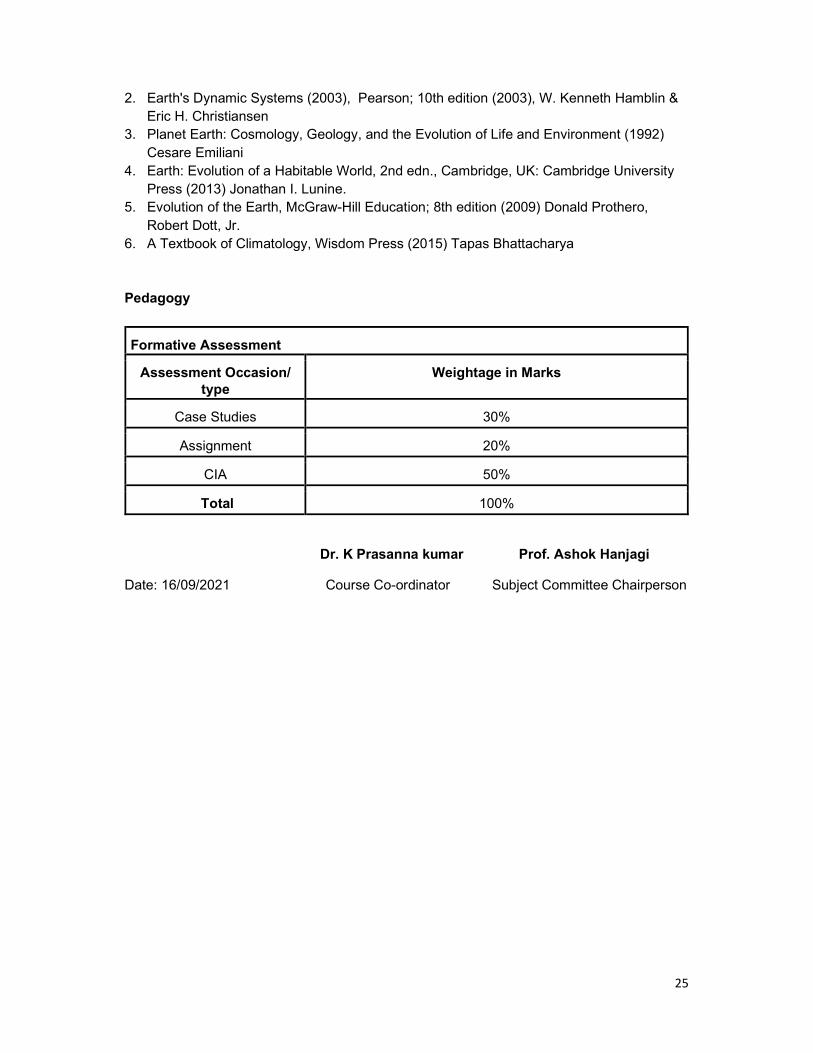
25
2. Earth's Dynamic Systems (2003), Pearson; 10th edition (2003), W. Kenneth Hamblin & Eric H. Christiansen
3. Planet Earth: Cosmology, Geology, and the Evolution of Life and Environment (1992) Cesare Emiliani
4. Earth: Evolution of a Habitable World, 2nd edn., Cambridge, UK: Cambridge University Press (2013) Jonathan I. Lunine.
5. Evolution of the Earth, McGraw-Hill Education; 8th edition (2009) Donald Prothero, Robert Dott, Jr.
6. A Textbook of Climatology, Wisdom Press (2015) Tapas Bhattacharya Pedagogy
Formative Assessment
Assessment Occasion/ type
Weightage in Marks
Case Studies 30%
Assignment 20%
CIA 50%
Total 100%
Dr. K Prasanna kumar Prof. Ashok Hanjagi
Date: 16/09/2021 Course Co-ordinator Subject Committee Chairperson

26
B.A. / BSc Semester 1
Title of the Course: OE: 1.2 Introduction to Natural Resources
Number of Theory Credits Number of lecture hours/ semester
3 39 or 42
Course Outcomes: At the end of the course the students will:
1. Understand concepts of different natural resources, its use, overuse, with its solution by natural resource management methods.
2. Appreciate the need for managing land and water resources for sustainable growth and development, managerial skills such as land evaluation and land classification.
3. Also, able to understand the causes and consequences of water stress and draw water conservation and management plans.
Course Objectives: This course aims to
1. explain the types of natural resources that exist. 2. Study the role of government and different agencies in the natural resource
management 3. Study the threat to the natural resources and the policies to solve it.
Content of Theory Course 1 13/15Hrs
Unit – 1 Concept of Resources 13/14
Meaning, Definition, importance and classification of Resources, Appraisal of Natural Resources, Natural Resources Economics, History of Conservation, need for conservation and Management of Natural Resources –Role of Government and NGO Agencies, Resource Creating Factors. Environmental Risk- types, wildlife, forest risk and its impact on environment and its management.
Unit – 2 Land Resources 13/14
Land Evaluation Methods, Land classification Methods, Land use and Land cover Mapping changes. Issue related to land use change –Land use and population, Land use pattern in the world. Land source at stress, land use planning and development. Soil erosion, soil degradation, methods of conservation.
Unit – 3 Water Resources 13/14
Importance of water, Recent trends in water use in the world and in India, water crises, (stress) causes and consequences of water stress or crises, methods of water conservation, watershed management, coastal and ocean Resources management, Fisheries Management
Unit – 4 Minerals Resources 13/14
Types of minerals, classifications of Major Minerals, their distribution and production. Such as Petroleum, Coal, Iron ore, Bauxite and Copper etc, and its uses. Mineral exploration methods, Mining, and its effects on environment. Mineral’s conservation and mining policy

27
References 1. Dr.Alka Gautham: Geography of Resources: Exploitation, Conservation and
Mangement, Sharada Pustak Bhavan, Allahabad. 2. Dr.P.S.Negi: Geography of Resources: Kedarnath Ramnath Publishers, New Delhi 3. Dr.Rajashekara Shetty(2009): An Analysis of World Resources with reference to
India, Sarala Raj, Ria Publishers, Mysore 4. Khanna K.K and Gupta V.K.(1993): Economic and Commercial Geography, Sultan
Chand, New Delhi 5. Prof. Zimmerwan – World Resources and Industries 6. Roy, P.R(2001) Economic Geography – A Study of Resources, New Central Book
Agency, Calcutta.
Pedagogy
Formative Assessment
Assessment Occasion/ type
Weightage in Marks
Seminar 30%
Assignment 20%
CIA 50%
Total 100%
Dr. K Prasanna kumar Prof. Ashok Hanjagi
Date: 16/09/2021 Course Co-ordinator Subject Committee Chairperson

28
B.A. / BSc Semester 1
Title of the Course: OE 1.3 Introduction to Physical Geography
Number of Theory Credits Number of lecture hours/ semester
3 39 or 42
Course Outcomes: 1. Students will be able to understand the fundamental concepts in Earth Sciences 2. understands basic terminology used to describe physical processes and landscape
forms. 3. Describe elements of the atmosphere and the oceans
Course Objectives: This course aims to
1. Study basic principles of the Earth Sciences 2. Understand the landforms, atmospheric elements and structure and basics of
oceanography
Content of Theory Course 1 52/56Hrs
Unit – 1 13/14
Origin, Shape and Size of the Earth, Movement of the Earth- Rotation and Revolution, Effects of the movement of Earth, Coordinates -Latitude, Longitude and Time.
Structure of the Earth,
Unit – 2 13/14
Rocks - types, significance, Weathering –types. Agents of Denudation - River, Glacier, Wind and Under Ground water.
Volcanicity, Earthquakes and Tsunamis
Unit – 3 13/14
Structure and Composition of Atmosphere, Weather and Climate. Atmospheric Temperature, Heat Budget of the atmosphere
Atmospheric Pressure, Winds and Precipitation
Unit – 4 13/14
Distribution of Land and Sea, Submarine Relief of the Ocean, Temperature and Salinity of Sea Water. Ocean Tides, Waves and Deposits, Ocean currents - Atlantic, Pacific and Indian Oceans. Marine Resources: Biotic, mineral and energy resources
References
1. B.S. Negi (1993) Physical Geography. S.J. Publication, Meerut 2. D.S. Lal (1998) Climatology. Chaitnya publishing house, Allahabad 3. K. Siddhartha (2001) Atmosphere, Weather and Climate. Kisalaya publication, New
Delhi 4. R.N. Tikka (2002) Physical Geography. Kedarnath Ramnath & co, Meerut

29
5. Willian D. Thornbury (1997) Principle of Geomorphology. New Age International (Pvt Ltd.) New Delhi.
Pedagogy
Formative Assessment
Assessment Occasion/ type
Weightage in Marks
Quiz 30%
Assignment 20%
CIA 50%
Total 100%
Dr. K Prasanna kumar Prof. Ashok Hanjagi
Date: 16/09/2021 Course Co-ordinator Subject Committee Chairperson

30
B.A. / BSc Semester 1
Title of the Course: OE 1.4 Fundamentals of Remote Sensing
Number of Theory Credits Number of lecture hours/ semester
3 39 or 42
Course Outcomes: 1. This course is to make understand the basic concepts of Remote Sensing and to
impart necessary skills of remote sensing analysis, and image interpretation to the students. So that, students acquire employable skills in remote sensing.
2. Students will learn how to handle and process the satellite images for understanding of biophysical phenomena of the earth system.
Course Objectives: 1. To congregate the basic concepts and fundamentals of physical principles of remote
sensing 2. To create a firm basis for successful integration of remote sensing in any field of
application. 3. To study basics of digital image processing and image interpretation techniques. 4. To study the applications of the remote sensing to solve the real-world problems.
Content of Theory Course 1 52/56Hrs
Unit – 1 Introduction 13/14
Definition of Remote Sensing, developmental stages, Laws of Physics, electromagnetic waves, spectrum, regions, wavelength, frequencies, and applications. Types-Satellites, Sensors, Payloads, Orbits, telemetry of satellites.
Process and types of Remote Sensing 13/14
Process of remote sensing, interaction of radiation with atmosphere and targets, atmospheric noises, attenuation in radiance, resolutions of remote sensing, optical remote sensing, visible region of the spectrum, thermal remote sensing, microwave remote sensing, Hyperspectral remote sensing, LiDAR, and other remote sensing platforms.
Unit – 3 Image Classification and Interpretation 13/14
Satellite products and its spectral characteristics, composite images, band ratios; Land use land cover classification schemes-Anderson and NRSC; Visual image interpretation, elements, stages of interpretation and interpretation keys. Image classification- supervised, unsupervised, and principal component analysis (PCA) and accuracy assessment.
Unit – 4 Applications of Remote Sensing 13/14
Disaster Management, Meteorological Studies, Agricultural and Irrigation Studies, Forestry Studies, Hydrological Studies, Natural Resource, Oceanic and Coastal mapping, Soil resource mapping, Urban and Rural Mapping and Management.

31
References 1. Remote Sensing of the Environment: An Earth Resource Perspective (Prentice Hall
Series in Geographic Information Science) - Second Edition (2006), John Jensen 2. Remote Sensing and GIS, Second Edition (2011), Bhatta, B. 3. Introduction to Remote Sensing and Image Interpretation (2003); Lillesand T.M. 4. Remote sensing and image interpretation (2015); Chipman, Jonathan W., Kiefer, Ralph
W., Lillesand 5. Introduction to Remote Sensing, Fifth Edition (2011); James B. Campbell, Randolph H.
Wynne 6. Practical handbook of remote sensing, First Edition (2016) - Lavender, Andrew,
Lavender, Samantha 7. Introductory Digital Image Processing: A Remote Sensing Perspective, Fourth Edition
(2015) - John R. Jensen 8. Image processing and GIS for remote sensing: techniques and applications; Second
Edition (2016) - Liu, Jian-Guo, Mason, Philippa J 1. https://onlinecourses.nptel.ac.in/noc19_ce41/preview Pedagogy
Formative Assessment
Assessment Occasion/ type
Weightage in Marks
Quiz 30%
Assignment 20%
CIA 50%
Total 100%
Dr. K Prasanna kumar Prof. Ashok Hanjagi
Date: 16/09/2021 Course Co-ordinator Subject Committee Chairperson

32
B.A. / BSc Semester 2
Title of the Course: Introduction to Climatology
Number of Theory Credits
Number of lecture hours/ semester
Number of practical Credits
Number of practical hours/ semesters
4 52 or 56 2 52 or 56
Course Outcomes:
After the completion of this course, students should be able to 1. define the field of climatology and to understand the atmospheric composition and
structure. 2. to outline the mechanism and process of solar radiation transfer to earth surface and to
ex- plain the temperature distribution and variation according to time and space. 3. to illustrate and explain the air pressure system, wind regulating forces and the formation
of the Atmospheric Disturbance. 4. to understand and compute the air humidity as well as to explain the process of
Condensation and formation of precipitation and its types.
Course Objectives: This course aims to: 1. to define the field of climatology and components of the climate system 2. to introduce various dimensions of climatology like structure and composition. 3. to understand the global atmospheric pressure, temperature, and wind system. 4. to study the concept of atmospheric moisture and its types
Content of Theory Course 1 52/56Hrs
Unit – 1 Composition and Structure of the Atmosphere 13/14
Nature and Scope of Climatology, Atmospheric Sciences; Climatology and Meteorology Origin and structure of the Atmosphere: Troposphere, Stratosphere, Mesosphere, Ionosphere, Exosphere and their characteristics. Composition of the atmosphere
Weather and Climate
Unit – 2 Atmospheric Temperature 13/14
Insolation: Definition, Mechanism, Solar Constant. Factors affecting the Insolation: Angle of incidence, length of the day, Sunspots, Distance between the earth and the sun, effect of the atmosphere. Heating and cooling process of the atmosphere-Radiation, Conduction, convection, and advection. Temperature: meaning and Influencing Factors on the Distribution of Temperature Distribution of the temperature: Vertical, Horizontal, and Inversion of temperature.
Global Energy Budget: Incoming shortwave solar radiation, Outgoing Longwave Terrestrial radiation, Albedo. Net Radiation and Latitudinal Heat Balances.
Unit – 3 Atmospheric Pressure and Winds 13/14
Atmospheric Pressure: Influencing factors on atmospheric pressure. Vertical and Horizontal Distribution of the atmospheric pressure and

33
Pressure Belts, Pressure Gradient. Tri-cellular-Hadley, Ferrel’s and Polar Cells. Winds: influencing factors, Types - planetary, seasonal, local wind Variable winds-Cyclones and anti-cyclones.
Air-Masses and Fronts: Definition, Nature, Source Regions, Classification.
Unit – 4 Atmospheric Moisture 13/14
Humidity: Sources, influencing factors and types-Absolute, Relative and Specific. Hydrological cycle: process of evaporation, condensation. Clouds and its types Precipitation and its forms.
Climate Change: Causes and consequences, recent issues-floods, drought,
Textbooks
1. Lal, D. S. (1998). Climatology. Allahabad: Chaitanya Publishing House. 2. P Mallappa, Physical Geography (Kannada Version) 3. Ranganath Principles of Physical Geography (Kannada Version) 4. Nanjannavar S S: Physical Geography (Kannada Version) 5. Hugar M R Physical Geography part 1(Kannada Version) 6. Goudar M B, Physical Geography (Kannada Version) 7. Kolhapure and S S Nanjan, Physical Geography (Kannada Version)
References
8. Lutgens, Frederic K. & Tarbuck, Edward J. (2010). The Atmosphere: An Introduction to Meteorology. New Jersey: Pearson Prentice Hall.
9. Oliver, John E. & Hidore, John J. (2003). Climatology: An Atmospheric Science. Delhi: Pearson Education.
10. Singh, S. (2005). Climatology. Allahabad: Prayag Pustak Bhawan. 11. Barry, R.G. and Chorley, R.J. (2003): Atmosphere, Weather and Climate; Psychology
Press, Hove; East Sussex. 12. Critchfield, H.J., (1975): general Climatology, Prentice Hall, New Jersey. 13. Mather,J.R.(1974): Climatology: Fundamentals and Applications; Mc Craw Hill Book
Co., U.S.A. 14. Rumney, G.R. (1968): Climatology and the World Climates, Macmillan, London. 15. Trewartha, G.T. (1980): An Introduction to Climate; McGraw Hill, New York, 5th
edition, (International Student Edition) Reference Websites
1. https://earthobservatory.nasa.gov/ 2. https://mausam.imd.gov.in/ 3. https://www.weatheronline.in/ 4. https://earthexplorer.usgs.gov/ 5. https://www.nhc.noaa.gov/satellite.php
34
Pedagogy
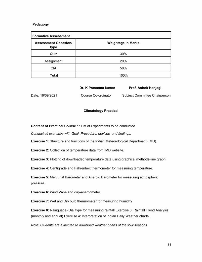
Formative Assessment
Assessment Occasion/ type
Weightage in Marks
Quiz 30%
Assignment 20%
CIA 50%
Total 100%
Dr. K Prasanna kumar Prof. Ashok Hanjagi
Date: 16/09/2021 Course Co-ordinator Subject Committee Chairperson
Climatology Practical
Content of Practical Course 1: List of Experiments to be conducted
Conduct all exercises with Goal, Procedure, devices, and findings.
Exercise 1: Structure and functions of the Indian Meteorological Department (IMD).
Exercise 2: Collection of temperature data from IMD website.
Exercise 3: Plotting of downloaded temperature data using graphical methods-line graph.
Exercise 4: Centigrade and Fahrenheit thermometer for measuring temperature.
Exercise 5: Mercurial Barometer and Aneroid Barometer for measuring atmospheric
pressure
Exercise 6: Wind Vane and cup-anemometer.
Exercise 7: Wet and Dry bulb thermometer for measuring humidity
Exercise 8: Rainguage- Dial type for measuring rainfall Exercise 3: Rainfall Trend Analysis
(monthly and annual) Exercise 4: Interpretation of Indian Daily Weather charts.
Note: Students are expected to download weather charts of the four seasons.

35
B.A. / BSc Semester 2
Title of the Course: OE 2.1 Introduction to Human Geography
Number of Theory Credits Number of lecture hours/ semester
3 52 or 56
Course Outcomes: 1. Students will learn how human, physical, and environmental components of the
world interact. 2. Students will be familiarized with economic processes such as globalization, trade
and their impacts on economic, cultural and social activities. 3. the student will Describe what geography and human geography are. 4. Understand population dynamics and migration.
Course Objectives: This course aims to
1. Understand the basics concepts of human geography 2. Study population attributes and dynamic nature of it 3. Introduce economic, cultural, and trade activities and their impact on the
development of the region
Content of Theory Course 1 52/56Hrs
Unit – 1 Introduction to Human Geography 13/14
Nature and scope, Development Environmental Determinism and Possiblism, Neo determinism (stop and go determinism) Approaches to human geography: Exploration and Descriptive approach, regional analysis Approach, Areal Differentiation Approach, Spatial organization Approach. Modern approaches: Welfare or Humanistic Approach, Radical Approach, Behavioral Approach, Post Modernism in geography
Fields and sub fields in Human geography
Unit – 2 Geographical Analysis of Population 13/14
Distribution and Growth of Population Density of population: meaning and Types: Arithmetic Density and Physiological Density. Regional distribution of Density of Population. Carrying capacity and sustainability, population Pyramid. Population Theories: Malthus Theory of Population, Demographic Transition Theory
Population Movement: Migration, Raventein’s Law of Migration, Factors of population Migration, Economic Push and Pull factors, Cultural Push and Pull Factors, Environmental Push and Pull Factors. Migration Types: Immigration and Emigration, Internal and International Migration
Unit – 3 Cultural Patterns and Processes 13/14
Concept of Culture, Material and Non material culture Cultural Regions, cultural Traits and Complexes, cultural Hearths, cultural Diffusion. Languages of the World: Types, Classification and Distribution. Language Extinction
Religions: Types and Classification. Distribution. Universalizing Religions: Christianity, Islam, Buddhism. Ethnic Religions: Hinduism, the Chinese religion, Shintoism, Judaism. The Major tribal population of the world.

36
Unit – 4 Human Economic Activities, Development and Settlements 13/14
Primary Economic Activities – Agriculture, Types: Primitive Subsistence, Intensive subsistence, Plantation Agriculture, Extensive Commercial grain cultivation, Mixed Farming, Dairy Farming Secondary and Tertiary Activities: Manufacturing, classification – based on size – Small Scale and Large scale. Based on Raw material – Argo-based, Mineral based, Chemical Based and Forest based. Industrial Regions of the world. Tertiary Activities: Types: Trade and commerce, Retail Trading services, Wholesale trading. Transport and communications: Factors, communication services – Telecommunication. Services: Informal and Non formal sector. Information technology and service. Human Settlements: Factors, Classification, Types and Patterns: Rural, Urban. Compact or Nucleated and Dispersed settlements. Rural settlement Patterns: linear, rectangular, circular, star shaped, T shaped.
Urban settlements: urbanism, classification – population size, occupation structure, Administration. functional classification of urban centres, types of urban settlements: towns, city, conurbation, Megalopolis, Million cities.
References
1. Hartshorne, T. A., & Alexander, J. W. (2010). Economic Geography. New Delhi: PHI Learning.
2. Knox, P., Agnew, J., & McCarthy, L. (2008). The Geography of the World Economy. London: Hodder Arnold.
3. Lloyd, P., & Dicken, B. (1972). Location in Space: A Theoretical Approach to Economic Geography. New York: Harper and Row.
4. Siddhartha, K. (2000). Economic Geography: Theories, Process and Patterns, New Delhi: Kisalaya Publications.
5. Smith, D. M. (1971). Industrial Location: An Economic Geographical Analysis, New York: John Wiley and Sons.
Pedagogy
Formative Assessment
Assessment Occasion/ type
Weightage in Marks
Quiz 30%
Assignment 20%
CIA 50%
Total 100%
Dr. K Prasanna kumar Prof. Ashok Hanjagi
Date: 16/09/2021 Course Co-ordinator Subject Committee Chairperson

37
B.A. / BSc Semester 2
Title of the Course: OE 2.2 Fundamentals of Natural disasters
Number of Theory Credits Number of lecture hours/ semester
3 39 or 42
Course Outcomes: Students will be able to 1. Understand the basics concepts in natural disasters 2. Study types of natural disasters and their effects Course Objectives: 1. The paper is intended to provide a general concept in the dimensions of disasters
caused by nature beyond the human control. 2. Introduce a holistic classification of natural disasters considering the Earth Sciences 3. Demonstrate the devastating effect of natural disasters to society;
Content of Theory Course 1 52/56Hrs
Unit – 1 Introduction to Natural Disaster 13/14
meaning, definition, and scope. Lithosphere and Natural Disasters Earthquakes and volcanoes,
Landslides and Avalanches
Unit – 2 Atmosphere and Natural Disasters 13/14
Heat wave and wildfire Cloud burst, hailstorm,
Drought and famines
Hydrosphere and Natural Disaster 13/14
Tsunami Hurricanes and cyclones
Floods and flash floods
Biosphere and Natural Disasters 13/14
Epidemics and pandemics Covid -19 and its effects
Techniques and technology to mitigate natural disasters
References 1. Dr. Mrinalini Pandey Disaster Management Wiley India Pvt. Ltd. 2. Tushar Bhattacharya Disaster Science and Management McGraw Hill Education (India)
Pvt. Ltd. 3. Jagbir Singh Disaster Management: Future Challenges and Opportunities K W
Publishers Pvt. Ltd. 4. J. P. Singhal Disaster Management Laxmi Publications.

38
5. Shailesh Shukla, Shamna Hussain Biodiversity, Environment and Disaster Management Unique Publications
6. C. K. Rajan, Navale Pandharinath Earth and Atmospheric Disaster Management: Nature and Manmade B S Publication
Pedagogy
Formative Assessment
Assessment Occasion/ type
Weightage in Marks
Seminar 30%
Assignment 20%
CIA 50%
Total 100%
Dr. K Prasanna kumar Prof. Ashok Hanjagi
Date: 16/09/2021 Course Co-ordinator Subject Committee Chairperson

39
B.A. / BSc Semester 2
Title of the Course: OE 2.3 Climate Change: Vulnerability and Adaptation
Number of Theory Credits Number of lecture hours/ semester
3 39 or 42
Course Outcomes: 1. This course is to make understand the basic concepts of Climate-Weather systems
and to impart necessary skills of Climate change, and its impact on earth systems to the students. So that, students acquire basic understanding of the climate systems of the earth and to study the applications of the Geoinformatics to study the climate change.
Course Objectives: 1. to provide a sound understanding of the economics of climate change from multiple
viewpoints 2. Demonstrate knowledge of the projected impacts of climate change and potential
strategies 3. for alleviating their negative impacts. 4. Define key terms (e.g., adaptation, resilience, vulnerability, mainstreaming) 5. Study application of the Geoinformatics in the Climate Change and Adaptation
Content of Theory Course 1 52/56Hrs
Unit – 1 Introduction to Climate Change 13/14
Meaning and concept of climate change. Origin of atmosphere. Concepts of weather and climate. Evidence of Climate Change: Historical and current weather and climate events: Meteorological, Lithogenic and biological, Greenhouse effect, Greenhouse Gases, Global Warming.
Extreme weather and climate event: Drought, Extreme Heat, Extreme precipitation, Hurricanes, Tornadoes and Wildfire.
Unit – 2 Causes and Effect of climate change 13/14
Natural cause: Solar variation, Volcanic eruption, ocean currents, Earth orbital change and internal variability Human causes: Burning fossil fuel, Deforestation, Intensive Agriculture, and industries. Impacts of climate change: Water resources, agriculture, human health, vegetation, economy and El nino, La Nina and Arctic Oscillation
International efforts to control the climate change: UNFCC its policy framework and provisions, Earth Summit Rio-de-Janeiro, World summit, Kyoto Protocol, Copenhagen summit and Doha Conference
Unit – 3 Climate change Vulnerability and Adaptation 13/14
Meaning and type of vulnerability Meaning, Definition, and types of adaptation Approaches of adaptation and Adaptation Strategies.
Adaptation in different sectors: Agriculture, Forest, Water resources, Biodiversity, Disaster Risk Management

40
Unit – 4 Vulnerability Assessment and climate change mitigation 13/14
Climate change vulnerability assessment Global Initiatives to climate change mitigation: Kyoto Protocol, carbon trading, clean development mechanism, COP. Indian initiative to support climate change mitigation: Improving energy efficiency, Diversification of energy sources, Modifying industrial processes, a multipronged strategy for sustainable development and Clean Development Mechanism (CDM) in India.
Case studies: MGNREGA (Mahatma Gandhi National Rural Employment 16 Guarantee Act) potential of generating co-benefits, Vertical Shaft Brick Kiln (VSBK) or Ecokiln
References
1. Earth: Evolution of a Habitable World, 2nd edn., Cambridge, UK: Cambridge University Press (2013) Jonathan I. Lunine.
2. Evolution of the Earth, McGraw-Hill Education; 8th edition (2009) DonaldProthero, Robert Dott, Jr.
3. A Textbook of Climatology, Wisdom Press (2015) Tapas Bhattacharya 4. Global Warming: The Complete Briefing, Cambridge University Press; 4th edition
(2009), John Houghton 5. K.Siddahartha (2020): Climatology, Atmosphere, Weather and Climate. Kitaba Mahal
Publication, New Delhi. 6. K.Siddahartha and others (2014): Basic Physical Geography Kishalaya Publications
Pvt, Publication , New Delhi. 7. Satapathy. S: Adaptation to Climate Change with a Focus on Rural Areas and India.
Indian Ministry of Environment and Forests, Director of the Climate Change Division. 8. IPCC – Intergovernmental Panel on Climate Change 2007b: Food, fibre and forest
products. In: Parry, M.L.; Canziani, O.F.; Palutikof, J.P.; van der Linden, P.J.; Hanson, C.E.: Climate Change 2007: Impacts, Adaptation and Vulnerability. Contribution of Working Group II to the Fourth Assessment Report of the Intergovernmental Panel on Climate Change.
9. Patricia Butler, Chris Swanston, Maria Janowiak, Linda Parker, Matt St. Pierre, and Leslie Brandt:Adaptation strategies and Approaches.
10. Ministry of Environment and Forest Government of India: Adaptation to Climate Change with a Focus on Rural Areas and India
11. Neelam Rana, Anand Kumar, Kavita Syal and Mustafa Ali Khan: Climate Change Mitigation in India
Web Resources 1. IEA Training Material: Vulnerability and Climate Change Impact Assessment for
Adaptation. 2. http://www.iisd.org/pdf/2010/iea_training_vol_2_via.pdf 3. Guidance on Integrating Climate Change Adaptation into Development Co-operation. 4. http://www.oecd.org/dac/43652123.pdf 5. Mainstreaming Climate Change Adaptation into Development Planning: A Guide for
Practitioners.

41
6. http://www.unep.org/pdf/mainstreaming-cc-adaptation-web.pdf 7. CGE Climate Change Training Materials. 8. http://unfccc.int/national_reports/non-
annex_i_natcom/training_material/methodological_documents/items/349.php 9. Compendium on Methods and Tools to Evaluate Impacts of, and Vulnerability and
Adaptation to, Climate Change. 10. http://unfccc.int/adaptation/nairobi_work_programme/knowledge_resources_and_pub
lications/items/5457.php 11. Centre for climate and Energy solutions. https://www.c2es.org/content/extreme-
weather-and-climate-change/ 12. https://www.history.com/topics/natural-disasters-and-environment/history-of-climate-
change 13. ghttp://www.ozcoasts.org.au/glossary/images/VulnerabilityDiag_AllenConsulting.jpg 14. ghttp://ccafs.cgiar.org/news/media-centre/climatehotspots 15. ghttp://www.oecd.org/document/24/0,3746,en_2649_34421_45619928_1_1_1_1,00.
html 16. ghttp://pmindia.nic.in/Pg01-52.pdf 17. https://www.checinternational.org/climate-change-mitigation-adaptation-resilience/
Pedagogy
Formative Assessment
Assessment Occasion/ type
Weightage in Marks
Case Studies 30%
Assignment 20%
CIA 50%
Total 100%
Dr. K Prasanna kumar Prof. Ashok Hanjagi
Date: 16/09/2021 Course Co-ordinator Subject Committee Chairperson

42
B.A. / BSc Semester 2
Title of the Course: DE 2.4: Basics of Geographic Information Systems (GIS)
Number of Theory Credits Number of lecture hours/ semester
3 39 or 42
Course Outcomes: 1. Students are trained to adapt the theoretical concepts in a practical way through the
mathematical models of geography. 2. Students will have the hands-on training on various modes of spatial and non-spatial
data collection, data storage, data analytics, data interpretation and data display through the thematic maps.
3. Students are exposed on spatial thinking to solve the geographical problems with range of proven mathematical and statistical models.
4. Students can employ in various corporate and government organisation where they deal to solve geographical problems.
Course Objectives: This course aims to:
1. Understand the concept and techniques of the Geographic Information Systems. 2. Define the GIS data types and structures. 3. Study geo processing and visualization concepts and techniques in GIS.
Content of Theory Course 1 52/56Hrs
Unit – 1 Introduction 10
Emergence of GI Science, Milestone and Developmental stages in GIS, Definition, scope, role of GIS in digital world; Components, functionalities, merits and demerits, global market, interdisciplinary domains, and its integration with GIS.
Unit – 2 Geodesy and Spatial Mathematics 10
Cartesian coordinates, latitude, longitudes, formats of angular units, geographical coordinates, Datum: WGS84, vs NAD32. UTM, Aerial Distance measurement using Geographic and projected coordinates, Area, Perimeter, length by coordinates and various international measures.
Unit – 3 GIS Data and Scale 10
Spatial Data and its structures; sources and types of data collection; data errors, topology of data and relationship. Large Scale vs Small Scale, generalization; precision and accuracy of data-logical consistency and non-spatial data integration
Unit – 4 Geoprocessing and Visualization 12
Spatial and Non-Spatial Queries, proximity analysis, Preparation of Terrain and Surface models. Hotspot and density mapping. Types of maps, thematic maps and

43
its types, relief maps, flow maps and cartograms. Tabulations: Graphs and Pivot tables.
References
1. An Introduction to Geographical Information Systems - Ian Heywood (2011) 2. Geographic Information Systems: A Management Perspective - Aronoff, S. (1989) 3. GIS - Fundamentals, Applications, and Implementations - Elangovan, K. (2006) 4. Introduction to Geographical Information Systems - Chang, Kang-Tsung (2015) 5. Remote Sensing and GIS - Bhatta, B. (2011) 6. Mathematical Modelling in Geographical Information System, Global Positioning
System and Digital Cartography - Sharma, H.S. (2006) 7. Spatial analysis and Location-Allocation Models - Ghosh, A. and G. Rushton (1987) 8. Geographic Information Systems and Cartographic Modelling - Tomlin, C.D. (1990) 9. Geographic Information Systems and Science - Paul A. Longley, et. al. (2015) 10. Geographic Information Systems and Environmental Modelling - Clarke, C., K. (2002)
Reference Websites
1. IIRS MOOC programme: https://isat.iirs.gov.in/mooc.php 2. ITC Netherlands, Principles of GIS
https://webapps.itc.utwente.nl/librarywww/papers_2009/general/principlesgis.pdf 3. Geographical Information Systems: Principles, Techniques, Management and
Applications https://www.geos.ed.ac.uk/~gisteac/gis_book_abridged/ Pedagogy
Formative Assessment
Assessment Occasion/ type
Weightage in Marks
Quiz 30%
Assignment 20%
CIA 50%
Total
Dr. K Prasanna kumar Prof. Ashok Hanjagi
Date: 16/09/2021 Course Co-ordinator Subject Committee Chairperson

Structure & Detailed Syllabus NEP-2020 & CBCS
Integrated M.Sc. Degree in Geography & Sustainable Developement
Geography, Natural Disaster Management & Geoinformatics
in the Universities and Colleges of Karnataka
Effective from 2021 - 2022

COMPOSITION OF CURRICULUM DRAFT COMMITTEE FOR B.A. /B.Sc. GEOGRAPHY PROGRAM
1Dr. Ashok Hanjagi
Professor, Bangalore University, BengaluruChairperson Signature
2Dr. B. Chandrashekara
Professor. University of Mysore, MysuruMember
3Dr. A. A. Mulimani
Professor, Karnatak University, DharawadMember
4Dr S. M. Hurkadli
Professor, Rani Channamma University, BelagaviMember
5
Dr. Ramu
Professor, Center for Geoinformatics Technology, University of Mysore, Mysuru
Member
6
Dr. L. T. Nayak
Associate Professor, Karnatak Science College, Dharawad
Member
7Dr. M. R. Hugar
Associate Professor, GFGC, Khaza Colony, VijayapuraMember
8Dr Rajashekaran D
Associate Professor, Govt. Arts College, BengaluruMember
9Dr. Gangadhar Sheeli
Associate Progessor. KLE Lingaraj College, BelagaviMember
10
Dr. K Prasanna Kumar
Special Officer, Karnataka State Higher Education Council
Member Convener
1

FOREWORD
New Education Policy (NEP) 2020 seeks to transform the Higher Education System in India by introducing the exit and entry options to the students. Selecting courses of choice will improve the education quality of the students. A creative combination of disciplines like Core, Open Elective, Vocational and Elective courses with multi-disciplinary nature is one key recommendation of NEP
2020.
The multiple exit and entry options in the Higher Education System would remove rigid boundaries and create new possibilities for students to choose and learn the courses of their choice anywhere in India can pave the way for improving student progress. A formal system of credit recognition, credit accumulation, credit transfers and credit redemption is a praiseworthy recommendation in the education system.
I am delighted to present “curriculum structure and syllabus of Five-Years Integrated M.Sc. Degree Program in Geography and Sustainable Development (Geography, Natural Disaster Management & Geoinformatics) with multiple exit and entry with skills and jobs opportunities at every point of exit”. I hope that the curriculum structure and syllabus will pave the way for overall development of the students. I ensure that student community will procure the benefits at large
Date: 16th September 2021
Place: Bengaluru
Prof. Ashok HanjagiChairman
Geography & Geoinformatics, Syllabus Framing Committee,
Karnataka
2

ACKNOWLEDGEMENT
The Five-Years Integrated M.Sc. Degree Program in Geography and Sustainable Developement with multiple exit and entry options offered in higher education institutions have been prepared with the help of Expert Committee Members formed by Karnataka State Higher Education Council, Bengaluru.
My special thanks to Prof. B. Thimme Gowda, Hon’ble Vice Chairman, Karnataka State Higher
Education Council, Bengaluru for his continuous direction and guidance to prepare the program.
I would like to extend my special thanks to my committee members Prof. B. Chandrashekar, University of Mysore, Mysuru; Prof. A.A. Mulimani, Karnatak University, Dharwad; Prof. S.M. Hurakadli, Rani Channamma University, Belagavi; Prof. Ramu, Centre for Geoinformatics Technology, UoM, Mysuru; Dr. L.T. Nayak, Karnatak Science College, Dharwad; Dr. M.R. Hugar, Govt. First Grade College, Vijayapura; Dr. Rajashekaran D., Govt. Arts College, Bengaluru; Dr. Gangadhar Sheeli, KLE’s Lingaraj College, Belagavi and Dr. K. Prasanna Kumar, Special Officer (Member Convener), Karnataka State Higher Education Council for their valuable inputs for the curriculum design and content development for Five-Years Integrated M.Sc. Degree Program in Geography and Sustainable Development.
I express my sincere thanks to all the BOS Chairmen and Members of various Universities in
Karnataka state for their help in designing the syllabus.
I equally thank Prof. R. Jaganathan, Chairman, Madras University and Prof. Jegankumar Chairman, Bharathidasan University for their valuable suggestions.
I would like to acknowledge and appreciate the efforts made by Mr. Sushant Sawant for preparing the tabular formats and typewriting the whole document.
Date: 16th September 2021
Place: Bengaluru
Prof. Ashok Hanjagi
ChairmanGeography & Geoinformatics, Syllabus Framing Committee,
Karnataka
3
National Educational Policy 2020
The approval of the National Education Policy (NEP) by the Ministry of Human Resource Development, GovernmentofIndiahasbeenwelldeliberatedasdiscussedsince2015.Theadventofindustry4.0scenario has rendered our current system of education outdated. Hence, the NEP is designed to contemplate the current skill requirements. The Indian education system with its earlier policies on education has greatly led to creation of fragmented system of education. However, bringing the whole system under one large umbrella is one of the best recommendations. The current NEP has attempted to rectify the same by removing stand-alone institutions, affiliated institutions, proposed formation and up-gradation of institutions to offer multidisciplinary education. Multidisciplinary education system with flexibility for undergraduate students is a key highlight of the NEP. It focuses on promoting and building vocational and skill enhancement courses, right from the entry level, which can ease the burden on the employment opportunities and supply of proficient/talented workforce.
Vision of NEP-2020
• An education system that contributes to an equitable and vibrant knowledge society, by providing high-quality education to all.
• Develops a deep sense of respect towards the fundamental rights, duties and Constitutional values, bonding with one’s country, and a conscious awareness of one’s role and responsibilities in a changing world.
• Instills skills, values, and dispositions that support responsible commitment to human rights, sustainable development and living, and global well-being, thereby reflecting a truly global citizen.
This National Education Policy 2020 aims to address the many growing developmental aspirations of our country. This Policy proposes the revision and revamping of all aspects of the education structure, including its regulation and governance, to create a new system that is aligned with the aspirations & Goals of 21st century education, including Sustainable Development Goal-4, while building upon India’s traditions and value systems.
NEP aims to have an education system, which is interdisciplinary in nature by 2030 with equitable access to the highest-quality education for all learners regardless of their social or economic background and seeks to “ensure inclusive and equitable quality education and promote lifelong learning opportunities for all within the time-frame.
4

Syllabus & Regulations Governing the Choice-Based Credit System (CBCS) for the Five-Years (Ten Semester) Integrated M.Sc. Degree Program
in Geography and Sustainable Developement (Geography, Natural Disaster Management & Geoinformatics)
Brief of the programm
THis 5 years progm integrates the Geogrphy, NDM and Geoino. stundets can get equal opportniyu. they are qwll prepared for entering multidisciplanry research after the completion og the program
Eligibility for Admision:
Candidates who have passed any PUC Science, Commerce, Arts examinations in Karnataka State or any other States in India with equal qualifications are eligible for admission to the course, provided they have secured 50% marks (45% for SC / ST / Category-I Candidates).
Scheme and Duration of the Course:
The Five-Years Integrated M.Sc. Degree Program in Geography and Sustainable Developement consists of 10 semesters in five academic years.
Discipline Specific Core (DSC) Courses:
The first, second, third and fourth semesters will have two DSC courses each. Every DSC course has 6 credits each (4 credits for theory and 2 credits for practical).
The fifth, sixth, seventh, eighth, ninth and tenth semesters have three Discipline Specific Core (DSC) courses each. The fifth and sixth semester DSC courses have 5 credits each (3 credits for theory and 2 credits for practical). The seventh semester has two DSC courses with 5 credits each (3 credits for theory and 2 credits for practical) and another DSC has 3 credits without practical component. In the seventh semester, the candidate willing to quit after fourth year needs to take research methodology course (for 3 credits).
The eighth semester has 3 DSC courses, one with 5 credits (3 credits for theory and 2 credits for practical) and another 2 with 3 credits each and with no practical component. If the candidate is willing to exit from this semester the candidate needs to take research project (for 6 credits).
The ninth semester has 3 DSC courses, two with 5 credits (3 credits for theory and 2 credits for practical) each and one with 4 credits (3 credits for theory and 1 credit for practical).
The tenth semester will have Research Project, Field Study/Visit, Field Tour Report and Internship for six, four, four and six credits respectively.
The candidates have to select the theme/topic in the given pool and research has to be carried out. The candidate should participate in a field survey wherein the candidate needs to collect primary
5

and secondary data from the relevant fields. Field tour is compulsory and needs to be conducted after the end of the semester or prior to the commencement of the next semester. Further for all the components staff-in-charge will be involved in guiding and supervising the candidates.
The candidate has to opt for internship (6 credits) compulsorily in the tenth semester. The candidate has to select the institutions/organizations/companies/establishments given in the list provided by the department. Further, the staff-in-charge will be involved in the guidance, continuous monitoring and evaluation of the candidates.
In the end the candidates need to submit the research results in the form of dissertation/reports for research project, internship, field study/visits and tour report. The candidates need to appear for viva- voce in the concerned department.
Open Elective (OE) Courses:
First, second, third and fourth semesters will have one OE course each. Every OE course has 3 credits and with no practical component. The OE courses are for other disciplines and the candidate has to choose one OE from the pool in each semester. The OE courses enhance the geographical knowledge and help students in preparation for the competitive examinations. There are totally 4 OE courses in the program.
Vocational Courses:Vocational Courses:
Fifth and Sixth semester will have two vocational courses each for 3 credits. The candidate has to choose one vocational course from the pool. There is a 2 credit internship course which has to be selected by the candidate compulsorily in the sixth semester. These courses can enable students to obtain the required technical knowledge along with artistic or practical skills.
Discipline Specific Elective (DSE) Courses:
The Fifth, Sixth, Seventh, Eighth and Ninth semesters will have DSE courses. All the DSE
courses have 3 credits each and with no practical component.
The seventh semester will have research methodology course for 3 credits and the eighth semester will either be a research project or Internship for 6 credits. If candidate is not interested to opt for the Research Methodology in the seventh semester the candidate can opt one more DSE course from the given pool.
However, the candidates willing to pursue a PhD program in future can select a Research Project in the eighth semester. The candidate should have opted for the Research Methodology course in the seventh semester itself. If candidate is not interested to opt for the Research project in the eighth semester, the candidate can opt two more DSE courses from the given pool. The DSE courses enhance the geographical knowledge and help students in preparation for the competitive examinations.
The ninth semester will have one DSE for 3 credits and the research methodology course for another 3 credits. If candidate is not interested to opt for the Research Methodology in the ninth semester the
6

candidate can opt one more DSE course from the given pool.
There shall be University examination at the end of each semester. The course pattern and the scheme of examinations are as follows:
Duration of the Course:
The duration of the Five-Years Integrated M.Sc. Program shall extend over 10 semesters (Five academic years) of 16 weeks or more, each with a maximum of 90 actual working days of instruction in each semester.
Course pattern:
In the faculty of Science, the number of credits per semester may vary from 20 to 25, an average of 23 credits per semester and a total of around 216 credits for the program. The credits shall be based on the number of instructional hours per week, generally 1 credit per hour of instruction in theory and 1 credit for 2 hours of practical or project work or internship per week. The courses offered in a program may be the Discipline Specific Core (DSC), Discipline Specific Elective (DSE), Open Elective (OE) and Vocational courses.
Medium of instruction:
The medium of instruction shall be Kannada / English.
Attendance:
The course shall be treated as an independent unit for the purpose of attendance. A student shall attend a minimum of 75% of the total instruction hours in a course including assignments and seminars in each semester. There shall be no provision for condonation of shortage of attendance and a student who fails to secure 75% attendance in a course shall be required to repeat that semester.
Internal Assessment:
Marks for internal assessment shall be awarded on the basis of Attendance, Test, Case Studies and Assignments / Seminars and other co-curricular activities. The internal assessment marks shall be notified on the department / college notice board for the information of the students and it shall be communicated to the Registrar (Evaluation) within 10 days before the commencement of the University examinations, and the Registrar (Evaluation) shall have access to the records of such internal assessment evaluations.
Board of Examiners (BOE):
Board of examiners constituted by the University shall consist of a Chairman, internal and external members out of which at least one shall be from the Department / College offering the course and at least two external members from other universities. The board shall scrutinize the question papers and shall forward for the approval of university.
Results:7

A candidate should obtain a minimum of 40% marks in each of the papers in the University examination and 50% marks including internal assessment marks. A candidate should obtain a minimum of 50% marks in all Semesters). The candidates who have passed in all the semester examinations are eligible for the award of the Five-Years Integrated M.Sc. Degree Program in Geography and Sustainable Development.
Carry Over:
A candidate who fails in a lower semester examination may go to the higher semester, however, the result of the candidates who have passed the VIII semester examination but not passed the lower semester examinations shall be declared as NCL (not completed lower semester examinations). Such candidates shall be eligible for the degree only after completion of all the lower semester examinations.
Question Paper Pattern:
The Theory exam will be conducting for 70 Marks and it consists of 3 Parts namely Short, Medium and Long answer questions.
Part – A Each question carries 4 marks and student has to answer 4 questions.
Part – B Each question carries 8 marks and student has to answer 3 questions.
Part – C Each question carries 15 marks and student has to answer 2 questions.
8

Model Curriculum
Name of the Degree Program: Five-Years Integrated M.Sc. Degree Program in Geography and Sustainable Development.
Discipline Core: Geography, Natural Disaster Management & Geoinformatics
Total Credits for the Program: 216216
Starting year of implementation: 2021-2022
Program Outcomes:
By the end of the program the students will be able to:
(Refer to literature on outcome based education (OBE) for details on Program Outcomes)
PO1: Relating to Knowledge
By the end of the program the students will be able to:
1.1 give explanation of relevant terms and concept of geography including definitions.
1.2 Give better explanation about relevant principles, theories and models in geography.
1.3 Show clear knowledge relating to man and environmental process and factors.
PO2: Understanding and application
By the end of the program the students will be able to:
2.1 Identify the importance of spatial scale and time scale.
2.2 Know the complex and interactive nature of physical and human environments.
2.3 Identify the importance of the resemblances and variance between places, environments and people.
2.4 Comprehend how processes bring changes in systems, distributions and environments.
PO3: Students Skills
By the end of the program the students will be able to:
3.1 Interpret a variety of types of geographical data and sources and recognise their limitations.
3.2 Communicate geographical evidence, ideas and arguments. 9
3.3 Use geographical data to identify trends and patterns.
3.4 Use diagrams and sketch maps to demonstrate geographical aspects.
3.5 Demonstrate skill of analysis and synthesis of geographical information
PO4: Students Evaluation
By the end of the program the students will be able to:
4.1 Critically evaluate geographical principles, theories and models
4.2 Assess the effects of geographical processes and change on physical and human environments.
4.3 Assess how the viewpoints of different groups of people, potential conflicts of interest and other factors interact in the management of physical and human environments.
4.4 Evaluate the relative success of failure of initiatives.
Syllabus Aims:These aims outline the educational context in which syllabus content should be viewed. Many of these aims may be delivered by the use of suitable case-studies, through application of geographi-cal skills and through practical field visits.
The Integrated M.Sc. Degree Program syllabus aims to enable students to:
• Know the significance of scale in studying geography, Natural Disaster Management and Geoinformatics.
• Know the processes functioning at various scales within physical and human environments
• Improve a sense of space, place and location
• Develop consciousness of the relevance of geography to understanding and solving contem-porary environmental problems
• to understand sustainable city and community in India and Karnataka.
• Explain the causes and effects of change over space and time on physical and human environ-ments using Gospatial Technology.
• Develop an gratefulness of the nature, value, limitations and importance of different approach-es to analyse and explanation in geography
• Increase the knowledge of, and ability to use and apply, appropriate skills and techniques in-cluding fieldwork
• Improve a logical approach in order to present a structured, coherent and evidence-based argument
• Develop a concern for accuracy and objectivity in extracting, recording, processing, present-ing, analysing and interpreting geographical data.
10

Curriculum Structure for Five-Years Integrated M.Sc. Degree Program
Name of the Post Graduate Program: Integrated M.Sc. Total Credits for the Program: 216Discipline/Subject: Geography, Natural Disaster Management & Geoinformatics Starting year of implementation: 2021-2022
Program Articulation Matrix for Core Courses:
Semester Title /Name of the course Program outcomes that the course addresses Pre-requisite course(s) Pedagogy Assessment
IPrinciples of Geomorphology PO-1, PO-2, PO-4 No Pre-requisite course(s) Interactive Lectures,
Case StudiesIn-course & End Course Assessment
Basics of Cartography PO-1, PO-2, PO-4 No Pre-requisite course(s) Interactive Lectures, Case Studies
In-course & End Course Assessment
IIIntroduction to Climatology PO-1, PO-3, PO-4 No Pre-requisite course(s) Interactive Lectures,
Case Studies, SeminarIn-course & End Course Assessment
Introduction to Remote Sensing PO-2, PO-3 No Pre-requisite course(s) Interactive Lectures, Case Studies, Quiz
In-course & End Course Assessment
IIIIntroduction to Oceanography PO-1, PO-2, PO-4 No Pre-requisite course(s) Inquiry-based learning,
Interactive LecturesIn-course & End Course Assessment
Geographic Information Systems PO-1, PO-3 Basics of Cartography Blended learning, Interactive Lectures, MOOCs
In-course & End Course Assessment
IV
Introduction to Natural Hazards & Disasters PO-1, PO-2, PO-4 No Pre-requisite course(s) Investigative Case-Based
Learning, SeminarIn-course & End Course Assessment
Population Resource & Dynamics PO-1, PO-3 No Pre-requisite course(s) Blended learning, Interactive Lectures, MOOCs
In-course & End Course Assessment
V
Watershed Management PO-2, PO-4 Principles of Geomorphology
Blended learning, Interactive Lectures, MOOCs
In-course & End Course Assessment
Spatial Data Analysis PO-2, PO-4 Geographic Information Systems
Blended learning, Interactive Lectures, MOOCs
In-course & End Course Assessment
Droughts: Mitigation, Preparedness & Response PO-2, PO-3, PO-4 No Pre-requisite course(s) Interactive Lectures, Group
ActivityIn-course & End Course Assessment
VI
Sustainable Water Resource Management PO-1, PO-2, PO-4 No Pre-requisite course(s) Cooperative Learning,
Interactive Lectures, MOOCsIn-course & End Course Assessment
Geo-surveying PO-1, PO-2, PO-4 Basics of Cartography Blended learning, Interactive Lectures, MOOCs
In-course & End Course Assessment
Digital Image Processing PO-1, PO-2, PO-4 Introduction to Remote Sensing
Blended learning, Interactive Lectures, MOOCs
In-course & End Course Assessment

VII
Sustainable Cities & Communities PO-2, PO-3, PO-4 No Pre-requisite course(s)Process-Oriented Guided Inquiry Learning (POGIL), Problem or Project Based
In-course & End Course Assessment, Final report
Disaster Risk Reduction & Resilience PO-2, PO-4 Introduction to Natural
Hazards & DisastersBlended learning, Interactive Lectures, MOOCs
In-course & End Course Assessment
Sustainable Rural Development PO-2, PO-4 No Pre-requisite course(s) Blended learning, Interactive Lectures, MOOCs
In-course & End Course Assessment
VIII
Geospatial Tech. for Agriculture & Food Security PO-1, PO-2, PO-4 Geographic Information
Systems & Remote SensingBlended learning, Interactive Lectures, MOOCs
In-course & End Course Assessment
Regional Planning & Development PO-1, PO-2, PO-4 No Pre-requisite course(s) Blended learning, Interactive Lectures, MOOCs
In-course & End Course Assessment
Climate Change: Vulnerability & Adaptation PO-1, PO-2, PO-4 No Pre-requisite course(s) Blended learning, Interactive
Lectures, MOOCsIn-course & End Course Assessment
IX
Forest Resource Management PO-2, PO-4 No Pre-requisite course(s) Blended learning, Interactive Lectures, MOOCs
In-course & End Course Assessment
Soil Resource Management PO-2, PO-4 No Pre-requisite course(s) Blended learning, Interactive Lectures, MOOCs
In-course & End Course Assessment
Hyperspectral, Microwave & Lidar PO-1, PO-2, PO-4 Remote Sensing Blended learning, Interactive Lectures, MOOCs
In-course & End Course Assessment
X
Research Project PO-1, PO-2, PO-4 Research MethodologyProcess-Oriented Guided Inquiry Learning (POGIL), Problem or Project Based
In-course & End Course Assessment, Final report
Field Visit / Tour PO-1, PO-2, PO-4 No Pre-requisite course(s)Process-Oriented Guided Inquiry Learning (POGIL), Problem or Project Based
In-course & End Course Assessment, Final report
Field Study Report PO-1, PO-2, PO-4 No Pre-requisite course(s)Process-Oriented Guided Inquiry Learning (POGIL), Problem or Project Based
In-course & End Course Assessment, Final report

Program Articulation Matrix for Open Elective (OE)
Semester Title of the course PO that the course addresses Pre-requisite course(s) Pedagogy Assessment
I
Mathematics for Geography PO-1, PO-2 No Pre-requisite course(s) Interactive lectures, Blended learning
In-course & End Course Assessment
Introduction to Natural Resources PO-1, PO-2 No Pre-requisite course(s) Interactive lectures, Blended learning
In-course & End Course Assessment
Physical Geography PO-1, PO-2, PO-3 No Pre-requisite course(s) Interactive lectures, Blended learning
In-course & End Course Assessment
Fundamentals of Remote Sensing PO-1, PO-2, PO-3 No Pre-requisite course(s) Interactive lectures, Blended learning
In-course & End Course Assessment
II
Spatial Statistics PO-1, PO-2 No Pre-requisite course(s) Inquiry-based learning, Interactive Lectures
In-course & End Course Assessment
Fundamentals of Natural Disasters PO-1, PO-2 No Pre-requisite course(s) Interactive lectures, Blended learning
In-course & End Course Assessment
Introduction to Geographic Information Systems (GIS) PO-1, PO-2, PO-4 No Pre-requisite course(s) Blended learning,
Case-Based LearningIn-course & End Course Assessment
Climate Change: Vulnerability & Adaptation PO-1, PO-2, PO-3 Fundamentals of Remote Sensing
Interactive lectures, Blended learning
In-course & End Course Assessment
III
Programming Fundamentals PO-1, PO-2 No Pre-requisite course(s) Interactive lectures, Blended learning
In-course & End Course Assessment
Geography of India PO-1, PO-2 No Pre-requisite course(s) Interactive lectures, Blended learning
In-course & End Course Assessment
Disaster Risk Reduction PO-1, PO-2 No Pre-requisite course(s) Interactive lectures, Blended learning
In-course & End Course Assessment
Application of GIS & Remote Sensing PO-1, PO-2, PO-4 Fundamentals of Remote Sensing, Basics of GIS
Interactive lectures, Blended learning
In-course & End Course Assessment
IV
Python Programming PO-1, PO-2 No Pre-requisite course(s) Interactive lectures, Blended learning
In-course & End Course Assessment
Geography of Karnataka PO-1, PO-2 No Pre-requisite course(s) Interactive lectures, Blended learning
In-course & End Course Assessment
Biogeography PO-1, PO-2 No Pre-requisite course(s) Interactive lectures, Blended learning
In-course & End Course Assessment
Population & Settlement Geography PO-1, PO-2, PO-4 No Pre-requisite course(s) Interactive lectures, Blended learning
In-course & End Course Assessment

Program Articulation Matrix for Vocational Courses:
Semester Title of the course PO that the course addresses Pre-requisite course(s) Pedagogy Assessment
VBasics Map Making PO-1, PO-3 No Pre-requisite course(s) Interactive lectures,
Blended learningIn-course & End Courses assessment
Mobile Asset Mapping PO-1, PO-3 No Pre-requisite course(s) Interactive lectures, Blended learning
In-course & End Courses assessment
VIOpen Source GIS PO-1, PO-3 No Pre-requisite course(s) Interactive lectures,
Blended learningIn-course & End Courses assessment
Landscaping & Layout Mapping PO-1, PO-3 No Pre-requisite course(s) Interactive lectures, Blended learning
In-course & End Courses assessment
Program Articulation Matrix for Discipline Specific Elective (DSE) :
Semester Title Of the course PO that the course addresses Pre-requisite course(s) Pedagogy Assessment
VII
Development of Geographic Thought PO-1 No Pre-requisite course(s) Blended learning, Interactive
Lectures, MOOCsIn-course & End Courses assessment
Geography of India PO-1, PO-2, PO-4 No Pre-requisite course(s) Blended learning, Interactive Lectures, MOOCs
In-course & End Courses assessment
Fundamentals of Physical Geography PO-2, PO-4 No Pre-requisite course(s)
Blended learning, Investigative Case-Based Learning, Seminar
In-course & End Courses assessment
Photogrammetry PO-1, PO-2, PO-4 Remote Sensing Cooperative Learning, Group Activity, Interactive Lectures
In-course & End Courses assessment
WebGIS PO-1, PO-2, PO-4 Geographic Information System
Inquiry-based learning, Interactive Lectures, case studies
In-course & End Courses assessment
Economic Geography PO-1, PO-2, PO-4 No Pre-requisite course(s) Cooperative Learning, Group Activity, Interactive Lectures
In-course & End Courses assessment
Political Geography PO-1, PO-2, PO-4 No Pre-requisite course(s) Blended learning, Interactive Lectures, MOOCs
In-course & End Courses assessment
Introduction to Natural Resources PO-1, PO-2, PO-4 No Pre-requisite course(s) Inquiry-based learning,
Interactive Lectures, case studiesIn-course & End Courses assessment

VIII
Alternative Sources of Energy PO-1, PO-2 No Pre-requisite course(s) Blended learning, Interactive Lectures, MOOCs
In-course & End Courses assessment
Environmental Geography PO-1, PO-2, PO-4 No Pre-requisite course(s) Blended learning, Interactive Lectures, MOOCs
In-course & End Courses assessment
Introduction to Hydrology PO-2, PO-4 No Pre-requisite course(s) Blended learning, Interactive Lectures, MOOCs
In-course & End Courses assessment
Fundamentals of Human Geography PO-1, PO-2, PO-4 No Pre-requisite course(s) Blended learning, Interactive
Lectures, MOOCsIn-course & End Courses assessment
Geography of Karnataka PO-1, PO-2, PO-4 No Pre-requisite course(s) Blended learning, Interactive Lectures, MOOCs
In-course & End Courses assessment
Solid Waste Management PO-2, PO-4 No Pre-requisite course(s) Blended learning, Interactive Lectures, MOOCs
In-course & End Courses assessment
Urban Hazards Management PO-2, PO-4 No Pre-requisite course(s) Blended learning, Interactive Lectures, MOOCs
In-course & End Courses assessment
Disasters: Environmental & Social Impact PO-2, PO-4 No Pre-requisite course(s) Blended learning, Interactive
Lectures, MOOCsIn-course & End Courses assessment
Research Project PO-2, PO-3, PO-4 No Pre-requisite course(s)Process-Oriented Guided Inquiry Learning (POGIL), Project Based Learning
End Courses assessment
IX
Spatial Data Science PO-2, PO-3, PO-4 Geographic Information System
Blended learning, Interactive Lectures, MOOCs
In-course & End Courses assessment
Crime GIS PO-2, PO-3, PO-4 Geographic Information System
Blended learning, Interactive Lectures, MOOCs
In-course & End Courses assessment
Artificial Intelligence PO-2, PO-3, PO-4 No Pre-requisite course(s) Blended learning, Interactive Lectures, MOOCs
In-course & End Courses assessment
Coastal Geography PO-2, PO-4 Physical Geography Blended learning, Interactive Lectures
In-course & End Courses assessment
Research Methodology PO-2, PO-4 No Pre-requisite course(s) Blended learning, Interactive Lectures, MOOCs
In-course & End Courses assessment
X Internship PO-2, PO-3, PO-4 No Pre-requisite course(s) Process-Oriented Guided Inquiry Learning (POGIL)
End Courses assessment

Five-Years Integrated M.Sc. Degree Program Contents of Courses in the Program
Course Type
Semester Discipline Specific Core (DSC) Open Elective (OE) (3) Vocational Courses (3)
Discipline Specific Elective (DSE) (4)
Research/Other Courses
IPrinciples of GeomorphologyBasics of Cartography
Mathematics for Geography /Introduction to Natural Resources /Introduction to Physical Geography /Fundamentals of Remote Sensing
Nil Nil Nil
IIIntroduction to ClimatologyIntroduction to Remote Sensing
Spatial Statistics /Fundamentals of Natural Disasters /Introduction to Geographic Information Systems (GIS) /Climate Change: Vulnerability & Adaptation
Nil Nil Nil
IIIIntroduction to OceanographyGeographic Information Systems
Programming Fundamentals /Geography of India /Disaster Risk Reduction /Application of GIS & Remote Sensing
Nil Nil Nil
IVIntroduction to Natural Hazards & DisastersPopulation Resources & Dynamics
Python Programming /Geography of Karnataka /Biogeography /Population & Settlement Geography
Nil Nil Nil
V
Watershed ManagementSpatial Data AnalysisDroughts: Mitigation, Preparedness & Response
NilBasics of Map Making /Mobile Asset Mapping
Nil Nil
VI
Sustainable Water Resource ManagementGeo-surveyingDigital Image Processing
NilOpen Source GIS /Landscaping & Layout Mapping
Nil Internship
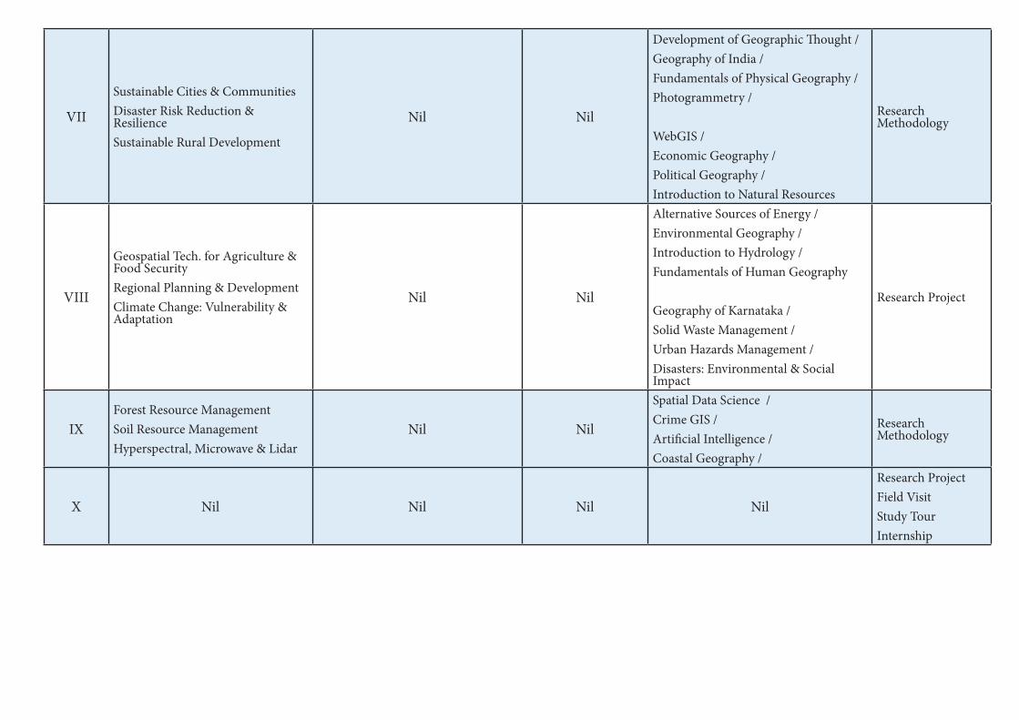
VII
Sustainable Cities & CommunitiesDisaster Risk Reduction & Resilience Sustainable Rural Development
Nil Nil
Development of Geographic Thought / Geography of India /Fundamentals of Physical Geography / Photogrammetry /
WebGIS /Economic Geography /Political Geography /Introduction to Natural Resources
Research Methodology
VIII
Geospatial Tech. for Agriculture & Food SecurityRegional Planning & DevelopmentClimate Change: Vulnerability & Adaptation
Nil Nil
Alternative Sources of Energy /Environmental Geography /Introduction to Hydrology /Fundamentals of Human Geography
Geography of Karnataka /Solid Waste Management /Urban Hazards Management /Disasters: Environmental & Social Impact
Research Project
IXForest Resource ManagementSoil Resource ManagementHyperspectral, Microwave & Lidar
Nil Nil
Spatial Data Science /Crime GIS /Artificial Intelligence /Coastal Geography /
Research Methodology
X Nil Nil Nil Nil
Research ProjectField VisitStudy TourInternship

Coursewise Credit and marks distribution for Five-Years Integrated M.Sc. Degree Program
Semester Course Type
Course NameCredits Marks
Theory Practical Tutorial Total Theory Practical Tutorial Total
I
DSC Principles of Geomorphology 4 2 - 6 100 50 - 150Basics of Cartography 4 2 - 6 100 50 - 150
OEMathematics for Geography / Introduction to Natural Resources / Physical Geography / Fundamentals of Remote Sensing
3 - - 3 100 - - 100
II
DSC Introduction to Climatology 4 2 - 6 100 50 - 150Introduction to Remote Sensing 4 2 - 6 100 50 - 150
OE
Spatial Statistics / Fundamentals of Natural Disasters / Introduction to Geographic Information Systems (GIS) / Climate Change: Vulnerability & Adaptation
3 - - 3 100 - - 100
III
DSC Introduction to Oceanography 4 2 6 100 50 - 150DSC Geographic Information Systems 4 2 6 100 50 - 150
OEProgramming Fundamentals / Geography of India / Disaster Risk Reduction / Application of GIS & Remote Sensing
3 - - 3 100 - - 100
IV
DSC Introduction to Natural Hazards & Disasters 4 2 6 100 50 - 150
DSC Population Resources & Dynamics 4 2 6 100 50 - 150
OEPython Programming / Geography of Karnataka / Biogeography/ Population & Settlement Geography
3 - - 3 100 - - 100
V
DSC Watershed Management 3 2 - 5 70 30 - 100DSC Spatial Data Analysis 3 2 - 5 70 30 - 100DSC Droughts: Mitigation, Preparedness & Response 3 2 - 5 70 30 - 100
VocVocational Course– 1Basics of Map aking/ Mobile Asset Mapping
3 - - 3 100 - - 100

VI
DSC Sustainable Water Resource Management 3 2 - 5 70 30 - 100DSC Geo-surveying 3 2 - 5 70 30 - 100DSC Digital Image Processing 3 2 - 5 70 30 - 100
Voc Vocational Course – 2 Open Source GIS / Landscaping & Layout Mapping 3 - - 3 100 - - 100
Internship 2 - - 2 50 - - 50
VII
DSC Sustainable Cities & Communities 3 2 - 5 70 30 - 100DSC Disaster Risk Reduction & Resilience 3 2 - 5 70 30 - 100DSC Sustainable Rural Development 4 1 - 5 70 30 - 100
DSE
Development of Geographic Thought / Geography of India /Fundamentals of Physical Geography /Photogrammetry
3 - - 3 100 - - 100
DSE
WebGIS /Economic Geography /Political Geography /Introduction to Natural Resources
3 - - 3 100 - - 100
Research Methodology 3 - - 3 100 - - 100
VIII
DSC Geospatial Tech. for Agriculture & Food Security 3 1 - 4 70 30 - 100DSC Regional Planning & Development 3 1 - 4 70 30 - 100DSC Climate Change: Vulnerability & Adaptation 3 - - 3 100 - - 100
DSE
Alternative Sources of Energy /Environmental Geography /Introduction to Hydrology /Fundamentals of Human Geography
3 - - 3 100 - - 100
DSE
Geography of Karnataka /Solid Waste Management /Urban Hazards Management /Disasters: Environmental & Social Impact
3 - - 3 100 - - 100
Research Project 6 - - 6 150 - - 150

IX
DSCForest Resource Management 3 2 - 5 70 30 - 100Soil Resource Management 3 2 - 5 70 30 - 100Hyperspectral, Microwave & Lidar 3 1 - 4 70 30 - 100
DSE
Spatial Data Science /Crime GIS /Artificial Intelligence /Coastal Geography
3 - - 3 100 - - 100
Research Methodology 3 - - 3 100 - - 100
XDSC
Research Project 6 - - 6 150 - - 150Field Visit 4 - - 4 100 - - 100Study Tour 4 - - 4 100 - - 100Internship 6 - - 6 150 - - 150
DSC: Discipline Specific Core, DSE: Discipline Specific Elective, OE: Open Elective, L+T+P: Lecture+Tutorial+Practical

Sem Discipline Specific Core (DSC) (Credits) (L+T+P)
Discipline Specific Elective (DSE) /
Open Elective (OE) (Credits) (L+T+P)
Ability Enhancement Compulsory Courses (AECC), Languages
(L+T+P)
Skill Enhancement Course (SEC)Total CreditsSkill-based
(Credits) (L+T+P)
Value-based (Credits) (L+T+P)
I
DSC-A1 Principles of Geomorphology (4+2)DSC-A2 Basics of Cartography (4+2)
OE-1.1 Mathematics for Geography/OE-1.2 Introduction to Natural Resources /OE-1.3 Physical Geography /OE-1.4 Fundamentals of Remote Sensing (3)
L1-1 (3), L2-1 (3)(3+1+0 each)
NilSEC-1: Digital Fluency (2) (1+0+2)
Physical Education for Fitness (1) (0+0+2)
Health & Wellness (1) (0+0+2)
25
II
DSC-A3 Introduction to Climatology (4+2)DSC-A4 Introduction to Remote Sensing (4+2)
OE-2.1 Spatial Statistics /OE-2.2 Fundamentals of Natural Disasters /OE-2.3 Introduction to Geographic Information Systems (GIS) /OE-2.4 Climate Change: Vulnerability & Adaptation (3)
L2-1 (3), L2-1 (3)(3+1+0 each)
Environmental Studies (2)
Nil Physical Education - Yoga (1) (0+0+2)
NCC/NSS/R&R (S&G)/ Cultural (1) (0+0+2)
25
Exit option with Certificate (50 Credits)
III
DSC-A5 Introduction to Oceanography (4+2)DSC-A6 Geographic Information Systems (4+2)
OE-3.1 Programming Fundamentals / OE-3.2 Geography of India /OE-3.3 Disaster Risk Reduction /OE-3.4 Application of GIS & Remote Sensing (3)
L1-3 (3), L2-3 (3)(3+1+0 each) Nil
SEC-2: Artificial Intelligence (2) (1+0+2)
Physical Education - Sports Skills (1) (0+0+2)
NCC/NSS/R&R (S&G)/ Cultural (1) (0+0+2)
25
IV
DSC-A7 Introduction to Natural Hazards & Disasters (4+2)DSC-A8 Population Resources & Dynamics (4+2)
OE-4.1 Python Programming /OE-4.2 Geography of Karnataka / OE-4.3 Biogeography /OE-4.4 Population & Settlement Geography (3)
L1-4 (3), L2-4 (3)(3+1+0 each)
Constitution of India (2)
Nil
Physical Education – Games (1) (0+0+2)
NCC/NSS/R&R (S&G)/ Cultural (1) (0+0+2)
25
Exit option with Diploma (100 Credits)Choose any one Discipline as Major, the other as the Minor
V
DSC-A9 Watershed Management (3+2)DSC-A10 Spatial Data Analysis (3+2)DSC-A11 Droughts: Mitigation, Preparedness & Response(3+2)
Vocational – 1 (3)Voc 1.1 Basics of Map Making /Voc 1.2 Mobile Asset Mapping
Nil NilSEC-3: Such as Cyber Security (2) (1+0+2)
Physical Education – Games (1) (0+0+2)
NCC/NSS/R&R (S&G)/ Cultural (1) (0+0+2)
22
Program Structure for the Integrated M.Sc. Degree in Geography & Sustainable Developement (Geography, Natural Disaster Management & Geoinformatics)

VI
DSC-A12 Sustainable Water Resource Management (3+2)DSC-A13 Geo-surveying (3+2)DSC-A14 Digital Image Processing (3+2)
Vocational – 2 (3)Voc 2.1 Open Source GIS /Voc 2.2 Landscaping & Layout Mapping
Internship (2)
Nil Nil
SEC-4: Professional Communication (2)
Physical Education – Games (1) (0+0+2)
NCC/NSS/R&R (S&G)/ Cultural (1) (0+0+2)
24
Exit option with Bachelor of Science Degree (144 Credits)
VII
DSC-A15 Sustainable Cities & Communities (3+2)DSC-A16 Disaster Risk Reduction & Resilience (3+2) DSC-A17 Sustainable Rural Development (4)
DSE-A1.1 Development of Geographic Thought DSE-A1.2 Geography of India DSE-A1.3 Fundamentals of Physical Geography DSE-A1.4 Photogrammetry(If student is not willing to carry out Research Project or Internship he /she can elect any one from above for 3 credits and one from below pools for another 3 credits)DSE-A2.1 WebGIS DSE-A2.2 Economic Geography DSE-A2.3 Political Geography DSE-A2.4 Introduction to Natural Resources
Research Methodology (3)
Nil Nil Nil Nil Nil 22
VIII
DSC-A18 Geospatial Tech. for Agriculture & Food Security (3+1)DSC-A19 Regional Planning & Development (3+1)DSC-A20 Climate Change: Vulnerability & Adaptation (3)
DSE-A3.1 Alternative Sources of EnergyDSE-A3.2 Environmental GeographyDSE-A3.3 Introduction to HydrologyDSE-A3.4 Fundamentals of Human Geography
(Student can elect any one from above for 3 credits and one from below pools for another 3 credits)
DSE-A4.1 Geography of KarnatakaDSE-A4.2 Solid Waste Management DSE-A4.3 Urban Hazards Management DSE-A4.4 Disasters: Environmental & Social ImpactOR (Student willing to exit from here can opt RP)DSE-A5 Research Project (6)
Nil Nil Nil Nil Nil 20
Exit option with Award of Bachelor of Science Honours Degree (186 Credits)

IX
DSC-A21 Forest Resource Management (3+2)DSC-A22 Soil Resource Management (3+2)
DSC-A23 Hyperspectral, Microwave & Lidar (3+1)
DSE-A6.1 Spatial Data Science DSE-A6.2 Crime GISDSE-A6.2 Artificial IntelligenceDSE-A6.2 Coastal Geography(Student can elect any one from above pool for 3 credits)DSE-A7 Research Methodology (3)Note: Student can elect one more from above pool if he /she has already taken RM in previous semester.
Nil Nil Nil Nil Nil 20
XDSC-A24 Research Project (6)DSC-A25 Field Visit (4) DSC-A26 Study Tour (4)
DSE-8 Internship (6) Nil Nil Nil Nil Nil 20
Award of Integrated M.Sc. Degree in Geography & Sustainable Development (216 Credits)

Technical Skills and possible jobs after each exit during and after the program
Year Exit Level Credits Technical Skills Possible Jobs
I Certificate 50• Map Interpretation• Geomorphic Analysis• Climate Data Analysis & Interpretation
• Field Surveyor• Weather Data Analyst
II Diploma 100• Cartography• Statistics Analysis
• Field Surveyor• Cartographer
III Degree 142
• Cartography• GIS and Image Analysis• Tourism Management
• GIS Field Surveyor• GIS Trainee• Nature Conservation
Officer• School Teacher
IV Degree with Honors 182
• GIS & Image Analysis• Resource Management• Town Planning• Tourism Management
• Sustainability Consultant• Tourism officer• Transport planner• Cartographer• GIS Engineer• Environmental consultant• Geography Teacher• Geography Researcher
V Integrated M.Sc. Degree
216 Credits
• Geospatial Analysis.• Photogrammetry• Web GIS Developement
• Program Manager for Response and Recovery
• Security Analyst• Sustainability engineer• Urban planner• Landscape architect• Disaster Recovery Specialist• Disaster Recovery
Coordinator• Emergency Management
Policy Advisor.• GIS Developer/ Manager• Scientists
24

25
Integrated M.Sc. Semester 1
Title of the Course: DSC-A1 Principles of Geomorphology
Number of
Theory Credits
Number of lecture
hours/ semester
Number of practical
Credits
Number of practical
hours/ semesters
4 52 or 56 2 52 or 56
Course Outcomes: 1. After the completion of this course, students should be able to: 2. Define the field of Geomorphology and to explain the essential principles of it. 3. to outline the mechanism of dynamic nature of the Earth’s surface and interior of the
Earth. 4. to illustrate and explain the forces affecting the crust of the earth and its effect on it. 5. to understand the conceptual and dynamic aspects of landform development
Course Objectives: This course aims to:
1. to define the concepts in Geomorphology and Physical Geography 2. to introduce various concept to understand cycles of the solid Earth surface 3. to understand the dynamic nature of the Earth’s surface, various processes, and
landforms. 4. to study the impact human on geomorphic system.
Content of Theory Course 1 52/56Hrs
Unit – 1 Geomorphology 13/14
Introduction to geography: physical and human geography
Introduction to Geomorphology: meaning, nature, development, and scope
Principles of Geomorphology
Geological Time Scale
Distribution of continents and oceans
Unit – 2 Systems and Cycles of the Solid Earth 13/14
Internal structure of the earth
Alfred Wegener’s continental drift
Theory of Isostacy: Views of Pratt and Airy
Convectional current theory and concept of sea floor spreading
Theory of Plate Tectonics: plate boundaries, subduction,
Case Studies: Volcano, Earthquake: reporting of latest incidents
Case Studies: Volcano, Earthquake: reporting of latest incidents
Unit – 3 The Dynamics of Earth 13/14
Earth’s Movements: Endogenetic and Exogenetic forces, Sudden and Diastrophic
movements- Epeirogenetic and Orogenetic Movements-Process of folding and faulting
Vulcanicity and earthquake
Rocks: Characteristics, types, importance, and rock cycle
Weathering: meaning, types and controlling factors
Mass Movement: meaning, controlling factors, types-landslides, rock-falls
Unit – 4 Evolution of Landforms 13/14
Evolution of Landforms

26
Landforms: meaning, types and factors controlling landforms development
Slope development: concept and types
Concept of Cycle of Erosion–W.M. Davis and W. Penck
Agents of Denudation: river; drainage patterns, groundwater, Sea waves, Wind and
Glaciers and resultant landforms.
Application of geomorphology: in India and Karnataka (Regional planning, Urban planning
and transportation, Mining, Hazard management, Agriculture and Environmental
management).
Textbooks
1. Ahmed E. (1985) Geomorphology, Kalyani Publishers, New Delhi.
2. P Mallappa, Physical Geography (Kannada Version)
3. Ranganath Principles of Physical Geography (Kannada Version)
4. Nanjannavar S S: Physical Geography (Kannada Version)
5. Hugar M R Physical Geography part 1(Kannada Version)
6. Goudar M B, Physical Geography (Kannada Version)
7. Kolhapure and S S Nanjan, Physical Geography (Kannada Version)
References
1. Bloom A.L. (1978) Geomorphology: A Systematic Analysis of Late Cenozoic Landforms
Prentice – Hall of India, New Delhi.
2. Brunsden D. (1985) Geomorphology in the Service of Man: The Future of Geography,
Methnen, U.K.
3. Chorley, R.J., Schumm, S. A. and Sugden, D.E. 1984: Geomorphology, Methuen, London
4. Cooke, R.U. and Warren, 1973: Geomorphology in Deserts, Batsford, London
5. Dayal, P. 1996: Textbook of Geomorphology, Shukla Book Depot, Patna.
6. Goudie Anrew et.al. (1981) Geomorphological Techniques, George Allen &Unwin, London.
7. Homes A. (1965) Principles of Physical Geology, 3rd Edition, ELBSS Edn.
8. Strahler A.N. (1968) The Earth Sciences, Harper & Row Intl. Edn, New York
9. Thornberry W.D. (1969) Principles of Geomorphology 2nd Edition, Wiley Intl. Edn. & Wiley,
1984.
10. Verstappen H. (1983) Applied Geomorphology, Geomorphological Surveys for Environmental
Develop- ment, Elsevier, Amsterdam
Reference Websites
1. http://www.solarviews.com/eng/earth.htm
2. http://www.moorlandschool.co.uk/earth/tectonic.htm
3. https://www.usgs.gov/
4. https://www.ksndmc.org/
Dr. K Prasanna kumar Prof. Ashok Hanjagi
Date 16/09/2021 Course Co-ordinator Subject Committee Chairperson

27
Geomorphology Practical
Content of Practical Course 1: List of Experiments to be conducted
Exercise-1: Identification of Rocks and Minerals. Mineral samples: Iron ore, Bauxite ore and
Manganese. Rock Samples: Granite, Basalt, Lime Stones, Sandstone, quartzite, and marble.
Exercise-2: Extraction and interpretation of Geomorphic information from Topographical maps
Exercise-3: Preparation of contour map from toposheet, Construction of Relief Profiles-serial, Super
imposed, Projected & Composite.
Exercise-4: Slope Analysis - Slope Maps (Wentworth method) Slope (isotan and isosin) and aspect
maps & Hypsometric curve and integral
Exercise-5: Drainage Morphometry: delineation of watershed, stream ordering and Morphometric
analysis: mean stream length, drainage density and drainage frequency.
Field Work: Measurement of channel cross-sections in the field, Geomorphic map of channel bed,
Study of erosional and depositional features in the field.
Case Study: students must be taken to observe local land formation and degradation and write a
report on their effectiveness.
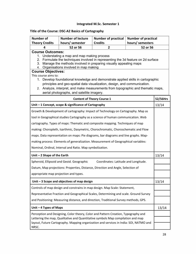
28
Integrated M.Sc. Semester 1
Title of the Course: DSC-A2 Basics of Cartography
Number of
Theory Credits
Number of lecture
hours/ semester
Number of practical
Credits
Number of practical
hours/ semesters
4 52 or 56 2 52 or 56
Course Outcomes: 1. Understating a map and map making process 2. Formulate the techniques involved in representing the 3d feature on 2d surface 3. Manage the methods involved in preparing visually appealing maps 4. Organisations involved in map making
Course Objectives: This course aims to:
1. Develop foundational knowledge and demonstrate applied skills in cartographic
principles and geo-spatial data visualization, design, and communication.
2. Analyze, interpret, and make measurements from topographic and thematic maps,
aerial photographs, and satellite imagery.
Content of Theory Course 1 52/56Hrs
Unit – 1 Concept, scope & significance of Cartography 13/14
Growth & Development of cartography: Impact of Technology on Cartography. Map as
tool in Geographical studies Cartography as a science of human communication. Web
cartography. Types of maps: Thematic and composite mapping. Techniques of map
making: Choropleth, Isarthmic, Dasymetric, Chorochromatic, Choroschematic and Flow
maps. Data representation on maps: Pie diagrams, bar diagrams and line graphs. Map-
making process: Elements of generalization. Measurement of Geographical variables:
Nominal, Ordinal, Interval and Ratio. Map symbolization.
Unit – 2 Shape of the Earth 13/14
Spheroid, Ellipsoid and Geoid. Geographic Coordinates: Latitude and Longitude.
Datum, Map projections: Properties, Distance, Direction and Angle, Selection of
appropriate map projection and types.
Unit – 3 Scope and objectives of map design 13/14
Controls of map design and constrains in map design. Map Scale: Statement,
Representative Fraction and Geographical Scales, Determining and scale. Ground Survey
and Positioning: Measuring distance, and direction, Traditional Survey methods, GPS.
Unit – 4 Types of Maps 13/14
Perception and Designing, Color theory, Color and Pattern Creation, Typography and
Lettering the map, Qualitative and Quantitative symbols Map compilation and map
layout, Future Cartography. Mapping organization and services in India: SOI, NATMO and
NRSC.

29
References
1. Monkhouse F.J. & H.R. Wilkinson (1952) Maps and Diagrams, their compilation and
concentration, Methuen & Co, London
2. . Harwell J.D & M.S. Newson (1973) Techniques in Physical Geography, Macmillan Edn. Ltd,
London.
3. Mishra R.P. & Ramesh A (1968) Fundamentals of Cartography, Prasaranga, University of
Mysore.
4. Menno-Jan Kraak&FerjanOrmeling (2003) Cartography Visualization of Geospatial Data,
Pearson Edn Pvt. Ltd. (Singapore) New Delhi.
5. Nag P (1992) Thematic Cartography and Remote Sensing, concept Publishing Co. New Delhi.
6. Tyner J., (1992). Introduction to Thematic Cartography, Prentice-Hall, Englewood Cliff, New
Jersey.
7. Robinson, A.H., Morrison J.L., Muehrcke P.C., Kimerling A.J., and Guptill S.C., (2009).
Elements of Cartography, New York, John Wiley and Sons. USA.
8. Kraack M.J., and Omeling F.J., (2015), Cartography: Visualization of Spatial Data (Third
Edition), Pearson Education Limited, England
Dr. K Prasanna kumar Prof. Ashok Hanjagi
Date 16/09/2021 Course Co-ordinator Subject Committee Chairperson
Cartography Practical
Content of Practical Course 1: List of Experiments to be conducted
Exercise 1: Representation of Data
Proportional symbols, Mono Dot Method, Multiple Dot Method, Circle Method, Sphere
Method, Cube Method, Choropleth Method, Isopleth Method, Choro-chromatic Method,
Choro-schematic maps, Block Pile Diagrams, Pie Diagrams, Flow diagrams
Exercise 2: Map Scale
Construction of the Map Scales, Map Scale Conversion
Exercise 3: Introduction to Topographical Maps
Interpretation of toposheet, Maps of Survey of India, marginal information of topographical
maps -all Signs and Symbols.
Excercise 4: Interpretation of SOI Topographical Maps
Relief, Drainage, Vegetation, Land use, means of communication and settlements
Excercise 4: Use of GPS
Collection of Locational Data using handheld GPS or Mobile GPS Apps

30
Integrated M.Sc. Semester I
Title of the Course: OE-1.1 Mathematics for Geography
Number of Theory Credits Number of lecture hours/ semester
3 39 or 42
Course Outcomes:
At the end of the course the students will: 1. Understand the foundations of mathematics. 2. Develop and maintain problem-solving skills. 3. Be able to write and understand basic proofs.
Course Objectives:
This course aims to 1. develop mathematical curiosity and use inductive and deductive reasoning when
solving problems. become confident in using mathematics to analyse and solve problems spatial in nature.
2. Students will feel a sense of accomplishment in their increasing ability to use mathematics to solve problems of interest to them or useful in their chosen fields. Students will attain more positive attitudes based on increasing confidence in their abilities to learn mathematics.
3. Students will learn to understand material using standard mathematical terminology and notation when presented either verbally or in writing.
Content of Theory Course 1 52/56Hrs
Unit – 1 Matrices 13/14
Characteristic equation - Eigen values and Eigen vectors of a real matrix- Cayley-
Hamilton theorem - Reduction of a real symmetric matrix to diagonal form and reduction
of quadratic form to canonical form by orthogonal transformation.
Unit – 2 Analytical Geometry (3 dimensions) 13/14
Analytical Geometry (3 dimensions): Distance Division formulae - Direction Cosines and
direction ratios, planes - straight line - angle between planes / straight line - shortest
distance.
Unit – 3 Differential Calculus 13/14
Differential Calculus: Determination of nth derivatives of standard functions - Leibnitz's
theorem (without proof) and applications.
Unit – 4 Partial differentiation 13/14
Euler's theorem - Total differentiation, differentiation of composite and implicit functions
- Jacobians errors and approximations. Vector differentiation: Velocity, acceleration of a
vector point function - Gradient, Curl, Solenoidal, Irrotational fields and their properties.

31
References
1. Higher Engineering Mathematics by Grewal, B.S., Khanna Publishers, 1993.
2. Engineering Mathematics by Sastry, S.S., Vol. I and II, Prentice Hall of India, 2nd edition,
1994.
3. Elementary differential equations by Rainville, E.D. and Bedient, P.E., 6th edition.
4. Higher Engineering Mathematics by Grewel, B.S., 33rd edition.
5. Differential Calculus by Shanthi Narayan, 13th edition.
Dr. K Prasanna kumar Prof. Ashok Hanjagi
Date 16/09/2021 Course Co-ordinator Subject Committee Chairperson

32
Integrated M.Sc. Semester I
Title of the Course: OE: 1.2 Introduction to Natural Resources
Number of Theory Credits Number of lecture hours/ semester
3 39 or 42
Course Outcomes: At the end of the course the students will:
1. Understand concepts of different natural resources, its use, overuse, with its solution by natural resource management methods.
2. Appreciate the need for managing land and water resources for sustainable growth and development, managerial skills such as land evaluation and land classification.
3. Also, able to understand the causes and consequences of water stress and draw water conservation and management plans.
Course Objectives: This course aims to
1. explain the types of natural resources that exist. 2. Study the role of government and different agencies in the natural resource
management 3. Study the threat to the natural resources and the policies to solve it.
Content of Theory Course 1 13/15Hrs
Unit – 1 Concept of Resources 13/14
Meaning, Definition, importance and classification of Resources, Appraisal of Natural
Resources, Natural Resources Economics, History of Conservation, need for conservation
and Management of Natural Resources –Role of Government and NGO Agencies, Resource
Creating Factors. Environmental Risk- types, wildlife, forest risk and its impact on
environment and its management.
Unit – 2 Land Resources 13/14
Land Evaluation Methods, Land classification Methods, Land use and Land cover Mapping
changes. Issue related to land use change –Land use and population, Land use pattern in
the world. Land source at stress, land use planning and development. Soil erosion, soil
degradation, methods of conservation.
Unit – 3 Water Resources 13/14
Importance of water, Recent trends in water use in the world and in India, water crises,
(stress) causes and consequences of water stress or crises, methods of water
conservation, watershed management, coastal and ocean Resources management,
Fisheries Management
Unit – 4 Minerals Resources 13/14
Types of minerals, classifications of Major Minerals, their distribution and production.
Such as Petroleum, Coal, Iron ore, Bauxite and Copper etc, and its uses. Mineral
exploration methods, Mining, and its effects on environment. Mineral’s conservation and
mining policy

33
Text Books
References
1. Dr.Alka Gautham: Geography of Resources: Exploitation, Conservation and
Mangement, Sharada Pustak Bhavan, Allahabad.
2. Dr.P.S.Negi: Geography of Resources: Kedarnath Ramnath Publishers, New Delhi
3. Dr.Rajashekara Shetty(2009): An Analysis of World Resources with reference to
India, Sarala Raj, Ria Publishers, Mysore
4. Khanna K.K and Gupta V.K.(1993): Economic and Commercial Geography, Sultan
Chand, New Delhi
5. Prof. Zimmerwan – World Resources and Industries
6. Roy, P.R(2001) Economic Geography – A Study of Resources, New Central Book
Agency, Calcutta.
Dr. K Prasanna kumar Prof. Ashok Hanjagi
Date 16/09/2021 Course Co-ordinator Subject Committee Chairperson

34
Integrated M.Sc. Semester I
Title of the Course: OE 1.3 Introduction to Physical Geography
Number of Theory Credits Number of lecture hours/ semester
3 39 or 42
Course Outcomes: 1. Students will be able to understand the fundamental concepts in Earth Sciences
2. understands basic terminology used to describe physical processes and landscape forms.
3. Describe elements of the atmosphere and the oceans
Course Objectives: This course aims to
1. Study basic principles of the Earth Sciences
2. Understand the landforms, atmospheric elements and structure and basics of oceanography
Content of Theory Course 1 52/56Hrs
Unit – 1 13/14
Origin, Shape and Size of the Earth, Movement of the Earth- Rotation and Revolution, Effects of the movement of Earth, Coordinates -Latitude, Longitude and Time. Structure of the Earth,
Unit - 2 13/14
Rocks - types, significance,
Weathering –types.
Agents of Denudation - River, Glacier, Wind and Under Ground water.
Volcanicity, Earthquakes and Tsunamis
Unit - 3 13/14
Structure and Composition of Atmosphere,
Weather and Climate.
Atmospheric Temperature, Heat Budget of the atmosphere
Atmospheric Pressure, Winds and Precipitation
Unit - 4 13/14
Distribution of Land and Sea, Submarine Relief of the Ocean, Temperature and Salinity of Sea Water. Ocean Tides, Waves and Deposits, Ocean currents - Atlantic, Pacific and Indian Oceans. Marine Resources: Biotic, mineral and energy resources
References
1. B.S. Negi (1993) Physical Geography. S.J. Publication, Meerut
2. D.S. Lal (1998) Climatology. Chaitnya publishing house, Allahabad
3. K. Siddhartha (2001) Atmosphere, Weather and Climate. Kisalaya publication, New Delhi
4. R.N. Tikka (2002) Physical Geography. Kedarnath Ramnath & co, Meerut
5. Willian D. Thornbury (1997) Principle of Geomorphology. New Age International (Pvt Ltd.)
New Delhi.
Dr. K Prasanna kumar Prof. Ashok Hanjagi
Date 16/09/2021 Course Co-ordinator Subject Committee Chairperson

35
Integrated M.Sc. Semester I
Title of the Course: OE 1.4 Fundamentals of Remote Sensing
Number of Theory Credits Number of lecture hours/ semester
3 39 or 42 Course Outcomes:
1. This course is to make understand the basic concepts of Remote Sensing and to impart necessary skills of remote sensing analysis, and image interpretation to the students. So that, students acquire employable skills in remote sensing.
2. Students will learn how to handle and process the satellite images for understanding of biophysical phenomena of the earth system.
Course Objectives:
1. To congregate the basic concepts and fundamentals of physical principles of remote sensing
2. To create a firm basis for successful integration of remote sensing in any field of application.
3. To study basics of digital image processing and image interpretation techniques.
4. To study the applications of the remote sensing to solve the real-world problems.
Content of Theory Course 1 52/56Hrs
Unit – 1 Introduction 13/14
Definition of Remote Sensing, developmental stages, Laws of Physics, electromagnetic
waves, spectrum, regions, wavelength, frequencies, and applications. Types-Satellites,
Sensors, Payloads, Orbits, telemetry of satellites.
Process and types of Remote Sensing 13/14
Process of remote sensing, interaction of radiation with atmosphere and targets,
atmospheric noises, attenuation in radiance, resolutions of remote sensing, optical remote
sensing, visible region of the spectrum, thermal remote sensing, microwave remote
sensing, Hyperspectral remote sensing, LiDAR, and other remote sensing platforms.
Unit – 3 Image Classification and Interpretation 13/14
Satellite products and its spectral characteristics, composite images, band ratios; Land use
land cover classification schemes-Anderson and NRSC; Visual image interpretation,
elements, stages of interpretation and interpretation keys. Image classification-
supervised, unsupervised, and principal component analysis (PCA) and accuracy
assessment.
Unit – 4 Applications of Remote Sensing 13/14
Disaster Management, Meteorological Studies, Agricultural and Irrigation Studies, Forestry
Studies, Hydrological Studies, Natural Resource, Oceanic and Coastal mapping, Soil
resource mapping, Urban and Rural Mapping and Management.
References
1. Remote Sensing of the Environment: An Earth Resource Perspective (Prentice Hall Series in Geographic Information Science) - Second Edition (2006), John Jensen
2. Remote Sensing and GIS, Second Edition (2011), Bhatta, B. 3. Introduction to Remote Sensing and Image Interpretation (2003); Lillesand T.M.

36
4. Remote sensing and image interpretation (2015); Chipman, Jonathan W., Kiefer, Ralph W., Lillesand
5. Introduction to Remote Sensing, Fifth Edition (2011); James B. Campbell, Randolph H. Wynne
6. Practical handbook of remote sensing, First Edition (2016) - Lavender, Andrew, Lavender, Samantha
7. Introductory Digital Image Processing: A Remote Sensing Perspective, Fourth Edition (2015) - John R. Jensen
8. Image processing and GIS for remote sensing: techniques and applications; Second Edition (2016) - Liu, Jian-Guo, Mason, Philippa J
14. https://onlinecourses.nptel.ac.in/noc19_ce41/preview
Dr. K Prasanna kumar Prof. Ashok Hanjagi
Date 16/09/2021 Course Co-ordinator Subject Committee Chairperson
WEB RESOURCES
1. Projections: https://map-projections.net/imglist.php 2. Textbook of Canadian Remote Sensing
https://www.nrcan.gc.ca/sites/www.nrcan.gc.ca/files/earthsciences/pdf/resource/tutor/fundam/pdf/fundamentals_e.pdf
3. ITC Netherlands, Principles of Remote Sensing 4. https://webapps.itc.utwente.nl/librarywww/papers_2009/general/principlesremotesensing.
REFERENCES: MOOC
5. Remote Sensing - https://nptel.ac.in/courses/105/108/105108077/ 6. Introduction to Remote Sensing https://nptel.ac.in/courses/121/107/121107009/ 7. Digital Image Processing of Remote Sensing Data -
https://nptel.ac.in/courses/105/107/105107160/ 8. Remote Sensing and GIS - https://nptel.ac.in/courses/105/103/105103193/ 9. Remote Sensing Essentials - https://nptel.ac.in/courses/105/107/105107201/ 10. Remote Sensing: Principles and Applications -
https://nptel.ac.in/courses/105/101/105101206/ 11. Basics of Remote sensing, GIS & GNSS technology and their applications 12. https://onlinecourses.swayam2.ac.in/aic20_ge05/preview 13. Remote Sensing and GIS

37
Integrated M.Sc. Semester II
Title of the Course: DSC-A3 Climatology
Number of
Theory Credits
Number of lecture
hours/ semester
Number of practical
Credits
Number of practical
hours/ semesters
4 52 or 56 2 52 or 56
Course Outcomes:
After the completion of this course, students should be able to 1. define the field of climatology and to understand the atmospheric composition and structure. 2. to outline the mechanism and process of solar radiation transfer to earth surface and to ex- plain
the temperature distribution and variation according to time and space. 3. to illustrate and explain the air pressure system, wind regulating forces and the formation of the
Atmospheric Disturbance.
4. to understand and compute the air humidity as well as to explain the process of Condensation and formation of precipitation and its types.
Course Objectives: This course aims to:
1. to define the field of climatology and components of the climate system
2. to introduce various dimensions of climatology like structure and composition.
3. to understand the global atmospheric pressure, temperature, and wind system.
4. to study the concept of atmospheric moisture and its types
Content of Theory Course 1 52/56Hrs
Unit – 1 Composition and Structure of the Atmosphere 13/14
Nature and Scope of Climatology,
Atmospheric Sciences; Climatology and Meteorology
Origin and structure of the Atmosphere: Troposphere, Stratosphere, Mesosphere,
Ionosphere, Exosphere and their characteristics.
Composition of the atmosphere
Weather and Climate
Unit – 2 Atmospheric Temperature 13/14
Insolation: Definition, Mechanism, Solar Constant.
Factors affecting the Insolation: Angle of incidence, length of the day, Sunspots, Distance
between the earth and the sun, effect of the atmosphere.
Heating and cooling process of the atmosphere-Radiation, Conduction, convection, and
advection.
Temperature: meaning and Influencing Factors on the Distribution of
Temperature
Distribution of the temperature: Vertical, Horizontal, and Inversion of temperature.
Global Energy Budget: Incoming shortwave solar radiation, Outgoing Longwave Terrestrial
radiation, Albedo. Net Radiation and Latitudinal Heat Balances.
Unit – 3 Atmospheric Pressure and Winds 13/14
Atmospheric Pressure: Influencing factors on atmospheric pressure.
Vertical and Horizontal Distribution of the atmospheric pressure and
Pressure Belts, Pressure Gradient.
Tri-cellular-Hadley, Ferrel’s and Polar Cells.

38
Winds: influencing factors, Types - planetary, seasonal, local wind
Variable winds-Cyclones and anti-cyclones.
Air-Masses and Fronts: Definition, Nature, Source Regions, Classification.
Unit – 4 Atmospheric Moisture 13/14
Humidity: Sources, influencing factors and types-Absolute, Relative and
Specific.
Hydrological cycle: process of evaporation, condensation. Clouds and its types
Precipitation and its forms.
Climate Change: Causes and consequences, recent issues-floods, drought,
Textbooks
1. Lal, D. S. (1998). Climatology. Allahabad: Chaitanya Publishing House. 2. P Mallappa, Physical Geography (Kannada Version) 3. Ranganath Principles of Physical Geography (Kannada Version) 4. Nanjannavar S S: Physical Geography (Kannada Version) 5. Hugar M R Physical Geography part 1(Kannada Version) 6. Goudar M B, Physical Geography (Kannada Version) 7. Kolhapure and S S Nanjan, Physical Geography (Kannada Version)
References
8. Lutgens, Frederic K. & Tarbuck, Edward J. (2010). The Atmosphere: An Introduction to Meteorology. New Jersey: Pearson Prentice Hall.
9. Oliver, John E. & Hidore, John J. (2003). Climatology: An Atmospheric Science. Delhi: Pearson Education.
10. Singh, S. (2005). Climatology. Allahabad: Prayag Pustak Bhawan. 11. Barry, R.G. and Chorley, R.J. (2003): Atmosphere, Weather and Climate; Psychology
Press, Hove; East Sussex. 12. Critchfield, H.J., (1975): general Climatology, Prentice Hall, New Jersey. 13. Mather,J.R.(1974): Climatology: Fundamentals and Applications; Mc Craw Hill Book
Co., U.S.A. 14. Rumney, G.R. (1968): Climatology and the World Climates, Macmillan, London. 15. Trewartha, G.T. (1980): An Introduction to Climate; McGraw Hill, New York, 5th
edition, (International Student Edition)
Reference Websites
1. https://earthobservatory.nasa.gov/
2. https://mausam.imd.gov.in/
3. https://www.weatheronline.in/
4. https://earthexplorer.usgs.gov/
5. https://www.nhc.noaa.gov/satellite.php
Dr. K Prasanna kumar Prof. Ashok Hanjagi
Date 16/09/2021 Course Co-ordinator Subject Committee Chairperson

39
Climatology Practical
Content of Practical Course 1: List of Experiments to be conducted
Conduct all exercises with Goal, Procedure, devices, and findings.
Exercise 1: Structure and functions of the Indian Meteorological Department (IMD).
Exercise 2: Collection of temperature data from IMD website.
Exercise 3: Plotting of downloaded temperature data using graphical methods-line graph.
Exercise 4: Centigrade and Fahrenheit thermometer for measuring temperature.
Exercise 5: Mercurial Barometer and Aneroid Barometer for measuring atmospheric pressure
Exercise 6: Wind Vane and cup-anemometer.
Exercise 7: Wet and Dry bulb thermometer for measuring humidity
Exercise 8: Rainguage- Dial type for measuring rainfall Exercise 3: Rainfall Trend Analysis (monthly
and annual) Exercise 4: Interpretation of Indian Daily Weather charts.
Note: Students are expected to download weather charts of the four seasons.

40
Integrated M.Sc. Semester II
Title of the Course: DSC-A4 Fundamentals of Remote Sensing
Number of
Theory Credits
Number of lecture
hours/ semester
Number of practical
Credits
Number of practical
hours/ semesters
4 52 or 56 2 52 or 56 Course Outcomes:
3. This course is to make understand the basic concepts of Remote Sensing and to impart necessary skills of remote sensing analysis, and image interpretation to the students. So that, students acquire employable skills in remote sensing.
4. Students will learn how to handle and process the satellite images for understanding of biophysical phenomena of the earth system.
Course Objectives:
5. To congregate the basic concepts and fundamentals of physical principles of remote sensing
6. To create a firm basis for successful integration of remote sensing in any field of application.
7. To study basics of digital image processing and image interpretation techniques.
8. To study the applications of the remote sensing to solve the real-world problems.
Content of Theory Course 1 52/56Hrs
Unit – 1 Introduction to Remote Sensing 13/14
Definition and components, History of Remote Sensing, Electromagnetic Magnetic
Spectrum, Basics of wave theory, Particle theory, Stefan Boltzman law - Wiens-
Displacement Law, Interaction of EMR with the atmosphere and with the surface feature,
Atmospheric window, spectral reflectance of land covers (minerals, rocks, water,
vegetation, and urban area).
Sensors and platforms 13/14
Types of orbits- sun synchronous and geo synchronous, Sources of energy, Classification of
remote sensors- Active, Passive, Electro-mechanical and optical sensors. Resolution
concept - Spectral, Radiometric, and temporal resolution. Platform types and
characteristics, Launch of space vehicles. Angular characteristics-FOV and IFOV,
pushbroom and whiskbroom cameras, Panchromatic, multi spectral, hyperspectral
scanners, geometric characteristics of the imageries. Advanced Remote Sensing:
Microwave, Radar (Scatterometer, Radiometer, and Altimeter), Lidar and Thermal.
Unit – 3 Fundamentals of Aerial Photography 13/14
Elements, Types and interpretation of Aerial photography, Principles, Classification of
Aerial photographs on the basis of Height and Tilt, Scales, Components of camera, film,
Aerial platforms. Elements of Aerial photo interpretation, Digital and Analog data, Image
formats, Stereo pairs, Applications of Aerial Photography
Unit – 4 Applications of Remote Sensing 13/14
International remote sensing centers, Indian remote sensing centers and their activities,
new satellite programs of India. Land observation satellites, Meteorological satellites,
Marine observation satellites. Remote Sensing Applications in various Fields.
41
References
9. Lillesand T.M and Kiefer R.W, Remote Sensing and Image interpretation, 7th Edition, John Wiley & Sons, Canada.
10. Jensen J.R, (2012), Remote Sensing of Environment: An Earth Resources Perspective, 2nd Edition, Pearson Education, Upper Saddle River, Prentice Hall, New Jersey.
11. Elachi C and van Zyl J.J, (2006). Introduction to the Physics and Techniques of Remote Sensing, John Wiley & Sons, Canada.
12. Joseph G, (2005), Fundamentals of Remote Sensing, 2nd Edition, Universities Press (India) Pvt Ltd, Hyderabad.
13. Narayan L R A, (1999), Remote sensing and its Applications, Universities Press (India) Pvt Ltd, Hyderabad.
14. Rampal K.K, (1999), Hand book of Aerial Photography and Interpretation, Concept Publishing Co, New Delhi.
15. Avery T.E and Berlin G.L, (1992), Fundamentals of Remote Sensing and Air Photo Interpretation, 5th Edition, Prentice Hall, New Jersey.
16. Sabins, F.F.Jr, (1987), Remote Sensing; Principles and Interpretation, 2nd Edition, W.H. Freeman and Co, New York.
17. John R. Jensen: Remote sensing of the Environment. Pearson education publication 18. 19. Jensen, John R., 2005, Introductory Digital Image Processing, 3rd Ed., Upper Saddle
River, NJ: Prentice Hall, 526 pages. 20. Principles of Remote Sensing – An Introductory Textbook by W. H. Bakker et al 21. 22. Frontiers of Remote Sensing Information Processing. by: C. H. Chen 23. http://rst.gsfc.nasa.gov/Front/tofc.html. 24. http://earthobsevatory.nasa.gov/Library/RemoteSensing
Dr. K Prasanna kumar Prof. Ashok Hanjagi
Date 16/09/2021 Course Co-ordinator Subject Committee Chairperson
WEB RESOURCES
15. Projections: https://map-projections.net/imglist.php 16. Textbook of Canadian Remote Sensing
https://www.nrcan.gc.ca/sites/www.nrcan.gc.ca/files/earthsciences/pdf/resource/tutor/fundam/pdf/fundamentals_e.pdf
17. ITC Netherlands, Principles of Remote Sensing 18. https://webapps.itc.utwente.nl/librarywww/papers_2009/general/principlesremotesensing.
REFERENCES: MOOC
19. Remote Sensing - https://nptel.ac.in/courses/105/108/105108077/ 20. Introduction to Remote Sensing https://nptel.ac.in/courses/121/107/121107009/ 21. Digital Image Processing of Remote Sensing Data -
https://nptel.ac.in/courses/105/107/105107160/ 22. Remote Sensing and GIS - https://nptel.ac.in/courses/105/103/105103193/ 23. Remote Sensing Essentials - https://nptel.ac.in/courses/105/107/105107201/ 24. Remote Sensing: Principles and Applications -
https://nptel.ac.in/courses/105/101/105101206/ 25. Basics of Remote sensing, GIS & GNSS technology and their applications 26. https://onlinecourses.swayam2.ac.in/aic20_ge05/preview 27. Remote Sensing and GIS

42
Remote Sensing Practical
Content of Practical Course 1: List of Experiments to be conducted
Exercise 1: Introduction to Aerial Photographs
Marginal information of Aerial photo product,
Exercise 2: Stereo Scope Viewing
Pocket stereoscope
Mirror stereoscope
Exercise 3: Interpretation of the Aerial Photographs
Visual interpretation keys. Interpretation of the Geomorphology, Transportation and
settlements using Aerial Photographs
Exercise 5: Satellite Image Interpretation
True Color Composite images, False Color Composite images, Interpretation of the
Land Use Land Cover, Geomorphology using satellite images
43
BA/BSc Semester 2
Title of the Course: OE 2.1 Spatial Statistics
Number of Theory Credits Number of lecture hours/ semester
3 39 or 42
Course Outcomes:
At the end of the course the students will be:
1. Describe and discuss the key terminology, concepts tools and techniques used in
2. statistical analysis
3. Understand and critically discuss the issues surrounding sampling and significance
4. Solve a range of problems using the techniques covered
5. Conduct basic statistical analysis of data.
Course Objectives:
This course aims to
1. To develop the student’s ability to deal with numerical and quantitative issues in
Geography.
2. To enable the use of statistical, graphical, and algebraic techniques wherever
relevant.
3. To have a proper understanding of Statistical applications in Geography.
Content of Theory Course 1 52/56Hrs
Unit – 1 Introduction 13/14
Statistical Methods for Geography - Scientific method and mathematical notation -
Descriptive Statistics - Measures of central tendency: Mean, Median, and Mode -
Measures of Dispersion: Range, Variance, Standard Deviation, z-score, Skewness, Kurtosis
and Histograms.
Unit – 2 Probability 13/14
Probability Concepts - Discrete Probability Distributions: Uniform, Binomial and Poisson
Distributions - Continuous Probability Distributions - Probability Models - Central Limit
Theorem and Confidence Intervals
Unit – 3 Hypothesis Testing and Sampling 13/14
Sources of Data - Sampling - Hypothesis Testing: z-test and t-test - Analysis of Variance
(ANOVA).
Unit – 4 Correlation and Regression 13/14
Covariance - Pearson’s Correlation Coefficient - Spearman’s Rank Correlation Coefficient –
Correlation and Geographic Problems -Regression Analysis.
References
1. Rogerson, P. A. (2001) Statistical Methods for Geography, Sage Publications, New
Delhi.
44
2. Pal, S. K. (1998) Statistics for Geoscientists, Tata McGraw Hill, New Delhi.
3. Hammond, P. and McCullagh, P. S., (1978) Quantitative Techniques in Geography:
An Introduction,Oxford University Press, New York.
4. S.C. Gupta (2018) Fundamentals of Statistics, 7th edition, Himalaya Publishing
House.Pedagogy
Dr. K Prasanna kumar Prof. Ashok Hanjagi
Date 16/09/2021 Course Co-ordinator Subject Committee Chairperson

45
Integrated M.Sc. Semester II
Title of the Course: OE 2.2 Fundamentals of Natural disasters
Number of Theory Credits Number of lecture hours/ semester
3 39 or 42
Course Outcomes: Students will be able to
1. Understand the basics concepts in natural disasters 2. Study types of natural disasters and their effects
Course Objectives: 1. The paper is intended to provide a general concept in the dimensions of disasters
caused by nature beyond the human control. 2. Introduce a holistic classification of natural disasters considering the Earth Sciences
3. Demonstrate the devastating effect of natural disasters to society;
Content of Theory Course 1 52/56Hrs
Unit – 1 Introduction to Natural Disaster 13/14
meaning, definition, and scope.
Lithosphere and Natural Disasters
Earthquakes and volcanoes,
Landslides and Avalanches
Unit – 2 Atmosphere and Natural Disasters 13/14
Heat wave and wildfire
Cloud burst, hailstorm,
Drought and famines
Hydrosphere and Natural Disaster 13/14
Tsunami
Hurricanes and cyclones
Floods and flash floods
Biosphere and Natural Disasters 13/14
Epidemics and pandemics
Covid -19 and its effects
Techniques and technology to mitigate natural disasters
References
1. Dr. Mrinalini Pandey Disaster Management Wiley India Pvt. Ltd.
2. Tushar Bhattacharya Disaster Science and Management McGraw Hill Education (India)
Pvt. Ltd.
3. Jagbir Singh Disaster Management: Future Challenges and Opportunities K W
Publishers Pvt. Ltd.
4. J. P. Singhal Disaster Management Laxmi Publications.

46
5. Shailesh Shukla, Shamna Hussain Biodiversity, Environment and Disaster Management
Unique Publications
6. C. K. Rajan, Navale Pandharinath Earth and Atmospheric Disaster Management: Nature
and Manmade B S Publication
Dr. K Prasanna kumar Prof. Ashok Hanjagi
Date 16/09/2021 Course Co-ordinator Subject Committee Chairperson

47
Integrated M.Sc. Semester II
Title of the Course: OE 2.3 Climate Change: Vulnerability and Adaptation
Number of Theory Credits Number of lecture hours/ semester
3 39 or 42
Course Outcomes: 1. This course is to make understand the basic concepts of Climate-Weather systems
and to impart necessary skills of Climate change, and its impact on earth systems to the students. So that, students acquire basic understanding of the climate systems of the earth and to study the applications of the Geoinformatics to study the climate change.
Course Objectives: 1. to provide a sound understanding of the economics of climate change from multiple
viewpoints 2. Demonstrate knowledge of the projected impacts of climate change and potential
strategies 3. for alleviating their negative impacts. 4. Define key terms (e.g., adaptation, resilience, vulnerability, mainstreaming)
5. Study application of the Geoinformatics in the Climate Change and Adaptation
Content of Theory Course 1 52/56Hrs
Unit – 1 Introduction to Climate Change 13/14
Meaning and concept of climate change.
Origin of atmosphere. Concepts of weather and climate.
Evidence of Climate Change: Historical and current weather and climate events:
Meteorological, Lithogenic and biological, Greenhouse effect, Greenhouse Gases, Global
Warming.
Extreme weather and climate event: Drought, Extreme Heat, Extreme precipitation,
Hurricanes, Tornadoes and Wildfire.
Unit – 2 Causes and Effect of climate change 13/14
Natural cause: Solar variation, Volcanic eruption, ocean currents, Earth orbital change and
internal variability
Human causes: Burning fossil fuel, Deforestation, Intensive Agriculture, and industries.
Impacts of climate change: Water resources, agriculture, human health, vegetation,
economy and El nino, La Nina and Arctic Oscillation
International efforts to control the climate change: UNFCC its policy framework and
provisions, Earth Summit Rio-de-Janeiro, World summit, Kyoto Protocol, Copenhagen
summit and Doha Conference
Unit – 3 Climate change Vulnerability and Adaptation 13/14
Meaning and type of vulnerability
Meaning, Definition, and types of adaptation
Approaches of adaptation and Adaptation Strategies.
Adaptation in different sectors: Agriculture, Forest, Water resources, Biodiversity, Disaster
Risk Management
Unit – 4 Vulnerability Assessment and climate change mitigation 13/14
Climate change vulnerability assessment

48
Global Initiatives to climate change mitigation: Kyoto Protocol, carbon trading, clean
development mechanism, COP.
Indian initiative to support climate change mitigation: Improving energy efficiency,
Diversification of energy sources, Modifying industrial processes, a multipronged strategy
for sustainable development and Clean Development Mechanism (CDM) in India.
Case studies: MGNREGA (Mahatma Gandhi National Rural Employment 16 Guarantee Act)
potential of generating co-benefits, Vertical Shaft Brick Kiln (VSBK) or Ecokiln
References
1. Earth: Evolution of a Habitable World, 2nd edn., Cambridge, UK: Cambridge
University Press (2013) Jonathan I. Lunine.
2. Evolution of the Earth, McGraw-Hill Education; 8th edition (2009) DonaldProthero,
Robert Dott, Jr.
3. A Textbook of Climatology, Wisdom Press (2015) Tapas Bhattacharya
4. Global Warming: The Complete Briefing, Cambridge University Press; 4th edition
(2009), John Houghton
5. K.Siddahartha (2020): Climatology, Atmosphere, Weather and Climate. Kitaba Mahal
Publication, New Delhi.
6. K.Siddahartha and others (2014): Basic Physical Geography Kishalaya Publications
Pvt, Publication , New Delhi.
7. Satapathy. S: Adaptation to Climate Change with a Focus on Rural Areas and India.
Indian Ministry of Environment and Forests, Director of the Climate Change Division.
8. IPCC – Intergovernmental Panel on Climate Change 2007b: Food, fibre and forest
products. In: Parry, M.L.; Canziani, O.F.; Palutikof, J.P.; van der Linden, P.J.;
Hanson, C.E.: Climate Change 2007: Impacts, Adaptation and Vulnerability.
Contribution of Working Group II to the Fourth Assessment Report of the
Intergovernmental Panel on Climate Change.
9. Patricia Butler, Chris Swanston, Maria Janowiak, Linda Parker, Matt St. Pierre, and
Leslie Brandt:Adaptation strategies and Approaches.
10. Ministry of Environment and Forest Government of India: Adaptation to Climate
Change with a Focus on Rural Areas and India
11. Neelam Rana, Anand Kumar, Kavita Syal and Mustafa Ali Khan: Climate Change
Mitigation in India
Web Resources
1. IEA Training Material: Vulnerability and Climate Change Impact Assessment for
Adaptation.
2. http://www.iisd.org/pdf/2010/iea_training_vol_2_via.pdf
3. Guidance on Integrating Climate Change Adaptation into Development Co-operation.
4. http://www.oecd.org/dac/43652123.pdf
5. Mainstreaming Climate Change Adaptation into Development Planning: A Guide for
Practitioners.
6. http://www.unep.org/pdf/mainstreaming-cc-adaptation-web.pdf
7. CGE Climate Change Training Materials.
8. http://unfccc.int/national_reports/non-
annex_i_natcom/training_material/methodological_documents/items/349.php

49
9. Compendium on Methods and Tools to Evaluate Impacts of, and Vulnerability and
Adaptation to, Climate Change.
10. http://unfccc.int/adaptation/nairobi_work_programme/knowledge_resources_and_pub
lications/items/5457.php
11. Centre for climate and Energy solutions. https://www.c2es.org/content/extreme-
weather-and-climate-change/
12. https://www.history.com/topics/natural-disasters-and-environment/history-of-climate-
change
13. ghttp://www.ozcoasts.org.au/glossary/images/VulnerabilityDiag_AllenConsulting.jpg
14. ghttp://ccafs.cgiar.org/news/media-centre/climatehotspots
15. ghttp://www.oecd.org/document/24/0,3746,en_2649_34421_45619928_1_1_1_1,00.
html
16. ghttp://pmindia.nic.in/Pg01-52.pdf
17. https://www.checinternational.org/climate-change-mitigation-adaptation-resilience/
Dr. K Prasanna kumar Prof. Ashok Hanjagi
Date 16/09/2021 Course Co-ordinator Subject Committee Chairperson

50
Integrated M.Sc. Semester II
Title of the Course: DE 2.4: Introduction to Geographic Information Systems (GIS)
Number of Theory Credits Number of lecture hours/ semester
3 39 or 42
Course Outcomes: 1. Students are trained to adapt the theoretical concepts in a practical way through the
mathematical models of geography.
2. Students will have the hands-on training on various modes of spatial and non-spatial data
collection, data storage, data analytics, data interpretation and data display through the
thematic maps.
3. Students are exposed on spatial thinking to solve the geographical problems with range of
proven mathematical and statistical models.
4. Students can employ in various corporate and government organisation where they deal to
solve geographical problems.
Course Objectives: This course aims to:
1. Understand the concept and techniques of the Geographic Information Systems.
2. Define the GIS data types and structures.
3. Study geo processing and visualization concepts and techniques in GIS.
Content of Theory Course 1 52/56Hrs
Unit – 1 Introduction 10
Emergence of GI Science, Milestone and Developmental stages in GIS, Definition, scope,
role of GIS in digital world; Components, functionalities, merits and demerits, global
market, interdisciplinary domains, and its integration with GIS.
Unit – 2 Geodesy and Spatial Mathematics 10
Cartesian coordinates, latitude, longitudes, formats of angular units, geographical
coordinates, Datum: WGS84, vs NAD32. UTM, Aerial Distance measurement using
Geographic and projected coordinates, Area, Perimeter, length by coordinates and various
international measures.
Unit – 3 GIS Data and Scale 10
Spatial Data and its structures; sources and types of data collection; data errors, topology
of data and relationship. Large Scale vs Small Scale, generalization; precision and accuracy
of data-logical consistency and non-spatial data integration
Unit – 4 Geoprocessing and Visualization 12
Spatial and Non-Spatial Queries, proximity analysis, Preparation of Terrain and Surface
models. Hotspot and density mapping. Types of maps, thematic maps and its types, relief
maps, flow maps and cartograms. Tabulations: Graphs and Pivot tables.
References
1. An Introduction to Geographical Information Systems - Ian Heywood (2011)
51
2. Geographic Information Systems: A Management Perspective - Aronoff, S. (1989)
3. GIS - Fundamentals, Applications, and Implementations - Elangovan, K. (2006)
4. Introduction to Geographical Information Systems - Chang, Kang-Tsung (2015)
5. Remote Sensing and GIS - Bhatta, B. (2011)
6. Mathematical Modelling in Geographical Information System, Global Positioning
System and Digital Cartography - Sharma, H.S. (2006)
7. Spatial analysis and Location-Allocation Models - Ghosh, A. and G. Rushton (1987)
8. Geographic Information Systems and Cartographic Modelling - Tomlin, C.D. (1990)
9. Geographic Information Systems and Science - Paul A. Longley, et. al. (2015)
10. Geographic Information Systems and Environmental Modelling - Clarke, C., K. (2002)
Reference Websites
1. IIRS MOOC programme: https://isat.iirs.gov.in/mooc.php 2. ITC Netherlands, Principles of GIS
https://webapps.itc.utwente.nl/librarywww/papers_2009/general/principlesgis.pdf 3. Geographical Information Systems: Principles, Techniques, Management and
Applications https://www.geos.ed.ac.uk/~gisteac/gis_book_abridged/
Dr. K Prasanna kumar Prof. Ashok Hanjagi
Date 16/09/2021 Course Co-ordinator Subject Committee Chairperson