subdivision application sample - home - city of orlando
TRANSCRIPT

S U B D I V I S I O N A P P L I C AT I O N
PRO J EC T LO C ATI O N D I D Y O U R E M E M B E R T O ?
Have a pre-application meeting within 60 days of submitting application
Have an Affidavit nota-rized by both the owner and applicant (even if same person)
Complete the submittal checklist and development plan checklist
Fold oversize copies so that they are no larger than 8 1/2“ by 14”
Submit all information as required at the pre-application meeting
Collate all required infor-mation into 23 individ-ual packages (including one package containing originals)
Submit prior to 2 p.m. on the application dead-line (6th Floor City Hall)
Check this box if this package contains full-size plans
ECONOMIC D EVELOPMENT D EPARTMENT C ITY PLANNING D IV IS ION
Updated September 26, 2012
Property Owner Name, Title
Company
Street Address
City State Zip
Telephone Number
Fax Number
E-Mail Address
Applicant Name, Title
Company
Street Address
City State Zip
Telephone Number
Fax Number
E-Mail Address
Parcel Identification Number
Property Address/Location
O W N E R / A P P L I C A N T I N F O R M A T I O N
Pre-Application Mtg. Verification
Date
T O B E C O M P L E T E D
Case Description
Minor Major
Sub-Type
Case # Assigned
Project Name
1 2 3 4 5 6
Commissioner District (circle one)
Page 2
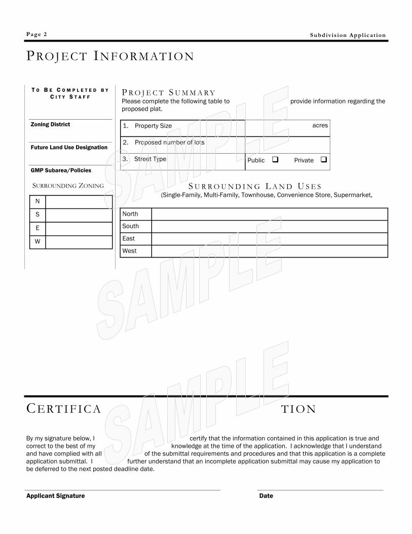
PRO J EC T IN FO RMATIO N
Subdiv is ion Appl icat ion
T O B E C O M P L E T E D B Y
C I T Y S T A F F
1. Property Size acres
2. Proposed number of lots
3. Street Type Public Private
Zoning District
Future Land Use Designation
GMP Subarea/Policies
SURROUNDING ZONING
N
S
E
W
North
South
East
West
S U R R O U N D I N G L A N D U S E S (Single-Family, Multi-Family, Townhouse, Convenience Store, Supermarket,
CERTI FI C A TI O N
By my signature below, I certify that the information contained in this application is true and
correct to the best of my knowledge at the time of the application. I acknowledge that I understand
and have complied with all of the submittal requirements and procedures and that this application is a complete
application submittal. I further understand that an incomplete application submittal may cause my application to
be deferred to the next posted deadline date.
Applicant Signature
Date
P R O J E C T S U M M A R Y Please complete the following table to provide information regarding the
proposed plat.
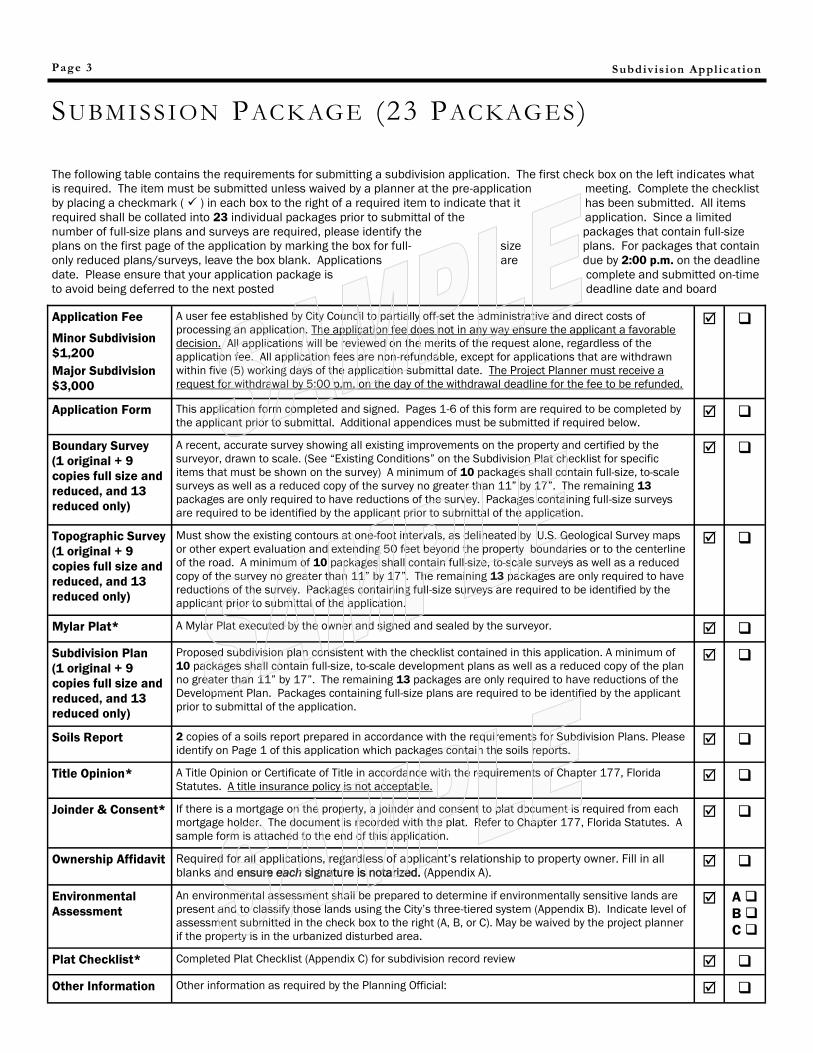
SU BM I SSION PACK AGE (23 PACKAG ES )
Application Fee
Minor Subdivision
$1,200
Major Subdivision
$3,000
A user fee established by City Council to partially off-set the administrative and direct costs of
processing an application. The application fee does not in any way ensure the applicant a favorable
decision. All applications will be reviewed on the merits of the request alone, regardless of the
application fee. All application fees are non-refundable, except for applications that are withdrawn
within five (5) working days of the application submittal date. The Project Planner must receive a
request for withdrawal by 5:00 p.m. on the day of the withdrawal deadline for the fee to be refunded.
Application Form This application form completed and signed. Pages 1-6 of this form are required to be completed by
the applicant prior to submittal. Additional appendices must be submitted if required below.
Boundary Survey
(1 original + 9
copies full size and
reduced, and 13
reduced only)
A recent, accurate survey showing all existing improvements on the property and certified by the
surveyor, drawn to scale. (See “Existing Conditions” on the Subdivision Plat checklist for specific
items that must be shown on the survey) A minimum of 10 packages shall contain full-size, to-scale
surveys as well as a reduced copy of the survey no greater than 11” by 17”. The remaining 13
packages are only required to have reductions of the survey. Packages containing full-size surveys
are required to be identified by the applicant prior to submittal of the application.
Topographic Survey
(1 original + 9
copies full size and
reduced, and 13
reduced only)
Must show the existing contours at one-foot intervals, as delineated by U.S. Geological Survey maps
or other expert evaluation and extending 50 feet beyond the property boundaries or to the centerline
of the road. A minimum of 10 packages shall contain full-size, to-scale surveys as well as a reduced
copy of the survey no greater than 11” by 17”. The remaining 13 packages are only required to have
reductions of the survey. Packages containing full-size surveys are required to be identified by the
applicant prior to submittal of the application.
Mylar Plat* A Mylar Plat executed by the owner and signed and sealed by the surveyor.
Subdivision Plan
(1 original + 9
copies full size and
reduced, and 13
reduced only)
Proposed subdivision plan consistent with the checklist contained in this application. A minimum of
10 packages shall contain full-size, to-scale development plans as well as a reduced copy of the plan
no greater than 11” by 17”. The remaining 13 packages are only required to have reductions of the
Development Plan. Packages containing full-size plans are required to be identified by the applicant
prior to submittal of the application.
Soils Report 2 copies of a soils report prepared in accordance with the requirements for Subdivision Plans. Please
identify on Page 1 of this application which packages contain the soils reports.
Title Opinion* A Title Opinion or Certificate of Title in accordance with the requirements of Chapter 177, Florida
Statutes. A title insurance policy is not acceptable.
Joinder & Consent* If there is a mortgage on the property, a joinder and consent to plat document is required from each
mortgage holder. The document is recorded with the plat. Refer to Chapter 177, Florida Statutes. A
sample form is attached to the end of this application.
Ownership Affidavit Required for all applications, regardless of applicant’s relationship to property owner. Fill in all
blanks and ensure each signature is notarized. (Appendix A).
Environmental
Assessment
An environmental assessment shall be prepared to determine if environmentally sensitive lands are
present and to classify those lands using the City’s three-tiered system (Appendix B). Indicate level of
assessment submitted in the check box to the right (A, B, or C). May be waived by the project planner
if the property is in the urbanized disturbed area.
A
B
C
Plat Checklist* Completed Plat Checklist (Appendix C) for subdivision record review
Other Information Other information as required by the Planning Official:
Page 3 Subdiv is ion Appl icat ion
The following table contains the requirements for submitting a subdivision application. The first check box on the left indicates what
is required. The item must be submitted unless waived by a planner at the pre-application meeting. Complete the checklist
by placing a checkmark ( ) in each box to the right of a required item to indicate that it has been submitted. All items
required shall be collated into 23 individual packages prior to submittal of the application. Since a limited
number of full-size plans and surveys are required, please identify the packages that contain full-size
plans on the first page of the application by marking the box for full- size plans. For packages that contain
only reduced plans/surveys, leave the box blank. Applications are due by 2:00 p.m. on the deadline
date. Please ensure that your application package is complete and submitted on-time
to avoid being deferred to the next posted deadline date and board
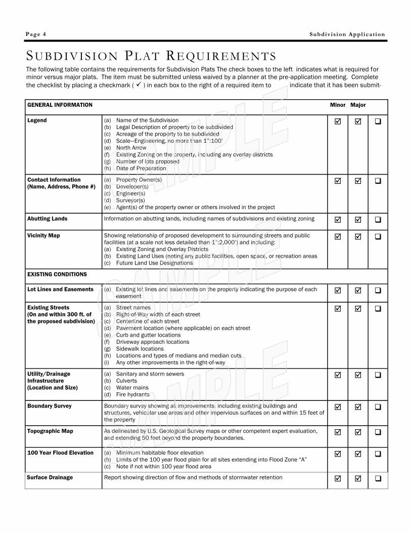
Subdivis ion Appl icat ion Page 4
SU BD IVI SION PL AT REQU I R EM ENTS
GENERAL INFORMATION Minor Major
Legend (a) Name of the Subdivision
(b) Legal Description of property to be subdivided
(c) Acreage of the property to be subdivided
(d) Scale—Engineering, no more than 1”:100’
(e) North Arrow
(f) Existing Zoning on the property, including any overlay districts
(g) Number of lots proposed
(h) Date of Preparation
Contact Information
(Name, Address, Phone #)
(a) Property Owner(s)
(b) Developer(s)
(c) Engineer(s)
(d) Surveyor(s)
(e) Agent(s) of the property owner or others involved in the project
Abutting Lands Information on abutting lands, including names of subdivisions and existing zoning
Vicinity Map Showing relationship of proposed development to surrounding streets and public
facilities (at a scale not less detailed than 1”:2,000’) and including:
(a) Existing Zoning and Overlay Districts
(b) Existing Land Uses (noting any public facilities, open space, or recreation areas
(c) Future Land Use Designations
EXISTING CONDITIONS
Lot Lines and Easements (a) Existing lot lines and easements on the property indicating the purpose of each
easement
Existing Streets
(On and within 300 ft. of
the proposed subdivision)
(a) Street names
(b) Right-of-Way width of each street
(c) Centerline of each street
(d) Pavement location (where applicable) on each street
(e) Curb and gutter locations
(f) Driveway approach locations
(g) Sidewalk locations
(h) Locations and types of medians and median cuts
(i) Any other improvements in the right-of-way
Utility/Drainage
Infrastructure
(Location and Size)
(a) Sanitary and storm sewers
(b) Culverts
(c) Water mains
(d) Fire hydrants
Boundary Survey Boundary survey showing all improvements, including existing buildings and
structures, vehicular use areas and other impervious surfaces on and within 15 feet of
the property
Topographic Map As delineated by U.S. Geological Survey maps or other competent expert evaluation,
and extending 50 feet beyond the property boundaries.
100 Year Flood Elevation (a) Minimum habitable floor elevation
(b) Limits of the 100 year flood plain for all sites extending into Flood Zone “A”
(c) Note if not within 100 year flood area
Surface Drainage Report showing direction of flow and methods of stormwater retention
The following table contains the requirements for Subdivision Plats The check boxes to the left indicates what is required for
minor versus major plats. The item must be submitted unless waived by a planner at the pre-application meeting. Complete
the checklist by placing a checkmark ( ) in each box to the right of a required item to indicate that it has been submit-
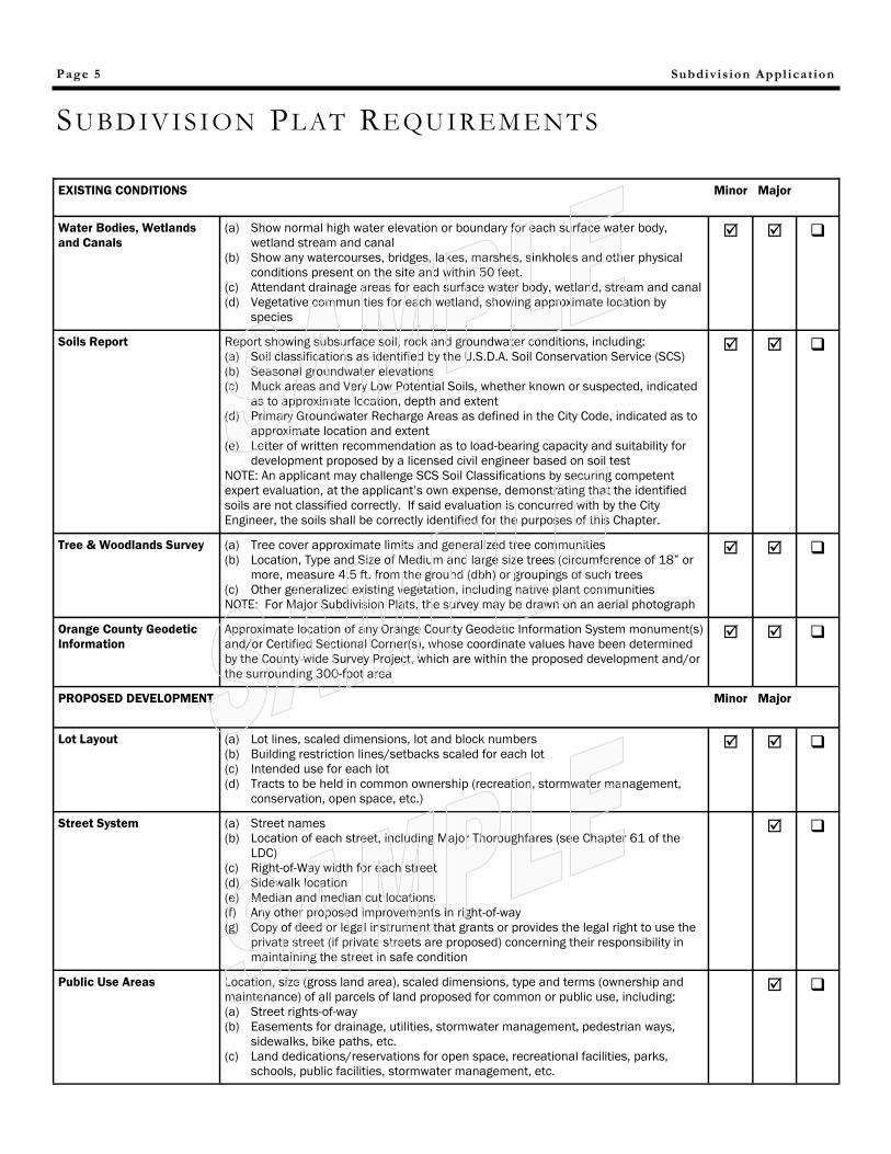
Subdivis ion Appl icat ion Page 5
SU BD IVI SION PL AT REQU I R EM ENTS
EXISTING CONDITIONS Minor Major
Water Bodies, Wetlands
and Canals
(a) Show normal high water elevation or boundary for each surface water body,
wetland stream and canal
(b) Show any watercourses, bridges, lakes, marshes, sinkholes and other physical
conditions present on the site and within 50 feet.
(c) Attendant drainage areas for each surface water body, wetland, stream and canal
(d) Vegetative communities for each wetland, showing approximate location by
species
Soils Report Report showing subsurface soil, rock and groundwater conditions, including:
(a) Soil classifications as identified by the U.S.D.A. Soil Conservation Service (SCS)
(b) Seasonal groundwater elevations
(c) Muck areas and Very Low Potential Soils, whether known or suspected, indicated
as to approximate location, depth and extent
(d) Primary Groundwater Recharge Areas as defined in the City Code, indicated as to
approximate location and extent
(e) Letter of written recommendation as to load-bearing capacity and suitability for
development proposed by a licensed civil engineer based on soil test
NOTE: An applicant may challenge SCS Soil Classifications by securing competent
expert evaluation, at the applicant’s own expense, demonstrating that the identified
soils are not classified correctly. If said evaluation is concurred with by the City
Engineer, the soils shall be correctly identified for the purposes of this Chapter.
Tree & Woodlands Survey (a) Tree cover approximate limits and generalized tree communities
(b) Location, Type and Size of Medium and large size trees (circumference of 18” or
more, measure 4.5 ft. from the ground (dbh) or groupings of such trees
(c) Other generalized existing vegetation, including native plant communities
NOTE: For Major Subdivision Plats, the survey may be drawn on an aerial photograph
Orange County Geodetic
Information
Approximate location of any Orange County Geodetic Information System monument(s)
and/or Certified Sectional Corner(s), whose coordinate values have been determined
by the County-wide Survey Project, which are within the proposed development and/or
the surrounding 300-foot area
PROPOSED DEVELOPMENT Minor Major
Lot Layout (a) Lot lines, scaled dimensions, lot and block numbers
(b) Building restriction lines/setbacks scaled for each lot
(c) Intended use for each lot
(d) Tracts to be held in common ownership (recreation, stormwater management,
conservation, open space, etc.)
Street System (a) Street names
(b) Location of each street, including Major Thoroughfares (see Chapter 61 of the
LDC)
(c) Right-of-Way width for each street
(d) Sidewalk location
(e) Median and median cut locations
(f) Any other proposed improvements in right-of-way
(g) Copy of deed or legal instrument that grants or provides the legal right to use the
private street (if private streets are proposed) concerning their responsibility in
maintaining the street in safe condition
Public Use Areas Location, size (gross land area), scaled dimensions, type and terms (ownership and
maintenance) of all parcels of land proposed for common or public use, including:
(a) Street rights-of-way
(b) Easements for drainage, utilities, stormwater management, pedestrian ways,
sidewalks, bike paths, etc.
(c) Land dedications/reservations for open space, recreational facilities, parks,
schools, public facilities, stormwater management, etc.
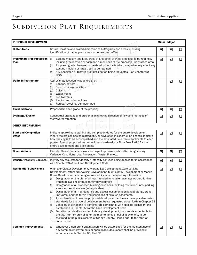
Subdivis ion Appl icat ion Page 6
SU BD IVI SION PL AT REQU I R EM ENTS
PROPOSED DEVELOPMENT Minor Major
Buffer Areas Nature, location and scaled dimension of bufferyards and areas, including
identification of native plant areas to be used as buffers
Preliminary Tree Protection
Plan
(a) Existing medium and large trees or groupings of trees proposed to be retained,
including the location of each and dimensions of the proposed undisturbed area
(b) Proposed grade changes on the development site which may adversely affect any
existing medium or large trees to be retained
(c) Any Specimen or Historic Tree designation being requested (See Chapter 60,
LDC)
Utility Infrastructure Approximate location, type and size of:
(a) Sanitary sewers
(b) Storm drainage facilities
(c) Culverts
(d) Water mains
(e) Fire hydrants
(f) Electric and other utilities
(g) Refuse/recycling/dumpster pad
Finished Grade Proposed finished grade of the property
Drainage/Erosion Conceptual drainage and erosion plan showing direction of flow and methods of
stormwater retention
OTHER INFORMATION
Start and Completion
Dates
Indicate approximate starting and completion dates for the entire development.
Where the project is to be platted and/or developed in construction phases, indicate
how phasing is to be accomplished and the estimated time frame applicable to each
phase. Specify proposed maximum intensity (density or Floor Area Ratio) for the
entire development and each phase
Board Actions Identify other actions necessary for project approval such as Rezoning, Zoning
Variance, Conditional Use, Annexation, Master Plan etc.
Density/Intensity Bonuses Identify any requests for density / intensity bonuses being applied for in accordance
with Chapter 58 of the Land Development Code
Residential Subdivisions Wherever Cluster Development, Average Lot Development, Zero-Lot-Line
Development, Attached Dwelling Development, Multi-Family Development or Mobile
Home Development are being requested, include the following information:
(a) Designation on the plat of all lots intended for cluster, average lot, zero-lot-line,
attached dwelling or multi-family development
(b) Designation of all proposed building envelopes, building restriction lines, parking
areas and service areas (as applicable)
(c) Designation of all maintenance and access easements on lots abutting zero-lot-
line yards, and the terms and conditions of all such easements
(d) An explanation of how the proposed development achieves the applicable review
standards for the type of development being requested as set forth in Chapter 58
(e) Conceptual elevations to demonstrate compliance with specific design criteria
established in Chapter 58 of the Land Development Code
(f) For attached dwelling and multi-family development, documents acceptable to
the City Attorney providing for the maintenance of building exteriors, to be
recorded in the public records of Orange County, Florida prior to the start of
construction.
Common Improvements (a) Whenever a non-profit organization will be established for the maintenance of
any common improvements or open space, documents shall be provided in
accordance with Chapter 65, Part 5E.
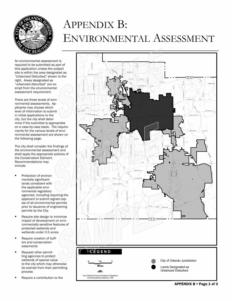
APPENDIX B: ENVIRONMENTAL ASSESSMENT
An environmental assessment is
required to be submitted as part of
this application unless the subject
site is within the area designated as
“Urbanized Disturbed” shown to the
right. Areas designated as
“urbanized disturbed” are ex-
empt from the environmental
assessment requirement.
There are three levels of envi-
ronmental assessments. Ap-
plicants may choose which
level of information to submit
in initial applications to the
city, but the city shall deter-
mine if the submittal is appropriate
on a case-by-case basis. The require-
ments for the various levels of envi-
ronmental assessment are shown on
the following page.
The city shall consider the findings of
the environmental assessment and
shall apply the appropriate policies of
the Conservation Element.
Recommendations may
include:
Protection of environ-
mentally significant
lands consistent with
the applicable envi-
ronmental regulatory
agencies, including requiring the
applicant to submit signed cop-
ies of all environmental permits
prior to issuance of engineering
permits by the City.
Require site design to minimize
impact of development on envi-
ronmentally sensitive features of
protected wetlands and
wetlands under 0.5 acres.
Require creation of buff-
ers and conservation
easements
Request other permit-
ting agencies to protect
wetlands of special value
to the city which may otherwise
be exempt from their permitting
process
Require a contribution to the
APPENDIX B Page 1 of 3
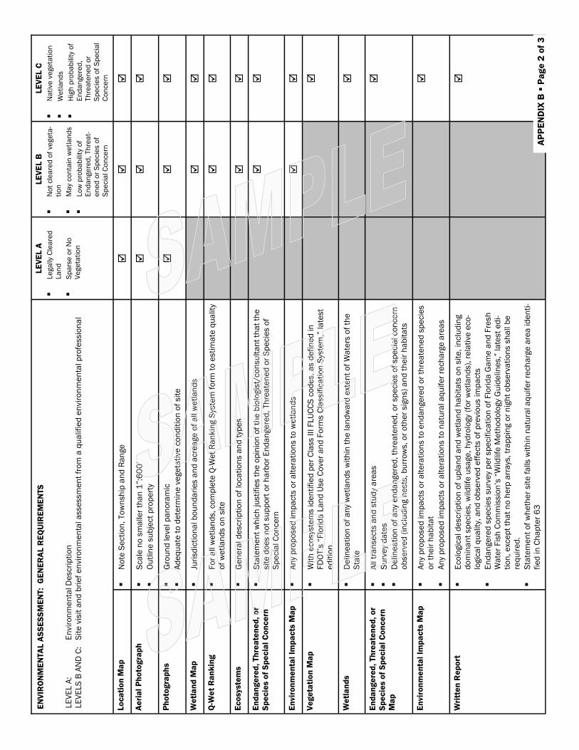
LE
VE
L A
Le
ga
lly
Cle
are
d
La
nd
Sp
ars
e o
r N
o
Ve
ge
tati
on
LE
VE
L B
No
t cle
are
d o
f ve
ge
ta-
tio
n
Ma
y co
nta
in w
etl
an
ds
Lo
w p
rob
ab
ilit
y o
f
En
da
nge
red
, Th
rea
t-
en
ed
or
Sp
ecie
s o
f
Sp
ecia
l C
on
ce
rn
LE
VE
L C
Na
tive
ve
ge
tati
on
We
tla
nd
s
Hig
h p
rob
ab
ilit
y o
f
En
da
nge
red
,
Th
rea
ten
ed
or
Sp
ecie
s o
f S
pe
cia
l
Co
nce
rn
Lo
ca
tio
n M
ap
No
te S
ecti
on
, To
wn
sh
ip a
nd
Ra
nge
Ae
ria
l P
ho
tog
rap
h
Sca
le n
o s
ma
lle
r th
an
1”:
60
0’
Ou
tlin
e s
ub
ject
pro
pe
rty
Ph
oto
gra
ph
s
Gro
un
d le
ve
l p
an
ora
mic
Ad
eq
ua
te t
o d
ete
rmin
e v
ege
tati
ve
co
nd
itio
n o
f sit
e
We
tla
nd
Ma
p
Juri
sd
icti
on
al b
ou
nd
ari
es a
nd
acre
age
of
all w
etl
an
ds
Q-W
et
Ra
nk
ing
Fo
r a
ll w
etl
an
ds,
co
mp
lete
Q-W
et
Ra
nk
ing S
yste
m f
orm
to
esti
ma
te q
ua
lity
of
we
tla
nd
s o
n s
ite
Ec
osyste
ms
Ge
ne
ral d
escri
pti
on
of
loca
tio
ns a
nd
typ
es
En
da
ng
ere
d,
Th
rea
ten
ed
, o
r
Sp
ec
ies o
f S
pe
cia
l C
on
ce
rn
Sta
tem
en
t w
hic
h ju
sti
fie
s t
he
op
inio
n o
f th
e b
iolo
gis
t/co
nsu
lta
nt
tha
t th
e
sit
e d
oe
s n
ot
su
pp
ort
or
ha
rbo
r E
nd
an
ge
red
, Th
rea
ten
ed
or
Sp
ecie
s o
f
Sp
ecia
l C
on
ce
rn
En
vir
on
me
nta
l Im
pa
cts
Ma
p
An
y p
rop
ose
d im
pa
cts
or
alt
era
tio
ns t
o w
etl
an
ds
Ve
ge
tati
on
Ma
p
Wit
h e
co
sys
tem
s id
en
tifi
ed
pe
r C
lass I
II F
LU
CC
S c
od
es,
as d
efi
ne
d in
FD
OT’s
“F
lori
da
La
nd
Use
Co
ve
r a
nd
Fo
rms C
lassif
ica
tio
n S
yste
m,”
la
test
ed
itio
n
We
tla
nd
s
De
lin
ea
tio
n o
f a
ny
we
tla
nd
s w
ith
in t
he
la
nd
wa
rd e
xte
nt
of
Wa
ters
of
the
Sta
te
En
da
ng
ere
d,
Th
rea
ten
ed
, o
r
Sp
ec
ies o
f S
pe
cia
l C
on
ce
rn
Ma
p
All t
ran
se
cts
an
d s
tud
y a
rea
s
Su
rve
y d
ate
s
De
lin
ea
tio
n o
f a
ny
en
da
nge
red
, th
rea
ten
ed
, o
r sp
ecie
s o
f sp
ecia
l co
nce
rn
ob
se
rve
d (
inclu
din
g n
ests
, b
urr
ow
s,
or
oth
er
sig
ns)
an
d t
he
ir h
ab
ita
ts
En
vir
on
me
nta
l Im
pa
cts
Ma
p
An
y p
rop
ose
d im
pa
cts
or
alt
era
tio
ns t
o e
nd
an
ge
red
or
thre
ate
ne
d s
pe
cie
s
or
the
ir h
ab
ita
t
An
y p
rop
ose
d im
pa
cts
or
alt
era
tio
ns t
o n
atu
ral a
qu
ife
r re
ch
arg
e a
rea
s
Wri
tte
n R
ep
ort
Eco
logic
al d
escri
pti
on
of
up
lan
d a
nd
we
tla
nd
ha
bit
ats
on
sit
e,
inclu
din
g
do
min
an
t sp
ecie
s,
wild
life
usa
ge
, h
ydro
logy
(fo
r w
etl
an
ds),
re
lati
ve
eco
-
logic
al q
ua
lity
, a
nd
ob
se
rve
d e
ffe
cts
of
pre
vio
us im
pa
cts
En
da
nge
red
sp
ecie
s s
urv
ey
pe
r sp
ecif
ica
tio
n o
f F
lori
da
Ga
me
an
d F
resh
Wa
ter
Fis
h C
om
mis
sio
n’s
“W
ild
life
Me
tho
do
logy
Gu
ide
lin
es,”
la
test
ed
i-
tio
n,
exc
ep
t th
at
no
he
rp a
rra
ys, tr
ap
pin
g o
r n
igh
t o
bse
rva
tio
ns s
ha
ll b
e
req
uir
ed
.
Sta
tem
en
t o
f w
he
the
r sit
e f
alls w
ith
in n
atu
ral a
qu
ife
r re
ch
arg
e a
rea
id
en
ti-
fie
d in
Ch
ap
ter
63
EN
VIR
ON
ME
NTA
L A
SS
ES
SM
EN
T:
GE
NE
RA
L R
EQ
UIR
EM
EN
TS
LE
VE
L A
:
En
vir
on
me
nta
l D
escri
pti
on
LE
VE
LS
B A
ND
C:
S
ite
vis
it a
nd
bri
ef
en
vir
on
me
nta
l a
sse
ssm
en
t fr
om
a q
ua
lifi
ed
en
vir
on
me
nta
l p
rofe
ssio
na
l
AP
PE
ND
IX B
P
ag
e 2
of
3
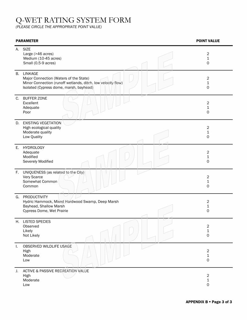
Q-WET RATING SYSTEM FORM (PLEASE CIRCLE THE APPROPRIATE POINT VALUE)
PARAMETER POINT VALUE
A. SIZE
Large (>46 acres)
Medium (10-45 acres)
Small (0.5-9 acres)
2
1
0
B. LINKAGE
Major Connection (Waters of the State)
Minor Connection (runoff wetlands, ditch, low velocity flow)
Isolated (Cypress dome, marsh, bayhead)
2
1
0
C. BUFFER ZONE
Excellent
Adequate
Poor
2
1
0
D. EXISTING VEGETATION
High ecological quality
Moderate quality
Low Quality
2
1
0
E. HYDROLOGY
Adequate
Modified
Severely Modified
2
1
0
F. UNIQUENESS (as related to the City)
Very Scarce
Somewhat Common
Common
2
1
0
G. PRODUCTIVITY
Hydric Hammock, Mixed Hardwood Swamp, Deep Marsh
Bayhead, Shallow Marsh
Cypress Dome, Wet Prairie
2
1
0
H. LISTED SPECIES
Observed
Likely
Not Likely
2
1
0
I. OBSERVED WILDLIFE USAGE
High
Moderate
Low
2
1
0
J. ACTIVE & PASSIVE RECREATION VALUE
High
Moderate
Low
2
1
0
APPENDIX B Page 3 of 3
The Office of Permitting Services processes final record plats though the City agencies for re-
view and approval and ultimate recording of the final p l a t at the Orange County Recording
Office.
Our goal is to make the plat review proc- ess an efficient and professional
experience. We encourage t h e professional’s preparing these plats for
recording in the official r e - cords take advantage of the same checklist we
use to review the plats for compliance with Florida Statute 177. This checklist was
compiled from rules con- tained within the 2009 Florida Statute 177 Part 1. In addition
to the rules contained within Florida Statute 177 those additional rules required by the City
of Orlando under the au- thority of the said statute have been included. This checklist is to be used in
the preparation of the final plat and should be signed and sealed by the Surveyor in responsible charge and sub-
mitted with the final Mylar plat, the Title Opinion or Certificate of Title to the Office of Permitting Services. Any plat sub-
mitted with substantial errors and omissions, that make it apparent to the City Sur- veyor that there was no quality con-
trol performed prior to submission, will not be reviewed by Survey Services.
The Office of Legal Affairs reviews the final plat and the Certifi- cate of Title or Title Opinion and the Join-
der and Consent forms that may be required as a result of t h e review of the title work.
The City Surveyor’s Office reviews the face of t h e plat for conformance to Florida
Statutes 177 and for any additional City of Orlando requirements. A field
check is performed to verify t h e correct placement of the permanent
reference markers. Addi- tionally, the face of the plat is checked to
verify accuracy and com- pliance with Florida Statutes 177.
Following the City Sur- vey’s first review, any errors and omissions will be detailed in a
letter sent to the Sur- veyor in responsible charge. If the field inspection does not pass, the
surveyor in responsible charge must contact the City Surveyor. If a third field check is required, the Sur-
veyor in responsible charge will be required to be on site during the field check.
Should you have any questions regarding the Surveying Services plat review proc- ess please feel free to contact
the City Surveyor at 407-246-3319.
Professional Surveyor and Mapper Signature and Seal
Date
APPENDIX C Page 1 of 7
APPENDIX C:
FINAL PLAT REVIEW CHECKLIST
State Statutes Requirement Summary
(Chapter 177, Florida Statutes—www.leg.state.fl.us)
177.041
Boundary
Survey
&
Title
Certification
Every plat or replat of a subdivision submitted to the approving agency of the local governing body
must be accompanied by:
(1) A boundary survey of the platted lands. However, a new boundary survey for a replat is
required only when the replat affects any boundary of the previously platted property or when im-
provements which may affect the boundary of the previously platted property have been made on
the lands to be replatted. The boundary survey must be performed and prepared under the re-
sponsible direction and supervision of a professional surveyor and mapper preceding the initial
submittal of the plat to the local governing body. This subsection does not restrict a legal entity
from employing one professional surveyor and mapper to perform and prepare the boundary sur-
vey and another professional surveyor and mapper to prepare the plat.
(2) A title opinion of an attorney at law licensed in Florida or a certification by an abstractor
or a title company showing that record title to the land as described and shown on the plat is in
the name of the person, persons, corporation, or entity executing the dedication. The title opinion
or certification shall also show all mortgages not satisfied or released of record nor otherwise ter-
minated by law.
177.051
Name and Replat
of Subdivision
(1) Every subdivision shall be given a name by which it shall be legally known. For the pur-
pose of this section, that name is the "primary name." The primary name shall not be the same or
in any way so similar to any name appearing on any recorded plat in the same county as to con-
fuse the records or to mislead the public as to the identity of the subdivision, except when the
subdivision is further divided as an additional unit or section by the same developer or the devel-
oper's successors in title. In that case, the additional unit, section, or phase shall be given the
primary name followed by the unit, section, or phase number. Words such as "the," "replat," or "a"
may not be used as the first word of the primary name. Every subdivision's name shall have legible
lettering of the same size and type, including the words "section," "unit," or "phase." If the word
"replat" is not part of the primary name, then it may be of a different size and type. The primary
name of the subdivision shall be shown in the dedication the primary name of the subdivision
shall be shown in the dedication and shall coincide exactly with the subdivision name.
(2) Any change in a plat, except as provided in s. 177.141, shall be labeled a "replat," and a
replat must conform to this part. After the effective date of this act, the terms "amended plat,"
"revised plat," "corrected plat," and "resubdivision" may not be used to describe the process by
which a plat is changed.
177.061
Qualification
and Statement
Required
Every plat offered for recording pursuant to the provisions of this part must be prepared by a pro-
fessional surveyor and mapper. The plat must be signed and sealed by that professional surveyor
and mapper, who must state on the plat that the plat was prepared under his or her direction and
supervision and that the plat complies with all of the survey requirements of this part. Every plat
must also contain the printed name and registration number of the professional surveyor and
mapper directly below the statement required by this section, along with the printed name, ad-
dress, and certificate of authorization number of the legal entity, if any. A professional surveyor
and mapper practicing independently of a legal entity must include his or her address.
(1) Before a plat is offered for recording, it must be approved by the appropriate governing
body, and evidence of such approval must be placed on the plat. If not approved, the governing
body must return the plat to the professional surveyor and mapper or the legal entity offering the
plat for recordation. For the purposes of this part:
APPENDIX C Page 2 of 7
APPENDIX C:
COMMUNICATION TOWER ADDITIONAL REQUIREMENTS
APPENDIX C:
FINAL PLAT REVIEW CHECKLIST
The following table contains the final plat review checklist for all sub- division plats. Complete the
checklist by placing a checkmark ( ) in each box to the left of each item to indicate that the
177.061
Qualification
and
Statement Re-
quired
cont’d
(a) When the plat to be submitted for approval is located wholly within the boundaries of a
municipality, the governing body of the municipality has exclusive jurisdiction to approve the plat.
(b) When a plat lies wholly within the unincorporated areas of a county, the governing body of
the county has exclusive jurisdiction to approve the plat.
(c) When a plat lies within the boundaries of more than one governing body, two plats must
be prepared and each governing body has exclusive jurisdiction to approve the plat within its
boundaries, unless the governing bodies having said jurisdiction agree that one plat is mutually
acceptable.
(2) Any provision in a county charter, or in an ordinance of any charter county or consolidated
government chartered under s. 6(e), Art. VIII of the State Constitution, which provision is inconsis-
tent with anything contained in this section shall prevail in such charter county or consolidated
government to the extent of any such inconsistency.
177.071
Approval of Plat
by Governing
Bodies
The boundary of the plat is located wholly in the City of Orlando municipal boundary
177.081
Dedication and
Approval
(1) Prior to approval by the appropriate governing body, the plat shall be reviewed for confor-
mity to this chapter by a professional surveyor and mapper either employed by or under contract
to the local governing body, the costs of which shall be borne by the legal entity offering the plat
for recordation, and evidence of such review must be placed on such plat.
(2) Every plat of a subdivision filed for record must contain a dedication by the owner or own-
ers of record. The dedication must be executed by all persons, corporations, or entities whose sig-
nature would be required to convey record fee simple title to the lands being dedicated in the
same manner in which deeds are required to be executed. All mortgagees having a record interest
in the lands subdivided shall execute, in the same manner in which deeds are required to be exe-
cuted, either the dedication contained on the plat or a separate instrument joining in and ratifying
the plat and all dedications and reservations thereon.
(3) When a tract or parcel of land has been subdivided and a plat thereof bearing the dedica-
tion executed by the owners of record and mortgagees having a record interest in the lands subdi-
vided, and when the approval of the governing body has been secured and recorded in compli-
ance with this part, all streets, alleys, easements, rights-of-way, and public areas shown on such
plat, unless otherwise stated, shall be deemed to have been dedicated to the public for the uses
and purposes thereon stated. However, nothing herein shall be construed as creating an obliga-
tion upon any governing body to perform any act of construction or maintenance within such dedi-
cated areas except when the obligation is voluntarily assumed by the governing body.
177.091
Plats Made for
Recording
(1) At the end of the plat approval process the requestor must submit two sets of digital files.
The file naming convention for both sets of digital files should include the permitting project num-
ber or master building permit number. If there are multiple files for the same number then a se-
quence number should be added to the file name. (eg PRJ2005-00121_1)
The first set of files must be in PDF format. The PDF file must have bookmarks that will
clearly identify each sheet in the file. The digital files must have the following characteristics:
The second set of files must be in one the following file formats: DXF, DGN,DWG or SHP
(ESRI). Text documents like energy calculations can be submitted in PDF format. The Coordinate
system must be State Plane Florida East NAD 83, feet. There must be either a separate index that
explains what is contained in each layer of the file or the layer name itself must be self explana-
tory.
Every plat of a subdivision offered for recording shall conform to the following:
Marginal lines, standard certificates and approval forms shall be printed on the plat with a
permanent black drawing ink. A print or photographic copy of the original drawing must be submit-
ted with the original drawing. APPENDIX C Page 3 of 7
APPENDIX C:
COMMUNICATION TOWER ADDITIONAL REQUIREMENTS
APPENDIX C:
FINAL PLAT REVIEW CHECKLIST PERMITTING AND CODE ENFORCEMENT
APPENDIX C:
COMMUNICATION TOWER ADDITIONAL REQUIREMENTS
APPENDIX C:
FINAL PLAT REVIEW CHECKLIST PERMITTING AND CODE ENFORCEMENT
177.091
Plats Made for
Recording
cont’d
(2) The size of each sheet shall be determined by the local governing body and shall be
drawn with a marginal line, or printed when permitted by local ordinance, completely around each
sheet and placed so as to leave at least a 1/2-inch margin on each of three sides and a 3-inch
margin on the left side of the plat for binding purposes.
(3) When more than one sheet must be used to accurately portray the lands subdivided, an
index or key map must be included and each sheet must show the particular number of that sheet
and the total number of sheets included, as well as clearly labeled match lines to show where
other sheets match or adjoin.
(4) In all cases, the letter size and scale used shall be of sufficient size to show all detail. The
scale shall be both stated and graphically illustrated by a graphic scale drawn on every sheet
showing any portion of the lands subdivided.
(5) The name of the plat shall be shown in bold legible letters, as stated in s. 177.051. The
name of the subdivision shall be shown on each sheet included. The name of the professional
surveyor and mapper or legal entity, along with the street and mailing address, must be shown on
each sheet included.
(6) A prominent "north arrow" shall be drawn on every sheet included showing any portion of
the lands subdivided. The bearing or azimuth reference shall be clearly stated on the face of the
plat in the notes or legend, and, in all cases, the bearings used shall be referenced to some well-
established and monumented line.
(7) Permanent reference monuments must be placed at each corner or change in direction
on the boundary of the lands being platted and may not be more than 1,400 feet apart. Where
such corners are in an inaccessible place, "P.R.M.s" shall be set on a nearby offset within the
boundary of the plat and such offset shall be so noted on the plat. Where corners are found to
coincide with a previously set "P.R.M.," the Florida registration number of the professional sur-
veyor and mapper in responsible charge or the certificate of authorization number of the legal
entity on the previously set "P.R.M." shall be shown on the new plat or, if unnumbered, shall so
state. Permanent reference monuments shall be set before the recording of the plat. The
"P.R.M.s" shall be shown on the plat by an appropriate symbol or designation.
(8) Permanent control points shall be set on the centerline of the right-of-way at the intersec-
tion and terminus of all streets, at each change of direction, and no more than 1,000 feet apart.
Such "P.C.P.s" shall be shown on the plat by an appropriate symbol or designation. In those coun-
ties or municipalities that do not require subdivision improvements and do not accept bonds or
escrow accounts to construct improvements, "P.C.P.s" may be set prior to the recording of the plat
and must be set within 1 year of the date the plat was recorded. In the counties or municipalities
that require subdivision improvements and have the means of insuring the construction of said
improvements, such as bonding requirements, "P.C.P.s" must be set prior to the expiration of the
bond or other surety. If the professional surveyor and mapper or legal entity of record is no longer
in practice or is not available due to relocation, or when the contractual relationship between the
subdivider and professional surveyor and mapper or legal entity has been terminated, the subdi-
vider shall contract with a professional surveyor and mapper or legal entity in good standing to
place the "P.C.P.s" within the time allotted.
(9) Monuments shall be set at all lot corners, points of intersection, and changes of direc-
tion of lines within the subdivision which do not require a "P.R.M." or a "P.C.P."; however, a monu-
ment need not be set if a monument already exists at such corner, point, or change of direction or
when a monument cannot be set due to a physical obstruction. In those counties or municipalities
that do not require subdivision improvements and do not accept bonds or escrow accounts to
construct improvements, monuments may be set prior to the recording of the plat and must be
set at the lot corners before the transfer of the lot. In those counties or municipalities that require
subdivision improvements and have the means of ensuring the construction of those improve-
ments, such as bonding requirements, monuments shall be set prior to the expiration of the bond
or other surety. (This subsection continues on next page).
APPENDIX C Page 4 of 7
APPENDIX C:
COMMUNICATION TOWER ADDITIONAL REQUIREMENTS
APPENDIX C:
FINAL PLAT REVIEW CHECKLIST PERMITTING AND CODE ENFORCEMENT
177.091
Plats Made for
Recording
cont’d
If the professional surveyor and mapper or legal entity of record is no longer in practice or is not
available due to relocation, or when the contractual relationship between the subdivider and pro-
fessional surveyor and mapper or legal entity has been terminated, the subdivider shall contract
with a professional surveyor and mapper or legal entity in good standing who shall be allowed to
place the monuments within the time allotted.
(10) The section, township, and range shall appear immediately under the name of the plat
on each sheet included, along with the name of the city, town, village, county, and state in which
the land being platted is situated.
(11) Each plat shall show a description of the lands subdivided, and the description shall be
the same in the title certification. The description must be so complete that from it, without refer-
ence to the plat, the starting point and boundary can be determined.
(12) The dedications and approvals required by ss. 177.071 and 177.081 must be shown.
(13) The circuit court clerk's certificate and the professional surveyor and mapper's seal and
statement required by s. 177.061 shall be shown.
(14) All section lines and quarter section lines occurring within the subdivision shall be indi-
cated by lines drawn upon the map or plat, with appropriate words and figures. If the description is
by metes and bounds, all information called for, such as the point of commencement, course
bearings and distances, and the point of beginning, shall be indicated. If the platted lands are in a
land grant or are not included in the subdivision of government surveys, then the boundaries are
to be defined by metes and bounds and courses.
(15) Location, width, and names of all streets, waterways, or other rights-of-way shall be
shown, as applicable.
(16) Location and width of proposed easements and existing easements identified in the title
opinion or certification required by s. 177.041(2) shall be shown on the plat or in the notes or leg-
end, and their intended use shall be clearly stated. Where easements are not coincident with
property lines, they must be labeled with bearings and distances and tied to the principal lot, tract,
or right-of-way.
(17) All contiguous properties shall be identified by subdivision title, plat book, and page, or,
if unplatted, land shall be so designated. If the subdivision platted is a part or the whole of a previ-
ously recorded subdivision, sufficient ties shall be shown to controlling lines appearing on the ear-
lier plat to permit an overlay to be made; the fact of its being a replat shall be stated as a subtitle
under the name of the plat on each sheet included. The subtitle must state the name of the subdi-
vision being replatted and the appropriate recording reference.
(18) All lots shall be numbered either by progressive numbers or, if in blocks, progressively
numbered in each block, and the blocks progressively numbered or lettered, except that blocks in
numbered additions bearing the same name may be numbered consecutively throughout the sev-
eral additions.
(19) Sufficient survey data shall be shown to positively describe the bounds of every lot,
block, street easement, and all other areas shown on the plat. When any lot or portion of the sub-
division is bounded by an irregular line, the major portion of that lot or subdivision shall be en-
closed by a witness line showing complete data, with distances along all lines extended beyond
the enclosure to the irregular boundary shown with as much certainty as can be determined or as
"more or less," if variable. Lot, block, street, and all other dimensions except to irregular bounda-
ries, shall be shown to a minimum of hundredths of feet. All measurements shall refer to horizon-
tal plane and in accordance with the definition of the U.S. Survey foot or meter adopted by the
National Institute of Standards and Technology. All measurements shall use the 39.37/12=3.28083333333 equation for conversion from a U.S. foot to meters.
(20) Curvilinear lot lines shall show the radii, arc distances, and central angles. Radial lines
will be so designated. Direction of nonradial lines shall be indicated.
(21) Sufficient angles, bearings, or azimuth to show direction of all lines shall be shown, and
all bearings, angles, or azimuth shall be shown to the nearest second of arc.
APPENDIX C Page 5 of 7
APPENDIX C Page 6 of 7
APPENDIX C:
COMMUNICATION TOWER ADDITIONAL REQUIREMENTS
APPENDIX C:
FINAL PLAT REVIEW CHECKLIST PERMITTING AND CODE ENFORCEMENT
177.091
Plats Made for
Recording
cont’d
(22) The centerlines of all streets shall be shown as follows: noncurved lines: distances to-
gether with either angles, bearings, or azimuths; curved lines: arc distances, central angles, and
radii, together with chord and chord bearing or azimuths.
(23) Park and recreation parcels as applicable shall be so designated.
(24) All interior excepted parcels as described in the description of the lands being subdi-
vided shall be clearly indicated and labeled "Not a part of this plat."
(25) The purpose of all areas dedicated must be clearly indicated or stated on the plat.
(26) When it is not possible to show line or curve data information on the map, a tabular
form may be used. The tabular data must appear on the sheet to which it applies.
(27) The plat shall include in a prominent place the following statements: "NOTICE: This
plat, as recorded in its graphic form, is the official depiction of the subdivided lands described
herein and will in no circumstances be supplanted in authority by any other graphic or digital
form of the plat. There may be additional restrictions that are not recorded on this plat that may
be found in the public records of this county."
(28) All platted utility easements shall provide that such easements shall also be ease-
ments for the construction, installation, maintenance, and operation of cable television services;
provided, however, no such construction, installation, maintenance, and operation of cable televi-
sion services shall interfere with the facilities and services of an electric, telephone, gas, or other
public utility. In the event a cable television company damages the facilities of a public utility, it
shall be solely responsible for the damages. This section shall not apply to those private ease-
ments granted to or obtained by a particular electric, telephone, gas, or other public utility. Such
construction, installation, maintenance, and operation shall comply with the National Electrical
Safety Code as adopted by the Florida Public Service Commission.
(29) A legend of all symbols and abbreviations shall be shown.
177.101
Vacation & An-
nulment of Plats
Subdividing Land
The approval of a replat by the governing body of a local government, which encompasses
lands embraced in all or part of a prior plat filed of public record shall, upon recordation of the
replat, automatically and simultaneously vacate and annul all of the prior plat encompassed by
the replat. Therefore all previously platted land labels and references must be removed and rela-
beled and referenced upon the replat.
177 Part 2
1) Every surveyor and mapper not under contract to the department for the execution of this
act who, in any survey or resurvey made under his or her direction, identifies, recovers, reestab-
lishes, remonuments, restores, or uses as control a public land survey corner or corner accessory
must, within 90 days after completion of the survey, file with the department a certified corner
record for each such corner or corner accessory, unless the corner or its accessories are sub-
stantially as described in a previously filed corner record. The record shall be signed, embossed
with the official seal of the surveyor and mapper, and produced on material suitable for reproduc-
tion or microfilming. The 90-day limitation may be extended with permission of the department.
All such certified corner records shall be accepted and filed with the department without further
inspection or approval of any public body or officer, if prepared in accordance with the criteria set
forth in subsection (3).
2) In every case in which a certified corner record of a public land survey corner is filed un-
der the provisions of this act, the surveyor and mapper must reconstruct or rehabilitate the
monument of such corner and accessories to such corner, so as to make them as permanent as
is reasonably possible and to facilitate their location in the future.

APPENDIX C Page 7 of 7
APPENDIX C:
COMMUNICATION TOWER ADDITIONAL REQUIREMENTS
APPENDIX C:
FINAL PLAT REVIEW CHECKLIST PERMITTING AND CODE ENFORCEMENT
City of Orlando—Additional Plat Requirements
Each plat must meet the following additional regulations required by the City of Orlando
as established in Florida Statute 177.011
1. The plat contains a metes and bounds legal description of the parent tract including the area.
2. The plat boundary is tied to 2 public land survey corners as defined in FS 177.503 and CCR numbers shown.
3. Copies of closure report for the parent boundary and all interior parcels and easements are included and
have a relative error of closure no less than 1’ in 10,000’.
4. A Location map including North arrow, scale and adjacent streets is included on the cover sheet.
5. All text is a minimum size of .10’’
6. The sheet size is 24” x 30” with no less than ½” margins on the top, bottom and right sides and 3” margin on
the left side.
7. The scale of the plat is 1”= 200’ or larger.
8. 4” X 4” X 30” concrete monuments including a metal cap marker with an LB or LS number must be placed at
each change of direction along the parent boundary of the plat. When right-of-way dedications are being made the
monuments shall be placed at the intersection of the parent boundary and the new right-of-way. The City Surveyor
prior to submittal must approve any variation of this additional requirement.
9. The boundary survey must be supported by the title opinion or certification submitted with the plat and must
include the zone classification for the parent boundary as designated on the most current FEMA FIRM.
10. The title opinion shall be of an attorney at law licensed in Florida or a certification by an abstractor or a title
company referencing that record title to the land as described and shown on the plat is in the name of the person,
persons, corporation, or entity executing the dedication. The title opinion or certification shall also reference all mort-
gages not satisfied or released of record nor otherwise terminated by law. The title opinion or certification shall also
reference all existing easements and encumbrances of record.
11. Chapter 59 Statement shown on Cover sheet.
12. A Topographic Survey of the parent parcel based upon NAVD 88 datum is included in the submittal.
13. The primary name of the subdivision shall be shown in the dedication with a font clearly different that the
word “Dedication”
14. Orange County 911 shall approve the subdivision name and all street names prior to being shown upon the
plat.
15. All Contiguous property including Streets shall be labeled with Plat Book and Page creating the Street or
“Not Platted”. Any recording information is welcome.
16. All lots shall be numbered either by progressive numbers or, if in blocks, progressively numbered in each
block beginning with the number “one”.
17. Statement of Lien Settlement: Submit to Orange County Property Appraiser’s Office (200 South Orange Ave-
nue, SunTrust Tower, Room 1700, 407.836.5050):
One (1) paper copy of the plat signed in the Dedication and by the preparing Surveyor (will not accept original
mylar).
Full name and local telephone number of a contact person must be written on the plat or a business card must
be attached. Please allow 3 to 5 business days for processing.
The Statement of Lien Settlement is prepared by the Mapping Department of the Property Appraiser’s Office for
the purpose of identifying all prior year or currently due and payable parcels that underlie the plat.
The Statement of Lien Settlement is reviewed and signed by a representative of the Tax Collector’s Office. You
will receive a call from the Tax Collector’s Office when the statement is ready for pick-up.
Statements are picked up on the 16th Floor of the SunTrust Tower in the Tax Collector’s Office. If there are addi-
tional questions, contact the Tax Collector’s Office at 407.836.5051. If taxes are unpaid and due, you will be in-
formed of the dollar amount that must be paid in full before the statement will be released.
A copy of the Statement of Lien Settlement must be provided to the Office of Permitting Services prior to
recording of the plat.
APPENDIX C Page 2 of 2
APPENDIX C:
COMMUNICATION TOWER ADDITIONAL REQUIREMENTS
APPENDIX C:
FINAL PLAT REVIEW CHECKLIST PERMITTING AND CODE ENFORCEMENT
EXAMPLE OF DEDICATION BLOCKS
PLATBOOK PAGE
DEDICA- TION KNOW ALL BY THESE PRE- SENTS, That
______________________________________________________________ Being the owner in fee simple of the lands described in the foregoing caption to this plat, hereby dedicates said lands and plat for the uses and purposes therein expressed and dedicates the ______________________________________ Shown heron to the perpetual use of the public. IN WITNESS THEREOF, has caused these pre- sents to be signed and attested to by the officers named below and its seal af- fixed hereto on By: Printed Name
________________________________
_____________________________________ Attest: Printed Name ________________________________
_____________________________________ Signed and sealed in the presence of: Printed Name ________________________________
QUALIFICATION STATEMENT OF SURVEYOR AND MAP- PER KNOW BY ALL THESE PRESENTS. That the undersigned, being a professional surveyor and surveyor and map- per that has prepared the foregoing plat and was made under my direc-tion and supervision and that the plat complies with all of the survey requirements of Chapter 177, Florida Statutes: and that said land is located in the City of Orlando, Orange County, Florida. Dated: __________________________________ Signed: __________________________________________ Registration Number Surveyor’s Name Company or Entity Address City, State Zip Code

APPENDIX C:
COMMUNICATION TOWER ADDITIONAL REQUIREMENTS
APPENDIX C:
FINAL PLAT REVIEW CHECKLIST PERMITTING AND CODE ENFORCEMENT
EXAMPLE OF DEDICATION BLOCKS
CERTIFICATE OF APPROVAL BY MUNICI- PALITY
THIS IS TO CERTIFY, That on the __________________, ________________________ Approved
the foregoing plat.
MAYOR______________________________________
ATTEST: __________________________________ City Clerk _________________________________________
CERTIFICATE OF APPROVAL BY
CITY PLANNING AND DEVELOPMENT DIRECTOR
Examined and Approved:
__________________________________________ Date _______________________
Director of Planning & Development
_______________________________________________________________
CERTIFICATE OF APPROVAL BY CITY ENGINEER
Examined and Approved: __________________________________________ Date _______________________

THE UNDERSIGNED hereby certifies that it is the
holder of a mortgage, lien or other encumbrance upon the following described
property:
See Attached Exhibit “A”
and that the undersigned hereby joins in and consents to the platting of a subdivision of the lands
described above by the owner thereof, and agrees that its mortgage, lien or other encumbrance, which is recorded in
Official Records Book _____, Page ____, in the Public Records of ________________________ shall be
subordinated to the above plat.
IN WITNESS WHEREOF, the undersigned has caused these presents to be executed
by its undersigned officer this ________ day of ______________, 20___.
Signed, sealed and delivered in the presence of:
WITNESS:
Name: _________________________________________
By: __________________________________
Print: _________________________________________ Print:
__________________________________
Title:
__________________________________
Name:
_________________________________________
Print: _________________________________________
STATE OF ________________________________________ COUNTY OF
_______________________________
THIS IS TO CERTIFY, that on the _________day of ___________________, 20___, before me, an officer duly authorized
to take acknowledgments in the State and County aforesaid, personally appeared _________________________________,
personally known to me, or who produced ____________________________ as identification, as the individual and officer
Return to:
City of Orlando
Permitting & Code Enforcement Division
400 S. Orange Avenue, Lobby Floor
Orlando, Florida 32802
JOINDER & CONSENT TO PLAT (INDIVIDUAL)
THE UNDERSIGNED hereby certifies that it is the
holder of a mortgage, lien or other encumbrance upon the following described property:
See Attached Exhibit “A”
and that the undersigned hereby joins in and consents to the platting of a subdivision of the lands
described above by the owner thereof, and agrees that its mortgage, lien or other encumbrance, which is
recorded in Official Records Book _____, Page ____, in the Public Records of ________________________ shall be
subordinated to the above plat.
IN WITNESS WHEREOF, the undersigned has caused these presents to be executed by its
undersigned officer this ________ day of ______________, 20___.
Signed, sealed and delivered in the presence of:
WITNESS:
Name: _________________________________________
By: __________________________________
Print: _________________________________________ Print:
__________________________________
Title:
__________________________________
Name: _________________________________________ (CORPORATE SEAL)
Print:
_________________________________________
STATE OF ________________________________________ COUNTY OF
_______________________________
THIS IS TO CERTIFY, that on the _________day of ___________________, 20___, before me, an officer duly authorized
to take acknowledgments in the State and County aforesaid, personally appeared _________________________________, as
__________________________ of the above named corporation, personally known to me, or who produced
__________________________ as identification, as the individual and officer described in and who executed the foregoing
Return to:
City of Orlando
Permitting & Code Enforcement Division
400 S. Orange Avenue, Lobby Floor
Orlando, Florida 32802
JOINDER & CONSENT TO PLAT (CORPORATION)