subdivision ordinance - mecklenburg county government€¦ · subdivision ordinance. 1.200. purpose...
TRANSCRIPT
MECKLENBURG COUNTY
SUBDIVISION ORDINANCE
AS AMENDED THROUGH
APRIL 11, 2000
- 1 -
A RESOLUTION AMENDING SUBDIVISION REGULATIONS THE MECKLENBURG COUNTY TEXT AMENDMENT SUBDIVISION REGULATIONS BE IT RESOLVED BY THE BOARD OF COMMISSIONERS OF MECKLENBURG COUNTY, NORTH CAROLINA: Section 1. The Mecklenburg County Subdivision Regulations as embodied in the Subdivision Ordinance are hereby amended as follows: 1. Amend the Subdivision Ordinance of Mecklenburg County by adopting a new ordinance
which supercedes the existing ordinance. 1.000. Purpose and Applicability 1.100. Short Title
This ordinance will be known and may be cited as the Mecklenburg Subdivision Ordinance.
1.200. Purpose
The provisions of this ordinance are adopted pursuant to the authority conferred by Section 153A-330 et. seq. of the General Statutes and certain special legislation for Charlotte and Mecklenburg County [Ch. 203, Sess. Laws 1961] and for the purpose of promoting the orderly development of the city and county, and for the purpose of coordinating streets within subdivisions with existing or planned streets or with public facilities; to secure adequate rights-of-ways or easements for street or utility purposes; to secure adequate spaces for recreation and school sites; to provide for the distribution of population and traffic in a manner which shall avoid congestion and overcrowding; to protect and enhance environmental quality; and to create conditions essential to health, safety, convenience and the general welfare.

- 2 -
1.300. Jurisdiction
The provisions of this ordinance apply to all subdivision activities for which approval under this ordinance is required in the unincorporated portions of Mecklenburg County. In addition, by agreement, the provisions of this ordinance may be applied to areas within other incorporated municipalities in Mecklenburg County.
1.400. Separability
If any section, paragraph, subdivision, clause or provision of this Ordinance is adjudged invalid by a court of competent jurisdiction, such adjudication will apply only to such section, paragraph, subdivision, clause or provision so adjudged and the remainder of this Ordinance will be deemed valid and effective.
1.500. Compliance with Ordinance
All plats for the subdivision of land must conform to the requirements of this ordinance, and be submitted in accordance with the procedures and specifications established herein. The description by metes and bounds in an instrument of transfer or other document used in the process of selling or transferring land will not exempt the transaction from compliance with this ordinance. (amendment effective May 1, 1989)
1.600. Modification of Certain Standards
Certain development standards, regulated by this ordinance and specifically listed below, may be modified under the provisions of Section 11.208 of the county zoning ordinance.
1. Street right-of-way. 2. Sidewalks. 3. Curb and gutter. 4. Type of street (public or private). 5. Street pavement width.
1.700. Effective Date
This ordinance will become effective January 1, 1988. 2.000. Definitions and Rules of Construction
- 3 -
2.100. Definitions
As used in this ordinance, the following terms will have the meanings indicated in this section:
APPEAL. An action relating to a dispute involving an administrative interpretation or application of an ordinance standard to a particular parcel of land.
CHARLOTTE-MECKLENBURG LAND DEVELOPMENT STANDARDS MANUAL. The manual of construction standards and details jointly prepared by the City Engineer and Mecklenburg County Director of Engineering which regulates and controls the provision and construction of public and private improvements relating to streets, sidewalks, drainage and other facilities. Whenever, in this ordinance reference is made to "standards" or "manual" it refers to that document.
COLLECTOR STREET (CLASS V). A roadway which assembles traffic from local streets, and distributes it to the nearest arterial street. The Class V road provides direct primary access to low/medium density land uses. It is designed to carry low to moderate traffic volumes at low to moderate speeds.
COMMERCIAL ARTERIAL STREET (CLASS III-C). A multi-lane, major roadway connecting Class I or II roads with lesser streets in the network, the Class III-C road may also connect this region to other regions. It is designed to accommodate large volumes of traffic at moderate speeds while also providing, as a major part of its function, direct access to nonresidential high trip generating land uses. A Class III-C road may be part of state primary or secondary highway systems.
DEPARTMENT OF ENVIRONMENTAL PROTECTION (D. E. P.) shall mean Mecklenburg County Department of Environmental Protection.
FREEWAY OR EXPRESSWAY (CLASS I). A multi-lane, grade-separated, limited access major road connecting this region, major activity centers or major roads with other regions, major activity centers or major roads. It is designed to accommodate large traffic volumes at high speeds. Such a facility may be part of the interstate, federal or state primary highway system. A Class I road will be built to or approaching interstate design standards.
- 4 -
LIMITED ACCESS ARTERIAL STREET (CLASS II). A multi-lane limited access major road connecting major activity centers or major roads. It is designed to accommodate large volumes of traffic at moderate speeds. Intersections are at grade, with access only at cross streets rather than at individual driveways. All types of land uses are acceptable along this road with proper consideration to environmental stresses related to the road.
LOCAL STREET (CLASS VI). This is a two lane roadway which provides access directly to adjoining low/medium density land uses. It also conducts traffic to local limited and Class V streets which serve the area. The Class VI road is designed to accommodate low volumes of traffic at low speeds. A local limited street (Class VI-L) serves the same system function as the Class VI street but is located in residential environments which have been created through special conditions or design considerations. These unique environments include planned developments and other similar techniques, or cul-de-sac streets in conventional subdivisions. A Class VI-L street may not provide vehicular access to elementary, junior or senior high schools, colleges, or official sites for such schools or to proposed places of public assembly including public or private parks, recreation facilities, or greenways.
MAJOR ARTERIAL (CLASS III). A multilane major roadway connecting Class I, II or III streets with lesser streets in the network. The Class III road may also provide connections between this and other regions. It is designed to accommodate large volumes of traffic at moderate speeds, but it is not intended to provide primary access to adjoining high trip generating uses.
MINOR ARTERIAL (CLASS IV). A roadway, frequently two lanes, providing a connection from Class II and Class III roads to other lesser roads in the system. It is designed to accommodate moderate volumes of traffic at moderate speeds. It does not have a significant function in connecting this region to other regions. Therefore, it usually only handles trips for short to moderate distances.
PARKS AND RECREATION DEPARTMENT. Park and Recreation Commission shall mean either the City Park and Recreation Department or the County Park and Recreation Department.
PLANNED DEVELOPMENT. A planned development is a group of two or more duplex or multi-family residential or nonresidential buildings established in a single development tract, having unified design of buildings and coordinated organization of open space, parking and service areas.
- 5 -
REVERSE FRONTAGE. The configuration of lots or a development site so that vehicular access to the lots or development site does not involve individual driveway connections to the street for which the access is restricted, but rather is from another means such as a public street which either intersects or runs parallel to the street for which access is restricted or a private street or easement. Reverse frontage does not relate to any particular orientation of the structure to the street.
SCHOOL BOARD. School board shall mean the Charlotte-Mecklenburg School Board.
STREET RIGHT-OF-WAY. Street right-of-way shall mean any public right-of-way set aside for public travel which has been accepted for maintenance by the State of North Carolina or the City of Charlotte or Mecklenburg County if so authorized, or has been dedicated for public travel by the recording of a plat or a subdivision which prior to the effective date of this ordinance has been approved by either the Planning Commission, the Charlotte City Council, or Board of County Commissioners or is subsequently approved by the Planning staff or the Planning Commission, or has otherwise been established as a public street prior to the adoption of this ordinance.
SUBDIVISION. A subdivision will include all divisions of a tract or parcel of land into two or more lots, building sites, or other divisions for the purpose, whether immediate or future, of sale, or building development of any type, including both residential and nonresidential multiple building site and multi-site projects even if there is no division of the underlying land into separate parcels which is to be recorded with the Register of Deeds and also includes all divisions of land involving the dedication of a new street or a new street right-of-way or a change in existing streets; provided, however, that the following will not be included within this definition nor be subject to the requirements of this ordinance: (amendment effective May 1, 1989) 1. The combination or recombination of portions of parcels created and
recorded prior to January 1, 1988, or portions of lots platted in compliance with this ordinance after January 1, 1988, where the total number of parcels or lots is not increased and the resultant parcels are equal to the standards of this ordinance.
- 6 -
2. The division of land into parcels greater than 5 acres where no street right-of-way dedication is involved.
3. The creation of strips of land for the widening or opening of streets or
the location of public utility rights-of-way.
4. The division of a tract in single ownership whose entire area is no greater than two acres into not more than three lots, where no street right-of-way dedication is involved and where the resultant lots are equal to or exceed the standards of the appropriate zoning classification.
5. The division of land into plots or lots for use as a cemetery.
6. Creation of a separate lot or building site by a less than fee simple
instrument, such as a ground lease, when the property interest created is divided from the original parcel for ten years or less, including options to renew.
7. The lease of space or other area within a building owned by the
landlord.
8. Easements for the purposes of utilities, driveways, parking, footpaths, trails or other similar purposes.
9. The division of a tract or parcel into separate tracts or parcels, or the
creation of interests in lots or parcels, by means of (a) a deed of trust, mortgage, or similar security interest solely for the purpose of securing any bona fide obligation (including transfers of such parcels or tracts pursuant to foreclosure or deeds in lieu of foreclosure) and (b) releases from the liens and operation of such deeds of trust, mortgages, or similar security interests.
10. Proceedings to partition interests in lots or parcels pursuant to Chapter
46 of the North Carolina General Statutes (or any successor statute) resulting in the division of a lot or parcel into two or more lots or parcels except where the partition proceeding is brought to circumvent the provisions of this Ordinance.
11. Transfers of tracts or parcels by inheritance or bona fide gift.
12. Condemnation or deed in lieu of condemnation, by either a public or
private condemnor; provided, however, that the condemnor must
- 7 -
comply with the requirements of this ordinance as to the property acquired, either prior to the commencement of any development of the property acquired, or prior to the issuance of any building permit on the property acquired, or within six months following the date of acquisition, whichever date first occurs.
SUBDIVISION, LIMITED. A subdivision that is not otherwise exempt from the provisions of this ordinance and where the tract or parcel of land retained by the owner submitting the land for subdivision approval is in excess of ten (10) acres. For such subdivisions the owner shall be required to plat only the parcel to be transferred or leased and only that parcel shall be subject to the requirements of this ordinance.
SUBDIVISION, MINOR. A subdivision that is not otherwise exempt from the provisions of this ordinance and that does not involve any of the following:
1. The creation of any new public streets or street right-of-way, or
improvements to an existing street.
2. The extension of any needed rights-of-way or easements for the water or sewer system operated by Charlotte-Mecklenburg Utility Department.
3. The installation of drainage improvements through one or more lots to
serve one or more other lots.
4. The installation of a private waste water treatment plant or a private water supply system for more than one lot or building site.
THOROUGHFARE. Any street designated on the adopted thoroughfare plan or any street which is an extension of any street on the thoroughfare plan and which extends into the area not covered by the thoroughfare plan. The words thoroughfare and arterial are used synonymously and indicate streets which are designated as Class I, II, III, III-C, or IV.
THOROUGHFARE PLAN. The most recent map approved by the City Council and the Board of County Commissioners which indicates the system of roads expected to serve major access and travel needs with regard to auto, truck and transit transportation. The words thoroughfare plan and arterial street plan are used synonymously.
- 8 -
THROUGH LOT. A lot with frontage on two streets.
VARIANCE. An action requesting consideration for relief from the strict enforcement of the standards of the ordinance where special circumstances or unusual considerations may exist on the parcel of land.
2.200. Rules of Construction
For the purposes of these regulations, the following rules of construction apply.
1. These regulations will be construed to achieve the purposes for which
they are adopted.
2. In the event of a conflict between the text of these regulations and any caption, figure, illustration, table, or map, the text of these regulations will control.
3. In the event of any conflict in limitations, restrictions, or standards
applying to a project, the more restrictive provision will apply.
4. The words "shall", "must", and "will", are mandatory in nature, implying an obligation or duty to comply with the particular provision.
5. The word "may" is permissive in nature except when used in the
negative.
6. Words used in the present tense include the future tense.
7. Words used in the singular number include the plural number and the plural number includes the singular number, unless the context of the particular usage clearly indicates otherwise.
8. Words used in the masculine gender include the feminine gender.
9. References to "days" will always be construed to be business days,
excluding weekends and holidays, unless the context of the language clearly indicates otherwise.

- 9 -
3.000. Decision Making and Administrative Bodies 3.100. Planning Staff
In addition to any authority granted to the staff of the Charlotte-Mecklenburg Planning Commission staff (herein after "Planning staff") by other ordinances of the City of Charlotte or Mecklenburg County, the Planning Director and the employees under his or her control will have the following powers and duties to be carried out in accordance with these regulations.
1. To review and approve all subdivisions of land within the authority
and jurisdiction of these regulations.
2. To maintain the text of these regulations.
3. To maintain files and other public records related to the administration and enforcement of these regulations.
4. To recommend and comment on proposed amendments to these
regulations.
5. To interpret of the provisions of these regulations.
6. To work to coordinate all local, state, and other appropriate agency review and comment on all subdivisions proposed under these regulations.
7. To establish such rules of procedure as necessary and proper for the
administration of their responsibilities under these regulations. 3.200. Charlotte-Mecklenburg Planning Commission
In addition to any authority granted to the Charlotte-Mecklenburg Planning Commission (hereinafter "Planning Commission) by other ordinances of the City of Charlotte or Mecklenburg County, and in accordance with the provisions of the Interlocal Agreement regarding the structure and responsibilities of the Planning Commission, the Planning Commission will have the following powers and duties to be carried out in accordance with these regulations.
- 10 -
1. To hear appeals filed regarding the action of the Planning staff in the approval or disapproval of any subdivision proposed under these regulations.
2. To hear and decide requests for variances from the standards of this
ordinance in accordance with the provisions of Section 4.000.
3. To hear and decide appeals from the interpretation of any provisions of this ordinance from the Planning staff.
In all of these matters, the Planning Commission may approve the request, deny the request, or approve the request with conditions relating to the intent and standards of the ordinance.
4.000. Appeals and Variances 4.101. Authority of Planning Commission
1. The Planning Commission will have the authority to hear and decide appeals from any order, decision, determination, or interpretation made by any administrative officer pursuant to or regarding these regulations.
2. The Planning Commission will have the authority to hear and decide
petitions for variances from the requirements of these regulations, which relate to subdivision of land or any development standards and requirements of this ordinance not inconsistent with other codes or ordinance.
4.102. Initiation
1. An appeal of the decision on a preliminary plan may be initiated by any person aggrieved or by any officer, department, board, or bureau of the City of Charlotte or Mecklenburg County. However, only the applicant has the right of appeal from the disapproval of a final plat as required by Section 6.600.
2. A petition for variance may be initiated only by the owner of the
affected property, an agent authorized in writing to act on the owner's behalf, or a person having a written contractual interest in the affected property.

- 11 -
4.103. Filing of Notice of Appeal
1. A notice of appeal in the form prescribed by the Planning Commission must be filed with the Planning Director within 10 days of the day a preliminary plan approval is issued or denied by the planning staff. The notice filed with the Planning Director must be accompanied by a nonrefundable filing fee as established by the Board of Commissioners. Failure to timely file such notice and fee will constitute a waiver of any rights to appeal under this section.
2. The filing of such notice will require the officer whose action is
appealed to transmit to the Planning Commission all administrative papers, records, and other information regarding the subject matter of the appeal.
3. Except as provided below, the filing of such notice shall stay any
proceedings in furtherance of the contested action. 4.104. Standards for Granting an Appeal
1. The Planning Commission may reverse or modify the order, decision, determination, or interpretation under appeal upon finding an error in the application of these regulations on the part of the officer rendering the order, decision, determination, or interpretation.
2. In modifying the order, decision, determination, or interpretation, the
Planning Commission will have all the powers of the officer from whom the appeal is taken.
4.105. Filing of Variance Petition
A petition for variance, in the form prescribed by the Planning Commission, must be filed with the Planning Director accompanied by a nonrefundable filing fee as established by the City Council or Board of Commissioners.
4.106. Standards for Granting a Variance
Before granting a variance, the Planning Commission must determine that:
- 12 -
1. The difficulty or hardship would result only from these regulations and from no other cause, including the actions of the owner or previous owners of the property; or
2. The difficulty or hardship is peculiar to the property in question and is
not generally shared by other properties used for the same purposes; or
3. The relationship of the property to natural topography or to the nature
of adjoining properties warrants relief from the standard in question; or
4. The difficulty or hardship from the application of these regulations
would prevent the owner from making a reasonable use of the property. The fact that the property could be utilized more profitably with the variance than without the variance will not be considered as grounds for granting the variance; or
5. The granting of a variance would permit the preservation of an
historic structure or site. 4.107. Determination of Completeness
1. Within 10 days of receiving a notice of appeal or a variance petition, the Planning Director will determine whether the notice or petition is complete. If the Planning Director determines that the notice or petition is not complete, he or she will notify the appellant or petitioner specifying the notice's or petition's deficiencies. The Planning Director will take no further action on the petition until the deficiencies are remedied. If the Planning Director fails to notify the appellant or petitioner, the notice or petition will be deemed complete. If the notice or petition is deemed complete, the Planning Director will schedule the appeal or variance for consideration at a hearing before the Planning Commission within 30 days.
2. A determination of completeness will not constitute a determination
of compliance with the substantive requirements of these regulations but will only allow review of the appeal of variance to proceed under this section. In the event that the notice or petition is automatically deemed complete due to the failure of the Planning Director to notify the appellant or petitioner of any deficiencies in the notice or petition, the deficiency of information may result in rejection of the appeal or variance by the Planning Commission.
- 13 -
4.108. Staff Review
After receipt of a complete variance petition or notice of appeal from an action taken, the Planning Director will review the notice or petition and send a written recommendation to the Planning Commission setting forth whether the appeal or variance should be granted or denied and the reasons for such recommendation. In making such recommendation, the Planning Director may consult with other City and County agencies and may allow them to review the notice of appeal or variance petition. The recommendation of the Planning Director will be submitted to the Planning Commission and mailed to the appellant or petitioner at least 5 days prior to the scheduled public hearing.
4.109. Notice and Hearing
1. The Planning Commission will hold public hearings on any appeal or variance petition, which comes before it in accordance with rules adopted by it for such purpose.
2. The Planning Commission will mail written notice of the time, place,
and subject of the hearing to the person or persons filing the notice of appeal or variance petition, to the owners of the subject property, and to the owners of property which adjoins or is directly across a street or alley from the subject property at least 15 days prior to the hearing.
4.110. Action By The Planning Commission
The Planning Commission will grant or deny the variance or will reverse, affirm, or modify the order, decision, determination, or interpretation under appeal by adopting a resolution and placing the resolution in the minutes of the meeting. The resolution must state the reasons that the Planning Commission used to reach its decision.
4.111. Rehearing
The Planning Commission will refuse to hear an appeal or variance petition, which has been previously denied unless it finds that there have been substantial changes in the conditions or circumstances relating to the matter.
4.112. Appeal from Planning Commission
Any appeal of a decision rendered by the Planning Commission under this
- 14 -
section must be to the superior court by proceedings in the nature of certiorari. Any petition for review by the superior court must be filed with the clerk of superior court within 30 days after the decision of the Planning Commission is filed in the office of the Planning Director or after a written copy thereof is mailed to every aggrieved party who has filed a written request for such copy with the Planning Director at the time of the hearing, whichever is later.
4.113. If there is an appeal from the decision of the planning staff taken to the
Planning Commission, then the person filing the appeal may not file a revised preliminary plan or revised final plat for the portion of the subject site affected by the appeal until the completion of the appeal to the Planning Commission or any final judicial determination. The planning staff may approve a preliminary plan or final plat for that portion of the property not affected by the action of the appeal.
4.114. Effect of Grant of Variance
After the approval of a variance by the Planning Commission, the petitioner will be required to follow the procedures for preliminary and final plat approval in order to proceed with development of the subject property. All decisions made by administrative officers under those procedures will comply with the variation in these regulations granted to the petitioner by the Planning Commission or court.
5.000. Amendments
The Planning staff may from time to time, and at the request of the City Council, Board of County Commissioners, or Planning Commission must, prepare certain improvements to the text of the subdivision ordinance to correct errors, update or modify the requirements, or otherwise improve the operation of the ordinance in regulating the subdivision of land.
Amendments to this ordinance may only be enacted pursuant to the public notice and public hearing requirements established by law. All text amendments must be referred to the Planning Commission for a recommendation prior to final action by the elected officials. Failure of the Planning Commission to act on such a recommendation within 30 days following the public hearing will be deemed to constitute an affirmative recommendation on the proposed amendment. An action to defer a recommendation for cause will constitute an action for the purposes of this section.
- 15 -
6.000. The Subdivision Process 6.100. Compliance Required
After the effective date of this ordinance, no plat of a subdivision of land subject to the jurisdiction of this ordinance will be filed or recorded by the County Register of Deeds until it has been submitted to and approved by the Charlotte-Mecklenburg Planning Commission staff. This includes all divisions of land as defined in Section 2.100. No preliminary subdivision plans or final subdivision plats are required to be filed with the Planning Commission or Register of Deeds for any multiple building site or multi-site project unless this ordinance requires the dedication of street right-of-way or reservation of land for public school, public park or other public facilities, provided, however, multiple building sites and multi-site projects must comply with Section 6.800 or Section 6.900, whichever is applicable. (amendment effective May 1, 1989)
6.200. General Requirements
The following statements provide general requirements and policies to be used in the design, review and approval of any subdivision under the jurisdiction of this ordinance. Questions of interpretation of any of these provisions should be discussed with the Planning staff at the earliest possible time in the development of a subdivision proposal.
1. Consistency with adopted public plan and policies. All subdivision of
land approved under these regulations should be consistent with the most recently adopted public plans and policies for the area in which it is located. This includes general policy regarding development objectives for the area as well as specific policy or plans for public facilities such as streets, parks and open space, schools, and other similar facilities. Plans and policies for the community are on file in the offices of the Planning Commission.
2. Conformity. All proposed subdivisions should be planned so as to
facilitate the most advantageous development of the entire neighboring area. In areas where existing development exists, new subdivisions should be planned to protect and enhance the stability, environment, health and character of the neighboring area. Emphasis will be placed on the protection of existing residential areas from the potential affects of traffic circulation from new development.
- 16 -
3. Extension of existing streets. The proposed street system should
extend existing streets on their proper projections at the same or greater width than the minimum required by this ordinance unless such extensions would result in the potential for undesirable traffic or land use relationships for existing or future development. Emphasis will be placed on the adopted thoroughfare plan and any adopted small area plans in the determination of street extensions and connections.
4. Access to adjoining unsubdivided property. The proposed street
system should be designed to provide for desirable access to and not to impose undue hardship upon unsubdivided property adjoining the subdivision and to provide interconnection to similar adjacent uses when such connection would facilitate traffic movement in the area. Reserve strips adjoining street rights-of-way for the purpose of preventing access to adjacent property are not permitted. However, the provision for or the existence of a potential access point does not mean that access at that point will be required or allowed in subsequent development of the area.
5. Relationship to topography. In sloping terrain, streets should parallel
the contours of the land insofar as practicable, to avoid steep grades and the concentration of storm water surface runoff.
6. Mature trees and Natural Vegetation. Streets and development sites
should be designed to protect and preserve, to the greatest extent practicable, stands of mature trees and other areas of significant natural vegetation.
7. Access to parks, schools, greenways, etc. Streets should be designed
or walkways dedicated to assure convenient access to parks, greenways, playgrounds, schools and other places of public assembly. Dedicated walkways may not be less than 15 feet in width and may be required to be large enough to provide vehicular access for maintenance vehicles.
8. Discourage through traffic. Streets should be laid out so as to
discourage through traffic unless the street is designated as a thoroughfare in the adopted thoroughfare plan or is a designated
collector street.
- 17 -
9. Relationship to railroad rights-of-way. When a subdivision adjoins a
railroad right-of-way the subdivider may be required to arrange the street pattern to provide for future grade separation of street and railroad crossings.
10. Half streets. Whenever an existing half street is adjacent to a tract of
land to be subdivided the other half of the street should be platted within such tract. New half streets are prohibited.
11. Parallel streets along thoroughfares. Where a tract of land to be
subdivided adjoins a federal or state highway or a major arterial street, the subdivider may be required to provide a street parallel to the highway or to utilize reverse frontage on an interior street for the lots to be developed adjacent to the highway. Where reverse frontage is established, deed restrictions or other means should be provided to prevent private driveways from having direct access to the highway or street.
12. Public School and Public Park Sites. When a tract of land that appears
in any adopted plan or policy document as a future public school, public park, greenway, or open space site falls within an area proposed to be subdivided, the Planning Staff will notify the appropriate agency of the proposed subdivision and its affect on the future public site. The appropriate agency must decide within 30 days if it wishes to reserve the site for future acquisition. If the site is not to be reserved, then the subdivision will be processed in the normal fashion. If the agency does wish to reserve the site, then the subdivision will not be approved without such reservation. The appropriate agency will have 18 months from the date of preliminary plan approval to acquire the site by purchase, receipt of a dedication or by initiating condemnation proceedings. If, at the end of the 18-month period, none of the actions listed above have commenced the subdivider may consider the land free of any reservation. The subdivider may choose to dedicate the area to be reserved and may transfer the development rights from the area to the remainder of the site in accordance with the provisions of Section 12.105 of the zoning ordinance.
13. Public Facilities. When a tract of land that appears in any adopted
plan or policy document as a future site for any community service
- 18 -
facility, including but not limited to police and fire stations, libraries, public housing, or other public use sites falls within an area proposed to be subdivided, the Planning staff will notify the appropriate agency of the proposed subdivision and its affect on the future public site. The appropriate agency must decide within 30 days if it wishes to reserve the site for future acquisition. If the site is not to be reserved, then the subdivision will be processed in the normal fashion. If the agency does wish to reserve the site, then the subdivision will not be approved without such reservation. The appropriate agency will have 18 months from the date of preliminary plan approval to acquire the site by purchase, receipt of a dedication or by initiating condemnation proceedings. If, at the end of the 18-month period, none of the actions listed above have commenced the subdivider may consider the land free of any reservation. The subdivider may choose to dedicate the area to be reserved and may transfer the development rights from the area to the remainder of the site in accordance with the provisions of Section 12.105 of the zoning ordinance.
14. Street names. Proposed street names should not duplicate nor too
closely approximate phonetically the name of any street within the county or city. Where proposed streets are extensions of existing streets, the existing street names should be used.
15. Easements. Easements established to the width and in the locations
required by the engineering department or the utility department, but in no case less then 10 feet wide, should be provided for open or piped storm drainage, sanitary sewers and water lines. This requirement applies to such lines installed at the time of the development of the subdivision, and to easements for such lines which may reasonably be expected to be installed in the future.
16. Proposed water and sewerage system. The preliminary subdivision
plan should be accompanied by satisfactory evidence as to the proposed method of providing potable water and a system of sanitary sewage collection and disposal.
.1 Where these systems are to be a part of the public water and
sanitary sewerage system owned and operated by the city, the acceptability of the proposed systems should be attested by the approval of the preliminary subdivision plan by the utility department or a letter from the utility department
- 19 -
stating the availability of water and/or sewer service and that the subdivision will be allowed to connect to the system upon completion and dedication of the systems in the development.
.2 When the proposed systems to serve more than one structure
do not contemplate the use of facilities owned and operated by the city, the proposed systems will be reviewed and approved by the agency or agencies with jurisdiction over the approval. Evidence must be provided by the developer prior to the preliminary plan approval of the required discharge permit or perk test for sewer disposal whichever is applicable. Prior to the approval of the final plat evidence must be provided that both the sewer and water system designs have been approved for construction. Prior to the issuance of any certificate of occupancy for any structure, evidence must be provided that both the water and sewer systems have been approved and are operational for the structures in question.
Where local standards exceed those of State or Federal agencies and where those standards may be enforced over those of State or Federal agencies, then the Department of Environmental Protection will coordinate all reviews for such standards. However, the approval of the proposed systems remains with the responsible agency or agencies, which may include the Department of Environmental Protection.
17. Restrictions on the subdivision of land subject to flooding. Lots that
are subject to flooding should not be established in subdivisions except as provided in Section 7.200.8.
18. Water Access Lots. Where a subdivision which adjoins the Catawba
River, or its impounded waters, contains interior lots, parcels or tracts of land which do not adjoin the water's edge, but any part of which is within 450 feet of the water's edge, one or more lots which adjoin the water's edge should be reserved to provide water access for the owners of interior properties. Such lots will hereafter be called Water Access Lots. (See Section 7.200.9)
If the property, which is in the same ownership, adjoins said subdivision, this property will be construed as being part of the subdivision for purposes of determining requirements of Water Access Lots.
- 20 -
6.300. Sketch Plan
Prior to the filing of an application for approval of the Preliminary Plan, it is strongly encouraged but not required that a Sketch Plan be submitted to the Planning staff for review and recommendation. When submitted, this Sketch Plan should be on a topographical survey and should show in simple sketch form the proposed layout of streets, lots, and other features in relation to existing conditions. It should include the following information:
1. the boundary lines of the property being subdivided;
2. water courses on the land to be subdivided;
3. the location, names, and right-of-way width of any existing streets on
or within 300 feet of the land to be subdivided;
4. the location of all property lines which intersect the boundaries of the property being subdivided.
6.310. Sketch Plan Required for Minor Subdivisions. In order to facilitate the
review and approval of a minor subdivision, a sketch plan must be submitted to the Planning staff. The Staff will advise the applicant of any deficiencies that must be corrected prior to submission of the final plat.
6.400. Preliminary Plan Requirements
The preliminary subdivision plan must be drawn to the following specifications and must contain or be accompanied by the information listed below. No processing or review of a preliminary plan will proceed without all of the information listed. Detailed standards and specifications for construction are contained in the Charlotte-Mecklenburg Land Development Standards Manual available from the City or County Engineer.
1. The boundary of the area to be subdivided and the location within the
area, or contiguous to it, of any existing streets, railroad lines, water courses, easements or other significant features of the tract.
2. The location, sizes, elevations of existing sanitary sewers, storm
drains, and culverts within the tract and immediately adjacent thereto. 3. Original contours at intervals of not less than 4 feet for the entire area
to be subdivided and extended into adjoining property for a
- 21 -
distance of 300 feet at all points where street rights-of-way connect to the adjoining property. These contours shall be referenced to mean
sea level datum established by the U. S. Coast and Geodetic survey and as extended by the city through its primary control system or to a benchmark that is within 2,000 feet of the subdivision. Proposed contours for the full width of all street rights-of-way, along open drainage channels and in all other portions of the subdivision where extensive grading is proposed must be shown. These requirements shall not apply where the size of the subdivision and the topography make such information unnecessary.
4. The location of proposed streets, alleys, easements, lots, parks or other
open spaces, reservations, other property lines and building setback lines with street dimensions, tentative lot dimensions, other property lines and the location of any building restriction flood lines required by Section 7.200.8.
5. The location of all proposed storm drains and appurtenances with
grades, inverts, and sizes indicated, together with a map of the drainage area or areas tributary to the proposed storm drains, a copy of the data used in determining the sizes of drainage pipes and structures, and the Building Restriction Floodline and Flood Protection Elevation for each lot subject to flooding as defined in Section 7.200.8.
6. The name of the subdivision; the name and signature of the owner or
the owner's duly authorized agent; the name of the surveyor, engineer or designer; the names of proposed streets; the names of adjoining subdivisions or property owners. The name assigned to the subdivision and the names assigned to streets at this time will be used throughout the review and approval process for preliminary and final plats and may not be changed without approval of the Planning staff.
7. The scale of the plan which shall not be smaller than 100 feet to the
inch, north point, date.
8. Typical cross sections of proposed streets showing width and proposed construction of roadways.
9. Proposed profiles of roadways. Where a proposed street is an
extension of an existing street the profile shall be extended to include 300 feet of the existing roadway and storm drains if present
and a cross section of the existing street shall be shown. Where a proposed street within the subdivision abuts a tract of land that
- 22 -
adjoins the subdivision and where said street may be expected to extend into said adjoining tract of land, the profile shall be extended to include 300 feet of the said adjoining tract.
10. The proposed method of water supply and sewer disposal, the number
of housing units.
11. A small scale vicinity map showing the location of the subdivision with respect to adjacent streets and properties.
12. The location of any existing demolition landfill on the site and the
location of any proposed demolition landfill sites if such information is available.
13. A timetable for estimated project completion of the area covered by
the preliminary plan. 6.500. Procedures for Approval 6.510. A preliminary plan of the proposed subdivision developed in accordance with
the specifications set forth in Section 6.400, must be submitted to the Planning staff. The plan must be accompanied by an application in duplicate signed by the owner and/or his duly authorized agent for approval of the plans on application forms to be furnished by the Planning staff. At the time of submission, the applicant will be advised as to the number of copies of the plan and related data required in Section 6.400 that must be submitted with the application.
Time limits for reviewing complete applications are as follows:
ACTION STAFF TIME
Initial review of preliminary 30 days plan - red line drawings Review of plans with corrections 20 days
and/or changes
Approval of completed and 10 days correct plan
- 23 -
The time limits do not apply to plans for which no sketch plan has been prepared and submitted to the Planning staff, or to plans which contain any proposed school, park, greenway, or other public facility for which reservation is required. The applicant may consent to an extension of any of the above time limits. Should the staff fail to respond within the time limits set out above, the application will be considered to be denied and the applicant may appeal the denial to the Planning Commission. If the application is denied by the planning staff, the staff will furnish a written notice of the denial and the reasons for the denial upon request of the applicant.
6.520. The required preliminary plan may be waived by the Planning staff for certain
subdivisions including metes and bounds subdivisions. Such applications will be designated "minor subdivisions", provided:
1. Such land abuts a street of required width and is so situated that no
new streets are proposed, and no improvements are required to be installed by the subdivider according to the provisions of this ordinance.
2. A plat of the tract being subdivided, accompanied by 2 applications
signed by the owner/developer and/or his duly authorized agent has been filed with the Planning staff.
3. The subdivider may be required to submit topographic information to
determine flood elevations whenever the property proposed to be subdivided, or re-subdivided, is traversed by or adjacent to a known water course. However, a final plat must be prepared and recorded as provided in Section 6.600.
The required preliminary plan may also be waived by the Planning staff for Limited Subdivision and/or those subdivisions which do not involve the dedication of a new street.
6.530. Final Plats. Upon tentative approval of the preliminary subdivision plan by
the Planning staff, the subdivider may proceed to comply with the other requirements of this ordinance, and the preparation of the final subdivision plat. The final plat may include all or only a portion of the subdivision as proposed and approved on the preliminary subdivision plan provided that all required improvements to any existing or new street shown on the preliminary plan within the boundaries of the final plat have been provided for or been assured by the posting of a surety as provided for in Section 8.400 prior to any final plat approval. The final subdivision plat must be developed in accordance with the specifications set forth in Section 6.600. When the
- 24 -
final plat is submitted to the Planning staff for approval, it must be accompanied by an application in duplicate signed by the owner and/or his duly authorized agent for final plat approval on an application form to be supplied by the Planning staff. The official plat for recording, together with a sufficient number of copies for distribution must be presented for approval. The Planning staff will approve final plats, which comply with the requirements of this ordinance within 30 days after complete submission.
For Limited Subdivisions the owner shall be required to plat only the parcel to be transferred or leased and only that parcel shall be subject to the requirements of this ordinance.
6.540. If the Planning staff disapproves a preliminary plan or final plat of a
subdivision, the grounds for such disapproval will be stated in writing to the applicant. After such disapproval an appeal from the decisions of the Planning staff may be taken to the Planning Commission in accordance with the provisions of Section 4.000. The Planning Commission may approve, disapprove in whole or in part, or otherwise modify the action of the Planning staff. A final plat of a subdivision approved by the Planning Commission upon appeal from the decision of the Planning staff will be eligible for recording by the Register of Deeds of Mecklenburg County.
6.550. Effect of Approval of Preliminary Plan. A preliminary plan approved under
the provisions of this ordinance will be valid for a period of three years from the date of approval. If no work on the site in furtherance of the plan has commenced within the three-year period, the preliminary plan approval will become null and void and a new application will be required to develop the site. If work on the site in furtherance of the plan has commenced that involves any utility installations or street improvements except grading, the plan will remain valid and in force and the subdivision may be completed in accordance with the approved plan.
6.560. Release of Grading Permit. Preliminary Plan approval is required for the
issuance of a grading permit for any grading work on the site for the installation of any improvements in furtherance of the development. The release of the grading permit may be authorized by the Planning staff prior to the approval of the preliminary plan if the matter(s) staying the approval are not related to nor will have an effect on the need for grading on the site. Once the preliminary plan is approved, further approvals under this provision are not required for grading permits for individual sites within the development.
6.600. Final Plat Requirements

- 25 -
The final plat will be prepared by a registered surveyor and must be drawn to scale not smaller than 100 feet equal 1 inch, and must contain the following information:
1. The exact boundary of the tract of land being subdivided, showing
clearly the disposition of all portions of the tract.
2. The lines and names of all streets, alley lines, lot lines, lot and block numbers, building setback lines, easements, reservations, on-site demolition landfills and areas dedicated to public purpose with notes stating their purposes. Also, the plat for all lots subject to flooding shall include a statement as follows: "This lot is subject to flooding during heavy rainfall and the construction of buildings or structures below the flood protection elevation of___________is prohibited, as further described by Section 7.200.8 of the Mecklenburg Subdivision Ordinance." Plats for multiple lots may include the flood protection elevations in tabular form.
In areas where the floodway regulations are applicable, the following statement shall be inscribed on the plat:
"Any construction or use within the areas delineated as floodway fringe district boundary line and floodway district encroachment line is subject to the restrictions imposed by the Floodway Regulations."
Any amendment to a previously approved final plat must note in writing on the amended plat the nature and extent of the changes and the deed or plat book and page number where previously recorded.
3. Sufficient data to determine readily and reproduce accurately on the
ground the location, bearing, and length of every street and alley line, lot line, building line, easements required hereunder or of record in Mecklenburg County or ascertainable by physical inspection of the property, and boundary lines of reserved or dedicated areas. All linear dimensions shall be in feet and hundredths thereof. The maximum allowable error of linear closure shall not be in excess of 1:10,000. In closed traverses the sum of the measured angles shall vary with the theoretical sum by a difference not greater than an average of 7.5 seconds per angle, or the sum of the total shall not differ from the theoretical sum by more than 90 seconds, whichever is smaller.
- 26 -
4. "As built" drawings and plans of all water system, sewer system, and storm drainage system facilities. Such plans should show all easements and/or rights-of-way to demonstrate that the facilities are properly placed. These drawings need not be placed on the final plat but must be submitted at the time of request for final plat approval or release of any surety for required improvements, whichever comes later.
5. The name of the township in which the subdivision is located, the
name of the subdivision, the name of the owner, the name, registration number and seal of the registered surveyor under whose supervision the plat was prepared, the date of the plat and north point, with indication of whether the north point is true, magnetic, or grid, and a small vicinity map showing the location of the subdivision with respect to adjacent streets and properties.
6. The accurate location of monuments which must be established along
the rear property lines of lots with a minimum of 2 per block located along a common line, including coordinates computed from the North Carolina Plane Rectangular Coordinate System and the City of Charlotte Primary Control System as extended therefrom, provided a control monument is within two thousand (2,000) feet of the subdivision. Design and material of the concrete monument must be in accordance with the standard detail contained in the Charlotte-Mecklenburg Land Development Standards Manual. The corners of all lots and parcels must be marked with iron posts driven flush with the ground. The iron posts must be placed where lot boundaries intersect railroad and public street rights-of-way. As an alternative the iron posts for the lot corners intersecting street rights-of-way may be placed behind the curb and gutter on the same line as the property line if the locations of these irons are noted on the record plat.
7. A certificate signed by the surveyor meeting the requirements of Section 47-
30 of the General Statutes of North Carolina for proof upon oath that the plat is in all respects correct, written as follows: "The undersigned surveyor, being duly sworn, deposes and says that the plat upon which this certificate appears was prepared in accordance with G.S. 47-30 as amended, is in all respects correct according to the best of his knowledge and belief, and was prepared from an actual survey made by him on the______day of ____________, 19____, with maximum linear error of closure of _________________, and a maximum field error of angular closure of _______." Final written approval by the Planning staff or the Secretary of the Planning Commission must be entered on the plat for recording.
- 27 -
Changes or amendments to an approved final plat which already bears the written approval prior to recording the plat constitutes a violation of this ordinance. A copy of the sealed and recorded final plat must be delivered to the Planning staff within 5 days of recording.
6.700. Plats Already Established By Survey
Plans for subdivisions of land previously approved by the Charlotte Planning Board or the Charlotte-Mecklenburg Planning Commission, but not recorded by the county register of deeds prior to February 29, 1956 will be approved for recording without complying with the requirements of this ordinance if the plat conforms to the previously approved plan.
Plats already established by survey and recorded in the Mecklenburg County Register of Deeds prior to the effective date of this ordinance will be eligible for development and other administrative permits without complying with the requirements of this ordinance, but must be developed in accordance with the provisions of the subdivision ordinance in effect at the time of its approval.
6.800. Planned Developments
The following requirements will apply for the preparation, submission, and approval of preliminary site plans for planned unit developments, cluster developments, subdivisions involving one-family attached dwellings and planned multi-family developments:
6.810. A pre-preliminary site plan conference will be arranged by the developer with
designated members of the Planning staff prior to the submission of a preliminary site plan for a planned unit development or a cluster development.
6.820. The developer must submit to the Planning staff a preliminary site plan and
supplemental documents for review and approval. The preliminary site plan must be prepared in accordance with the requirements of Section 6.400 and must include the following additional information:
1. The use, approximate height, bulk, and location of all buildings and
structures other than one-family detached and semi-detached
- 28 -
dwellings, except that one-family detached dwellings using a zero side yard shall be shown.
2. All proposed land use and dwelling units densities.
3. In the case of plans which call for development over a period of years,
a schedule showing the time within which application for final approval of all parts of the development are intended to be filed.
4. The proposed location, use, improvements, ownership, and manner of
maintenance of common open space areas.
5. Final drafts of legal documents dedicating and restricting the common areas and establishing a homes association or similar organization.
6. Proposed off-street parking and circulation plan showing the location
and arrangement of parking spaces and any driveways for ingress and egress to and from adjacent streets and highways.
6.830. The Planning staff will review the preliminary site plan to insure
conformance with the requirements of the zoning ordinance and with this ordinance. In addition, the Planning staff will evaluate the plan in accordance with the standards listed below.
1. The character, amount and arrangement of common open space areas
must adequately serve the needs of the resident.
2. Proposed means of dedication, ownership, and maintenance of all common areas, the restrictions of its uses, and the organization and authority of such homes associations as may be established for ownership and maintenance of the common area assure the continuance of such space for its designed purpose.
3. Site planning for the overall development provides protection of the
development from potentially adverse surrounding influences and protection of surrounding areas from potentially adverse influences within the development.
4. The terms and conditions proposed for development over a period of
years sufficient to protect the interests of the public and the residents of the development.
- 29 -
5. Deviation from conventional requirements is justified by the high
quality of design of the development. 6.840. The Planning staff action may be approval, tentative approval with
conditions, or denial of the preliminary site plan. When granted tentative approval with conditions, the developer must submit a revised plan that is in conformance with those conditions.
1. If the Planning staff disapproves a preliminary site plan, the applicant
will be notified of the grounds for such disapproval. After such disapproval an appeal from the decision of the staff may be taken to the Planning Commission. The Planning Commission may disapprove in whole or in part, or otherwise modify the action of the Planning staff.
2. The final plat for planned unit developments, cluster developments,
and subdivisions involving one-family attached dwellings shall be prepared in accordance with the requirements of Section 6.600 and shall contain the following additional information:
1. The use, bulk, and location of all buildings and structures
other than one-family detached and semi-detached dwellings;
2. All land uses;
3. The location, use, improvements, ownership, and manner of maintenance of all common areas.
6.900. Development Standards for Nonresidential Development
Subdivisions for nonresidential development must conform to the provisions of this ordinance and to the provisions of the applicable zoning district.
7.000. Subdivision Development Requirements 7.100. Design Standards for Streets
The following sections contain specifications for streets, which must be followed in the subdivision process. Detailed construction standards and specifications are contained in the Charlotte-Mecklenburg Land Development Standards Manual.
- 30 -
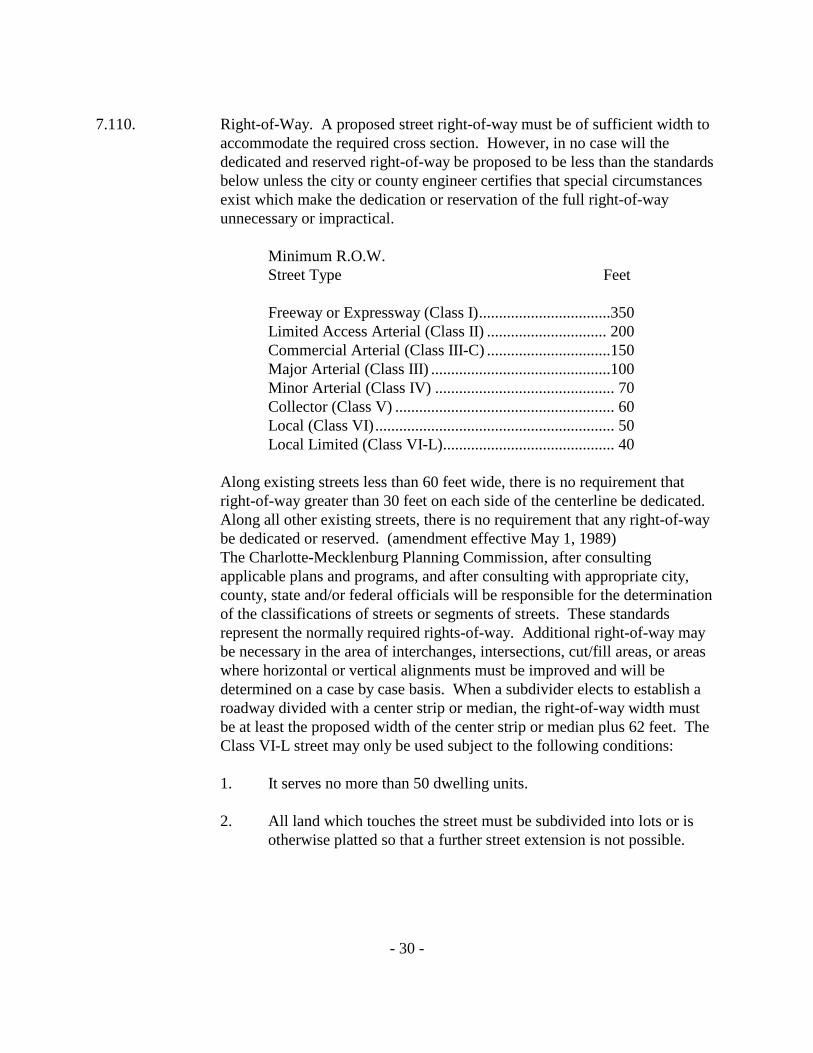
7.110. Right-of-Way. A proposed street right-of-way must be of sufficient width to
accommodate the required cross section. However, in no case will the dedicated and reserved right-of-way be proposed to be less than the standards below unless the city or county engineer certifies that special circumstances exist which make the dedication or reservation of the full right-of-way unnecessary or impractical.
Minimum R.O.W. Street Type Feet
Freeway or Expressway (Class I) .................................350 Limited Access Arterial (Class II) .............................. 200 Commercial Arterial (Class III-C) ...............................150 Major Arterial (Class III) .............................................100 Minor Arterial (Class IV) ............................................. 70 Collector (Class V) ....................................................... 60 Local (Class VI) ............................................................ 50 Local Limited (Class VI-L) ........................................... 40
Along existing streets less than 60 feet wide, there is no requirement that right-of-way greater than 30 feet on each side of the centerline be dedicated. Along all other existing streets, there is no requirement that any right-of-way be dedicated or reserved. (amendment effective May 1, 1989) The Charlotte-Mecklenburg Planning Commission, after consulting applicable plans and programs, and after consulting with appropriate city, county, state and/or federal officials will be responsible for the determination of the classifications of streets or segments of streets. These standards represent the normally required rights-of-way. Additional right-of-way may be necessary in the area of interchanges, intersections, cut/fill areas, or areas where horizontal or vertical alignments must be improved and will be determined on a case by case basis. When a subdivider elects to establish a roadway divided with a center strip or median, the right-of-way width must be at least the proposed width of the center strip or median plus 62 feet. The Class VI-L street may only be used subject to the following conditions: 1. It serves no more than 50 dwelling units.
2. All land which touches the street must be subdivided into lots or is
otherwise platted so that a further street extension is not possible.
- 31 -
3. It is designed to be permanently dead-ended or is a loop street with no additional street connections except at the ends.
7.120. Arterial street right-of-way. Whenever a tract of land to be subdivided
includes any part of an arterial street shown on the thoroughfare plan approved by the Planning Commission and adopted by the City Council and Board of County Commissioners and whenever such a right-of-way has been further defined by acceptable locational procedures sufficient to identify properties to be affected, a right-of-way for the arterial street must be platted in the location and to the width specified in the plan. The subdivider is responsible for the dedication of the right-of-way up to 100 feet (50 feet on either side of the centerline) or the reservation of the right-of-way in accordance with the provisions of Section 8.110. The remainder of the minimum required right-of-way over 100 feet must be reserved for future right-of-way use and must be shown as such on the final plat. All measurements involving minimum lot standards under this ordinance and under the zoning ordinance will be made at the edge of the full right-of-way. All of the area of the dedicated right-of-way for any public street except Class V or Class VI streets may be used in the computation of development rights, but may not be used for the computation of lot area, open space, required parking, storm water detention, or to fulfill any other mandatory requirement. The procedure for calculating the allowable number of lots or unit density is contained in Section 12.105 of the zoning ordinance. In addition, a developer may choose to dedicate the full right-of-way and thereby use the entire dedicated area for the density calculation.
7.130. Freeways. Whenever a tract of land to be subdivided includes any part of the
proposed right-of-way of a freeway, as shown on a thoroughfare plan approved by the Planning Commission and adopted by the City Council or the Board of County Commissioners, or adopted by the state Board of Transportation and whenever such a right-of-way has been further defined by acceptable locational procedures sufficient to identify properties to be affected, the right-of-way for the freeway must be reserved and remain undeveloped, pending future acquisition by the state or other governmental unit. The subdivider must reserve the proposed right-of-way in accordance with the requirements in Section 7.120.
7.140. Street off-sets. Where there is an off-set in the alignment of a street across an
intersection the off-set of the center lines may not be less than 125 feet.
- 32 -
7.150. Block lengths. Block lengths may not be more than 2,000 feet, except as
hereinafter provided. Where a longer block will reduce the number of railroad grade crossings, major stream crossings, or where longer blocks will result in less traffic through residential subdivisions from adjoining business or industrial areas, the Planning staff may authorize block lengths in excess of 2,000 feet. Block widths must be sufficient to allow 2 tiers of lots except where single tiers of lots will facilitate nonresidential development, the separation of residential and nonresidential developments or the separation of residential development from thoroughfares and along collector streets when reverse frontage is used along an adjacent thoroughfare.
7.160. Cul-de-sac. Cul-de-sac (streets designed to be permanently closed at one
end), may not be longer than 1,000 feet and must be terminated by a circular right-of-way not less than 80 feet in diameter (90 feet with curb and gutter and 100 feet with open ditches in Mecklenburg County) or other alternate turnaround designs as accepted by the city or county engineer; provided, however, that, this requirement may be waived where topographical or other or other unusual conditions exist which impose an undue burden on the subdivider.
7.170. When narrow streets permitted (Class VI-L). In certain circumstances, streets
may be constructed on a forty-foot right-of-way and with a twenty-two foot cross section (eighteen foot pavement plus two-foot roll curb). When a street serves 50 dwelling units or less and is permanently dead-ended, this smaller standard may be used. All other appropriate standards of this ordinance still apply to the construction of such a street.
7.180. Collector street designation. The designation of a collector street, or the
determination of the need for a collector street will be based on the criteria below. If the street in question meets at least 2 of the criteria, then the street will be designated as a collector street and must be built to the appropriate collector street standard.
1. The street intersects directly with an arterial street and provides access
to an area with an overall density of more than 1.0 dwelling unit per acre, or provides access to more than 125 dwelling units.
2. The street by its general configuration, in relationship to the existing
development of the area, in effect serves a collector function.
- 33 -
3. The street extends into an undeveloped area in such a manner as to
serve a future collector function.
4. The street serves as a primary access to a significant nonresidential, institutional, or recreational land use, as well as an access to a residential area.
7.200. Design Standards for Lots
1. Frontage on street. Each lot must have frontage on a street. However, lots designed for certain multi-family dwellings need not front on a street, provided that all portions of the dwelling unit proposed for such lots are located within 400 feet of a public street or private street that furnishes direct access to the property, and that access to each such lot be made available via either a public right-of-way or a private vehicular or pedestrian way owned by the individual lot owner in fee or in common ownership. Lots designed for certain one-family semi-detached dwellings need not front on a street; provided that, at least 1 unit of each dwelling group has frontage on a street, and that access to each dwelling unit is made available via either a public right-of-way or a private vehicular or pedestrian way owned by the individual lot owner in fee or in common ownership. Lots or building sites which are part of a larger nonresidential development such as a shopping center need not abut a street so long as the overall site abuts a street and is designed in such a way that access is furnished to all interior lots or building sites.
2. Side lines. Side lot lines shall, as nearly as practicable, be at right
angles or radial to street lines. Where side lot lines intersect at the rear of the lot, the angle of intersection shall not be less than 60 degrees.
3. Minimum sizes. Lots may not be less in width or area than required
by the zoning ordinance for the district in which the proposed subdivision is located. Larger lots may be required to accommodate on-site sewer disposal systems.
4. Building lines. Building lines shall be established on all lots in
accordance with the appropriate zoning classification. For residential subdivisions on arterial streets, the building line may not
- 34 -
be less than the required setback for the zoning district and shall regulate the placement of any structure relative to the arterial street right-of-way including all front, side and rear yards.
5. (Reserved) 6. (Reserved)
7. Driveway connections. Prior to the construction of any driveway or
other connection within the right-of-way of a public street, a permit must be secured in accordance of the Zoning Ordinance and other applicable codes and ordinances.
8. Lots subject to flooding. The County Engineer shall determine which
lots are subject to significant flooding, which will include those lots along any significant water course, whether or not the stream is enclosed with pipes or culverts, and may also include areas where it can reasonably be expected that significant overland flow of stormwater or flooding will occur. If any part of a proposed lot is subject to flooding, subdivider shall make a determination of the crest elevation of the flood expected to be equaled or exceeded, on the average, of one time in one hundred years (the "100-year flood") in accordance with generally accepted engineering practice, which is to be submitted with the seal and signature of a professional engineer to the County Engineer. This determination must reflect the actual conditions imposed by the completed subdivision, and must give due consideration to the effects of urbanization and obstructions. Upon request and subject to available staff and any applicable fees, the County Engineer will make the necessary determination of the 100-year flood crest if the necessary existing and proposed conditions are provided by the subdivider. No proposed building lot that is wholly or partly subject to flooding shall be approved unless there is established on the final plat a line representing an actual contour as determined by field survey, at an elevation one foot above the 100-year flood crest. Such line shall be known and identified on the final plat as the "Building Restriction Floodline." In addition, a "Flood Protection Elevation" for each lot subject to flooding shall be noted on the lot plan as determined by the County Engineer based on the Building Restriction Floodline, or for lots upstream of street crossings, the
- 35 -
low elevation of the street plus one foot, whichever is greater. All habitable buildings or structures shall be located outside the Building Restriction Floodline or the lowest usable and functional part of the structure shall not be below the Flood Protection Elevation. "Usable and functional part of the structure" shall be defined as being inclusive of living areas, basements, sunken dens, basement utility rooms, crawlspaces, attached carports, and mechanical appurtenances such as furnaces, air conditioners, water pumps, electrical conduits and wiring, but shall not include water lines or sanitary sewer traps, piping and clean-outs; provided, openings serving the structure are above the Flood Protection Elevation. Where only a portion of a proposed lot is subject to flooding as defined herein, such lot may be approved only if there will be available for building a usable lot area of not less than 1200 square feet. The usable lot area shall be determined by deducting from the total lot area the area of all yards and setbacks required by the applicable zoning district regulations and any remaining area of the lot lying below the building restriction floodline. During the construction of a subdivision, the developer shall maintain the streambed of each stream, creek or backwash channel contiguous to the subdivision in an unobstructed state and shall remove from the channel and banks of the stream all debris, logs, timber, junk and other accumulations of a nature that would, in time of flood, clog or dam the passage of waters in their downstream course. Installation of appropriately sized stormwater drains, culverts, bridges or erosion control devices will not be construed as obstructions in the stream. In areas of the County that are covered by the provisions of the Floodway Regulations, the Floodway Regulations will supersede the provisions of this ordinance regarding land within the regulatory floodplain.
9. Water Access Lots. The Water Access Lots must equal at least 10%
of the area (exclusive of streets) of all the interior property, which lies within 450 feet of the water's edge. However, where the 10% would equal less than 20,000 square feet, the subdivider will not be required to provide any Water Access Lots. All Water Access Lots shall have a minimum frontage at the water's edge of 100 feet.
The Water Access Lots must either be dedicated to Mecklenburg County Parks Department (but only if the Board of County Commissioners agree to accept such dedication) or be transferred in

- 36 -
fee simple title to a homeowners association of the interior lot owners of the subdivision.
Before approval of the final plat can be given, the subdivider must submit to the Planning staff a covenant stating either, (1) that he will dedicate the required amount of Water Access Lots to Mecklenburg County, or (2) that he will convey title of the Water Access Lots to a homeowners association of the purchasers of each interior lot. If the subdivider chooses to dedicate the Water Access Lots to the County, the Board of County Commissioners must have agreed to accept the final responsibility of maintaining the lots and the preliminary plan and final plat must show the dedication. If the title is transferred to a home owners association of the interior lot owners, the preliminary plan and final plat must designate the lots covered by the home owners association for each Water Access Lot.
10. Lots Within the Mountain Island Lake Watershed Protection Area.
The purpose of the Mountain Island Lake Watershed Protection Area is to provide for the protection of public water supplies as required by the North Carolina Water Supply Watershed Act (G. S. 143-214.5) and regulations promulgated thereunder. Mountain Island Lake Watershed Protection Area is that area within Mecklenburg County which contributes surface drainage into Mountain Island Lake and which is bounded as follows: Beginning at the Mountain Island Lake Dam on the Catawba River and proceeding along the ridgeline in a easterly direction to Rozzelle's Ferry Road and proceeding thence in an south easterly direction, along Rozzelle's Ferry Road to the intersection of Mt. Holly-Huntersville Road, and thence proceeding along Mt. Holly-Huntersville Road in a northeasterly direction to the intersection of Hambright Road and thence proceeding in a easterly direction along Hambright Road to N.C. 115 (Old Statesville Road) and thence proceeding in a northerly direction along N.C. 115 to the intersection of N.C. 73 and thence proceeding in a westerly-southwesterly direction along N.C. 73 to the Lake Norman Dam and thence proceeding in a southerly direction along the Catawba River to the beginning point.
- 37 -
A map showing the Mountain Island Lake Watershed Protection Area and the subareas CA1, CA2, CA3, CA4, PA1, PA2, and PA3 is incorporated herein as Appendix A. In any event of any difference or inconsistency between the areas as depicted on the map and the definition, the map or definition, which describes or depicts the greater geographical area shall control. Should these subareas be more specifically defined in the Mecklenburg County Zoning Ordinance by use of major landmarks such as roads and property lines to adjust the subarea boundaries, the subarea boundaries as described in the Zoning Ordinance shall control over those described in this ordinance.
For the purpose of this section, the following terms will have the definitions indicated below.
BMP's. Best Management Practices. A structural or non-structural management-based practice used singularly or in combination to reduce non-point source input to receiving waters in order to achieve water quality protection goals.
Non-structural BMP's. Non-engineered methods to control the amount of non-point source pollution. These may include land-use controls and vegetated buffers.
Structural BMP's. Engineered structures that are designed to reduce the delivery of pollutants from their source or to divert contaminants away from the water supply. Structural BMP’s allowed for use under the High Density Option are those which have been approved by the North Carolina Division of Water Quality and Mecklenburg County. These include wet detention ponds, extended dry detention ponds, and grass swales.
BUFFER. A natural or vegetated area through which stormwater runoff flows in a diffuse manner so that the runoff does not become channelized and which provides for infiltration of the runoff and filtering of pollutants. The buffer is measured landward from the normal pool elevation of impounded structures and from the bank of each side of streams or rivers.
- 38 -
BUILT-UPON AREA (B.U.). Built-upon areas shall include that portion of a development project or lots that are covered by impervious or partially impervious cover including buildings, pavement, gravel roads, recreation facilities (e.g. tennis courts) etc. (NOTE: Wooden slatted decks and the water area of a swimming pool are considered pervious.)
CLUSTER DEVELOPMENT. The grouping of buildings in order to conserve land resources and provide for innovation in the design of the project.
CRITICAL AREAS. The area adjacent to a water supply intake or reservoir where risk associated with pollution is greater than from the remaining portions of the watershed. The critical area of the Mountain Island Lake Watershed Protection Area is divided into four subareas as follows:
CA1 - Lower Gar Creek. From normal pool elevation of
Mountain Island Lake extending up Gar Creek to Beatties Ford Road and to approximately the ridgeline along the north side of Gar Creek and to Mt. Holly-Huntersville Road on the south side of Gar Creek.
CA2 - Upper Gar Creek. From Beatties Ford Road upstream
along Gar Creek to the limits of the Gar Creek drainage basin and to approximately the ridgeline along either side of Gar Creek.
CA3 - McDowell Creek. From normal pool elevation of
Mountain Island Lake extending one mile upstream on McDowell Creek and to approximately the ridgeline along either side of McDowell Creek.
CA4 - Lake Front. Extending landward one half mile from
normal pool elevation along Mountain Island Lake and the Catawba River between Cowan's Ford Dam and Mountain Island Lake Dam.
NORMAL POOL ELEVATION. The Mountain Island Lake normal pool elevation which is at contour interval 648 feet above the Mean Sea Level, United States Geological Survey (U.S.G.S.) Datum.
- 39 -
PERENNIAL STREAM. A stream or creek containing a continuous natural flow of water throughout the year except possibly under exceptionally dry conditions. They are identified on United States Geological Survey Quadrangle Maps by solid blue lines.
PROTECTED AREA. The area adjoining and upstream of the Critical Areas of water supply watersheds where risk of water quality degradation from pollution, while still greater than non watershed designated areas, is less than in the Critical Areas. The Protected Area is divided into three subareas as follows:
PA1 - The area extending from the outer limits of the critical
areas to five hydrologic miles from the normal pool elevation and draining to Mountain Island Lake.
PA2 - The area extending from the outer limit of the PA1 area
where it intersects with N.C. 73 and running in a north-northeasterly direction along N.C. 73 to the intersection of I-77 and thence proceeding in a southerly direction along I-77 to the intersection of Gilead Road (SR 2136) and thence in an easterly direction along Gilead Road to the intersection of N.C. 115 (Old Statesville Road) and thence in a southerly direction along N.C. 115 to the intersection of Hambright Road and thence in a westerly direction along Hambright Road to the intersection of Mt. Holly-Huntersville Road and thence in a northwesterly direction along the outer limits of the CA2 and PA1 areas to the beginning point.
PA3 - The area extending from the outer limits of the PA2 area
to the limits of the Mountain Island Lake Watershed.
SEPTIC TANK SYSTEM. A ground absorption sewage disposal system consisting of a holding or settling tank and a ground absorption field.
WATERSHED. The entire land area contributing surface drainage into a stream, creek, lake or other body of water.
- 40 -
WATER DEPENDENT STRUCTURES. Those structures for which the use requires access or proximity to or siting within surface waters to fulfill their basic purpose, such as boat ramps, boat houses, docks, piers, bulkheads and similar structures. Ancillary facilities such as restaurants, outlet for boat supplies, parking lots, and commercial boat storage areas are not water dependent structures.
1. Critical Area Development Standards:
Minimum lot sizes - CA1 - 2 acres
CA2 - 1 acre CA3 - 1 acre CA4 - 1/2 acre
Maximum Allowable Built Upon Area - CA1 - 6% B.U. Per Lot CA2 - 12% B.U.
CA3 - 12% B.U. CA4 - 24% B.U.
BUFFER AREA REQUIREMENTS. Buffers are intended to protect water quality by preventing stormwater runoff from becoming channelized while allowing for the infiltration of pollutants. The buffer areas are measured landward from normal pool elevation of impounded structures and from the bank along each side of streams. The minimum buffer widths shall be as follows:
CA1, CA2, CA3 - 100' or 100-yr. floodplain boundaries,
whichever is greater
CA 4 - 100'
No permanent structures, built upon areas, septic tanks systems or any other disturbance of existing vegetation shall be allowed within the buffer except as follows:
- 41 -
a. No trees larger than 2-inch caliper are to be removed except
for dead or diseased trees. Trees less than 2-inch caliper and undergrowth may be removed to be replaced by an effective stabilization and filtering ground cover based upon the Watershed Buffer Guidelines for Mecklenburg County contained in Appendix B and as approved by the County Environmental Protection Department.
b. Streambank or shoreline stabilization is allowed as approved
on a plan submitted to the applicable Engineering Department and the County Environmental Protection Department.
c. Water dependent structures and public projects such as road
crossings and greenway paths are allowed where no practical alternative exists. These activities should minimize built-upon surface area, direct run off away from surface waters, and maximize the utilization of nonstructural BMP's and pervious materials.
d. During new development or the expansion of existing
development the County can require enhancement of the existing vegetation in the buffer if necessary so that the buffer can effectively perform its filtering and absorption functions based on the Watershed Buffer Guidelines for Mecklenburg County contained in Appendix B.
e. Mitigation of disturbed buffers required. Should existing vegetation within the buffer be disturbed
(except as allowed by this Ordinance) or should vegetation which was added to a buffer pursuant to the requirements that existing vegetation in the buffer be enhanced be disturbed (except as allowed by this Ordinance), the Zoning Administrator shall require that any vegetation remaining in the buffer be enhanced in accordance with the Watershed Buffer Guidelines for Mecklenburg County contained in Appendix B so that the buffer can effectively perform its filtering and absorption functions.
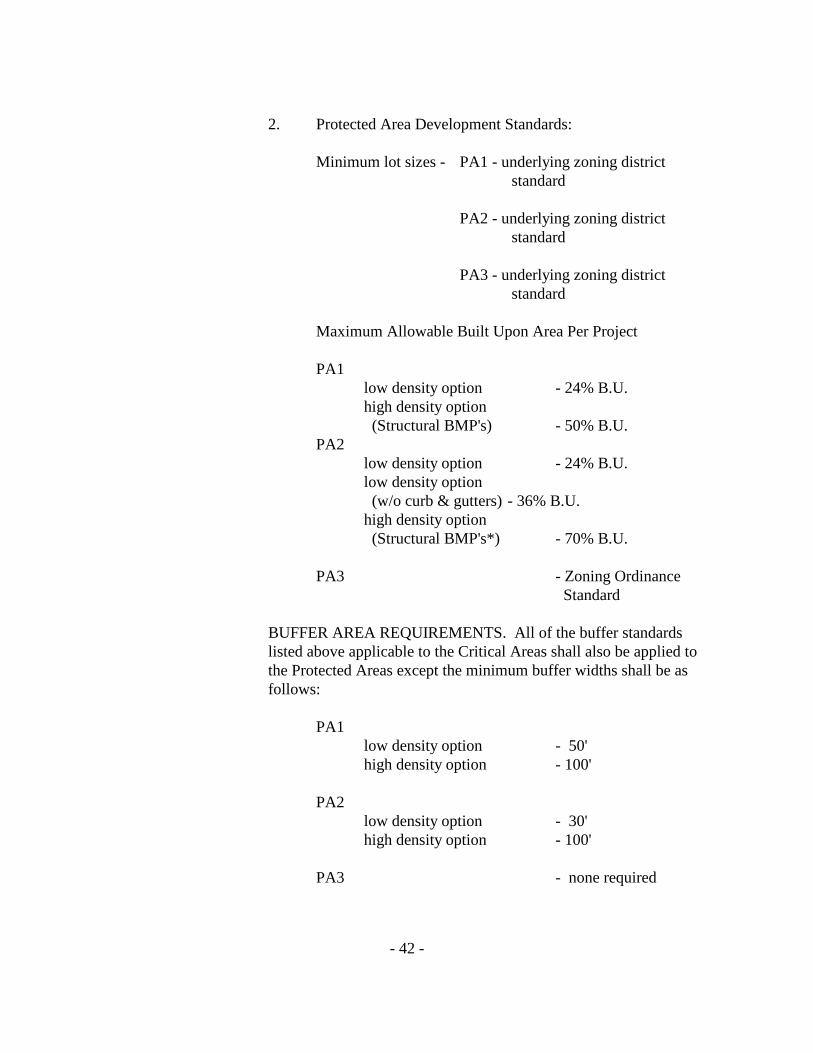
- 42 -
2. Protected Area Development Standards:
Minimum lot sizes - PA1 - underlying zoning district standard
PA2 - underlying zoning district
standard
PA3 - underlying zoning district standard
Maximum Allowable Built Upon Area Per Project
PA1
low density option - 24% B.U. high density option (Structural BMP's) - 50% B.U.
PA2 low density option - 24% B.U. low density option (w/o curb & gutters) - 36% B.U. high density option (Structural BMP's*) - 70% B.U.
PA3 - Zoning Ordinance
Standard
BUFFER AREA REQUIREMENTS. All of the buffer standards listed above applicable to the Critical Areas shall also be applied to the Protected Areas except the minimum buffer widths shall be as follows:
PA1
low density option - 50' high density option - 100'
PA2
low density option - 30' high density option - 100'
PA3 - none required
- 43 -
In the PA1 and PA2 subareas non-impervious recreational development and non-impervious pedestrian trails may be allowed in the required buffer if located a minimum of 30 feet from the stream bank.
Cluster Development is allowed within the Protected Area.
* STRUCTURAL BMP'S. Structural BMP’s or other storm water
management measures which have been approved by the North Carolina Division of Water quality are required under the High Density Option.
3. Posting of Financial Security Required
When Structural BMP's are required under the High Density Option, the approval of the High Density Development Permit will be subject to the owner filing a surety bond or letter of credit or making other financial arrangements which are acceptable to the County Engineering Department in an amount to be determined by the County Engineering Department in consultation with other agencies, such as the County Environmental Protection Department, in a form which is satisfactory to the County Attorney, guaranteeing the installation and maintenance of the required Structural BMP's until the earlier of either of the following events: (a) the passage of three (3) years from the date of completion of the Structural BMP; or (b) issuance of certificates of occupancy for seventy-five percent (75%) of all construction which might reasonably be anticipated to be built within the area which drains into the Structural BMP, allowing credit for improvements completed prior to the submission of the final plat. Upon the earlier of either of the following events: (a) the passage of three (3) years from the date of completion of the Structural BMP; or (b) issuance of certificates of occupancy for seventy-five percent (75%) of all anticipated construction relative to the required Structural BMP's, written notice thereof must be given by the owner to the County Engineering Department. The County Engineering Department will arrange for an inspection of the Structural BMP's and if found satisfactory, will within 30 days of the date of notice notify the owner in writing. The owner may then petition the Board of County Commissioners
- 44 -
for acceptance of maintenance responsibilities of the Structural BMP's. The County will accept maintenance responsibilities if the Structural BMP's have been built according to standards contained in the Charlotte-Mecklenburg Land Development Standards Manual and are functioning as designed, provided, however, that the Board of County Commissioners may attach reasonable conditions to its acceptance of maintenance responsibilities including requiring the granting of appropriate easements for ingress and egress.
11. Lots Within Catawba River/Lake Wylie Watershed Protection Area
The purpose of the Catawba River/Lake Wylie Watershed Protection Area is to provide for the protection of public water supplies as required by the North Carolina Water Supply Watershed Classification and Protection Act (G.S. 143-214.5) and regulations promulgated thereunder.
The Catawba River/Lake Wylie Watershed Protection Area is that area within Mecklenburg County, which contributes surface drainage into that portion of the Catawba River known as Lake Wylie and its tributaries.
A map showing the Catawba River/Lake Wylie Watershed Protection Area and its subareas (if any) is incorporated herein as Appendix A. Should the area be more specifically defined in the Mecklenburg County Zoning Ordinance by use of major landmarks such as roads and property lines to adjust the boundary, the boundary as described in the Zoning Ordinance shall control over those described in this ordinance.
For the purpose of this section, the following terms will have the definitions indicated below.
BMP's. Best Management Practices. A structural or non-structural management-based practice used singularly or in combination to reduce non-point source input to receiving waters in order to achieve water quality protection goals.
Non-structural BMP's. Non-engineered methods to control the amount of non-point source pollution. These may include land-use controls and vegetated buffers.

- 45 -
Structural BMP's. Engineered structures that are designed to reduce the delivery of pollutants from their source or to divert contaminants away from the water supply. Structural BMP’s allowed for use under the High Density Option are those which have been approved by the North Carolina Division of Water Quality and Mecklenburg County. These include wet detention ponds, extended dry detention ponds, and grass swales.
BUFFER. A natural or vegetated area through which stormwater runoff flows in a diffuse manner so that the runoff does not become channelized and which provides for infiltration of the runoff and filtering of pollutants. The buffer is measured landward from the normal pool elevation of impounded structures and from the top of the bank of each side of streams or rivers.
BUILT-UPON AREA (B.U.). Built-upon areas shall include that portion of a development project and/or lots that are covered by impervious or partially impervious cover including buildings, pavement, gravel roads, recreation facilities (e.g. tennis courts) etc. (NOTE: Wooden slatted decks and the water area of a swimming pool are considered pervious.)
CLUSTER DEVELOPMENT. The grouping of buildings in order to conserve land resources and provide for innovation in the design of the project.
CRITICAL AREA. The area adjacent to a water supply intake where risk associated with pollution is greater than from the remaining portions of the watershed.
NORMAL POOL ELEVATION. The Catawba River/Lake Wylie normal pool elevation as determined by the United States Geological Survey (U.S.G.S.) Datum.
PERENNIAL STREAM. A stream or creek containing a continuous natural flow of water throughout the year except possibly under exceptionally dry conditions. Such streams are identified on United States Geological Survey Quadrangle Maps.

- 46 -
PROTECTED AREA. The are adjoining and upstream of the Critical Area of water supply watersheds where risk of water quality degradation from pollution, while still greater than non watershed designated areas, is less than in the Critical Area.
SEPTIC TANK SYSTEM. A ground absorption sewage disposal system consisting of a holding or settling tank and a ground absorption field.
WATER DEPENDENT STRUCTURES. Those structures for which the use requires access or proximity to or siting within surface waters to fulfill its basic purpose, such as boat ramps, boat houses, docks, piers, bulkheads and similar structures. Ancillary facilities such as restaurants, outlet for boat supplies, parking lots, and commercial boat storage areas are not water dependent structures.
WATERSHED. The entire land area contributing surface drainage into a stream, creek, lake or other body of water.
1. Critical Area Development Standards:
Minimum lot area -
minimum required in the underlying zoning district
Maximum allowable built-upon area per project (% B.U.) -
Low Density Option - 24% High Density Option - 50% (structural BMP's)*
* STRUCTURAL BMP's. Structural BMP’s or other
storm water management measures, which have been approved by the North Carolina Division of Water quality, are required under the High Density Option.
- 47 -
BUFFER AREA REQUIREMENTS. Buffers are intended to protect water quality by preventing stormwater runoff from becoming channelized while allowing for the infiltration of pollutants. The buffer areas are measured landward from normal pool elevation of impounded structures and from the top of the bank along each side of streams. The minimum buffer widths shall be as follows:
low density option - 100' high density option - 100'
No permanent structures, built upon areas, septic tanks systems or any other disturbance of existing vegetation shall be allowed within the buffer except as follows:
a. No trees larger than 2-inch caliper are to be removed except
for dead or diseased trees. Trees less than 2-inch caliper and undergrowth may be removed to be replaced by an effective stabilization and filtering ground cover based upon the Watershed Buffer Guidelines for Mecklenburg County contained in Appendix B and as approved by the County Environmental Protection Department.
b. Streambank or shoreline stabilization is allowed as approved
on a plan submitted to the applicable Engineering Department and the County Environmental Protection Department.
c. Water dependent structures and public projects such as road
crossings and greenway paths are allowed where no practical alternative exists. These activities should minimize built-upon surface area, direct run off away from surface waters, and maximize the utilization of nonstructural BMP's and pervious materials.
d. During new development or the expansion of existing
development the County can require enhancement of the existing vegetation in the buffer if necessary so that the buffer can effectively perform its filtering and absorption functions based on the Watershed Buffer Guidelines for Mecklenburg County contained in Appendix B.
- 48 -
e. In the protected area non-impervious recreational development
and non-impervious pedestrian trails may be allowed in the required buffer if located a minimum of thirty feet (30') from the stream bank.
f. Mitigation of disturbed buffers required. Should existing vegetation within the buffer be disturbed
(except as allowed by this Ordinance) or should vegetation which was added to a buffer pursuant to the requirements that existing vegetation in the buffer be enhanced be disturbed (except as allowed by this Ordinance), the Zoning Administrator shall require that any vegetation remaining in the buffer be enhanced in accordance with the Watershed Buffer Guidelines for Mecklenburg County contained in Appendix B so that the buffer can effectively perform its filtering and absorption functions.
Cluster Development is allowed within the Critical Area.
2. Protected Area Development Standards:
Minimum lot area -
minimum required in underlying zoning district
Maximum Allowable Built Upon Area Per project (% B.U.) -
low density option - 24% high density option - 70% (structural BMP's)*
* STRUCTURAL BMP's. Structural BMP’s or other storm water management measures, which have been approved by the North Carolina Division of Water quality, are required under the High Density Option.
- 49 -
BUFFER AREA REQUIREMENTS. All of the buffer standards listed above applicable to the Critical Area shall also be applied to the Protected Area except the minimum buffer widths shall be as follows:
low density option - 40' high density option - 100'
Cluster Development is allowed within the Protected Area.
3. Posting of Financial Security Required
When Structural BMP's are required under the High Density Option, the approval of the High Density Development Permit will be subject to the owner filing a surety bond or letter of credit or making other financial arrangements which are acceptable to the County Engineering Department in an amount to be determined by the County Engineering Department in consultation with other agencies, such as the County Environmental Protection Department, in a form which is satisfactory to the County Attorney, guaranteeing the installation and maintenance of the required Structural BMP's until the earlier of either of the following events: (a) the passage of three (3) years from the date of completion of the Structural BMP; or (b) issuance of certificates of occupancy for seventy-five percent (75%) of all construction which might reasonably be anticipated to be built within the area which drains into the Structural BMP, allowing credit for improvements completed prior to the submission of the final plat. Upon the earlier of either of the following events: (a) the passage of three (3) years from the date of completion of the Structural BMP; or (b) issuance of certificates of occupancy for seventy-five percent (75%) of all anticipated construction relative to the required Structural BMP's, written notice thereof must be given by the owner to the County Engineering Department. The County Engineering Department will arrange for an inspection of the Structural BMP's and if found satisfactory, will within 30 days of the date of notice notify the owner in writing. The owner may
- 50 -
then petition the Board of County Commissioners for acceptance of maintenance responsibilities of the Structural BMP's. The County will accept maintenance responsibilities of the Structural BMP's. The County will accept maintenance responsibilities if the Structural BMP's have been built according to standards contained in the Charlotte-Mecklenburg Land Development Standards Manual and are functioning as designed, provided, however, that the Board of County Commissioners may attach reasonable conditions to its acceptance of maintenance responsibilities including requiring the granting of appropriate easements for ingress and egress.
8.000. Required Improvements 8.100. Standards and Specifications
1. Unless specifically noted, before any final plat of a subdivision is eligible for final approval, and before any street is accepted for maintenance by the city or the State Department of Transportation, minimum improvements (including drainage and soil erosion) must have been completed by the developer and approved by the city or county engineer in accordance with the standards and specifications of the Charlotte-Mecklenburg Land Development Standards Manual or bonded in accordance with the provisions of Section 8.400.3.
2. The intent of the specifications set out in this ordinance is to prescribe
minimum requirements for storm drainage and street improvements to be undertaken by the developer. Satisfactory completion of these improvements, attested by approval of the city or county engineering department, will qualify streets in the city to be accepted for maintenance by the city and streets in the county to be considered for maintenance by the state.
8.110. Improvement responsibility. In order to facilitate the provision of street
rights-of-way and necessary improvements, the following sections establish responsibilities for the installation of streets and related improvements for each class of street. Any area of right-of-way which must be reserved for future acquisition may be dedicated at the option of the developer or property owner for development rights transfer purposes as provided for in Section 7.120 of this ordinance and related provisions in Section 12.105 of the zoning ordinance.
- 51 -
Class I (Freeway-Expressway):
Right-of-way -- entire width reserved for future acquisition.
Class II (Limited Access Arterial):
Right-of-way -- entire width reserved for future acquisition.
Improvements -- Installed by the public.
Class III-C (Commercial Arterial)
Right-of-way -- 100' dedicated and the remainder reserved for future acquisition. (50' each side of the centerline). Any development along a Class III-C Street which requires specific improvements of the street to meet traffic demands of the particular development must dedicate the right-of-way necessary to accommodate those improvements.
Improvements -- installed by the public in accordance with a schedule of public street improvements, except that the developer is responsible for sidewalk construction along his project frontage on existing thoroughfares at the time of his development. Other specific improvements may be required to the thoroughfare to meet traffic demands of the particular development in which case the developer must install the necessary improvements at the time of development. If, however, a public improvement project for the street is programmed and funded, the developer may be relieved of the actual construction, but remains liable for the costs of the improvements for which he or she would otherwise be liable. The developer has the option, after consultation with the city or county engineer and the planning staff to construct all or a portion of the street if the developer wants to make use of the street for access to the development. Development along new Class III-C or extensions of Class III-C streets must utilize reverse frontage with the only access points being public streets or specifically approved street type entrances.
Class III (Major Arterial)
Right-of-way -- developer is responsible for the dedication of up to 100' (50' each side of the centerline). Any development along a Class III street which requires specific improvements of the street to meet traffic demands of the particular development must dedicate the right-of-way necessary to accommodate those improvements.
- 52 -
Improvements -- installed by the public in accordance with a schedule of public street improvements, except that the developer is responsible for sidewalk construction along his project frontage on existing thoroughfares at the time of his development. Other specific improvements may be required to the thoroughfare to meet traffic demands of the particular development in which case the developer must install the necessary improvements at the time of development. If, however, a public improvement project for the street is programmed and funded, the developer may be relieved of the actual construction, but the developer remains liable for the costs of the improvements for which he or she would otherwise be liable. The developer has the option, after consultation with the city or county engineer and the planning staff to construct all or a portion of the street if the developer wants to make use of the street for access to the development. Development along new Class III streets or extensions of Class III streets must utilize reverse frontage with the only access points being public streets or specifically approved street type entrances.
Class IV (Minor Arterial) Right-of-way -- Developer is responsible for the dedication of up to 70 feet (35 feet each side of the centerline). Additional right-of-way which may be required for improvements to meet specific traffic demands of the development must be dedicated by the developer.
Improvements -- installed by the public in accordance with a schedule of public street improvements, except that the developer is responsible for sidewalk construction along his project frontage on existing thoroughfares at the time of his development. Other specific improvements may be required to the thoroughfare to meet traffic demands of the particular development in which case the developer must install the necessary improvements at the time of development. If, however, a public improvement project for the street is programmed and funded, the developer may be relieved of the actual construction, but the developer remains liable for the costs of the improvements for which he or she would otherwise be liable. The developer has the option, after consultation with the city or county engineer and the planning staff to construct all or a portion of the street if the developer wants to make use of the street for access to the development. Development along new Class IV streets or extensions of Class IV streets must utilize reverse frontage with the only access points being public streets or specifically approved street type entrances.

- 53 -
Class V (Collector):
Right-of-way -- dedicated by the developer.
Improvement -- Constructed by the developer.
Class VI (Local):
Right-of-way -- dedicated by the developer.
Improvements -- Constructed by the developer.
All streets must be constructed to comply with the minimum standards of the Charlotte-Mecklenburg Land Development Standards Manual and all appropriate applicable city or county requirements. Public improvements will be made in accordance with adopted plan, programs, and budgets. It should not be expected that the occurrence of development will result in the immediate installation of public street improvements by the public sector unless those improvements are scheduled and funded in accordance with public policies and programs. The standards in this ordinance for the reservation and dedication of rights-of-way will not apply to any development meeting one or more of the following circumstances: (amendment effective May 1 1989)
1. Any multi-building site or multi-site project that had at least one
building built or under construction, or had a valid, unexpired building permit issued for at least one building prior to May 1, 1989.
2. Any project which had a site plan not requiring any additional right-
of-way approved prior to May 1, 1989 either:
.1 by the Planning Commission and/or Planning Staff; or
.2 under the conditional zoning district and/or special use permit zoning processes of the Zoning Ordinance. However, any change in the site plan requiring a public hearing or the creation of a new parcel of land may subject the project for which the site plan was revised or the newly created parcel of land to the provisions of this ordinance.
- 54 -
No dedication or reservation of right-of-way for a street or highway within a corridor for a street or highway on a plan established and adopted pursuant to N.C.G.S. 136-66.2 for a street or highway that is included in the Department of Transportation's "Transportation Improvement Program" will be required by the provisions of this ordinance unless and until the planning staff has determined and certified in writing (1) that the dedication or reservation does not result in the deprivation of a reasonable use of the original tract and (2) that the dedication or reservation is either reasonably related to the traffic generated by the proposed subdivision or use of the remaining land, or the impact of the dedication or reservation is mitigated by measures provided in this Ordinance. For these purposes the term "original tract" will mean all contiguous land owned by the applicant. The ability of the applicant to transfer density credits attributable to the dedicated right-of-way to contiguous land owned by the applicant is deemed to be a measure, which mitigates the impact of the dedication or reservation.
8.120. Drainage
1. Storm drainage adequate to accommodate a 10-year storm must be provided throughout the subdivision by means of storm drainage pipe or properly graded channels or natural drainage. Where adequate storm drainage has been provided by means of approved storm drainage pipe and the necessary easements to provide access to the drainage facilities, in accordance with city or county standards, and has been dedicated and accepted or otherwise conveyed to the city or county, the city or county will assume the responsibility for maintenance of the drainage pipe. Where adequate storm drainage has been provided by means of properly graded channels or ditches, the maintenance thereof will remain the responsibility of the property owner and must be so noted on the final plat and the deed for the affected lots.
2. In addition to the drainage improvements as required by this section,
the subdivider may provide for storm water detention, at a minimum standard as provided in Section 12.603 of the applicable zoning ordinance, to serve the entire subdivision as part of the drainage plan to be approved by the County Engineer. For the purposes of the subsection, the subdivision shall include the streets, sidewalks, driveways, roof tops and other impervious covers as proposed by the subdivider.
3. (Reserved)
- 55 -
8.130. Curb and Gutter
Standard curbs and gutters must be constructed on all arterial and commercial streets and streets within or abutting multi-family or other planned developments. Rolled curbs and gutters or standard curbs and gutters must be constructed on all local and collector streets. This requirement applies to all streets within 3 miles of the Charlotte City limit in the unincorporated portion of Mecklenburg County, and to all streets where curb and gutter would be required by the State of North Carolina for a street to be acceptable for state maintenance.
8.140. Sidewalk
Sidewalks are required in all subdivisions as follows:
1. Sidewalks are required on both sides of all new or existing Class III and IV streets in accordance with other improvement requirements of this ordinance.
2. Sidewalks are required on both sides of all new or existing Class V
(Collector) streets in accordance with other improvement requirements of this ordinance.
3. Sidewalks are required on both sides of all new or existing Class VI
(Local Residential) streets in accordance with other improvement requirements of this ordinance.
4. Sidewalks are required on both sides of all new or existing Class VI-L
(Local Limited Residential) streets in accordance with other improvement requirements of this ordinance, except that for streets accessing less than ten (10) lots or less than 250 feet in length sidewalk will only be required on one side of the street and not along the cul-de-sac “bulb”.
5. Location. Approval of sidewalk construction plans must be obtained
as part of the subdivision review process. Except in unusual circumstances, sidewalk must be located a minimum of 4 feet from the back of the curb or at the back of the right-of-way when no curb and gutter is required. If existing public street right-of-way is not available, the developer will be required to construct the sidewalk outside the street right-of-way on a permanent easement.
- 56 -
8.150. Street Markers and Barricades
1. Standard street markers must be installed at one corner of all street intersections including private streets before any certificates of occupancy may be issued for buildings or residences along those streets. The design, material, location and installation of the signs must be in accordance with standards specified by the Charlotte-Mecklenburg Land Development Standards Manual.
2. Barricades must be installed at the end of all dead-end streets except
cul-de-sac streets, which have been improved with a permanent turnaround as required by this Ordinance. Design, material and installation of the barricades must be in accordance with the Charlotte-Mecklenburg Land Development Standards Manual.
8.200. No Service Unless Street Accepted, or Tentatively Approved No department, officer, or employee of the City or County will accept for
maintenance, lay out, open, improve, grade, pave or light any streets or authorize the laying of water mains, sewers, connections or other facilities or utilities in any street within the City or County unless:
1. Such street has been accepted or opened as, or has otherwise received
the legal status of a public street prior to the effective date of this ordinance.
2. Or, for any new street, such street corresponds in its location and lines
with a street shown on a preliminary subdivision plan, tentatively approved by the planning staff or Charlotte Mecklenburg Planning Commission.
3. Or, such street has been accepted as a public street by a vote of a
majority of all the members of the City Council or by the State of North Carolina.
4. Or, such street is an approved private street built in conformance with
the provisions of all applicable ordinances.
The North Carolina Department of Transportation will accept subdivision streets for state maintenance purposes, which meet all the requirements of this Ordinance and meet the uniform state-wide standards adopted by the North Carolina Department of Transportation.
- 57 -
8.300. Other Public Facilities (Reserved) 8.400. Modification of Requirements; Bond
1. In subdivisions adjoining already established streets that have been accepted for maintenance by the North Carolina Department of Transportation, the requirements of Section 8.000 will apply as hereinafter provided; those requirements that would necessitate the general removal and reconstruction of established permanent pavements will not be applicable; where adjoining established street is a part of the North Carolina Department of Transportation's street system, the adjoining street must be improved in accordance with either the requirements of Section 8.000 and the requirements of Mecklenburg County or the North Carolina Department of Transportation, whichever establishes the higher standard.
2. Plats for new lots fronting on already dedicated or established streets
or roads that have not been accepted for maintenance by the North Carolina Department of Transportation or which have been accepted for maintenance by the North Carolina Department of Transportation, but have not been improved with a paved roadway will be eligible for final approval when the requirements of Section 8.000 have been complied with as closely as may reasonably be required considering the existing condition of the road, the extent of area to be platted and the cost of required improvements in relation to the comparative benefits to accrue to the subdivider and the other owners of property on both sides of the street or road.
3. Where the improvements required by this chapter have not been
completed prior to the submission of the final subdivision plat for approval, the approval of the plat will be subject to the owner filing a surety bond or an irrevocable letter of credit with the Engineering Department, in an amount to be determined by the County Engineering Department in consultation with other affected agencies, such as the Department of Environmental Health, with sureties satisfactory to the County guaranteeing the installation of the required improvements allowing credit for improvements completed prior to the submission of the final plat. Upon completion of the improvements and the submission of "as built" drawings, as required by the ordinance, written notice thereof must be given by the subdivider to the Engineering Department. The Engineering Department will arrange for an inspection of the improvements and if found satisfactory, will within 30 days of the date of notice authorize
- 58 -
in writing the release of the security given, subject to the warranty requirement below.
4. Warranty of certain improvements to protect the public interest.
(Reserved) 8.500. Inspection
1. The city or county must be notified two days in advance of the work to be started so that an authorized representative of the city or county engineer or other responsible agency may be assigned to make any and all necessary inspections of the work performed.
2. The inspector must be allowed access to all parts of the work, and
must be furnished with every reasonable facility to ascertain whether or not the work as performed is in accordance with the specifications.
3. No material may be placed nor any work performed except in the
presence of the inspector without special permission of the appropriate agency. Such inspection, however, does not relieve the contractor from any obligation to perform all of the work strictly in accordance with the specifications.
4. In case of any disputes arising as to the material furnished or the
manner of performing the work, the inspector will have authority to reject materials or suspend work until the question or issue can be referred to and decided by the appropriate agency. The contractor must remove any work or material condemned as unsatisfactory by the inspector and must rebuild and replace the work or material to the standard required by the specifications, all at his or her own expense.
9.000. Enforcement
1. After the effective date of this ordinance, a plat of a subdivision filed or recorded in the office of the Register of Deeds of Mecklenburg County without the approval of the Planning staff or the Charlotte-Mecklenburg Planning Commission as required by this ordinance, will be null and void for purposes of this ordinance.
- 59 -
2. Any person who, being the owner or the agent of the owner of any land located within the area of jurisdiction of this ordinance, subdivides land in violation of this ordinance or transfers or sells land by reference to, exhibition of, or any other use of a plat showing a subdivision of the land before the plat has been properly approved under this ordinance and recorded in the Office of the Register of Deeds of Mecklenburg County shall, upon conviction, be guilty of a misdemeanor which shall be punishable by a fine not to exceed $500.00, or imprisonment for not more than 30 days for each and every offense. Mecklenburg County through the County Attorney or the City of Charlotte through the City Attorney may enjoin such transfer or sale by action for injunction. All administrative actions relating to such a land, including the issuance of any grading, construction, building, or occupancy permit will be suspended. This ordinance will not affect the sale or transfer of any land, a plat of which was recorded prior to the effective date of this ordinance. (1-1-66 for Mecklenburg County)
3. In order to properly enforce the provisions of the subdivision
regulations as stated in this ordinance prior to the beginning of any construction, reconstruction, use, or alteration of any land, building, or structure, the appropriate permit must be obtained from the Building Standards Department. No permit will be issued unless there has been a determination made that the proposed use, building, or structure complies with the requirements of this ordinance.
10.000 Application and Processing Fees
Fees for the processing of applications for subdivision approval are established by ordinance by the Board of County Commissioners and will be collected at the time of initial application.

APPENDICES
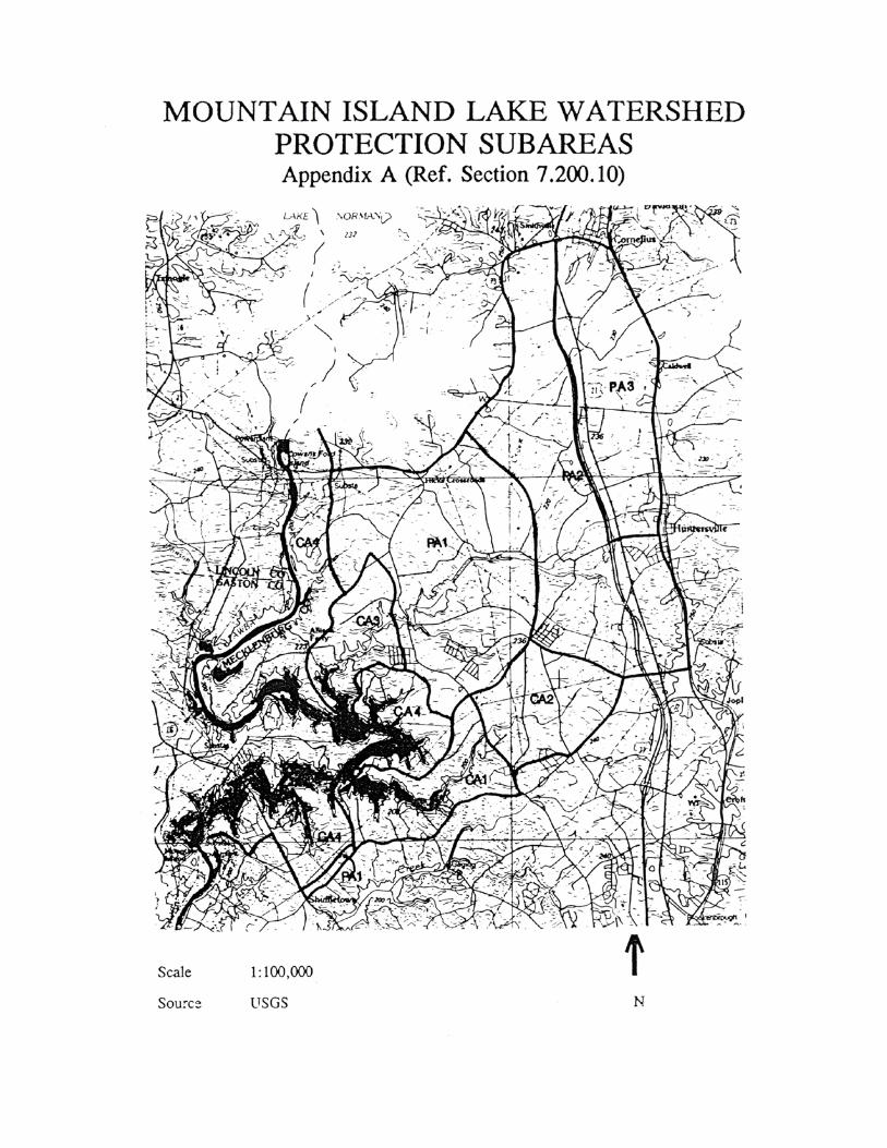
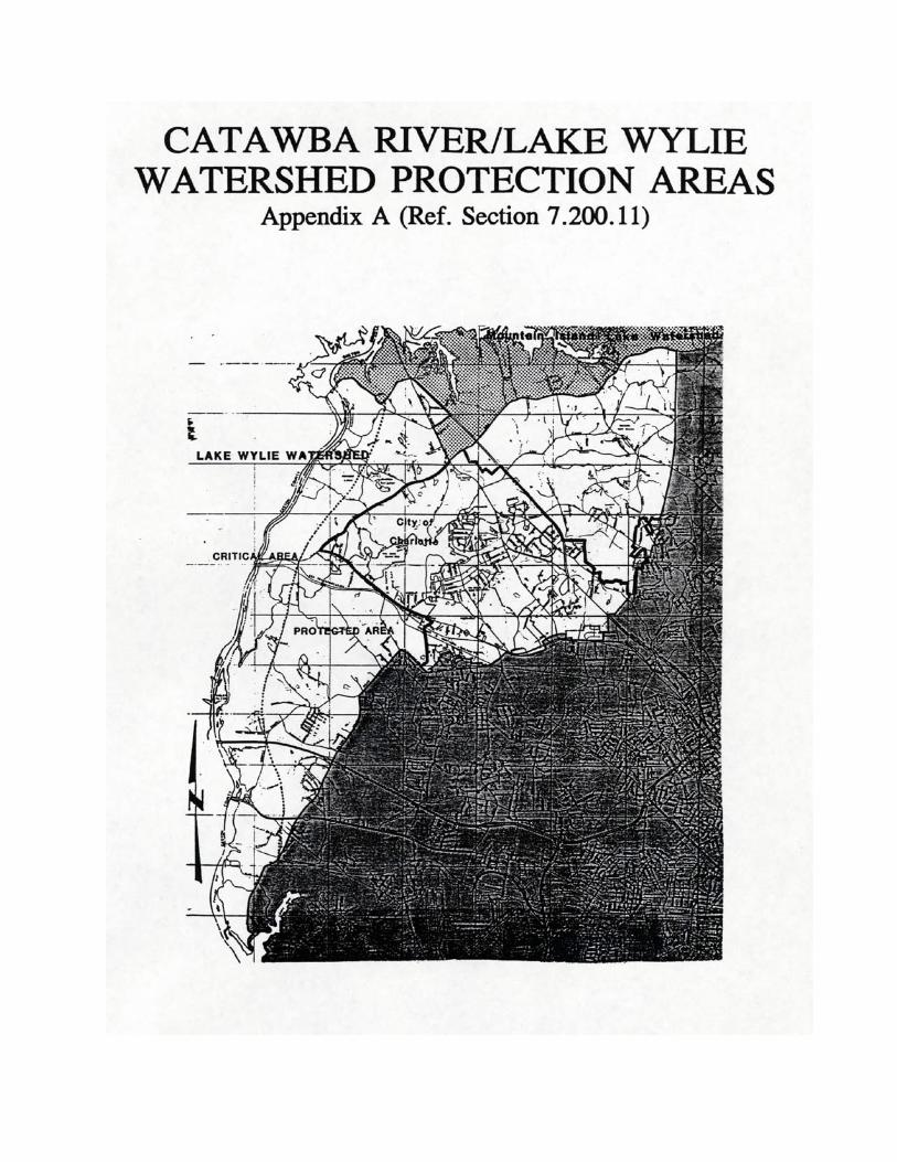
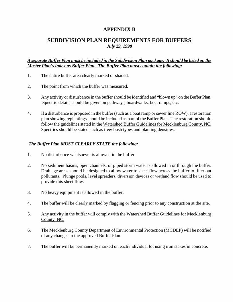
APPENDIX B
SUBDIVISION PLAN REQUIREMENTS FOR BUFFERS July 29, 1998
A separate Buffer Plan must be included in the Subdivision Plan package. It should be listed on the Master Plan’s index as Buffer Plan. The Buffer Plan must contain the following:
1. The entire buffer area clearly marked or shaded. 2. The point from which the buffer was measured. 3. Any activity or disturbance in the buffer should be identified and “blown up” on the Buffer Plan.
Specific details should be given on pathways, boardwalks, boat ramps, etc. 4. If a disturbance is proposed in the buffer (such as a boat ramp or sewer line ROW), a restoration
plan showing replantings should be included as part of the Buffer Plan. The restoration should follow the guidelines stated in the Watershed Buffer Guidelines for Mecklenburg County, NC. Specifics should be stated such as tree/ bush types and planting densities.
The Buffer Plan MUST CLEARLY STATE the following: 1. No disturbance whatsoever is allowed in the buffer. 2. No sediment basins, open channels, or piped storm water is allowed in or through the buffer.
Drainage areas should be designed to allow water to sheet flow across the buffer to filter out pollutants. Plunge pools, level spreaders, diversion devices or wetland flow should be used to provide this sheet flow.
3. No heavy equipment is allowed in the buffer.
4. The buffer will be clearly marked by flagging or fencing prior to any construction at the site. 5. Any activity in the buffer will comply with the Watershed Buffer Guidelines for Mecklenburg
County, NC. 6. The Mecklenburg County Department of Environmental Protection (MCDEP) will be notified
of any changes to the approved Buffer Plan. 7. The buffer will be permanently marked on each individual lot using iron stakes in concrete.
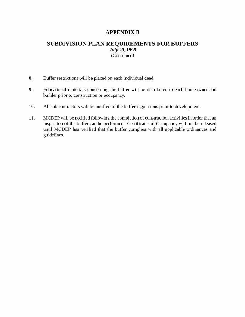
APPENDIX B
SUBDIVISION PLAN REQUIREMENTS FOR BUFFERS July 29, 1998 (Continued)
8. Buffer restrictions will be placed on each individual deed.
9. Educational materials concerning the buffer will be distributed to each homeowner and
builder prior to construction or occupancy. 10. All sub contractors will be notified of the buffer regulations prior to development. 11. MCDEP will be notified following the completion of construction activities in order that an
inspection of the buffer can be performed. Certificates of Occupancy will not be released until MCDEP has verified that the buffer complies with all applicable ordinances and guidelines.