subdivision regulations town of valdese north …
TRANSCRIPT

SUBDIVISION REGULATIONS
TOWN OF VALDESE
NORTH CAROLINA
Adopted 1984
TOWN OF VALDESE PLANNING DEPARTMENT
Amended 1999
Amended 2001
Amended 2008
Amended 2017
Amended 2021
TABLE OF CONTENTS
PAGE
ARTICLE A SUBDIVISION ORDINANCE, VALDESE, NORTH CAROLINA ................................ 1
Section 9-2001. Title ........................................................................................ 1
Section 9-2002. Authority and Enactment Clause ........................................... 1
Section 9-2003. Jurisdiction ............................................................................. 1
Section 9-2004. Purpose .................................................................................. 2
Section 9-2005. Services and Permits .............................................................. 2
Section 9-2005.1 Prerequisite to Plat Recording ............................................... 2
Section 9-2006. Penalties for Violation ........................................................... 3
Section 9-2007. Severability ............................................................................ 4
Section 9-2008. Variances ................................................................................ 4
Section 9-2009. Registration of Plats ............................................................... 5
Section 9-2010. Amendments.......................................................................... 6
Section 9-2011. Abrogation ............................................................................. 6
Section 9-2012 Thoroughfare Plans ................................................................ 6
Section 9-2013 School Sites on Land Use Plan ............................................... 7
Section 9-2014 Zoning and Other Plans .......................................................... 7
Section 9-2015 Reserved ................................................................................ 7
ARTICLE B DEFINITIONS .......................................................................................................... 8
Section 9-2020. Definitions .............................................................................. 8
Section 9-2021 Word Interpretation ............................................................16
ARTICLE C PROCEDURE FOR REVIEW AND APPROVAL OF SUBDIVISION PLATS ................17
Section 9-2030. Approval Prerequisite to Plat Recordation .........................17
Section 9-2030.01 Plat Required ......................................................................17
Section 9-2031 Minor Subdivision Approval Process .............................. 18
Section 9-2031.01 Procedure for Review of Minor Subdivision ......................18
Section 9-2031.02 Review Procedure ...............................................................19
Section 9-2031.03 Approval of Sketch Plat by Subdivision Administrator .......19
Section 9-2031.04 Disposition of Copies ..........................................................20
Section 9-2031.05 Final Plat Approval for Minor Subdivisions ........................20
Section 9-2031.06 Certifications to be Depicted on Plat .................................21
Section 9-2032 Major Subdivision Approval Process ............................. 25
Section 9-2032.01 Sketch Plan for Major Subdivisions ....................................25
Section 9-2033. Preliminary Plat – Submission Review ................................26
Section 9-2033.01 Information to be Contained or Depicted on the
Preliminary and Final Plats .................................................29
Section 9-2034 Final Plat Approval Process ........................................... 34
Section 9-2034.01 Improvements Installation .................................................34
Section 9-2034.02 Town Participation and Costs .............................................34
Section 9-2034.03 Performance Guarantee .....................................................34
Section 9-3034.04 Defects Guarantee ..............................................................38

Section 9-2034.05 Final Plat Review .................................................................38
Section 9-2035 Final Plat ....................................................................... 39
Section 9-2035.01 Plat Submitted ....................................................................39
Section 9-2035.02 Size of Plat and Scale ..........................................................39
Section 9-2035.03 Plat Required ......................................................................40
Section 9-2035.04 Certifications Required .......................................................40
Section 9-2035.05 Contents Required ..............................................................45
Section 9-2036. Review Procedure ......................................................... 46
Section 9-2036.01 Planning Board Review .......................................................46
Section 9-2036.02 Town Council Review .........................................................46
Section 9-2036.03 Disposition of Copies ..........................................................47
Section 9-2036.04 Recording of Final Plat ........................................................47
Section 9-2036.05 Re-subdivision Procedures .................................................47
Section 9-2036.06 Recombination of Land ......................................................48
ARTICLE D INSTALLATION OF PERMANENT REFERENCE POINTS AND IMPROVEMENTS .....49
Section 9-2040. Permanent Reference Points ........................................ 49
Section 9-2040.01 Public Sites and Open Space ..............................................49
Section 9-2040.02 Access to Parks, Schools, Etc. .............................................50
Section 9-2040.03 Restrictions on Land Subject to Flooding ...........................50
Section 9-2041 Design Standards and Required Improvements ............. 51

ARTICLE E GENERAL REQUIREMENTS AND MINIMUM STANDARDS OF DESIGN ...........52
Section 9-2050. General Requirements ...................................................52
Section 9-2050.01 Conformity to Existing Maps and Plans .........................52
Section 9-2050.02 Continuation of Existing Roads ......................................52
Section 9-2050.03 Access to Adjacent Properties .......................................53
Section 9-2050.04 Private Streets ................................................................53
Section 9-2050.05 Subdivision Street Disclosure Statement .......................53
Section 9-2050.06 Large Tracts and Parcels ................................................54
Section 9-2050.07 Lots .................................................................................54
Section 9-2050.07.01 Flag Lots .........................................................................54
Section 9-2050.08 Reserved.........................................................................54
Section 9-2050.09 Contour Map ..................................................................55
Section 9-2050.10 Street Names .................................................................55
Section 9-2051. Design Standards ...................................................... 56
Section 9-2051.01 Public Streets .................................................................56
Section 9-3051.02 Blocks .............................................................................63
Section 9-2052. Lot Designs ............................................................... 64
Section 9-2052.01 Lots .................................................................................64
Section 9-2052.02 Arrangement ..................................................................64
Section 9-2052.03 Lake Frontage Lots .........................................................65
Section 9-2052.04 Area ................................................................................65
Section 9-2052.05 Width ..............................................................................65
Section 9-2052.06 Depth ..............................................................................65
Section 9-2052.07 Orientation of Lot Lines .................................................66
Section 9-2052.08 Building Setback Lines ....................................................66
Section 9-2052.09 Easements ......................................................................66
Section 9-2052.10 Reserved.........................................................................67
Section 9-2052.12 Water and Sewer Utilities ..............................................69
Section 9-2052.13 Pedestrian Walkways .....................................................69
Section 9-2053. Cluster Development and Planned Unit Development 70 41
Section 9-2054 Hillside Subdivisions ................................................. 71
Section 9-2054.01 Widths ............................................................................71
Section 9-2054.02 Cul-de-sacs .....................................................................71
Section 9-2054.03 Grading ...........................................................................71
Section 9-2054.04 Street Grades .................................................................72
Section 9-2054.05 Street Improvements for Hillside Subdivisions ..............72
Section 9-2054.06 Hillside Lots ....................................................................72
1 | P a g e
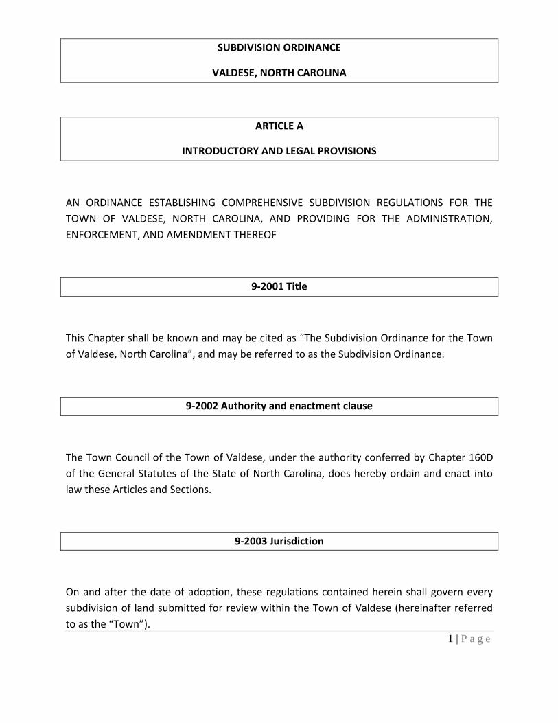
SUBDIVISION ORDINANCE
VALDESE, NORTH CAROLINA
ARTICLE A
INTRODUCTORY AND LEGAL PROVISIONS
AN ORDINANCE ESTABLISHING COMPREHENSIVE SUBDIVISION REGULATIONS FOR THE
TOWN OF VALDESE, NORTH CAROLINA, AND PROVIDING FOR THE ADMINISTRATION,
ENFORCEMENT, AND AMENDMENT THEREOF
9-2001 Title
This Chapter shall be known and may be cited as “The Subdivision Ordinance for the Town
of Valdese, North Carolina”, and may be referred to as the Subdivision Ordinance.
9-2002 Authority and enactment clause
The Town Council of the Town of Valdese, under the authority conferred by Chapter 160D
of the General Statutes of the State of North Carolina, does hereby ordain and enact into
law these Articles and Sections.
9-2003 Jurisdiction
On and after the date of adoption, these regulations contained herein shall govern every
subdivision of land submitted for review within the Town of Valdese (hereinafter referred
to as the “Town”).
2 | P a g e
9-2004 Purpose
The purpose of this chapter is to establish procedures and standards for the development
and subdivision of land within the Town of Valdese. It is further designed to provide for the
orderly growth and development of the Town; for the coordination of streets and highways
within proposed subdivisions with existing or planned streets and highways and with other
public facilities; for the dedication or reservation of recreation areas serving residents of
the immediate neighborhood within the subdivision and of right-of-way or easements for
streets and utility purposes; and for the distribution of population and traffic in a manner
that will avoid congestion and overcrowding and will create conditions essential to public
health, safety, and the general welfare. This chapter is designed to further facilitate
adequate water, sewerage, parks, schools, and playgrounds, and also to facilitate the
further re-subdivision of larger tracts into smaller tracts of land.
9-2005. No Service or Permits until Final Plat Approval
No street shall be accepted and maintained by the Town nor shall any street lighting, water,
or sewer be extended to nor connect with any subdivision of land not shall any permit be
issued by an administrative agent or department of the Town for the construction of any
building or other improvement requiring a permit upon any land concerning which a plat is
required to be approved, unless and until the requirements outlined in this chapter have
been complied with.
9-2005.1 Prerequisite to Plat Recordation
After the effective date of this chapter, each major subdivision plat of land within the
Town’s jurisdiction shall be approved by the Town Council following a recommendation
from the Planning Board before plat recordation. Minor subdivisions, as defined in the

3 | P a g e
chapter, shall be approved by the Subdivision Administrator before plat recordation.
Nothing herein compels the approval of any proposed subdivision by the Town Council or
the Subdivision Administrator except under the provisions of this chapter.
9-2006. Penalties for Violation
After the effective date of this chapter, any person who, being the owner or agent of the
owner of any land located within the jurisdiction of this chapter, thereafter subdivides such
land in violation of the chapter or transfers or sells land by reference to, the exhibition of,
or any other use of a plat showing a subdivision of the land before the plat has been
properly approved under such chapter and recorded in the office of the Burke County
Register of Deeds, shall be subject to the penalties listed below. The description by metes
and bounds in the instrument of transfer or other document used in the process of selling
or transferring land shall not exempt the transaction from this penalty. The Town, through
its attorney or other official designated by the Council, may enjoin illegal subdivision,
transfer, or sale of land by injunction.
(a) Any person violating any provisions of this chapter shall be guilty of a
misdemeanor and upon conviction shall be punished by a fine not exceeding two
hundred dollars ($200) or by imprisonment not to exceed thirty (30) days.
(b) A violation of this chapter shall be a civil offense and shall subject the offender to a
civil penalty in the amount of fifty dollars ($50) per day that the violation continues.
Any person violating this chapter shall be issued a written citation. The penalty shall
be paid to the tax collector at the Valdese Town Hall within seventy-two (72) hours
from the time of issuance of the written citation.
(c) Each day’s continuing violation shall be a separate and distinct offense.

4 | P a g e
(d) The provisions of the chapter may be enforced through equitable remedies issued by
a court of competent jurisdiction, including injunction and order of abatement.
(e) This chapter may be enforced by anyone, all, or a combination of the remedies
authorized herein.
9-2007. Severability
Should any section or provision of this chapter be decided by a court of competent
jurisdiction to be unconstitutional or invalid, such decision shall not affect the validity of the
chapter as a whole or any part thereof other than the part so declared to be
unconstitutional or invalid.
9-2008 Variances
The Board of Adjustment may authorize a variance from these regulations when, in its
opinion, undue hardship is likely to result from strict compliance. In granting any variance,
the Board shall make the findings required below, considering the nature of the proposed
subdivision, the existing use of land in the vicinity, the number of persons to reside or work
in the proposed subdivision, and the probable effect of the proposed subdivision upon
traffic conditions in the vicinity. No variance shall be granted unless the Board finds all the
following:
(a) Unnecessary hardship would result from the strict application of the regulation. It is
not necessary to demonstrate that, in the absence of the variance, no reasonable use
can be made of the property; and

5 | P a g e
(b)The hardship results from conditions that are peculiar to the property, such as
location, size, or topography. Hardships resulting from personal circumstances, as well
as hardships resulting from conditions that are common to the neighborhood or the
general public, may not be the basis for granting a variance. A variance may be granted
when necessary and appropriate to make a reasonable accommodation under the
Federal Fair Housing Act for a person with a disability; and
(c) The hardship did not result from actions taken by the applicant or the property
owner. The act of purchasing property with knowledge that circumstances exist that
may justify the granting of a variance is not a self-created hardship; and
(d) The requested variance is consistent with the spirit, purpose, and intent of the
regulation, such that public safety is secured and substantial justice is achieved.
No change in permitted uses may be authorized by variance. Appropriate conditions may be
imposed on any variance, provided that the conditions are reasonably related to the
variance.
Any other development regulation that regulates land use or development may provide for
variances from the provisions of those ordinances consistent with the provisions of this
subsection.
9-2009 Registration of Plats
Registration of all plats shall be by North Carolina General Statute 47-30.
6 | P a g e
9-2010 Amendments
.1 The Town Council may from time to time amend the terms of this chapter, but no
amendment shall become effective unless it shall have been proposed by or shall have
been submitted to the Planning Board for review and recommendation. The Planning
Board shall have thirty (30) days from the submittal date of the proposed amendment
within which to submit its report. If the Board fails to submit a report within the
specific time, it shall be deemed to have recommended approval of the amendment.
.2 No amendment shall be adopted by the Town Council until it has held a public hearing
on the amendment. Notice of the public hearing shall be published in a newspaper of
general circulation in the Town area at least once a week for two consecutive calendar
weeks prior to the hearing. The initial notice shall appear not more than 25 or less
than 10 days before the hearing date. In computing the 10 to 25 day period, the date
of the first publication shall be counted, but the date of the hearing shall not be
counted.
9-2011 Abrogation
It is not intended that this chapter repeal, abrogate, annul, impair, or interfere with any
existing easements, covenants, deed restrictions, agreements, rules, regulations, or permits
previously adopted or issued under the law.
9-2012 Thoroughfare Plans
Where a proposed subdivision includes any part of a thoroughfare which has been
designated as such upon an officially adopted thoroughfare plan of the Town, such part of
such thoroughfare shall be platted by the subdivider in the location shown on the plan and
at the width specified in this chapter.
7 | P a g e
9-2013 School Sites on Land Use Plan
North Carolina General Statute Chapter 160D-804 provides for the reservation of school
sites under a comprehensive land-use plan approved by the Town Council. For this
authorization to become effective, before approving such plans, the Town Council and the
Burke County Board of Education shall jointly determine the specific location and size of any
school sites to be reserved, which information shall appear in the comprehensive land-use
plan. Whenever a subdivision is submitted for approval which includes part or all of a school
site to be reserved under the plan, the Town shall immediately notify the Board of
Education and the Board of Education shall promptly decide whether it still wishes the site
to be reserved. If the Board of Education does not wish to reserve the site, it shall so notify
the Town of Valdese and no site shall be reserved. If the Board of Education does wish to
reserve the site, the subdivision shall not be approved without such reservation. The Board
of Education shall then have 18 months beginning on the date of final approval of the
subdivision within which to acquire the site by purchase or by initiating condemnation
proceedings. If the Board of Education has not purchased or begun proceedings to
condemn the site within 18 months, the subdivider may treat the land as free of the
reservation.
9-2014 Zoning and other Plans
Proposed subdivisions must comply in all respects with the requirements of the zoning
chapter in effect in the area to be subdivided and with the requirements of any other
adopted plans.
9-2015 Reserved.
8 | P a g e
ARTICLE B
DEFINITIONS
9-2020. Definitions
For this Chapter, certain words or terms used herein shall be defined as follows:
(a) ACCESS CORRIDORS. A strip of land lying between the side lot boundary lines of a
lake or riverfront lots offering access to lots at least one lot depth away from the
water’s edge.
(b) BUFFER. A buffer as required by certain sections of these regulations shall be one of,
or equal to one of the following:
(1) A six-foot-high wood basket-weave type fence.
(2) A six-foot-high solid picket type fence with the pickets being placed
facing the adjoining property.
(3) A six-foot-high chain-link type fence with panel inserts.
(4) A six-foot-high open type fence with evergreen vegetation planted
facing the adjoining property and completely blocking the view from
one area to another.
(5) A six-foot-high solid masonry wall.
(6) Other and/or additional screening as required by the Zoning
Enforcement Officer.
9 | P a g e
(c) BUILDING. Any structure used or intended for supporting or sheltering any use or
occupancy.
(d) BUILDING SETBACK LINE. A line establishing the minimum allowable distance
between the nearest portion of any building, excluding the outermost five feet (5')
of any uncovered porches, steps, gutters, and similar fixtures, and related front,
rear, or side property, or a right-of-way line if the right-of-way is closer to the
building.
(e) CLERK OF SUPERIOR COURT. Clerk of Superior Court of Burke County, North
Carolina.
(f) TOWN COUNCIL. The words Town Council shall mean the Town Council of Valdese,
North Carolina.
(g) DEDICATION. A gift, by the owner, of his property to another party without any
consideration being given for the transfer. Since a transfer of property is involved,
the dedication is made by a written instrument and is completed with an
acceptance.
(h) DOUBLE FRONTAGE LOT. A continuous (through) lot that is accessible from both
streets upon which it fronts.
(i) EASEMENT. A right to use the land of another for a special purpose such as a right of
ingress and egress, or a right to maintain a utility line across the land of another.

10 | P a g e
(j) Expedited Review. Review process whereby the Town of Valdese may require only a
final plat for the recordation for a division of a tract or parcel of land in single
ownership if all of the following criteria are met:
1. The tract or parcel of land to be divided is not exempted as a Ten-Acre Exemption.
2. No part of the tract or parcel to be divided has been divided in ten years before the division.
3. The entire tract or parcel of land must be greater than five acres.
4. The division of the tract or parcel of land must not result in more than three lots.
5. The resulting lots must meet lot dimension requirements of any applicable land use if any.
6. The use of any lot shall conform to applicable zoning requirements if any.
7. The resulting lots must have a permanent means of ingress and egress designated on a recorded plat. The subdivision must ensure access to the newly created lots.
8. The final plat shall be prepared following Section 9-2035 (The Final Plat) of the
Town of Valdese Subdivision Regulations and must be approved by the Town of
Valdese’s review officer.
(k) FLAG LOT. A lot so shaped and designed that the main building site area is set back
from the street on which it fronts and has an access strip connecting the main
building site with frontage street.
11 | P a g e
(l) HILLSIDE SUBDIVISION. Land proposed to be subdivided which has a slope of sixteen
percent (16%) or greater. That is an average difference in elevation of at least
sixteen (16) feet in a horizontal distance of one hundred (100) feet. The average
shall be obtained from at least fifteen (15) measurements, each twenty (20) feet
from the next.
(m) LOT. A parcel of land occupied or capable of being occupied by a main building or
group of buildings and accessory buildings, together with such yards, open spaces,
and lot areas as are required by the zoning ordinance, and having not less than the
minimum required frontage upon a street, either shown on a plat of record or
considered as a unit of property and described by metes and bounds.
(n) LOT FRONT. A portion of the lot that is adjacent to the street. In the case of lots
which adjoin a stream, lake, or pond, the lot front is considered to be the part of the
lot which adjoins the water.
(o) MINOR SUBDIVISION. A subdivision of land that meets the following criteria:
a. Involving not more than five (5) lots fronting on an existing approved street;
and
b. Not involving any new street or prospectively requiring any new street for
access to the interior property; and
c. Not requiring an extension of public sewage or water lines or creation of new
drainage easements through lots to serve property at the rear; and

12 | P a g e
d. Not adversely affecting the development of the remainder of the parcel or
adjoining property; and
e. Creating no new or residual parcels not conforming to the requirements of
these regulations.
f. All included land must be under the ownership of one sponsor.
(p) OFFICIAL MAPS OR PLANS. Any maps or plans endorsed by the Town Council as a
guide to the development of Town of Valdese.
(q) ORDINANCE. The word Ordinance or Regulation shall mean the Subdivision
Ordinance for Town of Valdese, North Carolina.
(r) PEDESTRIAN WALKWAYS. Any paved or unpaved public or private route intended
for pedestrian use, including a pedestrian path or esplanade, regardless of use by
other transportation modes.
(s) PLANNED UNIT DEVELOPMENT. The planned unit development is a permitted use
designed to provide for developments incorporating a single type or a variety of
related uses which are planned and developed as a unit. Such development may
consist of individual lots or common building sites. Common land must be an
element of the plan related to affecting the long-term value of the entire
development.
(t) PLANNING BOARD. The Planning Board of the Town of Valdese, North Carolina.
13 | P a g e
(u) PLAT. A map or plan of a parcel of land, which is to be or has been subdivided.
(v) PLAT, FINAL. A map of certain described land prepared by this chapter as an
instrument for recording with the Burke County Register of Deeds.
(w) PRIVATE STREETS. Any right-of-way or area set aside to provide vehicular access
which has not been accepted for maintenance or intended to be accepted for
maintenance by the Town of Valdese or the State of North Carolina, and which is not
maintained by the Town of Valdese or the State of North Carolina. An entity other
than the Town of Valdese, such as property owners, homeowner’s association,
community group, property management company, or similar type of organizations,
shall be responsible for upkeep and maintenance.
(x) RECREATION AREA OR PARK. An area of land or combination of land and water
resources that are developed for active and/or passive recreation that may include
manmade features that accommodate such activities.
(y) RESERVATION. A reservation of land does not involve any transfer of property
rights. It simply constitutes an obligation to keep the property free from
development for a stated period.
(z) SINGLE-TIER LOT. A lot that backs upon a limited access highway, a railroad, a
physical barrier, or another type of land use and to which access from the rear is
usually prohibited.
(aa) STREETS. A dedicated and accepted public right-of-way for vehicular traffic. The
following classifications shall apply:
14 | P a g e
(1) Access Street. A platted street designed to giving access to adjacent
property owners.
(2) Alley. A minor right-of-way privately or publicly owned, primarily for
service access to the back or side of properties.
(3) Arterials. This thoroughfare category includes those streets and
highways that carry large volumes of traffic at moderate speeds
through and within Town of Valdese. These thoroughfares provide
access to major commercial, industrial, and public traffic generators.
(4) Major Collector Streets. As the name indicates, traffic from local
streets are collected by these thoroughfares and carried to arterial
streets. While also serving as connectors between arterials, these
streets perform an additional function of providing access to adjoining
properties. Smaller volumes of traffic are carried on these streets and
speeds are lower.
(5) Local or Minor Streets. The local street system comprises all facilities,
not in one of the higher systems. It serves primarily to provide direct
access to adjoining land and access to the higher-order system.
(6) Cul-de-sac. A short local street having but one end open to traffic and
the other end is permanently terminated and a vehicular turn
around provided.
15 | P a g e
(bb) SUBDIVIDER. Any person, firm, organization, or corporation who subdivides or
develops any land deemed to be a subdivision as herein defined.
(cc) SUBDIVISION. All divisions of a tract or parcel of land into two or more lots, building
sites, or other divisions for sale or building development (whether immediate or
future) and shall include all divisions of land involving the dedication of a new street
or a change in existing streets, but the following shall not be included within this
definition nor be subject to the regulations established herein, with zoning
exception, building code and fire code regulations:
Exemptions:
a. The combination or recombination of portions of previously subdivided and
recorded lots where the total number of lots is not increased and the
resultant lots are equal to or exceed the standards of the Town as shown in
its subdivision regulations;
b. The division of land into parcels greater than ten (10) acres where no street
right-of-way dedication is involved;
c. The public acquisition by purchase of strips of land for the widening or
opening of streets;
d. The division of a tract in single ownership whose entire area is no greater
than two (2) acres into not more than three (3) lots, where no street right-of-
way dedication is involved and where the resultant lots are equal to or
exceed the standards of the Town, as shown in this chapter.
e. The division of a tract into parcels following the terms of a probated will or by
intestate succession under Chapter 29 of the General Statutes.
16 | P a g e
(dd) SUBDIVISION ADMINISTRATOR. The Planning Director for the Town of Valdese,
North Carolina, or his designated agent.
(ee) TOWN COUNCIL. The Town Council of the Town of Valdese.
9-2023. WORD INTERPRETATION
For the purpose of this chapter, certain words shall be interpreted as follows:
(a) The word “may” is permissive.
The words “shall” and “will” are mandatory.
The present tense includes the future tense and the future tense includes the
present tense.
The singular includes the plural and the plural includes the singular.
17 | P a g e
ARTICLE C
PROCEDURE FOR REVIEW AND
APPROVAL OF SUBDIVISION PLATS
9-2030 Approval Prerequisite to Plat Recordation
No final plat of a general subdivision within the jurisdiction of the town as established in
Section 9-2003 shall be recorded by the Register of deeds of Burke County until it has been
approved by the proper board or official as provided herein. To secure such approval of a
final plat, the subdivider shall follow the procedures established in this section.
9-2030.01 Plats Required
Under G.S. 160D-804, a final plat shall be prepared, approved, and recorded according to
the provisions of this chapter whenever any subdivision of land takes place. Whenever any
manipulation of property lines or property boundaries takes place within the jurisdiction of
the Town as established in section 9-2003 of this chapter that is exempt from these
regulations as provided by section 9-2020 of this chapter, a plat displaying such change
must be presented to the Subdivision Administrator. Each plat must be accompanied by a
fee outlined in the Town’s Fee Schedule.
18 | P a g e
9-2031 Minor Subdivision Approval Process
If the land to be subdivided meets the requirements of a minor subdivision as defined in
section 9-2020, the subdivider will not have to follow the same procedures as for a major
subdivision. The Subdivision Administrator shall approve minor subdivision plats if the
subdivider is the landowner or owner as defined in Article B – Definitions. The landowner
may authorize a person holding a valid option, lease, or contract to purchase to act as his or
her agent or a representative to make applications for development approvals.
The developer of a minor subdivision shall obtain all required permits and provide all
necessary information related to water, sewer, sediment/erosion control, stormwater
control, stream assessment, wetland assessment, and watershed, historical and
archeological sites.
The review process for a minor subdivision shall be adequate to protect the public interest
but shall also provide minimum delay and expense to the subdivider. A preliminary plat is
not required. The developer may go from a sketch plan to a final plat with the approval of
the Subdivision Administrator. However, the following minor plat approval process may be
used only where the subdivision meets the requirements of a minor subdivision as defined
in section 9-2020.
9-2031.01 Procedure for Review of Minor Subdivisions
A preliminary plat shall not be required for approval for minor subdivisions. Before
submission of a final plat, the subdivider shall submit to the Subdivision Administrator the
sketch plan of the proposed subdivision containing the following information:
1. A sketch vicinity map showing the location of the subdivision with neighboring tracts, subdivisions, roads, and waterways;
2. The boundaries of the entire tract and the portion of the tract to be subdivided;
19 | P a g e
3. The total acreage to be subdivided;
4. The existing and proposed uses of the land within the subdivision and the existing uses of land adjoining it;
5. The existing street layout and right-of-way width, lot layout, and size of lots;
6. The name, address, and telephone number of the owner;
7. The name, if any, of the proposed subdivision;
8. Streets and lots of adjacent developed or platted properties;
9. The zoning classification of the tract of land and adjacent properties;
9-2031.02 Review Procedure
The Subdivision Administrator shall review the sketch plan for general compliance with the
requirements of this chapter, and shall advise the subdivider or his agent of the regulations
of the proposed minor subdivision and the procedures to be followed in the preparation
and submission of the final plat.
9-2031.03 Approval of Sketch Plat by Subdivision Administrator
Upon approval of the sketch plan, the subdivider shall be advised that the final plat may be
prepared as long as it conforms to the sketch plan. The approval of the sketch plan shall in
no way be construed as constituting official approval of the final plat.

20 | P a g e
9-2031.04 Dispositions of Copies
A copy of the sketch plan shall be retained as part of the files of the Subdivision
Administrator, with the original drawing being returned to the subdivider or his authorized
agent.
9-2031.05 Final Plat Approval for Minor Subdivisions
.1 The Subdivision Administrator shall review the final plat for complete compliance
with the requirements outlined for final plat approval of these minor subdivision
regulations. The final plat shall be complete and show all information required for
final plats in section 9-3033-35, and all certifications and notarizations required in
section 9-2031.07 for final plat approval of a minor subdivision.
.2 The final plat shall be prepared by a Registered Land Surveyor currently licensed
and registered in the state by the North Carolina State Board of Registration for
Professional Engineers and Land Surveyors. The final plat shall conform to the
provisions for plats, subdivisions, and mapping requirements outlined in G.S. 47-30
as amended and the Manual of Practice for Land Surveying in North Carolina. In
the event of a conflict between the provisions for plats, subdivision, and mapping
requirements outlined in G.S 47-30 as amended and the Manual of Practice for
Land Surveying in North Carolina, the provisions as outlined in G.S. 47-50 as
amended shall control.
.3 Three copies of the final plat shall be submitted to the Subdivision Administrator.
One of these shall be on reproducible material; two shall be black or blue line
paper prints. Material and drawing medium for the original shall be following the
Manual of Practice for Land Surveying in North Carolina, where applicable, and the
requirements of the Burke County Register of Deeds. In the event of a conflict
between material and drawing medium for the original as outlined in the Manual
of Practice for Land Surveying in North Carolina and the requirements of the Burke
21 | P a g e
County Register of Deeds, the requirements of the Burke County Register of Deeds
shall control.
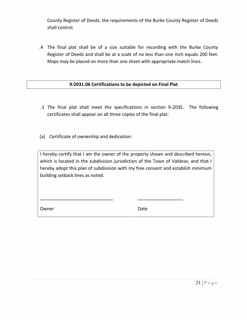
.4 The final plat shall be of a size suitable for recording with the Burke County
Register of Deeds and shall be at a scale of no less than one inch equals 200 feet.
Maps may be placed on more than one sheet with appropriate match lines.
9-2031.06 Certifications to be depicted on Final Plat
.1 The final plat shall meet the specifications in section 9-2035. The following
certificates shall appear on all three copies of the final plat:
(a) Certificate of ownership and dedication:
I hereby certify that I am the owner of the property shown and described hereon,
which is located in the subdivision jurisdiction of the Town of Valdese, and that I
hereby adopt this plan of subdivision with my free consent and establish minimum
building setback lines as noted.
_____________________________
Owner
__________________
Date
22 | P a g e
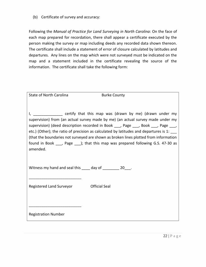
(b) Certificate of survey and accuracy:
Following the Manual of Practice for Land Surveying in North Carolina: On the face of
each map prepared for recordation, there shall appear a certificate executed by the
person making the survey or map including deeds any recorded data shown thereon.
The certificate shall include a statement of error of closure calculated by latitudes and
departures. Any lines on the map which were not surveyed must be indicated on the
map and a statement included in the certificate revealing the source of the
information. The certificate shall take the following form:
State of North Carolina Burke County
I, ______________ certify that this map was (drawn by me) (drawn under my
supervision) from (an actual survey made by me) (an actual survey made under my
supervision) (deed description recorded in Book ___, Page ___, Book ___, Page ___,
etc.) (Other); the ratio of precision as calculated by latitudes and departures is 1: ___
(that the boundaries not surveyed are shown as broken lines plotted from information
found in Book ___, Page ___); that this map was prepared following G.S. 47-30 as
amended.
Witness my hand and seal this ____ day of ________ 20___.
_________________________
Registered Land Surveyor Official Seal
_________________________
Registration Number
23 | P a g e
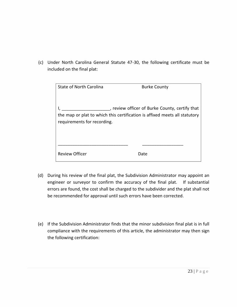
(c) Under North Carolina General Statute 47-30, the following certificate must be
included on the final plat:
State of North Carolina Burke County
I, ____________________, review officer of Burke County, certify that
the map or plat to which this certification is affixed meets all statutory
requirements for recording.
_____________________________ _________________
Review Officer Date
(d) During his review of the final plat, the Subdivision Administrator may appoint an
engineer or surveyor to confirm the accuracy of the final plat. If substantial
errors are found, the cost shall be charged to the subdivider and the plat shall not
be recommended for approval until such errors have been corrected.
(e) If the Subdivision Administrator finds that the minor subdivision final plat is in full
compliance with the requirements of this article, the administrator may then sign
the following certification:
24 | P a g e
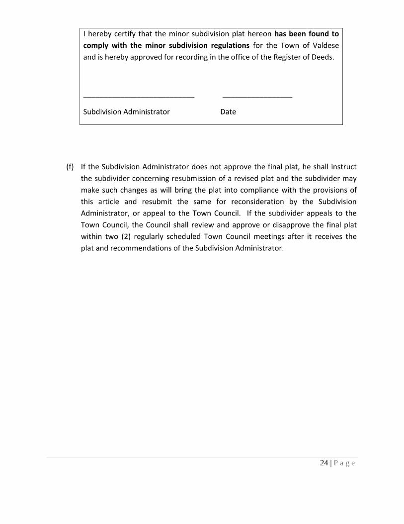
I hereby certify that the minor subdivision plat hereon has been found to
comply with the minor subdivision regulations for the Town of Valdese
and is hereby approved for recording in the office of the Register of Deeds.
___________________________ _________________
Subdivision Administrator Date
(f) If the Subdivision Administrator does not approve the final plat, he shall instruct
the subdivider concerning resubmission of a revised plat and the subdivider may
make such changes as will bring the plat into compliance with the provisions of
this article and resubmit the same for reconsideration by the Subdivision
Administrator, or appeal to the Town Council. If the subdivider appeals to the
Town Council, the Council shall review and approve or disapprove the final plat
within two (2) regularly scheduled Town Council meetings after it receives the
plat and recommendations of the Subdivision Administrator.
25 | P a g e
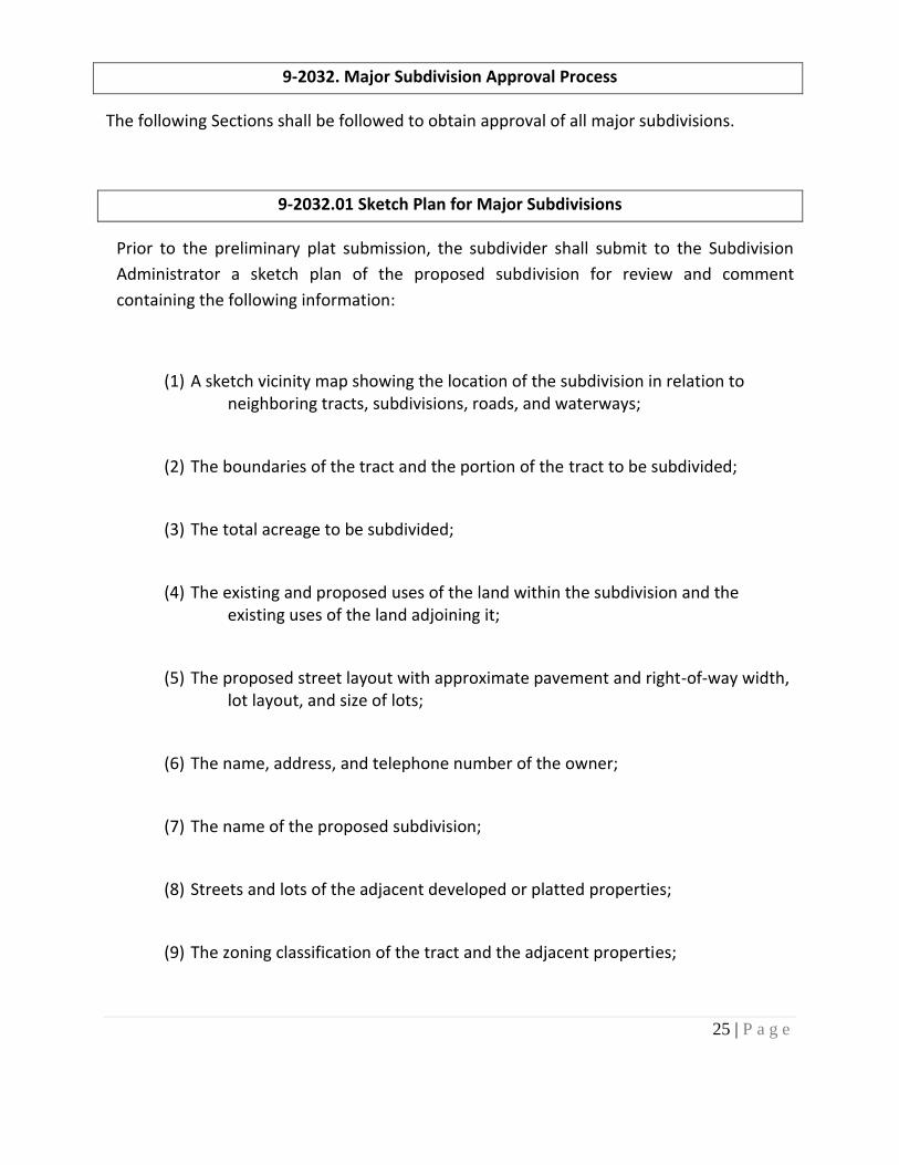
9-2032. Major Subdivision Approval Process
The following Sections shall be followed to obtain approval of all major subdivisions.
9-2032.01 Sketch Plan for Major Subdivisions
Prior to the preliminary plat submission, the subdivider shall submit to the Subdivision
Administrator a sketch plan of the proposed subdivision for review and comment
containing the following information:
(1) A sketch vicinity map showing the location of the subdivision in relation to neighboring tracts, subdivisions, roads, and waterways;
(2) The boundaries of the tract and the portion of the tract to be subdivided;
(3) The total acreage to be subdivided;
(4) The existing and proposed uses of the land within the subdivision and the existing uses of the land adjoining it;
(5) The proposed street layout with approximate pavement and right-of-way width, lot layout, and size of lots;
(6) The name, address, and telephone number of the owner;
(7) The name of the proposed subdivision;
(8) Streets and lots of the adjacent developed or platted properties;
(9) The zoning classification of the tract and the adjacent properties;
26 | P a g e
9-2033 Preliminary Plat Submission and Review
.1 For every subdivision within the territorial jurisdiction established by section 9-2003 of
this chapter which does not qualify for the abbreviated minor subdivision procedure,
the subdivider shall submit a preliminary plat which shall be reviewed and approved
by the Planning Board before any construction or installation of improvements may
begin.
.2 Eight copies of the preliminary plat (as well as any additional copies which the
Subdivision Administrator determines are needed to be sent to other agencies) shall
be submitted to the Subdivision Administrator at least 20 days before the Planning
Board meeting at which the subdivider desires the Planning Board to review the
preliminary plat. The Subdivision Administrator shall review the preliminary plat for
general compliance with the requirements of this chapter and any other applicable
Chapters and shall advise the subdivider or his authorized agent of the procedures to
be followed in the preparation and submission of the preliminary and final plats. This
review shall in no way be construed as constituting an official action of approval for
the recording of the subdivision by the Planning Board or the Town Council as required
by this Chapter.
.3 Submission of the preliminary plat shall be accompanied by the fee as outlined in the
Town’s Fee Schedule.
.4 Preliminary plats shall be of a suitable size for recording with the Burke County
Register of Deeds and shall be at a scale of no less than one inch equals 200 feet.
Maps may be placed on more than one sheet with appropriate match lines. (Reference
to Section 9-2035.02 and 9-2035.03)

27 | P a g e
.5 Preliminary plats shall meet the specifications in 9-2035.05. For the purposes of this
ordinance, no application shall be considered to have been submitted until it is
complete.
.6 After having received the preliminary plat from the subdivider, the Subdivision
Administrator shall submit copies of the preliminary plat and any other accompanying
material to other officials or agencies concerned with new development including, but
not limited to:
a. The district highway engineer as to proposed streets, highways, and drainage
systems;
b. The County Environmental Health Director or Town of Valdese Public Works
Director as to proposed water or sanitary sewer systems;
c. Any other agency or official designated by the Planning Board or other Town
official.
.7 The Planning Board shall review the preliminary plat at or before its next regularly
scheduled meeting which follows at least 20 days after the Subdivision Administrator
receives the preliminary plat and the comments from the appropriate agencies.
.8 The Planning Board shall, in writing, recommend approval, special approval with
recommended changes to bring the plat into compliance, or disapproval with reasons
within 20 days of its first consideration of the plat.
.9 If the Planning Board recommends approval of the preliminary plat, it shall retain one
copy of the plat for its minutes, and transmit two copies of the plat to the Town
Council with its recommendation.

28 | P a g e
.10 If the Planning Board recommends special approval of the preliminary plat, it shall
keep one copy of the plat for its minutes, transmit two copies of the plat and its
recommendation to the Town Council, and return the remaining copies of the plat and
its recommendation to the subdivider.
.11 If the Planning Board recommends disapproval of the preliminary plat, it shall retain
one copy of the plat for its minutes, transmit two copies of the plat and its
recommendation to the Town Council, and return the remaining copies of the plat and
its recommendation to the subdivider.
.12 If the Planning Board does not make a written recommendation within 30 days after
its first consideration of the plat, the subdivider may apply to the Town Council for
approval or disapproval.
.13 If the Planning Board recommends disapproval of the preliminary plat, the subdivider
may request the preliminary plat be presented to the Town Council at its next
regularly scheduled meeting for consideration.
.14 If the Town Council approves the preliminary plat, such approval shall be noted on
two plats. One plat shall be retained by the Town Council and one copy shall be
returned to the subdivider. If the Town Council approves the preliminary plat with
conditions, approval shall be noted on two plats along with a reference to the
conditions. One plat along with the conditions shall be retained by the Town Council
and one preliminary plat along with the conditions shall be returned to the subdivider.
If the Town Council disapproves of the preliminary plat, the reasons for such
disapproval shall be specified in writing. One plat and the reasons shall be retained by
the Town Council and one plat shall be returned to the subdivider.
29 | P a g e
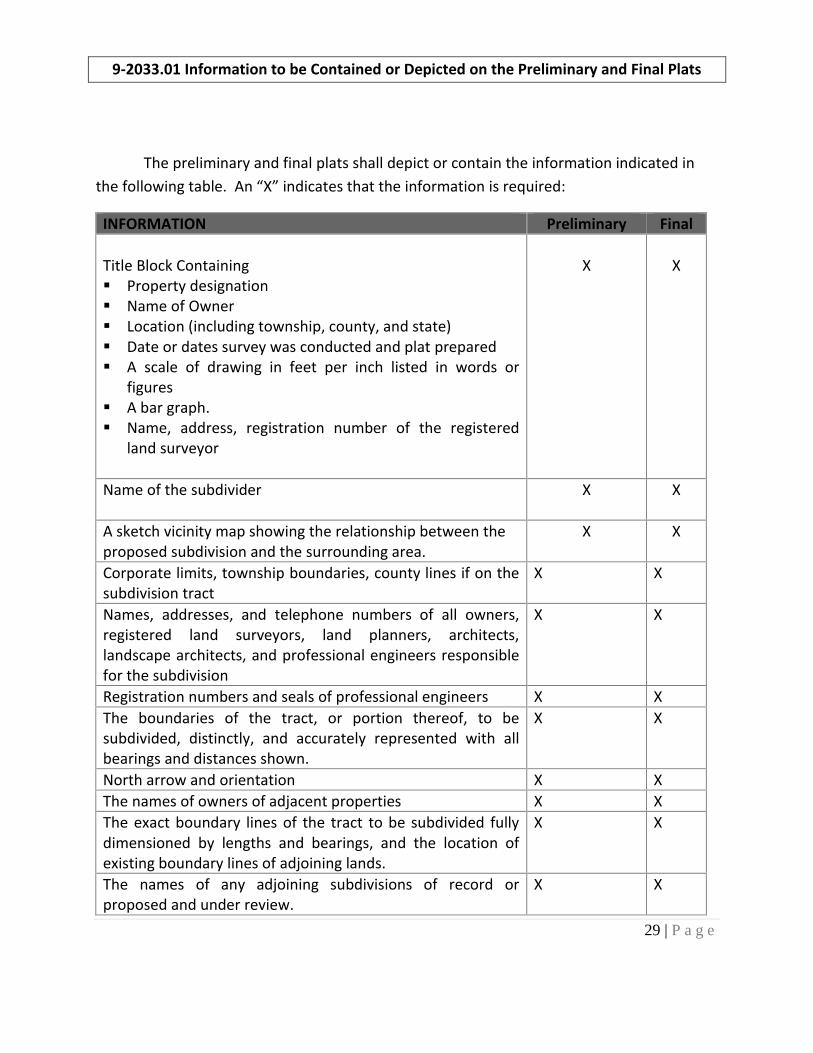
9-2033.01 Information to be Contained or Depicted on the Preliminary and Final Plats
The preliminary and final plats shall depict or contain the information indicated in
the following table. An “X” indicates that the information is required:
INFORMATION Preliminary Final
Title Block Containing Property designation Name of Owner Location (including township, county, and state) Date or dates survey was conducted and plat prepared A scale of drawing in feet per inch listed in words or
figures A bar graph. Name, address, registration number of the registered
land surveyor
X
X
Name of the subdivider
X X
A sketch vicinity map showing the relationship between the proposed subdivision and the surrounding area.
X X
Corporate limits, township boundaries, county lines if on the subdivision tract
X X
Names, addresses, and telephone numbers of all owners, registered land surveyors, land planners, architects, landscape architects, and professional engineers responsible for the subdivision
X X
Registration numbers and seals of professional engineers X X
The boundaries of the tract, or portion thereof, to be subdivided, distinctly, and accurately represented with all bearings and distances shown.
X X
North arrow and orientation X X
The names of owners of adjacent properties X X
The exact boundary lines of the tract to be subdivided fully dimensioned by lengths and bearings, and the location of existing boundary lines of adjoining lands.
X X
The names of any adjoining subdivisions of record or proposed and under review.
X X
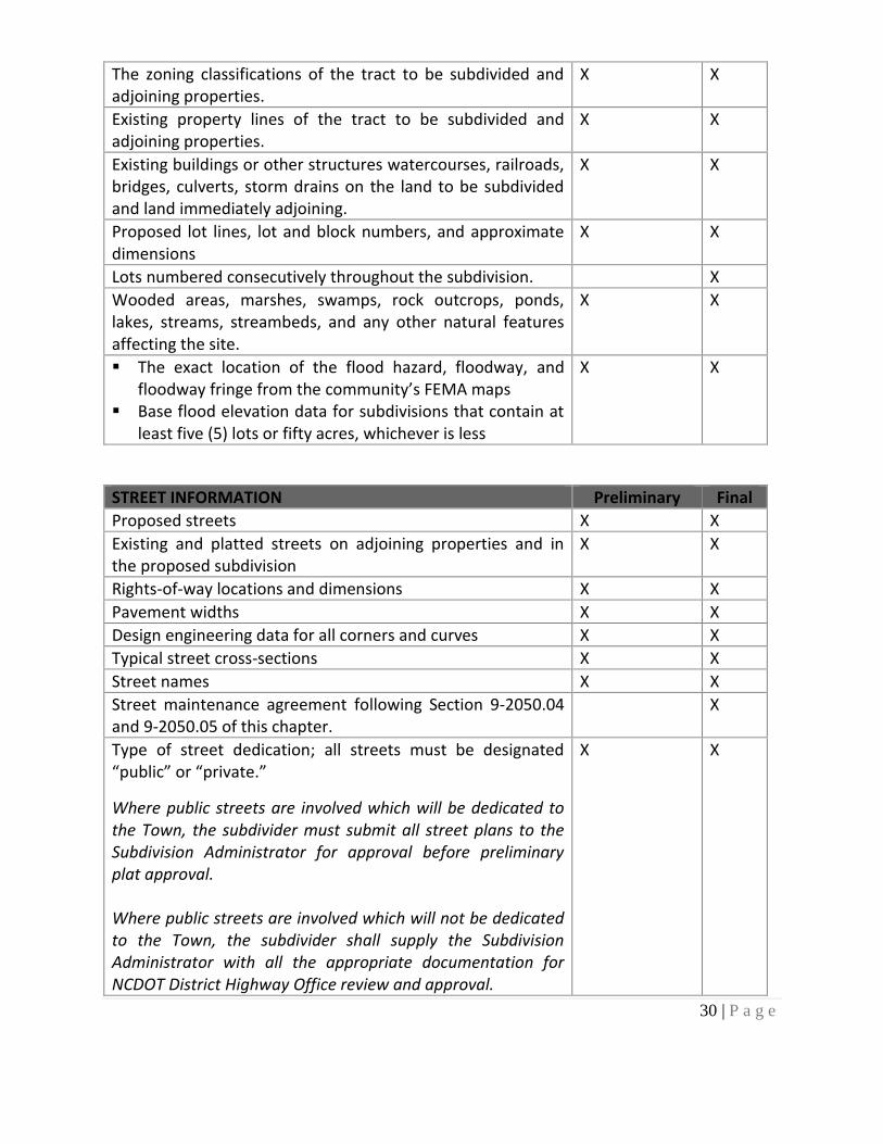
30 | P a g e
The zoning classifications of the tract to be subdivided and adjoining properties.
X X
Existing property lines of the tract to be subdivided and adjoining properties.
X X
Existing buildings or other structures watercourses, railroads, bridges, culverts, storm drains on the land to be subdivided and land immediately adjoining.
X X
Proposed lot lines, lot and block numbers, and approximate dimensions
X X
Lots numbered consecutively throughout the subdivision. X
Wooded areas, marshes, swamps, rock outcrops, ponds, lakes, streams, streambeds, and any other natural features affecting the site.
X X
The exact location of the flood hazard, floodway, and floodway fringe from the community’s FEMA maps
Base flood elevation data for subdivisions that contain at least five (5) lots or fifty acres, whichever is less
X X
STREET INFORMATION Preliminary Final
Proposed streets X X
Existing and platted streets on adjoining properties and in the proposed subdivision
X X
Rights-of-way locations and dimensions X X
Pavement widths X X
Design engineering data for all corners and curves X X
Typical street cross-sections X X
Street names X X
Street maintenance agreement following Section 9-2050.04 and 9-2050.05 of this chapter.
X
Type of street dedication; all streets must be designated “public” or “private.”
Where public streets are involved which will be dedicated to the Town, the subdivider must submit all street plans to the Subdivision Administrator for approval before preliminary plat approval. Where public streets are involved which will not be dedicated to the Town, the subdivider shall supply the Subdivision Administrator with all the appropriate documentation for NCDOT District Highway Office review and approval.
X X
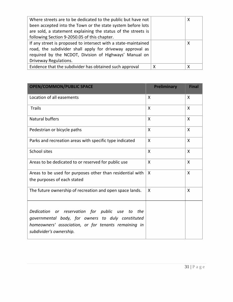
31 | P a g e
Where streets are to be dedicated to the public but have not been accepted into the Town or the state system before lots are sold, a statement explaining the status of the streets is following Section 9-2050.05 of this chapter.
X
If any street is proposed to intersect with a state-maintained road, the subdivider shall apply for driveway approval as required by the NCDOT, Division of Highways’ Manual on Driveway Regulations.
X
Evidence that the subdivider has obtained such approval X X
OPEN/COMMON/PUBLIC SPACE Preliminary Final
Location of all easements X X
Trails X X
Natural buffers X X
Pedestrian or bicycle paths X X
Parks and recreation areas with specific type indicated X X
School sites X X
Areas to be dedicated to or reserved for public use X X
Areas to be used for purposes other than residential with
the purposes of each stated
X X
The future ownership of recreation and open space lands.
Dedication or reservation for public use to the
governmental body, for owners to duly constituted
homeowners' association, or for tenants remaining in
subdivider's ownership.
X X
32 | P a g e
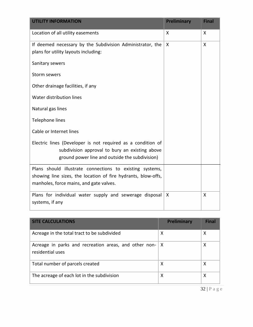
UTILITY INFORMATION Preliminary Final
Location of all utility easements X X
If deemed necessary by the Subdivision Administrator, the
plans for utility layouts including:
Sanitary sewers
Storm sewers
Other drainage facilities, if any
Water distribution lines
Natural gas lines
Telephone lines
Cable or Internet lines
Electric lines (Developer is not required as a condition of
subdivision approval to bury an existing above
ground power line and outside the subdivision)
Plans should illustrate connections to existing systems,
showing line sizes, the location of fire hydrants, blow-offs,
manholes, force mains, and gate valves.
X X
Plans for individual water supply and sewerage disposal
systems, if any
X X
SITE CALCULATIONS Preliminary Final
Acreage in the total tract to be subdivided X X
Acreage in parks and recreation areas, and other non-
residential uses
X X
Total number of parcels created X X
The acreage of each lot in the subdivision X X
33 | P a g e
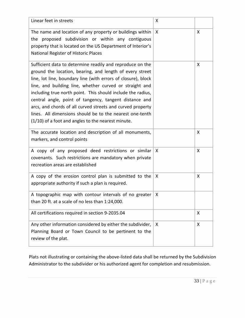
Linear feet in streets X
The name and location of any property or buildings within
the proposed subdivision or within any contiguous
property that is located on the US Department of Interior’s
National Register of Historic Places
X X
Sufficient data to determine readily and reproduce on the
ground the location, bearing, and length of every street
line, lot line, boundary line (with errors of closure), block
line, and building line, whether curved or straight and
including true north point. This should include the radius,
central angle, point of tangency, tangent distance and
arcs, and chords of all curved streets and curved property
lines. All dimensions should be to the nearest one-tenth
(1/10) of a foot and angles to the nearest minute.
X
The accurate location and description of all monuments,
markers, and control points
X
A copy of any proposed deed restrictions or similar
covenants. Such restrictions are mandatory when private
recreation areas are established
X X
A copy of the erosion control plan is submitted to the
appropriate authority if such a plan is required.
X X
A topographic map with contour intervals of no greater
than 20 ft. at a scale of no less than 1:24,000.
X
All certifications required in section 9-2035.04 X
Any other information considered by either the subdivider,
Planning Board or Town Council to be pertinent to the
review of the plat.
X X
Plats not illustrating or containing the above-listed data shall be returned by the Subdivision
Administrator to the subdivider or his authorized agent for completion and resubmission.
34 | P a g e
Section 9-2034 FINAL PLAT APPROVAL PROCESS
9-2034.01 Improvements Installation
Upon the approval of the preliminary plat by the Planning Board and Town Council, the
subdivider may proceed with the preparation of the final plat and install the required
improvements or arrange for the installation of the required improvements following the
approved preliminary plat and the requirements of this chapter.
Before approval of a final plat, the subdivider shall have completed the installation of the
improvements or provided guarantees of such installation, as specified in this chapter.
9-2034.02 Town Participation and Costs
The Town at the election of the Town Council may participate in the costs of providing
water and sewer services and in the cost of paving streets and sidewalks, including curb and
guttering, following the plans shown on the approved plat. If the subdivider desires Town
participation, a written request should be made to the Town before the installation of any
improvements.
9-2034.03 Performance Guarantee
.1 Following approval of the preliminary plat by the Town Council, the
subdivider may proceed with the preparation of the final plat and the installation
of or arrangement for required improvements following the approved preliminary
plat and the requirements of this chapter. Before approval of a final plat, the
subdivider shall have installed the improvements specified in this chapter or
guaranteed their installation as provided herein.
35 | P a g e
No final plat will be accepted for review by the Planning Board or Town Council
unless accompanied by a written notice by the Town Manager and/or Town
Engineer acknowledging compliance with the improvement and guarantee
standards of this chapter. The final plat shall constitute only that portion of the
preliminary plat which the subdivider proposes to record and develop at that time;
such portion shall conform to all requirements of this chapter.
.2 instead of requiring the completion, installation, and dedication of all
improvements before final plat approval, the Town may enter into an agreement
with the subdivider whereby the subdivider shall agree to complete all required
improvements. Once the said agreement is signed by both parties and the security
required herein is provided, the final plat may be approved by the Town Council if
all other requirements of this chapter are met. To secure this agreement, the
subdivider shall provide, subject to the approval of Town Council, either one or a
combination of the following “performance Guarantee” in G.S. 160D-804.1:
(a) Surety performance bond(s). The subdivider shall obtain a performance
bond(s) from a surety bonding company authorized to do business in North
Carolina. The bonds shall be payable to the Town and shall be in an
amount equal to 125% of the entire cost, as estimated by the subdivider
and approved by the Town Council, of installing all required improvements.
The duration of the bond(s) shall be until the improvements are accepted
by Town Council. The reasonably estimated cost of completion shall
include one hundred percent (100%) of the costs for labor and materials
necessary for completion of the required improvements. Where
applicable, the costs shall be based on unit pricing. The additional twenty-
five percent (25%) allowed under this subdivision includes inflation and all
costs of administration regardless of how such fees or charges are
denominated.
(i) Letter of Credit. An irrevocable letter of credit or other instruments
readily convertible into cash at face value, either with the Town or in
escrow with a financial institution designated as an official depository
36 | P a g e
of the Town. The Letter of Credit shall be in an amount equal to 125%
of the entire cost, as estimated by the subdivider and approved by the
Town Council, of installing all required improvements. The reasonably
estimated cost of completion shall include one hundred percent (100%)
of the costs for labor and materials necessary for completion of the
required improvements. Where applicable, the costs shall be based on
unit pricing. The additional twenty-five percent (25%) allowed under
this subdivision includes inflation and all costs of administration
regardless of how such fees or charges are denominated.
(b) Equivalent Security. The subdivider shall provide a form of guarantee
that provides equivalent security to a surety bond or letter of credit. The
amount of deposit shall be equal to 125% of the cost, as estimated by
the subdivider and approved by Town Council, of installing all required
improvements. The reasonably estimated cost of completion shall
include one hundred percent (100%) of the costs for labor and materials
necessary for completion of the required improvements. Where
applicable, the costs shall be based on unit pricing. The additional
twenty-five percent (25%) allowed under this subdivision includes
inflation and all costs of administration regardless of how such fees or
charges are denominated.
If cash or other instrument is deposited in escrow with a financial
institution as provided above, then the subdivider shall file with Town
Council an agreement between the financial institution and himself
guaranteeing the following:
i) That the escrow account shall be held in trust until released by the
Town Council and may not be used or pledged by the subdivider in
any other matter during the term of escrow; and
ii) That in case of a failure on the part of the subdivider to complete
said improvements, the financial institution shall, upon notification
by the Town Council, and submission by Town Council to the
financial institution of an engineer’s estimate of the amount
needed to complete the improvements, immediately either pay to

37 | P a g e
the Town the funds estimated to complete the improvements, up
to the full balance of the escrow account or deliver to the Town
any other instrument fully endorsed or otherwise made payable in
full to the Town.
.3 Duration - The Performance Guarantee shall initially be one year unless
the developer determines that the scope of work for the required
improvement necessitates a longer duration.
.4 Extension - If the current performance guarantee is likely to expire before
completion of the required improvements, the performance guarantee shall
be extended, or a new performance guarantee issued if the developer has
demonstrated reasonable, good-faith progress toward completion of the
required improvements that are secured by the performance guarantee. Such
extension shall only be for duration necessary to complete. If a new
performance guarantee is issued, the amount shall not exceed 125% of the
total cost of all incomplete improvements.
.5 Release - The Town Council may release a portion of any security posted as
the improvements are completed and recommended for approval by the
Planning Board. Within 30 days after receiving the Planning Board
recommendation, the Town Council shall approve said improvements. If the
Town Council approves said improvements, and then it shall immediately
release any security posted.
.6 Upon default, meaning failure on the part of the subdivider to complete the
required improvements on time as spelled out in the performance bond or
escrow agreement, then the surety, or the financial institution holding the
escrow account shall, if requested by the Town Council, pay all or any portion
of the bond or escrow fund to the Town the amount needed to complete the
improvements based on an engineering estimate. Upon payment, the Town
Council, in its discretion, may expend such portion of said funds as it deems
necessary to complete all or any portion of the required improvements. The
Town shall return to the subdivider any funds not spent in completing the
improvements.

38 | P a g e
9-2034.04 Defects Guarantee
.1 The Town Council shall require a bond guaranteeing utility taps, curbs, gutters, street pavement, sidewalks, drainage facilities, water and sewer lines, and other improvements against defects for one year. If said improvements are constructed at different times, then said guarantee shall continue until one year from the date of acceptance of the improvement last constructed. The amount of the bond shall be determined by the Town Manager or consulting engineer and shall be in cash or made by a surety company authorized to do business in North Carolina.
.2 The Town Council shall require the subdivider to submit a letter to the Town Clerk in
which he agrees to maintain all improvements and any ditch which has been dug
in connection with the installation of such improvements. The obligation to
maintain all improvements and ditches shall be binding to the subdivider for one year
following the acceptance of the improvements by the Town.
9-2034.05 Final Plat Review
No final plat will be accepted for review by the Planning Board or Town Council unless
accompanied by written notice by the Staff Planner acknowledging compliance with this
Chapter.
39 | P a g e
SECTIONS 9-2035 THE FINAL PLAT
The final plat may be approved for only that portion of the preliminary plat, which the
subdivider proposes to record and develop; however, all properties on the final plat shall
conform to all requirements of this chapter.
No final plat shall be approved unless and until the subdivider shall have installed, in that
area represented on the final plat, all improvements required by this chapter (or shall have
guaranteed their installation as provided for in Section 9-2034.03 of this chapter and all
permanent reference points described in Article D of this chapter).
9-2035.01 Plats Submitted
The subdivider shall submit five (5) copies of the final plat, so marked, to the Subdivision
Administrator not less than twenty (20) days before the Planning Board meeting at which
the approval of the plat is to be considered. One additional copy shall be prepared under
G.S. 47-30 and shall bear all the required certifications outlined in Section 9-2035.04 of this
chapter, at which time it will be considered for approval.
The reproducible drawing shall be given to the Subdivision Administrator not later than the
date of the Planning Board meeting at which approval is requested. The plat shall be
submitted not more than twelve (12) months after the date on which the preliminary plat
was approved; provided, however, a written extension of this time limit may be granted by
the Planning Board on or before the first anniversary of the approval.
9-2035.02 Size of Plat and Scale
Final plats shall be of a size suitable for recording with the Burke County Register of Deeds.
Where the size of land areas or suitable scale to assure legibility requires, maps may be
placed on two or more sheets with appropriate match lines. Final plats shall be drawn at a
scale of one (1) inch equals two hundred (200) feet, or greater.
40 | P a g e
9-2035.03 Plats Prepared
The final plat shall be prepared by a surveyor licensed and registered to practice in the State
of North Carolina. The final plat shall substantially conform to the preliminary plat as it was
approved. The final plat shall conform to the provisions of Section 47-30 of the General
Statutes of North Carolina.
9-2035.04 Certifications Required
The following signed certificates shall appear on the reproducible copy of the final plat
which is submitted to the Planning Board by the subdivider:
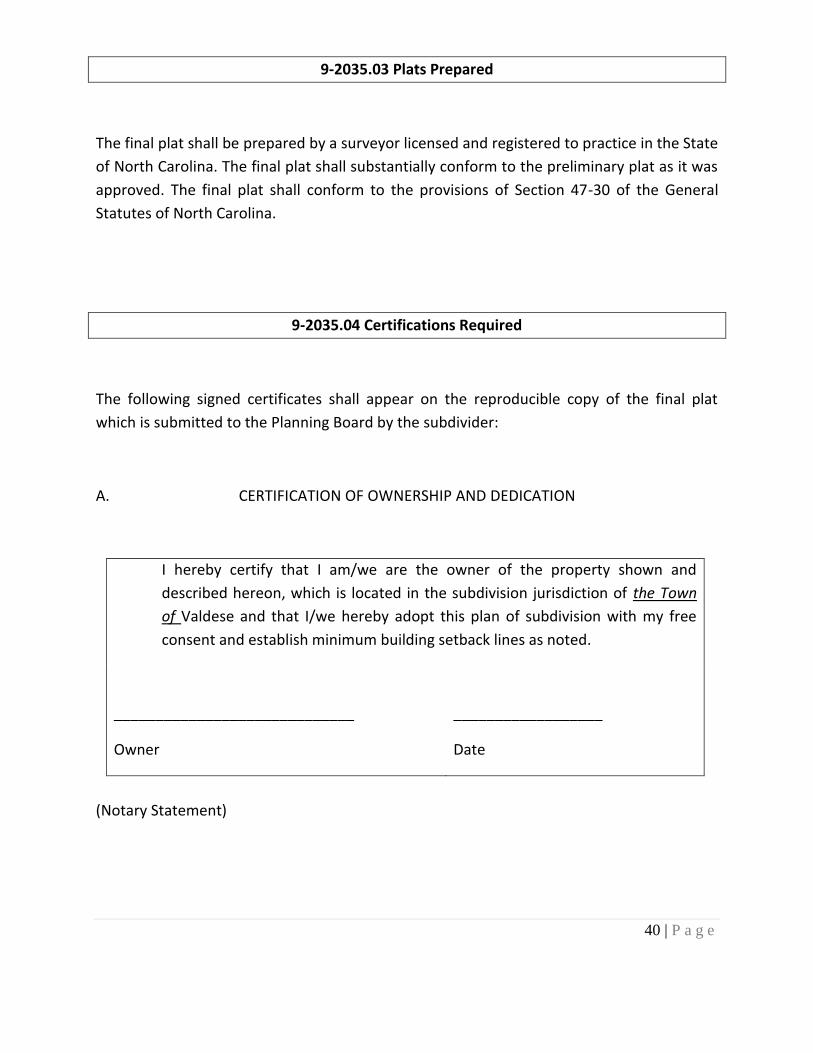
A. CERTIFICATION OF OWNERSHIP AND DEDICATION
I hereby certify that I am/we are the owner of the property shown and
described hereon, which is located in the subdivision jurisdiction of the Town
of Valdese and that I/we hereby adopt this plan of subdivision with my free
consent and establish minimum building setback lines as noted.
_____________________________
Owner
__________________
Date
(Notary Statement)
41 | P a g e
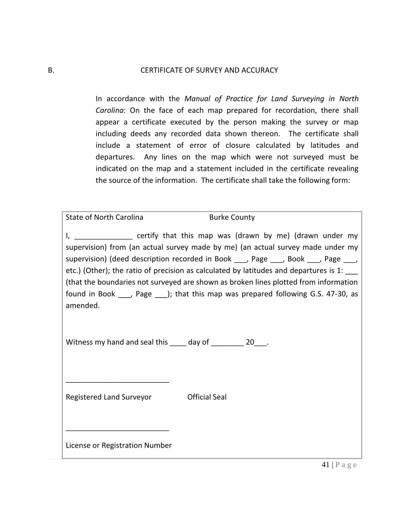
B. CERTIFICATE OF SURVEY AND ACCURACY
In accordance with the Manual of Practice for Land Surveying in North
Carolina: On the face of each map prepared for recordation, there shall
appear a certificate executed by the person making the survey or map
including deeds any recorded data shown thereon. The certificate shall
include a statement of error of closure calculated by latitudes and
departures. Any lines on the map which were not surveyed must be
indicated on the map and a statement included in the certificate revealing
the source of the information. The certificate shall take the following form:
State of North Carolina Burke County
I, ______________ certify that this map was (drawn by me) (drawn under my
supervision) from (an actual survey made by me) (an actual survey made under my
supervision) (deed description recorded in Book ___, Page ___, Book ___, Page ___,
etc.) (Other); the ratio of precision as calculated by latitudes and departures is 1: ___
(that the boundaries not surveyed are shown as broken lines plotted from information
found in Book ___, Page ___); that this map was prepared following G.S. 47-30, as
amended.
Witness my hand and seal this ____ day of ________ 20___.
_________________________
Registered Land Surveyor Official Seal
_________________________
License or Registration Number
42 | P a g e
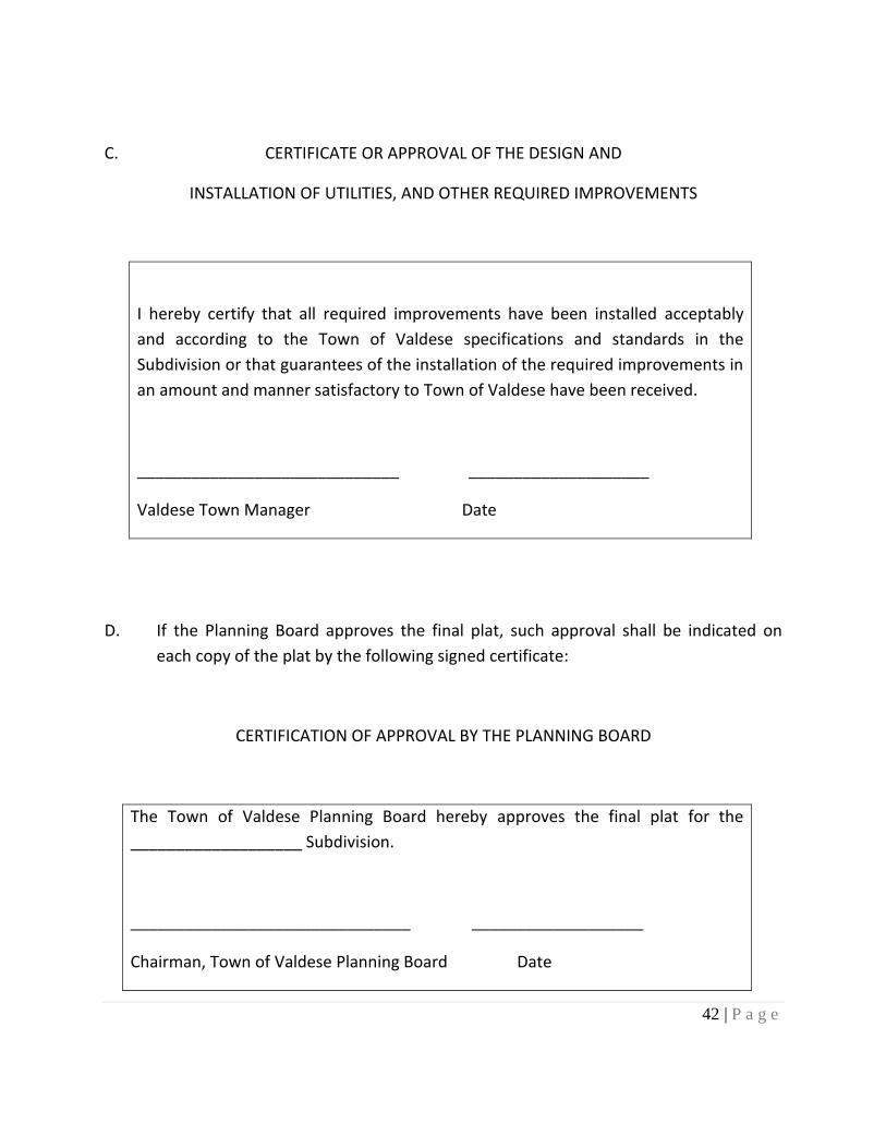
C. CERTIFICATE OR APPROVAL OF THE DESIGN AND
INSTALLATION OF UTILITIES, AND OTHER REQUIRED IMPROVEMENTS
I hereby certify that all required improvements have been installed acceptably
and according to the Town of Valdese specifications and standards in the
Subdivision or that guarantees of the installation of the required improvements in
an amount and manner satisfactory to Town of Valdese have been received.
_____________________________ ____________________
Valdese Town Manager Date
D. If the Planning Board approves the final plat, such approval shall be indicated on
each copy of the plat by the following signed certificate:
CERTIFICATION OF APPROVAL BY THE PLANNING BOARD
The Town of Valdese Planning Board hereby approves the final plat for the
___________________ Subdivision.
_______________________________ ___________________
Chairman, Town of Valdese Planning Board Date

43 | P a g e
E. If the Town Council approves the final plat, such approval shall be shown on each
recordable plat by the following signed certificate:
CERTIFICATION OF APPROVAL BY THE TOWN COUNCIL
Certificate of Approval for Recording
I hereby certify that the subdivision plat shown hereon has been found to comply
with the Subdivision Ordinance for the Town of Valdese, North Carolina and that
this plat has been approved by the Town Council for recording in the Office of the
Register of Deeds of Burke County.
______________________________ ___________________
Town Clerk, Town of Valdese Date
44 | P a g e
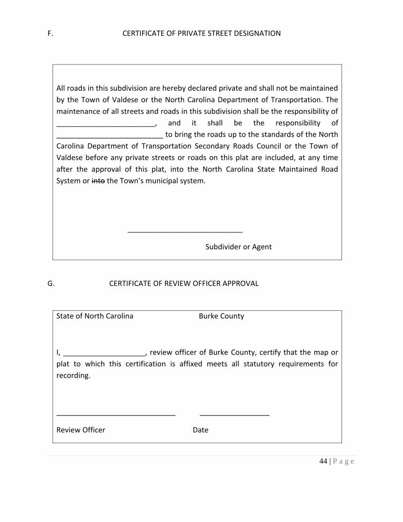
F. CERTIFICATE OF PRIVATE STREET DESIGNATION
All roads in this subdivision are hereby declared private and shall not be maintained
by the Town of Valdese or the North Carolina Department of Transportation. The
maintenance of all streets and roads in this subdivision shall be the responsibility of
________________________, and it shall be the responsibility of
__________________________ to bring the roads up to the standards of the North
Carolina Department of Transportation Secondary Roads Council or the Town of
Valdese before any private streets or roads on this plat are included, at any time
after the approval of this plat, into the North Carolina State Maintained Road
System or into the Town’s municipal system.
____________________________
Subdivider or Agent
G. CERTIFICATE OF REVIEW OFFICER APPROVAL
State of North Carolina Burke County
I, ____________________, review officer of Burke County, certify that the map or
plat to which this certification is affixed meets all statutory requirements for
recording.
_____________________________ _________________
Review Officer Date

45 | P a g e
9-2035.05 Contents Required
The final plat shall depict or contain the information listed in 9-2033. Plats not illustrating
or containing the data listed in 9-2033 shall be returned by the Subdivision Administrator to
the subdivider or his authorized agent for completion and resubmission.

46 | P a g e
9-2036 REVIEW PROCEDURE
Final plats shall be reviewed according to the following procedure:
9-2036.01 Planning Board Review
The Planning Board shall approve or disapprove the final plat within thirty (30) days of its
first consideration. During its review of the final plat, the Planning Board may appoint an
engineer or surveyor to confirm the accuracy of the final plat. If substantial errors are
found, the costs shall be charged to the subdivider and the plat shall not be approved until
such errors have been corrected.
If the Planning Board disapproves of the final plat, the Subdivision Administrator shall state
in writing its reasons for such action, specifying the provisions of this chapter with which
the plat does not comply. One copy of this statement shall be transmitted to the subdivider
within fifteen (15) days of disapproval and one copy shall be retained by the Planning Board
as part of its proceedings. If the final plat is disapproved, the subdivider may make such
changes as will bring the plat into compliance with the provisions of this chapter and
resubmit same for reconsideration by the Planning Board.
9-2036.02 Town Council Review
Upon approval of the final plat by the Planning Board, the Town Council shall review and
approve or disapprove the plat at its next regularly scheduled meeting, which takes place at
least fifteen (15) days after the Planning Board submits its recommendation. This applies
only if the Planning Board recommendation is submitted at least fifteen (15) days before
the Town Councils' regularly scheduled meeting.
47 | P a g e
If the final plat is disapproved by the Town Council, the reasons for such disapproval shall
be stated in writing, specifying the provision(s) of this chapter with which the final plat does
not comply. One (1) copy of such reasons shall be retained by the Town Council as a part of
its proceedings, one (1) copy shall be transmitted to the Subdivision Administrator, and one
(1) copy shall be transmitted to the subdivider. If the final plat is disapproved, the
subdivider may make such changes as will bring the final plat into compliance with this
chapter and resubmit same for consideration by the Planning Board as identified in
paragraph 9-2036.01.
9-2036.03. Disposition of Copies
Upon action by the Town Council on the final plat, the Subdivision Administrator shall retain
one copy and return the reproducible copy and any other copies to the developer. The
reproducible plat shall be filed with the Register of Deeds. One (1) print shall be retained by
the Subdivision Administrator.
9-2036.04 Recording the Final Plat
The subdivider shall file the approved major subdivision final plat with the Register of Deeds
of Burke County for recording within sixty (60) days after the date of the Town Council
approval. Otherwise, such approval shall be null and void. The subdivider shall file the
approved minor subdivision final plat with the Register of Deeds of Burke County for
recording within sixty (60) days after the date of the Subdivision Administrator approval.
Otherwise, such approval shall be null and void.
9-2036.05 Re-subdivision Procedures
For any re-platting or re-subdivision of land, the same procedures, rules, and regulations
shall apply as prescribed herein for an original subdivision. Lot sizes may, however, be

48 | P a g e
varied on an approved plan after recording, provided that (A) no lot or tract of land shall be
created or sold that is smaller than the size shown on the approved plan; (B) drainage,
easements, or rights-of-way shall not be changed; (C) street alignment and block sizes shall
not be changed; (D) the property line between the back of the lots shall not be changed; (E)
the rear portion of lots shall not be subdivided from the front parts; and (F) the character of
the area shall be maintained.
9-2036.06 Recombination of Land
1. Any plat or any part of any plat may be voided by the owner at any time before the
sale of any lot in the subdivision by a written instrument to which a copy of such plat
shall be attached, declaring the same to be voided.
2. Such instruments shall be approved by the same agencies as approved on the final
plat. The governing body may reject any such instrument which abridges or destroys
any public rights in any of its public uses, improvements, streets, or alleys.
3. Such instrument shall be executed, acknowledged or approved and recorded and
filed in the same manner as a final plat; and being duly recorded or filed shall
operate to destroy the force and effect of the recording of the plat so vacated, and
to divest all public rights in the streets, alleys, and public grounds, and all dedications
laid out or described in such plat.
4. When lots have been sold, the plat may be voided in the manner provided in
subsections (1) through (3) of this section by all owners of the lots in such plat
joining in the execution of such writing.
49 | P a g e
ARTICLE D
INSTALLATION OF PERMANENT REFERENCE
POINTS AND IMPROVEMENTS
9-2040. PERMANENT REFERENCE POINTS
Before the approval of the final plat, permanent reference points shall have been placed
per the following requirements:
(1) SUBDIVISION CORNER TIE: At least one corner of the subdivision shall be
designated by course and distance (tie) as required by standards of practice
outlined in G.S. 47-30.
(2) MONUMENTS: Within each block of a subdivision at least two (2)
Monuments designed and designated as Control Corners shall be installed.
Installation of monuments shall be following the standards of practice
outlined in G.S. 47-30.
(3) PROPERTY MARKERS: A steel or wrought iron pipe, solid iron pin, rebar, or
the equivalent not less than one-half (1/2) inches in diameter and at least
eighteen (18) inches in length shall be set at all property corners or offset in
the property line if the property corner is inaccessible (center of creek or
street, etc.), except those located by monuments. A marker shall also be set
at a point of curve, point of intersection, property corner, point of tangency
along street right of way, and reference point unless a Monument is placed at
said points. Additional Markers shall be placed where necessary.
9-2040. 01 Public Sites and Open Spaces
In subdividing property, due consideration should be given by the subdivider and the
Planning Board to the designation of suitable sites for parks, schools, and other uses. Such
provision should be indicated on the sketch plan so that it may be determined when and in
what manner such areas will be required.

50 | P a g e
9-2040. 02 Accesses to Parks, Schools, etc.
Streets shall be designed and walkways dedicated to assuring convenient access to adjacent
parks, playgrounds, schools, and other places of public assembly. Dedicated walkways shall
not be less than ten (10) feet in width.
9-2040. 03 Restrictions on Land Subject to Flooding
Lots that are subject to flooding shall not be established in subdivisions to create residential
building sites except as herein provided. Where the developer proposes to provide a levee
or raise the floor elevations above the flood level, an engineering report shall accompany
the subdivision application.
(1) If there is any watercourse of any type running through or within one
hundred and fifty (150) feet of the property proposed for subdividing, the
prospective subdivider shall furnish reasonable evidence to the Planning
Board that residential lots within the subdivision will not be flooded.
(2) No proposed residential building lot shown that is wholly subject to flooding
shall be approved.
(3) The Town of Valdese will utilize the most current Flood Insurance Rate Map
(FIRM).

51 | P a g e
9-2041. DESIGN AND STANDARDS AND REQUIRED IMPROVEMENTS
Street requirements for subdivisions shall meet the current Minimum Construction
Standards of North Carolina Department of Transportation, Division of Highways, and all of
the requirements of this chapter. In the case of conflict in requirements, the more stringent
shall apply except in the case of specific exceptions allowed for hillside subdivisions.
52 | P a g e
ARTICLE E
REQUIRED IMPROVEMENTS, DEDICATION,
RESERVATION AND MINIMUM STANDARDS OF DESIGN
9-2050 General Requirements
Each major subdivision shall contain the improvements specified in this article, which shall
be installed following the requirements of this chapter and paid for by the subdivider unless
other means of financing are specifically stated in this chapter. The land shall be dedicated
and reserved in each major subdivision as specified in this article. Each major subdivision
shall adhere to the minimum standards of design established by this article.
9-2050.01 Conformity to Existing Maps or Plans
The location and width of all proposed streets shall conform to the official plans, the
adopted thoroughfare plan, maps of the Town of Valdese, and existing or amended plans of
the Planning Board. Property owners must reserve the required right-of-way for proposed
road improvements, identified in the adopted thoroughfare plan when developing the
property.
9-2050.02 Continuation of Existing Roads
The proposed road layout shall be coordinated with the existing road system of the
surrounding area and, where possible, existing principal roads shall be extended.
53 | P a g e
9-2050.03 Access to Adjacent Properties
Where, in the opinion of the Planning Board, it is desirable to provide access to an adjoining
property, proposed roads shall be extended by dedication to the boundary of such property
and a temporary turnaround shall be provided.
9-2050.04 Private Streets
Private streets may be allowed in subdivisions, 10-acre Exempt Developments and Gated
Subdivisions provided they meet minimum construction standards of NC Department of
Transportation Subdivision Roads manual, the Town of Valdese subdivision general
requirements and minimum standards of design, and the North Carolina State Fire Code.
The Town will not maintain any private street. The Town will not accept into its street
maintenance system any private street that does not meet the standards listed in this
chapter.
9-2050.05 Subdivision Street Disclosure Statement
A. All streets shown on the final plat shall be designated following G.S. 136-102.6 as either
public or private. The designation of the streets as public shall be conclusively presumed as
an offer of dedication to the public.
B. Where streets are dedicated to the public but not accepted into the Town’s municipal
system, before lots are sold, a statement explaining the status of the street shall be
included in the final plat.
C. For all private streets, a disclosure statement naming the responsible party for street
maintenance shall be included on the final plat per 9-2035.04.F.

54 | P a g e
9-2050.06 Large Tracts and Parcels
Where land is subdivided into lots greater than one (1) acre and less than ten (10) acres,
such parcels shall be arranged to allow for the opening of future roads and logical further
re-subdivision.
9-2050.07 Lots
All lots shall front upon a public or private street. Every lot must front for at least thirty-five
(35) feet on a public or private street. Insofar as practical, side lot lines shall be at right
angles to straight lines or radial to curbed street lines.
9-2050.07.1 Flag Lots
The Planning Board may approve flag lots in exceptional cases where it is impractical to
serve an isolated lot by a public street. The frontage of the flag lot shall have a minimum
width of thirty-five (35) feet providing an access strip between two (2) regular lots to the
isolated building site. The area of such strip shall be excluded in computing the lot area and
width, and the length of said strip shall not exceed one hundred (100) feet. The lot must be
able to meet all dimensional and size requirements of the designated zoning district.
9-2050.08 Reserved
55 | P a g e
9-2050.09 Contour Maps
A contour map shall be provided if requested by the Subdivision Administrator. The contour
interval required will depend upon topographic and drainage characteristics and shall be
specified by the Subdivision Administrator.
9-2050.10 Street Names
Proposed streets, which are obviously in alignment with others existing and named, shall
bear the assigned name of the existing streets. In no case shall the name for proposed
streets duplicate or be phonetically similar to existing street names, irrespective of the use
of the suffix street, avenue, boulevard, drive, place, court, etc.
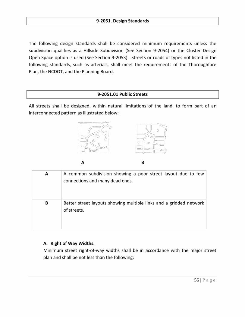
56 | P a g e
9-2051. Design Standards
The following design standards shall be considered minimum requirements unless the
subdivision qualifies as a Hillside Subdivision (See Section 9-2054) or the Cluster Design
Open Space option is used (See Section 9-2053). Streets or roads of types not listed in the
following standards, such as arterials, shall meet the requirements of the Thoroughfare
Plan, the NCDOT, and the Planning Board.
9-2051.01 Public Streets
All streets shall be designed, within natural limitations of the land, to form part of an
interconnected pattern as illustrated below:
A B
A A common subdivision showing a poor street layout due to few
connections and many dead ends.
B Better street layouts showing multiple links and a gridded network
of streets.
A. Right of Way Widths.
Minimum street right-of-way widths shall be in accordance with the major street
plan and shall be not less than the following:

57 | P a g e
TYPE OF STREET MINIMUM RIGHT-OF-WAY (FEET)
(1) Arterial 100
(2) Collector Streets - Minor 60
(3) Local or Minor (Residential Streets) 50
(5) Cul-de-sacs* 100
(6) Alleys** 20
* The distance from the edge of the pavement of the cul-de-sac to the right-of-way line
shall not be less than the distance from the edge of the pavement to the right-of-way line
on the street into the cul-de-sac
** Only allowed with a Special Use Permit in a Planned Unit Development
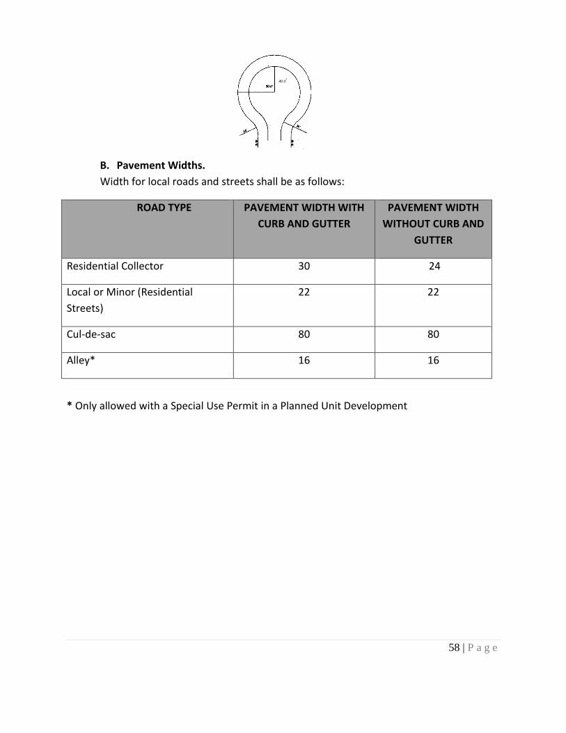
58 | P a g e
B. Pavement Widths.
Width for local roads and streets shall be as follows:
ROAD TYPE PAVEMENT WIDTH WITH
CURB AND GUTTER
PAVEMENT WIDTH
WITHOUT CURB AND
GUTTER
Residential Collector 30 24
Local or Minor (Residential
Streets)
22 22
Cul-de-sac 80 80
Alley* 16 16
* Only allowed with a Special Use Permit in a Planned Unit Development
40.0’

59 | P a g e
C. Grades. Street grades shall be as follows:
Street Type Maximum Grade Minimum Grade
without Curb &
Gutter
Minimum Grade
with Curb and
Gutter
Local or Minor 12% 0.5% 1%
Collector 9% 0.5% 1%
Alley* 12% 0.5% 1%
Cul-de-sac 5% 1% 1%
* Only allowed with a Special Use Permit in a Planned Unit Development
1. Grades approaching intersections shall not exceed five percent (5%) for a distance of not
less than one hundred (100) feet from the centerline of said intersection.
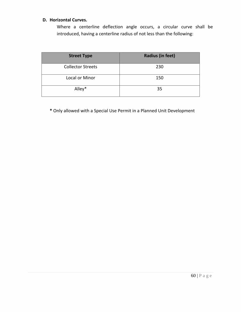
60 | P a g e
D. Horizontal Curves.
Where a centerline deflection angle occurs, a circular curve shall be
introduced, having a centerline radius of not less than the following:
Street Type Radius (in feet)
Collector Streets 230
Local or Minor 150
Alley* 35
* Only allowed with a Special Use Permit in a Planned Unit Development
61 | P a g e
E. Vertical Curves.
All vertical curves shall have such length as necessary to provide safe sight
distance based on NCDOT Minimum Construction Standards for Subdivision Roads.
F. Intersections.
Streets shall be laid out as follows:
1. Streets shall intersect as nearly as possible at right angles and no street
shall intersect at less than seventy-five (75o) degrees.
2. Street jogs with centerline offsets of less than one hundred twenty-five (125) feet shall be avoided.
3. Intersections with a major street or highway shall be at least eight hundred
(800) feet apart. This requirement may be waived by the Planning Board if
such a requirement would prevent a property owner fronting on a major
street or thoroughfare from having access to such a major street or highway.
H. Cul-de-sacs. Permanent dead-end streets are strongly discouraged except when
required by extreme topography, water, other natural features. When
permitted, no dead-end street shall be longer than 1200 feet or provide access
to more than twelve lots. Measurement shall be from the centerline of the last
intersection of a through the street to the center of the turnaround of the cul-
de-sac. Cul-de-sacs should not be used to avoid connection with an existing
street or to avoid extension of an important street.
I. Marginal Access Streets. Where a tract of land to be subdivided adjoins a
principal arterial street, the subdivider may be required to provide a marginal
access street parallel to the arterial street or reverse frontage on a minor street
for the lots to be developed adjacent to the arterial. When reverse frontage is
established, private driveways shall be prevented from having direct access to
the principal arterial.

62 | P a g e
J. Nonresidential Streets. The subdivider of a nonresidential subdivision shall
provide streets following the NCDOT Division of Highways’ Subdivision Roads
Minimum Construction Standards, July 1, 1985, as amended, and the standard of
this chapter, whichever are stricter regarding each particular item. Cross-access
between adjacent commercial subdivisions, existing and new, is strongly
encouraged wherever possible.
K. Access Points. Subdivisions that front on more than one public road shall
provide a minimum of one access point on at least two (2) public roads.
Exceptions may be made due to extreme topography, water, and other natural
features. If a subdivision has more than one access point on the same public
road, those access points must be separated by at least 300 feet or as many feet
as possible based on the property’s road frontage, topography, water, and other
natural features affecting the property.
63 | P a g e
9-2051.02 Blocks
The maximum and minimum length and width of blocks shall be as follows:
A. Length. Block lengths shall not exceed twelve hundred (1200) feet nor be less
than four hundred (400) feet. Where deemed necessary by the
Planning Board, a pedestrian path easement of at least ten (10) feet in
width may be required.
B. Widths. Blocks shall be wide enough to allow two tiers of lots of minimum depth,
except where fronting on major streets or prevented by topographic
conditions or adjoining a water area, in which case a single tier of lots
may be approved.
C. Block Numbers. Block numbers shall conform to the Town street numbering
system, if applicable.

64 | P a g e
9-2052. Lot Designs
All lots in new subdivisions shall conform to the zoning requirements of the district in which
the subdivision is located. Conformance to zoning requirements means, among other
things, that the smallest lot in the subdivision must meet all dimensional requirements of
the zoning district. It is not sufficient merely for the average lot to meet zoning
requirements.
9-2052.01 Lots
The size, shape, and orientation of lots shall reflect due consideration for topography and
drainage. Lots shall conform to the requirements of this Chapter and, also shall conform to
the following provisions.
9-2052.02 Arrangement
All lots shall front upon a public or private street. Every lot must front for at least thirty-five
(35) feet on a public or private street. Insofar as practical, side lot lines shall be at right
angles to straight lines or radial to curved street lines. Double frontage lots shall be avoided
wherever possible except where marginal access streets will be provided as per 9-2051.01 I.
65 | P a g e
9-2052.03 Lake Frontage Lots
Lake frontage lots shall have a minimum width of one hundred (100) feet at the front
building line. All other lots within four hundred and sixty feet (460) of the official pond level
of the lakes within Burke County shall have a minimum width of one hundred (100) feet at
the front building line. Lots shall also adhere to Rule 15A NCAC 02B.0243 by the NC Division
of Water Resources entitled Catawba River Basin: Protection and Maintenance of Existing
Riparian Buffers.
9-2052.04 Area
All lots shall have an area that complies with the requirements of the zoning district in
which the lot is located.
9-2052.05 Width
All lots shall have a minimum width that complies with the requirements of the zoning
district in which the lot is located.
9-2052.06 Depth
All lots shall have a minimum mean depth that complies with the requirements of the
zoning district in which the lot is located.
66 | P a g e
9-2052.07 Orientation of Lot Lines
Side lot lines shall be substantially at right angles or radial to street lines.
9-2052.08 Building Setback Lines
Building setback lines shall comply with the requirements of the zoning district in which the
lot is located.
9-2052.09 Easements
(1) Utility and drainage easements centered on rear or side lot lines shall be provided
where necessary and shall be at least twenty (20) feet in width, and ten (10) feet on
either side of the property lines. A greater width may be required for the installation
and maintenance of the facility.
(2) Pedestrian path easements of ten (10) feet in width shall be provided when such
area is required by the Planning Board.
(3) Where a subdivision is or will be traversed by a watercourse, drainage way, channel,
or stream, there shall be provided a stormwater easement or drainage right-of-way
conforming substantially with the lines of such watercourse, and an additional width
of twelve and one-half (12.5) feet from said lines of the watercourse for the
construction and maintenance.
67 | P a g e
9-2052.10 Reserved
9-2052.11 Storm Water Drainage
(1) The subdivision must meet the latest adopted requirements specified by the
state sediment and erosion control program, Town of Valdese watershed
protection ordinance, Phase II Storm Water Ordinance, national flood
insurance program, US Army Corp of Engineers regulations (Section 404 of
the Clean Water Act), and any other jurisdictional requirements under local,
State, and Federal rules or laws. Terms used in this section are as defined in
the North Carolina Erosion and Sediment Control Planning and Design
Manual.
(2) Where curbs and gutters are constructed, they shall be under the standards
of the North Carolina Department of Transportation’s “Guidelines for Curb
Cuts and Ramps for Handicapped Persons.”
(3) No surface water shall be channeled or directed into a sanitary sewer.
(4) Where feasible, the subdivider shall connect the stormwater drainage system
to an existing storm drainage system.
(5) Where an existing storm drainage system cannot feasibly be extended to the
subdivision, a surface drainage system shall be designed to protect the
proposed development from water damage.
(6) Surface drainage courses shall have side slopes of at least three (3) feet or
horizontal distance for each one (1) foot of vertical distance, and courses shall
be of sufficient size to accommodate the drainage area without flooding. The
minimum grade along the bottom of a surface drainage course shall be a
vertical fall of at least one (1) foot in each one hundred (100) feet of
horizontal distance.
68 | P a g e
(7) Where a subdivision is or will be traversed by a watercourse, drainage way,
channel, or stream, there shall be provided a stormwater easement or
drainage right-of-way conforming substantially with the lines of such
watercourse, and an additional width of twelve and one-half (12.5) of the said
lines of the watercourse for the construction and maintenance
(8) Where storm sewers, drains, and structures are installed, they shall be of a
size and type and location as required by this chapter, Town of Valdese
standards, and good engineering practices. The minimum size of storm
drains shall be fifteen (15) inches in diameter. The design flow for storm
sewer collectors shall be at least a ten (10) year storm frequency and the
design flow shall be at a twenty-five (25) year storm frequency for culverts
and storm sewers crossing streets. Storm drains carrying water from the
street right-of-way shall be placed along lot lines where feasible and shall
extend for a distance of thirty-five (35) feet minimum back of the building
line. All off-street storm drains or extensions shall be installed initially by the
subdivider and the responsibilities thereafter shall be transferred to the
purchaser(s) (or property owners association if applicable). Such extensions
shall have permanent easements centered with the pipe. The utility
easement shall be of width determined necessary for maintenance purposes
by the Town of Valdese Public Works Department based upon enclosure
depth, topography, and location of existing and proposed improvements, but
no less than 20 feet. The Town shall have a right to enter for maintenance
purposes where it determines that the public health, safety, or general
welfare constitutes a public necessity for such maintenance. However, the
Town does not otherwise maintain off-street storm drains. Where easements
are required, they shall be noted on the Final Plat.
(9) All pipes in street rights-of-way shall be constructed of N.C. Department of
Transportation approved plastic, reinforced concrete, corrugated aluminum,
or aluminized steel.
(10) Culverts shall be provided to accommodate all-natural water flow and shall
be sufficient length to permit a full-width roadway and the required slopes.
Cross drains shall be built on straight line and grade shall be laid on a firm
base, but not on rock. Pipes shall be laid with the spigot pointing in the
direction of the flow and with the end filled and matched to provide tight
joints and a smooth uniform invert. They shall be placed at a sufficient depth
below the roadbed to avoid dangerous pressure of impact, and in no case
shall the top of the pipe be less than one foot (1') below the roadbed.
69 | P a g e
(11) Where off-site runoff is to be conveyed through the subdivision, the design of
popes and/or channels shall be based on the full build-out of the off-site
drainage area(s) based on current zoning.
(12) Where stormwater is released from a storm drainage system, whether onto
the developed tract or to an off-site tract, the water shall be released in a
non-erosive manner such that downstream properties are not damaged.
Such protection shall be designed based on the design storm applicable to
the storm drainage system.
9-2052.12 Water and Sewer Utilities
A. All lots within new major subdivisions shall connect to the Town water system and
sanitary sewer system if available. These utilities shall be installed at the
subdivider’s expense.
B. Water and sanitary sewer systems shall be designed by a qualified North Carolina
registered professional engineer. System design and construction shall be per this
Chapter, Town of Valdese standards, and good engineering practices, as well as with
all applicable local, state, and federal rules and laws.
C. All easements for water and sewer lines to be installed outside the public street
right-of-way shall have a minimum width of twenty-five (25) feet, centered with the
pipeline.
9-2052.13 Pedestrian Walkways
A. All major subdivisions are encouraged to incorporate pedestrian facilities. These
facilities include, but are not limited to, sidewalks, walking trails, paths, bicycle lanes,
and greenways. New facilities shall connect to existing facilities if there are any
present.
B. All sidewalks shall conform to all current Americans with Disabilities Act (ADA)
standards. All sidewalks shall be placed in the right-of-way.
70 | P a g e
9-2053 Cluster Development and Planned Unit Development
The purpose of providing for the clustering of development and the resultant open space is
to offer recreation at or near each home, to improve the appearance of the area through
the preservation of green space, to counter the undesirable effects of urban congestion and
monotony, and to encourage group participation in community activities by all ages on a
local block or neighborhood basis. This assists in building community and personal stability
and security. Local parks, recreation areas, and other spaces in a planned neighborhood
pattern are intended to conserve areas of natural beauty, encourage cooperative
relationships between neighbors, and help promote public health, safety, and general
welfare.
The purpose of this Section is to provide an alternative subdivision procedure for single-
family use; or, governed by the minimum lot size requirements of this Subdivision
Ordinance (see Section 9-2052). This is to be accomplished by permitting the density of
dwelling units contemplated by the minimum lot size requirements to be maintained on an
overall basis when applied to specific tracts of land and thereby provide for desirable and
proper open space. Cluster subdivisions shall follow requirements for planned unit
developments in the Town of Valdese Zoning Ordinance (see Section 9-3111 and 9-3112).
71 | P a g e
9-2054 Hillside Subdivisions
Hillside Subdivisions shall comply with the following standards for Street Design:
9-2054.01 Widths
The public or private street shall have a right-of-way of not less than fifty (50) feet except
that a right-of-way of forty (40) feet will be permitted if a reduced width is essentially
unavoidable and is approved by the Planning Board.
9-2054.02 Cul-de-sacs
Permanent dead-end streets are strongly discouraged except when required by extreme
topography, water, or other natural features. The required turnaround on a dead-end
private street in a hillside subdivision shall have a roadway diameter of not less than fifty
(50) feet and a right-of-way diameter of not less than sixty (60) feet. If the street length
does not exceed three hundred (300) feet and if construction difficulties will not permit a
turnaround, the use of a “Y” or a “T” or other turning space of a design such as will allow a
vehicle with a wheelbase of at least twenty (20) feet to complete a turning movement with
a maximum of one backing movement, may be permitted if approved by the Planning
Board.
9-2054.03 Grading
Grading will not be required for the full right-of-way in hillside subdivisions if the Planning
Board determines that full grading will prevent convenient access to adjoining property or
will destroy the natural beauty of the site by excessive cut and fill. However, where the
slope extends beyond the right-of-way, slope easements shall be added where needed. The
easement shall extend ten (10) feet beyond the top of the cut where cut exceeds fifteen
(15) feet vertically.

72 | P a g e
9-2054.04 Street Grades
In hillside land subdivisions, maximum street grades permitted shall be fourteen percent
(14%) unless the Planning Board determines that a steeper grade is essentially unavoidable
and would not create excessive danger.
9-2054.05 Street Improvements for Hillside Subdivisions
Hillside Subdivisions shall comply with the following standards for Pavement:
Pavement widths shall not be less than specified in Section 9-2051.1 and 9-2050.04 except
where the average cross slope is sixteen percent (16%) or greater, pavement widths may be
reduced with Planning Board approval as follows:
A. Where the average cross slope is between sixteen percent (16%) and thirty-three
percent (33%), minimum pavement width may be reduced to eighteen (18) feet.
B. Where the average cross slope is greater than thirty-three percent (33%), no street
shall be constructed.
C. Where pavement width is reduced, on-street parking shall not be permitted.
9-2054.06 Hillside Lots
All lots in a hillside subdivision shall meet the requirements of the zoning designation of the
property.