subsurface geology, petrology and hydrothermal alterations
TRANSCRIPT

Proceedings World Geothermal Congress 2015
Melbourne, Australia, 19-25 April 2015
1
Sub-Surface Geology, Petrology and Hydrothermal Alteration of the Menengai Geothermal
Field, Kenya: Case Study of Wells MW-02, MW-04, MW-06 and MW-07
Mbia P.K, a, Mortensen A. K
b, Oskarsson N
c and Bjorn S. Hardarson B.S
d,
a Geothermal Development Company (GDC) Nairobi, Kenya
b Orkuveita Reykjavikur/Reykjavik Energy, Iceland
c School of Engineering and Natural sciences, University of Iceland
d ISOR, Iceland GeoSurvey, Grensasvegur 9, 108, Reykjavik, Iceland
Keywords: Menengai; Evolution; Magma, Petrochemistry; hydrothermal alteration; GDC (Geothermal Development Company)
ABSTRACT
Menengai is a trachytic central caldera volcano in the Kenya rift valley with abundant high-temperature geothermal activity. The
field is currently in its initial stages of development for geothermal energy in Kenya following Olkaria and Eburru fields. Regional
surface geology of Menengai is largely composed of late Quaternary volcanics. The building of a 200,000 year old trachyte shield
volcano was followed by piecemeal subsidence through two paroxysmal eruptions 29,000 and 8,000 B.P to produce a caldera of
about 84 km2 in size that has subsequently been largely filled by recent trachyte lavas. Twenty four exploration and production
wells, some of them hotter than 390oC, have been drilled in Menengai caldera by Geothermal Development Company (GDC). The
aim of this study is to reveal the evolutionary history of the Menengai volcano and to describe its igneous lithostratigraphy and
secondary mineralization in order to characterize hydrothermal processes within the field. Analytical methods used include
binocular microscope analysis, petrographic analysis, X-ray Diffractometer analysis and inductively coupled plasma (ICP-ES)
analysis. Studies of drill cutting from wells MW-02, MW-04, MW-06 and MW-07 have provided information on the stratigraphy,
hydrothermal alteration and present state of the geothermal system. Petrochemistry of these wells revealed subsurface
lithostratigraphy that includes, consolidated pyroclastic tuff, pyroclastics, basalt, trachybasalt, phonolite, trachy-andesite, syenitic
intrusive units, while trachyte constitutes over 90% of the total. Reaction of geothermal fluids with the host rocks has resulted in a
progressive hydrothermal alteration with increasing depth. A number of studies have recognized characteristic alteration zones at
Menengai based on distribution of key index alteration minerals. These zones, in order of increasing alteration grade, are zeolite-
smectite, quartz-illite and wollastonite-actinolite zone. The study reveals that Menengai evolved a complex compositional variation
with time as a result of magma fractionation, possibly in combination with crustal contamination and hydrothermal activities en
route to the surface. The study defines the geology of the Menengai into, post-caldera, syn-caldera, upper and lower pre-caldera
volcanics. Petrography and mineral chemistry of the basaltic and trachytic end members of the Menengai rocks indicate that two or
more distinct magma types were involved in the formation of the volcano. This study reveals that magma exists beneath the caldera
floor, at depth slightly over 2000 m within the summit area. This is evidenced by fresh glassy, quenched cuttings at these depths in
wells MW-04 and MW-06. This implies that the thickness of the geothermal reservoir above the magma-containing domain may be
no more than 1.5 km from the hydrostatic surface at ~400 m.
1. INTRODUCTION
The Menengai caldera volcano (centre at 35° 04’E, 0° 12’S) is located on the floor of the Kenya rift valley (Figures 1, 2). It is one
of seven late Quaternary caldera volcanoes in the inner trough of the Kenya rift valley, which are asssociated with a high thermal
gradient as a result of shallow intrusions (Figure 1). Other volcanoes within the rift, from north to south include Barrier,
Emuruangogolak, Silali, Paka, Korosi, Longonot and Suswa; all of which are associated with geothermal activity. The Menengai
volcano is located some 24 km south of Equator and about 10 km north of Nakuru town. The caldera is a prominent geographical
feature on the rift floor and its presence was noted as early as 1894 by travellers but first studied in details by McCall (1957a, b,
1964,1967). The caldera is partially filled by young rugged lava flows. Nakuru area lies at elevations between 1560 m and 2260 m
above sea level and is characterized by rather flat topography, as a result of filling of the rift by volcanic rocks, and flattening
topography by ignimbrites and other pyroclastic deposits locally covering faulting and differential uplift (e.g. KRISP working
group, 1987; Leat, 1991). The eastern shoulder of the inner trough rises some 600 m higher and forms the Bahati platform and the
western shoulder forms the Mau plateau.
The Menengai volcano is young and was formed about 200,000 years ago with the growth of 30 km3 volume lava shield (Leat
1983). It forms part of the central Kenya peralkaline province, which is characterised by its unique assemblage of peralkaline salic
magmatic systems (e.g. Macdonald and Baginski, 2009; Macdonald and Scaillet, 2006). The building of a trachyte shield volcano
was followed by piecemeal subsidence to produce, about 84 km2 large caldera. Menengai caldera has been largely filled by
younger-well preserved trachyte lavas, of post-caldera time (Jones and Lippard., 1979, Leat, 1983). The Menengai volcano is
currently in its initial stages of development for geothermal energy in Kenya by Geothermal Development Company (GDC). This is
the third geothermal field to be developed in Kenya following Olkaria and Eburru fields, which have been developed by KenGen.
Geothermal Development Company (GDC) began drilling in the Menengai in early 2011, and by April 2014, 24 wells have been
completed. The geothermal system in the Menengai provides good opportunities for studying high-temperature fluid-rock
interaction in a hydrothermal system. In this study four wells MW-02, MW-04, MW-06 and MW-07, in the Menengai geothermal
field, were used to study the extent of hydrothermal processes within different strata of the wells. However, selected samples from
well MW-08 were also used for petrological studies. Leat (1983) in his PhD work, studied the structural and geochemical evolution

Mbia et al.
2
of the Menengai caldera using surface data. The current geothermal wells make it possible to study the petrology and hydrothermal
history at depth using the cuttings from these wells with the aim of defining the subsurface conditions and evolution of the
Menengai caldera.
Figure 1: Location of the Menengai geothermal prospect and other prospects along the Kenya Rift Valley ( GDC, 2010)
In investigating the geochemical characteristics of the Menengai rocks, the fundamental objectives were to outline the petrogenesis
of the primary magma group and also outline differentiation in the primary magma. The study aimed at describing lithostratigraphy
within and below the caldera filling and define the hydrothermal processes that created the secondary mineralization within the
Menengai field. The study also aim at updating the geological conceptual model of the Menengai field based on the findings of this
research.
2. REGIONAL SETTING AND GEOLOGY
Menengai forms part of the central Kenya peralkaline province, unique assemblage of peralkaline salic magmatic systems
(Macdonald and Baginski, 2009;Macdonald and Scaillet, 2006). The building of a trachyte shield volcano was followed by
piecemeal subsidence to produce a caldera, about 84 km2 in area. The caldera has been largely filled by younger-well preserved
trachyte lavas, and a recent eruption, probably originating on the high ground north of the caldera, has blanketed the Ol’Rongai
plain (Jones and Lippard., 1979). This rift host several quaternary to recent volcanoes which has high thermal gradient as a result of
shallow intrusions. Tectonically, Menengai was divided into two systems; the Ol’rongai which has NNW trending and is older than
the NNE trending Solai system (Figure 5). In his surface geological mapping of the entire area, Leat (1984) recognized that post-
caldera lavas are located within the summit at the centre of Menengai caldera. The doming at the centre of the caldera was
interpreted as the on-going magmatic activity at depth. It is argued that caldera collapse occurred piecemeal, or Krakatau-style and
Menengai is regarded as one of the best preserved Krakatau-style calderas in the world (Macdonald et al., 2011; Leat, 1983, 1984).
The only major post-caldera modification has been the eruption of lavas into the caldera floor. Two periods of caldera collapse have
been recognized with each accompanied by the eruption of an ash-flow tuff, preceded by air-fall pumices, and both emplaced as
single flow units (e.g. Leat, 1984; Macdonald, 1984).
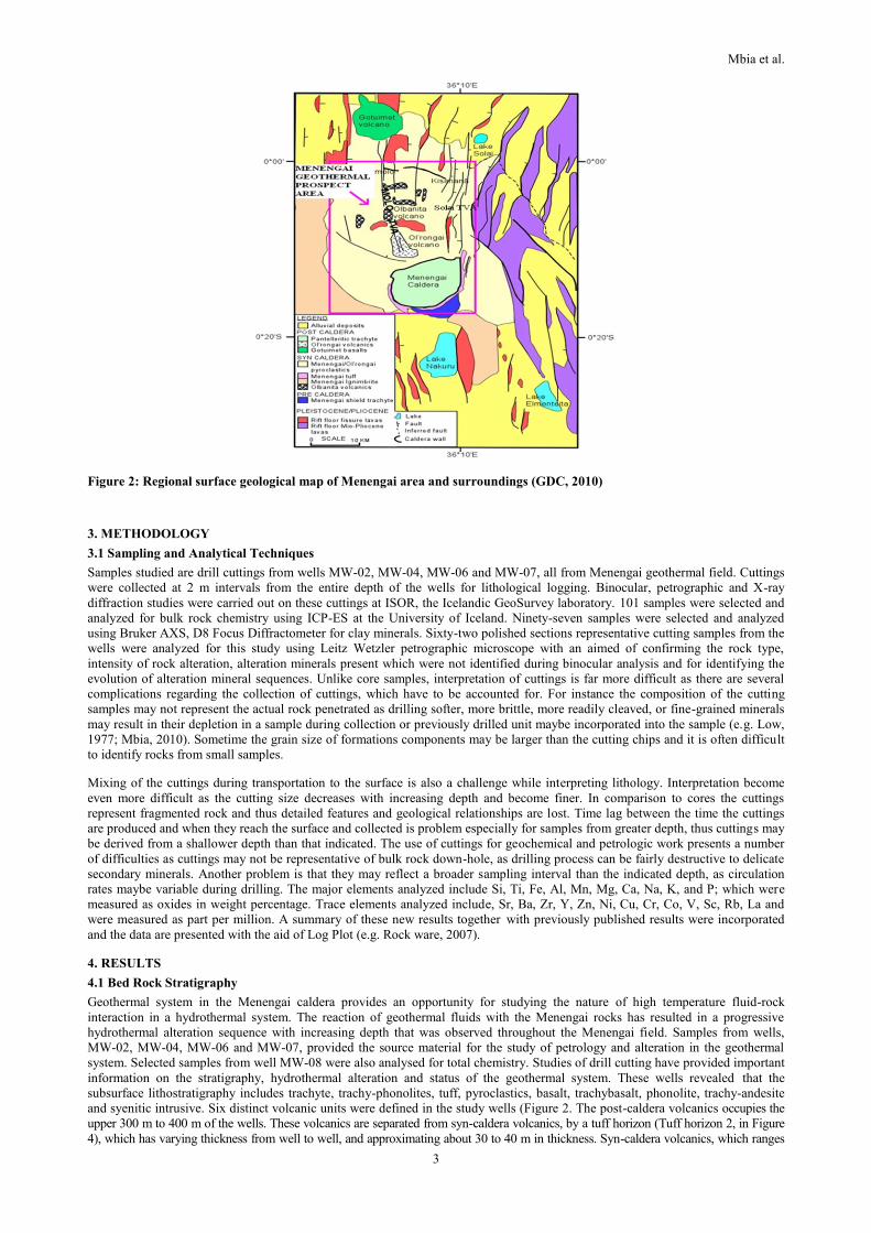
The regional surface geology of Menengai is largely composed of late Quaternary volcanics which are associated with the
development of the Kenya Rift (Figure 3). The area north of Menengai is characterized by lavas from N-S trending fissures (e.g.
Leat, 1984; Macdonald et al., 2011). These lavas are trachytic and trachy-phonolitic in composition and mainly observed to be
exposed by the scarp walls beyond the Olbanita swamps, Lomolo and Kisanana area (e.g. Leat, 1983; Jones, 1985; GDC, 2010).
They underlie ignimbrites and pyroclastics probably originating from Menengai eruptions to the south. The Pliocene eruptions that
followed the Miocene volcanics and the subsequent faulting are divided into four principal phases (Baker et al., 1988). These
phases were coupled with faulting episodes, during which time most of the structural features evolved. The first phase was the
wide-spread Mau-Kinangop tuff ash flows, (3.7-3.4 Ma). Major faulting occurred following the ignimbrite eruptions, which
converted an earlier half graben to a graben. The second phase was the eruption of the Limuru flood trachyte (2.0-1.8 Ma), which
was initiated by the progressive inward migration of the fault zones. This migration resulted in the formation of step-faulted
platforms (Mau escarpments) and the fissure eruptions of the Limuru trachyte flood lavas. Basalts and basaltic trachy-andesite form
the third and fourth phases, respectively (1.65-0.9 Ma). These last two phases were triggered by faulting that followed the Limuru
flood trachytes. This faulting was triggered by a convecting mantle, opening up fractures, which served as conduits for Quaternary
volcanic activity and the development of many large shield volcanoes of silicic composition in the axis of the rift (Baker et al.,
1988).
Mbia et al.
3
Figure 2: Regional surface geological map of Menengai area and surroundings (GDC, 2010)
3. METHODOLOGY
3.1 Sampling and Analytical Techniques
Samples studied are drill cuttings from wells MW-02, MW-04, MW-06 and MW-07, all from Menengai geothermal field. Cuttings
were collected at 2 m intervals from the entire depth of the wells for lithological logging. Binocular, petrographic and X-ray
diffraction studies were carried out on these cuttings at ISOR, the Icelandic GeoSurvey laboratory. 101 samples were selected and
analyzed for bulk rock chemistry using ICP-ES at the University of Iceland. Ninety-seven samples were selected and analyzed
using Bruker AXS, D8 Focus Diffractometer for clay minerals. Sixty-two polished sections representative cutting samples from the
wells were analyzed for this study using Leitz Wetzler petrographic microscope with an aimed of confirming the rock type,
intensity of rock alteration, alteration minerals present which were not identified during binocular analysis and for identifying the
evolution of alteration mineral sequences. Unlike core samples, interpretation of cuttings is far more difficult as there are several
complications regarding the collection of cuttings, which have to be accounted for. For instance the composition of the cutting
samples may not represent the actual rock penetrated as drilling softer, more brittle, more readily cleaved, or fine-grained minerals
may result in their depletion in a sample during collection or previously drilled unit maybe incorporated into the sample (e.g. Low,
1977; Mbia, 2010). Sometime the grain size of formations components may be larger than the cutting chips and it is often difficult
to identify rocks from small samples.
Mixing of the cuttings during transportation to the surface is also a challenge while interpreting lithology. Interpretation become
even more difficult as the cutting size decreases with increasing depth and become finer. In comparison to cores the cuttings
represent fragmented rock and thus detailed features and geological relationships are lost. Time lag between the time the cuttings
are produced and when they reach the surface and collected is problem especially for samples from greater depth, thus cuttings may
be derived from a shallower depth than that indicated. The use of cuttings for geochemical and petrologic work presents a number
of difficulties as cuttings may not be representative of bulk rock down-hole, as drilling process can be fairly destructive to delicate
secondary minerals. Another problem is that they may reflect a broader sampling interval than the indicated depth, as circulation
rates maybe variable during drilling. The major elements analyzed include Si, Ti, Fe, Al, Mn, Mg, Ca, Na, K, and P; which were
measured as oxides in weight percentage. Trace elements analyzed include, Sr, Ba, Zr, Y, Zn, Ni, Cu, Cr, Co, V, Sc, Rb, La and
were measured as part per million. A summary of these new results together with previously published results were incorporated
and the data are presented with the aid of Log Plot (e.g. Rock ware, 2007).
4. RESULTS
4.1 Bed Rock Stratigraphy
Geothermal system in the Menengai caldera provides an opportunity for studying the nature of high temperature fluid-rock
interaction in a hydrothermal system. The reaction of geothermal fluids with the Menengai rocks has resulted in a progressive
hydrothermal alteration sequence with increasing depth that was observed throughout the Menengai field. Samples from wells,
MW-02, MW-04, MW-06 and MW-07, provided the source material for the study of petrology and alteration in the geothermal
system. Selected samples from well MW-08 were also analysed for total chemistry. Studies of drill cutting have provided important
information on the stratigraphy, hydrothermal alteration and status of the geothermal system. These wells revealed that the
subsurface lithostratigraphy includes trachyte, trachy-phonolites, tuff, pyroclastics, basalt, trachybasalt, phonolite, trachy-andesite
and syenitic intrusive. Six distinct volcanic units were defined in the study wells (Figure 2. The post-caldera volcanics occupies the
upper 300 m to 400 m of the wells. These volcanics are separated from syn-caldera volcanics, by a tuff horizon (Tuff horizon 2, in Figure
4), which has varying thickness from well to well, and approximating about 30 to 40 m in thickness. Syn-caldera volcanics, which ranges

Mbia et al.
4
from about 300-450 m depth, was recognized as the third unit and was separated from the upper pre-caldera volcanics by tuff and
pyroclastic layer. Lower pre-caldera volcanics which has different chemical characteristic from the upper pre-caldera volcanic occupies the
lower section of the wells from about 1200 m to the bottom. However, well MW-02 shows distinct chemical characteristics compared to
the other studied wells and was not used for stratigraphical correlation purpose, though its results were compared with other wells for
interpretation purpose.
The study show that the dominant rock unit from the study wells is trachyte, which constitutes over 90% of the total rocks and is
intercalated by minor tuff layers. Minor phonolite and rhyolitic rocks were also noted, probably formed by fractional crystallization
of trachytic magma. Basalt occurs as minor intrusions at deeper zones. For the purpose of outlining different eruption episodes
recorded within the Menengai caldera, trachyte was classified into three varieties based on their texture, where variety one has
abundant large feldspar phenocryst in a fine grained matrix, classified as medium grained trachyte. Variety two are fine grained
trachytes with smaller feldspar phenocryst, the distinction being in the quantity of phenocrysts. Third variety consist of fresh
intrusions of trachytic lava, which were classified as syenite (coarse grained, holocrystalline trachyte), indicating that there were
episodes of magma rejuvenation during and after the Menengai shield formation process (Figure 3). Wells MW-04 and MW-06
were drilled into magma, resulting in fresh quenched glassy cuttings at 2080 m and 2172 m depth respectively, suggesting a
shallow heat source most likely a magma intrusion below the caldera summit. A number of studies have recognized characteristic
alteration zones at Menengai based on distribution of key index minerals. Syn-and post-caldera volcanics and lake sediments
completely cover the contact between the volcanics of the pre-caldera shield of Menengai and its underlying basement formation.
From total chemistry, Menengai trachyte are typically Potassic (k2O>Na2O) (Figure 10). The lava exhibits variation in various
depths where fractures allow water to interact with the rocks causing varying degrees of alteration. Furthermore, the composition of
the trachyte is different which leads to the theory that eruption took place in several episodes. The shallow depth lava (less than 100
m deep) has few vesicles infilled with amorphous silica and zeolites. Bulk rock chemistry has revealed some of the rock cuttings
belong to phonolitic group which was as a result of fractional crystallization of trachytic magma. From binocular analysis, it was
difficult to differentiate phonolite from trachyte at depth and especially due to high rate of alteration as a result of hydrothermal
activities in the caldera. Sanidine occurs as phenocrysts and also as bulk of groundmass (matrix). Nepheline occurs as either
interstitially or in well-formed microphenocrysts while pyroxene occurs characteristically as slender needles, often abundant to
colour the rock green. The principal dark-coloured minerals are pyroxene, aegirine or titaniferous augite.
Figure 3: Litho-stratigraphical correlation and volcanic units of wells MW-04, MW-06 and MW-07
4.2 Stratigraphic Correlation
A geological cross-section across wells MW-02, MW-04, MW-06 and MW-07 of Menengai geothermal field is shown in figure 3
below. Spatial variation of trace elements such as Zr, Zn, Rb, La, suggest well MW-02 has different spatial trends compared with
the other wells suggesting that the lava is from different magma source. This lava plotted together with the surface regional data
implying similar source (Figure 9 and 10). Therefore well MW-04, MW-06 and MW-07 were used for correlation purpose as their
chemistry indicate similar source with well MW-02 isolated.
The structures in the Menengai caldera are faults and fractures which are interpreted by displacement in the rock units and by the
loss of circulation during drilling resulting in unconformities within the lithological units. Subsurface faults therefore favour the

Mbia et al.
5
flow of thermal fluids making the Menengai field highly permeable and good production field. These faults are however not
obvious on the surface in the caldera due to the post caldera lava which filled up the caldera floor. The upper 300 m is composed of
Holocene post caldera lavas, tuff and pyroclastics.
Figure 4: Lithostratigraphy, alteration zones and distribution of secondary minerals with depth in well MW-04. Feed points
are inferred from loss of circulation and temperature logs.
Figure 5: Lithostratigraphy, alteration zones and distribution of secondary minerals with depth in well MW-06. Feed points
are inferred from loss of circulation, penetration rates and temperature logs.

Mbia et al.
6
The post caldera volcanics in wells MW-04, MW-06 and MW-07 correlate well and these volcanics are dominated by medium
grained trachyte lava, though at the surface fine-grained thin lava were found in all wells (Figure 10). The uppermost zone is
characterized by unaltered lava, intercalated by thin pyroclastics layers and it extends from the 0-386 m, 0-444 m, 0-430 m depth in
wells MW-07, MW-06 and MW-04 respectively.
Figure 6: Lithostratigraphy, selected alteration minerals, temperature logs in correlation with the status of geothermal
system in well MW-04 and MW-06.
Figure 7: Lithostratigraphy, penetration rate and aquifers in well MW-04. Aquifers are inferred from loss of circulation,
penetration rate and temperature logs.
Syn-caldera volcanics was dominated by medium grained trachyte lava, which extends from about 350 m to about 700 m depth.
This volcanic unit was separated from post-caldera volcanics by a tuff layer (tuff marker horizon 2, in Figure 10) and below by tuff
marker horizon 1. The lava sequence within this zone correlates well though with minor variation in depth and thickness. The pre-

Mbia et al.
7
caldera volcanics, are dominated by fine-grained trachyte and medium grained. The trachytes are intercalated by thin tuff and
pyroclastic layers. The pre-caldera volcanics sequence is characterized by scarce syenitic dykes.
Lateral continuity of the structures of the Menengai caldera filling is complicated by faults and fractures causing displacement of
rock-blocks which resulted in variation with depth within volcanic units from well to well. Slight vertical displacement of rock
units may block horizontal permeable layers but the fault system assures abundant vertical aquifers within fractured stratigraphic
units. Subsurface faults, which were interpreted from fractured cuttings, are associated with Molo and Solai TVAs, and favour the
flow of thermal fluids making the Menengai field a highly permeable and good production field. These faults are, however, not
obvious on the surface within the caldera due to the Holocene post caldera lavas, tuff and pyroclastics that form the uppermost 300
m of the caldera filling. The age of the marker horizon 1 is 12,500 years (Leat, 1991). The lower pre-caldera sequence starts from
about 1200 m depth to the bottom of the study wells.
4.3 Alteration Mineralogy
Hydrothermal fluids carry metals and anions close to equilibrium with the secondary minerals. The source of hydrothermal fluids is
mainly meteoric water (or seawater) since the low water content of magmas is insignificant in geothermal system. Magma
degassing and leaching of intrusive rocks are the principal sources of anions in hydrothermal system within active volcanic centers.
According to Armannsson (2012), excess water circulates through the surrounding rocks and may scavenge and transport metals to
sites where they can be precipitated as ore minerals. Hydrothermal fluids also circulate along fractures and faults. A formation
which has a well-developed fracture system, may serve as an excellent host rock for hydrothermal alteration. Fluids that flow
through open space fractures may precipitate secondary minerals along the walls of the fracture, eventually filling it completely
(Armannsson, 2012; Browne, 1984; Fridleifsson, 1991, 1983). The drill cuttings from the Menengai geothermal field which include
lavas, intrusions and tuffaceous fragments, show distinct alteration characteristics. Tuffs and pyroclastics fragments are typically
highly altered as compared with the insignificantly altered hard-rock cuttings from the same depth interval. Lavas and intrusives are
generally more resistant to alteration and hence less altered. Hydrothermal alteration progresses at different rates in the aquifer
rocks. At a given pressure and temperature the rate is dependent on lithology and permeability as well as salinity and volatile
content of the fluid (e.g. Browne and Ellis, 1970; Franzson, 2010; Marks et al., 2010).
In the Menengai wells, calcite, pyrite, smectite, zeolites, chalcedony, quartz, chlorite, albite, epidote, wollastonite, illite and
actinolite occurs as the main alteration minerals (Figure 11). Zeolite was noted from 200 m depth and it disappears at about 450 m
depth. Zeolite presence in a geothermal system indicates formation temperature between 40oC and 120oC (Franzson, 1998).
Smectite was noted from 398 m and disappears after 650 m depth. Secondary quartz was first noted at 740 m depth and persisted to
the bottom of the well. Its presence indicates formation temperature of above 1800C. Actinolite was first noted from 1880 m depth
to the bottom of the well. Adularia, Illite, albite, wollastonite and actinolite were first noted at 1100 m, 1200, 1200 m, 1412 m, and
1880 m, respectively (Figure 11). All these hydrothermal minerals are mainly present in veins, vug, and vesicles and as replacement
of primary minerals in volcanic rocks. These minerals form when circulating fluids and reservoir rocks react resulting in a
compositional change of both the solid and the fluid (e.g. Armannsson, 2012; Browne, 1984; Larsson et al., 2001). This reaction
normally involves dissolution of major rock-forming minerals and precipitation of hydrated secondary silicates, carbonates, sulfates
and sulfides.
Browne (1984) suggested that the products of geothermal alteration are controlled by temperature, original rock composition,
reaction time, flow, chemical composition of water (e.g. CO2, H2S), permeability, and these products in turn control the chemical
composition of the fluid. Pressure also plays a role in hydrothermal alteration though variation within geothermal reservoir rarely
exceed 200 bars, which is a small change though has an impact on the boiling zone of the fluid and minerals solubility (e.g.
Armannsson, 2012; Lagat, 1995). High alteration intensity and deposition of secondary minerals were noted more in aquifer zones
compared to fresh or unaltered shallow section of the wells.
Pyroxene occurs mostly as a groundmass mineral and occasionally as phenocrysts varying from aegirine to augite. In thin sections
pyroxenes are identified by two perpendicular cleavage orientations, inclined extinction. Pyroxene was observed to alter to clays as
well as to actinolite at higher temperatures.
Feldspars in the Menengai rocks are generally plagioclase in mafic rocks and sanidine in felsic rocks. Sanidine and plagioclase
occur as the major groundmass mineral as well as phenocrysts. In thin sections, the sanidine occurs as fine grained and elongated
crystals showing typical trachytic texture. It also occurs both in the groundmass and as phenocrysts in rocks exhibiting porphyritic
textures. The sanidine phenocrysts were readily identified by its low relief and simple twinning. At shallow depths, the feldspars are
relatively unaltered but become altered progressively with depth into albite, adularia and occasionally to clays or calcite. Epidote
sometimes replaces dissolved feldspar, presumably due to the local availability of Al and Ca that react with ferric iron to form
minerals of the epidote-clinozoizite series.
Fe-Ti oxides and other opaque minerals occur sparely distributed in all wells and usually show high resistance to alteration. The
main opaque and oxides present in the Menengai are ilmenite and magnetite, which usually become altered into pyrite and titanite.
4.4 Distribution and Description of Hydrothermal Alteration Minerals
Oxides Fe-oxides are distributed broadly especially on fractured cuttings and occurs mainly as hematite. At depth, oxidation is
mainly associated with baked contacts between syenitic intrusions and host rocks. It was also noted between pyroclastics layers
intercalating the lavas which were inferred as a period between eruption episodes. Calcite is abundant and occurs within almost all
lithologies in all wells below 200 m but diminishes at temperatures above 280oC. Calcite crystals have obvious cleavage. In the Menengai,
calcite occurs as a replacement of rock forming mineral and volcanic glass and as platy crystals infilling voids.
Clays in Menengai appear sparsely scattered throughout the lithological sequence. Low temperature clays such as smectite form at
temperatures as low as 50oC and can persist to temperatures of about 200⁰C. On the other hand, high temperature clays such as

Mbia et al.
8
chlorite and illite form at temperatures of above 230⁰C and 220oC respectively. Smectite were only detected in minor amounts by
XRD analysis. It is a swelling clay and swells from 12.93-13.94Å to 15-16Å in responding to glycol treatment (e.g Putnis, 1992).
Minor smectite were detected from 190 m to 720 m in well MW-06, from 350 m to 1100 m in well MW-06 though was not
identified in well MW-02 and well MW-07 as illustrated in Figures 11, 12, 13 and 14). Smectite are shallow low temperature stable
minerals and their presence in a geothermal field indicates temperature ranging between 50 and 2000C.
Zeolites are low temperature stable hydrothermal minerals, which are thermodynamically metastable at about ˂1100C. The zeolites
found in Menengai are scolecite/mesolite and cowlescite, which occurs generally as vesicle infillings in shallow depths. Zeolites
were first detected from 180 m depth in well MW-06 and their deepest occurrence is in well MW-07 at about 500 m depth (Figure
12).
Chlorite in the Menengai occurs in association with epidote, calcite and quartz mainly as a replacement of low temperatures clays.
Chlorite occurs at temperature over 2300C (Franzson, 1998). In the studied wells, it first occurs below 950 m depth in well MW-04.
Illite occurs as replacement of K-feldspars and occurs in veins and vesicles in the Menengai field. It was identified in XRD analysis
with its distinct peak at 10 Å, but the dominating illite-clay occurrence is in interlayered illite-vermiculite. Illite occurrence depict
temperatures >220oC in active geothermal field. Illite occurs in association with albite, calcite, pyrite and quartz in study wells.
Pyrite is abundant throughout most cuttings intervals in all four wells and usually indicates the degree of permeability in
geothermal systems. In the Menengai wells, pyrite appears as shiny yellowish gold cubic crystals and sometimes disseminated on
the rock surface as well as vein deposits. Pyrite persisted from the surface to the bottom of virtually all wells.
Chalcedony is low temperature silica compound which is normally white, massive and extremely fine grained and usually transforms into
quartz at higher temperatures. It appears bluish and semi-transparent or translucent under the binocular microscope. They are
cryptocrystalline and range from colorless, white, or bluish-grey in colour and are usually deposited in vesicles, fracture and also as veins in
all wells. In the studied wells chalcedony occurs at shallow depth to about 800 m and thereafter occurring rarely to about 900 m. In the
deeper sections of the wells the apparent chalcedony is most probably a cryptocrystalline aggregate of alpha quartz. Chalcedony indicates
temperatures below 1800C.
Secondary quartz occurs as replacement of chalcedony at depth and was found deposited mainly in veins and vesicles. It´s presence
in a geothermal system indicates temperatures of above 1800C (Franzson, 1998). Secondary quartz was identified in cuttings by its
typical euhedral shape. Generally it occurs as colorless and occasionally as white euhedral to subhedral crystals.
Epidote is a product of hydrothermal alteration of various minerals (feldspar, mica, pyroxene, amphiboles, clays, etc.) in igneous
rocks. The presence of epidote as a hydrothermal alteration mineral is always a good sign as it indicates temperatures of over 230⁰C
(Table 2). Epidote is rare in the Menengai as expected due to low iron content of the rocks and reducing condition that may arise
from volcanic emanations (hydrogen, hydrogen sulfide) that favors the formation of Fe (2+) minerals such as pyrite. Since epidote
is essentially the host mineral for Fe (3+), it requires oxidized environment. In systems with low total iron the Fe (3+) also resides in
magnetite and specially hematite making epidote less probable secondary mineral. Epidote was first encountered at 1090 m in well
MW-06 though found in sparse amounts. Where it occurs, it fills fractures and vesicles and occurs as a replacement of primary
plagioclase and pyroxene. In thin section, it appears as yellowish green in colour has prismatic crystals. Good cleavage was visible
in some crystals.
Table 1: Some temperature dependent minerals in the Menengai geothermal field and their temperature implications
(Modified from Reyes, 2000; Kristmannsdottir, 1979; Franzson, 1998).
Minerals Min. Temp.(OC) Max. Temp.(OC)
Zeolite 40 120
Smectite 30 <200
Calcite 50-100 280-300
Quartz 180 >300
Albite 180 >300
Adularia 180 >300
Illite 220 >300
Epidote 230 >300
Chlorite 230 >300
Wollastonite 270 >300
Actinolite 280 >300
Adularia forms minute anhedral to euhedral crystals that are pseudo-orthorhombic and are usually diamond shaped. It occurs as
replacement of sanidine and is occasionally deposited in veins as well as forming incrustations in fissured rocks. Where it occurs as

Mbia et al.
9
a replacement of sanidine or K-feldspars, there is nearly an isochemical transformation to an optically and structurally different
phase-adularia. In pseudomorphs after sanidine phenocryst, it produces a streaky extinction suggesting that the pseudomorphs are
made up of numerous overlapping crystals of rhombic section. Adularia occurs in wells MW-04 at 1100 m to the bottom of the
well. In well MW-02 and MW-07, adularia was not found.
Albite is a secondary mineral which by the breakdown of feldspars. The term Albitization here is referred to replacement of primary
K-feldspar and plagioclase phenocryst by hydrothermal albite. Albitized K-feldspar has a low refractive index and shows no zoning
but typical chessboard like twinning is common. Albite alteration occurs from about 500 m to deeper zones in the Menengai.
Wollastonite was noted at depth of the researched wells and was associated with the diminishing calcite. It is common in skarns or
contact metamorphic rocks formed by the calcite-quartz reaction:
CaCO3 + SiO2 => CaSiO3 + CO2
Wollastonite is a metastable mineral at temperatures above ≥ 2700C. It is an alteration mineral which is usually associated with
contact metamorphism and therefore its occurrence is probably related to the numerous intrusions in the caldera summit area. In the
cuttings it appears as a white, colorless or grey and fibrous, aggregate of elongated fine radiating crystals. It rarely occurs as a
single crystal and has an acicular habit. It is colourless in thin section with low interference colour of first order grey. The intense
CO2 reported from the Menengai wells can be explained as a result of magma degassing and disintegration of calcite and the
formation of wollastonite. It occurs mainly from 1450 m depth, in well MW-04 and from 1780 m in well MW-06, and prevails
down to the bottom of the wells. Wollastonite was not found in well MW-02 and well MW-07.
Actinolite is a high temperature mineral, mostly found in altered and metamorphic iron rich basic rocks. It is an intermediate solid
solution member between ferro-actinolite and tremolite. Usually, it appears as green to grey-green groundmass mineral, although
the colour varies depending on the amount of iron. It usually occurs as radiating, acicular crystals or a massive to granular
aggregates in the groundmass. In thin section, it is pale green to dark green with strong pleochroism and moderate relief. The
interference colours of actinolite depend on the iron and magnesium content and are usually green or brown. It is formed by the
replacement of ferromagnesian minerals in association with epidote and chlorite. Actinolite appeared from 2020 m in well MW-06
and at 1964 m in well MW-07. Actinolite was not found in well MW-02 and MW-04. Actinolite is a high temperature mineral
which indicates temperature of above 2800C and occurs as a replacement product of chlorite or pyroxene.
4.5 Vein and Vesicle Fillings
Veins form where the fluids flow through open space fractures and precipitate mineralization along the walls of the fracture,
eventually filling it completely. The form of mineralization and alteration associated with faults is highly variable, and may include
massive to fine-grained, networks of veinlet’s, and occasionally vuggy textures. Deposition of alteration minerals in veins, vesicles
and vugs depend on various factors such as porosity, fluid composition, temperature, permeability and duration of the interaction of
fluid and the host rock. In geothermal veins, the initial minerals to are usually fine grained clays and low temperature silica
(chalcedony). As the temperature increases and hydrothermal alteration progresses, this low temperature metastable minerals
assemblage transforms towards equilibrium at high-temperature yielding minerals such as wollastonite, quartz, chlorite, actinolite
epidote etc. Pyrite infill vesicles at a wide range of temperatures imply the steady flux of sulfide in the permeable rocks. Vein
minerals in Menengai field include calcite, quartz, prehnite and epidote. Due to use of rotary drilling in the study wells, most of the
macroscopic vein fillings and amygdales textures were lost.
4.6 Hydrothermal Mineral Zonation
Some secondary minerals are good geothermometers and are stable at specific temperatures, crystallizing at distinct temperature
range (Reyes, 2000). With few exceptions, minerals that provide information on their formation temperatures are those that contain
in their structures either (OH) or nH2O (Reyes, 2000). They include clays, prehnite, zeolites, garnet and amphiboles. The
distribution of alteration minerals gives information about formation temperature at the time of deposition. Reaction of host rock
with hydrothermal fluids has formed a prograde hydrothermal alteration sequence with depth. Alteration zones in the Menengai
geothermal system have been defined by the presence of one or more index minerals. The distribution of key indicator minerals
overlaps to some extent, so the top of the zone is normally defined at the depth when reasonable index mineral appears. Therefore,
depth boundaries vary from well to well. Four hydrothermal alteration zones were identified within Menengai geothermal field.
Unaltered zone (0-380 m)
This zone represents the shallow depth of the study wells. It extends from 0-444 m, 0-430 m and from 0-386 m depth in wells,
MW-04, MW-06 and MW-07 respectively. This zone represents the fresh young post-caldera lava. This zone is characterized by
fractured fresh and mildly oxidized lava with some minor tuff intercalations.
Smectite-zeolite zone (380-750 m)
This zone forms the lowest grade alteration zone and is mainly represented by cowlescite and mesolite as the index minerals. In all wells
this zone is characterized with abundant calcite and appearance of some pyrite. Zeolite decline in abundance with depth in this zone and
illite and quartz appears. In well MW-02, smectite appears from 300 m to 800 m and well MW-07; smectite persisted to 1200 m depth.
However it disappears at about 650 m and 700 m in well MW-04 and MW-06 respectively.
Quartz-Illite zone (750-1150 m)
This zone corresponds with the upper zone of the geothermal reservoir in Menengai system. The zone is characterized by the
occurrence of secondary quartz which occurs as a replacement of chalcedony and illite clays. Quartz indicates temperature over
1800C (Reyes, 2000). The depth and thickness of this zone is variable from well to well. Illite started appearing from 500 m and

Mbia et al.
10
620 m respectively in well MW-04 and MW-06. Its presence indicates formation temperature of over 220OC. However these
minerals started appearing at slightly deeper zones in well MW-02 and MW-07 as they occur from 1200 m and 800 m depth in well
MW-02 and MW-07 respectively.
Illite-Epidote zone (1150-1750 m)
This zone forms the deepest reservoir zone in well MW-02 and MW-07. The appearance of epidote indicates formation temperature
of above 230oC. Epidote was first recognized in well MW-02 and well MW-07 from 1400 m 1100 m respectively.
Wollastonite-actinolite zone (1750-2190 m)
Wollastonite and actinolite were only found in well MW-04 and MW-06. Actinolite and wollastonite were not found in wells MW-
02 and MW-07. Wollastonite and actinolite indicate formation temperature of over 2700C and over 2800C respectively (Franzson,
1998). Wollastonite was first identified at about 1800 m and 1600 m depth in well MW-06 and MW-04 respectively. This is the
final and the deepest alteration zone. Actinolite was first recognized in well MW-04 and well MW-06 at 1840 m and 2064 m.
Figure 8: Alkali-silica plot showing the compositional range of Menengai subsurface rocks from wells MW-02, MW-04,
MW-06, MW-07 and MW-08 and the neighboring volcanic centres.(modified from Clarke et al., 1990; Macdonald,
2006; Mitchell, 1986)
Figure 9: Al2O3 versus FeO classification of the Menengai rocks and the neighboring volcanic centres (modified from
Macdonald, 1974).
4.7 Alteration Minerals Geothermometry
Hydrothermal index minerals such as epidote, quartz, wollastonite and illite were used in this study to compare the alteration
minerals and measured temperature. The formation of alteration minerals evolves progressively from low-temperature to high-
temperature minerals with the last mineral to precipitate appearing on top or at the centre of the sequence. The sequence of

Mbia et al.
11
deposition can therefore be used to determine the thermal history and relative time scale of alteration minerals within geothermal
system (e.g. Franzson, 2010). Well MW-04 and MW-06 indicates higher formation temperatures than the alteration temperature
(Figure 9).
Figure 10: Major elements plotted against SiO2 and FeO versus Al2O3 of wells MW-02, MW-04, MW-07 and MW-08.
The inferred reservoir temperature is between 2000C and over 2700C based on the occurrence of quartz, illite, epidote, wollastonite
and actinolite as shown in Figure 9. However, the measured temperatures from well MW-04 and well MW-06 below 1900 m depth
in the wells recorded temperature of over 3500C suggesting the system is heating up. Fluid inclusion studies on quartz and calcite
(Mibei, 2012) indicate that the system is heating up within the caldera summit area where the study wells are located. Aquifers in
well MW-06 were identified in five distinct areas; between 350-400 m, 1000- 1100 m, 1450-1500 m, 1800-1900 m and between 2050-
2090 m depths. With the production casing set at 1088 m depth, the upper shallow cold aquifer was cased off. The feed-zone at 1800 m
depth reached temperatures of almost 3500C (slightly below the critical temperature of water, 3740C), implying that the steam at this zone
may be superheated as was later suggested to be as a result of shallow heat source evidenced by the presence of fresh chilled and quenched
glass cuttings at 2174 m depth. It is interesting how hot the well is only after 8 days of heating up (Figure 6). Normally the well requires
significantly longer heating up time to reach anything approaching the formation temperature. The MW-02 well was sunk in pre-caldera
volcanics and therefore it may be located by the Menengai caldera fault zone where vertical permeability may allow cold inflow to
penetrate into the well, as the production casing was set at 791 m depth, and cool down deeper and hot aquifers.
4.8 Whole-Rock Chemistry
Petrologists have developed several ways of classifying different rock types. As techniques for chemical analyses of silicate rocks
were developed, it was soon recognized that these compositional data are valuable in the development of petrological concepts.
Since then, various methods of manipulating chemical data, and chemical classifications, have been published. However, no single
method is conclusive in classifying all igneous rocks. Traditionally, the so called TAS diagram based on total alkalies (Na2O+ K2O)

Mbia et al.
12
and silica concentrations, has been used to separate alkalic and sub-alkalic rocks. The diagram was first proposed by Iddings (1892)
and has been further developed, by several authors, for example, and Harker (1909), Le Bas et al. (1986), Macdonald and Katsura
(1964) and Mitchell (1986). In Figure 11, the Menengai samples are plotted on the TAS diagram. The rocks show a chemical
variation ranging from basalt through to trachyte and rhyolite in composition. It is instantly noticeable that the MW-02 samples do
not plot with samples from the other analysed wells; infact there is barely an overlap. The samples however, plot with published
analyses of surface rocks which may indicate they were formed from a similar magma source as the regional rocks. These samples
from well MW-02 plot in lesser evolved trachyte and therefore means, volcanics might have a similar source with the regional rift
rocks (Figure 13). The variation and composition of both major and trace elements shows that well MW-02 has different trends and
concentrations compared with the other wells, suggesting that the lava was derived from a different magma source.
Figure 11: Zirconium variation with other selected elements from wells MW-02, MW-04, MW-06, MW-07 and MW-08.
In Al2O3 versus FeO diagram, the studied subsurface samples display two unique distinct trends, with well MW-02 showing similar
chemical clustering with surrounding surface samples from Menengai while the other wells, MW-04, MW-06 and MW-07 cluster
between pantellerites and comendite (Figure 21). Samples selected from well MW-08 plots in the pantelleritic trachyte field. The
two plots clearly show the importance of fractional crystallization even though other processes like magma mixing, assimilation
and hydrothermal activities may possibly be involved. This is addressed in subsequent sections. Geochemical trends for volcanic
rocks represent a ‘liquid line of descent’. This is the path taken by residual liquids as they evolve through the differential
withdrawal of minerals from the magma (e.g. Cox et al., 1979).
4.9 Geochemical Evolution of the Menengai Caldera
The discussion on the geochemistry of the Menengai is based on 101 new whole-rock chemical analyses of drill cuttings from wells
MW-02, MW-04, MW-06, MW-07 and MW-08. The results are compared and supplemented by the available surface geochemical
data (Clarke et al., 1990; Leat 1983; Macdonald et al., 2006, 1994). Several elements were plotted in order to discriminate, what
magmatic processes control the geochemical variation observed in the subsurface samples from the Menengai wells. All major

Mbia et al.
13
elements were plotted against SiO2 (Harker diagrams) for better interpretation (Figure 8). This study reveals that, TiO2, FeO, MgO
and CaO all show rather similar behavior and decrease as SiO2 increases. These coherent groups, correlate strongly with each other
as they are removed from the melt during fractional crystallization of ferromagnesian minerals and feldspar, whereas FeO content
increase in more fractionated melts (Figure 22). Na2O and K2O are mobile and are rather easily leached from rocks during fluid-
rock interaction and many rocks are in fact more scattered in those elements (Figure 8).
Figure 12: Trace element variation within volcanic units in Menengai wells. Series 1 from well MW-07, series 2, well MW-
04 and series 3 from well MW-06.
Figure 13: Trace element variation within volcanic units in wells MW-07, MW-04 and MW-06.
However, in spite of a few low-Na samples, most samples in this study surprisingly show little scatter as observed in relatively
fresh surface rocks. Incompatible elements such as Zr, Rb and La found in the study wells are generally believed to be enriched in
evolved magma (Figure 9). This is mainly interpreted to be as a result of crystal fractionation.
Ba and Zr show significant variation ranges and were used extensively in this study to depict the evolution episodes in different
stratus. Zr was used in this study as an index of fractionation because of its incompatible character for early rock forming minerals

Mbia et al.
14
and accordingly its large variation (0-1500 ppm, Figure 23). Zr also has high solubility in peralkaline melts (Leat, 1993) and has
been used as abscissa in geochemical plots from many volcanoes of the Kenya rift valley. In the post-caldera volcanics, high Zr was
recorded with very low Ba values. The same trend is repeated in the lower pre-caldera volcanics. This trend suggests the two
volcanic units being more evolved compared to the syn-caldera and upper pre-caldera volcanics (Figure 24). Basaltic intrusive
samples clearly show very low Zr with high iron suggesting a different source for the basalts as compared to the more evolved
rocks. A total of 13 trace elements were plotted in different variation and spider-diagrams. The distribution of trace elements
suggests different evolutionary history for different volcanics as was depicted from different incompatible elements such as Ba and
Zr (Figures 24 and 25).
Figure 1: Lithostratigraphy and spatial variation of zirconium in wells MW-02, MW-04, MW-06 and MW-07.
Figure 15: Lithostratigraphy and spatial variation of barium in wells MW-02, MW-04, MW-06 and MW-07.
Averages of trace elements from each volcanic unit, from each well were plotted together for interpretation (Figure 12). The results
show comparable trends in wells MW-04, MW-06 and MW-07. The post-caldera volcanics in all wells, plotted with the highest Zr
values with upper pre-caldera volcanics plotting as the least evolved volcanics (Figure 12). Compatible trace elements
concentrations change dramatically in an igneous liquid during fractional crystallization as they become depleted as the rocks
evolves. For instance, the depletion trend of strontium (Figures, 12) is probably as a result of fractional crystallization of

Mbia et al.
15
plagioclase. Element distribution may, however, be slightly modified by geothermal alteration. Some of the scattering in variation
diagrams was interpreted to be as a result of background “noise” introduced by using analyses of porphyritic samples (e.g. Wilson,
1989). Zr variation with depth of the study wells was tabulated along with lithostratigraphy of wells MW-02, MW-04, MW-06 and
MW-07 for comparison purposes (Figure 13). Comparable trends were depicted from wells MW-04, MW-06 and MW-07 and this
enable a clear distinction of these volcanic units. However, well MW-02 shows completely different trend compared with the other
studied wells. This trend therefore confirmed the earlier suggestions that well MW-02 volcanics are from completely different
magma source.
Figure 16: Lithostratigraphy and spatial variation of rubidium in wells MW-02, MW-04, MW-06 and MW-07.
Figure 17: Lithostratigraphy and spatial variation of lanthanum in wells MW-02, MW-04, MW-06 and MW-07
It is highly unlikely that each batch of parental magma will be identical in composition and consequently, the differentiation
process may not be exactly the same in each case. This accounts for scatter in addition to other processes like magma mixing,
assimilation and hydrothermal alteration. All the samples which lie on a linear trend of incompatible elements may indicate a
common source (single magma chamber).
Comparison of Zr variation in wells MW-02, MW-04, MW-06 and MW-07 with depth was plotted (Figure 14). High Zr values
were noted in post-caldera volcanics compared to syn-caldera volcanics. Similar trend was also noted in pre-caldera volcanics, with
lower pre-caldera volcanics having higher Zr values than upper pre-caldera volcanics. However, Zr variation trend with depth in
well MW-02 show different trends compared with the other study well (Figure 27). In the studied wells, Zn ranges from 50-300 ppm
in all analysed samples (Figure 28). Zn variation with depth of the study wells depicts a similar trend as Zr variation. Wells MW-04, MW-
06 and MW-07 show distinct spatial trends which defined different volcanic units (Figure 14).

Mbia et al.
16
Low Ba values were noted in post-caldera and lower pre-caldera volcanics compared with syn- and upper pre-caldera volcanics
(Figure 15). Ba depletion in these units was interpreted to be mainly, as a result of fractional crystallization and removal of large
quantities of plagioclase and alkali feldspar from the melt. Ba spatial trends therefore support the previous trace elements spider
diagrams trends, of volcanic units in the Menengai wells.
The variation trends indicate processes which are of fundamental importance in producing the diversity of igneous rocks found in
the researched wells. Rb and La variation trends were plotted in the study wells as shown in Figures 16 and 17 respectively. Low
values were noted in well MW-02 samples from top to the bottom of the well. However similar trends were depicted in wells MW-
04, MW-06 and MW-07. These trends further confirmed the volcanics from well MW-02 are of different source origin than the
other study wells.
5 CONCEPTUAL GEOLOGICAL MODEL
GDC (2010) developed the initial Menengai geothermal conceptual model using data from geological, geochemical, geophysical
and heat loss surface exploration surveys and has updated the model as more exploration and well data has become available. The
Geothermal Advisory Board (GAB, 2013) came up with the initial geothermal system conceptual cross section model based on the
subsurface data. Leat (1983) hypothesized an inner caldera within the one presently visible to account for the lower ash tuff
outcropping in the caldera wall.
With the current subsurface data from geothermal wells, this research has re-defined and incorporated new data and visualized a
more refined model. The deep flow of groundwater from highland to lowland areas is through permeable structures driven by the
hydraulic gradient. At just over 2 km depth, some drill holes entered a soft layer, which corresponds to fresh, glassy and quenched
cuttings. This zone coincides with extremely high temperature; exceeding 3500C to about 4000C as was recorded in wells MW-04,
MW-06 and MW-01 and MW-03, and this is inferred to be a magma body or intrusive complex underneath the central part of
caldera at 2 km depth. The intrusive activity provides an additional heat source as superheated fluids. From this, it is assumed that
the thickness of the geothermal reservoir where the magma is located may not be more than 1.5 km, from hydrostatic level at ~400
m to 2,000 m (e.g GAB, 2013). It is speculated that water entering the ground water body below the Menengai caldera floor may be
rain falling on the caldera floor, but also distantly derived groundwater that flows from the east (mainly from Bahati escarpment) and
west (mainly Mau escarpment), particularly along fractures, but also from any other direction as determined by the hydraulic head and
permeability (Figure 18). From this study, well MW-02 volcanics seems to be related with the rift volcanics and this was defined by
chemical variation from the other study wells. MW-07, may be located slightly away from the heat source, though inside the caldera as the
well never discharge upon opening.
Figure 18: Geological conceptual model of the central Menengai caldera. Vertical scale and relative volumes are
approximate (Modified from GDC, 2010).
6 DISCUSSION
The rocks analysed in the study wells are mainly volcanics and intrusives. These include trachyte, pyroclastics, trachy-basalt,
phonotephrite, trachy andesite, tuff, phonolite, rhyolite, and basalt and syenite intrusive. Trachyte constitutes over 90% of the total
rocks. Major and trace elements studies of the study wells show that, fractional crystallization is the dominant process involved in
the diversification of the primary magma spectrum, generating the wide variety of igneous rock compositions found in the
Menengai field. However, chemical trend such as Y versus Zr from well MW-02 suggests partial melting and contamination while
fractional crystallization was well displayed by depletion and linear trends displayed by residual and incompatible elements such as
Zr, La and Y from the other wells. The samples from well MW-02 suggest less evolved rocks and are comparable with the rift
samples of the Menengai and surrounding area. This may suggests that this well is drilled in a pre-caldera shield and is associated
with the caldera escarpment which is cold and associated with open fractures. This study shows that the Menengai caldera has a
complex compositional variation with time as summarized in, for example, Zr, La, Ba variation and spider diagrams. This was also
evidenced in TAS, FeO-Zr plot and Al2O3-FeO plots which show the evolution of trachytic magma.
The chemical stratification depicted in the study wells suggests that the magma chamber changes as it evolves (e.g. Bechmann et
al., 2008; Cox, 1978; Eichelberger, et al., 1977; Mahood, 1986; Marsh, 1982; McBirney, 1980). This may account for the contrast
in the geometries of zoning patterns typical for tuffs and volcanic units as well as the generally weaker zoning within distinct

Mbia et al.
17
volcanic units. This may be what happened in the Menengai during several piecemeal eruption episodes. Mobile elements such as
Na, Mn, K, Rb, Sr and Ba were partly leached or deposited away from original rocks by hydrothermal processes as was interpreted by
scattering of these elements. However, this scattering is surprisingly small when compared to relatively fresh rocks.
Hydrothermal minerals found in the Menengai are mainly present in veins and vesicles. The reaction normally involves dissolution
of major rock-forming minerals and precipitation of hydrated secondary silicates, carbonates, sulfates and sulfides. Their
distribution is pro-grade as is commonly the case with geothermal fields. Hydrothermal index minerals of interest found in the
study wells include chalcedony, pyrite, illite, albite, actinolite, calcite, quartz, albite, wollastonite and epidote. Epidote is rare in the
Menengai as expected due to low iron content of the rocks and reducing condition that may arise from volcanic emanations
(hydrogen, hydrogen sulfide) that favors the formation of Fe (2+) minerals such as pyrite. Since epidote is essentially the host
mineral for Fe (3+), it requires an oxidized environment to form in any abundance. In systems with low total iron the Fe (3+) also
resides in magnetite and hematite, making epidote a less probable secondary mineral. Rare epidote was also interpreted to be as a
result of a relative young age of the Menengai caldera. High CO2 content is an inhibitor to the formation of calcium bearing
minerals like actinolite, wollastonite, and epidote due to their affinity to calcium. Formation of wollastonite in wells MW-06 and
MW-04 at depth was interpreted to be partially as a result of breakdown of calcite and release of CO2. This was arrived after the
appearance of wollastonite in these wells below 1700 m which coincided with decreasing calcite.
The volcanic centres, which erupts the post-caldera lavas within the summit at the caldera centre, could suggest the on-going
magmatic activity at depth. It is therefore reasonable to assume that magma is at a shallow depth around the caldera summit.
Microseismic studies (Simiyu, 2009) indicate a near-surface magma body that indicates depths of around 4-3.5 km. However,
chilled cuttings from well MW-04 and MW-06 were noted at much shallower depth from 2082-2106 m and 2174-2190 m
respectively. These zones were also characterized by extremely high temperatures of over 3500C.
In the Menengai caldera, two main structures are of particular importance. The Molo TVA which trends NNW-SSE and the Solai
TVA, which trends NNE-SSW direction (Figure 7). Solai TVA cuts the Menengai caldera at the northern end and has a southern
extension under the Menengai volcanic pile and therefore, is an important hydrogeological domain that possibly favors
permeability in the area. These two structures seem to converge beneath the caldera and this has enhanced permeability of the
geothermal system within the caldera.
Temperature surveys, loss of circulation and penetration rate suggest two main feed zones in the research wells. A shallow feed
zone system occurs at around 900-1300 m depth, which corresponds to a shallow aquifer system and is mainly liquid dominated,
while the deeper feeder zone system, occurring below 1400 m depth corresponds to the lower aquifers system. Hydrothermal
alteration minerals assemblage indicates an area that has had temperatures of above 2700C as shown by the occurrence of
wollastonite and actinolite. However measured temperatures in well MW-06 recorded temperatures over 3500C , with well MW-04
recording temperature of 3980C at the bottom of the well. Similar temperatures, close to 4000C, were recorded in wells MW-01 and
MW-03, in the Menengai caldera. This suggests a strong conductive heat flow from wells bottom, probably magmatic, and point to
a shallow heat source (Figures, 6 and 7). Correlation of hydrothermal alteration and temperature profiles of wells MW-04 and MW-
06, indicating the system is heating up from the bottom. Earlier studies on fluid inclusions done in the area, indicates that the
geothermal system around the caldera summit is generally heating up. This could be attributed to the recent magmatic intrusions in
the area.
The petrography of the basalt and trachytic end members analysed in this project reveal distinct mineral parageneses that may be
ascribe to two or more distinct magma types from which the different mineral assemblages crystallized. Magma chamber processes
frequently modify the chemical composition of the primary magma, produced by partial melting of the source, through fractional
crystallization, magma mixing, contamination or a dynamic mixture of several of these processes. The presence of minor volume of
basaltic lava found in wells MW-02 and MW-08, may suggest basaltic magma intrusions in a trachytic magma chamber in the
Menengai caldera. The principal inference is that basaltic magmas intruded the trachytic magma chamber below the caldera and
were erupted in recent times within the caldera.
The occurrence of basalt-trachyte mixing events cannot be considered definitive evidence of a parent-daughter relationship between
basaltic and trachytic magmas in the Menengai (e.g. as explained in crystal fractionation models) because of the lack of
intermediate rocks. It simply suggests that mafic melts intruded the cooling felsic magma chamber. The supply of basaltic magma
from the upper mantle and melting of gabbro-cumulates at the base of the crust are separate phenomena which may occur
simultaneously and drive magma evolution (e.g. Turner & Campbell, 1986). Romengo et al. (2012) suggested that mixing between
basaltic melts and trachyte derived by partial melting could affect the evolution of the magma, possibly determining minor
differences in the degree of peralkalinity and in the trace element chemistry of the felsic magmas. Following emplacement or
eruption, igneous rocks maybe chemically modified, either by outgassing or by interaction with fluid (Romengo et al., 2012). The
volcanic cycles depicted in this study shows that the Menengai rocks are extremely evolved and indicate end of volcanic cycles.
7 CONCLUSIONS AND RECOMMENDATIONS
7.1 Conclusions
Fractional crystallization, possibly in combination with magma mixing and crustal contamination is the most important processes
that control the geochemical evolution of the Menengai rocks. The scattering of the residual trace elements variation shows that the
rocks may have been generated by processes more complex than simple fractional crystallization. However, some of the scattering
in variation diagrams may be as a result of background “noise” introduced by using analyses of porphyritic samples and
hydrothermal alteration. These variations may also imply that primitive material with complete hybridization occurred prior to
eruption. The rocks analysed in this study are mainly volcanics and intrusives. These include trachyte, pyroclastics, trachy-basalt,
phonotephrite, trachy andesite, tuff, phonolite, rhyolite, and basalt and syenite intrusive. Trachyte constitutes over 90% of the total
rocks.

Mbia et al.
18
At the Menengai, two main structures are of particular importance. The Molo TVA which trends NNW-SSE and the Solai TVA,
which trends NNE-SSW direction (Figure 7). Solai TVA cuts the Menengai caldera at the northern end and this would indicate that
these faults are younger than the caldera. However these faults are poorly exposed within the caldera floor though it has a southern
extension under the Menengai volcanic pile and therefore is an important hydrogeological domain that possibly favors permeability
in the area. These two structures seem to converge beneath the caldera and this has enhanced permeability of the geothermal system
within the Menengai caldera.
Hydrothermal alteration minerals assemblage indicates an area that has had temperatures of above 2700C as shown by the occurrence of
wollastonite and actinolite. However measured temperatures in some wells, such as MW-01 and MW-06 recorded temperatures over
3500C, while well MW-04 recording temperature of 3980C at the bottom of the well (Figures, 6, 7) Therefore correlation of hydrothermal
alteration mineralogy and temperature logs of well MW-04 and well MW-06 indicating that the system may be heating up. Earlier studies
on fluid inclusions done in the area, indicates that the geothermal system around the caldera summit is generally heating up. This could be
attributed to the recent magmatic intrusions in the area. Four hydrothermal zones are recognized in the Menengai geothermal system;
the zeolite-smectite zone, quartz-illite zone, illite-epidote zone and wollastonite-actinolite zone.
Aquifers are related to lithological boundaries, margins of intrusions and palaeo-tectonic (intra-caldera) structures which are
associated with the Molo TVA. Porosity and permeability levels are not related to the rock chemistry but are related to intrusions
and palaeo tectonics and lithological boundaries. Small batches of basaltic rocks found in well MW-02 and MW-08 may suggest
that, basaltic melts were able to intrude the shallow, low density, felsic magma body and mix with the resident magma.
7.2 Recommendations
Radiogenic and stable isotope geochemistry studies would confirm different origin of MW-02 volcanics, since distinctive trace
elements and Sr-Nd-Pb isotopic signatures are associated with different magma generation environments. This could be important
because it would indicate that there may be a fracture zone between MW-02 and the reminder of the caldera. If that could be the
case, the well can be important for reinjection. Isotopes survive the chemical fractionation which accompanies the formation and
evolution of magmas. This therefore implies that, isotopes can be used as geochemical tracers of magma origins even where trace
elements concentrations and ratios have been extensively modified by hydrothermal effects as in the Menengai geothermal field.
This will help, in ruling out the source of basalt from the more evolved alkaline rocks found in the Menengai field. It will also help
in justifying the evidence of crustal contamination which might have happened in the Menengai while the magma was ascending
and interacting with the crustal rocks as was interpreted in this study. For geothermal development, production wells should be
drilled at reasonable distance away from the caldera wall, and more so towards the caldera summit area. However re-injection wells
should be drilled near the caldera wall due to the expected high vertical permeability related to the caldera wall.
ACKNOWLEDGEMENTS
This paper is based on the research study which was funded by the United Nation University Geothermal training Programme
(UNU-GTP) as a Master thesis report at the University of Iceland, April 2014. The authors wish to thank Geothermal Development
Company (GDC), for allowing them to use data from wells. Special thanks to the University of Iceland and Iceland GeoSurvey
(ISOR) for providing the necessary access to laboratory facilities. The authors are indebted to Hjalti Franzson for his helpful
suggestions and discussion on various aspects of this work.
REFERENCES
Armannsson, H. 2012: Geochemical Aspects of Geothermal utilization. In: Sayigh A, (Ed) Comprehensive Renewable Energy, and
Vol. 7, pp. 95-168.
Baker, B.H., and Wohlenberg, J., 1971: Structure and evolution of the Kenya Rift Valley. Nature, 229, 538-542.
Baker, B.H., Mitchel, J.G., and Williams, L.A.J., 1988: Stratigraphy, geochronology and volcano-tectonic evolution of the Kedong-
Naivasha Kinangop region, Gregory Rift Valley, Kenya. Geological Society of London, 145, 107-116.
Baker, B.H., Mohr P.A., and Williams, L.A.J., 1972: Geology of the Eastern Rift System of Africa. Geol. Soc. of America, Special
Paper, 136, 67 pp.
Bechmann, O., and Bergantz, G.W, 2008: Deciphering Magma chamber Dynamics from styles of Compositional Zoning in large
silicic Ash flow sheet. Review in Mineralogy and Geochemistry. Vol. 69 pp. 651-674, 2008.
Browne, P.R.L., and Ellis, A.J., 1970: The Ohaaki-Broadlands hydrothermal area, New Zealand; Mineralization in active
geothermal systems. Economic Geology, 79, 671-695.
Browne, P. R. L., 1984: Lectures in geothermal geology and petrology. UNU G.T.P., Iceland, report 2, 37-38.
Chorowicz, J., 2005: The East African rift system. J. Afr. E. Sci. 43, 379-410.
Clarke, M. C. G., Woodhall, D. G., Allen, D., Darling, G., 1990: Geological, Volcanological and hydrogeological controls of the
occurrence of geothermal activity in the area surrounding Lake Naivasha. Min. of Energy, Nairobi, report 150, 138 pp.
Corti, G., 2011: Evolution and characteristics of continental rifting: Analog modeling-inspired view and comparison with examples
from the East African Rift System, Tectonophysics, doi: 10.1016/j. tecto.
Cox, K.G., Bell, J.D. and Pankhurst, R.J., 1979: The interpretation of Igneous Rocks.
Dunkley P.N., Smith, M., Allen, D. J. and Darling, W. G., 1993: The geothermal activity and geology of Northern sector of the
Kenya Rift Valley. British geological survey research report, 93, 1.
Eichelberger, J.C. and Gooley, R., 1977: Evolution of silicic Magma chambers and their Relationship to Basaltic Volcanism.
A.G.U. Geophys. Monogr., Washington, 20: 57-77.

Mbia et al.
19
Ellis, A.J., 1963: The solubility of calcite in sodium chloride solutions at high temperatures: American journal of science, V. 261, P
259-267
Fairhead, J.D., 1976: The structure of the lithosphere beneath the Eastern rift, East Africa, deduced from gravity studies.
Tectonophysics, 30: 269-298.
Franzson, H., 1998: Reservoir geology of the Nesjavellir high-temperature field in SW-Iceland. Proceedings, 19th Annual PNOC-
EDC Geothermal Conference Manila, Philippines, pp. 13-19.
Franzson, H., 2010: Borehole geology. UNU-GTP, Iceland, unpublished lecture notes.
Fridleifsson, G.O., 1983: The geology and the alteration history of the Geitafell central volcano, southeast Iceland. Unpubl. PhD
thesis, Grant institute of Geology, University of Edinburgh.
Fridleifsson, G.O., 1991: Hydrothermal systems and associated alteration in Iceland. Geological Survey of Japan, Report 277, pp.
83-90.
Garrels, R.M., and Christ, CL., 1965: Solutions, Minerals, and Equilibria: San Francisco, Freeman, Cooper & Company, 450pp.
GDC, 2013: Geothermal Advisory Board (GAB) report. Unpubl Geothermal Development Company (GDC) Internal report.
GDC, 2010: Menengai geothermal prospect; an investigation for its geothermal potential. Geothermal Development Company
(GDC); Geothermal resource assessment project, unpubl. Report.
Geotermica Italiana Srl., 1987: Geothermal reconnaissance survey in the Menengai- Bogoria area of the Kenya Rift Valley. UN
(DTCD)/GOK.
Giggenbach, W.F., 1980: Geothermal gas equilibria. Geochim. Cosmochim. Acta, 44, 2021-2032pp.
Giggenbach, W.F., 1984: Mass transfer in hydrothermal alteration systems- A- conceptual approach:
Harðarson, B.S, 1993: Alkalic Rocks in Iceland with special Reference to the snaefellsjokull volcanic system. Unpubl. Ph.D. thesis,
Univ. of Edinburgh.
Harker, A., 1909: The natural history of igneous rocks. MacMillan, New York.
Iddings J.P., 1892: Origin of igneous rocks. Bull. Phil. Soc. Washington, 12, 89-213.
Jones, W. B., 1981: Chemical effects of deuteric alteration in some Kenyan trachyte lavas, Mineral. Mag, 44, 279-285, 1981.
Jones, W.B., 1985: Discussion on geological evolution of trachytic caldera volcano, Menengai, Kenya Rift Valley. J. Geol. Soc.
Lond, 142,711-712pp.
Jones, W.B., and Lippard, S.J., 1979: New age determinations and the geology of the Kenya Rift-Kavirondo Rift junction, West
Kenya. J. geol. Soc. Lond.136, 693-704pp.
KRISP Working Group 1987: Structure of the Kenya rift from Seismic refraction. Nature, Lond. 325, 239-242.
Kristmannsdottir, H., 1979: Alteration of basaltic rocks by hydrothermal activity at 100-300o C. In: Mortland, M., Farmer, V.
(Eds.), Developments in sedimentology, Elsevier, Amsterdam, pp. 359-367
Larsson, D., Gronvold, K., Oskarsson. Gunnlaugsson, E., 2001: Hydrothermal alteration of plagioclase and growth of secondary
feldspar in the Hengill volcanic centre, SW Iceland. J. Vol and Geo Res 114 275-290.
Leat, P. T., 1983: The structural and geochemical evolution of Menengai caldera volcano, Kenya
Rift Valley, Ph.D. thesis, Univ. of Lancaster, Lancaster, United Kingdom, 1983.
Leat, P.T., 1984: Geological evolution of the trachytic volcano Menengai, Kenya Rift Valley. J Geol Soc London, 141: 1057-1069.
Leat, P.T., 1991: Volcanological development of the Nakuru area of the Kenya rift valley. J of African Earth sciences, Vol.13, ¾,
pp.483-498
Leat, P.T. and Macdonald, R., 1984: Geochemical evolution of the Menengai caldera volcano, Kenya. J. Geo. Soc. Lond. Vol, 89:
8571-8592.
Le Bas, M.J., Le Maitre, R.W., Streckeisen, A& Zanettin, B., 1986: A chemical classification of volcanic rocks based on the total
alkali-silica diagram. J. Petrology 27, 745-750.
Low, J.W., 1977: Examination of well cuttings and the lithological logs. In: Leroy, L.W., Leroy, D.O., and Raese, J.W. (eds.),
subsurface geology (4thed.). Colorado school of mines, Golden, Colorado, 286-303.
Macdonald, R., 1974: Nomenclature and Petrochemistry of the peralkaline oversaturated extrusive rocks. Bulletin Volc. 38, 498-
516.
Macdonald, R., 2002: Magmatism of the Kenya Rift Valley: a review. In: Transactions of the Royal Society of Edinburgh: Earth
sciences, 93, 239-253.
Macdonald, R., Navarro, J.M., Upton, B.G. J., and Davies, G.R., 1994: Strong compositional zonation in peralkaline magma:
Menengai, Kenya Rift Valley. J. Volc Geotherm Res, 60: 301-325.
Macdonald, R., and Baginski, B., 2009: The central Kenya peralkaline province: a unique assemblage of magmatic systems.
Mineralogical Magazine, 73, 1-16.

Mbia et al.
20
Macdonald, R., Baginski, B., Leat, P.T., White, J.C and Dzierzanowski, 2011: Mineral stability in peralkaline silicic rocks:
Information from trachytes of the Menengai volcano, Kenya.
Macdonald, R., and Katsura T., 1964: Chemical composition of Hawaiian lavas. J. Petro., 5, 82-133.
Macdonald, R., and Scaillet, B., 2006: The central Kenya peralkaline province: insights into the evolution of peralkaline salic
magmas. Lithos, 91, 59-73.
Mahood, G.A., 1986: Waxing and waning magma chambers: A comparison of Zoning in ignimbrites and plutons: 14th General
meeting, International Mineralogical Association, p.163.
Marks, N., Schiffman, P., Zierenberg, R., Franzson, H., and Fridleifsson, G., 2010: Hydrothermal alteration in the Reykjanes
geothermal system: Insights from Iceland deep drilling program well RN-17. J. vol. &Geo. Res.., 189, 172-190.
Marsh, B.D., 1982: On the mechanics of igneous Diapirism, stopping and zone melting. Am. J. Sci., 282:808-855.
McBirney, A.R. and Noyes, R.M., 1980: Crystallization and layering of the Skaergaard intrusion. J. Petrol., 20: 487-554.
McCall, G.J.H., 1957a: The Menengai caldera, Kenya Colony. 20th Int. Geol. Congress, section 1, 1:55-69.
McCall, G.J.H., 1957b: Geology and Groundwater conditions in the Nakuru Area. Tech. Rep., 3. Hydraulic Branch, M.O.W.,
Nairobi.
McCall, G.J.H., 1967: Geology of the Nakuru-Thomson’s Fall-Lake Hannington Area. Geo. Surv. Kenya, Rep., 78.
Mohr, P. 1982: Musings on continental rifts. In continental and oceanic rifts, G, Palmason (ed.), 293-309. Washington DC: Am.
Geophys. Union.
Nick, R., Macdonald, R., Fitton, G. J., Rhiannon, G., Smith, M and Barbara Barreiro, 2000: Two mantle plumes beneath the East
African rift system: Sr, Nd and Pb isotope evidence from Kenya Rift basalts.
O’Hara, M.J. and Mathews, R.E, 1981: Geochemical evolution in an advancing, periodically replenished, periodically tapped,
continuously fractionated magma chamber. J. Geol. Soc. Lond. 138, 237-77.
Omenda, P.A., 1997: The geochemistry evolution of quaternary volcanism in the south-central portion of the Kenya rift, Ph.D.
thesis, University of Texas, El Paso, pp.218.
Omenda, P.A., 2012: Geology and Geothermal activity of the East African Rift. Proceedings of short course VII on exploration for
Geothermal Resources, UNU-GTP conference, Naivasha Kenya.
Omenda, P.A., Onacha, S.A. and Ambusso, W.J., 1993: Geological setting and characteristics of the high temperature geothermal
systems in Kenya. Proceedings of the New Zealand Geothermal Workshop 15, 161-167.
Reyes, A.G., 1990: Petrology of Philippine geothermal systems and the application of alteration mineralogy to their assessment. J.
Volc. Geoth. Res., 43, 279-309.
Reyes, A.G., 2000: Petrology and mineral alteration in hydrothermal systems. From diagenesis to volcanic catastrophes. UNU-
GTP, Iceland, report 18-1998, 77pp.
Riaroh, D. and Okoth, W., 1994: The geothermal fields of the Kenya rift. Tectophysics 236, 117-130.
Rock Ware Inc., 2007: Log Plot program. Rockware Inc., USA.
Rogers, N., Macdonald, R., Fitton, J. G., George, R., Smith, M., Barreiro, B., 2000: Two mantle plumes beneath the East African
rift system: Sr, Nd and Pb isotope evidence from Kenya Rift basalts. Earth and Planetary Science Letters, 176, 387-400.
Rollinson H.R., 1993: Using geochemical data: evaluation, presentation, interpretation
Romengo, N., Landi, P., and Rotolo. S.G., 2012: Evidence of basaltic magma intrusions in a trachytic magma chamber at
Pantelleria (Italy). Jol. Min., crystallography, geochemistry, ore deposits, petrology, volcanology and applied topics on
environment, archeometry and cultural heritage.
Simiyu, S.M and Keller, G.R., 1997: An integrated analysis of lithospheric structure across the East African plateau based on
gravimetry anomalies and recent seismic studies. Tectonophysics 278, 291–313.
Simiyu, S.M. and Keller, G.R., 2001: An integrated analysis of the lithospheric structure across the East African plateau based on
gravity analysis and recent seismic studies. Tectonophysics Vol.278, 327-352.
Simmons, S.F and Christenson, W. B. 1994: Origin of calcite in boiling geothermal system. Ame. Jol. Sci., Vol. 294, March, 1994,
p. 361-400.
Smith, M., and Mosley, P., 1993: Crustal heterogeneity and basement influence on the development of the Kenya Rift, East Africa.
Tectonics 12 (2), 591-606.
Smith, R.L., and Bailey, R. A. 1968: Resurgent cauldrons. Men. Geol. Soc. Am. 116, 613-662.
Thompson, A. O. and Dodson, R.G., 1963: Geology of the Naivasha area. Govt. of Kenya Geol. Surv., report. No. 55, pp. 80.
Turner, J.S. and Campbell, I.H, 1986: Convection and mixing in magma chambers. Earth Sci. Rev. 23, 255-352.
Wilson, M., 1989: Igneous petrogenesis. A Global tectonic approach.