successful reclamation of lands - ndsu … · successful reclamation of lands disturbed by oil and...
TRANSCRIPT
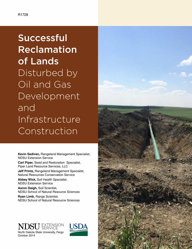
R1728
Successful Reclamation of Lands Disturbed by Oil and Gas Development and Infrastructure Construction
Kevin Sedivec, Rangeland Management Specialist, NDSU Extension Service
Carl Piper, Seed and Restoration Specialist, Piper Land Resource Services, LLC
Jeff Printz, Rangeland Management Specialist, Natural Resources Conservation Service
Abbey Wick, Soil Health Specialist, NDSU Extension Service
Aaron Daigh, Soil Scientist, NDSU School of Natural Resource Sciences
Ryan Limb, Range Scientist, NDSU School of Natural Resource Sciences
North Dakota State University, FargoOctober 2014
These recommendations are designed for pipeline and small-area disturbance that may take place when developing infrastructure for oil and gas development, not for general agriculture and conservation restoration.
Table of ContentsDevelopment of Reclamation Plan .........................................................................................................3
Land Preparation .....................................................................................................................................5Pipeline and Narrow Disturbance
Small Disturbance Areas Such as Pads, Access Roads and Other Construction Disturbance Areas
Seed Mixtures and Rates for Rangeland ...............................................................................................8Pipeline, Access Roads and Other Narrow Disturbance Upland Site Grass Seed Mixtures
Pipeline, Access Roads and Other Narrow Disturbance Upland Forb Seed Options (select three) to Seed With the Grass Seed Mixture
Pipeline, Access Roads and Other Narrow Disturbance Wet Meadow, Saline and/or Sodic Site Seed Mixtures
Small Disturbance Site Upland Forb Seed Options (select three) to Seed With the Grass Seed Mixture (well pads, staging areas, tower sites, pumping stations and other construction disturbance)
Small Disturbance Site Upland Grass Seed Mixtures (well pads, staging areas, tower sites, pumping stations and other construction disturbance)
Small Disturbance Site Wet Meadow, Saline and/or Sodic Site Seed Mixtures (well pads, staging areas, tower sites, pumping stations and other construction disturbance)
Varieties/Cultivars/Ecovars
Conservation Reserve Program (CRP) ................................................................................................12Hay Land Reclamation
Tame Pasture Reclamation
Right of Way ...........................................................................................................................................12
Seeding Dates ........................................................................................................................................12
Erosion Control .....................................................................................................................................13
Weed Control .........................................................................................................................................15
Determining the Success of the Reclamation Project .......................................................................15
This publication is designed to describe activities for the successful reclamation of North Dakota lands following disturbances associated with oil and gas production, and infrastructure construction. This includes topsoil/subsoil removal and replacement, well and pad development, pipeline and road construction, residential development and other activities related to the oil boom.
This publication only will address reclamation of non-contaminated soils. Contaminated soils may include lands compromised by oil spills (hydrocarbons) and brine spills.
We will introduce the critical components of a successful reclamation, provide recommended seed mixtures and seeding rates when reclaiming range and pasture land, and provide options to reduce soil erosion on disturbed rangelands, pastureland and hay lands. Although croplands are not specified directly in this publication, many of the topsoil salvage and replacement approaches, planning, preparation procedures and reclamation methods can be used as a guide to the successful reclamation of croplands.

3
Development of Reclamation PlanThe goal for any reclamation project is to restore
a site disturbed during the construction activities associated with oil and gas production to its pre-disturbance ecological structure and functions, as well as control erosion and sediment movement until the reclamation process is complete. The ecological structure and functions may include plant community integrity, watershed and water quality protection, wildlife habitat, retaining soil quality and productivity, and forage for livestock and wildlife.
What is important to understand is that minimizing the disturbance footprint before construction will provide a quicker return to the pre-disturbance conditions at a lower cost and with greater efficiency. A thorough, preconstruction inventory compiled by a botanist, certified professional in range management (CPRM), certified professional soil classifier or an experienced lay person with knowledge of soils, ecological sites, plant species and ecological function provides the basis for describing important functions of the land and setting clear objectives of the reclamation process.
This preconstruction inventory should include:1. Clearly defined objectives and scope of the
project. This will minimize the area that will be disturbed and reduce the construction footprint (area disturbed and severity of the disturbance).
2. Planning the reclamation and documenting the process prior to the disturbance. This document should be filed permanently for future reference.
3. Conducting a pre-disturbance/baseline inventory of the plant community, soils, topographic and landscape features. Photographs of the site provide valuable information. The Web Soil Survey can be used to provide an idea of the soil types found in area to be disturbed (however, a professional soil classifier will be needed to determine the actual soil types found on-site). Remember, the inventory should establish a framework for post-reclamation monitoring and evaluation.
4. Baseline inventory and documentation that includes 1) site-specific information and 2) on-site evaluation of ecosystem functions that need to be maintained or restored.

4
Components of existing, on-site information that need to be gathered for successful reclamation include:
3. Identification of vegetation and land use Delineate land use (farmland, native rangeland,
hay land, tame pasture, Conservation Reserve Program [CRP], etc.). Characterize the cover, productivity and plant community species’ diversity and composition, including threatened or endangered species, watch species and sensitive species when working on federally owned lands.
4. Topography, landforms and surface water These properties will affect post-disturbance
functions to be restored and identify if a need occurs to develop storm water retention sites and erosion control techniques.
5. Wildlife habitat Document wildlife species present through visual
observation, fecal pellets, tracks, small mammal burrows or disturbances, and bird nests. Include any threatened or endangered species, watch species and sensitive species. Consult the North Dakota Game and Fish Department, U.S. Fish and Wildlife Service, U.S. Forest Service, U.S. Bureau of Land Management or any other agencies to identify species and critical habitat within or around the disturbed area. Pre-project clearances must be made with these agencies and/or corresponding agency prior to disturbance activities on public lands.
6. Archaeological and historical resources Consult the North Dakota State Historical
Preservation office for more information.
1. Topsoil depth The boundary between topsoil and subsoil
material is determined based primarily on color (which indicates organic matter content), texture, pH and other properties that indicate suitable soil to support plant growth. The topsoil will contain remnant vegetative plant material and seeds that naturally occur and can help regenerate plant species that are present pre-disturbance. Topsoil is labeled at the “A horizon” in the Natural Resources Conservation Service (NRCS) Web Soil Survey. Determination and interpretation of soil pre-disturbance is completed by a certified professional soil classifier in North Dakota.
Clearly labeled stakes should be placed in the field indicating required depth to remove topsoil. Topsoil and subsoil must be removed in separate lifts and stockpiled in separate piles (for example, topsoil in one pile and subsoil in a separate pile) to reduce mixing soil layers when the reclamation process begins.
2. Properties of the subsoil and underlying materials
These properties should help identify any drainage issues and document water-holding capacity, allowing for the planning of erosion protection options; subsoil material has lower organic matter content than topsoil, making it typically lighter in color. It also may have a different texture than the topsoil material. Subsoil is referred to as the “B horizon” in the NRCS Web Soil Survey. Subsoil never should be placed or stored on top of topsoil. Consult your Soil Conservation District office or the Professional Soil Classifiers Associate of North Dakota for more information. Refer to North Dakota Century Code 43-36 for more information on soil classification and interpretation of soil properties.

5
Example of construction and reclamation of an access road during and after construction.
Land PreparationThe key to successful reclamation is to minimize the area of disturbance. This will reduce the cost
of reclamation, allow adjoining areas to remain intact and help accelerate the recovery process.

6
Top photo showing topsoil separated from subsoil. Bottom photo shows a close-up of the topsoil and subsoil separated during the exuviation process.
Pipeline and Narrow Disturbance
Take the following steps from the onset of construction to final recovery for successful reclamation in rangelands. Pipeline disturbances, particularly in croplands, can be identified decades after the disturbance, so take care to follow the appropriate reclamation guidelines.
1. Separate the topsoil from the subsoil.
a.) In areas where distinguishing the topsoil from subsoil is difficult, separate the top 8 inches of soil from the rest of the soil and treat it as topsoil. If you are unable to determine the depth of the topsoil, the Web Soil Survey (available online) is a useful tool for providing guidelines for topsoil depth. In all cases, a professional soil classifier can determine the depth of topsoil in the field.
b.) Do not mix topsoil and subsoil. Topsoil has biological, physical and chemical properties that are critical to recovery of the site.
c.) Store topsoil separately from the subsoil, either on the opposite side of the trench or with sufficient separation, to prevent the layers from mixing. Subsoil never should be mixed with the topsoil resource. Erosion control should be installed to ensure soil stays within the stockpile footprint. If stockpiles will remain longer than a growing season, seed the pile with a cover crop, or seed with perennial cover if the pile is to be retained for multiple years.
d.) If excavating below the subsoil or into different soil horizons, separate this soil from top- and subsoil so it can be backfilled at the base of the trench.
7
Non-native grasses and forbs can be invasive on native prairie. Clean equipment thoroughly after seeding non-native species to avoid transferring these species to areas where they are unwanted.
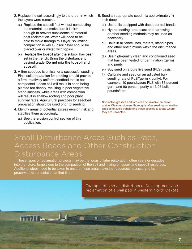
Example of a small disturbance. Development and reclamation of a well pad in western North Dakota.
Small Disturbance Areas Such as Pads, Access Roads and Other Construction Disturbance Areas
These types of reclamation projects may be the focus of later restoration, often years or decades into the future, largely due to the compaction of the soil and mixing of topsoil and subsoil resources. Additional steps need to be taken to ensure these areas have the resources necessary to be preserved for remediation at that time.
2. Replace the soil accordingly to the order in which the layers were removed.
a.) Replace the subsoil first without compacting the material, but make sure it is firm enough to prevent subsidence of material post-reclamation. Water will need to be able to move through this layer, so limiting compaction is key. Subsoil never should be placed over or mixed with topsoil.
b.) Replace the topsoil after the subsoil has been set in the trench. Bring the disturbance to desired grade. Do not mix the topsoil and subsoil.
3. A firm seedbed is critical for a successful seeding. Final soil preparation for seeding should provide a firm, relatively uniform seedbed that is not compacted. Loose soil will result in seed being planted too deeply, resulting in poor vegetative stand success, while areas with compaction will result in shallow rooting and poor plant survival rates. Agricultural practices for seedbed preparation should be used prior to seeding.
4. Identify areas of potential excess erosion risk and stabilize them accordingly.
a.) See the erosion control section of this publication.
5. Seed an appropriate seed mix approximately ¼ inch deep.
a.) Use drills equipped with depth-control bands.
b.) Hydro seeding, broadcast and harrowing or other seeding methods may be used as necessary.
c.) Rake in all fence lines, meters, stand pipes and other obstructions within the disturbance areas.
d.) Use high-quality clean and conditioned seed that has been tested for germination (germ) and purity.
e.) Buy seed on a pure live seed (PLS) basis.
f.) Calibrate and seed on an adjusted bulk seeding rate of PLS/(germ x purity). For example, 10 pounds/acre PLS with 85 percent germ and 90 percent purity = 13.07 bulk pounds/acre.
8
Seed Mixtures and Rates for RangelandWe divided the state into three major areas
for seed mixtures and separated them by major roadways (Figure 1). Major highways were used to simplify decision making for pipeline operators, engineers and contractors. The boundaries were delineated on general rangeland types and precipitation relative to a region.
Each section will have a recommended native rangeland seed mixture for upland sites and wet meadow, saline and/or sodic sites to apply on pipeline disturbance. Small disturbance sites will have a recommended native rangeland seed mixture for loamy/clayey sites, thin loamy/shallow loamy/limy sites, sandy/sands sites, and wet meadow, saline and/or sodic sites.
For the upland sites, select a minimum of three forbs/legumes from the recommended species list to complement the recommended grass-seeding mixtures. For the wet meadow, saline and/or sodic sites, select at least one forb species from the list that best fits the site.
Figure 1. Location of west, central and east zones, with the boundary, to be used for recommended seeding mixtures and rates in North Dakota. The West is an area from the Montana border east to U.S. Highway 83, Central stretches from U.S. Highway 83 to North Dakota Highway 32 and the East lies east of North Dakota Highway 32 to the Minnesota border.
Government agencies may have more rigorous restrictions on seed cultivars, origins, seeding dates or other specifications than those listed here. Consult with the corresponding agency before designing and purchasing a seed mixture.
Applying fertilizer to native plant seeding is not recommended. Fertilizers enhance exotic grasses and annual weeds, reducing the success of the establishment.
1. Strip topsoil and stockpile it in separate lifts for future restoration of the pad, road or other disturbance area at the end of its useful life. All topsoil should be salvaged per the depth determined by a professional soil classifier; this is your most valuable resource for successful reclamation. Topsoil should be stored separately from subsoil and, when possible, in shallow, wide piles. Stockpiles need to be stabilized to avoid erosional losses using re-established native grasses and/or erosion mats, even if it is for a “short” time period (less than one month). Retention of topsoil and subsoil resources in stockpiles is essential because top soil is a non-renewable resource.
2. Bring all slopes, roadways, sediment retainers and ditches to appropriate grade.
3. Replace subsoil first and then topsoil. As stated previously, you will want the subsoil to be firm but not compacted to allow for water movement into and through the subsoil material. Additionally, take care when replacing the topsoil to avoid destruction of soil structure and compaction upon replacement. The use of scrapers for this process can lead to compaction, so take care when using that type of equipment.
4. Final preparation for seeding should provide a firm, relatively uniform seedbed for seeding. Loose soil will result in seed being planted too deeply, resulting in poor stand success, while compacted soil will result in restrictive layers limiting root development. Agricultural practices to prepare the seedbed should be used.
5. Identify areas of potential excess erosion risk and stabilize them accordingly.
a.) See the erosion control section of this publication.
6. Seed an appropriate seed mix approximately ¼ inch deep.
a.) Use drills equipped with depth-control bands.
b.) Hydro seeding, broadcast and harrowing or other seeding methods may be used as necessary.
c.) Use high-quality clean and conditioned seed that has been tested for purity and germination.
d.) Buy and install seed on a pure live seed (PLS) basis.
e.) Calibrate and seed on an adjusted bulk seeding rate of PLS/(germ x purity). For example, 10 pounds/acre PLS with 85 percent germ and 90 percent purity = 13.07 bulk pounds/acre.

9
Upland Mixture (loamy, clayey, sandy, sands, shallow loamy, thin loamy)
Grass Species West* Central* East* PLS lb/ac1
Western wheatgrass 2.5 2.5 2.5 Green needlegrass 2.0 1.5 1.0 Slender wheatgrass 1.5 1.5 1.0 Little bluestem 1.0 1.0 1.0 Prairie sandreed 1.0 1.0 0.5 Sideoats grama 2.0 2.0 2.0 Blue grama 0.5 0.25 0.25 Big bluestem --- 1.0 1.0 Switchgrass --- 0.25 0.5 Canada wildrye --- 1.0 1.0 Indiangrass --- --- 1.0 Total seed mixture 10.5 12.0 11.75
1 PLS = Pure live seed: Seeding rates are 1.5 times the normal seeding rate based on 30 seed/ft2.
* West = west of U.S. Highway 83, Central = east of U.S. Highway 83 to North Dakota Highway 32, East = east of North Dakota Highway 32
Pipeline, Access Roads and Other Narrow Disturbance Upland Forb Seed Options (select three) to Seed With the Grass Seed Mixture
Upland Mixture (loamy, clayey, sandy, sands, shallow loamy, thin loamy)
Forb and Legume Species2 North Dakota PLS lb/ac1,3
Purple prairieclover 0.1 White prairieclover 0.1 Purple coneflower 0.1 Maximilian sunflower 0.1 Blanket flower 0.2 Black-eyed Susan 0.05 Stiff sunflower 0.1 Goldenrod 0.05 Lewis flax 0.1 Scarlet globemallow 0.05 Prairie coneflower 0.1
1 PLS = Pure live seed: Seeding rates are 1.5 times the normal seeding rate based on 30 seed/ft2.
2 Select a minimum of three forb/legume species from the list. The seeding rate of three selected forbs/legumes at the prescribed rate will equal approximately 5 percent of the total mixture.
3 Drill calibration is critical when seeding low rates because seed may be expensive.
Pipeline, Access Roads and Other Narrow Disturbance Wet Meadow, Saline and/or Sodic Site Seed Mixtures
Wet Meadow, Saline/Sodic Mixture
Grass Species West* Central* East*
PLS lb/ac1
Western wheatgrass 7.5 5.0 5.5 Slender wheatgrass 2.5 2.0 2.0 Prairie cordgrass 1.5 1.5 1.5 Inland saltgrass 0.5 0.5 0.5 Switchgrass --- 1.0 1.0 Total seed mixture 12.0 10.0 10.5
Forb Species2 PLS lb/ac1,3 Western yarrow 0.05 Gardner saltbush4 0.3 Fourwing saltbush4 0.45 Lewis flax 0.1
1 PLS = Pure live seed: Seeding rates are 1.5 times the normal seeding rate based on 30 seed/ft2.
2 Select a minimum of one forb species from the list. 3 Drill calibration is critical when seeding low rates because seed may
be expensive.4 Gardner and fourwing saltbush should be used only on the saline/
sodic sites.* West = west of U.S. Highway 83, Central = east of U.S. Highway 83 to
North Dakota Highway 32, East = east of North Dakota Highway 32
Pipeline, Access Roads and Other Narrow Disturbance Upland Site Grass Seed Mixtures

10
Small Disturbance Site Wet Meadow, Saline and/or Sodic Site Seed Mixtures (well pads, staging areas, tower sites, pumping stations and other construction disturbance)
Wet Meadow, Saline and/or Sodic Sites
Plant Species2,3 West* Central* East*
PLS lb/ac1
Western wheatgrass 8.0 5.0 5.0 Slender wheatgrass 2.0 2.0 2.0 Prairie cordgrass 2.0 2.0 2.0 Inland saltgrass 1.0 1.0 1.0 Switchgrass --- 1.0 1.0
Total grass seed mixture 13.0 11.0 11.0
Western yarrow 0.05 0.05 0.05 Gardner saltbush4 0.3 0.3 0.3 Fourwing saltbush4 0.45 0.45 0.45 Lewis flax 0.1 0.1 0.1
1 PLS = Pure live seed: Seeding rates are 1.5 times the normal seeding rate based on 30 seed/ft2.
2 Select a minimum of one forb/legume species from the list. 3 Drill calibration is critical when seeding low rates because seed
may be expensive.4 Gardner and fourwing saltbush should be used only on the
saline/sodic sites.* West = west of U.S. Highway 83, Central = east of U.S. Highway 83 to
North Dakota Highway 32, East = east of North Dakota Highway 32
Small Disturbance Site Upland Grass Seed Mixtures (well pads, staging areas, tower sites, pumping stations and other construction disturbance)
Loamy and Clayey Sites
Grass Species West* Central* East*
PLS lb/ac1
Western wheatgrass 5.0 3.0 2.0 Green needlegrass 2.5 2.0 2.0 Slender wheatgrass 1.0 1.0 1.0 Side-oats grama 2.0 2.0 2.0 Blue grama 0.5 0.25 0.25 Big bluestem --- 1.0 1.5 Switchgrass --- 0.25 0.5 Canada wildrye --- 1.0 1.0 Indiangrass --- --- 1.0 Total seed mixture 11.0 10.5 11.25
1 PLS = Pure live seed: Seeding rates are 1.5 times the normal seeding rate based on 30 seed/ft2.
* West = west of U.S. Highway 83, Central = east of U.S. Highway 83 to North Dakota Highway 32, East = east of North Dakota Highway 32
Thin Loamy, Shallow Loamy and Limy Sites
Grass Species West* Central* East*
PLS lb/ac1
Western wheatgrass 2.5 3.0 2.0 Green needlegrass 1.5 1.5 1.5 Slender wheatgrass 1.5 1.0 1.0 Little bluestem 1.0 1.0 1.0 Prairie sandreed 1.0 1.0 1.0 Sideoats grama 2.0 2.0 2.0 Blue grama 0.5 0.5 0.25 Big bluestem --- 1.0 1.5 Total seed mixture 10.0 11.0 10.25
1 PLS = Pure live seed: Seeding rates are 1.5 times the normal seeding rate based on 30 seed/ft2.
* West = west of U.S. Highway 83, Central = east of U.S. Highway 83 to North Dakota Highway 32, East = east of North Dakota Highway 32
Sandy and Sands Sites
Grass Species West* Central* East*
PLS lb/ac1
Western wheatgrass 2.5 2.5 2.0 Needle-and-thread 2.0 2.0 1.0 Canada wildrye 1.0 1.0 1.0 Little bluestem 1.0 1.0 1.0 Prairie sandreed 1.5 1.5 1.0 Sideoats grama 2.0 2.0 2.0 Blue grama 0.5 0.5 0.25 Sand/Big bluestem --- 1.5 2.0 Total seed mixture 10.5 12.0 10.25
1 PLS = Pure live seed: Seeding rates are 1.5 times the normal seeding rate based on 30 seed/ft2.
* West = west of U.S. Highway 83, Central = east of U.S. Highway 83 to North Dakota Highway 32, East = east of North Dakota Highway 32
Small Disturbance Site Upland Forb Seed Options (select three) to Seed With the Grass Seed Mixture (well pads, staging areas, tower sites, pumping stations and other construction disturbance)
Forb and Legume Mixture (loamy, clayey, sandy, sands, shallow loamy, thin loamy, limy)
Forb and Legume Species2 North Dakota
PLS lb/ac1,3
Purple prairieclover 0.1 White prairieclover 0.1 Purple coneflower 0.1 Maximilian sunflower 0.1 Blanket flower 0.2 Black-eyed Susan 0.05 Stiff sunflower 0.1 Goldenrod 0.05 Lewis flax 0.1 Scarlet globemallow 0.05 Prairie coneflower 0.1
1 PLS = Pure live seed: Seeding rates are 1.5 times the normal seeding rate based on 30 seed/ft2.
2 Select a minimum of three forb/legume species from the list. The seeding rate of three selected forbs/legumes at the prescribed rate will equal approximately 5 percent of the total mixture.
3 Drill calibration is critical when seeding low rates because seed may be expensive.
11
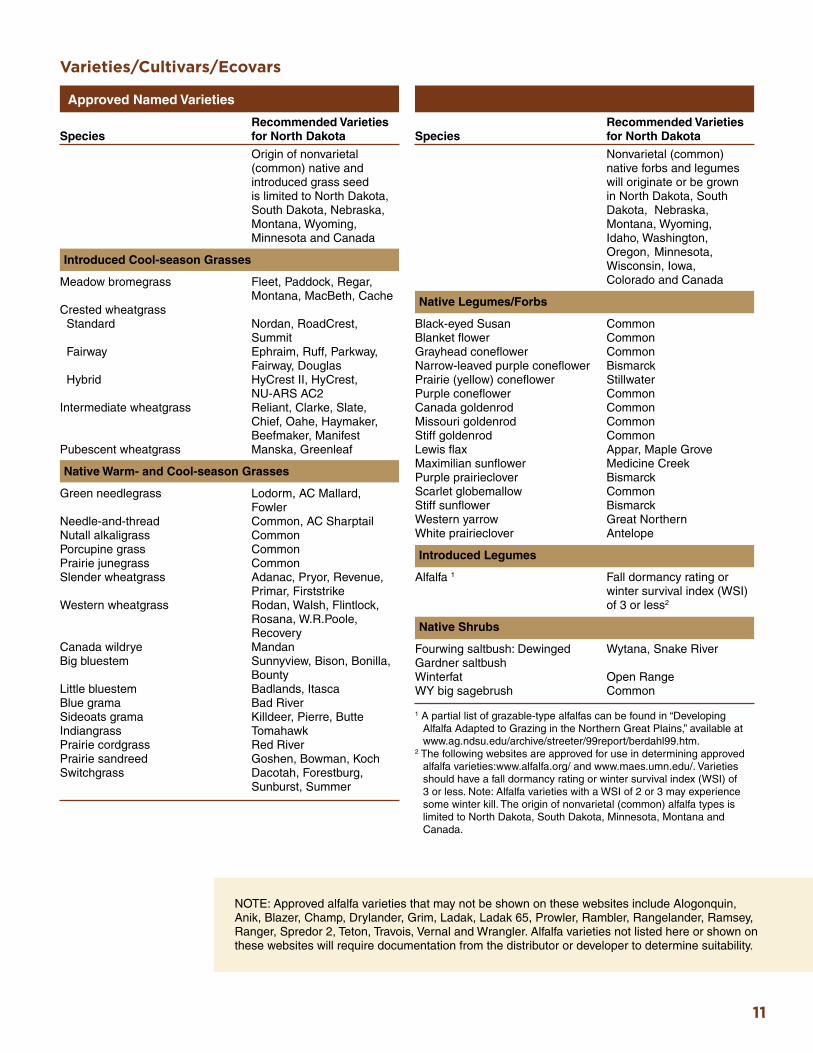
Varieties/Cultivars/Ecovars
Approved Named Varieties
Recommended Varieties Species for North Dakota
Nonvarietal (common) native forbs and legumes will originate or be grown in North Dakota, South Dakota, Nebraska, Montana, Wyoming, Idaho, Washington, Oregon, Minnesota, Wisconsin, Iowa, Colorado and Canada
Native Legumes/Forbs
Black-eyed Susan Common Blanket flower Common Grayhead coneflower Common Narrow-leaved purple coneflower Bismarck Prairie (yellow) coneflower Stillwater Purple coneflower Common Canada goldenrod Common Missouri goldenrod Common Stiff goldenrod Common Lewis flax Appar, Maple Grove Maximilian sunflower Medicine Creek Purple prairieclover Bismarck Scarlet globemallow Common Stiff sunflower Bismarck Western yarrow Great Northern White prairieclover Antelope
Introduced Legumes
Alfalfa 1 Fall dormancy rating or winter survival index (WSI) of 3 or less2
Native Shrubs
Fourwing saltbush: Dewinged Wytana, Snake River Gardner saltbushWinterfat Open Range WY big sagebrush Common
1 A partial list of grazable-type alfalfas can be found in “Developing Alfalfa Adapted to Grazing in the Northern Great Plains,” available at www.ag.ndsu.edu/archive/streeter/99report/berdahl99.htm.
2 The following websites are approved for use in determining approved alfalfa varieties:www.alfalfa.org/ and www.maes.umn.edu/. Varieties should have a fall dormancy rating or winter survival index (WSI) of 3 or less. Note: Alfalfa varieties with a WSI of 2 or 3 may experience some winter kill. The origin of nonvarietal (common) alfalfa types is limited to North Dakota, South Dakota, Minnesota, Montana and Canada.
Recommended Varieties Species for North Dakota
Origin of nonvarietal (common) native and introduced grass seed is limited to North Dakota, South Dakota, Nebraska, Montana, Wyoming, Minnesota and Canada
Introduced Cool-season Grasses
Meadow bromegrass Fleet, Paddock, Regar, Montana, MacBeth, Cache Crested wheatgrass Standard Nordan, RoadCrest, Summit Fairway Ephraim, Ruff, Parkway, Fairway, Douglas Hybrid HyCrest II, HyCrest, NU-ARS AC2 Intermediate wheatgrass Reliant, Clarke, Slate, Chief, Oahe, Haymaker, Beefmaker, Manifest Pubescent wheatgrass Manska, Greenleaf
Native Warm- and Cool-season Grasses
Green needlegrass Lodorm, AC Mallard, Fowler Needle-and-thread Common, AC Sharptail Nutall alkaligrass Common Porcupine grass Common Prairie junegrass Common Slender wheatgrass Adanac, Pryor, Revenue, Primar, Firststrike Western wheatgrass Rodan, Walsh, Flintlock, Rosana, W.R.Poole, Recovery Canada wildrye Mandan Big bluestem Sunnyview, Bison, Bonilla, Bounty Little bluestem Badlands, Itasca Blue grama Bad River Sideoats grama Killdeer, Pierre, Butte Indiangrass Tomahawk Prairie cordgrass Red River Prairie sandreed Goshen, Bowman, Koch Switchgrass Dacotah, Forestburg, Sunburst, Summer
NOTE: Approved alfalfa varieties that may not be shown on these websites include Alogonquin, Anik, Blazer, Champ, Drylander, Grim, Ladak, Ladak 65, Prowler, Rambler, Rangelander, Ramsey, Ranger, Spredor 2, Teton, Travois, Vernal and Wrangler. Alfalfa varieties not listed here or shown on these websites will require documentation from the distributor or developer to determine suitability.
12
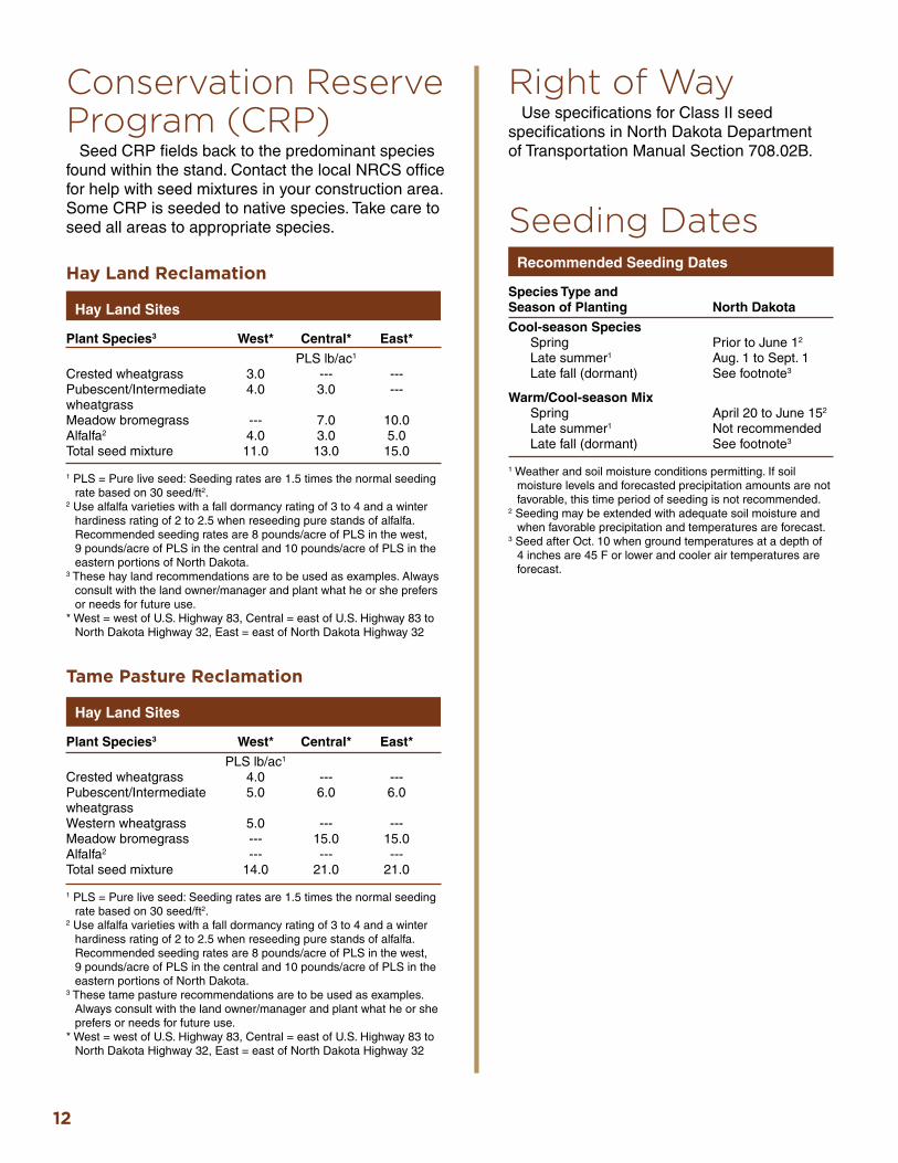
Conservation Reserve Program (CRP)
Seed CRP fields back to the predominant species found within the stand. Contact the local NRCS office for help with seed mixtures in your construction area. Some CRP is seeded to native species. Take care to seed all areas to appropriate species.
Hay Land Reclamation
Hay Land Sites
Plant Species3 West* Central* East*
PLS lb/ac1
Crested wheatgrass 3.0 --- --- Pubescent/Intermediate 4.0 3.0 --- wheatgrass Meadow bromegrass --- 7.0 10.0 Alfalfa2 4.0 3.0 5.0 Total seed mixture 11.0 13.0 15.0
1 PLS = Pure live seed: Seeding rates are 1.5 times the normal seeding rate based on 30 seed/ft2.
2 Use alfalfa varieties with a fall dormancy rating of 3 to 4 and a winter hardiness rating of 2 to 2.5 when reseeding pure stands of alfalfa. Recommended seeding rates are 8 pounds/acre of PLS in the west, 9 pounds/acre of PLS in the central and 10 pounds/acre of PLS in the eastern portions of North Dakota.
3 These hay land recommendations are to be used as examples. Always consult with the land owner/manager and plant what he or she prefers or needs for future use.
* West = west of U.S. Highway 83, Central = east of U.S. Highway 83 to North Dakota Highway 32, East = east of North Dakota Highway 32
Tame Pasture Reclamation
Hay Land Sites
Plant Species3 West* Central* East*
PLS lb/ac1
Crested wheatgrass 4.0 --- --- Pubescent/Intermediate 5.0 6.0 6.0 wheatgrass Western wheatgrass 5.0 --- --- Meadow bromegrass --- 15.0 15.0 Alfalfa2 --- --- --- Total seed mixture 14.0 21.0 21.0
1 PLS = Pure live seed: Seeding rates are 1.5 times the normal seeding rate based on 30 seed/ft2.
2 Use alfalfa varieties with a fall dormancy rating of 3 to 4 and a winter hardiness rating of 2 to 2.5 when reseeding pure stands of alfalfa. Recommended seeding rates are 8 pounds/acre of PLS in the west, 9 pounds/acre of PLS in the central and 10 pounds/acre of PLS in the eastern portions of North Dakota.
3 These tame pasture recommendations are to be used as examples. Always consult with the land owner/manager and plant what he or she prefers or needs for future use.
* West = west of U.S. Highway 83, Central = east of U.S. Highway 83 to North Dakota Highway 32, East = east of North Dakota Highway 32
Right of WayUse specifications for Class II seed
specifications in North Dakota Department of Transportation Manual Section 708.02B.
Seeding DatesRecommended Seeding Dates
Species Type and Season of Planting North Dakota
Cool-season Species Spring Prior to June 12
Late summer1 Aug. 1 to Sept. 1 Late fall (dormant) See footnote3
Warm/Cool-season Mix Spring April 20 to June 152
Late summer1 Not recommended Late fall (dormant) See footnote3
1 Weather and soil moisture conditions permitting. If soil moisture levels and forecasted precipitation amounts are not favorable, this time period of seeding is not recommended.
2 Seeding may be extended with adequate soil moisture and when favorable precipitation and temperatures are forecast.
3 Seed after Oct. 10 when ground temperatures at a depth of 4 inches are 45 F or lower and cooler air temperatures are forecast.

13
Example of using multiple erosion control methods to reduce sediment movement and aid in the restoration of the seeding.
Erosion ControlErosion control devices may be utilized when site
reclamation occurs outside the preferred seeding dates or when the topography of the site requires additional measures to enhance the restoration process.
In all cases, topsoil and subsoil stockpiles must be protected from erosional processes (wind and water), even if the duration of stockpiling is “short” (less than one month). Such protection certainly needs to be considered for long-term resource storage.
Spray-on covers such as mulching will help create a microclimate at the seed soil interface to promote germination while controlling erosion. Addition measures such as mats, which provide additional stability, may be used in higher-gradient areas or remote areas where access is limited.
Many erosion-control devices are available, and all are unique in some way. The best way to manage erosion is to evaluate the landscape as a whole, providing the proper controls based on need. For example, stabilizing the soil with mulch or crimping may control erosion and lessen the impact of raindrops or small sheet flows on a specific area (ditch bottom or pipeline trench).
But if your disturbed site is impacted from the surrounding landscape through runoff, other controls such as temporary berms, diversions or sediment fence diverting larger sheet flows from entering the site may be required. The area being protected may not be the only area impacting the erosion potential.
The North Dakota Department of Health’s Division of Water Quality (2001) states that erosion control is mandatory on all construction projects. Phase II of the National Pollution Discharge Elimination System (NPDES) will require projects disturbing areas larger than one acre to apply for a storm water discharge permit. These criteria will force smaller contractors who normally do not have to deal with temporary erosion control measures to install these devices.
This publication is intended to give all contractors, designers and inspectors the tools needed to properly install, maintain and implement their storm water pollution prevention (SWPP) plans. The proper use of best management practices (BMPs) will protect the environment and save the user time and money lost to erosion damage.
NOTE: For further information on erosion control, see “A Guide to Temporary Erosion-Control Measures for Contractors, Designers and Inspectors” published by the North Dakota Department of Health’s Division of Water Quality (June 2001), 1200 Missouri Ave., P.O. Box 5520, Bismarck, ND 58506-5520; www.ndhealth.gov/wq/wastewater/pubs/bmpmanual.pdf.

14
Erosion control
during the reclamation
process
Final restoration
with erosion control
structures removed
Example of a reclamation project using erosion control techniques, before and after photos.
15
Determining the Success of the Reclamation Project
A typical standard for successful revegetation is when the disturbed area has reached three to five established plants of replacement vegetation per foot2, as specified in the seed mixture or compared with adjacent undisturbed areas. Noxious weeds, by law, must be controlled by pulling or spraying before they spread or produce seed.
While monitoring the reclamation process, identify any areas of instability or erosion. Uncontrolled wind and water erosion can degrade a reclamation project rapidly, destroying the integrity of the land and quality of water down slope. If erosion points are found and appear to be worsening, incorporate control measures that slow and divert runoff flow.
Erosion control best management practices that may be incorporated include successful stands of vegetation, wattles, silt fences, straw bales and trenches. Wind erosion is more difficult to evaluate than water erosion; however, if best management practices are implemented for water erosion control, wind erosion control is highly likely.
Disturbed areas should be monitored for a period of time and compared with adjacent, similar reference areas to document that revegetation has been successful. If revegetation is successful, soil structure and function likely also have been reclaimed to a level conducive for stabilization of long-term, desirable vegetative communities.
Developing and following a long-term monitoring plan is critical so problems can be identified and controlled early. Direct monitoring and comparisons with suitable reference areas will ensure that landowner commitments, private and public, have been satisfied and that all applicable regulatory requirements are met.
Pay close attention to topsoil and subsoil replacement depths, seeding success, noxious weeds and erosion. Topsoil and subsoil replacement depths can be determined by using a soil auger and looking for color change. Darker material relative to other soil materials should be on the surface. Seedlings from the seeded plant species should be noticeable in the first growing season, but the presence of annual weeds throughout is not unusual. Seeded plants should occur throughout the site and annual weeds still will be present by the second growing season.
Weed ControlWeed control is essential for reclamation success.
Annual broadleaf and grass weeds will be common during the year of implementation and second year after seeding. These annual weeds should not be a concern during the first growing season; however, mowing or chemical treatment (depending on seed mixture) to control seed development may be necessary during the second growing season. If the seed mixture contains broadleaf, legume or shrub plants, chemical control would not be recommended because the chemical also will damage the seeded plants.
NOTE: For further information on weed control, see the “North Dakota Weed Control Guide” at www.ag.ndsu.edu/weeds/weed-control-guides/nd-weed-control-guide-1. This publication is available through an app (NDSU Pest Management app). For weed identification and control, see” Identification and Control of Invasive and Troublesome Weeds in North Dakota” at www.ag.ndsu.edu/publications/landing-pages/crops/identifcation-and-control-of-invasive-and-troublesome-weeds-in-north-dakota-w-1411.

All photos used with permission from Brenda Rettinger, Marathon Oil.
A special thank you goes to Energy & Environmental Research Center for their assistance in securing grant dollars that helped fund the program planning and production of outreach materials.
The NDSU Extension Service does not endorse commercial products or companies even though reference may be made to tradenames, trademarks or service names.
NDSU encourages you to use and share this content, but please do so under the conditions of our Creative Commons license. You may copy, distribute, transmit and adapt this work as long as you give full attribution, don’t use the work for commercial purposes and share your resulting work similarly. For more information, visit www.ag.ndsu.edu/agcomm/creative-commons.
1500-10-14
For more information on this and other topics, see www.ag.ndsu.eduCounty commissions, North Dakota State University and U.S. Department of Agriculture cooperating. North Dakota State University does not discriminate on the basis of age, color, disability, gender expression/identity, genetic information, marital status, national origin, public assistance status, sex, sexual orientation, status as a U.S. veteran, race or religion. Direct inquiries to the Vice President for Equity, Diversity and Global Outreach, 205 Old Main, (701) 231-7708. This publication will be made available in alternative formats for people with disabilities upon request, (701) 231-7881.
EERCEnergy & Environmental Research Center®
Putting Research into Practice