sudsnet national conference - abertay
TRANSCRIPT

SUDSnet National Conference
November 12th and 13th 2009
Coventry University TechnoCentre.
SUDSnet National Conference 2009 thanks the Conference Supporters and Sponsors:
Proceedings of the SUDSnet National Conference 2009. Coventry University TechnoCentre. Nov 12th and 13th 2009. www.sudsnet.abertay.ac.uk

SUDSnet is organised by:
Web: www.sudsnet.abertay.ac.uk E-Mail: [email protected]
SUDSnet Director: Prof. Chris Jefferies (UWTC, Abertay) SUDSnet Network Manager: Dr. Rebecca Wade (UWTC, Abertay)
SUDSnet Coordinator at Coventry University: Dr. Susanne Charlesworth (Coventry) SUDSnet Administrative Support: Ms. Leanne Gallagher (UWTC, Abertay)
SUDSnet is Administered from the Urban Water Technology Centre, University of
Abertay Dundee, Kydd Building, 40 Bell Street, Dundee DD1 1HG. Scotland. UK.
Phone: +44 (0)1382 308650 (R. Wade) Fax: +44 (0)1382 308117 (UWTC)
Acknowledgements: In addition to thanking the organisers and sponsors of this event, SUDSnet would like to acknowledge the funding provided by EPSRC from 2004-2007 to initiate and support the network (EPSRC Grant GR/S76809/01, Coventry University; & EPSRC Grant GR/S76816/01, University of Abertay Dundee). Special thanks go to Leanne Gallagher at The University of Abertay Dundee for her help with organisation and administration of this event.
.
Proceedings of the SUDSnet National Conference 2009. Coventry University TechnoCentre. Nov 12th and 13th 2009. www.sudsnet.abertay.ac.uk
2

Proceedings of the SUDSnet National Conference 2009. Coventry University TechnoCentre. Nov 12th and 13th 2009. www.sudsnet.abertay.ac.uk
3
SUDSnet 2009 Conference Proceedings - Contents page:
Page Article 1 Title Page and Sponsors 2 SUDSnet Network Organisers 3 Contents Page 4 List of Delegates 6 Programme of Paper Presentations 9 List of Display Stands and Poster titles Abstracts 10 Session 1: SUDS for Roads and New Developments 18 Session 2: Planning and SUDS 26 Session 3: SUDS Applications 32 Session 4: SUDS and Floods 36 Session 5: SUDS Performance 1 (rainwater harvesting, paving and heat pumps) 42 Session 6: SUDS Performance 2 (wetlands and ponds) 48 Session 7: Vegetated SUDS 56 Poster Abstracts

Proceedings of the SUDSnet National Conference 2009. Coventry University TechnoCentre. Nov 12th and 13th 2009. www.sudsnet.abertay.ac.uk
4
SUDSnet National Conference 2009 - Delegate List
Company / Affiliation
Delegate
Anglian Water Services Ken Banfield Brett Building and Landscaping Products Ltd
Tony Walker
Brett Building and Landscaping Products Ltd
Andrew Gill
Brett Building and Landscaping Products Ltd
John Howe
Brett Building and Landscaping Products Ltd
Shaun Crosskey
CIRIA Paul Shaffer CITY ROOFS Mathew Hoddinott Coventry University Susanne Charlesworth Coventry University Frank Warwick Coventry University Michelle Mayer Coventry University Jamie Beddow Coventry University Oyekemi Oyelola Cress Water Solutions Richard Hudson Econoplas Ltd John Gaskarth Econoplas Ltd John Grindrod Enzygo Ltd Matt Travis Enzygo Ltd Keelan Serjeant EPG Ltd Steve Wilson GEA 2 H Water Technologies Ltd Ron Buckland Gifford LLP Stephen Gibson Hanson Formpave Steve Spikes Hanson Formpave Stephen Coupe Hanson Formpave Peter Johns Heriot Watt University Scott Arthur Heriot Watt University Nicholas Bastien H R Wallingford Bridget Woods Ballard Hyder Consulting Leanne Roach Hyder Consulting Bob Sargent Isle of Man Government Ian Wade Mayer Brown Ltd Paul Stewart Micro Drainage Ltd James Berryman Moir Environmental Ltd Stewart Moir Mouchel Adolf Spitzer Polypipe Civils Emma Thompson Renfrewshire Council Stephen Tingle Renfrewshire Council Frank Bradley Robert Bray Associates Ltd Robert Bray

Proceedings of the SUDSnet National Conference 2009. Coventry University TechnoCentre. Nov 12th and 13th 2009. www.sudsnet.abertay.ac.uk
5
Scottish Water Doug Buchan SEPA Brian D'Arcy SEPA Neil McLean SEPA Shropshire Council Gavin Wong Shropshire Council James Gibson Simon Richards & Associates Simon Richards Sinclair Knight Merz Scott McLean University of Abertay Chris Jefferies University of Abertay Rebecca Wade University of Abertay Neil Berwick University of Abertay/Scottish Water Cynthia Aukerman University of Abertay Roshni Jose University of Edinburgh Kate Heal University of Edinburgh Miklas Scholz University of Edinburgh William McMinn University of Edinburgh/ Hanson Formpave
Kiran Tota-Maharaj
University of Georgia Bruce Ferguson University of Northampton Charlotte Crisp University of Portsmouth Saman Seekkubadu University of Portsmouth John Williams University of Sheffield Virginia Stovin University of Sheffield Claire Cannon

SUDSnet National SUDS conference 2009 – PROGRAMME Day 1: Thursday 12th November 2009 9.30 – 10.30 REGISTRATION & TEA/COFFEE 10.30 Welcome and Announcements: Rebecca Wade (SUDSnet, University
of Abertay Dundee) 5 mins
10.35 Introduction: Chris Jefferies (SUDSnet, University of Abertay Dundee)
10 mins
10.45 Keynote Speaker: Paul Shaffer (CIRIA) Current Guidance and Best Practice
20 mins
10.55 Discussion 10 mins Session 1: SUDS for Roads and New Developments CHAIR: Chris Jefferies 11.05 Keynote: Neil McLean (SEPA)
Making In-Roads to Greening Streets 20 mins
11.25 Chris Jefferies (University of Abertay Dundee) co-authors: Taye Akinrelere, and Frank Guz SUDS for Roads
20 mins
11.45 S Seekkubadu (Mayer Brown Ltd) co-authors: C Mant, JB Williams, P Stewart, E May, S Aldridge, W Brown An Assessment of the Performance of Sustainable Drainage Systems Integrated into the Design of a Major Development Area
20 mins
12.05 Nicolas Bastien (Heriot-Watt University) co-authors: Scott Arthur, Stephen Wallis, Miklas Scholz Towards Best Management of Runoff in New Developments
20 mins
12.25 Discussion 20 mins 12.45pm LUNCH and NETWORKING (Technocentre restaurant) 60 mins
POSTERS and DISPLAY STANDS (Conference rooms) Session 2: Planning and SUDS CHAIR: Rebecca Wade 1.45 Roger Nowell (GreenEstate)and Bob Bray (Robert Bray Associates
Ltd) A SUDS strategy and Planning Model to inform housing redevelopment in Sheffield
20 mins
2.05 Steve Wilson (EPG ltd) co-authors: Bob Bray, Simon Bunn, Eithne Flannagan A Local Authority Adoption Guide for SUDS
20 mins
2.25 Frank Warwick (Coventry University) co-authors: Susanne Charlesworth, Paul Cole, Jim Newton Planning for the Bigger Picture: The Feasibility of Sustainable Drainage in Coventry
20 mins
2.45 Bill Walton (Severn Trent Water) Sustainable Drainage Systems Guidance Severn Trent Water’s Approach to Adoption
20 mins
3.05 Discussion 20 mins 3.25 TEA/COFFEE and Networking 20 mins
Proceedings of the SUDSnet National Conference 2009. Coventry University TechnoCentre. Nov 12th and 13th 2009. www.sudsnet.abertay.ac.uk
6

Proceedings of the SUDSnet National Conference 2009. Coventry University TechnoCentre. Nov 12th and 13th 2009. www.sudsnet.abertay.ac.uk
7
Session 3: SUDS Applications CHAIR: Sue Charlesworth 3.45 Bruce Ferguson (University of Georgia, USA) co-authors: Olivia
Mikalonis and Benjamin K Ferguson Deck Construction and Performance for Impervious Surface Reduction
20 mins
4.05 Matthew Travis (Enzygo Ltd) Co-author: Keelan R Serjeant Keeping the Greens Green – Golf course SUDS and Rainwater Harvesting: A paradox of two holes
20 mins
4.25 Bob Bray (Robert Bray Associates Ltd) SUDS and Amenity – Value by design
20 mins
4.45 Discussion 20 mins
POSTERS and DISPLAY STANDS (Conference rooms) 6.30 pm CONFERENCE DINNER (Technocentre restaurant) Day 2: Friday 13th November 2009 9.00 – 9.30 Day 2 REGISTRATION & TEA/COFFEE 9.30 Welcome to day 2 and Announcements: Rebecca Wade
(SUDSnet, University of Abertay Dundee) 10 mins
Session 4: SUDS and Floods CHAIR: John Blanksby 9.50 Stephen Tingle (Renfrewshire Council)
Modular Surface Water Management Plan 20 mins
10.10 Will McMinn (University of Edinburgh) co-authors: Qinli Yang, Miklas Scholz Potential Use of Natural Flood Retention Wetlands to Control Diffuse Pollution
20 mins
10.30 Discussion 20 mins 10.50 am Parallel Workshops and TEA/COFFEE 60 mins each
Workshop 1 - SUDS and Floods. Lead by John Blanksby Workshop 2 - SUDS and Amenity – Value by design. Lead by Robert Bray
Session 5: SUDS Performance 1 (rainwater harvesting, paving and heat pumps) CHAIR: John Howe 11.50 Stephen Coupe (Hanson Formpave) co-authors: Susanne
Charlesworth, Amal Faraj Permeable Paving and Rainwater Harvesting: Legislation and Performance
20 mins
12.10 Jamie Beddow (Coventry University) co-authors: S Charlesworth, N Thomas, A Jones An Investigation of Pollutant Retention By TarmacDry Pervious Pavement Structures
20 mins
12.30 Kiran Tota-Maharaj (University of Edinburgh) co-authors: M. Scholz, P. Graboweicki, T. Ahmed, S. Coupe Molecular characterization of bacterial populations in urban runoff for combined permeable pavements and geothermal heat pumps.
20 mins
12.50 Discussion 20 mins 1.10pm LUNCH and NETWORKING (Technocentre restaurant) 60 mins
POSTERS and DISPLAY STANDS (Conference rooms)

Session 6: SUDS Performance 2 (wetlands and ponds) CHAIR: Steve Coupe 2.00 Kate Heal (University of Edinburgh) co-authors: Catherine Morgan,
Steve Wallis, Rebecca Lunn Improving the Design of Urban Stormwater Ponds
20 mins
2.20 Miklas Scholz (University of Edinburgh) co-authors: Atif Mustafa, Rory Harrington Microbial Communities Removing Nitrogen within an Integrated Constructed Wetland Treating Rural Runoff
20 mins
2.40 Virginia Stovin (University of Sheffield), co-authors: Ian Guymer, Jean Lacoursiere Towards an understanding of the effects of vegetation on residence times in ponds
20 mins
3.00 Discussion 20 mins 3.20 TEA/COFFEE and Networking 20 mins Session 7: Vegetated SUDS CHAIR: Neil McLean (SEPA) 3.40 Susanne Charlesworth (Coventry University) co-authors: Ernest
Nnadi, David Lawson Utilising Green and Food Composted material in Vegetated SUDS Devices: Pillows and PVC
20 mins
4.00 Virginia Stovin (University of Sheffield), co-authors: Hartini Kasmin and Abigail Hathway Quantifying evapotranspitration for green roof hydrological modelling
20 mins
4.20 Michelle Mayer (Coventry University) co-authors: Susanne Charlesworth, Paul Cole Using GIS to assess the pollution remediation characteristics of vegetated porous paving, Kenilworth, Warwickshire.
20 mins
4.40 Andy Waite (Coventry University) co-authors: Susanne Charlesworth, James Bennett An Investigation of the Pollutant Retention and Hydraulic Properties of Various Grass Species for Utilisation in SUDS Devices’
20 mins
5.00 Discussion 20 mins 5.20 Close of meeting 10 mins
Proceedings of the SUDSnet National Conference 2009. Coventry University TechnoCentre. Nov 12th and 13th 2009. www.sudsnet.abertay.ac.uk
8

Proceedings of the SUDSnet National Conference 2009. Coventry University TechnoCentre. Nov 12th and 13th 2009. www.sudsnet.abertay.ac.uk
9
DISPLAY STANDS – Sponsors, Supporters and Corporate Displays AQUADYNE (a product of Econoplas Ltd) www.econoplas.co.uk BRETT LANDSCAPING PRODUCTS LTD www.brett.co.uk CITYROOFS www.cityroofs.com GEA 2H Water Technologies Ltd www.gea-2h.com HANSON FORMPAVE www.formpave.co.uk SEPA www.sepa.org.uk SMART SPONGE PRODUCTS LIMITED www.burdensenvironmental.com Poster Titles Scottish Water: Tackling the Adoption of Public SUDS Cynthia Aukerman, Scottish Water / University of Abertay Dundee Making the (Right) Connection Alison Duffy, University of Abertay Dundee The use of soil amendments in improving water quality in vegetative SUDS. Oyekemi Oyelola, Coventry University.

Proceedings of the SUDSnet National Conference 2009. Coventry University TechnoCentre. Nov 12th and 13th 2009. www.sudsnet.abertay.ac.uk
10
Session 1: SUDS for Roads and New Developments Making In-Roads to Greening Streets Neil McLean & Brian D’Arcy. Scottish Environment Protection Agency Erskine Court, Castle Business Park, Stirling, FK9 4TR Introduction With the advent of legislative frameworks to require SUDS (Sustainable Urban Drainage Systems) now established or being developed there is a further need to focus on robust and refined methods and techniques to assist in sustainable drainage. At-source measures such as permeable paving systems, or filter trenches, are effective in providing treatment and attenuation of runoff prior to discharge to the water environment. However some recent focus has been to provide end-of-pipe systems such as ponds and basins, for example Scottish Water’s Sewers for Scotland 2nd Edition, but there is a growing need to look at elements that may appear upstream of these end –of-pipe systems, and apply “source control” techniques. Such techniques may appear in the nationally accepted high level guide, the SUDS Manual, but practitioners do not need to be tied strictly to the contents of this manual. In Road Systems The road system itself can offer opportunities and there are certain initiatives to promote and influence the choice of measures to include “in-road” situations that look beyond permeable surfaces. There is no doubt that properly designed and constructed permeable paving systems will provide both water quality improvements and flow attenuation benefits to any downstream or down-gradient water body, so why bother about other systems? Presently many roads authorities are reticent, or indeed resistant, to the use of permeable paving and will not adopt any such systems. This attitude discourages developers from considering installing permeable paving, opting more commonly for end-of-pipe arrangements. This by no means includes all roads authorities, as pockets of progress exist, such as in Bristol, Oxford and Edinburgh, where “champions” can see the benefits of improvement over conventional blacktop. So if, as seems likely, we are to have SUDS as a legislative requirement throughout Britain at least (Northern Ireland are willing, but still considering the options), and given the slow progress to adopt permeable paving, we should be considering a wider suite of options that developers will consider and that authorities will adopt. In addition, supplementing permeable paving systems will offer greater choice to developers and planners alike. Alternative SUDS Including SUDS as part of traffic calming can have virtually no additional land take but can provide excellent hydraulic benefits and passive treatment facilities as part of the sustainable drainage system. For example, instead of the dreaded road hump (road table or sleeping policeman) why can’t the road hump be inverted to create a “road sump”, which can be used to capture flow into a sub-surface reservoir? Such a reservoir would have to be properly and robustly constructed in order not to alter the bearing ratio of the road foundation, but if the reservoir was sealed with a prescribed outlet, this can easily be achieved. Runoff can be contained in the reservoir, which may not even be within the footprint of the road pavement, if flow routeing is used and released at a desired rate to any downstream receiver, such as a sewer, or further elements of SUDS, or a water body. Very few road sumps exist to date, probably due to lack of research and evidence that might otherwise overcome explicable reticence within the road engineering sector.

Proceedings of the SUDSnet National Conference 2009. Coventry University TechnoCentre. Nov 12th and 13th 2009. www.sudsnet.abertay.ac.uk
11
In-Road Arrangements A newer approach to traffic calming, and one that will generate less pollution, is the use of more frequent and tighter corners within the layout of any new development. By using tighter corners, vehicles will travel uniformly slower to move through the site. By ensuring drivers have good vision through each corner, i.e. by placing thin or low obstructions at the inside of corners, and not buildings, drivers will see any hazards prior to arriving around the corner. This newer approach is being encouraged together with the “Home Zone”, where pedestrians are given priority over road vehicles within major parts of each development. A key element of the Home Zone is the “shared surface” which has no defined footpath, essentially having one paved surface shared between pedestrians and vehicles. Therefore the need to have obstructions at corners becomes more essential as a traffic management function. The most obvious obstructions to use are bollards and raised kerbs as hard engineering options which can be translated into trees and green landscaping for a softer approach. This softer approach has clear advantages and can serve several purposes with additional knock-on benefits to the area and therefore community. Planting a tree at a corner will allow a clear line of site around the corner assuming nothing is built directly behind the tree and, as long as the tree roots are controlled and kept deep, will not disturb the road construction integrity. Indeed a useful aspect to incorporate into the road surface is a drainage system that will flow to be routed to trees and green landscaped areas thereby becoming bioretention cells within and throughout the whole development, overcoming gulley maintenance. Bioretention areas, or smaller cells, are a useful, but to date relatively rare, SUDS component. Excellent water quality treatment can be achieved and peak flow attenuation is obvious. One perceived drawback of any bioretention system is the landtake that it may have, but the footprint of these cells within a shared surface will have in effect no landtake as it becomes part of the shared surface layout. Maintenance will still be required of any green landscaping, but it is likely that such areas will be a requirement anyway through a planning condition. The prospect of blinding, or chocking of hydraulic continuity, of these cells will be minimum, but again will be a function of good design and construction; both critical to the success of any scheme. The Wider Approach – Creative Drainage This traffic management/urban drainage arrangement may not necessarily only use softer systems as described, but may involve hard features to convey runoff and even sculptures and other more creative, but functional units. Collectively hard and soft arrangements can then contribute to other aspects of the Integrated Urban Infrastructure (IUI) and encourage greater amenity, biodiversity and health considerations within the urban setting. It is important to realise that these green systems are not just dedicated planted areas that will accept drainage, but that a much more subtle and aesthetically pleasing system is created – even going beyond the “Green Streets” systems that have been constructed in places like Seattle, Portland and Vancouver in North America or Ashford in Kent and Northampton. Providing green landscapes within the footprint of a shared surface will offer a more appealing site that can sell houses for a developer and enhance the sense of place that communities can bond within, even improving health and well being and reducing crime; all considerations that planning authorities aspire to. We (will) have to provide SUDS. Through careful deliberation on what is required and what would be nice to have we can provide systems that meet water quality, flood management and biodiversity legislation all within the footprint of road systems within our towns and cities.

Selecting SUDS for Roads – new guidance for local authority roads Chris Jefferies*, Taye Akinrelere* and Frank Guz, * University of Abertay Dundee
Introduction The design of a SUDS system embeds long term environmental and social factors throughout the life of the system within the functional requirements of controlling the quantity and quality of runoff and inclusion of the amenity value of surface water in the urban environment. A wide range of technical guidance is available but unfortunately, while many describe the suitable design of SUDS, few provide appropriate advice for practitioners involved in the design or appraisal of roads within the non-trunk road network boundary. Early in 2008 the SUDS Scottish Working Party (SUDSWP), guided by practitioners, took ownership of this disconnect and a committed and enthusiastic group of individuals from a variety of organisations worked collaboratively to develop specific SUDS guidance for roads. Guided by SEPA and The Society of Chief Officers of Transportation for Scotland (SCOTS), partnership working between a range of pubic and private sector organisations has delivered the SUDS for Roads guidance document. It is anticipated that the primary readership of SUDS for Roads will be Local Authorities and private developers, however, the principles contained apply equally to designers in other disciplines
The purpose of the document is to guide the reader through the selection and design of SUDS for roads and to identify the various SUDS best practice measures that are suitable at reasonable cost. The document guides the reader to provide the necessary degree of protection to the water environment in terms of water quality and to provide appropriate flood mitigation. Capital and operational costs are addressed at the end to encourage sustainable development practices for contractors and roads authorities.
SUDS SELECTION FLOWCHART A selection flowchart is at the heart of the SUDS for Roads selection process. Various criteria characterise the capabilities and limitations of each SUDS for use on roads. Factors requiring to be considered for any given site are evaluated using the selection tool. Selection has three main processes of SCOPING, EVALUATION and FINAL SELECTION and these processes are further divided into six main stages. The selection flowchart is shown in Figure 1.
Proceedings of the SUDSnet National Conference 2009. Coventry University TechnoCentre. Nov 12th and 13th 2009. www.sudsnet.abertay.ac.uk
12
Various options matrices have been devised to support the selection and these lead to a binary scoring system which assists in options appraisal. Thus, in addition to the flowchart there are three matrices addressing SUDS; Options, Performance, and Maintenance. The procedure results in a SUDS Site Factors Scoring Worksheet. The scoring system is intended to enable options to be ranked but is not intended to set definitive rules as to which SUDS components should be used. However, it does provide a common basis for discussion and negotiations in deciding the most appropriate solution for a location. The process outlined in Figure 1 should be seen as an iterative rather than a linear process which has been developed to aid the comparison and selection of sustainable options. Each of the options initially selected using the selection matrix is scored on the basis of whether it meets the particular criteria/factor in question. When they meet an individual site-specific criterion, they are given a score of 1, otherwise the score is zero. The exception to this is the level of treatment criteria, the level of treatment score being based on each level of treatment. The score is unity if an option only
provides one level - with two levels of treatment, it has a score of 2. The site factor score is the sum of the individual scores.
Figure 1. Road SUDS Selection Flowchart

Proceedings of the SUDSnet National Conference 2009. Coventry University TechnoCentre. Nov 12th and 13th 2009. www.sudsnet.abertay.ac.uk
SCOPING STAGE A: PROJECT DESCRIPTION This initial selection clarifies the type of road to be developed. Once this is established the designer uses the matrix to select a range of SUDS options which are potentially suitable for that particular road to end with a list of applicable SUDS options. Some SUDS may be more attractive to certain stakeholders and less to others and is effectively the starting point for selection. SCOPING STAGE B: SITE CHARACTERIZATION For any given site, it is important to review and assess the site characteristics for any constraints which may point to a preference for certain options. A particular SUDS component should only be used in areas where the physical site characteristics are suitable, although some overcome unfavourable site conditions by incorporating particular design features. In this stage, the designer screens the initial list/ range of SUDS options derived from stage A and determines which factors apply. Different site factors or combinations of factors might limit the use of any of the SUDS options selected initially. PHYSICAL DRIVERS: Including space availability and cutting and grading requirements etc. SITE TOPOGRAPHY: Including contributing drained area, site slope, and depth to seasonal high water table.
Contributing drained Area Site Gradient Groundwater level; Has a significant influence on the type of SUDS selected, particularly infiltration
SUDS. A high groundwater level may lead to the risk of contamination of the groundwater and also cause the SUDS component to fill with water thus rendering the volume useless or even worse, causing excessive infiltration into the surface water drainage system. SITE SOIL PROPERTIES: In addition to the general topography of the site; soil properties such as the type(s) of soil, geological formation, hydraulic conductivity and water storage capacity at a site may dictate the SUDS type to be used. Soil characteristics may vary even for locations just a few metres apart and site measurement of soil properties are important. INTEGRATION WITH EXISTING INFRASTRUCTURE
ROAD INFRASTRUCTURE; Urban road projects are often constructed in stages and/or are reconstruction of existing roads. Retrofit of new SUDS into an existing drainage system built in an earlier stage presents different challenges from new construction. Existing road or bridges may also inhibit the choice of SUDS. Furthermore, concerns over the structural integrity of some road infrastructure such as footings, bridge abutments, and retaining walls may discourage infiltration.
UTILITIES AND OTHER INFRASTRUCTURE; Existing or proposed utilities and other infrastructure assets may inhibit the SUDS selected. For example, it is very important that a dedicated service strip is included where there is extensive pervious paving since any utility work might not be satisfactory and may compromise the function of the pavement. SITE FACTOR SCORE: The purpose of the site factor score is to provide a common assessment of the different opportunities and constraints offered by the SUDS options for a site. The scores for different options are used to rank the options so that the different technical merits can be openly considered. SCOPING STAGE C: APPLICABLE SUDS OPTIONS A ranked list of applicable SUDS options which are appropriate for the location is drawn up for further evaluation on the basis of the site factor score. Typical examples can be seen in Error! Reference source not found. and in Worked Examples 1 and 3. EVALUATION STAGE D: At this stage, the designer narrows the SUDS list and selects the best alternatives based on their site factor scores. These are further evaluated and screened using other site specific as well as non-site specific factors such as operation and maintenance requirements; social and ecological benefit and other technical issues such reliability and robustness of the selected options. SOCIAL AND ECOLOGICAL BENEFITS; The ranked SUDS options are further evaluated for their habitat creation potential, public health and safety concerns, community acceptance, etc. TECHNICAL DRIVERS; The ranked SUDS options are further evaluated as regards to their relative ease of construction, the system’s reliability, and the system’s robustness. OPERATION AND MAINTENANCE DRIVERS; Maintenance is an important part in the operation of any SUDS system and the maintenance effort needed for any of the SUDS option should be evaluated not only in terms of effort such as the relative frequency and ease of inspection, but also on issues such as the procurement of specific components, access to equipment and/ or the need for specialist maintenance skills or techniques. EVALUATION STAGE E - FINANCIAL CONCERNS The costs which should be considered are expressed in two ways, through the whole-life-cycle-cost including construction, operating and rehabilitation costs throughout the life of the SUDS and through the whole-life-maintenance-cost which considers the costs only from the point of view of the maintaining body. FINAL SELECTIONThe final choice of SUDS is made once the various considerations are resolved. The link to SUDS for Roads draft for consultation is ; http://scots.sharepoint.apptix.net/suds/General%20Publications/Forms/AllItems.aspx

An Assessment of the Performance of Sustainable Drainage Systems Integrated into the Design of a Major Development Area ^*Seekkubadu, S., *Mant, C., *Williams, J.B., ^Stewart, P., *May, E., ^Aldridge, S., Brown, W. ^Mayer Brown Ltd, Woking, *University of Portsmouth, Environment Agency, TSB Knowledge Transfer Partnership.
Introduction Sustainable Drainage Systems (SUDs) have been incorporated into the design of Waterlooville MDA in Hampshire, planned for 3000 dwellings, in consultation with developers, planners and Environment Agency (EA). SUDs designs integrate swales, detention basins and permeable pavements to reduce runoff and attenuate pollution. A KTP research project between Mayer Brown, University of Portsmouth and EA has been established with several unique features that allow a comprehensive evaluation of the SUDs: i) EA have undertaken extensive background monitoring of local watercourses ii) Mayer Brown intend to establish technical leadership in SUDs design and have incorporated monitoring features into designs; iii) the University of Portsmouth has a track record in wetlands and runoff monitoring and has laboratories near-by to facilitate intensive monitoring. This project will allow Mayer Brown’s designs to be evaluated for water quantity/quality performance. This will allow treatment process to be modelled and recommendations for future development of SUDs design guidelines. Extended monitoring of watercourses by EA throughout the project will give a comprehensive assessment of the impact of a major development with SUDs on hydrologic-environment. Methods
To date, a swale and detention pond system have been built. These are receiving road runoff from access roads to the site. This system is the focus of the current monitoring as there have been delays in building other parts of the SUDs due to the economic climate. The pond has two basins separated by a raised “island” to promote sedimentation and to avoid short circuiting. The pond system is 51 x 26 m with a permanent water depth of 1m (rising to 1.62 m at the overflow) and a storage capacity of 304 m3.
Proceedings of the SUDSnet National Conference 2009. Coventry University TechnoCentre. Nov 12th and 13th 2009. www.sudsnet.abertay.ac.uk
14
Sediment Trap
Basin 1
Basin 2
Figure 1. i) Plan of Balancing Pond and ii) Sediment Trap Design The monitoring is based around a multivariate design that monitors weather, water quantity, water quality, sediment accumulations and sediment quality in the system. An on-site Ott weather station has been installed by the EA and flow gauges installed at the pond inlet and outlet. Water quality (BOD, COD, TSS, VSS, pH, conductivity, DO, NH+, TON) is monitored every two weeks and sediment sample as are also taken for metal analysis (Ni, Cd, Cu, Pd, Zn, Cr). More detailed investigations (e.g. hydrocarbons, ecological status and chlorophyll) are undertaken every 6-months. Auto-samplers and Sondes have also been installed to capture storm events. Sediment traps have been installed in the basins to capture settling solids. These are removed monthly and are size fractionated between > and < 63 µm components and analysed for metals (as above).

This monitoring will continue throughout the construction phase of the development to assess the SUDs performance as construction pollution control systems and then during the residential occupation, alongside a resident awareness campaign. Results and Discussion The results of monitoring from March to October are presented below. Fig 2i shows that the BOD reduced across the pond systems and that the outlet levels were comparable to the receiving river. The suspended solids concentrations (Fig 2ii) have generally reduced over the sampling
period indicating that the system has stabilised after construction.
01/09/200901/07/200901/05/200901/03/2009
90
80
70
60
50
40
30
20
10
0
Date
TSS
(mg/
l)
Figure 2: i) BOD AND ii) Total suspended solids (TSS) in the detention pond system
RiverPond OutletBasin 2Basin 1
4
3
2
1
0
Location
BOD
(m
g/l)
Measurements of settling solids (Fig 3i) have shown that the fine particles (<63µm) predominate and, although more data is required, it appears that higher levels of settling material are found earlier in the system. Metal behaviour in the systems is showing some emerging trend with most metals being correlated with each other. Fig 3ii also shows a significant association (R=0.81, p<0.000) between soluble Cr and water pH, which may be expected due to Cr solubility curves.
Basin 2Basin 1
7
6
5
4
3
2
1
0
Sett
ling
Solid
s, g
/mon
th
>63um<63um
FractionSize
10.09.59.08.58.07.57.0
3.0
2.5
2.0
1.5
1.0
0.5
0.0
pH
Solu
ble
Cr in
Wat
er, u
g/l
Figure 3. i) Mass of settling solids and ii) soluble Chromium vs pH (outlier at pH 11, Cr 8 omitted) The metal concentrations in the settling solids are shown in Table 1. These values are well below the “contaminated land” trigger values.
Table 1. Metal Concentrations in Settling Solids (n=3) Metal (mg/Kg) Basin 1 Basin 2 Size Fraction >63µm <63µm >63µm <63µm Cr 11.4 11.0 9.10 10.8 Ni 9.21 8.65 7.20 8.63 Cu 76.7 52.7 106 68.4 Zn 113 109 169 148 Pb 35.4 75.8 28.1 27.4 Cd 0.215 0.168 0.277 0.197
This intensive multivariate monitoring allows the treatment performance to be assessed and also allows characterisation of the treatment mechanisms to increase the general understanding of SUDs processes and provide a more scientific basis for Mayer Brown’s SUDs design codes for pollutant removal.
A case study for SuDS treatment trains Proceedings of the SUDSnet National Conference 2009. Coventry University TechnoCentre. Nov 12th and 13th 2009. www.sudsnet.abertay.ac.uk
15

Proceedings of the SUDSnet National Conference 2009. Coventry University TechnoCentre. Nov 12th and 13th 2009. www.sudsnet.abertay.ac.uk
16
N.R.P. BASTIEN (1), S. ARTHUR (2), S.G. WALLIS (3), M. SCHOLZ (4) (1), (2) and (3) School of the Built Environment, Heriot-Watt University, Edinburgh EH14 4AS, UK. (4) Institute for Infrastructure and Environment, School of Engineering, The University of Edinburgh, Edinburgh EH9 3JL, UK. * Corresponding author, email: [email protected] INTRODUCTION Although the benefits of using SuDS treatment trains have been reported for some time, land take, construction costs, uncertainty regarding maintenance and adoption of SuDS are generally seen as barriers to implementation of source and site controls. In contrast, providing a good quality of life by improving environmental amenity and biodiversity in urban areas are key drivers for planners. By considering these views, the underlying philosophy of the presented research is that the development of a surface water management plan at an early stage, coupled with advances in how the treatment train is modelled, would help optimise water management and planning objectives by facilitating the implementation of SuDS treatment trains. The aim of the reported study is therefore to evaluate the potential benefits of using different treatment train solutions. Using a brownfield development case study, the reported research focuses on the holistic evaluation of the competing design solutions by focusing on key stakeholder objectives. METHODOLOGY The methodology developed can be divided into three modules:
1. Development of source, site and regional controls scenarios – this module focuses on selecting appropriate source and site controls that can be incorporated within the treatment train.
2. Treatment train assessment – this module aims to provide a novel holistic assessment of the treatment train based on key stakeholder objectives and is based upon: land take, costs, water quality and quantity.
3. Proposal for regional controls size reduction – this module discusses the possibility of reducing regional control size by objectively incorporating attenuation and water treatment at source and site control level.
To apply the methodology, part of the Clyde Gateway, the Dalmarnock Road, situated in Glasgow as been used as a case study. Logical combinations of different SuDS devices allow consideration of 23 different treatment trains comprising one to six SuDS that can be assessed for water quality performance and three SuDS that can be assessed on their ability to attenuate runoff. The impact of using source and site controls is used to reduce the sizing of regional control (Bastien et al., 2009). RESULTS AND DISCUSSION: Cost, land take and water quality performance relationships It is possible to consider how different attenuation and water quality improvement levels impact on both cost and land take. This is best done by considering three design scenarios: 1 - Where the design is for water quality improvement only; 2 - Where the design is for water quality improvement and limited retention; 3 - Where the design is for water quality improvement and robust retention. Data for these three scenarios are presented in Figure 3 where the relationship between land take, costs, water quality and water quantity can be identified. The costs appear to be mainly driven by the use of sub-surface storage and concrete block pavement in addition to the use of a regional control pond. Whereas land take is driven by the use of swales and linear wetlands. Green roofs and water butts have a relatively limited impact in comparison to the use of other SuDS. These plots can serve as a basis for discussion between all the stakeholders involved in the drainage of the Dalmarnock Road area.

Figure 2a: Cost size attenuation relationship when no attenuation is required
Figure 3b: Cost size attenuation relationship with 30 years
attenuation
Figure 3c: Costs size attenuation relationship with 100 years attenuation
With:
TSS removal (%):
CBP Concrete Block Pavement RP Regional Pond SS Sub-surface Storage SW Swales
CONCLUSIONS It can be concluded that a novel methodology has been presented which offers an opportunity for the key stakeholders involved in the drainage of surface runoff in urban areas to maximize the benefits of using SuDS in a treatment train. The reduction in regional land take can be achieved based on water quality performance or source and site control attenuation. Despite the problems associated with offsetting regional land take with source and site controls, it has been shown that a different footprint for SuDS can be achieved by using SuDS in series rather than as an end-of-pipe control. The results obtained should be seen within the context of several SuDS related considerations which will vary greatly between catchments: land value in urban areas; increased amenity and biodiversity in urban areas; better management of accidental pollution and improved degradation of pollutants. REFERENCES Bastien N, Arthur S, Wallis S, Scholz M., (2009). Towards the best management of SuDS treatment trains. 13th DIPCON conference, Seoul, Korea, 12-15 October 2009.
Proceedings of the SUDSnet National Conference 2009. Coventry University TechnoCentre. Nov 12th and 13th 2009. www.sudsnet.abertay.ac.uk
17

Proceedings of the SUDSnet National Conference 2009. Coventry University TechnoCentre. Nov 12th and 13th 2009. www.sudsnet.abertay.ac.uk
18
Session 2: Planning and SUDS The Development of a SUDS Strategy for Housing Redevelopment Roger Nowell - Sheffield City Council Bob Bray -Robert Bray Associates 1.0. Introduction
This SUDS project considers redevelopment sites in the housing sector within Sheffield. Significant parts of Sheffield have been cleared of existing housing but have retained existing infrastructure such as roads and sewers. This short commission by the Sustainable Housing and Affordable Warmth Team was to scope some of the issues associated with delivering SUDS within 26 sites. As yet there were no proposals for these sites so the key output was to look at broad issues of SUDS planning with each development. Examination of SUDS inclusion in some of these key areas of urban change could become a typical requirement within Local Authorities particularly once the draft Flood and Water Bill is enacted. 2.0. Developing the brief
Current guidance on SUDS within the UK, for example CIRIA C697, appear to start at the individual site design concept stage, but there is little to help establish the wider framework for SUDS infrastructure. As this work proceeded it became apparent that in the absence of any proposed development the key beneficial output would be a strategy to enable planners and developers to open planning negotiations with a clear guidance on inclusion of SUDS in the wider context of catchment planning. This process would only, however, be effective in the presence of a SUDS working group where pre-emptive work was carried out on design specifications and adoption etc allowing problem resolution during the actual planning application process. The Surface Water Management Plan tends to emphasize the issues of problematic areas of surface water flood risk. It is proposed that SUDS techniques should be planned for in all areas of change because of their contribution to management of pluvial and wider fluvial flooding in the face of climate change and their ability to improve water quality through removal of diffuse pollution and contribution to reductions in CSO spillages. 3.0. The Process of developing a SUDS strategy and SUDS Planning model
This study presents a simple and rational method for inclusion of SUDS in previously developed sites at a strategic level. Layer 1 :Initially sites were examined from the point of view of natural drainage characteristics independent of past or future development: Topography, geology, natural hydrology, anticipated surface flow, watercourses. This gave natural drainage patterns which would inform surface flow for SUDS infrastructure.

Proceedings of the SUDSnet National Conference 2009. Coventry University TechnoCentre. Nov 12th and 13th 2009. www.sudsnet.abertay.ac.uk
19
Layer 2 : Following this primary exercise existing drainage features were mapped including combined and surface water sewers, culverted watercourses and impediments to natural drainage. These were in effect historical constraints on future development that would dictate the route that run-off may need to follow. Layer 3 : The two assessment stages above provide the information base for a catchment plan or SUDS Strategy that can be used to inform the preliminary drainage proposals. In summary the SUDS strategy criteria are:
• Flow routes provide an infrastructure for drainage
• Development areas group around the flow routes in sub-catchments
• Each sub-catchment collects, cleans and controls run-off at source
• Clean water is retained on site or conveyed to adjacent open space for storage
• Water discharges to an urban watercourse, the combined sewer or storm sewer at Greenfield rate of run-off
4.0. A SUDS Planning Model
Guidance presently initiates design work from the individual site level. There is a potential that a developer would be working with no reference to the surrounding area. It is proposed that in the design process conceptual drainage design is preceded by this SUDS strategy providing a stronger and logical basis for decision making and a more coherent approach to surface water management. 5.0. Applying the Strategy and Planning Model in practice
This approach has been effective within the design development for one of the larger sites. The strategy was able to provide a clear basis for the design team for conceptual design using the flow plan to determine development permeability to surface water movement and discharge routes to watercourse and sewer. Further development of this approach could build a proactive planning tool for SUDS whereby opportunities can be realised in the future through a coordinated and incremental approach.

Proceedings of the SUDSnet National Conference 2009. Coventry University TechnoCentre. Nov 12th and 13th 2009. www.sudsnet.abertay.ac.uk
20
The first local authority adoption guide for SUDS Steve Wilson1, Simon Bunn2, Bob Bray3 and Eithne Flanagan2 1. The Environmental Protection Group Limited – [email protected] 2. Cambridge City Council 3. Robert Bray Associates Limited – [email protected] 1. Introduction Adoption of SUDS has long been seen as a significant barrier to their wider uptake, although some forward looking authorities such as Oxfordshire County Council have been adopting SUDS for over 10 years. Cambridge City Council has recognized the multiple environmental benefits that well designed SUDS can provide and, as part of efforts to promote their use, have a policy to adopt them when located in public open space. The emphasis of this paper is on the maintenance requirements and costs, and good design and construction is paramount in minimizing both of these once the systems are adopted. It does not seek to replicate existing technical guidance and will require all SUDS to be designed in accordance with The SUDS Manual. 2. Maintenance Maintenance requirements for a range of “soft” SUDS features such as ponds, wetlands and swales have been studied in a long running project looking at the actual maintenance of various SUDS schemes over 10 years. The required maintenance is a realistic estimate based on practical understanding rather than an academic study of what could theoretically be required. The most important findings of the study are that:
• provision of source control and good design of the SUDS and surrounding landscape minimizes maintenance requirements and thus costs. It also reduces the risk of failure due to factors such as erosion.
• inspection at critical stages of construction is important to reduce future
liabilities. Thus there is a great emphasis on good design of the whole system and the inclusion of source control in the adoption guide. This is not only good for Cambridge City Council but also for the developer as it will usually lead to lower construction costs. The maintenance requirements and costs assume source control is provided and they will increase significantly if it is not. For soft SUDS the regular maintenance simply comprises litter removal, grass cutting and other vegetation management that landscape contractors are familiar with and will carry out for the rest of the open space. Additional items for the SUDS include inspection and clearing of flow control structures (inlets and outlets) and occasional removal of silt. A table of maintenance items has been developed for each SUDS feature along with the likely frequency that each element of work will be required. Costs are provided for maintenance of SUDS. In reality the SUDS maintenance will be incorporated into the general work required for the open space and thus there will only be nominal increase in the general landscape costs to allow for the SUDS. There is also a minimum cost for small sites which is based on the fixed

Proceedings of the SUDSnet National Conference 2009. Coventry University TechnoCentre. Nov 12th and 13th 2009. www.sudsnet.abertay.ac.uk
21
cost for a maintenance team to visit the site for a minimum period of time (half a day or full day). Rates for larger areas are based on unit rates in the SPON’s external works and landscape price book 2008, for items that are comparable to the work required in SUDS features. Uncertainty is allowed for by the use of a contingency item that will provide finance for items such as localised erosion, vandalism, etc. The rates for both labour and plant and the unit rates have been cross checked in a number of ways to ensure they are realistic. The document includes full details of all the assumptions made in developing the costs so that they can be applied to any site and the rates updated as necessary. The main value of the costs is that the derivation is transparent, it is flexible and developers can see exactly what they are being asked to contribute to. The maintenance costs include an allowance for the removal of silt which is likely to be required only once every five years or so (or possibly event greater). This is based on the builds up of silt reported for several systems in the UK (Wilson and Derosa, 2006; Bray, ??; Heal, 2000). The guide also includes an approach to waste management of silt and vegetation removed from SUDS. This has been proposed to the Environment Agency and is currently under consideration by them. A decision from the Environment Agency is expected before the end of 2009. Acknowledgements Cambridge City Council have kindly given their permission for this paper to be published but the views expressed in this paper are those of the authors and not necessarily Cambridge City Council. The work to prepare the adoption guide was carried out by The Environmental Protection Group Limited, Robert Bray Associates and The Landscape Partnership.

Proceedings of the SUDSnet National Conference 2009. Coventry University TechnoCentre. Nov 12th and 13th 2009. www.sudsnet.abertay.ac.uk
22
Planning for the bigger picture: the feasibility of sustainable drainage in Coventry, UK
Frank Warwick1, Susanne Charlesworth1 Jim Newton2 Paul Cole1 1Sustainable Drainage Applied Research Group, Coventry University, UK 2Coventry City Council, UK Local Planning Authorities (LPAs) in England are gaining added responsibilities for surface water management planning, influenced by the implementation of the EU Floods Directive. They may also become responsible for managing public sustainable drainage systems (SUDS) if proposals in the draft Flood and Water Management Bill are enacted. Despite these additional responsibilities, one of the recognised barriers to SUDS implementation in England is the lack of available guidance for local planning authorities. The city of Coventry, in the West Midlands region of the UK, covers just under 100 km2. With some 300 000 inhabitants, the city has a history of skilled industrial activity, although service industries have now overtaken manufacturing in the city's employment profile. Forecasts show a continuing demand for development land for both employment and housing. Development can have significant impacts on local hydrology, and Coventry City Council has recognised the potential of sustainable drainage to reduce flood risk, improve water quality, and mitigate the effects of climate change. SUDS are recommended in the City's current planning guidelines as well as in the new Local Development Framework Core Strategy. However, there is no readily available overview, to assist planners, of the types of SUDS techniques which may be suitable for locations across the whole city. Coventry City Council and Coventry University are collaborating to review whether an assessment of feasible SUDS techniques covering the whole LPA area would be of value. The objective is to develop high-level decision support tools for use by planners to evaluate which SUDS techniques would be appropriate in specific situations. Although the city's planning policies recognise the value of SUDS, there have in practice been few implementations to date. SUDS are only one of a multitude of priorities that developers must address and planners must monitor. One strand of the work has been to review the relative importance of SUDS and related issues in planning policies. In the currently adopted Coventry Development Plan, fewer than 2% of the 238 planning policies relate to SUDS. The Planning and Compulsory Purchase Act (2004) introduced a revised approach for development planning with an increased emphasis on sustainability. Under the new system, the City's Local Development Framework (LDF) will replace the current Development Plan, and a draft is currently undergoing formal examination. The new system will have an increased emphasis on sustainable drainage, with over 5% of 137 policies relating to SUDS. The planning system imposes time limits on reaching formal planning decisions, with a target of 8 weeks to determine minor applications, and 13 weeks for major applications. Consequently, there is a need for rapid assessment tools to support pre-submission enquiries and give high-level guidance about appropriate SUDS options. Several SUDS rapid decision-making tools have already been developed for use in the UK, which might prove valuable in supporting the LPA's needs. However, a criticism of these tools as a body of work is a lack of consistency in their recommendations. There have been few comparisons of their application, so an early phase of this project attempted to test whether this criticism was valid. Six SUDS decision-making methodologies were applied to an inner-city retrofit site. When the resulting SUDS proposals were compared, few consistent recommendations emerged. The available decision-making methodologies appeared to focus on individual project sites, in parallel with most SUDS feasibility studies, which address the role for SUDS at specific sites. However, planning policy and guidance relating to surface water management in England utilises methodologies that cover different spatial scales. Planning Policy Statement 25, Development and Flood Risk, defines a flood risk

Proceedings of the SUDSnet National Conference 2009. Coventry University TechnoCentre. Nov 12th and 13th 2009. www.sudsnet.abertay.ac.uk
23
appraisal hierarchy from regional risk, through strategic assessments by local planning authorities, to site-specific assessments. Similarly, the Environment Agency's Water Framework Directive implementation approach encompasses river basin management planning by region, then, at a more detailed scale, Flood Management Plans and Abstraction Management Strategies for catchments within each river basin, through to local plans for each water body within the catchment. Since LPAs have to address planning at a strategic scale, then arguably SUDS feasibility assessments should provide information at this scale, in order to mirror the hierarchical approaches used in governmental surface water strategies. The research therefore considers whether the decision-making techniques that are appropriate for individual sites are equally suitable over broader spatial areas. When assessing planning applications, the spatial relationship between the development site and existing guidance and constraints must be readily accessible in order to support rapid evaluation. Geographical information systems (GIS) are useful for visualising relationships between multiple factors, particularly in a spatial planning context. Coventry's planners are already familiar with interpreting GIS-based information, so maps of SUDS potential were seen as a valuable way to communicate which techniques might be suitable at specific locations. Previous attempts to produce maps of SUDS potential at broader scales, e.g. Doncaster et al. (2008) and Ipswich Borough Council (2007), have been limited to showing infiltration capabilities, but they have not indicated which SUDS techniques might be appropriate as a result. Previous SUDS studies, e.g. SNIFFER (2006) and Stovin et al. (2007), have highlighted problems in obtaining data needed for SUDS evaluation at suitable spatial scales, and in a time frame required to support rapid decision-making. This project has encountered the same issues. Specific weaknesses that are not yet resolved include a sufficiently accurate land cover dataset, soil infiltration characteristics, private and public sewer data, historical flood events, and an understanding of the spatial variability of precipitation. This research aims to supply decision-support products that will assist planners by providing a readily accessible overview of specific and appropriate SUDS techniques for the whole LPA area. These include:
1. map layers showing those SUDS techniques which would be feasible within an LPA area. These need to reflect the different options likely to be suitable for greenfield, brownfield and retrofit development
2. transparency of the underlying logic employed to determine the proposed techniques
3. whether different groups of SUDS techniques can be characterised as appropriate for different land-use classes, e.g. dense city-centre environments, suburban streets, industrial and commercial estates.
These products will be tested using case studies of regeneration projects and retrofit sites in Coventry. References Doncaster, S., Stovin, V.and Morrow, B. (2008) Lower Irwell Valley, Salford. Integrated Urban Drainage Pilot Project
[online]. Available from <http://www.defra.gov.uk/environment/flooding/documents/manage/surfacewater/lowirwellreport.pdf> [30 September 2009]
Ipswich Borough Council (2007) Draft Strategic Flood Risk Assessment [online]. Available from <http://www.ipswich.gov.uk/site/scripts/downloads.php?categoryID=664> [30 September 2009]
SNIFFER (Scotland and Northern Ireland Forum for Environmental Research) (2006) Retrofitting Sustainable Urban Water Solutions. Project UE3(05)UW5 [online]. Available from <http://www.sniffer.org.uk/exe/download.asp?sniffer_outputs/UE3(05)UW5.pdf> [14 September 2009]
Stovin, V., Swan, A. and Moore, S. (2007) Retrofit SuDS for Urban Water Quality Enhancement [online]. Available from <http://www.retrofit-suds.group.shef.ac.uk/downloads/EA&BOCF%20Retrofit%20SUDS%20Final%20Report.pdf> [14 September 2009]

Proceedings of the SUDSnet National Conference 2009. Coventry University TechnoCentre. Nov 12th and 13th 2009. www.sudsnet.abertay.ac.uk
24
SUSTAINABLE DRAINAGE SYSTEMS GUIDANCE Severn Trent Water’s Approach to Adoption Bill Walton. Severn Trent Water Strategic Direction Statement The promotion and use of SUDS, is specifically set out in our Strategic Direction Statement – “focus on water”. Our Strategic Direction Statement, first introduced in December 2007, sets out our direction of travel for the next 25 years With reference to the use of SUDS, “focus on water” states,
“We will Promote the installation of Sustainable Urban Drainage Systems” KSI 2 – Dealing effectively with waste water.
SUDS & Adoptable Sewers Severn Trent Water is obliged to consider the adoption of sewers put forward by developers in accordance with Section 104 (“s104”) and Section 102 (“s102”) of the Water Industry Act 1991. These sections of the act deal with sewers to be constructed and existing sewers respectively. Over the past couple of years we have seen a rise in the use of SUDS on development sites and the proposed adoptable sewers draining into them. However, due to current legislation and funding arrangements under which Water & Sewerage companies operate, many of the SUDS assets are not able to be adopted nor maintained by the undertaker. Sewers for Adoption 6th Edition sets out that a statutory body should own and maintain these SUDS assets, i.e., local authorities. As such STW have sought to address the following two issues: 1) There was no STW written guidance for developers setting out (a) which
types of SUDS assets are adoptable, and (b) the requirements for developers to arrange for adoption by the relevant local authority
(in accordance with SFA 6th Ed.). 2) Having indicated our support for the installation of SUDS both by
developers, and us as set out in our SDS, how could this be worked out in practice?
Ownership and Maintenance Issues STW’s approach to ownership of SUDS is in line with the Government’s Response to the Pitt Review. Specifically:
“We propose that county and unitary authorities should take formal responsibility for adoption to ensure that effective funding and maintenance arrangements are put in place for adopted SUDS.”
(Full proposals on the SUDS arrangements are set out in the draft Floods and Water Management Bill which was published in April 2009. Please Note – this Guidance will continue to evolve in accordance with emerging legislation)

Proceedings of the SUDSnet National Conference 2009. Coventry University TechnoCentre. Nov 12th and 13th 2009. www.sudsnet.abertay.ac.uk
25
So what is Adoptable? In light of the above Severn Trent Water has drawn up a clear statement for developers to ensure that everyone can understand from the out set what is adoptable by STW and what STW will not be able to adopt. The following table clearly identifies our position on drainage solutions on all new development sites. It is important to reiterate that STW will adopt SUDS assets in accordance with the Government’s Response to the Pitt Review, for all other SUDS assets, STW will require developers to arrange for their adoption and maintenance by the local county and/or unitary authorities. Asset What is adoptable?
Sewers and Manholes In accordance with s102 or s104 of the Water Industry Act 1991, all sewers and manholes that are in line with Sewers for Adoption 6th Edition will be adoptable.
Underground Storage
Underground storage including tanks and large diameter pipes are adoptable.
Note: certain types of underground storage are not approved for adoption by STW, including all geocellular storage products. Our New Connections team will be able to advise.
All above ground storage assets are not adoptable as they do not fit into the present definition of a sewer, such as balancing ponds, swales and detention ponds.
Above Ground Storage Sewers reliant on this storage option are only adoptable if a maintenance regime is in place in line with the CIRIA SUDS manual report C697 and STW has in place a perpetual right to discharge.
Infiltration systems, such as soakaways and infiltration trenches are not adoptable.
Infiltration Systems Sewers reliant on this storage option are only adoptable if a maintenance regime is in place inline with the CIRIA SUDS manual report C697 and STW has in place a perpetual right to discharge.
Private storage assets are not adoptable.
Private Storage Sewers reliant on this storage option are only adoptable if a maintenance regime is in place inline with the CIRIA SUDS manual report C697 and STW has in place a perpetual right to discharge.
Proceedings of the SUDSnet National Conference 2009. Coventry University TechnoCentre. Nov 12th and 13th 2009. www.sudsnet.abertay.ac.uk
26
Session 3: SUDS Applications
Deck Construction and Performance for Impervious Surface Reduction Bruce K. Ferguson (University of Georgia, USA), Olivia Mickalonis, and Benjamin K. Ferguson
Reducing impervious surface cover is a highly effective way to reduce urban runoff and restore the hydrologic environment in the midst of urban development. Permeable surfaces such as interlocking pavers are well known for this purpose. This paper introduces another, previously ignored form of pervious surfacing: decks or boardwalks. Although their application is mostly limited to pedestrian traffic, they deserve to be on the list of available surfacing materials where every possible means is sought to satisfy today’s stringent stormwater management standards while accommodating a given intensity of urban development.
A general review of decks as pervious surfaces was given by Ferguson (2005). That decks are permeable seems intuitively obvious. However in satisfying jurisdictional stormwater requirements, definite quantitative evidence must be given. To that end, this paper establishes a quantitative basis for decks’ permeability, demonstrates their relative cost, and illustrates their use in a range of settings.
The permeability of level decks was quantified using the same type of analysis used for grate inlets (US Army Corps of Engineers, 1984, page 9-3; US Federal Highway Administration, 2001, pages 4-39 and 4-58). In this analysis, a slot of a given width between decking planks operates either as an orifice or a weir, depending on the depth of water ponded on top of the planks. We assumed conservative values for coefficients in the weir and orifice equations. The governing rate of flow is the lower of the two calculation results.
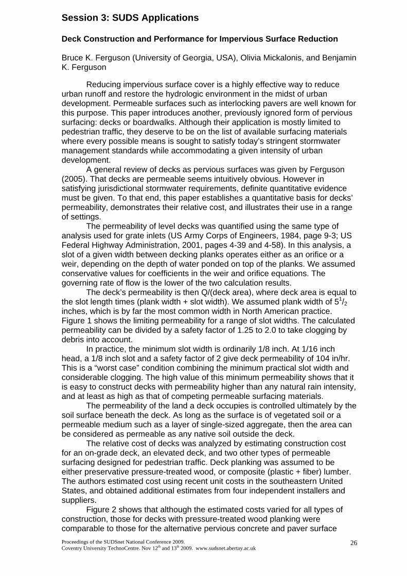
The deck’s permeability is then Q/(deck area), where deck area is equal to the slot length times (plank width + slot width). We assumed plank width of 51/2 inches, which is by far the most common width in North American practice. Figure 1 shows the limiting permeability for a range of slot widths. The calculated permeability can be divided by a safety factor of 1.25 to 2.0 to take clogging by debris into account.
In practice, the minimum slot width is ordinarily 1/8 inch. At 1/16 inch head, a 1/8 inch slot and a safety factor of 2 give deck permeability of 104 in/hr. This is a “worst case” condition combining the minimum practical slot width and considerable clogging. The high value of this minimum permeability shows that it is easy to construct decks with permeability higher than any natural rain intensity, and at least as high as that of competing permeable surfacing materials.
The permeability of the land a deck occupies is controlled ultimately by the soil surface beneath the deck. As long as the surface is of vegetated soil or a permeable medium such as a layer of single-sized aggregate, then the area can be considered as permeable as any native soil outside the deck.
The relative cost of decks was analyzed by estimating construction cost for an on-grade deck, an elevated deck, and two other types of permeable surfacing designed for pedestrian traffic. Deck planking was assumed to be either preservative pressure-treated wood, or composite (plastic + fiber) lumber. The authors estimated cost using recent unit costs in the southeastern United States, and obtained additional estimates from four independent installers and suppliers.
Figure 2 shows that although the estimated costs varied for all types of construction, those for decks with pressure-treated wood planking were comparable to those for the alternative pervious concrete and paver surface
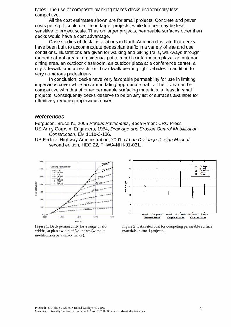
types. The use of composite planking makes decks economically less competitive.
All the cost estimates shown are for small projects. Concrete and paver costs per sq.ft. could decline in larger projects, while lumber may be less sensitive to project scale. Thus on larger projects, permeable surfaces other than decks would have a cost advantage.
Case studies of deck installations in North America illustrate that decks have been built to accommodate pedestrian traffic in a variety of site and use conditions. Illustrations are given for walking and biking trails, walkways through rugged natural areas, a residential patio, a public information plaza, an outdoor dining area, an outdoor classroom, an outdoor plaza at a conference center, a city sidewalk, and a beachfront boardwalk bearing light vehicles in addition to very numerous pedestrians.
In conclusion, decks have very favorable permeability for use in limiting impervious cover while accommodating appropriate traffic. Their cost can be competitive with that of other permeable surfacing materials, at least in small projects. Consequently decks deserve to be on any list of surfaces available for effectively reducing impervious cover.
References Ferguson, Bruce K., 2005 Porous Pavements, Boca Raton: CRC Press US Army Corps of Engineers, 1984, Drainage and Erosion Control Mobilization
Construction, EM 1110-3-136. US Federal Highway Administration, 2001, Urban Drainage Design Manual,
second edition, HEC 22, FHWA-NHI-01-021.
Figure 1. Deck permeability for a range of slot widths, at plank width of 5½ inches (without modification by a safety factor).
Figure 2. Estimated cost for competing permeable surface materials in small projects.
Proceedings of the SUDSnet National Conference 2009. Coventry University TechnoCentre. Nov 12th and 13th 2009. www.sudsnet.abertay.ac.uk
27

Proceedings of the SUDSnet National Conference 2009. Coventry University TechnoCentre. Nov 12th and 13th 2009. www.sudsnet.abertay.ac.uk
28
Keeping the Greens Green - Golf Course SUDS and Rainwater Harvesting, A paradox of two holes Matthew J Travis1 and Keelan R Serjeant1 1Enzygo Ltd, STEP Business Centre, Wortley Road, Deepcar, Sheffield, S36 2UH Key Words Sustainable Drainage, Flooding, Irrigation, Golf Courses, Rainwater Harvesting Abstract
With changes in weather patterns and increasingly dry summers, and wetter winter’s golf course operators are taking action to ensure the greens stay green, and the fairways don’t get bogged down.
Historically the management of surface water on golf courses has concentrated on irrigation and making sure that the greens and fairways remain lush and playable throughout the year. However irrigation systems do not always perform optimally, or are operated efficiently, and as a result are not always considered water efficient and sustainable. Traditionally, golf courses have relied on water supplies from private water companies or the abstraction of groundwater and/or surface water. These water sources can incur a high annual cost which is increasing as the resource becomes scarcer. Water abstraction for golf courses will become more heavily regulated through national policy and the regulatory framework such as the implementation of the European Water Framework Directive (European Union, 2000), Planning Policy Statement 25: Development and Flood Risk (PPS25) and the Water Act 2003. Within the existing regulatory regime, new golf course construction is required to ensure that the runoff from the golf course is no greater than that from the historic land use. This is commonly implemented through PPS25, and Technical Advise Note 15 (TAN15), in England and Wales. Further land drainage consents may be required for any offsite discharges. Our understanding of climate change suggests that such extreme events are likely to increase in frequency. Projections of future climate change indicate that more frequent short frequent short-duration, high-intensity rainfall and more frequent periods of long-duration rainfall. Central England’s temperature rose by almost 1oC during the twentieth century. Heat waves have become more frequent in summer and there are now fewer frosts and winter cold spells. Winters over the last 200 years have become wetter relative to summer; a larger proportion of winter precipitation in all regions now falls on heavy rainfall days than was the case 50 years.
Proceedings of the SUDSnet National Conference 2009. Coventry University TechnoCentre. Nov 12th and 13th 2009. www.sudsnet.abertay.ac.uk
29
These kinds of changes will not only have implications for river flooding and local flash flooding the changes will affect the irrigation of fairways due to the scarcity of water resources at certain times of the year and pressure of drainage systems. Some of these changes are already being felt. New techniques in drainage and irrigation have resulted in golf courses being designed to a higher standard, increasing their ability to remain playable all year round. The most sustainable source of water for irrigation is recycled water from rainfall and drainage systems.
The benefits of a correctly drained course are twofold: firstly capturing any irrigation or rainfall which is not taken up by grass or trees and routing it directly into the irrigation lakes/reservoir; secondly acting to provide enhanced drainage of the fairways, semi rough and greens. This dual action allows greater playability across a range of rainfall events, with increased drainage following a storm, and also provided a greater irrigation capture system, reducing the need for abstraction or reliance on public water supplies. The enhanced benefits of correctly drainage will be explored in the paper through examples of newly constructed golf courses alongside the design principals, pitfalls and maintenance issues.
Current guidance promotes sustainable water management through the use of Sustainable Drainage Techniques (SUDS) employed include water harvesting, water re-use systems most commonly used by integrating ponds and lakes into the design of the golf course. It is generally accepted that the implementation of SUDS as opposed to conventional drainage systems, provides several benefits. This paper will explore the regulatory regime for new golf course construction in England and Wales and the relative pressures on drainage and water re-use within the golf industry. Case studies showing the incorporation of SUDS into the layout of golf courses are provided. As part of a golf courses water management strategy a number of interconnecting lakes, ponds and lagoons can be designed to harvest and re-use rainfall. These each drain the surrounding fairways, greens and rough therefore, maximising the amount of water harvested during rainfall events.

Proceedings of the SUDSnet National Conference 2009. Coventry University TechnoCentre. Nov 12th and 13th 2009. www.sudsnet.abertay.ac.uk
30
SUDS and Amenity – Value by design Robert Bray – Robert Bray Associates: [email protected] 1. A new aspiration One of the great achievements of Sustainable Drainage Systems or SUDS has been the bringing together of disparate elements of managing rainfall into a holistic philosophy. The idea of an integrated drainage system to manage the quantity and quality aspects of runoff together with benefits for the community and wildlife evolved during the 1990s and was one of the signal innovations of the first SUDS design manual published in 2000. This manual recognized the omission of amenity consideration in traditional drainage and commented: ‘The amenity aspects, such as water resources, community facilities, landscaping potential and provision of wildlife habitats have largely been ignored’. The SUDS Manual CIRIA C697 2007, under Amenity Criteria, suggested that criteria should be derived from consideration of three key principles: 1. Health and safety 2. Visual impact and 3. Amenity benefit, arguably a back to front sequence. Interestingly the majority of the remaining part of the relevant clause 3.4 is concerned largely with Health and safety rather than the criteria that should be used to design Amenity in SUDS. 2. Why does this matter? SUDS mimics natural drainage by linking together a variety of landscape features, at or near the surface, in a ‘management train’ to improve the quantity and quality characteristics of runoff. Just as in nature, water is usually visible as it travels through the landscape and the places where it flows, stills, trickles or splashes hold a special place in our imagination. It is because we see and experience water in the landscape that we try to understand and evaluate the value it adds to our lives. Traditional drainage is largely out of sight and out of mind, as it is generally below ground, and only exercises our senses when it fails. An interesting dictionary definition of amenity is: ‘a useful or pleasant facility’ - perhaps it can be both at the same time. Significantly the definition separates something that can be measured, i.e. useful, from something that can be experienced, i.e. pleasure. This definition clearly assumes that the facility is visible and can be designed in such a way as to offer a usable space and provide intangible value that can be evaluated as an aesthetic element of design. The visible element of SUDS brings the sustainable management of rainfall into the same cultural arena as any other discipline with a visual component, one of aesthetic and cultural judgment as well as a functional and cost benefit evaluation. 3. Current thinking on the nature of amenity The most common response to amenity, at present, is to advocate ‘added value’ as the objective of open space design with each facility evaluated in a tangible way. This is the approach taken in the recent CABE review, ‘The Value of Public Open Space’. Similarly in the CABE 20 Building for Life criteria, most of the criteria relate to function with only one or two specific to housing character.

Proceedings of the SUDSnet National Conference 2009. Coventry University TechnoCentre. Nov 12th and 13th 2009. www.sudsnet.abertay.ac.uk
31
The book ‘Rain Gardens – Managing water sustainably in the garden and designed landscape’ by Nigel Dunnet and Andy Clayden is an inspirational gathering together of good design practice with many visually exciting examples but does not clearly identify the characteristics that need to be included in SUDS design to deliver the benefits we associate with Amenity. Two recent papers from the US begin to collate thinking on amenity in stormwater design in a rather different way under the titles, ‘Artful rainwater design in the urban landscape’ by Stuart Echols and a further joint paper ‘Stormwater as amenity: The application of artful rainwater design’ by Stuart Echols and Eliza Pennypacker. Although these papers discuss the design opportunities delivered by practitioners in the US they do not clearly identify the design criteria that are needed for SUDS design in terms of amenity nor a mechanism for evaluating amenity, or lack of it, in a design submitted to a planner or regulator. The authors however clearly identify the value of pleasure as well as usefulness in the design of stormwater facilities. 4. Conditions required before amenity can be integrated into SUDS design The flow of runoff from development must meet two basic conditions before it can be integrated into useful or pleasurable spaces: • quantity – controlled flows and volumes allow the designer to create safe and
beautiful spaces for the public with predictable water characteristics. • quality – clean water from a ‘management train’, where it is judged to be safe for
people, provides the resource for the age old fascination with water in the landscape. 5. Design criteria to aid design and evaluation of amenity in SUDS – an ideas session SUDSNET brings together academics and practitioners from a wide range of backgrounds who may be able to forge a realistic and practical set of design criteria that consider the useful, the aesthetic and the most understandable requirements for designers, planners and public alike. A short workshop is proposed to discuss the question of amenity and develop a set of criteria for the delivery of this most elusive element of the SUDS philosophy. The session assumes the two base line criteria relating to quantity and quality discussed above are agreed. Biodiversity requirements within SUDS design are considered separately as the design criteria for ecology having been set out clearly in publications like ‘Ponds, pools and lochans, published by SEPA, and are understood by many ecologists. Amenity in SUDS can be evaluated in a similar way to the functional and visual components that are part of Architecture, Landscape Design or any other discipline with a visual and functional aspect. An invitation is extended to all who find the design opportunities of SUDS an unfolding horizon for better if slightly wetter places.

Proceedings of the SUDSnet National Conference 2009. Coventry University TechnoCentre. Nov 12th and 13th 2009. www.sudsnet.abertay.ac.uk
32
Session 4: SUDS and Floods Modular Surface Water Management Plans – Scoping the Way Forward. Stephen Tingle B Eng, C Eng, M.I.C.E – Assistant Principle Engineer- Renfrewshire Council. [email protected] It’s generally accepted that there is a need to acquire a joint strategic and detailed perspective on surface water management in order to protect and encourage sustainable economic development. The preferred location for the primary arterial surface water conveyance routes, balancing peak flow and attenuated storage capacity, will act as the spine of any future drainage network, secondary drainage routes forming the remainder of the skeleton. Such routes require to be agreed early in the process, giving an affordable, sustainable, and lowest overall public cost solution. The Scottish Government has produced a new flood statute “The Flood Risk Management (Scotland) Act, 2009”, requiring specific cross cutting service agreements covering aspirations, programmed measures, and aligned funding, to enable all functions of all responsible authorities to be embedded within an exemplar Local Flood Risk Management Plan, with the concomitant duty under clause 41(b) for all to have regard to this plan. Clause 41(b) refers to “any” function of the responsible authorities, not simply the flood related functions of such authorities. Placing water infrastructure as first amongst equals in spatial planning is considered to be a key outcome of the Interreg III B NWE Urban Water Project. However, there is never a one size fits all, and there are emerging aspects of environmental green corridor and public movement, that could bring this into an all encompassing “sense of place” consideration. Water clearly needs to be first amongst equals in the process of a “sense of place” setting. These perspectives can be underpinned initially by regional LiDAR generated arterial surplus surface water overland flow mapping, in order to seek / locate affordable opportunistic intervention, in the surface water network. Later, very detailed modelling at the micro-catchment scale, including all aspects of drainage, assisted by LiDAR generated contours fleshes out the required multiple benefit measures. This does not preclude large regional models, as transferability of data between models is quite possible. What we cannot afford, is to ignore the bite sized micro-catchments, as they offer a reasonable size, for data build up on GIS, as well as public and developer liaison. Fortunately we now have the LiDAR generated DTM’s that can be used by very detailed fully integrated surface water drainage models, and regional overland arterial surface water flow models. The water centred / related modules required to underpin the “sense of place” are considered to include:- Water Quantity; Water Quality; Water in the Natural Environment; Water in the Built Environment; Groundwater; Wastewater and the disconnection of rainwater; Management and Maintenance of Surface Water; Aligned Funding; Carbon Reduction; Water Supply; Spatial Planning; Social Planning; Emergency Planning; and Contaminated Ground. Clearly there are many varied tasks to address, and the modules themselves can cover significant areas of influence, which have to be drawn together, into interdependent modules. LiDAR generated micro-catchment, sub-catchment and catchment boundaries for extreme storm events including at least the 1 in 200 year return period event is considered to be a key starting point for multidisciplinary consideration, which by necessity must consider other lesser storm events, which generate different boundary conditions. It should be noted here that such catchment boundaries are different to FEH and RBMP boundaries, and will throw up surprises. The modules will be detailed and populated with references to GIS and other plans, and act as toolkits for those potentially able to include surface water management. It will be necessary for this Modular Surface Water Management Plan (MSWMP) to be embedded within the GIS of all the responsible authorities, and within the RBMP, FRMP and LFRMP generated by the EU Water Framework and Flood Directives.

Proceedings of the SUDSnet National Conference 2009. Coventry University TechnoCentre. Nov 12th and 13th 2009. www.sudsnet.abertay.ac.uk
33
Renfrewshire Council is the lead/responsible authority of the process that culminates in a surface water management plan. As a result of so many varied aspects and potential opportunities, the MSWMP should be regarded as first amongst equals in terms of Plans, naturally including a relationship with the outside area and the regional context i.e. the LFRMP and RBMP. The surface water management desired outcomes within the MSWMP must therefore be reflected within the LFRMP, and FRMP, and vice versa. The Global description of the arterial flow of water through the micro-catchment, sub-catchment and catchments areas is referenced here, to the appropriate GIS layers managed by the partnership. This includes the sewer system, watercourses, storage, and SUDS. A description of both existing and future responsibilities is here, describing the peak flow conveyance demands in relation to the available capacities. The arterial overland surface water mapping highlights the vulnerable areas and also just where the opportunities for affordable flood risk mitigation are most likely. This mapping concerns the sewer, watercourse, SuDS, groundwater, natural and built hollows etc, and so much more. The watercourse, sewer networks and reservoirs, are related to these overland flows using GIS layering. What shows is a combination of vulnerable areas and areas without an acceptable arterial surface water peak conveyance capacity. The vulnerable areas will emerge from the quick scan, as do the demands for new arterial surface water conveyance routes. The potential for flood risk reduction will have to be jointly determined and agreed, and this sets out a clear agenda for detailed measure design and follow up analysis. The measures identified (both technical and spatial) depend upon available opportunities, and to what extent multiple benefits are available. This is where GIS becomes essential in sharing information at the inception of any potential infrastructure improvements. The alignment of measures and funding will be agreed prior to determining any agreed programme of measures. The potential for opportunity must be extensively investigated utilising layers of GIS related to the asset management of the natural and built environment. The outline extent of the flood risk problem can be related to the sub-catchments where both integrated sewer/ watercourse modelling and rainfall / topography overland flow mapping have both been undertaken and the relationship between the two demonstrates close similarity. Agreements to fund multi-benefit measures will be hampered by simple restatement of divisions in responsibility, unless there is a greater focus on outcomes and benefits, which would have to be funded anyway. The splitting of module GIS layer tabulation across record, information and outcomes, is set up specifically to identify benefits and targets to assist such a process of Sustainable Flood Risk Management.

Proceedings of the SUDSnet National Conference 2009. Coventry University TechnoCentre. Nov 12th and 13th 2009. www.sudsnet.abertay.ac.uk
34
Potential Use of Natural Flood Retention Wetlands to Control Diffuse Pollution
Qinli Yang, William R McMinn, Miklas Scholz
Institute for Infrastructure and Environment, School of Engineering, The University of Edinburgh, William Rankine Building, Mayfield Road, The King’s Buildings, Edinburgh EH9 3JL, Scotland, United Kingdom
Most natural and constructed retention basins keep runoff for subsequent release, thus avoiding downstream flooding problems. Some retention basins such as wetlands do perform other tangible albeit less ‘visible’ roles including diffuse pollution control and infiltration for groundwater recharge. The diversity of retention basins is therefore high and further complicated by often multiple and competing functions that these structures fulfil.
A classification system is therefore needed to allow clear communication between stakeholders such as politicians, planners, engineers and environmental scientists. The absence of a universal classification scheme for retention basins leads to confusion about the status of individual structures and their functions. This can lead to conflicts between stakeholders concerning the management of retention basins including wetlands.
Bastian et al. (2006) reviewed and assessed landscape classification systems, and pointed out their corresponding importance in terms of landscape diagnosis to assess different landscape functions. Scholz and Sadowski (2009) proposed a conceptual classification model based on 141 sustainable flood retention basins (SFRB) including 75 diverse wetland systems in the River Rhine Valley, Baden, Germany. Six SFRB types were defined based on the expert judgment of engineers, scientists and environmentalists.
The aim is to determine the key independent variables characterising retention basins, and to use them as classification variables relevant for the identification of wetland types (predefined by Scholz and Sadowski, 2009) that have a significant diffuse pollution and flood control potential using a principal component analysis (PCA) and a cluster analysis applied to 167 Scottish water bodies.
The SFRB classification scheme (Scholz and Sadowski, 2009) was adapted for Central Scotland, after a few insignificant adjustments were made. Based on a literature review, international site visits and expert judgement (team of engineers, scientists and environmentalists), a set of 39 variables were defined to characterize 167 water bodies, which contained SFRB and non-SFRB (i.e. predominantly unmanaged lakes without any diffuse pollution and flood control function).
A PCA was applied to reveal the relationships between variables, and to identify those that contribute most to the first and second component, and are independent, easy and reliable to determine. These variables were subsequently used for a Ward cluster analysis to identify seven distinct clusters (i.e. six SFRB types and a separate cluster for non-SFRB). Based on the hierarchical cluster analysis, the methodology proposed by Scholz and Sadowski (2009) and expert judgement, the groups that best matched the predefined SFRB types were identified.
The number of classification variables was reduced with the help of a PCA. Wetted Perimeter, Maximum Flood Water Volume, Flood Water Surface Area, Engineered Structure, Catchment Size, Outlet Arrangement and Operation, Dam Height, Land Animal Passage, Impermeable Soil Proportion and Mean Sediment Depth were the most important independent SFRB characterization variables,

which greatly contributed to the variability expressed by the first and second component.
A cluster analyses was performed with a reduced set of variables, which were independent, and easy and reliable to determine. Seven clusters containing the six SFRB types and a group comprising non-SFRB sites (predominantly unmanaged natural lakes) were identified. Figure 1 shows the groupings for the six SFRB types.
Fig. 1. Dendrogram used to identify the sustainable flood retention basin
groups A to F
The largest groups are Natural Flood Retention Wetlands (group E; 64 sites) and Traditional Flood Retention Basins (group A, 46 sites). The former includes passive natural flood retention wetlands characterized by a relatively high Wetted Perimeter and the latter comprises managed traditional reservoirs that are hydraulically optimized (or automated). The relatively small groups B, D and F represent SFRB, which could also be classed as wetlands with strong flood and diffuse pollution control functions based on the nature of their classification variables. The variables Wetted Perimeter, Flood Water Surface Area, Engineered Structure, Catchment Size, Outlet Arrangement and Operation and Mean Sediment Depth were mostly related to diffuse pollution control purposes by the statistical functions. Findings indicate that Scotland has a lower diversity of SFRB types than, for example, Baden (Germany), where six clear SFRB groups were identified.
The most important independent and accurately determined SFRB variables that resemble wetland systems with a high diffuse pollution treatment function were Wetted Perimeter, Engineered Structure, Catchment Size, Outlet Arrangement and Operation and Mean Sediment Depth. Natural Flood Retention Wetlands dominate the Scottish landscape, and could make a significant contribution to diffuse pollution control, if they are managed appropriately. ACKNOWLEDGEMENT
The European Regional Development Fund Interreg IVB 2007-2013 sponsored this project. REFERENCES Bastian, O., Kronert, R., Lipsky, Z. (2006) Landscape diagnosis on different space and time
scales - a challenge for landscape planning. Landsc. Ecol. 21:359-374. Scholz, M. and Sadowski, A.J. (2009) Conceptual classification model for Sustainable Flood
Retention Basins. J. Environm. Managem. 90: 624-633.
Proceedings of the SUDSnet National Conference 2009. Coventry University TechnoCentre. Nov 12th and 13th 2009. www.sudsnet.abertay.ac.uk
35

Proceedings of the SUDSnet National Conference 2009. Coventry University TechnoCentre. Nov 12th and 13th 2009. www.sudsnet.abertay.ac.uk
36
Session 5: SUDS Performance 1 (rainwater harvesting, paving and heat pumps) Permeable Paving and Rainwater Harvesting: Legislation and Performance
1Stephen Coupe, 2Susanne Charlesworth and 2Amal Faraj 1Hanson-Formpave Ltd, Coleford, Gloucestershire, UK GL16 8PR, (01594) 836999. [email protected] 2Coventry University, Faculty of Business Environment and Society, Priory Street, Coventry, West Midlands, UK, CV1 5FB, (02476) 888370, [email protected] Rainwater harvesting is now encouraged in the UK by a number of pieces of draft and implemented legislation. Although historically the UK has been slow to adopt measures that limit the use of mains water for non-potable purposes (e.g. for landscape watering, WC flushing and car washing), Future Water (2008) set clear goals to encourage the minimisation of mains water resources. The implications of using water close to its source are firstly, a rational and logical use of resources rather than wasting a precious resource and discharging it into the sewer network. Secondly, the energy required to purify water is significant, with 2-3% of all the electricity purchased in the UK and used in the production of water, and emitting about 1 % of the country's greenhouse gas emissions (Energy Saving Trust, 2009). Progress on both of these fronts would significantly reduce the UK’s CO2 impact and improve flood prevention by limiting the discharge of water from sites. The Code for Sustainable Homes (CSH) has been one of the practical measures that have been introduced to implement the above changes. First released by The Department for Communities and Local Government in 2006, the CSH provides clear guidance on the environmental standards required when building new houses, above and beyond the scope of building regulations. The degree of environmental impact of a housing development results in the awarding of a code level, 1-6 with 6 having the lowest impact. As water is a key area for code compliance, both grey water recycling and rainwater harvesting are possible choices for obtaining the higher code level awards. In essence, the approach by the CSH is two fold:
• Limiting the amount of water used in the development by the use of low flow taps, aerating shower heads, low water use appliances.
• The re-use of water on site by rainfall harvesting or grey water recycling
The water use in litres per person per day, attainable and verified by a code assessor must be 90 to obtain a code 4 rating for water. This compares favourably with the default value calculated by the Water Research Council of 212.05 L/person/day (CSH Technical Manual, 2008). The two halves of the water strategy, limiting demand and resource replacement of non-potable supply by on-site water are used in combination to produce a much lower value for water use than the default case.

Proceedings of the SUDSnet National Conference 2009. Coventry University TechnoCentre. Nov 12th and 13th 2009. www.sudsnet.abertay.ac.uk
37
In practice, the infrastructural requirements can be seen as onerous by developers who often approach this code category with a low knowledge base, unlike energy where progress has been made to make low carbon sources more accessible. It is possible however, to reduce the complexity and cost of integrating the interior plumbing and the reservoir and provide a SUDS device that will gain maximum available points in the Surface Water and Flood Risk section of the CSH. Where a permeable pavement is used for a driveway in new housing, not only does this adhere to good practice design to minimise runoff, the reservoir available is around 1m3 of water per 10 m2 of paving, integrating the landscaping with the building with no need for the extra cost of a separate SUDS device and rainfall reservoir. This strategy has been shown to provide 5 of 6 available points in the water section of the code and 4 of 4 available points in Surface Water Runoff and Flood Prevention. It is important that SUDS are recognised as relevant and helpful to the completion of a scheme by developers when constructing new buildings. This should raise the level of awareness of SUDS as an integral part of how a development is constructed rather than an afterthought on completion of the house envelope as is often the case in ‘traditional’ landscaping schemes. References: Energy Savings Trust (2009). http://www.energysavingtrust.org.uk/Water/Water-and-carbon-the-facts Department for Communities and Local Government. (2008). Code for Sustainable Homes, Technical Guide. Crown copyright.

An Investigation of Pollutant Retention by TarmacDry Pervious Pavement Structures J.A. Beddow1, S.M. Charlesworth1, A. R. Jones2 1SUDS ARG, BES, Coventry University, Priory Street, Coventry, CV1 5FB 2Tarmac Limited, Technical Centre, Ettingshall, Wolverhampton, WV4 6JP [email protected] and [email protected] Introduction Permeable pavement systems (PPS) are perhaps one of the most practical sustainable drainage solutions (SUDS) for widespread incorporation in to our ever expanding urban environment. They provide the stable hard surfaces needed by vehicles and pedestrians whilst counteracting many of the problems associated with impervious nature of traditional paving. As with other SUDS approaches, the infiltration of rainwater by PPS greatly reduces the volume of surface water runoff. This in turn decreases both the likelihood of flooding and the stress imposed on existing drainage infrastructure. A further advantage of the infiltration process is that it improves the chemical and biological quality of the water by filtering out and retaining many of the common pollutants found in stormwater runoff. The work presented here reports on a study investigating the long term pollutant retention characteristics of a number of different PPS constructions.. Methodology For this research Tarmac Ltd constructed 9 large permeable pavement model rigs. These included 5 surfaced with TarmacDry PPS (with varying sub-structures;1 - 3), 2 surfaced with porous concrete (4), 1 constructed using permeable block paving (PB) and 1 made from a cut-out taken from an early TarmacDry PPS car park which was installed in 1999. A schematic layout of one of the TarmacDry models together with a photograph of its surface is shown in Figure 1.
Proceedings of the SUDSnet National Conference 2009. Coventry University TechnoCentre. Nov 12th and 13th 2009. www.sudsnet.abertay.ac.uk
38
Figure 1 - (Left) Basic structure of PPS model. (Right) Photograph of
porous asphalt model surface. Two test pollutant materials, namely: a typical urban street dust (SD) and unused engine oil were used to contaminate the PPS model surfaces. These were added at random positions to each of the PPS models and at regular intervals in amounts equivalent to a month worth of loading in a typical urban environment (25 ml/m2 of oil and 21 g/m2 of SD). The concentration of heavy metals in the manufactured rain water is presented in Table 1. Pollutant Cu Ni Zn Pb Cd Each Month Rain mg/l 0.33 0.002 0.11 0.011 0.001 13 mm Street Dust [Total] mg/kg 233 25 357 150 1.1 21 g per m2
Oil mg/l 2.0 0.46 300 0.43 1.7 25 ml per m2
Table 1 - Concentration of heavy metals in artificial rain, SD and oil

Following addition of the pollutants, the surfaces were artificially rained on with tap water from a purpose built rainfall simulator (13 mm each time at a rate of 15 mm/hour). Samples of the outflow water were collected and then tested for heavy metals (Cd, Cu, Ni, Pb & Zn by ICP-AES), total hydrocarbons (Horiba IR Oil Analyser) and total suspended solids (gravimetric determination). Results and Discussion The results presented here cover 31 pollutant addition and rainfall events simulating a period equivalent to just over 2½ years. Figure 2 shows some of the results for the concentration of Cu in the outflow samples.
Figure 2.- Graphs of Cu concentration in the outflow from TarmacDry models 1A
& 1B (left) and % of added Cu retained (right). (LOD Cu 0.01 mg/l) In Figure 2 (left) it can be seen that the concentration of Cu in the outflow from the TarmacDry models (1A and 1B) are all significantly below the input concentrations (Table 1) and well below the WHO drinking water guideline threshold limit (2 mg/l). In Figure 2 (right) it can be seen that each of the PPS models had retained more than 98% of the Cu added during the monitoring period. The findings for each of the other heavy metals were very similar with all of them below WHO guideline levels and with >90% of the added loads retained. Equally the concentrations of oil and suspended solids in the effluents are very low with less than 1% of the total amount added having been discharged. Another finding common to each of the pollutants was that there was no indication of any significant differences in performance amongst the PPS types tested. Conclusions. The results from the study in terms of outflow water quality indicate that the added pollutants are being effectively retained within the PPS structures even after more than 2½ years of heavy pollutant loading. The results also demonstrate that the physical performance of the PPS system is unaffected. Acknowledgments The authors are grateful to the following individuals for their assistance in providing expert advice and guidance: Professor Chris Pratt, Neil Thomas, Lorna Everall, Dr Ernest Nnadi and Richard Collins. The authors are grateful to Tarmac Ltd for their financial support to this study.
Proceedings of the SUDSnet National Conference 2009. Coventry University TechnoCentre. Nov 12th and 13th 2009. www.sudsnet.abertay.ac.uk
39

Molecular Characterization of Bacterial Populations in Urban Runoff for Combined Pervious Pavements and Geothermal Heat Pumps
Kiran Tota-Maharaja, Miklas Scholza, Piotr Grabowieckia, Toqeer Ahmedb, Stephen Coupec
aInstitute for Infrastructure and Environment, School of Engineering, The University of Edinburgh, The King’s Buildings, Edinburgh EH9 3JL, Scotland, United Kingdom
bDepartment of Microbiology, Faculty of Biological Sciences, Quaid-i-Azam University, Islamabad, Pakistan
cSchool of Science and the Environment, Coventry University, Priory Street, Coventry CV1 5FB, UK
The use of permeable pavement systems with integrated geothermal heat
pumps (Fig. 1) for the treatment and recycling of urban runoff is novel and timely (Scholz and Grabowiecki, 2007). This study assesses the efficiency of the combined technology for controlled indoor and uncontrolled outdoor experimental rigs. Water quality parameters such as biochemical oxygen demand, nutrients, total viable heterotrophic bacteria and total coliforms were tested before and after treatment in both rigs. The water borne bacterial community genomic deoxyribonucleic acid (DNA) was analysed by polymerase chain reaction amplification followed by denaturing gradient gel electrophoresis and was further confirmed by DNA sequencing techniques.
Fig. 1. Schematic overview of temperature probes and temperature gauges
for geothermal heat pump simulation within permeable pavement systems.
The performance of twelve permeable pavement systems integrating
simulated ground source heat pumps was good with respect to water quality treatment (Fig. 2) and energy use performance indicators. Microbial count reductions were relatively high during the treatment process despite the simulation of a worst case pollution scenario involving the introduction of dog faeces to the simulated runoff. Figure 3 shows bands for selected strains, illustrating what organisms are dominant in the permeable pavements saturated zone, and it outlines the neighbour joining method for comparative analysis of bacterial communities in the permeable pavement system, indicating the most likely genetic relationships between 16S rDNA sequences from treated water samples.
Proceedings of the SUDSnet National Conference 2009. Coventry University TechnoCentre. Nov 12th and 13th 2009. www.sudsnet.abertay.ac.uk
40

Fig. 2. Removal rates for the (a) biochemical oxygen demand (BOD), (b)
suspended solids, (c) total heterotrophic bacteria and (d) Escherichia coli (June 2006 to March 2009).
Fig. 3. Neighbour joining method for comparative analysis of bacterial
communities in the experimental permeable pavement system.
The effluent could be used for recycling (e.g. garden watering and toilet flushing), considering that it does not pose an elevated risk to human heath. The additional heat provided by the ground source heat pumps did not result in a deterioration of microbial pollution due to regrowth during various operational modes. The efficiency of the ground source heat pump compares well with other systems used for residential developments described previously. ACKNOWLEDGEMENTS
The authors gratefully acknowledge the Hanson Formpave and Higher Education Commission of Pakistan (HEC) for providing funding and research facilities to the leading author to conduct this research work. REFERENCE Scholz, M., and Grabowiecki, P. (2007) Review of permeable pavement systems.
Build. Environm. 42:3830-3836.
Proceedings of the SUDSnet National Conference 2009. Coventry University TechnoCentre. Nov 12th and 13th 2009. www.sudsnet.abertay.ac.uk
41

Proceedings of the SUDSnet National Conference 2009. Coventry University TechnoCentre. Nov 12th and 13th 2009. www.sudsnet.abertay.ac.uk
42
Session 6: SUDS Performance 2 (wetlands and ponds)
Improving the design of urban stormwater ponds CATHERINE T. MORGAN1, KATE V. HEAL2*, STEVE G. WALLIS3 & REBECCA J. LUNN4 1 SESEF, Grant Institute, King's Buildings, West Mains Road, Edinburgh EH9 3JW 2 School of GeoSciences, The University of Edinburgh, Crew Building, King's Buildings, West Mains Road, Edinburgh EH9 3JN 3 School of the Built Environment, Heriot-Watt University, Edinburgh EH14 4AS 4 Department of Civil Engineering, University of Strathclyde, John Anderson Building, 107 Rottenrow, Glasgow G4 0NG * Corresponding author: [email protected], Tel: 0131 650 5420, Fax: 0131 662 0478 Key words design; modelling; outlet; performance; ponds; retention basins; SUDS; urban stormwater Introduction Urban stormwater ponds (or retention basins that contain a permanent water pool) are designed with the dual purpose of flow attenuation and water quality enhancement. These purposes may have potentially conflicting design implications because effective flow attenuation requires temporary storage and then delayed outflow of storm runoff (to create space for runoff from the next storm), whilst good water quality enhancement requires a longer storage time (to allow particle settling). From simulations of generic cylindrical ponds we have shown already that the design aim has a significant effect on pond performance (Morgan et al., 2007). Ponds designed for flow attenuation are more successful than those designed for water quality enhancement in terms of both flow and pollutant attenuation (measured as removal of suspended sediment) in both single and multiple storm events. Here we demonstrate, using a similar modelling approach, that the use of a dual outlet for retention ponds can resolve these design conflicts in an efficient manner. Modelling approach The mathematical model consisted of two components: a flow model and a sediment transport model; and in both cases the pond was modelled as a deterministic, lumped system. The pond was assumed to be cylindrical, having a single inlet. Flow through the pond was modelled using a standard storage routing method based on a conservation of water volume equation. Outflow from the pond was calculated using standard head-discharge equations. The sediment transport model was also based on conservation of mass and recognised that the concentration of suspended sediment in a stormwater pond (particularly during an inflow event) may not be uniform and that several flow-related processes, such as short-circuiting and flow-dependent settling, are likely to occur. To ensure that the simulated pond volume was realistically matched to inflow events, the simulations were based on Linburn Pond, located in the Dunfermline Eastern Expansion (DEX) development, eastern Scotland. Simulations focused on the 24 h duration inflow event, which is representative of the hydrological conditions in eastern Scotland. Peak inflows used were the 1 in 25 year, the 1 in 2 year and the Q90 events of 250, 125 and 28.7 L s-1, respectively, calculated from combining the local 30-year daily rainfall record with a simple rainfall-runoff model.

The inflow sedi-graph had a symmetrical triangular distribution, with a peak concentration of 100 mg L-1, and comprised sediment of five different particle sizes chosen from the analysis of sediment in the inlets to SUDS ponds in the DEX development. Initially, two outlet configurations were studied: a single outlet pond with a 90o V-notch weir crest set at 3 m above the pond base and a dual outlet pond with the same weir plus a 0.1 m-diameter pipe set at 1.5 m above the pond base. The ponds were sized to reduce the peak outflow to 50% or less of the peak inflow for the design storm which meant that the single outlet pond had a greater footprint than the dual outlet pond at 75 m and 36.2 m radius, respectively. Results and discussion Flow attenuation of the 1 in 2 year storm routed through both ponds was greater in the dual outlet pond than the single outlet pond (83% vs. 69% peak flow reduction), although sediment mass removed was greater in the single outlet pond compared to the dual outlet pond (50% vs. 78% of total mass settled). Simulations of Linburn Pond itself (40 m radius), which was designed with a single-level outlet, showed that addition of a pipe to provide a dual outlet resulted in dramatic increases in % peak flow reduction and % sediment mass settled, particularly for the 1 in 25 year and 1 in 2 year storms (Fig. 1). Further simulations showed that a dual outlet configuration provided excellent performance in terms of both flow attenuation and water quality enhancement using a permanent pool volume of only 1.4 Vt (treatment volume), considerably smaller than the normal pond sizing recommended in the UK of 3-4 Vt.
Proceedings of the SUDSnet National Conference 2009. Coventry University TechnoCentre. Nov 12th and 13th 2009. www.sudsnet.abertay.ac.uk
43
0
20
40
60
80
100
Q90 1 in 2 1 in 25
% p
eak
flow
redu
ctio
n
0
20
40
60
80
100
Q90 1 in 2 1 in 25
% s
edim
ent m
ass
settl
ed
Current designDual outlet design
(a) (b)
Fig. 1 Modelled flow attenuation (a) and sediment removal (b) in the current (single-level outlet) and a dual outlet design for Linburn Pond for different storm inflows Conclusions The use of multi-level outlet devices for urban stormwater ponds can provide benefits through improved flow attenuation and reduction in the footprint and/or permanent pool volume required for acceptable flow and water quality performance. Acknowledgements Scottish Water and Heriot-Watt University funded Catherine Morgan’s PhD and the British Atmospheric Data Centre provided rainfall data. Reference Morgan, C.T., Heal, K.V., Wallis, S.G. and Lunn, R.J. (2007). Assessing the effects of design and climate change on sediment removal in urban stormwater ponds. In: Webb, B. W. and de Boer, D. (Eds.), Water Quality and Sediment Behaviour of the Future: Predictions for the 21st Century, IAHS Publication no. 314, pp.71-78.

Proceedings of the SUDSnet National Conference 2009. Coventry University TechnoCentre. Nov 12th and 13th 2009. www.sudsnet.abertay.ac.uk
44
Microbial Communities Removing Nitrogen within an Integrated Constructed Wetland Treating Rural Runoff
Atif Mustafaa, Miklas Scholza, Rory Harringtonb
aInstitute for Infrastructure and Environment, School of Engineering, William Rankine Building, The King’s Buildings, The University of Edinburgh, Edinburgh EH9 3JL, Scotland, United Kingdom
bNational Parks and Wildlife, Department of Environment, Heritage and Local Government, The Quay, Waterford, Ireland
The processes of nitrogen removal and retention in constructed wetlands
are various and complex, and include ammonia volatilization, nitrification, denitrification, nitrogen fixation, plant and microbial uptake, mineralization (ammonification), nitrate-ammonification, anaerobic ammonia oxidation (ANAMMOX), ammonia adsorption and burial. Wetland systems are designed to provide favourable conditions for nitrogen removal. Macrophytes provide attachment surfaces for biofilms and support conditions for nitrification, if sufficient oxygen is available (Scholz et al., 2007).
The chemolithotrophic ammonia-oxidising bacteria are responsible for nitrification, in which ammonium (NH4) is converted to nitrite (NO2), and NO2 is subsequently transferred to nitrate (NO3). Previous population studies of ammonia-oxidising bacteria show that Nitrosomonas sp. dominate in engineered systems. Denitrification is the stepwise reduction of NO3 to dinitrogen (N2), associated with the release of nitric oxide (NO) and nitrous oxide (N2O) gases. Denitrifying bacteria assist in removing excess nitrogen from wastewater and also in the degradation of organic pollutants. Most bacteria with this functional trait belong to a wide array of the diverse subclasses of Proteobacteria.
The overall objective was to characterise and compare the microbial diversity responsible for nitrogen removal in different parts and components of an integrated constructed wetland (ICW; Scholz et al., 2007) and to identify relationships between water quality variables and the microbial diversity. The authors hypothesized that the community composition is likely to change throughout the different stages of wastewater treatment in an ICW. This was one of the first field-scale investigations of microbial communities in full-scale constructed wetlands located in the British Isles.
Inflows and outflows to each ICW cell were sampled, and a water analysis for the standard water quality parameters was carried out every two weeks. In April 2008, duplicate litter and sediment samples were collected from all cells of two different ICW systems. The sediment samples were brought together from the same area with a sediment sampler (Ø 4 cm) below the sediment-water interface, and the upper 3 cm were used for subsequent analysis. A total of twenty (ten sediment and ten litter samples) were collected from five sampling points. All samples were frozen immediately after collection.
The duplicate sediment and litter samples were subjected to deoxyribonucleic acid (DNA) extraction using a FastDNA® SPIN kit for Soil (MP Biomedical Inc., USA) according to the manufacturer’s protocol. The extracted DNA was stored at -20ºC. The ammonia-oxidising bacterial community was investigated using CTO primers, while the denitrifying bacterial community was assessed using the functional gene primers. Polymerase chain reaction (PCR) was performed on a Px2 Thermal Cycler (Thermo Hybaid Inc., Massachusetts, USA) in 47 µL of PCR Mega Mix manufactured by Microzone Ltd. (UK), 2 µL of primer mix and 1 µL of DNA extract.

The PCR products were generated by using different primers, and were analysed by denaturing gradient gel electrophoresis (DGGE). Samples were prepared by mixing 11 µL of the PCR products with 11 µL of the loading buffer and loaded onto the DGGE gel. The DGGE bands were excised using a sterile tip, transferred to 30 µL of TE buffer and stored at -20ºC. The PCR was performed as described above using the respective primers without a GC clamp. The ExoSAP-IT protocol was followed for cleaning. The cleaned PCR products were then sequenced. The NCBI BLAST (http://www.ncbi.nih.gov) website was used to find the closely related 16S rRNA gene sequences.
Both Nitrosospira and Nitrosomonas populations were detected in the ammonia-rich environment of the ICW. Nitrosospira sp. was detected in the wetland cells 1, 3 and 4, while Nitrosomonas sp. was detected in cell 2. Environmental factors such as salinity and ammonia concentrations may select for certain species of ammonia-oxidizing bacteria.
Eight sequences were detected in the litter samples collected from cells 1 and 2 where maximum nitrogen removal took place (Fig. 1). Pseudomonas and Dechloromonas were identified in the litter samples, while Paracoccus was identified in sediment samples collected from cells 1 and 2. Only one strain of Dechloromonas was identified in the last cell 4, which had only 5% vegetation cover and a higher concentration of nitrates relatively compared to ammonia-nitrogen (Fig. 1) implying that diversity and vegetation has an impact on the removal of nitrogen in the ICW.
0 5 10 15 20 25 30 35 40
C1In
C2In
C3In
C4In
C4Ef
Mon
itorin
g po
ints
Nutrient concentration (mg/l)
NO3-NNH4-N
Fig. 1. Nutrient reductions in selected wetland cells (In, influent; Ef,
effluent).
Ammonia oxidizing and denitrifying bacteria were identified within an ICW using molecular microbiological techniques. The community composition changed throughout the different stages of treatment. The study indicates that the litter component of the ICW system supports a high diversity of microorganisms. The higher diversity makes the treatment process more stable and efficient. ACKNOWLEDGEMENTS
Technical support by Susan Cook, Fiona Read and Andrew Goodhead is acknowledged. REFERENCE Scholz, M., Harrington, R., Carroll, P. and Mustafa A. (2007) The integrated constructed wetlands
(ICW) concept. Wetlands 27:337-354.
Proceedings of the SUDSnet National Conference 2009. Coventry University TechnoCentre. Nov 12th and 13th 2009. www.sudsnet.abertay.ac.uk
45

The effects of vegetation on residence times in ponds Virginia Stovin (University of Sheffield), Ian Guymer (University of Warwick), Jean O Lacoursiere & Lena B-M Vought (Kristianstad University, Sweden) Abstract Ponds are widely viewed as one of the more effective SUDS components, providing positive benefits for flow control, enhancing water quality and delivering amenity and habitat value. Examples of water quality improvement mechanisms include sedimentation and the uptake of nutrients by vegetation. Most of these water quality processes depend upon the residence time of the contaminants within the pond, and many of these benefits are also associated with the presence of emergent vegetation. However, if the contaminants pass through too quickly, the effectiveness of treatment will be reduced. The starting point for many pond design approaches is the simple assumption that nominal residence time can be calculated from the volume divided by the flowrate ( ). However, this assumes ideal (or ‘plug’) flow. In real ponds this will rarely happen. The potential problems associated with geometric short-circuiting effects (for example where an outlet is placed adjacent to the inlet) are generally recognized and understood. However, the impacts that pond vegetation will have on the flow field – and consequently on residence (treatment) times – has received less consideration. The research methodology utilizes field studies on a working agricultural stormwater management pond in Lyby, Sweden, combined with the use of both laboratory scale model studies (University of Warwick) and Computational Fluid Dynamics (CFD) numerical modelling work (University of Sheffield). The laboratory and CFD models provide simplified systems which enable specific performance aspects to be examined in greater detail. Selected outcomes from this research are illustrated below.
Field studies – Lyby Pond, Sweden
Plan of the pond, indicating location and extent of vegetation. The photograph (top right) was taken shortly after construction in 2001.
A sample trace test from the pond, undertaken in April 2009. Note that 80% of the tracer leaves the pond in a shorter time than the nominal retention time. 20% spends less than one quarter of the expected time, indicating significant short-circuiting.
Proceedings of the SUDSnet National Conference 2009. Coventry University TechnoCentre. Nov 12th and 13th 2009. www.sudsnet.abertay.ac.uk
46

Laboratory experiments – University of Warwick
The laboratory pond model is 1:30 horizontal scale, 1:15 vertical scale. Travel times have been established for a range of flowrates, both with and without vegetation. Surface PIV measurements show that the flow field is channelized through the pond when vegetation is present.
The tracer results clearly show increased levels of short-circuiting associated with the vegetated trace. With no veg, 25% of the tracer passes through the pond in 40% of the nominal retention time; with veg, 25% takes around 25% of tn.
Computational Fluid Dynamics (CFD) modelling – University of Sheffield
This plot shows the results of a simulated dye injection, using particle tracking. The inlet is on the left. Flow circulations are clearly evident, and particle residence times can be compared with the field and laboratory measurements.
0.00
0.05
0.10
0.15
0.20
0.25
0.30
0.35
0.00 0.05 0.10 0.15 0.20 0.25 0.30
Hei
ght a
bove
bed
(m)
Velocity (m/s)
Top of vegetation
Experimental Velocity Profile
CFD velocity profile
Preliminary CFD work has been undertaken to evaluate the suitability of a porous zone model to represent vegetation. The plot above compares the CFD-based vertical velocity profile with one measured within a straight, vegetated, laboratory channel.
Conclusions: • Although vegetation plays an important role in enhancing water quality
and amenity value in SUDS ponds, its impacts on flow patterns and retention times are not well understood.
• Some understanding of potential effects – and their implications for pond design and operation – is being obtained through a combination of field measurements, laboratory experiments and numerical simulations.
• Many natural ponds exhibit short-circuiting effects, which may be exacerbated by vegetation.
Proceedings of the SUDSnet National Conference 2009. Coventry University TechnoCentre. Nov 12th and 13th 2009. www.sudsnet.abertay.ac.uk
47
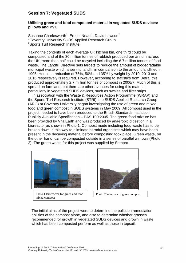
Session 7: Vegetated SUDS Utilising green and food composted material in vegetated SUDS devices: pillows and PVC. Susanne Charlesworth1, Ernest Nnadi1, David Lawson2 1Coventry University SUDS Applied Research Group. 2Sports Turf Research Institute. Taking the contents of each average UK kitchen bin, one third could be composted and of the 30 million tonnes of rubbish produced per annum across the UK, more than half could be recycled including the 6.7 million tonnes of food waste. The Landfill Directive sets targets to reduce the amount of biodegradable municipal waste which is sent to landfill in comparison to the amount landfilled in 1995. Hence, a reduction of 76%, 50% and 35% by weight by 2010, 2013 and 2016 respectively is required. However, according to statistics from Defra, this produced approximately 2.7 million tonnes of compost in 2006/7. Much of this is spread on farmland, but there are other avenues for using this material, particularly in vegetated SUDS devices, such as swales and filter strips. In association with the Waste & Resources Action Programme (WRAP) and the Sports Turf Research Institute (STRI), the SUDS Applied Research Group (ARG) at Coventry University began investigating the use of green and mixed food and green compost in SUDS systems in May 2009. All compost used in the project needed to have been produced to the British Standards Institution Publicly Available Specification – PAS 100:2005. The green-food mixture has been provided by VitalEarth and was produced by anaerobic digestion in a bioreactor as shown in Photo 1. Compost made including food waste has to be broken down in this way to eliminate harmful organisms which may have been present in the decaying material before composting took place. Green waste, on the other hand, can be composted outside in a series of parallel winrows (Photo 2). The green waste for this project was supplied by Sempro.
Photo 1 Bioreactor for green and food mixed compost
Photo 2 Winrows of green compost
The initial aims of the project were to determine the pollution remediation abilities of the compost alone, and also to determine whether grasses recommended for growth in vegetated SUDS devices and grown in waste which has been composted perform as well as those in topsoil.
Proceedings of the SUDSnet National Conference 2009. Coventry University TechnoCentre. Nov 12th and 13th 2009. www.sudsnet.abertay.ac.uk
48

Pot trials of grass types recommended by CIRIA and the Highways Agency in SUDS devices such as swales were assessed for their pollution remediation and hydraulic properties in an earlier project using commercially available general purpose compost. Table 1 below shows a ranking of the species of grass used based on their pollution remediation properties. From this ranking, the following grass types were selected to go forward to the waste compost trials:
1. Perennial Ryegrass 2. Tall Fescue 3. Strong Creeping Red Fescue 4. Creeping Bent
Topsoil and commercially available compost will be used as comparisons against the green and mixed compost. To date, the grass has been sown in a randomised block design (see photo 3) at a rate of 32g m-2 and the germination rate will be determined. Table 1 Ranking of grass species by pollution remediation using metal concentration in shoots. Species/metal Cu Ni Pb Zn Rank Browntop Bent 6 7 4 7 6 Creeping Bent 5 6 5 5 5 Velvet Bent 1 1 1 1 1 Perennial Ryegrass
4 5 3 3 3
Strong Creeping Red Fescue
3 4 4 4 3
Smooth Stalked Meadow Grass
2 2 2 2 2
Tall Fescue 6 3 5 5 4 Where 1 = highest average increase in shoot concentration in comparison with the control (no pollutant added)
The final aim will be the field testing of a compost “pillow” or Pre-vegetated Component (PVC) made of geotextile or biodegradable mesh filled with compost and with grass seed broadcast on the upper surface at the STRI test site in Yorkshire. The use of a PVC will enable the swale to be more roughly excavated, saving time, there will be less need for scarification, and the PVC will provide a more stable surface on which to establish a suitable grass sward. There will be no need to buy topsoil which will save money.
Proceedings of the SUDSnet National Conference 2009. Coventry University TechnoCentre. Nov 12th and 13th 2009. www.sudsnet.abertay.ac.uk
49
Photograph 3 random block design of pot trial

Proceedings of the SUDSnet National Conference 2009. Coventry University TechnoCentre. Nov 12th and 13th 2009. www.sudsnet.abertay.ac.uk
50
Quantifying evapotranspitration for green roof hydrological modelling Virginia Stovin, Hartini Kasmin and Abigail Hathway
Department of Civil and Structural Engineering, The University of Sheffield, Mappin Street, SHEFFIELD S1 3JD, UK (e-mail: [email protected]) Extensive green roofs reduce and attenuate storm runoff at source. They typically take the form of a ‘carpet’ of plants, supported by lightweight growing substrate overlying a drainage layer. During a rainfall event the key hydrological mechanisms operating within the green roof are the interception and storage of rainfall by the plant layer, infiltration and storage/attenuation in the substrate and reservoir storage in the drainage layer. During dry inter-event periods, moisture will be returned to the atmosphere via evapotranspiration. The evapotranspiration rate (ET) describes the combined effects of evaporation from the substrate and transpiration from the plants. A field-based green roof test bed (3 x 1 m) has been used to generate a continuous long-term record of green roof hydrological performance at the University of Sheffield. A simple conceptual model for green roof hydrological processes is capable of reproducing monitored data, both during a storm event, and over a longer continuous simulation period. The model comprises a substrate moisture storage component and a transient storage component. Storage within the substrate represents the roof’s overall stormwater retention capacity (or initial losses). Figure 1 compares modelled and monitored runoff for a large storm event. The event had 115.8 mm rainfall, with 103.3 mm runoff, giving a volumetric retention of just 11%. Model predictions are sensitive to the assumed value of ET. Here the model was calibrated using ET = 2.0 mm/day; however, standard methods for quantifying ET do not exist. Monthly ET values have been estimated using four different approaches: (a) analysis of storm event ADWP (antecedent dry weather period) and initial losses data; (b) calibration of the ET parameter in a continuous simulation model; (c) use of the Thornthwaite ET formula; and (d) direct laboratory measurement of evaporation. The first two approaches are based on data collected from the test rig, whereas the second two are independent of the need for direct field measuremdnts. A month-by-month comparison of all approaches is presented in Figure 2. Method (a). ET was estimated by dividing observed initial losses by the ADWP for each storm. Seasonal mean values are shown in Figure 2. ET rates range from <0.5 mm/day to a summer maximum of 1.71 mm/day. This suggests that, even in summer, the roof will take more than one week to fully regain its maximum moisture retention capacity (~15 mm) following saturation. Method (b). ET was estimated by model back-calibration. ET values were found to be comparable to those identified from the storm event ADWP analysis, ranging between 0.5 mm/day in winter months up to a maximum of 3.0 mm/day in May 2007. The data-based approaches outlined above provide useful indications of ET, but these estimates can only be applied where hydrological performance data already exists. Ideally ET should be determined as a function of local climatic variables, substrate physical properties and vegetation characteristics. Several hydrological formulae exist for the prediction of ET. Method (c), Thornthwaite’s formula, appears to be one of the simplest approaches, requiring only monthly mean temperature as an input. Figure 2 shows a positive correlation between this approach and the values determined practically using methods (a) and (b). Figure 2 suggests that there is potential to use a modified form of the Thornthwaite approach (i.e. 0.75 x ETTh) to generate suitable ET values from local climatic data. Method (d). Evaporation (from the substrate alone) was determined experimentally by monitorning moisture loss from samples at different times of the year. The four experimental values collected to date show a reasonable fit with the other ET estimates. Work is ongoing to determine whether the measured evaporation rates can be related to substrate physical characteristics, and to use this information to further modify ETTh to account for the type of substrate. Figure 2 brings together the full set of ET estimates described above. Similar trends in all of the data sets are evident, and it may be concluded that the Modified Thornthwaite

formula provides a good initial estimate for modelling purposes.
0.0
0.2
0.4
0.6
0.8
1.0
1.2
1.4
1.6
1.8
13/06/2007 12:00 14/06/2007 00:00 14/06/2007 12:00 15/06/2007 00:00 15/06/2007 12:00 16/06/2007 00:00 16/06/2007 12:00
Rainfall, Runoff (mm/5 min)
RainfallMonitored RunoffModelled Runoff
Figure 1. Monitored data and model results for 13-16 June 2007
0
1
2
3
4
5
6
0
50
100
150
200
250
Jan Feb Mar Apr May Jun Jul Aug Sep Oct Nov Dec Jan Feb Mar Apr May Jun Jul Aug Sep Oct Nov Dec Jan Feb Mar Apr
ETrates(mm/day)
Rainfall (mm)
Rainfall
(a) Seasonal mean ET values f rom monitored storms
(b) ET estimated by model calibration
(c) ET f rom Thornthwaite formula
(c) ET f rom Modif ied Thornthwaite formula
(d) Experimental Evaporation Data
Figure 2. Month-by-month comparison of a range of ET estimates
This paper is cut-down from: Kasmin H., Stovin V.R. and Hathway, E.A., 2009, Towards a generic rainfall-runoff model for
green roofs, 8th Int. Conf. On Urban Drainage Modelling (UDM), 7-11 Sept 2009, Tokyo, Japan.
See also: Stovin, VR, Dunnett, N, Hallam, A, 2007, Green Roofs – getting sustainable drainage off the
ground, 6th International Conference of Sustainable Techniques and Strategies in Urban Water Management (Novatech 2007), Lyon, France, 25-28 June, pp 11-18.
Stovin, V., 2009, The potential of green roofs to manage Urban Stormwater, Water and Environment Journal, Early view, published on-line May 2009,
Proceedings of the SUDSnet National Conference 2009. Coventry University TechnoCentre. Nov 12th and 13th 2009. www.sudsnet.abertay.ac.uk
51
Proceedings of the SUDSnet National Conference 2009. Coventry University TechnoCentre. Nov 12th and 13th 2009. www.sudsnet.abertay.ac.uk
52
Identifying and Mapping the Effect of Vehicles on a Grass Parking Surface M. L. Mayer* and S. Charlesworth SUDS Applied Research Group, Department of Geography, Environment and Disaster Management, Faculty of Business, Environment and Society, Coventry University, Priory Street, Coventry, CV1 5FB. *Corresponding author’s email: [email protected] Abstract This paper reports on an investigation into the effect that vehicles have on a grass-surfaced parking area, by detailing the possible heavy metal contamination of the surface soil, establishing any alteration to the natural magnetic properties, noting surface compaction and determining any relationship between these data. These data were mapped in a geographical information system (GIS) to show the distribution across the parking area. The use of grass as a parking surface presents an aesthetically pleasant alternative to ‘hard’ parking areas. In addition, the vegetative sustainable drainage system not only provides the protection of the groundwater by reducing the quantity of storm- and surface-water run-off from a rainfall event, but the soil and sub-base also act as a filter improving the quality of the flow-through, by removing harmful chemicals and elements. Prior to the field research, pot trials took place to determine the affect of increasing concentrations of oil application on four species of grass. These trials identified that ryegrass (Lolium perenne L.) had suitably tolerated the presence of engine oil over a period of six months. These trials gave an indication on what may happen if a sump deposited from an engine onto a grass surface in an extreme leakage event. Understanding the tolerance of oil presence provided just an insight into one of the variables that may affect a grass-surfaced parking area. Determining the other variables required the use of grass-surfaced bays that were physically parked upon on a regular basis. An overflow parking area, consisting of five reinforced, ryegrass-surfaced parking bays, was installed by Warwickshire County Council at Clinton Primary School in Kenilworth, Warwickshire. Staff and visitors to the school had parked on the grass area when usual tarmac spaces were occupied, ploughing up the surface. Removal of the original grass surface was replaced and reinforced with topsoil-filled SCS Integra 500 (recycled high density polyethylene) (Source Control Systems Ltd.), which provided the ability to maintain a compressive strength of 2,400kN/m², making the parking bays capable of supporting vehicle weights. The surface was reseeded with ryegrass to give the front of the school a visual grass appearance, as well as providing the necessary support for the additional parking requirements. Non-biased, randomised sampling of the five bays, plus the additional non-parking surface to the side of the bays, provided surface soil samples for magnetism (susceptibility, ARM, HIRM and SIRM) and heavy metal analyses (using the ICP). Compaction readings, measured with a pocket penetrometer (tons per sq. ft) (Cole-Parmer Instrument Company Ltd.), were obtained from the total parking area, highlighting the areas of the five bays where vehicles had come into contact with the surface.

Proceedings of the SUDSnet National Conference 2009. Coventry University TechnoCentre. Nov 12th and 13th 2009. www.sudsnet.abertay.ac.uk
53
Box plots and principal component analysis provided suitable methods of determining the relationships of the variables. Box plots gave clear summaries on each of the variables, comparing each bay instantly with each other, and noting any trends or outliers (abnormal readings). Principal component analysis made the comparison of the large set of data more manageable by removing the variables that correlate with each other as they measure a similar concept. This leads to the reduction of variables, with those remaining that account for the most variance. A survey of the staff that regularly used the grass-surfaced parking bays, gave additional information on their opinion on the alternative parking surface and their individual bay usage preference depended on the easiness of access and the availability of their favoured bay. Resulting compaction data identified that the bays that were used more frequently than others showed more compaction of the surface soil than those used less often. This information correlated with the preferential bay favoured by the regular staff users. The bays with the more compaction were parked on more often than the bays that were more difficult to manoeuvre into. However, the heavy metal and magnetism analyses determined that there was no significant relationship between the variables investigated, whether they had been extracted from parking bays that had been subjected to heavy usage or not. The geographical information system software, ESRI® ArcGIS®, was used to map the sampling locations on a plan of the school overflow car park, using x,y coordinates to make the identification of the locations visible in a diagrammatical form. This provided a simple method of visualising the data, as an interactive map, in relation to the parking area and the whole school site. By providing the coordinates for the sampling locations, it would be possible to identify the variables at a given position and to update the data when required. Keywords Grass surface; Lolium perenne L.; parking bays; heavy metals; contamination; compaction; magnetism; maps; GIS.

Proceedings of the SUDSnet National Conference 2009. Coventry University TechnoCentre. Nov 12th and 13th 2009. www.sudsnet.abertay.ac.uk
54
An Investigation of the Pollutant Retention and Hydraulic Properties of Various Grass Species for Utilisation in SUDS Devices Andrew Waitea, Susanne Charleswortha, James Bennettb, a SUDS Applied Research Group, Coventry University, CV1 5LW, b Sustainable Agriculture Applied Research Group, Coventry University, CV1 5LW
Urban environments possess large areas that are covered in impermeable surfaces, leading to
problems with build up of non-point pollutants on surfaces as well as increased volumes of runoff
produced with rainfall events. Sustainable Urban Drainage Systems (SUDS) offers a means to
mimic natural drainage processes to deal with the quality and quantity of runoff at the source.
Vegetative SUDS such as swales and filter strips are two such systems that can be used to help
manage drainage, removing the suspended solids and promoting infiltration of runoff into the soil.
This study aimed to investigate whether particular grass species would be more suitable in these
surfaces than others both in removing pollutants (e.g. Heavy Metals) and reducing flows.
The study was based on two separate trials to determine whether different grass species
performed differently in regards to pollutant and hydraulic retention. The pollutant retention trials
focused around a pot based study using seven different grass species. These species were either
recommended by CIRA and the Highways Agency or had characteristics that might show promise
within vegetative SUDS. They were grown in plants pots in a series of Latin Squares, being
grown to a recommended height of 100mm. Once at this length, street dust (SD) which had been
collected from the CV1 (Coventry city centre) was applied to each of the plants pots in varying
quantities. This SD received minimal processing to homogenise it yet still retain its real life
physical characteristics for the purpose of modelling its behaviour and affect on the grass
species. Once applied, the SD and grasses were watered as normally for 30days before the
compost, roots and shoots were harvested. Analysis was conducted using the Inductive Couple
Plasma Optical Emission Spectrometry (ICP-OES) to determine the heavy metal concentrations
(Cd, Cu, Ni, Pb and Zn) in the various components. Other techniques such as pH analysis and
mineral magnetic susceptibility were also used to determine the effects and movement of street
dust within the compost. The second trial was a hydraulic trial that involved the use of grassed
seed trays to simulate a vegetative surface. Simulated runoff was applied to each of the trays with
throughflow being collected along their length as an indication of inflitration.
The results from the pollutant retention trials illustrated that the SD was mainly concentrated in
the top layer of compost for all the grass species with only the fine material migrating through the

Proceedings of the SUDSnet National Conference 2009. Coventry University TechnoCentre. Nov 12th and 13th 2009. www.sudsnet.abertay.ac.uk
55
profile. Only Cd in the roots was influenced by the addition of SD whereas ANOVA analysis
indicated that SD treatments caused significant differences in heavy metal concentrations in
shoots. A pattern of accumulation was illustrated by decreases in heavy metal concentrations in
the compost which resulted in increased shoot concentrations. Development of root systems on
or near the surface of the pots was possibly a reason for increased uptake of heavy metals by
some species. Overall velvet bent (VB) and smooth stalked meadow grass (SSMG) showed the
greatest accumulations of heavy metals compared to their controls although browntop bent (BB)
and creeping bent (CB) also showing accumulation potential. The hydraulic trials showed that
throughflow and hence infiltration was related to the distance travelled along the tray. The species
showed no evidence of being better than each other at encouraging infiltration although all
encouraged more inflitration along the profile than bare compost control. Overall the Bent species
of grass (in particular VB) were shown to promote more throughflow than the non-bent species.
Based on the two trials the Bents (in particular VB) and SSMG were deemed to be suitable
species worthy of further investigation on a larger scale. These grasses showed that they actively
removed heavy metals from the compost, translocating them to the shoots and promoted
increased throughflow (in the Bents case). Further studies could investigate the proportions of
each grass species in mixtures as well as how these grasses would perform in larger, more
realistic examples of vegetative SUDS. Information would be collected on the species ability to
encourage inflitration as well as encouragement of settling of suspended solids.

Proceedings of the SUDSnet National Conference 2009. Coventry University TechnoCentre. Nov 12th and 13th 2009. www.sudsnet.abertay.ac.uk
56
Poster Abstract Scottish Water: Tackling the Adoption of Public SUDS Cynthia Aukerman (Scottish Water / University of Abertay Dundee, Urban Water Technology Centre, SUDS KTP Associate) [email protected] Doug Buchan (Scottish Water) & Alison Duffy (UWTC, University of Abertay Dundee) ABSTRACT: This poster aims to increase the understanding of the complexity that Scottish Water faces in the adoption of public SUDS. Surface water management in Scotland is a complicated matter, with regulatory responsibilities for surface water drainage split amongst multiple stakeholders. As the regulatory requirement for the inclusion of public SUDS is put into effect, best practices are informed through invaluable guidance documents by CIRIA, SEPA, Scottish Water, etc. Whilst these provide vital background information, it is Scottish Water’s responsibility to establish an internal process that ensures the adoption of efficient, cost-effective assets. The complexity of the adoption of public SUDS has become an internal issue at Scottish Water as well. At least 18 different teams must be in accord for the adoption of public SUDS since each team is integral to the development and implementation of public SUDS adoption. Following the publication of Sewers for Scotland 2nd Edition in November 2007, Scottish Water identified that they lacked the expert technical knowledge of public SUDS schemes and how best to implement and maintain them. Scottish Water identified that collaboration with Abertay’s Urban Water Technology Centre would address this gap. The resulting Knowledge Transfer Partnership will enable Scottish Water to avoid unplanned costs in maintenance and uninformed decisions leading to customer dissatisfaction. This project will also present the opportunity to adopt a more reliable and robust public SUDS asset base. The timeline for this project is 2 ½ years, resulting in an effective and smooth adoption process (along with training) in place by July 2011.

Proceedings of the SUDSnet National Conference 2009. Coventry University TechnoCentre. Nov 12th and 13th 2009. www.sudsnet.abertay.ac.uk
57
Poster Abstract Making the (Right) Connection Alison Duffy1, Chris Jefferies1, Brian D’Arcy2, Neil McLean2
1Urban Water Technology Centre, University of Abertay Dundee 2SEPA (Scottish Environment Protection Agency)
ABSTRACT: The poster aims at promoting an awareness of the problems with wrong connections of foul water into surface water drains. The Duloch Park development within the DEX site in Dunfermline, which has maturing SUDS across the 350 Ha site, is used to illustrate this message with four out of eight documented examples from the site. The wrong connections range from isolated homeowner connections to connections of foul to surface sewer (the SUDS) at the development stage from whole housing schemes and commercial properties.
Wrong connections are illegal in Scotland under SEPA General Binding Rules 10 and 11. They are a dangerous health threat to individuals and the surrounding environment. This poster is part of a SEPA drive to prevent wrong connections. The impacts of wrong connections at DEX have been significantly reduced due to a monitoring programme commissioned by the lead developer (Taylor Wimpey) which has detected problems at an early stage, where the offending parties have been informed and most of the problems sorted very quickly. This is not happening in many locations throughout Scotland, and the wrong-connections problems are widely seen as an intractable and chronic pollution issue.
Source control measures such as swales and permeable paving serving each cartilage are not a feature of housing developments at DEX, where the developers preferred to use site controls serving conventional drainage networks. Isolated wrong connections (i.e. a new bathroom in a home) are the most difficult to detect. It has become clear that if implemented, source control could have prevented the problems that have arisen, with wrong connections being self regulated by the home owner (or indeed business) due to the need to protect their own environment from the highly offensive (illegal & polluting) situation. A move towards source control SUDS at each house plot could be the most practical solution to the chronic problem of foul into surface drainage wrong connections.

End of Proceedings Book SUDSnet National Conference 2009
SUDSnet is organised by:
Web: www.sudsnet.abertay.ac.uk E-Mail: [email protected]
SUDSnet Director: Prof. Chris Jefferies (UWTC, Abertay) SUDSnet Network Manager: Dr. Rebecca Wade (UWTC, Abertay)
SUDSnet Coordinator at Coventry University: Dr. Susanne Charlesworth (Coventry) SUDSnet Administrative Support: Ms. Leanne Gallagher (UWTC, Abertay)
SUDSnet is Administered from the Urban Water Technology Centre, University of
Abertay Dundee, Kydd Building, 40 Bell Street, Dundee DD1 1HG. Scotland. UK.
Phone: +44 (0)1382 308650 (R. Wade) Fax: +44 (0)1382 308117 (UWTC)
Proceedings of the SUDSnet National Conference 2009. Coventry University TechnoCentre. Nov 12th and 13th 2009. www.sudsnet.abertay.ac.uk
58