sultan river restoration conceptual design
TRANSCRIPT

SULTAN RIVER RESTORATION
CONCEPTUAL DESIGN
Prepared for
Public Utility District No. 1 of Snohomish County
Prepared by
Herrera Environmental Consultants, Inc.


SULTAN RIVER RESTORATION
CONCEPTUAL DESIGN
Prepared for
Public Utility District No. 1 of Snohomish County
PO Box 1107
Everett, Washington 98206
Prepared by
Herrera Environmental Consultants, Inc.
2200 Sixth Avenue, Suite 1100
Seattle, Washington 98121
Telephone: 206-441-9080
February 23, 2021


i
sw 20-07466-000_sultanrvrrestorationconceptdesign_20210223.docx
CONTENTS
Introduction ..............................................................................................................................1
Study Area Description and River Reach Delineation .....................................................1
The First Phase of Work ............................................................................................................5
What Worked ..................................................................................................................6
What Could Be Improved ................................................................................................7
Goal and Objectives ..................................................................................................................8
Preferred Alternative ................................................................................................................8
New Extension of SC 1.....................................................................................................9
KB Island Removal ........................................................................................................ 12
District Parcel Wood Placement .................................................................................. 12
SC 2 Island Modification ............................................................................................... 15
Boulder Clusters ........................................................................................................... 15
References ............................................................................................................................. 16
APPENDICES
Appendix A Sultan River Drainage, WDF Stream Catalog
Appendix B PowerPoint Presentation – Prescribed High Flow Types in Relation to Ecosystem
Objectives. Prepared by Stillwater Sciences and presented to CALFED Bay Delta
Program

ii
sw 20-07466-000_sultanrvrrestorationconceptdesign_20210223.docx
TABLES
Table 1. Summary of Reach Conditions and Utilization. ........................................................................... 4
Table 2. Channel Characteristics in Each Process Reach (after Stillwater Sciences 2010). .............. 5
Table 3. Sultan River Restoration Alternatives Summary. ......................................................................... 9
FIGURES
Figure 1. Operational and Process Reach Juxtaposition Downstream of Culmback Dam.
(River miles are noted in the horizontal bars.) ............................................................................. 2
Figure 2. Profile of Sultan River Channel Gradient from the Confluence with the
Skykomish River Upstream to Culmback Dam (RM 0–RM 16.5)
(OR = “operational reach”; vertical exaggeration 50x). ............................................................. 5
Figure 3. Sultan River Restoration Conceptual Design Vicinity Map. ................................................... 10
Figure 4. New Extension of SC 1 Conceptual Design. ............................................................................... 11
Figure 5. KB Island Removal Conceptual Design. ....................................................................................... 13
Figure 6. District Parcel Wood Placement, SC 2 Island Modification, and Boulder Clusters
Conceptual Design. ............................................................................................................................ 14

February 2021
Sultan River Restoration Conceptual Design 1
INTRODUCTION
Public Utility District No. 1 of Snohomish County (the District) continues to operate and maintain
the Henry M. Jackson Hydroelectric Project No. 2157 (the Project) on the Sultan River in
Snohomish County, Washington, under a license from the Federal Energy Regulatory
Commission. The Project is a series of water works and other infrastructure, including the 262-
foot-tall Culmback Dam, located 25 miles east of the City of Everett, Washington. The Project is
used for power production and assistance with maintenance of the City of Everett’s water
supply. The Project occupies 10.9 acres (subsurface) of the Mount Baker-Snoqualmie National
Forest administered by the US Forest Service.
The Washington Department of Fisheries Stream Catalog (Williams 1975) characterized the
Sultan River well at the time:
Below Culmback Dam, for 13–14 miles, the Sultan has mostly steep gradients,
confined channel, and numerous cascades and rapids separated by short pool-riffle
stretches. The bottom is mainly large rock and boulders, some bedrock, and only a
few patches of gravel areas. Widths in the canyon range 5–15 yards. Much of the
bank is sheer rock face or large rock cuts.
Over its lower 3 miles, the river is of moderate gradient with a number of channel
split sections. Fall widths range from 8 to over 20 yards. A good pool-riffle balance
prevails, with numerous long, broad riffles. The bottom is mostly rubble and gravel,
with a few boulder-strewn areas. Banks are low earth cuts or broad gravel-rubble
beaches.
During Project relicensing, Stillwater Sciences compiled a detailed assessment of the habitat
conditions along the length of the river downstream of Culmback Dam (Stillwater Sciences
2010).
Study Area Description and River Reach Delineation
The Study Area defined by the District includes approximately 16.5 miles of the Sultan River
from Culmback Dam to its confluence with the Skykomish River.
Within the Study Area, the river is divided into sub-reaches based on both Project operational
structures (operational reaches) and physical and geomorphic characteristics (process reaches).
Descriptions of designated operational reaches (herein referred to as OR) and process reaches
(PR) are provided below. Figure 1 illustrates the geographic locations of these reaches and
overlap by river mile. Because the beginning and ending points for the process reaches (PR) are
not precise, they are not easily identified in the field. Therefore, the operational reaches, which
have discrete boundaries, were referenced during field surveys to inform concept design
development.
February 2021
2 Sultan River Restoration Conceptual Design
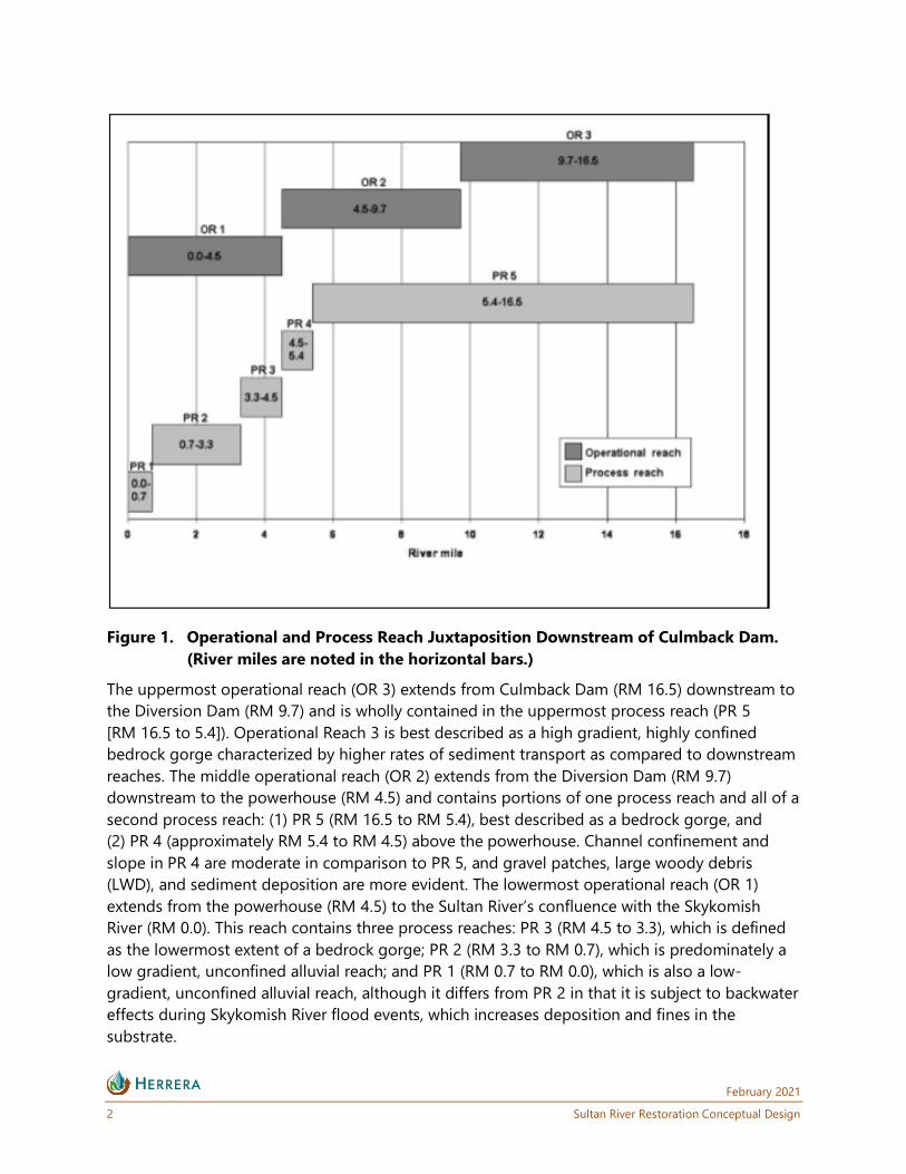
Figure 1. Operational and Process Reach Juxtaposition Downstream of Culmback Dam.
(River miles are noted in the horizontal bars.)
The uppermost operational reach (OR 3) extends from Culmback Dam (RM 16.5) downstream to
the Diversion Dam (RM 9.7) and is wholly contained in the uppermost process reach (PR 5
[RM 16.5 to 5.4]). Operational Reach 3 is best described as a high gradient, highly confined
bedrock gorge characterized by higher rates of sediment transport as compared to downstream
reaches. The middle operational reach (OR 2) extends from the Diversion Dam (RM 9.7)
downstream to the powerhouse (RM 4.5) and contains portions of one process reach and all of a
second process reach: (1) PR 5 (RM 16.5 to RM 5.4), best described as a bedrock gorge, and
(2) PR 4 (approximately RM 5.4 to RM 4.5) above the powerhouse. Channel confinement and
slope in PR 4 are moderate in comparison to PR 5, and gravel patches, large woody debris
(LWD), and sediment deposition are more evident. The lowermost operational reach (OR 1)
extends from the powerhouse (RM 4.5) to the Sultan River’s confluence with the Skykomish
River (RM 0.0). This reach contains three process reaches: PR 3 (RM 4.5 to 3.3), which is defined
as the lowermost extent of a bedrock gorge; PR 2 (RM 3.3 to RM 0.7), which is predominately a
low gradient, unconfined alluvial reach; and PR 1 (RM 0.7 to RM 0.0), which is also a low-
gradient, unconfined alluvial reach, although it differs from PR 2 in that it is subject to backwater
effects during Skykomish River flood events, which increases deposition and fines in the
substrate.

February 2021
Sultan River Restoration Conceptual Design 3
Operational reach designations were used to stratify the survey field effort and data for
quantifying in-river habitat and LWD. A summary of relative conditions and habitat for various
salmonid species is provided in Table 1. This approach was selected because of unambiguous
field identification of river reach breaks. Channel gradient and confinement by canyon walls is
relatively consistent through 13 miles of the river channel below Culmback Dam (PR 3),
excluding the steep 0.7-mile section immediately downstream of the dam. The lower 3.3 miles
(PR 2 and PR 1), extending to the confluence with the Skykomish River, differ substantially in
gradient and confinement from the rest of the river below Culmback Dam. A plot of channel
gradient (Figure 2) within the Study Area suggests that the channel has relatively consistent
gradients of 1 to 2 percent through most of its length, with average gradients decreasing to less
than 1 percent in the lower 3.3 miles (PR 2 and PR 1) to its confluence with the Skykomish River.
The steepest parts of the river are in the 0.7-mile section just below Culmback Dam and the
1-mile section just below the Diversion Dam (RM 9.7 to RM 8.7). At the finer scale of local
habitat units, slopes can average up to 3 to 5 percent over hundreds to thousands of feet, in
OR 2 and OR 3 for example.
Reservoir operations (rule curves) have reduced both the frequency and magnitude of spill
events. The reduction in frequency and magnitude of spill events has also reduced the frequency
and magnitude of scour events in the Study Area. The reduction in scour also limits the extent of
habitat-forming work that river flows can accomplish. Table 2 summarizes the channel
dimensions and presence of pools in each of the operational reaches. The District’s Process Flow
program attempts to strike a balance between flood control and habitat sustenance, but the
volumes of water associated with the high flow releases are effective at sediment transport only
in the upper operational reaches but insufficient for habitat creation in the lower operational
reach. The timing of high flows (natural and regulated) can result in impacts to developing eggs,
particularly Chinook.

February 2021
4 Sultan River Restoration Conceptual Design
Table 1. Summary of Reach Conditions and Utilization.
Reach
Physical Habitat Conditions (general description) Relative Fish Use (observed relative utilization)
Estimated
Bankfull
Width
(feet)
Average
Gradient
(percent)
Relative
Stream
Power
Scour
Potential Gravel LWD
SPAWNING REARING
Chinook Coho Chum Pink Steelhead Chinook Coho Chum Pink Steelhead
3 49.2 1.37 High High Wide
expanses
of good
gravel
Some
isolated
large
jams
High High Low Low Medium Limited Limited N/A N/A Limited
2 69.5 1.36 Medium Variable Patchy
(DDAM,
Marsh
Creek,
PH Index)
Perched
and
patchy,
some
jams
High Medium Low Medium High Fair to
good
Fair to
good
N/A N/A Fair to
good
1 161 0.42 Low Low Wide
expanses
of good
gravel
Low High High
(most in
SC 1
and 2)
High High High Very
good
Very
good
N/A N/A Very good

February 2021
Sultan River Restoration Conceptual Design 5
Figure 2. Profile of Sultan River Channel Gradient from the Confluence with the
Skykomish River Upstream to Culmback Dam (RM 0–RM 16.5)
(OR = “operational reach”; vertical exaggeration 50x).
Table 2. Channel Characteristics in Each Process Reach (after Stillwater Sciences 2010).
Process
Reach
Estimated
Bankfull Width
(feet)
Total
Main Channel Length
(feet)
Channel Width
per
Pool
Standard
Deviation Comments
1 161 15,537 96.5 573 Only one pool
2 60 42,076 10.6 6.83
3 49 26,317 11.2 22
THE FIRST PHASE OF WORK
The first phase of restoration work was motivated by a geomorphic assessment in the lower
Sultan River (Stillwater Sciences 2010), which found that a combination of sediment and wood
starvation and a lack of flood flows had simplified the channel network of the lower river. As a
result, the first phase of work (the project) sought to reengage or extend existing side channels
that were either lost or in the process of being lost. New side channels were also excavated. Log
jams were placed along the main channel and near side-channel entrances to increase hydraulic
complexity and encourage reengagement of the enhanced side channels. The project was
February 2021
6 Sultan River Restoration Conceptual Design
primarily constructed in 2012 and met the obligations of the license-required mitigation under
License Article 404. Most of the analysis of the work preceded a large flow event.
What Worked
Off-channel rearing has significantly improved as a result of the first phase of restoration in the
lower river. The best example of this is at the downstream end of the first phase project work.
Side Channel (SC) 4 at Reese Park (and the associated entrance engineered log jam, ELJ 1) has
been a complete success. The jam has nearly doubled in size (growing even larger in the
February 2020 flow event) and turned the newly created side channel into a viable, perennial
side channel. Geomorphic activity around the side channel is within the bounds of behavior of
an unmanaged river. The relative success of this project element is an indication that the
reduced flows and sediment transport have essentially shrunk the active alluvial fan to the area
immediately upstream from the US 2 Bridge.
The other seven engineered log jams that were constructed along the main stem river channel
did not initiate as much geomorphic change around them as hoped originally, partly because
“zero-rise” floodplain management regulations forced them to remain at the fringes of the
channel. As a result, they did not generate main channel pools until the February 2020 event.
After that event, all the ELJs constructed in the first phase generated pools. Furthermore, all of
them remain in place and have deepened the river on their edges and induced sediment
deposition in their lee. Several of the log jams have achieved their objective of redirecting flow,
especially those located near the entrances to side channels, specifically SC 2 and SC 1. ELJ 8,
opposite the inlet of SC 2, has initiated a side channel between it and the new bank, which
became a permanent side channel in the February 2020 flood event.
ELJ 8, across from the mouth of SC 2, has also triggered the delivery of more flow into the side
channel. The successful increase in flow has been accompanied by a drop in chum salmon
spawning in this previously very productive side channel, as found by the District’s escapement
surveys. One explanation for the reduction in spawning could be that the additional flow has
increased velocities and is also potentially diluting hyporheic input in this side channel (see next
section), though other (external) factors including regional population trends may be at play.
SC 1 has remained engaged and wetted throughout its extended length. The flow pathways
have also remained stable over time. However, geomorphic activity has been less than desired
but probably realistic given the low gradient. We interpret the lack of geomorphic activity in this
side channel to be partially a result of a plug of material that was left in the inlet to the side
channel. The plug was left to ensure that SC 1 did not induce an avulsion of the main channel to
the newly enhanced side channel. The redundant inlet also filled in during the February 2020
event.

February 2021
Sultan River Restoration Conceptual Design 7
What Could Be Improved
Salmonid spawning, while not limiting at current population levels, could be improved by
building in resiliency through diversification of substrate and habitat types. Rerouting of flow,
where possible, could add to the diversity of habitat in the main channel. While conventional
pool metrics indicate a lack of holding habitat in the lower river, more than adequate holding
habitat is provided in the form of glides. The value and utilization of holding habitats could be
improved through the addition of wood and/or boulders. Increasing cover could mitigate for
water depths greater than 6 feet since achieving significant changes in depth is probably not
realistic under the regulated flow regime.
Beginning upstream in SC 2, the log jam installation and increased flow to this side channel has
potentially impacted chum spawning and has not triggered diversification of the habitat in the
associated reach of the main channel. This jam was placed further into the channel because of
its limited flooding impact in that location and illustrates that these types of jams can be
effective, if feasible from a flooding perspective. Therefore, actions could be taken to return the
flow regime of this side channel closer to pre-project conditions and create the hydraulic and
geomorphic complexity desired in this area. The island across from the side channel inlet makes
an excellent target for this action.
More aggressive log jams could be planned that leverage the flood reductions of the first phase,
those geomorphic changes that have occurred since the first phase was constructed (i.e.,
primarily the expansion of the side channels), and those planned in this next phase. However,
flood impacts may still limit the possible size, and thus how productive these jams can be.
Removal of the plug at the SC 1 inlet could increase flow into, and potentially geomorphic
activity within, the side channel. Risk of avulsion to this channel appears to be minor. Very little
geomorphic activity is present near the newly constructed inlet, which indicates that it could be
widened without risk to avulsing the main channel to the side channel.
There also is an opportunity to extend the length of SC 1. One of the former high flow outlets of
SC 1 was blocked in the first phase to ensure adequate flow to the newly extended side channel
and because it lacked a defined outlet for fish to return to the river. With the successful
construction of the first phase and the building of a relationship with downstream landowners, it
may be possible to extend the side channel to this former alignment and beyond. It will likely be
necessary to increase flow to the SC 1 inlet, as mentioned in the previous paragraph, to support
this side-channel extension without compromising flow in the existing side-channel network.
In all, it appears that the side channel creation has nearly reached a sort of saturation in terms of
the flow and sediment available that could trigger natural habitat forming processes in those
existing side channels—except for those areas at the downstream half of PR2, where sufficient
sediment deposition and flow is achieved due to the influence of the Skykomish River. Main
channel flow and geomorphic diversity is also still low and could be improved, particularly
considering recent geomorphic change that might make more aggressive actions possible.

February 2021
8 Sultan River Restoration Conceptual Design
GOAL AND OBJECTIVES
The primary goal of this phase of restoration is to improve on the habitat conditions and build
on the earlier work, while not compromising the gains already made. The general philosophy is
to responsibly manage the regulated river, as infrastructure and regulatory conditions allow. This
means that channel-forming and -deforming flows are likely not possible or reduced in both
frequency and magnitude such that geomorphic variation must be forced, except in the most
downstream areas (e.g., SC 4). The first 9 years of operation under the new license indicate that
flow volumes may be insufficient to meet the full suite of ecosystem objectives, but that unusual
events like the flood in February 2020 can trigger positive habitat formation, when pushed by
small, engineered actions. Physical interventions that allow us to meet the objectives listed
under Channel Migration are desired and some of those actions are presented above (Table 1).
These objectives, as they relate to channel morphology, riparian habitat, and fish habitat,
respectively, include:
● Maintain channel planform, sediment transport, and bank erosion sufficient to cause
periodic lateral migration and maintenance of spatially complex channel morphology.
● Create diversity and maximize extent of river bank habitat, patch dynamics, and
vegetation community succession, and create backwater/off-stream habitat.
● Maintain shallow water, low-velocity channel edges and backwater/off-channel habitat
to provide a complex mosaic of fish habitat suitable for all life stages.
Several discussions with stakeholders via the Project’s Aquatic Resources Committee (ARC),
which includes the Tulalip Tribes, Washington Department of Fish and Wildlife, Washington
Department of Ecology, City of Everett, National Marine Fisheries Service, Snohomish County, US
Fish and Wildlife Service, US Forest Service, City of Sultan, and American Whitewater, resulted in
the development of a series of alternatives summarized in Table 3. Implementation specifics for
each of the alternatives are also included as notes in the table. Collectively the bolded actions
constitute the preferred alternative.
PREFERRED ALTERNATIVE
The preferred alternative, as summarized in the bolded alternative actions in Table 3, focuses on
those actions that are most likely to achieve the objectives and where landowner approval has
already been acquired (or not necessary in the case of project actions on District property). Each
of the five actions recommended to be carried forward in design are described in detail below.

February 2021
Sultan River Restoration Conceptual Design 9
Table 3. Sultan River Restoration Alternatives Summary.
Operational Reach Alternative Name Comments
1 – lower New Extension of SC 1 Meets all objectives. Landowner permission approved.
1 – lower Winter's Creek
Riparian Improvement Addresses only Objective 2, and then only partially. Requires
landowner permission.
1 – lower KB Island Removal Directly meets Objective 1, indirectly meets the two
others. The District is the landowner.
1 – lower District Parcel Wood
Placement Meets all objectives. The District is the landowner.
1 – lower SC 2 Island Modification Meets all objectives. Landowner permission is approved.
1 – lower ReStart ELJ Meets all objectives. Landowner permission required.
1 – lower Boulder Clusters Meets all objectives. Landowner permission approved.
Inexpensive and easily done in conjunction with the SC2
Island Modification.
1 – lower Unc's Side Channel Meets all objectives Landowner permission required.
1 – lower Gravel Supplementation
SC 3 While this alternative has the potential to address all the
objectives, there is concern that gravel placed in SC 3 will
not be mobilized. There is also potential for disturbance of
what is currently good habitat. Landowner permission also
required.
1 – lower Ames Creek Indirectly it meets Objectives 2 and 3. Landowner permission
required.
1 – lower Gravel Supplementation
TFR While this alternative has the potential to address all the
objectives, there is concern that gravel placed in SC 3 will
not be mobilized. There is also some potential for
disturbance of what is currently good habitat.
1 – upper Gravel Supplementation
Powerhouse While this alternative has the potential to address all the
objectives, there is significant risk that gravel placed in SC 3
will not be mobilized sufficiently to achieve the objectives.
2 – lower Side Channel Reactivation This alternative has the potential to meet all objectives.
However, the inaccessibility of the location would make
implementation extremely difficult and expensive.
2 – lower Reach 2 ELJ This has the potential to meet all objectives. However, the
inaccessibility of the location would make implementation
extremely difficult and expensive.
New Extension of SC 1
This action would expand flow to the left bank floodplain by removing a plug on an existing side
channel originating from SC 1 and excavating and expanding this existing side channel through
Osprey Park and neighboring private property (Figures 3 and 4). It would nearly double the length
of the SC 1 network and reengage a part of the floodplain that has been effectively abandoned.
Approximately one quarter of the channel is already forested, although it is colonized by
Himalayan blackberry. The remainder of the channel length would need to be reforested. The
action would not engage the entire length of the side channel but use another to keep the
channel on two private properties that have been collaborators with the District in the past.

February 2021
10 Sultan River Restoration Conceptual Design
Figure 3. Sultan River Restoration Conceptual Design Vicinity Map.

February 2021
Sultan River Restoration Conceptual Design 11
Figure 4. New Extension of SC 1 Conceptual Design.

February 2021
12 Sultan River Restoration Conceptual Design
Access is straightforward via existing Osprey Park trails. Flood impacts and avulsion risk from
this reengagement are a concern and are actively being investigated. The final design may have
to include flood and erosion mitigating elements (likely berms and ballasted large woody
debris), reducing the size of the proposed side channel, or both.
Estimated Cost: $1,070,000
KB Island Removal
This small island at the mouth of SC 1 was left in place, despite considerable work around it in
the first phase, primarily to prevent avulsion of the mainstem flow in the first phase of
restoration completed in 2012 (Figure 5). The nine years since this construction has shown little
tendency for the river to migrate or even draw more flow over time. Further, during and
following the February 2020 flood event, the redundant outlet was blocked by large woody
debris and accreted a large volume of coarse sediment, making this original inlet the only source
of water to SC 1 during lower flows. Therefore, expanding flow via the original SC 1 inlet is a
priority.
This small action can be accomplished by District crews. It will consist of removing all material
above the ordinary high mark including a large stump, which appears to be holding the island
together. This action will not require excavation below the ordinary high water mark, making it
possible to complete it before the winter of 2021-2022. Observing SC 1 changes due to this
action during the finalization of the other project actions further downstream will assist in
achieving the proper balance between increasing flows in SC 1 while preventing off-site impacts.
Estimated Cost: $19,600
District Parcel Wood Placement
This alternative will place large woody debris along the undeveloped left bank of the main
channel on the District parcel immediately north of Osprey Park (Figure 6). This alternative
action will increase hydraulic complexity of the bank, including possibly producing a holding
pool and slow moving flow in its wake. The conceptual design includes imported wood ballasted
by native borrow. Any trees removed during construction will be repurposed in the structure.
Access will be via an existing private driveway that extends nearly all of the way to the wood
placement location. Though the driveway is privately owned, the placement location is owned
by the District. Further analysis will be needed to determine the extent to which the wood can
extend into the channel. The opposite bank is in private ownership and is currently at risk due to
flooding; however, if this action is done simultaneously with the SC 2 Island Modification
(described below), it is likely that any flood impacts associated with the wood placement will be
offset by the excavation.
Estimated Cost: $25,600

February 2021
Sultan River Restoration Conceptual Design 13
Figure 5. KB Island Removal Conceptual Design.

February 2021
14 Sultan River Restoration Conceptual Design
Figure 6. District Parcel Wood Placement, SC 2 Island Modification, and Boulder Clusters
Conceptual Design.

February 2021
Sultan River Restoration Conceptual Design 15
SC 2 Island Modification
This alternative action would excavate a channel network in the island near the inlet of SC 2
(Figure 6). This island currently is not regularly inundated, even in the largest flood events.
Excavating channels will increase habitat complexity and draw flow away from SC 2. This action
will take advantage of the mature riparian vegetation already on the island. Although tree
removal will be avoided to the greatest extent possible, any trees removed will be reused to
create hydraulic complexity in the newly created channels.
This action is likely to have flood reduction benefits since flow conveyance will be expanded.
Access for construction is provided by the same private driveway that would provide access in
the District Parcel Wood Placement action. The side channel may need a temporary bridge,
though occasionally it runs dry in the summer (when construction would occur) and thus
bridging may not be necessary to complete the construction. This island is privately owned.
Estimated Cost: $76,000
Boulder Clusters
Along the thalweg on the west side of the SC 2 island, three boulder clusters are planned
(Figure 6). These clusters will add hydraulic complexity to the main channel and add roughness
to force more flow into the newly created channel network through the island.
Like the District Parcel Wood Placement action and the SC 2 Island Modification action, access
will be via the same private driveway and temporary bridge. Also like those actions, potential
flood impacts will be modeled; however, it is expected that excavation on the island itself will
more than compensate for any local water surface elevation increases caused by the boulder
clusters.
Estimated Cost: $22,000

February 2021
16 Sultan River Restoration Conceptual Design
REFERENCES
Stillwater Sciences. 2010. Sultan River Geomorphic Assessment of Side Channel Enhancement
Opportunities. Prepared for: Snohomish County Public Utility District No. 1. June 22.
Williams, R.W. et. al. 1975. Washington Department of Fisheries Stream Catalog.
<http://jeffersonco-
treis.info/PDF%20Files/3.07%20Threatend%20&%20Endangered%20References/Williams_RW.pdf>.

APPENDIX A
Sultan River Drainage, WDF Stream Catalog

APPENDIX B
PowerPoint Presentation – Prescribed High Flow
Types in Relation to Ecosystem Objectives
Prepared by Stillwater Sciences and
presented to CALFED Bay Delta Program
