summary of preferred plan …€¦ · esplana de htlnainai htl by maintenance of the existing...
TRANSCRIPT

Isle of Wight Shoreline Management Plan 2: Main Report –Chapter 5 Isle of Wight Council & Royal Haskoning December 2010
5. Policy summary of the preferred plan and implications
Contents Page 5. Policy summary of the preferred plan and implications 331
5.1 Introduction 333
5.2 Policy Summary Map 334
5.3 Policy Summary Tables 335
5.4 Policy Summary Implications 349
iwight.com - 331 - www.coastalwight.gov.uk/smp

iwight.com - 332 - www.coastalwight.gov.uk/smp
5. Policy summary of the preferred plan and implications
5.1 Introduction
This SMP has highlighted the importance of appropriate coastal policy decision-making for the Island which is heavily reliant on it’s shoreline for tourism and marine industries as well as being home to many coastal towns and villages. The SMP proposes focusing future expenditure on defences for communities at significant risk from future coastal flooding and erosion to seek a sustainable future for the Isle of Wight and address the risks of climate change predicted sea level rise. In securing the future of vulnerable coastal communities, the SMP also aims to sustain key road infrastructure and ferry transport links. The proposals contained in the SMP include addressing the potential tidal flood risk to the low-lying valleys of the Western and Eastern Yar rivers, supporting the communities directly at risk and also those reliant on the transport links that cross the valleys to West Wight, Bembridge and Forelands. Significant tidal flood risk to the communities and infrastructure of Yarmouth, Cowes and Ryde is recognised and addressed, as is the risk of erosion to a number of coastal communities including Ventnor. It is also a key outcome of the SMP to recognise the important and scenic natural landscape and shoreline of the Isle of Wight coast and estuaries, valued by residents and visitors alike, including allowing natural change to continue uninterrupted along long stretches of the south-western and northern coasts and supplying sediment to local beaches. It is clear that communities around the Isle of Wight coast will be affected by coastal change and the SMP encourages recognition of this longer term perspective so areas can begin to gradually adapt to future change, and reliance of coastal defences can be reduced. This chapter of the SMP provides a summary of the preferred plan and the preferred policy choices to implement that plan (as outlined in detail in chapter 4). Importantly it also aims to emphasise the implications of the preferred plan at each location, based on an assessment against five themes: Property and Land Use; Nature Conservation; Landscape; Historic Environment; Recreation and Amenity. Each of the 15 Management Areas and 61 Policy Units identified previously in chapter 4 has a summary of anticipated implications of the plan again set out in tabular form using the five themes identified above.
iwight.com - 333 - www.coastalwight.gov.uk/smp

5.2 Policy Summary Map
iwight.com - 334 - www.coastalwight.gov.uk/smp

5.3 Policy Summary Tables
Please note. For full details of SMP2 policies, please see chapter 4. Key: HTL - Hold the Line, A - Advance the Line, NAI – No Active Intervention, MR – Managed Realignment. PDZ1 Cowes and the Medina Estuary
Present & Previous Policy SMP2 Policy
SMP1 (1997) North East Coastal Defence Strategy
Study (2004)
Eastern Yar Flood and Erosion Risk
Management Strategy Policy Plan
Unit Policy Unit Policy Unit Policy
Management Area Policy Unit
To 2025
2026 to
2055
2056 to
2105 Comment
NEW 11
Hold the existing defence line - - 1A.1 Gurnard
Luck HTL NAI NAI
HTL supports the existing community and allows time for
adaptation. Unlikely to qualify
for national funding but HTL would
allow small scale private defences to
be maintained. Moving to NAI
reflects the medium to long term
increasing risks and need for increasing
adaptation. NAI would not preclude
maintenance of private defences
NEW 12
Hold the existing defence line
Strategy level examination of this frontage will be completed following publication of SMP2.
- -
MA 1A
1A.2 Gurnard Cliff NAI NAI NAI
iwight.com - 335 - www.coastalwight.gov.uk/smp

Present & Previous Policy SMP2 Policy
SMP1 (1997) North East Coastal Defence Strategy
Study (2004)
Eastern Yar Flood and Erosion Risk
Management Strategy Policy Plan
Unit Policy Unit Policy Unit Policy
Management Area Policy Unit
To 2025
2026 to
2055
2056 to
2105 Comment
NEW13
Hold the existing defence line
Or Advance the existing defence line
- - 1A.3 Gurnard
to Cowes Parade
HTL HTL HTL
NEW 14
(west)
Hold the existing defence line
Or Advance the existing defence line
- -
1A.4 West Cowes HTL HTL HTL
Recognise that HTL may be
difficult to achieve with sea level rise
and the community may need to
consider coastal adaptation. This will be examined
further in the Strategy Study.
1B.1 Central Medina – NW
NAI NAI NAI
NAI would not preclude
maintenance of private defences
1B.2 West
Medina Mills
HTL HTL HTL Private defences will be maintained
1B.3 Central Medina – SW
NAI NAI NAI
NAI would not preclude
maintenance of private defences
1B.4 Newport Harbour HTL HTL HTL
HTL with public and private defences
MA 1B
1B.5 Central Medina –East
NAI NAI NAI
NAI would not preclude
maintenance of private defences
Medina Estuary – Not covered by SMP1 - - - -
MA 1A 1A.5 East Cowes HTL HTL HTL
Recognise that HTL may be
difficult to achieve
iwight.com - 336 - www.coastalwight.gov.uk/smp

Present & Previous Policy SMP2 Policy
SMP1 (1997) North East Coastal Defence Strategy
Study (2004)
Eastern Yar Flood and Erosion Risk
Management Strategy Policy Plan
Unit Policy Unit Policy Unit Policy
Management Area Policy Unit
To 2025
2026 to
2055
2056 to
2105 Comment
NEW 14
(east)
Hold the existing defence line
Or Advance the existing defence line
-
with sea level rise and the community
may need to consider coastal adaptation. This will be examined
further in the Strategy Study.
- - -
NEW15
Hold the existing defence line
Or Retreat the existing defence line
SMU1
Hold the Line, followed by No
Active Intervention, but Monitor
-. - 1A.6
East Cowes Outer
Esplanade
HTL NAI NAI
HTL by maintenance of the
existing seawall until the end of its
effective life, gradually removing
the influence of management.
iwight.com - 337 - www.coastalwight.gov.uk/smp

PDZ2 Ryde and North-east Coastline
Present & Previous Policy SMP2 Policy
SMP1 (1997) North East Coastal Defence Strategy
Study (2004)
Eastern Yar Flood and Erosion Risk
Management Strategy Policy Plan
Unit Policy Unit Policy Unit Policy
Management Area Policy Unit
To 2025
2026 to
2055
2056 to
2105 Comment
SMU2 No Active
Intervention, but Monitor
- -RYD 1
Do nothing or Retreat the
existing defence line SMU3 No Active
Intervention, but Monitor
-
-
2A.1 Osborne Bay
NAI NAI NAI
RYD 2
Retreat the existing defence line SMU4
No Active Intervention, but
Monitor - -
MA 2A
2A.2 Woodside NAI NAI NAI
2B.1 Western Wootton
Creek NAI NAI NAI
Properties are generally set back from the shoreline and not in the risk
zone. NAI would not preclude
maintenance of private waterside
access structures and minor defences
fronting the narrow individual
properties and gardens, subject
to normal approvals.
RYD 3
Wootton Creek: Hold the existing
line
SMU5
Hold the Line, by Seawall
Encasement with Revetment,
Floodwalls and Rip-Rap
-
- MA 2B
2B.2 South-west
Wootton Creek
HTL HTL HTL
Continue defence to
properties from flood risk by HTL with private and public defences.
iwight.com - 338 - www.coastalwight.gov.uk/smp

Present & Previous Policy SMP2 Policy
SMP1 (1997) North East Coastal Defence Strategy
Study (2004)
Eastern Yar Flood and Erosion Risk
Management Strategy Policy Plan
Unit Policy Unit Policy Unit Policy
Management Area Policy Unit
To 2025
2026 to
2055
2056 to
2105 Comment
2B.3 Old Mill Pond MR MR MR
Undertake no specific defence
within the Mill Pond and accept increased saline
intrusion. Continue to
maintain use of the road.
2B.4 South-
east Wootton
Creek HTL HTL HTL
Continue defence to
properties from flood risk by HTL with private and public defences.
2B.5 Eastern Wootton
Creek NAI NAI NAI
Properties are generally set back from the shoreline and not in the risk
zone. NAI would not preclude
maintenance of private waterside
access structures and minor defences
fronting the narrow individual
properties and gardens, subject
to normal approvals.
2B.6 Fishbourne Ferry Terminal
HTL HTL HTL HTL with private defences.
iwight.com - 339 - www.coastalwight.gov.uk/smp

Present & Previous Policy SMP2 Policy
SMP1 (1997) North East Coastal Defence Strategy
Study (2004)
Eastern Yar Flood and Erosion Risk
Management Strategy Policy Plan
Unit Policy Unit Policy Unit Policy
Management Area Policy Unit
To 2025
2026 to
2055
2056 to
2105 Comment
2B.7 Outer
Eastern Creek
HTL HTL MR
Continue defence to
properties by HTL with private
and public defences; Assist protection of the ferry terminal at
the mouth of Wootton Creek;
Gradually realigning in the
third epoch.
RYD 4
Retreat the existing defence line SMU6
No Active Intervention, but
Monitor - -
2B.8 Quarr and Binstead NAI NAI NAI
SMU7
Hold the Line by Seawall
Encasement and Revetment
- - 2C.1 Ryde HTL HTL HTLHTL by seawall
encasement and revetment
RYD 5
Hold the existing defence line
SMU8a
Hold the Line followed by No
Active Intervention, but Monitor (trigger governing change of
policy option: economic or
technical viability of maintaining existing
defences)
-. - 2C.2
Appley
and Puckpool
HTL
HTL
HTL
HTL subject to the economic and technical viability of the maintaining
existing defences.
RYD 6
Hold the existing defence line
SMU8b
Hold the Line by Seawall
Encasement and Revetment
- -
SMU8c
Hold the Line by Seawall
Encasement and Revetment
- -
MA 2C
2C.3 Springval
e to Seaview
(Including the
Duver)
HTL HTL HTL
HTL with public and private defences,
including HTL by seawall
encasement and revetment.
iwight.com - 340 - www.coastalwight.gov.uk/smp

Present & Previous Policy SMP2 Policy
SMP1 (1997) North East Coastal Defence Strategy
Study (2004)
Eastern Yar Flood and Erosion Risk
Management Strategy Policy Plan
Unit Policy Unit Policy Unit Policy
Management Area Policy Unit
To 2025
2026 to
2055
2056 to
2105 Comment
RYD 7
Hold the existing defence line
SMU8d
Hold the Line by Seawall
Encasement and Revetment
-
-
RYD 8
Hold the existing defence line SMU9
Northern - GE 31- 32a - Hold the Line
by Seawall Encasement and Rock Revetment Central - GE 32b
and c - Hold the Line by Seawall
Encasement and Rock Revetment
Central - GE 32d - Hold the Line by
Offshore Breakwaters
Southern - GE 33 - Hold the Line by
Seawall Encasement and Rock Revetment
- -
2C.4 Seagrove Bay HTL HTL HTL
HTL with public and private
defences. Along the majority of
frontage HTL by seawall
encasement and revetment. Opportunity
along the central section to investigate
offshore breakwaters
iwight.com - 341 - www.coastalwight.gov.uk/smp

PDZ3 Bembridge and Sandown Bay
Present & Previous Policy SMP2 Policy
SMP1 (1997) North East Coastal Defence Strategy
Study (2004)
Eastern Yar Flood and Erosion Risk
Management Strategy
Management Area Policy Unit Policy Plan
Unit Policy Unit Policy Unit Policy To 2025
2026 to
2055
2056 to
2105 Comment
RYD 9
Retreat the existing defence
line
SMU 10
No Active Intervention, but
Monitor - - 3A.1 Priory Bay NAI NAI NAI
RYD 10
Hold the existing line
SMU 11
Hold the Line by Maintenance.
Carry out further studies. Review generic option
based upon the results.
Frontage 3 The Duver
Maintain the seawall for 50 years 3A.2
St Helens Duver
HTL HTL MR
HTL with public and private defences;
Realignment in the third epoch
in line with a plan for
management of the harbour entrance.
Frontage 2 St. Helens
Hold the line -maintain 3A.3 St Helens HTL HTL HTL
Maintain the defences at the
current level. Securing central
government funding will be difficult for this frontage and homeowners
and businesses should be
prepared to take action to protect their properties from flooding.
RYD 11
Hold the existing line
SMU 12
Hold the Line by Maintenance.
Carry out further studies.
Review generic option based upon
the results.
Frontage 1 Embankment Road
Hold the line -sustain
MA 3A
3A.4 Embankment Road HTL HTL HTL Strong links to
PU3C.2.
iwight.com - 342 - www.coastalwight.gov.uk/smp

Present & Previous Policy SMP2 Policy
SMP1 (1997) North East Coastal Defence Strategy
Study (2004)
Eastern Yar Flood and Erosion Risk
Management Strategy
Management Area Policy Unit Policy Plan
Unit Policy Unit Policy Unit Policy To 2025
2026 to
2055
2056 to
2105 Comment
3A.5 Bembridge Point NAI NAI NAI
No intervention will be
undertaken along the
shoreline of Bembridge Point
allowing the groyne to
collapse/disappear and
continuation of natural coastal
processes along the beach and
the sand dunes. Nb. During
epoch one a new defence
alignment to be defined that links
Embankment Road (PU3A.4)
with higher ground at the
back of Bembridge
Point; this will provide a
continuous defence around properties that will be held in future epochs
(nb. Eastern Yar Strategy 2010).
RYD 12
(part)
Hold the existing defence line
SMU 11
Hold the Line by Maintenance.
Carry out further studies.
Review generic option based upon
the results.
Frontage 4 Bembridge
Point
Do nothing but monitor
RYD 12
(part)
Hold the existing defence line
SMU 13a
Managed Realignment, by
slowing the rate of erosion
-
-
MA 3B
3B.1 Bembridge NAI NAI NAI
iwight.com - 343 - www.coastalwight.gov.uk/smp

Present & Previous Policy SMP2 Policy
SMP1 (1997) North East Coastal Defence Strategy
Study (2004)
Eastern Yar Flood and Erosion Risk
Management Strategy
Management Area Policy Unit Policy Plan
Unit Policy Unit Policy Unit Policy To 2025
2026 to
2055
2056 to
2105 Comment
SMU 13b -north
Hold the Line by Seawall
Encasement - - 3B.2 Lane End HTL HTL MR
SMU 13b –central
Managed Realignment by
Beach Management
- - 3B.3 Foreland MR MR MR
SMU 13b -south
Hold the Line by Seawall
Encasement - - 3B.4 Foreland
Fields HTL HTL MR
Gradually reduce influence of
management as existing
defences fail in the third epoch.
RYD 13
Do nothing
SMU 14
No Active Intervention, but
Monitor - - 3B.5 Whitecliff
Bay NAI NAI NAI
SAN 1 Do nothing - -
SAN 2 Do nothing - -
3C.1 Culver Cliff & Red Cliff NAI NAI NAI
SAN 3
Hold the existing defence line - -
SAN 4
Hold the existing line -
-
3C.2 Yaverland and Eastern Yar Valley
HTL HTL HTL Strong links to PU3A.4.
SAN 5
Hold the existing defence line - -
SAN 6
Hold the existing defence line - -
SAN 7
Hold the existing defence line - -
SAN 8
Hold the existing defence line
Strategy level examination of this frontage will be completed following publication of SMP2.
-
-
3C.3 Sandown
and Shanklin
HTL HTL HTL
VEN 1
(part)
Retreat the existing defence
line - -
MA 3C
3C.4 Luccombe NAI NAI NAI
iwight.com - 344 - www.coastalwight.gov.uk/smp

PDZ4 Ventnor and the Undercliff
Present & Previous Policy SMP2 Policy
SMP1 (1997) North East Coastal Defence Strategy
Study (2004)
Eastern Yar Flood and Erosion Risk
Management Strategy Policy Plan
Unit Policy Unit Policy Unit Policy
Management Area Policy Unit
To 2025
2026 to
2055
2056 to
2105 Comment
VEN 1
(part)
Retreat the existing defence line 4A.1 Dunnose NAI NAI NAI
VEN 2
Hold the existing defence line
MA 4A
4A.2
Ventnor & Bonchurch (Monk’s
Bay to Steephill
Cove)
HTL HTL HTL
VEN 3
Retreat the existing defence line
VEN 4
Retreat the existing defence line
4B.1 St.
Lawrence Undercliff
NAI NAI NAI
VEN 5
Hold the existing defence line 4B.2 Castlehav
en HTL HTL MR
Management option in epoch
three will be dependent on the
slope stability conditions in the area at the time and whether the
cliff retreat can be minimised through
MR. VEN
6 Do nothing
FRE 1 (part) Do nothing
Strategy level examination of this frontage will be completed following publication of SMP2.
-
MA 4B
4B.3 St.
Catherine’s and
Blackgang NAI NAI NAI
iwight.com - 345 - www.coastalwight.gov.uk/smp

PDZ5 South-west Coastline
Present & Previous Policy SMP2 Policy
SMP1 (1997) North East Coastal Defence Strategy
Study (2004)
Eastern Yar Flood and Erosion Risk
Management Strategy Policy Plan
Unit Policy Unit Policy Unit Policy
Management Area Policy Unit
To 2025
2026 to
2055
2056 to
2105 Comment
FRE1 Do nothing
FRE2 Do nothing
FRE3 Do nothing
Strategy level examination of this frontage will be completed following publication of SMP2.
- MA 5 5.1 Central
Chale Bay to Afton Down
NAI NAI NAI
Allow cliff erosion, support the geological
designation, abandon current A3055 and re-
route.
iwight.com - 346 - www.coastalwight.gov.uk/smp

PDZ6 West Wight
Present & Previous Policy SMP2 Policy
SMP1 (1997) North East Coastal Defence Strategy
Study (2004)
Eastern Yar Flood and Erosion Risk
Management Strategy Policy Plan
Unit Policy Unit Policy Unit Policy
Management Area Policy Unit
To 2025
2026 to
2055
2056 to
2105 Comment
FRE 4
Hold the existing defence line 6A.1 Freshwate
r Bay HTL HTL HTL
Short section of HTL provides flood
defence for the Western Yar Valley (with PU6C.3).
Maintain the road and support or enhance the
protective beach. FRE
5 Do nothing
TOT 1 Do nothing
TOT 2 Do nothing
MA 6A
6A.2
Tennyson Down,
Alum Bay and
Headon Warren
NAI NAI NAI
TOT 3
Hold the existing defence line 6B.1
Totland and
Colwell HTL HTL HTL
6B.2 Central Colwell
Bay NAI NAI NAI
TOT 4
Retreat the existing defence line
6B.3 Fort Albert HTL HTL NAI
Existing structures can be maintained to extend their life,
but gradually removing the influence of
management.
NEW1 Do nothing
Strategy level examination of this frontage will be completed following publication of SMP2.
-
MA 6B
6B.4 Fort
Victoria Country
Park NAI NAI NAI
iwight.com - 347 - www.coastalwight.gov.uk/smp

Present & Previous Policy SMP2 Policy
SMP1 (1997) North East Coastal Defence Strategy
Study (2004)
Eastern Yar Flood and Erosion Risk
Management Strategy Policy Plan
Unit Policy Unit Policy Unit Policy
Management Area Policy Unit
To 2025
2026 to
2055
2056 to
2105 Comment
NEW2
Hold the existing defence line 6B.5
Fort Victoria
and Norton
HTL NAI NAI
Existing structures can be maintained to extend their life,
but gradually removing the influence of
management.
6C.1 Norton Spit HTL HTL HTL
6C.2 Western
Yar Estuary -
west NAI NAI NAI
6C.3 The Causeway HTL HTL HTL
Short section of HTL provides flood
defence from Freshwater (with
PU6A.1)
6C.4 Western
Yar Estuary -
east NAI NAI NAI
6C.5 Thorley
Brook and Barnfields
Stream HTL MR NAI
HTL for the first epoch to allow time for habitat
adaptation; MR in the second epoch;
NAI in the third epoch, with
localised HTL .
NEW3
Hold the existing defence line
NEW4
Hold the existing defence line
NEW5
Hold the existing defence line
MA 6C
6C.6 Yarmouth to Port la
Salle HTL HTL HTL
iwight.com - 348 - www.coastalwight.gov.uk/smp

PDZ7 North-west Coastline
Present & Previous Policy SMP2 Policy
SMP1 (1997) North East Coastal Defence Strategy
Study (2004)
Eastern Yar Flood and Erosion Risk
Management Strategy Policy Plan
Unit Policy Unit Policy Unit Policy
Management Area Policy Unit
To 2025
2026 to
2055
2056 to
2105 Comment
NEW 6 Do nothing 7.1
Bouldnor Copse and Hamstead
NAI NAI NAIAllow cliff erosion,
supporting the natural habitats.
NEW 7
Retreat the existing defence line 7.2 Newtown
Estuary NAI NAI NAI
Allow tidal flooding and erosion. This would not preclude local management by the landowner
during the first epoch to maintain
limited quay structures and
access walkways. NEW
8 Do nothing
NEW 9 Do nothing
NEW 10 Do nothing
Strategy level examination of this frontage will be completed following publication of SMP2.
-
MAN7
7.3
Thorness Bay and southern Gurnard
Bay
NAI NAI NAIAllow cliff erosion,
supporting the natural habitats.
iwight.com - 349 - www.coastalwight.gov.uk/smp

5.4 Policy Summary Implications
The following table summarises the predicted implications of the preferred plan. Please also see the policy summary map in section 5.2 or the policies listed in section 5.3 in relation to the table below. This summary is based on the evidence contained in chapter 4 of the SMP and in the Appendices. Location reference Gurnard, Cowes and East Cowes Management Area reference MA 1A Policy Development Zone PDZ 1
PREDICTED IMPLICATIONS OF THE PREFERRED PLAN
Theme Policy Unit
Property & Land Use Nature Conservation Landscape Historic Environment Amenity &
Recreational Use PU1A.1 Gurnard
Luck Potential longer term impact on property and the community.
Supports SAC designation.
Maintains landscape quality. No significant historic interest on this frontage.
Support quality of, and access to, beach. In the longer term new access would need to be considered.
PU1A.2 Gurnard Cliff Property set back on the cliff top further away from eroding cliff.
Supports SAC designation and natural processes.
Maintains landscape quality. No significant historic interest on this frontage.
Support quality of beach.
PU1A.3 Gurnard toCowes Parade
A large number of properties continue to be defended against flooding, erosion and landslide reactivation.
Impacts should generally be neutral.
Historic landscape of Cowes waterside is maintained under the preferred plan.
Historic built environment of Cowes waterside is maintained under the preferred plan. Numerous listed buildings would be maintained.
Maintaining frontline defences along the esplanade and parade will provide continued access.
PU1A.4 West Cowes A large number of properties continue to be defended against flooding. Links to mainland via ferry terminal are protected.
Impacts should generally be neutral.
Historic landscape of West Cowes quayside is maintained, dependent on method of ‘Holding the Line’ applied (HTL) Consideration that the landscape of the town may change in the third epoch with SLR under the preferred plan.
Historic built environment of West Cowes quayside is maintained under the preferred plan. Numerous listed buildings would be maintained.
Maintaining frontline defences at along West Cowes promenade will provide continued areas of access.
PU1A.5 East Cowes A large number of properties continue to be defended against flooding. Links to mainland via ferry terminal are protected.
Impacts should generally be neutral.
Historic landscape of East Cowes quayside is maintained, dependent on method of HTL. Consideration that the landscape of the town may change in the third epoch with SLR under the preferred plan.
Historic built environment of East Cowes quayside is maintained under the preferred plan. Several listed buildings would be maintained.
Maintaining frontline defences at quay will provide continued areas of access.
iwight.com - 350 - www.coastalwight.gov.uk/smp

Theme Policy Unit
Property & Land Use Nature Conservation Landscape Historic Environment Amenity &
Recreational Use PU1A.6 East Cowes
Outer Esplanade
Longer term loss of car parking & access road along the promenade.
Supports SAC designations.
Maintains landscape quality. Some impact on the conservation area along the seafront.
Impact on amenity use and car parking in longer term.
Location reference Central Medina Estuary and Newport Management Area reference MA 1B Policy Development Zone PDZ 1
PREDICTED IMPLICATIONS OF THE PREFERRED PLAN
Theme Policy Unit
Property & Land Use Nature Conservation Landscape Historic Environment Amenity & Recreational Use
PU1B.1 Central Medina – NW Longer term inundation of surrounding natural waterside.
Natural estuary evolution will continue, is a positive benefit. Supports SPA, SSSi and Ramsar designation.
Preferred policy would maintain landscape in current form with some loss of terrestrial land to flood and erosion.
No significant impact. Natural change may result in loss of some historical features.
Possible adverse impacts on route of cycle route /footpath.
PU1B.2 West Medina Mills Commercial property can be maintained through private defences.
Would prevent natural processes along this estuary stretch
No significant historic interest on this frontage.; however potential impacts on the remains of the cement kiln (recently added to Local List)
The preferred plan impacts would be neutral.
PU1B.3 Central Medina – SW Longer term flooding impacts on gardens and properties.
Natural estuary evolution will continue, is a positive benefit. Supports SPA, SSSI and Ramsar designation.
Preferred policy would maintain landscape in current form with some loss of terrestrial land to flooding.
No significant historic interest on this frontage.
Possible adverse impacts on route of cycle route /footpath.
PU1B.4 Newport Harbour A large number of properties continue to be defended against flooding.
Impacts should generally be neutral.
Historic landscape of Newport quayside is maintained under the preferred plan.
Historic built environment of Newport is maintained under the preferred plan. Numerous listed buildings would be maintained.
Maintaining frontline defences will provide continued access.
iwight.com - 351 - www.coastalwight.gov.uk/smp

Theme Policy Unit
Property & Land Use Nature Conservation Landscape Historic Environment Amenity & Recreational Use
PU1B.5 Central Medina –East Longer term flooding impacts on properties and longer term inundation of natural waterside.
Natural estuary evolution will continue is positive benefit. Supports SPA, SSSi and Ramsar designation.
Preferred policy would maintain landscape in current form with some loss of terrestrial land to flood and erosion.
No significant impact. Natural change may result in loss of some historical features.
Possible adverse impacts on route of footpath and operation of small marina and recreational waterside facility .
Location reference Old Castle Point to Woodside Management Area reference MA 2A Policy Development Zone PDZ 2
PREDICTED IMPLICATIONS OF THE PREFERRED PLAN
Theme Policy Unit
Property & Land Use Nature Conservation Landscape Historic Environment Amenity & Recreational Use
PU2A.1 Osborne Bay
Potential loss in the longer term of land at Osborne House and Norris Castle.
Natural processes maintained under the preferred plan, therefore no negative impacts.
Continued no active intervention approach would help to maintain landscape value.
The gardens at Osborne House would have a small impact from the erosion processes. Potential to impact some listed buildings along the coast.
No negative impacts.
PU2A.2 Woodside
In the short term properties can be defended with private maintenance to current defences, but in the longer term potential for property losses.
With the removal of the influence of management Impacts should generally be neutral.
With the removal of the influence of management Impacts should generally be neutral.
No negative impacts. Implications for access.
Location reference Wootton Creek and Quarr Management Area reference MA 2B Policy Development Zone PDZ 2
iwight.com - 352 - www.coastalwight.gov.uk/smp

PREDICTED IMPLICATIONS OF THE PREFERRED PLAN
Theme Policy Unit
Property & Land Use Nature Conservation Landscape Historic Environment Amenity & Recreational Use
PU2B.1 Western Wootton Creek
Properties are generally set back above the floodzone. Some impacts on property and road access in the longer term.
Natural processes maintained under preferred plan, value of the SAC and Ramsar designations upheld.
Continued no active intervention approach would help to maintain landscape value.
There are no historic sites impacted.
Potential impact on edge of the holiday park, private moorings and access.
PU2B.2 South-west Wootton Creek
Preferred plan will help to maintain the community and manage risks from flooding. No loss of property would be anticipated.
Impacts should generally be neutral.
Impacts should generally be neutral.
Protection of private listed buildings.
Recreational and amenity opportunities will be maintained.
PU2B.3 Old Mill Pond
Preferred plan will help to protect link road between Newport and Ryde and manage risks from flooding.
Impacts should generally be neutral.
The existing pond would change with increased saline intrusion.
Protection of listed buildings.
Recreational and amenity opportunities will be maintained.
PU2B.4 South-east Wootton Creek
Preferred plan will help to maintain the community and floding. No loss of property would be anticipated.
Impacts should generally be neutral.
Impacts should generally be neutral.
Protection of private listed buildings.
Recreational and amenity opportunities will be maintained.
PU2B.5 Eastern Wootton Creek
Properties are generally set back above the floodzone. Some impacts on property and gardens in the longer term.
Natural processes maintained under the preferred plan, value of the SAC and Ramsar designations upheld.
Continued no active intervention approach would help to maintain landscape value.
Protection of private listed buildings. Natural change may impact upon some historical features such as wooden structures and palaeoenvironmental deposits in the area of Ranelagh Spit.
Potential impact on private moorings and access.
PU2B.6 Fishbourne ferry terminal
Ferry terminal, and therefore the link to the mainland, will be protected under the preferred plan.
Impacts on designations and coastal squeeze of the intertidal habitat.
Impacts should generally be neutral.
Impacts to important multi-period archaeological and palaeoenvironmental sites in the intertidal
Important ferry link to the mainland is maintained.
iwight.com - 353 - www.coastalwight.gov.uk/smp

Theme Policy Unit
Property & Land Use Nature Conservation Landscape Historic Environment Amenity & Recreational Use
zone.
PU2B.7 Outer Eastern Creek
Potential longer term impact on properties in the third epoch.
Impacts on designations and coastal squeeze of the intertidal habitat in short term. Re-alignment in the longer term should look for habitat creation opportunities.
Maintains landscape quality.
Potential impacts to multi-period archaeological and palaeoenvironmental sites in the intertidal zone.
Impacts are neutral.
PU2B.8 Quarr and Binstead
Generally no adverse impacts on property but may be some loss of gardens in the longer term.
Natural processes maintained under preferred plan, value of the SAC and Ramsar designations upheld.
Continued no active intervention approach would help to maintain landscape value.
Potential impacts to multi-period archaeological and palaeoenvironmental sites in the intertidal zone. Also in the longer term impacts to the medieval and modern abbeys at Quarr (SM and LBI).
Impacts are neutral.
Location reference Ryde to Seagrove Bay Management Area reference MA 2C Policy Development Zone PDZ 2
PREDICTED IMPLICATIONS OF THE PREFERRED PLAN
Theme Policy Unit
Property & Land Use Nature Conservation Landscape Historic Environment Amenity & Recreational Use
PU2C.1 Ryde
A large number of properties continue to be defended against flooding and erosion. Links to the mainland via ferry terminals and rail are protected.
Potential squeeze of habitat and the inability for the shoreline to respond to sea level rise without loss of important nature conservation interest.
Important landscape setting of Ryde and seafront is maintained.
Historic built environment of Ryde town centre is maintained under the preferred plan. Numerous listed buildings would be maintained.
Tourist and recreational facilities retained over long term, however loss of beach width is a risk over the long-term which could affect amenity and tourist value.
iwight.com - 354 - www.coastalwight.gov.uk/smp

Theme Policy Unit
Property & Land Use Nature Conservation Landscape Historic Environment Amenity & Recreational Use
PU2C.2 Appley and Puckpool
A large number of properties continue to be defended against flooding and erosion, including sewage treatment works.
Potential squeeze of habitat and the inability for the shoreline to respond to sea level rise without loss of important nature conservation interest.
Important landscape setting of Appley and Puckpool is maintained.
Historic built environment of including Puckpool Battery (SM) and listed buildings maintained.
Maintaining frontline defences will support important conservation value of the coast.
PU2C.3 Springvale to Seaview (Including the Duver)
A large number of properties continue to be defended against flooding and erosion.
Potential squeeze of habitat and the inability for the shoreline to respond to sea level rise without loss of important nature conservation interest.
Important landscape setting of Springvale to Seaview is maintained, dependent on method of HTL.
Many listed buildings would be maintained.
Maintaining frontline defences will support important conservation value of the coast.
PU2C.4 Seagrove Bay
A large number of properties continue to be defended against flooding and erosion.
Potential squeeze of habitat and the inability for the shoreline to respond to sea level rise without loss of important nature conservation interest.
Important landscape setting of Seagrove Bay is maintained.
Historic built environment of Seaview town centre is maintained under the preferred plan. Numerous listed buildings would be maintained.
Maintaining frontline defences will support important conservation value of the coast.
Location reference Bembridge Harbour Management Area reference MA 3A Policy Development Zone PDZ 3
PREDICTED IMPLICATIONS OF THE PREFERRED PLAN
Theme Policy Unit
Property & Land Use Nature Conservation Landscape Historic Environment Amenity & Recreational Use
PU3A.1 Priory Bay Encroachment of shore inland towards hotel and caravan site with potential longer term impacts due to slope reactivation.
Impacts should generally be neutral.
Headland form may change with eventual reduction in form and definition.
There will be an impact on sites in the southern part of this PU, including prehistoric and Roman occupation sites, C19 battery and WWII structures
Beach width may widen, maintaining sand for amenity and recreational use. Amenity use of holiday park may be impacted in the longer term.
iwight.com - 355 - www.coastalwight.gov.uk/smp

Theme Policy Unit
Property & Land Use Nature Conservation Landscape Historic Environment Amenity & Recreational Use
PU3A.2 St Helens Duver A number of residential and other properties at risk of flooding and erosion are protected, but flood risk on the inner Duver continues to increase in the medium to long term.
Impacts on designations and potential coastal squeeze of the intertidal habitat in the long term. Realignment in the longer term will allow designated habitats to evolve with sea level rise longer term.
Spit form will be maintained in the short and medium term, and (dependent on which areas of the spit are held or allowed to change under the proposed Managed Realignment policy in the long term) will be able to respond more naturally to coastal processes over the long term creating greater stability and ensuring positive function in relation to the harbour, maintaining harbour entrance.
Protection for St Helens Church in the medium term but potential impact on the Church, WWII structures and Conservation area in the medium to long term.
Car park, access roads, amenity use and beach maintained in the short and medium term, however may require longer term adaptation dependent on which areas of the spit are held or allowed to change under the proposed Managed Realignment policy in the long term.
PU3A.3 St Helens Residential and commercial properties will be protected at current levels however flood risks will increase over the medium to long term requiring adaptation.
Impacts should generally be neutral.
Existing harbour land and seascape maintained through the prevention of flooding.
Impacts should generally be neutral.
Small harbour-related quay side businesses in this frontage which will benefit from a maintain option to maintain harbour amenity. Use of harbour maintained and supported.
PU3A.4 Embankment Road Continuous defence provided to protect residential and commercial properties through the three epochs. Critical road access (Embankment Road) continued and protected.
Existing nature conservation values in the area maintained through protection of internationally designated freshwater environment behind the embankment.
Existing harbour land and seascape maintained through the prevention of major flooding and re-formation of the old estuary.
Historic assets protected. May be some impact on listed buildings and a locally important garden in the longer term.
Use of harbour maintained and supported.
iwight.com - 356 - www.coastalwight.gov.uk/smp

Theme Policy Unit
Property & Land Use Nature Conservation Landscape Historic Environment Amenity & Recreational Use
PU3A.5 Bembridge Point No properties at risk on the spit. Adjacent properties will be protected by the Hold the Line policy along Embankment Road to the south.
Existing nature conservation values in the area maintained through the No Active Intervention (NAI) policy.
Existing landscape values in the area maintained by NAI of the relatively stable spit.
There are no historic sites impacted.
The spit is currently stable. Use of harbour maintained and supported.
Location reference Bembridge Headland to Culver Cliff Management Area reference MA 3B Policy Development Zone PDZ 3
PREDICTED IMPLICATIONS OF THE PREFERRED PLAN
Theme Policy Unit
Property & Land Use Nature Conservation Landscape Historic Environment
Amenity & Recreational Use
PU3B.1 Bembridge Properties are generallyset back away from the potential erosion zone.
Impacts should generally be neutral.
Some retreat will occur with localised impact on landscape, however natural processes will drive the resulting landscape.
Historic assets subject to natural processes.
Continued sediment supply to the system will ensure beach widths are retained.
PU3B.2 Lane End Residential and commercial properties including RLNI assets protected in the medium term. In the long term Managed Realignment (MR) can reduce the potential risk.
Impacts should generally be neutral. Some realignment will occur with localised impact on landscape, however management processes will ensure natural processes drive resulting landscape.
Some realignment will occur with localised impact on landscape.
Historic assets protected.
Long term adaptation of existing tourist and amenity assets would be required. RLNI assets protected. Continued sediment supply to the system will ensure beach widths are retained.
PU3B.3 Foreland Commercial propertiesat potential risk in the medium to long term, and road access at potential risk in the shorter term, however Managed Realignment
Impacts should generally be neutral.
Realignment will occur with localised impact on landscape, however management processes will ensure natural processes drive resulting landscape.
Historic assets subject to natural processes.
Long term adaptation of existing tourist and amenity assets will be required. Continued sediment supply to the system will ensure beach widths are
iwight.com - 357 - www.coastalwight.gov.uk/smp

Theme Policy Unit
Property & Land Use Nature Conservation Landscape Historic Environment
Amenity & Recreational Use
(MR) can reduce the potential impact.
retained. MR can help maintain amenity use of the area.
PU3B.4 Foreland Fields Some clifftop residential and commercial properties at risk in the long term, in the medium term however Managed Realignment (MR) can reduce the potential impact.
Impacts should generally be neutral. Some realignment will occur with localised impact on landscape, however management processes will ensure natural processes drive resulting landscape.
Some realignment will occur with localised impact on landscape, however management processes will ensure natural processes drive resulting landscape.
Historic assets protected.
Long term adaptation of and coastal footpath would be required. Continued sediment supply to the system will ensure beach widths are retained.
PU3B.5 Whitecliff Bay Retreat to occur as natural processes drive resulting landscape, affecting some cliff top holiday park properties and grounds and cliff foot chalets in the north of the unit.
Impacts should generally be neutral.
Natural processes allowed to drive landscape change.
Historic assets subject to natural processes.
Long term adaptation of existing tourist and amenity assets and coastal footpath will be required. Continued sediment supply to the system will ensure beach widths are retained.
Location reference Sandown Bay Management Area reference MA 3C Policy Development Zone PDZ 3
PREDICTED IMPLICATIONS OF THE PREFERRED PLAN
Theme Policy Unit
Property & Land Use Nature Conservation Landscape Historic Environment Amenity & Recreational Use
PU3C.1 Culver Cliff and Red Cliff No risk along the majority of the frontage. Impact on the edge of holiday park and Yaverland Sailing Club.
Habitats allowed to evolve in accordance with climate change in the longer term.
Landscape will evolve naturally.
Potential impact on Yaverland Battery SM.
Continued sediment supply to the system will ensure beach widths are retained.
PU3C.2 Yaverland and Eastern Yar Valley
Residential and commercial properties protected over the long
The shoreline and its habitats will continue to be somewhat modified
Preferred plan will support the landscape value but it will
Historic interests preserved.
Preferred plan will support all current recreational and
iwight.com - 358 - www.coastalwight.gov.uk/smp

Theme Policy Unit
Property & Land Use Nature Conservation Landscape Historic Environment Amenity & Recreational Use
term. by the sea walls and other defence structures. Nearshore coastal processes will be constrained. Protection to Brading Marshes – SSSI.
continue to be defined by the defences and development which dominate the shoreline.
amenity opportunities, however loss of beach width is a risk over the long-term which could affect amenity and tourist value.
PU3C.3 Sandown and Shanklin Residential and commercial properties protected over the long term.
Frontage may experience coastal squeeze and loss of intertidal area due to rear of beach being constrained.
Plan will aim to support landscape value but the frontage will continue to be dominated by defence structures.
Historic interests preserved.
Tourist and recreational facilities retained over long term, however loss of beach width is a risk over the long-term which could affect amenity and tourist value.
PU3C.4 Luccombe Some erosion risk exists for cliff top properties in the longer term.
Nature conservation areas allowed to respond naturally over time.
Landscape will evolve naturally.
Very little risk – generally no implications from the plan.
Preferred plan will support all current recreational and amenity opportunities. Continued sediment supply to the system will support beach widths in this area and to the north.
Location reference Eastern Undercliff (including Ventnor) Management Area reference MA 4A Policy Development Zone PDZ 4
PREDICTED IMPLICATIONS OF THE PREFERRED PLAN
Theme Policy Unit
Property & Land Use Nature Conservation Landscape Historic Environment Amenity & Recreational Use
PU4A.1 Dunnose
No risk along the majority of the frontage. Longer term risk of landslide reactivation retreating upslope.
Natural processes and value of SAC maintained. Continued sediment supply to local shorelines.
Continued no active intervention approach would help to maintain landscape value.
There are no historic sites impacted.
Coastal access through the footpath network will need to adapt and be re-routed.
iwight.com - 359 - www.coastalwight.gov.uk/smp

Theme Policy Unit
Property & Land Use Nature Conservation Landscape Historic Environment Amenity & Recreational Use
PU4A.2 Ventnor & Bonchurch (Monk’s Bay to Steephill Cove)
A large number of properties continue to be defended against impacts of erosion and landslide reactivation.
The shoreline and its habitats will continue to be heavily modified by defences and natural processes will be constrained. This could lead to coastal squeeze and reduction in subtidal habitat area.
Preferred plan will support the landscape value and terraced frontage.
Victorian built environment of Ventnor is maintained under the preferred plan. Numerous listed buildings would be maintained.
Plan will support all current recreational and amenity opportunities.
Location reference Western Undercliff Management Area reference MA 4B Policy Development Zone PDZ 4
PREDICTED IMPLICATIONS OF THE PREFERRED PLAN
Theme Policy Unit
Property & Land Use Nature Conservation Landscape Historic Environment Amenity & Recreational Use
PU4B.1 St. Lawrence Undercliff
Generally no adverse impacts on property. Longer term risk of landslide reactivation retreating upslope.
Natural processes and value of SSSI and SAC maintained. Continued sediment supply to local shorelines.
Continued no active intervention approach would help to maintain landscape value.
There are middens and palaeoenvironmental deposits of prehistoric, Roman and medieval date on the cliff edge un this unit. Also, parks and gardens on the Local List, and structures relating to the St Lawrence Radar Station are at risk
Coastal access through may need to be re-routed.
PU4B.2 Castlehaven
Preferred plan will help manage risks from erosion, landslide reactivation. No loss of property would be anticipated in short and medium term but in the longer term slope stability conditions will
The shoreline and its habitats will continue to be modified by defences and natural processes will be constrained. This could lead to coastal squeeze and reduction in intertidal habitat area.
No impacts to the current landscape.
Protection provided to small number of listed buildings.
Recreational use would generally be unaffected by the plan.
iwight.com - 360 - www.coastalwight.gov.uk/smp

Theme Policy Unit
Property & Land Use Nature Conservation Landscape Historic Environment Amenity & Recreational Use
influence potential management options and long term adaptation to cliff retreat will be required.
PU4B.3 St. Catherine’s and Blackgang
Impacts on properties at Blackgang, St. Catherine’s Lighthouse and Chale Terrace. Longer term risk to sections of the A3055.
Natural processes and value of SSSi and SAC maintained. Continued sediment supply to local shorelines.
Continued no active intervention approach would help to maintain landscape value.
There will be some impact on archaeological and palaeoenvironmemtal sites located on the debris apron, and also listed buildings at Knowles Farm and St Catherine's Lighthouse.
NAI, coastal retreat and progressive adaptation already being practiced at this location. Amenity use of the area including Theme Park will gradually be lost. The coastal footpath will need to adapt to cliff retreat.
Location reference Central Chale Bay to Afton Down Management Area reference MA 5 Policy Development Zone PDZ 5
PREDICTED IMPLICATIONS OF THE PREFERRED PLAN
Theme Policy Unit
Property & Land Use Nature Conservation Landscape Historic Environment Amenity & Recreational Use
PU5.1 Central Chale Bay to Afton Down
Sections of the current A3055 road alignment and isolated properties will be affected by cliff retreat or risk to access.
Preferred plan supports cliff erosion and value of natural maritime cliff habitat maintained. Natural evolution of the Chines.
Preferred plan will support the landscape value.
Impact on archaeological and palaeoenvironmental sites located on cliff edge, adjacent to Chines and associated with the former Western Yar tributary
NAI will maintain the natural landscape, beaches and scenery of the area, maintaining the amenity interest overall. However, loss of access through potential loss of the A3055 road link and loss of areas of car parking will impact on tourism use and access. The coastal footpath will need to
iwight.com - 361 - www.coastalwight.gov.uk/smp

Theme Policy Unit
Property & Land Use Nature Conservation Landscape Historic Environment Amenity & Recreational Use adapt to cliff retreat.
Location reference Freshwater and the Tennyson Down headland (including Alum
Bay and Headon Warren) Management Area reference MA 6A Policy Development Zone PDZ 6
PREDICTED IMPLICATIONS OF THE PREFERRED PLAN
Theme Policy Unit
Property & Land Use Nature Conservation Landscape Historic Environment Amenity & Recreational Use
PU6A.1 Freshwater Bay Provides flood defence for numerous properties in Freshwater and the Western Yar Valley. The preferred plan maintains the coastal road and seeks to support or enhance the protective beach.
The shoreline and its habitats will continue to be heavily modified by defences and natural processes will be constrained. This could lead to coastal squeeze and reduction in intertidal habitat area.
Preferred plan will support the landscape value.
Historic features will be protected.
Plan will support current recreational and amenity opportunities, however, cliff retreat adjoining the defences may also impact on amenity use of the area.
PU6A.2 Tennyson Down, Alum Bay and Headon Warren
No impact along the majority of the frontage. Properties on the margins of Freshwater and Totland affected in the medium to long term. Cliff-top facilities at the edge of the Alum Bay park also at risk, although the main buildings are set back from the cliff edge.
The preferred plan for a non-interventional approach will generally support the core objectives of the SAC and SSSI.
Preferred plan will support the landscape value and iconic Needles.
Full or partial loss of Needles Old Battery (SM).
Current recreation and amenity use of the frontage would not be altered by the preferred plan although sea level rise access to Alum Bay (chair lift and stair) may need relocating. Coastal access will need to adapt.
iwight.com - 362 - www.coastalwight.gov.uk/smp
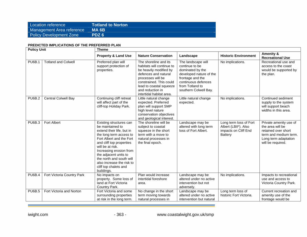
Location reference Totland to Norton Management Area reference MA 6B Policy Development Zone PDZ 6
PREDICTED IMPLICATIONS OF THE PREFERRED PLAN
Theme Policy Unit
Property & Land Use Nature Conservation Landscape Historic Environment Amenity & Recreational Use
PU6B.1 Totland and Colwell Preferred plan will support protection of properties.
The shoreline and its habitats will continue to be heavily modified by defences and natural processes will be constrained. This could lead to coastal squeeze and reduction in intertidal habitat area.
The landscape will continue to be dominated by the developed nature of the frontage and the continuous defences from Totland to southern Colwell Bay.
No implications. Recreational use and access to the coast would be supported by the plan.
PU6B.2 Central Colwell Bay Continuing cliff retreat will affect part of the cliff-top Holiday Park.
Little natural change expected. Preferred plan will support SMP high level nature conservation objectives and geological interest.
Little natural change expected.
No implications. Continued sediment supply to the system will support beach widths in this area.
PU6B.3 Fort Albert Existing structures can be maintained to extend their life, but in the long term access to Fort Albert and the Fort and cliff top properties will be at risk. Increasing erosion from the adjacent units to the north and south will also increase the risk to cliff top chalets and buildings.
The shoreline will be subject to coastal squeeze in the short term with a move to natural processes in the final epoch.
Landscape may be altered with long term loss of Fort Albert.
Long term loss of Fort Albert (LBII*). Also impacts on Cliff End Battery
Private amenity use of the area will be retained over short term and medium term. Long term adaptation will be required.
PU6B.4 Fort Victoria Country Park No impacts on property. Some loss of land at Fort Victoria Country Park.
Plan would increase intertidal foreshore area.
Landscape may be altered under no active intervention but not adversely.
No implications. Impacts to recreational use and access to Victoria Country Park.
PU6B.5 Fort Victoria and Norton Fort Victoria and some surrounding properties at risk in the long term.
No change in the short term moving towards natural processes in
Landscape may be altered under no active intervention but natural
Long term loss of historic Fort Victoria.
Current recreation and amenity use of the frontage would be
iwight.com - 363 - www.coastalwight.gov.uk/smp
Theme Policy Unit
Property & Land Use Nature Conservation Landscape Historic Environment Amenity & Recreational Use
Access to the area may be affected in the medium term.
the longer term. processes will drive the resulting landscape.
retained in the short term but lost or reduced in the medium to long term.
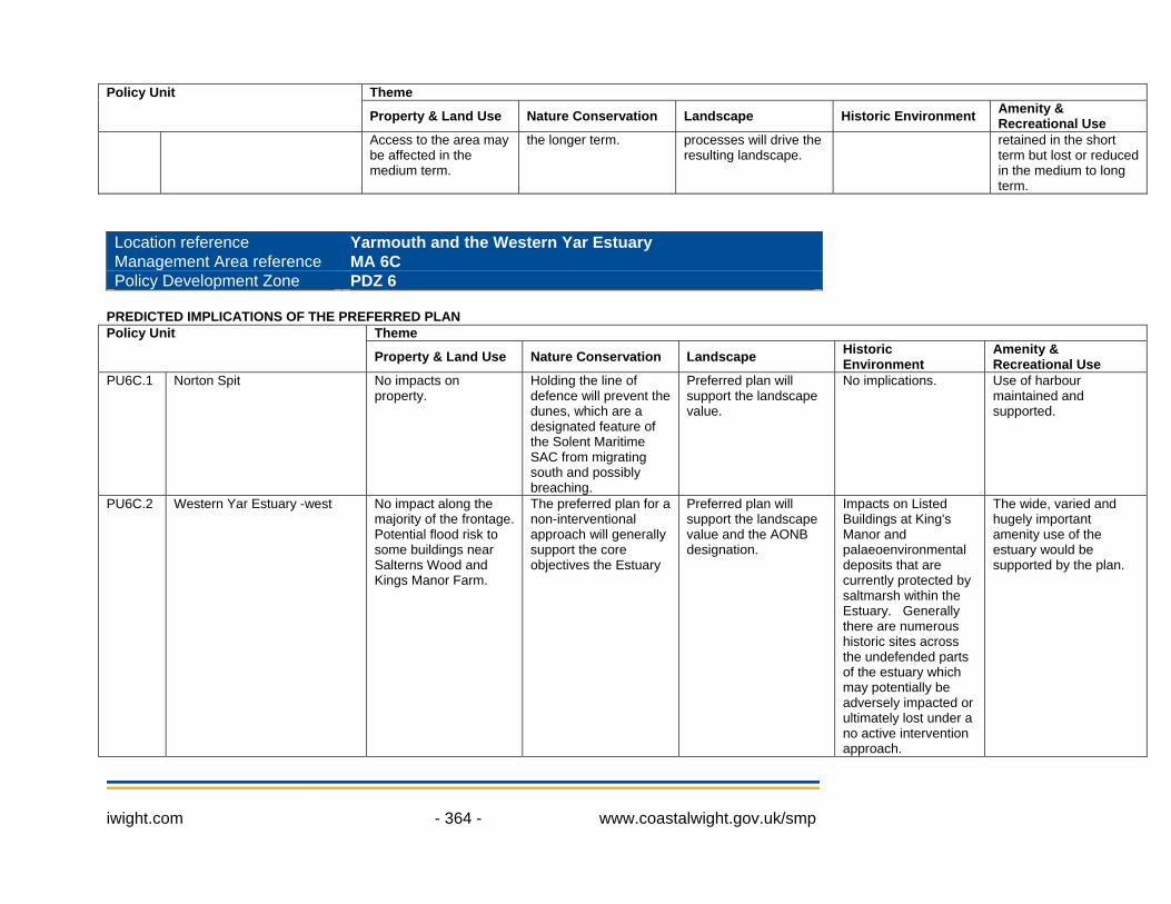
Location reference Yarmouth and the Western Yar Estuary Management Area reference MA 6C Policy Development Zone PDZ 6
PREDICTED IMPLICATIONS OF THE PREFERRED PLAN
Theme Policy Unit
Property & Land Use Nature Conservation Landscape Historic Environment
Amenity & Recreational Use
PU6C.1 Norton Spit No impacts on property.
Holding the line of defence will prevent the dunes, which are a designated feature of the Solent Maritime SAC from migrating south and possibly breaching.
Preferred plan will support the landscape value.
No implications. Use of harbour maintained and supported.
PU6C.2 Western Yar Estuary -west No impact along the majority of the frontage. Potential flood risk to some buildings near Salterns Wood and Kings Manor Farm.
The preferred plan for a non-interventional approach will generally support the core objectives the Estuary
Preferred plan will support the landscape value and the AONB designation.
Impacts on Listed Buildings at King's Manor and palaeoenvironmental deposits that are currently protected by saltmarsh within the Estuary. Generally there are numerous historic sites across the undefended parts of the estuary which may potentially be adversely impacted or ultimately lost under a no active intervention approach.
The wide, varied and hugely important amenity use of the estuary would be supported by the plan.
iwight.com - 364 - www.coastalwight.gov.uk/smp

Theme Policy Unit
Property & Land Use Nature Conservation Landscape Historic Environment
Amenity & Recreational Use
PU6C.3 The Causeway Widespread properties and core land use along the Western Yar valley protected under the preferred plan.
The preferred plan for a non-interventional approach will generally support the core objectives the Estuary, although the tidal flow to the south will remain restricted at this point. Freshwater habitats upstream will be maintained.
The preferred plan will support the landscape value.
Potential impacts on the Causeway itself, WWII pillbox and nearby All Saints Church.
Recreational use would generally be unaffected by the plan and the access route will be maintained.
PU6C.4 Western Yar Estuary -east No risk to properties. The preferred plan for a non-interventional approach will generally support the core objectives the Estuary.
The preferred plan will support the landscape value.
No implications. The wide, varied and hugely important amenity use of the estuary would be supported by the plan. Some access points and shoreline pathways may need to be re-positioned over time. Future risk to the cycle route would require adaptation to sustain use of the important route.
PU6C.5 Thorley Brook and Barnfields Stream
HTL in the first epoch and MR in the second epoch provide opportunity to address and reduce potential tidal flood risk to localised areas of property adjacent to the proposed new tidal floodplains.
HTL in the first epoch will allow time to plan for habitat adaption. MR then NAI in the medium and longer term will restore more natural behaviour and operation of these inlets with benefits for the nature conservation interest, although some habitat change will occur.
Landscape improvements could be delivered through programme of realignment or no active intervention in the longer term.
Potential impacts on historical features near Thorley.
Potential loss of cycle route would require adaptation to sustain use of the important route.
PU6C.6 Yarmouth to Port la Salle A large number of properties protected from flood and erosion risk under the preferred
The shoreline and its habitats will continue to be modified by the defences and natural
Landscape will continue to be dominated by open coast defences.
Variety of historical features, SM and listed buildings would be safeguarded under
Use of harbour maintained and supported. Recreational use and coastal access
iwight.com - 365 - www.coastalwight.gov.uk/smp
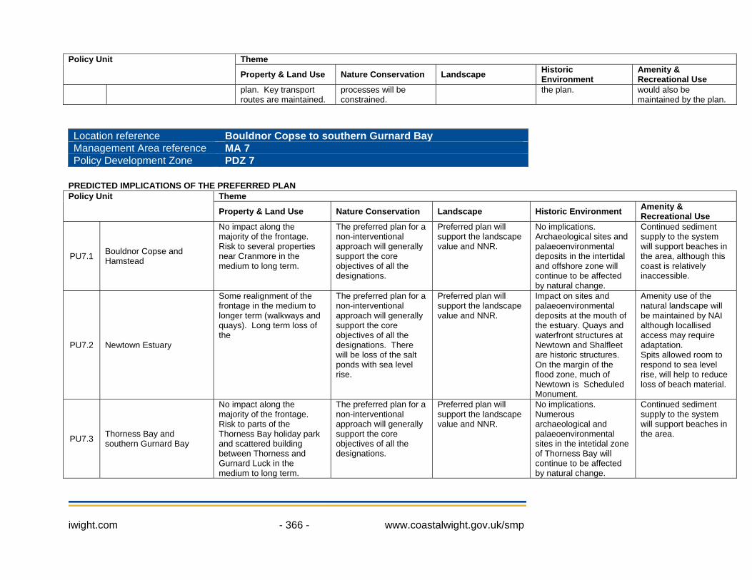
Theme Policy Unit
Property & Land Use Nature Conservation Landscape Historic Environment
Amenity & Recreational Use
plan. Key transport routes are maintained.
processes will be constrained.
the plan. would also be maintained by the plan.
Location reference Bouldnor Copse to southern Gurnard Bay Management Area reference MA 7 Policy Development Zone PDZ 7
PREDICTED IMPLICATIONS OF THE PREFERRED PLAN
Theme Policy Unit
Property & Land Use Nature Conservation Landscape Historic Environment Amenity & Recreational Use
PU7.1 Bouldnor Copse and Hamstead
No impact along the majority of the frontage. Risk to several properties near Cranmore in the medium to long term.
The preferred plan for a non-interventional approach will generally support the core objectives of all the designations.
Preferred plan will support the landscape value and NNR.
No implications. Archaeological sites and palaeoenvironmental deposits in the intertidal and offshore zone will continue to be affected by natural change.
Continued sediment supply to the system will support beaches in the area, although this coast is relatively inaccessible.
PU7.2 Newtown Estuary
Some realignment of the frontage in the medium to longer term (walkways and quays). Long term loss of the
The preferred plan for a non-interventional approach will generally support the core objectives of all the designations. There will be loss of the salt ponds with sea level rise.
Preferred plan will support the landscape value and NNR.
Impact on sites and palaeoenvironmental deposits at the mouth of the estuary. Quays and waterfront structures at Newtown and Shalfleet are historic structures. On the margin of the flood zone, much of Newtown is Scheduled Monument.
Amenity use of the natural landscape will be maintained by NAI although locallised access may require adaptation. Spits allowed room to respond to sea level rise, will help to reduce loss of beach material.
PU7.3 Thorness Bay and southern Gurnard Bay
No impact along the majority of the frontage. Risk to parts of the Thorness Bay holiday park and scattered building between Thorness and Gurnard Luck in the medium to long term.
The preferred plan for a non-interventional approach will generally support the core objectives of all the designations.
Preferred plan will support the landscape value and NNR.
No implications. Numerous archaeological and palaeoenvironmental sites in the intetidal zone of Thorness Bay will continue to be affected by natural change.
Continued sediment supply to the system will support beaches in the area.
iwight.com - 366 - www.coastalwight.gov.uk/smp