summer field school at cherryfield
TRANSCRIPT
1
Summer Field School at Cherryfield By Steven Anthony
The Cherryfield site was chosen again this year for
the MAHS annual Field School in Underwater
Archaeology. Eight students, fresh from completing the
MAHS Introductory Course, registered for the first field
school of the 2005 season. The students, pursuing their
final certification in the MAHS underwater archaeology
series, included John Dowdle, Cynthia Dowdle, Chris
Dunn, Kelley Elliott, Dave Lambert, Craig Lukezic,
Michelle Ryan, and Joyce Steinmetz. Several MAHS
members volunteered to
conduct the Field School.
Director of Education,
Tom Berkey, served as
Project Manager;
President, Steven Anthony,
served as Assistant Project
Manager; Kurt Knoerl
served as the Principal
Investigator; Michele
Anthony served as Dive
Supervisor and Project
Photographer; and Michele
Damian served as a dive
trainer. Dave Howe
provided the vessel Roper,
and served as her skipper
throughout the field school.
This site was chosen for
a variety of reasons. First
and foremost, was the
convenient proximity to Washington, D.C., area students
and the home port of the vessel Roper, which hails out of
nearby Tall Timbers Marina. Also, Tom was able to
secure reasonably priced accommodations at the Harry
Lundeberg School of Seamanship that is just around the
point from the marina and about a half hour steaming
time to the shipwreck site.
The site was named after Cherryfield Point, which
is the closest point of land in this rural part of southern
Maryland. MAHS has been
conducting a multiyear study
of this wreck for the state of
Maryland. Several field
schools have been conducted
at this site in
prior years, and Kurt’s
research and analysis suggest
that the vessel remains could
possibly be the wreckage of a
Ram Schooner. In the Winter
2002 edition of MAHSNEWS,
Kurt provided a summary of
previous research efforts and
an extensive discussion of the
data collected from the site.
Ram Schooners were
indigenous to the Chesapeake
Bay. Approximately thirty of
these vessels were built continued on page 3
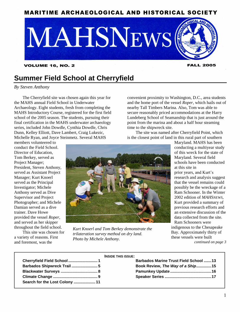
Kurt Knoerl and Tom Berkey demonstrate the
trilateration survey method on dry land.
Photo by Michele Anthony.
INSIDE THIS ISSUE: Cherryfield Field School ........................... 1 Barbados Marine Trust Field School ....... 13
Barbados Shipwreck Trail ........................ 5 Book Review, The Way of a Ship .............. 15
Blackwater Surveys .................................. 8 Pamunkey Update ...................................... 16
Climate Change ......................................... 9 Speaker Series ........................................... 17
Search for the Lost Colony .................... 11
2
Notes from the Prez – Steven Anthony
It was a beautiful summer here in the Mid-Atlantic
States this year, and MAHS members made the best of
it.
In June, MAHS conducted its 2005 Summer Field
School on the Cherryfield shipwreck site for the third
season. The Cherryfield site is located at the confluence
of the Potomac and St. Mary’s rivers and is in close
proximity to our Washington, D.C., area students. Eight
students from both the live class and video courses
worked under the direction of Tom Berkey, MAHS
Education Director, and T. Kurt Knoerl, Archaeologist
and Principal Investigator. The students participated in
the ongoing project of mapping and surveying this site
and collecting data for the State of Maryland. See the
article enclosed for more highlights about the 2005 Field
School.
Our speaker series continued in full swing over the
summer as well. MAHS members attending the General
Membership meetings enjoyed several excellent
presentations, including an informative review of
submarine museums located in the Washington, D.C.,
area and throughout the country, by Greg Stitz; a
discussion about the archaeology of the Washington
Navy Yard, by Charles Leedecker; and an overview of
the Hunley project, by Dr. Robert Neyland.
The Board of Directors also continued its
development of the new MAHS textbook over the
summer under the watchful direction of Ray Hayes and
Jim Smailes. In July, Ray provided the Board with a
revised draft of the new text on CD for review and
comment. In its present form, the book is 450 pages
including illustrations. The final version is targeted to be
a little more than 220 pages.
The MAHS Board also turned its attention to the
Photography and Videography class and revised the
course content to bring the class up to date, with more
focus on the evolving use of digital cameras and their
application in the field of underwater archaeology. This
popular program will be even more informative for the
2006 course.
However, it wasn’t all work this summer. The
MAHS Annual Summer Picnic and Crabfeast was held
at the Fairfax County Police Association facility this year. Everyone agreed that this was an excellent location
for the picnic, and we extended our grateful appreciation
to John Kuch for making the arrangements. Over a third
of the membership attended the picnic, and the crabs
disappeared quickly.
One important announcement for those who may
not have received the word yet, as of September, MAHS
continued on page 18
2005 MAHS OFFICERS
Steven Anthony – President (301) 652-2622
Ray Hayes – Vice President (301) 585-5892
James A. Smailes – Secretary (202) 543-4895
Steven Anthony – Treasurer (301) 652-2622
At Large Board Members
David Shaw Dennis Knepper
President Emeritus
David P. Howe
Committee Chairpersons
Education Director – Thomas Berkey
Dive Safety Officer – Earl Glock
Webmaster – Jesse Grittis
Equipment Manager – James A. Smailes
MAHSNEWS Editor: James A. Smailes
ADVISORS John Broadwater
Maritime Heritage Program Manager, National Oceanic and
Atmospheric Administration
Dr. Michael Crawford Early History Branch, Naval Historical Center
Dr. Kevin Crisman Assistant Professor of Anthropology, Texas A&M University
James A. Goold, J.D. Covington and Burling
Dr. Richard Gould Professor of Anthropology, Brown University
Dr. Paul Johnston Curator, Maritime History, National Museum of American
History, Smithsonian Institution
Dr. Susan Langley State Underwater Archeologist, Maryland
Jeffery Morris President, Azulmar, LLC
Larry Murphy Submerged Resource Center, National Park Service
Dr. Robert Neyland Head, Underwater Archaeology Branch, Naval Historical Center
Dr. John Seidel Assistant Professor of Anthropology and Environmental Studies,
Washington College
Dr. Roger C. Smith State Underwater Archaeologist, Florida
Bruce Terrell National Marine Sanctuaries, National Oceanic and Atmospheric
Administration
Dr. Gordon Watts Director, Institute for International Maritime Research
MAHSNEWS is the official publication of the Maritime Archaeological
and Historical Society (MAHS), a non-profit organization
dedicated to preserving our global maritime heritage.
MAHSNEWS will consider articles and notices for publication which
enhance public awareness and appreciation of maritime history,
archaeology, and heritage preservation.
3
continured from page 3
between 1889 and 1911, many of which were
constructed in Bethel, Delaware. Although Ram
Schooners often varied in length from 34 to 47 meters,
their beam measurements prior to 1890 were
consistently just shy of 7.3 meters. This narrow beam
design facilitated passage through the Chesapeake and
Delaware Canal.
During the June 2002 Field School, Kurt asked the
students to document some of the overall measurements
of this wreck. These measurements revealed that the
vessel was about 42 meters in length with a beam of 7.3
meters. Parts of the keelson were present but very little
remains of the rider keelsons, and there was no evidence
of sister keelsons or a centerboard trunk. So, in spite of
the fact that the overall measurements were consistent
with those of a Ram Schooner, Kurt speculated that the
wreckage might have been a canal-going barge instead.
For more definitive findings, Kurt was going to need
additional information.
On Friday evening, June 17, the students and
trainers convened about 8:00 pm in the Maryland Room
on the second floor of the Lundeberg School facility.
This was a spacious conference room graciously
provided by Howard Thompson, manager of the facility.
The Lundeberg School of Seamanship is a modern and
spacious campus that provides training and
accommodations for seamen participating in continuing
education programs of the Seafarers International Union.
The school was a pleasant and comfortable setting for
our course.
Tom and Kurt kicked the meeting off with an initial
briefing and orientation. Then, Craig Lukezic, who is an
archaeologist for the state of Delaware, provided the
group with an informative presentation on the Lewes
Maritime Archaeology Project. This project is the
ongoing study of an unknown shipwreck site lying in the
Harbor of Refuge, approximately one thousand yards
from Lewes Beach. Dan Griffith, former Delaware state
archaeologist, is supervising this project for the state.
Craig described the progress and accomplishments to
date and explained the reasons that archaeologists
believe the site may be the remains of a colonial
merchantman operating along the Atlantic coast between
1740 and 1760. The presentation was a special treat and
was enjoyed by all.
On Saturday morning, June 18, everyone was up
early and convened in the cafeteria for breakfast.
Anticipation of the day’s events was running high. After
breakfast, the students assembled on the lawn area
adjacent to the dock for a dry-land trilateration exercise
conducted by Tom and Kurt. This is the part of the field
school where students get to practice the trilateration
survey techniques that they learned in the Introductory
Course. A mock shipwreck site was set up on the lawn,
and the students tried their hand at taking measurements
and creating a scale drawing of the practice “site”.
In the meantime, Dave made the Roper ready at the
dock. So, as soon as the dry-land exercises were
complete, everyone loaded their gear and located a seat
for the trip to the wrecksite. We shoved off at about
11:30 am and steamed towards the mouth of the St.
Marys River, which empties directly into the Potomac
River and in turn empties into the Chesapeake Bay a
short distance away. It was a picture perfect day with
sunny skies and only a slight breeze that provided a calm
and pleasant boat ride along one of the most scenic and
historic rivers in the state. Some of the students were
experiencing these waters for the first time. As the bay
breezes washed over us we followed the overflight of
blue herons and took the opportunity to scan the
picturesque shoreline that is so characteristic of this part
of Maryland.
It was a short boat ride and soon the wrecksite
L-R: Michelle Ryan, Tom Berkey, and Steve Anthony
prepare for the first dive. Photo by Michele Anthony.
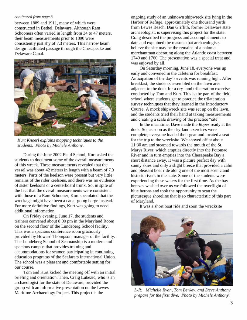
Kurt Knoerl explains mapping techniques to the
students. Photo by Michele Anthony.
4
loomed ahead. As the Roper made her approach, Dave
set the anchor, and Tom and I conducted the predive
safety discussion. Then Kurt laid out the research plan
and tasked the dive teams with their respective
assignments. This part of the river is very shallow and
the Roper could only get within 100 yards of the site. So,
the teams entered the water and proceeded to wade the
remaining distance to the wreck. We located the
structure close to the shoreline lying in only four feet of
water. Although SCUBA might be needed to collect
some of the measurements, the shallow water precluded
the need for much diving. Our dive supervisor would
have an easy job on this trip since there was obviously
minimal diving risk at the dizzying depths of four feet!
The greatest challenge of the day would be protecting
against sunburn and avoiding the Chesapeake Bay blue
claw crabs that made their home among the old timbers
and framing of the wreck.
Upon completing their assignments, the dive teams
exited the site and waded back to the Roper where they
proceeded to report and discuss their findings with Tom
and Kurt. Once all of the teams were aboard, the Roper
was underway and homeward bound. The conversation
soon turned to food and everyone was eagerly
anticipating ice cold drinks and sampling Southern
Maryland style cooking upon arrival. In about thirty
minutes, the Roper settled at the dock and everyone
offloaded their gear and rinsed and hung their wetsuits
so that they would be ready for the next day. Then we
were off to happy hour and supper.
Two groups formed during happy hour based on the
available choices for dinner, one for seafood and the
other for barbecue. Although neither group reported that
they had found gourmet dining, there were ample
portions and something on the menu for all.
After supper, the students assembled in the
Maryland Room at the Lundeberg school where Tom
and Kurt discussed the day’s activities and evaluated the
data collected. Students used this opportunity to ask
questions and complete their field notes and drawings.
Measurements were plotted and any problems
encountered with the data were fully discussed. After
sorting and cataloguing the information, Kurt established
new research assignments for the following day. Roper
was scheduled to be at the dock again at 9:00 am the
next morning so at the conclusion of the meeting, most
of the group retired early.
On Sunday morning, June 19, we convened in the
dining hall for breakfast and around 8:30 am everyone
proceeded to the dock to load up the Roper. It was a
cloudy, cool morning and a smoky mist lifted off the
water. But it was early, and it looked like the weather
gods might still deliver a sunny day. Roper shoved off at
9:30 am and the short boat ride to the site passed
quickly. As we began to approach, the students, now
continued on page 18
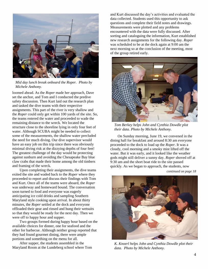
Mid day lunch break onboard the Roper. Photo by
Michele Anthony.
K. Knoerl helps John and Cynthia Dowdle plot their
data. Photo by Michele Anthony.
Tom Berkey helps John and Cynthia Dowdle plot
their data. Photo by Michele Anthony.
5
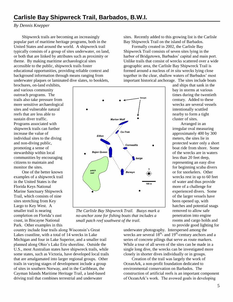
Carlisle Bay Shipwreck Trail, Barbados, B.W.I.
By Dennis Knepper
Shipwreck trails are becoming an increasingly
popular part of maritime heritage programs, both in the
United States and around the world. A shipwreck trail
typically consists of a group of sites underwater, on land,
or both that are linked by attributes such as proximity or
theme. By making maritime archaeological sites
accessible to the public, shipwreck trails foster
educational opportunities, providing reliable context and
background information through means ranging from
underwater plaques or laminated dive slates, to booklets,
brochures, on-land exhibits,
and various community
outreach programs. The
trails also take pressure from
more sensitive archaeological
sites and vulnerable natural
reefs that are less able to
sustain diver traffic.
Programs associated with
shipwreck trails can further
increase the value of
individual sites to the diving
and non-diving public,
promoting a sense of
stewardship within local
communities by encouraging
citizens to maintain and
monitor the sites.
One of the better known
examples of a shipwreck trail
in the United States is the
Florida Keys National
Marine Sanctuary Shipwreck
Trail, which consists of nine
sites stretching from Key
Largo to Key West. A
smaller trail is nearing
completion on Florida’s east
coast, in Biscayne National
Park. Other examples in this
country include four trails along Wisconsin’s Great
Lakes coastline, with a total of 14 wrecks in Lake
Michigan and four in Lake Superior, and a smaller trail
planned along Ohio’s Lake Erie shoreline. Outside the
U.S., most Australian states have shipwreck trails, while
some states, such as Victoria, have developed local trails
that are amalgamated into larger regional groups. Other
trails in varying stages of development include a group
of sites in southern Norway, and in the Caribbean, the
Cayman Islands Maritime Heritage Trail, a land-based
driving trail that combines terrestrial and underwater
sites. Recently added to this growing list is the Carlisle
Bay Shipwreck Trail on the island of Barbados.
Formally created in 2002, the Carlisle Bay
Shipwreck Trail consists of seven sites lying in the
harbor of Bridgetown, Barbados’ capital and main port.
Unlike trails that consist of wrecks scattered over a wide
geographic area, the Carlisle Bay Shipwreck Trail is
formed around a nucleus of in situ wrecks lying close
together in the clear, shallow waters of Barbados’ most
important historical anchorage. The sites include boats
and ships that sank in the
bay in storms at various
times during the twentieth
century. Added to these
wrecks are several vessels
intentionally scuttled
nearby to form a tight
cluster of sites.
Arranged in an
irregular oval measuring
approximately 400 by 300
meters, the sites lie in
protected water only a short
boat ride from shore. Some
of the wrecks are in waters
less than 20 feet deep,
representing an easy dive
for beginning scuba divers
or for snorkelers. Other
wrecks rest in up to 60 feet
of water and thus provide
more of a challenge for
experienced divers. Some
of the larger vessels have
been opened up, with
hatches and potential snags
removed to allow safe
penetration into engine
rooms and cargo holds and
to provide good lighting for
underwater photography. Interspersed among the
wrecks are several 18th- and 19
th-century anchors and a
series of concrete pilings that serve as route markers.
While a tour of all seven of the sites can be made in a
single long dive, the wrecks can be investigated more
closely in shorter dives individually or in groups.
Creation of the trail was largely the work of
OceanArk, a non-profit foundation dedicated to
environmental conservation on Barbados. The
construction of artificial reefs is an important component
of OceanArk’s work. The avowed goals in developing
The Carlisle Bay Shipwreck Trail. Buoys mark a
no-anchor zone for fishing boats that includes a
small patch reef southwest of the trail.
6
the trail were twofold: to provide a basis for reef
formation, and to develop attractive dive sites of interest
in terms of both cultural features (the wrecks) and
natural features (the coral and fish that are attracted to
the structures). As noted on the OceanArk website:
“Our intention is to purposefully sink ship wrecks and
aircraft around Barbados where coral has been severely
depleted and now needs protection.”
A considerable amount of work goes into
intentionally placing a vessel on the ocean floor.
Obtaining the rights to the boat is only the first step.
Most of the wrecks are 20th-century, metal-hulled vessels
that must be stripped and cleaned prior to sinking. The
largest and most complete vessel in the Carlisle Bay trail
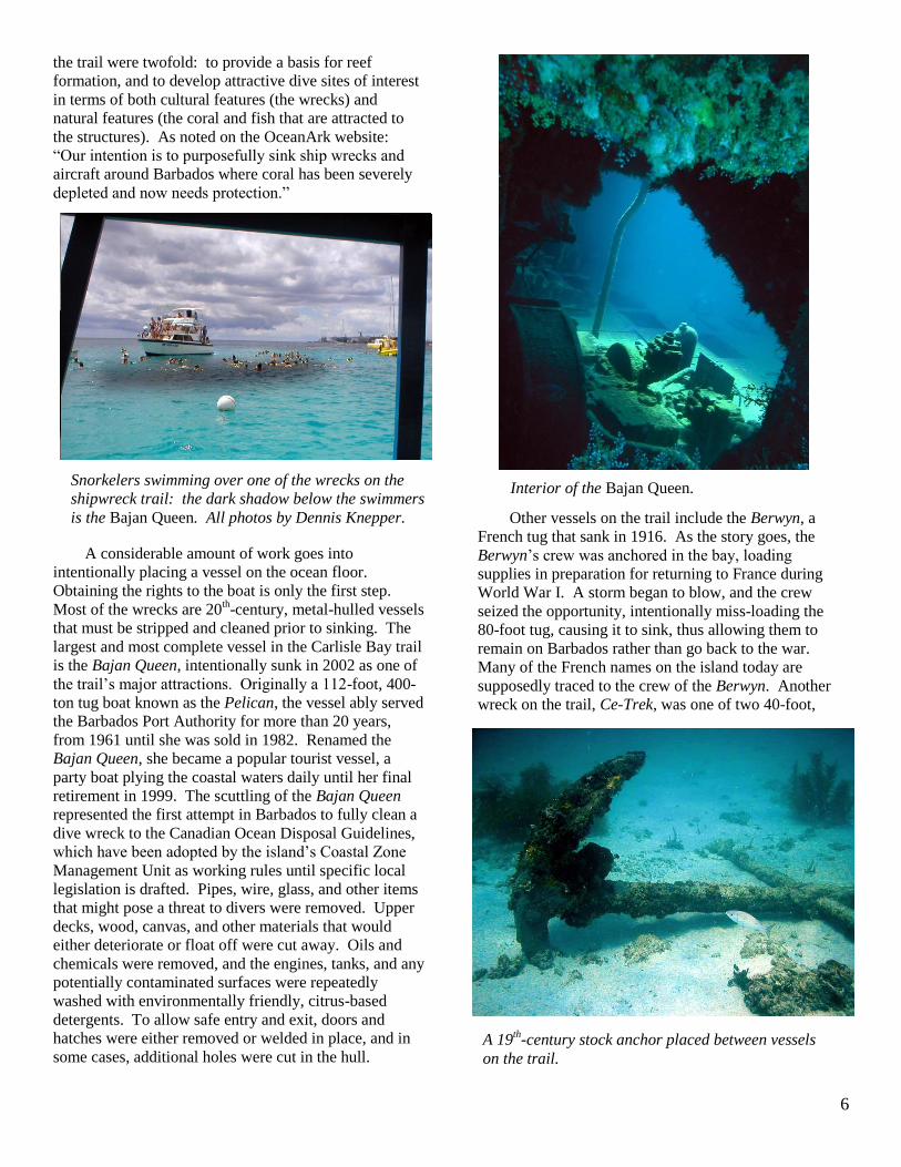
is the Bajan Queen, intentionally sunk in 2002 as one of
the trail’s major attractions. Originally a 112-foot, 400-
ton tug boat known as the Pelican, the vessel ably served
the Barbados Port Authority for more than 20 years,
from 1961 until she was sold in 1982. Renamed the
Bajan Queen, she became a popular tourist vessel, a
party boat plying the coastal waters daily until her final
retirement in 1999. The scuttling of the Bajan Queen
represented the first attempt in Barbados to fully clean a
dive wreck to the Canadian Ocean Disposal Guidelines,
which have been adopted by the island’s Coastal Zone
Management Unit as working rules until specific local
legislation is drafted. Pipes, wire, glass, and other items
that might pose a threat to divers were removed. Upper
decks, wood, canvas, and other materials that would
either deteriorate or float off were cut away. Oils and
chemicals were removed, and the engines, tanks, and any
potentially contaminated surfaces were repeatedly
washed with environmentally friendly, citrus-based
detergents. To allow safe entry and exit, doors and
hatches were either removed or welded in place, and in
some cases, additional holes were cut in the hull.
Other vessels on the trail include the Berwyn, a
French tug that sank in 1916. As the story goes, the
Berwyn’s crew was anchored in the bay, loading
supplies in preparation for returning to France during
World War I. A storm began to blow, and the crew
seized the opportunity, intentionally miss-loading the
80-foot tug, causing it to sink, thus allowing them to
remain on Barbados rather than go back to the war.
Many of the French names on the island today are
supposedly traced to the crew of the Berwyn. Another
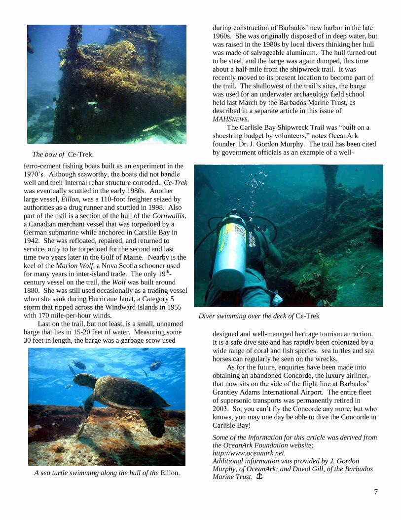
wreck on the trail, Ce-Trek, was one of two 40-foot,
Snorkelers swimming over one of the wrecks on the
shipwreck trail: the dark shadow below the swimmers
is the Bajan Queen. All photos by Dennis Knepper.
Interior of the Bajan Queen.
A 19th-century stock anchor placed between vessels
on the trail.
7
ferro-cement fishing boats built as an experiment in the
1970’s. Although seaworthy, the boats did not handle
well and their internal rebar structure corroded. Ce-Trek
was eventually scuttled in the early 1980s. Another
large vessel, Eillon, was a 110-foot freighter seized by
authorities as a drug runner and scuttled in 1998. Also
part of the trail is a section of the hull of the Cornwallis,
a Canadian merchant vessel that was torpedoed by a
German submarine while anchored in Carslile Bay in
1942. She was refloated, repaired, and returned to
service, only to be torpedoed for the second and last
time two years later in the Gulf of Maine. Nearby is the
keel of the Marion Wolf, a Nova Scotia schooner used
for many years in inter-island trade. The only 19th-
century vessel on the trail, the Wolf was built around
1880. She was still used occasionally as a trading vessel
when she sank during Hurricane Janet, a Category 5
storm that ripped across the Windward Islands in 1955
with 170 mile-per-hour winds.
Last on the trail, but not least, is a small, unnamed
barge that lies in 15-20 feet of water. Measuring some
30 feet in length, the barge was a garbage scow used
during construction of Barbados’ new harbor in the late
1960s. She was originally disposed of in deep water, but
was raised in the 1980s by local divers thinking her hull
was made of salvageable aluminum. The hull turned out
to be steel, and the barge was again dumped, this time
about a half-mile from the shipwreck trail. It was
recently moved to its present location to become part of
the trail. The shallowest of the trail’s sites, the barge
was used for an underwater archaeology field school
held last March by the Barbados Marine Trust, as
described in a separate article in this issue of
MAHSNEWS.
The Carlisle Bay Shipwreck Trail was “built on a
shoestring budget by volunteers,” notes OceanArk
founder, Dr. J. Gordon Murphy. The trail has been cited
by government officials as an example of a well-
designed and well-managed heritage tourism attraction.
It is a safe dive site and has rapidly been colonized by a
wide range of coral and fish species: sea turtles and sea
horses can regularly be seen on the wrecks.
As for the future, enquiries have been made into
obtaining an abandoned Concorde, the luxury airliner,
that now sits on the side of the flight line at Barbados’
Grantley Adams International Airport. The entire fleet
of supersonic transports was permanently retired in
2003. So, you can’t fly the Concorde any more, but who
knows, you may one day be able to dive the Concorde in
Carlisle Bay!
Some of the information for this article was derived from the OceanArk Foundation website: http://www.oceanark.net. Additional information was provided by J. Gordon Murphy, of OceanArk; and David Gill, of the Barbados Marine Trust. Î
Diver swimming over the deck of Ce-Trek
The bow of Ce-Trek.
A sea turtle swimming along the hull of the Eillon.
8
Estimating Success in Blackwater Surveys
By Robert Speir and James A. Smailes
In the previous issue of MAHSNEWS, Annette
Aronson described the ground-truth survey work done in
the Chester River that sought to identify shipwrecks or
other historic sites. Our mission was to validate targets
from a July 2004 side-scan sonar survey of the Chester
River conducted by Professor John Seidel of
Washington College, Chestertown, Maryland. The
targets we investigated, a subset of more than 180
available from the survey, were located on the southern
portion of the river from Chestertown to Spaniard Point,
near the river’s mouth at the Chesapeake Bay. Dive
depths ranged from 12 to 45 feet.
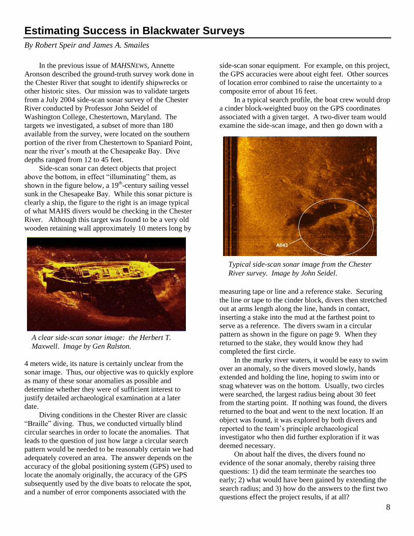
Side-scan sonar can detect objects that project
above the bottom, in effect “illuminating” them, as
shown in the figure below, a 19th-century sailing vessel
sunk in the Chesapeake Bay. While this sonar picture is
clearly a ship, the figure to the right is an image typical
of what MAHS divers would be checking in the Chester
River. Although this target was found to be a very old
wooden retaining wall approximately 10 meters long by
4 meters wide, its nature is certainly unclear from the
sonar image. Thus, our objective was to quickly explore
as many of these sonar anomalies as possible and
determine whether they were of sufficient interest to
justify detailed archaeological examination at a later
date.
Diving conditions in the Chester River are classic
“Braille” diving. Thus, we conducted virtually blind
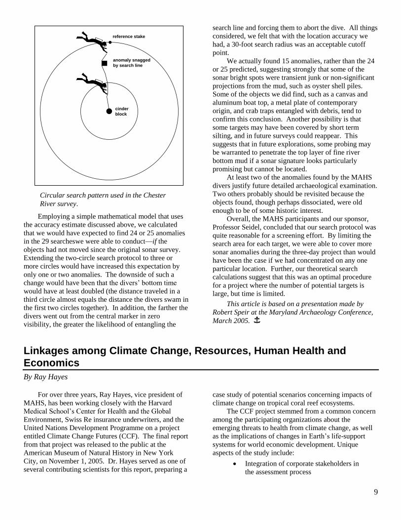
circular searches in order to locate the anomalies. That
leads to the question of just how large a circular search
pattern would be needed to be reasonably certain we had
adequately covered an area. The answer depends on the
accuracy of the global positioning system (GPS) used to
locate the anomaly originally, the accuracy of the GPS
subsequently used by the dive boats to relocate the spot,
and a number of error components associated with the
side-scan sonar equipment. For example, on this project,
the GPS accuracies were about eight feet. Other sources
of location error combined to raise the uncertainty to a
composite error of about 16 feet.
In a typical search profile, the boat crew would drop
a cinder block-weighted buoy on the GPS coordinates
associated with a given target. A two-diver team would
examine the side-scan image, and then go down with a
measuring tape or line and a reference stake. Securing
the line or tape to the cinder block, divers then stretched
out at arms length along the line, hands in contact,
inserting a stake into the mud at the farthest point to
serve as a reference. The divers swam in a circular
pattern as shown in the figure on page 9. When they
returned to the stake, they would know they had
completed the first circle.
In the murky river waters, it would be easy to swim
over an anomaly, so the divers moved slowly, hands
extended and holding the line, hoping to swim into or
snag whatever was on the bottom. Usually, two circles
were searched, the largest radius being about 30 feet
from the starting point. If nothing was found, the divers
returned to the boat and went to the next location. If an
object was found, it was explored by both divers and
reported to the team’s principle archaeological
investigator who then did further exploration if it was
deemed necessary.
On about half the dives, the divers found no
evidence of the sonar anomaly, thereby raising three
questions: 1) did the team terminate the searches too
early; 2) what would have been gained by extending the
search radius; and 3) how do the answers to the first two
questions effect the project results, if at all?
A clear side-scan sonar image: the Herbert T.
Maxwell. Image by Gen Ralston.
Typical side-scan sonar image from the Chester
River survey. Image by John Seidel.
9
Employing a simple mathematical model that uses
the accuracy estimate discussed above, we calculated
that we would have expected to find 24 or 25 anomalies
in the 29 searcheswe were able to conduct—if the
objects had not moved since the original sonar survey.
Extending the two-circle search protocol to three or
more circles would have increased this expectation by
only one or two anomalies. The downside of such a
change would have been that the divers’ bottom time
would have at least doubled (the distance traveled in a
third circle almost equals the distance the divers swam in
the first two circles together). In addition, the farther the
divers went out from the central marker in zero
visibility, the greater the likelihood of entangling the
search line and forcing them to abort the dive. All things
considered, we felt that with the location accuracy we
had, a 30-foot search radius was an acceptable cutoff
point.
We actually found 15 anomalies, rather than the 24
or 25 predicted, suggesting strongly that some of the
sonar bright spots were transient junk or non-significant
projections from the mud, such as oyster shell piles.
Some of the objects we did find, such as a canvas and
aluminum boat top, a metal plate of contemporary
origin, and crab traps entangled with debris, tend to
confirm this conclusion. Another possibility is that
some targets may have been covered by short term
silting, and in future surveys could reappear. This
suggests that in future explorations, some probing may
be warranted to penetrate the top layer of fine river
bottom mud if a sonar signature looks particularly
promising but cannot be located.
At least two of the anomalies found by the MAHS
divers justify future detailed archaeological examination.
Two others probably should be revisited because the
objects found, though perhaps dissociated, were old
enough to be of some historic interest.
Overall, the MAHS participants and our sponsor,
Professor Seidel, concluded that our search protocol was
quite reasonable for a screening effort. By limiting the
search area for each target, we were able to cover more
sonar anomalies during the three-day project than would
have been the case if we had concentrated on any one
particular location. Further, our theoretical search
calculations suggest that this was an optimal procedure
for a project where the number of potential targets is
large, but time is limited.
This article is based on a presentation made by
Robert Speir at the Maryland Archaeology Conference,
March 2005. Î
Linkages among Climate Change, Resources, Human Health and Economics
By Ray Hayes
For over three years, Ray Hayes, vice president of
MAHS, has been working closely with the Harvard
Medical School’s Center for Health and the Global
Environment, Swiss Re insurance underwriters, and the
United Nations Development Programme on a project
entitled Climate Change Futures (CCF). The final report
from that project was released to the public at the
American Museum of Natural History in New York
City, on November 1, 2005. Dr. Hayes served as one of
several contributing scientists for this report, preparing a
case study of potential scenarios concerning impacts of
climate change on tropical coral reef ecosystems.
The CCF project stemmed from a common concern
among the participating organizations about the
emerging threats to health from climate change, as well
as the implications of changes in Earth’s life-support
systems for world economic development. Unique
aspects of the study include:
Integration of corporate stakeholders in
the assessment process
Circular search pattern used in the Chester
River survey.
reference stake
anomaly snagged
by search line
cinder
block
10
Combined focus on physical, biological
and economic impacts
Anticipation of short-term impacts, rather
than century-scaled projections
Scenarios of plausible futures with gradual
and step-wise change
A framework to deal with and plan for
climate-related surprise impacts
The CCF report contains trends, case studies, and
scenarios which detail and analyze current climate
change related consequences for human health,
ecological systems, and the global economy. Ten case
studies, written by scientific experts, are included in the
report. Each outlines current effects of climate change
with regard to infectious diseases (malaria, West Nile
virus, Lyme disease, and asthma); extreme weather
events (heat waves and floods); and ecosystems (forests,
agriculture, and coral reefs). The studies survey existing
and future costs associated with climate change and the
growing potential for abrupt, widespread impacts. The
report suggests that the insurance industry will be at the
center of this issue, absorbing the risk and helping
society and business to adapt and reduce any new risks.
In the coral reef ecosystem case study, Dr. Hayes
addressed declines in coral reef vitality and integrity that
have been documented by many marine scientists
throughout recent decades. Mass coral reef bleaching
was first observed in the early 1980’s. Along with Dr.
Tom Goreau, Dr. Hayes pioneered the “HotSpot”
analysis that revealed anomalous elevations in sea
surface temperature due to climate change to be the
principal factor triggering coral bleaching. Bleaching
represents the uncoupling of symbiotic associations
between coral hosts and their microscopic algae or
zooxanthellae. With the loss of this dynamic
relationship, corals no longer function as keystone
species that integrate the reef frame, sustain functional
relationships within the reef community, and provide the
physical characteristics of the reef habitat. When
keystone coral species die and reefs cease to grow,
structural and physiological balance among reef
organisms are lost.
Degradation of reefs promotes rapid decline in
associated ecosystems, including mangroves stands, sea
grass beds, and beaches. Coastal wetlands that filter and
protect against the spread of toxic industrial,
agricultural, and domestic chemicals
into the ocean are compromised.
Associated ecosystems that serve as
important nurseries and habitats for
juvenile organisms are no longer able
provide those services. Reef
ecosystems cease to preserve and
protect sandy beaches. These
ecosystem degradations, attributable to
climate change, may additionally threaten the security
and welfare of people, wildlife, and flora in tropical
settings.
Rising air temperatures, that create deadly heat
waves on land, cause rising sea temperatures that result
in coral bleaching and emerging infectious diseases of
reef organisms. These rising sea temperatures also fuel
extreme weather events, such as hurricanes in the North
Altantic, Caribbean, and the Gulf of Mexico, typhoons
in the Pacific, and secondary events (tornados and
floods) worldwide. These events account for physical
and functional damages underwater, even though the
effects may be invisible from shore.
In addition to negative impacts upon natural
ecosystems, cultural resources may also be damaged by
storm activity. Storm surge and violent patterns of
vertical and horizontal circulation accelerate degradation
and displacement of shipwreck sites and submerged
historic artifacts. Although the present CCF report does
not focus specifically upon damages to submerged
cultural resources, it is obvious that where disruption of
marine ecosystems and threats to human health have
been documented, destruction and dispersion of
underwater archaeological resources may also have
occurred.
The CCF report illustrates how escalating climate
change is linked to the natural environment, to human
health risks, and to the economy. It indicates why this
information deserves attention from policy makers in
government, the boardrooms of corporations, and among
private citizens around the world. Real threats posed by
future climate change, including rising sea level from
glacial melting and thermal expansion, excessive
burning of fossil fuels in industrial machinery, trucks
and automobiles, and the persistent accumulation of
greenhouse gases (e.g., CO2, NOx and SOX) in the air
that we breathe, must be addressed at all levels of
society. How well and how quickly our generation
responds to future climate change will determine our
quality of life tomorrow and will exert lasting influence
upon the availability of natural (and cultural) resources
for research, education and enjoyment by future
generations.
The CCF report is available for viewing in full at
the following website: Î
11
The Legacy of Virginia Dare: The Search for the Lost Colony Settlement
by Bill Utley and Ray Hayes
In late summer of 1587, English settlers set foot on
Roanoke Island, becoming the first English colony in the
New World. Left to their own devices due to
circumstance, they disappeared into time, leaving behind
one of the New World’s most enduring mysteries. What
happened to the Lost Colony?
Truth be told, they weren’t the first Europeans to
settle in North America. By the time of the first English
arrival in 1584, the Spanish had a decades-old presence
in Florida and claimed a large portion of the East Coast
of North America, including the area the English settled.
The French had also established a presence in what is
now Canada, and the Basques were fishing off Nova
Scotia. In fact, it depends on your definition of “colony”
as to whether the colonists of 1587 were even the “First
Colony.” At least they were the first colony that
included families with a view to permanent settlement.
Previously, in the early 1580’s, Sir Walter Raleigh
was given a royal grant for land in “Virginia.” In 1584,
Raleigh sent a reconnaissance expedition that set up a
base on Roanoke Island, then in the territory of Virginia.
In 1585, Sir Richard Grenville, acting for Raleigh, led a
group that landed on Roanoke Island. This was indeed,
the first English colony. The expedition consisted of
soldiers, adventurers, explorers, and scientists. There
were no women or families with this group. The colony
lasted until June 1586, when Sir Francis Drake happened
by after raiding in the Caribbean. By this time, the
colony was short on supplies and, having managed to
kill a number of Indians, had worn out their welcome.
When Drake offered them passage back to England, they
took him up on the offer.
In 1587, a third expedition, consisting of 118 souls
led by John White, who had been on the 1585
expedition, arrived on Roanoke Island. They were
accompanied by two Indians who had voluntarily gone
back to England with the second expedition – Manteo
and Towaye. This was Manteo’s third trip to England,
since he had accompanied both the 1584 and 1585-6
groups. Manteo’s tribe lived on Croatan Island, a name
that would become an enduring part of the mystery of
the Lost Colony. The settlers, while adventurous, lacked
the skills to fend completely for themselves. It was clear
early on that they did not have adequate supplies, and
the Indians, while friendly, did not have the resources to
feed 118 additional mouths. John White was persuaded
to return to England to seek aid, leaving behind his
daughter and new granddaughter Virginia Dare, the first
English baby born in the Americas (a second baby was
born shortly thereafter). White expected to return within
months. He would never see any of the settlers again.
By the time White arrived in England, Spain was
threatening invasion, and all shipping was stopped in
anticipation of fighting the Spanish Armada. It would be
almost three years before White was able to leave
England again. When he arrived back at Roanoke Island
in August 1590, White found a deserted island – no
Indians and no colonists. The site was rundown, and
what items he found there, including his own personal
goods, were scattered around the site. Before White
departed three years earlier, he had arranged for a
message to be left if the colonists were forced to leave.
One form of the message denoted stress, and the other a
normal exodus. White found two signs in 1590. One
was the letters “CRO” carved in part of the crumbling
stockade, and the second was the word “CROATAN”
carved in a tree. The code indicating trouble was not
present. Certainly White recognized “Croatan” as the
location of Manteo’s village on Croatan Island. But
inexplicably, he did look there for the colonists. In fact,
it appears that he made no serious investigation into their
possible location before he returned to England. The
settlers at Jamestown and others over the decades, made
sporadic attempts to solve the mystery, but to no avail.
Other matters became more pressing, and the Lost
Colony became just another historical anomaly.
The middle of the 20th century saw a resurgence of
interest in locating the Lost Colony. Pioneering
archaeological work on Roanoke Island done by Jean C.
Harrington, and later by Ivor Noel Hume and his wife
Audrey, uncovered evidence of Grenville’s 1585
settlement, including portions of a fort and the remains
of the first scientific laboratory in the New World. But
none of the archaeology pinpointed White’s 1587
settlement or the contemporaneous Indian village. To
date, no artifacts have been recovered that can be
reliably dated to the 1587 colony.
Jump forward to the 21st century when, in 2004, a
group of professional archaeologists, historians, and lay
people founded the non-profit First Colony Foundation.
The object of the Foundation is to conduct methodical
archaeological and historical investigations to attempt to
locate the 1587 colony. There is a distinction here that
should be understood. The object of the Foundation is
not to solve the mystery of what happened to the
colonists, although that would be a bonus. The
Foundation’s goal is to locate the permanent site they
established on Roanoke Island. This may not solve the
mystery of their disappearance, but if located would fill
12
in many of the historical gaps. To that end, in October
2005 the Foundation funded the start of a multi-year
maritime archaeological effort to seek evidence of the
colony. This effort will take place in coordination with a
similar terrestrial archaeological search.
At first blush, it may seem strange to be looking for
evidence of the settlement in the water. But the only
archaeological evidence recovered to date was located at
the north end of Roanoke Island. This evidence included
a barrel well found just off the northeast shore. The
northern part of Roanoke, and in particular the northeast
shoreline, has seen serious erosion
in the past 400 years—in some cases
hundreds of yards. Therefore, the
possibility exists that the site has
eroded into the water. Several years
ago, MAHS Advisor, Dr. Gordon
Watts, conducted a magnetometer
survey of likely areas in the
northeast and east-central waters off
Roanoke Island. This survey turned
up several hundred magnetic
anomalies, although circumstance
did not allow a follow-up search at
that time.
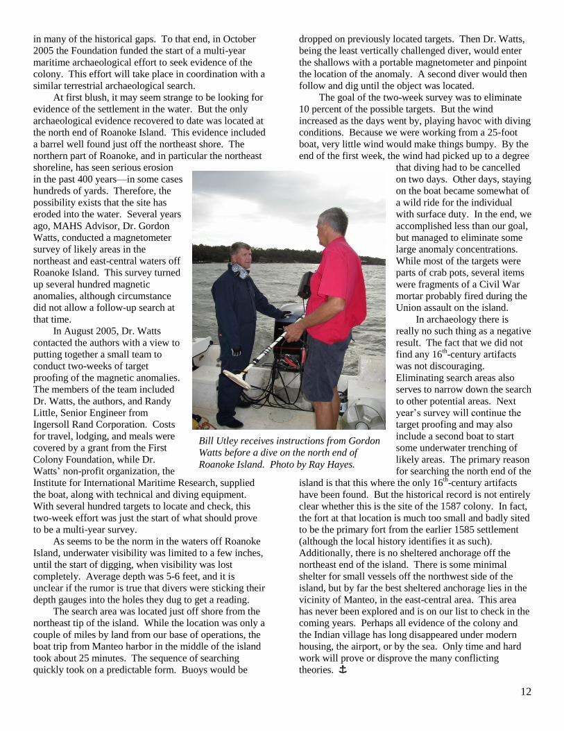
In August 2005, Dr. Watts
contacted the authors with a view to
putting together a small team to
conduct two-weeks of target
proofing of the magnetic anomalies.
The members of the team included
Dr. Watts, the authors, and Randy
Little, Senior Engineer from
Ingersoll Rand Corporation. Costs
for travel, lodging, and meals were
covered by a grant from the First
Colony Foundation, while Dr.
Watts’ non-profit organization, the
Institute for International Maritime Research, supplied
the boat, along with technical and diving equipment.
With several hundred targets to locate and check, this
two-week effort was just the start of what should prove
to be a multi-year survey.
As seems to be the norm in the waters off Roanoke
Island, underwater visibility was limited to a few inches,
until the start of digging, when visibility was lost
completely. Average depth was 5-6 feet, and it is
unclear if the rumor is true that divers were sticking their
depth gauges into the holes they dug to get a reading.
The search area was located just off shore from the
northeast tip of the island. While the location was only a
couple of miles by land from our base of operations, the
boat trip from Manteo harbor in the middle of the island
took about 25 minutes. The sequence of searching
quickly took on a predictable form. Buoys would be
dropped on previously located targets. Then Dr. Watts,
being the least vertically challenged diver, would enter
the shallows with a portable magnetometer and pinpoint
the location of the anomaly. A second diver would then
follow and dig until the object was located.
The goal of the two-week survey was to eliminate
10 percent of the possible targets. But the wind
increased as the days went by, playing havoc with diving
conditions. Because we were working from a 25-foot
boat, very little wind would make things bumpy. By the
end of the first week, the wind had picked up to a degree
that diving had to be cancelled
on two days. Other days, staying
on the boat became somewhat of
a wild ride for the individual
with surface duty. In the end, we
accomplished less than our goal,
but managed to eliminate some
large anomaly concentrations.
While most of the targets were
parts of crab pots, several items
were fragments of a Civil War
mortar probably fired during the
Union assault on the island.
In archaeology there is
really no such thing as a negative
result. The fact that we did not
find any 16th-century artifacts
was not discouraging.
Eliminating search areas also
serves to narrow down the search
to other potential areas. Next
year’s survey will continue the
target proofing and may also
include a second boat to start
some underwater trenching of
likely areas. The primary reason
for searching the north end of the
island is that this where the only 16th-century artifacts
have been found. But the historical record is not entirely
clear whether this is the site of the 1587 colony. In fact,
the fort at that location is much too small and badly sited
to be the primary fort from the earlier 1585 settlement
(although the local history identifies it as such).
Additionally, there is no sheltered anchorage off the
northeast end of the island. There is some minimal
shelter for small vessels off the northwest side of the
island, but by far the best sheltered anchorage lies in the
vicinity of Manteo, in the east-central area. This area
has never been explored and is on our list to check in the
coming years. Perhaps all evidence of the colony and
the Indian village has long disappeared under modern
housing, the airport, or by the sea. Only time and hard
work will prove or disprove the many conflicting
theories. Î
Bill Utley receives instructions from Gordon
Watts before a dive on the north end of
Roanoke Island. Photo by Ray Hayes.
13
Barbados Marine Trust Holds Its First Underwater Archaeology Field School with Support from MAHS Educational Materials
By Dennis Knepper
In the past year, MAHS continued to promote
maritime heritage internationally through the distribution
of its video education programs to Latin America and
the Caribbean Islands. The program was particularly
well received in Barbados, where it is being used by the
Barbados Marine Trust to support an emerging
curriculum in underwater archaeology.
In late 2003, the Barbados Marine Trust, a non-
governmental organization that promotes resource
conservation in the maritime environment of the island,
purchased the MAHS video series, Diving Into History,
to help in developing a maritime cultural resource
management program to complement their natural
resource conservation initiatives. Following the MAHS
model, the Trust is training a group of divers in the
proper theory and practices of underwater archaeology,
planning to call on volunteers from the group when
projects arise in the future. The Trust has held two
classes in Basic Underwater Archaeology, both in 2004,
using the video series as the basis of the course.
Participants in the first class included members of the
Board of Directors of the Marine Trust, while the second
class included representatives from the national
government, instructors from Underwater Barbados (the
dive shop in the capital city, Bridgetown, that supports
the Marine Trust’s dive activities), and employees from
a marine reserve on the west coast of the island.
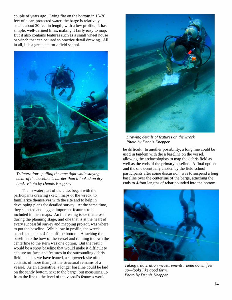
Near the end of the first class, MAHS members Ray
Hayes and Dennis Knepper went to Barbados to offer
assistance, answer questions that had arisen during the
class, and to discuss the potential for field school
activities. In March of 2005, Hayes and Knepper, along
with MAHS’ Bill Utley, returned to the island to assist
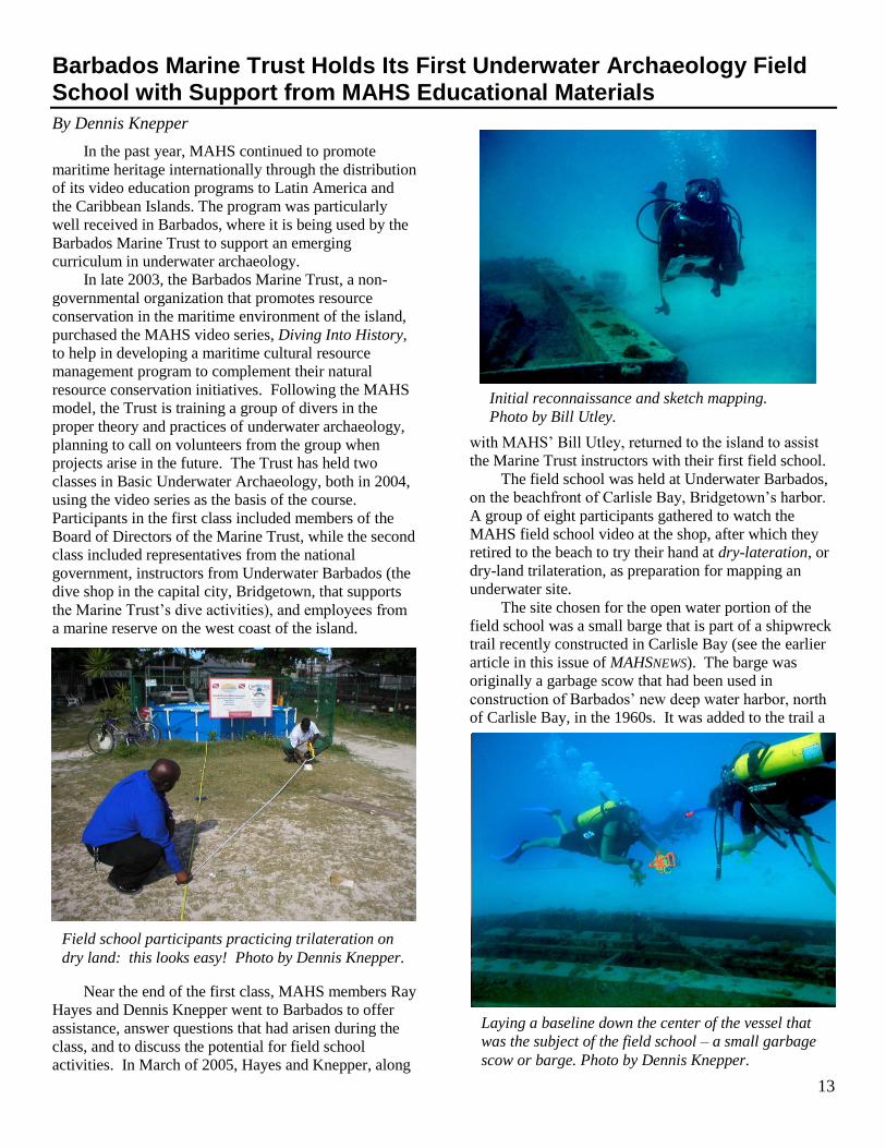
the Marine Trust instructors with their first field school.
The field school was held at Underwater Barbados,
on the beachfront of Carlisle Bay, Bridgetown’s harbor.
A group of eight participants gathered to watch the
MAHS field school video at the shop, after which they
retired to the beach to try their hand at dry-lateration, or
dry-land trilateration, as preparation for mapping an
underwater site.
The site chosen for the open water portion of the
field school was a small barge that is part of a shipwreck
trail recently constructed in Carlisle Bay (see the earlier
article in this issue of MAHSNEWS). The barge was
originally a garbage scow that had been used in
construction of Barbados’ new deep water harbor, north
of Carlisle Bay, in the 1960s. It was added to the trail a
Field school participants practicing trilateration on
dry land: this looks easy! Photo by Dennis Knepper.
Laying a baseline down the center of the vessel that
was the subject of the field school – a small garbage
scow or barge. Photo by Dennis Knepper.
Initial reconnaissance and sketch mapping.
Photo by Bill Utley.
14
couple of years ago. Lying flat on the bottom in 15-20
feet of clear, protected water, the barge is relatively
small, about 30 feet in length, with a low profile. It has
simple, well-defined lines, making it fairly easy to map.
But it also contains features such as a small wheel house
or winch that can be used to practice detail drawing. All
in all, it is a great site for a field school.
The in-water part of the class began with the
participants drawing sketch maps of the wreck, to
familiarize themselves with the site and to help in
developing plans for detailed survey. At the same time,
they selected and tagged important features to be
included in their maps. An interesting issue that arose
during the planning stage, and one that is at the heart of
every successful survey and mapping project, was where
to put the baseline. While low in profile, the wreck
stood as much as 4 feet off the bottom. Attaching the
baseline to the bow of the vessel and running it down the
centerline to the stern was one option. But the result
would be a short baseline that would make it difficult to
capture artifacts and features in the surrounding debris
field—and as we have leaned, a shipwreck site often
consists of more than just the structural remains of a
vessel. As an alternative, a longer baseline could be laid
on the sandy bottom next to the barge, but measuring up
from the line to the level of the vessel’s features would
be difficult. In another possibility, a long line could be
used in tandem with the a baseline on the vessel,
allowing the archaeologists to map the debris field as
well as the ends of the primary baseline. A final option,
and the one eventually chosen by the field school
participants after some discussion, was to suspend a long
baseline over the centerline of the barge, attaching the
ends to 4-foot lengths of rebar pounded into the bottom
Trilateration: pulling the tape tight while staying
clear of the baseline is harder than it looked on dry
land. Photo by Dennis Knepper.
Drawing details of features on the wreck.
Photo by Dennis Knepper.
Taking trilateration measurements: head down, feet
up—looks like good form.
Photo by Dennis Knepper.

15
sediments well beyond both the vessel and the edges of
the debris field.
Even though all of the participants were
professional divers accustomed to working underwater,
doing trilateration work still took some practice. It
didn’t take long to realize that even something as
apparently straightforward as recording a series of
dimensions with a tape measure requires some skill to do
correctly and accurately underwater. One of the
advantages of working on a wreck with clean, distinct
lines and a symmetrical shape was that measurement
errors were quickly apparent when the data were plotted
back at the dive shop.
In the end, the field school was a great learning
experience for all involved. Barbados is now well on its
way to having a group of trained avocational underwater
archaeologists able to assist in managing the rich
maritime cultural heritage of the island. Î
The Way of a Ship by Derek Lundy, Harper Collins Publishers
Book Review by Dennis Knepper
The lure of the open
ocean, the romance of the
sea. Sounds great,
doesn’t it? But what’s so
romantic about sailing
into gale force winds in
sub-freezing
temperatures, taking
literally months to round
a single headland, furling and unfurling heavy, stiff, and
frozen canvas sails in icy, relentless winds with
undermanned crews depleted by scurvy, and with a
cargo of coal burning out of control in the hold…this is
romantic? Maybe not, but it does make for an
interesting and compelling story, especially when told
with the vivid detail of Derek Lundy’s The Way of a
Ship.
The story is a fictionalized recreation of an actual
voyage made by Lundy’s great-great uncle in 1885,
sailing from Liverpool to San Francisco via the Horn.
The Horn. Cape Horn: the southern tip of South
America, notorious for high seas and almost
unimaginably bad weather. At these latitudes, the winds
howl interminably out of the west, making the passage
from the Atlantic to the Pacific one of the most difficult
and perilous on earth. As Lundy puts it, “try to visualize
a never-ending series of five- or six-story buildings
moving toward you at about forty miles an hour.” Even
near the turn of the 20th century, ships were routinely lost
in the passage and in an average year a sailor stood one
chance in twenty of dying during the voyage.
The ship in Lundy’s story is the Beara Head, one of
the last of the great metal-hulled, square-riggers, a huge,
four-masted behemoth that carried coal to California to
fuel the coastal steamships there. Lundy salts his
narrative liberally with historical information regarding
the end of the Age of Sail, describing the gradual
replacement of sailing ships by steam-driven vessels.
And the irony of those final years is not lost on him, as
he describes the great wind ships helping ensure their
own obsolescence, transporting fuel to power the vessels
that would eventually replace them.
The backdrop for the story is told in the
technological and social changes occurring at the time—
the development of machine propulsion, economic
upheaval, and in particular, the escape from the Irish
Depression via the Liverpool dockyards. Lundy portrays
the sailor’s world—in contrast to the life of the
steamship crew—as a place that was contained and
orderly, but also highly regimented, extremely
dangerous, and totally unforgiving. He describes the life
of those who rounded the Horn as one of both high
exhilaration and extravagant suffering. He includes a
wealth of detail about of the mechanics of ship handling,
setting canvas and adjusting rigging, and tacking and
wearing ship in foul weather. Also sprinkled throughout
are quotes from the great sea authors of the 19th
century—Conrad, Melville, and Dana—providing an
Plotting the data after the dive.
Photo by Dennis Knepper.
16
aesthetic perspective on the world of the sailor at the end
of the century.
The narrative is occasionally a little too broken up
with long background segments, so that the text reads at
times like an extended National Geographic article.
Early Patrick O’Brian or the best of Jack London are
perhaps better for sheer adventure writing, but Lundy’s
work is informative, fast-paced, and entertaining. He
gives a gripping account, for example, of being sent aloft
for the first time to the masthead 165 feet above the
deck, and going back many times thereafter in all kinds
of weather. His description of the near foundering of the
huge ship as it broaches to under the onslaught of a
gigantic rogue wave is spectacular and almost
frightening.
Lundy is no stranger to the Southern Ocean. As an
amateur sailor, he has himself sailed around the Horn
and has written an acclaimed account of the Vendée
Globe, a solo, round-the-world sailing race that some
consider the most dangerous race in the world. The Way
of a Ship is a fine tribute to the last of the great wind
ships and the men who sailed them. And it is a great
read. Î
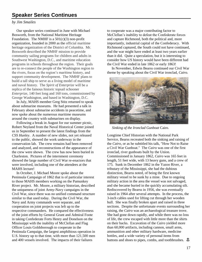
Pamunkey River Project Update
As we go to press, the Pamunkey River project is in
the field. This is an ongoing project that serves this
year as an additional field school opportunity for
students of the Basic Underwater Archaeology Course
who want to complete their field certification.
Throughout May and June of 1862, the banks of the
Pamunkey were an integral part of the Union Army’s
Peninsula Campaign against the defenses of Richmond.
A flotilla of canal boats, barges, and schooners helped
transport McClellan’s Army of the Potomac upriver
toward the Confederate capital.
The Richmond and York River Railroad which ran
southward from Richmond was an ideal supply line for
the Union forces. The rail line crossed the Pamunkey at
White House, the residence of Martha Custis Lee, wife
of Robert E. Lee. The bridge at White House was turned
into a supply wharf and trains and boxcars supplied
McClellan’s troops advancing from the south. White
House also became the site of the Union Army hospital,
and hospital ships docked along the busy riverbanks. As
a result of J.E.B. Stuart’s famous ride around
McClellan’s army, many of the structures and vessels
continued on page 18
Pamunkey River Project. Clockwise from lower left: Side-scan sonar image of an unidentified
target along the river; railroad bridge at White House Landing; White House; unidentified
sonar image; frames of a barge-like vessel currently visible on the river bank; vessels at White
House Landing. Background image: NOAA navigation chart.
17
Speaker Series Continues
by Jim Smailes
Our speaker series continued in June with Michael
Bosworth, from the National Maritime Heritage
Foundation. The NMHF is a 501(c)(3) non-profit
organization, founded in 2000 as the official maritime
heritage organization of the District of Columbia. Mr.
Bosworth described the NMHF mission to provide
community sailing programs for children and adults in
Southwest Washington, D.C., and maritime education
programs in schools throughout the region. Their goals
are to re-connect the people of the Washington region to
the rivers, focus on the region’s maritime history, and
support community development. The NMHF plans to
build a tall ship to serve as a living model of maritime
and naval history. The Spirit of Enterprize will be a
replica of the famous historic topsail schooner
Enterprize, 140 feet long and 160 tons, commissioned by
George Washington, and based in Washington, D.C.
In July, MAHS member Greg Stitz returned to speak
about submarine museums. He had presented a talk in
February about submarine accidents in peacetime, and
now spoke about the numerous maritime museums
around the country with submarines on display.
Following a break in August for our summer picnic,
Robert Neyland from the Naval Historical Center joined
us in September to present the latest findings from the
CSS Hunley. A number of new slides, not yet released
to the public, showed the work underway in the
conservation lab. The crew remains had been removed
and analyzed, and reconstructions of the appearance of
the crew were shown. The crew has now been buried in
Charleston. Pictures of the internment ceremony
showed the large number of Civil War re-enactors that
were involved, including one of the attendees at the
MAHS lecture!
In October, J. Michael Moore spoke about the
Peninsula Campaign of 1862 that is of particular interest
to those MAHS members working on the Pamunkey
River project. Mr. Moore, a military historian, described
the uniqueness of joint Army-Navy campaigns in the
Civil War, since there was no unified command structure
similar to that used today. During the Civil War, the
Navy and Army commands were separate, and
cooperation on joint projects was left up to the
respective commanders. He compared the effectiveness
of the joint efforts by General Grant and Admiral Foote
in taking Confederate Forts Henry and Donelson on the
Mississippi with the inability of McClellan and Flag
Officer Louis Goldsborough to cooperate in the
Peninsula Campaign, the largest amphibious operation in
U.S. history up to that time, with more than 121,500 men
and 400 vessels involved. The impacts of their failures
to cooperate was a major contributing factor to
McClellan’s inability to defeat the Confederate forces
and capture Richmond, both the political and, more
importantly, industrial capital of the Confederacy. With
Richmond captured, the South could not have continued,
and the war might have ended at least two years earlier
than it did. Quite a speculation, but it is interesting to
consider how US history would have been different had
the Civil War ended in late 1862 or early 1863!
In November, Edwin Bearss continued our Civil War
theme by speaking about the Civil War ironclad, Cairo.
Longtime Chief Historian with the National Park
Service, Bearss recreated both the sinking and raising of
the Cairo, or as he subtitled his talk, "How Not to Raise
a Civil War Gunboat." The Cairo was one of the first
ironclad, river gunboats built by the Union.
Commissioned in January 1862, Cairo was 165 feet in
length, 51 feet wide, with 13 heavy guns, and a crew of
175. Sunk in December 1862 in the Yazoo River, a
tributary of the Mississippi, she had the dubious
distinction, Bearss noted, of being the first known
military vessel to be sunk by a mine. Due to ongoing
military action in the area the vessel was not salvaged,
and she became buried in the quickly accumulating silt.
Rediscovered by Bearss in 1956, she was eventually
raised in 1964 after several attempts. In the process, the
3-inch cables used for lifting cut through her wooden
hull. She was finally broken apart and raised in three
sections. Despite the unfortunate events surrounding her
raising, the Cairo was an archaeological treasure trove.
She had gone down rapidly, and while there was no loss
of life, the crew escaped with little more than the shirts
on their backs. Excavation of the Cairo yielded more
than 60,000 artifacts, including cannon, small arms,
ammunition and other military hardware, medicine
bottles, and a wide variety of personal items from
buttons and shoes to pipes, combs, and toothbrushes. Î
Sinking of the Ironclad Gunboat Cairo.

18
Preznotes continued from page 2
has been conducting its classes and meetings at the
McLean High School. Please see the website for the
address and directions. This is a wonderful facility, and
we thank Terry Nelson for making the arrangements
with Fairfax County Schools again this year.
Finally, I am pleased to report that the MAHS
Board extended an invitation to Dr. Robert Neyland,
Head of the Archaeology Branch of the Naval Historical
Center, to serve on the MAHS Board of Advisors, and
he has graciously accepted. We look forward to working
more closely with Dr. Neyland, and MAHS will surely
benefit from his future counsel.
As you can see, it has been a busy and productive
summer for MAHS, and I thank all of the members and
advisors who volunteered their time to help us extend
our message of stewardship and shipwreck preservation
throughout the country and around the world.
See you on the water.
Steven Anthony
President Î
Cherryfield continured from page 4
familiar with the routine, lost no time
in suiting up and entering the water.
They proceeded with their assigned
tasks and for the next three hours
focused on gathering the remaining
measurements to complete their
drawings. By lunchtime, everyone
was ready for a break and returned to
the Roper to report their findings. It
was a very productive morning and
after reviewing the work, Tom and
Kurt concluded that the job was done
and all the data he was seeking for
this trip had been successfully
collected. So, Roper headed back to
the dock early, and Tom and Kurt
conducted their final briefing along
the way. The students were finally
able to relax and reflect on their first
underwater archaeology expedition.
After transferring the gear to our
vehicles, we were all on our way
back home again well before sunset.
From what the MAHS trainers
could determine, it was a very
successful field school. The students had collected
sufficient information
to support the ongoing study of the Cherryfield site and
expressed how much they had enjoyed the course. Î
Pamunkey continued from page 16
were burned, including the Lee’s White House, which
was fired by Union soldiers as they retreated. Research
indicates that at least 80 shipwrecks from the Civil War
period may lie along this reach of the Pamunkey River.
In past MAHS surveys, disarticulated shipwreck
remains and what may part of be the Union supply dock
at White House have been identified. In 2004, MAHS
teamed with John Seidel and Washington College to
conduct a side-scan sonar survey of the river. Over 100
targets were acquired. The goal of the current project is
to examine a sample of those targets and conduct a field
school, mapping one of the barges.
Bruce Terrell is Project Archaeologist, and Steve
Anthony is MAHS Project Manager. A project update
that includes results from the November survey will be
presented at the Middle Atlantic Archaeological
Conference in Virginia Beach in March, and a report is
planned for the Spring issue of MAHSNEWS. Î
L to R: Front Row: T. Berkey, M. Damian, S. Anthony, C. Dowdle, J.
Steinmentz; Second Row: M. Ryan, C. Dowdle, D. Lambert, K. Elliott, C.
Dunn, K. Knoerl, C. Lukezic, D. Howe. Photo by Michele Anthony.
19
20