sunday, may 26, 2019 8:30 a.m. edt
TRANSCRIPT

Sunday, May 26, 2019
8:30 a.m. EDT
Significant Activity – May 25-26
Significant Events:
• Flooding & Tornado – Central U.S.
Tropical Activity:
• Atlantic: No significant activity affecting U.S. interests
• Eastern Pacific: Disturbance 1: Low (30%)
• Central Pacific: No significant activity affecting U.S. interests
• Western Pacific: No significant activity affecting U.S. interests
Significant Weather:
• Flooding - Central U.S.
• Critical and Elevated Fire Weather – AZ, NM and TX
Declaration Activity:
• Emergency Declaration Approved - Oklahoma
• Request for Emergency Declaration – Louisiana
Hurricane Season begins in
5 days
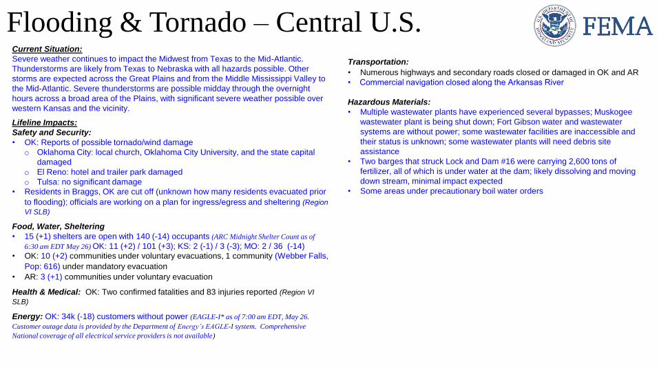
Flooding & Tornado – Central U.S.Current Situation:
Severe weather continues to impact the Midwest from Texas to the Mid-Atlantic.
Thunderstorms are likely from Texas to Nebraska with all hazards possible. Other
storms are expected across the Great Plains and from the Middle Mississippi Valley to
the Mid-Atlantic. Severe thunderstorms are possible midday through the overnight
hours across a broad area of the Plains, with significant severe weather possible over
western Kansas and the vicinity.
Lifeline Impacts:
Safety and Security:
• OK: Reports of possible tornado/wind damage
o Oklahoma City: local church, Oklahoma City University, and the state capital
damaged
o El Reno: hotel and trailer park damaged
o Tulsa: no significant damage
• Residents in Braggs, OK are cut off (unknown how many residents evacuated prior
to flooding); officials are working on a plan for ingress/egress and sheltering (Region
VI SLB)
Food, Water, Sheltering
• 15 (+1) shelters are open with 140 (-14) occupants (ARC Midnight Shelter Count as of
6:30 am EDT May 26) OK: 11 (+2) / 101 (+3); KS: 2 (-1) / 3 (-3); MO: 2 / 36 (-14)• OK: 10 (+2) communities under voluntary evacuations, 1 community (Webber Falls,
Pop: 616) under mandatory evacuation
• AR: 3 (+1) communities under voluntary evacuation
Health & Medical: OK: Two confirmed fatalities and 83 injuries reported (Region VI
SLB)
Energy: OK: 34k (-18) customers without power (EAGLE-I* as of 7:00 am EDT, May 26.
Customer outage data is provided by the Department of Energy’s EAGLE-I system. Comprehensive
National coverage of all electrical service providers is not available)
Transportation:
• Numerous highways and secondary roads closed or damaged in OK and AR
• Commercial navigation closed along the Arkansas River
Hazardous Materials:
• Multiple wastewater plants have experienced several bypasses; Muskogee
wastewater plant is being shut down; Fort Gibson water and wastewater
systems are without power; some wastewater facilities are inaccessible and
their status is unknown; some wastewater plants will need debris site
assistance
• Two barges that struck Lock and Dam #16 were carrying 2,600 tons of
fertilizer, all of which is under water at the dam; likely dissolving and moving
down stream, minimal impact expected
• Some areas under precautionary boil water orders

Flooding & Tornado – Central U.S.Response:
State/Local
• KS and AR EOCs at Full Activation
• OK, MO, and IL EOCs at Partial Activation
• LA EOC at Monitoring
• Emergency Declaration FEMA-3411-EM-OK approved for 10 counties in OK
• LA Governor requested an Emergency Declaration for 11 parishes
• OK, KS, and IA National Guards activated
FEMA Regions
• FEMA Region V
o RWC: Steady State, monitoring 24/7
o IMAT: Fully Mission Capable, prepared to respond (participating in an exercise in CO)
• FEMA Region VI
o RRCC: Level III, with select ESFs (day shift only)
o IMAT-1: Fully Mission Capable (on standby for AR and OK)
o IMAT-2: Deployed to OK EOC
o LNO deployed to OK EOC; 2 LNOs deployed to AR EOC
• FEMA Region VII
o RWC: Enhanced Watch, 24/7
o IMAT: Supporting RRCC
o LNO deployed to KS EOC
FEMA Headquarters
• NWC: Steady State, monitoring 24/7
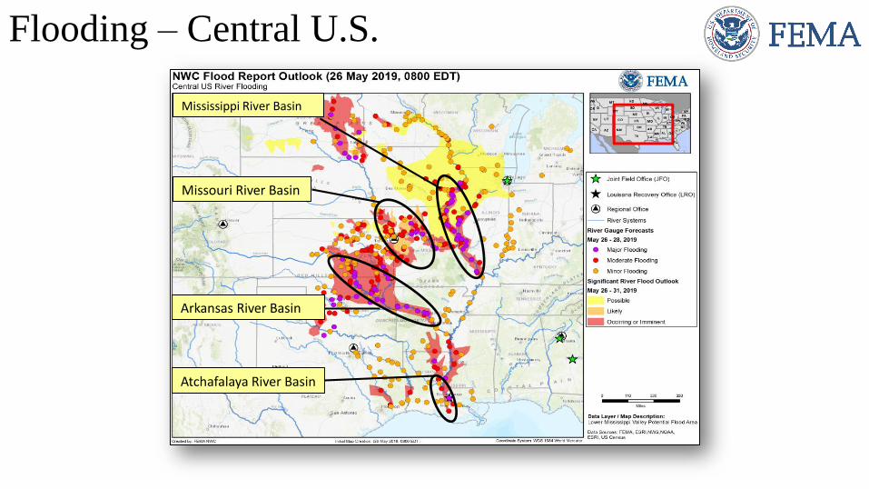
Flooding – Central U.S.
Mississippi River Basin
Missouri River Basin
Arkansas River Basin
Atchafalaya River Basin

Missouri River Basin
1. Missouri River at Glasgow crests on May 29 the
receding out of Major flood stage on Jun 1
2. Jefferson City will remain at Major Flood Stage
into the first week of June then rapid receding
expected
3. Meramec River, Missouri River and Mississippi
River converge near St Louis. Area is prone to
spring flooding each year
4. West Alton, MO issued Voluntary Evacuations
due to near record flood levels on the Mississippi
River
5. Mississippi River at Cape Girardeau expected to
crest May 30 and remain in Major flood stage though
early June. Several homes and structures in
southern Cape Girardeau County may be inundated
or cut off due to backwater flooding from the
Diversion Channel. Evacuations may be required.
1
2 3
5
4
https://water.weather.gov/ahps2/hydrograph.php?wfo=tsa&gage=tlso2
https://water.weather.gov/ahps2/hydrograph.php?wfo=tsa&gage=hsko2
https://water.weather.gov/ahps2/hydrograph.php?wfo=tsa&gage=mkgo2
https://water.weather.gov/ahps2/hydrograph.php?wfo=tsa&gage=lepo2
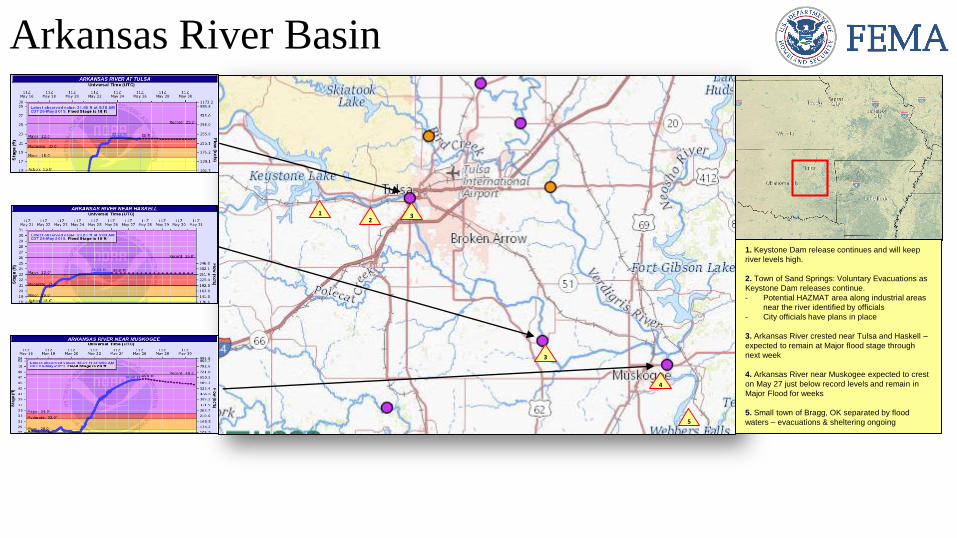
Arkansas River Basin
12
3
1. Keystone Dam release continues and will keep
river levels high.
2. Town of Sand Springs: Voluntary Evacuations as
Keystone Dam releases continue.
- Potential HAZMAT area along industrial areas
near the river identified by officials
- City officials have plans in place
3. Arkansas River crested near Tulsa and Haskell –
expected to remain at Major flood stage through
next week
4. Arkansas River near Muskogee expected to crest
on May 27 just below record levels and remain in
Major Flood for weeks
5. Small town of Bragg, OK separated by flood
waters – evacuations & sheltering ongoing
3
5
4
https://water.weather.gov/ahps2/hydrograph.php?wfo=tsa&gage=mkgo2

Atchafalaya River Basin
1
1. Morganza is a large spillway about 4k feet long and 125 bays located on the west side of Mississippi River just north of Morganza, Louisiana. - Mississippi River near the spillway expected to crest at 62ft (5
feet above opening thresholds)- USACE may open the spillway as early as Jun 2 (Decision point on
May 28)- Slow release for 3 days then potential full opening- Flooding across numerous parishes (Primarily farming,
agricultural and recreational camps)
Spillway has only been opened twice in its history (1973 and 2011). Each time the openings caused widespread impacts to the Louisiana farming industry and fisheries
2. Bayou Chene temporary flood gates installed to reduce backwater flood impacts to approx. 5k residents
3. Bonnet Carre Spillway – Opened twice in one year (historical)
4. Morgan City, LA. Populated city near the Gulf Coast end of the basin. City has been managing flooding for several months, opening the spillway will cause additional flood potential
2
3
4
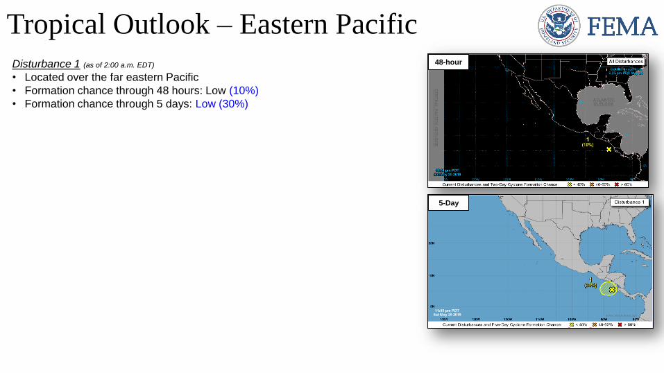
Tropical Outlook – Eastern Pacific
Disturbance 1 (as of 2:00 a.m. EDT)
• Located over the far eastern Pacific
• Formation chance through 48 hours: Low (10%)
• Formation chance through 5 days: Low (30%)
48-hour
5-Day
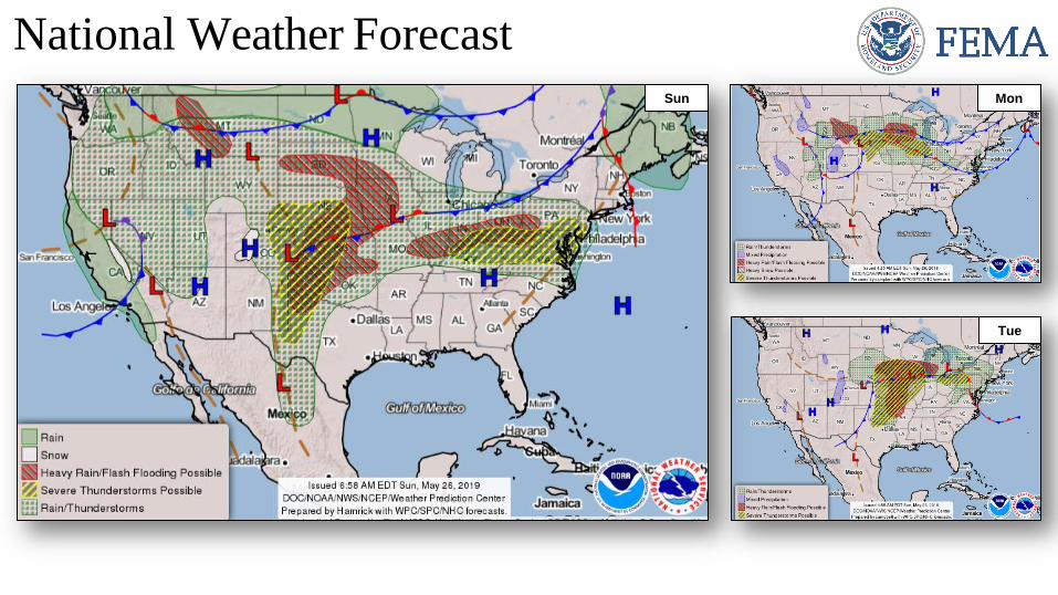
National Weather ForecastMon
Tue
Sun
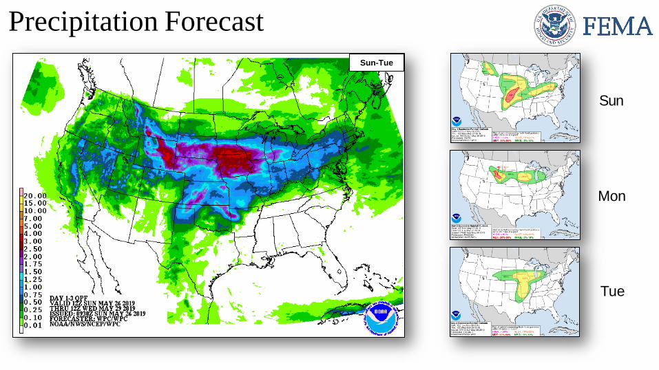
Precipitation Forecast
Tue
Sun
Mon
Sun-Tue
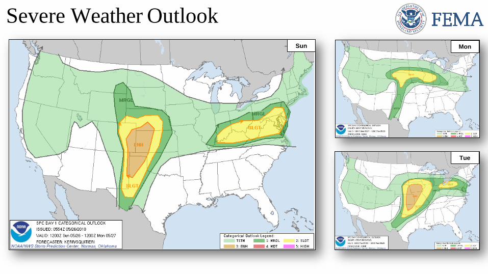
Severe Weather Outlook
Mon
Tue
Sun
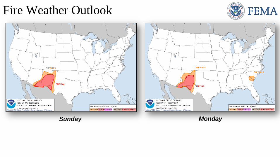
Fire Weather Outlook
Sunday Monday
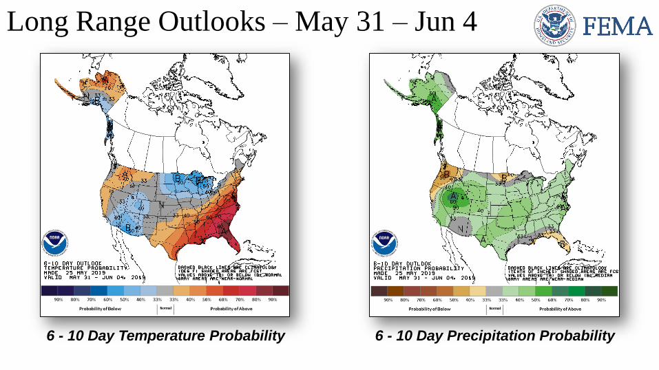
Long Range Outlooks – May 31 – Jun 4
6 - 10 Day Temperature Probability 6 - 10 Day Precipitation Probability
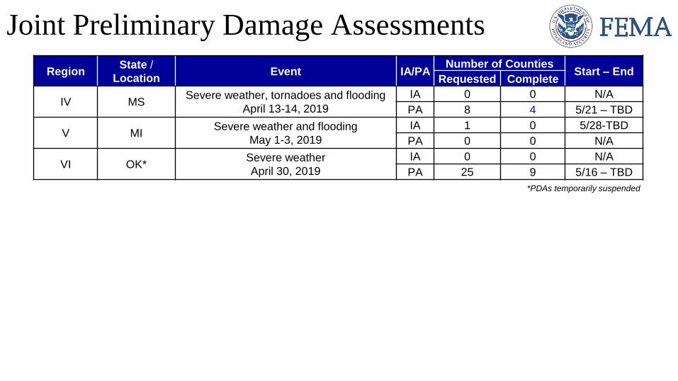
Joint Preliminary Damage Assessments
RegionState /
LocationEvent IA/PA
Number of CountiesStart – End
Requested Complete
IV MSSevere weather, tornadoes and flooding
April 13-14, 2019
IA 0 0 N/A
PA 8 4 5/21 – TBD
V MISevere weather and flooding
May 1-3, 2019
IA 1 0 5/28-TBD
PA 0 0 N/A
VI OK*Severe weather
April 30, 2019
IA 0 0 N/A
PA 25 9 5/16 – TBD
*PDAs temporarily suspended

Declaration Approved
FEMA-3411-EM-OK
• Emergency Declaration was approved on May 25, 2019 for the
State of Oklahoma
• For flooding beginning on May 7, 2019 and continuing
• Provides:
o Emergency protective measures (Category B), limited to direct
federal assistance, under the Public Assistance program at
75% federal funding for 10 counties
• FCO is Gerard M. Stolar
PA
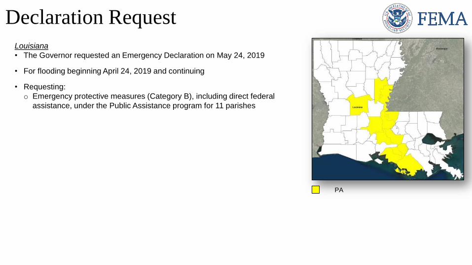
Declaration Request
Louisiana
• The Governor requested an Emergency Declaration on May 24, 2019
• For flooding beginning April 24, 2019 and continuing
• Requesting:
o Emergency protective measures (Category B), including direct federal
assistance, under the Public Assistance program for 11 parishes
PA
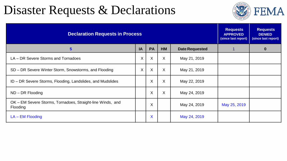
Declaration Requests in ProcessRequests
APPROVED(since last report)
Requests
DENIED(since last report)
5 IA PA HM Date Requested 1 0
LA – DR Severe Storms and Tornadoes X X X May 21, 2019
SD – DR Severe Winter Storm, Snowstorms, and Flooding X X X May 21, 2019
ID – DR Severe Storms, Flooding, Landslides, and Mudslides X X May 22, 2019
ND – DR Flooding X X May 24, 2019
OK – EM Severe Storms, Tornadoes, Straight-line Winds, and
FloodingX May 24, 2019 May 25, 2019
LA – EM Flooding X May 24, 2019
Disaster Requests & Declarations
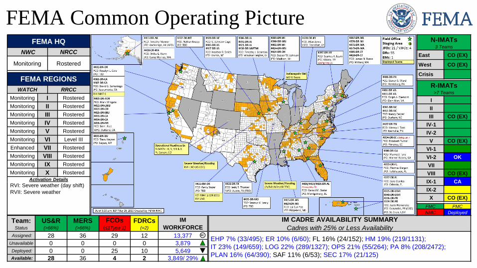
FEMA Common Operating Picture
Team:Status
US&R(>66%)
MERS(>66%)
FCOs(≤1Type 1)
FDRCs(=2)
IM
WORKFORCE
IM CADRE AVAILABILITY SUMMARY
Cadres with 25% or Less AvailabilityAssigned: 28 36 29 12 13,377
EHP 7% (33/495); ER 10% (6/60); FL 16% (24/152); HM 19% (219/1131);
IT 23% (149/659); LOG 22% (289/1327); OPS 21% (55/264); PA 8% (208/2472);
PLAN 16% (64/390); SAF 11% (6/53); SEC 17% (21/125)
Unavailable 0 0 0 0 3,879
Deployed: 0 0 25 10 5,649Available: 28 36 4 2 3,849/ 29%
FEMA HQ
NWC NRCC
Monitoring Rostered
FEMA REGIONS
WATCH RRCC
Monitoring I Rostered
Monitoring II Rostered
Monitoring III Rostered
Monitoring IV Rostered
Monitoring V Rostered
Monitoring VI Level III
Enhanced VII Rostered
Monitoring VIII Rostered
Monitoring IX Rostered
Monitoring X Rostered
Activation Details
RVI: Severe weather (day shift)
RVII: Severe weather
N-IMATs3 Teams
East CO (EX)
West CO (EX)
Crisis
R-IMATs>7 Teams
I
II
III CO (EX)
IV-1
IV-2
V CO (EX)
VI-1
VI-2 OK
VII
VIII CO (EX)
IX-1 CA
IX-2
X CO (EX)
FMC PMC
NMC Deployed
FEMA’s mission is helping people
before, during, and after disasters.
Click here to subscribe to this briefing.