superiund records cente r site: m. break · revision 01 februar - 20, 198y 7 superiund records...
TRANSCRIPT

REVISION 01 - FEBRUARY 20 1987
Superiund Records Center
SITE _MBREAKOTHER
EPA WORK ASSIGNMENT NUMBER 04-1L43EPA CONTRACT NUMBER 68-01-3250EBASCO SERVICES INCORPORATED
FINAL DRAFT
NEW BEDFORD HARBORDESCRIPTION OF
ALTERNATIVE DISPOSAL SITESRANKING AND SELECTIONFOR EVALUATION IN THE
OVERALL NEW BEDFORD FEASIBILITY STUDY
FEBRUARY 1987
Submitted by Approved by
Allen 1y Ikalainen PESite ManagerEG Jordan Co
Sieg riecTLT Stockinger PEProject ManagerEbasco Services Incorporated
SDMS DocID 000219679
NOTICE
The information in this document has been funded by the United States Environmental Protection Agency (US EPA) under REM III Contract NO 68-01-7250 to Ebasco Services Inc (Ebasco) This document is a draft and has not been formally released by either Ebasco or the US EPA As a draft this document should not be cited or quoted and is being circulated only for comment
TABLE OF CONTENTS
SECTION TITLE PAGE NO
10 BACKGROUND 1
20 EXISTING PCB APPROVED LANDFILLS shy 4
21 Introduction 4 22 Identification of Facilities 4 23 Description of Alternative 5 24 Additional Evaluation Factors 5 2 5 Summary 6
30 DISPOSAL AT UPLAND SITES IN THE VICINITY OF NEW BEDFORD 7
31 Introduction 7 32 Identification of the Screening Process 7 33 Description of Alternative 8 34 Additional Evaluation Factors 16 35 Summary 16
40 DISPOSAL AT SITES WITHIN NEW BEDFORD HARBOR 17
41 Introduction 17 42 Identification of the Screening Process 17 43 Description of Alternative 19 44 Additional Evaluation Factors 19 45 Summary 19
50 CONTAINED AQUATIC DISPOSAL 20
51 Introduction 20 52 Description of Alternative 20 53 Additional Evaluation Factors 22 54 Summary 22
TABLE OF CONTENTS (continued)
SECTION TITLE PAGE NO
60 OCEAN DISPOSAL 23
61 Introduction 23 62 Description of Alternative 23 63 Summary 23
70 ADDITIONAL CRITERIA FOR EVALUATION 25
71 Risk Assessment 25 72 Applicable or Relevant and Appropriate
Requirements (ARARs) 26
80 ESTIMATED DISPOSAL COSTS 27
-11shy
LIST OF TABLES
Table Title Page No
1 Upland Disposal Siting Characteristics 3
2 In-Harbor Disposal Siting Characteristics 12
3 Preliminary Cost Comparison for Disposal Sites 28
LIST OF FIGURES
Figure Title Page No
la Upland Disposal Sites - Fall River East Quadrangle 9
Ib Upland Disposal Sites - New Bedford North Quadrangle 10
Ic Upland Disposal Sites - Marion Quadrangle 11
2 In-Harbor Disposal Sites 18
3 Contained Aquatic Disposal Sites 21
4 Ocean Disposal Sites 24
APPENDIX A ESTIMATED UPLAND LANDFILL COST
APPENDIX B ESTIMATED IN-HARBOR DISPOSAL COSTS
APPENDIX C ESTIMATED CONTAINED AQUATIC DISPOSAL COSTS
APPENDIX D RESPONSE TO COMMENTS - DISPOSAL SITE SELECTION
-111shy
t
10 BACKGROUND
The objective of this report is to identify and describe alternative disposal sites for evaluation in the overall New Bedford Harbor Feasibility Study (FS) for cleanup of PCB contaminated sediments In addition to descriptive information on the sites available information on disposal costs and evaluations of disposal that will be performed in the FS are described
Alternative sites are generally of two types off-site outside of the confines of the Acushnet River Estuary and New Bedford Harbor or on-site within the confines of the Acushnet River and New Bedford Harbor EPAs National Contingency Plan (40 CFR 30068(f)(1)(i)) requires that remedial alternatives include treatment or disposal at an off-site facility
In this report off-site disposal is described in Section 20 Existing PCB Approved Landfills and in Section 30 - Disposal at Upland Sites in the Vicinity of New Bedford On-site disposal including shoreline is described in Section 40 - Disposal at Sites Within New Bedford Harbor including shoreline Section 50 - Contained Aquatic Disposal and Section 60 - Ocean Disposal
Sources of information for this report include evaluations of disposal sites by NUS Corporation (NUS) in 1984 and 1986 and the ongoing US Army Corps of Engineers dredged material disposal studies for the Acushnet River
NUS has conducted the major disposal site studies completed to date During the process of conducting the 1984 Fast-Track Feasibility Study for cleanup of PCB contaminated sediments in the Acushnet River Estuary New Bedford Harbor NUS completed an interim report titled Initial Evaluation of Potential Disposal Sites for Contaminated Dredged Materials June 1984 The report included an initial identification evaluation and ranking of potential sites both upland and shoreline Both EPA and the Massachusetts Interagency Task Force for New Bedford Harbor participated in establishing criteria for screening the identified sites These criteria are listed in the above-mentioned report In addition to the Interagency Task Force state and local governmental information on siting was obtained from previous solid waste disposal and regional planning studies
For upland sites thirty-seven potential disposal sites remained following the first phase screening by NUS In the second phase the five highest ranking sites were determined The first phase screening identified sites with critical flaws such that they would cause the sites to be eliminated from further screening These flaws included being located in close
^ i m_f
proximity to developedpopulated areas state parks or wildlife management areas public drinking water supply watersheds highly productive stratified glacial deposits including aquifers used for public water supplies and wetlands As described in Section 30 of this report these five sites listed on Table 1 will be evaluated further when upland disposal is studied in the overall New Bedford FS
For on-site disposal NUS in the 1984 Interim Siting Report identified twelve sites which wera then screened to a subset of five using the factors listed in Table 2
Following public comment on the Fast-Track Feasibility Study in 1984 EPA decided that further evaluation of potential in-harbor disposal sites was warranted NUS completed the evaluation in April 1986 the results are described in the report Investigation and Ranking of Potential In-Harbor Disposal Sites The April 1986 report identified fifteen potential in-harbor disposal sites as the most promising The identification was based upon a quantitative ranking procedure similar to that used in the 1984 siting study by NUS For purposes of the overall New Bedford FS the fifteen in-harbor sites identified by NUS will receive further evaluation when the in-harbor disposal alternative is studied
TAUIE 1 UPLAND oisrosAL SITING
= Optimal Feature
S-5 _ Lr6 ________L-16 Lr4_ Sr22A FACTOR
Site Specific Factors SITE_DESCRT PHO]L
Storage Capacity (cu yds) 6290000 1700000 (min cnt) gt700000 (min est) 1700000 min est) 1]460000
Current Land Use Woodland Inactive Gravel Pit Inactive Gravel Pit Woodlajd Woodland
Surface Conditions - Cover Type Dense Woodland
Med Size Trees Gravel Pits High Relief Gravel Pit High Relief Woodland
Med Size Trees Woodland Med Med Size Trees
- Site Drainage Good Poor Moderate Moderate Poor to Good - Onsite Streams None Ponded Water One Stream One Intermittent One Stream
Subsurface Conditions - Soil Loose Fine Sandy Silt
Peat Dense Till Ho Surface Soi] bull Located in Gravel Pit
Hot Investigated Till Present
No Surface Soil Located in Gravel Pit
Not Investigated Tin Present
- Depth to Bedrock 21 47 50 56 66 gt 20 ft gt 22 ft gt 27 ft gt 20 ft gt JO ft gt 12 ft 83 ft gt 29 ft gt 16 ft
- Depth to Groundwater Wetland atnear Surface 40 shy 120 ft
15 ft 3 ft 9 ft 15 ft 0 ft 1 ft 4 ft
Regional Factors Transport Distance 99 Miles 67 Miles 35 Miles 67 Miles 81 Miles - Type 4 Condition of Road Good 2 land Fair 2nd Highway Good 2 Lane Interstate FairGood 2nd Highway
- Traffic Density - Site Accessability
2nd 1 Highway Light PoorNo Access
Light Good Access
2nd Highway Heavy Good Access
Moderate PoorNo Access
Light Good Access
Environmental Conditions - Habitat Valve Woodland Barren Gravel Pits Barren Gravel Pit Woodland Uooiland
Woodland Some Wetlands - Surrounding Land Use Primarily Woodland
Habitat Conservation Woodland Agriculture Woodland Agriculture
Services Woodland Gravel Pits Industrial
Woodland Waste Disposal Agriculture
Public Health Considerations - Bjffer Zones - Receiving Streams
- Development along Route - Development around Site
Good Acuslinet Cedar Swamp
283 HousesMile Largely undeveloped few homes to east
poor Noquochoke Lake
333 HousesMile Undeveloped
Adequate Acuslmet River
514 HousesMile Uixieve loped
Adequate Noquochoke Lake
333 HousesMile Undeveloped
Good Haskell Swamp Brook River Sippican River bull 48 HousesMile Undeveloped
Data compiled frctn NUS Report Initial Evaluation of Potential Disposal Sitamps for Contaminated Dredge Materials June 1984
2 0 EXISTING PCB APPROVED LANDFILLS
21 INTRODUCTION
There are nine Environmental Protection AgencyResource Conservation and Recovery Act (EPARCRA) permitted landfills that are in substantial compliance currently operating within the United States for the disposal of materials containing PCBs In their Draft FS of August 1984 NUS identified CECOS International (CECOS) in Niagara Falls New York as the closest of these facilities but this facility is not currently capable of accepting EPA hazardous wastes due to cited operational violations SCA Chemical Services now operates a facility in Model City New York This facility is in close proximity (in relation to New Bedford Harbor) to the aforementioned CECOS facility The next closest site for disposal of PCB containing wastes is located in Williamsburg Ohio and is operated by CECOS
2 2 IDENTIFICATION OF FACILITIES
The SCA Chemical Services hazardous waste treatment and disposal facility in Model City requires that soils including dredged materials be legally landfillable in accordance with state regulations This neccessitates a 150 Ibsft load bearing capacity and the absence of all free liquids SCA has no limit on the concentration of PCBs in the soils and sediment which they will accept for landfilling A flat rate of $17500 per ton of material was quoted This facility would have the capacity to handle 100000 cubic yards of material as long as its delivery for disposal was spaced over time
SCA will also dispose of free liquids by incineration the cost of which is concentration dependent Liquids containing lt 1000 ppm total PCB would cost $340 per gallon and range up to nearly twice that for gt 100000 ppm total PCBs
The facility that CECOS operates in Williamsburg Ohio accepts PCB contaminated dredge spoils of any concentration $5000000 liability insurance is required to be supplied by the generator or hauler for the deposition of material at this facility to cover accidental spillage etc during transport These spoils must be able to withstand the load bearing capacity of facility equipment as indicated by passing the compaction test (40 CFR 261 Appendix 2 (B)) The spoils must also pass the paint filter liquids test (50 CFR 28742 71585 EPA Pub No SW846 Method 9095) to assure the absence of all free liquids
elecon H-P Krahn (EG Jordan) with P Cook (SCA Chemical Services) 100186 (716) 754-8231
-4shy
CECOS will accept liquids for incineration the price of which is BTU dependent The cost of disposal of material at the Ohio facility would be $205 per ton
Trucking the material to the New York facility would cost approximately $13000 per ton and $17000 per ton to the CECOS Ohio site Rail costs by comparison are $3500 per ton to Model City New York and $5200 per ton to the Williamsburg Ohio site Neither the CECOS nor SCA facilities have direct access to their sites by rail Thus a transfer would be necessary from rail to truck to complete the transport of material from New Bedford Harbor to the designated facility At up to approximately 10 miles of trucking from the rail yard the additional charge would be approximately $500 per ton for that transfer
23 DESCRIPTION OF ALTERNATIVE
The individual steps required to implement this disposal alternative are discussed in the NUS feasibility study The dredged material would undergo secondary dewatering in order to pass the compression test required by the facilities Methods of secondary dewatering described in the NUS report include vacuum filters centrifuges filter presses belt filters and drying beds The material would then be loaded into railcars or trucks via conveyor belts or front end loaders for transport to the designated facility If transport were by rail the dredged material would be transferred and trucked to the landfill
The detailed evaluation of this disposal alternative in the FS will identify opportunities for PCB and metals exposure during material handling and transport to the appropriate facility
24 ADDITIONAL EVALUATION FACTORS
As mentioned above nine landfills are currently approved by EPA Of those only three are located east of the Mississippi River The volume of material that may be dredged from the harbor and then disposed has not yet been determined This volume could range from zero to greater than 1000000 cubic yards of sediments The utilization of significant capacity of
2Telecon H-P Krahn (EG Jordan) with D Krause (CECOS International) 100186 102786 (716) 282-2676
Telecon H-P Krahn (EG Jordan) with T Calter (Clean Harbors Industries) 100286 (617) 849-1800
4Telecon H-P Krahn (EG Jordan) with T Cooke (Conrail Railroad) 102486 (617) 828-3356
-5shy
EPA-approved PCB facilities must be considered in light of the limited space available
Another issue that will be considered is the emphasis on permanent remedies under the recently promulgated Superfund Amendments and Reauthorization Act (SARA) of 1986 The amendments stress permanent treatment of waste and the applicationstringenthave to revie
of If
w s
technical state standards should they non-permanent remedies are employedite status every five years
beEPA
more would
25
SUMMARY
The SCA Chemical Services facility in Model City New York due to its relative proximity to New Bedford will be retained in this report for further evaluation as the existing out of state facility Transport of the sediments to the facility should occur primarily by rail with transfer of the material to truck for the portion of route that rail service does not cover These transport methods should minimize the costs of this alternative
Superfund Amendment and Reauthorization Act of 1986 (SARA) Title 1 Section 121 - Clean-Up Standards October 17 1986 99th Congress USA
Engineering Times September 1986 Vol 8 No 9 National Study of Professional Engineers Alexandria Virginia
3 0 DISPOSAL AT UPLAND SITES IN THE VICINITY OF NEW BEDFORD
3 1 INTRODUCTION
A second option for the disposal of the New Bedford Harbor sediments contaminated by PCBs is upland disposal _ sites were identified within a ten-mile radius of the harbor for the potential development of a harbor sediment storage TacilityT~~ ~f His initial task of site selection was conducted by NtTS with input from EPA and the New Bedford Harbor Task Force including the Massachusetts Department of Environmental Quality Engineering (DEQE) Southeast Regional Planning and Economic Development District US Department of Fish and Wildlife US Department of Energy US Soil Conservation Service and the Massachusetts Water Resources Commission Seventeen of the 37 sites had previously been identified through solid waste and regional planning studies by some of the above-mentioned agencies This selection process is discussed in the NUS report Initial Evaluation of Potential Disposal Sites for Contaminated Dredge Materials New Bedford Site Bristol County Massachusetts June 1984
32 IDENTIFICATION OF THE SCREENING PROCESS
As discussed in the NUS report the initial task in the site selection process was to screen out those sites containing critical flaws features which would prove prohibitive to waste disposal site development These features included developedpopulated areas state parks state wildlife use watersheds wetlands and highly productive stratified glacial deposits used for public drinking water supplies
All potential sites identified within a ten mile road distance from the dredging activity (based upon treatment near the Coggeshall Street bridge) were screened In addition a 50-acre minimum size was established based on anticipated sediment volumes to be disposed This screening selected the 37 upland sites for further evaluation of regional and site-specific factors
The regional factors that NUS considered consisted of transport distance route conditions environmental conditions and public health considerations Site-specific factors included storage capacity current land use surface conditions and subsurface conditions Property ownership is currently unknown A detailed description of these factors is given in the aforementioned NUS report
The NUS study assigned values to each factor from +1 to -1 for rating the various sites Some criteria such as storage capacity were based on a linear interpolation of storage volume between the maximum and minimum storage values of the 37 sites in question the largest volume receiving a +1 rating Other
-7shy
criteria received one of the three values (+1 0 -1) depending on their applicability to the requirements for an ideal storage facility For example cover types were categorized in three groups open fields being rated +1 due to ease and cost of preparation woodlands were rated 0 and quarries and pits a -1 due to the anticipated need to grout joints and fractures and regrade the area
Next the NUS siting study attached a weighting factor to each criterion such that the more important criteria received greater emphasis than the ones of lesser importance This weighting was developed by NUS with input from the USEPA and the New Bedford Harbor Task Force Public health considerations for example were given a greater weighting factor than transport distance The explanation given suggests that -the difference in cost of hauling the material between the closest and furthest (ten miles) site is small relative to the total cost of remediation Public health considerations are weighted] heavily due to the potential for contaminant releases via air and surface routes and the risk of exposure for the localj residents
Using the +1 to -1 rating factor and then multiplying that number by a given weighting factor NUS completed a quantitative ranking of the 37 sites in question from best to worst Due to the subjectivity of this ranking process this report has taken the five highest rated sites from the NUS study and has identified the most desirable characteristics in each category The specific characteristics of each site and those considered most desireable are given in Table 1 The FS will use the specific characteristics of each of these sites to perform the screening process The locations of these five sites are identified on Figures la Ib and Ic
33 DESCRIPTION OF ALTERNATIVE
The upland disposal alternative entails transporting dredged materials from the temporary storage areadewatering facility by truck to the designated site The storage facility would be constructed in accordance with the current RCRA TSCA and MA DEQE requirements to include two or more liners with a leachate-collection system above and between the liners
The costs incurred to implement this alternative would include approximately five dollars per cubic yard for transport of the material plus the cost of constructing an approved double-lined landfill with a leachate collection system The cost of constructing a facility capable of containing one million cubic yards is approximately 85 million dollars
EG Jordan Pre-Feasibility Study cost calculations for the construction of upland disposal sites 102286 Appendix A
-8shy
LEGEND
I I I STRirfitO SLraquoCIraquoL DEPO USED raquo3 GROUKOW4TEH
ESIOffTlAL DEVELOPMENT PLUS IOOO fOOT aufFES IONE
SUFraquoCE WATEH SUPPLY WATERSHEDS
TMDY AREA bullbull 7
- 7 bull bully bullbull 7 bull--
WESTPORT
Figure la
FALL RIVER EAST QUADRANGLE N-us Rg Qrt
NEW BEDFORD HARBOR SITING STUDYNEW BEDFORDMA deg ^ ntradef^ rlt-lthi 1 i r-Addendum - D r a f t Feasibility SCALE i1
Scudy of Remediai Action Alternatives September 198shyF igure A-3
LEGEND
PUBLIC WCLL
PBiVMC WELL
Figure Ib NEW SOUTH
Reproduced from XLS liEW_BEDLORDjiQRTHJ^ADRANGLE Report Initial
NEW_BEDFORD_HARBOR SITING STUDYNEW BEDFORDMA Evaluation of Potential SCALE i=4ilaquofi- Disposal Sites for Con-
cinated Dredge Mater i
LEGEND
I I I laquo7HlaquoTiripoundD GLACmi CEPOSITS UltCtgt raquo3 GBOUIDWATtS SULLIES
PUBLIC WELL
X X X WETL4NOS O PRIVATE WELL
EilDtNTm DEVELOPMENT PLUS 1000 FOOT (urfEK ZONE
I SIE V t-J= X Xshy^y if bullbull A j Z7^ bullbullgt bull - irgt ^
- I 1 i
Figure Ic
Reproduced from NTS MAmON QUADRANGLE Report Addendum shy
NEW BEDFORD HARBOR SITING STUDY NEW BEDFORD MA Draft Feasibility
SCALE Study of Remedial Action Alternctives September 198- Figure Ashy
Factor
I Current Site Current Use +Footage of Waterfront Lost Property Ownership
II Engineering Feasibility Depth to Bedrock Depth to Water Sediment Characteristics Land Existing Discharges +Length of Embankment
Distance to Dredge Route Conditions
XV Storage Capacity Capacity to +10 MSL Change per 1 Increase
V Environmental Factors +Acres of Open Water Lost +Acres of Wetlands Lost
VI Public Health Considerations Short-Term Exposure (IndComm) Long-Terra Exposure (Resident) Buffer Zones
bullbull = Per 1000 CY of Capacity = Optimal Feature (IndCoim) = InAistrialCommercial
TABLE 2(A) IN-HARBOR DISPOSAL SITING CHARACTERISTICS
Site n Western Cove
Undevel Land Open Water283Municipal Private
375 05 Deep Muck 35 One Present 587
3000River Transport (Pipeline)
459850 01 Yd 44800 Cu Yd
004 0006
High High Poor
Site 1A Cove Extension SE
Undevel Land Open Water 328
Municipal Private
65 125 Deep Muck 25 One Present 522
3000 River Transport (Pipeline)
671700 Cu Yd 61100 Cu Yd
004 gt0004
High High Poor
Site 1B Cove Extension N
Undevel Land Open Water 179 Municipal Private
45 17 Varies Muck SiltsSands 24 Present Multiple Present 1183
500 River Transport (Pipeline)
726910 CU Yd 65800 Cu Yd
004 gt0004
High High Poor
Data compiled from NUS Report Investigation and Ranking of Potential In-Harbor Disposal Sites Appendix A April 1986
Site 2 Sycamore Road Icwland
Salvage YardForestHetland 487 Municipal Private
50 065 Onshore SiltsSands 83 None Known 817
1500 River Transport (Pipeline)
688000 Cu Yd 68340 CU Yd
001 006
Medium High Poor
Factor
I Current Site Conditions Current Use +Footage of Waterfront lost Property Ownership
II Erxrineerina F vbilitv Depth to Bedrock Depth to Water Sediment Characteristics Land Existing Discharges +Length of Embankment
III Site Access Distance to Dredge Route Conditions
IV Storage Capacity Capacity to +10 MSL Change per I1 Increase
V Environmental Factors bullfAcres of Cpen Water Lost +Acres of Wetlands Lost
VI Public Health Considerations Short-Term Exposure (IndComm) Long-Tenn Exposure (Resident) Buffer Zones
+ = Per 1000 CY of Capacity = Optimal Feature (IndConm) = IndustrialConmercial
TABLE 2(B) IN-HARBOR DISPOSAL SITING CHARACTERISTICS
(continued)
Site 3 Site 4 Shoreline N of COOT Area between Qxra and I 195
Open Water 788 Private
50 03 Deep Muck None None Known 107
3300 River Transport (Pipeline)
291890 Cu Yd 27400 Cu Yd
006 None
Medium High Poor
Open Water 32 Private
625 5 Deep Muck None None Known 132
3500 River Transport (Pipeline)
125000 Cu Yd 8330 Cu Yd
004 None
Medium High Poor
Site |5 Area S of I 195
Undevel Land Cpen Water 312 Private
375 6 Near Bedrock Outcrop None None Known 1078
4300 River Transport (Barge)
160000 cu Yd 14440 Cu Yd
004 0012
Medium Medium Poor
Data compiled from NUS Report Investigation and Ranking of Potential In-Harbor Disposal Sites Appendix A April 1986
Site 6 Marsh Island
Valued Envt Light Octnml 281 Private
0 Landbased Near Bedrock (Xrbcrop 100 None Known 830
4300 River Transport (Barge)
177800 Cu Yd 17800 CU Yd
0 003
Medium Medium Adequate
TABLE 2(C) IN-HARBOR DISPOSAL SITING CHARACTERISTICS
(continued)
Site 7 Site 8 Site 9 Factor North Terminal Pope Island Ext Crow Island Ext
I Current Site Conditions Current Use Commercial Open Water Cpen Water Cpen Water +Footage of Waterfront Lost 3 35 526 None Property Ownership Municipal Private Unknown
II Erxrineerincf Feasibility Depth to Bedrock 625 75 525 Depth to Water 5 65 4 Sediitent Characteristics Fill Area SiltSand Deposition Area SiltSand Near Bedrock Outcrop Land 47 0 0 Existing Discharges Present None Known None Known +Length of Embankment 7 32 891 2128
III Site Access Distance to Dredge Route Conditions
6500 River Transport (Barge)
8500 River Transport (Barge)
10200 River Transport (Barge)
IV Storage Capacity Capacity to +10 MSL Change per 1 Increase
477800 Cu Yd 37800 Cu Yd
171100 Cu Yd 10370 Cu Yd
148000 Cu Yd None Possible
V Environmental Factors +Acres of Open Water Lost 4Acres of Wetlands lost
003 None
004 None
004 None
VT Public Health Considerations Short-Term Exposure (IndCoran)Long-Term Exposure (Resident)Buffer Zones
High Low
Poor
High Low Poor
Iow Low Mequate
+ = Per 1000 CY of Capacity = Optimal Feature (IndComm) = IndustrialCoranercial
Data conpiled from NUS Report Investigation and Ranking of Potential In-Harbor Disposal Sites Appendix A April 1986
Site 10 South Terminal
Recreational 384 Private
35 Landbased Historic Fill 100 None Known 633
14000 River Transport (Barge)
390740 Cu Yd 39100 Cu Yd
0 None
High High Poor
Factor
I Current Site Conditions Current Use -fFootage of Waterfront lost Property Ownership
II Engineering F ^ ilitv Depch to Bedrock Depth to Water Sediment Characteristics Land Existing Discharges +Length of Embankment
III Site Access Distance to Dredge Route Conditions
IV Storage Capacity Capacity to +10 MSL Change per 1 Increase
V Environmental Factors +Acres of Cpen Water Lost +Acres of Wetlands Lost
VI Public Health Considerations Short-Term Exposure (IndCorara) Long-Term Exposure (Resident) Buffer Zones
+ = Per 1000 CY of Capacity = Optimal Feature (IndComm) = IndustrialCoamercial
TABLE 2(D) OT-HARBOR DISPOSAL SITIN3 CHARACTERISTICS
Site flQA South Terminal Ext
Open Water Recreational 384 Private
375 6 Deposition Area Silt86 None Known 595
14000 River Transport (Barge)
491480 Cu Yd 45370 Cu Yd
001 None
High High Poor
(continued)
Site 11 Oove S of Marsh Island
Cpen Water 629 Municipal Private
50 4 Deposition Area SiltSand None None Known 954
5800 River Transport (Barge)
238500 Cu Yd 17000 Cu Yd
005 001
Iow High Poor
Site 12 Oonrail Railyard
ActiveInactive Railyard None Municipal Private
225 Iandbased Finn Previous Use 100 None Known 734
5000 Road Transport
381480 Cu Yd 38150 Cu Yd
None None
High Medium Poor
Data compiled from NUS Report Investigation and Ranking of Potential In-Harbor Disposal Sites Appendix A April 1986
34 ADDITIONAL EVALUATION FACTORS
The soils underlying the study area are of glacial origin They consist of a heterogenous mixture of clay silt gravel and boulders varying in size and shape and are not an effective barrier to contaminant migration
The depth to groundwater within the study area has been identified to be generally less than ten feet from the surface The greater the distance to the shallow aquifer the more time would be available to contain accidental spills before reaching the saturated zone The bedrock aquifer is also relatively close generally within 25 feet of the surface elevation
These geologic conditions will be evaluated in detail in the FS SARA requirements will be addressed during this evaluation
35 SUMMARY
The NUS screening process numerically ranked the 37 sites in question Only five of these sites were determined to have a positive final value (see NUS report Initial Evaluation of Potential Disposal Sites for Contaminated Dredge Materials June 1984) These five upland disposal sites have been retained after this initial screening for further evaluation as a New Bedford Harbor sediment depository One additional upland site has been retained for further evaluation despite the low scoring received for subsurface conditions environmental conditions and public health considerations in the NUS ranking system This site consists of an active quarry and gravel pits in close proximity to the upper reaches of the Acushnet River Estuary (less than one mile)
-16shy
40 DISPOSAL AT SITES WITHIN NEW BEDFORD HARBOR
4 1 INTRODUCTION
A third disposal option involves depositing the contaminated harbor sediments along the eastern or western shoreline in one or more of the fifteen identified sites The sites are identifed in Figure 2 These sites would be constructed of earthen materials so as to isolate them from the harbor waters NUS suggested two variations of this option 1) a partially lined disposal site and 2) a fully lined disposal site
The partially lined site would contain an impermeable synthetic material only along the sides of the disposal site The fully lined site would have the impermeable membrane liner extend beneath the site This second option would require removal of contaminated sediments within the disposal site prior to liner placement After the site is filled with the dewatered sediments the permanent containment site would be capped to further isolate the contaminated sediments
NUS has recently completed an investigation of this disposal option and presented the bull information in the report Investigation and Ranking of Potential In-Harbor Disposal Sites - New Bedford Site Bristol County Massachusetts April 1986 The fifteen sites are identified and characterizedthis report A more detailed study of this disposal optionperformed by NUS under the title Conceptual Development ofOn-Site Sediment Disposal Facility September 1986
in was an
42 IDENTIFICATION OF THE SCREENING PROCESS
The screening process employed by NUS for the in-harbor disposal sites was similar to that used to screen the various upland sites although the factors considered were somewhat different Both regional and site-specific factors were used The regional factors included environmental public health and socioeconomic considerations involved with the development and operation of the hazardous waste facility Site-specific factors include physical characteristics that would affect the engineering feasibility and features important to regulatory and environmental controls (such as proximity to wetlands or current land use) A more detailed description of each factor can be found in the above mentioned NUS report
As was the case with the upland site ranking each factor was assigned a numeric score ranging from +1 for the maximum value to -1 for the minimum value Each ranking factor was then assigned a weighting factor to reflect its relative importance among the factors Public health considerations assigned a weighting factor of (13) for example receive more weighting than current site conditions (06)
-17shy
i~
- v shy
^^^mm-i m-^ bull i -1 --5 f bullvi -poundamp llLtu-V - laquo pr 4^-44H-
fcti^ilpifc- bull ampffi^ |jj5yi)jiigtgt- 1 - I f
rs
1 raquo- shy _shy
--~shy
^bullbullVrv-5^^- bull ^-V-- v^4r
I A 10 IHCUIOCS AT I
laquo000 bull bull bull bull bull ltt I bull- bull - f - l i ^ laquo-^^=CT f =a FEET bullbullbull bull MAP IS A PORTtK OF THE U S 6 S NEW BEDFORD NORTH MA QUAPRANGII ltI99) AND A PORTION OF THE NfW BCDFORI- SOUTH MA OUAPRANGir IB) 7 5 WMUtt SERIES CONTOUR IIJTEFIVAI n
POTENTIAL IN-HARBOR PSPQSAL SITES Figure 2
OF THE ACUSHNET ESTUARYNEW BEDFORD- FAIRHAVEN HARBOR
NEW BEDFORD SITE NEW BEDFORP^ylA Reproduced from NUS report SCftLC bull l- OOO Investigation and Ranking
of Potential In-Harbor Disposal Sites April 1906 Figure 2-1
As with the upland site ranking the most desirable characteristics for each in-harbor site have been identified without the attached score due to the potential subjectivity discussed earlier The specific characteristics of each site and those considered to be most desirable are shown on Table 2
43 DESCRIPTION OF ALTERNATIVE
This siting alternative consists of the disposal of contaminated sediments along the harbors shoreline The dredged sediments would be transported to a temporary storage area for dewatering and potential treatmentdetoxification The dewatered and potentially treated sediments are then moved into the chosen site(s) This site would be segregated from the harbors water by means of an earthen dike and impermeable liner A variation includes removal of the sediments at the storage site and then lining the bottom with an impermeable liner Once full a cap would be placed over the sediments for permanent containment
NUS has developed a preliminary cost estimate of approximately $14000000 for this alternative in the 1984 Draft FS
44 ADDITIONAL EVALUATION FACTORS
During public review of the NUS FS a variation of the in-harbor disposal site option was proposed along the northern embankment of the Coggeshall Street Bridge that then follows the western shoreline (the New Bedford shore) north (Site IB) The embankment would be constructed in such a manner as to support a roadway which would create better access to the industrial and commercial properties along the New Bedford shore
Another site identified for disposal is located along the eastern shore of the Acushnet Estuary and is currently being used as an automobile junkyard Due to the limited size of this area (and thus storage capacity) this site was dismissed from further consideration
45 SUMMARY
Although the screening conducted by NUS has favored certain in-harbor sites all of the fifteen sites have been retained for potential detailed evaluation Once the disposal volume is determined the appropriate number of sites can be determined
Due to the favorable review of this disposal option NUS has conducted a more detailed analysis of some of the higher ranked sites This data can be found in their report Conceptual Development of an On-Site Sediment Disposal Facility September 1986
-19shy
1984 suggested that at id that disposes of the bullreversibly damaging or e shoreline Thus an -is of the contaminants bullrs them over thereby scribed in detail in the dy of Remedial Action
bull evaluated in detail by nated sediments placing ~ dredging of the clean t cell The next step jacing the contaminated diments may be dewatered o the CAD cell Clean ontaminatsd ones Upon returned essentially to estimated the cost of tely $14000000
~tive is identified in
on and dispersion during s back into the cells aterial back into the
n Sheet pile barriers ~sed to minimize this s scouring of the clean organisms such that the hird concern relates to i sediments that may be -Is
for this alternative f wetlands and second
3 all other potential - will be addressed and
CEIL Nlaquo5
JO_NEW BEDFORD CELL Nlaquo4
-CELL Nlt3
CELL tfiZ
CELL Nlaquo1
V A J bullr-v ix
ki clt y5^-r v ^ x bull y XAV^SJ Ljr^LTmdashi i_N^^^^
NOTE CAPACITY OF EACH CELL 13 APPROXIMATELY 2OOOOO CU YD
0 IOOO 2000
SCALE IN FEET
Figure 3
PLANVJEVV L4ySTRATING_DISPOSAL CELL LOCATIONS KltMi(lucec from NUS Report SyBSyRFACE DISPOSAL_ALTERNATIVE Addendum - Draft Feasibility Study
of Kumedlal Action Alternatives NEWJEDFORD_SJTEINEW BEDFORD MA SepLumber 198^t Figure 2-5
53 ADDITIONAL EVALUATION FACTORS
As a result of their comments on the NUS Draft FS for the Acushnet River Estuary USAGE is conducting detailed laboratory studies on the feasibility of CAD and is also developing a pilot dredging program that will evaluate this disposal alternative They will determine the feasibility of implementing this alternative along with various dredging techniques
A concern associated withbullthis study relates to the potential deposition of contaminated material into subsurface cells Currently under investigation is the feasibility of treatingdetoxifying the sediments The cost effectiveness of the treatment will also be studied
54 SUMMARY
The NUS Addendum to the Feasibility Study has identified five in-harbor sites which could be used in an application of CAD These five sites would be used in sequence (depending on volumes removed) for deposition of dredged material and have been retained for further evaluation pending results of the more detailed USAGE study
As identified above one of the key advantages to this option is the minimization of effects to the public and environment
-22shy
60 OCEAN DISPOSAL
61 INTRODUCTION
Open water dumping has been a common means of sediment disposal from harbor dredging Current federal requirements preclude the dumping of contaminated harbor sediments in the ocean due to the potential impacts on the marine ecosystemNevertheless should a treatment technologyBedford Harbor sediments non-toxic oceanviable due to the cost of implementation
(40 CFR render disposal
2274) the New may be
62 DESCRIPTION OF ALTERNATIVE
The sediments dredged during the clean-up operation would be transported to a temporary storage site for treatment dewatering After the sediments have been detoxified to the appropriate action levels (see ARARs) they would be loaded onto barges or scows for transport to the dump site
Three ocean disposal sites have been identified in the general vicinity of New Bedford Harbor The Foul Area is located off of the Boston shoreline the New London site is located off of the Connecticut shoreline and the West Island Spoil Area site is located south of West Island in Buzzards Bay One of the most significant cost factors for this alternative is the transport distance of the barge to the site For purposes of this evaluation the dredge spoils would be disposed of at the West Island site due to its proximity to New Bedford Harbor This site is identified in Figure 4
Due to the high operationleasing costs the costs of ocean dumping are contingent on the efficiency of the loading and transport of the sediments to the dump site By performing the loading operation non-stop with a ten-cubic-yard bucket for sediment transfer as compared to six days per week and twelve hour days with a six cubic yard bucket costs can almost be halved Given the above scenario an approximate cost comparison of the disposal of 100000 cubic yards disposal is $440000 as compared with $800000 for the twelve hourday and six dayweek routine
63 SUMMARY
Due to the stringent requirements for ocean disposal a more detailed analysis of treatment technologies is necessary before a realistic assessment can be made of the feasibility for the use of an ocean site If the sediments can be detoxified solidified to the levels stipulated ocean disposal can be utilized Thus the West Island facility will be retained for further evaluation because of the cost of disposal
Telecon H-P Krahn (EG Jordan) with P Rubinoff (USAGE) 102386
-23shy
Figure A
Ocean Disposal Site West Island Spoil Area Reproduced from US Dept of Cotmnerce National Oceanographic amp Atmospheric Administration Nautical Map 713230
70 ADDITIONAL CRITERIA FOR EVALUATION
In addition to factors specific to each disposal option each option will also be evaluated with respect to public health and environmental risks Applicable or relevant and appropriate requirements (ARARs) will also be addressed in the FS
71 RISK ASSESSMENT
An integral part of theremedial investigationfeasibility study (RIFS) process currently in progress for the New Bedford Harbor site is a risk assessment of the baseline no-action alternative This assessment will provide information for all potential routes of exposure to the PCBs and metals and is necessary to develop hypothetical exposure scenarios suitable for estimating the incurred body dose level of a contaminant for routes of exposure determined to be significant BattelleHydroQual model results will be used to determine the future extent and level of contamination in all media
The principal routes of exposure identified include direct contact with the sediment ingestion of aquatic biota and inhalation of airborne contaminants An additional route of exposure to both PCBs and metals may be through the ingest ion of terrestrial or avian biota These routes of exposure will be the focus of the quantitative baseline risk assessment
Toxicological information will be collected as part of the risk assessment to determine dose-response information Absorbtion rates additive synergistic andor antagonistic effects and carcinogenic or non-carcinogenic effects will be included
This risk assessment will be used as a baseline from which the various alternatives will be evaluated for public health and environmental effects (including a wetlands assessment) This evaluation will include both short-term and long-term effects of the activities associated with the alternative in question Activities involved in off-site disposal may increase the opportunity for exposure due to transport of material through some populated areas as well as increase traffic and associated noise Accidental spillage could contaminate areas not currently affected by pollutants contained in the removed sediments
Activities involved in in-harbor disposal may adversely impact the wetlands the storage capacity of tidal waters (especially during storm conditions) and the benthic environment The concerns mentioned as well as all other potential public health and environmental effects will be addressed and evaluated in the FS
bull25shy
72 APPLICABLE OR RELEVANT AND APPROPRIATE REQUIREMENTS (ARARs)
Dredging transport and disposal of harbor sediments containing PCBs and heavy metals would involve federal and state ARARs These ARARs are listed in the report Draft Regulation Assessment (Task 63) for New Bedford Harbor Massachusetts October 1986 EG Jordan CoEbasco Services Incorporated for all of the disposal alternatives except ocean disposal
The environmental requirements will prove the most significant constraints in implementing the ocean siting alternative Regulation 40 CFR 227 Subpart B (Environmental Impacts) identifies many unacceptable materials for ocean deposition including organohalogen compounds oil of any kind or in any form or known or suspect (by responsible scientific opinion) carcinogens mutagens or teratogens No wastes will be deemed acceptable for ocean dumping unless such wastes can be dumped so as not to exceed the limiting permissible concentration as defined in Section 22727 (Sect 2278) Furthermore the liquid phase must meet the marine water quality criteria (after allowance for initial mixing) bull Bioassay results must not indicate significant mortality or significant adverse sublethal effects including bioaccumulation due to the dumping of the -sediments The volume of material to be disposed could also be the limiting factor due to the potential for damage to the ocean environment
Other regulations applicable to ocean dumping are contained in 40 CFR 220-225 and 227-229
-26shy
80 ESTIMATED DISPOSAL COSTS
The various disposal site descriptions discussed in Sections 20 through 60 of this report have included preliminary cost estimates in the reference documents Although the cost estimates are preliminary the costs for the disposal portion of the overall remedial alternative have been summarized here Since the different remedial options vary the individual elements of disposal costs also vary and thus need to be examined within that context For example the cost of dredging the contaminated sediments was not included in any of the disposal alternatives although the cost for dredging of clean sediments was estimated for the Contained Aquatic Disposal
Costs for the various support actions necessary to fulfill the requirements of the different disposal options have not been included The off-site disposal option for example does not include the costs for the extensive handling and dewatering of dredged material that would be necessary prior to transport and disposal because these activities have not yet been evaluated The ocean disposal alternative will require complete detoxificationfixation of the sediment to meet the stringent ocean disposal requirements These costs have not been included because the feasibility of such treatment has not yet been evaluated
The estimated disposal costs have been summarized in Table 3 with supporting information contained in Appendices A B and C
-27shy
TABLE 3 PRELIMINARY COST COMPARISON FOR DISPOSAL
AT ALTERNATIVE CATEGORIES OF SITES
Volume feu vdsl
Existing PCB Approved Facility (1)
UplandDisposal Facility(3)
In-Harbor Disposal Facility
(4)
Contained Aquatic Disposal
(6)
Ocean Disposal
(7)
20000 $6100000 $200000
100000 $31000000 $1400000 shy $800000
1000000 $310000000 $14000000 $15000000 $14000000 $7600000
(2) (5) (8)
20000 $4300000 $160000
100000 $22000000 $440000
1000000 $220000000 $38000000 $3700000
(1) Costs assume $175ton deposition at SCAModel city facility and $130ton transporting costs by truck
(2) Costs assume $175ton deposition at SCAModel City facility and $40ton transporting cost by railtruck
(3) Costs include $5cu yd (ton) transport by truck See Appendix A for landfill costs
(4) Costs derived from NUS 1984 cost calculations for Alternative Ila (Unlined) 071184 These are 1984 cost estimates See Appendix B-l
(5) Costs derived from NUS 1984 cost calculations for Alternative lib (Lined) 071084 These are 1984 cost estimates See Appendix B-2
(6) Costs derived from NUS 1984 cost calculations for Alternative VIII 090784 These are 1984 cost est See Appendix C
(7) Cost assumes 2-1500 cu yd scows 1-12 hr shiftday 6 day wk mobdemob from Boston USAGE supervision 15 nautical mile RT to disposal site 6 cu yd bucket for transfer of material
(8) Cost assumes 2-1500 cu yd scows 2-12 hr shiftday 7 day wk mobdemob from Boston USAGE supervision 15 nautical mile RT to disposal site 10 cu yd bucket for transfer of material
APPENDIX A NEW BEDFORD HARBOR
GENERIC UPLAND DISPOSAL SITE SUMMARY CAPITAL COST ESTIMATE
1 Million Cubic Yards of Volume Height 40 Feet Area 21 Acres Property 31 acres
ITEM
Land Acquisition ClearingGrubbing Access Road Excavation Clay Recompaction and Dikes
Basal Sand Liner Materials Leachate Collection System
Site Drainage
Final Cover
SUBTOTAL
INDIRECTS (35) CONTINGENCY (25)
TOTAL (Est)
CONSTRUCTION COSTS
$62000 45000 36000 432000 441000
266000 1570000 1055000
290000
1153000
-$5400000
$1800000 $1300000
$8500000
COMMENTS
31 acres 10 gt Landfill area
average excavation over cell 2-ft depth clay on-site 3 1 slope 12 inches sand 2 liners (1 composite) piping drainage sand liners pump station manholes 12 inch drainage sand ditch 2 ft clay membrane topsoil seeding
Note Costs do not include leachate treatment long term monitoring
= Summary of more detailed breakdown of landfill costs October 22 1986 EG Jordan Co
-29shy
APPENDIX B-l NEW BEDFORD HARBOR
GENERIC UNLINED IN-HARBOR DISPOSAL FACILITY
ITEM MATERIAL EampL TOTAL
Construct Containment $1164970 $1874503 $3039473 Site
Pump Sediments to Con- 104000 104000 tainment Site
Cap Containment Site 2997880 2496104 5493984
Mobilization 20000 20000 Demobilization
SUBTOTAL $8657457
Health amp Safety Monitoring (4) 346298 $9003755
Level D Mark-Up (15 Total Labor) 674191 9677946
Contingency (20) 1935589 11613535
Overhead + Profit (10) 1161354 12774889
Engineering (15) 1916233
TOTAL -$15000000
-30shy
APPENDIX B-2 NEW BEDFORD HARBOR
GENERIC LINED IN-HARBOR DISPOSAL FACILITY
ITEM MATERIAL EampL TOTAL
Construct Containment $7635060 $7206681 $14841741 Site
Pump Sediments to Conshytainment Site
611200 611200
Cap Containment Site 3871000 3223000 7094000
Mobilization 20000 20000 Demobilization
SUBTOTAL $22566941
Health amp Safety Monitoring (4) 902678 $23469619
Level D Mark-Up (15 Total Labor) 1659132 25128751
Contingency (20) 5025750 30154501
Overhead + Profit (10) 3015450 33169951
Engineering (15) 4975493
TOTAL -$38000000
-31shy
APPENDIX C NEW BEDFORD HARBOR
CONTAINED AQUATIC DISPOSAL SITE SUMMARY COST ESTIMATE
1 million cubic yards of volume
ITEMMATERIAL
COST EampL TOTAL
Construct Temp ContainmentSite (Clean Sediments)
$503580 $1223179 $1726759
Dredge Clean Sediments 5400000 5400000
Transport Contam Sedimentsfrom Contaminated Site
490000 490000
Transport Clean Sedimentsfrom Contaminated Site
850000 850OOP
SUBTOTAL $8466759
Health amp Safety (4) 338670 8805429
Level D Monitoring Markup 92366 (15 of Total EampL Cost ($615775) 8897795 Contingency (20) 1779559
10677354 Overhead amp Profits (10) 1067735
11745089 Engineering (15) 1761763
TOTAL (Est) -$14000000
-32shy
APPENDIX D NEW BEDFORD HARBOR
RESPONSE TO COMMENTS shy DISPOSAL SITE SELECTION
ji
Sect ion
D-l
INTRODUCTION
Title Page No
34
D-2 US DEPARTMENT OF INTERIORFISH AND WILDLIFE SERVICE
shy34
D-3 US EPA - WETLANDS PROGRAM 34
D-4 - COMMONWEALTH OF MASSACHUSETTSCOASTAL ZONE MANAGEMENT
shy40
D-5 MASSACHUSETTS DEPARTMENT OF ENVIRONMENTAL QUALITY ENGINEERING 43
D-6 US ARMY CORPS OF ENGINEERSNEW ENGLAND DIVISION
shy 43
-33shy
NEW BEDFORD HARBOR RESPONSE TO COMMENTS - DISPOSAL SITE SELECTION
D-l INTRODUCTION
The draft report on disposal site selection New Bedford Harbor Description of Alternative Disposal Sites Ranking and Selection for Evaluation in the Overall New Bedford Feasibility Study November 1986 has been reviewed by various agencies including the US EPA Region I (Wetlands Program) the US Department of Interior Fish and Wildlife Service the Commonwealth of Massachusetts Office of Coastal Zone Management Massachusetts Department of Environmental Quality Engineering and the US Army Corps of Engineers New England Division Comments and questions on the Site Ranking Draft Report by these agencies are presented Although an attempt was made to respond to all comments many comments cannot be fully answered until ongoing and planned studies are completed as part of the overall New Bedford Harbor FS
D-2 US DEPARTMENT OF INTERIOR - FISH amp WILDLIFE SERVICE
Commentbull There are serious reservations regarding the ability of the existing testing protocol to accurately predict bioaccumulation and associated environmental risks (re bioassay and bioaccumulation studies as evaluation criteria for ocean disposal alternatives)
Response Should ocean disposal become a likely disposal alternative (ie a technology is incorporated that suitably detoxified the sediment by removing or solidifying the PCBs and metals prior to disposal as demonstrated in bench scale and pilot studies) then the applicable regulations (eg including 40 CFR 209 40 CFR 227 40 CFR 228 and 40 CFR 230) will be applied utilizing current information and analytical tools Among these are the BattelleHydroQual contaminant migrationfood-chain models which are being developed for this site
D-3 US EPA - WETLANDS PROGRAM
1) Comment We recommend that as part of the ongoing alternatives study EPA meet with the NBHDC to discuss dredge material disposal site needs and potential conflicts with proposed industrial developments
Response Initial contact has already been made with the New Bedford Harbor Development Commission (NBHDC)
-34shy
2) Comment
Response
3) Comment
Response
to address this issue Industrial development plans for New Bedford Harbor will be considered in the potential disposal site evaluation
At some point in the analysis we should consider various combinations of alternatives
The FS process as promulgated by the National Contingency Plan and amended by the Superfund Amendments and Reauthorization Act (SARA) includes certain steps that ultimately will result in a list of feasible alternatives for site remediation These steps include the identification of potential technologies their initial screening and their detailed screening prior to combination into various alternatives that will be used in the decision-making process for remediation of the site
The New Bedford Harbor FS will be assessing risk to public health and environment and the subsequent clean-up goals (ie sediment volume estimates for removal and information on the treatmentdetoxification technologies (volume andor toxicity reduction) We will then be better able to determine siting requirements including various combinations of sites for sediment disposal
PI What USAGE dredge material disposal studies
The US Army Corps of Engineers is conducting an Engineering Feasibility Study to evaluate in detail the feasibility of dredging and disposal of PCB contaminated sediments in the Acushnet River Estuary Task 3 in this study includes collection and analysis of sediment core samples for chemical contaminants and geotechnical properties USAGE is also conducting a topographic survey for a baseline map of the upper estuary in Task 11 Other tasks related to disposal siting are Task 12 - Upper Estuary Sediment Characterization Task 13 -Upper Estuary Geotechnical Investigation Task 14 - Upper Estuary Contaminant Migration Studies Task 16 Composite Sample Sediment Testing (to include elutriate leaching settling and consolidation tests) Task 17 - Conceptual Dredging and Disposal AlternativesSediment Contaminant Structure Evaluation
-35shy
4)
5)
Comment
Response
Comment
Response
6)
7)
Comment
Response
Comment
Response
8) Comment
Response
P2 Does paragraph 2 intend to refer to Table 2 or Table 1
Paragraph 2 discusses on-site disposal alternatives which are listed on Table 2 To clarify this we have referred paragraph 1 to Table 1 (upland disposal)
P6 The 50 acre minimum size may be too large for purposes of a combined alternatives approach
This size may also be too large for a single alternative approach but since we do not yet know the quantity nor the chemical contents of the sediment (that may be disposed) we chose to be conservative with the size requirements Also this is a criterion carried forth from the NUS FS-1984
P 7 This discussion indicates that upland disposal is feasible from a cost standpoint
This is correct however the various ARARs pertaining to this alternative need also be addressed for feasibility before upland disposal can be chosen as the siting option
Table 2 a) could be improved by using the site names in addition to the number b) the final site scores which NUS prepared should also be shown
a) Site names have been added for clarification b) As discussed on page 7 and again on page 14 (newly added clarifers) the individual scores have been replaced with the actual characteristics
Table 2A a) The CSOs at Site 1 should be indicated for existing discharges b) The acres of open water lost would be better shown as a total capacity to +10 msl rather than per 1000 cubic yards of capacity c) Considerashytion should be given to creating disposal sites higher than +10 msl to maximize site capacity and potentially lessen wetland impacts
a) The CSO which discharges at the outer edge of Site 1 (023) has been added to Table 2A b) A wetlands assessment is being conducted as part of the Feasibility Study for the estuary and
-36shy
9) Comment
Response
10 Comment
Response
lower harbor and bay With data from this study we will be better able to evaluate impacts on wetlands and mudflats from the shoreline disposal sites c) This additional height increase for the disposal sites has been taken into consideration as shown by the storage capacity increase per one foot increase in height The costs involved in this increase may be disproportionately greater though due to the increase in base required Aesthetics will also be considered when increasing the height of the disposal site is evaluated
a) Site 1s 1345 contain wetland resources (salt marsh) although the table indicates none exist b) Site 1 and 1A has poor buffer zones yet Table 2 shows an adequate buffer zone for site IB Site IB should also be considered poor
a) 27 acres of wetlands have been included in the report based on the Waterfront Park EIR by J Cortell Wetlands were not recognized by the Environmental Photographic Interpretation Center (EPIC) in their Wetlands Identification and Assessment April 1985 for the areas corresponding to sites 3 and 4 The data included in the siting report was taken from the NUS In Harbor Disposal Siting Report April 1986 which also did not recognize wetlands in those areas The wetlands assessment being conducted for the FS will evaluate these areas and will also be used to rank the various siting alternatives in the detailed screening Two acres of wetlands have been estimated for site 5 and have been incorporated in the report b) Data has been taken directly from the NUS reports on siting including buffer zone characteristics It seems NUS was separating some of the data for sites 1 1A and IB To be consistent with the text site IB buffer zone has been changed to poor
Wetland areas should be quantified for each of these sites In addition acres of intertidal mudflat should be separately listed
The detailed analysis of disposal sites will include wetland and mudflat quantification based upon the wetland assessment being conducted for the FS
-37shy
11 Comment
Response
12) Comment
Response
13) Comment
Response
Consideration should be given for the use of steel sheet pile instead of earthern dikes lessen impacts on wetlands increase disposal site volume
NUS has looked into the use of sheet piles Stability analysis performed for cantilever sheetpiles determined that sections of the harborestuary provide inadequate depth of overburden (to bedrock) to support the required embankment Thus inadequate resistence is present to prevent overturning failure Other types of sheetpile construction can be used but are much more costly Also the longevity or permanence of this type of barrier in a saline tidal environment comes in question especially in light of the new emphasis on permanence of a remedy in the SARA amendments to the NCP
P14 a) Have any areas been identified for temporary storage dewatering and potential treatmentdetoxification b) What potential conflicts exist for the use of site 1 for this purpose and the proposed pilot study by the USAGE
No areas have been identified specifically for purposes of temporary storage andor treatment Some areas of interest are the railyard (site 12) and site 1 The quarry and auto junkyard (although this was dismissed as a permanent site due to its small size) are other possibilities that will be investigated The pilot program at site 1 will not conflict with or compromise the use of site 1 as a temporary storage or treatment facility because the pilot program is not intended to be permanent
P15 Information concerning the possible use (any restrictions on use) of a disposal site after covering is needed to support a roadway What extra costs are involved to harden1 the sediments so that a roadway can be supported
A more detailed discussion of the in-harbor disposal site site 1 1A and IB is given in the NUS September 1986 report bullConceptual Development of an On-Site Sediment Disposal Facility1 The siting report (p15) was unclear about the roadway as it would be constructed on top of the embankment not the disposed
-38shy
sediments Changes to that effect have been made in the text
14) Comment
Response
15) Comment
Response
16) Comment
Response
17) Comment
Response
18) Comment
P 15 The site and storage capacity of the automobile junkyard should be identified Is adjacent land available
The automobile junkyard discussed in the siting report is located just over the city line of Fairhaven in the town of Acushnet The property lies between Porter and Lawson Streets and is bordered to the north west and south by the Acushnet River wetlands Residential homes border the site to the east The site is roughly the same size as site 5 approximately 6 acres The greater majority of adjacent land is wetland and thus would not be ideally suited for sediment deposition This site (including any adjacent properties) is poorly buffered from the public Technically the junkyard may be considered an upland site as it may be outside of the Superfund site boundaries
P15-17 What is the optimal depth of excavation for a CAD cell
The Army Corps of Engineers is currently evaluating this question through literature searches bench scale testing and the pilot study in the area of site 1
P18-20 the section 404 requirements are no less stringent than ocean disposal constraints
The major difference between ocean dumping and the shoreline disposal is that the wetlands that may be impacted by the deposition are within the limits of the Superfund site and in some areas highly contaminated SARA requirements strongly discourage the movement of contaminants from within the limits of a designated hazardous waste site to offsite areas
P 21 The last sentence of paragraph 4 is confusing It quotes 404(b)(l) Guidelines [Sec 23010(a)] in the middle of a discussion of ocean dumping requirements Moreover 40 CFR 230 does not apply to ocean waters
The inclusion of the referenced sentences was an error and has been removed from the paragraph
P 22 Cost estimates shown in Table 3 Appendix A B-l and B-2 and C should be revised to
-39shy
reflect the additional costs discussed on this page
Response The costs cited in the above mentioned appendices and tables were given to illustrate the approximate costs for the different siting alternatives These costs were neither detailed nor in some cases up-to-date (ie NUS FS costs of 1984 were used for some siting alternatives) The detailed screening of the remaining sites will include a comprehensive cost assessment to include capital costs operation and maintenance costs and present worth and sensitivity analysis
These costs will then be combined with removal and treatment technologies to develop a variety of remedial alternatives recognizing the NCP and SARA requirements
D-4 COMMONWEALTH OF MASSACHUSETTS - COASTAL ZONE MANAGEMENT
1) Comment None of the alternatives in the November 1986 report are permanent
Response Among the alternatives for remediation under consideration is dredging or excavation of the contaminated sediments If removed these sediments may need to be disposed of somewhere The objective of this report is to identify various options for disposal This does not exclude any form of treatment that may be performed on the sediments to create a permanent solution be it detoxification solidification incineration etc
2) Comment Major challenges of this project are the problems associated with dredging namely resuspension of sediments
Response These are important considerations in evaluating the alternatives and are being addressed under separate tasks in New Bedford Harbor Feasibility Study - Non-Removal and Removal Technologies Initial Screening Report February 1987
3) Comment Despite the costs it may be worth removing the more contaminated sediments to these upland sites (Existing Approved Landfills)
Response These landfills have been retained for detailed analysis primarily for the disposal of smaller
-40shy
4) Comment
Response
5) Comment
Response
6) Comment
Response
quantities of highly contaminated materials due to the high cost of transportation and disposal NUS has already determined that it would not be feasible nor cost effective to transport 1000000 cubic yards of material to an approved facility The deposition of material at an approved facility is also not consistent with the recently promulgated SARA requirements emphasizing permanence
The upland site identified as S-5 on the New Bedford South map (Figure A-4 NUS June 1984) has wetlands on itthe extent of wetlands within this site needs to be further described
Data on the upland sites was compiled from previously printed NUS reports The detailed screening of upland sites will reevaluate present conditions including potential wetlands productive aquifers and subsurface geology to identify an optimum upland site if such a site exists
It seems prudent to assume all in-harbor sites need to be fully lined
The USAGE is evaluating the need for liners in the shoreline sites both at a bench-scale level and in an upcoming pilot study This will identify liner requirements and what type would be necessary to fulfill the requirements for permanence
Four sites have salt marshes andor wetlands associated with them eg sites 1 1A 2 and 6Filling of such areas generally violates most recommended andor legislated criteria
Since the in-harbor sites are within the bounds of the New Bedford Superfund site and much of the wetlands have been found to be contaminated with PCBs and heavy metals storing the sediments on-site may be a prudent siting alternative The detailed screening will narrow the list of in-harbor sites to one or more optimal ones if they exist The 404(b) guidelines state that no discharge of dredged or filled material shall be permitted if there is a practicable alternative to the proposed discharge which would have less adverse impact on the aquatic ecosystem so long as the alternative does not have other significant adverse environmental consequences Moving contaminated sediments to a clean area
-41shy
7) Comment
Response
8) Comment
Response
9) Comment
Response
10) Comment
Response
off-site may have more significant consequences than creating a shoreline facility
There is confusion about the capacity of 10A which is listed as both 30000 cy and 491480 cy
There is an error in the NUS FS report that has accidentally been transcribed to the siting report Site 10A has approximately 25 additional storage capacity as compared to site 10 (491481 cu yds will be retained pending detailed screening of the in-harbor sites)
The area ranked second highest (Marsh Island extension) would involve filling in considerable marshland and potentially productive tidelands
Currently all in-harbor sites have been retained for detailed screening without any subjective ranking Once data on the wetlands and geotechnical investigations become available an informed decision can be made in choosing the optimum in-harbor site(s)
Problems associated with placement of fine-grained sediments in underwater containment areas should be addressed with some supporting data before this is chosen as a final alternative
The USAGE will be conducting a pilot dredging study within the Acushnet Estuary which will evaluate the effectiveness of the CAD cell system The study will include groundwater monitoring which will help determine what impacts the CAD system will have on groundwater (and contaminant) movement An evaluation of the hydrologic setting around the New Bedford site is on-going and data acquired will be used in the detailed screening of siting alternatives
Another consideration with CADs is the effectiveness of capping
Cap thickness is another parameter that will be studied within the dredging and disposal feasibility study and the pilot study being conducted by the USAGE
-42shy
D-5 MASSACHUSETTS DEPARTMENT OF ENVIRONMENTAL QUALITY ENGINEERING
1) Comment The Department recommends option 1A and IB be evaluated further as a preferred disposal site
Response The in-harbor sites 1A and IB are among those which have been retained for detailed screening that may later be incorporated into the final remedial alternative selection
2) Comment The Department further recommends that if this option is chosen replication of the two salt marshes destroyed be considered
Response The USAGE wetlands evaluation includes those wetlands that may be used for disposal As part of the evaluation means to mitigate impacts will be considered including replacement
3) Comment Compensatory storage would be required (for any filling of the harbor)
Response The USAGE is currently compiling flood data and storage requirements given different flood frequencies including the 100 year flood This study will also evaluate the different changes in flood storage capacity caused by construction of the in-harbor sites including the need for compensatory storage
D-6 US ARMY CORPS OF ENGINEERS - NEW ENGLAND DIVISION
1) Comment P 18 The West Island Spoil Area1 is not currently a disposal area for use and would need to be reopened The Foul Area1 off the Boston shoreline is an area being used presently
Response The West Island Spoil Area was retained for detailed screening of siting alternatives due to the proximity to the dredging operation The feasibility of reopening this site or transporting the material to another ocean disposal site will be evaluated in the detailed site screening
2) Comment P 18 The buckets discussed in the last paragraph hold ten cubic yards and six cubic yards respectively not cubic feet
Response The appropriate corrections have been make in the text
-43shy
3) Comment
Response
4) Comment
Response
5) Comment
Response
Table 3 footnote (8) uses a 6 cubic yard bucket This should be a 10 cubic yard bucket instead
The correction has been made on the table
P 25 Appendix B-l vs B-2 The costs for preparing the sediments seem very low in Appendix B-l There also seems to be quite a discrepancy in the pumping costs between the lined and unlined in-harbor disposal facilities It would also be helpful if the assumptions for the costs were given as for Appendix A as an example
An appropriate cost estimate was completed for only the disposal of sediments without the ancillary dredging or treatmentdewatering necessary Thus the pumping costs involve only pumping material from the temporary facility to the permanent site Due to the additional volume of material that needs to be dredged from the site of the permanent lined facility a greater volume needs to be pumped back to the site after liner placement The unlined site would not be dredged prior to sediment deposition The costs given are taken from the NUS FS August 1984 and are thus not current The detailed screening will include a comprehensive cost analysis with appropriate assumptions documented
P 27 Appendix C The costs for the CAD cell alternative seem confusing Also can the costs to transport the contaminated and clean sediments from the contaminated site be separated out as has been done
Again an attempt was made to separate out the dredging from the disposal of material The costs documented were taken directly from the NUS FS Addendum September 1984 page 2-32 As discussed above these costs will be updated and assumptions documented in the detailed screening phase of the FS
-44shy
- Text5
- barcode 274540
- barcodetext SDMS DOC ID 274540

LEGEND
I I I laquo7HlaquoTiripoundD GLACmi CEPOSITS UltCtgt raquo3 GBOUIDWATtS SULLIES
PUBLIC WELL
X X X WETL4NOS O PRIVATE WELL
EilDtNTm DEVELOPMENT PLUS 1000 FOOT (urfEK ZONE
I SIE V t-J= X Xshy^y if bullbull A j Z7^ bullbullgt bull - irgt ^
- I 1 i
Figure Ic
Reproduced from NTS MAmON QUADRANGLE Report Addendum shy
NEW BEDFORD HARBOR SITING STUDY NEW BEDFORD MA Draft Feasibility
SCALE Study of Remedial Action Alternctives September 198- Figure Ashy
Factor
I Current Site Current Use +Footage of Waterfront Lost Property Ownership
II Engineering Feasibility Depth to Bedrock Depth to Water Sediment Characteristics Land Existing Discharges +Length of Embankment
Distance to Dredge Route Conditions
XV Storage Capacity Capacity to +10 MSL Change per 1 Increase
V Environmental Factors +Acres of Open Water Lost +Acres of Wetlands Lost
VI Public Health Considerations Short-Term Exposure (IndComm) Long-Terra Exposure (Resident) Buffer Zones
bullbull = Per 1000 CY of Capacity = Optimal Feature (IndCoim) = InAistrialCommercial
TABLE 2(A) IN-HARBOR DISPOSAL SITING CHARACTERISTICS
Site n Western Cove
Undevel Land Open Water283Municipal Private
375 05 Deep Muck 35 One Present 587
3000River Transport (Pipeline)
459850 01 Yd 44800 Cu Yd
004 0006
High High Poor
Site 1A Cove Extension SE
Undevel Land Open Water 328
Municipal Private
65 125 Deep Muck 25 One Present 522
3000 River Transport (Pipeline)
671700 Cu Yd 61100 Cu Yd
004 gt0004
High High Poor
Site 1B Cove Extension N
Undevel Land Open Water 179 Municipal Private
45 17 Varies Muck SiltsSands 24 Present Multiple Present 1183
500 River Transport (Pipeline)
726910 CU Yd 65800 Cu Yd
004 gt0004
High High Poor
Data compiled from NUS Report Investigation and Ranking of Potential In-Harbor Disposal Sites Appendix A April 1986
Site 2 Sycamore Road Icwland
Salvage YardForestHetland 487 Municipal Private
50 065 Onshore SiltsSands 83 None Known 817
1500 River Transport (Pipeline)
688000 Cu Yd 68340 CU Yd
001 006
Medium High Poor
Factor
I Current Site Conditions Current Use +Footage of Waterfront lost Property Ownership
II Erxrineerina F vbilitv Depth to Bedrock Depth to Water Sediment Characteristics Land Existing Discharges +Length of Embankment
III Site Access Distance to Dredge Route Conditions
IV Storage Capacity Capacity to +10 MSL Change per I1 Increase
V Environmental Factors bullfAcres of Cpen Water Lost +Acres of Wetlands Lost
VI Public Health Considerations Short-Term Exposure (IndComm) Long-Tenn Exposure (Resident) Buffer Zones
+ = Per 1000 CY of Capacity = Optimal Feature (IndConm) = IndustrialConmercial
TABLE 2(B) IN-HARBOR DISPOSAL SITING CHARACTERISTICS
(continued)
Site 3 Site 4 Shoreline N of COOT Area between Qxra and I 195
Open Water 788 Private
50 03 Deep Muck None None Known 107
3300 River Transport (Pipeline)
291890 Cu Yd 27400 Cu Yd
006 None
Medium High Poor
Open Water 32 Private
625 5 Deep Muck None None Known 132
3500 River Transport (Pipeline)
125000 Cu Yd 8330 Cu Yd
004 None
Medium High Poor
Site |5 Area S of I 195
Undevel Land Cpen Water 312 Private
375 6 Near Bedrock Outcrop None None Known 1078
4300 River Transport (Barge)
160000 cu Yd 14440 Cu Yd
004 0012
Medium Medium Poor
Data compiled from NUS Report Investigation and Ranking of Potential In-Harbor Disposal Sites Appendix A April 1986
Site 6 Marsh Island
Valued Envt Light Octnml 281 Private
0 Landbased Near Bedrock (Xrbcrop 100 None Known 830
4300 River Transport (Barge)
177800 Cu Yd 17800 CU Yd
0 003
Medium Medium Adequate
TABLE 2(C) IN-HARBOR DISPOSAL SITING CHARACTERISTICS
(continued)
Site 7 Site 8 Site 9 Factor North Terminal Pope Island Ext Crow Island Ext
I Current Site Conditions Current Use Commercial Open Water Cpen Water Cpen Water +Footage of Waterfront Lost 3 35 526 None Property Ownership Municipal Private Unknown
II Erxrineerincf Feasibility Depth to Bedrock 625 75 525 Depth to Water 5 65 4 Sediitent Characteristics Fill Area SiltSand Deposition Area SiltSand Near Bedrock Outcrop Land 47 0 0 Existing Discharges Present None Known None Known +Length of Embankment 7 32 891 2128
III Site Access Distance to Dredge Route Conditions
6500 River Transport (Barge)
8500 River Transport (Barge)
10200 River Transport (Barge)
IV Storage Capacity Capacity to +10 MSL Change per 1 Increase
477800 Cu Yd 37800 Cu Yd
171100 Cu Yd 10370 Cu Yd
148000 Cu Yd None Possible
V Environmental Factors +Acres of Open Water Lost 4Acres of Wetlands lost
003 None
004 None
004 None
VT Public Health Considerations Short-Term Exposure (IndCoran)Long-Term Exposure (Resident)Buffer Zones
High Low
Poor
High Low Poor
Iow Low Mequate
+ = Per 1000 CY of Capacity = Optimal Feature (IndComm) = IndustrialCoranercial
Data conpiled from NUS Report Investigation and Ranking of Potential In-Harbor Disposal Sites Appendix A April 1986
Site 10 South Terminal
Recreational 384 Private
35 Landbased Historic Fill 100 None Known 633
14000 River Transport (Barge)
390740 Cu Yd 39100 Cu Yd
0 None
High High Poor
Factor
I Current Site Conditions Current Use -fFootage of Waterfront lost Property Ownership
II Engineering F ^ ilitv Depch to Bedrock Depth to Water Sediment Characteristics Land Existing Discharges +Length of Embankment
III Site Access Distance to Dredge Route Conditions
IV Storage Capacity Capacity to +10 MSL Change per 1 Increase
V Environmental Factors +Acres of Cpen Water Lost +Acres of Wetlands Lost
VI Public Health Considerations Short-Term Exposure (IndCorara) Long-Term Exposure (Resident) Buffer Zones
+ = Per 1000 CY of Capacity = Optimal Feature (IndComm) = IndustrialCoamercial
TABLE 2(D) OT-HARBOR DISPOSAL SITIN3 CHARACTERISTICS
Site flQA South Terminal Ext
Open Water Recreational 384 Private
375 6 Deposition Area Silt86 None Known 595
14000 River Transport (Barge)
491480 Cu Yd 45370 Cu Yd
001 None
High High Poor
(continued)
Site 11 Oove S of Marsh Island
Cpen Water 629 Municipal Private
50 4 Deposition Area SiltSand None None Known 954
5800 River Transport (Barge)
238500 Cu Yd 17000 Cu Yd
005 001
Iow High Poor
Site 12 Oonrail Railyard
ActiveInactive Railyard None Municipal Private
225 Iandbased Finn Previous Use 100 None Known 734
5000 Road Transport
381480 Cu Yd 38150 Cu Yd
None None
High Medium Poor
Data compiled from NUS Report Investigation and Ranking of Potential In-Harbor Disposal Sites Appendix A April 1986
34 ADDITIONAL EVALUATION FACTORS
The soils underlying the study area are of glacial origin They consist of a heterogenous mixture of clay silt gravel and boulders varying in size and shape and are not an effective barrier to contaminant migration
The depth to groundwater within the study area has been identified to be generally less than ten feet from the surface The greater the distance to the shallow aquifer the more time would be available to contain accidental spills before reaching the saturated zone The bedrock aquifer is also relatively close generally within 25 feet of the surface elevation
These geologic conditions will be evaluated in detail in the FS SARA requirements will be addressed during this evaluation
35 SUMMARY
The NUS screening process numerically ranked the 37 sites in question Only five of these sites were determined to have a positive final value (see NUS report Initial Evaluation of Potential Disposal Sites for Contaminated Dredge Materials June 1984) These five upland disposal sites have been retained after this initial screening for further evaluation as a New Bedford Harbor sediment depository One additional upland site has been retained for further evaluation despite the low scoring received for subsurface conditions environmental conditions and public health considerations in the NUS ranking system This site consists of an active quarry and gravel pits in close proximity to the upper reaches of the Acushnet River Estuary (less than one mile)
-16shy
40 DISPOSAL AT SITES WITHIN NEW BEDFORD HARBOR
4 1 INTRODUCTION
A third disposal option involves depositing the contaminated harbor sediments along the eastern or western shoreline in one or more of the fifteen identified sites The sites are identifed in Figure 2 These sites would be constructed of earthen materials so as to isolate them from the harbor waters NUS suggested two variations of this option 1) a partially lined disposal site and 2) a fully lined disposal site
The partially lined site would contain an impermeable synthetic material only along the sides of the disposal site The fully lined site would have the impermeable membrane liner extend beneath the site This second option would require removal of contaminated sediments within the disposal site prior to liner placement After the site is filled with the dewatered sediments the permanent containment site would be capped to further isolate the contaminated sediments
NUS has recently completed an investigation of this disposal option and presented the bull information in the report Investigation and Ranking of Potential In-Harbor Disposal Sites - New Bedford Site Bristol County Massachusetts April 1986 The fifteen sites are identified and characterizedthis report A more detailed study of this disposal optionperformed by NUS under the title Conceptual Development ofOn-Site Sediment Disposal Facility September 1986
in was an
42 IDENTIFICATION OF THE SCREENING PROCESS
The screening process employed by NUS for the in-harbor disposal sites was similar to that used to screen the various upland sites although the factors considered were somewhat different Both regional and site-specific factors were used The regional factors included environmental public health and socioeconomic considerations involved with the development and operation of the hazardous waste facility Site-specific factors include physical characteristics that would affect the engineering feasibility and features important to regulatory and environmental controls (such as proximity to wetlands or current land use) A more detailed description of each factor can be found in the above mentioned NUS report
As was the case with the upland site ranking each factor was assigned a numeric score ranging from +1 for the maximum value to -1 for the minimum value Each ranking factor was then assigned a weighting factor to reflect its relative importance among the factors Public health considerations assigned a weighting factor of (13) for example receive more weighting than current site conditions (06)
-17shy
i~
- v shy
^^^mm-i m-^ bull i -1 --5 f bullvi -poundamp llLtu-V - laquo pr 4^-44H-
fcti^ilpifc- bull ampffi^ |jj5yi)jiigtgt- 1 - I f
rs
1 raquo- shy _shy
--~shy
^bullbullVrv-5^^- bull ^-V-- v^4r
I A 10 IHCUIOCS AT I
laquo000 bull bull bull bull bull ltt I bull- bull - f - l i ^ laquo-^^=CT f =a FEET bullbullbull bull MAP IS A PORTtK OF THE U S 6 S NEW BEDFORD NORTH MA QUAPRANGII ltI99) AND A PORTION OF THE NfW BCDFORI- SOUTH MA OUAPRANGir IB) 7 5 WMUtt SERIES CONTOUR IIJTEFIVAI n
POTENTIAL IN-HARBOR PSPQSAL SITES Figure 2
OF THE ACUSHNET ESTUARYNEW BEDFORD- FAIRHAVEN HARBOR
NEW BEDFORD SITE NEW BEDFORP^ylA Reproduced from NUS report SCftLC bull l- OOO Investigation and Ranking
of Potential In-Harbor Disposal Sites April 1906 Figure 2-1
As with the upland site ranking the most desirable characteristics for each in-harbor site have been identified without the attached score due to the potential subjectivity discussed earlier The specific characteristics of each site and those considered to be most desirable are shown on Table 2
43 DESCRIPTION OF ALTERNATIVE
This siting alternative consists of the disposal of contaminated sediments along the harbors shoreline The dredged sediments would be transported to a temporary storage area for dewatering and potential treatmentdetoxification The dewatered and potentially treated sediments are then moved into the chosen site(s) This site would be segregated from the harbors water by means of an earthen dike and impermeable liner A variation includes removal of the sediments at the storage site and then lining the bottom with an impermeable liner Once full a cap would be placed over the sediments for permanent containment
NUS has developed a preliminary cost estimate of approximately $14000000 for this alternative in the 1984 Draft FS
44 ADDITIONAL EVALUATION FACTORS
During public review of the NUS FS a variation of the in-harbor disposal site option was proposed along the northern embankment of the Coggeshall Street Bridge that then follows the western shoreline (the New Bedford shore) north (Site IB) The embankment would be constructed in such a manner as to support a roadway which would create better access to the industrial and commercial properties along the New Bedford shore
Another site identified for disposal is located along the eastern shore of the Acushnet Estuary and is currently being used as an automobile junkyard Due to the limited size of this area (and thus storage capacity) this site was dismissed from further consideration
45 SUMMARY
Although the screening conducted by NUS has favored certain in-harbor sites all of the fifteen sites have been retained for potential detailed evaluation Once the disposal volume is determined the appropriate number of sites can be determined
Due to the favorable review of this disposal option NUS has conducted a more detailed analysis of some of the higher ranked sites This data can be found in their report Conceptual Development of an On-Site Sediment Disposal Facility September 1986
-19shy
1984 suggested that at id that disposes of the bullreversibly damaging or e shoreline Thus an -is of the contaminants bullrs them over thereby scribed in detail in the dy of Remedial Action
bull evaluated in detail by nated sediments placing ~ dredging of the clean t cell The next step jacing the contaminated diments may be dewatered o the CAD cell Clean ontaminatsd ones Upon returned essentially to estimated the cost of tely $14000000
~tive is identified in
on and dispersion during s back into the cells aterial back into the
n Sheet pile barriers ~sed to minimize this s scouring of the clean organisms such that the hird concern relates to i sediments that may be -Is
for this alternative f wetlands and second
3 all other potential - will be addressed and
CEIL Nlaquo5
JO_NEW BEDFORD CELL Nlaquo4
-CELL Nlt3
CELL tfiZ
CELL Nlaquo1
V A J bullr-v ix
ki clt y5^-r v ^ x bull y XAV^SJ Ljr^LTmdashi i_N^^^^
NOTE CAPACITY OF EACH CELL 13 APPROXIMATELY 2OOOOO CU YD
0 IOOO 2000
SCALE IN FEET
Figure 3
PLANVJEVV L4ySTRATING_DISPOSAL CELL LOCATIONS KltMi(lucec from NUS Report SyBSyRFACE DISPOSAL_ALTERNATIVE Addendum - Draft Feasibility Study
of Kumedlal Action Alternatives NEWJEDFORD_SJTEINEW BEDFORD MA SepLumber 198^t Figure 2-5
53 ADDITIONAL EVALUATION FACTORS
As a result of their comments on the NUS Draft FS for the Acushnet River Estuary USAGE is conducting detailed laboratory studies on the feasibility of CAD and is also developing a pilot dredging program that will evaluate this disposal alternative They will determine the feasibility of implementing this alternative along with various dredging techniques
A concern associated withbullthis study relates to the potential deposition of contaminated material into subsurface cells Currently under investigation is the feasibility of treatingdetoxifying the sediments The cost effectiveness of the treatment will also be studied
54 SUMMARY
The NUS Addendum to the Feasibility Study has identified five in-harbor sites which could be used in an application of CAD These five sites would be used in sequence (depending on volumes removed) for deposition of dredged material and have been retained for further evaluation pending results of the more detailed USAGE study
As identified above one of the key advantages to this option is the minimization of effects to the public and environment
-22shy
60 OCEAN DISPOSAL
61 INTRODUCTION
Open water dumping has been a common means of sediment disposal from harbor dredging Current federal requirements preclude the dumping of contaminated harbor sediments in the ocean due to the potential impacts on the marine ecosystemNevertheless should a treatment technologyBedford Harbor sediments non-toxic oceanviable due to the cost of implementation
(40 CFR render disposal
2274) the New may be
62 DESCRIPTION OF ALTERNATIVE
The sediments dredged during the clean-up operation would be transported to a temporary storage site for treatment dewatering After the sediments have been detoxified to the appropriate action levels (see ARARs) they would be loaded onto barges or scows for transport to the dump site
Three ocean disposal sites have been identified in the general vicinity of New Bedford Harbor The Foul Area is located off of the Boston shoreline the New London site is located off of the Connecticut shoreline and the West Island Spoil Area site is located south of West Island in Buzzards Bay One of the most significant cost factors for this alternative is the transport distance of the barge to the site For purposes of this evaluation the dredge spoils would be disposed of at the West Island site due to its proximity to New Bedford Harbor This site is identified in Figure 4
Due to the high operationleasing costs the costs of ocean dumping are contingent on the efficiency of the loading and transport of the sediments to the dump site By performing the loading operation non-stop with a ten-cubic-yard bucket for sediment transfer as compared to six days per week and twelve hour days with a six cubic yard bucket costs can almost be halved Given the above scenario an approximate cost comparison of the disposal of 100000 cubic yards disposal is $440000 as compared with $800000 for the twelve hourday and six dayweek routine
63 SUMMARY
Due to the stringent requirements for ocean disposal a more detailed analysis of treatment technologies is necessary before a realistic assessment can be made of the feasibility for the use of an ocean site If the sediments can be detoxified solidified to the levels stipulated ocean disposal can be utilized Thus the West Island facility will be retained for further evaluation because of the cost of disposal
Telecon H-P Krahn (EG Jordan) with P Rubinoff (USAGE) 102386
-23shy
Figure A
Ocean Disposal Site West Island Spoil Area Reproduced from US Dept of Cotmnerce National Oceanographic amp Atmospheric Administration Nautical Map 713230
70 ADDITIONAL CRITERIA FOR EVALUATION
In addition to factors specific to each disposal option each option will also be evaluated with respect to public health and environmental risks Applicable or relevant and appropriate requirements (ARARs) will also be addressed in the FS
71 RISK ASSESSMENT
An integral part of theremedial investigationfeasibility study (RIFS) process currently in progress for the New Bedford Harbor site is a risk assessment of the baseline no-action alternative This assessment will provide information for all potential routes of exposure to the PCBs and metals and is necessary to develop hypothetical exposure scenarios suitable for estimating the incurred body dose level of a contaminant for routes of exposure determined to be significant BattelleHydroQual model results will be used to determine the future extent and level of contamination in all media
The principal routes of exposure identified include direct contact with the sediment ingestion of aquatic biota and inhalation of airborne contaminants An additional route of exposure to both PCBs and metals may be through the ingest ion of terrestrial or avian biota These routes of exposure will be the focus of the quantitative baseline risk assessment
Toxicological information will be collected as part of the risk assessment to determine dose-response information Absorbtion rates additive synergistic andor antagonistic effects and carcinogenic or non-carcinogenic effects will be included
This risk assessment will be used as a baseline from which the various alternatives will be evaluated for public health and environmental effects (including a wetlands assessment) This evaluation will include both short-term and long-term effects of the activities associated with the alternative in question Activities involved in off-site disposal may increase the opportunity for exposure due to transport of material through some populated areas as well as increase traffic and associated noise Accidental spillage could contaminate areas not currently affected by pollutants contained in the removed sediments
Activities involved in in-harbor disposal may adversely impact the wetlands the storage capacity of tidal waters (especially during storm conditions) and the benthic environment The concerns mentioned as well as all other potential public health and environmental effects will be addressed and evaluated in the FS
bull25shy
72 APPLICABLE OR RELEVANT AND APPROPRIATE REQUIREMENTS (ARARs)
Dredging transport and disposal of harbor sediments containing PCBs and heavy metals would involve federal and state ARARs These ARARs are listed in the report Draft Regulation Assessment (Task 63) for New Bedford Harbor Massachusetts October 1986 EG Jordan CoEbasco Services Incorporated for all of the disposal alternatives except ocean disposal
The environmental requirements will prove the most significant constraints in implementing the ocean siting alternative Regulation 40 CFR 227 Subpart B (Environmental Impacts) identifies many unacceptable materials for ocean deposition including organohalogen compounds oil of any kind or in any form or known or suspect (by responsible scientific opinion) carcinogens mutagens or teratogens No wastes will be deemed acceptable for ocean dumping unless such wastes can be dumped so as not to exceed the limiting permissible concentration as defined in Section 22727 (Sect 2278) Furthermore the liquid phase must meet the marine water quality criteria (after allowance for initial mixing) bull Bioassay results must not indicate significant mortality or significant adverse sublethal effects including bioaccumulation due to the dumping of the -sediments The volume of material to be disposed could also be the limiting factor due to the potential for damage to the ocean environment
Other regulations applicable to ocean dumping are contained in 40 CFR 220-225 and 227-229
-26shy
80 ESTIMATED DISPOSAL COSTS
The various disposal site descriptions discussed in Sections 20 through 60 of this report have included preliminary cost estimates in the reference documents Although the cost estimates are preliminary the costs for the disposal portion of the overall remedial alternative have been summarized here Since the different remedial options vary the individual elements of disposal costs also vary and thus need to be examined within that context For example the cost of dredging the contaminated sediments was not included in any of the disposal alternatives although the cost for dredging of clean sediments was estimated for the Contained Aquatic Disposal
Costs for the various support actions necessary to fulfill the requirements of the different disposal options have not been included The off-site disposal option for example does not include the costs for the extensive handling and dewatering of dredged material that would be necessary prior to transport and disposal because these activities have not yet been evaluated The ocean disposal alternative will require complete detoxificationfixation of the sediment to meet the stringent ocean disposal requirements These costs have not been included because the feasibility of such treatment has not yet been evaluated
The estimated disposal costs have been summarized in Table 3 with supporting information contained in Appendices A B and C
-27shy
TABLE 3 PRELIMINARY COST COMPARISON FOR DISPOSAL
AT ALTERNATIVE CATEGORIES OF SITES
Volume feu vdsl
Existing PCB Approved Facility (1)
UplandDisposal Facility(3)
In-Harbor Disposal Facility
(4)
Contained Aquatic Disposal
(6)
Ocean Disposal
(7)
20000 $6100000 $200000
100000 $31000000 $1400000 shy $800000
1000000 $310000000 $14000000 $15000000 $14000000 $7600000
(2) (5) (8)
20000 $4300000 $160000
100000 $22000000 $440000
1000000 $220000000 $38000000 $3700000
(1) Costs assume $175ton deposition at SCAModel city facility and $130ton transporting costs by truck
(2) Costs assume $175ton deposition at SCAModel City facility and $40ton transporting cost by railtruck
(3) Costs include $5cu yd (ton) transport by truck See Appendix A for landfill costs
(4) Costs derived from NUS 1984 cost calculations for Alternative Ila (Unlined) 071184 These are 1984 cost estimates See Appendix B-l
(5) Costs derived from NUS 1984 cost calculations for Alternative lib (Lined) 071084 These are 1984 cost estimates See Appendix B-2
(6) Costs derived from NUS 1984 cost calculations for Alternative VIII 090784 These are 1984 cost est See Appendix C
(7) Cost assumes 2-1500 cu yd scows 1-12 hr shiftday 6 day wk mobdemob from Boston USAGE supervision 15 nautical mile RT to disposal site 6 cu yd bucket for transfer of material
(8) Cost assumes 2-1500 cu yd scows 2-12 hr shiftday 7 day wk mobdemob from Boston USAGE supervision 15 nautical mile RT to disposal site 10 cu yd bucket for transfer of material
APPENDIX A NEW BEDFORD HARBOR
GENERIC UPLAND DISPOSAL SITE SUMMARY CAPITAL COST ESTIMATE
1 Million Cubic Yards of Volume Height 40 Feet Area 21 Acres Property 31 acres
ITEM
Land Acquisition ClearingGrubbing Access Road Excavation Clay Recompaction and Dikes
Basal Sand Liner Materials Leachate Collection System
Site Drainage
Final Cover
SUBTOTAL
INDIRECTS (35) CONTINGENCY (25)
TOTAL (Est)
CONSTRUCTION COSTS
$62000 45000 36000 432000 441000
266000 1570000 1055000
290000
1153000
-$5400000
$1800000 $1300000
$8500000
COMMENTS
31 acres 10 gt Landfill area
average excavation over cell 2-ft depth clay on-site 3 1 slope 12 inches sand 2 liners (1 composite) piping drainage sand liners pump station manholes 12 inch drainage sand ditch 2 ft clay membrane topsoil seeding
Note Costs do not include leachate treatment long term monitoring
= Summary of more detailed breakdown of landfill costs October 22 1986 EG Jordan Co
-29shy
APPENDIX B-l NEW BEDFORD HARBOR
GENERIC UNLINED IN-HARBOR DISPOSAL FACILITY
ITEM MATERIAL EampL TOTAL
Construct Containment $1164970 $1874503 $3039473 Site
Pump Sediments to Con- 104000 104000 tainment Site
Cap Containment Site 2997880 2496104 5493984
Mobilization 20000 20000 Demobilization
SUBTOTAL $8657457
Health amp Safety Monitoring (4) 346298 $9003755
Level D Mark-Up (15 Total Labor) 674191 9677946
Contingency (20) 1935589 11613535
Overhead + Profit (10) 1161354 12774889
Engineering (15) 1916233
TOTAL -$15000000
-30shy
APPENDIX B-2 NEW BEDFORD HARBOR
GENERIC LINED IN-HARBOR DISPOSAL FACILITY
ITEM MATERIAL EampL TOTAL
Construct Containment $7635060 $7206681 $14841741 Site
Pump Sediments to Conshytainment Site
611200 611200
Cap Containment Site 3871000 3223000 7094000
Mobilization 20000 20000 Demobilization
SUBTOTAL $22566941
Health amp Safety Monitoring (4) 902678 $23469619
Level D Mark-Up (15 Total Labor) 1659132 25128751
Contingency (20) 5025750 30154501
Overhead + Profit (10) 3015450 33169951
Engineering (15) 4975493
TOTAL -$38000000
-31shy
APPENDIX C NEW BEDFORD HARBOR
CONTAINED AQUATIC DISPOSAL SITE SUMMARY COST ESTIMATE
1 million cubic yards of volume
ITEMMATERIAL
COST EampL TOTAL
Construct Temp ContainmentSite (Clean Sediments)
$503580 $1223179 $1726759
Dredge Clean Sediments 5400000 5400000
Transport Contam Sedimentsfrom Contaminated Site
490000 490000
Transport Clean Sedimentsfrom Contaminated Site
850000 850OOP
SUBTOTAL $8466759
Health amp Safety (4) 338670 8805429
Level D Monitoring Markup 92366 (15 of Total EampL Cost ($615775) 8897795 Contingency (20) 1779559
10677354 Overhead amp Profits (10) 1067735
11745089 Engineering (15) 1761763
TOTAL (Est) -$14000000
-32shy
APPENDIX D NEW BEDFORD HARBOR
RESPONSE TO COMMENTS shy DISPOSAL SITE SELECTION
ji
Sect ion
D-l
INTRODUCTION
Title Page No
34
D-2 US DEPARTMENT OF INTERIORFISH AND WILDLIFE SERVICE
shy34
D-3 US EPA - WETLANDS PROGRAM 34
D-4 - COMMONWEALTH OF MASSACHUSETTSCOASTAL ZONE MANAGEMENT
shy40
D-5 MASSACHUSETTS DEPARTMENT OF ENVIRONMENTAL QUALITY ENGINEERING 43
D-6 US ARMY CORPS OF ENGINEERSNEW ENGLAND DIVISION
shy 43
-33shy
NEW BEDFORD HARBOR RESPONSE TO COMMENTS - DISPOSAL SITE SELECTION
D-l INTRODUCTION
The draft report on disposal site selection New Bedford Harbor Description of Alternative Disposal Sites Ranking and Selection for Evaluation in the Overall New Bedford Feasibility Study November 1986 has been reviewed by various agencies including the US EPA Region I (Wetlands Program) the US Department of Interior Fish and Wildlife Service the Commonwealth of Massachusetts Office of Coastal Zone Management Massachusetts Department of Environmental Quality Engineering and the US Army Corps of Engineers New England Division Comments and questions on the Site Ranking Draft Report by these agencies are presented Although an attempt was made to respond to all comments many comments cannot be fully answered until ongoing and planned studies are completed as part of the overall New Bedford Harbor FS
D-2 US DEPARTMENT OF INTERIOR - FISH amp WILDLIFE SERVICE
Commentbull There are serious reservations regarding the ability of the existing testing protocol to accurately predict bioaccumulation and associated environmental risks (re bioassay and bioaccumulation studies as evaluation criteria for ocean disposal alternatives)
Response Should ocean disposal become a likely disposal alternative (ie a technology is incorporated that suitably detoxified the sediment by removing or solidifying the PCBs and metals prior to disposal as demonstrated in bench scale and pilot studies) then the applicable regulations (eg including 40 CFR 209 40 CFR 227 40 CFR 228 and 40 CFR 230) will be applied utilizing current information and analytical tools Among these are the BattelleHydroQual contaminant migrationfood-chain models which are being developed for this site
D-3 US EPA - WETLANDS PROGRAM
1) Comment We recommend that as part of the ongoing alternatives study EPA meet with the NBHDC to discuss dredge material disposal site needs and potential conflicts with proposed industrial developments
Response Initial contact has already been made with the New Bedford Harbor Development Commission (NBHDC)
-34shy
2) Comment
Response
3) Comment
Response
to address this issue Industrial development plans for New Bedford Harbor will be considered in the potential disposal site evaluation
At some point in the analysis we should consider various combinations of alternatives
The FS process as promulgated by the National Contingency Plan and amended by the Superfund Amendments and Reauthorization Act (SARA) includes certain steps that ultimately will result in a list of feasible alternatives for site remediation These steps include the identification of potential technologies their initial screening and their detailed screening prior to combination into various alternatives that will be used in the decision-making process for remediation of the site
The New Bedford Harbor FS will be assessing risk to public health and environment and the subsequent clean-up goals (ie sediment volume estimates for removal and information on the treatmentdetoxification technologies (volume andor toxicity reduction) We will then be better able to determine siting requirements including various combinations of sites for sediment disposal
PI What USAGE dredge material disposal studies
The US Army Corps of Engineers is conducting an Engineering Feasibility Study to evaluate in detail the feasibility of dredging and disposal of PCB contaminated sediments in the Acushnet River Estuary Task 3 in this study includes collection and analysis of sediment core samples for chemical contaminants and geotechnical properties USAGE is also conducting a topographic survey for a baseline map of the upper estuary in Task 11 Other tasks related to disposal siting are Task 12 - Upper Estuary Sediment Characterization Task 13 -Upper Estuary Geotechnical Investigation Task 14 - Upper Estuary Contaminant Migration Studies Task 16 Composite Sample Sediment Testing (to include elutriate leaching settling and consolidation tests) Task 17 - Conceptual Dredging and Disposal AlternativesSediment Contaminant Structure Evaluation
-35shy
4)
5)
Comment
Response
Comment
Response
6)
7)
Comment
Response
Comment
Response
8) Comment
Response
P2 Does paragraph 2 intend to refer to Table 2 or Table 1
Paragraph 2 discusses on-site disposal alternatives which are listed on Table 2 To clarify this we have referred paragraph 1 to Table 1 (upland disposal)
P6 The 50 acre minimum size may be too large for purposes of a combined alternatives approach
This size may also be too large for a single alternative approach but since we do not yet know the quantity nor the chemical contents of the sediment (that may be disposed) we chose to be conservative with the size requirements Also this is a criterion carried forth from the NUS FS-1984
P 7 This discussion indicates that upland disposal is feasible from a cost standpoint
This is correct however the various ARARs pertaining to this alternative need also be addressed for feasibility before upland disposal can be chosen as the siting option
Table 2 a) could be improved by using the site names in addition to the number b) the final site scores which NUS prepared should also be shown
a) Site names have been added for clarification b) As discussed on page 7 and again on page 14 (newly added clarifers) the individual scores have been replaced with the actual characteristics
Table 2A a) The CSOs at Site 1 should be indicated for existing discharges b) The acres of open water lost would be better shown as a total capacity to +10 msl rather than per 1000 cubic yards of capacity c) Considerashytion should be given to creating disposal sites higher than +10 msl to maximize site capacity and potentially lessen wetland impacts
a) The CSO which discharges at the outer edge of Site 1 (023) has been added to Table 2A b) A wetlands assessment is being conducted as part of the Feasibility Study for the estuary and
-36shy
9) Comment
Response
10 Comment
Response
lower harbor and bay With data from this study we will be better able to evaluate impacts on wetlands and mudflats from the shoreline disposal sites c) This additional height increase for the disposal sites has been taken into consideration as shown by the storage capacity increase per one foot increase in height The costs involved in this increase may be disproportionately greater though due to the increase in base required Aesthetics will also be considered when increasing the height of the disposal site is evaluated
a) Site 1s 1345 contain wetland resources (salt marsh) although the table indicates none exist b) Site 1 and 1A has poor buffer zones yet Table 2 shows an adequate buffer zone for site IB Site IB should also be considered poor
a) 27 acres of wetlands have been included in the report based on the Waterfront Park EIR by J Cortell Wetlands were not recognized by the Environmental Photographic Interpretation Center (EPIC) in their Wetlands Identification and Assessment April 1985 for the areas corresponding to sites 3 and 4 The data included in the siting report was taken from the NUS In Harbor Disposal Siting Report April 1986 which also did not recognize wetlands in those areas The wetlands assessment being conducted for the FS will evaluate these areas and will also be used to rank the various siting alternatives in the detailed screening Two acres of wetlands have been estimated for site 5 and have been incorporated in the report b) Data has been taken directly from the NUS reports on siting including buffer zone characteristics It seems NUS was separating some of the data for sites 1 1A and IB To be consistent with the text site IB buffer zone has been changed to poor
Wetland areas should be quantified for each of these sites In addition acres of intertidal mudflat should be separately listed
The detailed analysis of disposal sites will include wetland and mudflat quantification based upon the wetland assessment being conducted for the FS
-37shy
11 Comment
Response
12) Comment
Response
13) Comment
Response
Consideration should be given for the use of steel sheet pile instead of earthern dikes lessen impacts on wetlands increase disposal site volume
NUS has looked into the use of sheet piles Stability analysis performed for cantilever sheetpiles determined that sections of the harborestuary provide inadequate depth of overburden (to bedrock) to support the required embankment Thus inadequate resistence is present to prevent overturning failure Other types of sheetpile construction can be used but are much more costly Also the longevity or permanence of this type of barrier in a saline tidal environment comes in question especially in light of the new emphasis on permanence of a remedy in the SARA amendments to the NCP
P14 a) Have any areas been identified for temporary storage dewatering and potential treatmentdetoxification b) What potential conflicts exist for the use of site 1 for this purpose and the proposed pilot study by the USAGE
No areas have been identified specifically for purposes of temporary storage andor treatment Some areas of interest are the railyard (site 12) and site 1 The quarry and auto junkyard (although this was dismissed as a permanent site due to its small size) are other possibilities that will be investigated The pilot program at site 1 will not conflict with or compromise the use of site 1 as a temporary storage or treatment facility because the pilot program is not intended to be permanent
P15 Information concerning the possible use (any restrictions on use) of a disposal site after covering is needed to support a roadway What extra costs are involved to harden1 the sediments so that a roadway can be supported
A more detailed discussion of the in-harbor disposal site site 1 1A and IB is given in the NUS September 1986 report bullConceptual Development of an On-Site Sediment Disposal Facility1 The siting report (p15) was unclear about the roadway as it would be constructed on top of the embankment not the disposed
-38shy
sediments Changes to that effect have been made in the text
14) Comment
Response
15) Comment
Response
16) Comment
Response
17) Comment
Response
18) Comment
P 15 The site and storage capacity of the automobile junkyard should be identified Is adjacent land available
The automobile junkyard discussed in the siting report is located just over the city line of Fairhaven in the town of Acushnet The property lies between Porter and Lawson Streets and is bordered to the north west and south by the Acushnet River wetlands Residential homes border the site to the east The site is roughly the same size as site 5 approximately 6 acres The greater majority of adjacent land is wetland and thus would not be ideally suited for sediment deposition This site (including any adjacent properties) is poorly buffered from the public Technically the junkyard may be considered an upland site as it may be outside of the Superfund site boundaries
P15-17 What is the optimal depth of excavation for a CAD cell
The Army Corps of Engineers is currently evaluating this question through literature searches bench scale testing and the pilot study in the area of site 1
P18-20 the section 404 requirements are no less stringent than ocean disposal constraints
The major difference between ocean dumping and the shoreline disposal is that the wetlands that may be impacted by the deposition are within the limits of the Superfund site and in some areas highly contaminated SARA requirements strongly discourage the movement of contaminants from within the limits of a designated hazardous waste site to offsite areas
P 21 The last sentence of paragraph 4 is confusing It quotes 404(b)(l) Guidelines [Sec 23010(a)] in the middle of a discussion of ocean dumping requirements Moreover 40 CFR 230 does not apply to ocean waters
The inclusion of the referenced sentences was an error and has been removed from the paragraph
P 22 Cost estimates shown in Table 3 Appendix A B-l and B-2 and C should be revised to
-39shy
reflect the additional costs discussed on this page
Response The costs cited in the above mentioned appendices and tables were given to illustrate the approximate costs for the different siting alternatives These costs were neither detailed nor in some cases up-to-date (ie NUS FS costs of 1984 were used for some siting alternatives) The detailed screening of the remaining sites will include a comprehensive cost assessment to include capital costs operation and maintenance costs and present worth and sensitivity analysis
These costs will then be combined with removal and treatment technologies to develop a variety of remedial alternatives recognizing the NCP and SARA requirements
D-4 COMMONWEALTH OF MASSACHUSETTS - COASTAL ZONE MANAGEMENT
1) Comment None of the alternatives in the November 1986 report are permanent
Response Among the alternatives for remediation under consideration is dredging or excavation of the contaminated sediments If removed these sediments may need to be disposed of somewhere The objective of this report is to identify various options for disposal This does not exclude any form of treatment that may be performed on the sediments to create a permanent solution be it detoxification solidification incineration etc
2) Comment Major challenges of this project are the problems associated with dredging namely resuspension of sediments
Response These are important considerations in evaluating the alternatives and are being addressed under separate tasks in New Bedford Harbor Feasibility Study - Non-Removal and Removal Technologies Initial Screening Report February 1987
3) Comment Despite the costs it may be worth removing the more contaminated sediments to these upland sites (Existing Approved Landfills)
Response These landfills have been retained for detailed analysis primarily for the disposal of smaller
-40shy
4) Comment
Response
5) Comment
Response
6) Comment
Response
quantities of highly contaminated materials due to the high cost of transportation and disposal NUS has already determined that it would not be feasible nor cost effective to transport 1000000 cubic yards of material to an approved facility The deposition of material at an approved facility is also not consistent with the recently promulgated SARA requirements emphasizing permanence
The upland site identified as S-5 on the New Bedford South map (Figure A-4 NUS June 1984) has wetlands on itthe extent of wetlands within this site needs to be further described
Data on the upland sites was compiled from previously printed NUS reports The detailed screening of upland sites will reevaluate present conditions including potential wetlands productive aquifers and subsurface geology to identify an optimum upland site if such a site exists
It seems prudent to assume all in-harbor sites need to be fully lined
The USAGE is evaluating the need for liners in the shoreline sites both at a bench-scale level and in an upcoming pilot study This will identify liner requirements and what type would be necessary to fulfill the requirements for permanence
Four sites have salt marshes andor wetlands associated with them eg sites 1 1A 2 and 6Filling of such areas generally violates most recommended andor legislated criteria
Since the in-harbor sites are within the bounds of the New Bedford Superfund site and much of the wetlands have been found to be contaminated with PCBs and heavy metals storing the sediments on-site may be a prudent siting alternative The detailed screening will narrow the list of in-harbor sites to one or more optimal ones if they exist The 404(b) guidelines state that no discharge of dredged or filled material shall be permitted if there is a practicable alternative to the proposed discharge which would have less adverse impact on the aquatic ecosystem so long as the alternative does not have other significant adverse environmental consequences Moving contaminated sediments to a clean area
-41shy
7) Comment
Response
8) Comment
Response
9) Comment
Response
10) Comment
Response
off-site may have more significant consequences than creating a shoreline facility
There is confusion about the capacity of 10A which is listed as both 30000 cy and 491480 cy
There is an error in the NUS FS report that has accidentally been transcribed to the siting report Site 10A has approximately 25 additional storage capacity as compared to site 10 (491481 cu yds will be retained pending detailed screening of the in-harbor sites)
The area ranked second highest (Marsh Island extension) would involve filling in considerable marshland and potentially productive tidelands
Currently all in-harbor sites have been retained for detailed screening without any subjective ranking Once data on the wetlands and geotechnical investigations become available an informed decision can be made in choosing the optimum in-harbor site(s)
Problems associated with placement of fine-grained sediments in underwater containment areas should be addressed with some supporting data before this is chosen as a final alternative
The USAGE will be conducting a pilot dredging study within the Acushnet Estuary which will evaluate the effectiveness of the CAD cell system The study will include groundwater monitoring which will help determine what impacts the CAD system will have on groundwater (and contaminant) movement An evaluation of the hydrologic setting around the New Bedford site is on-going and data acquired will be used in the detailed screening of siting alternatives
Another consideration with CADs is the effectiveness of capping
Cap thickness is another parameter that will be studied within the dredging and disposal feasibility study and the pilot study being conducted by the USAGE
-42shy
D-5 MASSACHUSETTS DEPARTMENT OF ENVIRONMENTAL QUALITY ENGINEERING
1) Comment The Department recommends option 1A and IB be evaluated further as a preferred disposal site
Response The in-harbor sites 1A and IB are among those which have been retained for detailed screening that may later be incorporated into the final remedial alternative selection
2) Comment The Department further recommends that if this option is chosen replication of the two salt marshes destroyed be considered
Response The USAGE wetlands evaluation includes those wetlands that may be used for disposal As part of the evaluation means to mitigate impacts will be considered including replacement
3) Comment Compensatory storage would be required (for any filling of the harbor)
Response The USAGE is currently compiling flood data and storage requirements given different flood frequencies including the 100 year flood This study will also evaluate the different changes in flood storage capacity caused by construction of the in-harbor sites including the need for compensatory storage
D-6 US ARMY CORPS OF ENGINEERS - NEW ENGLAND DIVISION
1) Comment P 18 The West Island Spoil Area1 is not currently a disposal area for use and would need to be reopened The Foul Area1 off the Boston shoreline is an area being used presently
Response The West Island Spoil Area was retained for detailed screening of siting alternatives due to the proximity to the dredging operation The feasibility of reopening this site or transporting the material to another ocean disposal site will be evaluated in the detailed site screening
2) Comment P 18 The buckets discussed in the last paragraph hold ten cubic yards and six cubic yards respectively not cubic feet
Response The appropriate corrections have been make in the text
-43shy
3) Comment
Response
4) Comment
Response
5) Comment
Response
Table 3 footnote (8) uses a 6 cubic yard bucket This should be a 10 cubic yard bucket instead
The correction has been made on the table
P 25 Appendix B-l vs B-2 The costs for preparing the sediments seem very low in Appendix B-l There also seems to be quite a discrepancy in the pumping costs between the lined and unlined in-harbor disposal facilities It would also be helpful if the assumptions for the costs were given as for Appendix A as an example
An appropriate cost estimate was completed for only the disposal of sediments without the ancillary dredging or treatmentdewatering necessary Thus the pumping costs involve only pumping material from the temporary facility to the permanent site Due to the additional volume of material that needs to be dredged from the site of the permanent lined facility a greater volume needs to be pumped back to the site after liner placement The unlined site would not be dredged prior to sediment deposition The costs given are taken from the NUS FS August 1984 and are thus not current The detailed screening will include a comprehensive cost analysis with appropriate assumptions documented
P 27 Appendix C The costs for the CAD cell alternative seem confusing Also can the costs to transport the contaminated and clean sediments from the contaminated site be separated out as has been done
Again an attempt was made to separate out the dredging from the disposal of material The costs documented were taken directly from the NUS FS Addendum September 1984 page 2-32 As discussed above these costs will be updated and assumptions documented in the detailed screening phase of the FS
-44shy
- Text5
- barcode 274540
- barcodetext SDMS DOC ID 274540

Factor
I Current Site Conditions Current Use +Footage of Waterfront lost Property Ownership
II Erxrineerina F vbilitv Depth to Bedrock Depth to Water Sediment Characteristics Land Existing Discharges +Length of Embankment
III Site Access Distance to Dredge Route Conditions
IV Storage Capacity Capacity to +10 MSL Change per I1 Increase
V Environmental Factors bullfAcres of Cpen Water Lost +Acres of Wetlands Lost
VI Public Health Considerations Short-Term Exposure (IndComm) Long-Tenn Exposure (Resident) Buffer Zones
+ = Per 1000 CY of Capacity = Optimal Feature (IndConm) = IndustrialConmercial
TABLE 2(B) IN-HARBOR DISPOSAL SITING CHARACTERISTICS
(continued)
Site 3 Site 4 Shoreline N of COOT Area between Qxra and I 195
Open Water 788 Private
50 03 Deep Muck None None Known 107
3300 River Transport (Pipeline)
291890 Cu Yd 27400 Cu Yd
006 None
Medium High Poor
Open Water 32 Private
625 5 Deep Muck None None Known 132
3500 River Transport (Pipeline)
125000 Cu Yd 8330 Cu Yd
004 None
Medium High Poor
Site |5 Area S of I 195
Undevel Land Cpen Water 312 Private
375 6 Near Bedrock Outcrop None None Known 1078
4300 River Transport (Barge)
160000 cu Yd 14440 Cu Yd
004 0012
Medium Medium Poor
Data compiled from NUS Report Investigation and Ranking of Potential In-Harbor Disposal Sites Appendix A April 1986
Site 6 Marsh Island
Valued Envt Light Octnml 281 Private
0 Landbased Near Bedrock (Xrbcrop 100 None Known 830
4300 River Transport (Barge)
177800 Cu Yd 17800 CU Yd
0 003
Medium Medium Adequate
TABLE 2(C) IN-HARBOR DISPOSAL SITING CHARACTERISTICS
(continued)
Site 7 Site 8 Site 9 Factor North Terminal Pope Island Ext Crow Island Ext
I Current Site Conditions Current Use Commercial Open Water Cpen Water Cpen Water +Footage of Waterfront Lost 3 35 526 None Property Ownership Municipal Private Unknown
II Erxrineerincf Feasibility Depth to Bedrock 625 75 525 Depth to Water 5 65 4 Sediitent Characteristics Fill Area SiltSand Deposition Area SiltSand Near Bedrock Outcrop Land 47 0 0 Existing Discharges Present None Known None Known +Length of Embankment 7 32 891 2128
III Site Access Distance to Dredge Route Conditions
6500 River Transport (Barge)
8500 River Transport (Barge)
10200 River Transport (Barge)
IV Storage Capacity Capacity to +10 MSL Change per 1 Increase
477800 Cu Yd 37800 Cu Yd
171100 Cu Yd 10370 Cu Yd
148000 Cu Yd None Possible
V Environmental Factors +Acres of Open Water Lost 4Acres of Wetlands lost
003 None
004 None
004 None
VT Public Health Considerations Short-Term Exposure (IndCoran)Long-Term Exposure (Resident)Buffer Zones
High Low
Poor
High Low Poor
Iow Low Mequate
+ = Per 1000 CY of Capacity = Optimal Feature (IndComm) = IndustrialCoranercial
Data conpiled from NUS Report Investigation and Ranking of Potential In-Harbor Disposal Sites Appendix A April 1986
Site 10 South Terminal
Recreational 384 Private
35 Landbased Historic Fill 100 None Known 633
14000 River Transport (Barge)
390740 Cu Yd 39100 Cu Yd
0 None
High High Poor
Factor
I Current Site Conditions Current Use -fFootage of Waterfront lost Property Ownership
II Engineering F ^ ilitv Depch to Bedrock Depth to Water Sediment Characteristics Land Existing Discharges +Length of Embankment
III Site Access Distance to Dredge Route Conditions
IV Storage Capacity Capacity to +10 MSL Change per 1 Increase
V Environmental Factors +Acres of Cpen Water Lost +Acres of Wetlands Lost
VI Public Health Considerations Short-Term Exposure (IndCorara) Long-Term Exposure (Resident) Buffer Zones
+ = Per 1000 CY of Capacity = Optimal Feature (IndComm) = IndustrialCoamercial
TABLE 2(D) OT-HARBOR DISPOSAL SITIN3 CHARACTERISTICS
Site flQA South Terminal Ext
Open Water Recreational 384 Private
375 6 Deposition Area Silt86 None Known 595
14000 River Transport (Barge)
491480 Cu Yd 45370 Cu Yd
001 None
High High Poor
(continued)
Site 11 Oove S of Marsh Island
Cpen Water 629 Municipal Private
50 4 Deposition Area SiltSand None None Known 954
5800 River Transport (Barge)
238500 Cu Yd 17000 Cu Yd
005 001
Iow High Poor
Site 12 Oonrail Railyard
ActiveInactive Railyard None Municipal Private
225 Iandbased Finn Previous Use 100 None Known 734
5000 Road Transport
381480 Cu Yd 38150 Cu Yd
None None
High Medium Poor
Data compiled from NUS Report Investigation and Ranking of Potential In-Harbor Disposal Sites Appendix A April 1986
34 ADDITIONAL EVALUATION FACTORS
The soils underlying the study area are of glacial origin They consist of a heterogenous mixture of clay silt gravel and boulders varying in size and shape and are not an effective barrier to contaminant migration
The depth to groundwater within the study area has been identified to be generally less than ten feet from the surface The greater the distance to the shallow aquifer the more time would be available to contain accidental spills before reaching the saturated zone The bedrock aquifer is also relatively close generally within 25 feet of the surface elevation
These geologic conditions will be evaluated in detail in the FS SARA requirements will be addressed during this evaluation
35 SUMMARY
The NUS screening process numerically ranked the 37 sites in question Only five of these sites were determined to have a positive final value (see NUS report Initial Evaluation of Potential Disposal Sites for Contaminated Dredge Materials June 1984) These five upland disposal sites have been retained after this initial screening for further evaluation as a New Bedford Harbor sediment depository One additional upland site has been retained for further evaluation despite the low scoring received for subsurface conditions environmental conditions and public health considerations in the NUS ranking system This site consists of an active quarry and gravel pits in close proximity to the upper reaches of the Acushnet River Estuary (less than one mile)
-16shy
40 DISPOSAL AT SITES WITHIN NEW BEDFORD HARBOR
4 1 INTRODUCTION
A third disposal option involves depositing the contaminated harbor sediments along the eastern or western shoreline in one or more of the fifteen identified sites The sites are identifed in Figure 2 These sites would be constructed of earthen materials so as to isolate them from the harbor waters NUS suggested two variations of this option 1) a partially lined disposal site and 2) a fully lined disposal site
The partially lined site would contain an impermeable synthetic material only along the sides of the disposal site The fully lined site would have the impermeable membrane liner extend beneath the site This second option would require removal of contaminated sediments within the disposal site prior to liner placement After the site is filled with the dewatered sediments the permanent containment site would be capped to further isolate the contaminated sediments
NUS has recently completed an investigation of this disposal option and presented the bull information in the report Investigation and Ranking of Potential In-Harbor Disposal Sites - New Bedford Site Bristol County Massachusetts April 1986 The fifteen sites are identified and characterizedthis report A more detailed study of this disposal optionperformed by NUS under the title Conceptual Development ofOn-Site Sediment Disposal Facility September 1986
in was an
42 IDENTIFICATION OF THE SCREENING PROCESS
The screening process employed by NUS for the in-harbor disposal sites was similar to that used to screen the various upland sites although the factors considered were somewhat different Both regional and site-specific factors were used The regional factors included environmental public health and socioeconomic considerations involved with the development and operation of the hazardous waste facility Site-specific factors include physical characteristics that would affect the engineering feasibility and features important to regulatory and environmental controls (such as proximity to wetlands or current land use) A more detailed description of each factor can be found in the above mentioned NUS report
As was the case with the upland site ranking each factor was assigned a numeric score ranging from +1 for the maximum value to -1 for the minimum value Each ranking factor was then assigned a weighting factor to reflect its relative importance among the factors Public health considerations assigned a weighting factor of (13) for example receive more weighting than current site conditions (06)
-17shy
i~
- v shy
^^^mm-i m-^ bull i -1 --5 f bullvi -poundamp llLtu-V - laquo pr 4^-44H-
fcti^ilpifc- bull ampffi^ |jj5yi)jiigtgt- 1 - I f
rs
1 raquo- shy _shy
--~shy
^bullbullVrv-5^^- bull ^-V-- v^4r
I A 10 IHCUIOCS AT I
laquo000 bull bull bull bull bull ltt I bull- bull - f - l i ^ laquo-^^=CT f =a FEET bullbullbull bull MAP IS A PORTtK OF THE U S 6 S NEW BEDFORD NORTH MA QUAPRANGII ltI99) AND A PORTION OF THE NfW BCDFORI- SOUTH MA OUAPRANGir IB) 7 5 WMUtt SERIES CONTOUR IIJTEFIVAI n
POTENTIAL IN-HARBOR PSPQSAL SITES Figure 2
OF THE ACUSHNET ESTUARYNEW BEDFORD- FAIRHAVEN HARBOR
NEW BEDFORD SITE NEW BEDFORP^ylA Reproduced from NUS report SCftLC bull l- OOO Investigation and Ranking
of Potential In-Harbor Disposal Sites April 1906 Figure 2-1
As with the upland site ranking the most desirable characteristics for each in-harbor site have been identified without the attached score due to the potential subjectivity discussed earlier The specific characteristics of each site and those considered to be most desirable are shown on Table 2
43 DESCRIPTION OF ALTERNATIVE
This siting alternative consists of the disposal of contaminated sediments along the harbors shoreline The dredged sediments would be transported to a temporary storage area for dewatering and potential treatmentdetoxification The dewatered and potentially treated sediments are then moved into the chosen site(s) This site would be segregated from the harbors water by means of an earthen dike and impermeable liner A variation includes removal of the sediments at the storage site and then lining the bottom with an impermeable liner Once full a cap would be placed over the sediments for permanent containment
NUS has developed a preliminary cost estimate of approximately $14000000 for this alternative in the 1984 Draft FS
44 ADDITIONAL EVALUATION FACTORS
During public review of the NUS FS a variation of the in-harbor disposal site option was proposed along the northern embankment of the Coggeshall Street Bridge that then follows the western shoreline (the New Bedford shore) north (Site IB) The embankment would be constructed in such a manner as to support a roadway which would create better access to the industrial and commercial properties along the New Bedford shore
Another site identified for disposal is located along the eastern shore of the Acushnet Estuary and is currently being used as an automobile junkyard Due to the limited size of this area (and thus storage capacity) this site was dismissed from further consideration
45 SUMMARY
Although the screening conducted by NUS has favored certain in-harbor sites all of the fifteen sites have been retained for potential detailed evaluation Once the disposal volume is determined the appropriate number of sites can be determined
Due to the favorable review of this disposal option NUS has conducted a more detailed analysis of some of the higher ranked sites This data can be found in their report Conceptual Development of an On-Site Sediment Disposal Facility September 1986
-19shy
1984 suggested that at id that disposes of the bullreversibly damaging or e shoreline Thus an -is of the contaminants bullrs them over thereby scribed in detail in the dy of Remedial Action
bull evaluated in detail by nated sediments placing ~ dredging of the clean t cell The next step jacing the contaminated diments may be dewatered o the CAD cell Clean ontaminatsd ones Upon returned essentially to estimated the cost of tely $14000000
~tive is identified in
on and dispersion during s back into the cells aterial back into the
n Sheet pile barriers ~sed to minimize this s scouring of the clean organisms such that the hird concern relates to i sediments that may be -Is
for this alternative f wetlands and second
3 all other potential - will be addressed and
CEIL Nlaquo5
JO_NEW BEDFORD CELL Nlaquo4
-CELL Nlt3
CELL tfiZ
CELL Nlaquo1
V A J bullr-v ix
ki clt y5^-r v ^ x bull y XAV^SJ Ljr^LTmdashi i_N^^^^
NOTE CAPACITY OF EACH CELL 13 APPROXIMATELY 2OOOOO CU YD
0 IOOO 2000
SCALE IN FEET
Figure 3
PLANVJEVV L4ySTRATING_DISPOSAL CELL LOCATIONS KltMi(lucec from NUS Report SyBSyRFACE DISPOSAL_ALTERNATIVE Addendum - Draft Feasibility Study
of Kumedlal Action Alternatives NEWJEDFORD_SJTEINEW BEDFORD MA SepLumber 198^t Figure 2-5
53 ADDITIONAL EVALUATION FACTORS
As a result of their comments on the NUS Draft FS for the Acushnet River Estuary USAGE is conducting detailed laboratory studies on the feasibility of CAD and is also developing a pilot dredging program that will evaluate this disposal alternative They will determine the feasibility of implementing this alternative along with various dredging techniques
A concern associated withbullthis study relates to the potential deposition of contaminated material into subsurface cells Currently under investigation is the feasibility of treatingdetoxifying the sediments The cost effectiveness of the treatment will also be studied
54 SUMMARY
The NUS Addendum to the Feasibility Study has identified five in-harbor sites which could be used in an application of CAD These five sites would be used in sequence (depending on volumes removed) for deposition of dredged material and have been retained for further evaluation pending results of the more detailed USAGE study
As identified above one of the key advantages to this option is the minimization of effects to the public and environment
-22shy
60 OCEAN DISPOSAL
61 INTRODUCTION
Open water dumping has been a common means of sediment disposal from harbor dredging Current federal requirements preclude the dumping of contaminated harbor sediments in the ocean due to the potential impacts on the marine ecosystemNevertheless should a treatment technologyBedford Harbor sediments non-toxic oceanviable due to the cost of implementation
(40 CFR render disposal
2274) the New may be
62 DESCRIPTION OF ALTERNATIVE
The sediments dredged during the clean-up operation would be transported to a temporary storage site for treatment dewatering After the sediments have been detoxified to the appropriate action levels (see ARARs) they would be loaded onto barges or scows for transport to the dump site
Three ocean disposal sites have been identified in the general vicinity of New Bedford Harbor The Foul Area is located off of the Boston shoreline the New London site is located off of the Connecticut shoreline and the West Island Spoil Area site is located south of West Island in Buzzards Bay One of the most significant cost factors for this alternative is the transport distance of the barge to the site For purposes of this evaluation the dredge spoils would be disposed of at the West Island site due to its proximity to New Bedford Harbor This site is identified in Figure 4
Due to the high operationleasing costs the costs of ocean dumping are contingent on the efficiency of the loading and transport of the sediments to the dump site By performing the loading operation non-stop with a ten-cubic-yard bucket for sediment transfer as compared to six days per week and twelve hour days with a six cubic yard bucket costs can almost be halved Given the above scenario an approximate cost comparison of the disposal of 100000 cubic yards disposal is $440000 as compared with $800000 for the twelve hourday and six dayweek routine
63 SUMMARY
Due to the stringent requirements for ocean disposal a more detailed analysis of treatment technologies is necessary before a realistic assessment can be made of the feasibility for the use of an ocean site If the sediments can be detoxified solidified to the levels stipulated ocean disposal can be utilized Thus the West Island facility will be retained for further evaluation because of the cost of disposal
Telecon H-P Krahn (EG Jordan) with P Rubinoff (USAGE) 102386
-23shy
Figure A
Ocean Disposal Site West Island Spoil Area Reproduced from US Dept of Cotmnerce National Oceanographic amp Atmospheric Administration Nautical Map 713230
70 ADDITIONAL CRITERIA FOR EVALUATION
In addition to factors specific to each disposal option each option will also be evaluated with respect to public health and environmental risks Applicable or relevant and appropriate requirements (ARARs) will also be addressed in the FS
71 RISK ASSESSMENT
An integral part of theremedial investigationfeasibility study (RIFS) process currently in progress for the New Bedford Harbor site is a risk assessment of the baseline no-action alternative This assessment will provide information for all potential routes of exposure to the PCBs and metals and is necessary to develop hypothetical exposure scenarios suitable for estimating the incurred body dose level of a contaminant for routes of exposure determined to be significant BattelleHydroQual model results will be used to determine the future extent and level of contamination in all media
The principal routes of exposure identified include direct contact with the sediment ingestion of aquatic biota and inhalation of airborne contaminants An additional route of exposure to both PCBs and metals may be through the ingest ion of terrestrial or avian biota These routes of exposure will be the focus of the quantitative baseline risk assessment
Toxicological information will be collected as part of the risk assessment to determine dose-response information Absorbtion rates additive synergistic andor antagonistic effects and carcinogenic or non-carcinogenic effects will be included
This risk assessment will be used as a baseline from which the various alternatives will be evaluated for public health and environmental effects (including a wetlands assessment) This evaluation will include both short-term and long-term effects of the activities associated with the alternative in question Activities involved in off-site disposal may increase the opportunity for exposure due to transport of material through some populated areas as well as increase traffic and associated noise Accidental spillage could contaminate areas not currently affected by pollutants contained in the removed sediments
Activities involved in in-harbor disposal may adversely impact the wetlands the storage capacity of tidal waters (especially during storm conditions) and the benthic environment The concerns mentioned as well as all other potential public health and environmental effects will be addressed and evaluated in the FS
bull25shy
72 APPLICABLE OR RELEVANT AND APPROPRIATE REQUIREMENTS (ARARs)
Dredging transport and disposal of harbor sediments containing PCBs and heavy metals would involve federal and state ARARs These ARARs are listed in the report Draft Regulation Assessment (Task 63) for New Bedford Harbor Massachusetts October 1986 EG Jordan CoEbasco Services Incorporated for all of the disposal alternatives except ocean disposal
The environmental requirements will prove the most significant constraints in implementing the ocean siting alternative Regulation 40 CFR 227 Subpart B (Environmental Impacts) identifies many unacceptable materials for ocean deposition including organohalogen compounds oil of any kind or in any form or known or suspect (by responsible scientific opinion) carcinogens mutagens or teratogens No wastes will be deemed acceptable for ocean dumping unless such wastes can be dumped so as not to exceed the limiting permissible concentration as defined in Section 22727 (Sect 2278) Furthermore the liquid phase must meet the marine water quality criteria (after allowance for initial mixing) bull Bioassay results must not indicate significant mortality or significant adverse sublethal effects including bioaccumulation due to the dumping of the -sediments The volume of material to be disposed could also be the limiting factor due to the potential for damage to the ocean environment
Other regulations applicable to ocean dumping are contained in 40 CFR 220-225 and 227-229
-26shy
80 ESTIMATED DISPOSAL COSTS
The various disposal site descriptions discussed in Sections 20 through 60 of this report have included preliminary cost estimates in the reference documents Although the cost estimates are preliminary the costs for the disposal portion of the overall remedial alternative have been summarized here Since the different remedial options vary the individual elements of disposal costs also vary and thus need to be examined within that context For example the cost of dredging the contaminated sediments was not included in any of the disposal alternatives although the cost for dredging of clean sediments was estimated for the Contained Aquatic Disposal
Costs for the various support actions necessary to fulfill the requirements of the different disposal options have not been included The off-site disposal option for example does not include the costs for the extensive handling and dewatering of dredged material that would be necessary prior to transport and disposal because these activities have not yet been evaluated The ocean disposal alternative will require complete detoxificationfixation of the sediment to meet the stringent ocean disposal requirements These costs have not been included because the feasibility of such treatment has not yet been evaluated
The estimated disposal costs have been summarized in Table 3 with supporting information contained in Appendices A B and C
-27shy
TABLE 3 PRELIMINARY COST COMPARISON FOR DISPOSAL
AT ALTERNATIVE CATEGORIES OF SITES
Volume feu vdsl
Existing PCB Approved Facility (1)
UplandDisposal Facility(3)
In-Harbor Disposal Facility
(4)
Contained Aquatic Disposal
(6)
Ocean Disposal
(7)
20000 $6100000 $200000
100000 $31000000 $1400000 shy $800000
1000000 $310000000 $14000000 $15000000 $14000000 $7600000
(2) (5) (8)
20000 $4300000 $160000
100000 $22000000 $440000
1000000 $220000000 $38000000 $3700000
(1) Costs assume $175ton deposition at SCAModel city facility and $130ton transporting costs by truck
(2) Costs assume $175ton deposition at SCAModel City facility and $40ton transporting cost by railtruck
(3) Costs include $5cu yd (ton) transport by truck See Appendix A for landfill costs
(4) Costs derived from NUS 1984 cost calculations for Alternative Ila (Unlined) 071184 These are 1984 cost estimates See Appendix B-l
(5) Costs derived from NUS 1984 cost calculations for Alternative lib (Lined) 071084 These are 1984 cost estimates See Appendix B-2
(6) Costs derived from NUS 1984 cost calculations for Alternative VIII 090784 These are 1984 cost est See Appendix C
(7) Cost assumes 2-1500 cu yd scows 1-12 hr shiftday 6 day wk mobdemob from Boston USAGE supervision 15 nautical mile RT to disposal site 6 cu yd bucket for transfer of material
(8) Cost assumes 2-1500 cu yd scows 2-12 hr shiftday 7 day wk mobdemob from Boston USAGE supervision 15 nautical mile RT to disposal site 10 cu yd bucket for transfer of material
APPENDIX A NEW BEDFORD HARBOR
GENERIC UPLAND DISPOSAL SITE SUMMARY CAPITAL COST ESTIMATE
1 Million Cubic Yards of Volume Height 40 Feet Area 21 Acres Property 31 acres
ITEM
Land Acquisition ClearingGrubbing Access Road Excavation Clay Recompaction and Dikes
Basal Sand Liner Materials Leachate Collection System
Site Drainage
Final Cover
SUBTOTAL
INDIRECTS (35) CONTINGENCY (25)
TOTAL (Est)
CONSTRUCTION COSTS
$62000 45000 36000 432000 441000
266000 1570000 1055000
290000
1153000
-$5400000
$1800000 $1300000
$8500000
COMMENTS
31 acres 10 gt Landfill area
average excavation over cell 2-ft depth clay on-site 3 1 slope 12 inches sand 2 liners (1 composite) piping drainage sand liners pump station manholes 12 inch drainage sand ditch 2 ft clay membrane topsoil seeding
Note Costs do not include leachate treatment long term monitoring
= Summary of more detailed breakdown of landfill costs October 22 1986 EG Jordan Co
-29shy
APPENDIX B-l NEW BEDFORD HARBOR
GENERIC UNLINED IN-HARBOR DISPOSAL FACILITY
ITEM MATERIAL EampL TOTAL
Construct Containment $1164970 $1874503 $3039473 Site
Pump Sediments to Con- 104000 104000 tainment Site
Cap Containment Site 2997880 2496104 5493984
Mobilization 20000 20000 Demobilization
SUBTOTAL $8657457
Health amp Safety Monitoring (4) 346298 $9003755
Level D Mark-Up (15 Total Labor) 674191 9677946
Contingency (20) 1935589 11613535
Overhead + Profit (10) 1161354 12774889
Engineering (15) 1916233
TOTAL -$15000000
-30shy
APPENDIX B-2 NEW BEDFORD HARBOR
GENERIC LINED IN-HARBOR DISPOSAL FACILITY
ITEM MATERIAL EampL TOTAL
Construct Containment $7635060 $7206681 $14841741 Site
Pump Sediments to Conshytainment Site
611200 611200
Cap Containment Site 3871000 3223000 7094000
Mobilization 20000 20000 Demobilization
SUBTOTAL $22566941
Health amp Safety Monitoring (4) 902678 $23469619
Level D Mark-Up (15 Total Labor) 1659132 25128751
Contingency (20) 5025750 30154501
Overhead + Profit (10) 3015450 33169951
Engineering (15) 4975493
TOTAL -$38000000
-31shy
APPENDIX C NEW BEDFORD HARBOR
CONTAINED AQUATIC DISPOSAL SITE SUMMARY COST ESTIMATE
1 million cubic yards of volume
ITEMMATERIAL
COST EampL TOTAL
Construct Temp ContainmentSite (Clean Sediments)
$503580 $1223179 $1726759
Dredge Clean Sediments 5400000 5400000
Transport Contam Sedimentsfrom Contaminated Site
490000 490000
Transport Clean Sedimentsfrom Contaminated Site
850000 850OOP
SUBTOTAL $8466759
Health amp Safety (4) 338670 8805429
Level D Monitoring Markup 92366 (15 of Total EampL Cost ($615775) 8897795 Contingency (20) 1779559
10677354 Overhead amp Profits (10) 1067735
11745089 Engineering (15) 1761763
TOTAL (Est) -$14000000
-32shy
APPENDIX D NEW BEDFORD HARBOR
RESPONSE TO COMMENTS shy DISPOSAL SITE SELECTION
ji
Sect ion
D-l
INTRODUCTION
Title Page No
34
D-2 US DEPARTMENT OF INTERIORFISH AND WILDLIFE SERVICE
shy34
D-3 US EPA - WETLANDS PROGRAM 34
D-4 - COMMONWEALTH OF MASSACHUSETTSCOASTAL ZONE MANAGEMENT
shy40
D-5 MASSACHUSETTS DEPARTMENT OF ENVIRONMENTAL QUALITY ENGINEERING 43
D-6 US ARMY CORPS OF ENGINEERSNEW ENGLAND DIVISION
shy 43
-33shy
NEW BEDFORD HARBOR RESPONSE TO COMMENTS - DISPOSAL SITE SELECTION
D-l INTRODUCTION
The draft report on disposal site selection New Bedford Harbor Description of Alternative Disposal Sites Ranking and Selection for Evaluation in the Overall New Bedford Feasibility Study November 1986 has been reviewed by various agencies including the US EPA Region I (Wetlands Program) the US Department of Interior Fish and Wildlife Service the Commonwealth of Massachusetts Office of Coastal Zone Management Massachusetts Department of Environmental Quality Engineering and the US Army Corps of Engineers New England Division Comments and questions on the Site Ranking Draft Report by these agencies are presented Although an attempt was made to respond to all comments many comments cannot be fully answered until ongoing and planned studies are completed as part of the overall New Bedford Harbor FS
D-2 US DEPARTMENT OF INTERIOR - FISH amp WILDLIFE SERVICE
Commentbull There are serious reservations regarding the ability of the existing testing protocol to accurately predict bioaccumulation and associated environmental risks (re bioassay and bioaccumulation studies as evaluation criteria for ocean disposal alternatives)
Response Should ocean disposal become a likely disposal alternative (ie a technology is incorporated that suitably detoxified the sediment by removing or solidifying the PCBs and metals prior to disposal as demonstrated in bench scale and pilot studies) then the applicable regulations (eg including 40 CFR 209 40 CFR 227 40 CFR 228 and 40 CFR 230) will be applied utilizing current information and analytical tools Among these are the BattelleHydroQual contaminant migrationfood-chain models which are being developed for this site
D-3 US EPA - WETLANDS PROGRAM
1) Comment We recommend that as part of the ongoing alternatives study EPA meet with the NBHDC to discuss dredge material disposal site needs and potential conflicts with proposed industrial developments
Response Initial contact has already been made with the New Bedford Harbor Development Commission (NBHDC)
-34shy
2) Comment
Response
3) Comment
Response
to address this issue Industrial development plans for New Bedford Harbor will be considered in the potential disposal site evaluation
At some point in the analysis we should consider various combinations of alternatives
The FS process as promulgated by the National Contingency Plan and amended by the Superfund Amendments and Reauthorization Act (SARA) includes certain steps that ultimately will result in a list of feasible alternatives for site remediation These steps include the identification of potential technologies their initial screening and their detailed screening prior to combination into various alternatives that will be used in the decision-making process for remediation of the site
The New Bedford Harbor FS will be assessing risk to public health and environment and the subsequent clean-up goals (ie sediment volume estimates for removal and information on the treatmentdetoxification technologies (volume andor toxicity reduction) We will then be better able to determine siting requirements including various combinations of sites for sediment disposal
PI What USAGE dredge material disposal studies
The US Army Corps of Engineers is conducting an Engineering Feasibility Study to evaluate in detail the feasibility of dredging and disposal of PCB contaminated sediments in the Acushnet River Estuary Task 3 in this study includes collection and analysis of sediment core samples for chemical contaminants and geotechnical properties USAGE is also conducting a topographic survey for a baseline map of the upper estuary in Task 11 Other tasks related to disposal siting are Task 12 - Upper Estuary Sediment Characterization Task 13 -Upper Estuary Geotechnical Investigation Task 14 - Upper Estuary Contaminant Migration Studies Task 16 Composite Sample Sediment Testing (to include elutriate leaching settling and consolidation tests) Task 17 - Conceptual Dredging and Disposal AlternativesSediment Contaminant Structure Evaluation
-35shy
4)
5)
Comment
Response
Comment
Response
6)
7)
Comment
Response
Comment
Response
8) Comment
Response
P2 Does paragraph 2 intend to refer to Table 2 or Table 1
Paragraph 2 discusses on-site disposal alternatives which are listed on Table 2 To clarify this we have referred paragraph 1 to Table 1 (upland disposal)
P6 The 50 acre minimum size may be too large for purposes of a combined alternatives approach
This size may also be too large for a single alternative approach but since we do not yet know the quantity nor the chemical contents of the sediment (that may be disposed) we chose to be conservative with the size requirements Also this is a criterion carried forth from the NUS FS-1984
P 7 This discussion indicates that upland disposal is feasible from a cost standpoint
This is correct however the various ARARs pertaining to this alternative need also be addressed for feasibility before upland disposal can be chosen as the siting option
Table 2 a) could be improved by using the site names in addition to the number b) the final site scores which NUS prepared should also be shown
a) Site names have been added for clarification b) As discussed on page 7 and again on page 14 (newly added clarifers) the individual scores have been replaced with the actual characteristics
Table 2A a) The CSOs at Site 1 should be indicated for existing discharges b) The acres of open water lost would be better shown as a total capacity to +10 msl rather than per 1000 cubic yards of capacity c) Considerashytion should be given to creating disposal sites higher than +10 msl to maximize site capacity and potentially lessen wetland impacts
a) The CSO which discharges at the outer edge of Site 1 (023) has been added to Table 2A b) A wetlands assessment is being conducted as part of the Feasibility Study for the estuary and
-36shy
9) Comment
Response
10 Comment
Response
lower harbor and bay With data from this study we will be better able to evaluate impacts on wetlands and mudflats from the shoreline disposal sites c) This additional height increase for the disposal sites has been taken into consideration as shown by the storage capacity increase per one foot increase in height The costs involved in this increase may be disproportionately greater though due to the increase in base required Aesthetics will also be considered when increasing the height of the disposal site is evaluated
a) Site 1s 1345 contain wetland resources (salt marsh) although the table indicates none exist b) Site 1 and 1A has poor buffer zones yet Table 2 shows an adequate buffer zone for site IB Site IB should also be considered poor
a) 27 acres of wetlands have been included in the report based on the Waterfront Park EIR by J Cortell Wetlands were not recognized by the Environmental Photographic Interpretation Center (EPIC) in their Wetlands Identification and Assessment April 1985 for the areas corresponding to sites 3 and 4 The data included in the siting report was taken from the NUS In Harbor Disposal Siting Report April 1986 which also did not recognize wetlands in those areas The wetlands assessment being conducted for the FS will evaluate these areas and will also be used to rank the various siting alternatives in the detailed screening Two acres of wetlands have been estimated for site 5 and have been incorporated in the report b) Data has been taken directly from the NUS reports on siting including buffer zone characteristics It seems NUS was separating some of the data for sites 1 1A and IB To be consistent with the text site IB buffer zone has been changed to poor
Wetland areas should be quantified for each of these sites In addition acres of intertidal mudflat should be separately listed
The detailed analysis of disposal sites will include wetland and mudflat quantification based upon the wetland assessment being conducted for the FS
-37shy
11 Comment
Response
12) Comment
Response
13) Comment
Response
Consideration should be given for the use of steel sheet pile instead of earthern dikes lessen impacts on wetlands increase disposal site volume
NUS has looked into the use of sheet piles Stability analysis performed for cantilever sheetpiles determined that sections of the harborestuary provide inadequate depth of overburden (to bedrock) to support the required embankment Thus inadequate resistence is present to prevent overturning failure Other types of sheetpile construction can be used but are much more costly Also the longevity or permanence of this type of barrier in a saline tidal environment comes in question especially in light of the new emphasis on permanence of a remedy in the SARA amendments to the NCP
P14 a) Have any areas been identified for temporary storage dewatering and potential treatmentdetoxification b) What potential conflicts exist for the use of site 1 for this purpose and the proposed pilot study by the USAGE
No areas have been identified specifically for purposes of temporary storage andor treatment Some areas of interest are the railyard (site 12) and site 1 The quarry and auto junkyard (although this was dismissed as a permanent site due to its small size) are other possibilities that will be investigated The pilot program at site 1 will not conflict with or compromise the use of site 1 as a temporary storage or treatment facility because the pilot program is not intended to be permanent
P15 Information concerning the possible use (any restrictions on use) of a disposal site after covering is needed to support a roadway What extra costs are involved to harden1 the sediments so that a roadway can be supported
A more detailed discussion of the in-harbor disposal site site 1 1A and IB is given in the NUS September 1986 report bullConceptual Development of an On-Site Sediment Disposal Facility1 The siting report (p15) was unclear about the roadway as it would be constructed on top of the embankment not the disposed
-38shy
sediments Changes to that effect have been made in the text
14) Comment
Response
15) Comment
Response
16) Comment
Response
17) Comment
Response
18) Comment
P 15 The site and storage capacity of the automobile junkyard should be identified Is adjacent land available
The automobile junkyard discussed in the siting report is located just over the city line of Fairhaven in the town of Acushnet The property lies between Porter and Lawson Streets and is bordered to the north west and south by the Acushnet River wetlands Residential homes border the site to the east The site is roughly the same size as site 5 approximately 6 acres The greater majority of adjacent land is wetland and thus would not be ideally suited for sediment deposition This site (including any adjacent properties) is poorly buffered from the public Technically the junkyard may be considered an upland site as it may be outside of the Superfund site boundaries
P15-17 What is the optimal depth of excavation for a CAD cell
The Army Corps of Engineers is currently evaluating this question through literature searches bench scale testing and the pilot study in the area of site 1
P18-20 the section 404 requirements are no less stringent than ocean disposal constraints
The major difference between ocean dumping and the shoreline disposal is that the wetlands that may be impacted by the deposition are within the limits of the Superfund site and in some areas highly contaminated SARA requirements strongly discourage the movement of contaminants from within the limits of a designated hazardous waste site to offsite areas
P 21 The last sentence of paragraph 4 is confusing It quotes 404(b)(l) Guidelines [Sec 23010(a)] in the middle of a discussion of ocean dumping requirements Moreover 40 CFR 230 does not apply to ocean waters
The inclusion of the referenced sentences was an error and has been removed from the paragraph
P 22 Cost estimates shown in Table 3 Appendix A B-l and B-2 and C should be revised to
-39shy
reflect the additional costs discussed on this page
Response The costs cited in the above mentioned appendices and tables were given to illustrate the approximate costs for the different siting alternatives These costs were neither detailed nor in some cases up-to-date (ie NUS FS costs of 1984 were used for some siting alternatives) The detailed screening of the remaining sites will include a comprehensive cost assessment to include capital costs operation and maintenance costs and present worth and sensitivity analysis
These costs will then be combined with removal and treatment technologies to develop a variety of remedial alternatives recognizing the NCP and SARA requirements
D-4 COMMONWEALTH OF MASSACHUSETTS - COASTAL ZONE MANAGEMENT
1) Comment None of the alternatives in the November 1986 report are permanent
Response Among the alternatives for remediation under consideration is dredging or excavation of the contaminated sediments If removed these sediments may need to be disposed of somewhere The objective of this report is to identify various options for disposal This does not exclude any form of treatment that may be performed on the sediments to create a permanent solution be it detoxification solidification incineration etc
2) Comment Major challenges of this project are the problems associated with dredging namely resuspension of sediments
Response These are important considerations in evaluating the alternatives and are being addressed under separate tasks in New Bedford Harbor Feasibility Study - Non-Removal and Removal Technologies Initial Screening Report February 1987
3) Comment Despite the costs it may be worth removing the more contaminated sediments to these upland sites (Existing Approved Landfills)
Response These landfills have been retained for detailed analysis primarily for the disposal of smaller
-40shy
4) Comment
Response
5) Comment
Response
6) Comment
Response
quantities of highly contaminated materials due to the high cost of transportation and disposal NUS has already determined that it would not be feasible nor cost effective to transport 1000000 cubic yards of material to an approved facility The deposition of material at an approved facility is also not consistent with the recently promulgated SARA requirements emphasizing permanence
The upland site identified as S-5 on the New Bedford South map (Figure A-4 NUS June 1984) has wetlands on itthe extent of wetlands within this site needs to be further described
Data on the upland sites was compiled from previously printed NUS reports The detailed screening of upland sites will reevaluate present conditions including potential wetlands productive aquifers and subsurface geology to identify an optimum upland site if such a site exists
It seems prudent to assume all in-harbor sites need to be fully lined
The USAGE is evaluating the need for liners in the shoreline sites both at a bench-scale level and in an upcoming pilot study This will identify liner requirements and what type would be necessary to fulfill the requirements for permanence
Four sites have salt marshes andor wetlands associated with them eg sites 1 1A 2 and 6Filling of such areas generally violates most recommended andor legislated criteria
Since the in-harbor sites are within the bounds of the New Bedford Superfund site and much of the wetlands have been found to be contaminated with PCBs and heavy metals storing the sediments on-site may be a prudent siting alternative The detailed screening will narrow the list of in-harbor sites to one or more optimal ones if they exist The 404(b) guidelines state that no discharge of dredged or filled material shall be permitted if there is a practicable alternative to the proposed discharge which would have less adverse impact on the aquatic ecosystem so long as the alternative does not have other significant adverse environmental consequences Moving contaminated sediments to a clean area
-41shy
7) Comment
Response
8) Comment
Response
9) Comment
Response
10) Comment
Response
off-site may have more significant consequences than creating a shoreline facility
There is confusion about the capacity of 10A which is listed as both 30000 cy and 491480 cy
There is an error in the NUS FS report that has accidentally been transcribed to the siting report Site 10A has approximately 25 additional storage capacity as compared to site 10 (491481 cu yds will be retained pending detailed screening of the in-harbor sites)
The area ranked second highest (Marsh Island extension) would involve filling in considerable marshland and potentially productive tidelands
Currently all in-harbor sites have been retained for detailed screening without any subjective ranking Once data on the wetlands and geotechnical investigations become available an informed decision can be made in choosing the optimum in-harbor site(s)
Problems associated with placement of fine-grained sediments in underwater containment areas should be addressed with some supporting data before this is chosen as a final alternative
The USAGE will be conducting a pilot dredging study within the Acushnet Estuary which will evaluate the effectiveness of the CAD cell system The study will include groundwater monitoring which will help determine what impacts the CAD system will have on groundwater (and contaminant) movement An evaluation of the hydrologic setting around the New Bedford site is on-going and data acquired will be used in the detailed screening of siting alternatives
Another consideration with CADs is the effectiveness of capping
Cap thickness is another parameter that will be studied within the dredging and disposal feasibility study and the pilot study being conducted by the USAGE
-42shy
D-5 MASSACHUSETTS DEPARTMENT OF ENVIRONMENTAL QUALITY ENGINEERING
1) Comment The Department recommends option 1A and IB be evaluated further as a preferred disposal site
Response The in-harbor sites 1A and IB are among those which have been retained for detailed screening that may later be incorporated into the final remedial alternative selection
2) Comment The Department further recommends that if this option is chosen replication of the two salt marshes destroyed be considered
Response The USAGE wetlands evaluation includes those wetlands that may be used for disposal As part of the evaluation means to mitigate impacts will be considered including replacement
3) Comment Compensatory storage would be required (for any filling of the harbor)
Response The USAGE is currently compiling flood data and storage requirements given different flood frequencies including the 100 year flood This study will also evaluate the different changes in flood storage capacity caused by construction of the in-harbor sites including the need for compensatory storage
D-6 US ARMY CORPS OF ENGINEERS - NEW ENGLAND DIVISION
1) Comment P 18 The West Island Spoil Area1 is not currently a disposal area for use and would need to be reopened The Foul Area1 off the Boston shoreline is an area being used presently
Response The West Island Spoil Area was retained for detailed screening of siting alternatives due to the proximity to the dredging operation The feasibility of reopening this site or transporting the material to another ocean disposal site will be evaluated in the detailed site screening
2) Comment P 18 The buckets discussed in the last paragraph hold ten cubic yards and six cubic yards respectively not cubic feet
Response The appropriate corrections have been make in the text
-43shy
3) Comment
Response
4) Comment
Response
5) Comment
Response
Table 3 footnote (8) uses a 6 cubic yard bucket This should be a 10 cubic yard bucket instead
The correction has been made on the table
P 25 Appendix B-l vs B-2 The costs for preparing the sediments seem very low in Appendix B-l There also seems to be quite a discrepancy in the pumping costs between the lined and unlined in-harbor disposal facilities It would also be helpful if the assumptions for the costs were given as for Appendix A as an example
An appropriate cost estimate was completed for only the disposal of sediments without the ancillary dredging or treatmentdewatering necessary Thus the pumping costs involve only pumping material from the temporary facility to the permanent site Due to the additional volume of material that needs to be dredged from the site of the permanent lined facility a greater volume needs to be pumped back to the site after liner placement The unlined site would not be dredged prior to sediment deposition The costs given are taken from the NUS FS August 1984 and are thus not current The detailed screening will include a comprehensive cost analysis with appropriate assumptions documented
P 27 Appendix C The costs for the CAD cell alternative seem confusing Also can the costs to transport the contaminated and clean sediments from the contaminated site be separated out as has been done
Again an attempt was made to separate out the dredging from the disposal of material The costs documented were taken directly from the NUS FS Addendum September 1984 page 2-32 As discussed above these costs will be updated and assumptions documented in the detailed screening phase of the FS
-44shy
- Text5
- barcode 274540
- barcodetext SDMS DOC ID 274540
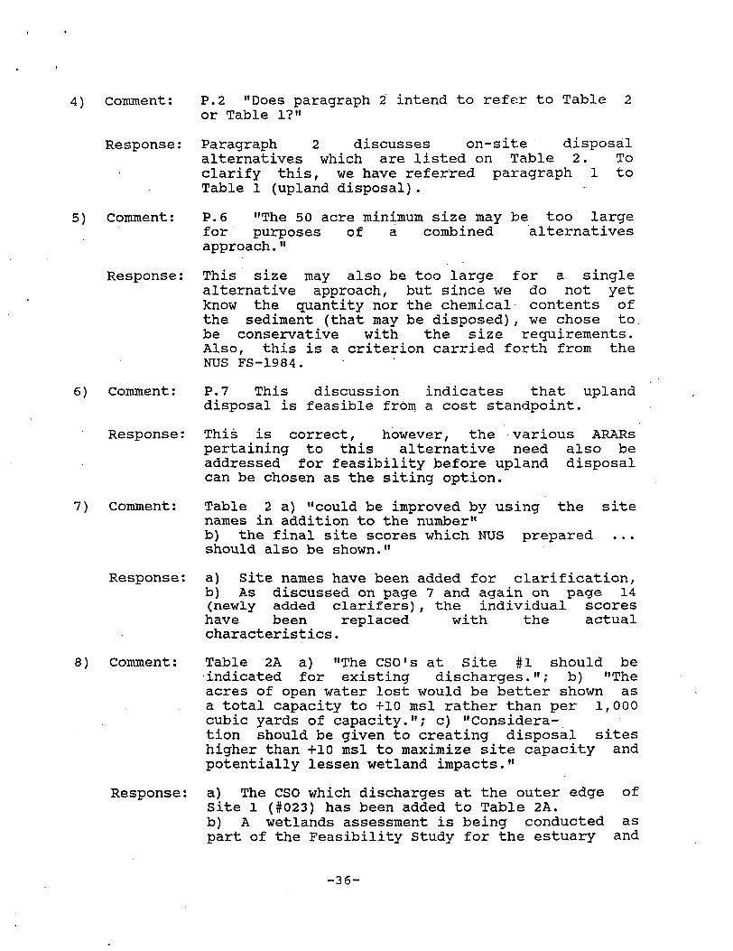

9) Comment
Response
10 Comment
Response
lower harbor and bay With data from this study we will be better able to evaluate impacts on wetlands and mudflats from the shoreline disposal sites c) This additional height increase for the disposal sites has been taken into consideration as shown by the storage capacity increase per one foot increase in height The costs involved in this increase may be disproportionately greater though due to the increase in base required Aesthetics will also be considered when increasing the height of the disposal site is evaluated
a) Site 1s 1345 contain wetland resources (salt marsh) although the table indicates none exist b) Site 1 and 1A has poor buffer zones yet Table 2 shows an adequate buffer zone for site IB Site IB should also be considered poor
a) 27 acres of wetlands have been included in the report based on the Waterfront Park EIR by J Cortell Wetlands were not recognized by the Environmental Photographic Interpretation Center (EPIC) in their Wetlands Identification and Assessment April 1985 for the areas corresponding to sites 3 and 4 The data included in the siting report was taken from the NUS In Harbor Disposal Siting Report April 1986 which also did not recognize wetlands in those areas The wetlands assessment being conducted for the FS will evaluate these areas and will also be used to rank the various siting alternatives in the detailed screening Two acres of wetlands have been estimated for site 5 and have been incorporated in the report b) Data has been taken directly from the NUS reports on siting including buffer zone characteristics It seems NUS was separating some of the data for sites 1 1A and IB To be consistent with the text site IB buffer zone has been changed to poor
Wetland areas should be quantified for each of these sites In addition acres of intertidal mudflat should be separately listed
The detailed analysis of disposal sites will include wetland and mudflat quantification based upon the wetland assessment being conducted for the FS
-37shy
11 Comment
Response
12) Comment
Response
13) Comment
Response
Consideration should be given for the use of steel sheet pile instead of earthern dikes lessen impacts on wetlands increase disposal site volume
NUS has looked into the use of sheet piles Stability analysis performed for cantilever sheetpiles determined that sections of the harborestuary provide inadequate depth of overburden (to bedrock) to support the required embankment Thus inadequate resistence is present to prevent overturning failure Other types of sheetpile construction can be used but are much more costly Also the longevity or permanence of this type of barrier in a saline tidal environment comes in question especially in light of the new emphasis on permanence of a remedy in the SARA amendments to the NCP
P14 a) Have any areas been identified for temporary storage dewatering and potential treatmentdetoxification b) What potential conflicts exist for the use of site 1 for this purpose and the proposed pilot study by the USAGE
No areas have been identified specifically for purposes of temporary storage andor treatment Some areas of interest are the railyard (site 12) and site 1 The quarry and auto junkyard (although this was dismissed as a permanent site due to its small size) are other possibilities that will be investigated The pilot program at site 1 will not conflict with or compromise the use of site 1 as a temporary storage or treatment facility because the pilot program is not intended to be permanent
P15 Information concerning the possible use (any restrictions on use) of a disposal site after covering is needed to support a roadway What extra costs are involved to harden1 the sediments so that a roadway can be supported
A more detailed discussion of the in-harbor disposal site site 1 1A and IB is given in the NUS September 1986 report bullConceptual Development of an On-Site Sediment Disposal Facility1 The siting report (p15) was unclear about the roadway as it would be constructed on top of the embankment not the disposed
-38shy
sediments Changes to that effect have been made in the text
14) Comment
Response
15) Comment
Response
16) Comment
Response
17) Comment
Response
18) Comment
P 15 The site and storage capacity of the automobile junkyard should be identified Is adjacent land available
The automobile junkyard discussed in the siting report is located just over the city line of Fairhaven in the town of Acushnet The property lies between Porter and Lawson Streets and is bordered to the north west and south by the Acushnet River wetlands Residential homes border the site to the east The site is roughly the same size as site 5 approximately 6 acres The greater majority of adjacent land is wetland and thus would not be ideally suited for sediment deposition This site (including any adjacent properties) is poorly buffered from the public Technically the junkyard may be considered an upland site as it may be outside of the Superfund site boundaries
P15-17 What is the optimal depth of excavation for a CAD cell
The Army Corps of Engineers is currently evaluating this question through literature searches bench scale testing and the pilot study in the area of site 1
P18-20 the section 404 requirements are no less stringent than ocean disposal constraints
The major difference between ocean dumping and the shoreline disposal is that the wetlands that may be impacted by the deposition are within the limits of the Superfund site and in some areas highly contaminated SARA requirements strongly discourage the movement of contaminants from within the limits of a designated hazardous waste site to offsite areas
P 21 The last sentence of paragraph 4 is confusing It quotes 404(b)(l) Guidelines [Sec 23010(a)] in the middle of a discussion of ocean dumping requirements Moreover 40 CFR 230 does not apply to ocean waters
The inclusion of the referenced sentences was an error and has been removed from the paragraph
P 22 Cost estimates shown in Table 3 Appendix A B-l and B-2 and C should be revised to
-39shy
reflect the additional costs discussed on this page
Response The costs cited in the above mentioned appendices and tables were given to illustrate the approximate costs for the different siting alternatives These costs were neither detailed nor in some cases up-to-date (ie NUS FS costs of 1984 were used for some siting alternatives) The detailed screening of the remaining sites will include a comprehensive cost assessment to include capital costs operation and maintenance costs and present worth and sensitivity analysis
These costs will then be combined with removal and treatment technologies to develop a variety of remedial alternatives recognizing the NCP and SARA requirements
D-4 COMMONWEALTH OF MASSACHUSETTS - COASTAL ZONE MANAGEMENT
1) Comment None of the alternatives in the November 1986 report are permanent
Response Among the alternatives for remediation under consideration is dredging or excavation of the contaminated sediments If removed these sediments may need to be disposed of somewhere The objective of this report is to identify various options for disposal This does not exclude any form of treatment that may be performed on the sediments to create a permanent solution be it detoxification solidification incineration etc
2) Comment Major challenges of this project are the problems associated with dredging namely resuspension of sediments
Response These are important considerations in evaluating the alternatives and are being addressed under separate tasks in New Bedford Harbor Feasibility Study - Non-Removal and Removal Technologies Initial Screening Report February 1987
3) Comment Despite the costs it may be worth removing the more contaminated sediments to these upland sites (Existing Approved Landfills)
Response These landfills have been retained for detailed analysis primarily for the disposal of smaller
-40shy
4) Comment
Response
5) Comment
Response
6) Comment
Response
quantities of highly contaminated materials due to the high cost of transportation and disposal NUS has already determined that it would not be feasible nor cost effective to transport 1000000 cubic yards of material to an approved facility The deposition of material at an approved facility is also not consistent with the recently promulgated SARA requirements emphasizing permanence
The upland site identified as S-5 on the New Bedford South map (Figure A-4 NUS June 1984) has wetlands on itthe extent of wetlands within this site needs to be further described
Data on the upland sites was compiled from previously printed NUS reports The detailed screening of upland sites will reevaluate present conditions including potential wetlands productive aquifers and subsurface geology to identify an optimum upland site if such a site exists
It seems prudent to assume all in-harbor sites need to be fully lined
The USAGE is evaluating the need for liners in the shoreline sites both at a bench-scale level and in an upcoming pilot study This will identify liner requirements and what type would be necessary to fulfill the requirements for permanence
Four sites have salt marshes andor wetlands associated with them eg sites 1 1A 2 and 6Filling of such areas generally violates most recommended andor legislated criteria
Since the in-harbor sites are within the bounds of the New Bedford Superfund site and much of the wetlands have been found to be contaminated with PCBs and heavy metals storing the sediments on-site may be a prudent siting alternative The detailed screening will narrow the list of in-harbor sites to one or more optimal ones if they exist The 404(b) guidelines state that no discharge of dredged or filled material shall be permitted if there is a practicable alternative to the proposed discharge which would have less adverse impact on the aquatic ecosystem so long as the alternative does not have other significant adverse environmental consequences Moving contaminated sediments to a clean area
-41shy
7) Comment
Response
8) Comment
Response
9) Comment
Response
10) Comment
Response
off-site may have more significant consequences than creating a shoreline facility
There is confusion about the capacity of 10A which is listed as both 30000 cy and 491480 cy
There is an error in the NUS FS report that has accidentally been transcribed to the siting report Site 10A has approximately 25 additional storage capacity as compared to site 10 (491481 cu yds will be retained pending detailed screening of the in-harbor sites)
The area ranked second highest (Marsh Island extension) would involve filling in considerable marshland and potentially productive tidelands
Currently all in-harbor sites have been retained for detailed screening without any subjective ranking Once data on the wetlands and geotechnical investigations become available an informed decision can be made in choosing the optimum in-harbor site(s)
Problems associated with placement of fine-grained sediments in underwater containment areas should be addressed with some supporting data before this is chosen as a final alternative
The USAGE will be conducting a pilot dredging study within the Acushnet Estuary which will evaluate the effectiveness of the CAD cell system The study will include groundwater monitoring which will help determine what impacts the CAD system will have on groundwater (and contaminant) movement An evaluation of the hydrologic setting around the New Bedford site is on-going and data acquired will be used in the detailed screening of siting alternatives
Another consideration with CADs is the effectiveness of capping
Cap thickness is another parameter that will be studied within the dredging and disposal feasibility study and the pilot study being conducted by the USAGE
-42shy
D-5 MASSACHUSETTS DEPARTMENT OF ENVIRONMENTAL QUALITY ENGINEERING
1) Comment The Department recommends option 1A and IB be evaluated further as a preferred disposal site
Response The in-harbor sites 1A and IB are among those which have been retained for detailed screening that may later be incorporated into the final remedial alternative selection
2) Comment The Department further recommends that if this option is chosen replication of the two salt marshes destroyed be considered
Response The USAGE wetlands evaluation includes those wetlands that may be used for disposal As part of the evaluation means to mitigate impacts will be considered including replacement
3) Comment Compensatory storage would be required (for any filling of the harbor)
Response The USAGE is currently compiling flood data and storage requirements given different flood frequencies including the 100 year flood This study will also evaluate the different changes in flood storage capacity caused by construction of the in-harbor sites including the need for compensatory storage
D-6 US ARMY CORPS OF ENGINEERS - NEW ENGLAND DIVISION
1) Comment P 18 The West Island Spoil Area1 is not currently a disposal area for use and would need to be reopened The Foul Area1 off the Boston shoreline is an area being used presently
Response The West Island Spoil Area was retained for detailed screening of siting alternatives due to the proximity to the dredging operation The feasibility of reopening this site or transporting the material to another ocean disposal site will be evaluated in the detailed site screening
2) Comment P 18 The buckets discussed in the last paragraph hold ten cubic yards and six cubic yards respectively not cubic feet
Response The appropriate corrections have been make in the text
-43shy
3) Comment
Response
4) Comment
Response
5) Comment
Response
Table 3 footnote (8) uses a 6 cubic yard bucket This should be a 10 cubic yard bucket instead
The correction has been made on the table
P 25 Appendix B-l vs B-2 The costs for preparing the sediments seem very low in Appendix B-l There also seems to be quite a discrepancy in the pumping costs between the lined and unlined in-harbor disposal facilities It would also be helpful if the assumptions for the costs were given as for Appendix A as an example
An appropriate cost estimate was completed for only the disposal of sediments without the ancillary dredging or treatmentdewatering necessary Thus the pumping costs involve only pumping material from the temporary facility to the permanent site Due to the additional volume of material that needs to be dredged from the site of the permanent lined facility a greater volume needs to be pumped back to the site after liner placement The unlined site would not be dredged prior to sediment deposition The costs given are taken from the NUS FS August 1984 and are thus not current The detailed screening will include a comprehensive cost analysis with appropriate assumptions documented
P 27 Appendix C The costs for the CAD cell alternative seem confusing Also can the costs to transport the contaminated and clean sediments from the contaminated site be separated out as has been done
Again an attempt was made to separate out the dredging from the disposal of material The costs documented were taken directly from the NUS FS Addendum September 1984 page 2-32 As discussed above these costs will be updated and assumptions documented in the detailed screening phase of the FS
-44shy
- Text5
- barcode 274540
- barcodetext SDMS DOC ID 274540

4) Comment
Response
5) Comment
Response
6) Comment
Response
quantities of highly contaminated materials due to the high cost of transportation and disposal NUS has already determined that it would not be feasible nor cost effective to transport 1000000 cubic yards of material to an approved facility The deposition of material at an approved facility is also not consistent with the recently promulgated SARA requirements emphasizing permanence
The upland site identified as S-5 on the New Bedford South map (Figure A-4 NUS June 1984) has wetlands on itthe extent of wetlands within this site needs to be further described
Data on the upland sites was compiled from previously printed NUS reports The detailed screening of upland sites will reevaluate present conditions including potential wetlands productive aquifers and subsurface geology to identify an optimum upland site if such a site exists
It seems prudent to assume all in-harbor sites need to be fully lined
The USAGE is evaluating the need for liners in the shoreline sites both at a bench-scale level and in an upcoming pilot study This will identify liner requirements and what type would be necessary to fulfill the requirements for permanence
Four sites have salt marshes andor wetlands associated with them eg sites 1 1A 2 and 6Filling of such areas generally violates most recommended andor legislated criteria
Since the in-harbor sites are within the bounds of the New Bedford Superfund site and much of the wetlands have been found to be contaminated with PCBs and heavy metals storing the sediments on-site may be a prudent siting alternative The detailed screening will narrow the list of in-harbor sites to one or more optimal ones if they exist The 404(b) guidelines state that no discharge of dredged or filled material shall be permitted if there is a practicable alternative to the proposed discharge which would have less adverse impact on the aquatic ecosystem so long as the alternative does not have other significant adverse environmental consequences Moving contaminated sediments to a clean area
-41shy
7) Comment
Response
8) Comment
Response
9) Comment
Response
10) Comment
Response
off-site may have more significant consequences than creating a shoreline facility
There is confusion about the capacity of 10A which is listed as both 30000 cy and 491480 cy
There is an error in the NUS FS report that has accidentally been transcribed to the siting report Site 10A has approximately 25 additional storage capacity as compared to site 10 (491481 cu yds will be retained pending detailed screening of the in-harbor sites)
The area ranked second highest (Marsh Island extension) would involve filling in considerable marshland and potentially productive tidelands
Currently all in-harbor sites have been retained for detailed screening without any subjective ranking Once data on the wetlands and geotechnical investigations become available an informed decision can be made in choosing the optimum in-harbor site(s)
Problems associated with placement of fine-grained sediments in underwater containment areas should be addressed with some supporting data before this is chosen as a final alternative
The USAGE will be conducting a pilot dredging study within the Acushnet Estuary which will evaluate the effectiveness of the CAD cell system The study will include groundwater monitoring which will help determine what impacts the CAD system will have on groundwater (and contaminant) movement An evaluation of the hydrologic setting around the New Bedford site is on-going and data acquired will be used in the detailed screening of siting alternatives
Another consideration with CADs is the effectiveness of capping
Cap thickness is another parameter that will be studied within the dredging and disposal feasibility study and the pilot study being conducted by the USAGE
-42shy
D-5 MASSACHUSETTS DEPARTMENT OF ENVIRONMENTAL QUALITY ENGINEERING
1) Comment The Department recommends option 1A and IB be evaluated further as a preferred disposal site
Response The in-harbor sites 1A and IB are among those which have been retained for detailed screening that may later be incorporated into the final remedial alternative selection
2) Comment The Department further recommends that if this option is chosen replication of the two salt marshes destroyed be considered
Response The USAGE wetlands evaluation includes those wetlands that may be used for disposal As part of the evaluation means to mitigate impacts will be considered including replacement
3) Comment Compensatory storage would be required (for any filling of the harbor)
Response The USAGE is currently compiling flood data and storage requirements given different flood frequencies including the 100 year flood This study will also evaluate the different changes in flood storage capacity caused by construction of the in-harbor sites including the need for compensatory storage
D-6 US ARMY CORPS OF ENGINEERS - NEW ENGLAND DIVISION
1) Comment P 18 The West Island Spoil Area1 is not currently a disposal area for use and would need to be reopened The Foul Area1 off the Boston shoreline is an area being used presently
Response The West Island Spoil Area was retained for detailed screening of siting alternatives due to the proximity to the dredging operation The feasibility of reopening this site or transporting the material to another ocean disposal site will be evaluated in the detailed site screening
2) Comment P 18 The buckets discussed in the last paragraph hold ten cubic yards and six cubic yards respectively not cubic feet
Response The appropriate corrections have been make in the text
-43shy
3) Comment
Response
4) Comment
Response
5) Comment
Response
Table 3 footnote (8) uses a 6 cubic yard bucket This should be a 10 cubic yard bucket instead
The correction has been made on the table
P 25 Appendix B-l vs B-2 The costs for preparing the sediments seem very low in Appendix B-l There also seems to be quite a discrepancy in the pumping costs between the lined and unlined in-harbor disposal facilities It would also be helpful if the assumptions for the costs were given as for Appendix A as an example
An appropriate cost estimate was completed for only the disposal of sediments without the ancillary dredging or treatmentdewatering necessary Thus the pumping costs involve only pumping material from the temporary facility to the permanent site Due to the additional volume of material that needs to be dredged from the site of the permanent lined facility a greater volume needs to be pumped back to the site after liner placement The unlined site would not be dredged prior to sediment deposition The costs given are taken from the NUS FS August 1984 and are thus not current The detailed screening will include a comprehensive cost analysis with appropriate assumptions documented
P 27 Appendix C The costs for the CAD cell alternative seem confusing Also can the costs to transport the contaminated and clean sediments from the contaminated site be separated out as has been done
Again an attempt was made to separate out the dredging from the disposal of material The costs documented were taken directly from the NUS FS Addendum September 1984 page 2-32 As discussed above these costs will be updated and assumptions documented in the detailed screening phase of the FS
-44shy
- Text5
- barcode 274540
- barcodetext SDMS DOC ID 274540